#RioGrande Compact settlement is โ€˜on track…this is an extraordinary moment unlike any in history’ — Colorado State Attorney General Phil Weiser (AlamosaCitizen.com)

Click the link to read the article and listen to the Valley Pod on the Alamosa Citizen website:

July 9, 2025

A draft agreement settling the long-running Rio Grande Compact lawsuit dealing with New Mexicoโ€™s delivery of water to the Texas border is on the one-yard line and should be pushed across the goal line come fall, says Colorado Attorney General Phil Weiser.

Weiser was on a two-day tour of the San Luis Valley this week when he gave an update on the lawsuit to members of the Rio Grande Basin Roundtable. All three compact states โ€“ Colorado, New Mexico and Texas will be party to the settlement. 

Earlier this week, Special Master D. Brooks Smith scheduled a hearing for the week of Sept. 29 on the parties motions toward a settlement. 

The states had worked out a previous agreement to the 2013 case, only to have the federal government object when the proposed settlement was presented to the U.S. Supreme Court. This time, said Weiser, the federal governmentโ€™s role has been addressed.

โ€œWeโ€™re on track,โ€ Weiser said during a recording of The Valley Pod. โ€œWe have a settlement that properly has the federal government in its place and resolves the concerns which were mostly between New Mexico and Texas.โ€


Listen hereย to the full Valley Pod episode with AG Phil Weiser.


Colorado has nine interstate water compact agreements, including the Colorado River Compact which dominates the headlines. At the Rio Grande Basin Roundtable meeting, Conejos Water Conservancy District Manager Nathan Coombs asked Weiser how the state and local water users could collaborate on more โ€œcreative waysโ€ in administering the river compacts.

โ€œWe all agree with keeping our compacts whole. But I would ask what are some of the processes we could go through to make them more vehicles for the water users within the state as we see this drying?โ€ Coombs said.

On The Valley Pod, Weiser addressed the Valleyโ€™s efforts to recover the Upper Rio Grande Basinโ€™s confined and unconfined aquifers.

โ€œWe will have to continue looking at this situation of groundwater and have to keep asking โ€˜How do we best manage this precious resource?โ€™ I donโ€™t have any immediate views on what to do in the face of the challenging hydrology. I do believe we have to keep thinking hard about a series of strategies that include โ€˜How are we most smartly storing water, how are we re-using water, and how are we conserving water?โ€™โ€

Weiser, a two-term attorney general, is a candidate for governor, seeking the Democratic Party nomination in 2026. In The Valley Pod episode he talks more about his candidacy as well as the 27 different lawsuits Colorado has been party to in the past six months in challenging the Trump Administration.

โ€œThis is an extraordinary moment unlike any in history,โ€ Weiser said.

Rio Grande and Pecos River basins. Map credit: By Kmusser – Own work, Elevation data from SRTM, drainage basin from GTOPO [1], U.S. stream from the National Atlas [2], all other features from Vector Map., CC BY-SA 3.0, https://commons.wikimedia.org/w/index.php?curid=11218868

Safeguarding the sagebrushโ€™s rich wet meadows, one #Wyoming gulch at a time: Simple erosion-control technique named after scientist Bill Zeedyk fortifies ecologically valuable riparian zones all around the western U.S — Mike Koshmrl (WyoFile.com)

Cooper Fieseler places stones intended to prevent erosion during a June 2025 Zeedyk structure-building outing on the White Acorn Ranch. (Mike Koshmrl/WyoFile)

Click the link to read the article on the WyoFile website (Mike Koshmrl):

Tom Christiansen drew a parallel to the human body as he described the purpose of the low-tech rock structures heโ€™s been building for years within the creases of western Wyomingโ€™s sagebrush sea. 

The malady? Erosion. The treatment: A carefully placed stone.  

โ€œEach of these is a stitch on what we donโ€™t want to become a sucking chest wound,โ€ Christiansen told a group of rock-moving volunteers on Saturday in late June. 

The group was assembled on the White Acorn Ranch, a picturesque cattle operation south of the Lander Cutoff Road thatโ€™s within the spectacular Golden Triangle โ€” a 367,000-acre region along the flanks of the Wind River Range that houses the best remaining sagebrush habitat on Earth.

In a June 2025 outing near South Pass, Tom Christiansen, Mark Kot and Lindsey Washkoviak distribute stones that will be positioned into Zeedyk structures intended to protect wet meadows. (Mike Koshmrl/WyoFile)

The high desertโ€™s sagebrush-steppe has enormous ecological value. Thatโ€™s evidenced by the struggling species that depend upon the embattled biome. But itโ€™s an arid environment, and certain nooks and crannies play an outsized role in nourishing the landscapeโ€™s native and domesticated inhabitants. High on that list are the grassy wet meadows that convey precious water, like arteries pump blood, through the contours of the sagebrush-covered hills.

โ€œThese areas are pretty small, but theyโ€™re very important,โ€ said Christiansen, a retired sage grouse coordinator for the Wyoming Game and Fish Department. โ€œThese are the grocery stores.โ€ 

Youngsters Cooper Fieseler and Camryn Christiansen-Fieock check out a mega-sized Zeedyk structure built to address an especially broad โ€œheadcutโ€ that was eroding into the green grass uphill. (Mike Koshmrl/WyoFile)

But those bottomlands can become barren of the biomass that feeds insects, sage grouse chicks and on down the food chain. Erosion, although a natural phenomenon, can be hastened by factors like overgrazing and extreme weather events made more likely by climate change. When erosion runs out of control into grassy gulches, they become incised gullies. Out goes the vegetation. 

Thatโ€™s where the simple rock structures come in. 

The same spot before the mega-sized Zeedyk structure went in. (Tom Christiansen)

โ€œPrevent that erosion, get more water into the soil, keep the water table up, keep the green vegetation โ€” thatโ€™s the intent of these structures,โ€ Christiansen said. 

Known as Zeedyk structures, after their inventor, Bill Zeedyk, the stone assemblies come in different shapes and sizes. At the White Acorn Ranch and numerous other corners of the West, there are โ€œone rock dams,โ€ โ€œzuni bowls,โ€ โ€œrock mulch rundownsโ€ and other hand-built structures intended to arrest vertical โ€œheadcutsโ€ in ephemeral streambeds.

By facilitating the flow of water and slowing it down, the structures can prevent erosion from spreading uphill. Although the ecological do-gooding tactic relies on simple concepts and materials โ€” essentially well-placed rocks โ€” building it out requires hard physical labor. 

Mark Kot listens to a discussion about Zeedyk structures in June 2025. (Mike Koshmrl/WyoFile)

A bevy of volunteers flocked to South Pass on June 21 to erect new Zeedyk structures and shore up old ones. 

Jared Oakleaf, Liz Lynch and Lindsey Washkoviak ventured up from Lander. Mark Kot, bad back and all, came from Rock Springs to move rock. Christiansen made the drive from Green River alongside his granddaughter, Camryn Christiansen-Fieock, of Big Piney. On a day off, Wyoming Game and Fish Department habitat biologist Troy Fieseler made the trek from Pinedale and with his son, Cooper. 

A group of volunteers building Zeedyk structures in June 2025 aims to preserve the grassy bottoms pictured in this photo on the White Acorn Ranch. (Mike Koshmrl/WyoFile)

The rocks were donated, too. Robert Taylor, an avid sage grouse hunter from Washington state, ponied up for the materials the volunteers carefully placed. 

Several of the bunch devoting their Saturday to moving rocks up on South Pass were seasoned. Fieseler even learned the ropes from the techniqueโ€™s namesake himself. 

โ€œThe very first time I did it, we had Bill Zeedyk come out,โ€ he said. โ€œHe taught us to read the landscape.โ€

Troy Fieseler motions while talking with fellow volunteers during a June 2025 Zeedyk structure-building outing on the White Acorn Ranch. (Mike Koshmrl/WyoFile)

That 2021 workshop, held at Seedskadee National Wildlife Refuge, imparted Fieseler with lessons he hasnโ€™t forgotten. Protecting uneroded wet meadows is a far more efficient use of time and resources than trying to restore those that have already washed out, he recalled.

Over the last decade, Zeedykโ€™s erosion-control tactics have gained traction in Wyoming and well beyond. The Natural Resources Conservation Serviceโ€™s Sage Grouse Initiative gave the concept its legs, Christiansen said. Now there are thousands of structures dispersed across hundreds of projects, he said.

โ€œEach of these, whatโ€™s its significance?โ€ Christiansen said. โ€œAn individual one, itโ€™s not so much, but when you start doing thousands of these across the West, there is significance.โ€

Zeedyk structures in action helping to control erosiion and retain moisture on a gulch in the White Acorn Ranch. (Tom Christiansen)

Enough time has passed since the techniqueโ€™s inception that restoration specialists know it works, thanks to long-term monitoring

The White Acorn Ranchโ€™s Zeedyk structures also have proven hardy and able to withstand the worst that the harsh Wyoming environment can throw their way. Christiansen and his fellow volunteers labored in a corner of the state that got walloped during the winter of 2022-โ€™23 by an unusually hefty snowpack. 

โ€œThis ensured the runoff from the heavy snow,โ€ Christiansen said. โ€œThey dealt with a lot of energy, and handled it. Very few rocks moved.โ€

Christiansen spoke of the rock structureโ€™s resilience on the front end of a day of labor. From a section of state land, he motioned down a draw. 

โ€œThereโ€™s over 20 structures between here and where that slope toes off,โ€ he said. 

Every one of them had been erected by Christiansen, the crews of Zeedyk structure-building volunteers and agency folks that have also chipped in.

Frances Brennan, Cooper Fieseler and Camryn Christiansen-Fieock pose after a couple hours of playing and moving rocks that went into Zeedyk structures on the White Acorn Ranch. (Mike Koshmrl/WyoFile)

Data Dump: Abandoned oil and gas wells in #NewMexico: Also: Public lands continue to take a beating, despite one small victory — Jonathan P. Thompson (LandDesk.org)

A serious mess, also known as the NE Hogback #53 well and associated infrastructure. Chuza, the most recent owner of the site in the Horseshoe Gallup oil field in northwestern New Mexico, went bankrupt. That left New Mexico and federal taxpayers holding the cleanup bill. The site has been partially reclaimed, but only partially. Jonathan P. Thompson photo.

Click the link to read the article on The Land Desk website (Jonathan P. Thompson):

July 2, 2025

๐Ÿ›ข๏ธย Hydrocarbon Hoedownย ๐Ÿ“ˆย Data Dumpย ๐Ÿ“Š

A new report on New Mexicoโ€™s abandoned and orphaned oil and gas wells presents an alarming and expensive scenario for the state. It reveals that while the industry generates a lot of revenue for the state, cleaning up its mess is also poised to cost state and federal taxpayers hundreds of millions of dollars. No, this report was not put out by an environmental or progressive advocates, but by the stateโ€™s legislative finance committee.

New Mexico has been an oil and gas hotspot for more than a century, during which drillers have sunk at least 121,000 wells, mostly in the San Juan and Permian basins in the northwest and southeast portions of the state. Newly drilled wells typically kick out a large volume of oil and/or gas during the first months after drilling, generating a lot of cash for their operators and for state coffers, and helping to push production numbers for the state through the roof.

Decline curve generated by decline curve analysis software, utilized in petroleum economics to indicate the depletion of oil & gas in a petroleum reservoir. By Richard Banks – Sent to me personally, GFDL, https://commons.wikimedia.org/w/index.php?curid=33914059

But the wells are soon afflicted with whatโ€™s known as the decline curve, meaning that the longer they pump, the less they pump. You know, itโ€™s kind of like aging in people. Eventually, aging will render all oil and gas wells into low-producing stripper wells (Iโ€™m not sure how this analogy extends to the human realm, but hey โ€ฆ) that kick out less than 10 barrels of oil per day. Thousands of New Mexico wells are extreme strippers, producing one barrel or less daily. Yet they continue to spew methane, hydrogen sulfide, and volatile organic compounds at the same as or an even higher rate than their younger, more vital counterparts.


A trip through a sacrifice zone: The Horseshoe Gallup oilfield — Jonathan P. Thompson


This is problematic for a number of reasons. For one, the operators of stripper wells are likely to be smaller, less financially secure companies, and itโ€™s easier and cheaper for them to keep the wells in a nearly inactive state โ€” during which the wells continue to ooze pollutants into the air and groundwater โ€” than to decommission, plug, and reclaim them. It may make economic sense to abandon these wells, or for the companies to cease to exist and โ€œorphanโ€ the wells, leaving them to the state or federal taxpayers to clean up, since reclamation bonds are woefully inadequate. And, finally, these wells generate almost nothing in production taxes, meaning that they arenโ€™t contributing much to the stateโ€™s conservation fund, a portion of which is used to clean up abandoned and orphaned wells.


Saga of an Oil Well (The Horseshoe Gallup Field Sacrifice Zone Part II) — Jonathan P. Thompson


The near constant drone of drilling for over a century has resulted in a near-constant addition of low- to non-producing wells to New Mexicoโ€™s rosters. While responsible and financially solvent companies plug and reclaim their own wells, many smaller operators simply walk away.

New Mexicoโ€™s Oil Conservation Division is currently responsible for plugging close to 1,000 abandoned and orphaned wells, including 700 on state or private land, and for remediation and reclamation of an additional 500 well sites and 18 infrastructure sites (such as leaky tank batteries).

Detail of interactive map showing orphaned, inactive, and low-producing wells on state and private land in the San Juan Basin (this leaves out hundreds of additional such wells on federal lands).

At recent rates, plugging them will take close to a decade, not including remediation/reclamation. OCD is also responsible for remediation and reclamation of an additional 500 well sites and 18 infrastructure sties. In total, plugging, remediation, and reclamation of all currently orphaned wells and infrastructure on state and private land is estimated to cost a minimum of $208 million, and likely more. And thatโ€™s just for now.

The report goes on to say: โ€œโ€ฆ in addition to wells the state already has legal authority to plug, thousands of inactive and low-producing wells are at risk of being orphaned, potentially increasing the stateโ€™s liability by many orders of magnitude.โ€ There are about 1,400 inactive at high risk of being orphaned on state and private land, according to the OCD. And there are thousands more that are extremely low-producing wells โ€” putting out less than one barrel of oil equivalent per day โ€” for which the โ€œexpected cost of cleanup far exceeds predicted future revenues, increasing their risk of being orphaned.โ€

And the kicker: โ€œAltogether, the stateโ€™s current and near-future liability for well plugging and site remediation is estimated to be between $700 million and $1.6 billion.โ€

More data from the report:

  • 38,817 Number of stripper wells, meaning they produce less than 10 barrels of oil-equivalent daily, in New Mexico, making up about 64% of the stateโ€™s active wells. This number will continue to increase.
  • $100,000 Average cost to plug single oil and gas well.
  • 450% Percent the average state-contracted cost to plug an oil and gas well in New Mexico has increased since 2019.
  • $250,000 Maximum amount of financial assurance an operator in New Mexico must post to cover the costs of plugging and reclaiming its wells. This cap applies whether the operator has five wells or 500 wells, meaning it actually provides almost no financial assurance whatsoever.
  • $46.4 million Amount spent by the New Mexico Oil Conservation Division to plug and reclaim 360 wells and associated infrastructure between 2019 and 2024.
  • 9% Percent by which the cost of plugging a gas well exceeds that of an oil well. Most of the wells in the San Juan Basin are gas wells.
  • $208 million Estimated cost to New Mexico to plug, remediate, and reclaim all existing orphaned and abandoned wells and infrastructure on state and private land.
  • $5.6 million Amount in financial assurance associated with orphaned wells or their operators, meaning most of the costs will be shouldered by the taxpayers โ€” either via the state reclamation fund or federal grants.
  • $66.7 million April 2025 balance of New Mexicoโ€™s oil and gas reclamation fund (which is funded by a portion of conservation tax revenues).
  • $6 million Tax revenue New Mexicoโ€™s 3,024 wells producing less than 1BOE/day would generate with the West Texas Intermediate oil price at $70/barrel (itโ€™s currently lower than that). Plugging and reclaiming those same wells would cost an estimated $531 million to $885 million. โ€œThe vast majority of the wellsโ€”87%โ€”are owned by private companies whose financial health is difficult for regulators to assess.โ€
  • $1.6 millionย Amount New Mexico paid in 2024 to plug six of Ridgeway Arizonaโ€™s wells under a 2023 settlement agreement with the company. Under the agreement, the state pays to plug 299 of the companyโ€™s wells, and the company reimburses the state $2 for each barrel of oil it sells, with a minimum payment of $30k per month. But at current rates, the total cost to plug the remaining wells could be $60 million or more, meaning it would take the company as long as 170 years to pay it off.

๐ŸŒต Public Lands ๐ŸŒฒ

By now youโ€™ve probably heard that Sen. Mike Lee pulled his public land sell-off provision from the budget reconciliation bill that the Senate just passed following intense backlash. And perhaps youโ€™re planning on celebrating the salvation of Americaโ€™s public lands on July 4.

Thereโ€™s so much BS in Leeโ€™s statement. How, for example, does selling public land to developers keep it from being ruined for the next generation? It doesnโ€™t, it just locks up that land for every generation except those that can afford to buy a house in the new subdivision that would go there. Public land is not โ€œlocked away from the people who live there.โ€ But it would be locked away if it was privatized. And while there is no property tax on public lands, there are federal payments in lieu of taxes, or PILT, which a county can use to fund schools and search and rescue operations. Plus, public lands generate billions in revenue for gateway communities through public land usersโ€™ sales and lodgers taxes and local spending.

Well, I hate to be Mr. Buzzkill, but while this victory may be sweet, it does little to offset the bitterness brought by continuing attacks on public lands, along with democracy, morality, decency, and, well, America, itself, this Independence Day week.

The โ€œBig, Beautiful Billโ€ perpetuates and amplifies the massive transfer of wealth from low- and middle-income and working-class Americans to the richest 10%. It will slash Medicaid and other vital programs Americans have paid into and rely upon, while also dismantling tribal sovereignty. And yet, it will also drive up the deficit by trillions of dollars due to additional spending on the military industrial complex, which is reaching its tentacles further into immigration enforcement, wildlife blocking border walls, deportations, and $450-million-per-year concentration camps. With Trump threatening to revoke citizenship from U.S.-born citizens whom he considers threats (e.g. Zohran Mamdani and Elon Musk), those camps may end up housing his political opponents. I really hate to make this comparison, but that is some severe Nazi-esque nastiness.

The Senateโ€™s bill gives more handouts to the oil and gas and coal industries, while revoking tax credits for wind and solar power, which could kill those industries when they are needed most.

And yes, some of you may cheer a weaker renewable-energy industry, since it will mean fewer utility-scale installations blanketing the desert. I get that. But it will also hurt rooftop solar and larger installations on big box stores, over parking lots, or in fallow agricultural land, brownfields or other appropriate sites. A western Colorado farmerโ€™s plan to install solar panels to generate electricity and shade his crops, for example, is imperiled by the GOPโ€™s plans.

This at a time when strain on the power grid is exponentially increasing due to the outsized demand of more and more AI-powering, hyperscale data centers. That power will come from somewhere, and if itโ€™s not solar or wind or batteries, then itโ€™s likely to be from pollution-intensive coal and natural gas (mined and drilled from public lands), fish-killing hydropower, or new nuclear reactors (that will require uranium mined from public lands).

And keep in mind, oil and gas leasing and mining claims represent a sort of quasi-privatization of public lands. Sure, the government retains title to the land, but the corporations get access to the minerals within, can rip the land apart to get to them, and can cut off public access with the necessary permits. With its accelerated 14-day โ€œenergy emergencyโ€ permitting process, the Trump administration is making it a heck of a lot easier for corporations to mine, drill, and otherwise develop public lands, sans public input. The latest beneficiaries include:

  • NorthWestern Energy, which was given the Bureau of Land Management green light to build aย 74-mile natural gas pipelineย between Helena and Three Forks, Montana.
  • Ormat got the BLM go-ahead to move forward on three separate geothermal projects in Nevada:
    โ€ข Exploration work at theย Diamond Flat projectย near Fallon;
    โ€ข Upgrades at theย McGinness Hills projectย in Lander County;
    โ€ข Exploration drilling at theย Pinto Geothermal Projectย near Denio.

Iโ€™m not suggesting that these are horrible projects that shouldnโ€™t have been approved. Geothermal holds a lot of potential as a relatively clean, round-the-clock baseline power source, and these are merely upgrades and exploration, not full on developments. Still, geothermal development and even exploration have impacts and can affect groundwater aquifers, springs, and wetlands. Land agencies should have as much time as it takes to adequately analyze potential effects, and tribal nations should be consulted and have time to do their own analysis. And if itโ€™s happening on public lands, then the public deserves to know about it and have an opportunity to weigh in. None of that is possible under this 14-day permitting process.

So, yeah, happy Fourth of July, yโ€™all and welcome to the Divided States of Project 2025. And on that note, the Land Desk will be taking the rest of the week off.


๐Ÿ“ธ Parting Shot ๐ŸŽž๏ธ

Just getting into the olโ€™ July Fourth spirit with this picture of Raymond “Squeekโ€ Huntโ€™s signs near his mutton meat slaughterhouse and shop in Waterflow, New Mexico. I mean, it does have an American flag in it, after all.

President Trumpโ€™s First EPA Promised to Crack Down on Forever Chemicals. His Second EPA Is Pulling Back — Anna Clark (Propublica.org)

Lock and Dam No. 1 on the Cape Fear River in Bladen County, North Carolina. By Bud Davis, U.S. Army Corps of Engineers – U.S. Army Corps of Engineers Digital Visual LibraryImage pageImage description pageDigital Visual Library home page, Public Domain, https://commons.wikimedia.org/w/index.php?curid=2000782

Click the link to read the article on the Propublica website (Anna Clark):

July 2, 2025

EPA Administrator Lee Zeldin claims to prioritize combatting long-lasting chemicals called PFAS. Despite this, the agency has delayed enforcement of standards and terminated over $15 million in funding for โ€œforever chemicalsโ€ research.

ProPublica is a nonprofit newsroom that investigates abuses of power. Sign up to receiveย our biggest storiesย as soon as theyโ€™re published.

One summer day in 2017, a front-page story in the StarNews of Wilmington, North Carolina, shook up the lives of hundreds of thousands of people. The drinking water system, it said, was polluted with a contaminant commonly known as GenX, part of the family of โ€œforeverโ€ PFAS chemicals.

It came from a Chemours plant in Fayetteville, near the winding Cape Fear River. Few knew about the contaminated water until the article described the discoveries of scientists from the Environmental Protection Agency and a state university. Given that certain types of PFAS have been linked to cancer, there was widespread anxiety over its potential danger.

In the onslaught of legal action and activism that followed, the EPA during President Donald Trumpโ€™s first term took an assertive stance, vowing to combat the spread of PFAS nationwide.

In its big-picture PFAS action plan from 2019, the agency said it would attack this complex problem on multiple fronts. It would, for example, consider limiting the presence of two of the best-known compounds โ€” PFOA and PFOS โ€” in drinking water. And, it said, it would find out more about the potential harm of GenX, which was virtually unregulated.

By the time Trump was sworn in for his second term, many of the planโ€™s suggestions had been put in place. After his first administration said PFOA and PFOS in drinking water should be regulatedstandards were finalized under President Joe Biden. Four other types of PFAS, including GenX, were also tagged with limits.

But now, the second Trump administration is pulling back. The EPA said in May that it will delay enforcement on the drinking water limits for PFOA and PFOS until 2031, and it will rescind and reconsider the limits on the other four. Among those who challenged the standards in court is Chemours, which has argued that the EPA, under Biden, โ€œused flawed science and didnโ€™t follow proper rulemaking proceduresโ€ for GenX.

These EPA decisions under Trump are part of a slew of delays and course changes to PFAS policies that had been supported in his first term. Even though his earlier EPA pursued a measure that would help hold polluters accountable for cleaning up PFAS, the EPA of his second term has not yet committed to it. The agency also slowed down a process for finding out how industries have used the chemicals, a step prompted by a law signed by Trump in 2019.

At the same time, the EPA is hampering its ability to research pollutants โ€” the kind of research that made it possible for its own scientists to investigate GenX. As the Trump administration seeks severe reductions in the EPAโ€™s budget, the agency has terminated grants for PFAS studies and paralyzed its scientists with spending restrictions.

Pointing to earlier announcements on its approach to the chemicals, the EPA told ProPublica that itโ€™s โ€œcommitted to addressing PFAS in drinking water and ensuring that regulations issued under the Safe Drinking Water Act follow the law, follow the science, and can be implemented by water systems to strengthen public health protections.โ€

โ€œIf anything,โ€ the agency added, โ€œthe Trump administrationโ€™s historic PFAS plan in 2019 laid the groundwork for the first steps to comprehensively address this contamination across media and we will continue to do so this term.โ€

In public appearances, EPA Administrator Lee Zeldin has pushed back on the suggestion that his agency weakened the drinking water limits on GenX and similar compounds. Future regulations imposed by his agency, he said, could be more or less stringent.

โ€œWhat we want to do is follow the science, period,โ€ he has said.

That sentiment perplexes scientists and environmental advocates, who say there is already persuasive evidence on the dangers of these chemicals that linger in the environment. The EPA reviewed GenX, for example, during both the first Trump and Biden administrations. In both 2018 and 2021, the agency pointed to animal studies linking it to cancer, as well as problems with kidneys, immune systems and, especially, livers. (Chemours has argued that certain animal studies have limited relevance to humans.)

Scientists and advocates also said itโ€™s unclear what it means for the EPA to follow the science while diminishing its own ability to conduct research.

โ€œI donโ€™t understand why we would want to hamstring the agency that is designed to make sure we have clean air and clean water,โ€ said Jamie DeWitt, a toxicologist in Oregon who worked with other scientists on Cape Fear River research. โ€œI donโ€™t understand it.โ€

Delays, Confusion Over PFAS

Favored for their nonstick and liquid-resistant qualities, synthetic PFAS chemicals are widely used in products like raincoats, cookware and fast food wrappers. Manufacturers made the chemicals for decades without disclosing how certain types are toxic at extremely low levels, can accumulate in the body and will scarcely break down over time โ€” hence the nickname โ€œforever chemicals.โ€

The chemicals persist in soil and water too, making them complicated and costly to clean up, leading to a yearslong push to get such sites covered by the EPAโ€™s Superfund program, which is designed to handle toxic swaths of land. During the first Trump administration, the EPA said it was taking steps toward designating the two legacy compounds, PFOA and PFOS, as โ€œhazardous substancesโ€ under the Superfund program. Its liability provisions would help hold polluters responsible for the cost of cleaning up.

Moving forward with this designation process was a priority, according to the PFAS plan from Trumpโ€™s first term. Zeldinโ€™s EPA describes that plan as โ€œhistoric.โ€ And, when he represented a Long Island district with PFAS problems in Congress, Zeldin voted for a bill that would have directed the EPA to take this step.

The designation became official under Biden. But business groups, including the U.S. Chamber of Commerce, and organizations representing the construction, recycling and chemical industries, sued. Project 2025, The Heritage Foundationโ€™s playbook for the new administration, also questioned it.

Zeldin has said repeatedly that he wants to hold polluters accountable for PFAS, but his EPA requested three delays in the court case challenging the Superfund designation that helps make it possible.

The agency said in a recent motion it needed the latest pause because new leadership is still reviewing the issues and evaluating the designation in context of its โ€œcomprehensive strategy to address PFOA and PFOS.โ€

The EPA also delayed a rule requiring manufacturers and importers to report details about their PFAS use between 2011 and 2022. An annual bill that sets defense policy and spending, signed by Trump in his first term, had charged the EPA with developing such a process.

When Bidenโ€™s EPA finalized it, the agency said the rule would provide the largest-ever dataset of PFAS manufactured and used in the United States. It would help authorities understand their spread and determine what protections might be warranted.

Businesses were supposed to start reporting this month. But in a May 2 letter, a coalition of chemical companies petitioned the EPA to withdraw the deadline, reconsider the rule and issue a revised one with narrowed scope.

When the EPA delayed the rule less than two weeks later, it said it needed time to prepare for data collection and to consider changes to aspects of the rule.

In an email to ProPublica, the agency said it will address PFAS in many ways. Its approach, the agency said, is to give more time for compliance and to work with water systems to reduce PFAS exposure as quickly as feasible, โ€œrather than issue violations and collect fees that donโ€™t benefit public health.โ€

The court expects an update from the EPA in the Superfund designation case by Wednesday, and in the legal challenges to the drinking water standards by July 21. The EPA could continue defending the rules. It could ask the court for permission to reverse its position or to send the rules back to the agency for reconsideration. Or it could also ask for further pauses.

โ€œItโ€™s just a big unanswered question whether this administration and this EPA is going to be serious about enforcing anything,โ€ said Robert Sussman, a former EPA official from the administrations of Presidents Bill Clinton and Barack Obama. As a lawyer, he now represents environmental groups that filed an amicus brief in PFAS cases.

Back in North Carolina, problems caused by the chemicals continue to play out.

A consent order between the state and Chemours required the manufacturer to drastically reduce the release of GenX and other PFAS into the environment. (The chemicals commonly called GenX refer to HFPO-DA and its ammonium salt, which are involved in the GenX processing aid technology owned by Chemours.)

Chemours told ProPublica that it invested more than $400 million to remediate and reduce PFAS emissions. It also noted that there are hundreds of PFAS users in North Carolina, โ€œas evidenced by PFAS seen upstream and hundreds of miles awayโ€ from its Fayetteville plant โ€œthat cannot be traced back to the site.โ€

PFAS-riddled sea foam continues to wash up on the coastal beaches. Chemours and water utilities, meanwhile, are battling in court about who should cover the cost of upgrades to remove the chemicals from drinking water.

Community forums about PFAS draw triple-digit crowds, even when theyโ€™re held on a weeknight, said Emily Donovan, co-founder of the volunteer group Clean Cape Fear, which has intervened in federal litigation. In the fast-growing region, new residents are just learning about the chemicals, she said, and theyโ€™re angry.

โ€œI feel like weโ€™re walking backwards,โ€ Donovan said. Pulling back from the drinking water standards, in particular, is โ€œdisrespectful to this community.โ€

โ€œItโ€™s one thing to say youโ€™re going to focus on PFAS,โ€ she added. โ€œItโ€™s another thing to never let it cross the finish line and become any meaningful regulation.โ€

A letter dated April 29, 2025, notifying Michigan State University about the termination of a grant for research into PFAS, one day after the EPA said in a press release that it was committed to combating PFAS contamination by, in part, โ€œstrengthening the science.โ€ Credit: Obtained by ProPublica

Research Under Fire

The EPA of Trumpโ€™s first term didnโ€™t just call for more regulation of PFAS, it also stressed the importance of better understanding the forever chemicals through research and testing.

In a 2020 update to its PFAS action plan, the EPA highlighted its support for North Carolinaโ€™s investigation of GenX in the Cape Fear River. And it described its efforts to develop the science on PFAS issues affecting rural economies with โ€œfirst-of-its-kind funding for the agriculture sector.โ€

Zeldin, too, has boasted about advancing PFAS research in an April news release. โ€œThis is just a start of the work we will do on PFAS to ensure Americans have the cleanest air, land, and water,โ€ he said.

At about the same time, though, the agency terminated a host of congressionally appropriated grants for PFAS research, including over $15 million for projects focused on food and farmlands in places like Utah, Texas and Illinois.

Scientists at Michigan State University, for example, were investigating how PFAS interacts with water, soil, crops, livestock and biosolids, which are used for fertilizer. They timed their latest study to this yearโ€™s growing season, hired staff and partnered with a farm. Then the EPA canceled two grants.

In virtually identical letters, the agency said that each grant โ€œno longer effectuates the program goals or agency priorities. The objectives of the award are no longer consistent with EPA funding priorities.โ€

The contrast between the agencyโ€™s words and actions raises questions about the process behind its decisions, said Cheryl Murphy, head of Michigan Stateโ€™s Center for PFAS Research and co-lead of one of the projects.

โ€œIf you halt it right now,โ€ she said, โ€œwhat weโ€™re doing is weโ€™re undermining our ability to translate the science that weโ€™re developing into some policy and guidance to help people minimize their exposure to PFAS.โ€

At least some of the researchers are appealing the terminations.

About a month after PFAS grants to research teams in Maine and Virginia were terminated for not being aligned with agency priorities, the agency reinstated them. The EPA told ProPublica that โ€œthere will be more updates on research-related grants in the future.โ€

Even if the Michigan State grants are reinstated, there could be lasting consequences, said Hui Li, the soil scientist who led both projects. โ€œWe will miss the season for this year,โ€ he said in an email, โ€œand could lose the livestock on the farm for the research.โ€

Federal researchers are also in limbo. Uncertainty, lost capacity and spending restrictions have stunted the work at an EPA lab in Duluth, Minnesota, that investigates PFAS and other potential hazards, according to several sources connected to it. As one source who works at the lab put it, โ€œWe donโ€™t know how much longer we will be operating as is.โ€

The EPA told ProPublica that itโ€™s โ€œcontinuing to invest in research and labs, including Duluth, to advance the mission of protecting human health and the environment.โ€

Meanwhile, the agency is asking Congress to eliminate more than half of its own budget. That includes massive staffing cuts, and it would slash nearly all the money for two major programs that help states fund water and wastewater infrastructure. One dates back to President Ronald Reaganโ€™s administration. The other was spotlighted in a paper by Trumpโ€™s first-term EPA, which said communities could use these funds to protect public health from PFAS. It trumpeted examples from places like Michigan and New Jersey.

The EPA lost 727 employees in voluntary separations between Jan. 1 and late June, according to numbers the agency provided to ProPublica. It said it received more than 2,600 applications for the second round of deferred resignations and voluntary early retirements.

โ€œThese are really technical, difficult jobs,โ€ said Melanie Benesh, vice president for government affairs at the nonprofit Environmental Working Group. โ€œAnd the EPA, by encouraging so many employees to leave, is also losing a lot of institutional knowledge and a lot of technical expertise.โ€

The shake-up also worries DeWitt, who was one of the scientists who helped investigate the Cape Fear River contamination and who has served on an EPA science advisory board. Her voice shook as she reflected on the EPAโ€™s workforce, โ€œsome of the finest scientists I know,โ€ and what their loss means for public well-being.

โ€œTaking away this talent from our federal sector,โ€ she said, will have โ€œprofound effects on the agencyโ€™s ability to protect people in the United States from hazardous chemicals in air, in water, in soil and potentially in food.โ€

Map showing the Cape Fear River drainage basin. By Kmusser – Self-made, based on USGS data., CC BY-SA 3.0, https://commons.wikimedia.org/w/index.php?curid=5506415

Can fracking #wastewater be reused?: #NewMexicoโ€™s legislators are eager to repurpose โ€œproduced water,โ€ but environmental organizations say that there is no safe way to do that — Shi En Kim (High Country News)

A DEQ worker collects samples from Alkali Creek below where produced water from the Moneta Divide Field is discharged. (Wyoming DEQ)

Click the link to read the article on the High County News website (Shi En Kim):

June 9, 2025

On Oct. 2, 2024, a geyser erupted in Toyah, a town in west Texas 50 miles from the New Mexico border. This was not a case of water miraculously appearing in the desert, a deliverance from the areaโ€™s long-standing drought. Rather, it was an environmental disaster: a blowout from an orphaned oil and gas well.

What gushed from the ground wasnโ€™t actually water, but rather a vile brine of heavy metals, radioactive substances, chemical additives and noxious organics โ€” the by-product of fracking. 

The Toyah incident is the latest of at least eight leaks over the preceding 12 months in the Permian Basin, a fracking hub across west Texas and southeastern New Mexico. It highlights the increasingly urgent challenge of what to do with frackingโ€™s wastewater โ€” what fossil fuel companies euphemistically call โ€œproduced water.โ€ But some New Mexico legislators have a solution in mind: For the last few years, theyโ€™ve proposed reusing the wastewater off the oil field for industrial purposes, such as data center cooling and hydrogen production.

Part of their argument is that New Mexico desperately needs water. More than 90% of its residents live in areas facing drought. In the next 50 years, the already-arid state will see its ground- and fresh water sources shrink by 25%.

Political pressure is mounting on New Mexicoโ€™s lawmakers to tap into fracking wastewater as a new resource. Environmental groups, however, strongly oppose the idea, arguing that there is still no way to make the wastewater safe for off-field use. Year after year, the New Mexico Legislature finds itself at a crossroads.

โ€œWe are, as a state, very beholden to oil and gas,โ€ said Carlos Matutes, the New Mexico director at the advocacy group GreenLatinos thatโ€™s part of the coalition opposing produced water reuse. Any bill that sanctions produced water, he said, โ€œis almost guaranteed to come back.โ€

PRODUCED WATER is an existential dilemma for the oil and gas industry. Fracking involves blasting underground rock with water to free up trapped oil and gas, but when that water returns to the surface, it is laden with contaminants it picks up from the earth. Every barrel of hydrocarbons reaped also generates up to 10 barrels of contaminated water. In 2021 alone, New Mexico was spewing 147 million gallons of toxic wastewater daily.

Drilling companies usually dispose of wastewater in dedicated injection wells. Water, however, does what water always does: It flows where it wishes, heedless of human-drawn boundaries. And it can travel for miles underground, then burst forth from improperly sealed oil wells, as it did with Toyah. (So far, no company has claimed ownership of the well, though its use dates back to 1961.) Even wastewater that stays underground finds ways to revolt โ€” by triggering earthquakes. As fracking operations have ramped up over the last decade, so too has the tally of tremors. In the past year alone, New Mexico experienced over 2,500 quakes, most of them concentrated in the southeastern corner of the state, where fracking is most flagrant. In comparison, only 45 tremors rumbled the state in 2017.

Currently, most of New Mexicoโ€™s produced water is either injected underground or transported across state lines for disposal elsewhere. By contrast, neighboring Texas permits repurposing treated wastewater for other uses or discharging it into the environment.

Produced water. Graphic credit: U.S. Department of Energy

In late 2023, New Mexico Gov. Michelle Lujan Grisham floated a strategic water supply proposal to follow in the footsteps of its neighbor. Initially, she proposed investing $500 million of state funds in treating produced water. But that measure dried up in legislative budget negotiations. In subsequent revisions, Lujan Grisham has watered down the funding allocation, from $250 million in 2024 to $75 millionin 2025. Each time, pushback from environmental groups helped flush produced water treatment from the proposals altogether.

Even if the plan had sailed through, though, it would not have recouped a significant amount of water, said Rachel Conn, the deputy director of the water conservation organization Amigos Bravos. Removing contaminants from fracking wastewater requires copious energy to boil off and squeeze fresh water from dissolved toxins. Her team estimates that it costs at least $2 to treat a barrel, twice as much as it costs to send it down an injection well. The total amount could easily top $1 billion a year. (In Texas, oil companies pay more, as much as $10 per barrel for treatment.) Given the high costs, Conn said that the amount of water the strategic water supply could afford to treat would meet no more than 1% of New Mexicoโ€™s water needs โ€” a literal drop in the bucket.

Additionally, environmental organizations like Amigos Bravos have raised concerns about the safety of fracking wastewater, whether itโ€™s treated or untreated. Radioactivity levels around several injection wells in Ohio and West Virginiaexceed the federal safety limit by several hundred-fold; and in one Pennsylvanian river, radium still persists among mussels even five years after the last discharge of produced water.

The complex cocktail of chemicals found in produced water makes it hard to characterize, said Bonnie McDevitt, a research physical scientist at the U.S. Geological Survey. Companies usually guard the chemical additives in their fracking fluid as a trade secret. Toxicity requirements cannot cover every contaminant present, essentially leaving some questionable compounds completely unregulated. That means that even if the treated wastewater technically meets drinking water standards, it may not necessarily be safe to drink. Environmental advocates are calling for testing limits on 600 compounds potentially found in fracking wastewater before it can be used off fracking fields.

But the fossil fuel industry insists that the treatment technology is ready; Ryan Hall, the director of technical operations at NGL Energy Partners, said, โ€œWe can treat to any spec.โ€ As one of the nationโ€™s largest handlers of the industryโ€™s wastewater, his company manages 2.5 million barrels from the Permian Basin, mainly by disposing of it in injection wells. NGL Energy has also explored wastewater treatment in some states, and Hall said it is eager to start in New Mexico once authorities give the legislative greenlight.

The New Mexico Produced Water Research Consortium, which is partially funded by oil and gas companies, is currently leading the effort to develop purportedly safe and affordable treatment methods. The instituteโ€™s recent projects include advancing various separation technologies and studying the health impacts of produced water on indicator species, like aquatic microbes and plants. โ€œIโ€™m with the environmental groups,โ€ said Pei Xu, the instituteโ€™s research director and an environmental engineer at New Mexico State University. โ€œWe also want this water to be very safe. I think we have made a lot of very good progress.โ€

THE BATTLE BETWEEN industry and environmental groups is heating up. In April, New Mexicoโ€™s Water Quality Control Commission announced that it would allow pilot treatment projects to discharge up to 84,000 gallons of wastewater into groundwater daily. Environmental groups filed court briefs and staged a protest outside the Capitol, and 27 state legislators wrote a letter to the commission urging it to reconsider. In a follow-up hearing on May 13, the commission rescinded its April decision and reinstituted the ban.

What environmental groups want, ideally, is to end fracking altogether. But thatโ€™s unlikely to happen anytime soon: New Mexico is economically dependent on oil and gas, ranking second in the nationโ€™s top fossil fuel-producing states. Industry has a solid grip on politics here โ€” roughly 60% of Lujan Grishamโ€™s 2017-2022 campaign contributions came from the stateโ€™s largest oil corporations.

At the very least, environmental groups say, taxpayer dollars shouldnโ€™t be used to solve a problem of the industryโ€™s own making. โ€œIt should be the industryโ€™s responsibility to clean up that produced water,โ€ Conn said. Her suggestion: Reuse the wastewater for future fracking. About 60% of wastewater is recycled on oil fields; Conn says bumping the rate to 90% could save 4 billion gallons of fresh water โ€” more than all the produced water that the strategic water supply proposal would treat.

Active Permian Basin pumpjack east of Andrews, Texas. By Zorin09 – Own work, CC BY 3.0, https://commons.wikimedia.org/w/index.php?curid=14607474

Meanwhile, drilling shows no signs of slowing down. Across the Permian playa, pumpjacks rise like giant birds pecking at the ground. Strewn alongside these steel flocks are miles-deep injection wells, each designated by a comparatively squat wellhead that often comes in the shape of a cross โ€” a headstone for an otherwise unmarked grave for the vast refuse that refuses to go quietly.

Environmental groups protest outside New Mexicoโ€™s Capitol after the state announced it would allow pilot treatment projects to discharge up to 84,000 gallons of wastewater into groundwater daily. Courtesy of New Energy Economy

#Wyoming Part of Massive #Geothermal Reserve That Could Power 10% of America — Cowboy State Daily

Overview of Artists’ Paintpots (Norris Basin?) By LucasยทG – Own work, CC BY-SA 4.0, https://commons.wikimedia.org/w/index.php?curid=74721533

Click the link to read the article on the Cowboy State Daily website (David Madison). Here’s an excerpt:

June 3, 2025

A new U.S. Geological Survey study identifies Wyomingโ€™s western border as part of a massive geothermal reserve. Geologists say it could be tapped to generate electricity equal to 10% of Americaโ€™s current power supply.

A new federal assessment identified Wyoming as part of a massive underground geothermal energy resource that could generate electricity equal to 10% of America’s current power supply…A May U.S. Geological Survey’s report on geothermal systems in the Great Basin found that the arid lands of Nevada and adjoining parts of California, Oregon, Idaho, Utah and a sliver of Wyoming’s western border with Idaho contain enough geothermal energy to generate 135 gigawatts of electricity from the upper 6 kilometers of the Earth’s crust. The assessment spotlights the potential for a dramatic increase in geothermal electricity production, which now provides less than 1% of the nation’s power supply. However, realizing this potential depends on widespread deployment of enhanced geothermal systems technology.

“USGS assessments of energy resources are about the future,” said Sarah Ryker, acting director of the USGS. “We focus on undiscovered resources that have yet to be fully explored, let alone developed.”

Enhanced geothermal systems involve engineers creating open fractures in impermeable rock, allowing water to circulate and extract heat to generate electricity…With the recent findings from the USGS, the current focus is on enhanced geothermal systems, which makes geothermal electricity generation possible in more places…Thatโ€™s where fracking technology from the oil and gas industry comes in, which Wyoming knows well.ย 

“We call it hydraulic stimulation. And oil and gas, they call it fracking. It’s the same physics, but it’s a different process,” Podgorney said.ย 

New study shows huge groundwater losses along #ColoradoRiver — Alex Hager (KUNC.com) #COriver #aridification

The sun shines on homes in Phoenix, Arizona on October 19, 2024. A significant portion of the Colorado River basin’s groundwater losses came from Arizona, but the new study says those losses might have been worse without state regulations. Experts are now calling for more regulations around groundwater pumping to stem further depletion. Alex Hager/KUNC

Click the link to read the article on the KUNC website (Alex Hager):

June 2, 2025

This story is part of ongoing coverage of water in the West, produced by KUNC in Colorado and supported by the Walton Family Foundation. KUNC is solely responsible for its editorial coverage.

The Colorado River basin has lost huge volumes of groundwater over the past two decades according to a new report from researchers at Arizona State University.Researchers used data from NASA satellites to map the rapidly-depleting resource.

The region, which includes seven Western states, has lost 27.8 million acre-feet of groundwater since 2003. Thatโ€™s roughly the volume of Lake Mead, the nationโ€™s largest reservoir.

Udall/Overpeck 4-panel Figure Colorado River temperature/precipitation/natural flows with trend. Lake Mead and Lake Powell storage. Updated through Water Year 2024. Credit: Brad Udall

The findings add a layer of complication for the already-stressed Colorado River. As demand for its water outpaces supply, more users may be turning to groundwater instead, which is often less regulated than water from above-ground rivers and streams.

The majority of water conservation work throughout the Colorado River basin has been focused on cutbacks to surface water use. Some river experts say the focus should be broader.

Brian Richter analyzes water policy and science as president of Sustainable Waters. He was not an author of the study but says its findings show the need for a โ€œholistic perspectiveโ€ on water management from the regionโ€™s leaders.

โ€œIt suggests that we have to become more aggressive and more urgent in our reduction of our overall consumption of water,โ€ he said.

Creating a balance of water that’s taken from aquifers and water that replenishes aquifers is an important aspect of making sure water will be available when itโ€™s needed. Image from โ€œGetting down to facts: A Visual Guide to Water in the Pinal Active Management Area,โ€ courtesy of Ashley Hullinger and the University of Arizona Water Resources Research Center

The study found that groundwater losses in the Colorado River basin were 2.4 times greater than the amount of water lost from the surfaces of Lake Powell, Lake Mead, and a number of other smaller reservoirs that store Colorado River water. The study highlights agricultureโ€™s outsized water use in the Colorado River basin, and said that industry could suffer some of the greatest consequences if the region keeps sapping limited water supplies.

Most of the losses happened in the riverโ€™s Lower Basin states of Arizona, California and Nevada. The study says Arizonaโ€™s โ€œActive Management Areas,โ€ which the state set up to regulate groundwater withdrawal, may have helped slow depletion.

Kathleen Ferris, an architect of Arizonaโ€™s groundwater laws, said much more work is needed to protect groundwater.

โ€œWe are not on track,โ€ said Ferris, who was not involved in the study. โ€œWe are way behind the eight ball, and I’m really sad that nothing seems to get done. We should have been thinking about this issue 25 years ago.โ€

Ferris is now a senior research fellow at Arizona State Universityโ€™s Kyl Center for Water Policy.

As experts call for more robust groundwater management policies, Richter said this study presents a small silver lining: scientists are producing better data than ever before, giving policymakers a better sense of the regionโ€™s water problems.

โ€œFrom a public policy standpoint, this is bad news,โ€ he said. โ€œThis tells us that it’s worse than we thought, because now we understand what’s going on underground as well. From a science perspective, this kind of study is good news, because it says that we are now much more capable of accurately describing a water problem like what we’re experiencing in the Colorado River system.โ€

Map of the Colorado River drainage basin, created using USGS data. By Shannon1 Creative Commons Attribution-Share Alike 4.0

Groundwater is rapidly declining in the #ColoradoRiver Basin, satellite data show — The Los Angeles Times #COriver #aridification

GRACE TWS trend map. (a) The time series of nonseasonal GRACE/FO TWS (km3/year) over UCRB and LCRB for the period (4/2002โ€“10/2024). (b) Spatial variation in TWS trends for the Colorado River Basin for the investigated period (mm/year) (c) Time series comparison of the change in storage ฮ”S/ฮ”t derived from the water balance equation (Equation 1) and GRACE/FO. ฮ”S/ฮ”t calculated from GRACE/FO TWS anomalies in km3. The light shading represents uncertainties.

Click the link to read the article on The Los Angeles Times website (Ian James). Here’s an excerpt:

May 27, 2025

  • New research based on satellite data shows the depletion of groundwater in the Colorado River Basin far exceeds losses from the riverโ€™s reservoirs.ย 
  • Scientists say overpumping is leading to alarmingly rapid declines in groundwater at a time when climate change is putting growing strains on the Southwestโ€™s water supplies.

Scientists at Arizona State University examined more than two decades of satellite measurements and found that since 2003 the quantity of groundwater depleted in the Colorado River Basin is comparable to the total capacity of Lake Mead, the nationโ€™s largest reservoir. The researchers estimated that pumping from wells has drained about 34 cubic kilometers, or 28 million acre-feet, of groundwater in the watershed since 2003 โ€” more than twice the amount of water that has been depleted from the riverโ€™s reservoirs during that time.

โ€œThe Colorado River Basin is losing groundwater at an alarming rate,โ€ said Karem Abdelmohsen, the lead author and a researcher at ASUโ€™s School of Sustainability.

[…]

Groundwater movement via the USGS

The losses are being driven largely by heavy pumping to supply agriculture, he said. At the same time, prolonged drought and rising temperatures have sapped river flows and decreased the amount of water percolating underground and recharging aquifers.

โ€œAs surface water becomes less dependable, the demand for groundwater is projected to rise significantly,โ€ the researchers wrote in the study, which was published Tuesday in the journal Geophysical Research Letters. โ€œGroundwater is a crucial buffer โ€ฆ but it is rapidly disappearing due to excessive extraction.โ€

Map credit: AGU

Bureau of Land Management restores significant water right north of Silverton: Mineral Point Ditch once diverted 11 cubic feet per second from #AnimasRiver — The #Durango Herald

The โ€œBonita Peak Mining Districtโ€ superfund site. Map via the Environmental Protection Agency

Click the link to read the article on The Durango Herald website (Reuben M. Schafir) Here’s an excerpt:

April 29, 2025

The Bureau of Land Management is restoring up to 11 cubic feet per second of water previously diverted to the Uncompahgre River Basin back to the headwaters of the Animas River north of Silverton. Thatโ€™s a win for fish, other aquatic wildlife and mining remediation, said Trout Unlimitedโ€™s Mining Coordinator Ty Churchwell, because the water will dilute heavy metals to less toxic concentrations. Both the national organization of Trout Unlimited and the local Five Rivers chapter provided financial assistance with the acquisition. The 11-cubic-foot diversion is aboutย 10% of the riverโ€™s total current flowsย in Silverton before the confluence with Cement Creek…

The previous owner held the rights to divert the water through the Mineral Point Ditch โ€“ before it entered Burrows Creek โ€“ over into the Uncompahgre Basin for agricultural use. This resulted in a 100% depletion of that water from the Animas River…The BLM paid $297,000 โ€“ fair market value โ€“ to buy the water right from a willing seller, agency spokeswoman Katie Palubicki said in an email to The Durango Herald, using funding from the Land and Water Conservation Fund and the agencyโ€™s Abandoned Mine Lands program to acquire the right.

Lots going on in #Kiowa these days: Well project advances — #Colorado Community Media

Kiowa Creek. Photo credit: The Town of Kiowa

Click the link to read the article on the Colorado Community Media website (Nicky Quinby). Here’s an excerpt:

April 29, 2025

The Town of Kiowa has good news to report, including a new Main Street Board and progress towards funding the Water Well Redundancy Project…After some starts and stops, theย Kiowa Water and Wastewater Authorityย is making headway on its Water Well Redundancy Project, thanks in part toย Congresswoman Lauren Boebert. On March 20, Boebert visited with Town of Kiowa staff and town trustees…Boebert pledged to write letters supporting road improvement and parks projects, and also agreed to write Kiowa Water and Wastewater Authority a congressional letter of support for the Well Redundancy Project, [Kim] Boyd said. Boyd further explained that the Town of Kiowa currently relies on a single 66-foot alluvial groundwater well to meet the communityโ€™s water needs.

โ€œThis infrastructure is insufficient for current demands and poses a significant risk in the event of mechanical failure or environmental stress,โ€ she shared. โ€œIt limits the townโ€™s ability to grow and sustain essential services, including domestic water supply and fire protection.โ€

The Colorado Department of Public Health and Environment (CDPHE) mandates that municipal water systems maintain at least two wells to ensure redundancy and protect public health.

#DeBeque seeking federal funding to help secure secondary water source — The #GrandJunction Daily Sentinel

Minter Avenue in De Beque, March 2013. By Jeffrey Beall – Own work, CC BY 3.0, https://commons.wikimedia.org/w/index.php?curid=25467639

Click the link to read the article on the Grand Junction Daily Sentinel website (Dan West). Here’s an excerpt:

April 27, 2025

The town of De Beque is seeking Congressionally directed spending to help it secure a secondary water source, as it currently relies solely on the Colorado River to supply water to the community. De Beque Town Treasurer Katherine Boozell said the town is looking at drilling a well near the townโ€™s Water Treatment Plant. According to Boozell, the well could cost in excess of $400,000 to drill.

โ€œAt present, the Town of De Beque relies solely on the Colorado River as its drinking water source,โ€ Boozell wrote in an email. โ€œThis dependence leaves the community vulnerable during periods of high turbidity, which occur frequently due to mudslides from wildfire burn scars upstream or sediment disruption caused by storms. When turbidity levels spike, we are forced to shut down intake to our treatment plant because the water is too muddy to process.โ€

The town does have a tank where it can store treated water, but that is a temporary solution, she said. When the tank is dry, the town is unable to provide treated water until the riverโ€™s water conditions improve. This poses a public health risk, she said, making a secondary water source an urgent need…According to a fact sheet about the proposal, a new well would not only improve reliance for the townโ€™s water but also improve the water quality as well.

#RioGrande lawsuit scheduled for June trial in Philadelphia: Mediation will continue in the meantime — Danielle Prokop (SourceNM.com)

The Rio Grande at Isleta Blvd. and Interstate 25 on Sept. 7, 2023. (Photo by Anna Padilla for Source New Mexico)

Click the link to read the article on the Source NM website (Danielle Prokop):

April 16, 2025

The federal judge overseeing the lawsuit between New Mexico, Texas and Colorado over Rio Grande water has ordered a 10-day trial in Philadelphia starting June 9 at the request of all the parties, who are also pursuing mediation talks to resolve the lawsuit in the meantime.

The case, officially called Original No. 141 Texas v. New Mexico and Colorado, began more than a decade ago, sparked by escalating legal disputes around Rio Grande water below Elephant Butte between Texas and New Mexico.

The U.S. Supreme Court allowed the federal government โ€” which operates a network of dams, and nearly 140 miles of irrigation canals to deliver water to two irrigation districts in the region and Mexico โ€” to enter as a party to the case in 2018.

In the February status hearings, the federal mediator and attorneys for all three parties told United States Court of Appeals for the Third Circuit Chief Judge D. Brooke Smith, who is overseeing the case, that they were still seeking a resolution to the 12-year old case.

Jeffrey Wechsler, the lead attorney representing New Mexico, said setting a trial date would help mediation talks.

โ€œDeadlines help negotiations rather than hinder them,โ€ Wechsler said, according to transcripts of the hearing.

The New Mexico Department of Justice and other partiesโ€™ attorneys confirmed to Source NM that mediation talks are ongoing as of April, with another mediation session scheduled for April 22, according to NMDOJ Chief of Staff Lauren Rodriguez. โ€œMeanwhile, the trialโ€”focused on determining liability and establishing a baseline for apportionment under the compactโ€”remains on schedule,โ€ she wrote in a statement, โ€œif an agreement is not reached by then.โ€

Any potential settlement or recommendation from Smith based on a trial would still need approval from the U.S. Supreme Court, the only court that handles interstate waters disputes.

Last year, U.S. Supreme Court justices struck down a deal proposed by New Mexico, Colorado and Texas to end the litigation in a close 5-4 decision. They sided with objections from the federal government that the statesโ€™ deal unfairly excluded the โ€œunique federal interests,โ€ and sent the case back to the negotiation table and potentially trial.

The alliances between the state and federal government in the case have dramatically shifted since 2022 as the nature of the dispute changed. Initially, Texas and the federal government agreed that New Mexico pumping below Elephant Butte threatened Rio Grande water for both Texas irrigation and treaty obligations to Mexico.

However, since Colorado, New Mexico and Texas proposed a deal to measure Texasโ€™ water at the state line and include transfers of water between New Mexico and Texas irrigation districts to balance out shortfalls, the federal government is going to have to build its own case.

โ€œTexas and the United States are no longer aligned,โ€ federal attorney Thomas Snodgrass told Smith in February. He said the federal government was still preparing a case that New Mexico should be held liable for groundwater pumping impacts on the Rio Grande since 1938.

The court already held one part of a two-part trial in October 2021, but the proposed settlement delayed the second part indefinitely.

Weschler told Smith in February that if the case does proceed to trial in June, it will be shorter than the three-months set aside for trial in 2021.

โ€œThe case is prepared for trial. In fact, itโ€™s halfway through trial,โ€ Weschler said. โ€œWeโ€™ve completed our discovery, weโ€™ve completed disclosures โ€” thereโ€™s really not much more to do other than to begin.โ€

Rio Grande and Pecos River basins. Map credit: By Kmusser – Own work, Elevation data from SRTM, drainage basin from GTOPO [1], U.S. stream from the National Atlas [2], all other features from Vector Map., CC BY-SA 3.0, https://commons.wikimedia.org/w/index.php?curid=11218868

#Kansas Farmers Dramatically and Profitably Pare Water for Irrigation: Much lower draw on #OgallalaAquifer has not hindered regionโ€™s giant farm economy — Brett Walton (circleofblue.org)

A corn crop is harvested in the U.S. Great Plains, where center-pivot irrigation systems draw water from the Ogallala Aquifer. Photo ยฉ Brian Lehmann / Circle of Blue

Click the link to read the article on the Circle of Blue website (Brett Walton):

April 14, 2025

To save a dying aquifer โ€“ or at least their piece of it โ€“ a group of roughly 60 farmers in northwest Kansas decided on a self-imposed diet.

The move a dozen years ago to voluntarily restrict the water they pumped from the Ogallala Aquifer, the lifeblood of the High Plains, was seen by some as a risky proposition. In the semi-arid region, farmers might have gone bankrupt without water drawn from deep underground. But they were skilled and savvy land managers, and thought they could survive a 20 percent water cut.

Years of scholarship and economic analysis have proved them correct โ€“ in more ways than one.

The farmers in northwest Kansas not only remain profitable. They are practicing irrigated agriculture with a significantly lighter environmental footprint. Fewer carbon emissions, less fossil energy use. Annual groundwater declines of 1.5 to 2 feet before the restrictions are now a half foot or less. In some years, the groundwater level has inched up. Their part of the Ogallala is not quite stable, but a balance between recharge and extraction is closer than it has been in generations.

In light of these successes, the experiment in little Sheridan County is instructive, illustrating a plan of attack for other areas of the planet where agriculture โ€“ the biggest consumer of water โ€“ is exceeding the limits of a finite resource. Northern India, Californiaโ€™s Central Valley, Iran, and the North China Plain โ€“ all are arid and semi-arid farming hot spots and epicenters ofย groundwater depletionย that could learn from Kansas, where four additional groundwater management areas with varying conservation targets have been established following the Sheridan model. For an ag industry that can be leery of untested practices and new methods, the undisputed achievement on the High Plains is a compelling proof of concept.

โ€œI think itโ€™s been pretty transformational, particularly in the area of Kansas water policy and management, but certainly in adjacent states as well, because I think it helped to allay fears of the producers of trying to tackle change,โ€ said Jean Steiner, an adjunct professor of agronomy at Kansas State University.

McGuire, V.L., and Strauch, K.R., 2022. Data from U.S. Geological Survey.

The importance of the Ogallala Aquifer to the economy of the High Plains is difficult to understate. Spanning eight states from South Dakota in the north to Texas in the south, the Ogallala is North Americaโ€™s largest source of underground fresh water. In a region with few flowing rivers and sporadic rain, its groundwater nurtures vast harvests of cotton, corn, soybeans, and wheat, in addition to some of the nationโ€™s biggest cattle feedlots. All told, the Ogallala supports an agriculture industry worth $35 billion.

Because of limited precipitation, the Ogallala as it has been managed is essentially a finite resource, a bank account slowly being drawn down to produce immense quantities of grain. Some areas on the aquiferโ€™s fringe are already too depleted for irrigation.

Seeing the trend lines and wanting to delay or avoid that fate, farmers in Sheridan County said enough. In 2013, they became the first group in the state to adopt a new conservation tool, called a Local Enhanced Management Area.

The LEMA was locally designed but came with the force of law. It bound farmers in the 99-square-mile management area to a 20 percent cut in groundwater pumping. To help farmers cope, the volume restrictions were paired with more flexible rules for water use. If they did not need a portion of their water allocation one year โ€“ because of sufficient rain or a different crop mix โ€“ farmers could carry it over to the next. The change allowed them to take advantage of a wet year by saving their pumping for a drier period in the future.

What benefits did this bring? Previous studies found that pumping restrictions did not hurt farm profitability. Farmers cut their operational costs โ€“ less money spent on seeds, fertilizer, energy โ€“  or shifted from corn to less water-intensive crops, and were less wasteful with the water they had, producing yields that were a bit smaller than before but not drastically so. The dollars and cents penciled out.

โ€œWe can safely say itโ€™s not economically detrimental to reduce water use,โ€ said Bill Golden, a Kansas State University agricultural economics professor who conducted the research.

The Ogallala Aquifer crosses eight states and is North Americaโ€™s largest underground source of fresh water. Map: Erin Aigner for Circle of Blue

To the economic gains, now add ecological benefits.

Steiner is a co-author on a new study that is the first to assess the LEMAโ€™s effect on the environment. The study, using computer models that simulated resource inputs and crop outputs, found a host of co-benefits to reducing water use.

Compared to nearby farmland that had no water limits, the Sheridan LEMA came out ahead. Fossil energy use โ€“ natural gas is the most common fuel source for the groundwater pumps โ€“ was 22 percent lower. Greenhouse gas emissions were 20 percent lower. Losses of reactive nitrogen, linked to fertilizer use, were down 1.4 percent.

Because yields were smaller in the LEMA, the numbers were slightly less impressive when measured per unit of grain produced. Reactive nitrogen losses were even a touch higher than the control group without water limits. Still, the benefits were impressive overall, Steiner said.

โ€œReplicating LEMA-type policies more widely across the region can be a viable solution (environmental and economic) to stabilize the Ogallala Aquifer water levels for the next few decades, as demonstrated by this and previous research,โ€ the study concluded.

Stabilizing the aquifer is a main reason the Sheridan farmers went on their water diet. They wanted to preserve the aquifer for their children and grandchildren. That outcome appears to be happening.

Before the LEMA went into effect in 2013, annual water level declines in the area averaged 1.5 feet, sometimes as much as 3 feet, said Brownie Wilson of the Kansas Geological Survey, which conducts annual groundwater monitoring. Now the declines are roughly a half foot, and some years the water level has increased.

โ€œYou can definitely see a shift in water use and a shift in water level,โ€ Wilson said.

Shifting behaviors are another measurement of the LEMAโ€™s success. The concept is spreading through the state. Sheridan County farmers have twice extended their LEMA agreement, which now runs through 2027. Four other LEMAs have been established, including all of Groundwater Management District 4, which is the district that contains Sheridan County.

Golden is working on an economic analysis for Wichita County, which established a LEMA in 2021. He is finding similar results as in Sheridan County: no decrease in net revenue.

State officials are also looking for ways to reward this locally driven conservation. Last year representatives from the office of Gov. Laura Kelly and the Kansas Water Authority held public meetings to gather suggestions for a state water infrastructure funding program. The blueprint, published in December, recommends that farmers participating in a LEMA should have top priority for irrigation funding.

Measuring the value of the #SanLuisValleyโ€™s water: New report puts a dollar amount on water in various sectors of the economy โ€“ and itโ€™s billions — AlamosaCitizen.com #RioGrande

The Rio Grande ties together generations of people and communities across the San Luis Valley. Credit: Chris Lopez

Click the link to read the article on the Alamosa Citizen website:

April 4, 2025

The next time a water exportation project is pitched to move water from the San Luis Valley โ€“ and there will be a next time โ€“ the speculator will learn the value of that water to the six-county region measures into the billions of dollars.

A new report by American Rivers and senior economist Claire Sheridan of One Water Econ captures for the first time the economic value of the water that runs through the San Luis Valley. It was a study prompted in 2022 by the threat of water exportation from the Upper Rio Grande Basin by Renewable Water Resources

As part of its proposal to export and sell 20,000 acre-feet of water every year from the Valley, RWR offered to establish a $50 million community fund that it argued would fairly compensate the Valley for its water. The study, โ€œThe Economic Value of Water Resources in Coloradoโ€™s San Luis Valley,โ€ pegs fair compensation of the RWR proposal at around $1.3 billion per year. (More on that figure below)

โ€œItโ€™s a really complex question to answer. What is the value of water in the San Luis Valley?โ€ said Heather Dutton, manager of the San Luis Valley Water Conservancy District. โ€œThe value of water in the San Luis Valley is so much greater than a one-time payment of $50 million.โ€ 

Dutton, Sheridan from One Water Econ, and American Riversโ€™ Emily Wolf presented the findings of the report at the annual Rio Grande State of the Basin Symposium held March 29 at Adams State.

The study goes beyond putting a dollar value to water for the Valleyโ€™s agricultural purposes. It also examines the value of water as it relates to the Valleyโ€™s outdoor recreation industry and wildlife and natural habitat surroundings. 

Boat ramp on the Rio Grande. Credit: The City of Alamosa
Sandhill crane watching March 11, 2025. Photo credit: Owen Woods/Alamosa Citizen

And it looks at โ€œwater-dependentโ€ industries that are key to the Valleyโ€™s economy and their reliance on water for their customers and sanitation services. Those โ€œwater-dependentโ€ industries like San Luis Valley Regional Medical Center and Adams State University account for approximately 21 percent of total direct economic output and 23 percent of employment in the Valley, according to the study.

โ€œCapturing the value of water as it is used in homes, businesses, and for environmental purposes can add important information to conversations about the future of the Valley and its water resources,โ€ noted the studyโ€™s authors.

The study puts into perspective how valuable water in the Upper Rio Grande Basin is when you apply it to the Valleyโ€™s economy and livelihood. According to the report, the San Luis Valley economy generates $4.5 billion in total annual economic output, largely driven by hospitals, electric power companies, insurance, crop farming and cattle ranching. Alamosa and Rio Grande Counties account for 60 percent of the population and 67 percent of total economic output in the region.

Sandhill Cranes

Other insights from the report:

  • Agriculture in the San Luis Valley, including cattle ranching, generates 10 percent of all output in the region (although this varies significantly by county) and makes up 39 percent of Coloradoโ€™s total agricultural output.
  • Agriculture is the single largest private employer in the SLV, and irrigated agriculture employs 8 percent of the total workforce (an estimated 2,322 jobs per year). Approximately 64 percent of these jobs are in the category of all other crop farming (which represents alfalfa and grass hay) and 34 percent are in vegetable farming (mostly potatoes).ย 
  • The agriculture, forestry, fishing, and hunting sector generate over 4,000 jobs each year. This sector also leads in economic output, generating $566 million annually.ย 
  • The value of clean drinking water in the San Luis Valley is estimated to be over $3,600,000 per day.

The analysis also found that water-related habitat in the Valley is valued at more than $49 million annually and the annual Crane Festival generates $4 million in direct revenue from visitor spending.

โ€œItโ€™s just apparent that just as water flows through this community, so do the dollars that are generated from that water,โ€ said economist Claire Sheridan.

Sheridan did the math for the audience at the Rio Grande Symposium in explaining how far under value RWRโ€™s $50 million community fund pitch was when considering the value of water to residents of the Valley.

She used a model FEMA goes by in its emergency management work that factors in two components in creating a value for water to a community: One component is a willingness to pay for clean and safe drinking water. โ€œIf you go to your tap and turn on your water, what are you willing to pay to make sure that you can drink that water? What is that worth to you?โ€ The other component is โ€œavoided replacement costโ€ that factors in costs if a resident has to go buy water.

For the San Luis Valley and its estimated population of 46,600, those two components combined come out to about $77.23 per person, per day, said Sheridan. When you apply $77.23 to the Valleyโ€™s population, the value for clean drinking water in the San Luis Valley is about $3.6 million per day or $1.3 billion annually.

1869 Map of San Luis Parc of Colorado and Northern New Mexico. “Sawatch Lake” at the east of the San Luis Valley is in the closed basin. The Blanca Wetlands are at the south end of the lake.

Water powers the heart of life in the #SanLuisValley: New study details the economic benefits of key sectors and services that depend on water — Heather Dutton and Emily Wolf (AlamosaCitizen.com) #ActOnClimate

A view of one of the Valley’s major agriculture resources, cattle. Credit: Owen Woods

Click the link to read the article on the Alamosa Citizen website (Heather Dutton and Emily Wolf):

March 27, 2025

Here in the San Luis Valley, water is deeply connected to our way of life. The Rio Grande, its tributaries and connected groundwater support local heritage, agriculture, recreation and the natural environment. Like all of the regionโ€™s streams and rivers, the Rio Grande is critical to the livelihood and economies of the communities of the SLV and is a growing recreational and economic asset to communities outside of the Valley as well.

Photo credit: Sinjin Eberle/American Rivers

To help illustrate the critical value water plays across all sectors in the Valley, American Rivers and One Water Econ released a new study this week, The Economic Value of Water Resources in Coloradoโ€™s San Luis Valley, which presents the economic benefits of key sectors and services that depend on water in the Valley. The analysis looks at irrigated agriculture, municipal and industrial uses, tourism and recreation, and environmental values like wildlife habitat.

While we all know and understand the intrinsic value of water in the Valley, economic data will further elevate not only the social importance of water, but also the economic contributions the Rio Grande and Conejos River, other streams, and connected groundwater provide to the San Luis Valley. Our community can use this economic data to tell the story of ongoing collaborative water management projects, help fight future threats, including groundwater export schemes, and make the case for multi-benefit river restoration efforts that are a win-win-win for agriculture, communities, and the environment.

San Luis People’s Ditch March 17, 2018. Photo credit: Greg Hobbs

Irrigated agriculture, a key economic driver in the SLV, is reliant on the surface water flowing through the Valley along with the vast number of groundwater wells and is deeply connected to the history of the Valley. The study found that crops supported by surface and groundwater make up 39 percent of Coloradoโ€™s total agricultural output, despite the population of the Valley being less than 1 percent of Coloradoโ€™s population. Additionally, irrigated agriculture was found to contribute more than $480 million annually in economic output. For every $1 that is spent on local inputs for agriculture production, an additional $1.56 is generated in the regional economy. Potatoes and vegetables are the largest economic generators in the agricultural space, with an annual economic output of $184 million. Not only does irrigated agriculture provide critical economic benefits, but the irrigated fields and wet meadows also support critical migratory bird habitat.

Sandhill cranes stop and gather in a field near the Monte Vista National Wildlife Refuge during their yearly trek.

Recreation, a growing economic sector for the Valley, is heavily reliant on water flowing from the surrounding mountains into the Valley and provides significant economic value. The Great Sand Dunes National Park and Preserve attracts national and international travelers, as do the world-class birding and wildlife viewing opportunities at the nine state and national wildlife refuges that are made up of wetland, riparian, and open water ecosystems, and support numerous species of resident and migratory birds, including sandhill cranes. Additionally, the Rio Grande and Conejos River draw many visitors for both whitewater boating and world class fishing. The recent economic analysis found water-related recreation provides $213.7 million in benefits annually in the San Luis Valley, and for every $1 spent on recreation, $1.91 is generated through ripple effects within the local economy. The Valleyโ€™s riverside lands, wetlands, and wet meadows are a critical part of the natural infrastructure supporting recreation and many species of wildlife. The analysis found that water-related habitat in the Valley is valued at more than $49 million annually and the annual Crane Festival generates $4 million in direct revenue from visitor spending.

Many other industries beyond recreation and agriculture also rely on water โ€“ local breweries, distilleries, bakeries, greenhouses, hospitals, and hotels among others โ€“ all rely on water. These โ€œwater-dependentโ€ industries (WDIs) generally rely on the services of water utilities to support and grow their businesses. Water-dependent industries in the Valley support nearly $1.3 billion annually in total economic output. Water is undeniably a critical resource for the Valley, providing not only economic benefits but other ecosystem services, and intrinsic and cultural values. The economic data from this new analysis provides San Luis Valley communities with information to help protect the Valley from export schemes, further support water projects that conserve the Valleyโ€™s precious resources, and illustrate to those outside the Valley why water is so critical to the livelihoods of every person in the SLV.

Partners involved in the creation of the study from American Rivers, One Water Econ, and the San Luis Valley Water Conservancy District will present information about the study at the Rio Grande State of the Basin Symposium at Adams State University on March 29. The event is open to the public and all are encouraged to attend. The analysis is also available on American Riverโ€™s website at www.americanrivers.org/SLVEconomicReport.

We see the climate change in #NewMexico — Laura Paskus (WritersOnTheRange.org) #ActOnClimate

Click the link to read the article on the Writers on the Range website (Laura Paskus):

March 10, 2025

Here in New Mexico, our growing season has lengthened since the 1970s, even as stream flows have decreased. Fire season starts earlier, lasts longer, and in some years, ignites the forests into record-breaking blazes, like the gargantuan Hermits Peak-Calf Canyon and Black fires in 2022.

If you look at the last century in New Mexico, stretches of higher temperatures have lengthened; heat waves are hotter and nights, consistently warmer.

Rising heat and expanding aridity harm ecosystems and wildlife and hotter days are dangerous for anyone outside, especially people without housing or access to cool spaces. Extreme heat even interacts with certain medications people need for their physical and mental health. 

It should be no surprise that weโ€™re facing another crackly-dry spring, summer, and fall. Fans watching the March 2 Oscars on Albuquerque TV saw flashing red-flag fire warnings. The next day, high winds and dust storms blasted the state; near Deming, a haboob of fast-moving dust shut down highways.

West Drought Monitor map March 11, 2025.

As of early March, 92 percent of New Mexico was experiencing drought, with almost 30 percent of the state in severe to extreme drought, according to the U.S. Drought Monitor.

Arizona is in even worse shape: 100 percent of the state is in drought, with 87 percent in severe to exceptional drought. And the interior Westโ€™s three-month outlook is for warm, dry conditions โ€” especially in Arizona and New Mexico.

Here in New Mexico, the Middle Rio Grande Conservancy Districtโ€”which supplies water for farmsโ€”is warning runoff season will be short and river flows, low. The districtโ€™s leaders are urging farmers to plan for extended periods between irrigation deliveries and say that without summertime monsoons, they will not meet everyoneโ€™s needs this year.

During the 1900sโ€”including during the infamous 1950s drought and earlier in this centuryโ€”armers could often still expect full water allocations in a dry year.

Now, when farmers donโ€™t receive waterโ€”and the Rio Grande dries for long stretchesโ€”itโ€™s not only because there isnโ€™t enough snow melting off the mountains.  Itโ€™s also because consistently dry soils suck up any moisture, making both forests and croplands thirstier.

Not only that, but decades of persistent drought and warming temperatures have desiccated reservoirs along the Rio Grande and its tributary, the Chama River.

On the Chama River, Heron Reservoir is 14 percent full; its neighbors, El Vado and Abiquiu, are at 14 percent and 51 percent respectively. Further down the watershed, on the Rio Grande in southern New Mexico, Elephant Butte Reservoir is only 13 percent full, and its neighbor, Caballo, nine percent full. 

In New Mexico, some water users, including the irrigation district, rely on water piped from the Colorado River watershed into the Chama and then the Rio Grande. This year, most of that supplemental water wonโ€™t be there.

The view upstream on both watersheds is also troubling, especially in Arizona, New Mexico and southern Utah where the snowpack is โ€œbelow to well-below median.โ€ Last month, the Colorado Riverโ€™s two largest reservoirs, Lake Powell and Lake Mead, were 34 percent full, the lowest theyโ€™d been in early February for the last 30 years of records.

Iโ€™m alarmed by many things happening right now, including the disappearance of climate data from federal websites and the gutting of federal workforces and budgets. We need wildland firefighters, scientists, and the staffers who kept our parks and public lands functioning.

But as a reporter who has covered climate change and its impacts in my state for more than two decades, I take the long view along with a local view.

We have known for decades that the planet is steadily warming and that the impacts of climate change would intensify. And we must resist focusing solely on the current chaos of the federal government. [ed. emphasis mine]

Laura Paskus. Photo credit: Writers on the Range

Thereโ€™s never been a better time to become immersed in local politics or organizing, and to hold state and local leaders accountable for action on climate.

We can collaborate on local solutions and work together to better deal with the crises we face. Really, we have no choice.

Laura Paskus is a contributor to Writers on the Range, writersontherange.org, an independent nonprofit dedicated to spurring lively conversation about Western issues She is longtime reporter based in Albuquerque and the author of At the Precipice: New Mexicoโ€™s Changing Climate and Water Bodies.

#Colorado Will Require Oil and Gas Companies to Increase Water Recycling for Fracking — Jake Bolster and Martha Pskowski (InsideClimateNews.org) #ActOnClimate

Directional drilling from one well site via the National Science Foundation

Click the link to read the article on the Inside Climate News website (Jake Bolster and Martha Pskowski):

March 13, 2025

Freshwater use in oil and gas drilling has come under scrutiny in Colorado as the state faces a historic drought. On Wednesday, March 12, state regulators announced new rules that will require drillers to use more recycled water in their operations and, hopefully, relieve pressure on scarce freshwater resources.

As Colorado continues to produce fossil fuels at record pace, the Centennial State has become awash in a caustic, brackish and chemically-laden fluid known as produced water, a byproduct of the drilling and fracking process. 

Diagram of Hydraulic Fracking Machinery and Process. By Emiliawilkinson – Own work, CC BY-SA 4.0, https://commons.wikimedia.org/w/index.php?curid=132536012

This water can have high levels of salts, metals and other contaminants, making it more difficult and expensive to treat for reuse than for disposal. Oil and gas companies in Colorado typically dispose of produced water by pumping it back into old, out-of-service wells and other geological formations using injection wells, permanently severing it from the hydrological cycle. Meanwhile, freshwater demand for oil and gas production in Colorado is forecasted to rise in the coming decade as the industry drills deeper vertically and farther horizontally.

The oil and gas industry, whose activity in Colorado accounts for almost 4 percent of U.S. total crude oil output, uses about 11 billion gallons of fresh water annually in Colorado, according to data collected by the Colorado Energy and Carbon Management Commission (ECMC). Thatโ€™s comparable to the amount of water stored behind a small dam, but accounts for less than one percent of all fresh water used in the state. 

โ€œThings are changing quicklyโ€ for Colorado as climate change intensifies, said Harmony Cummings, a director of the Green House Connection Center, an environmental nonprofit party to the rulemaking. โ€œHow low the reservoirs are is terrifying to me.โ€

Turning Waste Into a Resource

In 2023, the Colorado state legislature passed HB23-1242 (Water Conservation In Oil And Gas Operations: Concerning water used in oil and gas operations, and, in connection therewith, making an appropriation), which required the ECMC to adopt rules โ€œrequiring a statewide reduction in usage of fresh water and a corresponding increase in usage of recycled or reused water in oil and gas operations.โ€

The bill also created Coloradoโ€™s Produced Water Consortium, a body of 31 people including regulators, industry representatives, environmentalists and scientists. The group is studying how produced water that comes to the surface during drilling can be reused in other oil and gas operations to reduce freshwater consumption, and its reports served as the basis for its recommendations to the ECMC. 

โ€œThe consortium started out with everyone coming in with an agenda,โ€ said Hope Dalton, the consortiumโ€™s director. โ€œThen they began to learn from each other and trust each other and really work to create these data-informed recommendationsโ€ฆI think the recommendations are very solid.โ€

Produced water is a catch-all term for water that flows out of oil and gas wells after conventional drilling or hydraulic fracturing, or fracking. This liquid waste can contain drilling chemicals injected into wells, toxic hydrocarbons like benzene, a known carcinogen, and water dislodged from deep underground that carries sediments, salts, metals like barium, manganese and strontium, and Naturally Occurring Radioactive Materials (NORM).

Oil and gas evaporation pond

The Produced Water Consortium compiled data on existing water practices in Coloradoโ€™s oil and gas industry to inform the rule-making. It found that water diverted for fracking in Colorado totals about 26,000 acre feet a year, or 0.17 percent of the stateโ€™s total water use. One acre-foot is 325,851 gallons of water, meaning the oil and gas industry holds rights to about 8.5 billion gallons of freshwater annually.

Between July 2023 and March 2024, according to the consortiumโ€™s findings, operators reported to the state that they disposed of 87 percent of their produced water and recycled the remaining 13 percent. Companies reported that 93.2 percent of produced water disposal was into underground injection wells. Much smaller volumes of water are disposed of in pits or discharged into state surface water bodies. The initial data on recycling rates is self-reported by the companies and only reflects the short period of time that reporting has been required.

The Denver-Julesburg basin, or DJ Basin for short, along Coloradoโ€™s Front Range is home to a vast majority of the industryโ€™s development and water demand. It is also home to the vast majority of the stateโ€™s population, including the metro areas of Denver, Boulder and Fort Collins. From 2019 to 2024, an average of two new fracking wells were completed daily in the DJ Basin, five-and-a-half times the industryโ€™s rate in other basins in the state, according to ECMC data.

Niobrara Shale Denver Julesberg Basin

Companies in the DJ Basin account for almost three quarters of the industryโ€™s total water use, according to ECMC data from 2022. In the DJ Basin, only 0.4 percent of that water is recycled. The Western Slope, which is more rural, has fewer drilling companies but a much higher rate of recycling produced water for operations, sometimes as high as 100 percent.

Under Coloradoโ€™s new regulations, by the beginning of 2026, oil companies must use at least 4 percent recycled produced water across their operations in the state. In 2030, that requirement increases to a minimum of 10 percent. 

The ECMC will convene again in 2028 to draft new benchmarks beyond 2030. If a consensus fails to emerge, minimum averages of 20 percent recycled water in 2034 and 35 percent in 2038, as recommended by the Consortium, will become law.

If an operator is unable to meet these thresholds, they would be allowed to purchase โ€œcreditsโ€ for excess produced water recycled by other operators, but only if those credits would be used in the same basin.

โ€œIncreasing recycling doesnโ€™t necessarily equate to a decrease in freshwaterโ€ use, said Cummings. If the rate of fracking in Colorado rises faster than the produced water recycling thresholds, itโ€™s possible that produced water reuse and freshwater use could both go up, she said.

Other new rules require oil and gas companies to make quarterly reports on what freshwater is used for, the total amount of water and produced water used in each basin, and figures on emissions from truck traffic, among other statistics. Operators will also be required to report how they would meet produced water reuse thresholds. The ECMC could issue penalties to companies that donโ€™t comply with the new rules.

But Cummings worried those penalties arenโ€™t onerous enough. There are โ€œno real teethโ€ in the enforcement mechanisms, said Cummings, who spent eight years working in the oil and gas industry. If given the proper combination of regulation and incentives, she is confident companies could recycle produced water at greater rates than Colorado is requiring.

โ€œIโ€™ve seen them do incredible projects when profits are on the other side of that,โ€ she said.

A Sagebrush Rebel returns to Interior: Karen Budd-Falen has spent her career fighting the agency; Mining Monitor; “Avalanche” comes out from behind the paywall — Jonathan P. Thompson (LandDesk.org)

Ryan Bundy speaks at the 2014 Recapture rally to protest federal land management, which took place just days after armed insurrectionists threatened federal officers who had tried to detain Cliven Bundyโ€™s cattle, which had long been grazing on public lands illegally. Karen Budd-Falen โ€” reportedly appointed to be the number three at Interior โ€” represented Bundy years before the standoff, but later condemned his response. Nevertheless, her writings and court cases provided an ideological underpinning for the Bundys and their fellow insurrectionists. Jonathan P. Thompson photo.

Click the link to read the article on The Land Desk website (Jonathan P. Thompson):

March 7, 2025

Interior Secretary Doug Burgum has given another indication of how he plans to oversee public lands with the reported appointment of Karen Budd-Falen, a Wyoming property rights lawyer and rancher, as associate deputy Interior secretary, the departmentโ€™s third in command. This will be Budd-Falenโ€™s third stint at Interior: She worked under James Watt, Ronald Reaganโ€™s notorious Interior secretary, and served as deputy Interior solicitor for wildlife and parks under the first Trump administration. Budd-Falen revealed the appointment to Cowboy State Daily this week, though the administration has yet to announce it.

Budd-Falen has spent much of her five-decade-long career fighting against federal oversight and environmental protections โ€” she has been called an โ€œarchitect of the modern Sagebrush Rebellionโ€ โ€” and is a private property rights extremist (except when they get in the way of public lands grazing).

In 2011, Budd-Falen divulged her core philosophy โ€” and her distorted view of the U.S. Constitution โ€” in a keynote speech to a meeting of Oregon and California county sheriffs, many of who adhered to the โ€œconstitutional sheriffโ€ creed. She told them that โ€œthe foundation for every single right in this country, our freedom of speech, our freedom to vote, our freedom to petition, is all based on the right of ownership of private property.โ€

While this is obviously a messed up interpretation, it is an honest reflection of her worldview, and she has often stuck with it even if it meant going after extractive interests. In the 1990s, for example, Budd-Falen represented the legendary, stalwart Republican-turned-anti-oil-and-gas activist Tweeti Blancett in her attempt to get the Bureau of Land Management to clean up the mess its industry-friendly ways had facilitated on and around her northwest New Mexico ranch. And Budd-Falenโ€™s law firm often worked with landowners to get the best possible deal from energy companies that developed their property.

But more often than not, Budd-Falenโ€™s vision of private property rights extends beyond a landownerโ€™s property lines and onto the public lands and resources โ€” at the expense of the land itself, the wildlife that live there, and the people who rely upon it for other uses.

In a telling article in the Idaho Law Review in 1993, Budd-Falen and her husband, Frank Falen, argued that grazing livestock on public lands was actually a โ€œprivate property rightโ€ protected by the Constitution. If you were to extend this flawed logic to oil and gas and other energy leases and unpatented mining claims, then corporations and individuals would have private property rights on hundreds of millions of acres of public lands. This may sound alarmist, but the fact is, the federal land management agencies often adhere to this belief. Once an oil and gas lease is issued, for example, a BLM field office is unlikely to deny a drilling permit for the lease, since doing so would be violating the companyโ€™s private property rights. Who needs public land transfers when this sort of de facto privatization is commonplace?

Many of Budd-Falenโ€™s cases relied on a similar argument: That private property rights can apply to public resources. She defended Andrew VanDenBerg, for example, who bulldozed a road across the Whitehead Gulch Wilderness Study Area in Coloradoโ€™s San Juan Mountains to access his mining claim โ€” just one of many times she wielded RS-2477, the 160-year-old statute, to try to keep roads across public lands open to motorized travel and bulldozers. She represented big landowners who felt that they had the right to kill more big game โ€” a public resource โ€” than the law allowed, because they owned more acreage.

Budd-Falen was instrumental in crafting a slew of ordinances for Catron County, New Mexico, declaring county authority over federally managed lands and, specifically, grazing allotments. While the ordinances and resolutions focused on land use, they also contained language influenced by the teachings of W. Cleon Skousen, an extreme right-wing author, Mormon theologian, and founder of the National Center for Constitutional Studies, nรฉe the Freeman Institute, known for its bestselling pocket-size versions of the US Constitution.

The ordinances were โ€œabout the legal authority of county governments and the legal rights of local citizens as regards the use of federal and state lands.โ€ They were intended to preserve the โ€œcustoms and cultureโ€ of the rural West, which apparently included livestock operations, mining, logging, and riding motorized vehicles across public lands. And the Catron County commissioners were ready to turn to violence and even civil war to stop, in the words of the ordinance, โ€œfederal and state agentsโ€ that โ€œthreaten the life, liberty, and happiness of the people of Catron County โ€ฆ and present danger to the land and livelihood of every man, woman, and child.โ€ The National Federal Lands Conference, a Utah-based organization launched in the late 1980s by Sagebrush Rebel Bert Smith, a contemporary and philosophical collaborator of Skousenโ€™s, peddled similar ordinances to other counties around the West.

Budd-Falen has been especially antagonistic toward the Endangered Species Act, often representing clients hoping to reduce the lawโ€™s scope or to water down its enforcement or applicability. In 2013, for instance, she filed an amicus brief in support of People for the Ethical Treatment of Property Ownersโ€™ claim that the ESA should not apply to Utah prairie dogs because the speciesโ€™ range was confined to one state. The property owners lost and the U.S. Supreme Court declined to hear the case.

Occasionally Budd-Falen has veered away from defending property rights, however, if it means keeping cows on public lands. After Bill Clinton designated Grand Staircase-Escalante National Monument in 1996, the Grand Canyon Trust bought out grazing allotments in the monument from willing sellers with the intention of retiring the permits for good. It was a win-win situation, one that allowed ranchers to bring in a pile of cash and maybe retire or move operations to a more cattle-appropriate area, and it protected sensitive areas from the ravages of grazing.

Nevertheless, Kane and Garfield County commissioners didnโ€™t like the deal, mostly because they didnโ€™t like the monument. So they sued to block the permit retirements, in an attempt to undercut the transactions, and Budd-Falen stepped in to represent them. She said she was trying to ensure the survival of the โ€œcowboyโ€™s Western way of life,โ€ apparently even if it was against the cowboysโ€™ own wishes. โ€œI think itโ€™s important to keep ranchers on the land,โ€ she told the Deseret News. She definitely will not do anything to reform public lands grazing during her tenure, but then thatโ€™s no different from any other administration so far, Republican or Democrat.

In the early 1990s Budd-Falen represented a number of southern Nevada ranchers โ€”including Cliven Bundy โ€” in their beef with the feds over grazing in endangered desert tortoise habitat. Budd-Falen was quick to condemn the Bundysโ€™ armed insurrection against the federal government when BLM rangers tried to remove their cows from public lands, where they had been grazing illegally for years. And she also spoke out against the Bundy-led armed takeover of the Malheur National Wildlife Refuge.

Still, one canโ€™t deny that her work and words โ€” often hostile and aimed at environmentalists and federal land agencies โ€” provide an intellectual underpinning for the Bundy worldview. She is an alumni of the Mountain West Legal Foundation, the breeding ground for the Sagebrush Rebellion and Wise Use movement that helped launch the careers of Watt and Gale Norton, the Interior secretary under W. Bush. And in 2007 Budd-Falen told High Country Newsโ€™s Ray Ring that her most important case was when she used RICO, and anti-racketeering law, to go after BLM agents who had cited her client for violating grazing regulations.

Her rhetoric outside the courtroom not only inflames, but also provides justification for those who may be inclined to take up arms against their purported oppressors. She has referred to federal land management agencies as โ€œa dictatorshipโ€ wielding its โ€œbureaucratic power โ€ฆ to take private property and private property rights.โ€ She once made the spurious claim that โ€œthe federal government pays environmental groups to sue the federal government to stop your use of your property.โ€

Seems pretty crazy to put someone like that near the top of a federal land management agency, but then, thatโ€™s par for the course for Trump and company.

The tally at Interior now includes, in addition to Budd-Falen:

  • Interior Secretary Doug Burgum, whoย has close ties to oil tycoon Harold Hamm, and whoย suggestedย using โ€œinhospitable or unoccupiedโ€ public lands to pay down the federal debt.
  • BLM director Kathleen Sgamma,ย an oil and gas industry lobbyistย who has sued the agency she is now tapped to lead.
  • Deputy Interior Secretary Katharine McGregor, who served the same position during the final year of Trumpโ€™s first term, and was most recently the VP of Environmental Services at NextEra Energy in Florida.

โ›๏ธMining Monitor โ›๏ธ

It appears that Trumpโ€™s executive orders are beginning to change the way regional public lands offices operate. Patrick Lohmann with Source NM reports, for example, that Cibola National Forest Service employees โ€” at least the ones that werenโ€™t fired by DOGE โ€” were ordered to prioritize โ€œmission criticalโ€ activities, including reviews of proposed uranium mines, to comply with Trumpโ€™s energy orders.

There are currently two proposed uranium mines on the forest, which includes Mount Taylor and surrounding areas near Grants, New Mexico. Energy Fuels โ€” the owner of the Pinyon Plain uranium mine and the White Mesa uranium mill โ€” is looking to develop the Roca Honda mine on about 183 acres. And Laramide Resources wants to build the La Jara Mesa mine. Both projects would be underground, not surface mines, and were originally proposed over a decade ago, but stalled out when uranium prices crashed. Now that prices have increased, the firms have expressed renewed interest.

The dots show abandoned uranium mining and milling sites.

The Grants and Mount Taylor area was ravaged by Cold War-era uranium mining and the wounds from the previous boom continue to fester. That include the remnants of Anaconda Minerals Companyโ€™s Jackpile-Paguate Mine on Laguna Pueblo land, which was once the worldโ€™s largest open-pit uranium mine, producing some 24 million tons of ore.

Miners were exposed to radioactive and toxic heavy metals daily, even spending their lunch breaks sitting on piles of uranium ore. Blasting sent tremors through the puebloโ€™s adobe homes, and a cloud of poisonous dust drifted into the village of Paguate, just 2,000 feet from the mine, coating fruit trees, gardens, corn, and meat that was set out to dry. A toxic plume continued to spread through groundwater aquifers, and the Rio Paguate, a Rio Grande tributary, remains contaminated more than a decade after the facility became a Superfund site, despite millions of dollars in cleanup work. Laguna residents and former mine workers still suffer lingering health problems โ€” cancer, respiratory illnesses and kidney disease โ€” from the mine and its pollution.

Now the feds are saying approving new uranium mines in the same area is โ€œmission critical.โ€

***

In December, the Biden administration began the process of halting new mining claims and mineral leasing for the next 20 years on 165,000 acres in the upper Pecos River watershed west of Santa Fe, New Mexico. This included holding meetings to gather public input on the plan. But the BLM canceled the first such meeting, scheduled for late February, and has not announced a new date, sparking fears that the new administration may be withdrawing plans for a mineral withdrawal.

Rio Grande and Pecos River basins. Map credit: By Kmusser – Own work, Elevation data from SRTM, drainage basin from GTOPO [1], U.S. stream from the National Atlas [2], all other features from Vector Map., CC BY-SA 3.0, https://commons.wikimedia.org/w/index.php?curid=11218868

Included within the acreage are more than 200 active mining claims held by Comexico LLC, a subsidiary of Australia-based New World Resources. For the past several years, Comexico has been working its way through the permitting process to do exploratory drilling at what it calls its Tererro mining project. It has met with stiff resistance from locals and regional advocacy groups, partly because mining has a dark history in the Pecos River watershed. In 1991, a big spring runoff washed contaminated mine and mill waste from a long-defunct mine into the upper Pecos River, killing as many as 100,000 trout. That prompted a multi-year cleanup of various mining sites.

***

๐Ÿ“ธ Parting Shot ๐ŸŽž๏ธ

And now for a special treat, or maybe torture, but either way it might help take your mind off the dismantling of Democracy for a few moments. Itโ€™s my blow-by-blow analysis of the 1978 movie Avalanche, starring Rock Hudson and Mia Farrow. Normally this would be behind a paywall, like all of the other Land Desk archives. But Iโ€™m opening up to everyone for a limited time only in honor of the snowslide-triggering storm that is pounding the San Juans as I write. Enjoy. And, while youโ€™re at it, check out our interactive map of long-lost ski hills in southwest Colorado.

AVALANCHE: A blow-by-blow analysis of the 1978 disaster flick — Jonathan P. Thompson, February 9, 2022

I was drawn in by the close-up winter aerial shots of ridges and peaks of the San Juan Mountainsโ€”Look, thereโ€™s Vestal! I yelled to my non-existent viewing companions as Rock Hudsonโ€™s name flashed on the screen. And Arrow! And Mount Garfield! I kept watching the lost-to-obscurity 1978 disaster film,

Read full story

Shaping #Coloradoโ€™s Water Future: How Audubon Rockies will protect birds, watersheds, and communities in Colorado in 2025 — Abby Burk (RockieAudubon.org)

Great Blue Heron. Photo: Michael Rodock/Audubon Photography Awards.

Click the link to read the article on the Audubon Rockies website (Abby Burk):

February 24, 2025

Audubon Rockies is committed to advocating for smart, science-driven, and collaborative water policies that sustain healthy rivers and resilient ecosystemsโ€”because protecting water means protecting the birds, communities, and economies that depend on it. As the 2025 legislative session unfolds, water remains a foundational topic. By collaborating with both Republicans and Democrats, we have successfully driven meaningful change over the years.  

Key decisions at the Colorado State Capitol shape how we manage this vital resource in the face of climate change-influenced supplies and changing demands. From securing funding for water conservation efforts to advancing nature-based solutions and ensuring equitable water management, this yearโ€™s legislative discussions will have ripple effects across our landscapes, wildlife, and people. Stay tuned as we break down the important areas of water legislation work moving through the State Capitol this session. 

Funding for Water 

Coloradoโ€™s budget plays a critical role in protecting and sustaining our water resources, yet ongoing fiscal challenges, a deficit of more than one-billion dollars, and federal funding fluctuations put pressure on funding water, habitat conservation, and more. Colorado is facing a budget crisis due to a combination of factors, including declining tax revenues, rising costs, and constitutional constraints like the Taxpayerโ€™s Bill of Rights (TABOR), which limits the state’s ability to generate and allocate funds. Increased demands on essential services such as education, healthcare, transportation, and water infrastructure, coupled with inflation and economic uncertainty, have strained available resources. As demands on our water supply grow and climate change intensifies pressures on our rivers, wetlands, and watersheds, it is essential to advocate for sustainable financial solutions that support Coloradoโ€™s long-term resilience. Audubon is working to ensure that state water funding remains strong and dedicated to conservation, restoration, and resilience-building efforts.  

Healthy mountain meadows and wetlands are characteristic of healthy headwater systems and provide a variety of ecosystem services, or benefits that humans, wildlife, rivers and surrounding ecosystems rely on. The complex of wetlands and connected floodplains found in intact headwater systems can slow runoff and attenuate flood flows, creating better downstream conditions, trapping sediment to improve downstream water quality, and allowing groundwater recharge. These systems can also serve as a fire break and refuge during wildfire, can sequester carbon in the floodplain, and provide essential habitat for wildlife. Graphic by Restoration Design Group, courtesy of American Rivers

Wetlands Rulemaking  

In 2025, Audubon Rockies remains actively engaged in the HB24-1379 rulemaking process. In collaboration with state agencies and conservation partners, Audubon is advocating for science-based policies to ensure that permitting prioritizes avoiding and minimizing impacts to vital ephemeral streams and wetlands, and that any key ecological functions lost due to permitted activities in these waters are compensated for through restoration activities. These objectives align with the legislative intent of HB24-1379 and are vital to protecting the fragile wetland ecosystems birds rely on. By providing expert input, supporting transparent decision-making, and championing nature-based solutions, Audubon works to secure strong, practicable, lasting protections for freshwater habitats and the birds and communities that depend on them. 

Protecting Land and Rivers 

Audubon works closely with the State of Colorado to ensure that public lands and healthy watersheds are protected and sustainably managed for both people and wildlife through federal administration changes. Through outreach, collaboration, and on-the-ground conservation efforts, Audubon supports management and policies that enhance watershed resilience, improve habitat connectivity, and safeguard the vital water resources that flow through our public lands.  

As Colorado River negotiations continue, Audubon remains committed to supporting collaborative, science-based solutions that balance the needs of people, wildlife, and ecosystems. With increasing pressures from drought, climate change, and growing water demands, finding equitable and lasting agreements among basin states is critical. Audubon advocates for water management strategies across the Colorado River basin that prioritize healthy ecosystems and sustainable water use while ensuring that birds and communities reliant on the Colorado River have a secure future. By working with policymakers, water leaders, and conservation partners, Audubon advocates for consensus-based solutions that promote the riverโ€™s ecological integrity and support a sustainable water future for all. 

Betting the farm while irrigation supplies dwindle — Brian Richter (SustainableWaters.org)

Flood irrigation in the Arkansas Valley via Greg Hobbs

Click the link to read the article on the Sustainable Waters website (Brian Richter):

February 17, 2025

One of the editors of a new international agricultural journal recently invited me to write a guest essay about the impacts of climate change and water scarcity on irrigated farmland, which produces nearly 40% of global food supplies. My essay was published last week in Discover Agriculture.

The invitation to write this essay came as a surprise, a challenge, and an opportunity.

It was a surprise because I am by no means an expert on irrigation. Yes, Iโ€™ve been fortunate to have worked with very knowledgeable agricultural experts in recent years in publishing a series of papers on agricultural water use (see below), but the motivation behind those papers has been environmental conservation, not farming or food security per se.

Hence, the invitation was a challenge. I needed to learn a lot very fast if I was going to offer a credible account of the state of irrigated farming from a global perspective.

I accepted this challenge because it provided an opportunity to take stock of the food security risk posed by climate change and water scarcity, and to make the case that global food supplies, farmer livelihoods and farm viability, urban drinking water supplies, and the vitality of freshwater ecosystems are all tightly intertwined. In at least two-thirds of the water-stressed basins (rivers, lakes, aquifers) around the globe, you cannot make progress on any of these issues without addressing the use of water in agriculture because irrigated agriculture accounts for nearly 90% of all water consumed on our planet.

LEVEL OF WATER STRESS OF ALL SECTORS BY MAJOR BASIN, 2018. Source: FAO and UN-Water, 2021, modified to comply with UN, 2021.

The picture I paint in my essay is not pretty. Three-quarters of irrigated farmland suffers from water shortages. One-third of all water use is unsustainable, meaning we are consuming water supplies faster than they are being replenished, resulting in depletion of water stored in reservoirs and aquifers. Climate change is rapidly increasing water risks because of the impact of global warming on water availability. Water scarcity is measurably impacting our food supply, farmer livelihoods, and the economic viability of many farms around the globe.

Our unsustainable overuse of water is also impacting cities that depend on the same water sources as farmers. If water sources are heavily drawn down by irrigation diversions or groundwater pumping, there is less water to support vibrant urban communities and economies.

When the flow of rivers is depleted by diversions to farms and cities, it has a devastating impact on freshwater biodiversity and ecosystem services. Global populations of freshwater animals have declined by 85% over the past half-century, and water depletion is a leading cause.

In closing my essay I struggled mightily to offer hope for the future. As some of my colleagues have said about my usual glass-half-full mentality, โ€œhow can you be optimistic when there is so much evidence to the contrary?โ€ The good news is that we have all the know-how and technology we need to feed a growing global population while also sustaining healthy rivers and lakes and wetlands. But the massive challenge is that we desperately lack the leadership, will power, and water governance to bring our knowledge to fruition, and to bring our water use back into balance with natureโ€™s replenishment of our water sources.

Itโ€™s often said that people rise to a challenge when their back is against a wall. Weโ€™re there now, my friends.


For those interested in other recent work Iโ€™ve done with amazing colleagues on water and agriculture:

Richter, B. and M. Ho. 2022. Sustainable Groundwater Management for Agriculture. World Wildlife Fund, Washington DC. https://www.worldwildlife.org/publications/sustainable-groundwater-management-for-agriculture

Richter, B.D.,  K.F. Fowler, G. Lamsal, C.L. Lant, W.J. Ripple, and R.R. Rushforth (2025). Reducing irrigation of livestock feed is essential to saving Great Salt Lake. Environmental Challenges,18. https://doi.org/10.1016/j.envc.2024.101065

Richter, B.D., G. Lamsal, L.Marston, S. Dhakal, L. Singh Sangha, R.R. Rushforth,D. Wei, B.L. Ruddell, K.F. Davis, A. Hernandez-Cruz, S. Sandoval-Solis, and J.C. Schmidt (2024).  New water accounting reveals why the Colorado River no longer reaches the sea. Communications Earth & Environment 5, 134. https://www.nature.com/articles/s43247-024-01291-0

Richter, B.D., E. Prunes, N. Liu, P. Caldwell, D. Wei, K.F. Davis, S. Sandoval-Solis, G.R. Herrera, R.S. Rodriguez, Y. Ao, G. Lamsal, M. Amaya, N. Shahbol. (2023) Opportunities for Restoring Environmental Flows in the Rio Grandeโ€“Rio Bravo Basin Spanning the USโ€“Mexico Border. Journal of Water Resources Planning and Management 150(2) https://doi.org/10.1061/JWRMD5.WRENG-6278

Richter, B.D., Y. Ao, G. Lamsal, D. Wei, M. Amaya, L. Marston & Davis, K.F. (2023) Alleviating water scarcity by optimizing crop mixes. Nature Waterhttps://doi.org/10.1038/s44221-023-00155-

Richter, B.D., D. Bartak, P. Caldwell, K.F. Davis, P. Debaere, A. Y. Hoekstra, T. Li, L. Marston, R. McManamay, M.M. Mekonnen, B. Ruddell, R.R. Rushforth, and T.J. Troy. 2020. Water scarcity and fish imperilment driven by beef production. Nature Sustainabilityhttps://doi.org/10.1038/S41893-020-0483-

Richter, B.D., J.D. Brown, R. DiBenedetto, A. Gorsky, E. Keenan, C. Madray, M. Morris, D. Rowell, and S. Ryu. 2017. Opportunities for saving and reallocating agricultural water to alleviate scarcity. Water Policy,  https://doi.org/10.2166/wp.2017.143

Messing with Maps: Pipeline edition — Jonathan P. Thompson (LandDesk.org)

Click the link to read the article on the Land Desk website (Jonathan P. Thompson):

February 11, 2025

๐Ÿ—บ๏ธ Messing with Maps ๐Ÿงญ

Detail of a 1931 New Mexico oil and gas map showing part of the San Juan Basin, where commercial drilling began in earnest in the early 1920s. Note that there were already pipelines running from Bloomfield to Albuquerque, from the Ute Dome to Durango and from the Rattlesnake Dome to Gallup.

On the afternoon of December 5, 2024 at least seven homes were evacuated in rural La Plata County, Colorado, after a major pipeline ruptured and spilled some 23,000 gallons of gasoline 1.ย Two months later, lingering fumes and contamination kept at least one of the evacuated households from returning home,ย according to the Durango Herald.

The spill tainted nine domestic wells with benzene concentrations of up to 300 parts per billion; the carcinogenโ€™s maximum allowable level is 5 parts per billion. And the nearby Rainbow Springs trout farm suffered an 80,000 fingerling die-off in the days following the spill, according to theย Herald, though a conclusive link between the two has yet to be made.

Graphic credit: The Land Desk

That a bunch of hydrocarbons broke free from their confines in that part of the country didnโ€™t shock me: La Plata County is in the San Juan Basin, where oodles of natural gas has been pumped from the ground over the last century or so, and leaks, breaches, and spills have been frequent โ€” sometimes with deleterious results. But I was a bit taken aback to read that the material that spilled was gasoline that came from a major, interstate pipeline.

In fact, several Facebook commenters expressed their doubts, saying it must have been drip condensates or liquid natural gas, instead, coming from one of the lines associated with the gas fields or the processing plant nearby. But the Herald reporter got his info directly from the pipeline operator (and they should know). And I double-checked the Pipeline and Hazardous Materials Safety Administration incident report, which said Enerprise Productsโ€™ Four Corners Lateral Loop pipeline, which was installed in 1980, had spilled 544 barrels (or 22,848 gallons) of non-ethanol gasoline.

Curiously, both Energy Information Administration and PHMSA records show that only natural gas-carrying lines pass through the county. But apparently the line now carries auto fuel from Texas to New Mexico, Colorado, and Wyoming, where it helps keep pump prices affordable, or so the pipeline operator told the Herald.

Itโ€™s one of seven natural gas, carbon dioxide, or hazardous liquids pipelines โ€” totaling 225 miles โ€” that cross La Plata County. The Western states contain about 93,024 miles of these long-distance methane and petroleum carrying lines (this does not include local gathering systems that web their way through the oil and gas fields or natural gas distribution lines that run through towns and cities).

The top 15 counties in the Western U.S. in terms of gas transmission and hazardous liquid pipeline mileage. Source: PHMSA.

Thatโ€™s one of those things about pipelines. You might be subtly aware they exist, thanks to the strips of land that have been cleared of vegetation and the signs warning you not to dig there. But the fact that there are large quantities of flammable, sometimes explosive, climate-altering substances rushing beneath your feet on their way to distant destinations is not something that is often at the top of oneโ€™s mind. At least not until they leak, rupture, or explode.

Graphic credit: The Land Desk

And they do, more often than most of us would hope. Usually the cause is corrosion, a failed weld, or some other type of equipment or material failure, though excavation-caused ruptures are also up there. Cars and trucks run into pipelines and break them, floods or seismic activity can tear them apart, and sometimes lightning strikes them.

Natural gas is composed mostly of methane, a potent greenhouse gas with about 86 times the atmospheric warming potential than carbon dioxide. So every release is contributing to climate change. A major breach or a slow leak that goes undetected can emit massive amounts of methane; in April, a construction worker breached a pipeline that released 118,000 MCF (thousand cubic feet) of natural gas before it was shut off 2. Plus, when the stuff builds up it can explode, which makes gas line leaks especially dangerous. Crude oil and gasoline spills, meanwhile, can harm wildlife, waterways, and people, and evenย carbon dioxide pipeline rupturesย can be fatal.

So itโ€™s good to have strong regulations around pipelines, as well as a well-staffed agency to enforce those regulations. Itโ€™s also nice to know where the major pipelines are around you. And for now, at least, you can find out by consulting the PHMSAโ€™s National Pipeline Mapping System. Just enter your state and county and you get a map of the big hazardous liquid and natural gas transmission lines. You can also do an accident query and see where there have been accidents near you. One drawback is that the system limits how far you can zoom in on the map, apparently because theyโ€™re worried about saboteurs using it to locate targets. Hereโ€™s what the zoomed in map looks like. This is about the same view as the opening image from 1931.

Graphic credit: The Land Desk

Here are some zoomed out maps to give you a sense of where the pipelines are concentrated, with the highest densities in the Permian Basin and Louisiana.

Graphic credit: The Land Desk

DATA DUMP:

  • 122ย Number of U.S. interstate natural gas transmission system incidents, accidents, and spills in 2024, resulting in 7 injuries.
  • 1.82 millionย MCF Volume of natural gas released during those incidents.
  • Corrosionย The leading cause of natural gas transmission pipeline incidents.
  • 13, 28ย Number of fatalities and injuries, respectively, resulting from natural gas distribution system incidents nationwide in 2024.
  • 309,560 MCFย Volume of natural gas released during distribution system incidents.
  • $549,000ย Total damages, as of early February, resulting from the Enterprise pipeline spill in La Plata County in December.
  • 192ย Number of incidents reported on Enterprise Products Operating pipelines between 2017 and 2025.
  • 294ย Number of incidents in interstate hazardous liquid pipelines nationwide in 2024.
  • 80ย Number of hazardous liquids incidents in 2024 that occurred in pipelines that were installed prior to 1985. Ten of the damaged lines were installed prior to 1940.
  • 16,708ย Barrels of crude oil spilled in 2024 pipeline incidents.
  • 3,333ย Barrels of refined petroleum products spilled or lost in 2024 pipeline incidents.
  • $70 millionย Total damages resulting from hazardous liquid (crude oil, gasoline, and other products) pipeline incidents in 2024.

Parting Poem

Now for something completely different, Iโ€™d like to leave you with this lovely poem by Richard Shelton. Itโ€™s from his Selected Poems, 1969-1981, which is easily my most read book, as I come back to it time after time. No one captures the essence of the desert like Shelton.

1 Which is about enough gasoline to fuel the olโ€™ Silver Bullet (the Land Deskโ€™s official mascot) for another 800,000 miles or so.

2 The average U.S. residence uses about 65 MCF of natural gas per year.

Coloradoโ€™s Stream & Wetlands Protection Bill Becomes a Law: Representing the environment as a stakeholder in Coloradoโ€™s HB24-1379 rulemaking — Nathan Boyer-Rechlin (Rockies.Audubon.org)

Spotted Sandpiper. Photo: Mick Thompson/Audubon Rockies

Click the link to read the article on the Audubon Rockies website (Nathan Boyer-Rechlin):

January 28, 2025

Colorado is in the midst of a nation-leading rulemaking for its state-waters protection program, established by HB24-1379: Regulate Dredge & Fill Activities in State Waters (HB1379) which Governor Polis signed into law on May 29th. This bill establishes a state regulatory program to permit dredge and fill activities that impact state waters not covered by the Clean Water Act (CWA). This encompasses removal, filling, or other alteration of wetlands and ephemeral streams from activities such as mining and infrastructure development. Audubon Rockies told the story of why Colorado needed new legislation following the Supreme Courtโ€™s Sackett Decisionโ€”which removed crucial wetland protectionsโ€”and how the bill passed with bi-partisan support in our June 2024 blog post, โ€œA Colorado Program the Colorado Way.โ€

Ephemeral streams are streams that do not always flow. They are above the groundwater reservoir and appear after precipitation in the area. Via Socratic.org

The core of this programโ€™s regulatory jurisdiction are ephemeral streams and isolated wetlands. Existing federal and state-managed regulatory programs tend to undervalue these types of streams and wetlands, and inadequately mitigate for loss of these habitats and their ecological functions. HB1379 has given Colorado the opportunity to lead the nation in developing a regulatory program that not only fills the gap left by Sackett, but effectively addresses impacts to these key habitats that birds, and humans, rely on. Although the bill set a strong framework for the regulatory program, the gains made during the legislative session could be minimized if the next step isnโ€™t done well. That next step, the rulemaking process, is currently underway.

Anatomy of a Rulemaking

Most of us who grew up with the American public school system likely remember Bill, that โ€œsad little scrap of paperโ€ who only ever dreamed of becoming a law (revisit that Schoolhouse Rock clip for a trip down memory lane). However, what our schoolhouse rock education left out was the long road ahead once poor Bill finally achieves his dream. Sadly for him, it’s not over yet. In most cases, a bill that passes through the state or federal legislature is a sketch or outline which sets the structure and parameters for how a law will function. The rulemaking process fills in the color and detail. 

In our billโ€™s case, HB24-1379 outlines key requirements and structure for a state program to regulate dredge and fill impacts to state waters which are not covered under the Supreme Courtโ€™s current interpretation of the Clean Water Act. The bill directs Coloradoโ€™s Department of Public Health and Environmentโ€™s (CDPHE) Water Quality Control Commission (WQCC) to develop and promulgate rules detailing how the program will be administered by December 31, 2025. These rules will determine regulatory requirements for stream restoration projects; determine how permits are evaluated, including standards avoiding and minimizing impacts to state waters; and establish a compensatory mitigation program to ensure that all lost stream and wetland functions due to permitted activities are replaced. How these rules are written will determine how effectively the state program meets the billโ€™s objectives.

CDPHE began convening stakeholders, including Audubon and our partners, in September 2024.  They then released the first draft of new regulations on December 6th. CDPHE is holding monthly stakeholder meetings through November 2025 to build consensus on priorities and draft additional language. WQCC will begin the formal rulemaking process in August 2025, which will include a public comment period for the proposed rules and the rulemaking hearing will be held on December 8, 2025.

Whatโ€™s at Stake?

The United States Geological Surveyโ€™s National Hydrography Dataset estimates that 24 percent of Coloradoโ€™s streams are ephemeral and 45 percent are intermittent. These streams provide key habitat for more than 400 bird species throughout Colorado and are vital for mitigating climate and drought impacts, protecting water quality in downstream riverways by capturing sediment and other pollutants, and regulating late season flows and stream temperatures.

Colorado Rivers. Credit: Geology.com

One of the most critical components of a dredge and fill permitting program is compensatory mitigation. In the federal dredge and fill permitting program ((ยง) 404 of the CWA), which Colorado is modeling its program after, permittees must first avoid and minimize all impacts to regulated waters and then compensate for all unavoidable impacts. Wetland compensatory mitigation most commonly takes place through mitigation banks, where permittees purchase credits from a mitigation bank that has previously constructed wetlands. Mitigation can also be done through an in-lieu fee program or onsite, where the impacts are taking place, by the permittee.

Sunrise Over Wetland by NPS/Patrick Myers

While wetland mitigation has been a well-established practice for decades, stream mitigation has only become common in the last 20 years. Due to challenges unique to streams, and particularly ephemeral streams which are more challenging to create or replace through mitigation banks, stream mitigation has been largely ineffective at replacing the functions lost through dredge or fill impacts. One review of the efficacy of stream mitigation programs found that โ€œexisting methods often devalued partially degraded, small, and non-perennial streams and thus discouraged protection and restoration of these stream types.โ€ Developing a compensatory mitigation program that effectively replaces the functions of ephemeral streams that are lost through unavoidable impacts is a key challenge this rulemaking will address.

HB24-1379 included three key provisions to ensure the program adequately protects ephemeral streams and isolated wetlands:

  1. The rules must focus on avoidance and minimization of all adverse impacts [of permitted projects] and describe avoidance and minimization standards.
  2. The rules must implement a compensatory mitigation program for all unavoidable impacts [of permitted projects]. Compensatory mitigationย mustย compensate for all โ€œfunctions of state waters that will be lost as a result of the authorized activityโ€
  3. The rules must include an exemption [from permitting] for stream restoration projects in ephemeral streams that are designed solely for ecological lift. Ecological life refers to improvement in the biological and/or hydraulic health of the stream.

While the first draft regulation has been released, many of the sections of the rules that will address these issues are still under development.

Better Together โ€“ Working Collaboratively for the Environment

Audubon and our partners have been actively engaged with CDPHE through their stakeholder engagement processes to advocate for strong rules in these three areas. In November, Audubon along with 10 other conservation organizations contributed and signed on to a letter to CDPHE detailing our priorities. This coalition, Protect Coloradoโ€™s Waters, also submitted specific feedback on the draft regulations in early January and are continuing to be engaged in advocating for strong rules that ensure avoidance and minimization of wetlands impacts and effective mitigation when needed. Our priorities also include ensuring that qualified stream restoration projects, designed for ecological lift, can continue without undue regulatory burden.

While Audubon and our partners secured a major victory for birds and people with the passing of HB24-1379, our billโ€™s journey is not done yet. If CDPHE can develop and promulgate rules for this program that ensure that permitted projects are the least damaging available alternative, ensure any lost functions are replaced through mitigation, and streamline permitting for voluntary stream restoration projects, then Coloradoโ€™s program will be the first of its kind to effectively protect these vital habitats. To stay engaged and attend future stakeholder meetings, visit CDPHEโ€™s dredge and fill engagement website.

Colorado River headwaters tributary in Rocky Mountain National Park photo via Greg Hobbs.

Rare earth elements found in #LincolnCreek raise new questions: Mineralized tributary and Ruby mine also source of rare earth elements in Lincoln Creek — Heather Sackett (AspenJournalism.org)

Lincoln Creek was orange just downstream of the mineralized tributary in July 2024. A team of scientists from the University of Colorado Boulder found that a mineralized tributary is also contributing rare earth elements to Lincoln Creek, in addition to other metals like aluminum. Credit: HEATHER SACKETT/Aspen Journalis

Click the link to read the article on the Aspen Journalism website (Heather Sackett):

January 25, 2025

Recent sampling shows that a high-alpine tributary of the Roaring Fork River, in addition to having high concentrations of certain metals, also contains rare earth elements. But what that means for human and aquatic health is unclear.

Scientists from the University of Colorado Boulder presented the preliminary results from water-quality sampling on Lincoln Creek over last summer at a public meeting hosted by the Roaring Fork Conservancy at the Basalt Regional Library on Thursday. 

Occupying a lesser-known corner of the periodic table, rare earth elements (which, despite their name, are commonly occurring in Earthโ€™s crust) are a set of 17 heavy metals that are used in making products such as cellphones, fiber-optic cables and computer monitors. With names such as yttrium, lanthanum and neodymium, they often turn up at sites in Colorado where there is acid rock drainage, such as upper Lincoln Creek.

โ€œYou get a phoneโ€™s worth of neodymium coming down the mineralized tributary about every 5ยฝ minutes,โ€ said Adam Odorisio, a graduate student and researcher at CUโ€™s environmental engineering department. โ€œThis translates to 96,000 phones per year. And what I think is the most striking fact in this is that this is for one tributary. You multiply this across hundreds of acid mine sites in Colorado and potentially thousands across the Western U.S. and itโ€™s very exciting for resource extraction.โ€ 

CU scientists are also monitoring other high alpine acid rock and mine drainage sites in Colorado, including the Snake River. Odorisio said the concentrations of rare earth elements in a mineralized tributary that feeds Lincoln Creek was in the middle of the pack when compared to other sites around the state.

Twin Lakes collection system

In addition to the potential for mining valuable rare earth metals, scientists are eager to learn more about their impacts to human health and aquatic environments. There are no state or federal water quality standards for rare earth elements. Lincoln Creek is a source of drinking water for Front Range cities, including Colorado Springs. 

โ€œThis is just wide open as an unknown area,โ€ said Diane McKnight, a professor at CUโ€™s Institute of Arctic and Alpine Research. โ€œItโ€™s not clear that itโ€™s something to worry about here. The water from (Lincoln Creek) that goes into the Twin Lakes system is highly diluted.โ€ 

Over nine days from June through October, the CU team collected 79 water samples from eight sites, took sediment core samples from the Grizzly Reservoir lakebed, and collected rock scrapings and bugs from the waterway. Early results also confirmed what the Environmental Protection Agency found in previous water-quality tests: The water is highly acidic, and concentrations of metals including zinc, copper and aluminum exceed standards for aquatic life. Scientists found that a groundwater source could also be adding metals to Lincoln Creek. They are still analyzing the data and plan to present more results at a spring meeting.

โ€œFor the greater scientific community, the fate of rare earth elements in aquatic systems is not well understood,โ€ Odorisio said. โ€œWe are hoping to change that.โ€

The headwaters of Lincoln Creek upstream from the Ruby Mine and mineralized tributary. Recent water sampling by scientists from the University of Colorado Boulder found rare earth elements in the creek downstream, but implications for human health and aquatic impacts are unclear. Credit: HEATHER SACKETT/Aspen Journalism

The results may be of use to the Lincoln Creek workgroup, an ad hoc group โ€“ composed of officials from Pitkin County, Colorado Parks and Wildlife, the U.S. Forest Service, Colorado Department of Public Health and Environment, Independence Pass Foundation, Roaring Fork Conservancy and others โ€“ that is trying to understand how contaminants are impacting Lincoln Creek and the Roaring Fork River. The group has hired consultants LRE Water to compile water-quality data collected by several different agencies last summer and propose options to clean up the waterways. 

โ€œThe rare earth metals is a group we havenโ€™t really thought through,โ€ said Kurt Dahl, Pitkin Countyโ€™s environmental health manager. โ€œThatโ€™s one of the things that we are talking through with the contractor, LRE Water.โ€ 

The water quality of Lincoln Creek has been under increased scrutiny in recent years as fish kills and discoloration of the water downstream of Grizzly Reservoir have become more frequent. In July, reservoir owner and operator Twin Lakes Reservoir & Canal Co. drained the reservoir for a planned dam-rehabilitation project, releasing an orange slug of sediment-laden water from the bottom of the reservoir downstream. Testing showed that the water had high levels of iron and aluminum, but not copper, which is toxic to fish.

An EPA report in 2023 determined that a โ€œmineralized tributary,โ€ which feeds into Lincoln Creek above the reservoir near the ghost town of Ruby, is the main source of the high concentrations of metals downstream. 

Prior to mining, snowmelt and rain seep into natural cracks and fractures, eventually emerging as a freshwater spring (usually). Graphic credit: Jonathan Thompson

The process that causes metals leaching into streams can be both naturally occurring and caused by mining activities. In both cases, sulfide minerals in rock come into contact with oxygen and water, producing sulfuric acid. The acid can then leach the metals out of the rock and into a stream, a process known as acid rock drainage. The contamination from acid rock drainage seems to be increasing at other locations around Colorado and may be exacerbated by climate change as temperatures rise. 

The recent water-quality-testing effort on Lincoln Creek is probably just the beginning of a long-term data-collection and monitoring program, Dahl said. 

โ€œI think thereโ€™s still a lot of energy around this,โ€ Dahl said. โ€œPeople are really invested in this, and itโ€™s going to take a couple of years to get it characterized.โ€

Aspen Journalism, which is solely responsible for its editorial content, is supported by a grant from the Pitkin County Healthy Community Fund.

This story ran in the Jan. 27 edition of The Aspen Times.

Map of the Roaring Fork River drainage basin in western Colorado, USA. Made using USGS data. By Shannon1 – Own work, CC BY-SA 4.0, https://commons.wikimedia.org/w/index.php?curid=69290878

#Arizona Governor Hobbs proposes adding over $60 million to defend Stateโ€™s waterย future — Doug MacEachern (Arizona Department of Water Resources) #aridification

Arizona Rivers Map via Geology.com.

Click the link to read the release on the ADWR website (Doug MacEachern):

January 30, 2025

A breakdown of water-related investments included in the recently released Executive Budget proposal from Arizona Governor Katie Hobbs:

$14.6M Deposit to WIFA Water Conservation Grant Fund

Governor Hobbs has now allocated $14.6 million to the Water Conservation Grant Fund to enable the Water Infrastructure Finance Authority (WIFA) to continue investing in generational water conservation projects.

Thanks to $200 million awarded by the State in federal funds allocated through the American Rescue Plan Act, WIFA has been able to fund conservation-focused projects across Arizona. To date, WIFA has funded over 150 water conservation projects. The Governorโ€™s 2025 Executive Budget proposal includes investments in current and future water solutions, including WIFAโ€™s funding for rural water supply development and long-term augmentation.

These critical resources will help ensure that rural areas can invest in the infrastructure they need to be water resilient, statewide efforts continue their investment in the infrastructure Arizona needs to find sustainable, renewable water supplies for the future. These investments speak directly to the mission of WIFA, which has been to augment and expand Arizonaโ€™s water supplies.

$12M Grant for City of Buckeye Renewable Water Infrastructure

By enrolling in the new Alternative Designation of 100-year Assured Water Supply (ADAWS) Program, the City of Buckeye has committed to increasing the sustainability of its water resource portfolio, a major step forward toward creating sustainable growth. This allocation of $12 million will help Buckeye build infrastructure to reuse its effluent supplies and recover them from a hydrologically connected area; facilitating sustainable growth and increased use of renewable water supplies.

  • $7M Statewide Groundwater Monitoring and Data Collection

These allocations will provide ADWR with much needed additional tools to ย ensure that Arizonaโ€™s groundwater resources are properly managed and protected. Governor Hobbs has invested $7 million to ADWR to install groundwater monitoring index wells throughout rural Arizona to observe declining groundwater levels and inform ongoing groundwater protection efforts. Without these index wells, ADWR hydrologists are less able to accurately assess the health of groundwater supplies in rural areas.

  • $5.5M For ADWR Hydrogeologic Studies in Priority Groundwater Basins

To help rural communities understand and protect their groundwater supplies, ADWR hydrologists create groundwater models that help water managers and community leaders understand the conditions of their aquifers. This $5.5 million investment will allow ADWR hydrogeologists to collect key hydrogeologic information to build these critical models in groundwater basins experiencing severe water declines.

  • $3.45M ADWR Leading Edge Satellite Water Monitoring Systems & Equipment

This investment with ADWR funds the acquisition and use of cutting-edge technologies including absolute gravity survey equipment to monitor aquifer conditions, funding for the Arizona Continuously Operating Reference Stations (AZCORS) Network that provides critical GPS data for scientists, engineers, and surveyors throughout Arizona. It provides funds for satellite monitoring of statewide water demand, and funding for ADWR contractual partnerships with the US Geological Survey (USGS) to collect key water use data.

El Paso County to consider forever chemicals testing agreement with Air Force — #Colorado Politics #PFAS

Fountain Creek photo via the Fountain Creek Watershed Flood Control and Greenway District

Click the link to read the article on the Colorado Politics website (Savannah Eller). Here’s an excerpt:

January 22, 2025

The El Paso County Board of County Commissioners will soon have an option on the table to formalize a forever chemicals testing agreement with the Air Force over wells at Fountain Creek Regional Park. Todd Marts, El Paso County director of community services, said in an informal meeting with commissioners on Tuesday that the U.S. Air Force has been regularly testing wells for two forever chemical types in “surrounding areas” including the park. The agreement would formalize continued access for the military…

Widefield aquifer via the Colorado Water Institute.

Residents in and around Fountain and Security-Widefield were previously exposed to elevated levels of forever chemicals from firefighting foams used on Peterson Space Force Base. The communities have since put in systems to treat groundwater…The county did not have immediate plans to mitigate forever chemicals in park water, with Melvin pointing out that the chemicals lived up to their name. El Paso County’s parks department is considering the addition of a third well to serve the Fountain Creek Nature Center, will would also be subject to testing under the access agreement with the Air Force. The contract will allow military access for testing for one year, with the option to renew for nine years. The El Paso County commissioners will vote on the agreement as an item at an upcoming public meeting.ย 

17 #Colorado water, #drought projects in limbo after Trump halts spending from Biden-era law — Shannon Mullane (Fresh Water News)

Dillon Reservoir is Denver Waterโ€™s largest reservoir. It sends water to the Front Range via the 23-mile-long Roberts Tunnel under the Continental Divide. Photo credit: Denver Water.

Click the link to read the article on the Water Education Colorado website (Shannon Mullane):

January 23, 2024

On Friday, in the last hours of the Biden administration, the U.S. Bureau of Reclamation announced it would spend $388.3 million for environmental projects in Colorado and three other Colorado River Basin states.

Now that funding is in limbo.

The money was set to come from a Biden-era law, the Inflation Reduction Act. On Monday, President Donald Trump ordered federal agencies to halt spending money under the act. Lawmakers were still trying to understand whether the freeze applied to the entire Inflation Reduction Act or portions of it as of Wednesday afternoon.

Shoshone Falls hydroelectric generation station via USGenWeb

The new executive order focused on energy spending but also raised questions about funding for environmental projects in the Colorado River Basin, including $40 million for western Coloradoโ€™s effort to buy powerful water rights tied to Shoshone Power Plant on the Colorado River and 16 other projects in Colorado.

Past regulations have been burdensome and impeded the development of the countryโ€™s energy resources, according to the executive order.

โ€œIt is thus in the national interest to unleash Americaโ€™s affordable and reliable energy and natural resources,โ€ the order said. โ€œThis will restore American prosperity โ€” including for those men and women who have been forgotten by our economy in recent years.โ€

The president issued dozens of executive actions within hours of his inauguration, including rescinding 78 of former President Joe Bidenโ€™s executive actions.

Where spending is stalled, federal agencies will have 90 days to review their funding processes to make sure they align with the Trump administrationโ€™s policies.

For now, the future is unsure for 42 environmental projects in four states โ€” Colorado, New Mexico, Utah and Wyoming.

Environmental efforts for the Colorado River

The proposed projects focus on improving habitats, ecological stability and resilience against drought in the Colorado River Basin, where prolonged drought and overuse have cast uncertainty over the future water supply for 40 million people. Reclamation also awarded $100 million for Colorado River environmental projects in Arizona, California and Nevada.

Coloradans were promised up to about $135 million from the Inflation Reduction Act as part of the Upper Basin Environmental Drought Mitigation Program. Itโ€™s one of many buckets that have distributed money from the act to Colorado.

This map shows the 15-mile reach of the Colorado River near Grand Junction, home to four species of endangered fish. Map credit: CWCB

With the funding, people around the state hope to upgrade infrastructure to help protect 15 miles of key habitat near Grand Junction for endangered species on the Colorado River. They want to improve aquatic habitats along rivers in Grand County, where low flows threaten fish and aquatic life, and restore ancient, water- and carbon-storing fens.

โ€œIt wasnโ€™t surprising, but we still need to wait to see how it gets interpreted, and what itโ€™s going to apply to or not apply to,โ€ said Steve Wolff, general manager of the Southwestern Water Conservation District. The district joined with local partners to apply for funding for 17 projects in southwestern Colorado and was awarded $25.6 million.

โ€œWe would all be very disappointed if any of this money was removed,โ€ Wolff said. โ€œThese funds are really bipartisan and are meant to get put on the ground and do good work.โ€

The town of Silverton, Colorado, USA as seen from U.S. Route 550. By Daniel Schwen – Own work, CC BY-SA 4.0, https://commons.wikimedia.org/w/index.php?curid=10935432

One of those projects aims to restore ancient fens along Highway 550, known as the Million Dollar Highway, between Silverton and Ouray in southwestern Colorado.

These fens, between 6,000 and 14,000 years old, naturally store carbon and slow runoff from the mountains, helping to maintain flows into the summer when water runs low and demand outpaces supply. Drought, a history of mining, and human impacts in the area have degraded the fen ecosystems over time, said Jake Kurzweil, a hydrologist with Mountain Studies Institute in southwestern Colorado.

The project managers want to hire locally to help the rural economy. And the work would help restore river ecosystems where they begin โ€” at their headwaters โ€” if the funding actually comes through.

โ€œUntil thereโ€™s a contract in place, we wonโ€™t be including it in our budgets,โ€ Kurzweil said. โ€œWeโ€™re optimistically hopeful, but not counting our chickens before they hatch.โ€

Of the 42 Upper Colorado River projects awarded funds from the Inflation Reduction Act, 17 projects would include work in Colorado:

San Juan River Basin. Graphic credit Wikipedia.
  • Southern Ute Indian Tribeโ€™s Pine River Environment Drought Mitigation Project: Up to $16.7 million:ย The funding would improve the health of the Pine River watershed, fish passage,ย deteriorating infrastructure,ย and water quality while addressing drought impacts.
Shoshone Hydroelectric Plant back in the days before I-70 via Aspen Journalism
  • Shoshone Water Rights Preservation Project: Up to $40 million:ย The funding would go toward the $99 million purchase of theย Shoshone Power Plantโ€™s water rightsย by the Colorado River Water Conservation District. The district says it will protect future water supplies for ecosystems, farms, ranches, communities and recreational businesses.
The Dolores River shows us whatโ€™s at stake in the fight to protect the American West — Conservation Colorado
  • Addressing Drought Mitigation in Southwestern Colorado: Up to $25.6 million:ย The funding would support 17 projects in the Dolores and San Juan river basins in southwestern Colorado. The projects aim to restore ecosystems and enhance biodiversity and water resources while supporting local communities and endangered species.
Tomichi Creek, a tributary of the Gunnison River, runs through the Peterson Ranch property. The Colorado Water Conservation Board holds an instream flow water right for 18 cfs on the creek in this stretch. CREDIT: HEATHER SACKETT/ASPEN JOURNALISM
  • Grand Mesa and Upper Gunnison Watershed Resiliency and Aquatic Connectivity Project: Up to $24.3 million:ย The funding would restore watersheds to combat drought impacts to water quality and habitat in western Colorado.
Orchard Mesa circa 1911
  • Orchard Mesa Irrigation District Conveyance Upgrades for 15-Mile Reach Flow Enhancement: Up to $10.5 million:ย The funding would convert open canals into pressurized pipelines, improving water delivery efficiency and reducing environmental stressors. This upgrade aims to support endangered fish species by enhancing streamflow in a critical stretch of the Colorado River.
A man fishes along Blue River. The federal government Dec. 19, 2023, announced a $1.8 million grant for a habitat restoration on a section of the Blue River. Blue River Watershed Group/Courtesy photo
  • Enhancing Aquatic Habitat in Colorado River Headwaters: Up to $7 million:ย The funding would restore streamย habitats along the Fraser,ย Blue and Colorado rivers in Grand County through channel shaping and bank stabilization.
Coyote Gulch on the Yampa River Core Trail August 24, 2022.
  • Yampa River/Walton Creek Confluence Restoration Project: Up to $5 million:ย The funding would restore river and floodplain habitat around Steamboat Springs.
Yellow-billed cuckoos have nearly been extirpated from the western U.S. Photo courtesy Rocky Mountain Bird Observatory.
  • Drought Resiliency on Western Colorado Conserved Lands: Up to $4.6 million:ย The funding would help improve wetlands, floodplains, erosion control structures and habitat for at-risk species like the yellow-billed cuckoo and Gunnison sage-grouse.
The Colorado River, which feeds into Lake Powell, begins its 1,450-mile journey in Rocky Mountain National Park near Grand Lake, Colorado. Denver Water gets half of its water from tributaries that feed into the Colorado River. Some of these tributaries include the Fraser River in Grand County and the Blue River in Summit County. Photo credit: Denver Water
  • Upper Colorado Basin Aquatic Organism Passage Program: Up to $4.2 million:ย The funding would restore stream habitat in Grand County to improve biodiversity, habitats, fish passage and drought resilience.
Palisade peach orchard
  • Conversion of Wastewater Lagoons into Wetlands: Up to $3 million:ย The funding would turn outdated sewer lagoons intoย wetlands to improve biodiversityย and habitat for migratory waterfowl and endangered fish species in Palisade.
Fruita Reservoir #2 Dam Removal & Comprehensive Environmental Restoration. Photo credit: SGM
  • Fruita Reservoir Dam Removal: Up to $2.8 million:ย The funding would remove a dam on Piรฑon Mesa to restore wetlands, habitat and biodiversity.
Beaver dam analog. Photo: Juliet Grable
  • Monitoring and Quantifying the Effectiveness of Beaver Dam Analogs on Drought Influenced Streams in the Upper Colorado River Basin: Up to $1.9 million:ย The funding would restore degraded headwater meadows by implementing structures that mimic theย natural functions of beaver dams.
Uncompahgre River Valley looking south
  • Uncompahgre Tailwater Rehabilitation Project: Up to $1.8 million:ย The funding would stabilize stream banks, restore aging infrastructure and improve the river habitat to help with ecological health and recreational opportunities.
Photo credit: Town of Gypsum
  • Eagle River Habitat Improvement, Gypsum Ponds State Wildlife Area: Up to $1.5 million:ย The funding would improve fish habitat and water quality along the Eagle River in Eagle County.
Bicycling the Colorado National Monument, Grand Valley in the distance via Colorado.com
  • Orchard Mesa and Grand Valley Metering Efficiency Project: Up to $1.5 million:ย The funding would improve water management in the Grand Valley through the installation of advanced metering technology and real-time remote monitoring systems.
Biologists say federal target numbers are too low to ensure recovery of the Gunnison sage-grouse, which is listed as threatened under the Endangered Species Act. The bird’s largest population is in the Gunnison basin. Photo credit: Colorado Parks and Wildlife.
  • Habitat Restoration in the Gunnison Basin: Up to $750,000:ย ย The funding would use low-tech restoration structures to restore habitat for the endangeredย Gunnison sage-grouseย in the Gunnison River Basin.
Toxic-algae blooms appeared in Steamboat Lake summer of 2020. The lake shut down for two weeks after harmful levels of a toxin produced by the blue-green algae were found in the water. As climate change continues, toxic blooms and summer shutdowns of lakes are predicted to become more common. Photo credit: Julie Arington/Aspen Journalism
  • Cyanobacteria Monitoring and Treatment for Drought-driven Blooms in a High Elevation, Upper Colorado Reservoir to save Ecosystem Function: Up to $518,000:ย The funding would use real-time water quality monitoring tools and targeted treatments toย combat algal bloomsย and restore aquatic health at Williams Fork Reservoir.

More by Shannon Mullane

The American Oil Industryโ€™s Playbook, Illustrated: How Drillers Offload Costly Cleanup Onto the Public — Mark Olalde, illustrations by Peter Arkle (ProPublica.org) #ActOnClimate

Abandoned gas well located in Lower Rio Grande Valley National Wildlife Refuge. By Hillebrand, Steve, USFWS – https://digitalmedia.fws.gov/digital/collection/natdiglib/id/13540/rec/9, Public Domain, https://commons.wikimedia.org/w/index.php?curid=113189594

Click the link to read the article on the ProPublica website:

by Mark Olalde, illustrations by Peter Arkle, special to ProPublica

December 30, 2024

ProPublica is a Pulitzer Prize-winning investigative newsroom. Sign up for The Big Story newsletter to receive stories like this one in your inbox.

Series: Unplugged:Will Taxpayers Foot the Oil Industryโ€™s Cleanup Bill?

More in this series

In December 1990, officials in the federal agency tasked with regulating offshore oil and gas drilling received a memo with a dire warning: America faced a ticking time bomb of environmental liability from unplugged oil and gas wells, wrote the agencyโ€™s chief of staff. Those wells and their costly cleanup obligations were being concentrated in the hands of cash-strapped drillers at the same time as production was shrinking. (The document, unearthed by public interest watchdog organization Documented, was shared with ProPublica and Capital & Main.)

More than three decades later, little action has been taken to heed that warning, and the time bomb is threatening to explode.

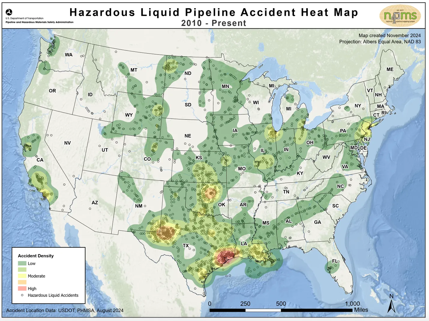
More than 2 million oil and gas wells sit unplugged across the country. Many leak contaminants like brine, methane and benzene into waterways, farmland and neighborhoods. The industry has already left hundreds of thousands of old wells as orphans, meaning companies walked away, leaving taxpayers, government agencies or other drillers on the hook for cleanup.

Americaโ€™s oil fields are increasingly split between a small number of wells producing record profits and everything else. Researchers estimate roughly 90% of wells are already dead or barely producing.

Consider the Permian Basin, the worldโ€™s most productive oil field, stretching from West Texas across southeastern New Mexico.

โ€œThe Permian is the oil patchโ€™s Alamo โ€” thatโ€™s where itโ€™s retreating to,โ€ Regan Boychuk, a Canadian oil cleanup researcher, said of the oil industry. โ€œThatโ€™s their last stand.โ€

Even here, many wells sit idle and in disrepair. Itโ€™s time to plug them, according to a growing chorus of researchers, environmentalists and industry representatives.

The question of who pays for cleanup remains unanswered. Time and again, oil companies have offloaded their oldest wells. Their tactics are not written down in one place or peddled by a single law firm โ€” but companies follow an unmistakable pattern. The strategy, which is legal if followed properly, has become such a tried-and-true endeavor that researchers and environmentalists dubbed it โ€œthe playbook.โ€

Clark Williams-Derry, an analyst with clean-energy-focused think tank the Institute for Energy Economics and Financial Analysis, studies fossil fuel companiesโ€™ cleanup costs. โ€œThereโ€™s almost a cheerleading squad for shedding your liabilities, like a snake sheds its skin and just slithers away,โ€ he said.

Should you want to become an oil executive and try this strategy yourself, hereโ€™s how it works โ€ฆ

As you launch your business, begin by collecting subsidies, tax breaks and other incentives from the government to guarantee you can pump oil and gas profitably. Globally, fossil fuel subsidies total in the trillions each year, according to organizations such as the International Monetary Fund.

Next, start pumping and profiting.

As you set up your business, create layers of shell companies. Down the road, theyโ€™ll provide a firewall between you and your liabilities โ€” key among them, cleanup costs.

Once oil and gas production slows, sell low-producing wells. Smaller drillers operating on thinner margins, known in the business as โ€œscavenger companies,โ€ will be happy to take them off your hands.

Rinse and repeat by selling wells as their profits slow to a trickle. Theyโ€™ll be sold again to ever-smaller companies that teeter on the edge of insolvency. Maintenance and environmental stewardship will usually fall by the wayside as companies eke out a profit. Studies show that the number of environmental violations rises as wells pass to less-capitalized drillers. But these wells arenโ€™t your problem any longer.

Pull any remaining profits before regulators hit you with violations and fines for your remaining wells that arenโ€™t pumping and may be leaking.

Then, idle the wells โ€” pausing production, but not plugging them or cleaning up โ€” and walk away. Regulators are typically tasked with ensuring that as much oil as possible is pumped out of the ground, so rules allow wells to sit idle, instead of being plugged, in case prices surge and it becomes profitable to restart them. However, a study in California found that, after wells are inactive for only 10 months, thereโ€™s a 50-50 chance they will never produce again.

Regulators will likely grow tired of asking you to clean up your wells, but you can make the case for leaving them unplugged for now. Pitch grand plans, as other drillers have โ€” maybe repurposing the wells for bitcoin mining, carbon sequestration or the synthesis of hydrogen fuel โ€” that require the wells to remain open.

When regulatorsโ€™ patience has reached its limit, remind them what will happen if they come down hard on you. Fines or other extra costs could force your business into bankruptcy, leaving your unplugged wells as orphans and taxpayers on the hook. Ask them if they want to be responsible for that catastrophe.

โ€œThe root of the problem is thereโ€™s no regulator of the oil industry across North America,โ€ Boychuk said, adding that โ€œthe rule of law has never applied to oil and gas.โ€

When regulators finally act, declare bankruptcy. The Bankruptcy Code is meant to protect businesspeople like you who took risks. More than 250 oil and gas operators in the U.S. filed for bankruptcy protection between 2015 and 2021, according to law firm Haynes Boone. (Industry groups estimate there are several thousand oil companies in the country.)

Regulators only require oil and gas companies to set aside tiny bonds that act like a security deposit on an apartment. Because you didnโ€™t clean up your wells, youโ€™ll lose that money, but itโ€™s a fraction of the profits youโ€™ve banked or the cost of the cleanup work. ProPublica and Capital & Main found that bonds typically equal less than 2% of actual cleanup costs.

And as you finalize your exit, the labyrinth of shell corporations you set up should act as corporate law intends, protecting you from future responsibility. Such companies, little more than stacks of paper, will be responsible for your liabilities, not you. Even if regulators know who is behind a company, it becomes increasingly difficult to penetrate each layer of a business to go after individual executives.

โ€œItโ€™s the essence of corporate law,โ€ Williams-Derry said.

Now that youโ€™ve offloaded your wells, youโ€™re free to start fresh โ€” launch a new oil company and buy some of your old wells for pennies on the dollar, a proven option. Maybe you leave oil entirely โ€” thatโ€™s also tried-and-true. Or become a vintner and open a winery just down the road from the wells you left as orphans โ€” you wouldnโ€™t be the first.

For its part, the oil industry downplays the so-called playbook and the countryโ€™s orphan well epidemic. โ€œThereโ€™s a general trend, which is there are very few orphan wells,โ€ said Kathleen Sgamma, who has been among oil companiesโ€™ most vocal proponents as president of the Western Energy Alliance, an industry trade group. Plus, she said, companiesโ€™ bonds and statesโ€™ orphan well funds help pay for plugging.

But those tasked with addressing the reality of the countryโ€™s orphan wells disagree. โ€œWe have a welfare system for oil and gas. I hope you understand that,โ€ said New Mexico Commissioner of Public Lands Stephanie Garcia Richard, who oversees the stateโ€™s public lands. New Mexico has already documented more than 1,700 orphan wells across the state. โ€œWe have oil and gas welfare queens.โ€

In New Mexico, Garcia Richard is trying to hold accountable one of the myriad drillers that have followed key steps in the playbook, the oil company known as Siana.

Siana is made up of two related entities โ€” Siana Oil and Gas Co. LLC and Siana Operating LLC โ€” based in Midland and Conroe, Texas. The company operated 11 wells in southeastern New Mexico in the heart of the Permian Basin.

In reality, Siana is the corporate shield for a man named Tom Ragsdale. After he aggregated his few wells, he generated cash through a trickle of oil and gas production and set up a business injecting other companiesโ€™ wastewater into his wells to dispose of it. But the state worried that Ragsdaleโ€™s operations were polluting the environment and that he was refusing to pay royalties and rental fees he owed the state, according to State Land Office staff.

Ragsdale did not respond to repeated requests for comment from ProPublica and Capital & Main. He also did not appear for a pretrial conference after the state brought legal action against Siana, court records show, and a state court judge ruled against his companies.

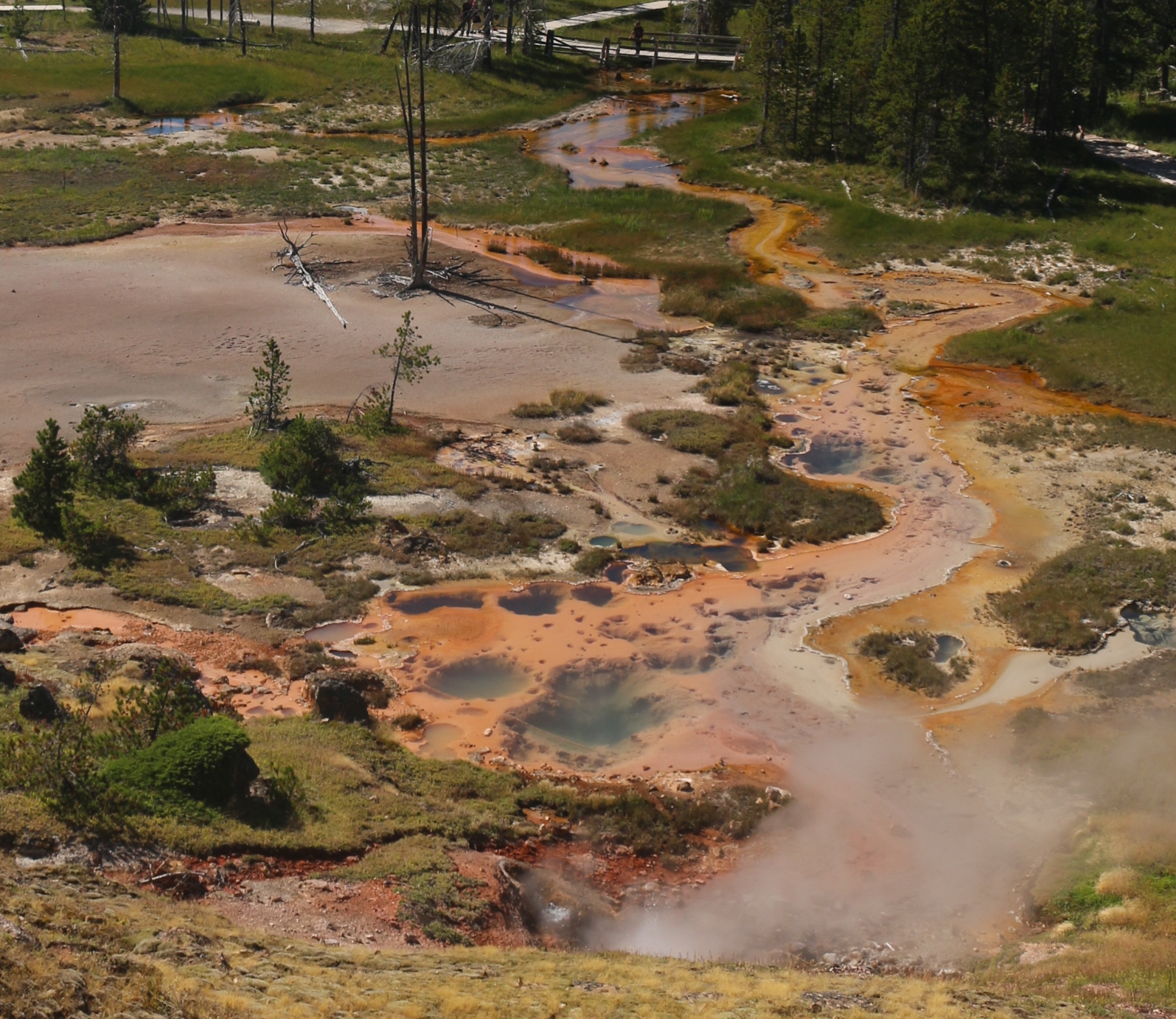
Siana was responsible for at least 16 spills, according to New Mexico Oil Conservation Division data, mainly spilling whatโ€™s called produced water, a briny wastewater that comes to the surface alongside oil and gas. โ€œCorrosionโ€ and โ€œEquipment Failureโ€ were among the causes.

The State Land Office hired an engineering firm to study the damage. The firm produced a damning 201-page report in 2018, finding oil and salt contamination exceeding state limits at Sianaโ€™s most polluted site. At high enough levels, these substances can kill plants, harm wildlife and impact human health.

The State Land Office estimated that cleaning up that site alone would cost about $1 million.

In 2020, New Mexico won a judgment against Ragsdaleโ€™s companies that, with interest, is now worth more than $3.5 million. But it wonโ€™t cover the cleanup cost. Between a small bond and the judgment, the state has been able to recover a mere $50,000 or so from Siana and related entities.

When the state tried to collect the rest, Ragsdale placed Siana Oil and Gas in bankruptcy protection in June 2023. Although he listed the company as having millions in assets at the time of the bankruptcy, the company had only $20,500 in a bank account. Court records show Siana is responsible for between $1 million and $10 million in liabilities, including money owed to the state of New Mexico, other oil companies, various counties and others.

Stickers plastered around Sianaโ€™s drill sites โ€” on which the companyโ€™s name is misspelled โ€” provide phone numbers to call in case of leaks or other emergencies. None went to Ragsdale or Siana employees. A man named William Dean answered one number. He owned a local oil field services company called Deanโ€™s Pumping that was contracted to work on Sianaโ€™s wells, but Ragsdale stopped paying its bills, ultimately owing his company tens of thousands of dollars, Dean said.

โ€œHe was trying to half-ass things,โ€ Dean said of Ragsdale. โ€œI donโ€™t know what happened to Tom.โ€

Sianaโ€™s bankruptcy case is ongoing, but Ragsdale has been largely unresponsive even in those proceedings.

Siana is, Garcia Richard said, โ€œan exemplar of how our system has failed.โ€ Although he was very nearly free of his old wells, Ragsdale flouted the playbook and ignored the bankruptcy judgeโ€™s demands that he participate in the case. In an unusual move, the judge in late September issued a warrant for Ragsdaleโ€™s arrest to compel him to hand over certain data. The U.S. Marshals Service was investigating Ragsdaleโ€™s whereabouts but had not taken him into custody as of mid-December, according to an agency representative.

The day after the judge issued the arrest warrant, the bankruptcy trustee filed a complaint alleging Ragsdale had committed fraud, siphoning about $2.4 million from Siana to purchase real estate in Houston.

That money could have gone toward cleaning up the mess left to New Mexico taxpayers.

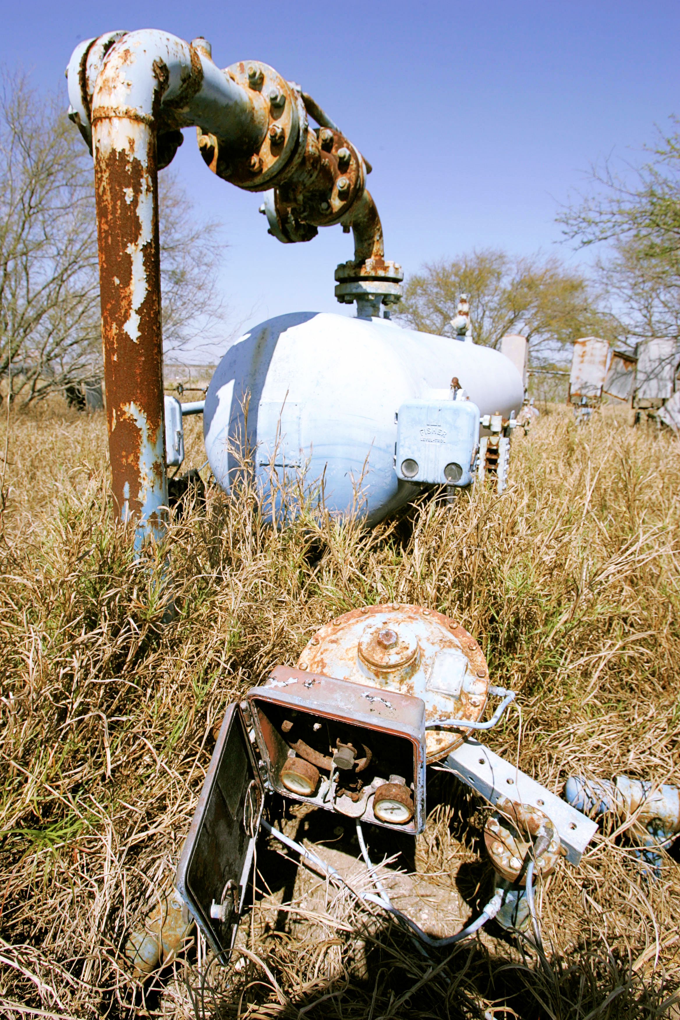
ProPublica and Capital & Main visited Sianaโ€™s 11 wells in late 2023. At one drill site, methane leaked from a wellhead that had also stained the surrounding land black from spilled oil. The air was sour with the smell of toxic hydrogen sulfide. A nearby tank that held oil for processing was rusted through. Another had leaked an unidentified liquid. There appeared to be hoofprints where cattle had tracked through the polluted mud.

ProPublica and Capital & Main found oil spills at multiple Siana wells. At others, the idle pump jacks stood silent โ€” corroded skeletons at the end of the line, the detritus of another run through the playbook.

Efforts to reform the system that has shielded oil companies from liability have been haphazard. When the federal government rewrote its rule setting bond levels on federal public land earlier this year, a simple math error meant the government would ask oil companies to set aside around $400 million less in bonds than it wouldโ€™ve otherwise. And when states have tried to pass reforms, theyโ€™ve been stymied by state legislatorsโ€™ and regulatorsโ€™ chummy relationships with the industry.

As an ever-greater share of wells go offline and the economy transitions to cleaner forms of energy, policymakers face a choice: Do they focus attention on propping up or cleaning up the industry?

Sgamma of the Western Energy Alliance gives voice to one path forward. โ€œAny time a well goes into an orphan status, itโ€™s not a good thing,โ€ Sgamma said, yet her group has been instrumental in killing efforts to address the orphan well epidemic and the oil industryโ€™s contributions to climate change. Her organization is suing to halt the federal rule that sought to bring bonding levels closer to true plugging costs.

Sgamma co-authored the energy section of Project 2025, the conservative policy paper with deep ties to the first Trump administration that lays out policy priorities for a conservative White House. The plan would โ€œStop the war on oil and natural gas,โ€ reopen undeveloped habitat from Alaska to Colorado for drilling, increase the number of sales for oil leases on public lands and shrink federal environmental agencies. President-elect Donald Trump has repeatedly indicated this closely aligns with his vision for pumping Americaโ€™s โ€œliquid gold.โ€ He has begun staffing his administration with pro-oil and gas figures.

The future for which Sgamma is fighting sees a resilient American oil and gas industry, able to โ€œtake a lot of punchesโ€ while continuing to grow unabated.

Or thereโ€™s the future Garcia Richard, who oversees New Mexicoโ€™s public land, envisions. She has paused the leasing of public land to drillers until the Legislature forces oil companies to pay state taxpayers higher royalties that reflect fair market rates. She directed her staff to aggressively pursue companies like Siana. And her office is preparing to raise required bonding levels. As she talked about this work, she held up the literal rubber stamp that imparts the State Land Officeโ€™s seal on documents, suggesting thatโ€™s not how business is done anymore. She also held up a small notebook where she tracks the numerous companies her office is pursuing for polluting the stateโ€™s land and water.

In her future, Garcia Richard said, oil drillers wouldnโ€™t behave like Siana and Ragsdale. โ€œA good-acting company is a company that understands thereโ€™s a cost of doing business that shouldnโ€™t be borne by the landowner, shouldnโ€™t be borne by the taxpayers,โ€ she said. But in the modern American oil industry, she added, the playbook and the still-burning fuse of the cleanup time bomb represent little more than โ€œWild West behavior.โ€

$24.97 million to support #RioGrande headwaters conservation projects: Federal funding comes in final days of Biden Administration; will support restoration efforts in #Colorado and #NewMexico — #Alamosa Citizen

Rio Grande, looking south near Cole Park. The Alamosa Riverfront Project is among several that received funding last week under the 2022 Inflation Reduction Act. Credit: The Citizen

Click the link to read the article on the Alamosa Citizen website:

January 20, 2025

Conservationists focused on the Rio Grande Basin signal it as an initial win in a battle for federal dollars to address the impacts of drought and the need for a sustainable water supply.

Theyโ€™ve seen how the federal government has kicked into gear to address the same issues on the Colorado River Basin, and have wondered why the Rio Grande Basin largely has been ignored.

Until now. 

The U.S. Department of Interior and Bureau of Reclamation announced last week in the final days of the Biden Administration a $24.97 million award to support water conservation and habitat restoration efforts in the headwaters of the Rio Grande.

Itโ€™s a drop in the bucket compared to the billions that have been awarded to projects on the Colorado River, but itโ€™s a start.

โ€œTodayโ€™s announcement provides a critical down payment that will make the headwaters of the Rio Grande better prepared to handle the ongoing impacts of drought, while supporting state and local efforts to sustainably manage water supplies for future generations,โ€ said Alexander Funk, Director of Water Resources, Theodore Roosevelt Conservation Partnership.

The money came through the 2022 Inflation Reduction Act (IRA) and was among the final announcements by the Biden Administration of funding awarded through the federal legislation. 

The significance of that is nobody in the agriculture, conservation, and water world knows if the incoming Trump Administration will carry on with the Inflation Reduction Act, or if that particular federal legislation and the $369 billion approved by Congress falls to the wayside.

โ€œWeโ€™re shocked we got anything,โ€ said Amber Pacheco of the Rio Grande Water Conservation District and member of the Rio Grande Basin Roundtable. She described a rush at the end to send to the Bureau of Reclamation โ€œshovel-readyโ€ projects that could earn IRA funding.

โ€œIt was a โ€˜quick overnight, send some projects that we can fund,โ€™โ€ said Pacheco.

Rio Grande and Pecos River basins. Map credit: By Kmusser – Own work, Elevation data from SRTM, drainage basin from GTOPO [1], U.S. stream from the National Atlas [2], all other features from Vector Map., CC BY-SA 3.0, https://commons.wikimedia.org/w/index.php?curid=11218868

Out of the award comes funding for a variety of projects in the San Luis Valley as well projects for the middle Rio Grande in New Mexico. Overall, $18 million will go toward Rio Grande Basin projects in Colorado and $7 million for Rio Grande restoration efforts in New Mexico.

The San Luis Valley and Conejos Water Conservancy Districts, the Rio Grande Water Conservation District and the Rio Grande National Forest in southern Colorado are among the eight recipients selected under one cooperative agreement to receive $24.9 million for several drought resiliency activities in the Upper Rio Grande Basin, the Bureau of Reclamation said in announcing the money.

For the Valley, those projects will include the Alamosa Riverfront Restoration project; Rio Grande Reservoir Low Flow Valve; Pine River Weminuche Pass Ditch Turnback Structure; Lower Conejos River Restoration Project; Platoro Reservoir Restoration and Wildfire Risk Mitigation Project โ€“ Phase 1; Saguache Creek Multi-benefit Restoration at Upper Crossing Station; and Rio Grande Confluence Restoration Project, among others.

โ€œThis announcement shows that when Colorado and New Mexico work together, big things can help that benefit fish and wildlife, support local economies, and tackle some of the regionโ€™s most pressing water challenges,โ€ said Funk.

โ€œThe Rio Grande is the underpinning that supports the economic and ecological health of the region. This funding allows conservation partners to critically address and relieve the challenges this habitat and community have experienced from long-term drought and sustainability insecurity,โ€ said Tracy Stephens, senior specialist for riparian connectivity at The National Wildlife Federation. โ€œWe applaud the Bureau of Reclamationโ€™s investment and recognition of the importance of riparian health and habitat connectivity. This funding is an important step forward in a collective effort to achieve well-connected and functional riparian corridors to protect the wellbeing of people, plants, and wildlife in the Upper Rio Grande.โ€

Screen shot from the Vimeo film, “Rio Grande Headwaters Restoration Project: Five Ditches,” https://vimeo.com/364411112

Water-short #RepublicanRiver Basin hits farm dry-up milestone, as #Kansas looks on — Jerd Smith (Fresh Water News)

Republican River in Colorado January 2023 near the Nebraska border. Photo credit: Allen Best/Big Pivots

Click the link to read the article on the Water Education Colorado website (Jerd Smith):

January 16, 2025

Farm communities on the Eastern Plains, under the gun to deliver water to Kansas and Nebraska, are poised to permanently retire 17,000 acres of land, with the help of $30 million in state and federal funding.

Creating a balance of water that’s taken from aquifers and water that replenishes aquifers is an important aspect of making sure water will be available when itโ€™s needed. Image from โ€œGetting down to facts: A Visual Guide to Water in the Pinal Active Management Area,โ€ courtesy of Ashley Hullinger and the University of Arizona Water Resources Research Center

From Wray, to Yuma to Burlington, growers are being paid to permanently shut off irrigation wells linked to the Republican River to ensure the vital waterway can deliver enough water to neighbors to the east, as required under the Republican River Compact of 1943.

As of this month, ranchers had already retired 10,000 acres under the program, and the rest will be set aside in coming months.

By 2029, the region must retire an additional 8,000 acres, as required under a compact resolution signed in 2016, for a total of 25,000 acres, according to Deb Daniel, general manager of the Republican River Water Conservation District, which is overseeing the initiative.  This is occurring in an area on the south fork of the river.

According to Colorado State University it is one of the largest dry-ups of irrigated agricultural lands in the West.

The dry-up has allowed Colorado to meet a critical deadline with Kansas, demonstrating that it was making progress on the goal.

Coloradoโ€™s Republican River Basin. Credit: State of Colorado.

โ€œWe did it,โ€ said Daniel. But more work remains. 

The 2022 funding came under the American Rescue Plan Act, the COVID-relief program that Congress approved giving states hundreds of millions of dollars to buffer the effects of the pandemic.

Through that program, Colorado lawmakers approved $30 million to the Republican and $30 million to the Rio Grande Basin as well for a similar program.

This year, the Republican Basin will receive another $6 million in state funding to continue paying farmers to permanently shut off wells.

โ€œAgriculture is the economic driver for the northeastern counties of Colorado. This is a difficult situation for the producers,โ€ said Jason Ullmann, state engineer with the Colorado Division of Water Resources. โ€œI know this work hasnโ€™t been easy, and more must be done. I applaud the Republican River Water Conservation District for their major efforts to reach this deadline,โ€ he said in a statement.

A new analysis shows a nearly 30% decline in Coloradoโ€™s irrigated lands in the last 25 years, driven in part by the stateโ€™s legal obligations to deliver water across state boundaries, as in the Republican Basin. Other factors include declining river flows due to climate change and drought, and the dry-up of farmlands by fast-growing cities.

Daniel said water officials hope they can continue to pay farmers to permanently retire land and to do so in a way that doesnโ€™t cripple the regional economy.

โ€œWe need time to let these communities adjust, to adapt to having less irrigated agriculture. As these wells go down, our communities are adjusting, but most of the time, unless they have other industries, the communities just go away,โ€ Daniel said.

More by Jerd Smith

More than 9,000 Landsat images provide vegetation health metrics for the Republican River Basin. Credit: David Hyndman

EPA takes unprecedented step to remove uranium waste from the Navajo Nation: The decision opens the door for new ways to manage uranium pollution on tribal land — Natalia Mesa (High Country News)

Red Water Pond Road Community leader, Larry King, addresses plans to relocate the Quivera Mine Waste Pile that is located about 1,000 feet from the closest residence. Shayla Blatchford

Click the link to read the article on the High Country News website (Natalia Mesa):

January 17, 2025

As a child, herding her grandmotherโ€™s sheep, Teracita Keyanna unknowingly wandered onto land contaminated with radioactive waste from three abandoned uranium mine and mill waste sites located near her home on the Navajo Nation. 

Keyanna and other Dinรฉ citizens have been living with the consequences of uranium mining near the Red Water Pond Road community since the 1960s. But now, uranium waste rock that has sat for decades at a Superfund site will finally be moved to a landfill off tribal land.

โ€œThis is a seismic shift in policy for Indigenous communities,โ€ said Eric Jantz, an attorney for the New Mexico Environmental Law Center. 

On Jan. 5, in a first-of-its-kind move, the Environmental Protection Agency signed an action memo to transport 1 million cubic yards of low-grade radioactive waste from the Quivira Mining Co. Church Rock Mine to a disposal site at the Red Rock Regional Landfill. The Northwest New Mexico Regional Solid Waste Authority owns and operates the landfill, which is located about 6 miles east of Thoreau, New Mexico. 

โ€œI feel like our community has finally had a win,โ€ Keyanna said. She is a member of the Red Water Pond Road Community Association, a grassroots organization made up of Dinรฉ families that have been advocating for the waste removal for almost two decades. โ€œItโ€™ll help the community heal.โ€

Companies extracted an estimated 30 million tons of uranium ore on or near the Navajo Nation from 1944 to 1986, largely to fuel the federal governmentโ€™s enormous nuclear arsenal. When the mines were abandoned in the 1980s, the toxic waste remained. Today, there are hundreds of abandoned mines in plain sight on the Navajo Nation, contaminating the water, air and soil. Altogether, there are an estimated 15,000 uranium mines across the West โ€” 1,200 of them on the Navajo Nation alone โ€” with the majority located in the Four Corners region. 

The impact of all this mining on Dinรฉ communities has been devastating. A 2008 study found uranium contamination in 29 water sources across the Navajo Nation, while other studies show that people living near waste sites face a high risk of kidney failure and various cancers. 

At Quivira, the cleanup is set to begin in early 2025 and will continue for six to eight years, according to an EPA news release. The permitting process, which will provide opportunity for public comment, will be overseen by the New Mexico authority that manages the proposed waste site and is responsible for its long-term safety monitoring.  

Mine Waste Area with Limited Vegetation. Photo credit: EPA

The EPA had considered multiple options for waste remediation. But for years, Red Water Pond Road advocates and other local organizations continually pushed it to simply remove the waste, a course of action that the EPA has never taken before, even though the Navajo Nation has repeatedly called for the federal government to move all uranium waste from Dinรฉ tribal land. 

Throughout the Navajo Nation, said Jantz, โ€œprior to this decision, EPAโ€™s primary choice in terms of remediation of mine was to bury the piles under some dirt and plant some grass seeds on top, called cap in place.โ€ But studies have shown that this approach is not effective at containing radioactive waste in the long term, he said. 

The agency took a similar approach when addressing the other uranium waste in the Church Rock area. In 2013, the EPA and the Nuclear Regulatory Commission, which oversees uranium mine-waste cleanup, dumped 1 million cubic yards of waste from the Northeast Church Rock Mine โ€” a different waste site, roughly 3 miles from the Quivira Mine โ€” on top of existing tailings located half a mile from the Red Water Pond Road communities. 

But the EPA plans to handle the Quivira Mineโ€™s waste differently, placing it in geoengineered disposal cells with a groundwater leak protection system after it is moved off-site, an approach that Jantz called โ€œstate-of-the-art.โ€

The Quivira Mine cleanup is part of the 2014 Tronox settlement, which provided $5.15 billion to clean up contaminated sites across the United States. The settlement allocated $1 billion of those funds to clean up 50 uranium mines across the Navajo Nation. 

There is a lot more to be done, said Susan Gordon, coordinator for the Multicultural Alliance for a Safe Environment, a grassroots organization led by uranium-impacted communities. Hundreds of abandoned mines pepper the Navajo Nation, and the EPA has not formulated a broader plan to clean up the majority of them. Funding is also an issue, she added. 

What the EPAโ€™s decision means for the future of uranium mine waste remediation is unclear. Under other circumstances, Jantz said that the decision would signal a sea change for the EPAโ€™s policy of removing waste from the Navajo Nation. But the incoming Trump administration has not indicated its policy on hazardous waste disposal.

As Jantz put it, โ€œAll bets are off.โ€

Graphic credit: Environmental Protection Agency

Record precipitation in 2024 gave little relief to irrigators: Most of the water ended up in the soil, not the unconfined aquifer — @AlamosaCitizen #RioGrande #SanLuisValley

Gauging station near Mogote on the Conejos River. Record precipitation did not translate to record river flows. Credit: The Citizen

Click the link to read the article on the Alamosa Citizen website:

January 15, 2025

Alamosa never gets 16 inches of total precipitation in a year. Never. Ever. Except that it did in 2024. 

Turns out, 2024 was among the wettest on record across the San Luis Valley going back to 1895, with all six counties registering historic levels of precipitation. Here are the precipitation totals by county, according to data from the NOAA National Centers for Environmental Information:

  • Alamosa County, 16.75 inches
  • Conejos County, 24.29 inches
  • Costilla County, 22.53 inches
  • Mineral County, 32.60 inches
  • Rio Grande County, 19.66 inches
  • Saguache County, 21.86 inches

The headscratching is how so much moisture was realized in a year when the unconfined aquifer of the Upper Rio Grande Basin dropped to near its lowest level, which became problematic for irrigators who are under orders by the state of Colorado to reduce their groundwater pumping to help recover the ailing aquifer.

โ€œTwo things,โ€ said Cleave Simpson, general manager of the Rio Grande Water Conservation District and local hay grower. โ€œWe didnโ€™t have continuous steady snowpack in the winter months that put us in a good position, and then the volume of snow we got was on top of drier conditions last fall where moisture, instead of showing up in a stream, ends up in the ground in soil conditions.

โ€œSo to that end, this year at my farm in October, I get an inch and a half of rain, in October. That never, ever happens. So the hope is then, that nice soil moisture that we got in October will set us up for success.โ€

Craig Cotten, division engineer for the Colorado Division of Water Resources, said the wet 2024 was a boon to local farmers and their efforts to recover the Valleyโ€™s aquifers. What it didnโ€™t do was increase the amount of water stored in reservoirs.

โ€œThe reservoirs in the Rio Grande Basin in Colorado typically store water in winter when the senior priority ditches are shut off. The reservoirs can also store during the irrigation season, but only if there is a significant amount of water in the rivers to serve not only the irrigation ditches but the reservoirs as well,โ€ said Cotten.

โ€œThis typically requires very high river flows, which did not occur in 2024 even with the rain events that were the primary reason for the high precipitation total in 2024. The significant rains in the Rio Grande Basin did increase the river flows, but not enough to get the reservoirs into priority. The increase in reservoir storage in 2024 was about typical of what occurs in an average year.โ€

Without the high levels of precipitation in 2024, the critical unconfined aquifer was in danger of falling to a level of storage nobody was expecting to see after years of irrigators working to reduce their groundwater pumping.

Colorado precipitation for the 12 months ending January 15, 2024. Credit: High Plains Regional Climate Center.

โ€œThe large amount of precipitation in the Rio Grande Basin during the summer of 2024 helped the unconfined aquifer in multiple ways,โ€ said Cotten. โ€œThis precipitation increased the streamflow in the Rio Grande throughout the summer, allowing the ditches and canals to divert more water than they otherwise would have.

โ€œThis increased diversion in turn allowed delivery of a higher amount of water into recharge pits and the aquifer. The precipitation also helped to meet the irrigation needs of the crops, allowing the farmers to not pump their wells as much as they would otherwise.โ€

The hope among local farmers is that the wet fall months of 2024, when October and November delivered more than 11 inches of snow, will translate into an above-average spring runoff and give a boost to surface water coming into the Valley in 2025.

Rio Grande and Pecos River basins. Map credit: By Kmusser – Own work, Elevation data from SRTM, drainage basin from GTOPO [1], U.S. stream from the National Atlas [2], all other features from Vector Map., CC BY-SA 3.0, https://commons.wikimedia.org/w/index.php?curid=11218868

Cleanup of abandoned uranium mines set to start after Navajo Nation, EPA reach agreement — AZCentral.com

Graphic credit: Environmental Protection Agency

Click the link to read the article on the AZCentral.com website (Arlyssa D. Becenti). Here’s an excerpt:

January 8, 2025

After years of demanding the cleanup of uranium waste at the Kerr-McGee Quivira Mines on the Navajo Nation community advocates got the news this week that the Environmental Protection Agency will remove waste rock from three areas of the site and move it to a new off-site repository. The removal of over 1 million cubic yards of radioactive waste from the sites about 20 miles northeast of Gallup will begin in early 2025, the EPA said. The waste will be taken to a new off-site repository at Red Rocks Landfill east of Thoreau, N.M. The process, including permitting, construction, operation and closure of the repository, is expected to take 6-8 years.

โ€œI feel as though our community finally has something of a win,โ€ said Teracita Keyanna, a member of the executive committee for Red Water Pond Road Community Association. โ€œRemoving the mine waste from our community will protect our health and finally put us back on a positive track to Hรณzhวซ.โ€

Commercial exploration, development, and mining of uranium at Quivira Mines began in the late 1960s by the Kerr-McGee Corporation and later its subsidiary. The mine sites are the former Church Rock 1 (CR-1) mining area; the former Church Rock 1 East (CR-1E) mining area; and the Kerr-McGee Ponds area. The mines were in operation from 1974 to the mid-1980s and had produced about 1.2 million tons of ore, making them among the 10 highest producing mines on the Navajo Nation…From World War II until 1971, the U.S. government was the sole purchaser of uranium ore, driving extensive mining operations primarily in the southwestern United States. These efforts employed many Native Americans and others in mines and mills. Between 1944 and 1986, nearly 30 million tons of uranium ore were extracted from Navajo lands under leases with the Navajo Nation. With over 500 abandoned uranium mines โ€” many say the total could be in the thousands โ€” clean up of mines has always been a battle.

Do homebuyers know enough about a propertyโ€™s water? What to ask the real estate agent — Fresh Water News

The downtown Denver skyline from Arvada. Photo credit: Allen Best/Big Pivots

Click the link to read the article on the Water Education Colorado website (Shannon Mullane):

January 2, 2025

Potential property owners are often not asking enough questions about water, experts say โ€” and it can end up being a costly mistake.

When someone buys a property in Colorado, they can find themselves thrust into the complicated world of Western water. People looking in towns and cities might need to learn about providers and rate changes. Those interested in empty lots, unincorporated areas of  counties or rural areas of the state might need to study up on water rights, wells and irrigation.

If theyโ€™re prepared, buyers will reach out to experts, and even attorneys, to understand the ins-and-outs of their new water supply before signing a deal. If theyโ€™re not, they could end up in the middle of a fight or with an expensive liability.

โ€œThere have been neighborly confrontations over water,โ€ said John Wells, a broker and owner of the Wells Group in Durango. โ€œIโ€™ve seen people turn other peopleโ€™s ditches off, locking their headgates, unlocking their headgates. It doesnโ€™t make for a good neighborly situation.โ€

Western water law is frequently confusing โ€” even for experts and real estate agents. Interested buyers coming from out of state are often used to a completely different system of managing water. Urban residents looking to move into rural Colorado might have little experience with ditches, ponds or water law.

โ€œMost brokers donโ€™t understand it because itโ€™s complicated and confusing, and it doesnโ€™t really impact their clientโ€™s ability to purchase a house,โ€ said Aaron Everitt, a Fort Collins-based broker and developer with The Group Real Estate.

But skipping past a thorough review of water assets can leave buyers with frustrating problems. They might face water bill increases, lead pipes, or leaky sprinklers. For more rural properties, a typo or missing signature in a water or land deed can take an extra month to fix. Ponds and reservoirs on a property might actually be illegal water storage โ€” which could take a court process or big dollars to resolve, said Bill Wombacher, an attorney with Nazarenus, Stack & Wombacher, who teaches a water law class for real estate agents.

New property owners might be surprised to see a stranger in their backyard clearing out a ditch โ€” or, as happened in 2022 in Kittredge, dozens of people using private property to access a popular creek running through private property, which prompted a local debate about public access.

It is easier to handle any water questions that come up before a deal is signed, and buyers might want to budget extra time in the purchase process for tasks like well inspections, said Amanda Snitker, chair of the market trends committee for Denver Metro Association of Realtors.

One piece of advice: โ€œBe sure theyโ€™re being thorough. Donโ€™t be afraid to ask questions, even though they might seem silly,โ€ Wells said. โ€œThereโ€™s no silly question when it comes to water.โ€

So what kind of questions should a buyer ask? [We] asked the experts to break it down.

I want to buy in an urban area. Where do I start?

People interested in buying a home, apartment or townhome in a more populated area โ€” like a town, city, special district or planned development โ€” should start by understanding their water supply and who provides it.

Is the property already connected to a main water system?

If so, it can save money for the buyer. Tap fees, the cost of adding a new connection, can be as low as $1,500 to $8,000, said Wells, who works in small towns and rural areas in southwestern Colorado. Or, the price of tapping into the local water system could be more like $50,000 in areas of the Front Range or $200,000 in some areas of the Western Slope where water supplies are tight, Wombacher said. Some water providers can also freeze adding new connections when their water system or supply is maxed out.

Who is the propertyโ€™s water provider? 

Some areas come with more established networks of pipes, canals, tunnels and reservoirs operated by a water provider. These water districts and utility providers are public entities, and buyers should know how functional or dysfunctional the organization is, Everitt said.

Itโ€™s also helpful to understand if the organization is planning to build new water infrastructure or has a backlog of needed repairs, Snitker said. The cost of water and related fees can vary depending on the water provider, and itโ€™s good to know those details up front, she said.

Graphic credit: EPA

The experts also recommended learning about wastewater systems, water quality and any water-related expenses that could come up for new owners. Here are some questions they recommended asking:

  • Can the seller provide 12 months of water bills?
  • Are there any broken sprinklers or leaky pipes?
  • Can buyersย add water-efficiency features, like systems that capture grey water or rain?
  • Has the property ever had any issues with galvanized pipes? Does it have any lead pipes?
  • What is the quality of the water, and are there any contaminants?
  • If there is a septic system, how old is it and where is it located?

Outside of a service area? Hereโ€™s how to begin.

Not all properties lie within an established service area for a water provider, like homes in unincorporated areas, rural counties and some new developments.

Homes, ranches and land in rural areas also might come with water rights โ€” a complicated part of how Coloradans access water.

When a buyer tours a property, they should keep an eye out for certain features to know what to ask: Look for wells, ponds, lakes, ditches, streams, irrigation systems and other outdoor water features, experts said.

This Parshall flume on Red Mountain measures the amount of water diverted by the Red Mountain Ditch. Pitkin County commissioners approved a roughly $48,000 grant to pipe the last 3,600 feet of the ditch in the Starwood neighborhood. CREDIT: HEATHER SACKETT/ASPEN JOURNALISM

Whatโ€™s up with ditches

Colorado is covered with a decades-old network of ditches that help transfer water to farmers, ranchers and communities around the state. These are often earthen, straight and clearly human-made, but they can also be easy to miss.

For Wombacher, ditch easements are the single most-frequent source of frustration among his clients, he said.

They are tied to a complicated system of water rights, which means ditch users have legal rights to receive a certain amount of water at specific times and locations during the year.

Ditch managers and users can move up and down the channel, even on private property, to do maintenance and manage water supplies.

That means property owners might see water flowing, but itโ€™s not theirs to use. They cannot disrupt the transfer of water, use ditch water or move the ditches (unless they go to water court). If that does happen? โ€œItโ€™s like an immediate lawsuit every single time,โ€ Wombacher said.

Questions to ask:
  • Is it actively used?
  • How might this impact what I can and canโ€™t do with the property?
  • If Iโ€™m not able to move the ditch, do I still want the property?
  • Who operates the ditch?
See a pond, get the papers

If a buyer sees a pond or lake on the property, they should ask for the water court decrees attached to the stored water.

This pond in Chaffee County near Salida is one of thousands in the Arkansas River Basin that is being evaluated by the Division 2 engineerโ€™s office as part of a new pond management program. Engineers say ponds without decreed water rights could injure senior water rights holders. Photo credit: Colorado Division of Natural Resources via Aspen Journalism

โ€œThere are quite a few unlawful uses going on out there, particularly with ponds and reservoirs,โ€ Wombacher said.

Property owners build water storage and sometimes do not go through the water court process to get a legal right to access, store and use the water.

โ€œJust because a seller has been able to get away with something for a long time, doesnโ€™t mean the buyer will,โ€ Wombacher said. โ€œAnytime thereโ€™s a water use going on on a property, you want to make sure as a buyer that itโ€™s a lawful use.โ€

Typical water well

What does it mean if thereโ€™s a well?

The state of Colorado regulates wells, and well permits come with specifications about how much water can be used and what it can be used for.

Interested buyers should start by learning about water court decrees and permits related to the well. The state has databases that can provide more information about a well using its permit number.

Adding new wells can be expensive and come with limitations based on the location and characteristics of a property, like whether it is larger or smaller than 35 acres, experts said. Buyers will also want to ask about any water quality, contamination or pressure issues in advance.

Questions to ask: 
  • If there is not a well โ€” and a buyer might want one โ€” what are the options for getting a well?
  • Can you provide a recent inspection report?
  • Does the well produce the amount of water stated in the permit? If not, the property might need aย cistern.

โ€œJust like you do a home inspection, you call someone and they do a well inspection,โ€ Snitker said.

What do I need to know about water rights?

Many properties, especially in rural areas, come with irrigation water supplies โ€” and therefore, water rights.

Water rights can add value to a property, but they also come with restrictions related to where, when and how much water can be used. These rights are legally tied to certain beneficial purposes, like farming, drinking, snowmaking, fire prevention and more.

โ€œI think a lot of lay people, and itโ€™s not their fault, think they can use water anytime they want,โ€ Wells said.

Some water rights are also more valuable than others: Under Colorado water law, more recently established โ€œjuniorโ€ rights get cut off first when water is short so older and more valuable โ€œseniorโ€ rights get their share.

Donโ€™t need irrigation water? A property owner has to go to water court to change details of a water right. And a new owner canโ€™t just own a water right and plan never to use the water for its intended purpose. If that happens, the state might analyze whether a right has been โ€œabandoned,โ€ which could dissolve the right.

Water rights are often transferred from one owner to another using a deed or a title. New buyers should check to make sure these documents are in good order, Wells said.

โ€œSometimes itโ€™s prudent to hire a water attorney to make sure that what is in the deed matches what youโ€™ll actually be sold,โ€ he said.

Questions to ask:
  • How much water can I use, when, where and for what purpose?
  • What year is the water right, and how senior is it compared with others on the same stream or river?
  • What is the supply like in periods of drought?
  • Does the water right match what Iโ€™d like to use the water for, or could I have to go to water court to change it?
  • Are the ditches, canals and other infrastructure that deliver the water well-maintained?
  • What fees come with the water supply?

More by Shannon Mullane

#Colorado Parks and Wildlife to award $1.1 million to projects that restore wetland habitat for waterfowl and at-risk species: Application deadline February 10, 2025

Photo credit: Colorado Parks and Wildlife

Click the link to read the release on the Colorado Parks and Wildlife website (Joey Livingston):

December 23, 2024

DENVER โ€” Colorado Parks and Wildlife is seeking applications for wetland and riparian restoration, enhancement and creation projects to support the Wetlands for Wildlife Program.

This year, CPW will award over $1.1 million in funds from Great Outdoors Colorado (GOCO) and Colorado Waterfowl Stamps to projects in Colorado that support the Wetlands Program Strategic Planโ€™s two main goals: 

  1. Improve the distribution and abundance of ducks, and opportunities for public waterfowl hunting. Applications supporting this goal should seek to improve fall/winter habitat on property open for public hunting (or refuge areas within properties open for public hunting) or improve breeding habitat in important production areas (including North Park and the San Luis Valley in Colorado, and other areas contributing ducks to the fall flight in Colorado).
  2. Improve the status of declining or at-risk species. Applications supporting this goal should seek to clearly address habitat needs of these species. See the identified threats, recommended conservation actions, and progress to date for these species in the Colorado State Wildlife Action Plan (SWAP) Conservation Dashboards.

Wetlands for Wildlife application guidance and instruction is available at: cpw.state.co.us/wetlands-wildlife-grants. The application deadline is Monday, Feb. 10. 

About the program
The Colorado Wetlands for Wildlife Program is a voluntary, collaborative and incentive-based program to restore, enhance and create wetlands and riparian areas in Colorado. Funds are allocated annually to the program and projects are recommended for funding by a CPW committee with final approval by the Director.

โ€œWetlands are so important,โ€ said CPW Wetlands Program Coordinator Brian Sullivan. โ€œThey comprise less than two percent of Coloradoโ€™s landscape, but provide benefits to over 75 percent of the species in the state, including waterfowl and several declining species. Since the beginning of major settlement activities, Colorado has lost half of its wetlands.โ€

Since its inception in 1997, the Colorado Wetlands Program and its partners has preserved, restored, enhanced or created more than 220,000 acres of wetlands and adjacent habitat and more than 200 miles of streams. The partnership is responsible for more than $40 million in total funding devoted to wetland and riparian preservation in Colorado.

Permafrost is thawing across Boreal and Arctic lands, causing old carbon stored in soil or sediment to be released to the atmosphere as CO2 or CH4 — Dr. Merritt Rae Turetsky (โ€ช@queenofpeat.bsky.socialโ€ฌ)

Permafrost is thawing across Boreal and Arctic lands, causing old carbon stored in soil or sediment to be released to the atmosphere as CO2 or CH4. A lot of these emissions occur in winter because post-thaw soils can become too wet to freeze, like this thaw bog in northwestern Canada.

Dr. Merritt Rae Turetsky (@queenofpeat.bsky.social) 2024-12-30T18:03:39.848Z

2024 – 2025: Look back, look ahead — @AlamosaCitizen

On Sunday, Dec. 29, the daytime high of 57 degrees in Alamosa established a new record for the date, making December 2024 one of the warmest Decembers this century. | Credit: The Citizen

Click the link to read the article on the Alamosa Citizen website:

December 30. 2024

A mild December caps a year of unusual weather for Alamosa and the greater San Luis Valley. Or maybe itโ€™s just the new normal in a century of changing climates and chaotic weather patterns.

The month of December brought 10 different 50-degree weather days, and an average temperature of 45 degrees โ€“ or 10 degrees above whatโ€™s been historically normal, according to figures from the National Weather Service.

On Sunday, Dec. 29, the daytime high of 57 degrees in Alamosa established a new record for the date, making December 2024 one of the warmest Decembers this century.

The summer and late fall were strange as well this year. Between May and August, the Valley floor received 6.14 inches of rain, making it one of the wettest four-month periods on record this century.

For perspective, the San Luis Valley typically experiences 7 inches of total precipitation and around 30 inches of measurable snow each year. In 2024, Alamosa experienced 11.36 inches of precipitation and 37 inches of snow.

Those late spring and summer rains came off a record amount of total snow in March when 14.5 inches fell, way above the 4 inches of snow that is typical for the month. Indeed, 2024 was a strange, wet weather year.

Yet, the Upper Rio Grande Basin continues to struggle and local irrigators remain under state pressure to reduce their groundwater pumping and retire more fields. In August alarm bells went off for water managers when readings of the unconfined aquifer storage levels shockingly showed the critical aquifer near its lowest measurable point.

โ€œYouโ€™re always under pressure and the sense of urgency is always there,โ€ said Cleave Simpson of the stress farmers and ranchers in the San Luis Valley face to recover the ailing aquifers of the Rio Grande. He works as general manager for the Rio Grande Water Conservation District and represents the Valley and most of southwestern Colorado as a state senator.

In his role as state legislator, Simpson sponsored legislation that resulted in $30 million committed to pay Valley irrigators to retire more groundwater wells to reduce their groundwater pumping. Over the past dozen years, payments made to either temporarily or permanently fallow agricultural fields and reduce the amount of groundwater pumped in the Valley have totaled $100 million, according to figures Simpson cited on this episode of The Valley Pod.

The podcast episode with Simpson looks back on the century and how the new millennium, now 25 years in, has been dominated by the effects of climate change.

U.S. Drought Monitor July 23, 2002.

โ€œFrom climate, in particular, 2002 was this critical moment in time for us. Thatโ€™s when the whole paradigm shifted for the San Luis Valley and Colorado and really the western U.S.,โ€ said Simpson. โ€œThat was the worst drought in our recorded history. The Rio Grande had never seen those kinds of diminished flows, ever, since we started recording it.

โ€œItโ€™s basically since 2002 till today, thatโ€™s 22 years of this drying, this no snow pack, this change in how runoff occurs, and the timing and the volumes.โ€

Simpson and others who closely follow the weather patterns of the San Luis Valley say itโ€™s no longer drought but aridification settling into the soil that the Valley will wrestle with as the 21st century proceeds.

Weโ€™ll see now what 2025 has in store.

Rio Grande and Pecos River basins. Map credit: By Kmusser – Own work, Elevation data from SRTM, drainage basin from GTOPO [1], U.S. stream from the National Atlas [2], all other features from Vector Map., CC BY-SA 3.0, https://commons.wikimedia.org/w/index.php?curid=11218868

A #RepublicanRiver Basin milestone — Allen Best (@BigPivots)

Republican River in Colorado January 2023 near the Nebraska border. Photo credit: Allen Best/Big Pivots

Click the link to read the article on the Big Pivots website (Allen Best):

December 23, 2024

10,000 acres in the basin have now been retired from irrigation. But Colorado must remove 15,000 more acres before 2030.

Colorado has achieved a milestone, retiring 10,000 acres from irrigation in the Republican River Basin of northeastern Colorado.

But a much larger, more difficult challenge lies ahead. The state must retire 25,000 acres before 2030 in order to comply with the compact with Nebraska and Kansas governing water in the basin.

The Colorado Division of Water Resources announced on Dec. 20 that Nebraska and Kansas agreed that Colorado has taken the necessary actions to retire the minimum 10,000 acres based on executed contracts and aerial data collected in the summer of 2024.

The compact between the three states was ratified in 1942. Then came the widespread adoption of high-capacity wells followed by center-pivot sprinklers that permitted exploitation of the Ogallala and other aquifers. The aquifers feed into various forks of the Republic River.

Flows in the river subsequently declined. Kansas and Nebraska complained, rolling out the legal sabers. That resulted in formation of the Republican River Water Conservation District in 2004 to address the over-drafting of the aquifer. A resolution between Colorado and its neighbors in 2016 gave Colorado a specific target. It must figure out how to eliminate irrigation from 25,000 acres in the South Fork of the Republican River by the end of 2029.

Wells in the Republican River Basin in Colorado.

Dick Wolfe, then the state water engineer, was asked in September of 2016 how this would be accomplished. He paused a moment, then pretended to have a scissors in his hands, as if a barber, saying โ€œBit here, a bit there.โ€ And that is what has been happening.

Irrigators in the district contribute to the district on a per-acre basis. The money is used to induce irrigators to end their diversions via the wells.

State legislators in 2023 allocated $30 million to supplement the districtโ€™s self-generated funds to sweeten the pot. The Colorado Water Conservation Board earlier this year added another $6 million.

The map below shows the location of wells in the district. It mostly lies between Interstates 70 and 76.

Some parts of the aquifer, mostly in the southern parts, ceased to have sufficient water for pumping. At a meeting this year in Wray, directors of the conservation district were told that even in the better areas along the North Fork of the River, in the Yuma and Wray areas, water levels have been dropping a foot and a half a year.

There is some agreement among directors that stepped-up action must be taken in order to meet the 2029 deadline for retirement. They will take up that discussion at a February meeting.

See also:

The declining Ogallala Aquifer

Facing hard deadlines in water and in climate, too 

The Republican River basin. The North Fork, South Fork and Arikaree all flow through Yuma County before crossing state lines. Credit: USBR/DOI

#Kansas and #Nebraska Agree that #Colorado Has Reached #RepublicanRiver Compact Milestone — Colorado Department of Natural Resources

Republican River in Colorado January 2023 near the Nebraska border. Photo credit: Allen Best/Big Pivots

Click the link to read the release on the Colorado Department of Natural Resources website (Michael Elizabeth Sakas):

December 20, 2024

Colorado has officially reached the milestone of retiring more than 10,000 acres of farmland from irrigation in the southern Republican River basin. These efforts are necessary to stay in compliance with the Republican River Compact with Kansas and Nebraska.

Depleted groundwater in the Republican River Basin has impacted how much surface water flows east. To remedy this, the Republican River Compact Administration (โ€œRRCAโ€) adopted a resolution in 2016 to retire 10,000 acres in this part of the basin by 2024.

An additional 15,000 acres need to be retired by December 31, 2029. Colorado is already well on its way to meeting this second milestone, with nearly 7,000 additional acres under contract for retirement.

โ€œAgriculture is the economic driver for the northeastern counties of Colorado. This is a difficult situation for the producers,โ€ said Jason Ullmann, State Engineer with the Colorado Division of Water Resources. โ€œI know this work hasnโ€™t been easy, and more must be done. I applaud the Republican River Water Conservation District for their major efforts to reach this deadline.โ€

Colorado provided Kansas and Nebraska with the executed contracts and aerial data collected in the summer of 2024. Kansas and Nebraska agreed that Colorado has taken the necessary actions to retire at least 10,000 acres.

โ€œBy working together with the State of Colorado, the Republican River Water Conservation District continues to make great strides in complying with the ongoing requirements imposed by the 2016 Republican River Compact Administration Resolution,โ€ said Deb Daniel, general manager of the Republican River Water Conservation District. โ€œThe RRWCD continues, with financial support from Colorado, to provide funding to compensate well owners who are willing to voluntarily retire a portion of their irrigated acres to ensure that Colorado and the Republican Basin achieve and maintain compliance with the compact.โ€

Earlier this year, the Colorado Water Conservation Board approved $6 million to be included in the proposed 2025 CWCB projects bill to support efforts to retire additional acres in the Republican River basin. In 2022, the Colorado state legislature unanimously approved $30 million in the pursuit of retiring the required irrigated acres. The CWCB administers those funds, which were awarded through Senate Bill 22-028.

Kansas River Basin including the Republican River watershed. Map credit: By Kmusser – Self-made, based on USGS data., CC BY-SA 3.0, https://commons.wikimedia.org/w/index.php?curid=4390886

An Abrupt Decline in Global Terrestrial Water Storage and Its Relationship with Sea Level Change — Springer Nature Link

Click the link to access the report on the Springer Nature Link website (Matthew Rodell,ย Anne Barnoud,ย Franklin R. Robertson,ย Richard P. Allan,ย Ashley Bellas-Manley,ย Michael G. Bosilovich,ย Don Chambers,ย Felix Landerer,ย Bryant Loomis,ย R. Steven Nerem,ย Mary Michael Oโ€™Neill,ย David Wieseย &ย Sonia I. Seneviratne). Here’s the abstract:

November 4, 2024

As observed by the Gravity Recovery and Climate Experiment (GRACE) and GRACE Follow On (GRACE-FO) missions, global terrestrial water storage (TWS), excluding ice sheets and glaciers, declined rapidly between May 2014 and March 2016. By 2023, it had not yet recovered, with the upper end of its range remaining 1ย cm equivalent height of water below the upper end of the earlier range. Beginning with a record-setting drought in northeastern South America, a series of droughts on five continents helped to prevent global TWS from rebounding. While back-to-back El Niรฑo events are largely responsible for the South American drought and others in the 2014โ€“2016 timeframe, the possibility exists that global warming has contributed to a net drying of the land since then, through enhanced evapotranspiration and increasing frequency and intensity of drought. Corollary to the decline in global TWS since 2015 has been a rise in barystatic sea level (i.e., global mean ocean mass). However, we find no evidence that it is anything other than a coincidence that, also in 2015, two estimates of barystatic sea level change, one from GRACE/FO and the other from a combination of satellite altimetry and Argo float ocean temperature measurements, began to diverge. Herein, we discuss both the mechanisms that account for the abrupt decline in terrestrial water storage and the possible explanations for the divergence of the barystatic sea level change estimates.

Article Highlights

  • Global terrestrial water storage, excluding glaciers and ice sheets, declined abruptly between May 2014 and March 2016, with a corollary increase in sea level
  • A series of droughts, possibly linked to global warming, has since helped to prevent global terrestrial water storage from recovering
  • Also around 2015, two independent estimates of barystatic sea level began to diverge, but we find no evidence of a connection with the terrestrial water storage decline
Illustration of the NASA’s Gravity Recovery and Climate Experiment Follow-On (GRACE-FO) spacecraft, which will track changes in the distribution of Earthโ€™s mass, providing insights into climate, Earth system processes and the impacts of some human activities. GRACE-FO is a partnership between NASA and the German Research Centre for Geosciences. Credits: NASA/JPL-Caltech

#OgallalaAquifer Summit: Collaboration on the High Plains — NOAA

Click the link to read the article on the NOAA website:

December 11, 2024

A patchwork of green circles dot the landscape across the High Plains of the United States, their green grid created by sprinklers irrigating with well water pumped from the Ogallala Aquifer. Relying heavily on the Ogallala Aquifer, farmers and livestock growers in this semi-arid region produce nearly one-fifth of the wheat, corn, cotton and cattle produced in the United States as of 2011.

The importance of the Ogallala Aquifer and the communities it supports cannot be overstated. Irrigation of crops significantly boosts productivity and supports the socioeconomic lifeblood of this region. Agricultural sales from the Ogallala Aquifer region contribute billions of dollars to local economies and national gross domestic product. 

However, the Ogallala Aquifer is in trouble. Groundwater measurements in the Ogallala Aquifer show ongoing declines in aquifer water quality and quantity. The shared water resource can be managed sustainably, but this will require cooperation by water users within the region and support from those outside of the region who also benefit from it.

In March 2024, NOAAโ€™s National Integrated Drought Information System (NIDIS) and the Irrigation Innovation Consortium at Colorado State University partnered with the Kansas Water Office and others in the region to host the third Ogallala Aquifer Summit.

The Summit brought together more than 230 crop and livestock growers, scientists and technical experts, water managers, governments (local, state, and federal), and other partners to work to address water management challenges within the region. Summit opening remarks were delivered by Kansas Governor Laura Kelly and U.S. Senator for Kansas Jerry Moran.

โ€œWithout water there is no agriculture, and without agriculture there are no rural communities in the High Plains,โ€ said Kansas Senator Jerry Moran. โ€œThe future of the High Plains region depends on leadership to preserve water.โ€

This third Summit built on successes of past Summits led in 2021 and 2018 by the Irrigation Innovation Consortium. Key takeaways from the Summit were summarized in the recently published 2024 Ogallala Aquifer Summit Summary Report. The Summit program was split among four sessions, each devoted to some aspect of the theme, “Building Trust, Mobilizing Collaboration.”

Session 1: Applying Science and Data for Regional Agricultural Sustainability

The opening session focused on the science of the hydrology and climatology of the region with the goal of building trust and collaboration between scientists, who are working to understand the dynamics of the Aquifer, and business leaders and decision-makers, who are implementing the knowledge being produced. Presenters highlighted the value seasonal climate predictions provide to manage risks to the community, as well as tools to support decisions to withdraw groundwater. 

Session 2: Harnessing the Power of Peer Networks

The next session focused on harnessing the power of peer networks to bring people together to share successes and lessons learned. This included a presentation about the successes of the Master Irrigators program in some states, and successes in individual regions and farms when solutions are implemented.

Session 3: Mobilizing Supply Chain Partners

The second day opened with a focus on the nationwide and global risk presented by Ogallala water challenges. Water scarcity in this region impacts local, national, and global economies, and even national security, because, as one panelist pointed out, “food security is national security.” Producers underscored the need to recognize the economic value of water in approaches to address these risks. 

Subsequent discussions focused on mobilizing supply chain partners to support agricultural sustainability within the region. Sustainable water use in the Ogallala not only impacts local farmers within the region, but major corporations from across the country and the world who rely on Ogallala water. Customers at grocery stores across the country buy bread or beef that was grown from Ogallala water. Northern Texas alone produces 20% of U.S. cotton using water that is drawn from the Ogallala Aquifer. This cotton is being worn as t-shirts or blue jeans by millions of people around the world. Corporations who rely heavily on production in the High Plains regions are invited to be part of the ongoing conversation about sustainable use, hence the importance of mobilizing supply chain partners.

Session 4: Building the Future We Want: Thinking and Acting Intergenerationally

The final session focused on building intergenerational collaboration. Thinking and acting intergenerationally is about making sure there is a future for the next generation in the region. Participants discussed their desire for flexible and voluntary tools to manage the aquifer and a need for more educational opportunities to create future leaders and a skilled workforce for the next generationโ€™s water. 

The conference ended with a capstone session that asked Summit participants, โ€œWhat do you hope to be true in three years?โ€ This 90-minute conversation helped articulate the potential next-steps to arrive at real progress in the region. Participants hoped to return to the next Summit having made strides in communicating and collaborating further, developing and implementing new tools, and broadening educational and research opportunities in the region.ย 

Ogallala aquifer via USGS

Historic water rights settlements yet to deliver lifeline to Navajo Nation — The Navajo Times #ColoradoRiver #COriver #aridification #CRWUA2024

Navajo Reservation map via NavajoApparel.com

Click the link to read the article on the Navajo Times website (Donovan Quintero). Here’s an excerpt:

December 15, 2024

At the Colorado River Water Users Association conference last week in Las Vegas, Nevada, representatives from the 25th Navajo Nation Council, the Navajo Nation Department of Justice, the Office of the President and Vice President, and the speakerโ€™s office outlined the significant water challenges facing Navajo communities and the opportunities presented by ongoing water rights settlement agreements. Crystal Tulley-Cordova, a hydrologist with the Navajo Nation Department of Water Resources, stated at the conference that the tribe is committed to safeguarding water resources across its 27,000-square-mile Navajo Nation, which spans Arizona, Utah, and New Mexico…Tulley-Cordova explained that the Navajo Nation has historically relied on groundwater, which can take thousands of years to recharge…

Three key water rights settlement acts are critical to the Navajo Nationโ€™s water future, Tulley-Cordova stated. The Northeastern Arizona Indian Water Rights Settlement Act of 2024, the Navajo Gallup Water Supply Act of 2023, and the Navajo Nation Rio San Josรฉ Stream System Water Rights Settlement Act of 2024 provide opportunities to secure water rights and avoid costly litigation…

The CRWUAโ€™s 2024 report highlighted significant developments and challenges in water management, particularly emphasizing the efforts of the Ten Tribes Partnership. The partnership, established in 1992, includes tribes with federally recognized water rights in the Colorado River Basin, such as the Navajo Nation, the Ute Indian Tribe, and the Southern Ute Indian Tribe, which collectively hold rights to approximately 20% of the riverโ€™s mainstream flow…The Navajo Nation was a focal point of the report, with updates on key infrastructure projects such as the Navajo-Gallup Water Supply Project. The initiative, supported by federal legislation, will deliver reliable drinking water to underserved Navajo communities by 2029. Recent advancements include the awarding of a $267 million contract for the San Juan Lateral Water Treatment Plant, one of the projectโ€™s cornerstone facilities. The report also highlighted innovative collaborations, such as the Jicarilla Apache Nationโ€™s efforts to use its settlement water rights creatively. By leasing water to the state of New Mexico, the tribe supported endangered species preservation while funding essential water delivery projects. These collaborative approaches demonstrate how tribal water rights can address both ecological and human needs.

The complexities of a sustainable Subdistrict 1: Groundwater modeling expert discusses the nuances of one-for-one pumping and recovering groundwater levels — @AlamosaCitizen #RioGrande #SanLuisValley

Credit: Rio Grande Water Conservation District

Click the link to read the article on the Alamosa Citizen website:

December 8, 2024

Call it a meeting of the minds โ€“ Willem A. Schreรผder, the CU computer scientist behind the groundwater modeling of the Upper Rio Grande Basin, and a group of San Luis Valley irrigators who are racing against time to reduce groundwater pumping in what state water engineers call โ€œone of the most productive irrigated farming areas in the state.โ€

Schreรผder spent more than an hour at a Dec. 4 meeting with farmers who form the governing board of Subdistrict 1 of the Rio Grande Water Conservation District. They wanted to know if the subdistrictโ€™s upcoming Fourth Plan of Water Management, which calls for irrigators to limit their groundwater pumping to the amount of surface water that naturally flows in, is going to work. 

Itโ€™s called one-for-one pumping, and while the plan has been approved by the Subdistrict 1 board, the Rio Grande Water Conservation District board and the state engineer, it still needs sign off from the state water court, which likely wonโ€™t happen until 2026.

While all the Valleyโ€™s farmers face pressure to reduce groundwater pumping in the face of a changing climate, itโ€™s the crop producers in Subdistrict 1 who are on the clock and under state orders to recover groundwater levels of the unconfined aquifer and maintain a sustainable irrigation water supply by 2031.

Itโ€™s Schreรผderโ€™s mathematicsโ€™ modeling that clues in the Colorado Division of Water Resources to the response the river system and aquifers are having through a steady reduction of groundwater pumping over the past two decades.

Schreรผderโ€™s expert witness testimony explaining the Rio Grande Decision Support System (RGDSS) model has been the subject of state water court proceedings and undoubtedly will be again in upcoming cases.

His session with Subdistrict 1 managers yielded a few insights, notably:

  • The recharge of streams should occur as close to the point of where the groundwater pumping occurred, a problem that has particularly come to light around Saguache Creek and the groundwater pumping that occurs in that area of the Valley.
  • The formation of the newย Southern Colorado Water Conservancy Districtย will complicate the RGDSS model in ways Schreรผder still has to figure out.
  • As much as the RGDSS model can be useful in showing the response of the river to less groundwater pumping, there is always an imbalance even if irrigators are perfectly recharging the same amount as theyโ€™ve pumped out.

What follows is a partial, edited transcript of the conversation to get at some of the more pertinent questions. Jake Burris, president of the Subdistrict 1 board of managers, opened the discussion:

Burris: The first question I would throw at you is, the anchor of the amended plan, should we be successful, is that we would only pump imported water as itโ€™s brought in. Live within our means, sort of speak. If that is the case, is it unreasonable to assume that we would not be generating any new depletions at that point?

Schreรผder: New depletions anywhere, or a particular stream?

Burris: Anywhere, any stream.

Schreรผder:ย So the short answer is โ€˜Noโ€™ in the sense that yes, we probably still will have the depletions, and what it comes down to is that the one-for-one plan essentially is one that deals with an average. So weโ€™re looking at a districtwide or subdistrict-wide average balance, whereas when we talk about stream depletions, weโ€™re talking about time, place, amount. And so itโ€™s very easy to construct a hypothetical situation where if you look at where the pumping occurs and where the recharge occurs, that those recharges in pumping are not exactly coincident and as a result, the distance between where you recharge and where you are pumping basically directs depletions to a particular direction. And so what could very likely occur is that on one stream you actually have an accretion and on another stream you have depletion. So on average you tend to be sort of in balance with the surface network, but the people on the stream that is depleted, are not going to be happy. . .So unless the way that the one-for-one works is that the recharge occurs in exactly the place where the pumping occurs, you likely will have depletions to some streams.โ€

Burris: So itโ€™s not just simply an issue from an administrative standpoint of us utilizing our recharge on an average. Thatโ€™s irrelevant. It is a logistics and timing problem, regardless?

Schreรผder: Thereโ€™s both a temporal and spatial component to that. Think about for example, the depletions to the Rio Grande and Iโ€™m making up numbers here, but just to make the argument easier, letโ€™s say 50 percent of your depletions occur in year one and then 30 percent in year two and 10 percent in years three and four. So itโ€™s front-loaded as far as when the depletions occur, and youโ€™re working on a five-year average and letโ€™s say for those first five years, or first four of the five years, letโ€™s say thereโ€™s negative 25,000 acre-feet of pumping to managed recharge. . .and then in the last year, year five, we basically have a 100,000 acre-feet of pumping in excess of recharge. So because half of that occurs in year one, and the offsets from two years and three years and four years and five years ago are lesser amounts, even though on the five-year average you are in balance, you could have a situation that on the Rio Grande in that first year after the big pumping you do not have an impact. So itโ€™s both the temporal scale at which things happen, as well as the spatial scale. Itโ€™s also a reflection of where did that recharge occur and where did the pumping occur. If you average it out, they donโ€™t fall right on top of each other.

Burris: The way the model then is I guess essentially looking at it for lack of a better way, but from a temporal and spatial standpoint, Sub 1โ€™s aquifer itself is irrelevant. Itโ€™s not looking at it from a form of recharging an aquifer as a whole and recharging for all the wells as a conglomerate. Itโ€™s looking at the individual wells and the areas around each well?

Schreรผder: As far as the model is concerned, yes.

Burris: I think thatโ€™s our big disconnect, or at least I should speak for myself there. The way Sub 1โ€™s structured is with the way the aquifer system is and the way we treat the wells and recharges, itโ€™s in totality. Itโ€™s as a conglomerate, and so you canโ€™t take that perspective in any way to the model?

Schreรผder: Thatโ€™s right? And so thereโ€™s actually three parts to this. The first is as far as Subdistrict 1โ€™s one-for-one is concerned, to a large part thatโ€™s going to address sustainability because what you put in and what you take out balances, that should be sustainable. So thatโ€™s the one part. The other part then, of course, is the groundwater modeling, which tries to figure out just exactly where the spring depletions occur. And then the third part to that is well, we need to calculate these response functions and the response function needs to capture the essential behavior of the model so that we have a simpler way of actually applying the inputs and predict what the depletions are. The problem that we are going to face in the future is that so far the response function approach has actually worked pretty well because what we found is that if you simply look at what the imbalance between pumping and recharge is in the โ€™90s and early 2000s, it did a pretty good job of predicting where the stream depletions would be if all you do is to calculate the net consumptive use and you run it through that function, and then you get the stream depletion prediction. But what if we go one-for-one and the next CU (consumptive use) is zero a lot of time, how are we going to figure out a response function that we can then use to predict what the stream depletion is? 

Burris: It is a possibility to reconsider conceptually how the model is I guess, the framework of the model? Or are we pretty much stuck with how the system is now, if that makes sense?

Schreรผder: I think we are fairly confident in the framework of the model because it is able to reproduce what has happened historically pretty well. The question that weโ€™re struggling with is โ€˜How do we ask the what-if question?โ€™ Had there not been wells or had the wells only operated in a way where the pumping matched the recharge, what would the stream depletions have been? And thatโ€™s a little bit more tricky question that we need to answer now. In the past, because there was always an imbalance between pumping and recharge, it sort of worked out. But if we are actually finding that we are leaving the response function zeros a lot, and if the model does all of the superimposition of individual wells in terms of one answer, and then we average things and we run that sort of the response function, we donโ€™t come up with that same answer, thatโ€™s the problem, right? Thatโ€™s the definition of non-linear. Linear means if you have a function that translates an input to an output, all you have to do is average the inputs and the function will give you the same average on the outputs. Whereas in the non-linear system, if you run the individual items through the function and you then average the results, you donโ€™t get the same answer. And thatโ€™s what we are struggling with. Will we be able to properly linearize that?

Burris: Iโ€™ll throw one more question at you and then Iโ€™ll let somebody else talk. What is the difference in impacts specifically, Iโ€™ll say, to Saguache Creek as far as the model sees them between unconfined wells and confined wells? Is the classification different in the model? Is the impact different, or are those treated the same sort of like we treat them the same in Sub 1?

Schreรผder: Theyโ€™re different in the sense that, because in the confined aquifer you typically have lower storage co-efficients, the columns of depression that accumulate for those tend to spread out wider and faster than they do in the unconfined aquifer. And so since the model basically just stacks all of those on top of each other and then calculates the total, it takes into consideration the fact that confined and unconfined wells behave differently. But as far as, can you tell me exactly how confined wells are, what the total is from confined wells and whatโ€™s the total from the unconfined wells? Iโ€™ve not tried to make that separation. We always just consider it in total because again, this is a non-linear system. So how you evaluate individual wells versus all of the wells in the subdistrict as a whole, if you add up all the individual wells, it doesnโ€™t add up to the total for the subdistrict as a whole. So itโ€™s a little difficult to make that clear distinction between the two.

Credit: Rio Grande Water Conservation District

The seventh iteration of the RGDSS model is being finalized by Schreรผder, which led to this exchange with another of the Subdistrict 1 managers. The conversation also then delved into the new Southern Colorado Water Conservancy District.

Sub1 Board: When will we have, โ€˜This is the final seven version?โ€™ Do we need to take action soon or can we wait a month or two for you to finalize it?

Schreรผder: So I am hoping, we have a meeting on Dec. 17, I think is the date, and Iโ€™m hoping to finalize the model for that, or at least get peopleโ€™s agreement that this is good enough that we should be moving on to the application of the model. So now we start asking the model questions, and itโ€™ll probably be several months if not a year before we go from OK, we now have a modelโ€™ translating that into, do we ask the right question for each zone and then what are the response functions that are coming out of that? So itโ€™s probably going to be at least a year before we have the answer that will apply for the next five or 10 years.

Sub 1 board member, on the Sustainable Water Augmentation Group known as SWAG: SWAG forming their own subdistrict and I guess trying to do it alone, how would you see that changing those fields and their new conservation district now outside of our subdistrict. Would that impact this data set?

Schreรผder: Well, I guess to the extent that they do their own thing, they give us more site-specific information, weโ€™ll try to incorporate that into the model. The difficult thing that we need to figure out is, โ€˜How do we deal with it separate from the rest of Sub 1?โ€™ And thatโ€™s not going to be easy.

Sub 1 board member: Just clipping those wells out of our dataset, youโ€™re saying itโ€™s not just as straightforward as, โ€˜Hey, these ones are closer to Saguache and theyโ€™re no longer in the map.โ€™ Does that help the math?

Schreรผder: Well, and I mean thatโ€™s part of the problem, right, is itโ€™s sort of obvious that yeah, those guys are probably having a bigger impact on Saguache Creek than the rest, but how do we actually run the model in such a way that we can actually quantify that? And thatโ€™s one of the problems that you have an nonlinear system, is if you start breaking it up into lots of little parts, the answer doesnโ€™t sum up to the total and that becomes problematic in terms of how do you figure out what the total impact on the stream is and how to distribute that back to individual people? And itโ€™s something that weโ€™ve worked very hard to avoid, but theyโ€™re sort of forcing our hand and I donโ€™t know exactly what the answers can be.

Sub 1 board member: You mentioned the substantial decrease in pumping over the last 10, 15 years in Subdistrict 1. Is there a scenario where if that were to continue or if wells were continuing to be retired in Sub 1, that that cone of depression would no longer reach Saguache Creek or we would no longer have applications in any scenario?

Schreรผder: Itโ€™s that balance, right, between where the recharge occurs and where the pumping is. So if we basically do one-for-one and we can put the recharge exactly where weโ€™ve pumped, then there should be no net cone of depression. And so thatโ€™s the problem, right? Thereโ€™s always an imbalance, and so even if you are perfectly recharging the same amount as you are pumping, itโ€™s always going to push the cone of depression in one direction.

Jake Burris: I once again will reiterate how appreciative I, and we are, that youโ€™re willing to make the trip down here and talk to us. It was hugely helpful, at least for me, just the general perspective o,f itโ€™s drastically different how we treat Sub 1 and administer it versus how the model sees it, I guess is how Iโ€™ll put it. But we do appreciate you taking the time.

Schreรผder: Well, and again, let me just reiterate. The sustainability requirement, thereโ€™s the modelโ€™s predictions of impact, and then the response functions themselves, and the way that the response functions work right now, by definition, if you had no net CU (consumptive use), there would be no depletion. But thatโ€™s the existing response functions, and thatโ€™s one of the things that we need to figure out at the end of phase seven is, OK that particular model of response function is probably not going to work again. So what are we going to do to fix that?

San Luis Valley Groundwater

How much water do Colorado communities actually need? In one, surprisingly little — Jerd Smith (Fresh Water News)

Front yard in Douglas Countyโ€™s Sterling Ranch are sparse on turf. Houses use well below the average volumes for Colorado. Photo/Allen Best

Click the link to read the article on the Water Education Colorado website (Jerd Smith):

November 25, 2024

Douglas County is adding new homes like crazy. Some of its towns plan to double in size in the next 30 years, but these new homes use shockingly little water, blowing up traditional water planning rules and raising questions about how much water Colorado communities need to grow.

Sterling Ranch, for instance, has more than 10 years of data showing that the master-planned community of 3,400 residences just off Interstate 25 near Littleton uses just 0.18 acre-foot of water for each single family home, about 30% less than most urban homes, where 0.25 to 0.50 acre-foot per home is the norm. An acre-foot equals 326,000 gallons.

The community conserves by requiring water-wise lawns, using super-efficient showers and toilets, and installing separate meters for indoor and outdoor use. It also uses recycled water for its parks.

In response, Douglas County has allowed Sterling Ranch to adopt much lower water standards for the thousands more new homes it plans to build. The community will hold 12,500 homes when it is fully built.

Since 2013, Douglas County commissioners have twice allowed the community to dedicate less water to new homes, agreeing to a reduced standard of 0.40 acre-feet, from 0.75 in 2013 and to 0.24 in 2021. Next month, Sterling Ranch and its water district, Dominion Water and Sanitation, will ask the county for the authority to set the standards in the future as it sees fit, without county review, something that incorporated cities, such as Parker and Castle Rock do now.

Lindsay Rogers, a municipal water conservation analyst with Western Resource Advocates, said the lowering of water demand standards is welcome news.

โ€œThe new standard is a good approach,โ€ she said, and very different from traditional planning efforts in Colorado, where cities routinely ask for much more water than is actually needed, placing higher demands on rivers and underground supplies and raising the cost of water service, a major contributor to higher home prices.

โ€œWe want to see counties, cities, and water providers setting a water dedication that is as closely aligned as possible with the water use on site,โ€ she said.

โ€œSterling Ranch is a great example who has done this well, and has proven savings, and should be rewarded for its efforts,โ€ she said.

More and more homes

Like other arid Western states being blistered by drought, warming temperatures, and lower stream flows, Coloradoโ€™s water future is not assured. The Colorado Water Plan predicts that the state could need up to 740,000 acre-feet of new water supplies by 2050 under the most dire planning scenarios, where the climate warms intensely and growth surges.

Cities are looking to add tens of thousands of homes to put roofs over the heads ofย  new residents. Someย estimates indicate as many as 325,000 new homesย will be needed.

But if new homes can operate with 30% less water than they once did, would that lessen future shortages and provide the state some breathing room? Possibly.

But itโ€™s not likely to do much, according to Kat Weismiller, acting head of the water supply planning section at the Colorado Water Conservation Board, because the scale of development is small.

โ€œWe look at a range of drivers, including social values, around water conservation and development to understand future water demands. While the new development at Sterling Ranch is innovative and sets an important example for how we can develop new communities in a water-efficient way, at this time, the scale of this type of development is fairly limited and it would be unlikely to meaningfully shift the way we forecast water needs at the state level or entirely close the gap,โ€ she said.

Ultra-water-efficient homes

The trend toward ultra-water-efficient homes appears to be on an upward trajectory.

Another large Douglas County development under consideration, the Pine Canyon Ranch on Castle Rockโ€™s border, asked for and has been given preliminary approval by the Douglas County Planning Commission to build 800 new homes and 1,000 townhomes and apartments with just 0.27 acre-feet of water per home.

Kurt Walker owns Pine Canyon Ranch. His family has been trying to annex into Castle Rock for 20 years. Tired of waiting for the city to act, the Walker family went to the county. Its plan calls for a sophisticated recycled water system and water-efficient homes.

The plan has drawn opposition from Castle Rock and others worried about the potential use of nonrenewable groundwater, and added traffic and congestion. If the land is annexed into Castle Rock โ€” talks are underway again โ€” the city would likely supply the water, bringing the ranchโ€™s groundwater into its own water system, which uses a combination of surface water, recycled water and groundwater. Castle Rock requires new homes to come with 1.1 acre-feet of water.

Walker said he believes a deal will eventually be reached with Castle Rock. But he defends his familyโ€™s use of the nonrenewable groundwater it owns. In Colorado, landowners typically own rights to the water contained in the aquifers beneath their land.

โ€œIf I really wanted to maximize the amount of houses on my property, I would not have reduced the water standard to 0.27. โ€ฆ Our plan would leave about 50% of our groundwater rights in the ground, untouched,โ€ Walker said. โ€œIf I was in this just to put as many houses on this property as I could, I would have taken everything out of the aquifer that I could. That could have added 600 or 700 houses onto what we proposed. But we didnโ€™t do that.โ€

Water stored in Coloradoโ€™s Denver Basin aquifers, which extend from Greeley to Colorado Springs, and from Golden to the Eastern Plains near Limon, does not naturally recharge from rain and snow and is therefore carefully regulated. Courtesy U.S. Geological Survey.

A look into the past

There was plenty of that type of development in the 1970s as Douglas County began to boom. Developers tapped its groundwater repeatedly. The water was so pure, it needed little treatment. Other cities, such as Denver, brought water over mountains from miles away. But here, it could just be pulled up through a water well. This helped keep the cost of building homes low and lured developers who built Highlands Ranch, Parker and Castle Rock.

But those underground water supplies proved to be fragile. Some aquifers can be recharged from snowmelt and rain, but these, in the Denver Basin, are sealed in rock formations which recharge slowly. As pumping increased, the aquifers declined. Soon, wells began to fail and alarms began ringing.

The water picture today is much different. In 1985, state lawmakers forced well owners to limit their pumping by extracting just 1% of available water supplies each year, in the hope of extending the aquifersโ€™ life for 100 years.

Now, though the Denver Basin aquifers continue to supply millions of gallons of water to Douglas County communities, the declines have slowed, and water districts and cities have moved to develop and use renewable surface supplies from rivers, and from recycled water plants.

And the county itself is much more concerned about future water supplies today. Though it does not own reservoirs and pipelines, it guides water use, as other counties do, by regulating how much water developers must bring to the table before they are approved to begin building.

This year it created its own Water Resources Commission and is creating a 25-year water plan. The county has been criticized for not creating a longer-term plan, say 100 or 300 years, as nearby counties have done. But County Commissioner George Teal said the 25-year plan is only a first-step.

โ€œWe plan on a 20-year horizon right now,โ€ he said. โ€œIt doesnโ€™t mean we wonโ€™t do a 100-year plan at some point.โ€

Some say itโ€™s time to stop groundwater use entirely

Steve Boand, a former county commissioner and water consultant, has been monitoring the health of the countyโ€™s groundwater supplies for decades.

He supports lower water requirements for new homes, but he wants the county to go further and outlaw building solely with nonrenewable groundwater, something he acknowledges isnโ€™t on the countyโ€™s political radar right now.

โ€œItโ€™s up to community planners to figure out what the right balance is โ€” 0.5 is OK, if a house only needs 0.3, and 0.2 can be allocated to other uses, like park land,โ€ Boand said. โ€œWe have to try these things to see if they will work.โ€

Western Resource Advocatesโ€™ Rogers says sheโ€™s encouraged by the data, at Sterling Ranch and elsewhere, that shows new homes can be built with much lower water profiles. That they are also likely to encourage more growth is real but less concerning, she said.

โ€œItโ€™s possible that these new standards will mean more homes,โ€ she said. โ€œBut growth is happening, and it is going to continue whether it is in Douglas County or other places in Colorado. The fact that the growth is happening in places like Sterling Ranch, where they have all of these efficiencies in place, is a good thing.โ€

More by Jerd Smith

New study says Arapahoe County sitting pretty on water supplies, for now — Jerd Smith (Fresh Water News)

Photo credit: KB Homes

Click the link to read the article on the Water Education Colorado website (Jerd Smith):

November 21, 2024

Arapahoe County has enough water to meet its needs through 2050, according to a new study, but major steps will need to be taken to reduce future demand and protect the countyโ€™s groundwater supplies.

Arapahoe County Commissioner Jeff Baker, in a statement, said the study is a cautionary tale, showing that while existing supplies generate 141,000 acre-feet of water each year, future growth could strain those supplies.

โ€œIf they want to build, they need to make sure there is enough water to provide adequate water resources to people. This is not a green light to develop,โ€ Baker said.

Arapahoe County is home to 656,000 people, who use 83,400 acre-feet of water a year. By 2050, those numbers are expected to soar, with population topping 900,000 and water demand increasing to as much as 116,000 acre-feet a year, according to the new report.

Water stored in Coloradoโ€™s Denver Basin aquifers, which extend from Greeley to Colorado Springs, and from Golden to the Eastern Plains near Limon, does not naturally recharge from rain and snow and is therefore carefully regulated. Courtesy U.S. Geological Survey.

As with other counties, Arapahoe County does not deliver water, relying instead on 12 separate water districts and agencies to supply its communities, according to Anders Nelson, a spokesman for the county. Some of its supplies come from renewable surface water โ€” primarily runoff from mountain snowpack โ€” while the more rural parts of the county rely on groundwater.

The study outlines several steps that should be taken to protect the fast-growing community southeast of Denver from future water shortages. The county will require developers to document adequate water for new construction projects; implement county-wide water-efficient landscaping rules, and encourage regional partnerships and water sharing agreements.

More by Jerd SmithJerd Smith is editor of Fresh Water News. She can be reached at 720-398-6474, via email at jerd@wateredco.org or @jerd_smith.

Group of irrigators forming new water conservation district: District would include 77 parcels in three counties, signals push away from Rio Grande Water Conservation District @AlamosaCitizen #RioGrande #SanLuisValley

Credit:ย court documents

Click the link to read the article on the Alamosa Citizen website:

October 26, 2024

A new water conservancy district is taking shape on the western end of the San Luis Valley that will compete for groundwater purchases to keep farms in operation and add to the complicated efforts to restore the underground aquifers of the Upper Rio Grande Basin.

Winding its ways through Colorado Division 3 Water Court is an application from a group of Valley irrigators to form the Southern Colorado Water Conservancy District and Groundwater Management Subdistrict. 

The farming operations that would belong to the new conservancy district would include 77 parcels of irrigated lands with an assessed valuation of $13.3 million, according to documents filed with the application. The parcels show up in Saguache, Rio Grande and Alamosa counties.

The application to form a new conservancy district comes from the same farm operators who formed the Sustainable Water Augmentation Group. Last year, SWAG filed for an alternative augmentation plan in state district water court in effort to avert a groundwater management plan approved by the Rio Grande Water Conservation District and its Subdistrict 1.

In essence, SCWCD has replaced SWAG in the fight for sustainability of farming and ranching in the western end of the Valley. The formation of a new conservancy district also signals a push away for these farm operations from the Rio Grande Water Conservation District and its strategies.

Once operational, Southern Colorado Water Conservancy District will find itself working with the Colorado Division of Water Resources to get its water management plans approved just as the Rio Grande Water Conservation District does for its members.

โ€œAgain, the primary objective of the SCWCD will be to obtain and operate a decreed plan or plans for augmentation, and/or a groundwater management plan, to allow landowners in the District to continue to operate their groundwater wells in accordance with Colorado law,โ€ the group said in its application filed with Division 3 water court.

The next district water court hearing on the application is scheduled in November.

Asier Artaechevarria, Willie Myers and Les Alderete โ€“ all three of whom formed the SWAG board of directors โ€“ would be the initial board of directors steering the Southern Colorado Water Conservancy District, according to court filings.

SCWCD would impose a mill levy tax upon the farms operating within its boundaries to pay for operations and strategy to adhere to the stateโ€™s groundwater pumping rules. The conservancy district would include approximately 250 wells, and the group said it plans to invest another $40 million to obtain approximately another 6,000 acre-feet of water to โ€œachieve and maintain a sustainable water supply.โ€

San Luis Valley Groundwater

Monday Briefing — @AlamosaCitizen #SanLuisValley #RioGrande

From email from the Alamosa Citizen:

October 21, 2024

Wet and dry 

In the case of the Upper Rio Grande Basin, two conflicting conditions can both be true at once. On one hand, the year has brought much more rain than is typical. With more than an inch of rain over the weekend, the San Luis Valley has seen more than 10 inches of total precipitation so far in 2024, or 3 inches above whatโ€™s normal, according to the National Weather Service. On the other hand, low snowpack in the San Juans and Sangre de Cristos from a winter ago left Valley farmers with less than a normal water year for irrigation. On May 6, the Rio Grande Basin had half of the typical snowpack, according to the Colorado Climate Center, and we know theย unconfined aquifer relied on by so many irrigators remains a major problem. The state currently has a five percent curtailment on groundwater wells in the San Luis Valley. In calculating its downstream water obligations to New Mexico under the Rio Grande Compact, Colorado is anticipating the Rio Grande to finish the irrigation season at 78 percent of whatโ€™s normal for flows and 80 percent on the Conejos River, according to Craig Cotten, division engineer for the Colorado Division of Water Resources.

San Luis Valley Groundwater

New conservancy district forms

Winding its way through Colorado Division 3 Water Court is an application from a group of Valley irrigators to form the Southern Colorado Water Conservancy District and Groundwater Management Subdistrict. The initial board of directors would be Art Artaechevarria, William Meyers, and Les Alderete, according to the application submitted to state water court in Alamosa. The formation of a new water conservancy district will allow the group of farmers to manage their own affairs when it comes to meeting Coloradoโ€™s rules governing groundwater pumping in the San Luis Valley. Like the Rio Grande Water Conservation District and its subdistrict formations, the new SOCO Water Conservancy District would impose a mill levy tax upon the farms operating within it to pay for its operations and strategy to adhere to the stateโ€™s groundwater pumping rules. The Southern Colorado Water Conservancy District has membership among farmers in Saguache, Rio Grande and Alamosa counties. The new water conservancy district will include approximately 250 wells, and in its application it tells the water court that the subdistrict plans to obtain approximately 6,000 acre-feet to augment depletions from wells and estimates it will cost $40 million to obtain the water. Thereโ€™s a lot more to this developing water story. More in the coming week.

Rio Grande and Pecos River basins. Map credit: By Kmusser – Own work, Elevation data from SRTM, drainage basin from GTOPO [1], U.S. stream from the National Atlas [2], all other features from Vector Map., CC BY-SA 3.0, https://commons.wikimedia.org/w/index.php?curid=11218868

Hearing this week on Rio Grande Compact case

The decade-long Rio Grande Compact case of Texas v. New Mexico and Colorado will have a hearing before retired Chief Judge D. Brooks Smith on Wednesday, Oct. 23, in Denver. Smith, who retired as chief judge of the U.S. Third Circuit Court of Appeals in 2021, was appointed new Special Master in the case by the U.S. Supreme Court in July. The appointment came after the U.S. Supreme Court agreed with the U.S. Department of Interior and denied a consent decree that the states had negotiated which would have settled the case. Smith now takes over the case and is expected to set a course of action during the hearing this week.

#Colorado Leading on #Geothermal: Governor Polis Congratulates Colorado Mesa University on Being a Featured Department of Energy Top Case Study

The benefits of this geo-exchange system extend beyond environmental impact. By significantly reducing energy costsโ€”saving millions of dollars each yearโ€”CMU is able to keep tuition affordable. These savings directly support the CMU Promise, additional merit aid, more scholarships, and other cost-saving initiatives that benefit students. Photo credit: Colorado Mesa University (June 7, 2024)

Click the link to read the release on Governor Polis’ website (Eric Maruyama):

October 11, 2024

Today, Governor Polis celebrated Colorado Mesa Universityโ€™s (CMU) nation-leading geothermal heating system for being recognized as one of only 19 case studies across the nation by the Department of Energy as one of the best geothermal systems. 

โ€œCongratulations to Colorado Mesa University for being featured as a U.S. Department of Energy case study for geothermal heating. CMU has one of North America’s largest geothermal heat pump systems and connects 16 buildings, providing 90% of the energy required to operate the campus. Plans are underway to connect the remaining campus buildings, comprising 800,000 square feet, to the central loop to achieve a 100% geothermal campus. CMUโ€™s work is a great example of Coloradoโ€™s leadership in providing clean, low-cost energy resources,โ€ said Governor Polis. 

CMUโ€™s gold-standard geothermal system regulates 1.2 million square feet of building space, has saved the university $15.9 million in heating and cooling costs since 2008, and reduces CMUโ€™s carbon footprint by nearly 18,000 metric tons of CO2 each year. As chair of the Western Governorโ€™s Association, Governor Polisโ€™s Heat Beneath Our Feet Initiative focused on advancing innovative geothermal solutions. Earlier this year, Governor Polis announced $7.7 million in awards for 35 Geothermal projects across the state. Governor Polis and the Colorado Energy Office also recently launched Tax incentives to increase Geothermal electricity production. 

#Colorado Supreme Court โ€œslow sipโ€ ruling could affect city water supplies from fast-growing #Greeley to #CastleRock — Fresh Water News

Water stored in Coloradoโ€™s Denver Basin aquifers, which extend from Greeley to Colorado Springs, and from Golden to the Eastern Plains near Limon, does not naturally recharge from rain and snow and is therefore carefully regulated. Courtesy U.S. Geological Survey.

Click the link to read the article on the Water Education Colorado website (Jerd Smith):

October 10, 2024

Nearly 40 years ago, after watching aquifers below Douglas County plunge amid fast growth and heavy use, Colorado lawmakers adopted a โ€œsip slowlyโ€ management process that required communities such as Parker and Castle Rock to pump out fixed amounts of nonrenewable groundwater each year in an effort to make the resource last at least 100 years.

Fast forward to 2020. That year, the state directed well owners to sip even slower, explicitly stating how much water their permits entitled them to, and requiring them to stop pumping at the end of that 100-year period if they have fully used the water to which they were entitled when the original well permits were issued.

But Parker and Castle Rock objected, suing the state over the new permitting language. They argued that the original volume estimates used to calculate their annual pumping rates were never meant as formal, total volume limits. Those limits, they argued, could sharply limit their future water supplies because they were essentially a best guess, based on measuring technology that has changed considerably since then.

Aurora and Greeley joined the case, siding with the state. A special water court ruled against Parker and Castle Rock, which together appealed to the Colorado Supreme Court. The high court is expected to issue a ruling in the case before the end of the year, according to spokeswoman Suzanne Karrer.

Under Coloradoโ€™s so-called 100-year rule, well owners can extract no more than 1% of the water under their lands each year, pumping all the water within 100 years of the issuance of their permits. But prior to use of the new permitting language, the total volume of water that could be taken out over the life of the permit was never explicitly stated on the permits themselves, though it was used to calculate the annual extraction rate.

State officials said they added the water volumes to ensure wells are regulated in a uniform way and that well owners are informed at the start of that 100-year clock how much actual water they can pump.

Deputy State Engineer Tracy Kosloff explained, via email. โ€œIf the amount pumped is less than the annual maximum, the length of time it takes to reach the total allowed withdrawal will be more than 100 years. For instance, if one pumps half of the maximum each year, it will take 200 years to reach the total.โ€

However, if the maximum allowed each year is pumped, then the permit will expire at the end of the 100 years, and the well owner would have to stop pumping and find other water sources, Kosloff said.

But Parker and Castle Rock argue that water levels in the aquifer vary and that over that 100-year period more water might actually be available to them. Establishing a lifetime limit, especially one based on an estimate and old measuring technology, could deprive them of water to which they are entitled.

Colorado designated groundwater basins.

Colorado is home to several aquifer formations, some of which can be easily recharged via rainfall and snowmelt, and are considered renewable. Others cannot be readily recharged and thus are considered to be nonrenewable. These are known as nontributary aquifers and wells drilled in these areas are at the heart of the dispute.

Sean Chambers, Greeleyโ€™s director of water and sewer utilities, supports water regulatorsโ€™ effort to more closely manage nonrenewable underground supplies by including a specific volume on permits because it will better protect everyone over the long run.

Greeley is planning a major new aquifer storage facility on the Wyoming border known as the Terry Ranch. The city wants to ensure water it stores underground isnโ€™t inadvertently tapped by other users whose pumping could siphon off the cityโ€™s supplies, Chambers said via email.

When it became clear in the 1980s and 1990s that the aquifers were in decline, Douglas County communities began reducing the amount of water they were taking out of the aquifers, adding surface supplies from the South Platte River and Cherry Creek, and building multimillion dollar water recycling plants so they can reuse the water they already own.

Parker once relied on nonrenewable groundwater for more than 90% of its supplies, but has since reduced that use to roughly 35%. By 2050, it hopes to drop that amount to 25% of its supplies, according to Ron Redd, manager of the Parker Water and Sanitation District.

Ultimately, Redd said, itโ€™s likely that the state laws on the books now will have to be changed as a result of the dispute.

โ€œIf we lose, we will try to run legislation upholding our interpretation of the law,โ€ he said. โ€œWe were surprised by this. No one knew it was coming until suddenly we saw this condition on our well permits.โ€

More by Jerd Smith. Jerd Smith is editor of Fresh Water News. She can be reached at 720-398-6474, via email at jerd@wateredco.org or @jerd_smith.

Water treatment process in Greeley. Graphic via Greeley Water

Modeling the Future of the #ColoradoRiver in a Changing #Climate — Fresh Water News #COriver #aridification

dCrystal Lake with San Juan mountains in the background near the Uncompahgre River โ€“ one of the tributaries of the Colorado River. Photo by M. Raffae

Click the link to read the article on the Water Education Colorado website (Raffae Muhammed):

October 11, 2024

The importance of the Colorado River cannot be overstated for the American West. The river and its tributaries serve more than 40 million people by providing drinking and municipal water. The water from the river basin irrigates more than 5 million acres of land, which produces around 15% of the nationโ€™s crops. The dams in the basin generate 4,200 megawatts of hydro-power. Overall, the river system sustains over 16 million jobs, contributes $1.4 trillion per year to the economy, and supports terrestrial and aquatic ecosystems (USBR, 2012.)

West Drought Monitor map October 8, 2024.

However, the current drought that has lingered for decades now poses a significant threat to everything that depends on the mighty Colorado River. The river basin lies in the region which is infamous for its natural variability. Over the course of history, the region has had cycles of dry and wet periods, which may also make the present drought look like a natural phenomenon alone. However, a study conducted in 2021 showed that around 19% of the current drought conditions can be attributed to human-induced climate change. Not only that, but the conditions are worse than they have been in at least 1200 years.

Since 90% of the streamflow in the Colorado River originates in the upper part of the basin,several studies over the years have focused on watershed modeling in that region many studies have investigated historical flows, while others have included baseflow โ€“ the steady release of groundwater that seeps into a stream or river. Some have gone further to use historical streamflow and baseflow to predict future conditions in the river basin using various climate models. However, almost all studies have either used pre-development scenarios โ€“ conditions when there was little to no water infrastructure such as dams, canals, levees, etc., management, and regulations โ€“ or have used oversimplified models that ignore the complexities of groundwater movement, storage, and interactions with the surface water.

The Colorado River Basin is one of the most highly regulated and over-allocated river systems in the world. As a result, basing studies on pre-development scenarios seems to be of little practical importance in this day of rapidly changing climate. Moreover, the importance of groundwater and its interactions with surface water cannot be ignored, as more than half of the streamflow in the basin is contributed by baseflow.

Colorado transmountain diversions via the State Engineer’s office

The river basin also has trans-basin or trans-mountain diversions. These diversions bring water from the western slope of the Rocky Mountains, which are in the Colorado River Basin, to the eastern slope of the Rockies outside of the basin. These diversions have also been ignored in previous models.

Map credit: AGU

Therefore, my team, which includes my Ph.D. advisor at CSU, Associate Professor Ryan Bailey, and two scientists from the Agricultural Research Service, is working to address this knowledge gap by incorporating key hydrological processes that were overlooked in previous research studies. We are using a physically based and spatially distributed model to build and quantify historical streamflows and groundwater levels in the Upper Colorado River Basin for the post-development scenario. A physically based model simulates how water moves through the environment, using real-world processes, instead of relying on statistical patterns. A spatially distributed model, on the other hand, takes into account differences in the landscape and natural features across different areas. In our model, we have included reservoirs, canals, irrigation schedules, floodplains, trans-basin diversions, and tile drainage โ€“ an agricultural drainage system that removes excess subsurface water from irrigated fields. The model also simulates groundwater fluxes such as groundwater recharge, canal seepage, tile drainage flow, saturation excess flow, lake and reservoir seepage and evaporation, and groundwater-floodplain exchanges, which can be used to identify spatio-temporal patterns in the river basin.

Once we simulate the historical hydrology and fluxes, we plan to run what-if scenarios, hypothetical situations to help us analyze different options, for several water management, land use change, and climate change scenarios. This will allow us to come up with best management practices to address water issues and manage water resources more effectively and efficiently.

Historic photo of the Lee’s Ferry gage on the Colorado River. Photo credit: USGS

In the final phase of the study, we use what-if scenarios to assess the political and socio-economic aspects of the model. This includes, crop budgets, agricultural productivity in monetary terms, possibility and probability of Denver getting shut out from trans-mountain diversions in case of a drought, economic implications of sustainable groundwater use, the amount of water flowing at Leeโ€™s Ferry in Arizona โ€“ the dividing point of the upper and lower basins, and so on.

The findings of this study can influence how water managers, government agencies, farmers, and other stakeholders approach water use and management for higher revenues and sustainability. Ecologists can gain insights into future streamflows and their potential impacts on aquatic ecosystems. Additionally, it will provide the scientific community with a solid foundation and valuable catalyst for future research. In the long run, these findings can help shape water policy, advancing the goal of achieving integrated regional water management.

M. Raffae

The fate of the Colorado River Basin does not only depend on the climate and its variability, but also on the policies we create that define how we store, move, use, and manage our water. To come up with policies that help us sustain the economy, environment, and society, it is imperative that we conduct a comprehensive hydrological modeling study for the post-development scenario that shows us both our best- and worst-case scenarios for the future to better prepare for it. This study is an ambitious attempt to do so.

About the author:ย M. Raffae is a Ph.D. student in the Department of Civil and Environmental Engineering at Colorado State University (CSU) funded by the Fulbright Foreign Student scholarship program. He is also a fellow in the NSF Research Traineeship (NRT) Program InTERFEWS at CSU.