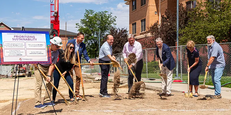
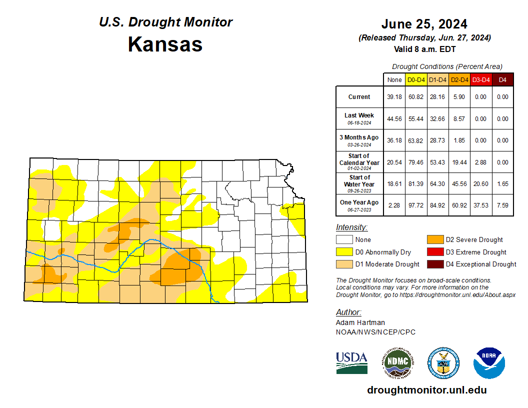
The benefits of this geo-exchange system extend beyond environmental impact. By significantly reducing energy costs—saving millions of dollars each year—CMU is able to keep tuition affordable. These savings directly support the CMU Promise, additional merit aid, more scholarships, and other cost-saving initiatives that benefit students. Photo credit: Colorado Mesa University (June 7, 2024)
Today, Governor Polis celebrated Colorado Mesa University’s (CMU) nation-leading geothermal heating system for being recognized as one of only 19 case studies across the nation by the Department of Energy as one of the best geothermal systems.
“Congratulations to Colorado Mesa University for being featured as a U.S. Department of Energy case study for geothermal heating. CMU has one of North America’s largest geothermal heat pump systems and connects 16 buildings, providing 90% of the energy required to operate the campus. Plans are underway to connect the remaining campus buildings, comprising 800,000 square feet, to the central loop to achieve a 100% geothermal campus. CMU’s work is a great example of Colorado’s leadership in providing clean, low-cost energy resources,” said Governor Polis.
Water stored in Colorado’s Denver Basin aquifers, which extend from Greeley to Colorado Springs, and from Golden to the Eastern Plains near Limon, does not naturally recharge from rain and snow and is therefore carefully regulated. Courtesy U.S. Geological Survey.
Nearly 40 years ago, after watching aquifers below Douglas County plunge amid fast growth and heavy use, Colorado lawmakers adopted a “sip slowly” management process that required communities such as Parker and Castle Rock to pump out fixed amounts of nonrenewable groundwater each year in an effort to make the resource last at least 100 years.
Fast forward to 2020. That year, the state directed well owners to sip even slower, explicitly stating how much water their permits entitled them to, and requiring them to stop pumping at the end of that 100-year period if they have fully used the water to which they were entitled when the original well permits were issued.
But Parker and Castle Rock objected, suing the state over the new permitting language. They argued that the original volume estimates used to calculate their annual pumping rates were never meant as formal, total volume limits. Those limits, they argued, could sharply limit their future water supplies because they were essentially a best guess, based on measuring technology that has changed considerably since then.
Aurora and Greeley joined the case, siding with the state. A special water court ruled against Parker and Castle Rock, which together appealed to the Colorado Supreme Court. The high court is expected to issue a ruling in the case before the end of the year, according to spokeswoman Suzanne Karrer.
Under Colorado’s so-called 100-year rule, well owners can extract no more than 1% of the water under their lands each year, pumping all the water within 100 years of the issuance of their permits. But prior to use of the new permitting language, the total volume of water that could be taken out over the life of the permit was never explicitly stated on the permits themselves, though it was used to calculate the annual extraction rate.
State officials said they added the water volumes to ensure wells are regulated in a uniform way and that well owners are informed at the start of that 100-year clock how much actual water they can pump.
Deputy State Engineer Tracy Kosloff explained, via email. “If the amount pumped is less than the annual maximum, the length of time it takes to reach the total allowed withdrawal will be more than 100 years. For instance, if one pumps half of the maximum each year, it will take 200 years to reach the total.”
However, if the maximum allowed each year is pumped, then the permit will expire at the end of the 100 years, and the well owner would have to stop pumping and find other water sources, Kosloff said.
But Parker and Castle Rock argue that water levels in the aquifer vary and that over that 100-year period more water might actually be available to them. Establishing a lifetime limit, especially one based on an estimate and old measuring technology, could deprive them of water to which they are entitled.
Colorado designated groundwater basins.
Colorado is home to several aquifer formations, some of which can be easily recharged via rainfall and snowmelt, and are considered renewable. Others cannot be readily recharged and thus are considered to be nonrenewable. These are known as nontributary aquifers and wells drilled in these areas are at the heart of the dispute.
Sean Chambers, Greeley’s director of water and sewer utilities, supports water regulators’ effort to more closely manage nonrenewable underground supplies by including a specific volume on permits because it will better protect everyone over the long run.
Greeley is planning a major new aquifer storage facility on the Wyoming border known as the Terry Ranch. The city wants to ensure water it stores underground isn’t inadvertently tapped by other users whose pumping could siphon off the city’s supplies, Chambers said via email.
When it became clear in the 1980s and 1990s that the aquifers were in decline, Douglas County communities began reducing the amount of water they were taking out of the aquifers, adding surface supplies from the South Platte River and Cherry Creek, and building multimillion dollar water recycling plants so they can reuse the water they already own.
Parker once relied on nonrenewable groundwater for more than 90% of its supplies, but has since reduced that use to roughly 35%. By 2050, it hopes to drop that amount to 25% of its supplies, according to Ron Redd, manager of the Parker Water and Sanitation District.
Ultimately, Redd said, it’s likely that the state laws on the books now will have to be changed as a result of the dispute.
“If we lose, we will try to run legislation upholding our interpretation of the law,” he said. “We were surprised by this. No one knew it was coming until suddenly we saw this condition on our well permits.”
More by Jerd Smith. Jerd Smith is editor of Fresh Water News. She can be reached at 720-398-6474, via email at jerd@wateredco.org or @jerd_smith.
Water treatment process in Greeley. Graphic via Greeley Water
The importance of the Colorado River cannot be overstated for the American West. The river and its tributaries serve more than 40 million people by providing drinking and municipal water. The water from the river basin irrigates more than 5 million acres of land, which produces around 15% of the nation’s crops. The dams in the basin generate 4,200 megawatts of hydro-power. Overall, the river system sustains over 16 million jobs, contributes $1.4 trillion per year to the economy, and supports terrestrial and aquatic ecosystems (USBR, 2012.)
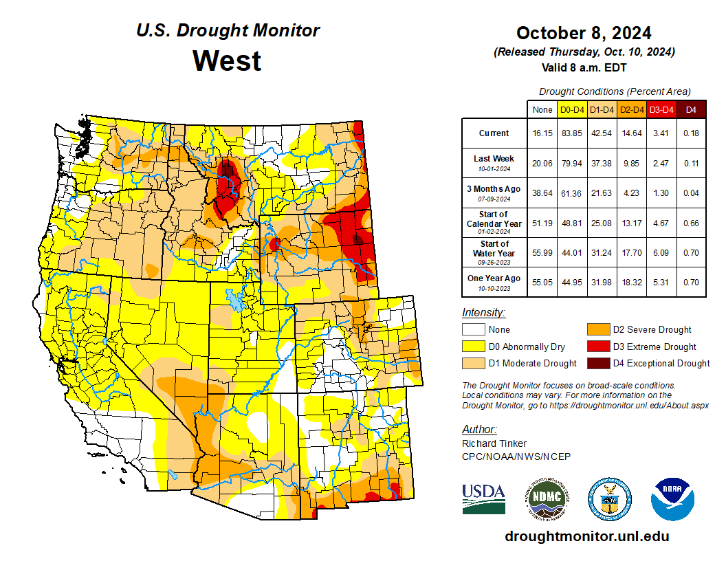
West Drought Monitor map October 8, 2024.
However, the current drought that has lingered for decades now poses a significant threat to everything that depends on the mighty Colorado River. The river basin lies in the region which is infamous for its natural variability. Over the course of history, the region has had cycles of dry and wet periods, which may also make the present drought look like a natural phenomenon alone. However, a study conducted in 2021 showed that around 19% of the current drought conditions can be attributed to human-induced climate change. Not only that, but the conditions are worse than they have been in at least 1200 years.
Since 90% of the streamflow in the Colorado River originates in the upper part of the basin,several studies over the years have focused on watershed modeling in that region many studies have investigated historical flows, while others have included baseflow – the steady release of groundwater that seeps into a stream or river. Some have gone further to use historical streamflow and baseflow to predict future conditions in the river basin using various climate models. However, almost all studies have either used pre-development scenarios – conditions when there was little to no water infrastructure such as dams, canals, levees, etc., management, and regulations – or have used oversimplified models that ignore the complexities of groundwater movement, storage, and interactions with the surface water.
The Colorado River Basin is one of the most highly regulated and over-allocated river systems in the world. As a result, basing studies on pre-development scenarios seems to be of little practical importance in this day of rapidly changing climate. Moreover, the importance of groundwater and its interactions with surface water cannot be ignored, as more than half of the streamflow in the basin is contributed by baseflow.
Colorado transmountain diversions via the State Engineer’s office
The river basin also has trans-basin or trans-mountain diversions. These diversions bring water from the western slope of the Rocky Mountains, which are in the Colorado River Basin, to the eastern slope of the Rockies outside of the basin. These diversions have also been ignored in previous models.
Map credit: AGU
Therefore, my team, which includes my Ph.D. advisor at CSU, Associate Professor Ryan Bailey, and two scientists from the Agricultural Research Service, is working to address this knowledge gap by incorporating key hydrological processes that were overlooked in previous research studies. We are using a physically based and spatially distributed model to build and quantify historical streamflows and groundwater levels in the Upper Colorado River Basin for the post-development scenario. A physically based model simulates how water moves through the environment, using real-world processes, instead of relying on statistical patterns. A spatially distributed model, on the other hand, takes into account differences in the landscape and natural features across different areas. In our model, we have included reservoirs, canals, irrigation schedules, floodplains, trans-basin diversions, and tile drainage – an agricultural drainage system that removes excess subsurface water from irrigated fields. The model also simulates groundwater fluxes such as groundwater recharge, canal seepage, tile drainage flow, saturation excess flow, lake and reservoir seepage and evaporation, and groundwater-floodplain exchanges, which can be used to identify spatio-temporal patterns in the river basin.
Once we simulate the historical hydrology and fluxes, we plan to run what-if scenarios, hypothetical situations to help us analyze different options, for several water management, land use change, and climate change scenarios. This will allow us to come up with best management practices to address water issues and manage water resources more effectively and efficiently.
Historic photo of the Lee’s Ferry gage on the Colorado River. Photo credit: USGS
In the final phase of the study, we use what-if scenarios to assess the political and socio-economic aspects of the model. This includes, crop budgets, agricultural productivity in monetary terms, possibility and probability of Denver getting shut out from trans-mountain diversions in case of a drought, economic implications of sustainable groundwater use, the amount of water flowing at Lee’s Ferry in Arizona – the dividing point of the upper and lower basins, and so on.
The findings of this study can influence how water managers, government agencies, farmers, and other stakeholders approach water use and management for higher revenues and sustainability. Ecologists can gain insights into future streamflows and their potential impacts on aquatic ecosystems. Additionally, it will provide the scientific community with a solid foundation and valuable catalyst for future research. In the long run, these findings can help shape water policy, advancing the goal of achieving integrated regional water management.
M. Raffae
The fate of the Colorado River Basin does not only depend on the climate and its variability, but also on the policies we create that define how we store, move, use, and manage our water. To come up with policies that help us sustain the economy, environment, and society, it is imperative that we conduct a comprehensive hydrological modeling study for the post-development scenario that shows us both our best- and worst-case scenarios for the future to better prepare for it. This study is an ambitious attempt to do so.
About the author: M. Raffae is a Ph.D. student in the Department of Civil and Environmental Engineering at Colorado State University (CSU) funded by the Fulbright Foreign Student scholarship program. He is also a fellow in the NSF Research Traineeship (NRT) Program InTERFEWS at CSU.
Audubon supports the Yavapai-Apache Nation’s water rights settlement and pending legislation, the Yavapai-Apache Nation Water Rights Settlement Act of 2024.
The Yavapai-Apache Nation and other parties in Arizona have come to a historic agreement with the settlement now before Congress. Not only will this settlement—when passed by Congress and signed by the President—ensure a reliable and sustainable water supply for the Yavapai-Apache Nation in north central Arizona’s iconic “Verde Valley,” it will preserve the Verde River and its precious habitat by reducing reliance on groundwater.
Healthy mountain meadows and wetlands are characteristic of healthy headwater systems and provide a variety of ecosystem services, or benefits that humans, wildlife, rivers and surrounding ecosystems rely on. The complex of wetlands and connected floodplains found in intact headwater systems can slow runoff and attenuate flood flows, creating better downstream conditions, trapping sediment to improve downstream water quality, and allowing groundwater recharge. These systems can also serve as a fire break and refuge during wildfire, can sequester carbon in the floodplain, and provide essential habitat for wildlife. Graphic by Restoration Design Group, courtesy of American Rivers
Within the Verde Valley, Audubon has identified four Important Bird Areas, all of which rely on healthy groundwater levels to sustain flowing rivers and streams and the rich plant life and wildlife they support. One of the many benefits of this settlement includes helping to sustain a portion of the Verde River downstream of the Yavapai-Apache Nation that was designated as a Wild and Scenic River by Congress in 1984.
The settlement is the result of innovative and creative thinking from the Yavapai-Apache Nation, Salt River Project, the Town of Camp Verde, the Town of Cottonwood, the Town of Clarkdale, and others. The settlement includes building a 60-mile water pipeline from C.C. Cragin Reservoir on the Mogollon Rim, north of Payson, increasing the capture of wastewater into sewer systems, boosting the use of reclaimed water, and the potential for regional water planning and collaboration among nearby municipalities and the Yavapai-Apache Nation.
Audubon Southwest, our regional office in Arizona and New Mexico, is also part of the Water for Arizona Coalition. In 2022, Water for Arizona outlined a vision for how to improve Arizona’s water outlook, called the Arizona Water Security Plan. One of the six key tenets is: Continue to support Tribes in resolving Tribal water issues. This settlement is a key milestone as Arizona works to improve its overall water security.
It is long past due for the Yavapai-Apache Nation to have secure and reliable water supplies, and this settlement is a monumental step forward for their growing community. Bipartisan, bicameral legislation to enact and fund the settlement is sponsored by Arizona’s Senators Kelly (D) and Sinema (I) in the U.S. Senate. Representative Schweikert (R) introduced the U.S. House bill, cosponsored by Representatives Ciscomani (R), Lesko (R), Stanton (D), and Gallego (D).
Audubon supports the passage of the settlement legislation and the provision of approximately $1 billion to ensure the project is brought to completion. As part of our support, we sent a letter to Arizona’s Congressional delegation, which you can view below.
hen the state of Colorado created the Groundwater Compact Compliance Fund with $30 million earmarked for recovering the aquifers of the Upper Rio Grande Basin, there was an intention to steer a good portion of the money toward irrigators working in Subdistrict 1 of the Rio Grande Water Conservation District.
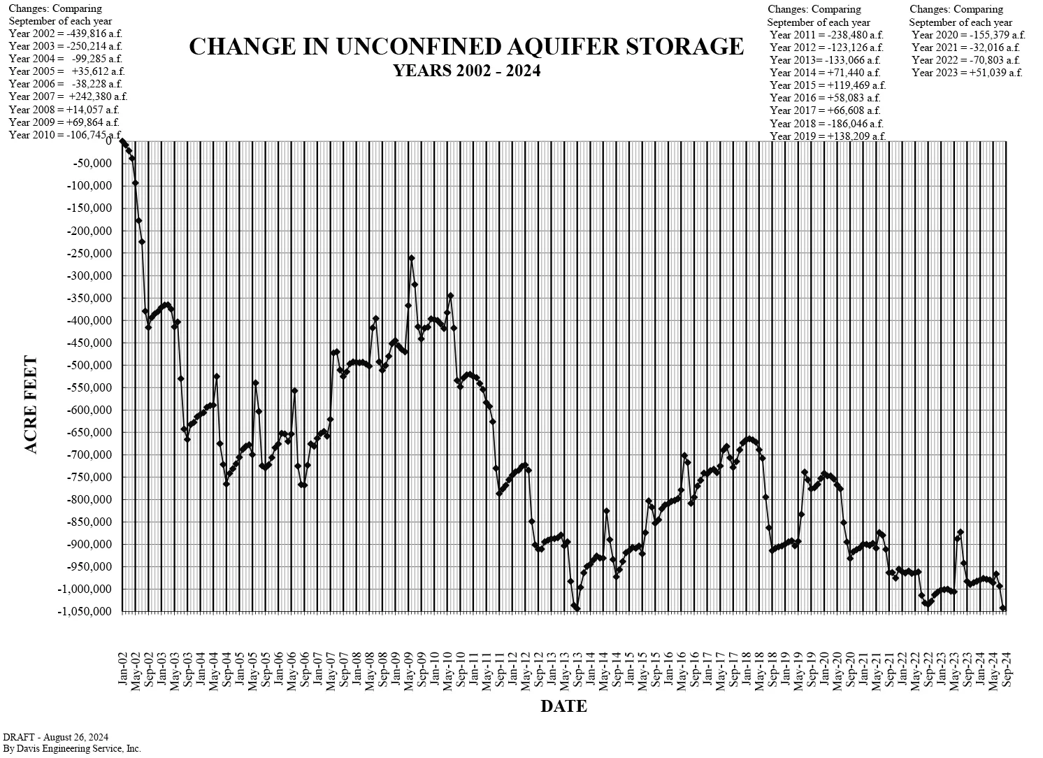
Whether the strategy will work is under question. Last month’s reading of the unconfined aquifer storage levels shockingly showed it at its lowest point, despite millions in tax dollars that have been spent to retire groundwater wells.
San Luis Valley Groundwater
The motivation behind Senate Bill 22-028 was to use state tax dollars to continue to dry out farming fields located in the most productive area of the San Luis Valley because that’s where the depleted unconfined aquifer of the Upper Rio Grande Basin runs through. For the past two decades the state Division of Water Resources has been working with Rio Grande Water Conservation District and the farmers and ranchers who operate in Subdistrict 1 to reduce the amount of groundwater they pump each growing season to help recover the struggling aquifer.
The 2022 state senate bill would bring new money into the effort. Of the $30 million allocated from Groundwater Compact Compliance Fund to the Upper Rio Grande Basin, nearly $14 million has been directed to retire 44 more groundwater wells in Subdistrict 1, with more money likely to come to further the strategy.
The state monitors the amount of groundwater pumped with flow meters tied to center pivot sprinklers which water the fields. The meter reading will tell the farm operator how many acre-feet of water they’ve used during the irrigation season, and each fall figures from those flow meters are reported to the state.
The assumption has been that by reducing the amount of groundwater pumped from the unconfined aquifer, the aquifer would recharge over time. Over the past decade, it appeared the strategy had validity with the aquifer at times showing a bounce back.
Then came the reading from this August which showed the unconfined aquifer storage near its lowest level, and state and local water managers found themselves scratching their heads in disbelief and frustration.
“It is disappointing to see that the aquifer has dropped lower this year. We had hoped to see an increase in aquifer levels, but another lower-than-average river flow year meant that less water was available to recharge the aquifers,” said Craig Cotten, the state division water engineer in the San Luis Valley.
The continued decline in unconfined aquifer levels is the reason the state engineer this year approved a new Groundwater Management Plan that is included in the Subdistrict 1 Fourth Amended Plan of Water Management. The plan was more than a year in the making and still needs approval from the state water court to go into effect. That won’t happen at the earliest until sometime in 2026.
Meanwhile, the clock is ticking.
“It is very concerning, especially given that Subdistrict #1, under its current plan, has just seven more years in which to recover the unconfined aquifer to a sustainable level. If the aquifer has not recovered by then, and if the subdistrict is still operating under its current Groundwater Management Plan, then the State Engineer will have no choice but to curtail all of the non-exempt wells in this area,” Cotten said.
There are several “ifs” in that scenario, all of which should get addressed when the state water court takes up the new Groundwater Management Plan for Subdistrict 1. But again, that’s not until 2026, and the clock, as Cotten mentions, is ticking.
Amber Pacheco, deputy general manager for the Rio Grande Water Conservation District, said there are 3,614 wells included in the Subdistrict 1 annual replacement plan. The idea that the state would come in and shut those down because farmers couldn’t recover the unconfined aquifer to a sustainable level is the constant worry Subdistrict 1 farm operators work under.
“There is no specific timeline in which the Subdistrict will meet its objective to reach a Sustainable Water Supply by reaching an Unconfined Aquifer Storage Level between 200,000 and 400,000 acre-feet below that storage level that was calculated to exist on January 1, 1976, but it may be 20 years or less depending on the hydrologic conditions following the period the new plan is implemented,” Pacheco said.
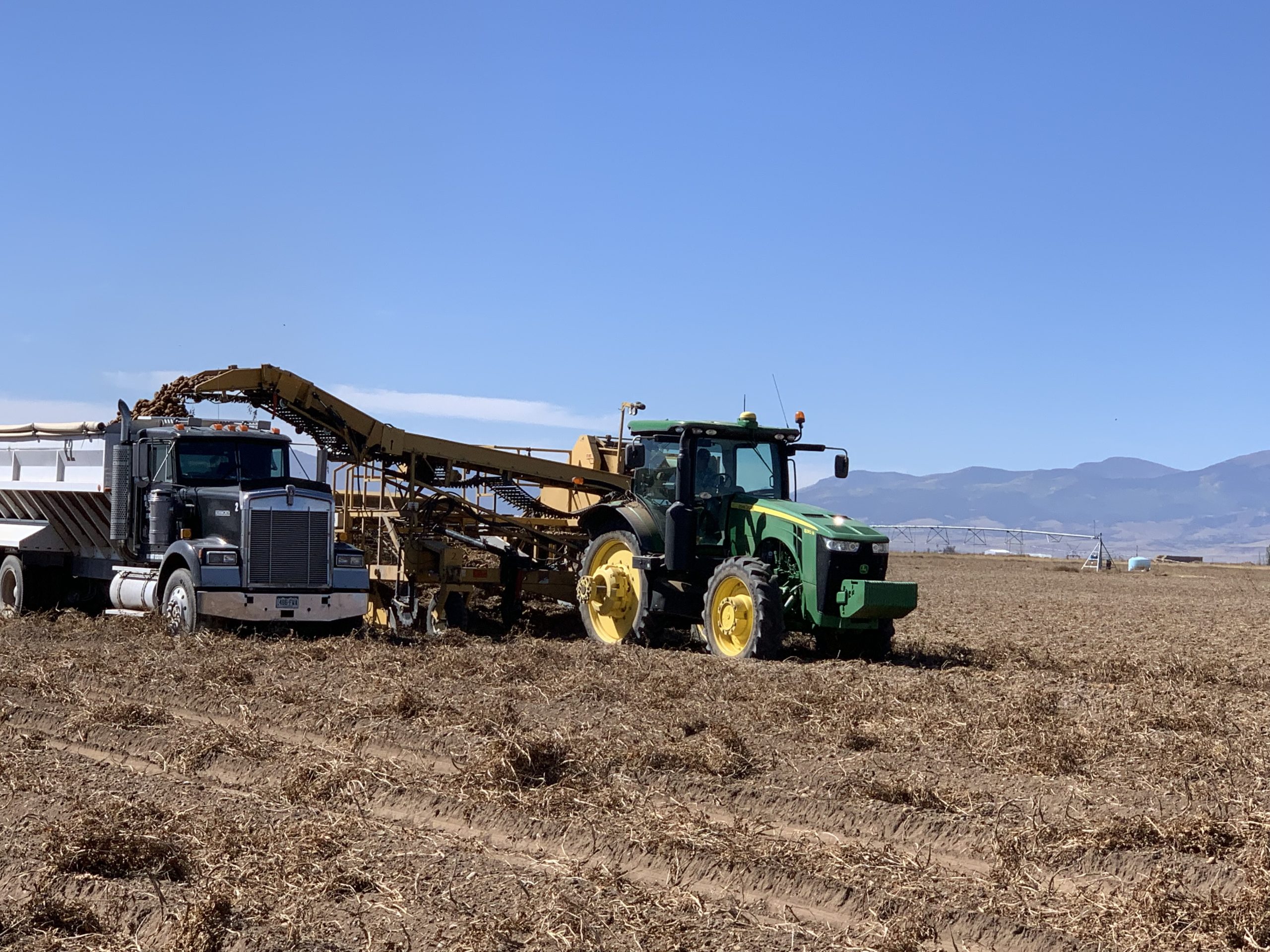
Take a drive down County Rd E or any of the other country roads that cross through Rio Grande and Alamosa counties and you’ll notice the Valley’s potato harvest in full swing. Take a bit closer look, and in the midst of the harvested fields is a growing amount of agricultural acreage once productive that is now intentionally dried out to save on the groundwater below.
The last days of the potato harvest. Photo credit: The Alamaosa Citizen
With the unconfined aquifer showing little to no bounce back after years of attempted recovery, the expectation is that the western and northern ends of the San Luis Valley will see more dry fields in the growing seasons to come. The money spent through the state’s Groundwater Compact Compliance Fund to retire more groundwater wells will begin to show up in the 2025, 2026 planting seasons and beyond.
As Cotten said, Subdistrict 1 is “one of the most productive irrigated farming areas in the state.”
Farming with a struggling aquifer is making it less so.
The U.S. Air Force has a plan for cleaning up a decades-old jet fuel spill from a base near Albuquerque.
However, the local water authority said last week that the plan is inadequate, in part because it scales back current remediation efforts and doesn’t mention how the Air Force will address sudden issues.
In 1999, officials discovered a fuel leak, assumed to be more than 24 million gallons, in the jet fuel loading facility at Kirtland Air Force. The leak could be twice the size of the infamous Exxon Valdez oil spill of 1989, according to the Global Atlas of Environmental Justice.
It’s unclear when the leak – the largest underground toxic spill in U.S. history – first occurred, but it had been spilling fuel into the ground for decades by the time it was discovered, according to Kelsey Bicknell, environmental manager at the Albuquerque Bernalillo County Water Utility Authority.
An Air Force report says existing measures have prevented further migration of the fuel contaminants and that officials are regularly taking groundwater samples to ensure that drinking water remains safe both on and off-base.
Bicknell said there are concerns with the way the Air Force plans to go forward, including a lack of forward-looking analysis and the absence of a “trigger action plan” that identifies possible changes and prescribes a response to those changes.
She told the water authority’s Technical Customer Advisory Committee that the fuel soaked its way through almost 500 feet of soil, and ultimately reached the water table, where rock wouldn’t permit it to drop further. Then, she said, it began to pool underground.
Bicknell said the fuel not only contaminated the groundwater but also released volatile vapor into the nearby atmosphere.
She said the Air Force used a vapor extraction system to clean up more than a half-million gallons of fuel.
“This was a really successful system,” Bicknell said, adding that the program was shuttered after about a decade.
Bicknell said the Air Force is now using a groundwater pump-and-treat system that targets the dissolved fuel components that have moved away from the source of the leak and area. There are also four extraction wells, brought online between 2015 and 2018; they draw out and treat groundwater.
Bicknell said the Air Force has announced plans to turn off two of the wells. But that was done without input from the water authority and without including the agency in decision-making.
Air Force representatives did not immediately respond to phone and email requests for comment.
Bicknell said the goal now is to try to get the Air Force to reverse its decision before the wells are shut down. State and federal regulators have jurisdiction over the cleanup plan, she said, but the water authority cannot veto what the Air Force wants to do.
“Ultimately, we’re the water carrier, the ones that are impacted,” Bicknell said. “If the Air Force messes up, it is our source water that’s impacted, and it’s us that lose out on access to a supply source, so including us in the room and in project discussions and decision-making is something that is paramount.”
The U.S. Forest Service has finalized a land exchange with Mt. Emmons Mining Company located in Gunnison and Saguache counties.
Under the agreement, finalized on Aug. 29, the Forest Service exchanged 539 acres of federal land located adjacent to the Keystone Mine for 625 acres of land owned by Mt. Emmons Mining Company located within the Grand Mesa, Uncompahgre and Gunnison National Forests and Rio Grande National Forest.
Iron Fen. Photo credit from report “A Preliminary Evaluation of Seasonal Water Levels Necessary to Sustain Mount Emmons Fen: Grand Mesa, Uncompahgre and Gunnison National Forests,” David J. Cooper, Ph.D, December 2003.
The land exchange allows the Forest Service to improve wildlife habitat and recreation opportunities by reducing private inholdings and creating more contiguous public land. The parcels acquired by the Forest Service include riparian and wet meadow habitats, which are vital to various bird and aquatic species.
Additional benefits of the land exchange include an established Conservation Easement and Mineral Extinguishment Agreement, prohibiting mining and allowing for non-motorized recreation in the future. It allows Mt. Emmons Mining Company to address mining remediation efforts, including water quality and facilitated the transfer of ownership and administration of the Kebler Winter Trailhead to Gunnison County.
“We are pleased to see this momentous exchange finalized,” said Dayle Funka, Gunnison district ranger. “This project was truly a collaborative effort with local non-profits, private landowners and local and federal governments working to benefit future generations. We encountered obstacles throughout the process but found ways to move forward in the spirit of collaboration. As a result of many people’s dedication and perseverance, this land exchange will enhance public access and enable future non-motorized recreational opportunities. I commend the Mt. Emmons Mining Company for their commitment to mining remediation efforts and water quality, while honoring the values of the community.”
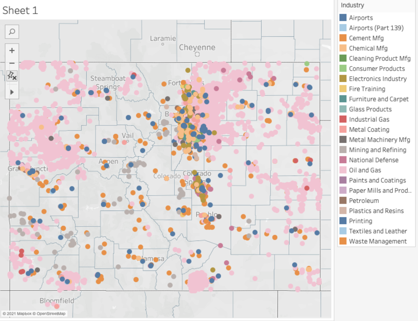
A whistleblower and watchdog advocacy group used an EPA database of locations that may have handled PFAS materials or products to map the potential impact of PFAS throughout Colorado. They found about 21,000 Colorado locations in the EPA listings, which were uncovered through a freedom of information lawsuit. Locations are listed by industry category. (Source: Public Employees for Environmental Responsibility analysis of EPA database)
Click the link to read the article on The Denver Post website (Meg Wingerter). Here’s an excerpt:
Colorado will receive $225,000 each of the next three years to monitor exposure to lead in rural residents and to “forever chemicals” in people who encounter them at work. The Centers for Disease Control and Prevention made grants to Colorado, Arizona, New Mexico and Utah for “biomonitoring,” which refers to testing blood or other bodily fluids for chemical contamination. The grants will allow them to test the amount of lead and other heavy metals in rural residents’ blood, while testing for per- and polyfluoroalkyl (PFAS) will focus on firefighters and other people in jobs where they frequently use the chemicals.
Exploratory wells have damaged the water flow at Ha’ Kamwe’ in Wikieup, Arizona, seen here on Saturday, March 5, 2022. Ha ‘Kamwe is a hot spring sacred to the Hualapai Tribe, which says an Australian company’s proposed lithium mining project threatens. (Photo by Ash Ponders/Earthjustice)
For years, the Hualapai Tribe tried to work with the U.S. Bureau of Land Management by actively voicing their concerns about a lithium exploration project near Wikieup, in northern Arizona.
The project allows a mining company to drill and test over 100 sites across BLM land that surrounds one of the Hualapai Tribe’s cultural properties, among them Ha’Kamwe’, a medicinal spring sacred to the tribe.
Ha’Kamwe’ is featured in tribal songs and stories about the history of the Hualapai people and their connection to the land. The historic flow and spring temperature are important attributes for its traditional uses, according to the tribe.
Out of concern for Ha’Kamwe’, the tribe submitted multiple public comments, sent several letters of concern and participated in tribal consultations with BLM throughout the planning phase for the Big Sandy Valley Lithium Exploration Project. Big Sandy, Inc., a subsidiary of Australian mining company Arizona Lithium, leads the project.
“It doesn’t feel like the BLM really heard us or took our comments into full consideration,” said Ka-voka Jackson, the director of the Hualapai Department of Cultural Resources, adding that the tribe often felt as if it was “never taken seriously.”
Big Sandy, Inc. has been seeking approval for its project since 2019, and the Hualapai Tribe has been voicing its concerns every step of the way. However, their efforts still fell flat, as BLM gave the project the green light on June 6.
BLM’s approval of the Big Sandy Valley Project allows the mining company to drill and test up to 131 exploration holes across 21 acres of BLM-managed public land to determine whether a full-scale lithium mining operation could be viable.
Two months later, the Hualapai Tribe filed a lawsuit against the Bureau of Land Management, challenging its approval.
Lawsuit: BLM refused to consider alternatives
Ha’Kamwe’ is located within the Hualapai Tribes property known as Cholla Canyon Ranch, and the boundaries of the Big Sandy Valley project nearly surround the entire property.
Only one portion of the tribe’s land does not border the drilling project. Jackson said it’s “surprising, appalling and, frankly, disgusting” that the BLM is trying to say there are no adverse effects on the tribe’s cultural property or cultural resources.
“The tribe maintains that we are opposed to this project,” she said. “This lawsuit is to make sure that BLM is going through the proper processes.”
“These exploratory wells — some of which will be drilled close to Ha’Kamwe’ — will penetrate deep below ground into the aquifer that supports the spring’s flows,” the lawsuit states. “The Project will also create noise, light, vibrations, and other disturbances that will degrade Ha’Kamwe’s character and harm Tribal members’ use of the spring for religious and cultural ceremonies.”
The lawsuit claims that the project violated mandates under the National Environmental Protection Act and the National Historic Preservation Act. Ha’Kamwe’ is recognized as a traditional cultural property and is eligible to be listed on the National Register of Historic Places.
“The litigation is asking for full compliance with the National Historic Preservation Act (NHPA) and the National Environmental Policy Act (NEPA),” said Earthjustice Senior Attorney Laura Berglan, who is part of the team representing the Hualapai Tribe.
This includes BLM taking a “hard look” at the environmental impacts of the exploration activity, as well as considering the impact of its actions on historic properties, she said.
The lawsuit claims that BLM approved the mining project without appropriately considering a reasonable range of alternatives or taking a hard look at water resources under the NEPA and moved forward with the project without providing mitigation measures under the NHPA for Ha’Kamwe’ and other resources important to the tribe, thus violating both acts.
“This isn’t a situation where the tribe wasn’t engaged throughout,” Berglan said, adding that the Hualapai Tribe had provided BLM with traditional Indigenous knowledge related to the project. Still, it was not fully taken into account.
Berglan said the tribe has been trying to work with BLM for years, and has committed a substantial amount of time and resources to review drafts of the environmental assessments and submit extensive comments.
“A lot of time has gone into this process, and to be sort of disrespected by not taking into account their Indigenous knowledge that this (project) is going to have impacts on Ha’kamwe’ is troublesome,” she added.
The lawsuit argues that the tribe even asked BLM to consider alternatives to the project — such as drilling fewer wells or moving them farther from the spring — to reduce its adverse effects. However, BLM refused to consider a reasonable range of alternatives to the project proposal.
“BLM violated NEPA by failing to consider a middle-ground alternative that would address the tribe’s concerns,” the lawsuit states
The Arizona Mirror contacted BLM for comment on the lawsuit, but a representative said the bureau does not comment on pending litigation.
‘We were ignored’
Jackson said that the Hualapai Tribe does not want this mining project to happen, and like many other tribes in Arizona, they are experiencing just how hard it is to stop mining operations in the state.
“We submitted all our comments,” Jackson said. “We were ignored.”
Jackson said the tribe filed the lawsuit because it believes BLM did not follow the proper processes during the Sandy Valley project’s environmental analysis phase.
“Not all of those comments were addressed, and when the (environmental assessment) had been finalized, the BLM said there were no adverse effects on historic property, which is very contradictory to all the tribe’s comments that have been submitted to the BLM,” Jackson said.
Jackson said that before BLM finalized the environmental assessment, the tribe tried to stay in constant communication with the bureau to stay current on the project and were hopeful the bureau would consider their comments, but did not hear back.
“It’s been very upsetting for us,” Jackson said, adding that it’s been hard for the tribe because they are going up against an agency that has a lot of their ancestral homelands in their legal possession.
Dolores Garcia, the public affairs specialist at the BLM Arizona State Office, said in an email to the Mirror that BLM conducted outreach to tribes for consultations over the past three years. Details on the type of outreach efforts were not provided.
The tribes include the Chemehuevi Indian Tribe, the Colorado River Indian Tribes, the Fort Mojave Indian Tribe, the Hopi Tribe, the Hualapai Tribe, the Navajo Nation, the Salt River Pima-Maricopa Indian Community, the Yavapai-Apache Nation and the Yavapai-Prescott Indian Tribe.
“Tribal consultation is considered confidential government-to-government communication, so we cannot discuss specific details related to consultation,” Garcia said.
However, Garcia said that, based on input from the tribes and the public, BLM worked with the proponent to revise its exploration plan, which included removing the use of a groundwater well within a few hundred feet of Ha’Kamwe’ and a nearby staging area.
“Water needed to support the drilling operations will be trucked to the site,” Garcia said. “The proponent has also committed to providing the opportunity for the Hualapai Tribe and other descendant tribal communities to monitor ground disturbing activities onsite.”
Jackson said their experience with how BLM moved forward on this lithium project did not give the tribe much faith in potential future projects.
She said when projects like Big Sandy Valley get proposed in the area, the tribe hopes that the BLM will come to work with them and take their comments seriously because they have been the stewards of the land for generations.
“We still use Ha’Kamwe’ as a community,” Jackson said. “When people go there, they have this sense of being, a sense of place, a sense of belonging, and a really deep ancestral tie there.”
‘Temporary’ disruptions don’t need permanent fixes, BLM says
As part of its environmental assessment, BLM listed several short- and long-term effects, including the temporary disruption to cultural practices at or near Ha’Kamwe’ and the impact on native wildlife and vegetation of up to 21 acres.
Even with these effects included in the assessment, which are concerns the Hualapai Tribe has brought up multiple times, BLM concluded that the Big Sandy Valley project would not significantly impact the quality of the area and an environmental impact statement was not needed.
“Visual, noise, and vibration effects from drilling activities would be temporary,” the BLM wrote in its final report. “Coordination with and providing notice to the Hualapai Tribe of drilling activities in the vicinity of the Ha’Kamwe’ may reduce impacts to cultural practices at or near the hot spring.”
Jackson said the tribe and its members have every right to be out at Ha’Kamwe’ utilizing the spring for prayer and healing because it is part of their spirituality and religion. Tribal members have full access to the property and can use it whenever necessary.
“Having that type of noise occurring is really disrupting,” she said. “It takes away from a lot of the spirituality and ability to practice ceremony in peace.”
Jackson said the tribe will have to deal with the disruptions throughout the project’s 18-month duration.
“That’s a long time for tribal members to be affected, and that disrupts all of our activities,” she added. “It disrupts our spirituality.”
The drilling project threatens not only ceremonial ways of life but also natural resources the tribe relies on. Jackson said the community gathers native plants only found in the Big Sandy Valley area, including willows for basket making, traditional tobacco, and clay.
“Those plants coming from that area have meaning,” she said, and they are the same native plants their ancestors gathered from.
“When we gather, we’re not restricted to just the Hualapai property,” Jackson said because tribal members gather on the public BLM land in the area, too.
“That’s our right as people to be able to go out there and gather,” she added, and the bulldozing that will occur to create the paths to the drilling sites will have an impact. “The desert will never recover from all that.”
Jackson said part of what makes the area sacred for the tribe is maintaining the integrity of the land, and the tribe feels that the mining operations will permanently change the location.
They’re concerned about how the project will impact the spring because the drilling will occur so close to the site.
According to BLM, to minimize impacts on Ha’Kamwe’, a water source that was previously proposed to be used for the project has been removed from the plan, and a staging area that would have been set up near Ha’Kamwe’ has also been removed.
“Analysis of water resources has determined that the water source for Ha’Kamwe’ is located in a deeper aquifer,” the report states. The proposed drilling is not anticipated to reach the aquifer, according to BLM, and if water is intersected during the drilling, the hole shall be plugged using cement grout or bentonite clay.
Jackson said the tribe does not think that is good enough because if the mining hits the water and does utilize bentonite clay or cement grout, there is no guarantee that it won’t have an adverse effect or potentially block off the underground water that flows through the spring.
“If the temperature were to be affected that’s changing the entire character of the spring and the integrity of it,” Jackson said, which is a big deal for the tribe because Ha’Kamwe’ translates to “warm spring.”
“We’re going to try every way we can to try and stop this operation,” Jackson said, adding that this is the first lithium mining project of its kind on their homelands and they’ve opposed it the entire time.
“It’s kind of scary looking into the future, seeing how these mining companies can kind of get away with this and how the BLM is letting it happen, even when they know how it will negatively impact the tribes and the tribe’s sacred lands,” Jackson said.
Eighty years ago, the United States and Mexico worked out an arrangement to share water from the two major rivers that run through both countries: the Rio Grande and the Colorado. The treaty was created when water wasn’t as scarce as it is now. Water from Mexico flows to Texas’ half-billion-dollar citrus industry and dozens of cities near the border. On the Mexican side, some border states like Baja California and Chihuahua are heavily reliant on the water that comes from the American side of the Colorado River.
Now, those water-sharing systems are facing one of the biggest tests in their history. Mexico is some 265 billion gallons of water behind on its deliveries to the United States. Unpredictable weather patterns due to climate change, growing populations, aging infrastructure and significant water waste have left both countries strapped for water and have escalated tensions along the border. Maria-Elena Giner is the U.S. commissioner of the International Boundary and Water Commission, the binational agency that oversees the 1944 water treaty and settles disputes. Mexico is “at their lowest levels ever” in the treaty’s history, Giner said. The treaty operates in five-year cycles, and the current deadline for deliveries isn’t until October 2025.
But “the question is that they’re so far behind, it will be very difficult, if not statistically impossible, for them to make up that difference,” Giner said…
To address the water scarcity in Texas, officials last year proposed a solution: a treaty “minute,” or amendment, that would allow Mexico to pay water directly to South Texas instead of giving two-thirds to the Mexican state of Tamaulipas first, as currently specified in the treaty. But quenching the thirst in South Texas ahead of its own citizens was likely a nonstarter ahead of Mexico’s presidential election this year. Negotiations on the treaty changes were completed and both countries were set to sign last December, but Mexico has yet to receive official authorization to do so, said Giner, of the International Boundary and Water Commission.
Rio Grande and Pecos River basins. Map credit: By Kmusser – Own work, Elevation data from SRTM, drainage basin from GTOPO [1], U.S. stream from the National Atlas [2], all other features from Vector Map., CC BY-SA 3.0, https://commons.wikimedia.org/w/index.php?curid=11218868
Blanca Wetlands, Colorado BLM-managed ACEC Blanca Wetlands is a network of lakes, ponds, marshes and wet meadows designated for its recreation and wetland values. The BLM Colorado and its partners have made strides in preserving, restoring and managing the area to provide rich and diverse habitats for wildlife and the public. To visit or get more information, see: http://www.blm.gov/co/st/en/fo/slvfo/blanca_wetlands.html. By Bureau of Land Management – Blanca Wetlands Area of Critical Environmental Concern, Colorado, Public Domain, https://commons.wikimedia.org/w/index.php?curid=42089248
Dozens of environmentalists, homebuilders, farmers and road builders, along with Colorado water quality regulators, will buckle down next week to begin work on a complex new set of rules designed to protect thousands of acres of wetlands for years to come.
And, yes, they want your help.
Colorado’s Water Quality Control Commission plans a series of public meetings in the coming months, with a kickoff meeting Sept. 4, followed by workshops Sept. 13 and Oct. 4. Meetings will be held virtually and workshops will be held virtually and in person, according to state health officials.
Colorado is the first state to address a major gap created last year when the U.S. Supreme Court, in its Sackett v. EPA decision, wiped out a critical set of environmental safeguards contained in the Clean Water Act.
Healthy mountain meadows and wetlands are characteristic of healthy headwater systems and provide a variety of ecosystem services, or benefits that humans, wildlife, rivers and surrounding ecosystems rely on. The complex of wetlands and connected floodplains found in intact headwater systems can slow runoff and attenuate flood flows, creating better downstream conditions, trapping sediment to improve downstream water quality, and allowing groundwater recharge. These systems can also serve as a fire break and refuge during wildfire, can sequester carbon in the floodplain, and provide essential habitat for wildlife. Graphic by Restoration Design Group, courtesy of American Rivers
House Bill 1379, approved by Colorado lawmakers in May, identifies which streams and wetlands must be protected, and where exceptions and exclusions for such things as homebuilding, farming and road building will apply. During the next 16 months, the rules spelling out how the law will be enforced must be crafted and approved by the Colorado Water Quality Control Commission.
Lawmakers have given the regulators and participants until December 2025 to finish the rules and launch the oversight program.
“For 50 years we all depended on the Clean Water Act to protect our watersheds,” said Stu Gillespie, an attorney with EarthJustice who helped negotiate House Bill 1379. “But that was taken away by the Supreme Court. Now we all need to be involved because we all rely on these watersheds. I hope people will keep tabs and engage from the outset so we don’t lose any more wetlands and streams.”
Ephemeral streams are streams that do not always flow. They are above the groundwater reservoir and appear after precipitation in the area. Via Socratic.org
The Sackett case had major impacts in Colorado and the West, where vast numbers of streams are temporary, or ephemeral, flowing only after major rainstorms and during spring runoff season, when the mountain snow melts. The Sackett decision said, in part, that only streams that flow year-round are subject to oversight. It also said that only wetlands that had a surface connection to continually flowing water bodies qualified for protection. Many wetlands in Colorado have a subsurface connection to streams, rather than one that can be observed above ground.
House Bill 1379 corrected those problems.
But lawmakers and others remain worried that the Colorado Department of Public Health and Environment’s Water Quality Control Division, already facing a major backlog on issuing permits for one of its programs, will have difficulty keeping up with the permitting demands of the new wetlands program.
Sen. Barbara Kirkmeyer, a Republican from Brighton, said she is hopeful that new requirements calling for frequent reporting to the state’s Joint Budget Committee, or JBC, and lawmakers will keep the program on track and help fill the funding gaps that have plagued the health department in recent years.
Lawmakers have provided nearly $750,000 this year for the initial work and OK’d four new full-time positions for the program as well as part-time legal support, according to the final fiscal note on House Bill 1379.
“We’ve always understood that we needed a permitting process in place,” Kirkmeyer said Aug. 20 at a meeting of the Colorado Water Congress. “But we also need safeguards to ensure there is oversight at the JBC so we can ensure permits are being processed in a timely manner.”
An Apology: Our service that sends these posts hs malfunctioned; this one sat in limbo for the past two weeks. I hope we have things back to where we can again get it to you every 3-4 weeks. – George
In the last post here, with the Colorado River’s Upper and Lower Basins in stalemate over how to distribute the suffering after the 2026 expiration of the Interim Guidelines, I suggested we use the time to do what we’ve all been saying we need to do, but find it hard to do: ‘think outside the box.’ The ‘box’ in this case being the Colorado River Compact. We can go back to Monday-morning-quarterbacking the rivermeisters as they try to figure out how to drag the Compact, its misbegotten two-basin division and its Marley’s-chain Law of the River into the 21st century. But for the moment – let’s just indulge in imagining river scenarios that might actually reflect Colorado River realities in the 21st century.
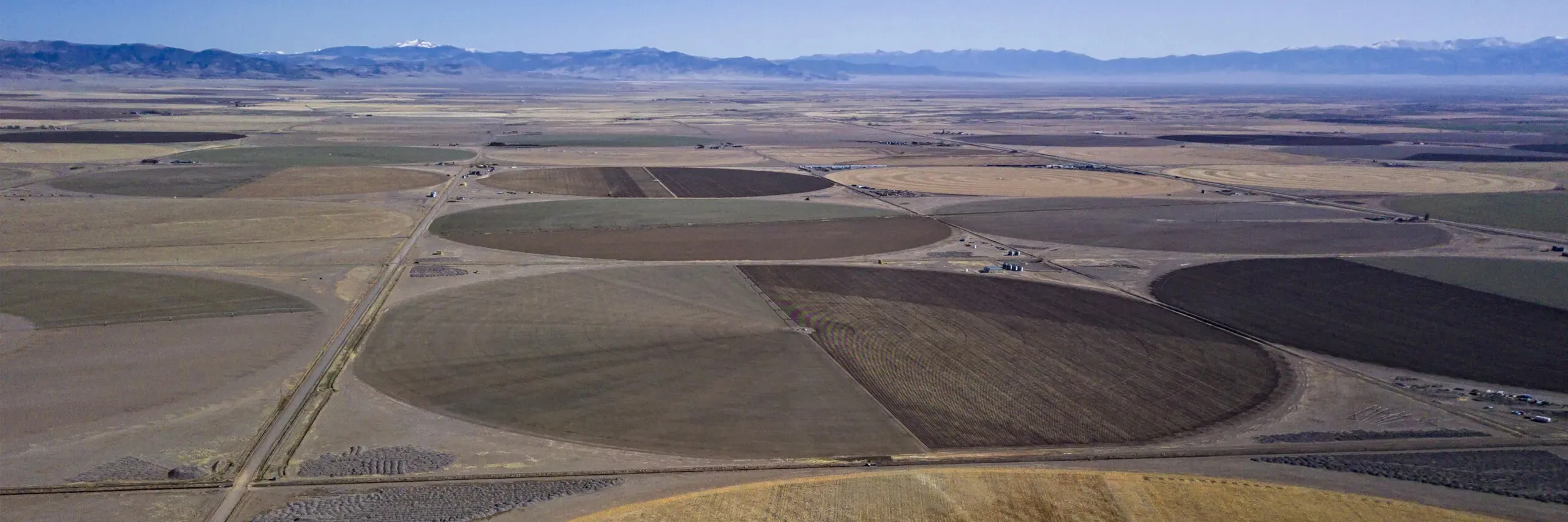
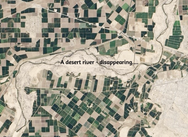
In the last post (click if you need a review) I sketched out the nature of the ‘desert river,’ which is what the Colorado River is. Rivers flowing through deserts only exist at all because of mountains or other highlands that force air moving through (as in ‘prevailing westerlies’) to rise, cool, and condense whatever water vapor it is carrying into precipitation, rain or snow, that falls on the mountains and eventually flows downhill because that’s what liquid water does, eventually coalescing into a river. In this case, it flows out into deserts which by definition are arid regions with a paucity of precipitation and a powerful propensity for turning liquid water back into vapor. Once the desert river is in its desert, it begins to disappear because it gets so little recharge from precipitation beyond its mountain origins, and gives up its water to riparian life, to evaporation, to groundwater. We can say with some accuracy that it is the nature of a desert river to gradually disappear into its deserts – as liquid water, anyway.
The Colorado River is a true desert river; the mountains and highland plateaus surrounding the natural basin produce 85-90 percent of the river’s total water supply, according to the Western Water Assessment study of the ‘state of the river science.’ Now it almost entirely disappears in the deserts of the Southwest – the high ‘cold deserts’ of the Colorado Plateau and Southern Rockies piedmont, and the subtropical Sonora and Mojave Deserts below the plateau canyons. This is mostly due to human uses now; we remember with nostalgia that the Colorado River flowed naturally into the Gulf of California, but that was mostly during its snowmelt flood season; by late fall and through the winter there were probably many years when it did not make it through the delta jungle to the Gulf at all.
The Compact experience should make us all leery of dividing a river into basins. But the way a desert river works suggests a natural division into two parts – as opposed to a two-basin political division, using state boundaries that have no relevance to down-on-the-ground geography. The natural division is a water-production region, in the highlands where the majority of the precipitation falls and the river forms its tributaries; and a water-consumption region, in the deserts where that produced water gradually disappears – especially now that humans are spreading it much farther than nature ever intended.
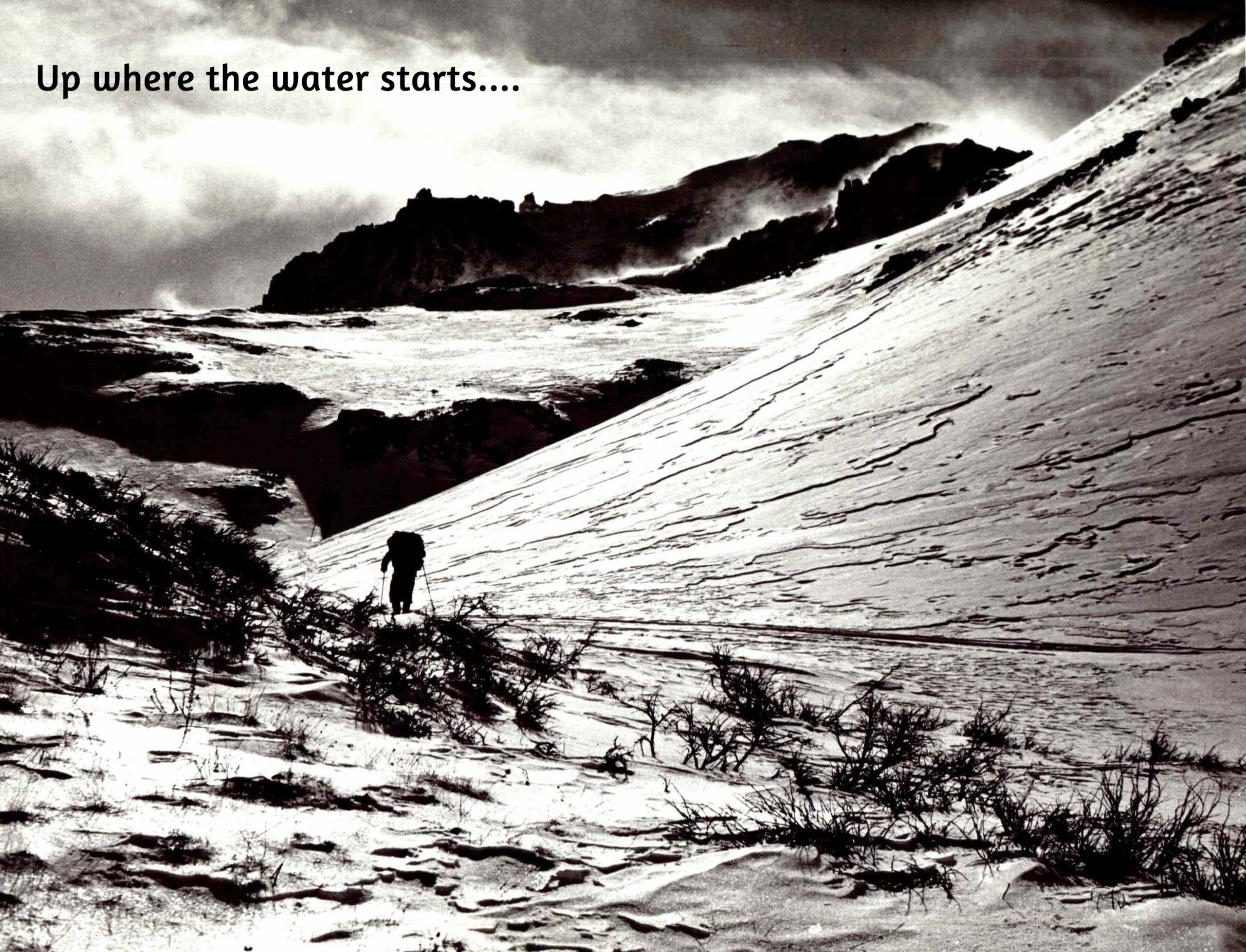
Colorado River “Beginnings”. Photo: Brent Gardner-Smith/Aspen Journalism
Today, we’ll go to the headwaters, to explore the river’s ‘water-production’ region. The major water-production region for the Colorado River lies almost entirely above the 8,000-foot elevation, mostly on the west slopes of the Southern Rockies in Colorado and Wyoming, but also water from the Wind Rivers in Wyoming, and the east slopes of the Wasatch Range in Utah, and the high plateaus and mountains of eastern Arizona and western New Mexico that give Arizona the Gila River.
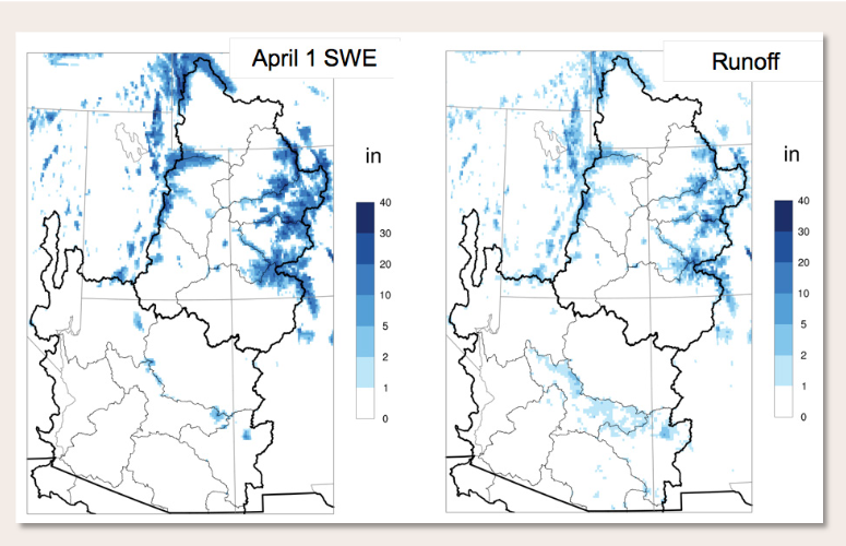
The Western Water Assessment graphic below basically shows the water-production region for the Colorado River (whose natural basin is the black line). ‘April 1 SWE’ is the ‘snow water equivalent on April 1,’ the amount of water in the snowpack that constitutes the majority of the river’s water. Late March to early April is generally presumed to be the time of the highest snowpack in the mountains and other highlands surrounding the upper reaches of the River, so a map of the ‘April 1 SWE’ is a passable map of the river’s water-production area. The blue areas (inside the black line) are less than 15 percent of the 245,000 square-mile River Basin, and as you can see, it is not a contiguous area – just the places that rise high enough to make the moving air give up to the highlands its moisture as rain or snow. Water management decisions throughout the Basin begin to be made on the basis of the April 1 SWE. (The gray lines, by the way, are watershed boundaries for different tributaries and divisions of the river, not the waterways themselves.)
You’ll note that the adjacent averaged annual ‘Runoff’ map indicates that considerably less water flows out of the water-production region than the ‘April 1 SWE’ map shows. Scientists have found that the amount of water that actually makes it into the Colorado River is only a fraction of the water that falls in the river’s water-production region. The Western Water Assessment’s study of the ‘State of the Science’ on Colorado River climate and hydrology claims that on average around 170 million acre-feetof water falls on the Colorado River Basin annually, with the largest portion of that falling on the highlands of the water-production area – yet the river carries on average less than a tenth of that precipitation. What happens to the rest of it?
The short answer there is, the sun is what happens to it: the sun gives, and the sun takes away. The sun distills pure water vapor from the oceans, and the winds (also created by the sun) carry that vapor over the land areas, where begins the ‘dance’ I described in the last post, as water vapor gets pushed up against mountain slopes and condensed to precipitation which falls on the mountains as rain or snow – where the sun and winds quickly go to work on trying to transform it back to vapor.
This begins even in the depths of winter, in sub-freezing weather: the sun beating down on a ‘solid’ snowpack releases enough heat energy to turn the snow crystals directly to water vapor, without going through the liquid state – a process called sublimation. Sublimation happens when a snowpack is directly exposed to the sun; it also happens when the wind blows the snow around breaking down the ice crystals; and it happens when coniferous tree branches intercept and hold the falling snow or rain, which is vaporized off the branches by the sun. On a day of brilliant sun, fairly common in the water-production region, you can actually see ‘steam’ – water vapor – rising where snow sits on an exposed darker surface – rocks or branches. And all of this in temperatures below freezing.
The East River Valley, northwest of the historic town of Gothic, home to the Rocky Mountain Biological Laboratory. The mountain with the pointed peak in the distance is Mount Crested Butte. Photo credit: Mark Stone/University of Washington
A major study of the water-production area is underway in the Upper East River valley near Crested Butte, as part of a U.S. Energy Department ‘bedrock to upper atmosphere’ study of water and energy; it includes what is probably the most intensive study of sublimation ever assembled. The science team is mainly working on sun and wind sublimation in open areas; early results suggest that around 10 percent of a winter snowpack disappears through that form of sublimation. Losses from branch interception might be as large as that or larger. Guesstimates over the years suggest that as much as a third of the precipitation that falls might disappear through sublimation of ‘solid’ snow to water vapor through the course of a winter.
The snowpack is only ‘safe’ from sublimation where it gets some protection from the sun and wind. Snow that makes it down to the ground in forested areas – not intercepted by branches – is sheltered somewhat from the sun and wind. ‘Aspect’ (location on the mountain) is also important: snow on the north and east slopes of mountains may never see the direct sun all winter, although it will feel the wind.
Eventually winter turns to not-winter, and the accumulated snowpack begins to melt as the air generally warms (with sublimation also ratcheting up with heat). One of three things will happen to the resulting ‘snow water.’ Where slopes are steep or rocky or both, a lot of the water melting out will become runoff – water running off under the affluence of gravity: trickles run together and find their way into the stream flowing out of the watershed, streams meeting other streams in ever larger watersheds until rivers flow out of the mountains into the water-consumption region where they are quickly put to work by farmers and ranchers.
Back up to the melting edge, however – if it can, the water melting out of snow will not run off but will sink into the ground, the preferred alternative for the ‘life project’ on the planet (but not always for the human users). How much water runs off, and how much sinks in, depends on how fast the snow melts and how steep or rocky the slope.
The water that sinks in – groundwater – passes first into a soil area laced and spaced by the roots of all the plant life living on the surface, from little tundra miniatures to great trees. This is variously called the ‘vadose zone,’ the interflow, or most plainly, the unsaturated zone. The roots in the unsaturated zone will take up a lot of that water for their plants to use: some of it will go into the plant’s structure and systems, but most of it – as much as 95 percent of it – will be transpired by the plant: emitted into the atmosphere as water vapor, a kind of air-conditioning system that increases with higher temperatures.
For big old spruces in the subalpine forest, transpiration might be around 80 gallons a day on average (more on a warmer day); for lodgepole pine, maybe 40 gallons a day. That might not sound like lot, a mere 0.0002 of an acre-foot. But next time in the mountains, look at a forested slope across a valley, and try to estimate the number of trees there to the nearest thousand….
In addition, any time the flowing or standing water is exposed to the sun, the sun takes a cut through straight evaporation. Evaporation also increases with temperature. One of the East River project researchers, Dr. Rosemary Carroll, claims in a research paper that, in a typically dense montane forest, the total evapotranspiration (evaporation plus transpiration) can add up to equal the precipitation that fell on the forest.
So it becomes clear that the water produced in its mountains for the Colorado River is a ‘net’ figure – precipitation minus natural depletion from a) a winter of sublimation every day the sun shines, b) evaporation of water melted from snow when exposed to the sun, and c) transpiration by the forests of the water making its way underground.
But we have to then add back in the groundwater that makes its way down through the unsaturated zone to a saturated zone below most of the thirsty roots. The top of the saturated zone is called the water table, which rises and falls with the amount of water saoking into the ground. Water in both the unsaturated and saturated zones filters its way downslope pulled by gravity and pushed by more water coming in above.
Eventually it will makes its way to the bottom of the watershed where the stream flows; there, if the water table is higher than the stream level, the groundwater will feed into the stream. Scientists have figured out how to tell from a sample of stream water how much of it is runoff, and how much has come through the groundwater route; over a good water year with healthy water tables, the ratio of groundwater to runoff will be about 50-50, with runoff being greater during the spring flood season and groundwater dominating the fall and winter flows.
Carroll notes in the same paper that the journey of groundwater to the stream might be very leisurely; while some of it might make its way through the cobble found in many mountain valleys in a matter of days, water that sinks into cracks and interstices in more solid rock might not show up in the stream for a century – or never, unless someone drills into the rock and installs a pump.
In the final tally, about one-fifth of the precipitation that falls in the high headwaters emerges as water for the river. Another portion of it is in ‘longterm storage’ as groundwater in aquifers. But the rest, probably more than half of it, has gone back to the vaporous state of water. The sun giveth, and the sun taketh away.
The ‘Headwaters Challenge’ ought to be obvious. We can’t do a lot about what happens up in the alpine tundra – but are there management strategies for the forests we could employ that might cut down on the amount of water we lose to the sun there, increasing the net water production even a little to compensate for what we are losing to the warming climate? That’s the romantic exploration I’m on these days, reading a lot of scientific papers I only partially understand. I may or may not be ready to say anything about this in the next post – but I wanted to get the challenge in front of those who read this, to ask if any of you have any ideas….
Meanwhile – the apparent preference of the sun for water in the vaporous state should probably make us a little nervous. Obviously, the warmer it gets, the more water gets sublimated, evaporated and transpired – and we seem to be doing all we can to make the world warmer. Not a good survival strategy for species dependent on liquid water, even though we are convinced we cannot survive without the things whose byproducts make the world warmer…. That’s a bigger challenge facing us all.
Creating a balance of water that’s taken from aquifers and water that replenishes aquifers is an important aspect of making sure water will be available when it’s needed. Image from “Getting down to facts: A Visual Guide to Water in the Pinal Active Management Area,” courtesy of Ashley Hullinger and the University of Arizona Water Resources Research Center
As Californians pump increasing amounts of water from the ground, sometimes siphoning flows from the rivers above and hurting fish, wildlife and other water users, an old state law is proving to be a new and successful means of reining in excessive pumping. A Superior Court judge ruled last week that Sonoma County must do more to ensure responsible groundwater pumping under the state’s Public Trust Doctrine. The historical doctrine holds that rivers, creeks and other waterways must be protected for the public. Groundwater has only recently been considered part of the Public Trust Doctrine, as the hydrological connection between waterways and below-ground water supplies has become clear. The new court decision is likely the first to enforce this. The ruling will not only require Sonoma County to revisit and perhaps rewrite its ordinance for permitting groundwater wells, but it could set the stage for other counties to similarly step up regulation for groundwater pumping. With aquifers being overdrawn across the state as above-ground supplies get squeezed, environmentalists are optimistic that this will be the case.
“This ruling is particularly welcome given steadily growing groundwater pumping, declining natural resources and a changing climate that is making droughts deeper and longer,” said Barry Nelson, founder of the consulting company Western Water Strategies. “We hope this decision will be followed by counties statewide so that they start considering impacts on surface flows more seriously when permitting groundwater pumping.”
A Rio Grande sign at Isleta Blvd. and Interstate 25 on Sept. 7, 2023. The U.S. Supreme Court appointed a new special master to oversee the case, after their June ruling blocking a proposed deal. (Photo by Anna Padilla for Source New Mexico)
Click the link to read the article on the Source NM website (Danielle Prokop):
August 26, 2024
The U.S. Supreme Court appointed a new judge to oversee the Rio Grande water dispute between Texas and New Mexico.
The case will continue on after the high court’s June ruling dismissed a deal between New Mexico, Colorado and Texas, as five justices sided with objections from the federal government to the deal.
Justices appointed Judge D. Brooks Smith, U.S. Court of Appeals for the Third Circuit from Duncansville, Pennsylvania, to replace federal appeals Judge Michael Melloy as the special master in the case in July.
A special master acts as a trial judge, decides on issues in the case and prepares reports to inform the U.S. Supreme Court’s ultimate opinions in the case.
Smith, 72, has a long career in law, first starting in private practice and as a prosecutor. He donned the robes in 1984 as both a Court of Common Pleas judge in Blair County, Pennsylvania, and an administrative law judge.
In 1988, he was appointed by President Ronald Regan and confirmed to a federal position for the U.S. District Court for the Western District of Pennsylvania.
In 2002, the Senate confirmed his appointment by the Bush administration to the federal appeals court, where he’s served since.
This is the third special master for the case, called Original No. 141 Texas v. New Mexico and Colorado.
In a complaint filed in 2013, Texas alleged that pumping in New Mexico below Elephant Butte Reservoir was taking Rio Grande water owed to Texas under a compact from 1939.
That 85-year old document governs the Rio Grande’s use between Colorado, New Mexico and Texas, and also includes provisions for sending water to Mexico under 1906 treaty obligations and acknowledges regional irrigation districts.
In 2018, the U.S. Supreme Court unanimously ruled to allow the federal government to join the case, accepting the arguments that New Mexico’s groundwater pumping threatened federal obligations to deliver water to Mexico and two irrigation districts.
After months of negotiations and a partial trial, Colorado, Texas and New Mexico proposed a deal to end the yearslong litigation. The federal government and regional irrigation districts objected to the deal, saying that it imposed unfair obligations and was negotiated without their agreement.
Melloy recommended the court ignore the federal government’s objections and approve the state’s proposed deal.
In June, the high court released a narrow 5-4 ruling siding with the federal government’s objections and blocking the state’s deal.
It’s unclear what comes next in the case under the new special master, but the parties could return to the negotiation table to hammer out another deal or return to the courtroom.
Rio Grande and Pecos River basins. Map credit: By Kmusser – Own work, Elevation data from SRTM, drainage basin from GTOPO [1], U.S. stream from the National Atlas [2], all other features from Vector Map., CC BY-SA 3.0, https://commons.wikimedia.org/w/index.php?curid=11218868
The Central Arizona Project canal passes alfalfa fields and feedlots in La Paz County, Arizona. The fields are irrigated with pumped groundwater, not CAP water. Source: Google Earth.
Imagine that you’ve set off for a hike in the desert of western Arizona, hoping to get up high so you can get a view of the juxtaposition of alfalfa fields against the sere, rocky earth. But you somehow get disoriented, the sun reaches its apex and beats down on you, the temperature climbing into the triple digits. The ground temperature becomes so hot you can feel it through the soles of your Hoka running shoes. Your water bottle is empty. Feeling certain you are going to die you pick a direction and stagger in as straight a line as you can manage, rasping for help. And then, just when you’re about to curl up under a rock and surrender, you see, coming straight out of a hillside, a virtual river. It must be a mirage, you think, or a hallucination, you run toward it, climb the fence, and dive into the cool, deep water.
This is not a fantasy scenario. There is, in fact, a place in the western Arizona desert where a lost traveler could stumble upon a giant canal emerging from the earth.
The Central Arizona Project’s Mark Wilmer pumping plant at Lake Havasu. The 14 plants on the CAP system push water across more than 300 miles with a vertical gain of 3,000 feet. Moving water requires enormous amounts of power, making the CAP the state’s largest single electricity user, with annual power bills totaling $60 million to $80 million. Source: Google Earth.
Central Arizona Project canal daylighting at the Buckskin Mountain Tunnel. Source: Google Earth
The outlet of the San Juan Chama Project runs into Willow Creek west of Los Ojos before running into Heron Lake. Source: Google Earth
The Rio Blanco intake for the San Juan-Chama Project, which takes water from three upper San Juan River tributaries and ships it across the Continental Divide to the Chama River watershed and, ultimately, the Rio Grande. Source: Google Earth
It’s just one of the crazy plumbing projects along the Colorado River and its tributaries. And they can look pretty weird when you stumble upon them in remote places. That’s what happened to me the other day — virtually. I was using Google Earth to chart the 1776 Escalante-Dominguez expedition’s path when, near Chama, I came across a large volume of water emanating from an arid meadow. After some thought I realized it was the outlet for the San Juan-Chama Project that diverts about 90,000 acre-feet of water annually from three tributaries of the San Juan River, sends it through the Continental Divide via a tunnel, and delivers it to Willow Creek and Heron Reservoir. From there it can be released into the Chama River, which runs into the Rio Grande, which is used by Albuquerque and Santa Fe to supplement groundwater and the shrinking Rio Grande.
The Big Thompson Project sucks water out of the Colorado River near its headwaters and siphons it through the mountains via the Alva Adams Tunnel. The water feeds reservoirs that feed Front Range cities and is used to generate hydropower. Adams tunnel inlet at Grand Lake. Source: Google Earth
The Big Thompson Project sucks water out of the Colorado River near its headwaters and siphons it through the mountains via the Alva Adams Tunnel. The water feeds reservoirs that feed Front Range cities and is used to generate hydropower. Penstocks and powerplant at Flatiron reservoir on the right. Source: Google Earth
These things aren’t only unsettling in a visual way, but in a conceptual way as well. One would expect cities and agricultural zones to rise up around where the water is and to grow according to how much water is locally available. Instead, cities rise up in places of limited water and grow as if there were no limits, importing water (and power and other resources) from far away.
The Julian Hinds pumping station, near Desert Center, California, lifts water from the Colorado River Aqueduct 441 feet as it makes its way toward Los Angeles. Source: Google Earth
The Southern Nevada Water Authority was forced to build a third water intake from Lake Mead that was able to draw water as the reservoir continued to shrink. The pumping plant is pictured. Source: Google Earth
Moab tailings site with Spanish Valley to the south
Click the link to read the article on The Deseret News website (Amy Joi O’Donoghue). Here’s an excerpt:
August 6, 2024
Sixteen million tons of radioactive uranium tailings once sat near the banks of the Colorado River, putting the waterway in peril of contamination on the outskirts of Moab. Removal began in 2009 and was halted for a time due to lack of funding for the U.S. Department of Energy cleanup project, but work is continuing at a steady clip — with nearly 15 million tons shipped by rail to a disposal cell about 30 miles away at Crescent Junction. At this rate, the tailings removal may be completed by next year, but much work remains to be done afterward for full remediation of the area in which the uranium mill operated for nearly three decades…
Mary McGann, a Grand County commissioner who heads up the steering committee involved in the project, said she envisions something similar to Las Colonias Park in Grand Junction, Colorado. It, too, was a remediation site for tailings removal and it, too, is adjacent to the Colorado River…
Contamination from what the locals call “The Pile” has been a problem for the Colorado River in Grand County — before the establishment of the Moab Uranium Mill Tailings Remedial Action, or UMTRA, Project. But the project established groundwater wells to prevent the leaching and to serve other useful purposes.
During the reporting period, which ran in mid-July of 2023 to mid-July this year, officials noted there were over 1,036,719 tons of uranium mill tailings shipped by rail four times a week. To date, the project has shipped more than 14.8 million tons, or about 92% of the total estimated 16 million tons in the tailings pile to be moved. During that same reporting period, more than 151,162 tons of debris was placed in the disposal cell — also shipped by rail. That includes the successful removal of 14 autoclaves — each weighing 16,000 pounds, according to project spokeswoman Barbara Michel.
Petersen Air Force Base. Photo credit: Peterson Air and Space Museum
Click the link to read the article on The Guardian website (Tom Perkins). Here’s an excerpt:
August 12, 2024
The US air force is refusing to comply with an order to clean drinking water it polluted in Tucson, Arizona, claiming federal regulators lack authority after the conservative-dominated US supreme court overturned the “Chevron doctrine”. Air force bases contaminated the water with toxic PFAS “forever chemicals” and other dangerous compounds. Though former US Environmental Protection Agency (EPA) officials and legal experts who reviewed the air force’s claim say the Chevron doctrine ruling probably would not apply to the order, the military’s claim that it would represents an early indication of how polluters will wield the controversial court decision to evade responsibility. It appears the air force is essentially attempting to expand the scope of the court’s ruling to thwart regulatory orders not covered by the decision, said Deborah Ann Sivas, director of the Stanford University Environmental Law Clinic…
The supreme court in late June overturned the 40-year-old Chevron doctrine, one of its most important precedents. The decision sharply cut regulators’ power by giving judges the final say in interpreting ambiguous areas of the law during rule-making. Judges previously gave deference to regulatory agency experts on such questions. The ruling is expected to have a profound impact on the EPA’s ability to protect the public from pollution, and the Tucson dispute highlights the high stakes in such scenarios – clean drinking water and the health of hundreds of thousands of people hangs in the balance…
Several air force bases are largely responsible for trichloroethylene (TCE) – volatile organic compounds – and PFAS contaminating drinking water sources in Tucson. A 10-sq-mile (26 sq km) area around the facilities and Tucson international airport were in the 1980s designated as a Superfund site, an action reserved for the nation’s most polluted areas. The EPA in late May issued an emergency order under the Safe Drinking Water Act requiring the air force to develop a plan within 60 days to address PFAS contamination in the drinking water.
Click the link to read the article on the InkStain website (John Fleck):
I’ve been
a) Playing with Datawrapper as a tool for displaying data here on Inkstain, and
b) Thinking about Albuquerque’s aquifer as bad summer river flows force us back onto groundwater
(City #2, in the North Valley, is one of a quartet of groundwater monitoring wells drilled in the late ’50s as Albuquerque’s population and groundwater pumping began to grow. I use it for big picture attention because it’s reasonably well placed to give a good rough picture of what’s going on, and has a nice long time horizon.)
update:
City Well #2
USGS Groundwater Monitoring Well 350824106375301, better known as Albuquerque’s “City Well #2”
Map: John Fleck, Utton Center, University of New Mexico School of LawSource: USGSCreated with Datawrapper
From satellite view, the land north of the Arkansas River is a seemingly random checkerboard of vital green and desperate brown, quickly fading from a few thriving farm acres to the broad, water-drained desolation of northern Crowley County.
From the cab of Matt Heimerich’s pickup, each alternating square of emerald corn or desiccated knapweed is a decision by a distant big city — to either share Colorado resources responsibly or toss rural Arkansas River counties to the fate of the hot summer winds.
That square was reseeded with native grass after Aurora bought the water in the 1970s, Heimerich says. That plot, Colorado Springs dried up and it’s all weeds. That farm, Aurora wants to dry it up soon, but the water court referee wants a better reseeding plan.
Heimerich’s family is one of the few farmers remaining in the 790 square miles of Crowley County after city water buy-ups shrank the county’s irrigated acres from more than 50,000 in the 1970s to just a few thousand this year. He jumps down from the pickup to clear invasive kochia weeds from a pipe opening gushing cool canal water down a 1,500-foot corn row.
Straight line diagram of the Lower Arkansas Valley ditches via Headwaters Magazine
Two miles away is downtown Olney Springs, population 310. Crowley County as a whole has only 5,600 residents, and more than a third of those are inmates at two prisons. The only retail operation left in Olney Springs is a soda vending machine against the wall of town hall.
As Heimerich clears his irrigation pipe, he pauses to jab a thumb over his shoulder 150 miles to the north at Aurora, where the population increased by more than 100,000 over 20 years. “When you build a new development, at the end of the day, you’re drying up a farm,” Heimerich said. “Where else is it going to come from?”
“Crowley is just the worst example of what can happen when nobody cares, and nobody pays attention,” he said. The tiny community serves as an enduring reminder of the cultural and economic ruin that occurs when big cities in Colorado and elsewhere purchase farms, dry up the land and move the water to urban areas. It gave rise to the term “buy and dry,” a practice now widely condemned.
The practice was supposed to end in the Lower Arkansas Valley in 2003 with a hard-fought federal court battle and settlement. Since then, state lawmakers and top water and farm agencies have changed laws and spent millions of dollars testing new protective methods for sharing water temporarily between rural and urban areas. They have also spent heavily to improve water quality for thousands of people living near the river who still don’t have clean water to drink.
The big cities insist they have learned their lessons from the Crowley County disaster.
“The results of what happened in Crowley County are unacceptable and widely recognized as a travesty,” said Colorado Springs Utilities spokesperson Jennifer Jordan. “We’ve taken those lessons to heart.”
Arkansas River Basin — Graphic via the Colorado Geological Survey
But outraged Lower Arkansas growers and water districts say new efforts to protect their farm water aren’t working. At the same time, the big cities say new laws making it easier to share farm water don’t provide enough reliable water to grow their communities.
The cities also say big changes in the future water picture, climate-driven reductions in stream flows and threats to their Colorado River supplies leave them little choice but to draw more farm water.
This year they did that, inking deals in the Lower Arkansas worth more than $100 million to buy and lease land and water, raising alarms among local growers and generating big questions about whether the state is doing enough to protect rural farm communities and the water that keeps them going.
Buy and dry light
The cities say a lot has changed in the past 20 years and that these new deals represent innovations in water sharing. But critics in the Lower Arkansas Valley say these same deals signal that no one is doing enough to prevent “buy and dry” or the latest tool in the water acquisition quiver, “lease and dry,” in which water is pulled from farmland periodically.
Aurora, for instance, spent $80 million in April to buy nearly 5,000 acres of farms in Otero County and the more than 6,500 acre-feet of water associated with that land. An acre-foot equals nearly 326,000 gallons of water, enough to irrigate half an acre of corn, or supply at least two urban homes for one year.
Aurora plans to use the water itself in three out of 10 years, leaving it on the farms the rest of the time. Some 4,000 acres of land will be dried up intermittently when Aurora is using the water, according to Karl Nyquist, a developer and grower who negotiated the deal with Aurora and who is operating the farms for Aurora under the lease agreement.
Colorado Springs has a different arrangement just downriver in Bent County, where it will permanently purchase up to 15,000 acre-feet of water from local farmers. Colorado Springs will also help pay local farmers to install modern center pivot irrigation systems that use less water, allowing the city to keep the saved water for its use.
In Crowley County. Photo: Brent Gardner-Smith/Aspen Journalism
In this deal, Colorado Springs and the farmers will be responsible for revegetating any dried-up land. It will use the water in five out of 10 years, and it has agreed to make a one-time, upfront payment of $2.5 million to Bent County plus payments each year based on how much water is taken off the fields. The money is in addition to payments to farmers.
“We wanted to make sure Bent County was kept whole,” said Scott Lorenz, a senior water projects manager with Colorado Springs Utilities.
Bessemer Ditch circa 1890 via WaterArchives.org
And in Pueblo County, perhaps the least controversial of the three deals, Pueblo Water agreed to purchase nearly one-third of the shares in the local historic Bessemer Ditch system for $56.2 million. Pueblo continues to lease the water back to the farmers for now. At the same time, the Palmer Land Conservancy has developed a sophisticated new framework that measures farm productivity on land watered by the Bessemer Ditch and will eventually help direct water to the most productive farms as Pueblo takes its water. The hope is that the new system will increase overall farm productivity on the ditch system and help make up for anything lost when the less productive lands are dried up, according to Dillon O’Hare, Palmer’s senior conservation manager.
Palmer is also working to analyze the impact of the deals on water quality downstream and how to prevent further damage, O’Hare said.
Irrigated farmland is evaporating
The three projects come as new data shows Colorado’s irrigated farmlands are shrinking. Since 1997, the state has lost 32% of these lands, with areas in the Lower Arkansas Valley seeing losses higher than that, according to an analysis of federal agricultural data by Fresh Water News.
Crowley County has lost 90% of its irrigated lands in that period. Pueblo has lost 60.2%, and Bent and Otero have lost 37.6% and 35.2%, respectively.
State agriculture and water officials are worried about the decline, but say they have few tools to prevent it because farmers are free to sell their water rights to whomever they want.
“Am I concerned? Definitely,” said Robert Sakata, a long-time vegetable grower near Brighton, and former member of the Colorado Water Conservation Board who now serves as the director of water policy for the Colorado Department of Agriculture. “We all talk about water being a limited resource, but prime farmland is also limited and it’s important to take that into consideration.”
Not all these losses are due to big city water prospecting. Climate change, market challenges and legal obligations to deliver water to downstream states are also fallowing Colorado farmlands.
Everyone is sympathetic. No one is in charge.
Still, more than 20 years after the intergovernmental peace accords, it wasn’t supposed to be this way.
The Lower Arkansas Valley region is part of the sprawling Arkansas River Basin. The river has its headwaters near Leadville and flows through Buena Vista, Salida, Cañon City, into Pueblo Reservoir and on over the state line east of Lamar.
Its counties were once a sweet spot in the basin’s agriculture economy. The river fed a bountiful chain of tomato, sugar beet and onion fields, as well as acres of luscious Rocky Ford melons, and chiles, corn and alfalfa.
Cities say these latest deals, which they call “water sharing” agreements, will bolster the agricultural economies and keep remaining water on farm fields forever. But the term “sharing” doesn’t sit well with some local farmers and water officials who have a deep distrust of the cities they blame for the region’s decline.
“I call it a charade,” said Mike Bartolo, a retired Colorado State University Extension research scientist who farms in Otero County near Rocky Ford. “You dry up an acre, you’re drying up land that was formerly irrigated. That’s buy and dry.”
While the state’s highly touted Water Plan cheers for the concept of cities helping rural areas thrive after water losses, there is no mechanism or state law or bureaucracy to watchdog new sales.
After the 2003 agreement in the Lower Arkansas Valley, state and local water leaders began testing new ways for cities and farmers to temporarily share water, something that had been almost impossible under older water law.
But Aurora and Colorado Springs say the early experimental programs didn’t provide enough water at reasonable prices to fulfill their fast-growing community needs permanently.
Lorenz, the Colorado Springs Utilities manager, said the city does lease some water in the valley, but it hasn’t been enough to ensure the stability of its long-term water supply.
“The major concern is that we would lease from a particular farmer, and then a different city would come out and buy those water rights and the farmer wouldn’t lease to us anymore,” he said.
And in fact that is what just happened in April, when Aurora purchased the Otero County farms, which had formerly leased water to Colorado Springs.
Colorado Springs Utilities formally opposes the latest Aurora water deal, as do the Southeastern Colorado Water Conservancy District based in Pueblo, and the Lower Arkansas Valley Water Conservancy District in Rocky Ford.
But their anger has so far been expressed by passing resolutions, not filing lawsuits.
How Aurora Water and other cities have treated Arkansas River counties like Crowley after past buy-ups leaves nothing but suspicion about newly announced deals, local leaders say.
Though Aurora says it is not attempting any more permanent dry-ups of local land, “I don’t think any of us believe them,” said Heimerich, Crowley County’s representative on the Southeastern Conservancy board. Heimerich also is a member of the board of Water Education Colorado, which is a sponsor of Fresh Water News. “They’ll do whatever they need to do and apologize later.”
Thornton, Larimer and Weld counties conducted a similar debate publicly — from the 1990s to this year — as Thornton bought up 17,000 acres of northern Colorado farms and their water rights and began drying up the land. County commissioners and other local officials brought their legal weight and bully pulpits to bear in demanding extensive concessions from Thornton. The Adams County city has been reseeding dried up land with native grass and backfilling lost property taxes, but gets mixed reviews from locals.
The latest Lower Arkansas water deals are also pitting Colorado’s big cities directly against each other in conflicts not seen for decades. When the board of Colorado Springs Utilities passed a resolution earlier this year condemning Aurora’s Otero County deal, it was a direct shot from leadership of a city of nearly 500,000 — the Colorado Springs City Council is the utility board.
“The idea is that there’s Denver, there’s a Denver metro complex and they’re going to just do whatever they want to do and the rest of the state has to go along with it,” City Councilman Brian Risley said.
But Alex Davis, a top Aurora Water official, said Colorado Springs’ ire is unwarranted.
“Aurora has worked in close partnership with Colorado Springs for decades and that will continue,” she said. “This is a case where we disagree.”
Peter Nichols, general counsel for the Lower Arkansas Water Conservancy District in La Junta, said he is deeply concerned by what cities are proposing now.
“We thought we were through with all of this. We thought we had it under control,” he said of the Aurora and Colorado Springs purchases.
Nichols is among those who have spent much of the past 20 years creating a system, now known as the super ditch, that allows seven local irrigation companies to negotiate leases with cities.
A map of the Fry-Ark system. Aspen, and Hunter Creek, are shown in the lower left. Fryingpan-Arkansas Project western and upper eastern slope facilities.
Importantly, it also won the legal right to move leased water stored in Pueblo Reservoir out of the valley, via the federal Fryingpan-Arkansas Project and the Otero Pipeline, removing what had been a key barrier to leasing.
Nichols said local growers and water districts have worked hard to find ways to share water so that it doesn’t permanently leave the valley. That the cities are now jumping the line with these new deals isn’t OK with him.
A farmer’s — and a county’s — greatest asset
Colorado Springs and the other thirsty Front Range cities want farmers like the young Caleb Wertz to be the new face of urban water agreements. On a recent 95-degree summer afternoon, Wertz high-tailed it across Bent County driving an ambulance to take an injured neighbor to the hospital. He had planned to be on his farm, but that’s life in the Lower Arkansas Valley.
The population is shrinking, and everyone has too many jobs to count. The local farmer is also a first responder. Your primary care provider is a farmer’s wife.
Arriving back at the farm just after 5 p.m., Wertz talks about what is perhaps the most controversial decision he has ever made: Selling a portion of his agricultural water to fuel housing growth in Colorado Springs.
The deal will pay him enough so that he can install modern irrigation systems, drying up portions of the fields, known as corners, that won’t be reached by the new, center pivot sprinklers, and allow Colorado Springs to buy the saved water.
He is also planting cotton alongside his traditional corn, and he believes he is the first in the state to do so. A new modern variety is supposed to use half the water, just one acre-foot per acre, rather than the two acre-feet of water that older types, such as those grown in Arizona, use.
For Wertz, the agreement will give him enough money to keep farming and enough new technology to make his remaining agricultural water go farther. He will become a rarity in the area: A young farmer with enough land and water to continue the business his family started in 1919 and to expand it.
“The water purchase makes it a lot more doable because we can farm those acres so much more with pivots,” Wertz said. “That’s the case even though we’re drying up the corners. … That has a bad connotation to it. But Colorado Springs is reimbursing the farmers to turn those corners into pasture land or to revegetate. … Even if it is not producing corn, it’s not just becoming wasteland.”
But to some of his neighbors in the valley, Wertz has entered a hostile no-man’s land, facilitating yet another dry-up of farmland in a region that has already lost too much water and land to urban thirst.
“I know people don’t like it and people are entitled to their opinions, but a lot of those are the older generation who don’t like seeing it because of what happened years before I was even born,” said Wertz, who is 23. “I was glad to see the Springs come in and ask questions about working with us.
“We were quite leery at first. But they have proved it to us. It is extending the water use for them and us, and allowing my brother and I to start taking over some of these acres that haven’t been farmed for a while because there isn’t enough manpower.”
But can the land come back after fallowing?
Another worry for Lower Arkansas growers is whether new methods that allow cities to take the water off the fields for one or more years and then return it at a later time, do more harm than good. They’re not sure farmland in the region is resilient enough to bounce back from cycles of city-caused drought.
Perry Cabot, a research scientist and specialist in farming practices and farm economies, has spent years studying the issue. He says that there is hope for fallowing, after years of experiments and tests, but only with crops such as alfalfa and other grasses and sometimes corn.
“The programs we have done saw alfalfa return almost with a vengeance,” Cabot said. “Grass hay is the second-best candidate.”
Nyquist, the developer and grower who is leasing back and farming the land he recently sold to Aurora, agreed, saying fallowing programs do work, but they are not good for small growers who don’t have the cash to buy the necessary new equipment and nutrients that are needed to help fully restore the crops once water returns.
Still, Jack Goble, general manager of the Lower Arkansas Valley Water Conservancy District in Rocky Ford is wary of plans that take water from parts of farm fields over long periods of time.
“And I haven’t found a farmer yet that believes that that’s a viable farming situation, ” he said. “It’s tough to bring that land back.”
Dan Hobbs irrigating from the Bessemer Ditch. Credit: Greg Hobbs
For years, valley water hasn’t been drinkable
Anger aimed west and north from Lower Arkansas Valley towns extends to water quality issues, not just water volume.
For many decades, groundwater wells and the river have been contaminated by farm runoff, mining operations and some naturally occurring pollutants.
The same federal Fryingpan-Arkansas Project that in 1962 created Pueblo Reservoir was also supposed to solve the drinking water problem for 40 communities downriver by building the 130-mile Arkansas Valley Conduit to move clean water from Pueblo Reservoir. But it wasn’t until 2023 that final funding for the $610 million pipeline arrived.
Some downstream leaders are galled that Aurora can start taking more fresh water out of the Arkansas before serious pipeline construction has begun to serve the 50,000 people in long-suffering downstream towns.
“My whole life has been under drinking water restrictions, not being able to attain safe drinking water except to go buy it or to go through extraordinary measures to treat it,” said Dallas May, whose family ranches 15,000 acres north of Lamar. May also is on the Southeastern Colorado Water Conservancy District board.
The Colorado Department of Public Health and Environment’s Water Quality Division, which tests Lower Arkansas water a few times a year, classifies most of the river below Pueblo Reservoir as not supporting drinking water or “aquatic life use.” The classification calls the Lower Arkansas suitable for “warm-water aquatic life” and recreation.
The state did not respond to requests for more detailed assessments of Lower Arkansas water health. Asked if state efforts were improving water quality on the Arkansas, a spokesperson said in an email, “Trend studies require extensive data over a significant period of time. The water quality in watersheds is influenced by a wide variety of factors, including precipitation and weather trends that can highly influence the water quality from year to year.”
Some Lower Arkansas farmers and officials are tired of waiting. They see the problem getting worse as, for instance, Aurora takes more water out of Otero County, “What happens is all of the bad things are concentrated into what is left,” May said, “and that is a huge problem.”
Silence at the state level?
The Colorado Water Conservation Board spent years writing the statewide Water Plan, convening forums and task forces, and conducting listening sessions on the tensions between city water needs and the survival of agricultural communities. They say they are concerned about new city water buys, but add they have no authority to influence any deals because water rights are private property rights and can be bought and sold at will.
The board declined an interview request about Aurora’s water purchase or the broader water use questions.
“The Colorado Water Plan sets a vision for meeting the state’s future water needs and was broadly supported by local communities,” Russ Sands, the board’s water supply planning chief, said in email responses to questions. “But the decisions that happen in local communities regarding their water purchases and planning are largely outside of the state’s control. Accountability for staying true to the vision of the Water Plan is a collective responsibility.”
The loss of irrigated farmland isn’t expected to slow anytime soon as climate change dries up streams and population growth drives cities to buy more. The Colorado Water Plan’s forecast shows the population of the Arkansas River Basin, which includes Colorado Springs and Pueblo, surging more than 60% by 2050, increasing the pressure to tap farm water.
Sakata, the state water policy advisor, who farms near Brighton, said protecting the state’s irrigated farmland will take more work. “We can’t just say lease the water for three out of 10 years. We need to have agreements so that water sharing will be really available.”
As an onion grower, Sakata can’t do interruptible water supply agreements because he has long-standing yearly agreements with suppliers that require him to deliver vegetables. If he fallows his land for a year, the money he would likely be paid wouldn’t be enough to compensate him for the loss of onion sales and the need to support his employees during the break.
Farm research scientist Cabot would like to see the state begin buying irrigated farms, using conservation easements to protect them from development or purchase, and then leasing that land and its water to young growers.
What else state leaders can do to preserve what’s left of Colorado’s irrigated land isn’t clear yet, but Alan Ward, a Pueblo native who is also director of water resources for the Pueblo Water, said the state needs to reexamine its policies and goals.
“There is only so much water available, and I don’t think it’s realistic for the state to continue to think that we can control our urban areas and grow them fast without impacting agriculture.” Clarifying that he was speaking as a private individual, rather than a water official, he said, “I’d rather have the farms continue and not have the urban growth, but I am probably in the minority on that.”
Where does the battle flow next?
Water veterans such as Cabot said the state is likely doing everything it can right now to protect irrigated ag lands. But like Sakata, he says more work needs to be done to shore up farm markets and to create easier, more lucrative water sharing arrangements.
“I don’t want to oversimplify this,” Cabot said, “but the simplest way for cities to get this water is to go to farmers and say ‘How much did you make last year?’ and then offer them 10% more. … These are not just fields. They are farm enterprises.”
Kate Greenberg, Colorado’s agriculture commissioner, is overseeing multimillion-dollar efforts to protect farmlands by improving soil health, solving market challenges and making farm water use more efficient. She says the people of Colorado are on board with her agency’s efforts.
“We did a study last year that showed over 98% of Coloradans believe agriculture is an integral part of our state. If we’re taking water out of agriculture, where are we putting it to beneficial use?
“Are we conserving it to grow urban developments and do we want to see that over preserving agriculture and biodiversity. We need to answer that question as a state.”
Bartolo, the retired CSU researcher, hopes the answer comes soon, before any more of the valley water is siphoned off for urban use.
As news of the deals spreads, Bartolo’s sense of deja vu is growing and his fears for the future of the valley’s irrigated ag lands is growing too. No one knows yet what will happen when Aurora’s contract to use the Fryingpan-Ark to deliver water expires in 2047.
“Having lived through it in my lifetime, I have seen the drastic changes,” Bartolo said.
What worries him, and other growers too, is “what happens if they come back after 2047? What happens then?”
The biggest water trials facing the Rio Grande Water Conservation District and local farmers are set for 2026.
Peter Ampe, attorney for the Rio Grande Water Conservation District, told board members Tuesday that three major water cases are set for trial in 2026. The cases are:
The fourth Plan of Water Management for Subdistrict 1 scheduled for six weeks starting Jan. 2, 2026
Sustainable Water Augmentation Group and its proposed alternative augmentation plan for a group of irrigators in Subdistrict 1 set for a six-week trail starting June 29, 2026
The city of Alamosa and its confined aquifer case set for a three-week trial starting on Oct. 19, 2026
Each of the cases is subject to settlement ahead of any trial. Ampe said the city of Alamosa’s case to guarantee itself more water for future expansion has the best chance of agreement before a trial would begin.
The fourth Plan of Water Management for Subdistrict 1 is a key document that outlines future strategies to recover the unconfined aquifer of the Upper Rio Grande Basin. Farmers in the subdistrict, which covers parts of Alamosa County around Mosca-Hooper and Rio Grande County, are under pressure from state water managers to restore the aquifer.
The subdistrict’s updated water management plan has been approved by the state engineer and needs approval from the District 3 Water Court to go into effect.
The alternative augmentation plan proposed by the Sustainable Water Augmentation Group had the start of a water trial in 2023 only to have the trial come to a sudden end when the group withdrew its application. The application withdrawal came after the town of Del Norte terminated an agreement to lease water to the SWAG farmers as a replacement source for groundwater pumping by SWAG members.
Greg Higel, board chair of Rio Grande Water Conservation District, said the board will have to prioritize spending on attorney fees in its annual budgets. MORE: Alamosa Citizen maintains an extensive archive of water stories.
Click the link to read the article on the Water Education Colorado website (Shannon Mullane):
July 25, 2024
After four years of experimentation, a group of researchers in Texas have successfully used a type of virus — used to combat bacterial infections in medicine — to kill bacteria in wastewater from fracking.
This wastewater, which can come with radioactive, cancer-causing materials, and yes, bacteria, often gets shoved back underground for storage. But increasingly, Colorado and other states are looking at ways to clean the wastewater enough that it can be used in other mining operations instead of fresh water. It’s an intriguing idea in Colorado, where fresh water supplies have been strained by a two-decade megadrought.
Could viruses really help? The potential is there — but so are big questions about practicality, researchers say.
“It’s outside-the-box science. We knew that,” said Zacariah Hildenbrand, part of the six-person University of Texas research team that published a study on the viruses in April. “But I mean, necessity is the mother of all innovation here, and we need to find some novel technologies.”
Wastewater, called produced water, is the major waste stream generated by oil and gas production, according to the group’s research published in the peer-reviewed journal Water. The research was funded by Biota Solutions, a Texas-based research company founded to develop viruses to kill bacteria in produced water.
Oil and natural gas can be thousands of feet below the ground’s surface, where it mixes with brackish water. At that depth, the water can include naturally occurring carcinogenic compounds and radioactive materials. It’s so salty that, if used for irrigation, it could kill plants.
During the fracking process, companies pump a mixture of fresh water, sand and chemicals [ed. including PFAS] underground where it mixes with oil, gas and the brackish water. It returns to the surface and is separated from the oil and gas. The result is produced water, which can not be used for drinking or irrigation, per state regulations.
In Colorado, water used for fracking averaged about 26,000 acre-feet per year from 2011 to 2020, or about 0.17% of the water used in the state, according to the Colorado Division of Water Resources. One acre-foot roughly equals the annual water used by two to three households.
The highest volumes of water used for hydraulic fracturing are used within the counties along the Front Range in Denver-Julesburg Basin.
“In an arid state like Colorado, where we’re worried about how much water is getting down the Colorado River, that rubs a lot of people the wrong way. And it should,” said Joseph Ryan, an environmental engineering professor at the University of Colorado.
Attack of the viral “spiders”
The complex cocktail of produced water also comes with another ingredient: bacteria.
Some of the bacteria can corrode pipes while others sour the gas, which makes it stinkier and requires more processing. Both can cost oil and gas companies money, Hildebrand said.
Historically, companies have treated these bacteria with disinfectants, like chlorine and hydrogen peroxide. But over time, the bacteria can become more resistant. To protect themselves, they change their membrane structure to become less permeable — like putting on a raincoat in a storm, he said.
Some companies end up using twice as many chemicals to kill the same amount of bacteria, which is more costly and less environmentally sustainable, he said.
So the researchers set out to test another technology: The bacteriophage.
Bacteriophages are viruses that infect specific bacteria. They’re like the spiders in the “Starship Troopers” movie, Hildebrand said. Once the phage finds its host bacteria, it hooks into the surface of the cell, injects its DNA into the center of the bacteria, and hijacks the bacteria’s replication mechanisms.
Then it reproduces until the bacteria explodes.
The process allows the virus to multiply exponentially and infect more cells. But Hildebrand stressed the virus targets only its specific host bacteria, not any other type of cell.
Bacteriophages have been used for decades in medicine to treat issues like skin infections, indigestion and food poisoning caused by E. coli.
“Under the microscope, at the atomic scale, it’s scary. It’s an all-out civil war between bacteria and viruses,” he said. “But from the human perspective, it’s totally innocuous.”
Is the virus enough?
The researchers’ study showed that bacteriophages successfully deactivated two strains of bacteria found in produced water — but there are some key hurdles that would need to be addressed for the technique to be used by oil and gas operators.
Produced water could include tens of thousands of bacterial strains, which means researchers would need far more strains of viruses to disinfect the produced water. And right now, there aren’t enough commercially available bacteriophage strains to make it happen, Hildebrand said.
“The goal is, we just learn enough from all of the basins that ultimately I build a 200-phage cocktail that’s kind of a kill-all, if you will. It’s a belt-and-suspenders approach,” he said. “Once I build it initially, it will renew itself in the environment.”
After the up-front costs, the bacteriophage technique would cost less than a penny per barrel because the virus renews itself, Hildebrand said based on his economic estimates.
Ryan of CU Boulder has doubts, big ones.
When it comes to reusing produced water, corroding pipes are a small problem compared to the radioactivity, salinity and carcinogenic compounds, he said.
There are so many microorganisms in the water that it would be difficult to affordably find enough bacteriophages to completely disinfect it. There’s no way fixing the minor problems caused by bacteria would be worth the effort and cost, he said.
“It’s a questionable solution to a problem that just doesn’t seem at the top of the list of importance if you’re trying to do something with produced water,” Ryan said.
Hildebrand acknowledged that disinfection alone is not enough to clean produced water to a reusable level, but it would help, especially if the bacteria have become resistant to other disinfection methods.
Ryan is one of 31 people on the Colorado Produced Water Consortium, which includes industry, state, federal and environmental representatives. (He emphasized he was not speaking for the group.)
In 2023, the Colorado legislature created the consortium to study how to reuse and recycle wastewater from fracking. The group is set to publish its fourth study on produced water Aug. 1 — one of nine that will be presented to legislators and state agencies.
Hope Dalton, the consortium’s director, declined to comment on the fresh-out-of-the-lab research.
“Generally speaking, bench-level research is innovative and new and hasn’t been tested,” she said. “Then you go out to industry and use it on the larger, pilot scale. Once it’s proven at the larger, pilot scale, then it can be implemented as practice.”
That’s the next step for the Texas researchers, Hildebrand said.
“Yes, it’s very early stages, but considering how effectively it works … how robust the phages are and how cheap they are to produce, I think it provides a really unique solution moving forward,” he said.
One year ago, the Supreme Court issued its sweeping decision in the case Sackett v. EPA, which invalidated federal Clean Water Act protections for most streams and wetlands in the United States. Since then, the fight for clean water protections has been at the state level. This report outlines the state of clean water protections one year out from the Sackett decision and why federal protections for our critical waters is vital in the face of worsening climate change and other threats.
In the year since the Supreme Court ruling, two states passed or introduced legislation to create new permitting programs to fill the gap in federal protections and eight states passed or introduced stronger laws and policies to strengthen state protections. Two states passed legislation weakening state-level protections, while efforts to weaken state protections failed in four other states.
The Importance of Wetlands and Streams
Wetlands and streams are the livers and heart of our ecosystems. These critical waters prevent flooding, filter pollution, store carbon, and provide critical habitat for wildlife. According to the Environmental Protection Agency (EPA), ”Wetlands are among the most productive ecosystems in the world, comparable to rain forests and coral reefs.”
Similarly, streams that flow only part of the year play a critical role in maintaining the quality and supply of our drinking water and aid water conservation.
Our lakes and rivers depend on these critical waters, which in turn depend on the Clean Water Act (CWA or the Act) for protections to keep them healthy for fishing and swimming, agriculture and other business uses, and as a source for drinking water. In many cultures, particularly Indigenous cultures, water has a deep religious and spiritual element, and water is seen as life — waters are considered sacred places to cherish and protect. To limit their protection under the CWA could degrade the quality of water in waterways that people and wildlife depend on.
Healthy mountain meadows and wetlands are characteristic of healthy headwater systems and provide a variety of ecosystem services, or benefits that humans, wildlife, rivers and surrounding ecosystems rely on. The complex of wetlands and connected floodplains found in intact headwater systems can slow runoff and attenuate flood flows, creating better downstream conditions, trapping sediment to improve downstream water quality, and allowing groundwater recharge. These systems can also serve as a fire break and refuge during wildfire, can sequester carbon in the floodplain, and provide essential habitat for wildlife. Graphic by Restoration Design Group, courtesy of American Rivers
Little Snake River agricultural lands along the Colorado-Wyoming border. (Angus M. Thuermer, Jr./WyoFile)
Click the link to read the article on the InkStain website (John Fleck):
July 15, 2024
A team out of Wyoming, including my Colorado River Research Group colleague Kristiana Hansen, has a new paper that reminds us that we need to be careful about how we thinking about conserving water that is being “wasted.”
Their case study is an area on the New Fork in Wyoming, a tributary of the Green, which is a tributary of the Colorado, where producers use flood irrigation on timothy grass to grow livestock forage.
Flood irrigation is often seen as “wasteful.” One approach is to install “more efficient” irrigation technology. But – and this is one of my repetitive talking points with students in the graduate water policy course I teach every fall – you need to flag the word “waste” when you see it in a water policy discussion and think carefully about how you’re using it.
That water is going somewhere, and doing something. You have to include this in your analysis. Maybe it’s really being “wasted”. But you may find that the place the water is going, and the thing that it’s doing, is valuable!
That’s what the Wyoming team found. Flood irrigation recharges the shallow aquifer – reducing the spring peak in the area’s streams, and slowly releasing that water back into those same streams in late summer. Which is crucial, in this case, for economically valuable fisheries – recreational brown trout fishing, to cite their analysis.
This is at the heart Bruce Lankford’s oddly named work on the “paracommons,” which has provided an enormously helpful analytical framework for my thinking about this stuff.
Cleaning up our urban sewage for reuse is super popular right now, and can in some cases be an enormously powerful water policy response to scarcity. But we’ve got to be mindful about where that “wasted” water is going and what positive benefits it is providing. Lots of inland urban cities in the southwestern United States treat their wastewater and return it to rivers, where it feeds ecosystems and downstream users.
Click the link to read the article on the Sibley’s Rivers website (George Sibley):
July 17, 2024
In the last post, I suggested that the Colorado River Compact with its ‘temporary equitable division’ into two basins could now be considered irrelevant (or worse, obstructive) because we have finally effectively accomplished, over the past century, the goal that brought the seven-state Compact commission together in 1922, but which they were unable to achieve then: a seven-way division of the use of the river’s waters.
They wanted a legally constituted seven-way division that would override the appropriation doctrine at the interstate level, to avoid a seven-state horserace for water in which California was already lapping the field, but in 1922 they lacked, for that goal, both a sufficient knowledge of the river’s flows and reasonable expectations for their own growth. Finally they settled on the two-basin division that was, from the start, problematic (Arizona refused to even ratify it), but which sufficed to persuade Congress that the states were enough in agreement so that Congress could go ahead with funding the big mainstem structures the Bureau of Reclamation was champing at the bit to build (perhaps the real goal of the Compact).
But now, after a century of Colorado River development, we ought to be able to say, with resignation if not confidence, that, yes, we have accomplished an eight-way division of use of the river’s waters (seven states plus Mexico). We can say this because all of the waters of the river have been put to use; what each state has to use now is almost certainly all the water it will ever have to use – at best.
Is it an ‘equitable’ division? The Compact intended for each basin to have the use of half of the river’s waters; what has evolved over the century is roughly two-thirds of the river being used by the Lower Basin, one third by the Upper. But a huge majority of the 35-40 million people served by the river live in the Lower Basin; the majority of the best land irrigable by the river is there. Speaking as an Upper Basin inhabitant, I would rather see the water go where the people are, than the people coming to where the water is (although too much of that is happening anyway).
Map credit: AGU
But to my point: the seven-way (plus Mexico) division of the use of the waters that the Compact commissioners wanted has been achieved – like it or not. (Water for the 30 First People tribes is shoehorned into the state allotments.) So can we not finally jettison the two-basin division that has really proven to be nothing but divisive? As indicated by the current situation, with each basin producing a plan for the future that is unacceptable to the other basin?
We seem to have two options for the post-2026 operation and management of the river systems and structures at this point: one, add another set of ‘Law of the River’ modifications, corrections, crutches and bandaids to the beat-up Compact. Or two, start to do what we keep telling ourselves we need to be doing today: ‘thinking outside the box’ – the Compact being the box we’re in. Nested in a larger box, the appropriation doctrine as the ultimate answer, no matter what the question.
So with the seven states currently deadlocked in the two-basin box, we might take the moment to at least haul ourselves up onto the edge of the box to look around – and we might find a start in looking at the basic nature and function of our river, underneath all the physical, legal and economic structures we’ve laid over it to control and contain its basic nature. There is also some interesting science happening around the river I want to get into….
The basic function of every stream is to collect and carry off water from precipitation that the precipitation ‘catchment basin’ could not ‘catch’ and put to work in some way nurturing other life, soaking into the root zone of the plant life or accumulating in surface pools and lakes. When it comes too fast (as when a snowpack is melting), or the slope is too steep or rocky, the ‘catchment basin’ becomes a ‘watershed,’ shedding water. This is not to say that a living stream is just a ‘drainage ditch’; the water itself gives intimations of trying to stay with the land, slowing itself with picking up everything from sand and gravel to whole trees; and when the slope gentles enough, it drops what it is carrying in its own path and forces itself into looping meanders and wetlands that maximize contact with the land and opportunities to stay there.
A stream becomes a ‘gaining’ or ‘losing’ stream, depending on what is happening in the watershed it is moving through: precipitation causes direct runoff from the land, and also raises the water table, the level of saturation in whatever geological structures underlie the watershed. Both of those can add water to the stream, making it a ‘gaining’ stream. If there is no precipitation, or only enough to wet the root zone for whatever plant life is trying to hold the watershed together, and if the stream is carrying a flow that is higher than the water table in the stream’s riparian zone, then the stream will give some of its water to its riparian zone in what hydrologists call a ‘hyporheic exchange,’ making it a ‘losing’ stream. (Personally, I think of it as a ‘giving stream.’)
You can probably see where this is going for a river in an arid region like most of the Colorado River Basin. Humid-region rivers like the Mississippi and its eastern tributaries tend to be ‘gaining streams’ all the way to the oceans, due to precipitation throughout the basin, but an arid-region river is more likely to be a ‘losing (giving) stream’ once it leaves its relatively wet headwaters.
This Trail Ridge Road view of the Colorado Front Range shows how the upslope conditions are created. Photo credit: Texas A&M University
A state-of-the-science study by the Western Water Assessment (based at the University of Colorado), compiling work from many river scientists, reported that 85-90 percent of the Colorado River’s total water supply is runoff from the mountain headwaters of the Colorado River. The mountains force air upward into cooler atmospheric levels, where any moisture in the air condenses and falls as precipitation, mostly above 8,000 feet in elevation. There would be no Colorado River were it not for the mountain ranges rising to 14,000 feet in the Southern Rockies – which constitute less that 15 percent of the Basin’s 250,000 square miles. The river’s desert reaches receive very little dependable precipitation – a lot of which comes in violent summer storms powerful enough to break through the ‘heat shield’ that creates the virga – the afternoon would-be storms when rain is seen trailing out of clouds, but being vaporized before reaching ground by the rising desert heat.
The Colorado River, despite its mountain origins, is a desert river. Below the 7,000-foot elevation the river’s tributary streams flow onto (and deeply into) the high deserts of the Colorado Plateau, then out of those canyons and into the subtropical Sonora and Mojave Deserts. Desert rivers, as a rule, are gaining streams only in their headwaters highlands; once in the deserts, they are losing (giving) streams that begin to disappear, through evaporation, plant transpiration, and ‘giving’ to low water tables – and now, of course, to humans diverting the river to irrigate rich but dry desert lands, or to water great desert cities: human practices that go back 6,000 years to the ‘Fertile Crescent’ of the Tigris and Euphrates Rivers and the floodplains of the Nile.
The Colorado River, despite its mountain origins, is a desert river. Below the 7,000-foot elevation the river’s tributary streams flow onto (and deeply into) the high deserts of the Colorado Plateau, then out of those canyons and into the subtropical Sonora and Mojave Deserts. Desert rivers, as a rule, are gaining streams only in their headwaters highlands; once in the deserts, they are losing (giving) streams that begin to disappear, through evaporation, plant transpiration, and ‘giving’ to low water tables – and now, of course, to humans diverting the river to irrigate rich but dry desert lands, or to water great desert cities: human practices that go back 6,000 years to the ‘Fertile Crescent’ of the Tigris and Euphrates Rivers and the floodplains of the Nile.
The Colorado River, as it ran before we went to work on it, still carried enough water so there would be some left after its passage through the deserts, to ‘waste’ into the Gulf of California – most of in a 2-3 month flood as the snow melted, then dropping to a trickle in the delta that probably went intermittent in drier periods. But the Great Basin north of the Colorado River region has good current examples of what happens more or less naturally with desert rivers.
Credit: USGS
Forty streams and rivers flow into the Great Basin from the Sierras, the Wasatch, the Colorado and Columbia Plateaus, and the smaller Nevada ranges within its basin-and-range landscape, and most of those streams just disappear there. Some of them are substantial like the Truckee and Humboldt Rivers as they emerge from the mountains, and flow into salty fluctuating lakes similar to but much smaller than the Great Salt Lake (also in the Great Basin). But most of those streams disappear in shallow silty playas that are dry most of the year, or they just dribble off into the riparian scrub growth they nurture in passing.
Evaporation and plant transpiration from those ‘dying’ Great Basin desert rivers is probably responsible for some of the precipitation that falls on the Southern Rockies and creates the Colorado River. As the dried-out westerlies pass over the Sierras where they’ve dumped their load of Pacific moisture – a lot of it on the Sierras’ east slopes (Tahoe Lake regularly gets 8-20 feet of snow), the dried air warms up as it flows down the mountains and begins picking up vapor evaporated from the 40 Great Basin streams and rivers, carrying it on to the Rockies where it is again condensed to precipitation.
Colorado River water is thus at the end of a line of freshwater transformations beginning with water vapor from the Pacific Ocean, condensed to rain over California’s coastal mountains, running off as liquid water to the Central Valley, then to vapor again under the hot sun, picked by the westerlies, then condensed to serious rain or snow over the high Sierras, then back to water running off the Sierras, then evaporated again in the Great Basin and again picked up by the westerlies, then condensed again to snow as it is cooled over the Southern Rockies, then melted as runoff and groundwater for the Colorado River.
The freshwater dance: less than three percent of the planet’s water is in the freshwater cycle at any time, but all land-based life depends on that fraction, mostly in its liquid state. One notices, however, that the sun and wind that create it over the ocean and move it onto land work hard to return it to its vaporous state – and what we are doing to our atmosphere is making it easier for the vaporizing forces, and more difficult to keep enough liquid water for all life everywhere.
When it comes to contemplating the management and operation of a desert river, it’s useful to begin by trying to ignore all of the artificial boundaries drawn over the river basin, especially the state boundaries which (except for where the river divides California from Arizona) bear absolutely no resemblance to or reflection of any real geography. Dividing unsettled lands into large ‘territories,’ bounded by straight lines useful only in oceanic navigation, is an imperial ploy used to create weak political and economic states with a developed dependence on the powers that drew the lines – in our case, setting up resource supply territories for the ever-expanding industrial juggernaut ‘back east.’
Western US
If you can forget the state lines and look at nature’s usually blurrier or fuzzier lines – you don’t need to be hydrologist to see that a desert river divides naturally into two regions: a water-production region in the mountains and other uplands that receive most of the river-creating precipitation, and a water-consumption region, the deserts where the river’s water gradually disappears into atmospheric vapor, groundwater, or riparian life – now including extensive human activities taking some of the water a long way from the natural river channel.
Obviously the two regions require different management strategies, in a time of water-stress. In the Colorado River’s ‘water-consumption’ region, with humans now the largest consuming entity, the management challenge is in the broad range of activities that can be called ‘conservation’: implementing systemic changes like requiring low-flow fixtures in all construction or remodeling; determining the best balance of water uses and providing the carrots and sticks to work toward those balances; doing what can be done to capture whatever precipitation does fall rather than treating it as ‘storm runoff’; where possible ‘hiding’ stored water away from the sun through recharging underground aquifers; developing internal and inter-community water reuse and sharing systems for the metropolitan sprawls – et cetera.
Rendering of Phoenix’s proposed Cave Creek direct potable reuse project. Source: City of Phoenix
A lot of work is already being done in these ventures – mostly initiated by the cities themselves, or by large irrigation entities – sometimes working together with the cities. Such measures are expensive – some of them very expensive, like reuse systems requiring substantial disruptive replumbing, but they do ‘increase the water supply’ to the extent that water not needed in one place can fill a shortage somewhere else.
But an entirely different set of management challenges await up in the ‘water-production’ region – the 15 percent of the basin that produces 85-90 percent of its water – and not a lot is being done about those challenges, so far as I can tell, at least not in a conscious and deliberate way. Most of the water-production region is public land, and most of it is administered by the U.S. Forest Service which has a lot of other challenges on its plate.
But there is a factoid from the aforementioned Western Water Assessment study of Colorado River science that intrigues: they say that as much as 170 million ace-feet of precipitation falls on the Colorado River Basin, the majority of it in the mountain headwaters tributaries – yet only about 10 percent of that shows up in the river. What happens to the rest of it?
Contractors move equipment as part of a 2021 study of removing per- and polyfluoroalkyl (PFAS) from the aquifer under Cannon Air Force base, near Clovis, New Mexico. New Mexico asked a judge to require the federal government to pay current and future damages from PFAS in court documents filed Monday, July 8, 2024. (Courtesy U.S. Air Force Staff Sgt. Maxwell Daigle)
Click the link to read the article on the SourceNM.com website (Danielle Prokop):
July 10, 2024
New Mexico requested a judge order the federal government to pay the past and future costs of cleaning up ‘forever chemicals’ from military bases across the state, per court documents filed Monday.
New Mexico officials argue the federal government needs to be accountable for PFAS contamination costs at Cannon Air Force Base, Holloman Air Force Base, Kirtland Air Force Base, White Sands Missile Range and Fort Wingate.
Now, after a federal rules change on Monday, they hope it will allow the state to recover damages and future cleanup costs for PFAS contamination left by the U.S. Department of Defense at military bases across New Mexico.
“We applaud the EPA’s listing of certain PFAS, or ‘forever chemicals,’ as hazardous substances under the Superfund statute,” New Mexico Attorney General Raúl Torrez said. “This enables us to pursue monetary damages and costs at federal facilities, as stated in our amended complaint.”
Torrez said the change means a federal law requiring polluters to pay to clean up contamination now applies to PFAS.
The designation of PFAS as a hazardous substance is separate from the EPA’s efforts to remove the forever chemicals in drinking water.
The filing makes the federal government liable to pay for current and future costs, repair damages to water, land, air and address impacts to wildlife and the state’s economy.
“This opens the door for us to really help communities like Clovis who have been suffering for far too long with this threat, if not actuality of PFAS,” New Mexico Environment Secretary James Kenney said.
He told Source New Mexico that if a judge grants the request, the timeline for payment would be uncertain, but pointed to a similar process on the Gold King Mine, which took several years.
The state has spent an estimated $8 million to $10 million on technical, legal costs and clean-up at Cannon and Holloman, Kenney said, but the estimates for cleanup at all sites will be expensive.
“We could easily be looking at up to 150 million, if not more, especially once we understand the magnitude of the damages,” Kenney said.
He said it’s unclear when the state will have an estimated cost of damages available.
“It depends if we have cooperation by the United States,” Kenney said. “I would say to be five and-a-half years in, and to be where we are today, does not scream – to me – cooperation.”
As part of those costs, New Mexico is looking to recoup at least $850,000 for the removal of thousands of PFAS-contaminated cow carcasses from a dairy farm next to Cannon, another $1.3 million for investigation contamination around bases, according to the complaint.
The filing amends a five-year old civil case before the federal District of South Carolina Court. That case combined 500 claims from across the country seeking damages from contamination caused by the use of a fire-fighting foam containing PFAS. The case has been in a discovery phase since 2020.
Specifically, New Mexico said the U.S. Army and the U.S. Air Force broke state law by failing to contain or “address contaminants, hazardous wastes, and hazardous substances,” listing how PFAS was found in groundwater and surrounding environment.
The original 2019 complaint only focused on Cannon and Holloman Air Force bases, but the amended complaint filed Monday expands to five sites.
New Mexico argued in their 65-page motion that while the federal government has acknowledged that PFAS poses “an imminent and substantial danger,” at Cannon, that they have failed to take action to clean up.
The complaint asked that the court grant the state the power to direct the federal government to “to take all steps necessary” on clean-up.
The U.S. Department of Defense deferred comment to the U.S. Department of Justice Tuesday.
New Mexico is embroiled in a second, separate federal lawsuit with the U.S. Department of Defense over PFAS, which is still in mediation, and is not part of the effort to recoup damages.
This term, the court’s conservative supermajority handed down several rulings that chip away at the power of many federal agencies. But the environmental agency has been under particular fire, the result of a series of cases brought since 2022 by conservative activists who say that E.P.A. regulations have driven up costs for industries ranging from electric utilities to home building. Those arguments have resonated among justices skeptical of government regulation. On Friday [June 28, 2024], the court ended the use of what is known as the Chevron doctrine, a cornerstone of administrative law for 40 years that said that courts should defer to government agencies to interpret unclear laws. That decision threatens the authority of many federal agencies to regulate the environment and also health care, workplace safety, telecommunications, the financial sector and more…
But more remarkable have been several decisions by the court to intervene to stop environmental regulations before they were decided by lower courts or even before they were implemented by the executive branch. On Thursday, the court said the E.P.A. could not limit smokestack pollution that blows across state borders under a measure known as the “good neighbor rule.” In that case, the court took the surprising step of weighing in while litigation was still pending at the United States Court of Appeals for the District of Columbia Circuit.
Iron Fen. Photo credit from report “A Preliminary Evaluation of Seasonal Water Levels Necessary to Sustain Mount Emmons Fen: Grand Mesa, Uncompahgre and Gunnison National Forests,” David J. Cooper, Ph.D, December 2003.
The court also acted in an unusually preliminary fashion last year when it struck down a proposed E.P.A. rule known as Waters of the United States that was designed to protect millions of acres of wetlands from pollution, acting before the regulation had even been made final…Similarly, in a 2022 challenge to an E.P.A. climate proposal known as the Clean Power Plan, the court sharply limited the agency’s ability to regulate greenhouse gas emissions from power plants, even though that rule had not yet taken effect.
That kind of intervention has little in the way of precedent. Usually, the Supreme Court is the last venue to hear a case, after arguments have been made and opinions have been rendered by lower courts…Collectively, those decisions now endanger not only many existing environmental rules, but may prevent future administrations from writing new ones, experts say…
NREL researcher Diana Acero-Allard presents the University of Oklahoma Team GeoTribe with their first-place certificate for the 2023 Geothermal Collegiate Competition. Photo by University of Oklahoma
Click the link to read the release on the NREL website (Kelly MacGregor):
June 10, 2024
The University of Oklahoma Won 2023 Technical Track With Their Design for Sustainable Greenhouse Heating and Cooling Using Geothermal Energy
How can we sustainably keep greenhouses cool in the summer and warm in the winter?
On May 2, 2024, the first-place team in the Technical Track of the 2023 Geothermal Collegiate Competition held a community event to showcase its innovative geothermal system, developed in partnership with the Osage Nation, which aims to do just that.
The team designed a system of geothermal wells in Pawhuska, Oklahoma, to heat and cool the Tribe’s 40,000-square-foot greenhouse, supporting efforts for native food sovereignty.
The proposed geothermal system design would help alleviate the challenge of maintaining a constant year-round growing temperature, which is critical in an area recognized as a food desert.
“The Harvestland greenhouse was created to provide the Osage Nation access to fruits and vegetables, especially during the food shortage during the pandemic,” said Jose Aramendiz, a Ph.D. candidate in petroleum engineering at The University of Oklahoma and a member of the GeoTribe team. “Helping the greenhouse be self-sufficient could lead to cut energy costs, allowing redirection of funds to increase the benefits the greenhouse provides to the community.”
Nabe Konate, Ph.D. candidate at the University of Oklahoma, explains the team’s winning project, which included partnership with the Osage Nation. Photo by University of Oklahoma
Through a geothermal resources assessment, the team found there is enough energy at about 2,000 feet below the surface to directly heat and cool the 40,000-square-foot greenhouse, as well as a nearby fish farm.
The team also investigated converting inactive oil and gas wells near the site, but they were not suitable because of their age and disrepair. But these wells could provide a great deal of information about the geological deposition and temperature of the site, helping inform the geothermal system design.
The students—Cesar Vivas, Nabe Konate, Jose Aramendiz, Gurban Hasanov, and Vagif Mammadzada—received $10,000 as a first-place prize, as well as additional funding to host the May 2 event. Their stakeholder engagement event included a networking session, presentations by the team and school leadership, and a tour of the Mewbourne School of Petroleum and Geological Engineering laboratories.
“In our experience, the stakeholders were a key part of our success,” said Konate, University of Oklahoma Ph.D. candidate and Team GeoTribe member. “Stakeholder engagement is important because it aligns people with common interest in working together to develop geothermal energy.”
“The most important aspect was listening to the Tribal community’s past experiences, concerns, and advice,” said Aramendiz, also a Ph.D. candidate at The University of Oklahoma and a member of Team GeoTribe. “Learning from them and integrating their beliefs into our concept was key for our group to understand how we could collaborate respectfully.”
Administered by NREL and funded by the Geothermal Technologies Office at the U.S. Department of Energy, the Geothermal Collegiate Competition is an annual challenge that offers college students experience in the renewable energy industry and the chance to win cash prizes for developing real-world geothermal solutions.
by Priscilla Totiyapungprasert, El Paso Matters June 27, 2024
CLINT, Texas – When pecan farmer Guadalupe Ramirez glanced up at the overcast skies last Friday morning, he felt a sense of relief. The drizzle that came wasn’t much, he said, not like the burst of rainfall parts of El Paso received earlier that week. But still, he welcomed the light sprinkle of rain and cooler temperatures – a break, finally, from the relentless stretch of dry, 100-plus degree weather.
“The skies were gray, but not gray in sadness,” Ramirez said. “I thought ‘Oh, this is nice. It’s going to be a nice day.’”
Ramirez was flood irrigating his trees at Ramirez Pecan Farm that morning. The family-run farm, located in the small town of Clint east of the El Paso city limits, has 300 trees whose fruit are small and green in the summer. As the pecans ripen, the husks will turn brown and crack open, ready for harvest in late fall and winter.
But if the trees don’t get enough water, the pecans drop too early. Last summer’s brutal, record-breaking heat could even affect the quality of this year’s pecans if the orchard doesn’t experience a decent monsoon season, Ramirez said.
New pecans, tiny and green, appear in the foliage of trees at Ramirez Pecan Farm, June 21, 2024. Co-owner Lupe Ramirez says that o save resources, a tree stressed by heat and drought may drop its pecans early, leaving him with a far-reduced crop. (Corrie Boudreaux/El Paso Matters)
As climate change and human activities cause higher temperatures, longer heat waves and lower water levels, local farmers have no choice but to adapt if they want to keep their crops alive.
Longer stretches of hotter days “not a one-time deal”
About 9 miles north of Ramirez Pecan Farm, the Loya family also received a sprinkle – not the amount of rain they wanted. Ralph and Marty Loya manage Growing with Sara Farms in Socorro, selling fruit and vegetables from their farm store Bodega Loya, as well as through Desert Spoon Food Hub in El Paso.
Their farm has lost a couple rows of squash already. Workers will have to replant the lost crops, which requires more seed and compost, Marty said.
This June, workers had to harvest crops more quickly because the food can’t sit out in the sun, Marty said. Some food will dry out. Other foods, such as okra, grow bigger and harder. Timing is more critical than ever.
Ralph Loya finds ripe tomato on the vine at Growing With Sara farm, where he employs growing practices he learned from his father and grandfather. (Corrie Boudreaux/El Paso Matters)
It’s not just the timing of harvest. The timing of planting has also affected some crops, said Raymond Flores, farm assistant at La Semilla Food Center in Anthony, New Mexico, just west of El Paso.
Last year the first crop of corn planted in early spring didn’t do well, he said. The area experienced a streak of more than five consecutive weeks of triple-digit temperatures in June and July. Prolonged heat stress sterilized the pollen and affected the flowers, which couldn’t produce much corn.
The second planting around the end of May fared better, Flores said. The extreme heat wave had begun to subside by the time the corn stalks began flowering.
Tomato fertility is also particularly sensitive to the heat, he added. Last year’s tomato harvest came later than usual because the plants couldn’t produce until it cooled down. Workers use shade covers for the tomatoes.
Farmers in general are resilient and have already made changes because of the ongoing drought,” said Tony Marmolejo, operations development manager at Desert Spoon Food Hub. But the duration of last year’s high temperatures caught people off guard.
“When we got hit with the heat wave last year, everyone knew it wasn’t a one-time deal,” Marmolejo said. “Local farmers started making adjustments before this one came about.”
A basket of locally-grown carrots at Desert Spoon Food Hub on May 31, 2023. (Corrie Boudreaux/El Paso Matters)
Marmolejo coordinates with suppliers, mostly organic farms in El Paso and New Mexico, to place orders based on what they have available.
Desert Spoon Food Hub would usually get baby carrots around this time from a farm in Vado, New Mexico. But the carrots came earlier in the year and for a shorter time, Marmolejo said. So far, he’s seen less tomatoes and asparagus coming in. The squash and peaches aren’t coming in as early either.
“Not everybody got rain,” Marmolejo said of the recent break in weather patterns. “They have to use more water because there’s less moisture in the air, less moisture in the soil. But there’s less water supply, so it’s a no-win situation here.”
The El Paso area normally receives an inch of rain from May through June, but has only received 0.07 inches in the past two months, according to National Weather Service data.
Dwindling water supply also a concern
While most of the Ramirez farm is dedicated to pecan trees, it also grows alfalfa for livestock. But Ramirez said they stopped planting alfalfa in the last couple years because they need to save all the water for the pecan trees.
A grackle flies through an irrigated orchard at Ramirez Pecan Farm, June 21, 2024. The water that floods the orchards attracts animals in the summer heat. (Corrie Boudreaux/El Paso Matters)
To plan ahead, workers trim down the trees in the winter so, come summer, there’s less branches to hydrate. It’s a balancing act of quantity and quality. When water is limited, Ramirez has to be efficient if he wants his trees to produce quality pecans.
Ramirez waters his trees through flood irrigation every two to three weeks.
Letting the soil get too dry and start cracking will stress the roots and make it difficult to retain moisture, he said. Older trees have deeper roots that can tap into the underground water basin, but if it’s a dry year, the water basin level also goes down.
If he receives less water from his allotment, he reduces irrigation to just enough to keep the trees alive, but that’s not enough to have the healthiest trees, he said.
His water allotment fluctuates depending on water levels at Elephant Butte reservoir in New Mexico. The reservoir feeds the Rio Grande canal system from which he and other El Paso farmers draw their water.
Lupe Ramirez, co-owner and manager of Ramirez Pecan Farm, shows the size difference between what he says is an average-sized pecan leaf and a leaf whose growth is stunted by heat and drought, June 21, 2024. (Corrie Boudreaux/El Paso Matters)
Rain helps in ways beyond water conservation. Rainwater has a different profile of nutrients, which includes nitrates, a form of nitrogen, Ramirez explained. The rain also knocks down pests such as aphids from the leaves, he added.
“Maybe it’s wishful thinking,” Ramirez said. “I’m hoping for a good wet season, but climate is changing.”
Monsoon, when the region normally receives the majority of its rainfall, runs from June 15 to Sept. 30. Last year, El Paso received 4 inches of rain, below its historic annual average of 9 inches.
His wife, Marty, said they’re considering putting more shade structures on their produce fields as well as a new cover on their greenhouse next year. The shade creates cooler temperatures, which help the soil retain moisture.
Ramirez said he has a shallow well and has thought about installing a deeper well. But wells come with a hefty price tag and don’t address tightening water restrictions, he said.
Lupe Ramirez, co-owner and manager of Ramirez Pecan Farm, poses for a portrait in front of his farm store, where he sells homemade pecan candies and baked goods and raw, unshelled pecans, June 21, 2024. (Corrie Boudreaux/El Paso Matters)
If drought and extreme heat waves continue, small farms with less capital and access to resources could get pushed out of the industry, Flores said.
“The best time to take action against climate change is as soon as possible, but there’s only so much we can do,” Flores said. “It’s a giant system. It’s going to take the collective effort of everyone to change.”
This article first appeared on El Paso Matters and is republished here under a Creative Commons license.
In this archive photo, an ATV races along the dry bed of the Arkansas River at Dodge City, Kansas. Because of irrigation and other factors, the river has been dry since the late 1970s. Max McCoy
In the summer of 1894, a curious railway car plied the tracks of western Kansas, a chemical soup wafting to a sky ruled by a demon sun and chastened by moisture-devouring winds. At the helm of this experiment on wheels, owned by the Rock Island railroad, was a 32-year-old train dispatcher who had convinced railway officials and town leaders across the state that he had the secret to make it rain.
The aspiring rainmaker, Clayton B. Jewell, was an instant celebrity in a parched land thirsting for heroes. Rock Island officials were so confident of his ability they eventually designated three cars for his rain-making experiments, which by their count had succeeded in all of 52 attempts.
Jewell kept the concoction of chemicals he sent to the sky a closely held secret and scoffed at others who said they had achieved similar results with his method. In an 1895 letter to his hometown newspaper, the Topeka State Journal, he boasted that if only he had the necessary equipment he would “wager my life itself that I could produce rain in ten minutes in the clearest of skies.”
Jewell traversed western Kansas in his rainmaking car during the worst drought in Kansas that anybody could remember and the seventh straight year of crop failures. The drought had lasted an agonizing 20 months. The resulting economic chaos had ruined farmers and threatened the businesses, like railroads, that depended on profits from hauling and selling crops.
At Clay Center, W.I. Allen, assistant general manager of the Rock Island line, had in April sat in his private car at Clay Center, and surveyed the dry Kansas prairie.
“We will stop this thing,” Allen declared, as reported by the Kinsley Mercury. “We will send our rainmakers into southern and western Kansas, temper this heat and save the corn crop.”
“The great Arkansas Valley, one of the richest west of the Missouri River, with its great underflow of water, is to-day a vast desolate waste,” reported the New York Times in August 1894. “Hundreds of square miles of fine crops have been burned up in less than three days, and the cornstalks are scarcely worth cutting for fodder, as all the blades will fall to pieces when handled.”
The harsh reality of agriculture beyond the 100th Meridian, which runs through Dodge City and roughly separates the arid western third of the state from its more humid majority, was already well known. John Wesley Powell, the Grand Canyon explorer and director of the U.S. Geological Survey during the late 19th century, had argued that plans for settlement and development west of the line should be different because of the lack of water. Powell’s warning was ignored, according to Wallace Stegner’s 1954 book on Powell and the West, “Beyond the Hundredth Meridian.”
After the Civil War, a myth took hold on the Great Plains that “rain follows the plow.” This phrase, which expanded on previous notions that once broken the sod would absorb rain like a sponge, was coined in 1881 by Charles Dana Wilber, a journalist and land speculator. Simply planting lush green crops, Wilber wrote, would cool the earth and attract showers.
Many homesteaders staked their futures on the belief that simply breaking ground for crops would attract enough precipitation to allow rain beyond the 100th Meridian, and for a few years it seemed to work. Then came trials that must have seemed Biblical in nature: the locusts and the periodic droughts and terrifying twisters. The economic spasms of bust and boom continued until the Dust Bowl of the 1930s wiped just about everyone out, with southwest Kansas and the Oklahoma panhandle at the center of the disaster.
The Dust Bowl of the 1930s wiped out Midwestern farmers and prompted a mass migration. (Arthur Rothstein/Library of Congress)
The Dust Bowl was the result of severe drought, economic collapse, and poor soil conservation. It was an environmental crisis made worse by greed and bad decisions, and it prompted one of the largest migrations in American history. By 1940, some 2.5 million people had abandoned the plains states. Powell’s warning about settlement west of the 100th Meridian had proven true.
After World War II, technology provided a solution to the problem of farming in the arid West: irrigation.
Flood irrigation — photo via the CSU Water Center
In western Kansas and most of the Great Plains in the first decades of the last century, irrigation meant “flood irrigation.” It was an inefficient method of flooding cropland by diverting the flow of water from a river by way of a canal (or “ditch” as they are mostly called in the West). Ditches are still used to move water from one place to another, but by far the most water used in agriculture in western Kansas is groundwater from the Ogallala Aquifer. The aquifer is one of the world’s largest and lies beneath eight states, from South Dakota to Texas.
McGuire, V.L., and Strauch, K.R., 2022. Data from U.S. Geological Survey.
In the 1950s, it was thought the water in the aquifer was inexhaustible. More and more wells were drilled to reach the aquifer and new delivery methods, chiefly center point irrigation, revolutionized farming. But unlike surface water such as that found in a river, with a relatively quick recharge from rain and snow, the groundwater in the Ogallala Aquifer is prehistoric. It is recharged on a geological time scale. Now we know the aquifer is not inexhaustible. In some places, such as beneath the community of Jetmore, north of Dodge City, the aquifer is already nearing depletion. That depletion is accelerated by climate change and continued over pumping of water.
Once the water is gone, it’s gone for the rest of our lifetimes — and because geologic recharge is so slow, several hundred or perhaps thousands of lifetimes to come. Kansas Reflector’s Allison Kite, in partnership with Stateline reporter Kevin Hardy, reported in May that despite the grim prognosis, one of the state’s locally controlled water management districts has resisted adopting meaningful water conservation methods.
Southwest Kansas Groundwater Management District 3, perched just above the Oklahoma panhandle in the extreme southwest corner of Kansas, is under fire for its travel expenses, lack of a formal conversation policy and its alienation of farmers who would like to conserve water. Despite a budget of $1 million, it has spent little of it on conservation, although executive director Mark Rude argues everything the district does is in the name of conservation. But in contrast to other districts, District 3 is clearly lagging.
The state’s five groundwater management districts were established in the 1970s, according to the Kansas Geological Survey. In 2020, for example, Groundwater Management District 1 used a state law that allows for the creation of “Limited Enhanced Management Areas” to commit farmers to reduce consumption by 50% over seven years.
By 2026, according to a new state law, all districts — including District 3 — will be forced to submit reports to the Legislature and file a water conservation action plan with the state’s chief engineer.
Much of the resistance in District 3 is cultural. Locals like being in control, dislike being told what to do, and consider their legacy water rights sacred. On the district’s website you can read about how the district was organized to “provide for the stabilization of agriculture by establishing the right of local users to determine their own destiny with respect to the use of groundwater.”
Such declarations ignore the rest of us, who have a reasonable right to expect that prehistoric groundwater in the Ogallala Aquifer should belong to us all. But Kansas water rights are based on the “first in time — first in right” principle, which means the earliest users are given priority.
Kansas Aqueduct route via Circle of Blue
Perhaps the thinking of District 3 officials is best represented by a couple of stunts in which thousands of gallons of Missouri River water was trucked 400 miles to southwest Kansas. The project was meant to drum up support for an aqueduct that would take water from the Missouri River in northeast Kansas to a reservoir in Utica. Since water flows downhill, and taking water to the west in Kansas is literally an uphill battle, 15 pumping stations would be required. The ground-hugging aqueduct — really, just a glorified ditch — would cost an estimated $18 billion to build and another billion a year in ongoing costs.
The Kansas aqueduct is a nutty idea, but one that has taken root among some individuals in western Kansas desperate for a solution to continue irrigation after the depletion of the Ogallala Aquifer. Aside from its expense and impracticality, it is a regressive idea that harkens back to the days of ditches and avoids a conversation about us having squandered the resource beneath our feet. It also ignores any objections the folks on the other side of the Missouri River, in Iowa and Missouri, might have to say about us taking water from a river we share.
Sprinklers irrigate a field in Hamilton County, Kansas, where some farmers have petitioned to be removed from a local groundwater management district. State lawmakers are pressuring the district to do more to conserve water in the Ogallala Aquifer. (Allison Kite/Kansas Reflector)
The aqueduct is something our 1890s rainmaker, Clayton B. Jewell, might have understood. At least, he might have appreciated how desperate some folks are to believe in a solution that doesn’t really address the problem.
The problem is that agriculture in the state is unsustainable beyond the 100th Meridian without irrigation. Instead of an anomaly, the magnitude of drought that drove the Dust Bowl can be expected to occur with alarming frequency.
“Paleoclimatic data collected for western Kansas indicate a drought as severe as the Dust Bowl occurs there, on average, three to four times a century, according to a Kansas Geological Survey circular. “Based on that probability, there is a 35% chance for a severe drought year in any decade, a 70% chance within a 20-year span, and a 100% chance over the estimated 40-year working lifetime of a western Kansas farmer.”
The new law that requires District 3 to deliver a water conservation action plan was passed in response to the Kansas Water Authority saying last year that the state’s longstanding policy of simply slowing depletion was insufficient to protect the Ogallala aquifer. The law is a step toward the state taking control of water management from local districts if consumption continues to outpace conservation.
The battle over the aquifer’s decline pits good policy against powerful agricultural and political interests. Add to the mix the independence that seems woven into the cultural fabric of southwestern Kansas, and you have the ingredients for a water war that might define the region for decades to come.
But this is one war we may already have lost.
We’ve already killed the Arkansas River in western Kansas, leaving just a dry bed behind. Every other river and stream and creek in that third of the state has also vanished. The natural recharge just isn’t enough to keep water in them. Worse, climate change appears to be driving the arid zone to the east, creating an even bigger water crisis.
About a third of Kansas counties are currently in a moderate to severe drought, with some of the worst conditions in the area served by District 3, according to the U.S. Drought Monitor. The drought puts pressure on farmers to pump more water instead of voluntarily committing to conserve. It’s difficult to get people to do the right thing when it’s against their economic interests.
If only Jewell’s apparatus had really worked.
The rainmaking railway car was inspected in 1892 by a newspaper reporter who described the mysteries within.
“Inside the laboratory part of the car a wide shelf about two feet from the floor extends from one end to the other,” the correspondent wrote. “On this are many curious-looking bottles and boxes said to contain the chemicals from which the rain producing gases are made.”
There were also pipes, bottles, other laboratory apparatus, and a 24-cell battery. Jewell said the gases produced would rise to 8,000 feet, then condense, creating a vacuum that would be filled with moisture — and produce rain.
“There are many thinking people in Kansas who believe absolutely in Jewell’s rain-making system, and they are encouraging him in every possible way,” wrote the observer. In other quarters, however, Jewell’s work was received with skepticism, and sometimes superstition, as those who prayed for rain regarded his apparatus as the work of the devil.
Jewell died in Coffeyville in 1906, aged 44, from pneumonia.
“For two or three seasons Mr. Jewell did little else besides operating this (rainmaking) car and apparatus,” noted his obituary in the Topeka Capital, “but it was finally abandoned.”
No rainmaker, no aqueduct, and no prayer will save western Kansas from the depletion of the Ogallala Aquifer. The best we can hope for is to reduce consumption, buy a little more time, and adjust to a changing climate and economy. It is time to heed the warning John Wesley Powell gave us so long ago — and prepare for the new Dust Bowl.
Max McCoy is an award-winning author and journalist. Through its opinion section, the Kansas Reflector works to amplify the voices of people who are affected by public policies or excluded from public debate. Find information, including how to submit your own commentary, here.
In western communities, mobile home parks provide a more affordable place to live, but residents often face problems with their drinking water.
In Colorado, a new law gives the state authority to test water quality in these communities and force owners to fix any issues.
The state plans to start testing the water at hundreds of parks across the state this summer. Officials have already gotten a head start at one community in Western Colorado that helped spur the legislation.
Apple Tree Park sits on the banks of the Colorado River just across from the town of New Castle.
Silvia Barragán moved to the park in 2015. Her street is lined with trees and she has a big yard with a garden.
“Some people might look at this as just a trashy mobile park, but it’s not,” Barragán said. “It’s a nice, nice neighborhood. There’s a lot of kids in the summer running around and there’s a lot of elderly people that have lived here most of their lives.”
Barragán is originally from Michoacán, Mexico, and she raised her family in western Colorado. Her experience at Apple Tree Park over the last decade has mostly been positive.
“Since I moved here, I felt peaceful and at home,” Barragán said. “My neighbors are great neighbors and I haven’t had any issues in Apple Tree except the water.”
For years, Barragán and her neighbors have been speaking out about the discolored water that comes out of their taps.
“It’s kind of brownish, yellowish. It’s kind of nasty,” she said. “It’s like river water, like if I’m camping and I go get river water, that’s what it looks like.”
Barragán only wears black now because the water stains her clothes and laundry, and it ruins her appliances.
It has an unpleasant smell and taste, so she fills up water jugs at the local grocery store.
“I buy water,” Barragán said. “I buy water for cooking, I buy water for drinking, I buy water for the dogs.”
When the state tested the water at Apple Tree Park, they found it meets federal EPA standards under the Safe Drinking Water Act, passed in 1974, but it has higher than normal levels of heavy metals such as iron and manganese. The park is supplied by groundwater wells, and is outside the limits of the nearby town of New Castle, which draws the majority of its drinking supply from a nearby creek.
Joel Minor used to manage the Colorado Department of Public Health and Environment’s environmental justice program, and said Apple Tree’s situation — of heavy metals showing up in underground well water — is pretty common.
“Because of the taste and color and odor of the water, it can be unpleasant to drink and can cause other issues,” Minor said. “We recognize that that creates challenges for park residents and may require them to spend money on things like bottled water or repairing or replacing appliances.”
While Apple Tree’s overall water system meets federal health standards for drinking, a recent round of testing this winter found that a few samples out of the 200 taken had manganese levels that were above the EPA’s health advisory for infants. High levels of manganese can negatively impact babies’ brain development.
When the state got the test results back in February, they worked with the park owner—Utah-based company Investment Property Group (IPG)—to notify residents and local health officials about the issue.
“What we want folks to know is to be cautious about using tap water from the park for making formula for infants under the age of six-months-old,” Minor said. “These particular locations where this occurred seem to be spots where maybe the water isn’t being flushed quite as well.”
With the passage of the Mobile Home Park Water Quality Act in 2023, the state’s been working with IPG to do more regular testing and to fix the water issues. The company didn’t respond to multiple requests for comment.
In 2020, IPG bought the mobile home park from the local Talbott family, which had owned the park since its inception. The company has properties across 13 states, including more than 110 mobile home parks, according to the Mobile Home Park Home Owners Allegiance’s online database.
The state has been having regular meetings with IPG, Garfield County health officials, local advocacy groups and park residents to come up with a variety of ways to improve the water.
“One key short-term solution that we’ve been working with the park on is flushing the water system more frequently, which can help remove iron and other metals that have accumulated in the system,” Minor said. “We’ve also worked with that same coalition to put on an informational webinar about how to do in-home flushing for appliances like water heaters and pipes so that residents are also able to flush their own water systems.”
Another short-term fix already underway is putting in water stations where residents can fill up jugs for cooking and drinking.
The state is providing direct funding to the park in the form of an assistance grant to help install these stations. One has already been installed at a local school across from the mobile home park that’s also owned by IPG, and the company plans to install a second by early June in a communal area near the entrance to the park.
“That was something we came up with based on feedback from park residents that folks are having to drive across the river and across the highway into New Castle to fill water jugs for drinking and other purposes,” Minor said. “So these are key short-term solutions, but we recognize they don’t address the root cause of the problem.”
To address the root cause, the state is proposing bigger engineering solutions like installing a filtration system, or even connecting Apple Tree to a municipal water supply.
But Apple Tree is just one of about 750 mobile home parks in Colorado. The new legislation gives the state authority to test, but the full scope of just how bad water quality could be at those parks, and the costs to fix the various causes could easily begin to rise as testing ramps up.
There is additional funding available for park owners to make these system-wide changes, and if they don’t, the state could impose fines until the problem is fixed.
“We are really trying to prioritize solutions that won’t increase rent for park residents by either looking at lower cost options or ways of getting outside funding that can ensure that some of those costs don’t get passed on to residents,” Minor said. “We know that passing along the cost could potentially make the equity challenges that are already at play worse if residents have to pay more for their water bills or their space rents.”
Alex Sanchez leads the Glenwood Springs-based Latine advocacy nonprofit Voces Unidas, which worked with Apple Tree residents and Democratic Colorado House Representative Elizabeth Velasco of Glenwood Springs to pass the water quality legislation.
“We’re not opposed to getting state dollars and federal dollars to be able to support or incentivize some of these solutions,” Sanchez said. “But ultimately, we believe it’s the responsibility of those corporate owners who have been making a lot of profit off the backs of hardworking folks without having access to, you know, quality water, potentially sidewalks, infrastructure and other benefits that many of us take for granted.”
For Sanchez and Voces Unidas, the new law is just the first step in addressing a widespread environmental justice issue — many people living in these communities have lower incomes, don’t speak English as a first language, don’t have access to resources to file complaints, and are Latines or other people of color.
“The issue is not just contained to one or two parks. Something is happening in these mobile home park communities and because they’re not regulated, there’s not a lot of accountability,” Sanchez said. “Many of these communities across Colorado are owned by corporations that are from out of state.”
In a recent statewide poll in Colorado, Voces Unidas found 41% of mobile home park residents surveyed did not trust or drink their water.
Since 2020, the state’s health and environment department has received 66 formal water quality complaints from 42 parks. State officials estimate that it will take them four years to test the water at all of Colorado’s roughly 750 parks.
For her part, Apple Tree Park resident Silvia Barragán is glad that her community is at the top of the state’s list.
“When I bought this place, I thought I was gonna retire here,” Barragán said. “So I would be sad to think that I need to buy another place just because, you know, I haven’t seen any change.”
Barragán hopes the new legislation will speed things up, but she doesn’t know how much longer she can wait for clean water.
This story was produced by Aspen Public Radio, in partnership with The Water Desk, an independent initiative of the University of Colorado Boulder’s Center for Environmental Journalism.
On May 29, 2024, Colorado Governor Jared Polis stated “Water is life in Colorado and today I was proud to protect our water resources that are essential for our agriculture, our economy, and our way of life.” That day, he signed HB24-1379 Regulate Dredge & Fill Activities in State Waters, making Colorado the first state in the nation to pass legislation that addresses the stream and wetlands protection gap created by the May 2023 Sackett vs. Environmental Protection Agency (EPA) decision. It took a lot of hard work, long days, collaboration, substantive and technical outreach, leaning into complex topics, working through misinformation, and dealing with a competing bill. We had to make some compromises, but ultimately, we came together in the “Colorado way” on a new law that works for Colorado’s unique intermountain waterways and protects wetlands and streams that were put at risk of losing protection by the Sackett decision.
Audubon convened and facilitated conversations to support consensus around a good solution and worked to depoliticize wetland and stream protections. After all, they support all of us. Audubon celebrates our network who submitted 2,248 comments to legislators in support of creating a robust Colorado Dredge and Fill Program that covers all streams and wetlands. Audubon members also made more than 60 contributions to the “What’s Your Wetland?” storymap in support of HB24-1379. Audubon celebrates our critical partnerships with the Protect Colorado Waters Coalition and the Colorado Healthy Headwaters Working Group as we worked together to preserve our critical needs through a storied and challenging process.
The new law—led by Speaker of the House Julie McCluskie (D-Dillon), Senator Dylan Roberts (D-Frisco), Representative Karen McCormick (D-Longmont), and Colorado Department of Public Health and Environment’s (CDPHE) Director of the Water Quality Control Division, Nicole Rowan—is excellent news for Colorado’s birds and communities that critically depend upon clean water. It helps lead the way for other states in their pursuit of wetland and stream protections in the post-Sackett landscape.
House Bill 24-1379 was one of two proposed bills that sought to address the regulatory gap created by the Sackett decision. Senate Bill 24-127, sponsored by Senator Barbara Kirkmeyer (R-Brighton), was the second. Due to the two competing approaches of the two bills, consensus was found after a wild ride of public engagement, testimonies, intense negotiations, and 29 amendments. Notably, Senator Kirkmeyer became a co-sponsor to the amended and final HB24-1379 within the last week of the legislative session, winning bipartisan backing.
Why Was a “Colorado Program” Necessary to Protect Wetlands and Streams?
Wetlands and stream systems are essential for birds and provide ecosystem services such as water purification, wildlife habitat, and flood, wildfire, and drought mitigation. Colorado has lost about 50 percent of its wetlands due to development since statehood, so protecting what remains is imperative.
The Clean Water Act provides authorities for the EPA and the U.S. Army Corps of Engineers (USACE) to define and regulate different types of water bodies. This includes the 404 Permit Program, which determines which wetlands must be regulated and which kinds of dredge-and-fill activities must be permitted for specific waterways. The U.S. Supreme Court decision in Sackett v. EPA dramatically narrowed the scope of these regulations and undercut waters subject to federal regulation and placed an estimated 60 percent of Colorado wetlands at risk of losing protections. Moreover, all ephemeral streams and a significant portion of intermittent streams in every area of the state would have lost protection if a new state program was not adopted. The United States Geological Survey’s National Hydrography Dataset* (as reported in Colorado’s 2022 Sackett Amicus Brief) estimates that 24 percent of Colorado’s streams are ephemeral and 45 percent are intermittent** meaning over two-thirds of Colorado’s waters are temporary and lack year-round flow.
The Sackett decision opened the doors for development to occur next to and on top of wetlands on private land, so long as there is no surface water connection between them and flowing waterways. House Bill 24-1379 was drafted to moderate the pendulum swings in federal wetland and stream protection levels in Colorado by creating a predictable State permitting and protections program that would work for Colorado’s intermountain semi-arid waterways.
What Does the New Law do for Colorado’s Wetlands, Streams, and Restoration Projects?
The new state Dredge and Fill Permit Program created by HB24-1379 contains many details established in statute, and there are areas where more time and attention is needed to determine outcomes through a rulemaking process. Although the new law contains all of the federal 404 agricultural exemptions and some new exemptions tailored to Colorado needs on irrigation ditches, and much more, the below list pertains to Audubon and the Colorado Healthy Headwater Working Group’s direct work in protecting wetlands and streams and restoration project capabilities.
The new regulatory protections program, with its broad application to Colorado ‘State Waters,’ surpasses the scope of the federal ‘Waters of the United States.’
“State Waters” C.R.S. 25-8-103(19) means any and all surface and subsurface waters which are contained in or flow in or through this state, but does not include waters in sewage systems, waters in treatment works of disposal systems, waters in potable water distribution systems, and all water withdrawn for use until use and treatment have been completed.“
The new permitting program is structured to prioritize avoidance of adverse impacts to State Waters, followed by minimization and, finally, compensatory mitigation of the unavoidable impacts.
Federal 404 guidelines are the floor and not the ceiling for any state rules, allowing Colorado to customize regulations that work for intermountain semi-arid waterways.
The existing Water Quality Control Commission (WQCC) will draft the new rules and review and issue individual permits so that no new regulatory commission will be formed, and reports will be generated detailing the functionality of the new permitting approach.
The new law creates a new definition in the statute of “ecological lift,” which “means an improvement in the biological health, as well as the chemical, geomorphic or hydrologic health of an area that has been damaged, degraded for destroyed.”
This new definition is used as one of several criteria for when certain restoration projects will not be required to obtain a state dredge and fill permit: For ephemeral streams, the WQCC must promulgate rules that include: “An exemption for voluntary stream restoration efforts in ephemeral streams that do not require compensatory mitigation and are designed solely to provide ecological lift where the activity is taking place.” This was one of the provisions that Audubon pressed hard for to maintain the status quo that restoration of rangeland ephemeral drainages to stop erosional headcuts from destroying critical mesic areas could continue to take place without having to obtain a dredge and fill permit (as these areas have always fallen outside of the federal 404 permit jurisdiction). These mesic area restoration projects have been happening for about 10 years in Colorado with great success.
For perennial and intermittent streams, if your restoration project requires a federal USACE 404 Nationwide Permit 27 or other general permit, provided those activities result in net increases in aquatic resource functions and services, then a project proponent will not need a separate permit from the Water Quality Control Division.
What Are the Next Steps?
CDPHE will initiate the rulemaking process starting September 2024 through December 2025 to fully form the regulatory program put in place by HB24-1379. All voices will play a role in both the design and implementation of HB24-1379’s regulatory program, helping to set up Colorado for long-term success. Watch for additional information and engagement from Audubon. Sign up for notifications and learn more here!
Conclusion
Water connects us all, and rivers do not stop flowing at state lines. More must be done to restore federal protections for interstate river health while adequately supporting state wetland and stream protection programs. As a headwater state, Colorado must continue to lead the way for the rest of the West and the nation in terms of what can be accomplished with collaboration and shared vision. HB24-1379 does that and puts Colorado on a path to protect its waterways for future generations. At Audubon, we know the value and connectivity of our watersheds, wetlands, streams, and rivers; these are waterways we all depend upon—birds and people. We also know the value of bringing people together for durable solutions and we cannot do this work without you. Together, we can protect our most precious natural resource, water, and the health of our waterways and continue the Colorado way of coming together to address our most pressing issues.
Thank you for helping us pass this historic legislation.
Healthy mountain meadows and wetlands are characteristic of healthy headwater systems and provide a variety of ecosystem services, or benefits that humans, wildlife, rivers and surrounding ecosystems rely on. The complex of wetlands and connected floodplains found in intact headwater systems can slow runoff and attenuate flood flows, creating better downstream conditions, trapping sediment to improve downstream water quality, and allowing groundwater recharge. These systems can also serve as a fire break and refuge during wildfire, can sequester carbon in the floodplain, and provide essential habitat for wildlife. Graphic by Restoration Design Group, courtesy of American Rivers
A gas exploration company with Florida ties is pursuing plans to pull groundwater out of existing coalbed methane wells in southern Wyoming, then pipe it into the lower reaches of the water-stressed Colorado River Basin.
The project was formally initiated in December, when the State Engineer’s Office received 21 groundwater test well applications from Mark Dolar of Dolar Energy, LLC. The test wells are all located on Bureau of Land Management property south of Rawlins in the Atlantic Rim gas field.
Two test well applications have since been rescinded by Dolar to comply with the state of Wyoming’s sage grouse and big game migration policies, according to an email from State Engineer Brandon Gebhart.
A project review letter from the Wyoming Game and Fish Department summarizes what the project proponent seeks to do with the water.
“If the water is of sufficient quality, the applicant hopes to transport groundwater to Colorado via a pipeline,” states a letter signed by Habitat Protection Supervisor Will Schultz.
But Sen. Larry Hicks (R-Baggs), who’s on staff with the Little Snake River Conservation District, has met with Dolar and believes that’s one of several uses of the water being considered if the plans move forward. Exchanges within Wyoming, he said, could also be an outcome.
“The simple fact is the market’s much more lucrative now than it was 20 years ago,” Hicks told WyoFile. “He doesn’t have to send it to Colorado.”
Sen. Larry Hicks (R-Baggs) during the Wyoming Legislature’s 2024 budget session. (Mike Koshmrl/WyoFile)
Hicks used that rough historic benchmark because there have been repeated efforts since Atlantic Rim field drilling started in the mid-2000s to make use of the water surfaced during gas production. Currently, he said, the produced water is injected back into the ground — which takes energy and money — and it doesn’t make sense given the currently dismal economics of natural gas.
“The water is probably, at this point in time, as valuable or more valuable than the natural gas,” Hicks said. “It’s just a matter of figuring out how you utilize that water, and whether there’s a sufficient enough quantity to justify a lot of expenditures.”
Energy companies in the past ultimately determined that using Atlantic Rim formation water didn’t pencil out, even though it’s considered pretty high quality. And they’ve tried, even building out infrastructure.
A historic endeavor
Steve Degenfelder, then a land manager for Atlantic Rim driller Double Eagle Petroleum, recalled that his former employer secured permits to surface discharge a limited volume of untreated water via a pipeline and separately desalinate other volumes. Neither worked out long-term.
“We did discharge some into Muddy Creek, but very little,” Degenfelder said. “We just got a lot of resistance from the environmental community and BLM.
Gas drilling infrastructure in the Atlantic Rim field in 2015. (Ken Driese)
Groundwater in the Atlantic Rim area is both abundant and filled by snowmelt coming off the west slope of the Sierra Madre Range, Degenfelder said. During the heyday of the Atlantic Rim field’s development, the two largest drilling companies were producing roughly 100,000 barrels of byproduct water daily — the equivalent of a small stream that flows continuously carrying nearly 7 cubic feet per second. Oftentimes water encountered during the drilling process has a lot of organic matter like oil, but in this region, it’s pretty pristine, he said.
“There’s a great deal of water to be had and it’s class three water [in Wyoming regulation],” Degenfelder said, “so it’s very good for livestock and wildlife to consume.”
But it’s also too salty for the most likely use: irrigation. The Wyoming Department of Environmental Quality has standards, and the Atlantic Rim water generally doesn’t cut it.
“The sodium is too high,” Hicks said. “[DEQ] was concerned that when you irrigate with high-sodium water, you poison the soil. It turns white.”
White crusts of natural salts along a tributary to Muddy Creek. (Carleton Bern/U.S. Geological Survey)
Already, there are issues with too much salt in Atlantic Rim waterways, and disturbing the soil in the region through industrial activity might have increased salinity levels at times. Salt concentrations in the main drainage in the area — Muddy Creek — increased by between 33% and 71% in the years 2009-2012 compared to 2005-2008, according to a 2015 U.S. Geological Survey study. But the sharp uptick in salinity also doesn’t perfectly align with the height of the drilling boom, the Earth Island Journal reported at the time.
It’s unclear how Dolar Energy would deal with water that’s too salty for irrigation.
Hicks’ understanding is that Dolar Energy seeks to “cherry pick” the highest-quality water from the test wells and potentially market that only.
What’s the plan this time?
Mark Dolar did not respond to multiple WyoFile requests for an interview. His company’s website includes little information, though it does feature a short podcast that describes his interest in natural gas resources in the Atlantic Rim field. A map included on the website shows that he’s also done business in the Pinedale area, three parts of Utah plus Colorado’s Piceance Basin.
Dolar’s bid to put Wyoming water in a pipeline and send it to Colorado has been attempted before on a much larger scale.
Conceptual route for the Flaming Gorge Pipeline — Graphic via Earth Justice
More than a decade ago Fort Collins, Colorado resident Aaron Million pushed a failed proposal to tap Flaming Gorge Reservoir and pipe the water across southern Wyoming and the Continental Divide to the Colorado Front Range. Although it’s been shot down repeatedly, a fourth iteration of the project was still on the table as of 2022, and the dream of the largest privately funded water project in the history of the West is still not dead, according to a recent feature story in the progressive magazine Mother Jones.
Flaming Gorge Reservoir on the Utah side near the dam in September 2021. (Dustin Bleizeffer/WyoFile)
Degenfelder has met Dolar before but was unaware of his recent proposal. “I wonder what those guys can sell Wyoming water to Colorado for?” he asked.
The Atlantic Rim and Muddy Creek drain into the Little Snake River Basin, a tributary of the Green River that’s part of the overallocated Colorado River Basin. Amid long-term drought, it’s an era of depleted reservoirs and cuts to water allocations in the region — which may be mandatory in Wyoming’s portion of the basin by 2025.
Given the shortages, Hicks’ sense is that the value of water in the Colorado River Basin has increased “astronomically” and that there’d be a market for the Atlantic Rim water. Still, he said, there are many factors that could prevent the plan from coming to fruition, one of them being the economics of tapping less than two dozen abandoned wells.
“Is there enough water there of sufficient quality that it doesn’t have to be treated?” Hicks asked.
Hurdles and hurdles
Hicks sees another hurdle: It’s unclear whether water taken out of Atlantic Rim-area aquifers and surface discharged is subject to interstate water agreements.
“If he produces all of that [water] and they say, ‘That’s connected to the surface water,’ Wyoming’s only entitled to 14% of that under the Upper Colorado River Compact,” the state senator said.
Groundwater is subject to the Colorado River Compact “to the extent it is Colorado River System water as that term is used in the compact,” Gebhart, the state engineer, explained in an email.
“However, the seven states which are subject to the compact have never mutually determined to what extent groundwater constitutes Colorado River System water,” Gebhart wrote. “The ability to use groundwater within Wyoming is only subject to our individual state laws.”
Gas drilling infrastructure in the Atlantic Rim field in 2015. (Ken Driese)
Constitutionally, the groundwater is owned by the state of Wyoming. If Dolar Energy proceeds with its plans, the company intends to file applications for the “points of use” of the Atlantic Rim groundwater, Gebhart said.
Permitting for activities and disturbances to federal land is another potential obstacle.
The State Engineer’s Office sent Dolar Energy’s 21 groundwater test well applications to the Bureau of Land Management on Feb. 15, according to the state engineer. At that time, the state office shared concerns about who would be responsible for the currently plugged and abandoned coalbed methane wells if they weren’t going to be used after being reentered.
The BLM’s Wyoming office hasn’t taken any action because Dolar Energy hasn’t submitted anything, said Brad Purdy, deputy state director for communications. All of the leases for the old wells have been terminated, he said.
“If the company is interested in doing commercial H2O wells off of those CBM wells, we have to get some applications,” Purdy said. “We don’t have any right-of-way applications, we have no [applications to drill] to reenter a plugged well. The proponent has a lot of stuff they need to submit before we can run NEPA and even begin to analyze this.”
Wildlife managers’ concerns are another potential impediment to Dolar Energy’s plans.
Coalbed methane gas pads litter the Atlantic Rim field in the Muddy Creek drainage in south-central Wyoming. (Google Maps screenshot)
The Wyoming Game and Fish Department’s review letter shows that 19 of the 21 applied-for test wells (two were later rescinded) are located within the designated Baggs Mule Deer Migration Corridor. Of those, six wells are located on ground that’s both “stopover” and “high use” habitat. One well each fell solely within high use and stopover areas, while the remainder would be located within “low” or “medium” use areas.
“The proposed well sites were recently plugged and the pads reclaimed,” Game and Fish’s letter states. “We are concerned that disturbance at these well sites, specifically within the high use area and stopovers within high use areas, will impede or reverse the reclamation process while also negatively impacting migrating mule deer.”
“Lastly, it should also be noted that a water pipeline in the Baggs area will likely traverse sensitive and vital wildlife habitats, much like these exploratory wells,” the letter noted.
Sprinklers irrigate a field in Hamilton County, Kansas, where some farmers have petitioned to be removed from a local groundwater management district. State lawmakers are pressuring the district to do more to conserve water in the Ogallala Aquifer. (Allison Kite/Kansas Reflector)
Click the link to read the article on the Kansas Reflector website (Allison Kite and Kevin Hardy):
June 13, 2024
After decades of local inaction, Kansas lawmakers are pushing for big changes in irrigation.
This story, the second in an occasional series about water challenges facing the American heartland, is a partnership between Kansas Reflector and Stateline. Read the first story here.
JETMORE, Kan. — An inch or two of corn peeks out of the dirt, just enough to reveal long rows forming over the horizon.
Sprinkler engines roar as they force water from underground to pour life into dusty fields.
Thunder cracks. The wind whips up dirt as a trail of dark storms looms. The crashing hot and cold fronts would probably set off tornado sirens — if there were any in this remote part of the state.
It’s spring in southwest Kansas, a hub for the nation’s crop, dairy and beef industries.
Ogallala aquifer via USGS
As the familiar seasonal rhythm plays out, some farmers are bracing for major changes in how they use the long-depleting Ogallala Aquifer. The nation’s largest underground store of fresh water, the Ogallala transformed this arid region into an agricultural powerhouse.
After 50 years of studies, discussions and hand-wringing about the aquifer’s decline, the state is demanding that local groundwater managers finally enforce conservation. But in this region where water is everything, they’ll have to overcome entrenched attitudes and practices that led to decades of overpumping.
“It scares the hell out of me,” farmer Hugh Brownlee said at a recent public meeting in the district on the changes to come.
Last year, Kansas lawmakers passed legislation squarely targeting the Southwest Kansas Groundwater Management District, which spans a dozen counties. Unlike the two other Kansas districts that sit atop the crucial aquifer, this one has done little to enact formal conservation programs that could help prolong the life of the aquifer. The new law aims to force action.
The district has come under fire from legislators increasingly incensed by its substantial travel expenses, its lack of formal conservation policies and its alienation of farmers who are trying to save water. At a hearing in February on a bill meant to help farmers in one county leave the district, a Kansas House member floated the idea of doing away with the organization, also known as Groundwater Management District 3, altogether.
“Maybe that’s something that we need to consider — just dissolve GMD 3 so that these other boards that are doing good work are not affected,” said state Rep. Cyndi Howerton, a Republican from Wichita.
District leaders think the criticism is unfair. But even they acknowledge that painful change is brewing. Change that will force farmers to cut back.
Clay Scott, a farmer and rancher who has served on the district’s board for more than two decades, said most local farmers are ready to change. That’s partly because they don’t want to give the state a reason to impose its own restrictions, he said.
Scott said the problem of overuse has been generations in the making and can’t be reversed overnight.
“It’s going to take us time to turn this ship around,” he said.
But critics say the organization has already had plenty of time. Decades.
“My biggest disappointment with GMD 3 is they’ve had 50 years to build a consensus on conservation and they failed to do it,” said Frank Mercurio, who works for a dairy with facilities across southwest Kansas and southeast Colorado.
The discussions here mirror those occurring not just across the eight Ogallala states (Colorado, Kansas, Nebraska, New Mexico, Oklahoma, South Dakota, Texas and Wyoming) but also across the country. The dual threat of climate change and overpumping of groundwater threatens farming and agricultural communities coast to coast.
Outside the town of Syracuse, Kansas, Brownlee runs a small farm with dryland and irrigated fields divided by a curvy two-lane blacktop. More than 200 years ago, Mexican and American traders following the Santa Fe Trail crossed this part of the plains on ox-pulled wagons.
Brownlee, who farms part time and drives a propane truck, said he understands the shrinking water supply. But he thinks the state is to blame — not farmers. Decades ago, Kansas officials issued more water rights than the aquifer can sustain.
The state should fix that, rather than punishing farmers with across-the-board cuts, he said.
“They want to be able to flip the switch and just stop it,” Brownlee said. “That’s not going to do anybody no good.”
Hugh Brownlee walks by a dry creek bed on his farm near Syracuse, Kansas. Farmers such as Brownlee could face irrigation cutbacks following legislation from Kansas lawmakers. (Allison Kite/Kansas Reflector)
‘Should have been done 40 years ago’
In a community center on Main Street in Lakin, Kansas, a few dozen farmers in feed and seed hats last month pulled folding chairs off a big metal rack.
Just below the stained drop ceiling panels, a tilted projector shone onto a bare beige wall the district’s plans to comply with the new law. The first step: identifying priority areas for its conservation efforts.
An expert from the Kansas Geological Survey pointed to maps of the district. Blood red blots showed where aquifer conditions were most severe. In some parts of the district, the aquifer is already all but gone. Other areas have more than 60 years of water left even if they don’t cut back their usage.
But at this and a series of meetings across southwest Kansas, district leaders outlined plans to declare its entire territory a priority area. Some critics viewed the move as a stall tactic, but district leaders say it leaves all options available to them. The district in 2026 will have to present an action plan, which it says will reflect the huge variations in aquifer conditions.
Kansas’ chief engineer, Earl Lewis, who will evaluate the board’s plan and future conservation efforts, said the board likely can designate the whole region a priority, though he’s not sure it meets “the spirit” of the law.
In the series of meetings, farmers ran through familiar questions, concerns and excuses.
What about the farms pumping the aquifer down in Oklahoma?
What about all the new dairies and feedlots coming in?
What about city drinking water wells?
Crop irrigation accounts for 85% of all water use in Kansas — even more in western Kansas.
The group also discussed the possibility of paying growers to shut down their wells.
But one farmer said he can’t farm his sandy soil without irrigation. After the meeting, he declined to be named, saying he could get in big trouble for sharing his real feelings.
Local farmer Steve Sterling interjected at the first meeting in Garden City to say conservation planning “should have been done 40 years ago.” Some of his neighbors abandoned their farm when he was 12, he said. They were out of water.
Katie Durham, who manages Groundwater Management District 1 in western Kansas, drove south to attend some of the meetings in GMD 3. She said she hoped the farmers in attendance understood that change is coming under the new law.
“This is happening,” Durham said. “I just hope that urgency and sense of wanting to be involved and kind of taking ownership of the future on a local level — I just hope people are understanding that.”
McGuire, V.L., and Strauch, K.R., 2022. Data from U.S. Geological Survey.
‘This is a cultural thing’
Between the 1950s and the 1970s, Kansas created the fundamental problem that allows aquifer depletion by granting farmers the right to pump more water out of the aquifer each year than returns to it via rainfall. But the state has largely left it up to locals to find solutions to the problem.
The state charged the three groundwater management districts over the Ogallala with protecting both the agricultural economy and aquifer water. But their five-decade histories primarily have been marked by further decline of the Ogallala Aquifer. Two districts have made progress in recent years and helped farmers to slow, or even stop, the decline.
GMD 3 is different.
Burke Griggs, a water attorney who previously worked for the state, argues the southwest Kansas district isn’t doing much compared with the other two.
“The law is the same. The regs are basically the same,” he said. “This is a cultural thing.”
He argues the state should take a firmer stance in aquifer management.
“I think it’s time for a reckoning,” Griggs said.
District officials say farmers in GMD 3 have used 13% less water in the past 10 years compared with the decade before. But it’s unclear how much of that change is intentional — from conservation — or a reflection of the limited water available in the declining aquifer.
Though its territory is twice the size of the other two districts’ combined, the southwest Kansas district hasn’t accomplished as much. The other districts have offered financial assistance to farmers investing in water-efficient irrigation systems and championed large-scale restrictions on pumping.
GMD 3 has done none of that. Between 2010 and 2022, financial records show, the district spent, on average, only 13% of the money it budgeted for conservation. In most years, it didn’t spend anything on conservation.
Mark Rude, who has been the organization’s executive director for nearly two decades, said the district’s entire budget supports water conservation. The district takes in more than $1 million per year and spends 70% of that on salaries and benefits, according to financial documents received through a records request. The rest goes largely to office equipment, travel and other administrative costs.
“I mean, ultimately, that’s why we’re here,” Rude said, “and if you look at the $600,000-plus we (spend) on staff, why is the staff here?”
This summer, the district board will consider a 38% increase in the fee it imposes on water users, which is expected to raise more than $200,000 each year. Rude said that money would primarily be used to hire two new employees to help with grant projects offering technical assistance to farmers trying to conserve water.
Between 2010 and 2022, GMD 3 spent about four times as much on travel for Rude and staff as on water conservation. On average, the GMD pays more than $20,000 each year for Rude’s travel — plus another $20,000 for the rest of its staff members — compared with $10,000 for water conservation.
Last year, the district changed its financial statements, reporting fewer, broader categories. The new financial structure did not distinguish travel costs from other expenses.
Rude defends the spending by saying it’s necessary to build the partnerships and relationships needed to achieve district goals, including its aim of piping in water from out of state.
“How else do you do it?” Rude said. “Really, please show us: How else do you do it?”
Mark Rude, executive director of the Southwest Kansas Groundwater Management District, addresses farmers at a community center in Lakin, Kansas, on May 20, 2024. Kansas lawmakers are requiring the district to create a new plan to help preserve the Ogallala Aquifer, which spans eight states. (Allison Kite/Kansas Reflector)
Last year, lawmakers from both sides of the aisle questioned Rude during a committee hearing on why the district wasn’t doing more to conserve groundwater.
State Rep. Lindsay Vaughn, an Overland Park Democrat, said during a legislative hearing that the district had 50 years to act but made no progress on addressing aquifer decline.
“The issue is only becoming more urgent,” Vaughn said, “and I am discouraged to see that there aren’t any real efforts right now to get the ball rolling and coming up with a long-term plan.”
The district’s lack of action also has drawn the attention of farmers who mounted a campaign to secede.
In 2022, Hamilton County farmers submitted a petition to withdraw from the groundwater district.
They characterized the organization as a bureaucratic mess with a ballooning budget that spends little on conservation, obstructs programs meant to slow groundwater decline and provides no benefits for dryland farmers who also pay assessments.
Kansas Aqueduct route via Circle of Blue
The petition criticized groundwater district leaders’ fixation on building an aqueduct across the state. The organization twice has trucked water 400 miles from the Missouri River to western Kansas in an effort to sell the idea.
In their petition, Hamilton County farmers said the project only managed to move and dump water with “no tangible benefit to anyone.”
Richard Geven, owner of the 10,000-head Southwest Plains Dairy, was among those who signed the petition to leave.
Geven, a native of the Netherlands who has been farming here for nearly 20 years, said he sees little reason for the groundwater district. When he has issues with his wells or needs clarity on water rights, he works with state regulators.
But he pays assessments every year to the district.
“We don’t know what the purpose is,” he said. “We think, ‘What are they doing? We don’t need them.’”
Vast expanses of wheat grow in Southwest Kansas. Long an agricultural hub, the region is facing renewed pressure from state leaders seeking to preserve the quickly depleting Ogallala Aquifer. (Kevin Hardy/Stateline)
‘They will face the same choices’
Across most of the Ogallala states, governments have preferred to encourage voluntary conservation rather than mandating steep cutbacks, said Kevin Wagner, director of the Oklahoma Water Resource Center at Oklahoma State University.
Oklahoma allows farmers to use up to 2 feet of water each year on every acre they own. But usage is not monitored. Farmers report annual estimates of water usage.
And the state has not banned the drilling of new irrigation wells.
Researchers have closely monitored the decline of the aquifer across the Oklahoma Panhandle — it’s dropping about half a foot per year, he said.
But there’s no telling how much individual farmers are using or conserving.
“When I talk to producers in Oklahoma, there’s a lot of feeling that Oklahoma producers are doing just as good at conserving as their neighbors in Texas and in Kansas,” Wagner said. “And honestly there’s no data out there right now.”
Oklahoma state Rep. Carl Newton, a Republican, introduced legislation this year that would require irrigators to meter their water use.
The measure passed, but amid steep opposition from agriculture trade groups, Republican Gov. Kevin Stitt vetoed it. He called it government overreach and a violation of private property rights.
Newton said he plans to reintroduce the bill, which he described as “a starting point” for conservation efforts.
“You’ve got to find out where your problem is to get an idea of where to go,” he said. “That was my whole goal.”
Kansas started requiring irrigators to install meters and report water usage in the early 1990s.
Formal conservation efforts have been underway in other parts of the region for years.
In Nebraska’s Republican River Basin, groundwater regulators have helped producers install soil moisture probes and more accurate meters that use telemetry to conserve. And Colorado offers a master irrigator course to help farmers grow crops more efficiently.
In Wichita County, Kansas, just beyond the bounds of GMD 3, farmers created a conservation program that launched in 2021. Called a local enhanced management area, farmers committed to cutting water use by at least 25%.
Farmer Don Smith said the program provided a chance for locals to act together before the state stepped in.
Smith, his brother and nephews together run Smith Family Farms, which grows corn, wheat and milo against a backdrop of massive wind turbines. Shiny grain bins emblazoned with the family name tower near the office, where a curious Australian shepherd keeps watch, rearing up on hind legs to peer through the door.
The farm is mostly dryland. Its irrigated fields draw upon 38 wells, connected to advanced sprinkler systems that help reduce water use. The farm also has transitioned to no-till methods, which keeps more moisture in the soil.
Smith said the farm shows that growers can save water and still make money. Lower water use does lead to lower yields, he said. But it also makes growing crops less expensive.
Smith knows the groundwater district just to his south has deeper wells and more abundant water. But the declining aquifer eventually will force changes there.
“I guess it’ll be interesting to see if at some point somebody responds before the gun’s to their head,” he said. “They will face the same choices we all north of them have had to face.”
In Wichita County, Smith said, test wells show the changes have slowed or even reversed aquifer decline. But even so, he doesn’t think irrigated farming will last forever. He expects the day will come when pumping small amounts of water won’t be worth the cost.
“We all understand that we are sucking water out of a bathtub,” he said. “And the rate we’re taking it out of the bathtub exceeds the rate Mother Nature can put it back in.”
Click the link to access the report on the American River website. Here’s the introduction:
Introduction One year ago, the Supreme Court issued its sweeping decision in the case Sackett v. EPA, which invalidated federal Clean Water Act protections for most streams and wetlands in the United States. Since then, the fight for clean water protections has been at the state level. This report outlines the state of clean water protections one year out from the Sackett decision and why federal protections for our critical waters is vital in the face of worsening climate change and other threats.
In the year since the Supreme Court ruling, two states passed or introduced legislation to create new permitting programs to fill the gap in federal protections and eight states passed or introduced stronger laws and policies to strengthen state protections. Two states passed legislation weakening state-level protections, while efforts to weaken state protections failed in four other states.
Autumn view of the wetlands and cottonwood groves in the Yampa River basin at Carpenter Ranch, located west of Steamboat Springs, Colorado. Photo courtesy of The Nature Conservancy
One year after the U.S. Supreme Court removed federal regulations protecting wetlands and streams from development pressures in its Sackett v. the EPA decision, Colorado is the first state in the nation to pass legislation replacing those regulations, according to a new national report.
The report, by the Clean Water For All coalition and Lawyers for Good Government, shows that eight other states have taken action to restore some level of protection or are trying; five launched failed attempts to impose further cutbacks; and one state, Indiana, rolled back protections further. Thirty-five states have taken no action.
Environmentalists say the spotty response is a clear indication that Congress must intervene to create consistent, clearly defined protections that work for all states, and which protect rivers and wetlands that cross state boundaries.
“Different states are struggling to see how to respond to it,” said Kristine Oblock, senior campaign manager for the Clean Water for All coalition. “And the state-by-state solutions are not going to be enough to protect our waters. … Our goal is to restore federal protections.”
The problem is particularly acute in Colorado and other Western states, where vast numbers of streams are temporary, or ephemeral, flowing only after major rainstorms and during spring runoff season, when the mountain snow melts. The Sackett decision said, in part, that only streams that flow year-round are subject to federal oversight. It also said that only wetlands that had a surface connection to continually flowing water bodies qualified for protection. Many wetlands in Colorado have a subsurface connection to streams, rather than one that can be observed above ground.
The Sackett decision came after decades of federal court battles over murky definitions about which waterways fall under the Clean Water Act’s jurisdiction, which wetlands must be regulated, and what kinds of dredge-and-fill work in waterways should be permitted. There also were long-running disputes over what authority the act had over activities on farms and Western irrigation ditches, and what activities industry and wastewater treatment plants must seek permits for.
Finding a clear, bipartisan solution that Congress might embrace isn’t likely to be easy. “It’s only been a year, so a lot of different entities are still working out the path forward,” said Jonathan Wood, vice president of law and policy at Montana-based Property and Environment Research Center, or PERC, a conservative think tank that filed a brief supporting the Sacketts, in last year’s Supreme Court case. The Sacketts are private landowners.
“It’s possible that Congress could act,” Wood said. “I think there is an appetite for it but it seems unlikely. And if the suggestion is to just go back to how it was applied pre-Sackett, I don’t see a path forward for that.”
Polls in Colorado and nationwide show majority support among Democrats, Republicans and independents for restoring protections.
Colorado lawmakers were able to win bipartisan backing for their bill after weeks of intense negotiations. Whether the same thing could occur at the national level is a big question.
“Bipartisan is easier at the state level because you aren’t trying to regulate different hydrologies across the country. Any time you’re trying to establish a rule that applies to New England and the West, it is difficult,” Wood said. That Colorado lawmakers were able to agree on regulatory exemptions for agriculture, developers, some cities and other industries also likely helped propel the measure to passage, Wood said.
And there are other options besides Congress. PERC’s mission is to find free market solutions to environmental problems. Wood said PERC would like to see incentives for private landowners to protect wetlands, something Indiana lawmakers approved this year, even after removing other protections. PERC would also like to see industry held accountable for paying the costs of restoring the wetlands that have already been lost.
“Wetlands reduce pollution from someone else, so why not make the polluters pay,” Wood said. “These kinds of opportunities all provide a path forward that is less conflict ridden than the Clean Water Act regulations that have applied for the last several decades.”
Still, environmentalists plan to keep their eyes on Congress, said Josh Kuhn, senior water campaign manager for Conservation Colorado.
“It’s clear that there is bipartisan support for this effort from the public and we need them to make their voices heard,” Kuhn said. “Doing so will create the political will to address the threat of deteriorating water quality and the impacts of climate change,” Kuhn said.
More by Jerd SmithJerd Smith is editor of Fresh Water News. She can be reached at 720-398-6474, via email at jerd@wateredco.org or @jerd_smith.
One year ago, the Supreme Court issued its sweeping decision in the case Sackett v. EPA, which invalidated federal Clean Water Act protections for most streams and wetlands in the United States. Since then, the fight for clean water protections has been at the state level. This report outlines the state of clean water protections one year out from the Sackett decision and why federal protections for our critical waters is vital in the face of worsening climate change and other threats.
In the year since the Supreme Court ruling, two states passed or introduced legislation to create new permitting programs to fill the gap in federal protections and eight states passed or introduced stronger laws and policies to strengthen state protections. Two states passed legislation weakening state-level protections, while efforts to weaken state protections failed in four other states.
Healthy mountain meadows and wetlands are characteristic of healthy headwater systems and provide a variety of ecosystem services, or benefits that humans, wildlife, rivers and surrounding ecosystems rely on. The complex of wetlands and connected floodplains found in intact headwater systems can slow runoff and attenuate flood flows, creating better downstream conditions, trapping sediment to improve downstream water quality, and allowing groundwater recharge. These systems can also serve as a fire break and refuge during wildfire, can sequester carbon in the floodplain, and provide essential habitat for wildlife. Graphic by Restoration Design Group, courtesy of American Rivers
With the obligatory shovels in pre-softened dirt, a group of political leaders from the Navajo Nation, New Mexico state and local government, and water agencies this morning (Wed. 5/15/2024) formally inaugurated a new pipeline being built to connect the Navajo community of To’Hajiilee to the 3.5 million gallon reservoir in the picture – clean, piped water to a community that now has one working well and water so bad no one drinks it.
One of the oldtimers who’d been working on it for more than two decades walked up to me and said, “This is an impossible project.”
What he meant was that the project had overcome seemingly insurmountable hurdles in the interactions between a welter of government agencies with overlapping jurisdictions and sometimes incompatible responsibilities.
I went to the event wearing two hats – as a member of the Albuquerque Bernalillo County Water Utility Authority’s Technical Customer Advisory Committee, and on behalf of the Utton Center, which has a long history of working on Native American water stuff. (I was literally wearing my ABCWUA gimme cap, I don’t have an Utton one.)
To’Hajiilee, 35-ish miles west of Albuquerque, has six water wells. Five have already failed. The sixth is regularly off line. When it’s down, they have to shut down school and the clinic. When it’s working, the water is awful.
The vision statement from the Universal Access to Clean Water For Tribal Communities project is simple: “Every Native American has the right to clean, safe, affordable water in the home ensuring a minimum quality of life.”
In this 1999 book Development as Freedom, the Nobel laureate economist and moral philosopher Amartya Sen explains freedoms as “the capabilities that a person has, that is, the substantive freedoms he or she enjoys to lead the kind of life he or she has reason to value.”
“Rights” are tricky political terrain, because they’re often framed in negative terms – the absence of coercion or interference from others, particularly the state. But Sen’s making an affirmative argument here. It is not enough for the collective to simply get out of the individual’s way. The collective has an affirmative moral obligation to create the conditions under which the individual can flourish – to pursue that which they “have reason to value,” to repeat Sen. That’s sorta what my friends at the Universal Access project are saying with their vision statement.
At the urging of a colleague, I’ve been reading Sen lately in an effort to make sense of the moral underpinnings of the collective choices we face as we cope with the reality of less water. (For those familiar with Sen, know that I am not reading the mathy parts – they’re impenetrable!)
THE PLUMBING – PHYSICAL AND FINANCIAL
The Albuquerque Bernalillo County Water Utility’s 7W reservoir, the tan thing in the picture, sits on high ground midway between Albuquerque and To’Hajiilee, a perfect water source for the community. In eighteen months under the current construction schedule, we’ll have a 7 mile pipe from here to there.
If the tally in my notes is correct (don’t hold me to this, I’m not a real journalist any more), it’s a ~$20 million project, with a mix of federal, state, and Navajo Nation funding.
The actual water in the pipes is the result of a fascinating agreement between the Navajo Nation and the Jicarilla Apache Nation in norther New Mexico. The Navajo Nation will lease Jicarailla water, which will be wheeled down the San Juan River, into the Rio Grande, and then diverted by the Albuquerque Bernalillo County Water Utility Authority, treated, and pumped up to 7W.
THE STRUGGLES TO GET THIS DONE
Former Bernalillo County Commissioner Debbie O’Malley, speaking at the groundbreaking, told the story of the bare-knuckle politics it took to overcome the intransigence of a landowner that stood in the way of the project – Western Albuquerque Land Holdings. And for sure, O’Malley and the group she worked with deserve a ton of credit for the use of their knuckles at a critical point in the struggle to get the pipeline built.
But more important is the community of To’Hajiilee itself, people like Mark Begay, my colleague on the Albuquerque water utility’s Technical Customer Advisory Committee. For decades, Begay and the other leaders in To’Hajiilee acted on behalf of their community to pursue “that which they had reason to value” – water!
This is about the community’s own collective agency, “the result of collective processes and collective actions in which people’s interactions shape their common destiny.” (Oscar Garza-Vázquez)
It was a joy to share the celebration of their success. I’ll be back in 18 months when they open the taps.
Healthy mountain meadows and wetlands are characteristic of healthy headwater systems and provide a variety of ecosystem services, or benefits that humans, wildlife, rivers and surrounding ecosystems rely on. The complex of wetlands and connected floodplains found in intact headwater systems can slow runoff and attenuate flood flows, creating better downstream conditions, trapping sediment to improve downstream water quality, and allowing groundwater recharge. These systems can also serve as a fire break and refuge during wildfire, can sequester carbon in the floodplain, and provide essential habitat for wildlife. Graphic by Restoration Design Group, courtesy of American Rivers
Groundwater interactions with mountain streams are often simplified in model projections, potentially leading to inaccurate estimates of streamflow response to climate change. Here, using a high-resolution, integrated hydrological model extending 400 m into the subsurface, we find groundwater an important and stable source of historical streamflow in a mountainous watershed of the Colorado River. In a warmer climate, increased forest water use is predicted to reduce groundwater recharge resulting in groundwater storage loss. Losses are expected to be most severe during dry years and cannot recover to historical levels even during simulated wet periods. Groundwater depletion substantially reduces annual streamflow with intermittent conditions predicted when precipitation is low. Expanding results across the region suggests groundwater declines will be highest in the Colorado Headwater and Gunnison basins. Our research highlights the tight coupling of vegetation and groundwater dynamics and that excluding explicit groundwater response to warming may underestimate future reductions in mountain streamflow.
Kathleen Tsosie remembers seeing her dad come home every evening with his clothes covered in dirt. As a little girl, she never questioned why, and she was often more excited to see if he had any leftover food in his lunchbox.
“We used to go through his lunch and eat whatever he didn’t eat,” Tsosie said, recalling when she was around 4 years old. “And he always had cold water that came back from the mountain.”
Tsosie’s father, grandfather, and uncles all worked as uranium miners on the Navajo Nation near Cove, Arizona, from the 1940s to the 1960s. The dirt Tsosie’s father was caked in when he arrived home came from the mines, and the cold water he brought back was from the nearby springs.
In the late 1960s, Tsosie said her grandfather started getting sick. She remembers herding sheep with him and how he would often rest under a tree, asking her to push on his chest because it hurt.
Tsosie said she was about 7 years old when her uncles took her grandfather to the hospital. At the time, she didn’t know why he was sick, but later on, she learned he had cancer. Her grandfather died in October 1967.
Over a decade later, Tsosie’s father also started getting sick. She remembers when he came to visit her in Wyoming; she was rubbing his shoulders when she felt a lump. She told him to get it checked out because he complained about how painful it was.
Her father was diagnosed with cancer in 1984 and went through treatments, but died in April 1985.
“When my dad passed away, everybody knew it was from the mine,” Tsosie said. He was just the latest on a long list of Navajo men from her community who worked in the uranium mines and ended up getting sick and passing away.
She recalls how her father used to tell her that, one day, it may happen to him, but she did not want to believe him. Her dad worked in the uranium mines for over 20 years.
The sickness did not stop there. In February of 2007, Tsosie was diagnosed with breast cancer, and she would spend years in treatment and eventually go into remission in December 2007.
But, this year, Tsosie got the news in February that her cancer has returned, and she is now taking the steps toward getting treatment.
Tsosie’s family history with uranium mining and growing up in an area downwind from nuclear testing sites is similar to many Navajo families in Arizona, Utah and New Mexico. Her family is among the thousands potentially impacted by radiation from nuclear weapon testing, according to National Cancer Institute research.
Because of that history, Tsosie became an advocate for issues related to downwinders and uranium mine workers from the Navajo Nation, including the continuation of the Radiation Exposure Compensation Act.
The Radiation Exposure Compensation Act, or RECA, provides a program that compensates individuals who become ill because of exposure to radiation from the United States’ development and testing of nuclear weapons.
RECA was initially set to expire in 2022, but President Joe Biden signed a measure extending the program for two more years. Now, it’s set to expire in less than a month.
Tsosie first heard of the program in the 1990s after her mother applied for it because her father was a uranium mine worker. She remembers the day her mother got a compensation check for $100,000 and handed it to her.
“She gave it to me, and she said, ‘This is from your dad,’” Tsosie said, adding that her mother didn’t go into many details at the time, only saying that families with loved ones who died of cancer were getting checks.
Tsosie said she was upset about the check because her father had died, and $100,000 was nothing in comparison.
“I was really mad, and that’s just how the federal government thinks of us as Navajo people,” she explained.
The second time she worked with RECA was for her own case. After her cancer treatments concluded in December 2007, she took some time to heal before determining in March 2008 whether she qualified for RECA. She did qualify and received compensation.
Since RECA was passed in 1990, more than 55,000 claims have been filed. Of those, more than 41,000 claims, or about 75%, have been approved — and roughly $2.6 billion had been paid out as of the end of 2022.
Claims for “downwinders” yield $50,000. For uranium mines and mill workers providing ore to construct nuclear weapons, claimants typically receive $100,000.
Proving that exposure to nuclear waste and radiation causes cancers and other diseases is difficult. However, the federal program doesn’t require claimants to prove causation: They only have to show that they or a relative had a qualifying disease after working or living in certain locations during specific time frames.
In July 2023, the U.S. Senate voted to expand and extend the RECA program, and it was attached as an amendment to the National Defense Authorization Act, which funds the Department of Defense.
It could have extended health care coverage and compensation to more uranium industry workers and “downwinders” exposed to radiation in several new regions — Colorado, Missouri, New Mexico, Idaho, Montana, and Guam — and expanded coverage to new parts of Arizona, Nevada and Utah.
The defense spending bill for 2024 was signed into law on Dec. 22 by Biden, but the RECA expansion was cut from the final bill before it landed on his desk.
When she heard that the Radiation Exposure Compensation Act amendments failed to pass, Tsosie said it really impacted her, and she cried because so many people deserve that funding.
“I know what it feels like. I know what it feels like to suffer,” she said.
The sunset of the Radiation Exposure Compensation Act is approaching fast, and leaders from the Navajo Nation are urging Congress to act on the expansion bill that has been waiting for the U.S. House of Representatives to take it up for more than two months.
“Time is running out,” Justin Ahasteen, the executive director of the Navajo Nation Washington Office, said in a press release.
“Every day without these amendments means another day without justice for our people,” he added. “We urge Congress to stand on the right side of history and pass these crucial amendments.”
The bill passed through the U.S. Senate with a bipartisan 69-30 vote on March 7. But since being sent to the House on March 11, the bill hasn’t moved.
The RECA expansion bill would include more communities downwind of nuclear test sites in the United States and Guam. It would extend eligibility for uranium workers to include those who worked after 1971. Communities harmed by radioactive waste from the tests could apply for the program, and expansion would also boost compensation payments to account for inflation.
“The Navajo Nation calls for immediate passage of S. 3853,” Ahasteen said in a press release. “This is to ensure that justice is no longer delayed for the Navajo people and other affected communities.”
Ahasteen told the Arizona Mirror in an interview that congressional leaders holding the bill back due to the program’s expense is not a good enough reason not to pass it.
“They keep referencing the cost and saying it’s too expensive,” he said. But, he explained, the RECA expansion is only a sliver of U.S. spending on foreign aid or nuclear development.
And it shouldn’t even be a matter of cost, Ahasteen said, because people have given their lives and their health in the interest of national security.
“The bill has been paid with the lives and the health of the American workers who were exposed unjustly to radiation because the federal government kept it from them and they lied about the dangers,” he said.
Navajo uranium miners at the Rico Mine in 1953. (Source: The Navajo Uranium Miner Oral History and Photography Project at the Center for Southwest Research, University Libraries, University of New Mexico)
From 1945 to 1992, the U.S. conducted a total of 1,030 nuclear tests, according to the Arms Control Association.
Many were conducted at the Nevada Test Site, with 928 nuclear tests conducted at the site between 1951 and 1992, according to the Nevada National Security Site. About 100 of those were atmospheric tests, and the rest were underground detonations.
According to the United Nations Scientific Committee on the Effects of Atomic Radiation, atmospheric tests involved unrestrained releases of radioactive materials directly into the environment, causing the largest collective dose of radiation thus far from man-made radiation sources.
Between the 1940s and 1990s, thousands of uranium mines operated in the United States, according to the United States Environmental Protection Agency. Most operated in Colorado, Utah, Wyoming, New Mexico and Arizona, typically on federal and tribal lands.
The number of mining locations associated with uranium is around 15,000, according to the EPA, and of those, more than 4,000 have documented uranium production.
Navajo Nation leaders advocated and worked with officials in Washington, D.C., for decades to get the amendments added to the RECA that would benefit more Navajo people who have been impacted by uranium mining, as well as radiation exposure.
Their efforts continue with the current expansion bill: Navajo Nation President Buu Nygren, Navajo Nation Council Speaker Crystalyne Curley and the Navajo Nation Washington Office team have been working on an advocacy push this week with congressional leaders.
“Our people have borne the cost of America’s nuclear program in their health and well-being,” Nygren said in a written statement. “The amendments we advocate for today are not merely legislative changes; they are affirmations of justice and a commitment to heal the wounds of the past.”
On May 14, Nygren and Curley met with former Navajo uranium miners and members of Congress to urge passage of the amendments before RECA expires in a few weeks.
“As the Navajo Nation, we feel that that’s the best fit for us, especially for our miners,” Curley told the Mirror about her support of the expansion bill.
Curley said she’s spent her time in Washington educating congressional leaders about the Navajo Nation and the impact uranium mining has had on their people.
“A lot of our Navajo fathers, grandparents, and uncles went into these mines without any protection,” she said. “And now, many decades later, we’re dealing with the health effects.”
The legacy of uranium mining has impacted the Navajo Nation for decades, from abandoned mines to contaminated waste disposal.
From 1944 to 1986, nearly 30 million tons of uranium ore were extracted from Navajo lands, according to the EPA, and hundreds of Navajo people worked in the mines, often living and raising families in close proximity to the mines and mills.
Ahasteen said those numbers show exactly how large the uranium operations were on the Navajo Nation and the impact it would have on the Navajo people.
“There are photos on record to show Navajo people being exploited, not given any proper protective equipment, but (the federal government) knew about the dangers of radiation since the ’40s,” Ahasteen said. “They were given a shovel and a hard hat, and they were told: Go to work. You’ll earn lots of money. You’ll have a nice life, and we did that, but it didn’t work so well for us.”
Although the mines are no longer operational across the Navajo Nation, contamination continues, including 523 abandoned uranium mines in addition to homes and water sources with heightened levels of radiation.
The health risks associated with this contamination include the possibility of lung cancer from inhaling radioactive particles, as well as bone cancer and impaired kidney function resulting from exposure to radionuclides in drinking water.
“We want to remind all of the members of Congress that it was because of the Navajo Nation that we are where we are today,” Ahasteen said. “It is because of the uranium workers (that) the United States is the nuclear power that it is today.”
Ahasteen said the Navajo people have demonstrated their patriotism for the U.S. time and time again, but the country continues not to recognize that.
“That’s really what’s appalling,” he added.
As of December 2022, the U.S. Department of Justice stated that 7,704 claims from tribal citizens representing 24 tribal nations had been filed with the RECA program, 5,310 had been granted and more than $362.5 million had been awarded.
Navajo people make up 86% of the claimants, according to the DOJ, and they have received awards totaling more than $297 million.
RECA’s downwind affected area covers land within multiple federally recognized tribal nations, including the Navajo, Hopi and White Mountain Apache.
Ahasteen provided RECA claim numbers for Arizona as of April 2023. A total of 15,603 RECA claims had been submitted in Arizona, 3,052 of which came from the Navajo Nation.
“That accounts for about 20% of all claims in Arizona,” he said.
In New Mexico, he said that there were a total of 7,300 claims, and 2,900 were Navajo.
“That means 40% of all of New Mexico claims are Navajo,” Ahasteen said. “Combined between Arizona and New Mexico, Navajo makes up about a fourth of all RECA claims.”
Ahasteen said it is disappointing that the program is approaching expiration and that the expansion bill still hasn’t moved in the House.
“We are hopeful that when it is brought to the House floor for a vote, Congress will speak, and they will move forward with the amendments because it’s the right thing to do,” he added.
Arizona Mirror is part of States Newsroom, a nonprofit news network supported by grants and a coalition of donors as a 501c(3) public charity. Arizona Mirror maintains editorial independence. Contact Editor Jim Small for questions: info@azmirror.com. Follow Arizona Mirror on Facebook and Twitter.
A wetland along Castle Creek. Photo credit: Brent Gardner-Smith/Aspen Journalism
Click the link to read the article on The Denver Post website (Elise Schmelzer). Here’s an excerpt:
May 18, 2024
Nine major bills aim to reduce water use in cities, replace nixed federal protections of wetlands and minimize the amount of toxic “forever chemicals” leaching into water supplies. Gov. Jared Polis already has signed four of the bills into law, while four more await his signature and one will go to voters…But momentum must continue if Colorado is to avoid looming water shortages, lawmakers and advocates said. Critical conversations about paying farmers and others to use less water and making sure that conserved water is used thoughtfully must turn into policy, they said…
The biggest achievement this year, lawmakers and advocates said, was the passage of House Bill 1379, which fills a gap in wetlands and stream protection created by a U.S. Supreme Court decision last year…Among other water-related bills passed this session were two focused on quality: Senate Bill 81, which has been signed into law, bans the sale of some consumer products with intentionally added PFAS chemicals — like cookware and ski wax — beginning in 2026 and another class of products in 2028, in part to reduce how much of the chemicals reach waterways. And Senate Bill 37 (not yet signed into law) orders a study of ways to use “green infrastructure” to improve water quality…Voters will be asked in November to decide a ballot measure referred by House Bill 1436 allowing the state to keep more sports betting tax revenue for state water projects. The measure would remove the cap on the amount of money that goes for those projects…
Several other bills are targeted at conservation in various ways:
Senate Bill 197 (not yet signed into law), would implement recommendations from the Colorado River Drought Task Force convened last year. That includes making it easier for tribal nations to apply for state water grants and allowing people who hold agricultural water rights to loan them to the state water conservation board to boost flows.
House Bill 1362 (signed into law), allows the installation of graywater systems in new construction statewide. Graywater systems collect water after its first use and reuse it for a variety of purposes, like flushing toilets or watering plants.
House Bill 1435 (not yet signed), would allocate $56 million to water projects through state agencies, including water supply forecasting and turf replacement. The bill also includes $20 million for the purchase of the Shoshone power plant water rights.
The state Division of Water Resources recently reported about 35 miles of dry channel with no flow on the Humboldt River. (Photo Credit: Colton Brunson, Water Commissioner, Nevada Division of Water Resources)
After two decades of dwindling aquifers, landowners in northern and central Nevada are choosing to surrender their groundwater rights to the state in exchange for cash payments, and more are waiting in line.
Everyone from family farmers to residents in mid-sized towns depend on groundwater in Nevada, but over-pumping and persistent drought means there is simply not enough water to go around.
The Voluntary Water Rights Retirement Program was allocated a total of $25 million in funding last year to address groundwater conflicts by purchasing groundwater rights from private landowners in over-pumped and over-appropriated basins in northern and central Nevada communities, and there’s been massive interest.
While the program is only available to landowners in about half of Nevada’s counties, water rights sellers have offered to sell a total of $65.5 million in water rights in a matter of months — about $40 million more than available funding.
“Farmers want to farm,” said Jeff Fontaine, the executive director of the Central Nevada Regional Water Authority and the Humboldt River Basin Water Authority. “But a lot of them see the writing on the wall.”
Throughout the Central Nevada Regional Water Authority region — an agency created to proactively address water resource issues in the region — there are 25 over-appropriated groundwater basins, eight of which are also over-pumped. An over-pumped basin is one that is pumped at a greater rate than it is replenished.
Water regulators have until September to enter into contractual agreements and acquire those groundwater rights, but as of May the program has already received commitments to retire more than 25,000 acre-feet of ground water annually. That’s about the average amount of water in both the Boca Reservoir and Donner Lake any given year.
“We’re gonna do that in one year,” said James Settelmeyer, director of the Nevada Department of Conservation and Natural Resources, during a Joint Interim Standing Committee on Natural Resources meeting Friday.
Due to high interest in the program not every application will result in a purchase, but state water regulators noted that not a single applicant has voluntarily dropped out of the program.
“We had some of the oldest ranches in the state that were looking at selling,” Settelmeyer said, adding that the decision came down to the rising cost of digging deeper and deeper wells to reach the shrinking water table.
Water rights holders are asking “’Do I drill another well or take my old well and go down an additional 200 to 300 feet? Or do I look at this program?’” he said, adding, “there are some that are getting a bit older and may not have someone willing to take over the property.”
Nevada landowners understand they’re between a rock and a hard place, said local water regulators.
Fontaine, the executive director of the Central Nevada Regional Water Authority and the Humboldt River Basin Water Authority, said sharply declining groundwater levels is what motivated farmers in Humboldt County’s Middle Reese River Valley and Antelope Valley to sell.
“Some of the applicants we talked to were looking at having to spend potentially hundreds of thousands of dollars to deepen their wells. And at some point they realized that the situation isn’t getting any better anytime soon,” Fontaine said, during the Friday meeting.
Most of the funding will likely go to Eureka’s Diamond Valley, a small farming community in central Nevada, and the state’s only “critical management area,” as designated by the Nevada State Water Engineer. The designation means the valley’s groundwater levels are rapidly declining, and groundwater rights holders in the area are required to create a plan to address over-pumping or risk losing their rights.
More water rights than water
If all sales go through, the state expects to retire about 30% of the annual groundwater yield in Diamond Valley, Fontaine said.
Water regulators said the program application process was designed to purchase water rights that are in regular use and to weed out water rights sellers who have not pumped over the last five years, in order to effectively address shrinking aquifers in northern and central Nevada.
Decades of granting more water rights than actual available water has left Nevada in a difficult position. Before electricity and modern pumping technology was available, there was little threat of draining an aquifer “but times have changed,” Fontaine said.
“The state did over-appropriate these groundwater basins. The past thinking was that water users were not going to put their entire allocations to use,” he said.
Colorado, Kansas and Oregon have set up similar programs. But those programs have not seen the level of interest and demand Nevada’s water retirement program has.
“There was a lot of interest in this program. In fact, I would say that it exceeded our expectations,” Fontaine said.
During the meeting, water managers and conservation groups in the state emphasized the need to establish a permanent statewide voluntary water rights retirement program based on the success of the limited program currently available for select counties.
Republican Nevada State Sen. Pete Goicoechea sponsored a bill in 2023 that would have created a statewide program to buy and retire water rights. But the legislation never made it to the floor for a vote.
“As we go into the next legislative session, we have the chance to take this pilot project and its learnings and create a stable funding mechanism to ensure that we can leverage these opportunities in the future,” said Peter Stanton, the CEO of the Walker Lake Conservancy, which focuses on restoring and maintaining Walker Lake.
In February 2023, the current Radiation Materials License holder, Colorado Legacy Land (CLL), declared insolvency and stated they could no longer maintain staff to ensure site security or continue regular operations. The Department of Public Health and Environment (CDPHE) took emergency action and contracted with the existing company, Ensero Solutions LLC, to continue with the necessary on-site activities. CDPHE assumed the monitoring program including wells and air monitoring stations because CLL had abandoned these responsibilities.
At the end of February, the CDPHE sent a letter to residents of Lincoln Park who have been part of the well-monitoring program established decades ago to keep track of groundwater contamination associated with the former Cotter Uranium Mill. The agency was asked for permission to access properties and test wells as had been done routinely in the past by either Cotter or CLL.
At the Community Advisory Group (CAG) meeting on April 16, Shiya Wang, CDPHE Radiation Project Manager, announced that of the 38 letters sent to well owners, only 16 responses were received to allow CDPHE representatives to continue the monitoring program. If you, the well-owner, receive a follow-up letter, please take the time to complete your information and get it back to the CDPHE. Any questions can be directed to the agency or the CAG at its Facebook page, “Lincoln Park/Cotter Community Advisory Group”
The reason for monitoring, as stated in the letter, is: “Continuous sampling of environmental media provides valuable data to both the State and to the Lincoln Park Community regarding the migration of hazardous constituents in the environment that have been associated with historical operations at the Site. Residents are encouraged to continue providing access to the sampling location so that this information can continue to assist the State’s, as well as the community’s, understanding of the current conditions in the area.
The report which covers microplastics and nanoplastics states “a myriad of environmental exposure pathways to humans including ingestion, inhalation, and bodily absorption, are likely to exist.” It adds there is growing evidence that bioaccumulation of microplastics in tissues and organs of humans can potentially lead to nutritional and reproductive effects.
Current science gaps are mentioned. The report says that “understanding if or when environmental exposures pose a health risk is complicated by the diversity of microplastic sizes, morphologies, polymer types, and chemicals added during manufacturing or sorbed from the environment; ongoing challenges in analytical methods used to detect, quantify, and characterize microplastics and associated chemicals in our ecosystems; and the fact that ecotoxicological studies regarding microplastics are still in their infancy.”
It also adds that a better understanding of the sources, pathways, fate, and biological effects of microplastics has become a priority of the federal government as well as some state governments.
Federal environmental officials have rejected a request by Aethon Energy to pump Moneta Divide oilfield wastewater into the Madison aquifer, saying the deep reservoir could be used for drinking water, especially by tribal nations on the Wind River Indian Reservation.
The Wyoming Oil and Gas Conservation Commission in November 2020 approved wastewater disposal into the 15,000-foot deep well, but the U.S. Environmental Protection Agency said last week the state’s decision did not align with federal rules.
Aethon’s plan does not support a finding “that the aquifer cannot now and will not in the future serve as a source of drinking water,” the EPA wrote in a 20-page record of decision. Aethon argued, and the Wyoming commission agreed 4-1, that the underground Madison formation was too deep and remote to be used for drinking water.
The EPA relied on the Safe Drinking Water Act as the authority under which to protect the aquifer. It also cited climate, environmental justice and tribal interests in its decision, pointing to the nearby Wind River Indian Reservation as a community that could use the water.
“The significance of that is the EPA finally didn’t wimp out on us,” said Wes Martel, a member of the Wind River Water Resources Control Board. “We’re just glad they now have some people in place following up on their Indian policy.”
The Eastern Shoshone and Northern Arapaho Tribes “foresee increased reliance on groundwater for drinking water purposes and anticipate needing to access deeper aquifers, such as the Madison aquifer, as the climate changes and water resources grow scarcer,” the EPA wrote in a 94-page analysis of tribal interests. The agency cited historic cultural and spiritual ties to the land and water and tribes’ status as sovereign nations in its decision.
“We have to make sure our future generations have a reliable source of clean water,” Martel said. “Our reservation, this is all we have left. We’ve got to do our best to protect it.”
The Powder River Basin Resource Council, along with the Wyoming Outdoor Council and others, has spent years monitoring discharge reports and industry permits and was vital in challenging pollution threats, Martel said.
The EPA understood that science, and the law did not support Aethon’s request, said Shannon Anderson, organizing director and staff attorney with the resource council. “They recognized the value of our groundwater resources and the need to protect those into the future,” she said, hailing the decision.
Vast quantities of water
Aethon must find a way to dispose of produced water — a brine pumped from energy wells to release gas and oil — as it expands the Moneta Divide field by 4,500 wells. The U.S. Bureau of Land Management authorized that expansion in 2020, leaving the question of water disposal to Wyoming, which has authority over surface and underground water quality under overarching federal standards.
Aethon must find a way to dispose of the equivalent of 120 Olympic-sized swimming pools full of produced water a day to expand the field. Aethon and Burlington Resources, a co-producer at Moneta, could generate $182 million a year in federal royalties, $87.5 million a year in Wyoming severance taxes and $106 million annually in County Ad Valorem taxes from the expansion.
An elk skull adorns a fencepost near the Eastern Shoshone’s buffalo management land on the Wind River Indian Reservation. (Katie Klingsporn/WyoFile)
But Aethon has violated state permits that allow it to pump some produced water into Alkali and Badwater creeks that flow into Boysen Reservoir, a drinking water source for the town of Thermopolis. Wyoming’s Department of Environmental Quality has notified the Dallas-based investment company of its infraction and has required Aethon to reduce the salinity of surface discharges this year.
The DEQ this year listed the two creeks as “impaired” and unable to sustain aquatic life. Underground injection of wastewater into the Madison was to be a new component of the disposal program.
The EPA cited climate change, drought, increasing temperatures and use of reservation surface water by others as some of the reasons to preserve the Madison aquifer.
“Removing the existing statutory and regulatory protections for a potential source of high-quality drinking water for the rural and overburdened communities in Fremont County and on the WRIR would further exacerbate existing inequities particularly with respect to historic and ongoing adverse and cumulative impacts to water resources and community health,” the EPA wrote.
“Thus, equity and environmental justice considerations, which include Tribal interest considerations, support maintaining the existing [Safe Drinking Water Act] protections that apply to the aquifers consistent with Congressional intent to protect both current and potential future sources of drinking water,” EPA documents state.
Neither Aethon nor a representative of the Oil and Gas Conservation Commission responded immediately to a request for comment Wednesday. But WyoFile received this response from Tom Kropatsch, oil and gas supervisor for the Wyoming Oil and Gas Conservation Commission, shortly after publication:
“We do not agree with EPA’s decision on this application. We are still reviewing their decision and the information utilized by EPA in support of their decision. Much of this information was not part of the original application or a part of the record. EPA did not follow the standard procedure of allowing the WOGCC and the applicant to review and respond to the additional information they had available prior to making their final decision. EPA evaluated data that differs in its geographic, geologic, engineering, and other technical information. EPA also inappropriately related the proposed injection location to other areas of the state. Since the data EPA reviewed does not accurately reflect the conditions at the location of the proposed disposal well it is not appropriate to rely on it for a decision on this application. The WOGCC is reviewing EPA’s decision and weighing its options for further action.”
Blanca Wetlands, Colorado BLM-managed ACEC Blanca Wetlands is a network of lakes, ponds, marshes and wet meadows designated for its recreation and wetland values. The BLM Colorado and its partners have made strides in preserving, restoring and managing the area to provide rich and diverse habitats for wildlife and the public. To visit or get more information, see: http://www.blm.gov/co/st/en/fo/slvfo/blanca_wetlands.html. By Bureau of Land Management – Blanca Wetlands Area of Critical Environmental Concern, Colorado, Public Domain, https://commons.wikimedia.org/w/index.php?curid=42089248
On May 6th, 2024 the Colorado Legislature passed HB24-1379 – a bill designed to protect the wetlands and streams at risk after the U.S. Supreme Court’s ruling in Sackett v. EPA (Environmental Protection Agency). The passage of the house bill saw overwhelming support from the regulated community, environmentalists, and concerned citizens.
HB24-1379 would not have been passed if not for the hard work and dedication of the bill sponsors; Speaker Julie McCluskie, Senator Dylan Roberts, Representative Karen McCormick, and Senator Barbara Kirkmeyer. These sponsors worked tirelessly to advocate for our state waters by compromising with and listening to stakeholders throughout the session.
Colorado is one of the first states in the country to pass legislation to restore protections to wetlands and streams from development activities. Other states will be able to model the stakeholder engagement process utilized by the bill sponsors to provide protections from unmitigated development.
The Protect Colorado Waters Coalition was the primary driver behind the campaign which helped HB24-1379 cross the finish line. Both Kristine Oblock, Campaign Manager with Clean Water for All and Josh Kuhn, Senior Water Campaign Manager with Conservation Colorado, upheld the coalition and worked behind the scenes to have foundational elements included in the legislation. For example, the coalition was successful in keeping the current definition of state waters. The bill sponsor went a step further to directly include wetlands within that definition to permanently expand the scope of covered waters. As we detailed in previous posts, the more comprehensive definition of state waters removes the need to quibble over jurisdiction and streamlines the permit process for applicants. Additionally, the coalition advocated for the federal 404(b)(1) guidelines to act as the floor rather than the ceiling for environmental review of permit decisions.
We, here at the Getches-Wilkinson Center, are ecstatic to see the coalition’s efforts result in meaningful legislation designed to protect our aquatic ecosystems for generations to come. Our mission is to promote the sustainability of the lands, air, and water in the Western United States and HB24-1379 aligns with that mission. We look forward to the rulemaking process where the Water Quality Control Commission within the Colorado Department of Public Health and the Environment will promulgate rules to establish how permits are issued, and the requirements applicants must follow.
Ephemeral streams are streams that do not always flow. They are above the groundwater reservoir and appear after precipitation in the area. Via Socratic.org
Excessive levels of PFAS have been detected at 80 percent of active and decommissioned military bases.
In 2016, Tony Spaniola received a notice informing him that his family shouldn’t drink water drawn from the well at his lake home in Oscoda, Michigan. Over the course of several decades, the Air Force had showered thousands of gallons of firefighting foam onto the ground at Wurtsmith Air Force Base, which closed in 1993. Those chemicals eventually leached into the soil and began contaminating the groundwater.
Alarmed, Spaniola began looking into the problem. “The more I looked, the worse it got,” he said. Two years ago, his concern prompted him to co-found the Great Lakes PFAS Action network. The coalition of residents and activists is committed to making polluters, like the military and a factory making waterproof shoes, clean up the “forever chemicals” they’ve left behind.
PFAS, or per- and polyfluoroalkyl substances, are a class of nearly 15,000 fluorinated chemicals used since the 1950s to make clothing and food containers, among other things, oil- and water-repellent. They’re also used in firefighting foam. These chemicals do not break down over time, and have contaminated everything from drinking water to food. Research has linked them to cancer, heart and liver problems, developmental issues, and other ailments.
The U.S. Department of Defense, or DOD, is among the nation’s biggest users of firefighting foam and says 80 percent of active and decommissioned bases require clean up. Some locations, like Wurtsmith, recorded concentrations over 3,000 times higher than what the agency previously considered safe.
Today, the EPA considers it unsafe to be exposed to virtually any amount of PFOA and PFOS, two of the most harmful substances under the PFAS umbrella. Earlier this month, it implemented the nation’s first PFAS drinking water regulations, which included capping exposure to them at the lowest detectable limit. As of April 19, the agency also designated these two compounds “hazardous substances” under the federal Superfund law, making it easier to force polluters to shoulder the costs of cleaning them up.
Meeting these regulations means that almost all of the 715 military sites and surrounding communities under Defense Department investigation for contamination will likely require remediation. Long-standing cleanup efforts at more than 100 PFAS contaminated bases that are already designated Superfund sites, like Wurtsmith, reveal some of the challenges to come.
“The heart of the issue is, how quickly are you going to clean it up, and what actions are you going to take in the interim to make sure people aren’t exposed?” said Spaniola.
A sign warning hunters not to eat deer because of high amounts of toxic PFAS chemicals in their meat, in Oscoda, Michigan. Drew YoungeDyke, National Wildlife Federation
In a statement to Grist, the DOD says its plan is to follow a federal clean up law called the Comprehensive Environmental Response, Compensation, and Liability Act, or CERCLA, to investigate contamination and determine near- and long-term clean up actions based on risk. But many advocates, including Spaniola, say the process is too slow and that short-term fixes have been insufficient.
The problem started decades ago. In the 1960s, the Defense Department worked with 3M, one of the largest manufacturers of PFAS chemicals, to develop a foam called AFFF that can extinguish high-temperature fires. The PFAS acts as a surfactant, helping the material spread more quickly. By the 1970s, every military base, Navy ship, civilian airport, and fire station regularly used AFFF.
Firefighting foam containing PFAS chemicals is responsible for contamination in Fountain Valley. Photo via USAF Air Combat Command
In the decades that followed, millions of gallons flowed into the environment. According to the nonprofit Environmental Working Group, or EWG, 710 military sites throughout the country and its territories have known or suspected PFAS contamination. Internal studies and memos show that not long after 3M and the US Navy patented the foam in 1966, 3M learned that its PFAS products could harm animal test subjects and accumulated in the body.
In a 2022 Senate committee hearing, residents from Oscodatestified about the health impacts, such as tumors and miscarriages, from the PFAS contamination at Wurtsmith. In 2023, Michigan reached a settlement after suing numerous manufacturers, including 3M and Dupont. Today, thousands of victims across the country are suing the chemical’s manufacturers. While some organizations and communities have tried to hold the military financially responsible for this pollution — farmers in several states recently filed suits in the U.S. District Court in South Carolina to do just that — the DOD says it’s not legally liable.
Congressional pressure on the Pentagon to clean these sites has been growing. In 2020, National Defense Authorization Acts required it to phase out PFAS-laden firefighting foam by October, 2023. Since passing that law, Congress has also ordered the department to publish the findings of drinking and groundwater tests on and around bases.
Results showed nearly 50 sites with extremely high levels of contamination, and hundreds more with levels above what was then the EPA’s health advisory. Following further congressional pressure, the military announced plans to implement interim clean-up measures at three dozen locations, including a water filtering system in Oscoda.
According to a report by the Environmental Working Group, it took an average of nearly three years for the Department of Defense to complete testing at these high-contamination sites. It took just as long to draft stopgap cleanup plans. Today, 14 years after PFAS contamination was discovered at Wurtsmith, the first site to be tested, no site has left the “investigation” phase, and there has yet to be a comprehensive plan to begin permanent remediation on any base.
The Department of Defense says any site found to have PFAS contamination exceeding the Environmental Protection Agency’s previous guideline of 70 parts per trillion will receive immediate remediation, such as bottled waters and filters on faucets. When a site is found to be contaminated, the EPA says, the department has 72 hours to provide residents with alternate sources of water.
After six years spent working with various clean up initiatives, Spaniola says waiting for the military to take action has taken a toll on the people of Oscoda. “The community had a really good relationship with the military,” he said. “I’ve watched that change from a very trusting relationship to a terrible one.”
Dozens of states have mandated additional requirements to treat PFAS in municipal water systems, but such efforts often overlook private well owners. That’s leaving thousands of people at risk, given that in Michigan, where some 1.5 million people drink water from contaminated sources, 25 percent of residents rely on private wells.
Nationwide, the Environmental Working Group found unsafe water in wells near 63 military bases in 29 states. While the DOD has tested private wells, it has not published the total number of wells tested or identified which of them need to be cleaned up.
Typical water well
“For those who are on well water, it’s a real problem until there’s a bit of recognition for some sort of responsibility for the contamination,” said Daniel Jones, associate director of the Michigan State University Center for PFAS Research. He is advising cleanup efforts near Grayling, Michigan. “It sort of comes down to who has pockets deep enough to pay for the things that need to be done.”
The EPA’s recent decision to designate PFOA and PFOS “hazardous substances” under the federal Superfund law is unlikely to provide quick financial assistance to communities, even though the agency has made $9 billion available for private well owners and small public water systems to address contamination. Whether that support reaches private well owners is up to individual states, which can work with regional EPA offices to draft project plans before applying for grants to secure funding.
The agency has established a five-year window for water systems to test for PFAS and install filtering equipment before compliance with the newly tightened levels will be enforced. While EPA says the new PFOA and PFOS regulations do not immediately trigger an investigation or qualify them as Superfund sites on the National Priorities List, decisions for each site will be on a case-by-case basis.
“It is a tremendous win for public health, it is tremendously important and cannot cannot come soon enough, particularly for military communities who have been exposed for decades,” said Melanie Benesh, vice president of governmental affairs at the Environmental Working Group. Benesh hopes that the new rules help push the Defense Department to move more quickly.
PFAS contamination in the U.S. October 18, 2021 via ewg.org.
Every March, thousands of Sandhill cranes stop in #GreatSandDunes National Park & Preserve on their way to their northern breeding grounds. The fields and wetlands of #Colorado’s San Luis Valley provide excellent habitat for these majestic #birds. With the dunes and mountains nearby, they dance and call to each other. It’s one of nature’s great spectacles. Photo @greatsanddunesnps by #NationalPark Service.
Currently, there are two conflicting bills in the Colorado Legislature that would create a new state program regulating the dredge and fill of wetlands and streams across the State – HB 24-1379 and SB 24-127. A key question facing lawmakers is the scope of this new program or, in other words, which wetlands and streams will be protected. The sponsors of the Senate Bill assert that it will mirror the federal program as it existed under the Obama Administration and that it adopts the “significant nexus” test, which dictated the scope of the federal Clean Water Act program during that timeframe. This article dispels that argument and demonstrates that SB24-127 would, in fact, cover far fewer wetlands and waterbodies than were protected under the significant nexus test of the federal Clean Water Act.
I. The “Significant Nexus” Test
The history of wetland regulation at the federal level has a long and complicated history that we have previously detailed. The Supreme Court has now decided four cases that address the definition of “Waters of the United States” (WOTUS). In response to those cases, nearly every administration since 2000 has attempted to craft its own definition of WOTUS by regulation.
In 2006, the Supreme Court decided Rapanos v. Army Corps of Engineers, and Justice Kennedy developed by the significant nexus test in his concurring opinion.1 Pursuant to this test, wetlands were said to have a significant nexus to traditional navigable waters if, “either alone or in combination with similarly situated lands in the region, significantly affect the chemical, physical, and biological integrity of other covered waters.”2 To conform with this test, the Obama administration amended the regulatory definition of WOTUS and included eight categories of waters.
Under this regulatory definition of the significant nexus test, any wetlands located within the 100-year floodplain and are not more than 1500 feet from the ordinary high-water line were defined as “adjacent” and therefore a WOTUS.3 Additionally, wetlands within 4,000 feet of the high-water mark of any traditional navigable water, interstate water, territorial seas, impoundments, or covered tributaries could be included as a WOTUS if they have an effect on the chemical, physical, or biological integrity of navigable waters.4 Therefore, the significant nexus set a floor by including all wetlands within the 100-year floodplain and within 1500 feet from the ordinary high-water line while also protecting certain other wetlands within 4,000 feet of a high water mark depending on site characteristics.
II. Distinguishing SB24-127 from the Significant Nexus Test
SB24-127 does not fill the gap created by Sackett, because it does not provide potential protections for those wetlands out to 4000 feet from the ordinary high-water mark, which could include a significant number of wetlands in a high elevation state like Colorado. SB24-127 would limit the jurisdiction of the new state removal fill program, to those waters within the 100-year floodplain and those not more than 1500 feet from a lake, reservoir, or stream.5 Unlike the Obama Administration’s significant nexus test, however, SB24-127 does not provide for coverage for any wetlands outside the 100-year floodplain and 1500-foot demarcation, regardless of whether those waters have a significant nexus to traditional navigable waters. Thus, if a wetland were outside the 100-year floodplain and 1501 feet away from a state water, it would not be protected regardless of how important that wetland may be in protecting the integrity of state waters and wildlife habitat.
SB24-127 claims to limit jurisdiction under these parameters because it would help remove the time intensive and costly process of completing case-specific analysis to determine jurisdiction. However, the program will still have to engage in determining which wetlands are subject to the state agency’s jurisdiction.
Moose heading down to the wetlands and the Colorado River in Rocky Mountain National Park May 19, 2023.
III. Implications for Colorado
Our analysis demonstrates that SB24-127 does not fill the gap created by the Sackett decision. As compared to the significant nexus test that was put in place by the Obama Administration after the Rapanos decision, SB24-127 would protect far fewer wetlands across Colorado even though these wetlands play a critical role in protecting clean water, wildlife habitat, and outdoor recreation.
In our view, HB24-1379 is the better policy choice, because it includes all wetlands within the definition of state waters and thus does not require time-consuming and expensive case-by-case determinations about jurisdiction. HB 24-1379 also includes exclusions for certain activities – not categories of wetlands – which are much easier to administer. And it relies heavily on general permits for routine categories of activities, which provide predictability and certainty for the regulated community.
If we make the wrong policy choice in designing Colorado’s wetland protection program, we may possibly threaten the interconnectedness of our water systems in Colorado, create long-term water quality impacts, and affect downstream waters. Our state waters also play a vital role in flood and fire mitigation which are likely to be of greater importance as climate change ravages the Western United States.
SB24-179 does not fill the Sackett gap, it instead creates new, unpredictable regulatory gaps that will be difficult and expensive to administer, creating uncertainty for the regulated community and other stakeholders. If there is one thing we have learned from the tortured history of the federal wetland program it is this – any attempt to define the scope of the program based on the “connection” between a wetland and other surface water is doomed to conflict and unnecessary expense. All wetlands deserve protection, especially here in the state of Colorado. We have an opportunity right now to avoid that morass, but SB24-179 would simply lead us back down that same dusty road.
Corn in Baca County. Photo credit: Allen Best/Big Pivots
Click the link to read the article on the Big Pivots website (Allen Best):
Unanimous votes in the Colorado Legislature are rare, but they do happen. Consider HB24-1435, the funding for the Colorado Water Conservation Board projects.
The big duffle bag of funding for various projects was approved 13-0 by the Senate Water and Agriculture Resources Committee. It had bipartisan sponsors, including Rep. Marc Catlin, a former water district official from Montrose.
“Colorado has been a leader in water for a long, long time, and this is bill is an opportunity for us to stay in that leadership position,” said Catlin, a Republican and a co-sponsor.
“This is one of my favorite bills,” said Rep. Karen McCormick, a Democrat from Longmont and former veterinarian. She is also a co-sponsor.
This historical photo shows the penstocks of the Shoshone power plant above the Colorado River. A coalition led by the Colorado River District is seeking to purchase the water rights associated with the plant. Credit: Library of Congress photo
The bill has some very big-ticket items, including $20 million for the Shoshone power plant agreement between Western Slope interests and Public Service Co. of Colorado, better known by its parent company, Xcel Energy. Andy Mueller, the general manager of the Glenwood Springs-based Colorado River District, called the effort to keep the water in the river “incredibly important” to those who make a living in the Colorado River Basin.
This map shows the 15-mile reach of the Colorado River near Grand Junction, home to four species of endangered fish. Map credit: CWCB
Mueller also pointed out that keeping water in the river will benefit of four endangered species of fish that inhabit what is called the 15-mile stretch of the Colorado River near Grand Junction.
Another $2 million was appropriated for the turf-replacement program in cities, a program first funded in 2022. Another mid-range item is telemetry for Snotel sites, to keep track of snow depths, the better to predict runoff. It is to get $1.8 million.
Among the smallest items in the budget is a big one for Baca County, in Colorado’s southeast corner. The bill, if adopted, would provide the Colorado Water Conservation Board with $250,000 to be used to evaluate the remaining water in aquifers underlying southeastern Colorado. There, near the communities of Springfield and Walsh, some wells long ago exhausted the Ogallala aquifer and have gone deeper into lower aquifers, in a few cases exhausting those, too. Farmers in other areas continue to pump with only modest declines.
What exactly is the status of the underground water there? How many more decades can the agricultural economy dependent upon water from the aquifers continue? The area is well aside from the Arkansas River or other sources of snowmelt.
A study by the McLaughlin Group in 2002 delivered numbers that are sobering. Wes McKinley, a former state legislator from Walsh, at a meeting in February covered by the Plainsman Herald of Springfield, said the McLaughlin study numbers show that 84% of the water has been extracted. That study suggested 50-some years of water remaining. If correct, that leaves 34 years of water today.
Tim Hume, the area’s representation on the Colorado Groundwater Commission, has emphasized that he believes this new study will be needed to accurately determine how water should be managed.
How soon will this study proceed? asked Rep. Ty Winter, a Republican from Trinidad who represents southeastern Colorado. Tracy Kosloff, the deputy director of the Colorado Division of Water Resources, answered that the technical analysis should begin sometime after July. “I would think it is reasonable to finish it up by the end of 2025, but that is just an educated guess.”
She said the state would work with the Baca County community to come up with a common goal and direction “about how they want to manage their resources.”
Unlike the Republican River area of northeastern Colorado, where farmers also have been plunging wells into the Ogallala and other aquifers, this area of southeastern Colorado has no native river. In the Republican Basin, Colorado is trying to remove 25,000 acres from irrigation by the end of 2029 in order to leave more water to move into the Republican River. See story. A similar proposition is underway in the San Luis Valley, where farmers have also extensively tapped the underground aquifers that are tributary to the Rio Grande. See story.
San Luis Valley Groundwater
The closest to critical questioning of the bill came from Rep. Richard Holtorf, a Republican who represents many of the farming counties of northeastern Colorado. He questioned the $2 million allocated to the Office of the Attorney General.
He was told that $1 million of that constantly replenishing fund is allocated to the Colorado River, $110,000 for the Republican River, $459,000 for the Rio Grande, $35,000 for the Arkansas and $200,000 for the South Platte.
Then there’s the litigation with Nebraska about the proposed ditch that would begin in Colorado near Julesburg but deliver water to Nebraska’s Perkins County. Colorado hotly disputes that plan.
Lauren Ris, the director of the Colorado Water Conservation Board, said Colorado is “very confident in our legal strategy.”
Holtorf also noted that the severance tax provides 25% of the funding for the water operations. The severance tax comes from fossil fuel development. As Colorado moves to renewable energy, “what happens to this Colorado water if we kill the goose that lays the golden egg?”
Ris replied said future declines in the severance tax is a conversation underway among many agencies in Colorado state government.
The South Platte Hotel building that sits at the Two Forks site, where the North and South forks of the South Platte River come together. Photo: Brent Gardner-Smith/Aspen Journalism
Children age five and younger, and women who are pregnant, planning to become pregnant or breastfeeding, are more susceptible to health impacts from commonly called “forever chemicals,” which have been found so far in unhealthy levels in one neighborhood water system in Routt County…Sleepy Bear mobile home park, located along U.S. Highway 40 on the western edge of Steamboat Springs, has recorded PFAS levels in the neighborhood water system that are higher than health advisory and national drinking water standards. The mobile home park is not part of the city water system and uses a well water system, according to the local park manager…
“Most people living in the United States have some amount of these chemicals in their blood,” according to the Colorado Department of Public Health & Environment. “People in communities that have been contaminated by PFAS — through water or other sources — are more likely to have health impacts.”
[…]
Consumer drinking water testing for Sleepy Bear showed 9.2 parts per trillion of PFOA, which is more than double the newly released legally enforceable standards set by the U.S. Environmental Protection Agency. The EPA limits PFOA and PFOS drinking water standards to four parts per trillion. The CDPHE, which issues water system permits in the state, advised Sleepy Bear residents to “consider taking action to reduce your exposure.” Since the EPA previously issued a health advisory in June 2022, Sleepy Bear voluntarily participated in a proactive testing program for PFAS water sampling in June 2023. Sleepy Bear contracted water operator Ron Krueger, owner of Crystal Clear Water Treatment in Lakewood, said Thursday he is awaiting direction from the CDPHE for next steps…
Mount Werner Water & Sanitation District General Manager Frank Alfone said the district has been conducting voluntary PFAS testing that will continue throughout 2025. The most recent testing in February showed no detectable levels of PFAS in the city drinking water supply.
The Navajos live in the same 1,400-mile-long Colorado River Basin that brings fresh water to millions in Southern California, yet about 30% of homes on the reservation were built without indoor plumbing. With the absence of pipes connecting homes in this isolated corner of the reservation to a water source, many Navajos must spend hours each week driving to a community center in the tribal settlement of Dennehotso to refill portable tanks. While California wrangles with other Western states over the Colorado River’s drought-stricken water supply, Navajo water rights advocates estimate that the 175,000 members who live on the reservation subsist on average on just 5 to 10 gallons a day per person. Compare that to the 76 to 100 gallons of water the Environmental Protection Agency says most Californians use daily…
Some see hope in a proposed landmark agreement that would settle all outstanding water rights disputes between the Navajo, Hopi and San Juan Southern Paiute tribes and the state of Arizona. If the final terms of the agreement are approved by the tribal government, the Navajos will ask Congress for $5 billion in federal funding to expand the reservation’s water delivery infrastructure, says Navajo Nation Council Speaker Crystalyne Curley.
“In the past, we’ve tried to get all of the parties to the table to secure water rights, which since time immemorial we’ve had to fight for,” Curley says…
The failure to extend water service to all Indigenous Americans is especially galling given their traditional role as nature’s caretakers, says Heather Whiteman Runs Him, associate clinical professor and director of the Tribal Justice Clinic at the University of Arizona in Tucson.
“We respect water in ways that many other Americans don’t,” says Whiteman Runs Him, a Crow tribal member from Montana. “The vast majority of Americans take water access for granted. You pay a water bill but don’t think about what you’re paying for.”
[…]
The disparity in water access between Navajo tribal members and other Americans was dramatized in a recent U.S. Supreme Court ruling. Brushing aside a host of treaties and legal precedents dating to the formation of the reservation on a fraction of Navajo ancestral territory in 1868, the court determined that the federal government is not obligated to help the tribe get more access to water from natural sources such as the Colorado River basin.