Here’s the release from the AWWA — Rocky Mountain Section:
The water has been tasted, the water has been tested and the winner of the “Best of the Rocky Mountain Section” water taste test has been announced! City of Fort Collins took first place with a panel of veteran judges and media reporters evaluating water appearance, quality, order, and taste, of course. Competition was stiffer this year with 15 municipalities, from Wyoming, Colorado and New Mexico, competing for the title of the best drinking water in the mountain west during the 2019 annual conference of the Rocky Mountain Section of the American Water Works (RMSAWWA) in Keystone, Colorado. You can learn more about the winner, City of Fort Collins Utility, by visiting http://www.fcgov.com. Second place was awarded to Aurora Water, Colorado with the City of Cheyenne Board of Public Utilities, Wyoming coming in third.
City of Fort Collins will now go on to represent the mountain west in the national “Best of the Best” water taste test at the American Water Work Association’s Annual Conference and Exposition (ACE20) in Orlando, Florida, June 14-17, 2020. Over 11,000 water professionals across the country will gather at ACE20 where the best-tasting tap water in North American will be declared.
The RMSAWWA is the regional section for the AWWA, which is the largest non-profit, science-based organization in the world for drinking water professionals. The RMSAWWA covers Wyoming, Colorado and New Mexico and has over 2,400 members, representing water utilities, engineering consultants and water treatment specialty firms.
Gering-Ft. Laramie-Goshen canal. Photo credit: Wyoming Farm Bureau Federation
Here’s the release from Governor Gordon’s office:
Governor Mark Gordon expressed his gratitude to Wyoming and Nebraska’s congressional delegations, Nebraska Governor Pete Ricketts and State of Nebraska agencies, and especially to State of Wyoming agencies for their collaborative efforts to address the ongoing needs of farmers impacted by the July 17 Goshen/Ft. Laramie irrigation tunnel collapse. These efforts contributed to today’s announcement by the United States Department of Agriculture’s Risk Management Agency that crop losses and prevented planting due to the collapse will constitute an insurable event.
“We wouldn’t be here today if it weren’t for the diligent work of the Wyoming Office of Homeland Security, Wyoming State Geological Survey, Wyoming State Engineer’s Office and the Wyoming Department of Agriculture, alongside our counterparts in Nebraska, to help provide the necessary information to open the doors for crop insurance coverage for producers in the affected area,” said Governor Gordon. “The State of Wyoming will continue our ongoing efforts to obtain additional assistance for farmers impacted by this event. Many thanks to the numerous federal, state and local elected officials for bringing their resources to the table as well.”
The July 17, 2019 irrigation tunnel collapse and subsequent breach of a canal wall cut off irrigation to more than 100,000 acres of farmland in Wyoming and Nebraska. Work to repair the irrigation tunnel and stabilize a sinkhole that formed above the tunnel’s roof is continuing.
“The Wyoming Office of Homeland Security, our other sister agencies and Goshen Irrigation District have provided much-appreciated leadership since the collapse,” added Doug Miyamoto, Director of the Wyoming Department of Agriculture. “We need to continue this collaboration to ensure that the irrigation system is restored as quickly as possible. It is vital that we exhaust all avenues of potential assistance to our producers in the aftermath of this disaster.”
Gering-Ft. Laramie-Goshen canal. Photo credit: Wyoming Farm Bureau Federation
From The University of Nebraska Lincoln< (Jessica Groskopf/Cory Walters):
As repairs continue on the tunnel that collapsed on the Goshen/Gering-Fort Laramie Canal, unanswered questions remain about whether crop insurance will cover crop losses stemming from the loss of irrigation water.
Crop Insurance provides protection against “unavoidable, naturally occurring events.” Due to the complexity of the Goshen/Gering-Fort Laramie situation, it is unknown if crop insurance will cover crop loss.
Three tunnels are used to deliver water from the Whalen Dam on the North Platte River to the Goshen/Gering-Fort Laramie Canal. The second tunnel, south of Fort Laramie, Wyo., collapsed on July 17. Water has been shut off at the Whalen Dam since the incident occurred in order to inspect and repair the tunnel. This has left 107,000 acres of cropland in Nebraska and Wyoming without irrigation water during a critical time in the growing season.
Several factors may have contributed to the tunnel collapse. According to a report by the National Weather Service in Cheyenne “precipitation has been upwards of 200-300% above normal for the past water year (1 Oct. 2018 to present).” However, the tunnel in question was built in 1917 by the Bureau of Reclamation, which owns the structure. The Goshen Irrigation District and Gering-Fort Laramie Irrigation District were responsible for operating and maintenance of the tunnel.
Crop insurance is a federal program administered by the USDA Risk Management Agency. All crop insurance policies, regardless of the crop insurance agent, are subject to the same provisions. Thus if it is determined that the tunnel collapse was not from an “unavoidable, naturally occurring event,” all crop insurance policy holders on the Goshen/Gering-Fort Laramie Canal would not receive an indemnity payment for their crop loss.
Farmers in the affected area need to continue to manage their crop as if water will return to the canal and they will covered by their crop insurance policy. Failure to do so may negate individual crop insurance coverage. Producers must receive written permission from the insurance company to replant, abandon or destroy a crop.
This information is designed to support and help clarify existing crop insurance policy provisions and procedures. For more detailed information and options you may have, please consult a crop insurance agent.
The Gering-Ft. Laramie-Goshen canal ordinarily carries water from the North Platte River to irrigate more than 100,000 acres in eastern Wyoming and western Nebraska. But last Wednesday, part of a 102-year old concrete tunnel on the canal collapsed, blocking that water. Wednesday, an overflow crowd packed a Scottsbluff meeting room to hear an update on the situation.
Gering-Ft. Laramie Irrigation District General Manager Rick Preston said officials are working on a temporary fix which will involve working into the tunnel, inserting steel ribs covered with metal plates and grout, hoping to clear a path to resume the flow.
“This is a long shot. We don’t even know what’s in there. In a perfect situation, you’re looking at 21 days before we can get water back into the system,” Preston said.
Gering–area farmer Preston Stricker said he’s coped with water shortages before, but never a complete cutoff. “The effects? Nobody’s ever tried this, so we don’t know yet. But it could be devastating, with no rain and the heat the way it generally is at the end of July, the first part of August. Corn’s in its pollinating stage within the next week to 10 days, and a very, very critical time, so the yield drag could be tremendous,” Sticker said.
Xin Qiao, a University of Nebraska irrigation management specialist, said that if corn doesn’t get any irrigation water by mid-August, that could cut yields by 80-90 percent.
In addition to how long the outage will last, other questions include who will pay for repairs, and how much, if any of the losses will be covered by crop insurance.
According to a Goshen Irrigation District news release, during the early morning hours on July 17, an apparent collapse in a tunnel on the Fort Laramie Canal, about one and a half miles south of the town of Fort Laramie, caused water to back up and breach the canal bank upstream of the tunnel. The Fort Laramie Canal provides irrigation water to approximately 107,000 acres in Wyoming and Nebraska served by the Goshen and Gering-Fort Laramie Irrigation Districts and the Wright and Murphey Ditch Company.
Wyoming Farm Bureau Federation Vice President/Goshen County Farmer Cole Coxbill says the magnitude of the tunnel collapse is devastating. “In 13 miles, the water in the canal rose by four feet in just a half hour,” he explained. “It just went from bad to worse as the severity of the washout and tunnel collapse was discovered. The crew’s quick action and response to get the canal shut down as soon as they did saved additional destruction.”
All hands are on deck to determine a plan to repair the tunnel and canal to restore service. “Tunnel experts are onsite as well as engineers, legislators, irrigation district board members and other interested parties,” Coxbill said. “Today, Wyoming Governor Mark Gordon toured the damage and is in touch with and working with Nebraska Governor Pete Ricketts.”
To put the scope in perspective, Coxbill explained the size of Tunnel 2; the tunnel that collapsed. “Construction started in 1916 and finished in 1917. It is 2,160 feet long; 140 foot to 180 foot below ground and it is a 14 foot by 14 foot concrete tunnel,” he explained. “The cave in blocked it off totally and backed the water up in the canal washing out a good quarter mile of the canal. All of this is about 13 miles from the diversion dam on the river and the canal’s length in Wyoming alone is 85 miles.”
According to Coxbill, a state economist gave an initial forecast guess of a $60 million direct economic impact to Wyoming and Nebraska. “That doesn’t include the turnover effect,” Coxbill explained. “That is the direct economic impact the loss of irrigation water will have on our states.”
There are approximately 52,000 acres in Wyoming impacted with the loss of irrigation water. “Farmers are all in at this point in the season,” Coxbill stated. “All our chips are on the table and now we face the outlook of no irrigation water.”
“We are hoping to have some more answers as the irrigation boards meet again tomorrow to discuss what the tunnel company found and what they think,” he said.
“The devastation and reality of no water is still setting in and on how tragic this can and will be to the farmers and the community,” Coxbill concluded.
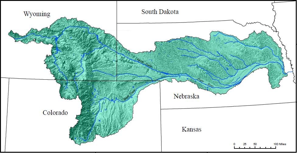
The Platte River is formed in western Nebraska east of the city of North Platte, Nebraska by the confluence of the North Platte and the South Platte Rivers, which both arise from snowmelt in the eastern Rockies east of the Continental Divide. Map via Wikimedia.
Momentum is building in Colorado to create new reservoirs to draw more water from the South Platte River, reducing the flow into Nebraska. Nebraska officials should monitor this situation closely, now and in coming years, to make sure the water volume continues to meet the requirements under a 1923 South Platte River agreement between the two states.
Maintaining a proper flow in the Platte River — formed by the confluence of the South Platte and North Platte Rivers in western Nebraska — is crucial to our state’s agriculture, hydropower and long-term metropolitan water sources for Omaha and Lincoln.
Colorado apparently has considerable room at present to make further diversions and still remain in compliance. “In many years, more water is passing that gauging station at the state line than needs to” under the agreement, Colorado State Engineer Kevin Rein says.
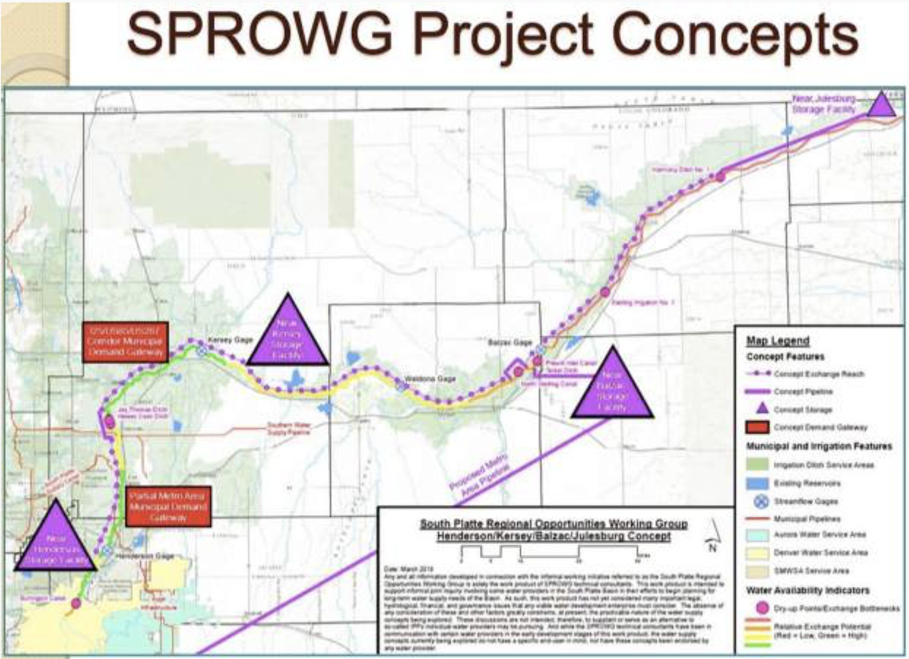
A group called the South Platte Regional Opportunities Working Group, or SPROWG, is proposing to store 175,000 acre-feet of water in a series of reservoirs on the South Platte River, from north of Denver to the Morgan County line. The project also includes a long pipeline to pump water from the river back to the metro area to be cleaned and re-used. Graphic credit: CWCB via Aspen Journalism
The proposed reservoirs, to serve Front Range urban residents, would keep about 150,000 acre-feet of water in Colorado, the Denver Post reports. That’s about half of the estimated amount that Colorado lawmakers claim their state can legally divert on average each year under the 1923 agreement. For comparison: When full, Nebraska’s Lake McConaughy has a capacity of 1.74 million acre-feet.
A 1993 study of Nebraska water history by the University of Nebraska-Lincoln stated, “Some Nebraskans may still bemoan that the state gave away too much water to Colorado in the South Platte Compact of 1923, but it was a voluntary agreement.”
The tremendous metro growth in Colorado’s Front Range is spurring the call for new reservoirs. Urban groundwater levels are declining in the face of dramatically increased demand. Meanwhile, agricultural producers in Colorado’s South Platte River basin support reservoir creation as a way to safeguard their own groundwater from urban diversion. Officials in western Colorado are in favor, saying the South Platte water could reduce the current allocation of western Colorado water to the Front Range via tunnels. Supportive, too, are Colorado water-policy officials, who included the South Platte reservoir concept in their 2015 State Water Plan.
In short, a wide-ranging set of powerful urban and rural interests in Colorado have come together to press for more South Platte water. “We owe it to our state, to our water users and our farmers to capture as much water as we can” out of the South Platte, said Joe Frank, manager of Colorado’s Lower South Platte Water Conservancy District.
Nebraskans can take heart that strong legal protections are in place to safeguard the significant water volume the state receives via the North Platte River, a vital irrigation source. The river supplies Lake McConaughy, for example, with its wide-ranging irrigation and groundwater recharge role for more than half a million acres in the Platte River valley, plus hydropower generation and recreation.
The U.S. Supreme Court issued a decree in 1945 setting out a legal framework for interstate water allocation along the North Platte. In 2001, Nebraska and Wyoming reached a settlement on sharing North Platte water after 15 years of legal wrangling. The agreement essentially froze Wyoming’s water use at the 2001 level and stipulated that groundwater hydrologically connected to the North Platte be included. The settlement created a committee — of federal, Nebraska, Wyoming and Colorado officials — to work out future disagreements.
“In contrast to the meager and seasonal administrative execution of provisions contained in the South Platte Compact,” a 2006 UNL analysis stated, “administrative actions in the North Platte River watershed are extensive and occur year-round.”
Nebraska may have future legal leverage regarding the South Platte if any Colorado diversions raise environmental concerns, such as negative effects on protected animal species. Two examples: sandhill cranes and whooping cranes, which congregate in great numbers annually in central Nebraska.
The proposed South Platte reservoirs are “one of those rare solutions that really is good for both rural Colorado and folks who live in the Denver metro area,” a Colorado state senator stated. Evidently so, but on this side of the border, Nebraskans need to remain watchful and assertive to ensure our state’s rights are recognized and safeguarded to the full extent of applicable law.
Platte River photo credit US Bureau of Reclamation.
Fort Laramie Irrigation Canal. This camera looks over a north flowing canal that provides irrigation water to surrounding fields. Agriculture in this part of the state is made possible in part by irrigation canals like this. Scotts Bluff National Monument is visible on the horizon. Photo credit: Platte Basin Time Lapse
Here’s the release from Governor Gordon’s office:
Governor Mark Gordon, members of the executive branch, and representatives from multiple state agencies are mobilizing in an effort to provide assistance to farmers affected by a catastrophic irrigation tunnel collapse in Goshen County.
The Governor signed an Executive Order for a Declaration of Emergency today, allowing him to deploy state resources to Goshen County as needed. The collapse occurred early in the morning of July 17 along the Fort Laramie-Gering irrigation canal west of Lingle and caused a large breach of the canal wall. The disaster inundated farmland near the breach and has left more than 100,000 acres of cropland in Wyoming and Nebraska without water during a critical period for growers. Goshen County Commissioners issued a Local Disaster Declaration earlier today.
“This is a serious emergency and we recognize addressing an issue of this magnitude will take coordination, especially because it affects so many Wyoming and Nebraska farmers,” Governor Mark Gordon said. “We are working with an understanding of the urgency of the situation, along with a need to proceed carefully. Wyoming is united in its effort to find the right way to help the Goshen Irrigation District get up and running.”
After visiting the site on Friday, the Governor and members of the executive branch met Monday morning to analyze ways to provide state support to Goshen County and the Goshen Irrigation District. The Governor’s office is assembling resources to engage federal partners and is working with the Wyoming Department of Agriculture, the Wyoming Office of Homeland Security and the State Engineer’s Office to explore potential options for resources and assistance.
State officials and representatives from Governor Gordon’s office will attend a stakeholder’s meeting organized by the Goshen Irrigation District scheduled for 2 pm Wednesday, July 24, at the Eastern Wyoming College auditorium. The meeting is open to the public and will include a discussion of the collapse and a possible timeline for repairs to the tunnel and ditch.
From the Goshen County Commissioners via The Torrington Telegram:
The Goshen County Board of Commissioners has officially declared the collapse of an irrigation tunnel along the Fort Laramie-Gering Irrigation Canal as a local disaster.
In a declaration issued Monday morning, July 22, the county stated that “extensive damage was caused to private property and the loss of irrigation water will result in an extensive loss of agricultural crops to the farmers of Goshen County within the disaster area.”
The declaration, signed by Chairman Wally Wolski, vowed to seek emergency funds from any and all sources.
“All locally available public and private resources available to mitigate and alleviate the effects of this disaster have been insufficient to meet the needs of the situation,” the declaration said. “The Chairman of the Goshen County Board of Commissioners has declared a State of Emergency on behalf of Goshen County, and will execute for and on behalf of Goshen County Commission the expenditure of emergency funds from all available sources, the invoking of mutual aid agreements, and the requesting of assistance from the State of Wyoming.”
The Goshen Irrigation District has organized a stakeholder’s meeting to discuss the Fort-Laramie Gering irrigation tunnel collapse, repairing the tunnel and the ditch, and the timeframe of the repairs. The meeting will be held Wednesday, July 24, 2 p.m. at the Eastern Wyoming College auditorium.
The GID issued a press release on Friday, July 19, to ask people to stay away from the collapse to allow the GID and various contractors space to make the necessary repairs. The collapse occurred in a remote section of the canal, with only a one-lane road to get in or out of the site.
“Goshen Irrigation District and Gering-Fort Laramie District are asking for all patrons to please observe all road closure signs near the tunnel and canal breach,” the release said. “There will be large equipment and contractors in and out of that site every day of the week and for extended hours. Please, for your safety, do not impede the work that needs to be done.”
Least Tern. Photo credit Doug German via Audubon. From Audubon Rockies (Daly Edmunds):
The Platte River Recovery Implementation Program (PRRIP) is a multi-state effort that began in 1997, when the governors of Colorado, Wyoming, and Nebraska joined with the U.S. Secretary of Interior to sign the “Cooperative Agreement for Platte River Research and Other Efforts Relating to Endangered Species Habitat along the Central Platte River, Nebraska.”
Based on the novel idea that a collaborative approach would prevent years of courtroom battles over limited water supplies and individual river species, the PRRIP works to accommodate the habitat needs of these threatened and endangered bird species by increasing stream flows in the central Platte River during relevant time periods. While these species require habitat in central Nebraska for survival, their habitat is created and maintained through a dynamic river system that begins with water from Colorado and Wyoming. The program also enhances, restores and protects habitat, and does so in a manner to accommodate new water-related activities. This is a good program but due to expire this year.
Wyoming Senator Barrasso (R) and Colorado Representative Neguse (D) each took leadership positions on this issue, sponsoring complementary bills in the Senate (S.990) and House (H.R. 3237), that propose to extend the program. Audubon Rockies and Audubon Nebraska thanked the entire Colorado Congressional Delegation for their unanimous, bipartisan support for these bills. Our offices also thanked Wyoming’s Senator Enzi for supporting the Senate bill, and Representative Cheney recently joined other western co-sponsors of the House bill. Additionally, all Colorado and Wyoming Audubon chapters sent letters thanking their respective congressional delegations for their unanimous, bipartisan of a strong stewardship program.
Least tern
Piping plover
Whooping crane adult and chick. Credit: USGS (public domain)
The Platte River is formed in western Nebraska east of the city of North Platte, Nebraska by the confluence of the North Platte and the South Platte Rivers, which both arise from snowmelt in the eastern Rockies east of the Continental Divide. Map via Wikimedia.
Meanwhile click here to enjoy the 2019 Audubon Photography Awards winners.
Birds make fascinating subjects, as the winners and honorable mentions of this year’s contest, our 10th, make clear. They’re at once beautiful and resilient, complex and comical. It’s no wonder why we love them so.
The images that won the 2019 Audubon Photography Awards, presented in association with Nature’s Best Photography, are as impressive as ever, but attentive readers might notice a few more images than usual. That’s because we’ve added two awards. The Plants for Birds category is inspired by Audubon’s Plants for Birds program, supported by Coleman and Susan Burke, which provides resources for choosing and finding plants native to zip codes in the United States. This category poses a new challenge to photographers: Don’t just capture an incredible moment—make sure it also features a bird and plant native to the location in which the photo was taken, in order to highlight the critical role native habitat plays in supporting bird life. And in the spirit of Kevin Fisher, Audubon’s longtime creative director who recently retired, the Fisher Prize recognizes a creative approach to photographing birds that blends originality with technical expertise. It honors a photograph selected from all of the submissions that pushes the bounds of traditional bird photography.
We want to extend a heartfelt thank you to all 2,253 entrants, hailing from all 50 U.S. states, Washington, D.C., and 10 Canadian provinces and territories. Your dedication to appreciating, celebrating, and sharing the wonder of birds and the landscapes they inhabit inspires us now and throughout the year.
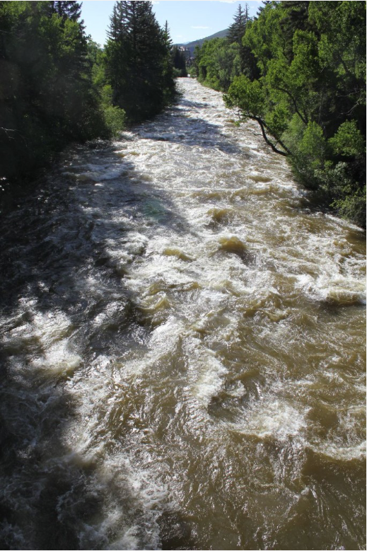
The Poudre and Big Thompson rivers are gushing as a wave of warm weather sends mountain snowmelt rushing toward Northern Colorado, but regional officials say flows should taper this week and don’t expect major flooding.
The Poudre flowed about 4.3 feet high at the Lincoln Street gauge Tuesday afternoon. Its volume of 956 cubic feet per second was nearly three times the median for this time of year…
A blast of summer heat will bring Fort Collins a string of days with highs above 90 degrees, starting Wednesday and holding on through Saturday, according to the National Weather Service. Hodges said flood risk isn’t a big concern, though, because so much of the mountain snowpack that feeds the Big Thompson and Poudre rivers has already melted…
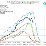
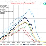
Remaining snowpack is plummeting in both the North Platte and South Platte river basins, according to the Natural Resources Conservation Service…
The onset of summer also means people will divert more water from the Poudre, which loses over 60% of its water before it even gets to Fort Collins…
The Big Thompson and Poudre rivers have likely already reached their peaks, Hodges said. The Big Thompson reached about 5.8 feet — action stage for flooding is 6.5 — above the canyon mouth on Thursday, according to the Colorado Division of Water Resources…
The Poudre reached about 5.7 feet at the canyon mouth Friday. Action stage is 6.5 feet. It peaked at about 5.5 feet through town on Friday, well below the action stage of 9 feet.
The warmer temperatures in Colorado’s mountains are expected to melt quite a bit of snowpack. Be warned that Colorado’s rivers and waterways will be swollen with fast moving and powerful water, making them very dangerous. Three people have died in three separate incidents over the past week in Colorado rivers.
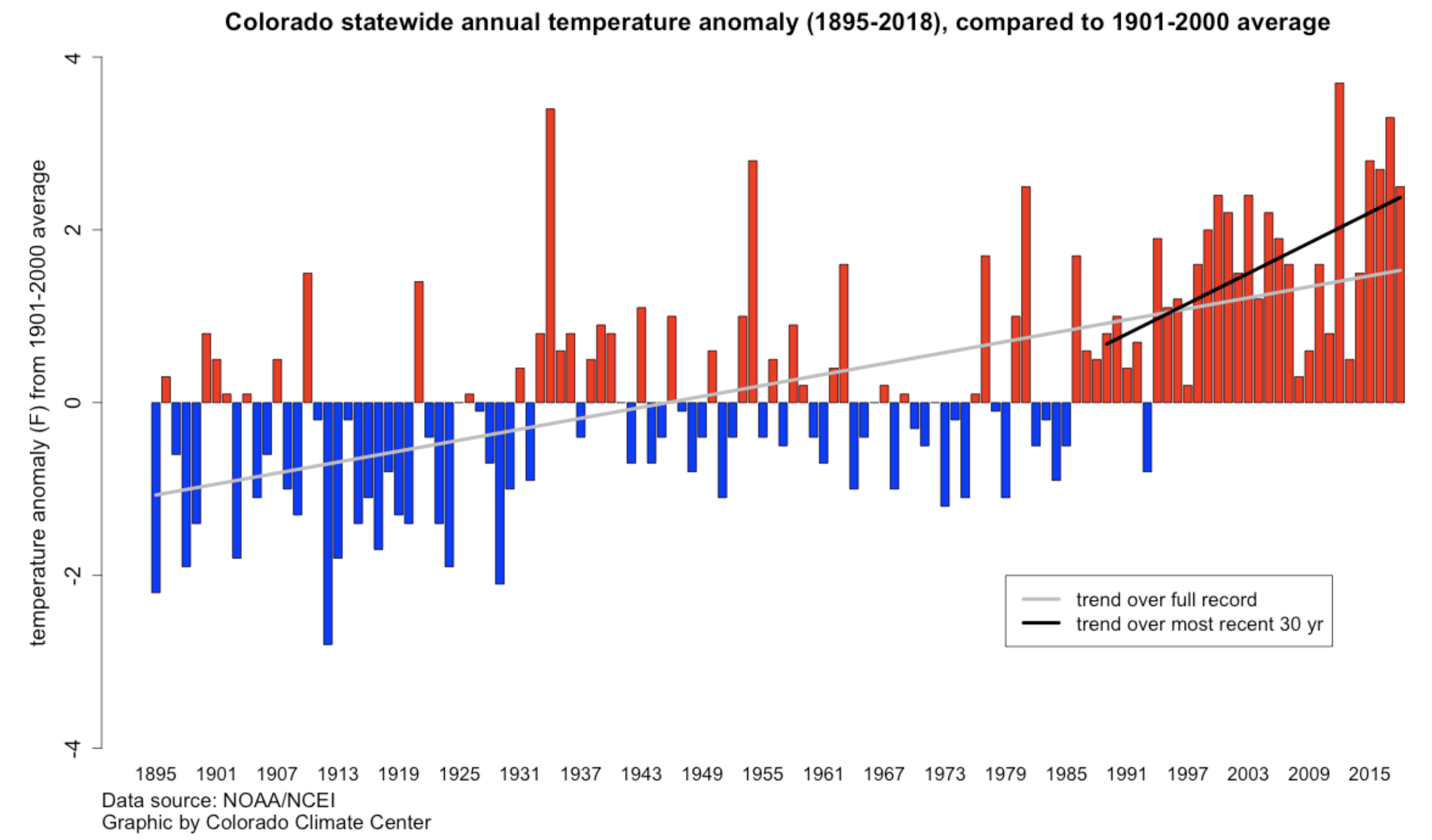
Warming temperatures but especially so during spring months
In Pennsylvania, the groundhog known as Punxsutawney Phil saw no shadow this year. That is supposed to portend an early spring.
In the Rocky Mountains, early springs have been coming no matter what. This was a cold winter in many places, but on average the climate has been warming for several decades. It’s sure to get much warmer yet.
A case in point is Colorado’s North Park, headwaters of the North Platte River but a short distance from the headwaters of the Colorado River and also the Steamboat ski area.
There, according to Dr. J.J. Shinker, an associate professor from the University of Wyoming, the temperature overall has increased 1.44 degrees Celsius (2.6 degrees Fahrenheit) since 1909.
The Eagle River roils with spring runoff in June 2011 near Edwards, Colo. Photo/Allen Best
But warming during the spring months of March, April, and May has been disproportionate, rising almost 4 degrees Fahrenheit (2.21 degrees C) on average since 1909.
“That’s a lot of warming in a short period of time,” she told members of the Colorado Water Congress at a recent conference. She also pointed out that warming at high elevations has been disproportionately greater than the global average.
(But Jeff Lukas of Western Water Assessment, the lead author of “Climate Change in Colorado,” the 2014 synthesis report sponsored by the Colorado Water Conservation Board, points out that “there is no robust and consistent evidence that higher-elevation regions in Colorado are warming at a different rate than lower-elevation regions.”
But of disproportionate warming during spring, there is no dissent. And that produces earlier runoff in the North Platte and other rivers in Colorado. On average, runoff occurs five days earlier for every degree Celsius in warming.
This matters to water managers, who try to ensure the irrigation ditches still have enough water come August and September. It also matters to mountain resorts as warming springs shrink the backend of ski season.
But everybody should be concerned for two more reasons, says Shinker. First, the worst droughts we’ve seen, the worst on record since Eurosettlement about 150 years ago, don’t come close in depth and intensity to those of the past. Forest fires of the past were also giant affairs.
This was part of natural variability. But now there is the overlay of what might be called unnatural variability, this overlay caused by human forcing of the climate.
“The warming that we are seeing is occurring at a rate that is outside the range of natural variability,” Shinker said in an interview after her talk to Colorado water managers. “And it’s occurring as a result of the greenhouse gases that result from human activity.”
Paleoclimatologists can tell much about shifting climates of the past 12,000 years by studying high mountain lakes. Consider Emerald Lake, which is in Colorado’s Sawatch Range, near the trailheads to the state’s two highest mountains, Elbert and Massive. Scientists studying lake sediments and other clues have documented shorelines that a millennium ago were much lower. The droughts then lasted for decades, even hundreds of years, what are called megadroughts.
Lake of the Woods, which is located in Wyoming along the Continental Divide south of Jackson Hole, also offers evidence deciphered by scientists of a megadrought 5,200 years ago.
The point, said Shinker, is that natural variability has always occurred in the interior West. So, too have, extreme events, such as the wildfires that accompanied a megadrought in North Park about 2,000 years ago.
In the Colorado River Basin, scientists have reached much the same conclusion. Undeniably, there have been several hard drought years since 2000. But Brad Udall of Colorado State University and other scientists have concluded that it’s not a drought as conventionally understood. Rather, rising temperatures have begun causing more evaporation and transpiration, resulting in less water getting downstream.
That doesn’t mean conventional climatic forces don’t have swagger. From her post in Wyoming, Shinker studies what causes natural climatic variability in the interior West, such as movement of the polar jet stream north and south. But now there’s an overlay to those natural climatic variations, one created by human activities.
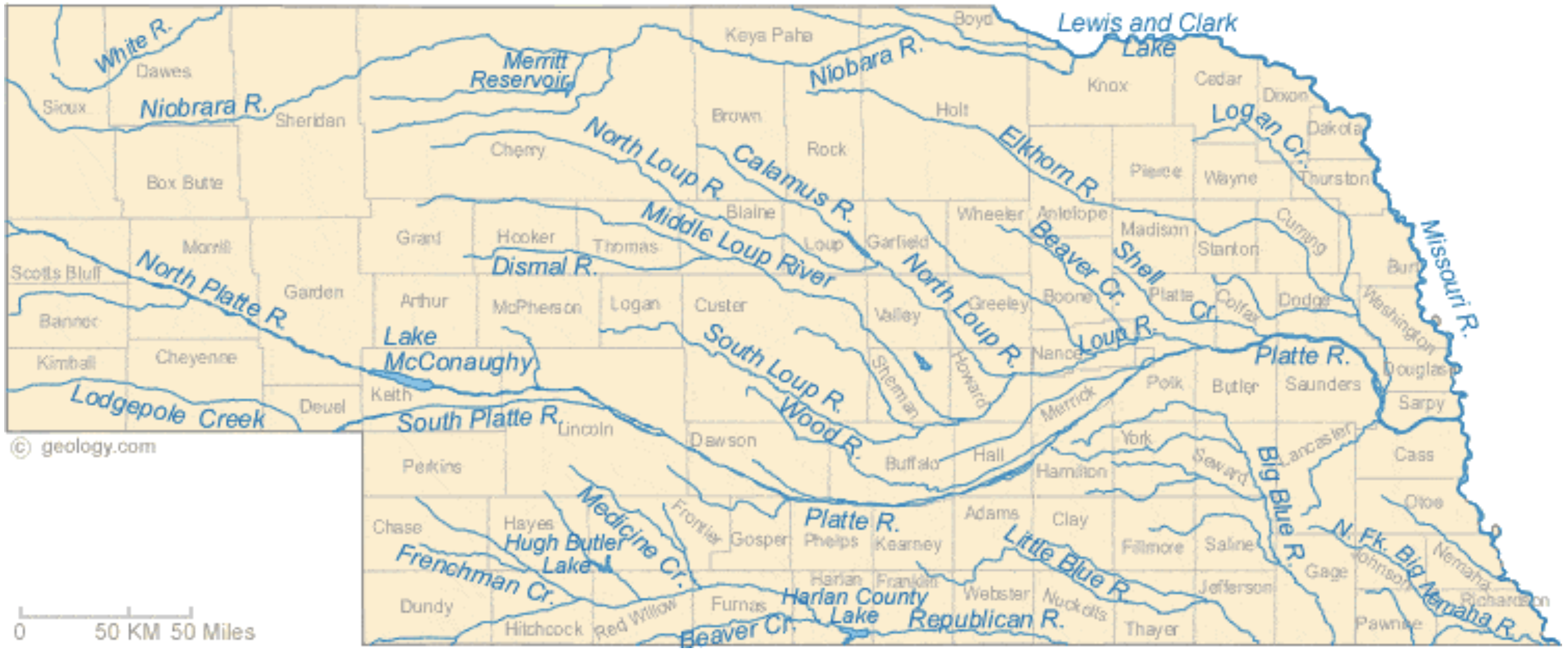
Nebraska Rivers Shown on the Map: Beaver Creek, Big Blue River, Calamus River, Dismal River, Elkhorn River, Frenchman Creek, Little Blue River, Lodgepole Creek, Logan Creek, Loup River, Medicine Creek, Middle Loup River, Missouri River, Niobrara River, North Fork Big Nemaha River, North Loup River, North Platte River, Platte River, Republican River, Shell Creek, South Loup River, South Platte River, White River and Wood River. Nebraska Lakes Shown on the Map: Harlan County Lake, Hugh Butler Lake, Lake McConaughy, Lewis and Clark Lake and Merritt Reservoir. Map credit: Geology.com
Water is a contradiction for Western Nebraska. It’s both seemingly abundant, yet simultaneously finite and scarce.
A new film by a local award-winning documentary filmmaker explores this contradiction and tells the story of water in the Panhandle, from the founding of the numerous irrigation and natural resources districts that line the North Platte valley, to the legal fights surrounding the regulation, distribution and control of that water.
Insight Creative Independent Productions Executive Producer and Director Becky McMillen’s “Rising Water,” was originally designed to be a web series, and viewers will get a first peek at it when the film premiers at the Legacy of the Plains Museum in Gering on Saturday, March 2, at 1 p.m. The screening of the documentary is in conjunction with The Smithsonian’s Museum on Main Street the Water/Ways” exhibit, which is open now until April 13 at Legacy.
“Everyone knows how to use YouTube, and they’ve gotten used to web series,” McMillan said. “They’re used to watching short pieces.”
In essence, each of the segments of the film is a self-contained documentary which covers a different facet of the story of our water, she said.
The hour and fifteen minute feature is the product of more than three solid years of work, with much of the footage and information gathered over a greater period of time. McMillen said that her father, Udell Hughes Sr., helped her with much of the technical research for the film. It also contains material gathered during production of McMillen’s last major project, “River of Time: Wyoming’s Evolving North Platte River,” a half-hour program which premiered on Wyoming PBS in November 2012.
“We’ve been sort of building up towards this film,” she said. “A lot of my historical research was actually done at Legacy of the Plains.”
The film contains interviews with managers of irrigation districts, farmers, UNL researchers and footage from public hearings concerning water issues.
“I knew that I needed to talk about the Ogallala Aquifer, but it took me a while to understand that issue,” McMillen said.
So she consulted UNL research hydrogeologist Jim Goeke, who is known as “Mr. Water.” Goeke researched the aquifer and arguably knows more about the water under our feet than any other human being.
McMillen said she was surprised by how candid Goeke.
“He gave me courage to address issues that probably weren’t very popular and won’t be very popular,” she said. “We have sucked so much water out of the aquifer and I’ve been watching the Pumpkin Creek battle for years, but lost track of it.”
The challenge for McMillen was to tie together the surface water and ground water portions of the story.
And it was a lawsuit over the little western Nebraska stream that became a big State Supreme Court case.
In 2009 The Spear T Ranch settled with more than a dozen upstream ranchers and farmers in a dispute between irrigators feuding over water in Pumpkin Creek.
“I was thinking about Pumpkin Creek, but I didn’t have any visuals,” she said. “I’d filmed a meeting of farmers years ago, but the camera went south on me and there was no way I could recover the footage.”
Then synchronicity struck. McMillen’s bookkeeper was from the Spear T Ranch, and the family over time had saved all of the newspaper clippings about the fight.
“That helped me tie it all together,” McMillen said. “You just have to be able to listen and when you hear something say ‘What was that?’”
And the hunger for investigative work is what fuels most of her projects.
“I have to tell myself to stop, take notes and check things out,” she said. “I hear stories all the time and I’d love to go chase them, but I have to be responsible and pay my bills.”
McMillen said a lot of the project has been self-funded because she couldn’t kick the habit once a lead seemed promising.
Newspapers also provided McMillen a window into the issues. As the “first draft of history,” clippings are featured at prominent portions of the film.
“The Star-Herald is in a lot of these stories that I brought back from the past,” she said. “There was so much information that really help me understand what was going on at the time.”
Another portion of the film is spent exploring contamination concerns, especially the 2015 fight against a Colorado company who sought permission to use an abandoned oil well in Sioux County as a wastewater disposal site. Sioux County landowners eventually won their appeal and state lawmakers reformed the process in which permits are granted.
“I documented almost everything, and there is a lot of that in there, along with newspaper clippings” she said. “The physical thing is really important, because I couldn’t have told any of this story without the work of reporters from back in the 1800s on to the present day.”
And those are the little things, McMillen said.
“I saw articles where they hung effigies of law makers because they were going to shut the water off,” she said. “There’s always a fight about water. One guy will say ‘I was here first,’ and another guy will say, ‘hey I need that.’ And just because you were here first doesn’t mean you get to have all of it.”
And over the course of making the film McMillen said that she’s learned that there needs to be change to protect and preserve not only the Valley’s greatest gift, but the way of life for Farmers and Ranchers who live here.
“We’re going to have to look beyond what we’re calling ‘traditional practices,’” she said. “We can continue on the same track that we have been. We can’t keep expanding and still be able to sustain that.”
It was her discussions with farmers that drove home the point for her.
“I think we need to look at it as growing food,” she said. “I would like us to grow more food that doesn’t have to be shipped, because we’re going to have to address climate change and reverse it.”
And at the same time, caution needs to be exercised when employing solutions, she said.
“What we think are the solutions are not always the best way of doing things,” she said. “We can’t just blindly forge ahead just because we think it’s a good idea. At the time we’re looking at sustainable energy, we’re also wanting to put it in places that will never be the same.
“We need to work within the infrastructure we already have and not go to condemning land so that we can use it for transmission lines or wind farms. There is plenty of space for that without tearing up areas that can’t be returned to their natural state.”
…as Colorado’s drought intensifies and the state grows desperate to increase snowpack, a new study is helping create buzz around cloud seeding. And for the first time, Colorado is stepping up its game and plans to try cloud seeding not just from generators on the ground, but by airplane.
Cloud seeding, or weather modification, is mentioned multiple times in the Colorado Water Plan.
And a drought contingency plan approved this month by half of the seven states that make up the Colorado River Basin coalition includes three key components: reducing water consumption, managing reservoirs and “augmenting” the water supply through cloud seeding and removal of water-sucking tamarisk, or salt cedar trees.
“By itself, cloud seeding is not a drought buster, but it is one proven method to use along with demand management and reservoir operations,” said Dave Kanzer, deputy chief engineer for the Colorado River District, based in Glenwood Springs.
A breakthrough study of cloud seeding by aircraft involving University of Colorado and University of Wyoming researchers took place in 2017 in the mountains of southwest Idaho. It captured attention after its results were published this year in the Proceedings of the National Academy of Sciences. For the first time, researchers — in a second aircraft flying near the cloud-seeding plane — could see silver iodide enter the clouds and form snow crystals.
“We unambiguously can show it works in the atmosphere,” said Dr. Katja Friedrich, a professor of atmospheric and oceanic sciences at CU and one of the study’s authors. “That was very revolutionary.”
In the experiment, funded by the National Science Foundation with support from Idaho Power Co., the cloud-seeding airplane passed through the clouds dropping flares of silver iodide, a compound that attaches to water molecules and forms crystals. The turboprop soaring above the Payette Basin also flared silver iodide from its wings as it flew through clouds rich with supercooled water droplets, ripe for seeding.
The research plane flew near the seeded clouds and was able to record via radar that silver iodide caused the water molecules in the clouds to freeze. The researchers’ radar detected water molecules inside clouds becoming “glaciated” and growing heavier after they were seeded with silver iodide, forming snow.
Now that they’ve proved cloud seeding works, follow-up work is needed to determine how much snow it actually produces and whether it’s an efficient way to increase snowpack, Friedrich said. Cloud seeding in Colorado is a $1.2 million annual operation, and according to the best estimates of researchers, can increase snowfall anywhere from 2 to 15 percent per storm…A turboprop plane, a King Air C90 owned by Weather Modification International, recently began seeding clouds in southern Wyoming. Now the North Dakota-based company is working with Jackson County, Colorado, on plans to boost snowfall in the lower Medicine Bow Range northwest of Fort Collins.
Snowpack from that mountain range ends up in the headwaters of the North Platte River and Walden Reservoir, northeast of Steamboat Springs. Jackson County water officials have filed permits for the project with the state Department of Natural Resources and final approval is only a matter of paperwork..
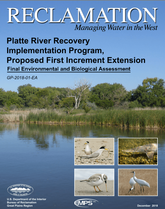
Here’s the release from the Bureau of Reclamation (Brock Merrill):
The Bureau of Reclamation has released the Final Environmental and Biological Assessment (EA) and signed the Finding of No Significant Impact (FONSI) for the Platte River Recovery Implementation Program, Proposed First Increment Extension. Reclamation, working with the states of Wyoming, Colorado, and Nebraska, water users, and environmental and conservation organizations, proposes to extend the First Increment of the basin-wide, cooperative Recovery Implementation Program by 13 years. Reclamation participates in the Program to meet its obligations under the Endangered Species Act.
The purpose of this action is to continue implementing Program projects in order to accomplish the following:
Reduce flow shortages in the Platte River aimed at conforming with U.S. Fish and Wildlife Service target flows
Continue land management activities necessary to provide habitat for target threatened and endangered species
Continue integrated monitoring, research, and adaptive management, in order to assess the progress of the Program and inform future management decisions
The final EA and FONSI evaluates and discloses the potential impacts of the proposed 13 year extension of the Program’s First Increment. The final EA and FONSI does not represent the final decision of the Secretary of the Interior, in cooperation with the Governors of the states of Colorado, Nebraska, and Wyoming, to extend the Program. The final EA and FONSI informs the Secretary that the potential impacts of the proposed extension do not warrant the preparation of an Environmental Impact Statement. The formal decision by the Secretary regarding whether or not to extend the Program in cooperation with the Governors will occur at a later date.
The Platte River is formed in western Nebraska east of the city of North Platte, Nebraska by the confluence of the North Platte and the South Platte Rivers, which both arise from snowmelt in the eastern Rockies east of the Continental Divide. Map via Wikimedia.
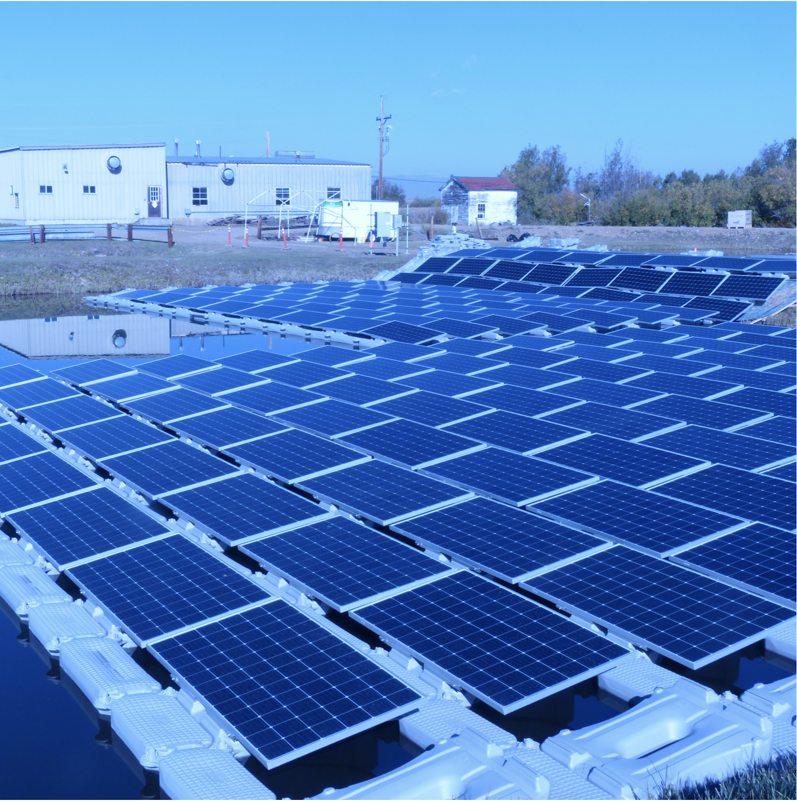
When a town has high electric bills and no available land for a solar farm, a floating solar plant on the pond of a waste water plant makes great sense. Walden, Colorado, population 750, elevation 8,000 feet plus, and land area of 0.34 square miles, is such a town.
Photo credit: CleanTechnica.com
“We were spending about $22,000 a month for electricity for the water treatment facility, and this 75 kW solar installation will save us $10,000 a month,” says Jim Dustin, mayor of Walden, Colo. “We’ll pay for the plant in 20 years, and it is still expected to run 10 more years after that,” he says.
The plant technology was furnished by floating solar specialists Ciel & Terre USA and was installed by GRID Specialists. The $400,000 cost of the plant was offset by a $200,000 grant from the Colorado Department of Local Affairs, which manages revenues earned by oil and gas development tax in the state. The project also was supported by the Colorado Energy Office.
“The Energy Office is interested in this installation because it gets down to minus 40 or 50 degrees in the winter, and we have very high winds. They want to know if the technology will work, because there are irrigation ponds and unused water bodies all over this state,” says Dustin. The energy office has offered $120,000 to move the installation to another location if it doesn’t work in Walden, he adds.
The Energy Office is also interested in conserving water in the state, where evaporation reduces holding pond levels by up to 90 inches per year, according to Taylor Lewis, a program engineer at the agency. “We have 2,000 man-made reservoirs in the state to keep water so if we can identify a few where it makes sense to cover them with solar, there could be a double benefit of water savings and electricity generation,” he says.
The concept of covering drinking water bodies to reduce evaporation is not new. “I’ve been looking at claims by the City of Los Angeles that they have saved billions of gallons of water over the past 10 years at four reservoirs, using black floating plastic balls,” Lewis says. “We’re interested in studying the impact with floating solar here,” he adds.
Johnson Controls came up with the initial idea of a floating solar array for Walden, says Dustin. “The floating solar array is a milestone for the Town of Walden and highlights the potential for Colorado’s overall energy efforts,” said Rowena Adams, a Performance Infrastructure account executive at Johnson Controls, in a statement.
“It was a practical choice for Walden given the surrounding bodies of water and the town’s energy resiliency efforts at the Town Water Treatment Facility, as well as the desire to conserve water and minimize algae growth,” Adams said.
Ciel & Terre, the technology provider, has more water projects in mind for Colorado. “With demand for solar power continuing to rise and available real estate becoming more expensive, floating solar is the ideal solution for anyone with a manmade pond or body of water. It’s cost-effective, quick to install, easy to maintain, and offers a variety of environmental benefits,” said Eva Pauly-Bowles, the representative director for the US office of the French company.
“Floating solar is no longer an exotic niche in the US, but a rapidly growing sector of the solar market. Ciel & Terre USA has other larger floating solar projects under construction and planned across the country,” Papuly-Bowles said.
Deploying a floating solar array on manmade bodies of water improves energy production by keeping the solar system cooler, Ciel & Terre says. At the same time it reduces evaporation, controls algae growth, and reduces water movement to minimize bank erosion, it says. Floating solar arrays also make optimal use of pond surfaces, providing clean solar energy without committing expensive real estate or requiring rooftop installations, the company adds.
Established in 2006 as a renewable Independent Power Producer (IPP), Ciel & Terre has been fully devoted to floating solar PV since 2011. The French company pioneered Hydrelio, the first specific and industrialized system to make solar panels float on water, with criteria such as cost-effectiveness, safety, longevity, resistance to winds and waves, simplicity, drinking water compliance, and optimized electrical yield, the company states in its profile.
Ciel & Terre has floating solar installations in Japan, Korea, China, UK, France, Brazil, Singapore, Malaysia, Italy, and Taiwan as well as the United States. The company has its United States headquarters in Petaluma, California.
Center pivot sprinklers in the Arikaree River basin to irrigate corn. Each sprinkler is supplied by deep wells drilled into the High Plains (Ogallala) aquifer.
From the University of Denver Water Law Review (Jeremy Frankel):
The grain-growing region in the High Plains of America—known as America’s breadbasket—relies entirely on the Ogallala Aquifer. But long term unsustainable use of the aquifer is forcing states in the region to face the prospect of a regional economic disaster. As the High Plains states reach the verge of a major crisis, the states have taken different approaches to conservation with varying results.
The Ogallala Aquifer supports an astounding one-sixth of the world’s grain produce, and it has long been an essential component of American agriculture. The High Plains region—where the aquifer lies—relies on the aquifer for residential and industrial uses, but the aquifer’s water is used primarily for agricultural irrigation. The agricultural demands for Ogallala water in the region are immense, with the aquifer ultimately being responsible for thirty percent of all irrigation in the United States. The Ogallala Aquifer has long been unable to keep up with these agricultural demands, as the aquifer recharges far slower than water is withdrawn.
Aside from the obvious agricultural ramifications from the Ogallala’s depletion, recent studies have shown that groundwater depletion also has a severe effect on freshwater ecosystems in the region. Each state has had to confront the issue in their own way, but the depletion of the aquifer has become severe enough to warrant the attention of the federal government as well. At the state level, the focus has been on maintaining an orderly depletion of the aquifer rather than developing a plan for sustainable use. However, some states have achieved some level of success in slowing down the aquifer’s depletion. Kansas, for example, has recently achieved mild success by adopting a program that put conservation in the hands of the State’s farmers. On the other hand, Nebraska has seen more success than Kansas by being tougher on farmers and exercising its enforcement powers. The federal government has also set up financial and technical assistance for farmers who commit to conservation and is funding large-scale pipeline projects to bring in water to the more desperate areas of the High Plains.
When early explorers Zebulon Pike and Francisco de Coronado came upon the High Plains, they described it as a desert — an impossible region to farm.
Irrigation changed that. It allowed residents to pull water from the Ogallala Aquifer, and grow crops nearly anywhere. The first irrigation wells in Kansas were drilled east of Garden City in 1908.
The Ogallala is a massive, underground sponge, spanning from South Dakota and Wyoming, down through the High Plains to west Texas and New Mexico. Over 27,000 of the total 35,000 wells with active water rights in Kansas overlie the Ogallala, with 87 percent used for irrigation.
But decades of pumping water out, with little return, has taken its toll.
After 110 years of drilling and draining, the world’s largest aquifer is drying up.
The Ogallala is the primary source of water for western Kansas farms, ranches and some communities, but projections indicate several areas that will go dry within 25 to 50 years at current usage rates. Some regions in Haskell County may have a decade or less…
The Ogallala Aquifer Summit was organized by Colorado State University’s Ogallala Water CAP Program — a coordinated agriculture project funded by the United States Department of Agriculture – National Institute of Food and Agriculture. The summit brought together scientists, government agents and producers from the eight states situated over the Ogallala to discuss shared challenges and current initiatives to preserve the aquifer.
Conversations between states had a rocky start, partly because they were spurred out of litigation regarding the Republican River basin along the Colorado, Nebraska and Kansas borders. The conflict led to monthly meetings of the Republican River Compact Administration — comprised of one member from each state — to change the approach and improve water management.
“No offense to those that are here, but I’m just excited to come to an interstate water conference that doesn’t have more lawyers than it does farmers and ranchers,” Kansas Secretary of Agriculture Jackie McClaskey said to applause from the summit crowd.
Nebraska Natural Resources Program Director Jesse Bradley and Colorado Commissioner of Agriculture Don Brown joined McClaskey for the first panel of the summit, discussing the cultivation of interstate conversations.
Brown joked that the whole problem was Nebraska’s fault — Nebraska native Frank Zybach invented center pivot irrigation while living in Colorado — and Bradley fired back that ‘you always blame the upstream state.’
She credits interstate conversations regarding the Republican River as a critical factor for changing the tone of the discussion. Instead of fighting over the water, the group is now working together to preserve water.
“The biggest way we learned this lesson is from the complete 180 we’ve done on the Republican River discussions,” McClaskey said. “In July 2014, we started meeting month-to-month and created a true, long-term agreement, and are using those lessons to expand to all the states.
“Now, I would call my colleagues from Nebraska and Colorado friends, which may not seem like a big deal, but it’s a lot easier to solve a problem with a friend than with an enemy.”
The Platte River is formed in western Nebraska east of the city of North Platte, Nebraska by the confluence of the North Platte and the South Platte Rivers, which both arise from snowmelt in the eastern Rockies east of the Continental Divide. Map via Wikimedia.
From email from Reclamation:
The Bureau of Reclamation has scheduled a North Platte River Water Information Meeting in Scottsbluff, Nebraska.
The meeting will be held at 10:00 a.m., on Wednesday, April 11, at the Scottsbluff Panhandle Station Auditorium, Scottsbluff, Nebraska. The meeting is being held to apprise water users and other interested parties of the reservoir storage and current water supply conditions. Information regarding snowmelt runoff and expected reservoir operations for water year 2018 will be presented.
The Platte River is formed in western Nebraska east of the city of North Platte, Nebraska by the confluence of the North Platte and the South Platte Rivers, which both arise from snowmelt in the eastern Rockies east of the Continental Divide. Map via Wikimedia.
The plan is to divert excess Platte water via canal, culvert and pipeline over the Platte-Republican divide near Smithfield in south-central Nebraska’s Gosper County and run it south into the Republican via Turkey Creek, the Omaha World-Herald reported.
The 25-mile-long stream is a tributary of the Republican starting about 3 miles west of Smithfield. It empties into the Republican between Edison and Oxford. The Republican River rises in Colorado and crosses southern Nebraska before flowing into Kansas.
The primary objective is to help ensure the state’s compliance with an interstate compact that allocates certain percentages of the Republican River’s flows to Nebraska, Kansas and Colorado, said John Thorburn, general manager of the Tri-Basin Natural Resources District in Holdrege. Although the states have been working in harmony on managing the river in recent years, disputes among the three have escalated to the U.S. Supreme Court.
After three years of active planning, project proponents submitted their initial permit paperwork to the Nebraska Department of Natural Resources last week.
Tri-Basin partnered with the Alma-based Lower Republican NRD to develop the $1.4 million to $1.9 million enterprise known as the Platte Republican Diversion Project. It would tap Platte water from a canal owned by the Holdrege-based Central Nebraska Public Power and Irrigation District. The district stores North Platte River water in Lake McConaughy in western Nebraska and delivers it downstream and into canals for delivery to farmers to irrigate cropland.
“This is precedent-setting for Nebraska,” Thorburn said. “We’d be taking otherwise ‘wasted’ water to be put to good use for a beneficial purpose.”
Thorburn and others expect resistance from environmental organizations that have raised concerns, saying there really isn’t extra water in the Platte and that it’s all precious in providing habitat for endangered bird species, including the whooping crane, piping plover and least tern.
The Platte’s floodwater — the excess flows that would be diverted at times — scrubs trees and other vegetation from sand bars and other important habitat for sandhill cranes. Downstream near Lincoln and Omaha, the river replenishes aquifers and well fields providing drinking water to the state’s two largest cities.
The diversion would not occur during the June-through-August irrigation season, Thorburn said.
The potential economic impact of the project in the Republican basin would range from $14.2 million to $33 million, depending on how much of the water required to meet interstate agreements and obligations comes from the diversion versus other sources, according to a study by the Bureau of Business Research at the University of Nebraska-Lincoln.
The Platte in central Nebraska is designated by the Natural Resources Department as over appropriated, meaning there is more demand for the water than the river can provide. It is the state’s only over appropriated river. Still, there are times when floods funnel high water down the river’s usually shallow channels.
An engineering study by Olsson Associates of Lincoln for the project partners indicated that under two scenarios a potential 57,000 to nearly 140,000 acre-feet of unallocated water could have been diverted from the Platte into the Republican during the period of 2013 to 2016. An acre-foot is the volume of water that would cover an acre of land 12 inches deep.
The peak scenario would require 100 cubic feet per second of water to flow down Turkey Creek at times. A cubic foot is like a box of water measuring one foot by one foot by one foot. It contains around 7½ gallons. This rate of flow is a bit less than the volume of water Omahans see in Big Papillion Creek at Q Street in a typical March.
Turkey Creek’s current base flow is about 12 cubic feet per second. Erosion-control measures and other improvements would allow the creek to handle diverted flows up to 100 cubic feet per second without damaging the surrounding land in Gosper and Furnas Counties, according to the engineering study. The draft application calls for diverting 275 cubic feet per second from the Platte in order to provide up to 100 cubic feet per second into Turkey Creek.
Platte River photo credit US Bureau of Reclamation.
Whooping Cranes
Pallid sturgeon
Least tern
Piping plover
Here’s the release from the US Bureau of Reclamation (Brock Merrill):
The Bureau of Reclamation is preparing an environmental assessment (EA) for the Platte River Recovery Implementation Program, Proposed First Increment Extension. Reclamation, working with the states of Wyoming, Colorado, and Nebraska, water users, and environmental and conservation organizations, proposes to extend the First Increment of the basin-wide, cooperative Recovery Implementation Program by 13 years. Reclamation is doing this to meet its obligations under the Endangered Species Act.
The purpose of this action is to continue implementing projects that provide additional water, in order to accomplish the following:
Reduce flow shortages in the Platte River aimed at conforming with U.S. Fish and Wildlife Service target flows
Continue land management activities necessary to provide habitat for target threatened and endangered species
Continue integrated monitoring, research, and adaptive management, in order to assess the progress of the program and inform future management decisions
Reclamation will hold four public scoping meetings during the 45-day scoping period to gather information from other agencies, interested parties, and the public on the scope of alternatives for the EA. The public is encouraged to attend the open house EA scoping meetings, to learn more about the proposal and to assist Reclamation in identifying issues.
The public scoping meetings on the EA are scheduled as follows (All meetings will be held 6:00 – 8:00 p.m.):
October 4, 2017, at Goshen County Fair Grounds, 7078 Fairgrounds Road, Torrington, Wyoming
October 5, 2017, at The Ranch Events Complex, 5280 Arena Circle, Loveland, Colorado (Located in the Larimer County Conference Center; park in Lot B)
October 11, 2017, at Hotel Grand, 2503 S. Locust Street, Grand Island, Nebraska
October 12, 2017, at Platte River Recovery Implementation Program Executive Director’s Office, 4111 4th Avenue, Suite 6, Kearney, Nebraska
At each meeting, the public will have the opportunity to provide written input on resources to be evaluated, significant issues or concerns, and potential alternatives.
Written comments are due by close of business November 2, 2017. Members of the public may submit written comments at the public scoping meetings, via email to platteriver@usbr.gov, or by mail to:
Bureau of Reclamation
Attention: Brock Merrill
P.O. Box 950
Torrington, WY 82240
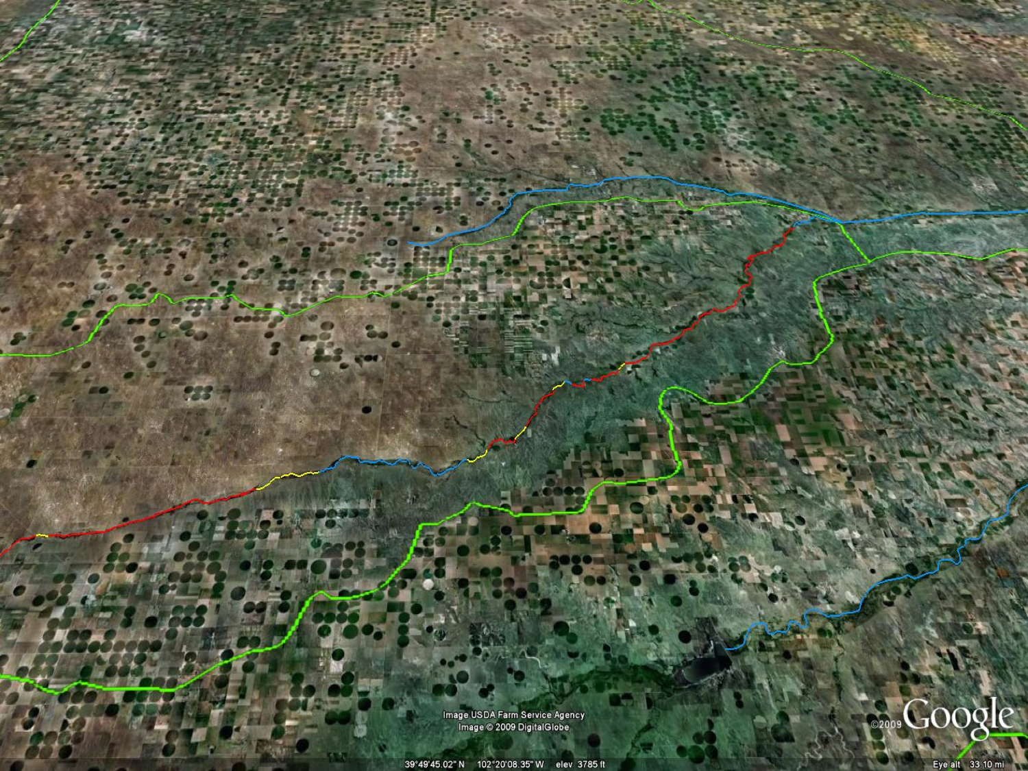
A Google Earth image of the crop circles in the lower Arikaree River watershed, highlighting the river reaches that were dry (red), disconnected pools (yellow), and flowing (blue) at the lowest water in late summer 2007. Only one segment of 9 miles of flowing river remained as habitat for fish. The river flows from left to right. Image created by Jeff Falke, University of Alaska Fairbanks.
Here’s the release from Colorado State University:
Farmers in the Great Plains of Nebraska, Colorado, Kansas and the panhandle of Texas produce about one-sixth of the world’s grain, and water for these crops comes from the High Plains Aquifer — often known as the Ogallala Aquifer — the single greatest source of groundwater in North America. A team of researchers, including Colorado State University Professor Kurt Fausch and Jeff Falke, a CSU alumnus and an assistant professor at the University of Alaska Fairbanks, have discovered that more than half a century of groundwater pumping from the aquifer has led to long segments of rivers drying up and the collapse of large-stream fishes.
If pumping practices are not modified, scientists warn that these habitats will continue to shrink, and the fish populations along with them.
The research team combined modeling from the past and future to assess changes in Great Plains streams and their fish populations associated with groundwater pumping from the High Plains Aquifer. The findings have implications for watersheds around the world, because irrigation accounts for 90 percent of human water use globally, and local and regional aquifers are drying up.
A ‘train wreck’
The Arikaree River in 2000 in early summer, when water is near its maximum extent. Photo: Kurt Fausch
Fausch said the study results are sobering. Based on earlier observations and modeling by Falke and a team of graduate students and faculty at CSU, the Arikaree River in eastern Colorado, which is fed by the aquifer and used to flow about 70 miles, will dry up to about one-half mile by 2045.
“You have this train wreck where we’re drying up streams to feed a growing human population of more than 7 billion people,” Fausch said.
Fausch described the situation as a “wicked problem,” one with no good solution. “More water is pumped out every year than trickles back down into the aquifer from rain and snow,” he said. “We are basically drying out the Great Plains.”
Pumping has dried up streams, small rivers
Since the 1950s, pumping has extracted nearly as much water as what exists in Lake Erie — about 100 trillion gallons — and almost none of it trickles back into the aquifer.
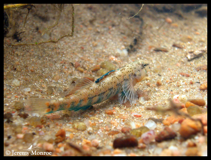
“This pumping has dried up long segments of many streams and small rivers in the region,” Fausch said. From 1950 to 2010, a total of 350 miles of stream dried up in the large area the team studied in eastern Colorado, southwestern Nebraska and northwestern Kansas. “Our models project that another 180 miles of stream will dry up by 2060,” Fausch said. An orangethroat darter, one of the nine remaining native fish species in the Arikaree River. Photo: Jeremy Monroe, Freshwaters Illustrated.
The loss of fish in the area is also a concern. “What we’re losing are the fishes that require habitat found only in the rivers and large streams of the region, and replacing them with those that can survive in the small streams that are left,” Fausch said. “We are losing whole populations of species from rivers in that region because there’s no habitat for them.”
As an example, seven of the 16 native fish species that were once found in the Arikaree River have disappeared since the first surveys were done in the 1940s. These fish include small minnows, suckers and catfish, species that the CSU scientist said are not among those that are currently federally endangered or threatened, so there’s little regulatory authority to preserve the habitats.
“We’re losing fish that people really don’t know about,” said Fausch. “They are cool and very beautiful, but not charismatic.”
Losing a river means losing more than fishes
Effects from the groundwater pumping will extend beyond the fishes and streams, too. Farmers in that area hope to conserve enough water so that future generations can continue to work on the land. And the everyday places that benefit from water could also disappear.
“If they lose the river, they’ll not only lose fishes, but they’ll also lose water for their cattle, and cottonwoods that provide shade,” Fausch explained. “They also lose the grass that grows in the riparian zone, which is critical forage for cattle in summer. Some of that’s your livelihood, but it’s also the place you go for picnics, and to hunt deer and turkeys. If you lose the river, you lose a major feature of what that landscape is.”
Center pivot sprinklers in the Arikaree River basin to irrigate corn. Each sprinkler is supplied by deep wells drilled into the High Plains aquifer.
Fausch said that there are some signs of progress, despite the grim findings. Local officials have put meters on wells to ensure that farmers pump only the amount of water allowed under their permits. And farmers are always experimenting with new technology that will allow them to optimize the amount of water they use to achieve the highest crop yields, since it takes electricity to pump the water from deep underground and this is an important cost to them. This doesn’t mean that the groundwater levels that feed streams are not declining, but instead are declining at a slower rate than in the past, he said.
Growing dryland crops an option
One additional option, though it might be a hard sell, is for farmers to grow dryland crops, meaning that they rely only on rainfall each year, instead of pumping water. The problem is the crop yields then vary widely from year to year, depending on the rain.
“Every farmer understands that eventually they will no longer be able to afford to pump as much water,” said Fausch. “Farmers are amazing economists. New options such as economical drip irrigation are being discussed, and farmers will likely switch to these options when they become available.”
Fausch, who has studied rivers throughout his entire career, grows wistful when talking about the research. “When we lose these rivers, we will lose them for our lifetime, our children’s lifetime, and our grandchildren’s lifetime,” he said.
Even if all pumping were stopped tomorrow, the aquifer would refill very slowly, over the next 100 years or more, said Fausch. As the groundwater table rose, rivers would start to flow again.
“Groundwater declines are linked to changes in Great Plains stream fish assemblages” was published in Proceedings of the National Academy of Sciences.
Falke received his doctorate in fisheries biology from CSU in 2009. The research team includes scientists from Kansas State University, Tennessee Technological University, U.S. Geological Survey, Colorado Parks and Wildlife, Westar Energy and The Nature Conservancy.
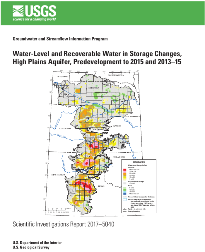
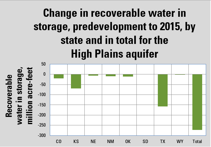
The U.S. Geological Survey has released a new report detailing changes of groundwater levels in the High Plains aquifer. The report presents water-level change data in the aquifer for two separate periods: from 1950 – the time prior to significant groundwater irrigation development – to 2015, and from 2013 to 2015.
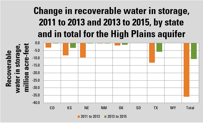
“Change in storage for the 2013 to 2015 comparison period was a decline of 10.7 million acre-feet, which is about 30 percent of the change in recoverable water in storage calculated for the 2011 to 2013 comparison period,” said Virginia McGuire, USGS scientist and lead author of the study. “The smaller decline for the 2013 to 2015 comparison period is likely related to reduced groundwater pumping.”
In 2015, total recoverable water in storage in the aquifer was about 2.91 billion acre-feet, which is an overall decline of about 273.2 million acre-feet, or 9 percent, since predevelopment. Average area-weighted water-level change in the aquifer was a decline of 15.8 feet from predevelopment to 2015 and a decline of 0.6 feet from 2013 to 2015.
The USGS study used water-level measurements from 3,164 wells for predevelopment to 2015 and 7,524 wells for the 2013 to 2015 study period.
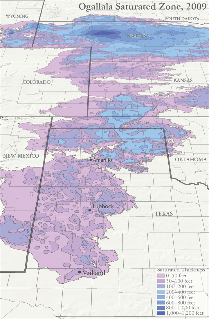
The High Plains aquifer, also known as the Ogallala aquifer, underlies about 112 million acres, or 175,000 square miles, in parts of eight states, including: Colorado, Kansas, Nebraska, New Mexico, Oklahoma, South Dakota, Texas and Wyoming. The USGS, at the request of the U.S. Congress and in cooperation with numerous state, local, and federal entities, has published reports on water-level changes in the High Plains aquifer since 1988 in response to substantial water-level declines in large areas of the aquifer.
“This multi-state, groundwater-level monitoring study tracks water-level changes in wells screened in the High Plains aquifer and located in all eight states that overlie the aquifer. The study has provided data critical to evaluating different options for groundwater management,” said McGuire. “This level of coordinated groundwater-level monitoring is unique among major, multi-state regional aquifers in the country.”
High Plains aquifer water-level changes, predevelopment (about 1950) to 2015. Figure 1 from USGS SIR 2017-5040.(Public domain.)Bar graph showing change in water-in-storage, predevelopment to 2015, by state and in total for the High Plains aquifer. States in region include Colorado, Kansas, Nebraska, New Mexico, Oklahoma, South Dakota, Texas and Wyoming. (Public domain.)Bar graph showing change in recoverable water in storage, 2011 to 2013 (orange) and 2013 to 2015 (green), in million acre-feet by state and in total for the High Plains aquifer. Recoverable water in storage from 2013 to 2015 for the aquifer declined 10.7 million acre-feet, which is about 30 percent of the recoverable water in storage change from 2011 to 2013. This difference is likely related to reduced groundwater pumpage during the 2013 and 2014 irrigation seasons as compared to the 2011 and 2012 irrigation seasons. (Public domain.)
After hearing dozens of public comments, and having their email inboxes flooded with input, the council voted 6-1 late Tuesday night to take a place at the table with the Northern Water Conservancy District, the lead proponent of NISP and representative of 15 backers of the project. NISP would include two reservoirs fueled by the Poudre River, including one near the mouth of the Poudre Canyon.
Council members were also clear that they didn’t view opening discussions as giving in to the project. Councilman Bob Overbeck — the only vote against it — added to the Tuesday resolution that the council outright opposed the project in 2008 and voted in 2015 not to support the project in its current form. The word “negotiate” and phrase “mutual interests,” referring to the city and Northern Water, were also struck from the resolution.
Nonetheless, Gary Wockner, of Save the Poudre, said his group is looking at putting the question of whether the city should support NISP before city voters…
Advocacy group Save the Poudre conducted an opinion poll, via 556 automated phone calls, which results found an overwhelming amount of opposition to the project among city voters.
About 50 of the 60 or so people who made public comment Tuesday opposed the resolution or NISP outright…
John Stokes, head of the city’s natural areas department, said Wednesday staff was happy to get more direction from council, in terms of having discussions with Northern Water regarding city concerns and mitigation proposals. He was also clear that staff didn’t view it as authority to make any decisions regarding the city’s support or efforts of NISP.
“Council makes the decisions about all of this, and, clearly, if we’re going to make any progress on this, it needs to be with council on board,” he said…
Brian Werner, spokesperson for Northern Water, said his group was grateful to be able to have more robust conversations about NISP with the city. There have been some talks with the city about its concerns, but it always felt “sort of like walking on egg shells,” without formal backing, Werner said.
He noted Northern Water and its constituents have already shifted plans to address concerns about low-flow periods of when the Poudre River might dry up by including promises of base flows. Werner cited the city’s softening positions between 2008 and 2015 as proof of Northern Water’s efforts.
“They’ve gone from an almost hell no, to a we’re not happy right now, but maybe make some changes and come back with another proposal,” Werner said. “… I would argue that shows we’ve been listening to Fort Collins as we’ve been trying to craft and draft this plan.”
Update: The council adopted an amended version of the resolution with a 6-1 vote. Bob Overbeck was the only dissenting vote.
The Fort Collins City Council discussed Resolution 5217, which would begin discussions with the Northern Colorado Water Conservancy District, a public agency which provides water to northeastern Colorado, on Tuesday. The discussion revolved around a controversial proposal known as the Northern Integrated Supply Project.
The NISP is a proposed project meant to deliver 40,000 acres of water a year to 15 Northern Colorado communities. While the city itself would not a participate in the NISP, a portion of southeastern Fort Collins would partake in the project.
The NISP would consist of three reservoirs along the Cache La Poudre River, including a large reservoir to the north of the city known as Glade Reservoir which would divert over 1,200 cubic feet per second of the river’s peak flows. This would reduce annual river flows by 20 percent and by 30 percent during the peak flow months of May, June and July, a staff report said.
However, the project is not without opposition. According to non-profit organization Save the Poudre, the NISP/Glade Reservoir project would cause immense ecological damage to the Poudre River.
According to the organization’s website, the project’s aim of reducing peak flows would prevent the river from cleaning itself of algae, endangering the Poudre’s water quality as well as the habitat of a number of aquatic plants and animals.
The staff report also acknowledges that “it is likely the health of the river will be negatively impacted by NISP, especially without well-planned and extensive mitigation actions.” The report states that although the river is able to support a number of ecological systems, the Poudre is approaching “critical thresholds below which the river’s health and resilience will suffer.”
The city’s Natural Resources Director John Stokes recommended the City Council to begin discussions with the Northern Colorado Water Conservancy District. In particular, he recommended to negotiate with the public agency, saying it would be the best alternative outcome.
If the city were to forego consulting with Northern Water the project would be left to federal and state agencies who would not consider the NISP’s impacts on Fort Collins.
Close to 40 Fort Collins citizens approached the council for public comment, some urging the council to negotiate with Northern Water and some voicing their reservations.
“I’ve noticed a marked decline in the river corridor already… I see virtually nothing anymore,” said one Fort Collins citizen about the current state of the Poudre.
The city owns around 60 percent of the river’s corridor and the city has already engaged in a number of projects with regards to the Poudre, such as clean-ups and the creation of trails.
Negotiations with Northern Water does not mean that the city has already agreed to the NISP’s construction. In order to construct the reservoirs a permit must be obtained from the U.S. Army Corps of Engineers who must assess the environmental impacts of the project.
The NISP has been in the federal permitting process for 12 years and thus requires many state and federal permits in order for the project to push forward. In 2015 the council passed a resolution which stated “the City Council cannot support NISP as it is currently described and proposed (as of 2015).”
Map sources: Houston, Natalie. 2011. Hydrogeologist, Texas Water Science Center, U.S. Geological Survey. Personal communication, October 2011. Houston, Natalie, Amanda Garcia, and Eric Strom. 2003. Selected Hydrogeologic Datasets for the Ogallala Aquifer, Texas. Open File Report 2003-296. August 2003.
By permanently barring the use of two wells in an area where farmers rely on the Ogallala Aquifer to grow corn, the judge concluded the Garetson family’s senior water right had been “impaired” by their neighbor – a company that holds a junior water right.
“What made this case so important is the precedent that is now set,” said Jay Garetson, who filed the lawsuit in 2012 together with his brother Jarvis. The Garetsons have said they sued not only to defend their livelihood but also to press the state to enforce its water laws, and to call attention to the urgent need for action to preserve the aquifer.
“Our goal was to force this to the forefront,” Garetson said in an interview on Wednesday. “The best-case scenario would be it forces people to recognize that the status quo is no longer an option.”
Kansas’ “first-in-time, first-in-right” water rights system gives priority to those who have been using their wells the longest. And farmers are actually using much less water than they would be permitted under the system of appropriated groundwater rights established decades ago.
But with aquifers levels dropping and a limited supply left that can be economically extracted for farming, the Garetsons and others argue that the state and water districts should step in to establish limits on pumping…
Garetson said the decision should help bring order to a chaotic situation, and he hopes the case will be a catalyst for management of groundwater. He said he thinks the local groundwater district should establish a water budget and institute a sort of “cap-and-trade” system, in which water use would be scaled back based on established rights and could be sold between farmers, thereby allowing the market to sort out the scarcity problem.
He thinks such a system could serve as a model across the Ogallala Aquifer and in other areas of the country where aquifers are declining due to excessive pumping.
Garetson has seen some wells go dry on his farm, where he and his brother grow corn and sorghum. And he acknowledges his own pumping contributes to what is effectively the “mining” of groundwater.
He wants state officials and the region’s water managers to establish limits to move “in the direction of sustainability” – even though that’s a high bar to reach given the area’s limited water supplies and slow rate of aquifer recharge.
Garetson said he hopes the court decision will help Kansas farmers move away from the pattern of unchecked pumping that is draining the aquifer. Under the status quo, he said, “we’re actually just borrowing from the future. We’re burning up our savings account.”
The Michigan Ditch is a 5.2-mile conveyance system that brings water from the high mountains into the Joe Wright Reservoir, a part of City’s two water sources. Over the years, the Michigan Ditch, a combination of pipeline and open channel originally built around 1900 and purchased by Fort Collins in the 1970s, was subject to the whims of Mother Nature. Specifically, one portion of the water supply route that crosses an area known as “the mudslide” was subject to periodic damage when the slides occurred.
The City was accustomed to making simple repairs that involved digging up the pipe and moving or replacing it when the slide moves. But in September 2014, crews noticed something unusual. The pipe, which typically moved only during snowmelt in the spring, had moved substantially since its repair that summer. The following spring, even more movement showed that a more permanent fix was needed.
“It was apparent that this wasn’t something we could simply dig up and put back in place like previous years,” said Owen Randall, chief engineer for Fort Collins Utilities. “We knew we needed a long-term solution that could cost upwards of $10 million. When I told City management the response was: ‘The water is worth $180 million, so go fix it.’”
In summer 2015, the City got to work with a geotechnical assessment that included seismic refraction as well as vertical and horizontal borings. Meanwhile, the City put together a team of consultants and contractors to help ascertain the best way to move forward. After exploring the options, the team decided that a tunnel that would re-route the water through the mountain in stable rock was the best solution…
The tunnel option provided the long-term solution the City was looking for while having the added benefits of less maintenance, less environmental impact and a construction cost comparable to other options…
The logistics of working on the side of a mountain also presented challenges. The project site was located 2.5 miles up a narrow, winding dirt road that dictated the weight and dimensions of the equipment that could be safely transported. Additionally, the nearest town (Walden, Colorado; population 3,000) was located 30 miles away, with Fort Collins 70 miles away. Even cell phone service had to be brought in.
“Due to the nature of the road, we were limited to about an 11-ft wide load,” said John Beckos, project manager for BT Construction. “We were unable to get a crane to the site, and the biggest excavators we could bring in were nearly hanging off the edge of the mountain on the way up.”
The site access also dictated the type of tunnel boring machine that could be used to excavate the tunnel. After evaluating the options, the project team elected to use an Akkerman hard-rock TBM that had a mixed face cutterhead to deal with the highly fractured, hard rock and abundant fault and shear zones. The machine was compact enough to accommodate the limited space at both the launch and retrieval pits, light enough to be handled by the available equipment, and had enough power to drill through rock that reached strengths of 15,000 psi…
The tunnel was mined from the downstream portal to the upstream portal. The first 40 ft of the alignment was straight before it transitioned into the 630-ft radius curve spanning 726 ft. The TBM was equipped with a conveyor system and dual muck boxes to remove the spoil. Spoil was stockpiled near the site to be used by the City for future repairs to the ditch and pipeline, as well as the access road, which the City also maintains…
Randall said the ground made tunneling a challenge. “The only thing consistent about the ground was that the rock was inconsistent,” he said. “We would find hard zones 2-3 inches thick, 2-3 feet thick and 30-feet thick. We knew we were going to get into difficult geology, but it still posed a challenge.”
Once the TBM was completely launched into the mountainside, the team had originally planned to be tunneling for about 6 weeks from early July through the middle of August. The inconsistent rock in the middle of the drive would end up slowing productions down and delaying the hole out until Sept. 29. And, despite the challenging ground, the TBM holed through precisely on target. Project team members credited the VMT guidance systems, typically used for larger and longer tunnels, for keeping the tunnel on line and grade…
Over the last 20 years, Fort Collins has implemented and refined its delivery system known as the Alternative Product Delivery System (APDS). Fort Collins retains a group of prequalified contractors and consultants on an annual contract basis – known as master service agreements – and when a project is needed, the City can call on its team of service providers with expertise in a particular area to negotiate a contract. This allows the City to quickly gather a team to develop the project from start to finish.
In the case of the Michigan Ditch Tunnel, the project team was brought on board to determine the best solution for the problem. As the project began to take shape as a tunnel, the City negotiated further contracts for tunnel design, construction and TBM procurement. The project team additionally developed a risk register to help identify and mitigate potential occurrences that could impact the project.
“Rather than trying to write a contract for the whole project up front, we can write contracts that are very well defined, knowing what our scope of work is going to be as planning and design progresses,” Randall said.
The added benefit of having the project team in place was that the project goals were defined by the team, rather than by an individual party or parties. “This was a very challenging and difficult project, but when you have everybody working toward the same goal, it makes all the difference in the world,” Randall added.
“The team functioned at a very high level and with great communication,” Dornfest said. “It was extremely challenging, but there was never any finger pointing and we were able to get the job done on schedule and under budget.”
Thanks to planning, teamwork and determination, the Michigan Ditch Tunnel project was successfully completed approximately $1 million below the initial budget of $8.5 million. The ditch system is now back online, assuring Fort Collins citizens of a reliable source of water for the years to come.
View of runoff, also called nonpoint source pollution, from a farm field in Iowa during a rain storm. Topsoil as well as farm fertilizers and other potential pollutants run off unprotected farm fields when heavy rains occur. (Credit: Lynn Betts/U.S. Department of Agriculture, Natural Resources Conservation Service/Wikimedia Commons)
Morgan Conservation District’s 62nd annual meeting will be held on February 9th.
It will be held at the Fort Morgan Home Plate Restaurant, 19873 U.S. Hwy. 34. Breakfast will be at 8 a.m. and the meeting will start at 9 a.m. The cost of the meeting will be $25 in advance, and that will cover the annual meeting, annual membership in Morgan Conservation District, and free breakfast that morning.
If you do not RSVP in advance, and show up on the day of the meeting, please be advised that the cost will be the same, however breakfast will not be free, due to our needing to order the food in advance. Our keynote speakers, Bill Hammerich and Andrew Neuhart.
Bill Hammerich has served as the CEO of Colorado Livestock Association (CLA) for the past fourteen years. He grew up on a cattle and farming operation in Western Colorado and he attended CSU where he graduated with a degree in Agricultural Economics. Following graduation, he began working with Monfort of Colorado, then Farr Feeders and was with the Sparks Companies before joining CLA in 2002.
His time spent in the cattle feeding industry provided him not only with an understanding of how to feed cattle, but also the importance of protecting and sustaining the environment in which one operates.
Bill and his wife Sabrina live in Severance, Colorado and have two grown children, Justin and Jessica, and four grandsons.
Andrew Neuhart completed both a B.S. in Natural Resource Management and an M.S. in Watershed Science at CSU. After spending two years assisting in precision farming studies in the San Luis Valley for the USDA Soil, Plant and Nutrient Research team, Andrew went to work for the State of Colorado’s Water Quality Control Division. For 9 years with the WQCD, Andrew led a Permitting Unit for discharge permits under the Clean Water Act, for both industrial and domestic wastewater treatment facilities. Working for Brown and Caldwell over the last 4 years, Andrew assists clients with regulatory issues under the Clean Water Act, and has been working with the Ag Task Force, part of the Colorado Monitoring Framework, to get the word out regarding nutrient regulations and their impacts to agricultural operations.
Mr. Hammerich and Mr. Neuhart will be speaking about Regulation 85.
Regulation 85 establishes requirements for organizations holding a NPDES permit and with the potential to discharge either nitrogen or phosphorus to begin planning for nutrient treatment based on treatment technology and monitoring both effluents and streams for nitrogen and phosphorus.
The data from these efforts is designed to better characterize nutrient sources, characterize nutrient conditions and effects around the state and to help inform future regulatory decisions regarding nutrients. Please come to the meeting and learn more from our very knowledgeable keynote speakers!
Please RSVP as soon as possible to Angela at morganconservationdistrict@gmail.com or call 970-427-3362. Space is limited.
The Platte River is formed in western Nebraska east of the city of North Platte, Nebraska by the confluence of the North Platte and the South Platte Rivers, which both arise from snowmelt in the eastern Rockies east of the Continental Divide. Map via Wikimedia.
Nebraska has a unique role among the four partners in the Platte River Recovery Implementation Program, according to Nebraska Department of Natural Resources Director Jeff Fassett.
“All the (protected) species and all the habitat are in Nebraska,” he said.
The Central Platte Valley is the target area for least terns, piping plovers and whooping cranes, while pallid sturgeon are in the Lower Platte River.
All the water options for a proposed program extension, which will focus on reducing river depletions by another 40,000 [acre-feet] or more, are in Nebraska to be as close as possible to the target habitat.
Fassett said that with a major reservoir project now off the table, new projects will include groundwater recharge, facilities to hold water for retimed releases and water leasing.
He noted Tuesday at the annual convention of the Nebraska State Irrigation and Nebraska Water Resources associations that initial water projects were completed by all three states toward meeting the program’s first-increment goal to reduce river depletions by 130,000-150,000 [acre-feet].
However, more recent projects and those being considered for the future are only in Nebraska. “There is hydrologic logic about that,” Fassett said, because projects hundreds of miles from the target habitat are not as effective.
Nebraska’s benefits include regulatory stability the program provides for the Platte Basin. Projects in Nebraska, Colorado and Wyoming that must comply with the federal Endangered Species Act can do so through the program instead of individually, he said.
Another issue for Nebraska is its own demands to enhance water in the river. Fassett said state laws for the overappropriated area of the Platte Basin west of Elm Creek require “moving the train backward” to mitigate new water uses since 2007.
Click here to buy your tickets. Here’s the pitch from the Colorado Water Trust:
Overview
The destiny of the west is written in the headwaters of Colorado. Tens of millions of people, billions of dollars of agricultural production, and an enormous amount of economic activity across a vast swath of America from California to the Mississippi River are all dependent on rivers born in the mountains of Colorado. In this time of increasing demand and limited supply, it is essential to promote a more informed and inclusive discussion concerning decisions affecting our water resources.
VIP Reception starts at 5:30pm in Henderson’s Lounge followed by the screening.
Proceeds from the event will go to support the Colorado Water Trust:
The Colorado Water Trust is a private, nonprofit organization whose mission is to restore flows to Colorado’s rivers in need. Founded in 2001, the Colorado Water Trust coordinates market-based water transactions, water-sharing agreements, infrastructure projects, and other creative solutions to restore flows to our state’s dry rivers and streams. Together with our diverse partners throughout the state, we are restoring habitat for fish and other wildlife, improving local economic opportunities, and where lost, returning to Colorado’s landscape the beauty of a flowing river. http://www.ColoradoWaterTrust.org
“I used to be a orthodox card-carrying humanities academic with contempt for the manipulations of nature that engineers perpetrated. And then, I realized how much a beneficiary I was of those perpetrations.” — Patty Limerick (The Great Divide)
This is an important film and Ms. Limerick hits the nail on the head with her statement. When folks understand the history of Colorado and how water has shaped that history, when they learn about the disease and hardship that goes hand in hand with scarcity of water here in the arid west, when they witness the bounty from plains farms and the western valleys and the economic drivers associated with Colorado’s cities, when they take time to sit down to talk and learn from neighbors and others, opinions can change, understanding can grow, problems can be solved, and opportunities can be realized.
Jim Havey and the filmmakers set out an ambitious goal, that is, the telling of Colorado’s water story, without advocacy and without pointing fingers. The Great Divide accomplishes the telling using a superb screenplay written by Stephen Grace, the stunning footage by Jim Havey, along with the old photographs and maps of Colorado (and the Colorado River Basin).
Prior appropriation and anti-speculation are big ideas that form the foundation of Colorado water law. Article XVI of the Colorado Constitution includes detail about the preferred uses and the rights of diverters to cross private land to put the public’s water to beneficial use. All water in Colorado belongs to the citizens but diverters gain a property right allowing them to use the water.
The filmmakers manage to explain these details well during the film. The film describes the law, the compacts between states, river administration, and the 21st Century world of water. They emphasize the work and pioneering efforts needed to get Colorado where it is today.
San Luis People’s Ditch via The Pueblo Chieftain
Starting with the San Luis People’s ditch (the oldest water right in continuous use in Colorado — 1852) Coloradans have built out many projects large and small to put the water to beneficial use. The Great Divide describes many of these projects including the big US Bureau of Reclamation projects, Colorado-Big Thompson, Fryingpan-Arkansas, the Aspinall Unit, and what many think will be USBR’s last big project, Aninas-La Plata.
According to the film an early project, Cheesman Dam on the South Platte River, enabled delivery of high quality water to the City of Denver which had been plagued by outbreaks of cholera and other waterborne diseases.
These projects have gotten Colorado to this point with over 5 million residents and a diversified economy. However, in the documentary the head of Denver Water Jim Lochhead states, “If we grow the next 5 million people the way we’ve grown the last 5 million — that may not be sustainable.”
There is a tension between environmentalists and water developers in today’s Colorado, highlighted by the film. The Great Divide explores the historical roots of the environmental movement starting with the Sierra Club effort to save Echo Park on the Yampa River, up through the legislation allowing the Colorado Water Conservation Board to hold and establish instream flow rights, the successful efforts to block groundwater withdrawals in the San Luis Valley for Front Range growth, and the mammoth decision to not permit the Two Forks Reservoir on the the South Platte River.
The City of Denver and many of the suburbs were counting on that project for future needs. It is interesting to note that the loss of Two Forks led to increased groundwater withdrawals from the Denver Basin Aquifer System and an increase in purchases of agricultural rights by municipal systems. Both of these alternatives are unsustainable but have led to recharge projects, water reuse projects by Denver Water and Aurora Water, along with serious efforts to allow alternative transfer methods for agricultural water that would protect farmers and keep the water with the land. The Great Divide touches on these newer more sustainable solutions.
Drought is a constant possibility in Colorado. The film shows how the drought of the 1930s spurred northeastern Colorado to line up behind the Colorado-Big Thompson Project for new supplies and storage.
US Drought Monitor August 6, 2002
When things turned around after the drought of 2002 The Great Divide informs us that municipalities had to rethink conservation efforts and that pumpers with insufficient augmentation water were shut down. Denver Water managed to cut per capita consumption by 20% below pre-2002 levels and other utilities noted similar savings.
The film examines the aftermath of the 2002 drought and the efforts by the Colorado legislature which passed the Colorado Water for the 21st Century Act. It established the Interbasin Compact Committee (IBCC) and the nine basin roundtables. The roundtables and the IBCC were formed as a forum to share needs but most importantly share values. One of the outcomes of the effort has been the realization, stated in the film by Travis Smith that, “We are more connected than we’d like to admit.”
Colorado Water Plan website screen shot November 1, 2013
This connectedness, along with the need to solve looming wide-ranging supply gaps were the motivation for Governor Hickenlooper to issue an executive order to the Colorado Water Conservation Board to create Colorado’s first ever water plan. The Governor has an opportunity to present his view of the need for the plan in the film. He touches on the fact that however the plan turns out it will be built by the grass roots.
During his introduction of the film Justice Gregory Hobbs advised us to listen to the words along with viewing the images. He was right, the narrative by Peter Coyote engages and informs. You cannot listen to Mr. Grace’s words without learning at the same time. And that’s the point right? Educate and inform with an accurate representation of Colorado water issues and history…
The film is a stellar vehicle for educating and generating conversation. Go see it when you can, buy the book, and then start talking and teaching.
Wyoming has moved one step closer to getting more water for ranching, agriculture and industrial development.
The U.S. House Committee on Natural Resources has advanced a bill that would allow the state to take an additional 125,000 acre-feet of water from the Green River at the Fontenelle Dam…
State officials say expanding the Fontenelle is necessary for farmers and ranchers who need a reliable water supply to keep crops and livestock healthy.
They feel the measure would also be an economic incentive for new businesses to grow and create jobs in southwestern Wyoming…
[Gary Wockner] notes Wyoming isn’t the only state trying to get more water from a shrinking source.
He points to a proposal by Denver Water to expand the Gross Dam that would remove an additional 5 billion gallons annually from the Colorado.
While upper-basin states may technically have rights to the water, Wockner says the challenges of a changing climate and 16 years of drought can’t be ignored.
The dam that forms Gross Reservoir, located in the mountains west of Boulder. Photo: Brent Gardner-Smith/Aspen Journalism
The rotating cutting wheel of a custom-built tunnel boring machine began to slowly emerge from a mountainside around 5 a.m., said Owen Randall, chief engineer with Fort Collins Utilities.
The breakthrough was an exciting moment for crews that have been working on the 760-foot-long tunnel near Cameron Pass since June…
Crews still have four to six weeks of work to wrap up the project, which will carry Michigan Ditch and its valuable water to city-owned Joe Wright Reservoir.
Dismantling and removing a tunnel boring machine from the mountain will take three to four days. Hydraulic and electronic equipment used to operate the machine will be stripped from the tunnel before a 60-inch diameter pipe is installed to carry the water.
Weather could be a challenge as crews hustle to wrap up the project before heavy snowfall comes to the area. A few inches of snow fell last weekend, Randall said, but has since melted away…
Crews have been working on the project 24 hours a day since mid-September to make up for delays caused by equipment problems and the challenge of cutting through exceptionally hard rock.
Michigan Ditch provides the city with 2,000 to 3,000 acre-feet of raw water a year. The water is used to meet return flow obligations on the Poudre River mandated through various water-exchange agreements.
The market value of water supplied through the Michigan Ditch-Joe Wright Reservoir system is about $180 million, according to the city.
The tunnel project is in response to a slow-moving landslide that has been affecting the ditch for several years. Damage was especially severe in 2015.
City officials decided to protect the piped ditch by sending it through bedrock that the slide can’t affect. The project is expected to cost Fort Collins Utilities about $8.5 million.
After overcoming equipment problems and putting in 24-hour work days, crews on Wednesday were within 35 feet of reaching the end of what will be a 764-foot-long tunnel.
“We’ve made tremendous progress …,” said Owen Randall, chief engineer with Fort Collins Utilities. “We should be out sometime (Thursday) or Friday at the very latest.”
Breaking through the mountain will be done slowly and carefully to avoid destabilizing the mountainside, he said.
Crews still have four to six weeks of work to wrap up the project, which will carry Michigan Ditch and its valuable water to city-owned Joe Wright Reservoir near Cameron Pass.
Dismantling and removing a custom-built tunnel boring machine from the mountain will take three to four days. Hydraulic and electronic equipment used to operate the machine will be stripped from the tunnel before a 60-inch diameter pipe is installed to carry the water.
A stretch of unusually hard rock inside a mountain near Cameron Pass has slowed a tunneling project aimed at shoring up Fort Collins’ water supply.
Progress on a 760-foot tunnel that will carry Michigan Ditch water to the city-owned Joe Wright Reservoir was stopped as of Thursday.
Crews are waiting for the arrival of replacement parts for the cutting head of a tunnel boring machine, or TBM, that was custom built for the project, said Owen Randall, chief engineer for Fort Collins Utilities.
Bearings on cutting disks on the rotating head have repeatedly burned out while dealing with a wall of pegmatite, a type of granite that can have various minerals and be exceptionally hard, Randall said.
Project managers are “literally looking around the world” for replacement disks, he said. When some will arrive at the work site is not known.
Rock conditions have varied tremendously during the course of the tunneling, which began in late June. Some layers of rock have been fractured and relatively easy to cut through, he said. Others have been difficult.
“We went 300 feet on the first set of disks,” Randall said. “We used up two sets going the next 8 feet. It’s just been very variable.”
Before the TBM was shut down, the cutting wheel was grinding out clouds of powder rather than chunks of rock, he said.
The machine was 482 feet into the mountain as of Thursday. Time and weather are becoming concerns as crews want to have the TBM off the mountain before heavy snow comes.
Randall said crews still expect to finish the project this fall.
Once the tunnel is cut, a 60-inch pipe made of fiberglasslike material will be put in place to carry Michigan Ditch. Randall said he wants to have water flowing through the pipe before the onset of winter.
“We are going to get through,” he said. “But safety will dictate how long we keep people working up here.”
Crews have been working seven days a week, 12 hours a day. That will increase to 24 hours a day Sept. 12. About 1,000 feet of pipe is expected to be delivered that week, Randall said.
The project is in response to a slow-moving landslide that has been affecting the ditch for several years. Damage was especially severe in 2015.
Erin Light, center, and Shanna Lewis in a pasture with a mule while checking on the Meeker Ditch on July 11. Light has curtailed diversions into the ditch, which she determined was wasting water.
MEEKER – The mule in a pasture east of Meeker along the White River seemed happy to see Erin Light, a state division engineer, and Shanna Lewis, a water commissioner, when they went to take a look at the amount of water flowing through the Meeker Ditch on July 11.
Lewis, who grew up on a Colorado ranch, praised the mule’s beautiful, deer-like coloring and said they’d become friends on her frequent visits to check the ditch.
But the warm equine reception the two enforcers of Colorado water law received differed from the response they sometimes get from ranchers in Division 6, which encompasses the Yampa, White and North Platte river basins, especially when they are visiting a ditch because they think its operator is diverting more water than they need through their head gate.
“I would say I’m more telling than I am curtailing,” said Light, who has been the division engineer based in Steamboat Springs since 2006. “There have only been a few situations where I’ve actually said, ‘That’s it. We’re curtailing you.’ And they’re very obvious situations where they’ve got a lot of water going down the tail end of their ditch, where you can’t argue that this isn’t waste.
“Where the problem becomes in determining waste is that I can go out to a piece of land and say, ‘Oh my gosh, you’ve got 6 inches of water on this land. There’s ducks swimming around. This is wasteful,’” she continued. “You can go to the landowner or the irrigator and say, ‘This is waste,’ and they’ll stare you right in the face and say, ‘The hell it is.’”
Division and state engineers working for Colorado’s Division of Water Resources, as Light does, are the only officials who have the authority to determine if waste is occurring on an irrigation system. And their primary response is to curtail wasteful flows at the head gate.
But determining if there is waste in a ditch is a case-by-case exercise. It’s site specific and time sensitive, and it can take time to understand how someone manages their ditch.
There’s no state definition of waste or written guidelines, but in the end it’s a fact-based analysis focused on how much water is needed to irrigate so many acres.
An allowance is also made for customary inefficiencies on a ditch system. Water leaking out of an old ditch, for example, is not considered waste. But beyond inefficiency, which is often a physical issue, there is waste, which is usually a water-management issue.
And waste is a much bigger issue on the Western Slope than on the state’s drier eastern plains, where irrigators have long watched for anyone wasting water.
A field flooded with water from the Yampa RIver this year. Erin Light, the division engineer for Division 6, said this is an example of diverting more water than is necessary.
Free river, or not
In 2014, Light served the Meeker Ditch with a written curtailment order, and she also told the big Maybell Canal on the Yampa River that they had to stop wasting water.
And she did so even though neither river was “under administration,” the term for the body of water being called out by senior downstream diverters, so both were considered in a “free river” condition.
Nor was there another water right that was being injured by either ditch’s diversions.
Just in the past 10 days, Light’s office has informed rancher Doug Monger that water is being wasted in the irrigation system he manages on his Yampa River Ranch three miles east of Hayden.
Monger is a Routt County commissioner, a member of the Yampa-White Roundtable, and a director on the Colorado River Water Conservation District’s board.
When asked Tuesday, during a break in a daylong strategic retreat at the River District, about Light’s belief that he was wasting water, he responded in a way that she has heard before.
“I don’t know what the hell difference it makes if I’m wasting water or not, it’s going back in the river,” Monger said. “Who the hell cares, if it’s a free river.”
“I know he is wasting water,” Light said Monday of Monger. “And he should be the poster child of what should be done, not what shouldn’t be done.
“About 10 days or so ago, our water commissioner approached a bunch of water users in the ditch system,” she explained. “There are several ditches that combine and co-mingle there.
“They were immediately going, ‘That’s Doug Monger’s responsibility, Doug’s the one controlling that,’ which I take as Doug is the one controlling the head gates,” Light said. “One of our water commissioners, Brian Romig, went to Doug and said, ‘We’ve got a problem here. You’re diverting too much water.’ From what Brian told me, Doug somewhat recognized it. He concurred that he needed to reduce his diversions.”
But Tuesday, Monger was not willing to go that far, saying he understood from the water commissioner only that he was still figuring out how Monger’s ditch works.
“I won’t acknowledge it,” Monger said of the allegation that he was diverting more water than he needs. “And if they start coming up with some scenario on it, we can always get our attorney. “
That was the same initial response that David Smith, the primary shareholder on the Meeker Ditch, had when Light curtailed his ditch in 2014.
But since then, and after spending $40,000 in legal and engineering fees, Smith has come around to see Light’s point.
“I would tell you that Erin and I started out on opposite ends on this thing, but both of us have kind of tried to work our way towards middle ground that we can both agree on,” he said.
Smith was busy this week bringing in hay on his well-tended fields along the White River just west of Meeker — the same fields his grandfather irrigated.
“I’ve had some disagreements with her, but Erin is an intelligent gal,” he said of Light, who has a master’s degree in civil engineering from Colorado State University with an emphasis in hydraulics and hydrology. “We’ve worked with her, and we’ve worked with the people that she has here, and at the end of the day it’s helped all of us, and I think we’re all better educated because of it.”
Well-tended fields along the White River west of Meeker irrigated by the Meeker Ditch. The ditch has been directed to divert less water at its head gate than it used to.Shanna Lewis, a water commissioner in Division 6, inspecting the Meeker Ditch’s measuring flume. Lewis suggested it’s easy for outsiders to critique how ranchers manage their water, but that there are a lot of factors, and experience, involved that are not always readily apparent.
Laying down the law
The Meeker Ditch has a water right dating back to 1883 to divert 20 cubic feet per second (cfs) of water and two other later and smaller rights that allow it to divert 25.95 cfs in all.
The ditch diverts water from the White River just east of Meeker, runs it through Meeker proper, and then to fields west of town. (See map).
In her August 2014 curtailment order, Light said the historic water rights held by the Meeker Ditch represent enough water to irrigate about 1,000 acres, but today only 153 acres are actively being irrigated. And engineers at Resource Engineering Inc. calculated that the Meeker Ditch only needed 6 cfs to irrigate the fields still served by the ditch.
Attorney Kevin Patrick of Patrick, Miller and Noto, a water law firm with offices in Aspen and Basalt, had hired Resource Engineering to analyze the irrigation ditch on behalf of a client who owned commercial property under the ditch.
Since 2004, the property had been intermittently subject to flooding by water leaking from the ditch.
Patrick sent the engineering report and a letter to Light. “The ditch is diverting unnecessary water which is merely being spilled” and “the excessive running of water, over that reasonably required for the reasonable application of water to beneficial use for the decreed purposes and lands, is forbidden” under state law, the letter says.
After investigating the matter, Light found the ditch had been consistently diverting about 20 cfs at its head gate, but was then sending much of the water out of the ditch and down Curtis Creek, Sulphur Creek or Fairfield Gulch, back toward the White River.
Light then curtailed diversions at the Meeker Ditch head gate, which she has the authority to do. And when asked to do so by Smith, she put the curtailment order in writing.
“Colorado statute clearly prohibits the running of water not needed for beneficial use,” Light wrote in her order, dated Aug. 15, 2014.
Light cited a Colorado statute that reads “it shall not be lawful for any person to run through an irrigating ditch any greater quantity of water than is absolutely necessary for irrigating his land, it being the intent and meaning of this section to prevent the wasting and useless discharge and running away of water.”
And she addressed the issue of water being released from the ditch and back to the river.
“Generally when water is being wasted off the end of the irrigated acreage, through waste gates, or at the tail end of the ditch, the head gate should be turned down to eliminate that waste of water,” Light wrote. “In this case it appears that water is being diverted at too great a rate for the lands that are being irrigated, and the rate of diversion is not being reduced to eliminate waste.”
Light’s stance on enforcing waste has the backing of her boss, State Engineer Dick Wolfe.
A photo from the Resource Engineering report documenting waste on the Meeker Ditch in 2014. Water from the ditch is being turned out into Sulphur Creek, while the main flow in the ditch continues through the pipe above the outfall.
Use it or lose it?
Both Wolfe and Light served recently on a committee, convened by the Colorado Water Institute at Colorado State University, that issued a report in February on the widely brandished piece of advice to irrigators to “use it or lose it.”
The report is called “How diversion and beneficial use of water affect the value and measure of a water right” and is subtitled “Is ‘use it or lose it’ an absolute?”
The 11-page report ends with several declarative statements about waste that give further backing to Light’s approach, and that she might well wish to see chained to every head gate on the Western Slope.
“Water that is diverted above the amount necessary for application to a beneficial use (including necessary for transit loss) is considered waste,” states the report.
“Increased diversions for the sole purpose of maintaining a record of a larger diversion are considered waste,” it says, referring to the practice of diverting toward the full amount of a decree in order to bolster the future potential value of a water right.
And, “Wasteful diversions will either be curtailed, or will not be considered as part of the water right’s beneficial use.”
Wolfe, who recently gave a presentation to the Colorado Ag Water Alliance on the “use it or lose it” report, said that Light is not being overzealous in her enforcement of waste.
“She is not going out and as a division engineer purposely looking and being more assertive or aggressive about trying to find where waste is going on,” Wolfe said. “These are ones that just came to our attention.”
Alan Martellaro, the division engineer for Division 5, has not taken the same approach as Light when it comes to curtailing waste.
“To actually actively go look for waste is not something that’s historically been done unless there’s a call on the stream,” said Martellaro, who is based in Glenwood Springs and whose jurisdiction includes the Colorado, the Roaring Fork, and the Crystal river basins. “It just hasn’t been the mode we’ve ever been in.”
Kevin Rein, the deputy state engineer who also served on the “use it or lose it” committee, said issues vary from division to division.
“In Division 6, in the Yampa-White, we’ve had periods of free river without administration for a long time, because it hasn’t been over-appropriated,” Rein said. “That means not being water short. So very often people were just diverting whatever they wanted because, why not? But she’s really directing herself to getting people to measure their diversions and pay attention to duty of water. I think you choose what’s important in your division. That’s important in her division.”
“Duty of water” is essentially how much water someone needs to grow crops on a certain amount of land, without waste. In the Yampa and White river basins, the duty of water is generally held to be that it takes 1 cfs to adequately irrigate 40 acres of land.
After giving a presentation at a water workshop in Gunnison in June about the “use it or lose it” report, Rein was asked why the state doesn’t go around and curtail people who are over-diverting.
“We do, as resources allow,” Rein said. “It’s simply a matter of looking at our water districts where we, maybe, have one water commissioner and maybe a deputy. Maybe if they each had two or three more deputies, then we could do that.”
Light sounds like she could use some help.
“When it comes down to obvious waste,” she said, “I would say we have a tremendous problem with it. I had a long-standing water commissioner — he was with us for 40 years and grew up a rancher — tell me one day, ‘The problem with irrigators today is they don’t go out and move their sets. They just open the head gate wider.’”
“Sets” refers to how irrigators have set various control points, such as check dams and internal head gates, along their ditches.
“That just blew me away,” Light said. “Here’s a longtime rancher living in the community of Meeker his entire life who is more or less telling me that his co-irrigators … just open up their head gate and don’t move sets anymore. To me, that’s where the inefficiency is. Go out, divert less water, and move your damn sets.”
Erin Light, after being asked to pose for a photo at the head gate of the Meeker Ditch. Light has curtailed diversions into the ditch to reduce the amount of water being wasted in the ditch system.
Defending Light
After receiving Light’s written curtailment order in August 2014 on the Meeker Ditch, Smith appealed it to an administrative hearing officer, which was a rare move.
Wolfe said the appeal, which was addressed to him, “is the only curtailment order that I am aware of that has been appealed since I have been state engineer.” He’s been state engineer since since 2007 and has been with the Division of Water Resources since 1993.
An attorney for the Meeker Townsite Ditch Co., which owns the Meeker Ditch, told the state that Light was “attempting to restrict the diversion of water down the Meeker Ditch at a time when the White River is not under an administrative call and at a time when no other water rights owner is affected by the diversion.”
At that point, the state stepped in to defend Light’s curtailment order, and Philip Lopez, an assistant attorney general, prepared an answer to Smith’s appeal.
In his answer, Lopez cited a relatively straightforward statute that reads: “During the summer season it shall not be lawful for any person to run through his irrigating ditch any greater quantity of water than is absolutely necessary for irrigating his land, and for domestic and stock purposes, it being the intent and meaning of this section to prevent the wasting and useless discharge and running away of water.”
And he quoted the Colorado Supreme Court in Fellhauer v. People, where it said, “The right to water does not give the right to waste it.”
As to the matter of Light, or any other division engineer, not being able to curtail waste if there is not a call on the river, Lopez wrote “the division engineer has the authority to curtail [the Meeker Ditch’s] wasteful diversions at any time pursuant to [state law], regardless of whether or not the White River is under administration.”
Lopez did concede, though, that the water rights held by the Meeker Ditch still allowed it to divert water, as long as they did so “without waste.”
That’s an important distinction for Smith, who insists that he wasn’t technically curtailed, only that he can’t waste water when diverting.
“She hasn’t curtailed me to the amount of water that I can use,” Smith said. “All that Erin tells me is that whatever amount of water I have in the ditch, that she doesn’t want us wasting any water.”
Light has a different take.
“We curtailed them,” Light said. “We issued an order to stop wasting. They hired an attorney. They hired an engineer. It went to the hearing officer. They don’t waste anymore.”
The hearing officer in the case denied the ditch’s appeal, indicating it was a matter for water court. But Smith declined to go there.
“We kind of came to a working agreement that we were going to try to work with it, but as far as the laws, there was never a test case,” Smith said.
That may be, but on July 11, when Light and Lewis measured the flow in the Meeker Ditch, it was running at 6 cfs, not 20 cfs as it often used to.
The diversion structure for the Maybell Canal on the Yampa River east of Maybell. The ditch has been working to reduce diversions after the division engineer found it was diverting more water than it needed.
The Maybell Canal
Light has also curtailed another irrigation ditch in Division 6, the Maybell Canal on the Yampa River near Maybell, which she found was similarly diverting more water than it needed.
The canal diverts water from the Yampa into a head gate located in a canyon on the edge of Little Juniper Mountain, about 30 miles west of Craig. (See map).
The Maybell Canal has a senior water right for 42.2 cfs that was adjudicated in 1923 and appropriated in 1899. It also has a junior right for 86.8 cfs that was adjudicated in 1972 and was appropriated in 1946.
The waste on the Maybell Canal was brought to Light’s attention by one of her water commissioners who’d visited the ditch. Light then verbally instructed the canal’s manager to stop wasting water. Mike Camblin, manager of the Maybell Irrigation District, wasn’t happy when he got the curtailment order from Light, but he’s now working to secure funding to make $197,000 worth of improvements to the irrigation system.
On July 13, the Yampa-White-Green basin roundtable approved a $108,000 grant of state funds to help fix several issues on the ditch system. One of those improvements is a modern, automated “waste gate” a mile below the head gate.
Camblin said such a remote-controlled system won’t work at the head gate, which is higher up in the canyon without cell phone service and prone to being washed out by high water.
But he is willing to use the automated gate to reduce sending more water than necessary out the bottom of the ditch, where the water returns to the Yampa River.
The arrangement for the new gate does not entirely please Light, however. She insisted that Camblin agree to send someone up to the head gate within three days after receiving information from the new automated gate that they are over-diverting.
An agreement to that end has been worked out and is poised for adoption, both Light and Camblin said.
“The whole goal is to not only help Erin out but to make us better at what we do,” Camblin told his fellow roundtable members on July 13.
In an interview this week, Camblin said, “At times we were probably taking more water than we need, but that’s what this whole process is about, to cut that down.” He said he is forging a productive working relationship with Light.
“I think it all comes down to communication, especially with Erin and the water commissioners,” he said. “If they get to know us and how our ditch can run better, and we allow them to do that, and we communicate, we can solve a lot of problems.”
Water diverted into the Maybell Canal enters a flume a mile below the head gate and crosses the Yampa River. A remote-operated outlet is to be installed just above the flume in an effort to reduce diversions into the ditch.The Maybell Canal, toward its end, below the town of Maybell, on July 13, 2016. The ditch is working to waste less water by reducing diversions from the Yampa River.
Watch that stick
Dan Birch, the deputy general manager at the Colorado River Conservation District and a member of the Yampa-White basin roundtable, is supportive of the improvements that Camblin is trying make on the Maybell Canal.
“I think Mike’s really trying to do the right thing, and I think he wants to take a look at ways he can manage his diversions better,” Birch said. “I certainly don’t think he’s diverting just for the sake of diverting.”
Birch also cautioned against using a stick to beat back waste.
“You can’t go into a situation and say, ‘Hey, you guys are wasting water, I want you to reduce your diversions,’” Birch said. “You really have to be prepared to go into that situation and say, ‘Hey, look, here’s something that we’re seeing here. Let’s have a conversation. I’m interested in exploring what we might do to improve flow in the river.’”
But Light feels the Maybell Canal needed to be prodded into action.
“What has partially pushed the Maybell Canal to go the direction they have is us really putting our foot down that we’re not going to allow this waste to continue,” she said. “Again, the waste is so blatant. They were diverting about 54 cfs at the head gate, and we estimated about 18 cfs going out the tail end. It’s like, ‘No, you can’t do that.’”
Birch was asked directly if he thought the Maybell Canal would be making its proposed improvements without Light’s enforcement actions.
“That’s a fair question, and my immediate response is probably not,” he said.
While Light has been able to work with both Smith and Camblin, she knows she’s raising the hackles of ranchers in the Yampa and White river basins.
“I don’t think the irrigation community wants to be told they’re wasting,” she said. “I’d love to do more as far as waste, but I do have to tread lightly.”
Editor’s note: Aspen Journalism, the Aspen Daily News and Coyote Gulch are collaborating on coverage of rivers and water. The Daily News published this story on Sunday, July 24, 2016
A custom-built tunnel boring machine has been “launched” into a mountain side near Cameron Pass as part of Fort Collins Utilities project aimed at restoring and protecting Michigan Ditch.
As of Friday, the tunneling machine built by Akkerman of Brownsdale, Minnesota, had dug 91 feet into the mountain, said Diana Royval, spokesperson for Fort Collins Utilities.
“Everything is going very well and is even a little ahead of schedule,” Royval stated in an email to the Coloradoan.
Last year, a slow-moving landslide heavily damaged a piped section of Michigan Ditch, which carries water to city-owned Joe Wright Reservoir.
To ensure delivery of the ditch’s water, city officials decided to bore an 800-foot-long, 8-foot-diameter, slightly curved tunnel into bedrock and run a pipe through it.
When the tunnel is complete, a 60-inch pipe made from a fiberglass-type material will be installed and connected to the ditch, which originates in the upper Michigan River basin.
The tunnel boring machine is 27 feet long and weighs 58,000 pounds. It is “driven” by an operator who sits inside the machine. A conveyance belt and ore cars run out the back of the machine carrying material generated by a rotating cutting head.
Construction on the project is expected to be finished by fall with the ditch back in operation for spring runoff in 2017, city officials say.
The city of Fort Collins is preparing to pay $6.3 million to repair a water pipeline more than 60 miles from city limits.
This would be on top of about $2 million already directed toward dealing with a section of Michigan Ditch that was taken out by a slow-moving landslide south of Cameron Pass.
That’s a lot of money. But given the value and importance of the city’s water supply system, the expenditure is necessary and well-spent, city officials say.
Michigan Ditch moves water from the upper Michigan River basin high in the mountains to the Poudre River basin and city-owned Joe Wright Reservoir.
Portions of the 6-mile-long ditch are open, but a stretch of the ditch carries water through a 54-inch iron pipeline. A 2015 landslide separated the pipeline at its joints, filling it with mud and taking the ditch out of commission.
The city plans to bore an 800-foot tunnel through bedrock behind the slide to protect the pipeline from further disruption. Construction is expected to begin in spring with the goal of having the pipeline ready to carry water in time for the 2017 spring runoff…
the city needs to get the pipeline fixed in order to meet long-term obligations under the terms of a water-use agreement involving Fort Collins, Platte River Power Authority and the Water Supply and Storage Co.
Water from Joe Wright Reservoir and nearby Chambers Lake also must be released to meet terms of an agreement between Fort Collins and Greeley to support aquatic life in the Poudre River, according to city documents.
Steamboat skiers and snowboarders prefer their champagne dry, but the relatively wet snow that buried the slopes over the weekend put a big boost into the snowpack on nearby Rabbit Ears Pass, where the amount of water stored in the standing snow jumped from a healthy 126 percent of median Jan. 30 to 135 percent Monday morning with the snow continuing to fall.
The snowpack on Rabbit Ears now contains 18.9 inches inches of water — and counting — compared to the median 14 inches for the first day of February. After measuring 69 inches Sunday, the snow depth at 9,400 feet on the pass had settled to 67 inches Monday morning.
But it’s a different story north of Steamboat Springs beginning at Buffalo Pass and continuing north to snow pack measuring sites maintained by the Natural Resources Conservation Service (NRCS) on the edges of the Mount Zirkel Wilderness Area.
The Tower site on Buff Pass has significantly more snow than Rabbit Ears, as it always does. However, on a percentage basis, the snowpack measurement of 23 inches is just 84 percent of median at 27.5 inches, according to the NRCS.
The pattern repeats further north at the Lost Dog and Mount Zirkel sites at roughly the same latitude on opposite sides of the Continental Divide. Lost Dog is on the western flanks of the Park Range in Routt County where the snow that melts into the streams ultimately finds its way into the Colorado River.
At the Zirkel site on the eastern, or North Park side of the Divide, the water is bound for the North Platte River and finally the Mississippi River.
The snowpack at Lost Dog is 90 percent of median, and at Zirkel, it is 87 percent of median. The combined Yampa/White river drainages stand at 106 percent median snowpack based on 20 measuring sites. That ranks the basin last among the eight major basins in the state with the San Miguel/Dolores/Animas/San Juan Basin leading the way at 123 percent of median. Lizard Head Pass south of Telluride stands at 162 percent of median snowpack.
On the east side of Rabbit Ears in Buffalo Park at an elevation of 9,240 feet, the snowpack contains 10.5 inches of water — 144 percent of median. But the nearby Columbine measuring site at 9,160 feet is at just 101 percent of median with 14.9 inches of water.
Turning to South Routt, the Crosho measuring site at 9,100 feet at the foot of the Flat Tops southeast of Phippsburg has 9.9 inches of water — 146 percent of median.
Fort Collins is preparing to spend about $7 million to repair a mountain water pipeline damaged by a slow-moving landslide south of Cameron Pass.
A portion of the 54-inch iron pipeline that carries Michigan Ditch to city-owned Joe Wright Reservoir was broken apart by tons of dirt and mud sliding downhill last spring.
The landslide has been active for many years, said Carol Webb, water resources and treatment operations manager for Fort Collins Utilities. Short-term repairs have been made to stabilize the pipeline, including realigning a section affected by the slide area in fall 2014.
“It’s been moving several inches at a time for quite a while,” Webb said. “But this last time it moved several feet.”
The slide separated the pipeline at its joints, filling it with mud and taking the ditch out of commission. As a long-term solution, the city plans to bore an 800-foot tunnel through bedrock behind the slide to protect the pipeline from further disruption, Webb said.
Construction is expected to begin in spring with the goal of having the pipeline ready to carry water in time for the 2017 spring runoff…
Michigan Ditch is about six miles long. It captures water from the upper Michigan River basin and carries it into the Poudre River basin.
City officials expect to tap into reserve funds to pay for the project. City Council likely will be asked to appropriate funds in January, Webb said.
The construction project has been prequalified for a loan from the Colorado Water Conservation Board, but the city is leaning toward funding the work itself, Webb said.
The city’s water supply is not expected to be negatively affected by the pipeline problem. Abundant snowfall last spring filled Joe Wright Reservoir and the Colorado-Big Thompson Project, meaning the city should be able to meet its needs and water-release obligations through fall 2016, according to a memo to City Council.
About 2,500 acre feet of water is released from Joe Wright Reservoir each year to meet terms of a water-use agreement involving the city, Platte River Power Authority and the Water Supply and Storage Co.
Another 900 acre feet is released from the reservoir and nearby Chambers Lake to meet the terms of an agreement between Fort Collins and Greely to support aquatic life in the Poudre River, according to city documents.
A report at the Sept. 9 meeting of the Platte River Recovery Implementation Program Governance Committee in Kearney estimated the current cost at $170 million. Neither figure includes property acquisition.
“Much of the work is on hold, in particular the negotiations with landowners,” said Mike Drain, Central Nebraska Public Power and Irrigation District Natural Resources Manager told the Hub Friday.
The Holdrege-based district would build, own and operate the two shallow reservoirs along the south side of the Platte River between Lexington and Overton that would temporarily hold excess water for later releases back to the river when needed to meet habitat target flows for threatened and endangered birds.
CNPPID’s major benefit would be to operate the upstream J-2 hydropower plant more efficiently.
The Platte Program, which involves the U.S. Department of Interior, Colorado, Wyoming and Nebraska, would pay the majority of the costs and get the majority of river benefit credits.
Nebraska would pay for 25 percent of the credits, with the Grand Island-based Central Platte Natural Resources District and Holdrege-based Tri-Basin NRD each participating for 20 percent of the Nebraska share.
At Thursday’s CPNRD board meeting in Grand Island, the NRD’s biologist and Governance Committee representative, Mark Czaplewski, was asked what factors had caused the two project estimates to be so far apart.
“The biggest one by far was underestimating what it would take to line the reservoir,” Czaplewski said, explaining that RJH Consultants Inc. of Englewood, Colo., the engineering consultant hired by CNPPID, based the original figure on surveys of off-site areas, while the new number applies to what is known about the actual J-2 project site.
“There were a number of things,” he added, including some redesign on the reservoirs’ ring dikes and that contractors were “a little hungrier” for jobs when the first estimate was made than they are now.
Czaplewski said the J-2 project is an important part of the Platte Program’s first-increment goal to reduce annual Platte River depletions by 130,000-150,000 acre-feet. The J-2 project benefits have been estimated at 48,000 a-f…
The J-2 Regulating Reservoirs project already was behind on several schedule targets. Drain said CNPPID officials had hoped to have full access or ownership of all land within the project footprint by the end of this year, which isn’t going to happen.
“There isn’t any way that we haven’t at least delayed the project now,” he added.
First water over Cheesman back in the day via Denver Water
Denver Water’s collection system via the USACE EIS
9News.com reporter Maya Rodriguez has embarked on a series about the Colorado Water Plan and water issues in Colorado. The first installment deals with Cheesman Dam and Reservoir.
Correction: The original post attributed the article to *Mary* Rodriguez. Coyote Gulch blames autocorrect rather than the author and his propensity to post at the wee hours of the morning.
Here’s an excerpt from Ms. Rodriguez’s article:
It is something most of us take for granted: running water. Colorado is now beginning to grapple with how to keep the tap flowing, both now and in the future. As the state develops a water plan, set to be released in December, we are beginning a series of stories revolving around that precious resource…
Cheesman Reservoir and Dam
Nearly 7,000 feet above sea level, it’s a place of stillness and a quiet refuge. Yet, it’s also a place capable of wielding immense power.
Cheesman Reservoir is a major source of water for communities up and down the Front Range. It holds 25 billion gallons of water. That’s enough water to cover Sports Authority Field with a foot of water more than 79,000 times. All of it is held in place by the Cheesman Dam, which was built nearly 110 years ago.
“It was tremendous foresight that this reservoir has been pretty much unchanged in all that time,” documentary filmmaker Jim Havey of Havey Productions said.
The reservoir is just one of the places Havey is beginning to capture as part of an upcoming documentary called “The Great Divide.” The subject? Water.
“We looked at water, initially, as a great way to tell the story of Colorado,” he said.
Colorado’s water system is a complex combination of reservoirs, rivers and dams. As the state’s population has grown, though, there has been a greater need to come up with a water plan that can evolve with time.
“Really, it is all connected,” said Travis Thompson, spokesperson for Denver Water, which bought the Cheesman Reservoir nearly 100 years ago.
Denver Water– along with water municipalities and agencies across Colorado– is now working on a long-term plan for Colorado’s water. It includes, among other things, figuring out the best way to manage the state’s water as it flows between different river basins and whether or not to create more reservoirs.
“We’re not planning just for today, we’re planning for tomorrow– 25 years, 50 years down the road,” Thompson said. “And we have many challenges that we’re looking into, just like our forefathers had.”
Those challenges include how to provide enough water for people and industries in Colorado, as well as people in 18 other states– and even two states in Mexico– which also get their water from rivers that begin in Colorado.
“What the water plan is going to mean, I don’t think anybody knows yet,” Havey said.
Yet, it’s a plan that has a lot riding on it below the surface. The first draft of the state’s water plan is due in December and is expected to be presented to the state legislature next year. For more information about the water documentary, “The Great Divide,” go to http://bit.ly/1qDftUO.
More Denver Water coverage here. More South Platte River Basin coverage here. More Colorado Water Plan coverage here.
Significant portions of the Ogallala Aquifer, one of the largest bodies of water in the United States, are at risk of drying up if it continues to be drained at its current rate. Courtesy of MSU
The scope of this mounting crisis is difficult to overstate: The High Plains of Texas are swiftly running out of groundwater supplied by one of the world’s largest aquifers – the Ogallala. A study by Texas Tech University has predicted that if groundwater production goes unabated, vast portions of several counties in the southern High Plains will soon have little water left in the aquifer to be of any practical value.
The Ogallala Aquifer spreads across eight states, from Texas to South Dakota, covering 111.8 million acres and 175,000 square miles. It’s the fountain of life not only for much of the Texas Panhandle, but also for the entire American Breadbasket of the Great Plains, a highly-sophisticated, amazingly-productive agricultural region that literally helps feed the world.
This catastrophic depletion is primarily manmade. By the early eighties, automated center-pivot irrigation devices were in wide use – those familiar spidery-armed wings processing in a circle atop wheeled tripods. This super-sized sprinkler system allowed farmers to water crops more regularly and effectively, which both significantly increased crop yields and precipitously drained the Ogallala.
Compounding the drawdown has been the nature of the Ogallala itself. Created 10 million years ago, this buried fossil water is–in many places—not recharged by precipitation or surface water. When it’s gone, it’s gone for centuries…
“The depletion of the Ogallala is an internationally important crisis,” says Burke Griggs, Ph.D., consulting professor at the Bill Lane Center for the American West at Stanford University. “How individual states manage the depletion of that aquifer will obviously have international consequences.”[…]
“We’re headed for a brick wall at 100 miles per hour,” says James Mahan, Bruce Spinhirne’s father-in-law and a plant physiologist at the USDA’s Agricultural Research Service lab in Lubbock. “And, really, the effects of climate change are branches hitting the windshield along the way.”
Last August, in a still-echoing blockbuster study, Dave Steward, Ph.D., and his colleagues at Kansas State University, informed the $15 billion Kansas agricultural economy that it was on a fast track to oblivion. The reason: The precipitous, calamitous withdrawal rates of the Ogallala Aquifer.
The Ogallala is little known outside this part of the world, but it’s the primary source of irrigation not just for all of western Kansas, but the entire Great Plains. This gigantic, soaked subterranean sponge – fossil water created 10 million years ago – touches eight states, stretching from Texas all the way up to South Dakota, across 111.8 million acres and 175,000 square miles.
The Ogallala supports a highly-sophisticated and amazingly-productive agricultural region critical to the world’s food supply. With the global population increasing, and as other vital aquifers suffer equally dramatic declines, scientists acknowledge that if the farmers here cannot meet ever-growing food demands, billions could starve.
Steward’s study predicted that nearly 70 percent of the portion of the Ogallala beneath western Kansas will be gone in 50 years. He’s not the kind of person to shout these results; he speaks slowly and carefully. Yet, he has the evident intensity of one who’s serving a greater purpose. “We need to make sure our grandkids and our great grandkids have the capacity to feed themselves,” he says.
Now the chief executive of the state, himself from a farming family, is using Steward’s report as a call to action.
“One of the things we [have] to get over … is this tragedy of the commons problem with the Ogallala,” says Governor Sam Brownback, a Republican who at age 29 was the youngest agriculture secretary in state history. “It’s a big common body of water. It’s why the oceans get overfished … You have a common good and then nobody is responsible for it.”
“That’s one of the key policy issues that you have to get around,” Brownback says in his roomy, towering office at the capitol in Topeka. “Everyone has to take care of this water.”
In that spirit, a tiny legion of farmers and landowners in the northwest corner of Kansas, where the Rockies begin their rise, have just begun year two of what could be one of the most influential social experiments of this century.
The group is only 125 in number but controls 63,000 acres of prime farmland in Sheridan County. Collectively, voluntarily, they have enacted a new, stringent five-year water conservation target, backed by the force of law and significant punishments.
The Local Enhanced Management Act, or LEMA, is the first measure of its kind in the United States. Specifically, the farmers are limiting themselves to a total of 55 inches of irrigated water over five years – an average of 11 inches per year…
“So now we have the high morality of the need to protect the ecosphere. But it’s legal to rip the tops off mountains. It’s legal to drill in the Arctic. It’s legal to drill in the Gulf. It’s legal to build pipelines. It’s legal to send carbon into the dumping ground called an atmosphere. So we’ve not yet reconciled the high moral with the legal.” [Wes Jackson]
The Laramie River reached 6.3 feet Tuesday in Laramie, entering “moderate-flood” stage. With warming temperatures and rain in the forecast, it could reach 6.7 feet by June 1, according to the National Weather Service. The “major-flooding” threshold is 7 feet.
Nearly 200 volunteers checked in at Woods Landing and Big Laramie Valley Volunteer Fire Department stations Tuesday to pile thousands of sandbags near the rising river…
The Snowy and Sierra Madre ranges got between 3 and 4 feet of snow on Mother’s Day, followed by temperatures warming to above 70 degrees and rainstorms over the weekend, Binning said.
Even in land-locked Colorado, Memorial Day served as a day at the beach for folks across the state.
High water in rivers statewide brought out the adventurous and encouraged others to take a more cautious approach and enjoy the views from dry land as the potential hazards of swift and surging currents began to reveal themselves at the start of what is expected to be a banner year for snowmelt runoff.
“It’s a blessing in that our overall season ends up being really, really good,” said Antony McCoy, head boatman and operations manager for Vail-based Timberline Tours whitewater rafting company. “But during the early season in a year like this, we often have to reroute and run trips differently than normal in the name of safety. Out decisions are always based on safety first and fun second, and we make those decisions day by day.”
With warm temperatures and weekend precipitation boosting flows, Timberline Tours and other established commercial rafting companies were forced to make reroute Memorial Day trips away from the raucous Dowd Chute section of the Eagle River between Minturn and EagleVail. The company institutes a cutoff for commercial trips through the Class IV-plus run when the river broaches 4½ feet on the gauge installed atop Dowd Chute, launching just below the most severe whitewater rapids instead.
“That’s a fun level for expert kayakers, but it gets tricky in a raft,” McCoy said. “And with water this high, most clients don’t really notice the difference. They still love it.”
Ironically, it’s just about the time that many commercial rafting companies begin to take more extreme precautions when many of the most daring decide that conditions are optimal.
A few miles below the Eagle River’s confluence with the Colorado River, the state’s growing cadre of river surfers arrived en masse at the increasingly renowned Glenwood Springs Whitewater Park on Monday. There they were greeted by river flows unseen on the Colorado since the high-water year of 2011, measuring in the neighborhood of 16,000 cubic feet per second below the confluence with the Roaring Fork River.
“I drive up here from Boulder just about every weekend this time of year,” said Ben Smith, a stand-up paddle (SUP) surfer of two years who had never ridden the river at flows above 5,000 cfs before this spring. “This season, I’m going to surf it as much as I can, and every weekend is like a new experience for me. It’s a different wave each time. Better and better.”
Surfers on Monday’s unofficial launch of summer were lined up as many as 10 deep on both sides of the Colorado River at West Glenwood, some with paddles and others with traditional surfboards diving headlong into the raging currents before popping to their feet for rides lasting several minutes. They alternated with — and largely outnumbered — skilled whitewater kayakers performing tricks in the frothy whitewater as spectators on the banks took in the show. One photographer launched a drone above the surfers to capture the action on video.
“This wave is by far my favorite,” Smith added. “A lot of kayak play holes have a big foam pile that’s designed to hold the kayaks in the play spot, whereas this wave is so steep that it’s gravity that’s pulling you down the face of it, which is what an ocean wave does. Plus it’s so clean. You can make these nice big turns on a clean, green wave. It’s the closest thing to ocean surfing I think that you are going to get in Colorado.”
In a state renowned for its paddlesports offerings and participation, it comes as no surprise that Smith and several others have adapted a paddle to the surfing equation. Credit for SUP’s origin goes back to Honolulu, where it was known as “beach boy” surfing by the Hawaiians who used paddles while standing to photograph tourists taking surfing lessons more than 50 years ago. The sport’s recent resurgence on the ocean has rapidly crept inland during the past decade, where it has established a home on and around the beaches of Colorado.
The heavy rains and scattered thunderstorms in Boulder County over the weekend gave emergency officials a taste of what may be coming during flash flood season this summer. With the ground still heavily saturated from September’s floods, the rain that fell off and on for multiple days last week pooled in underpasses, streets and drainage areas, and it gave residents of the area burned in the Fourmile Fire of 2010 a short-lived scare. Ultimately, emergency officials said the storms didn’t cause any significant destruction and allowed them to test their plans ahead of what’s sure to be another busy flash flood season in Colorado…
Flash flood season officially began April 1 and ends Sept. 1, though it’s not just local rains and thunderstorms that can cause flooding, Chard said.
Thunderstorms high up in the mountains can cause the snow to melt quickly, prompting spring runoff to accelerate and fill the creeks within the county. Chard added that extra runoff may also occur because the ground is still saturated with water from September’s floods. The water table can stay elevated for a year to 18 months after such a major rain event, Chard said.
All of those factors have led emergency officials to ask residents to be extra vigilant this flash flood season.
“Make sure you’re signed up for emergency warnings, have a plan, have a weather radio,” Chard said. “Pay attention to the skies; pay attention to the forecast.”
With 20 inches of water still stacked up in the snow on Rabbit Ears Pass and forecasts of daily high temperatures pushing into the low 80s Wednesday before tapering off to the mid-70s later in the week, the Yampa River in Steamboat Springs has a chance to reach the bank-full stage at the Fifth Street Bridge June 4 to 5. But the current outlook does not foresee it exceeding flood stage of 7.5 feet in the next 11 days.
The Yampa was flowing harmlessly over its banks and bypassing its meanders in the vicinity of Rotary Park as of late Sunday afternoon.
The Elk River at its confluence with the Yampa west of Steamboat is another story. The Colorado Basin River Forecast Center in Salt Lake City, Utah, updated its projected streamflows for the Elk Tuesday morning and reported that the river shot beyond bank-full over the holiday weekend and could nudge flood stage overnight Wednesday and Thursday before dipping just under flood stage again during the daylight hours. A tentative forecast for the Elk, which is weather dependent, anticipates the river will go higher June 1 to 3 but continue to bounce above and below flood stage during its diurnal cycle, which sees peak flows at night…The Elk was flowing at 4,090 cubic feet per second at 4 p.m. Tuesday, and to put that in perspective, it peaked at 6,860 cfs on June 6, 2011. The Yampa, which was flowing at 3,360 cfs Tuesday afternoon, peaked at 5,200 on June 7, 2011.
The snowpack on Rabbit Ears is 175 percent of the median for the date, and some of that snowmelt will inevitably flow down Walton Creek, which passes through the city’s southern suburbs near Whistler Park before running beneath U.S. Highway 40 and quickly into the Yampa.
Soda Creek is another tributary of the Yampa that can create minor flooding in Old Town Steamboat. #City of Steamboat Springs Public Works Department Streets and Fleet Superintendent Ron Berig said Tuesday the creeks become a problem when the Yampa gets so high it backs up its tributaries.
With rivers already running high and temperatures expected to rise, the National Weather Service has extended a small-stream flood advisory for Grand County until 9:30 p.m. on Thursday, May 29. Nowell Curran with Grand County’s Office of Emergency Management said her office gave the go ahead to extend the advisory due to a possible increase of runoff into the already swollen Upper Colorado River and its tributaries…
Snowpack in the Upper Colorado River Basin was over 140 percent of its normal level in April, according to a Natural Resources Conservation Service snow survey. Officials said earlier this year that they were preparing for a run-off season comparable to 2011, but Curran said that the worst case scenario could now surpass the destructive flooding Grand County saw that year.
Northern Colorado’s water storage is nearing capacity headed into the peak season for farm and residential users due to mountain snow melt and rains. Horsetooth Reservoir and Carter Lake are already full.
“We haven’t been this full for a couple years at the two reservoirs,” said Brian Werner, spokesman for Northern Colorado Water Conservancy District.
“We’re anticipating that we’re going to fill our west slope storage as well. Lake Granby the second largest reservoir in the state, we anticipate, that if we don’t fill it up completely we’re going to get very close,” Werner said…
High mountain snow melt and recent rains caused the Big Thompson River to peak at 11 hundred cubic feet per second over the weekend, well above its usual peak of 900 cubic feet per second. The Cache La Poudre peaked at 4700 cubic feet per second over the Memorial Day weekend, it’s normal peak is 3,000 cubic feet per second…
“What it means is we can’t capture much of that water. And most of the local storage, the reservoirs, that people see when they drive around Northern Colorado are full for the most part, so what’s going to happen unless ditches are opened and are ready to take as much of that water as they can, we’re going to see a lot of that water just pass downstream into Nebraska,” he said.
FromThe Denver Post (Tom McGhee) via the Loveland Reporter-Herald:
The National Weather Service has placed the Cache La Poudre River near Greeley under a flood warning and numerous roads are closed in the area.
“For the most part, the flooding today is snowmelt in the high country,” Evan Kalina, a meteorologist with the National Weather Service in Boulder, said Tuesday afternoon.
The river was overflowing its banks, with water rising 8.9 feet from the riverbed at 10:30 a.m. Tuesday. It is expected to reach 9 feet by Tuesday evening.
“Once you reach 8 feet, you start to see the water spilling into low-lying areas,” Kalina said.
By 9 a.m. Thursday, water is expected to fall below flood level and the flood warning is expected to be lifted, Kalina said.
Flood advisories — which signal that stream and river levels are higher than normal, but not at flood level — were in effect along the Cache La Poudre, Big Thompson and St. Vrain Rivers in Larimer and Weld counties until 7:15 p.m. Tuesday evening.
Jackson and Grand counties are under flood advisories until 9:30 a.m. Thursday. The area has been hit by thunder and hail storms, and even tornadoes, during the past week or so.
But the chance of rain in the next few days is low, at about 20 percent, Kalina said. Heavier moisture will move in during the weekend, but “at this point it is unlikely that the weather will be as active as it was last week,” Kalina said.
Temperatures are expected to hover in the low to mid-80s for the rest of the week, Kalina said.
From email from Wyoming Governor Matt Mead:
Governor Matt Mead is sending three more Wyoming National Guard teams to Carbon County today. The North Platte River in Saratoga is expected to rise to record levels this week. In total there will be 150 National Guard personnel in Carbon County today. They have been assisting local efforts since this weekend by filling thousands of sandbags.
“This is a tense time for Saratoga and several other communities in Wyoming. I know the local officials, the Wyoming National Guard, the Office of Homeland Security, the Smokebusters and volunteers are working very hard to protect the people and homes. It is a team effort,” Governor Mead said.
There will be 150 National Guard soldiers and airmen, more than 80 volunteers and 24 members of the Smokebusters team, which assists with forest fire fighting and flooding, in Carbon and Albany Counties today. The Wyoming Office of Homeland Security also has personnel across Wyoming working with emergency managers from counties and municipalities.
“This is a comprehensive state response,” said Guy Cameron, Wyoming Office of Homeland Security Director. “Governor Mead has told us to protect Wyoming communities from flooding and we are doing everything possible to make that happen.”
Governor Mead increased the numbers of Guard personnel deployed to Saratoga today due to warmer temperatures and increased rainfall.
“It’s an important mission for us to keep Wyoming residents safe during flood season and to support local prevention efforts,” said Maj. Gen. Luke Reiner, Wyoming’s Adjutant General.
Here’s the release from Colorado State University (Jennifer Dimas):
The Cache la Poudre River is life-blood for Northern Colorado. In recognition of its importance to the area, the community is invited to the first Poudre River Forum, 10 a.m. – 4:30 p.m. on Saturday, Feb. 8 at The Ranch Events Complex in Loveland. The forum, “The Poudre: Working River/Healthy River,” will focus on all of the river’s stakeholders, representing perspectives from agricultural, municipal, business, recreational and environmental backgrounds. Topics to be discussed include:
• The water rights of agricultural and municipal diverters;
• Where the water in the Poudre comes from and what it does for us;
• Ecological factors such as flow, temperature, fish and sedimentation.
The forum will feature presentations and dialogue, including remarks by State Supreme Court Justice Greg Hobbs about how the Poudre itself was the site of early conflict and cooperation leading to the development of the doctrine of prior appropriation in the West, and how water law has evolved in recent years.
Following the event, a celebration of the river will be held until 6 p.m. with refreshments and jazz by the Poudre River Irregulars.
Click here to read the report. From email from Western Resource Advocates (Courtney Morrissey):
As advocates for the protection of Wyoming’s rivers and natural heritage, Western Resource Advocates and Trout Unlimited believe it is imperative for water planning to ensure healthy rivers and to minimize the adverse environmental impacts of water supply strategies.
Sustaining Wyoming’s rivers and streams is critical to Wyoming’s economy and exceptional quality of life. The report Filling the Gap: Meeting Future Urban Water Needs in the Platte Basin, Wyoming (Western Resource Advocates and Trout Unlimited, 2013) documents how Wyoming can more than meet the future water needs of the urban subbasins in the Platte Basin while minimizing impacts to the state’s rivers and streams. Specifically, the smart structural projects, conservation, reuse, and agriculture-urban sharing strategies analyzed in the report would produce 25,000 acre-feet of water per year by 2035, which is 19,600 acre-feet (6.4 billion gallons) of water in excess of the urban subbasin’s 2035 demands.
Our integrated portfolio approach more than fills the projected needs of the urban communities of the Platte Basin, Wyo. while protecting the state’s rivers, economy, and quality of life. Importantly, this water portfolio meets future needs more cheaply and without the need for the types of new, large, environmentally -damaging transbasin diversions that have been a hallmark of traditional water supply planning.
New supply development concepts via the Front Range roundtables
Here’s the text from the recently approved draft of the white paper:
Introduction
The Colorado River Basin is the “heart” of Colorado. The basin holds the headwaters of the Colorado River that form the mainstem of the river, some of the state’s most significant agriculture, the largest West Slope city and a large, expanding energy industry. The Colorado Basin is home to the most-visited national forest and much of Colorado’s recreation-based economy, including significant river-based recreation.
Colorado’s population is projected by the State Demographer’s Office to nearly double by 2050, from the five million people we have today to nearly ten million. Most of the growth is expected to be along the Front Range urban corridor; however the fastest growth is expected to occur along the I-70 corridor within the Colorado Basin.
Yampa River Basin via the Colorado Geological Survey
Here’s a post arguing to keep the Yampa River riparian system as a baseline for a healthy river from Susan Bruce writing for the Earth Island Journal. Here’s an excerpt:
Governor John Hickenlooper’s directive to the Colorado Water Conservation Board earlier this year to create a Colorado Water Plan by 2015 has put the Yampa, which has the second largest watershed in the state, under the spotlight.
Efforts to dam the Yampa go back to the proposed construction of Echo Park Dam, which Congress vetoed in 1952, bowing to a groundswell of public outcry led by David Brower, then with the Sierra Club. But in a compromise he later regretted, Brower supported the construction of two other dams: Glen Canyon on the Colorado River and Flaming Gorge on the Green River. The Green and Yampa rivers used to have similar flows and ecosystems. The construction of the Flaming Gorge Dam in 1962 modified the Green’s hydrograph, reducing sediment flow by half and tapering its seasonal fluctuations to a slower, more consistent flow, opening the way for invasive species like the tamarisk tree to crowd out native ones.
More recently, in 2006, there was a proposal to build a reservoir near Maybell, CO, and pump water from the Yampa to a reservoir about 230 miles away for municipal and agricultural use on the Front Range. But the plan was scrapped due to environmental and cost concerns; the reservoir would have cost between $3 billion and $5 billion.
The oil and gas industry is also eyeing the Yampa. Shell Oil had plans to pump about 8 percent of the Yampa’s high-water flow to fill a 1,000-acre reservoir, but it shelved the proposal in 2010, citing a slowdown of its oil-shale development program. Still, oil production in Colorado is at its highest level since 1957 and gas production at an all-time high. While industrial and municipal water needs are projected to increase with population growth, the largest water user, agriculture, will continue to divert the lion’s share of Colorado’s water, around 80 percent. All of which mean the pressure to suck up Yampa’s water is only going to grow.
The most unique characteristic of the Yampa is its wild and unimpeded flow, in particular the extensive spring flooding that washes away sediment, giving the river its brownish hue. This “river dance” helps establish new streamside forests, wetlands, and sandy beaches, as well as shallows that support species like the endangered Colorado pikeminnow and razorback sucker. By late fall, the water barely covers the riverbed in some stretches…
The rafting industry, which contributes more than $150 million to Colorado’s economy, has a strong voice when it comes to the Yampa’s future. Although damming the Yampa would provide a more consistent flow over a longer season, George Wendt – founder of OARS, the largest rafting company in the world – speaks for most outfitters when he says he would rather see the Yampa retain its natural state.
Conservationists also argue that the Yampa’s full flow helps meet Colorado’s legal obligation to provide water to the seven states within the Colorado Basin and Mexico. Measures being considered to protect the Yampa include an instream flow appropriation by the Colorado Water Conservation Board that would reserve Yampa’s water for the natural function of rivers, and a Wild and Scenic River designation by Congress.
Many proponents of keeping the Yampa wild point to its value as a baseline – an ecosystem naturally in balance. “If things go awry on dammed rivers, which they do, we have a control river, so to speak,” says Kent Vertrees of The Friends of the Yampa. “Keeping the last wild river in the Colorado Basin intact is important to a healthy environment and so future generations can experience in situ millions of years of history little changed by man.”
Click here to register. From email from the Foundation:
Join us July 10-12 for CFWE’s first interstate tour – we will travel along the Platte River through northeastern Colorado, Wyoming, and Nebraska. Don’t miss this unique opportunity to meet water colleagues from downstream states!
Whether or not you work directly with the Platte River, the tour is a great opportunity to broaden your understanding of Colorado’s role in the Platte River Recovery Implementation Program and learn how other states manage this critical resource. Highlights will include the opportunity to:
Network with water professionals, state legislators, educators, and other decision-makers
See first-hand irrigation efficiencies and creative arrangements in agricultural water use
Learn about the relationship between water users and habitat recovery along the Platte River system
Here’s a guest column running in The Denver Post, written by Allen Best, that gives an overview of the current state of the Colorado River. Click through and read the whole article. Here’s an excerpt:
Tow icebergs from Alaska? Pilfer from a tributary of the Yellowstone River in Wyoming? Or, even sneak water from the Snake, boring a 6-mile tunnel from a reservoir near Jackson Hole to the Green River? While it’s sure to make Idaho’s spud farmers cranky, it would help Tucson, Los Angeles and that parched paradigm of calculated risk, Las Vegas.
Interior Secretary Ken Salazar and everybody else with a megaphone has carefully branded these ideas as improbable or worse. Only slightly more credible is the idea of a pipeline from the Mississippi River. It could originate near Memphis, traverse 1,040 miles and, if reaching Castle Rock, rise 6,000 feet in elevation. Pumping would require a steady 800 megawatts of electricity, or a little more than what the Comanche 3 power plant in Pueblo produces.
In theory, this 600,000-acre feet of muddy Mississippi would replace diversions from the Colorado River headwaters between Grand Lake and Aspen. Those diversions range between 450,000 and 600,000 acre-feet annually. That would leave the creeks and rivers to the whims of gravity and geography, at least until arriving at Las Vegas and other places with growing thirst.
Cheap water? Not exactly: It would cost $2,400 per acre-foot for this Memphis-flavored sludge, assuming the idea isn’t grounded by protests from barge and riverboat operators. (Sometimes they, too, say they need more water.)
Colorado still needs to look at projects to bring in new water supplies despite a state water board’s decision last month to put the Flaming Gorge pipeline task force on ice. The Arkansas Basin Roundtable, the main proponent of the task force, still supports dialogue with other state roundtables on the subject and getting the statewide Interbasin Compact Committee to tackle the issue head-on.
“It’s time we start looking at issues,” said Jeris Danielson, who represents the roundtable on the IBCC. The IBCC has adopted a “fourlegged stool” that includes new supply along with identified projects, conservation and agricultural transfers.
The Colorado Water Conservation Board in January voted to suspend funding for the task force, saying the committee was duplicating work assigned to the IBCC. The group began its work in 2011 to determine issues surrounding two proposals to build water pipelines from southwestern Wyoming to Colorado’s Front Range.
“All of us thought the task force made good progress and had some good discussions on tough issues,” said Alan Hamel, who represents the Arkansas River basin on the CWCB. “Their thoughts will be folded into other work the CWCB is doing to move forward newsupply discussions.”
“I think the most important thing we did was establish a list of attributes for what constitutes a good project,” said Betty Konarski, a member of the task force.
“I felt we set the groundwork to move forward,” said Reed Dils, a task force member and former CWCB representative. “If we’re ever going to see another large project in the state, it will take the cooperation of all the roundtables.”
Roundtable Chairman Gary Barber, who also sat on the task force, said the group identified an immediate gap in agricultural water needs, and a municipal gap by 2020. It made no recommendation on whether or not to build a Flaming Gorge pipeline.
Danielson and Jay Winner, the other basin representative on the IBCC, vowed to press the IBCC to more action at its meeting in March.
Here’s a great use of social media to get the word out about HB12-1278. The YouTube video — produced and directed by Colorado Water Institute, animated by Noah Besser — follows the history of the appropriation and administration of the South Platte River downstream of the mountains.
Here’s an article from last week that deals with the demise of the Flaming Gorge Task Force. It ran in the Grand Junction Daily Sentinel and was written by Gary Harmon.
Last year, American Rivers listed the Green River as #2 on our annual list of America’s Most Endangered Rivers®, due to the potential impact of this pipeline on the river, the recreation economy, and the water supply for the lower Colorado River Basin…
Recently, a coalition of 700 business owners called Protect the Flows commissioned a poll that found 84% of West Slope residents and 52% of metro Denver-area residents oppose building additional water pipelines across the mountains. In fact, 76% of Colorado residents think that the solution lies in using water in smarter and more efficient ways, with less waste…
The Green River is a paddler’s paradise. In May 2012, Steve Markle with O.A.R.S. told us why paddlers love the Green River so much. Then in August, Matt Rice, our Director of Colorado Conservation, told us about his trip fishing the Green, and the big trout, beautiful scenery, and solitude he found there. Finally, Scott Willoughby with the Denver Post gives a description of the river that makes you jealous if you don’t have easy access to this trout oasis (even if you aren’t an avid fisherman!).
It is no wonder so many people care about preserving adequate water flows in the Green River. It not only provides essential water and cash flow for West Slope towns, but also a great adventure for the citizens of Colorado and beyond.
More Flaming Gorge Pipeline coverage here and here.