FromThe High Country News (Anna V. Smith) [November 6, 2020]:
In Arizona and Wisconsin, Native turnout — which often leans liberal — made the difference in Biden’s slim but winning margin.
Biden/Harris supporter Cindy Honani stands outside the Navajo Nation Council Chamber while holding a sign above her head to protect herself from the snow in Window Rock in late October. Sharon Chischilly/Navajo Times via The High Country News
Note: This article has been updated with voter data as of Nov. 9 at 2 p.m. mountain standard time.
This year’s presidential election has been a close race in a handful of states, including Arizona. On Wednesday, for just the second time in 70 years, the Associated Press called the race for a Democratic presidential candidate, in part due to the Native vote.
Indigenous people in Arizona comprise nearly 6% of the population — 424,955 people as of 2018 — and eligible voters on the Navajo Nation alone number around 67,000. Currently, the margin between Democratic candidate Joe Biden — who has released a robust policy plan for Indian Country — and incumbent President Donald Trump is 17,131 as of Monday. (Votes continue to be counted, so numbers may change)
Precinct-level data shows that outside of heavily blue metropolitan areas like Phoenix and Tucson, which also have high numbers of Indigenous voters, much of the rural blue islands that have voted for Biden and Mark Kelly, the Democratic candidate for U.S. Senate, are on tribal lands. On some Tohono O’odham Nation precincts, Biden and Democratic vice presidential candidate Kamala Harris won 98% of the vote. As of Nov. 9, the three counties that overlap with the Hopi Tribe and Navajo Nation went for Biden at a rate of 57%, as opposed to 51% statewide. Voter precincts on the Navajo Nation ranged from 60-90% for Biden.
That pattern is consistent with 2016, when the rest of the state went for Trump. “Partisan groups have long ignored Native voters, including in states such as Arizona, New Mexico, North Dakota, South Dakota and Montana,” says Jordan James Harvill (Cherokee), chief of staff of the nonpartisan group VoteAmerica, which worked directly with Navajo Nation and community partners to get out the vote. “We view these voters as some of the highest-potential voters in the electorate and we’ll continue to invest in voters in Indian Country for years to come.”
Indigenous people in Arizona were hit hard by the pandemic, which was exacerbated by Republican state officials who did little to limit the spread of COVID-19 through public safety measures like required mask wearing, business closures, or adequate translations for COVID-19 resources. All this was compounded by an inadequate federal response that delayed financial relief to tribal governments.
At one point in May, the Navajo Nation had the highest ratio of COVID-19 cases in the U.S., surpassing New York City. President Jonathan Nez has criticized the Trump administration for its botched response, and the Navajo Nation has joined other tribal nations in a lawsuit over the dispersal of the funds. Recent exit polls showing how Indigenous voters favored Biden overall in Arizona also showed the pandemic response to be the most important issue on their minds.
In the weeks before the election, several Navajo citizens filed suit against the state of Arizona over the deadline for mail-in ballots. Pointing to the myriad challenges Indigenous communities face with vote-by-mail, they asked the court to allow ballots to be postmarked — instead of received — by 7 p.m. on Election Day. They lost the case, but because of efforts by groups like VoteAmerica, Four Directions, Rural Utah Project and the Nez administration, counties like Apache County, which overlaps the Navajo Nation and Hopi Tribe, saw 116% voter turnout compared to the 2016 election. (Votes are still being counted, so total numbers and percentages are likely to change.)
On the Tohono O’odham Nation, which spans Pima, Maricopa and Pinal counties, most precincts were above 90% for Biden, according to a statewide map pulled together by ABC15 Arizona. Throughout the Trump administration, O’odham citizens and the tribal government have been vocal in their opposition to the border wall, which Trump has forced through without tribal consultation, even as it severs the landscape and destroys ancestral O’odham sites. Those high numbers were repeated throughout precincts covering the lands of the Hualapai, Havasupai, White Mountain Apache, Gila River, San Carlos Apache, Pascua Yaqui, Cocopah and Colorado River tribes, generally within the range of 70-90% for Biden.
Indigenous voters are by no means a monolith, and the majority of Indigenous people live in urban areas, which makes it likely that many more voted in metro areas and therefore don’t appear in voting data from tribal lands. (In fact, a survey done by a coalition of Indigenous organizations called Building Indigenous Power showed that Indigenous voters on reservations were less likely to vote compared to those in the city or small towns.) Still, clear voting patterns can be seen across Indian Country:
In Montana, though the state went for Trump overall, counties overlapping with the reservations of the Blackfeet Nation, Fort Belknap Tribes, the Crow Tribe and Northern Cheyenne Tribe went blue. The divides were often stark; Glacier County, encompassed by the Blackfeet Nation, went for Biden by 64%, the highest in the entire state, while the neighboring county voted for Trump by 75%. The Native vote in Montana has made the difference before, when Indigenous voters helped Sen. Jon Tester, a Democrat who has advocated for Indian Country in legislation regarding water settlements, missing and murdered Indigenous women, and tribal recognition, get elected the last three terms in often-close races.
Wisconsin, a closely watched swing state, went narrowly for Biden by around 20,500 votes. There, the Indigenous population is 90,189 people as of 2018. Wisconsin counties overlapping the lands of the Bad River Band of Lake Superior Chippewa, the Menominee Tribe and the Stockbridge-Munsee Band of Mohicans show that voters there helped tip the count to a Democratic majority. Menominee County, which overlaps the Menominee Tribe’s reservation, voted for Biden 82%, compared to the state as a whole at 49.4%.
South Dakota went for Trump by 61% — except on tribal lands. Counties overlapping the lands of the Standing Rock Sioux, Cheyenne River Sioux, Oglala Sioux, Rosebud Sioux and Crow Creek tribes went for Biden. In Oglala Lakota County, which overlaps with the Oglala Sioux Tribe’s Pine Ridge reservation, Biden won with 88%. In Todd County, which overlaps the Rosebud Sioux Reservation, Biden won 77% of the vote.
Additionally, Indigenous candidates did well: A historic six Native candidates will be heading to the U.S. Congress next term, New Mexico has made history by becoming the second state after Hawaii whose delegation to the U.S. House of Representatives will now be made up entirely of women of color, two of whom are Native. That’s in addition to dozens of Indigenous candidates elected to state and local offices, 11 of which were elected to state office in Arizona.
As the 2020 election comes to a close, James Harvill says this election illuminates the importance of the Native vote, which is likely to only grow because of an increasing young population aging into the electorate and a strong level of community support. “When we’re looking on to the next several years, we’re going to see that Native American voters become one of the defining members of the electorate, much like we’re seeing of Latinx and Black voters.”
Anna V. Smith is an assistant editor for High Country News. Email us at editor@hcn.org or submit a letter to the editor.
This story was originally published at High Country News (hcn.org) on November 6, 2020..
The Cameron Peak fire soon after it started on Aug. 13, 2020. By Sept. 11, the fire had grown to more than 102,000 acres (now >200,000 acres) and was not expected to be considered out until Oct. 31. Photo credit: InciWeb via The Colorado Sun
Fort Collins City Council members approved the rate increases, 3% for electricity and 2% for water, with some hesitation in light of COVID-19’s continued economic impacts on the community. For the typical household in Fort Collins, the rate increase will mean an average monthly increase of $2.36 for electricity and $0.96 for water.
Several council members said the city should consider a possible moratorium on service shut-offs if COVID-19 risk factors trigger another stay-at-home order. Cases and hospitalizations continue to mount in Larimer County, and the health department elevated restrictions on public gatherings Wednesday.
Fort Collins Utilities recently notified about 4,000 customers that service shut-offs will resume after Nov. 13. The city is encouraging residents and businesses to apply for financial assistance with their bill or set up a payment plan…
The 3% electricity rate increase will cover a bump in wholesale power costs and bolster Utilities reserves to prepare for future capital improvements. The 2% water rate increase is a result of the Cameron Peak and East Troublesome wildfires, which have ripped across Fort Collins’ watershed and are expected to cost the city between $1 million and $4.3 million in mitigation costs…
The city had planned to request a 2% water rate increase for 2022, but moved it ahead one year because of the fire, said Lance Smith, Utilities strategic finance director. Utilities is likely to propose another modest rate increase for 2022.
The Cameron Peak Fire, approaching full containment at nearly 209,000 acres, is the biggest fire in Colorado history. Utilities staff said earlier in October they expect its impact on the city’s water quality to be similar to the 2012 High Park Fire, which filled the Poudre River with ash, soil and sediment and infamously turned the stream black for a brief period. The 2013 flood eventually washed out much of the remaining debris, but city leaders consider it unlikely that Fort Collins will get another flood of that magnitude again soon…
That means the Cameron Peak Fire’s fallout will probably persist for longer, degrading water quality in the river that makes up about 50% of Fort Collins’ water supply. The city’s share of post-fire recovery work will drain an estimated $1 million to $4.3 million from Utilities funds, and the projected 2021 rate increase will produce roughly $600,000 to offset that cost.
Fort Collins Mayor Wade Troxell said he understands the necessity of the unexpected water rate increase given the “extraordinary” circumstances…
The electricity rate increase will cover a 0.3% wholesale cost increase from Platte River Power Authority and partially address a gap between Utilities’ revenues and operating expenses. Utilities has also put a hiring freeze in place and won’t give salary increases in 2021 to address the gap between revenue and expenses…
Council members agreed to approve the rate increases but keep the door open for future discussion about lingering utility rate issues. The time-of-day rate structure, which charges customers higher rates for electricity used during peak-use hours, has been in place for about two years. But council members are still hearing from residents who are dissatisfied with the perceived unfairness of the change and uncertain about how to navigate the rate structure without significantly disrupting their daily routines.
Time-of-day rates, which use cost signals to flatten the community’s peak electricity demand, make “logical, connect-the-dots, engineering sense,” council member Ross Cunniff said, “but it has not made intuitive sense for most of our residents, and that’s risky.”
The four states in the upper basin, including New Mexico, are working on demand management plans to reduce the risk they will be mandated to reduce water use to fulfill obligations of the 1922 Colorado River Compact.
While this could reduce the risk to the water users, New Mexico Interstate Stream Commission Director Rolf Schmidt-Petersen told the San Juan Water Commission that he is not highly optimistic that the upper basin states can reach an agreement about demand management and storage. He said coming to an agreement on these topics will take a while…
The San Juan River, below Navajo Reservoir. Photo: Brent Gardner-Smith/Aspen Journalism
Recognizing that drought could strain the limited supplies in the river, both the upper and the lower Colorado River basins have created drought contingency plans. One key element of the upper basin plan is demand management. This means water users can be paid to temporarily reduce their water consumption and the water saved through that method would be placed in one of the upper basin reservoirs, such as Navajo Lake.
If a situation arose where the upper basin could not reach its contractual obligation to deliver water to Lake Powell, the water stored in one of those reservoirs would be released to meet those requirements.
The details about demand management are still being worked out and, on Nov. 4, representatives from the New Mexico Interstate Stream Commission provided the San Juan Water Commission with an update on those efforts.
Schmidt-Petersn said there is only a small chance that there will be a call on the river that would require the upper basin to curtail use, but the demand management proposal will protect the water users if such situation arose.
Currently, New Mexico is in the stakeholder outreach process of developing a demand management plant, according to Ali Effati, who presented on behalf of the Interstate Stream Commission.
Effati said demand management could be easier to set up in New Mexico than in other upper basin states due to the proximity to Lake Powell, however there are still questions that remain such as how to shepherd the water that is released to meet the compact requirement and make sure that it makes it into Lake Powell.
All four upper basin states — Colorado, Utah, Wyoming and New Mexico — must agree on demand management and storage, as must the Upper Colorado River Commission. This type of agreement may be hard to achieve, Schmidt-Petersen warned, as each state works to protect its own interest in the Colorado River water.
San Juan Water Commissioner Jim Dunlap, who represents rural water users, emphasized the importance of having a way to meet the Colorado River Compact requirements even if a drought reduces the flows significantly in the rivers. Navajo Lake
New Mexico currently does not use all the water that it is allocated and Dunlap said that furnishes a “false benefit” to the lower basin states and could lead to challenges if New Mexico chose to increase its utilization of its allocated water.
Farmington Community Works Director David Sypher highlighted an area that could create challenges: how to fairly share the burden of water shortages. If a drought does occur, entities will have to cut back. But Sypher said the City of Farmington has already invested in efforts to conserve water such as leak detection, storage and maintenance. This has led to higher water rates for customers.
Sypher said conservation is a huge part, if not the most important part, of demand management.
The city would pay a fine of $2 million and commit to an additional $43 million in stormwater projects over 15 years, Mayor John Suthers announced earlier this week.
Suthers said “an agreement in principle” exists for a settlement between the city — the defendant in the case — and the plaintiffs including the Environmental Protection Agency, the Colorado Department of Public Health and Environment, Pueblo County and the lower Arkansas Valley Water Conservancy District.
“We’re now entering a 30-day comment period,” he said. “At the end of it, the judge will evaluate whether he wants to approve the settlement. I suspect he will.”
The mayor said that in the next few weeks, city officials will explain settlement details to the public, and that he already has City Council approval to pay the penalty.
“The federal government would get $1 million of the fine, and the state would get the other half,” he said. “The state’s share actually goes into a current project in the Arkansas River. That’s a lot better than a $12 million fine that was initially discussed.”
As a result of the penalty, however, Suthers said the city will have to raise its stormwater fee to homeowners and businesses over the next 15 years to pay the penalty…
Suthers said the city’s stormwater issues were a result of inaction by previous city councils, but upon his election as mayor in 2015 he pledged to address the issue and heal the rift between Pueblo County leaders, who had threatened to sue the city.
In fact, in the spring of 2016, Pueblo County agreed on a long-range plan in which the city would spend $460 million over 20 years on 71 stormwater projects, maintenance and enforcement.
To help generate the needed revenue, Suthers in 2017 pushed for the re-establishment of a stormwater fee ultimately passed by voters that November…
The city hoped its progress on stormwater issues would prevent a lawsuit, but in November 2016 the EPA initially filed suit and the other plaintiffs joined in. U.S. District Judge Richard Matsch presided over the weeklong bench trial in Denver in September 2018, and issued his ruling two months later.
Gothic mountain shrouded in clouds behind several cabins in the Rocky Mountain Biological Laboratory in Gothic, Colorado, USA. By Charlie DeTar – Own workby uploader, CC BY-SA 3.0, https://commons.wikimedia.org/w/index.php?curid=4795644
FromColorado Public Radio (Joe Wertz, Michael Elizabeth Sakas, and Sam Brasch):
After days of uncertainty and delayed counting, Joe Biden was elected the 46th president of the United States on Saturday — a historic vote that will likely have profound effects on federal environment and energy policy, and the country’s response and adaptation to the hazards of climate change…
In Colorado, voters broke 52.3 percent for Biden and 42.1 percent for Trump, preliminary data shows.
Throughout the campaign, Biden pledged to restore environmental regulations reversed or weakened during the Trump administration, including the Endangered Species Act and rollbacks of methane and mercury rules. Biden also talked up a more-progressive environmental agenda that would see the U.S. rejoin the Paris climate agreement, ban new oil and gas drilling on public lands and promote renewable energy.
Climate change is an increasingly critical motivating issue for a segment of the Colorado electorate. Recent polling finds that well over half of Coloradans think the U.S. government should do more than its doing now to address it.
Here’s a quick review of some key climate change and environmental outcomes from Colorado’s 2020 election.
John Hickenlooper
U.S. Senate
Winner: John Hickenlooper
Background: Colorado’s former two-term Democratic governor, John Hickenlooper, defeated Republican incumbent Cory Gardner in the race for the Senate by nearly 10 percentage points. Both candidates touted their environmental records, but only Hickenlooper highlighted climate change as a major platform issue, calling it “the defining challenge of our time.”
In his acceptance speech, Hickenlooper said that, “Regardless of which party ends up controlling the Senate, I want you to know that I will work with anyone and everyone to help Coloradans… to protect our planet, and address the nightmare of these endless wildfires by tackling climate change.”
If Biden wins the presidency, he would need support from both the House and the Senate to pass major pieces of his $2 trillion climate plan…
Gardner has often refused to acknowledge human-caused climate change, and focused instead on his public lands and conservation record, including the passage of the Great American Outdoors Act. But conservationist saw Gardner’s record as problematic, for things like not stopping the Trump administration from rolling back clean air and water rules.
Denver’s Brown Cloud via the Denver Regional Council of Governments.
Denver Climate Tax
Result: Ballot Measure 2A passes
Background: Denverites signed off on 2A, a measure that increases sales and use taxes levied on most goods by .25 percent, according to unofficial election results. The proposal should generate about $36 million a year to fund programs to combat and adapt to climate change, including cleaner transportation, upgrades to infrastructure and improving the energy-efficiency of streets and local homes and buildings.
Other cities have adopted more direct taxes on carbon emissions, but the Denver climate tax is unique. Opponents worried about the disproportionate impact of hiking the sales tax, which many consider “regressive” because they’re paid equally by people with different income levels.
Image from Grand County on June 6, 2020 provided courtesy of Jessica Freeman via Colorado Parks and Wildlife.
Wolf Reintroduction
Result: Proposition 114 passes
Background: Coloradoans approved Proposition 114, which clears a path for state wildlife authorities to bring wolves back to the Western Slope by 2024.
The Associated Press had not officially called a winner in the campaign by the time this story was published, but proponents of the measure declared victory, opponents conceded defeat and state wildlife officials expect the measure to pass.
Supporters said reintroducing wolves will positively affect other animals’ evolution and support biodiversity in an ecosystem that was long shaped by the predators.
Background: Ten years ago, Boulder voters rejected a new franchise agreement with Xcel Energy and decided instead to pursue a city-run electric utility, which proponents said would give residents more control over the source of the county’s electricity and pollution that fuels climate change.
In approving 2C, Boulder voters agreed to pause the municipalization effort and re-enter a 20-year franchise arrangement with Xcel, part of a settlement agreement in which the utility said it will slash carbon emissions from Boulder operations at least 80 percent by 2030.
Boulder voters also appear to have voted to pass 2D, which extends a city utility tax originally enacted to pay for municipalization expenses. The measure repurposes the tax to fund to-be-determined green energy projects.
Colorado River “Beginnings”. Photo: Brent Gardner-Smith/Aspen Journalism
Colorado River Water Conservation District: Ballot Measure 7A
Result: Approved, according to preliminary count — 163,384 votes in favor; 61,689 opposed
Background: Western Slope voters approved a property tax increase to fund various projects designed to improve and secure water supplies for the 15-county Colorado River Water Conservation District, preliminary results show
Ballot Measure 7A will raise property taxes by a half-mill in 2021 and is expected to bring in $4.9 million, most of which will fund projects that improve the quality and availability of water throughout the Colorado River watershed, which is threatened by climate change.
Kamala Harris has been a rising star in Democratic politics for much of the last two decades
Kamala Harris made history Saturday as the first Black woman elected as vice president of the United States, shattering barriers that have kept men — almost all of them white — entrenched at the highest levels of American politics for more than two centuries.
The 56-year-old California senator, also the first person of South Asian descent elected to the vice presidency, represents the multiculturalism that defines America but is largely absent from Washington’s power centers. Her Black identity has allowed her to speak in personal terms in a year of reckoning over police brutality and systemic racism. As the highest-ranking woman ever elected in American government, her victory gives hope to women who were devastated by Hillary Clinton’s defeat four years ago.
Harris has been a rising star in Democratic politics for much of the last two decades, serving as San Francisco’s district attorney and California’s attorney general before becoming a U.S. senator. After Harris ended her own 2020 Democratic presidential campaign, Joe Biden tapped her as his running mate. They will be sworn in as president and vice president on Jan. 20.
Biden’s running mate selection carried added significance because he will be the oldest president ever inaugurated, at 78, and hasn’t committed to seeking a second term in 2024.
Harris often framed her candidacy as part of the legacy — often undervalued — of pioneering Black women who came before her, including educator Mary McLeod Bethune, civil rights activist Fannie Lou Hamer and Rep. Shirley Chisholm, the first Black candidate to seek a major party’s presidential nomination, in 1972.
“We’re not often taught their stories,” Harris said in August as she accepted her party’s vice presidential nomination. “But as Americans, we all stand on their shoulders.”
[…]
Harris is the second Black woman elected to the Senate. Her colleague, Sen. Cory Booker, who is also Black, said her very presence makes the institution “more accessible to more people” and suggested she would accomplish the same with the vice presidency.
Harris was born in 1964 to two parents active in the civil rights movement. Shyamala Gopalan, from India, and Donald Harris, from Jamaica, met at the University of California, Berkeley, then a hotbed of 1960s activism. They divorced when Harris and her sister were girls, and Harris was raised by her late mother, whom she considers the most important influence in her life…
“British 19th Century, East Indian Lotus (Nelumbo nucifera), late 19th century, gouache on oriental paper, overall: 42.2 x 33.4 cm (16 5/8 x 13 1/8 in.), Ailsa Mellon Bruce Collection, 1970.19.1”. By British 19th Century – This file was donated to Wikimedia Commons as part of a project by the National Gallery of Art. Please see the Gallery's Open Access Policy., CC0, https://commons.wikimedia.org/w/index.php?curid=81415124
Kamala is Sanskrit for “lotus flower,” and Harris gave nods to her Indian heritage throughout the campaign, including with a callout to her “chitthis,” a Tamil word for a maternal aunt, in her first speech as Biden’s running mate. When Georgia Sen. David Perdue mocked her name in an October rally, the hashtag #MyNameIs took off on Twitter, with South Asians sharing the meanings behind their names.
The mocking of her name by Republicans, including Trump, was just one of the attacks Harris faced. Trump and his allies sought to brand her as radical and a socialist despite her more centrist record, an effort aimed at making people uncomfortable about the prospect of a Black woman in leadership. She was the target of online disinformation laced with racism and sexism about her qualifications to serve as president.
Congresswoman Pramila Jayapal of Washington said Harris’ power comes not just from her life experience but also from the people she already represents. California is the nation’s most populous and one of its most diverse states; nearly 40% of people are Latino and 15% are Asian. In Congress, Harris and Jayapal have teamed up on bills to ensure legal representation for Muslims targeted by Trump’s 2017 travel ban and to extend rights to domestic workers…
“That’s the kind of policy that also happens when you have voices like ours at the table,” said Jayapal, who in 2016 was the first South Asian woman elected to the U.S. House. Harris won election to the Senate that same year.
Harris’ mother raised her daughters with the understanding the world would see them as Black women, Harris has said, and that is how she describes herself today.
She attended Howard University, one of the nation’s historically Black colleges and universities, and pledged Alpha Kappa Alpha, the nation’s first sorority created by and for Black women. She campaigned regularly at HBCUs and tried to address the concerns of young Black men and women eager for strong efforts to dismantle systemic racism.
Her victory could usher more Black women and people of color into politics.
After a recent storm that dropped nearly 2 feet of snow across the southern San Juan Mountains, the San Juan River has seen a rise in its flow rate compared to recent readings. Last month, a record low flow rate was set.
According to the U.S. Geological Survey, the San Juan River was flowing at a rate of 48.4 cfs as of 3 p.m. on Tuesday, Nov. 3.
Based on 84 years of water records, the river is still flowing below the average rate of 117 cfs for this date. The highest recorded rate for this date was in 1987 at 657 cfs. The lowest recorded rate was 22 cfs, recorded in 1956.
A boater, John Dufficy, makes his way down the lower end of the San Juan River toward the take-out, in 2014. Photo Credit: Aspen Journalism/Brent Gardner-Smith
From email from Reclamation (Susan Novak Behery):
In response to increasing tributary flows, the Bureau of Reclamation has scheduled a decrease in the release from Navajo Dam from 400 cubic feet per second (cfs) to 300 cfs on Monday, November 9th, starting at 4:00 AM. Releases are made for the authorized purposes of the Navajo Unit, and to attempt to maintain a target base flow through the endangered fish critical habitat reach of the San Juan River (Farmington to Lake Powell).
The San Juan River Basin Recovery Implementation Program recommends a target base flow of between 500 cfs and 1,000 cfs through the critical habitat area. The target base flow is calculated as the weekly average of gaged flows throughout the critical habitat area from Farmington to Lake Powell.
A view from the highway of the massive East Troublesome wildfire smoke cloud near Rocky Mountain National Park in Colorado on October 16, 2020. As of November 4, 2020, the wildfire has consumed more than 193,000 acres of land a was only 37% contained. Photo credit: Inciweb
Extreme weather events took the spotlight again in October as the nation saw raging wildfires, record hurricane activity and record snowfall in some parts.
Temperature and precipitation, however, ranked very close to average across the contiguous U.S. last month.
Here are more highlights from NOAA’s latest monthly U.S. climate report:
Climate by the numbers
October 2020 | Temperature and precipitation
The average October temperature across the contiguous U.S. was 54.4 degrees F, 0.3 of a degree above the 20th-century average and placed the month in the middle third of the climate record.
Some state standouts include California, which had its hottest October on record, as well as Arizona and Florida where each ranked third hottest. The coldest temperatures covered much of the northern Rockies, Great Plains and the Great Lakes.
The average precipitation last month was 2.16 inches — exactly average. This placed October in the middle third of the historical record.
Some places, however, were quite dry. Below-average precipitation fell across much of the Western U.S., the Deep South, central and northern Plains as well as across portions of the Southeast. California had its second driest October on record.
Year to date | January through October 2020An annotated map of the United States showing notable climate and weather events that occurred across the country during October 2020. For text details, please visit http://bit.ly/USClimate202010.
The average contiguous U.S. temperature for the year to date (YTD) was 57.0 degrees F, 2.1 degrees above the 20th-century average. This tied 2006 as the seventh-warmest YTD on record.
Arizona, Florida and New Mexico ranked as warmest on record for this 10-month period, while there were no notable regions reporting below-average temperatures.
The YTD U.S. precipitation total was 26.30 inches, 0.94 of an inch above average, and ranked in the wettest third of the record. So far this year, Tennessee has had its wettest YTD; North Carolina, its second wettest.
An annotated map of the United States showing notable climate and weather events that occurred across the country during October 2020. For text details, please visit http://bit.ly/USClimate202010.
More notable climate events in October
Record wildfires scorched the West: Colorado had its three-largest wildfires in state history last month — the Cameron Peak, Pine Gulch and East Troublesome fires. In particular, the East Troublesome fire spread rapidly to more than 193,000 acres. Wildfires also grew explosively in California, with nearly 100,000 Orange County residents evacuating as the Silverado and Blue Ridge fires burned.
Historic tropical activity in the Atlantic: Through October 31, 11 named Atlantic tropical cyclones have made landfall in the U.S. this hurricane season, breaking the previous record of nine landfalls in 1916. In October alone, Hurricanes Delta and Zeta both struck Louisiana just a few weeks apart.
Record snowfall in some places: Heavy snow was reported across parts of the West and Plains last month. It was the snowiest October on record for many places, including: Great Falls, Montana (28.0 inches); Minneapolis-St. Paul (9.3 inches) and St. Cloud, Minnesota (7.2 inches); Spokane, Washington (7.5 inches); Albuquerque, New Mexico (4.2 inches); Amarillo, Texas (7.4 inches); and Wichita, Kansas (1.6 inches).
Western Slope voters have overwhelmingly passed a proposal by the Colorado River Water Conservation District to raise property taxes across its 15-county region.
According to preliminary results as of 10:45 p.m. Tuesday, encompassing about 246,245 ballots, about 72% of voters said yes to the measure. Saguache County was the lone county to vote against the measure.
Pitkin County voters passed ballot question 7A with 80% in favor, despite three of five county commissioners and Pitkin County’s representative to the River District board John Ely opposing the measure. Nearly 69% of voters in Mesa County, which has the largest population base in the district, supported the measure.
The River District announced that the measure had received voter approval in a news release at 7:55 p.m. Tuesday, saying the organization is ready to get to work implementing water projects across the district.
River District general manager Andy Mueller said the results prove that water is the one issue that can unite voters in western Colorado.
“It was the one issue that’s not partisan, that was about uniting a very politically diverse region,” he said. “Everybody is so sick of the nasty, divisive, partisan politics. People with (Donald) Trump signs and (Joe) Biden signs voted for the same thing.”
Ballot measure 7A raises property taxes by a half-mill, or an extra $1.90 per year for every $100,000 of residential home value. The measure will raise nearly an additional $5 million annually for the River District, which says it will use the money for fighting to keep water on the Western Slope, protecting water supplies for Western Slope farmers and ranchers, protecting drinking water for Western Slope communities, and protecting fish, wildlife and recreation.
According to numbers provided by the River District, the mill levy will increase to $40.28 from $18.93 annually for Pitkin County’s median home value, which at $1.13 million is the highest in the district. In Eagle County, where the median home value is $660,979, the mill levy will increase to $23.63 from $11.11 annually.
Property owners can expect to see the mill-levy increase on their 2021 tax bill.
The proposal received wide support among county commissioners, agricultural organizations and environmental groups.
Eagle County Commissioner and River District board member Kathy Chandler-Henry, who also served as vice-chair of the political action committee Yes on 7A, said it would have been nearly impossible for the River District to protect Western Slope water without the tax increase.
“I’m glad people throughout the district saw the value in that, even though it’s a tough time to be asking for a tax increase,” she said. “I think that’s a huge win and a huge vote of confidence in the work the River District’s been doing.”
The River District, based in Glenwood Springs and created by the state legislature in 1937 to develop and protect water supplies in western Colorado, spans Grand, Summit, Eagle, Pitkin, Gunnison, Garfield, Rio Blanco, Routt, Moffat, Mesa, Delta, Montrose, Ouray, Hinsdale and Saguache counties.
The River District’s fiscal implementation plan for the revenue that would be raised by the tax hike says 86% would go toward funding water projects backed by roundtables and local communities. Those projects would fall into five categories: productive agriculture; infrastructure; healthy rivers; watershed health and water quality; and conservation and efficiency.
This story ran in The Aspen Times, the Glenwood Springs Post Independent, the Summit Daily News, the Vail Daily, the Steamboat Pilot and Today and the Sky-Hi News.
The Colorado River Water Conservation District spans 15 Western Slope counties. River District directors are asking voters this fall to raise the mill levy.
FromThe Grand Junction Daily Sentinel (Dennis Webb):
A 2007 deal creating guidelines governing how Lake Powell and Lake Mead are operated in coordination isn’t scheduled to expire until 2026. But water officials in Colorado River Basin states are already beginning to talk about the renegotiations that will be undertaken to decide what succeeds the 2007 criteria.
“I think the guidelines have been a big success,” John Entsminger, general manager of the Southern Nevada Water Authority, said Wednesday during the 10th annual Upper Colorado River Basin Water Forum. The forum is put on by Colorado Mesa University’s Ruth Powell Hutchins Water Center and this year is taking place online due to the pandemic.
The 2007 criteria dictate how much water must be released each year from Powell into Mead, in an effort to equalize water levels in the two reservoirs. The criteria are important to Colorado and other states in the Upper Colorado River Basin because those states rely on Powell water storage for meeting long-term delivery obligations to downstream states based on a 1922 interstate compact.
Amy Haas, executive director of the Upper Colorado River Commission, which represents Upper Basin states, said she thinks the 2007 guidelines have reduced the “safe yield” of water for the Upper Basin. Even with low inflows into Powell, the guidelines resulted in releases of 9 million acre-feet a year of water from Powell every year from 2015-19, compared to the 8.3 million acre-feet negotiated average minimum objective, she said.
Entsminger called that a simplistic analysis that cherry-picks data. He says his entity’s modeling indicates that under the 2007 criteria there is more water in Powell and less in Mead than otherwise would have been the case.
Tom Buschatzke, director of the Arizona Department of Water Resources, said that with the guidelines in places, Powell water levels largely have remained around 50% of capacity “through some horrendously dry years” and only three or four years of above-average inflows.
The criteria encourage water conservation and provide rules for determining water shortages and reducing water use by Arizona and Nevada.
Entsminger said the 2007 agreement increased cooperation and communication among states in the river basin, provided certainty by operating the two reservoirs together, and headed off litigation only two years after states were close to going to the Supreme Court over river water issues…
Those states are evaluating the possibility of demand management measures to temporarily curtail agricultural, municipal and other use during droughts. The goal is to bolster Powell levels with water that could be reserved for compact delivery obligations. But Haas said it’s important to assess the risk of curtailment of Upper Basin uses occurring as well. Such a curtailment has never happened.
The “bathtub ring” at Lake Powell evidences lower flows coming into the reservoir. Federal officials are making emergency releases from upper basin reservoirs to prop up levels and Lake Powell and preserve the ability to make hydroelectric power. CREDIT: BRENT GARDNER-SMITH/ASPEN JOURNALISM
The white bathtub ring along Lake Mead reflects the effects of years of drought in the Colorado River Basin. Source: Water Education Foundation
Between the lack of moisture this spring, summer and fall, rising temperatures and a heads-up statewide wildfire season, the Gunnison Valley continues to feel the severe effects of drought as we head into what’s expected to be a warmer than average winter season.
According to the United States Drought Monitor’s latest update…every region of Colorado is currently in at least moderate drought, with more than 21 percent of the state in the most severe “exceptional” category. The last time the entire state of Colorado had been in drought was July 2013. Most of Gunnison County is one level below, in “extreme” drought, with the northwestern tip in the “exceptional” category.
West Drought Monitor November 3, 2020.
Water levels
Water availability is a growing concern as we experience less and less precipitation and rising temps. Due to such dry soil moisture conditions and early warm temperatures this past spring, last winter’s average snowpack dried up very quickly and the water supply in Gunnison County “was literally disappearing before our very eyes,” said Sonja Chavez, general manager for the Upper Gunnison River Water Conservancy District (UGRWCD).
According to Chavez, peak water flows occurred about two weeks early and quickly fell. Blue Mesa’s projected max fill capacity this summer was approximately 604,000 acre-feet, only about 72 percent of maximum capacity. The Taylor Reservoir’s highest fill this summer was about 80,000 acre-feet, only about 75 percent to 80 percent full.
“We knew things were really dry and we knew we weren’t going to have a lot of water, and were likely going to have a deficit at the end of the year,” said Chavez. So the UGRWCD, in partnership with the Taylor Local Users Group (TLUG), made the decision to forego typical fall water releases from Taylor Reservoir in order to provide enough water for water users this summer.
This, said Chavez, meant agricultural water users would finish their only hay crop of the season, forego any potential second cut and not put fall water on their fields. “Upper Gunnison users had to go into their irrigation season having less water available to them,” said Chavez, which will then affect their crop supply. Bill Trampe of the Colorado River District estimates that hay crops around Gunnison were at 50 percent to 60 percent of normal.
The water adjustments were also intended to let recreational water users make the most of a limited seasonal water supply. But the lower water levels limited the boating season, impacted water temperatures in the fisheries and ended up funneling anglers to certain segments of the rivers. This then put more pressure and impact on those river sections experiencing higher concentrations of people…
Winter forecast
Even though Colorado already experienced a couple of early wet snow storms this fall, bringing a little moisture to our soils and helping to tame the wildfires, Chavez said the combination of warm weather in between storms and already dry soils are not reassuring looking ahead to 2021. “The soils are like a sponge,” she said. “If the soils are wet going into winter and the water freezes and stays there, the soils will melt come spring and help get the crops going. But if you don’t have that and you go into the next season dry, it’s much harder to fill that crop.”
[…]
The National Oceanic and Atmospheric Administration’s (NOAA) annual winter outlook calls for a drier-than-average and warmer than average winter season in Colorado, especially for the southern half of the state. This, according to the Rocky Mountain Biological Laboratory (RMBL), will likely lead to an escalation of the drought we are experiencing.
Researchers from OU and the University of Colorado at Boulder are working together by using drones to study how storms form in coastal urban areas to help improve weather forecasting.
This team of researchers wants to better understand how storms form through the relationship between atmospheric circulations, according to an OU press release. Atmospheric circulations are the winds driven by changes in temperature and pressure, and particles in the air, known as aerosols, and convection.
“By deploying a fleet of remotely piloted aircraft systems in the Houston, Texas, area, we will gain valuable insight to improve the ability for computers to predict how and why storms will form so that meteorologists can provide better warnings in advance of dangerous hail, flash flooding or high winds,” Liz Pillar-Little, OU’s Center for Autonomous Sensing and Sampling assistant director and College of Atmospheric and Geographic Sciences research scientist, said in the release.
The release reads Houston is an excellent location to study these processes due to the interactions between different air masses, which have been observed previously to induce or enhance storm formation.
In the release, Pillar-Little said “mid-latitude” storm systems can produce severe storms with flooding, strong wind and lightning. The physics behind this is hard to represent in models, she said.
“Like a pot of water coming to boil, convection is the transfer of heat from a warmer area to a cooler one,” Pillar-Little said in the release. “The combination of these atmospheric circulations and aerosols in coastal urban environments, like Houston, can drive convective processes by which big storms are created.”
The team involved in this study includes researchers from OU’s CASS, along with scientists from the Cooperative Institute for Research in Environmental Sciences at the University of Colorado Boulder and the Integrated Remote and In-Situ Sensing Laboratory, according to the release.
As wildfires, avalanches and drought increase in intensity, worried city managers are planning and budgeting for better water systems and backup sources.
Communities across Colorado are…problems linked to a changing climate, from forest fires to drought. They are also already spending money on solutions to address them.
It cost Summit County nearly $88,000 to dig out from under historic avalanches in 2019 and in Carbondale the year before, low stream flows imperiled the town’s water supply spurring a $600,000 water system upgrade.
“The impacts are very real and lived and are concretely affecting communities,” said Jacob Smith, executive director of Colorado Communities for Climate Action, a coalition of 34 local governments promoting state climate policies…
At the moment, Colorado finds itself grappling with its worst wildfire season ever. Hundreds of thousands of acres burned in eight significant fires this fall, including the three largest on record, as all of the state drifted into drought status for the first time since 2013…
Colorado Drought Monitor November 3, 2020.
Over the past few decades, forest fires have been more frequent and larger in a hotter, drier West. This year’s unparalleled wildfire season Colorado coincided with the state’s warmest August on record.
Studies have shown that average summer temperatures in Colorado have risen by more than 2.5 degrees Fahrenheit since 1986. The growing heat creates drier soils, lower snowpack, earlier thaws, lower stream flows.
All those add up to increased risk of wildfires and, according to one study, added 26 days to the average fire season in the West between 1979 and 2015, a 41% increase.
There are serious risks when wildfires fires damage or destroy the watersheds towns and cities rely upon for their drinking water.
“Burned watersheds are prone to increased flooding and erosion, which can impair water-supply reservoirs, water quality, and drinking-water treatment processes,” according to the U.S. Geological Service.
The 2010 Fourmile Canyon fire, for example, burned just 23% of the watershed near Boulder, still a USGS study found that after severe thunderstorms the water heading to the city’s water treatment plant was laden with mud, nutrients and metals – some at levels four times normal.
After the High Park fire burned more than 87,000 acres in Larimer County in 2012, the Poudre River ran black after heavy rains and choked the intake pipes of Fort Collins’ water treatment plant. The water smelled and tasted like smoke.
The city now has sensors in 10 locations in the Upper Poudre to alert the treatment plan if there is a water quality problem and Fort Collins Utilities runs an average of 110 lab tests a day on its water.
Fort Collins is now “very concerned” about the Cameron Peak fire, the state’s largest fire ever, burning west of the city, Gretchen Stanford, a utility spokeswoman, said in an email…
Horsetooth Reservoir is out of commission for upgrades, leaving it only with Poudre River water. Stanford said processes are in place to deal with any water quality, odor or taste problems.
And the effects of these fires can last for years. Five years after the 2002 Hayman Fire, Denver Water was still dealing with water quality problems created by the wildfire, including a $30 million project to remove tons of sediment from the Strontia Springs Reservoir…
A warming world will create drier soils, more evaporation and more water sucked up by plants and all that led to lower stream flows, according to several scientific studies.
“There is no question that climate change is affecting stream flow,” said Brad Udall, a senior researcher at Colorado State University’s Colorado Water Institute.
Heat, not a lack of precipitation, was the key driver in a 20% decline in Colorado River flow between 2000 and 2014, compared to 20th century averages, and if the current trends continue, it will decline another 20% by 2050, according to a study co-authored by Udall.
Since 2000, the Roaring Fork’s streamflow has been about 13% lower than the 20th century average, according to a study done for Carbondale by the Western Water Assessment, an affiliate of the University of Colorado.
The study found that while there was no appreciable change in the average snow and rainfall the average temperature for the area increased 2.2 degrees Fahrenheit above the 20th century average.
That trend is projected to continue. “All climate models indicate that the climate of the Roaring Fork Valley will continue to warm well into the 21st century. Under the lower-emissions scenario, by 2050, average temperatures are projected to be 3-5°F warmer than the late-20th century average,” the study said…
The Carbondale and Glenwood Springs water projects are a sign of things to come. “What people are looking for now is redundancy, multiple sources of water supply,” Udall said. “One source, one pipeline has become a risk. It’s like betting on one stock.”
It is not only low stream flows but the timing of those flows that are presenting problems for some communities, such as Northglenn.
“Climate change isn’t going to impact Northglenn from a quantity perspective, but from a timing perspective,” said Tamara Moon, the city’s environmental manager. “The city has water rights that come into priority in the fall and rights in late May and early June. A concern is we may not have the availability of water in the fall that we have now.”
Northglenn’s worries are prompted by three trends associated with climate change: lower snowpack, earlier thaws and hotter summers. They could add up to less water in the fall.
One study led by John Abatzoglou, a University of Idaho geography professor, used 20 different climate models and federal data on snowpack to assess potential changes and projected a 5% to 20% decline in snow levels in the central and southern Rockies by 2050.
The snow season will also shorten, with more precipitation coming as rain instead of snow and earlier thaws of the snowpack, according to the study. All this could change the timing and availability of water supplies creating a need for alternative supplies or more storage.
“It is entirely possible if the runoff is early, we may not get our full quantity,” Moon said, “and in dry years we may not get the fall water.”
This scenario has Northglenn looking for ways to capture and store more water during the spring.
Water won big in Colorado on Election Day as voters in two multi-county districts approved property tax increases to fund water projects and programs.
Voters in two local water districts — the Colorado River Water Conservation District on the West Slope and the St. Vrain and Left Hand Water Conservancy District on the Front Range — said yes to ballot measures that will generate millions of dollars in new money for conservation, water education, stream health, storage and agriculture.
Based on vote totals as of 4:30 a.m. this morning, 72 percent of voters in the Colorado River District approved ballot issue 7A, with nearly 28 percent voting against the measure.
Meanwhile, 69 percent of voters in the St. Vrain and Left Hand Water Conservancy District approved a separate ballot issue 7A, with 31 percent voting against.
Though statewide funding for water projects has historically been a tough sell for Colorado voters, local initiatives with a more direct connection to residents are finding more success at the polls in recent years. These 2020 water funding ballot measures come on the heels of similar successes in 2018, when voters in Denver, Eagle, Chaffee and Park counties approved tax increases, new taxes, and tax extensions for water and land-focused initiatives.
“Passing any type of fiscal measures statewide in Colorado is going to continue to be an extreme challenge but it’s a much different story on the local level and the regional level,” said Matt Rice, director of the Colorado Basin Program for American Rivers, which supported the Colorado River District measure. “People in Colorado like to make their own decisions locally about fiscal issues, but also about how we manage and protect and restore our rivers for the environment, for agriculture and for local economies.”
In deciding to ask voters for more money this year, the two districts’ leaders cited factors like growing demand for water, drought, higher temperatures, population growth, declining oil and gas revenue, and declining property tax levels under the state’s Gallagher Amendment.
Those reasons resonated with voters on both sides of the political spectrum across the state. On the West Slope, for example, voters in right-leaning counties like Mesa and Montrose and left-leaning counties like Pitkin and Summit approved the ballot measure. (Of note: Nearly 80 percent of voters in Pitkin County approved the ballot measure, despite opposition by three county commissioners and the county’s representative on the district’s board.)
“It’s really a testament to what can happen if people put aside partisan differences on water issues,” said Andy Mueller, general manager of the Colorado River District. “Voters in Colorado are seeing the effects of rising temperatures, changing climate and the impact it’s having on water resources, and they know that we need to adapt and mitigate and that it’s going to cost money to do that.”
An angler casts a line on the Roaring Fork River upstream of Basalt in Pitkin County. West Slope voters said yes to millions in new taxes for the Colorado River District. Credit: Jerd Smith, Fresh Water News
West Slope says yes
In the large Colorado River District, which includes 15 counties and some 500,000 residents, voters approved a mill levy increase that will double the district’s budget by generating an additional $4.9 million every year starting in 2021.
The district spans an area that covers 28 percent of the state and encompasses the Colorado River and its major tributaries, which include the Yampa, the White, the Gunnison and the Uncompahgre rivers.
With the passage of the ballot measure, West Slope voters approved a median residential property tax increase of $7.03 per year for residents of Grand, Summit, Eagle, Pitkin, Garfield, Routt, Moffat, Rio Blanco, Mesa, Delta, Ouray, Gunnison and parts of Montrose, Saguache and Hinsdale counties. The increase represents an additional $1.90 per year for every $100,000 of home value.
The district, which has 22 employees, will use the new funding for projects related to agriculture, infrastructure, water quality, conservation, efficiency, and other key priority areas determined by local communities and river basin roundtables.
District leaders say they will also stretch the extra money further by using it to solicit matching funds from state, federal and private sources.
Water funding on the Front Range
It was also a historic night for the St. Vrain and Left Hand Water Conservancy District, where voters approved a property tax increase for the next 10 years. This is the first time in nearly 50 years — since its founding in 1971 — that the district has asked voters for more funding.
The district’s board thought long and hard about how best to approach voters — and whether this was the right year to do it. But in the end, their approach paid off.
“The discussions were good and essentially resulted in consensus and agreement with the board,” said Chris Smith, board vice president representing district 3, which encompasses northwest Longmont and parts of unincorporated Boulder County. “It was all done in a very thoughtful manner, which speaks a lot to having a board that represents, geographically, the entire watershed.”
Smith said he was happy to see the West Slope ballot measure pass, too.
“The people of Colorado have really keyed in on the importance of water,” he said. “There are so many new people moving to Colorado, it’s good to see that they’re carrying on that mantle of protecting our most important resource.”
The St. Vrain and Left Hand district encompasses some 500 square miles along the St. Vrain and Left Hand creeks in Boulder, Weld and Larimer counties. Voters agreed to a mill levy increase from 0.156 mills to 1.25 mills through 2030.
The tax increase will generate an additional $3.3 million per year for the district starting in 2021, up from the $421,000 generated annually by the current mill levy. On a $350,000 home, the tax increase represents an additional $2.61 per month; on a $500,000 commercial building, it’s an extra $15.10 per month.
District leaders say they will use the extra money for projects related to water quality, river and creek health, water education, agriculture, storage and conservation, among others.
Sarah Kuta is a freelance writer based in Longmont, Colorado. She can be reached at sarahkuta@gmail.com.
The South Platte River Basin is shaded in yellow. Source: Tom Cech, One World One Water Center, Metropolitan State University of Denver.
Here’s the release from Western Resource Advocates (Jennifer Talhelm):
Today, the Water for Colorado coalition celebrates the passage of two key local ballot measures that will increase investment in Colorado’s rivers and streams. Together these measures will generate nearly $8 million annually to support critical water-related needs.
Voters approved a property tax increase for the St. Vrain and Left Hand Water Conservancy District, which will provide $3.3 million a year to protect water quality, safeguard drinking water, maintain healthy forests, rivers and creeks, plan ahead for dry years and grow food locally. The funds will be allocated using the District’s recently developed 5-Point Water Action Plan that will protect rivers, forests, and local water quality.
On the West Slope, voters approved a mill levy increase for the Colorado River Water Conservation District, which will bring in nearly $5 million a year to support healthy rivers, local agriculture, watershed health, and water quality in the 15 counties that make up the district. According to its Fiscal Implementation Plan, the District will allocate these funds through partnerships with water users and communities for priority projects identified by local communities and Basin Roundtables.
Local funding from both measures will support the types of solutions and water management projects outlined in Colorado’s Water Plan. The Water Plan, finalized in 2015, provides a blueprint to address the gap between water supply and demand across the state.
“Whether they’re on the Front Range or the West Slope, Coloradans know that water is essential for life; they value protecting our rivers and streams, and that’s why an incredibly diverse group of Coloradans unified in support of the two funding measures,” said Bart Miller, Western Resource Advocates’ Healthy Rivers Program Director. “The passage of these two ballot measures will mean communities will have $8 million more a year working to ensure there is enough water for everyone – for drinking, farming and ranching, recreation, and wildlife. But while we’re justifiably celebrating today, the wildfires that have been burning across the state this fall are a destructive reminder that climate change and drought will keep stressing our water, and we all need to keep working for full funding for Colorado’s Water Plan.”
“Both measures provide an essential blueprint to these river districts to better manage water supplies and, in turn, support the communities and economies that rely on them,” said Matt Rice, Director of the Colorado Basin Program for American Rivers. “Voters have clearly rallied around water as a shared priority and recognized the urgent need to safeguard our drinking water, protect forests that are critical to water supplies, and maintain healthy rivers and creeks.”
“Our economy depends on a healthy, reliable Colorado River System, and Colorado voters realized that in the passage of two ballot issues on water yesterday. Billions of dollars are generated every year in Colorado by river-related recreation, and we know that healthy rivers mean a thriving economy across our communities. The St. Vrain and Left Hand Water Conservancy District can now implement their five-point plan to protect that area’s rivers and water sources, and the Colorado River District can continue its important, locally driven work throughout the 15 counties they serve,” said Molly Mugglestone, Director of Communications and Colorado Policy for Business for Water Stewardship.
“The passage of these measures comes as Colorado continues to grapple with extreme wildfires and ongoing drought conditions across the state. The water Coloradans use to drink, irrigate crops, recreate, and sustain our communities is water that we share with wildlife that depend on our rivers, streams, and lakes. In the face of a historic drought and the ongoing threat of climate change, these kinds of forward-looking investments in how we care for and sustain our water supplies are critical to ensuring the collective future of the people and wildlife of Colorado,” said Abby Burk, Western Rivers Regional Program Manager for Audubon Rockies .
“I want to applaud Coloradans who voted to keep our rivers healthy and flowing. The wise investment they approved will protect clean drinking water and iconic waterways now and for future generations,” said Kelly Nordini, Executive Director of Conservation Colorado.
Coloradans continue to prioritize water by voting to approve ballot measures that use tax revenues to invest in healthy rivers, clean drinking water, resilient agriculture, and a thriving recreation economy. This year’s double win marks another voter-approved effort to fund work that supports the Water Plan. In November 2019, voters passed Proposition DD to legalize sports betting and use the resulting taxes to help fund Colorado’s Water Plan.
However, the Water for Colorado Coalition will continue its efforts to fully fund the Water Plan. This is essential, because even though these local ballot measures will generate significant funding for water in Colorado, a larger funding gap for implementing Colorado’s Water Plan remains. The Water Plan estimates that $100 million dollars per year is needed to protect scarce water resources and to prevent future water shortages in the state.
About the Water for Colorado Coalition
The Water for Colorado Coalition is dedicated to ensuring our rivers support everyone who depends on them, working toward resilience to climate change, planning for sustained and more severe droughts, and enabling every individual in Colorado to have a voice and the opportunity to take action to advocate for sustainable conservation-based solutions for our state’s water future.
The community of organizations that make up the Water for Colorado Coalition represent diverse perspectives and share a commitment to protecting Colorado’s water future to secure a reliable water supply for the state and for future generations.
The Colorado River Water Conservation District spans 15 Western Slope counties. Voters across the district are considering a mill-levy increase that would raise the River District’s budget by $5 million, funding a variety of water-related projects. Colorado River District/Courtesy image
St. Vrain and Lefthand Water Conservancy District map.
Here’s the release from Rice University (Jade Boyd):
Boron nitride coating is key ingredient in hypersaline desalination technology
A thin coating of the 2D nanomaterial hexagonal boron nitride is the key ingredient in a cost-effective technology developed by Rice University engineers for desalinating industrial-strength brine.
Rice University’s Kuichang Zuo (left) and Qilin Li helped develop a highly efficient technology for desalinating industrial-strength brine with a salt content as much as 10 times greater than seawater. (Photo by Jeff Fitlow/Rice University)
More than 1.8 billion people live in countries where fresh water is scarce. In many arid regions, seawater or salty groundwater is plentiful but costly to desalinate. In addition, many industries pay high disposal costs for wastewater with high salt concentrations that cannot be treated using conventional technologies. Reverse osmosis, the most common desalination technology, requires greater and greater pressure as the salt content of water increases and cannot be used to treat water that is extremely salty, or hypersaline.
Hypersaline water, which can contain 10 times more salt than seawater, is an increasingly important challenge for many industries. Some oil and gas wells produce it in large volumes, for example, and it is a byproduct of many desalination technologies that produce both freshwater and concentrated brine. Increasing water consciousness across all industries is also a driver, said Rice’s Qilin Li, co-corresponding author of a study about Rice’s desalination technology published in Nature Nanotechnology.
“It’s not just the oil industry,” said Li, co-director of the Rice-based Nanotechnology Enabled Water Treatment Center (NEWT). “Industrial processes, in general, produce salty wastewater because the trend is to reuse water. Many industries are trying to have ‘closed loop’ water systems. Each time you recover freshwater, the salt in it becomes more concentrated. Eventually the wastewater becomes hypersaline and you either have to desalinate it or pay to dispose of it.”
Rice University’s desalination technology for hypersaline brine features a central passage for heated brine that is sandwiched between two membranes. A stainless steel heating element produces fresh, salt-free water by driving water vapor through each membrane. A coating of the 2D nanomaterial hexagonal boron nitride (hBN) protects the heating element from the highly corrosive brine. (Image courtesy of Kuichang Zuo/Rice University)
Conventional technology to desalinate hypersaline water has high capital costs and requires extensive infrastructure. NEWT, a National Science Foundation (NSF) Engineering Research Center (ERC) headquartered at Rice’s Brown School of Engineering, is using the latest advances in nanotechnology and materials science to create decentralized, fit-for-purpose technologies for treating drinking water and industrial wastewater more efficiently.
One of NEWT’s technologies is an off-grid desalination system that uses solar energy and a process called membrane distillation. When the brine is flowed across one side of a porous membrane, it is heated up at the membrane surface by a photothermal coating that absorbs sunlight and generates heat. When cold freshwater is flowed across the other side of the membrane, the difference in temperature creates a pressure gradient that drives water vapor through the membrane from the hot to the cold side, leaving salts and other nonvolatile contaminants behind.
A large difference in temperature on each side of the membrane is the key to membrane desalination efficiency. In NEWT’s solar-powered version of the technology, light-activated nanoparticles attached to the membrane capture all the necessary energy from the sun, resulting in high energy efficiency. Li is working with a NEWT industrial partner to develop a version of the technology that can be deployed for humanitarian purposes. But unconcentrated solar power alone isn’t sufficient for high-rate desalination of hypersaline brine, she said.
“The energy intensity is limited with ambient solar energy,” said Li, a professor of civil and environmental engineering. “The energy input is only one kilowatt per meter square, and the production rate of water is slow for large-scale systems.”
Adding heat to the membrane surface can produce exponential improvements in the volume of freshwater that each square foot of membrane can produce each minute, a measure known as flux. But saltwater is highly corrosive, and it becomes more corrosive when heated. Traditional metallic heating elements get destroyed quickly, and many nonmetallic alternatives fare little better or have insufficient conductivity.
“We were really looking for a material that would be highly electrically conductive and also support large current density without being corroded in this highly salty water,” Li said.
The solution came from study co-authors Jun Lou and Pulickel Ajayan in Rice’s Department of Materials Science and NanoEngineering (MSNE). Lou, Ajayan and NEWT postdoctoral researchers and study co-lead authors Kuichang Zuo and Weipeng Wang, and study co-author and graduate student Shuai Jia developed a process for coating a fine stainless steel mesh with a thin film of hexagonal boron nitride (hBN).
Rice University engineers created a robust heating element for desalinating highly corrosive industrial-strength brine by adding a protective coating of the 2D nanomaterial hexagonal boron nitride to a commercially available stainless steel mesh. (Photo by Kuichang Zuo/Rice University)
Boron nitride’s combination of chemical resistance and thermal conductivity has made its ceramic form a prized asset in high-temperature equipment, but hBN, the atom-thick 2D form of the material, is typically grown on flat surfaces.
“This is the first time this beautiful hBN coating has been grown on an irregular, porous surface,” Li said. “It’s a challenge, because anywhere you have a defect in the hBN coating, you will start to have corrosion.”
Jia and Wang used a modified chemical vapor deposition (CVD) technique to grow dozens of layers of hBN on a nontreated, commercially available stainless steel mesh. The technique extended previous Rice research into the growth of 2D materials on curved surfaces, which was supported by the Center for Atomically Thin Multifunctional Coatings, or ATOMIC. The ATOMIC Center is also hosted by Rice and supported by the NSF’s Industry/University Cooperative Research Program.
The researchers showed that the wire mesh coating, which was only about one 10-millionth of a meter thick, was sufficient to encase the interwoven wires and protect them from the corrosive forces of hypersaline water. The coated wire mesh heating element was attached to a commercially available polyvinylidene difluoride membrane that was rolled into a spiral-wound module, a space-saving form used in many commercial filters.
A coiled distillation membrane system for desalinating hypersaline brine. Rolling the system into a coil demonstrated the possibility of adopting a common space-saving, water-filtration format. (Photo by Kuichang Zuo/Rice University)
In tests, researchers powered the heating element with voltage at a household frequency of 50 hertz and power densities as high as 50 kilowatts per square meter. At maximum power, the system produced a flux of more than 42 kilograms of water per square meter of membrane per hour — more than 10 times greater than ambient solar membrane distillation technologies — at an energy efficiency much higher than existing membrane distillation technologies.
Li said the team is looking for an industry partner to scale up the CVD coating process and produce a larger prototype for small-scale field tests.
“We’re ready to pursue some commercial applications,” she said. “Scaling up from the lab-scale process to a large 2D CVD sheet will require external support.”
NEWT is a multidisciplinary engineering research center launched in 2015 by Rice, Yale University, Arizona State University and the University of Texas at El Paso that was recently awarded a five-year renewal grant for $16.5 million by the National Science Foundation. NEWT works with industry and government partners to produce transformational technology and train engineers who are ready to lead the global economy.
Ajayan is Rice’s Benjamin M. and Mary Greenwood Anderson Professor in Engineering, MSNE department chair and a professor of chemistry. Lou is a professor and associate department chair in MSNE and a professor of chemistry.
The research was supported by NSF. Additional co-authors include Hua Guo and Ruikun Xin, both of Rice; and Menachem Elimelech and Akshay Deshmukh, both of Yale.
A canoe floats in the Milvich family pond in Old Snowmass. The Colorado Division of Water Resources issued a cease-and-desist letter because the pond, which does not have a legal water right, was taking water out of priority. Photo credit: Heather Sackett/Aspen Journalism
Rebecca Milvich has many fond childhood memories of playing in the pond on her family’s Old Snowmass property, which they purchased in 1985.
Every summer, the pond off Little Elk Creek Avenue in Old Snowmass, became the neighborhood hangout as Milvich and her siblings and friends swam and paddled a canoe. Still today, the pond, which is filled by a ditch branching off Little Elk Creek, brings the family joy as they admire the ducks, fish and muskrats that live there.
“Those are the passions that are wrapped around it,” Milvich said. “It’s very personal. It’s something that has enhanced our quality of life a thousandfold. Our ability to have a water feature has changed our lives for the better, for sure.”
But on Sept. 22, the Milvich family received a cease-and-desist order from the Colorado Division of Water Resources that said they had to stop filling their pond because of a downstream call on the Colorado River, in which water users junior to the Grand Valley irrigators’ water rights had to be shut off.
It turned out the Milvich family did not have a legal water right for their pond, making them one of the most junior water users on the Colorado River system and one of the first to be curtailed.
“We were from Southern California and we missed having the beach,” Milvich said. “And my dad was excited to purchase an actual piece of property that had water on it, totally not knowing that we were in some ways for these last 35 years breaking some rules and regulations. We had absolutely no idea.”
The Milvich family’s pond is not the only one in the area lacking a water right. DWR officials say undecreed ponds throughout the region are depleting the Colorado River system in a time when a climate change-fueled drought makes it more important than ever to account for every last drop of water.
The Glenwood Springs-based Division 5 engineer’s office issued five cease-and-desist orders for ponds without water rights this season in the upper Roaring Fork Valley. And officials say there are many more ponds like these out there. Some of them are recently built for fire protection.
The main concern with these ponds is water loss to the Colorado River system through evaporation. The bigger the surface area, the more water that is lost.
“A lot of the depletions are pretty small, but it’s death by a thousand cuts,” Division 5 Engineer Alan Martellaro said. “When you have these all over the place, they add up at some point.”
According to Colorado water law, anyone is allowed to divert water from a stream simply by putting it to beneficial use as long as it does not harm senior water-rights holders. To protect their ability to keep using the water and save their place in line, most users make their water right official by getting a decree through water court. This enshrines the water right in Colorado’s system of prior appropriation in which the older the water right, the more powerful it is.
“It’s a good idea because it protects your standing,” Martellaro said. “It protects your priority. That’s the whole point of a water right.”
That means ponds without a decree are last in line and are the first to be shut off when there’s a downstream call from irrigators in the Grand Valley, which have much older water rights — one from 1912 and one from 1934. Known as the “Cameo Call,” these irrigators can control all junior water rights upstream of their diversion at the roller dam in DeBeque Canyon.
Most summers, Grand Valley irrigators “call” for their water when streamflows begin to drop. In general, the drier the year, the earlier the call comes on. This year, the Cameo Call first came July 30 and went off at the end of irrigation season Oct. 26.
As long as the call is on, junior upstream water rights must be shut off or “curtailed” so that the downstream irrigators can get the full amount of water to which they are legally entitled. It is up to the division engineer’s office to decide exactly how to administer the call and which junior water rights to curtail, but undecreed water use is generally the first to go.
“When the call is on, they are stealing somebody else’s water if they don’t have a water right,” said Bill Blakeslee, water commissioner for District 38, which encompasses the Roaring Fork River watershed.
Blakeslee said he doesn’t like to issue cease-and-desist orders, and his goal is to educate people about the Colorado River system.
“We don’t like to do our business this way, but this is one of the tools we use to help people understand we don’t have as much water as we used to and we all need to take steps to preserve as much as we can,” he said. “It makes a statement to the general public that we are in a drought situation, so let’s not do things that continue to contribute to further loss of water.”
Even though the ponds are causing water loss to the river system at all times, Blakeslee said he can apply the pressure of the law only when there is a call.
“I can’t enforce the rules until the call goes on the system,” he said.
Rebecca Milvich has many fond childhood memories of playing in this pond on her family’s property in Old Snowmass. Officials from the Colorado Division of Water Resources say ponds without a water right, such as this one, are depleting the Colorado River system. Photo credit: Heather Sackett/Aspen Journlism
Compact call
The Milviches were supposed to have stopped diverting water out of priority within 10 days of receiving the order or else face enforcement actions such as having to pay the state’s costs and legal fees. But Martellaro said his office so far has not fined the owners of any of the five ponds and won’t as long as they are working toward a solution. And since the Grand Valley call is now off the river, the issue is less urgent — for the moment.
Colorado is entering a period of tighter accountability for some water users as Lake Powell’s levels continue to drop and the threat of a compact call looms larger in a warming West.
A compact call could occur if the upper-basin states (Colorado, Wyoming, Utah and New Mexico) can’t deliver the 7.5 million acre-feet of water per year to the lower-basin states (Arizona, California and Nevada), as required by the Colorado River Compact, a nearly century-old binding agreement. Upper-basin water managers desperately want to avoid this scenario.
“I guess you could say one of the elephants in the room is the interstate compact situation,” Blakeslee said.
So what are the Milviches’ options to remedy the situation? In order to be allowed to keep using water for the pond when a call is on, they must replace that water to the system. One possibility is getting a contract for an augmentation plan with a local water-conservancy district to release water from Ruedi Reservoir to make up for depletions from the pond. The Milviches have met with an engineer to assess their options.
Whatever they decide, securing a water right through water court can be a lengthy, expensive process.
“We are definitely terrified about that reality,” Milvich said.
Aspen Journalism is a local, nonprofit, investigative journalism organization covering water and rivers in collaboration with The Aspen Times and other Swift Communications newspapers. This story ran in the Nov. 2 edition of The Aspen Times.
If nothing else, [Wes] McKinley’s crusade has brought attention to the profound disconnect between the emerging water crisis in eastern Colorado and a state policy that encourages total depletion of the resource. The surface water in virtually all of the state’s major river basins, from the Colorado, Arkansas and Rio Grande rivers to the humblest creeks, has been over-appropriated for decades. The major source of non-tributary water in the Far Quarter is the High Plains Aquifer, also known as the Ogallala Aquifer. Farms and ranches have been draining the aquifer, a vast underground reservoir of fresh water stretching across eight states, at an accelerating rate, despite warnings that the overpumping is likely to have catastrophic effects on fish habitat, interstate compact agreements and the sustainability of the aquifer itself, which requires centuries to recharge.
The warnings have been trickling through Baca County for more than fifty years. A 1966 study of groundwater in the area of the Cimarron River, which cuts across the southeast corner of Colorado and then vacillates between Kansas and Oklahoma, concluded that “the most serious problem in the Cimarron Basin appears to be the extreme decline of water levels from pumping.” A 2001 report prepared for the Southern High Plains Groundwater Management District noted that groundwater levels in the district had dropped a hundred feet in the past half-century; the report recommended a moratorium on all new and replacement wells in the High Plains Aquifer, except for domestic wells with a modest pumping rate of 15 gallons per minute.
Yet no moratorium was ever put in place. Instead, the Colorado Ground Water Commission has continued to issue large-capacity well permits like they were gimme caps. Data provided by the Colorado Division of Water Resources indicates that the commission granted 64 permits for new wells in the Southern High Plains in the last 21 months — a rate that’s more than triple the average number for the previous five years.
“Colorado does not have a statutory directive that impact to an aquifer needs to be considered when issuing a well permit,” says Kevin Rein, the state engineer, who also serves as executive director of the groundwater commission.
Long-range studies about climate change and dwindling aquifers don’t figure in the permitting process, which is preoccupied with mundane questions of how many other wells are operating within half a mile of the new well and whether an immediate neighbor would suffer “material damage” from additional pumping. McKinley contends that the rules as currently written don’t adequately protect the resource and shift the burden of proof to the opponents, who have to show that their own water rights would be adversely impacted by a new well. But Rein points out that some groundwater management districts have successfully petitioned the commission for a declaration that their area is over-appropriated, a finding that prevents the issuance of new well permits.
“That has happened in many of the basins, but it hasn’t happened in the Southern High Plains,” Rein observes. It isn’t the commission’s place to get involved in promoting such prohibitions or seeking changes in the law that would protect the High Plains Aquifer from more wells, he adds: “As the state engineer, I don’t have the charge to bring that sort of policy discussion.”
Water attorney Curtis estimates that McKinley’s objections cost his clients $200,000 in legal expenses and delays. McKinley’s time would have been better spent, he suggests, gathering the required technical data to petition the commission to close the district to new wells.
“Water rights are vested property rights, and you can’t strip someone of those rights without a proper basis,” Curtis says. “He knows the process. Either he doesn’t have the energy to do it the right way or he doesn’t care. But he never presented a single piece of relevant evidence to support his position.”
A major factor in the recent surge of permits in Baca County is a ramping up of irrigation wells on the Cimarron Valley Ranch, a 45,000-acre cattle ranch that stretches along 22 miles of the Cimarron River in Oklahoma and Colorado. Owned by Georgia-based LGS Holding Group, the property is for sale for $39,900,000, reduced from $45 million. An online real estate listing touts “some of the best hunting in the country,” including the ranch’s resident elk herd, as well as “incredible diversity in regard to terrain, wildlife, livestock grazing, income opportunities and more.” Also prominently mentioned is the ranch’s ample water supply and new well permits, which will allow the operation to double its number of irrigation pivots.
The mega-ranch’s wells account for nearly half of the permits the commission has issued in the Southern High Plains over the past two years. That rankles local rancher Dan Caldwell, a longtime friend of McKinley’s, whose property lies just across the state line from the Oklahoma stretch of the Cimarron Valley Ranch. Caldwell says that he, too, filed an objection to the LGS permits, but was told he hadn’t proved material damage — and that he could be liable for legal fees if he persisted. He knew his objection wasn’t going anywhere, he says, when he learned a representative of the Colorado Attorney General’s Office was joining the case —representing the groundwater commission, not the citizens of Baca County.
“We have no recourse,” Caldwell says. “We are nothing to them. There’s no reason to give our water away so freely, but they’re doing it.”
The Southwest Kansas Groundwater Management District also protested the LGS applications, on the grounds that new pumping along the Cimarron River was bound to diminish supplies downstream. A few years ago, Kansas won a long-running lawsuit concerning Colorado’s excessive water use under the Arkansas River Compact, but no such compact exists regarding the Cimarron.
“Colorado has a presumption that there’s water available for any application unless there’s a hearing,” notes Mark Rude, executive director of the district. “We had to become an opposer of the application in order to be involved in the hearing process. We’ve since discovered that Colorado works to not have a hearing process.”
Like Caldwell and McKinley, Rude was told there wouldn’t be a hearing because he lacked the legal standing to object. Southwest Kansas no longer permits new wells that would draw upon the High Plains Aquifer out of concern over the falling water table. But neither Colorado nor Oklahoma has followed suit.
“We have tools in Kansas to propose reductions in allocations, just to make the water last a little longer,” Rude says. “But it’s hard to have those conversations locally when people say, ‘Well, it’s unrestricted in Colorado and the Oklahoma Panhandle.’”
Rein calls the recent spike in permits in Baca County “anomalous” and doesn’t see any particular cause for concern in the recent water enhancements at a 45,000-acre ranch. “Certainly, some people in the basin are alarmed,” he says. “Is the commission alarmed? I don’t think we’ve had open discussion about that.”
McKinley doesn’t know what his objections might have accomplished, but he hopes more people will ask questions about where the water is going. “You don’t know what works and what don’t,” he says. “I’ve always thought there’s nothing wasted; it’s an experience gained. Sometimes, though, you pay a lot of tuition and wonder what you’ve learned.”
Dinosaur tracks in Picketwire Canyon. Photo credit: USFS
The only public access to the dinosaur tracks in Picketwire Canyon is by way of the Withers Canyon trailhead, an eleven-mile round trip. With the guided four-wheel tours suspended, you have three choices for mode of transport: mountain bike, horseback or on foot.
Bikers might think twice, after watching a few cautionary YouTube videos about the many, many goat’s head stickers and opportunities for flat tires. The horse option has some drawbacks, too; although most of the path is a level stroll along the canyon floor, the steep descent into the canyon on a rock-strewn trail and the purgatorial ascent at the end may not be something you want to do on top of a thousand-pound animal.
That leaves the third option, a six-hour hike in rugged and largely exposed country. Since temperatures in the canyon can be intense from late spring until early fall, reaching as high as 110 degrees in July and August, the Forest Service advises visitors to carry “at least” a gallon of water per person. (In 2017, two summer hikers died in separate heat-related incidents.) But on a temperate fall day, the startling, shifting environment of the canyon — from juniper-and-piñon prairie to meadows lined with cottonwoods to bright fields of yarrow and cacti in bloom — can make you forget you’re wandering through the northern edge of the Chihuahuan Desert.
For most visitors, the highlight of the journey is crossing the Purgatoire to arrive at a vast limestone plain, the stamping ground of monsters. The giant paw prints embedded in the ancient lake shore, back when the canyon was a lush, steamy tropical retreat, tell a story about lumbering, plant-eating apatosauruses traveling in gregarious herds, and the three-toed carnivores who stalked them. This quarter-mile stretch of the river is the most extensive set of dinosaur tracks in North America, yet it’s just a small portion of the Jurassic riches in the area; numerous fossils have been painstakingly unearthed by volunteers under the supervision of a Forest Service paleontologist.
The bones and tracks may be the main draw, but they’re hardly the only one. In 1988, a University of Wisconsin student on a field trip headed down from the west rim of the canyon to check out the dinosaur tracks. On the way down, he came across a petroglyph panel in a shallow alcove and snapped a picture of it. He assumed the panel was already well known to researchers. It wasn’t. According to Loendorf’s account in his book Thunder & Herds: Rock Art of the High Plains, when a wildlife biologist familiar with the canyon saw the photo, “he realized that he was looking at a significant and previously unknown site.”
The panel features a single human figure in the center, surrounded by three dozen quadrupeds — some with elaborate antlers, some suggestive of bison and sheep. The central figure holds an object in its right hand, possibly a net or snare, indicating a form of control over the animals. Loendorf regards the Zookeeper, as the panel has become known, as one of several key rock-art sites in the area that provide glimpses into the hunter-gatherer culture that once flourished there. He believes a climatic event more than 600 years ago, one that ruined crops and drove the game away, may have been responsible for its abrupt disappearance.
“You have these obvious hunt scenes, driving animals — antelope, probably — into nets, and then it just ends,” he notes. “It pretty much suggests that the Apishapa were affected, like all of the Southwest, by drought. I personally think at least some of the Apishapa people were seasonal and pulled back to the mountains in the wintertime. And the drought period ended that; then they stayed close to the mountains year-round. Then came the Apache and the Comanche. They weren’t dependent on trying to grow corn.”
The Colorado River Water Conservation District spans 15 Western Slope counties. River District directors are asking voters this fall to raise the mill levy.
FromAspen Journalism (Heather Sackett) via The Aspen Times:
According to preliminary results as of 10:45 p.m. Tuesday, encompassing about 246,245 ballots, about 72% of voters said yes to the measure. Saguache County was the lone county to vote against the measure.
Pitkin County voters passed ballot question 7A with 80% in favor, despite three of five county commissioners and Pitkin County’s representative to the River District board John Ely opposing the measure. Nearly 69% of voters in Mesa County, which has the largest population base in the district, supported the measure.
River District general manager Andy Mueller said the results prove that water is the one issue that can unite voters in western Colorado. [ed. emphasis mine]
“It was the one issue that’s not partisan, that was about uniting a very politically diverse region,” he said. “Everybody is so sick of the nasty, divisive, partisan politics. People with (Donald) Trump signs and (Joe) Biden signs voted for the same thing.”
Ballot measure 7A raises property taxes by a half-mill, or an extra $1.90 per year for every $100,000 of residential home value. The measure will raise nearly an additional $5 million annually for the River District, which says it will use the money for fighting to keep water on the Western Slope, protecting water supplies for Western Slope farmers and ranchers, protecting drinking water for Western Slope communities, and protecting fish, wildlife and recreation.
According to numbers provided by the River District, the mill levy will increase to $40.28 from $18.93 annually for Pitkin County’s median home value, which at $1.13 million is the highest in the district. In Eagle County, where the median home value is $660,979, the mill levy will increase to $23.63 from $11.11 annually.
Property owners can expect to see the mill-levy increase on their 2021 tax bill.
The proposal received wide support among county commissioners, agricultural organizations and environmental groups…
The River District’s fiscal implementation plan for the revenue that would be raised by the tax hike says 86% would go toward funding water projects backed by roundtables and local communities. Those projects would fall into five categories: productive agriculture; infrastructure; healthy rivers; watershed health and water quality; and conservation and efficiency.
Aspen Journalism is a local, nonprofit, investigative news organization covering water and rivers in collaboration with The Aspen Times and other Swift Communications newspapers. For more, go to aspenjournalism.org.
Troublesome questions about where we’re headed during our hotter, drier, longer summers in Colorado
East Troublesome, now the second largest fire in Colorado as defined by acreage, appears to have started on Oct. 14 within a mile or so of my first backpack trip 40 years ago.
My days of backpacking have ended. These very large, very strange fires such as East Troublesome will almost certainly become more common in coming decades. For about a decade, wildfire specialists have been using a new word to describe those of another dimension: megafires. Colorado this year has had three wildfires that crossed the threshold of the simplest metric, 100,000 acres in size.
East Troublesome hurtled past that metric in less than 90 minutes. Like at least one other fire, it appears to have created its own weather. And then there’s the weirdness of the timing. It started in mid-October, traditionally a time of down comforters and, if not every year, most years in the mountains, snow on the ground.
The largest fire in Colorado history is now the Cameron Peak Fire. It started Aug. 15 and has now reached 209,000 acres. The East Troublesome Fire is second at 194,000 acres. Both remain live fires. The third largest fire, Pine Gulch, north of Grand Junction, also occurred this year, covering 139,000 acres before being declared completely contained in September. Partly in Colorado, but mostly in Wyoming, is the Mullen Fire, at 177,000 acres.
Smoke from the Mullen Fire along the Wyoming-Colorado border as seen from the Snowy Range in Wyoming on Oct. 6. Photo/Allen Best
But first, about that backpack trip. In 1980, I was living in Kremmling, a small town with a blue collar and cowboy boots. The busiest bar was called the Hoof ‘n’ Horn. Most people worked at the Edwards Hines sawmill, one of several sawmills in the region, or at the Amax Henderson molybdenum mill, which was “up” the Williams Fork Valley 25 miles away.
About backpacking, I knew nothing. My equipment was laughable, more suitable for a city park than a stretch of country rarely visited by people except cowboys during roundup time. A girlfriend drove me up Colorado 125, the road between Granby and Walden, and then onto a Forest Service road, and dropped me off.
It rained hard that night, lightning crashing fiercely, and there were bumps in the night, probably cattle and maybe elk, but I thought for sure bears. Then the sun came up. I had caught the bug. Exploring places beyond the roads became a passion. A decade later I had become an avid backpacker and a pretty good backcountry skier, too.
The East Troublesome fire started Oct. 14 and would have been a record fire in the 20th century and, by 21st century standards it was still respectably large. But in the dull, gray sky along Front Range, it was indistinct from the smoke of the Cameron Peak Fire and then the fire near Boulder called CalWood.
We had watched the CalWood fire that Saturday evening from a restaurant in Boulder, the last one along Broadway before it joins Highway 36. The fire had started about seven hours before and was already, I believe, the largest in Boulder County history. Sitting outside at the restaurant, we could see the fire flaring in the distance, maybe 10 miles away. I didn’t realize how personal it was to people in the next socially distanced table until later. Cathy, my companion, who still has good hearing, said they were people who had homes in the fire area. One was calling his insurance agent.
Like a volcanic eruption
On Oct. 21, a week to the day after East Troublesome had started, I saw a Facebook post showing a giant plume of smoke as seen from Park Meadows, in Denver’s South Metro area. I assumed one of these Front Range fires had blown up. It had been another unseasonably warm day. The person who posted the photo compared it to Mt. Vesuvius erupting.
Later, the story has been pieced together. The fire had advanced to northeast of Hot Sulphur Springs but still east of Colorado 125, the highway that goes from Windy Gap—west of Granby a few miles—north to Willow Creek Pass and to Walden.
Brad White, the fire chief for Grand County Fire Protection District No. 1, whose service territory includes most of the affected area other than Grand Lake, says the fire made a run toward evening, as the sun was getting low in the sky. The fire had been burning a mixture of live and dead trees in the Kinney Creek area northeast of Hot Sulphur Springs. In 90 minutes, pushed by winds from the southwest, the fire rushed to Rocky Mountain National Park and across Trail Ridge Road. By White’s calculation, that’s a distance of 17 miles.
Slow-burning fires spread by the ground, often from tree crown to tree crown. This fire, during its runs, leaped great distances, a process called spotting. Visiting the charred remains of Columbine Lake, a housing development west of Grand Lake, White and others found a burning fist-sized ember—a piece of burning tree that they believe was hurled into the sky and came down miles away, like hail.
The East Troublesome fire was large by conventional Colorado standards, having covered a large area north of Hot Sulphur Springs. Then, in one evening it sprinted past Grand Lake and across the Continental Divide.
The current issue of Wired magazine tells of something similar, but set in Redding, Calif. An employee of the Forest Service, Eric Knapp, barely escaped a fire alive. The assumption he had made was that the fire would spread in typical fashion, on the ground. It instead created a giant column of fire and smoke, like a tornado, and then spread ashes and embers. That is what nearly killed the Forest Service fire expert and many of his neighbors. It sounds like something similar happened with the East Troublesome fire.
A key paragraph from that story:
“Knapp knew this could signal a once rare and dangerous phenomenon known as plume-driven fire, in which a fire’s own convective column of rising heat becomes hot enough and big enough to redirect wind and weather in ways that can make the fire burn much hotter and, with little warning, spread fast enough to trap people as they flee.”
Michael Kodas, the Boulder-based author of a 2017 book called “Megafire,” says Cameron Peak, East Troublesome and Pine Gulch fires all produced what are called pyrocumulus clouds, basically thunderheads. In the case of Pine Gulch, it produced lightning. Lightning from such smoke-born clouds can make the fire worse or spread it.
So far, though, Colorado has escaped what has now been observed in California: tornadoes caused by wildfires. They’ve been nicknamed firenadoes.
But the East Troublesome fire had enough wind to sprint hard across Grand County. White’s estimate bears repeating: This fire ran 17 miles in 90 minutes. And 105,000 acres in an evening. To put that into perspective, Colorado’s largest forest fire until 2020 was the Hayman Fire of 2002, which covered 138,000 acres. It’s largest single-day run was 60,000 acres.
The Troublesome fire got big and did so fast in a month when fires are rare. It also leaped across the Continental Divide. In some areas, where the Continental Divide in Colorado is forested and relatively low, that wouldn’t be all that notable. But in this case it leaped across two miles of rock and tundra to start a fire that quickly forced the evacuation of the east side of Estes Park, including the downtown area, and eventually the entire valley. In published reports, firefighting experts described it as so rare as to cause head-scratching.
It may have created its own weather, as big fires can do. Some anecdotal reports gleaned second-hand describe intense winds. From Fraser, about 30 miles to the south, Andy Miller, with whom I worked almost 40 years ago at the now-defunct Winter Park Manifest, said he saw tall columns of smoke, thunderhead-type formations. Atop this cloud of smoke were lenticulars, which commonly are at 40,000 feet.
On the outskirts of Granby, Patrick Brower and his wife and children had packed their car that Wednesday. The town was under a pre-evacuation order, but some areas on the mesa north of the high school were ordered to evacuate. That afternoon, there had been a steady stream of evacuees flowing through Granby—people from Grand Lake and the Three Lakes area—driving by his former office at the Sky-Hi News. Police did a good job of getting people out of harm’s way, he says, just as they had in Granby in 2004.
“It was scary for sure, because there were massive, massive clouds of smoke,” he says. “But the fire was still west and north of Granby.”
Brower has a habit of sticking around until the last minute. In 2004, when he was still editor and publisher of the newspaper, Brower fled through the back door of the newspaper office just as the bulldozer of the small-town terrorist Marvin Heemeyer crashed through the front door.
Heemeyer nursed his grudges against the world in Grand Lake, the town of knotty-pine-sided buildings at the entrance to Rocky Mountain National Park. It mostly escaped the fire.
Despite the greenery evident in the foreground of this photo, there was a stench all around such as being amid 10,000 smoldering campfires. Photo/Allen Best
On Saturday, 11 days after East Troublesome made its big run, I drove to Granby and then Grand Lake. An electric sign at the entrance said, “Locals only please.” My companion and I instead followed Highway 34 to the blockade at the entrance to Rocky Mountain National Park. In the background of Grand Lake were giant hillsides of charred, dead trees. Immediately along the highway, only a few areas had burned. Nearly all the houses remained standing. The Grand County Sheriff had estimated the loss of 100 houses. I suspect considerable luck. Easily, hundreds of houses could have burned if the wind had been in a slightly different direction.
Munching on our ham sandwiches, the car windows open, because it was warm, almost hot, we smelled the stench, the stink of being in a landscape of 10,000 campfires. It became unpleasant, almost sickening. We wondered what it would be like to live amid that strench for days, even weeks.
This is from the Nov. 2, 2020, issue of Big Pivots. To join the mailing list go to BigPivots.com
President Trump famously blamed environmentalists in the case of California’s fires this summer with his comment that “you gotta clean your floors, you gotta clean the forest.” The general grievance that I heard in Trump comments was that it’s those darned environmentalists wanting nature pure and pristine. If only the logging industry were allowed to get out the harvest.
In fact, sawmills in Colorado during the 20th century did cut a lot of wood. The mill in Kremmling when I was there ran 12 to 14 million board-feet a year. When Louisiana-Pacific came in, it did 20 million board feet. I assume the mill in Walden had some comparable numbers to the earlier Kremmling mill. These mills would mostly have had access to the wood on national forest lands in the East Troublesome fire area.
Then came the beetle epidemic. There had been a fairly significant epidemic in the lodgepole pine that dominates that country in the early 1980s. Then, in 1996, a much, much bigger epidemic, first along Keyser Creek, near the molybdenum mill where I had once worked, then spreading outward: the Fraser Valley and Winter Park, Grand Lake, Summit County and Vail, Steamboat Springs and along I-70 near the Eisenhower Tunnel.
Some of this wood has been harvested, such as for wood pellets at a new mill in Kremmling. More in recent years has been used to produce electricity at a plant at Gypsum.
Mostly it was left standing or it fell down. The economics of wood in Colorado just aren’t that good. To make electricity, for example, requires a subsidy. Even so, it makes no sense to haul the wood more than 70 miles. And the dimensional timber from Colorado’s mostly scrawny lodgepole pine just isn’t worth that much. Bigger trees in the Pacific Northwest and British Columbia, that’s where the money is. As for the beetle killed trees, they begin twisting and cracking fairly soon after they’ve died.
Suppressed fires
A century of fire suppression also mattered. Fires had been big in the 19th century in Colorado. There were big fires in the 1850s and then again in 1878. The latter fires were attributed to Ute Indians and were called spite fires. Maybe, maybe not. Better authenticated are the fires set by prospectors to study the rock outcrops more easily. We do know that Vail’s famous Back Bowls lost their trees in 1878.
This federal policy of fire suppression in landscapes that are fire prone has been written about often, and in various ways. In “The Big Burn,” Timothy Egan wrote about the fire in northern Idaho that covered three million acres in 1910 and triggered the fire-suppression policy in the new federal agency created to manage the forest reserves. In his delightful novel “English Creek,” Ivan Doig created a central figure who was dogged by a disquieting past that never comes out until late in the book. He had, we learned, let a fire get out of hand.
The East Troublesome fire burned to the shores of Granby Reservoir in one or two places but more generally had a northeasterly trajectory. Photo/Allen Best
In 1988, by which time I was in Vail, the harm of fire suppression had become apparent. That was the year that Yellowstone was “lost.” But – the ecologists insisted – fire is natural in forests, even if the scale in Yellowstone was mind boggling: 1.2 million acres. Colorado that summer was smoked up by the I Do fire west of Craig, named because a firefighter got married the day lightning caused the fire. It covered 15,000 acres. At the time, it was Colorado’s record.
In Vail in the 1990s, the Forest Service tried to reintroduce fire to improve game habitat. There was bitter opposition, although fire did occur after I left. Trees were cut, mostly with more thought to aesthetics and biology, along Red Sandstone Road north of Vail and in the Buffehr Creek area. And swathes of forest on the south—think ski mountain—side of Vail were thinned of wood in the first decade of this century after the big drought, the big fires of 2002, and the bark beetle left forests red and then needle-less.
In Summit County, the pivot may have been even greater. I greatly oversimplify here, but think of public policy that went from thou-shalt-cut-no-trees to thou-shalt-cut-trees.
Climate change matters, too—immensely so. During my years in Kremmling, it routinely got to 20 and 30 below. Most memorable was the January morning in 1979 when the thermometer at the Phillips 66 gas station next to where I lived registered 62 below. That wasn’t an official record temperature, but it’s as cold as it gets on Colorado’s record books. Nowadays, In Fraser, the self-described “icebox of the nation,” it got to 14 below last week. During mid-winter it can get to 30 below. But that’s not routine, like in the good, cold days.
Then add to that warming trend this year’s exceptional heat. It wasn’t particularly a dry winter at the headwaters of the Colorado River where the East Troublesome fire began. But spring came early, and summer turned hot.
Many homes along Highway 34 and west of Granby Reservoir were spared, perhaps the result of the luck of winds. Photo/Allen Best
This August was the driest and hottest on record in much of Colorado. By mid-month, several fires were raging: The Williams Fork fire began almost precisely at the epicenter of the bark beetle epidemic from 1996, near where I had worked during that year of my first backpack trip. There was Grizzly Creek above Glenwood Canyon, which shut down Interstate 70 for two weeks, causing bumper-to-bumper traffic across South Park as people took the long, long detour through Gunnison to get to Denver. But after a a snowstorm in early September, it got hot again. I was in the Steamboat area a few days before that East Troublesome fire began, and it had been 85 degrees at an elevation of almost 8,000 feet. Yikes.
The current issue of Foreign Affairs has an article by Michal Oppenheimer of Princeton University titled: “As the World Burns: Climate Change’s Dangerous Next Phase.” He talked about wildfires and cyclones, disparate, but alike in important ways, and increasingly common:
“Soon, some once-in-a-lifetime catastrophes will become annual debacles. As temperatures rise, the odds that such events will occur at any specific location in a given year are growing quickly, particularly in coastal areas,” wrote Oppenheimer. He went on to make the case for adaptation getting equal billing with mitigation.
Megafires—including 2020’s Cameron Peak, East Troublesome, and Pine Gulch—are burning hotter and longer, with record destruction this year of 700,000 acres in Colorado and 6 million acres around the West. The smoke that exposed tens of millions of people to heavy particulates, health researchers say, will pose an even greater risk to public health in years to come.
The U.S. Interagency Fire Center defines a megafire by its size: more than 100,000 acres. By that count, Colorado has had three alone this year after having just one before in 2002.
Kodas, the “Megafire” author, dislikes a simple metric of size in deciding when to apply mega to a fire. Impacts also matter, and by that measure none of this year’s fires caused near as much damage as those along the Front Range in years past: Waldo Canyon at Colorado Springs, Four Mile west of Boulder and High Park west of Fort Collins.
Colorado, he agrees, has entered a new era of wildfires: a time of larger fires more resistant to suppression and fires outside what has typically been considered wildfire season. In this, Colorado has company with California but also other parts of the world, he says. Next year may not be as bad as this year. Every year won’t look the same. But the trend is clear.
There’s also something else, as was hinted by the October fire near Boulder.
“We will see bigger fires and I think we will also see fires closer to and more threatening to our infrastructure, our communities, our homes,” he says. “That’s when these fires will really become mega.”
Fires, some of them very big, have always been a part of our ecosystems. In the early 1600s, for example, there was a giant, stand-replacing fire in the Fraser Valley. But in the 20th century, it was still possible to describe the high-elevation forests on the Western Slope as “asbestos forests,” the threat of fire was so remote. We’ve lost that illusion. Now we have the unnatural created by accumulating greenhouse gases like a heavy wool blanket on top of what is natural.
In 1980, during my first backpack trip, the accumulation of greenhouse gases measured at Mauna Loa stood at 338 parts per million. This year we hit 411 ppm.
East Troublesome, foremost among the several giant fires in Colorado during 2020, tells me we’ve entered a new era. Call it a Big Pivot.
Allen Best is a Colorado-based journalist who publishes an e-magazine called Big Pivots. Reach him at allen.best@comcast.net or 303.463.8630.
Here’s an in-depth report about the East Troublesome fire from Jesse Paul that’s running in the The Colorado Sun. Click through and read the whole article, it is a terrific bit of writing. Here’s an excerpt:
The Colorado Sun interviewed about a dozen firefighters, first responders and evacuees to piece together a timeline of the East Troublesome fire’s terrifying 100,000-acre run on Oct. 21
Grand Lake Fire Marshal Dan Mayer was horrified.
In a matter of minutes, the East Troublesome fire had transformed his community into an unrecognizable hellscape. Homes were burning all around him. Hundreds of spot fires threatened more structures. Embers and smoke were blowing by in what seemed like hurricane-force winds.
The fire was so intense that Mayer was forced to flee along with scores of civilians and other first responders as the inferno — perhaps the fastest-moving in Colorado history — made its initial pass through the high-altitude vacation community of Grand Lake. ..
The Colorado Sun interviewed about a dozen firefighters, first responders and evacuees to piece together a timeline of the East Troublesome fire’s terrifying run on Oct. 21, the day it became one of the most destructive wildfires in Colorado history, burning more than 100,000 acres in a matter of hours and consuming more than 300 homes…
The accounts provided to The Sun reveal just how dire the situation became within a short span, and just how narrowly many people and homes escaped death and destruction. Within two hours, the East Troublesome blaze had turned from a docile foe into an unstoppable force, prompting evacuations over an area so large that authorities thought it would take hours to get everyone out. They had about 90 minutes.
A mix of paid and volunteer firefighters from a few small Grand County departments were on their own to try to save their community. Some of their own homes were destroyed in the flames.
Todd Holzwarth, chief of the East Grand Fire Protection District in Winter Park, Fraser and Tabernash, said firefighters took a major risk. “I told my guys, ‘You have engaged a fire that, under most circumstances, what everybody does is back off, get into safe areas and get their cameras out,’” Holzwarth said.
It’s not totally clear what happened, but firefighters now believe the smoke column that was building over the fire all day suddenly collapsed, sending a rush of air downwards and shooting flames out in every direction toward fuels that were tinder-dry after a summer of climate-change-driven drought.
Baumgarten said the firestorm reminded him of a weather event in Grand County a few years ago that sent damaging microbursts from Kremmling to Grand Lake…
East Troublesome Fire October 21, 2020 via Wildfire Today.
The first fire engines arrived in the Trail Creek Estates neighborhood between 5:30 and 6 p.m. Crews quickly realized there was little they could do. The fire was moving too fast and was too intense for them to actually battle it.
“By the time our engines got to the area, they couldn’t get in,” White said, calling the fire behavior “pretty chaotic.”
Sagebrush in the subdivision was burning so intensely that the shrubs put off 10-to-15-foot flames. The fire was also racing through the crowns of lodgepole pine.
“In some areas the fire seemed to be at ground level,” White said. “In other areas it was in the canopy and throwing off a lot of heat.”
The East Troublesome fire as it tore through the Trail Creek Estates subdivision on Oct. 21, 2020. (Brian White, Grand Fire Protection District)
The operation quickly moved from structure protection to evacuation. Crew gave up on using their fire engines to battle the flames and instead started using them to get people out of the fire’s path.
Planting strips of native prairie grasses on a farm in Iowa provides habitat for pollinators and protects soil and water. Omar de Kok-Mercado/Iowa State University, CC BY-ND
The Research Brief is a short take about interesting academic work.
The big idea
Restoring native habitats to at least 20% of the world’s land currently being used by humans for farming, ranching and forestry is necessary to protect biodiversity and slow species loss, according to a newly published study conducted by a team of environmental scientists including us. Our analysis found that this can be done in ways that minimize trade-offs and could even make farms more productive by helping to control pests, enhancing crop pollination and preventing losses of nutrients and water from soil. These working landscapes can still be grazed, mowed, harvested or burned, as long as these activities sustain or restore native species diversity.
Only 38% of the 82 countries we reviewed have national laws requiring native habitat on working lands. Most were in Europe and required that just 5% be kept wild. In many countries only forest habitats are regulated, while grasslands and other highly threatened landscapes are ignored. These decisions are driven by politics, economics and cultural values, but overall they lack clear scientific guidelines.
Through the establishment of a conservation bank on the Sparling Ranch in California, more than 2,000 acres of valuable habitat for tiger salamanders and red-legged frogs will be protected, including 14 breeding ponds, while the Sparling family continues to raise and graze cattle on their land. Steve Rottenborn, USFWS/Flickr
Why it matters
Restoring habitat creates homes for wildlife, but it also contributes to human well-being and supports all life on Earth. Native vegetation prevents erosion and purifies the water we drink and the air we breathe. It sequesters carbon, mitigating climate change, and acts as a buffer against flooding, landslides and storms. The wildlife species that move in may pollinate crops or control pests.
For more than a century, conservationists have worked to save threatened species by protecting them within large national parks and refuges. This clearly hasn’t been enough: The Earth is losing plants and animals at more than 100 times the normal rate, in what some scientists believe is the Earth’s sixth mass extinction event.
[The Conversation’s newsletter explains what’s going on with the coronavirus pandemic. Subscribe now.]
Under the 1992 Convention on Biological Diversity, an international treaty ratified by 196 nations, countries have pledged to conserve 17% of the planet’s land area in protected zones by 2020. So far, they have failed to meet that target. Now many conservationists are proposing an expanded effort that would conserve as much as 30% of land by 2030, and as much as half by 2050. Where will all this land come from?
With global land use expanding and becoming more intensive and dominated by monocultures, there is an urgent need to conserve and restore native species outside of protected areas – within landscapes managed for people.
Forests in upstate New York protect and filter New York City’s drinking water supply. The forests are managed and monitored to ensure water quality; they also provide habitat for wildlife and recreation opportunities. NYDEC
What’s next
Though the benefits are many and there are numerous successful restoration models to draw upon, wild habitats continue to be degraded, razed and eliminated.
Critical policy opportunities are just ahead. Europeans are now deciding how much agricultural land to devote to “landscape and habitat features.” New conservation targets will be part of the post-2020 global biodiversity framework negotiated at next spring’s 15th meeting of the Convention on Biological Diversity. Its ambitious global vision is nothing less than “living in harmony with nature” by 2050.
this 16 inch long Mountain whitefish (Prosopium williamsoni) was caught and released in the McKenzie River near the town of Blue River, Oregon on September 1, 2007. By Woostermike at English Wikipedia – Transferred from en.wikipedia to Commons by OhanaUnited., Public Domain, https://commons.wikimedia.org/w/index.php?curid=5099696
As a Yampa River Botanic Park team member, [Jeff] Morehead removes the diversion dam on Fish Creek under U.S. Highway 40 every year. The water flows through two arches under the road, and the dam keeps the water level high enough in one of them so water diverts to the Yampa River Botanic Park.
Each fall after Halloween, the park closes and Morehead removes the dam. This year, as requested by Steamboat Springs Water Resources Manager Kelly Romero-Heaney and Public Works City Engineer Ben Beall, Morehead removed the structure a bit earlier. Additionally, he created a wing dam of rock and fabric to divert the water through one arch instead of two, deepening the flow of water.
“I was just happy to help,” said Morehead. “You could tell the fish were going right past me while I was doing it. I was like, ‘Holy crap, this is absolutely working.’”
Without the diversion, waterflow through both arches isn’t deep enough to allow the fish to swim and jump through the box culvert steps. The middle arch has one large step of about 18 inches, according to Morehead, which would be nearly impossible for the fish to leap over.
“It’s staircased in a way that the drops are like 18 inches and there’s a long flat that approaches the staircase, so the whitefish can’t really swim and get a jump over that 18 inches.”
There used to be a third arch, but as of summer 2019, a sidewalk underpass filled the far right arch. That left the far left arch as the only viable option for fish to get upstream.
With more water flowing through the arch, it allowed whitefish to swim upstream and spawn in the waters of Fish Creek. Development and low water levels have made it harder to access their main spawning tributary for the fish living in the headwaters of the Yampa. The whitefish spawn, or lay their eggs, in early to mid-October. The eggs will hatch in the spring before the waters reach their peak flow.
As seen in a video taken and edited by Morehead, the whitefish seem to have utilized the access point to Fish Creek.
Whitefish populations in the Yampa River Basin have been dwindling for years, so, as part of the Yampa River Health Assessment and Streamflow Management Plan adopted in 2018, the city of Steamboat Springs vowed to “promote native fish populations from further decline and promote range expansion where possible.” The Fish Creek diversion is just one way the city is working to accomplish that task.
The mountain whitefish isn’t endangered, but its numbers are falling in the Yampa River Basin, where it’s one of two native salmonids in the area, the other being cutthroat trout. The species is also found in Colorado in the White River Basin. They live in the Northwest in cool waters of high elevation streams, rivers and lakes, particularly in Montana, Idaho, Oregon and Washington.
While they are thriving in other areas of the country, including the White River Basin, they are struggling in the Yampa River Basin as noted in samples taken from the river every few years, most recently conducted by Billy Atkinson, an aquatic biologist for Colorado Parks and Wildlife.
A huge reason for their decline is the non-native northern pike. Pike are predacious fish and feed on the whitefish. There have been efforts to control the pike population in the area, which is another goal of the Yampa River Health Assessment and Streamflow Management Plan.
Mountain whitefish are doing well in the White River, where there are no northern pike to prey on the native fish. There are other ecological factors that can be attributed to the whitefish’s success in the White River basin, but no pike is the biggest difference between that system and that of the Yampa River.
Predation is just one issue plaguing the whitefish.
The whitefish, which can grow up to 2 feet, loves cold water in high elevations. A 20-year drought in Colorado has brought on some particularly rough water years, though, lowering the flow in rivers across the state.
The Yampa River was extremely low this year, closing to usage Sept. 2 when the streamflow dropped below 85 cubic feet per second. Shallower water is warmed by the sun far easier than deeper water, causing stress to fish that prefer cooler temperatures.
Thankfully, there are already efforts in place to improve this on two fronts. The Upper Yampa Water Conservancy District releases water from Stagecoach Reservoir to improve river flow and prevent the loss of fish habitat when the water line lowers.
Additionally, the Yampa Valley Sustainability Council and Retree have been planting young trees on the banks of the Yampa in designated spots. When they grow, the trees will provide shade to the river, helping maintain lower temperatures.
This year, with water levels so low, the end of summer river closure extended into the fall to put less stress on the entire Yampa River ecological system. With low flow, fish, such as the mountain whitefish, concentrate in small pools due to limited resources.
The new regulations would require PAWSD to treat wastewater so that it is cleaner than the water initially taken in through their river diversions, Ramsey explained. This would mean the treated wastewater that gets discharged downstream would be cleaner than the water PAWSD takes in upstream.
Ramsey went on to explain how treating the wastewater to that extent may not be worth it, given the next water district to pull from that water source is over 100 miles away.
According to Ramsey, this would be upward of a $12 million capital investment project.
When asked in a phone interview about where the funding needed for a project like this would come from, he said, “We have no idea, that’s the problem.”
The board also discussed the possibility of raising the monthly sewer service base charge from $32 to $47 in 2025…
In the meeting, Ramsey ex- plained that PAWSD could fight the state on the imposed regulations.
PAWSD has already hired an at- torney to assist with the matter. According to Ramsey, PAWSD chose to hire attorneys with Law of The Rockies, who are currently representing Mt. Crested Butte in its dispute…
According to Walsh, the revised intergovernmental agreement with the Pagosa Springs Sanitation Gen- eral Improvement District (PSS- GID) “clearly stated that expansion and/or modification was a joint expense.”
PAWSD and the PSSGID entered into the agreement for PAWSD to treat the PSSGID’s wastewater.
Drought surcharge plan
The board also discussed the possibility of implementing a new drought surcharge rate plan. The new plan would include five stages of drought, progressing from a vol- untary stage to stage four.
The triggers used to determine the drought stage would include the San Juan River flow rate and the Hatcher Reservoir water level, along with the call date on the Four Mile diversion and the date when snowpacks on the mountains have melted away.
According to a presentation from Ramsey, for the voluntary through stage two categories, there would be no extra sur- charge for up to 4,000 gallons of water used in residential units per month. For stages three and four, there would be a surcharge of $7.68 per unit.
According to the presentation, for the voluntary stage and stage one, there would be no surcharge for residential units using more than 4,000 gallons of water a month. In stage two, a “2x stan- dard tier rate fee” would be ap- plied when using more than 4,000 gallons. Stage three would incur a “surcharge and a 3x standard tier rate fee” and stage four would in- cur a “surcharge and a 4x standard rate fee” for residential units using more than 4,000 gallons of water a month.
These new rates have not been applied yet, and according to Ramsey, PAWSD will be conducting a water usage study before imple- menting a new plan.
The Crystal River runs low outside of Carbondale on September 1, 2020. With average temperatures warming in summer months by as much as 3.5 degrees since the 1950s in Garfield County, streamflows are trending down as peak runoff comes earlier and more water is sucked up by evaporation and dry soils, stressing available water supplies in late summer and fall. Photo credit: Dan Bayer/Aspen Journalism
In November 2018, Marble Town Manager Ron Leach received a letter that he said was a wake-up call.
The letter was a notice from the Colorado Division of Water Resources that the town’s water rights had been “out of priority” for four weeks the previous August and September because of a call placed by a senior water-rights holder downstream on the Crystal River.
During drought years — and 2018 was an extreme one, with the Crystal running at less than 5% of average after peaking in May, several weeks earlier than usual — junior water-rights holders may have to curtail their water usage until the senior call is satisfied.
“Drought and water supply have been on people’s minds for a long time around here, but we’ve never gotten a letter like that,” Leach said.
The letter urged the Marble Water Company — the private nonprofit entity that delivers water to the town’s approximately 150 residents and a handful of businesses — to create a plan of augmentation, which is an alternate source of water such as a storage pond. Without augmentation, the letter warned, a call could subject Marble to a cease-and-desist order on its municipal water wells.
Several other neighborhoods that get their water from the Crystal also narrowly dodged a bullet that August. The same call put more than 40 homes in Carbondale at risk of not having water, according to Town Manger Jay Harrington.
“Firefighting capability was an issue, too,” Harrington said. “That’s where we had to scramble.”
Carbondale officials were able to make an emergency arrangement with another senior water-rights holder on the Crystal to temporarily borrow water to supply the homes. And they quickly set in motion plans to avoid the situation in the future. In essence, the town is shifting the supply for some of its water needs from the heavily irrigated Crystal to the more reliable Roaring Fork, as the town has three wells that draw from the Roaring Fork aquifer, and has the option to develop more wells. The town also owns 500 acre-feet of water in Ruedi Reservoir it can use to offset its well depletions from the Roaring Fork aquifer.
Up in Marble, Leach doesn’t have multiple, redundant water supplies to serve his constituents. Noting that Marble’s water supply barely exceeds peak summer demand, an engineering firm’s preliminary recommendation was for an 11-acre-foot reservoir, which would require 3 to 4 acres of flat ground.
“The town of Marble doesn’t have cash to do anything like that,” said Leach, who added that space in the constrained mountain valley might also be a hurdle. “There’s no easy solution.”
Still, Leach is confident something will get figured out — a state-funded water study of the Crystal was recently approved, he said — but a very dry 2020 has underscored that the water issue is not going away anytime soon. During what’s now widely accepted as a two-decade-long drought in the Colorado River basin, temperatures have risen, summer rains can’t be relied on and streamflows have dropped, with earlier peak flows sometimes leaving little water in streams by late summer. The state’s letter to Marble noted that “it is reasonable to assume that this administration scenario could happen more frequently in the future.”
To those who deal with water day to day, there’s no question climate change is here and its impacts are being increasingly felt in the summer.
“It all starts with climate change — that’s the big picture,” said Leach. “What’s happening in Marble, this is the micro-example.”
Other Roaring Fork municipalities are also grappling with climate-caused water supply issues. The city of Aspen, which provides municipal water from free-flowing Maroon and Castle creeks and has seen Stage 2 water restrictions enacted two of the past three summers, is creating a 50-year water plan — driven in part by climate-change impacts — that may include expanded water storage. In Basalt, the 2018 Lake Christine Fire came close to cutting power supplies, which could have caused the failure of pump stations that deliver water to users. And after one of Glenwood Springs’ water sources was temporarily shut down during this summer’s Grizzly Creek Fire, debris, ash, mudslides and fire retardant pose lingering hazards.
“We need to continually work on our water systems as we continue to adapt to climate change,” said Harrington. “We are going to have to figure out how to slow it down, but in the meantime, we need to take climate change into our planning.”
“We need to continually work on our water systems as we continue to adapt to climate change,” said Harrington. “We are going to have to figure out how to slow it down, but in the meantime, we need to take climate change into our planning.”
Marble Town Manager Ron Leach is looking for ways to augment the town’s water supply, which comes from the Crystal River aquifer. In 2018, that supply was threatened when the river was running too low to satisfy all water-rights holders. Photo credit: Catharine Lutz/Aspen Journalism
The heat is on
Warming temperatures, linked to increased global greenhouse-gas emissions, are the catalyst that impacts other key conditions in the mountains, including lower snowpacks and streamflows; earlier snowmelt and runoff peaks; more precipitation in the form of rain than snow; more frost-free days; and lower soil moisture.
As average temperatures rise in all seasons, heat waves like the one that gripped Colorado during the summer of 2020 are becoming more common. According to the National Oceanic and Atmospheric Administration, average temperatures from May to October in Pitkin and Garfield counties have risen more than 2 degrees Fahrenheit since the 1950s. Some months are warming faster than others. In Pitkin County, June, July and September have warmed by nearly 3 degrees since 1950, while in Garfield County, June and September are 3.5 degrees warmer.
Marble Town Manager Ron Leach is looking for ways to augment the town’s water supply, which comes from the Crystal River aquifer. In 2018, that supply was threatened when the river was running too low to satisfy all water-rights holders. Credit: NOAA via Aspen Journalism
Noting that 12 of the hottest 14 years in western Colorado have occurred in the past 18 years, Colorado River Water Conservation District general manager Andy Mueller said at a recent conference that “the biggest change in temperatures has been occurring within our district and eastern Utah, which is a real problem when you look at the fact that we’re the area that produces the most-significant amount of water in the entire rivershed.”
Scientists are in broad agreement that as long as greenhouse-gas emissions continue to rise — or even level off — temperatures will follow suit.
Projections for the region range depending on emissions scenarios, but nearly all of them forecast at least another rise of average temperatures of 3 degrees Fahrenheit by mid-century and a rise of approximately another 10 degrees by the end of the 21st century. To put this into perspective, a warming Aspen could have the climate of Carbondale or Glenwood Springs, while Glenwood would look and feel like Grand Junction in a few decades.
This graph shows the range of average maximum temperature increases projected for Carbondale under both and high and low emissions scenario. Credit: NOAA via Aspen Journalism
The atmosphere taketh away
Local summer precipitation trends are less clear. Monsoon rains — or the lack thereof — drive great swings year to year in summer precipitation, which is usually dwarfed, in terms of volume, by winter precipitation in the form of snow. Historical data shows no clear trends. A report prepared for the town of Carbondale says that average precipitation in the 20th century and since 2000 are about the same.
Still, the summer of 2020 capped a decade of multiple dry summers. Colorado this year saw its third-driest April-July period, according to the National Weather Service, and the 2.5 inches of precipitation Aspen had from June through August was nearly 2 inches below normal. It was the fourth summer in a row with below-average precipitation and the driest in that stretch — even the summer of 2018 saw more rain.
Precipitation projections are also not very clear — although some experts suggest that precipitation could decrease in the summer and increase in the winter. But whether there’s a little more or a little less rain and snow in the future — and the latest models show a long-term decline in the Colorado River Basin — scientists say it doesn’t matter.
Brad Udall: Here’s the latest version of my 4-Panel plot thru Water Year (Oct-Sep) of 2019 of the #coriver big reservoirs, natural flows, precipitation, and temperature. Data goes back or 1906 (or 1935 for reservoirs.) This updates previous work with @GreatLakesPeck
“There’s more uncertainty in how much precipitation is going to change and less uncertainty about how much temperature is going to change,” said hydrology expert Julie Vano, who is research director at Aspen Global Change Institute. “And the effect of just having warmer temperatures means more water is leaving the system.”
Jeff Lukas, a researcher on NOAA’s Western Water Assessment team, put it this way: “A warming atmosphere is a thirstier atmosphere.” In the Roaring Fork Valley, he said, only about a third of all precipitation makes it into streams and rivers; the other two-thirds is reclaimed by evapotranspiration, which is the combination of evaporation from surfaces and what plants absorb then release. Since evapotranspiration is driven in large part by temperature, as temperatures rise, the amount of water in rivers declines.
“The atmosphere giveth and the atmosphere taketh most of it away,” said Lukas. “Warming is the factor — across all seasons and all water-cycle processes — that draws moisture away from the land surface before becoming runoff.”
A table showing hydroclimate trends from Western Water Assessment’s “Colorado River Basin Climate and Hydrology State of the Science” report.
The flow is low
After more than a century of diversions, dams, storage projects and other stream manipulations, it’s complicated to calculate trends in natural streamflow, the term for the amount of water in a river. But streamflow, also called runoff, has perhaps the most direct effect on water availability. And trends are not looking good.
Since 2000, according to a recent report, the average annual volume of water in the upper Colorado River basin, from its headwaters to Lees Ferry (just below Lake Powell in Arizona), has dropped 15% below the long-term average from 1906 to 2019. Published last April, the Western Water Assessment’s “Colorado River Basin Climate and Hydrology State of the Science” report synthesizes all of the recent studies and data on this massive topic. The report’s authors compiled ever-increasing evidence about how rising temperatures are contributing to less water in the Colorado River, which supplies the needs of 40 million people. Although precipitation is still an important factor, some research shows that warming accounts for up to half of the water loss. One study calculated that every 1 degree Fahrenheit of warming decreases runoff by 7.5%.
Jeff Lukas, a researcher on NOAA’s Western Water Assessment team, has calculated that between 2000 and 2018, the Roaring Fork River at Glenwood Springs had 13% less water than the 20th century average, which in large part is attributable to declining peak flows, shown here in this graph. Credit: Lauren Lassalle/Aspen Journalism
Declining streamflows are also found up the Colorado’s tributaries. Taking into account water that would’ve been in the stream if it weren’t for diversions and ditches, Lukas calculated that between 2000 and 2018, the Roaring Fork River at Glenwood Springs had 13% less water than the 20th-century average. Analyzing data on the Crystal River near Redstone, he calculated a 5% drop in annual mean streamflow since 2000, compared with the latter half of the 20th century, but a 10% decline during drier years.
In that same analysis of the Crystal, Lukas found that the date of peak streamflow had shifted one week earlier since 2000: from reliably arriving in June to sometimes coming in May. Multiple studies across the Colorado basin have similarly calculated a one- to four-week earlier runoff — which means that high-country snowpacks are melting earlier, so that the highest volume of snowmelt rushing down those streams is coming earlier in the spring.
But an above-average snowpack doesn’t mean an equivalent runoff, as this past year has shown. After a good winter followed by a warm, dry spring and summer, just 55% of the upper Colorado’s runoff made it into Lake Powell.
“The expectation that this amount of snow leads to this amount of runoff — we’re just not seeing as much as we did in the past,” said Vano, the hydrology expert.
Projections on how runoff will change in the coming decades from Western Water Assessment’s “Colorado River Basin Climate and Hydrology State of the Science” report.
Earlier peak runoff and lower flows mean less water (especially in drought years) in late summer and early fall, a critical time for irrigation, recreation and natural systems. From late July through October, the Crystal River upstream from Carbondale has been flowing below half of average, lower than the instream flow water right held by the state for that stretch of river — but since irrigation rights are senior to the conservation right, there’s often no recourse. For example, that is what happened in August on another tributary of the Roaring Fork, when the Colorado Water Conservation Board, which holds 1,700 instream-flow rights throughout the state, requested administration of its instream rights on Hunter Creek, acknowledging that it would likely be “a futile call.”
“A river is not a river without water in it,” said Heather Tattersall Lewin, science and policy director for the Roaring Fork Conservancy.
As with higher temperatures, declining streamflows and earlier runoff are certain into the future, but how much will depend on emissions. A 2006 report by the Aspen Global Change Institute calculated that by 2030, peak runoff for the Roaring Fork River at Woody Creek will occur in May rather than June. And by 2100, the lingering snowpack we see on the high peaks in June will no longer exist, which means less water in the stream all summer. Add in increased demand from growth and diversions, and future Roaring Fork River flows through Aspen could go below required instream-flow levels for nine months of the year.
Downstream in Glenwood Springs, the Roaring Fork’s late summer flows could decline by 30% to 50% by 2070, according to a 2018 analysis by Lukas.
“Changes to water will touch nearly everything,” he said. “All the risk is on the dry side.”
The Crystal River showing a fraction of its normal summer volume in September. Water supply challenges related to climate change have been evident along the waterway as warmer summer temperatures stress streamflows. Photo credit: Dan Bayer/Aspen Journalism
The underlying factor
Another important factor to consider is one we don’t really see: soil moisture.
One of the metrics used to calculate drought severity, soil moisture has been studied locally by the Aspen Global Change Institute since 2013. This short period of record may preclude discerning any trends about whether local soils are getting drier, but the data does show how moisture levels can have a domino effect season to season.
Elise Osenga, community science manager for the institute, likens the soil to a sponge. A dry sponge, like dry soil, absorbs more water than when it’s wet, while a wet sponge, like saturated soil, lets the excess run off. The water that the soil doesn’t absorb goes into streams.
“Climate change is more likely to dry soils in the spring,” said Osenga, who explained that peak snowmelt and peak soil saturation happen around the same time in the mountains. “When that happens, we’ll see soils dry earlier in the summer and become more dependent on summer rain — which is problematic when we don’t get those rains.”
The Aspen Global Change Institute has been tracking local soil moisture since 2013. In each of the past three years, soil moisture has dipped well under the 2013-2017 average for most of the summer.
Each of the past three years, soil moisture in Pitkin County has dipped well under the 2013-2017 average for most of the summer. The drought year of 2018 saw an early snowmelt and soil drying, but fall rains helped soils recover, auguring well for the next year. Most remember the record snows of late winter and spring of 2019, but the lack of rain that summer dried things up. And 2020 largely mirrored 2018, although 2020 saw slightly better soil moisture until late summer.
This year, things may have cooled off since August, but drought conditions have worsened, with all of Colorado, as of Oct. 22, in some form of drought and 78% of the state in extreme or exceptional drought. This doesn’t bode well for spring.
With soil moisture, said Osenga, “what happens in September and October is actually really interesting, because it plays a big role in determining whether we start the next spring already at risk of a drought versus in better shape.”
With multiple dry years over the past two decades, some scientists are wondering if we’re entering a period of megadrought, which hasn’t been seen in several hundred years.
“It might be a combination of natural variability plus climate change — a double whammy,” said Vano.
No single drought is evidence of climate change, Lukas said, but “what we’re seeing since 2000 is that climate change is stacking the deck. We’re more prone to the deep droughts, the ones that sneak out of left field like in 2020.”
And even with good planning, that’s sure to make water managers in Marble and Carbondale and throughout the Colorado River basin nervous.
“We do see changing conditions, whether attributable to increased demand/development by water users, drought or long-term climate change,” wrote Colorado water commissioner Jake DeWolfe in an email. “Any of them leads to the same problem: a shortage of water. We are involved in planning for the future likelihood that we will need to limit, if not curtail, uses in Colorado to meet the needs of downstream states.”
An abridged version of this story ran in The Aspen Times on Oct. 30.
Following the United States Fish and Wildlife Service’s announcement to remove endangered species protections for gray wolves in all lower 48 states, world-renown animal behavior expert and conservationist, Dr. Jane Goodall, founder of the Jane Goodall Institute & UN Messenger of Peace, decried the decision citing the important roles that wolves play in their ecosystems and the fact that the move lacks both the support of the scientific community, as well as the public.
Gray wolves occupy only a tiny area compared to their historic home range. Wolves are essential predators in their ecosystems. It is important to understand that where wolves have been restored, the ecosystem comes back into balance. Today’s decision further challenges existing vulnerable populations of wolves with hunting and trapping. Removing these protections fundamentally threatens their survival and the balance of ecosystems across the U.S.
As we approach Election day next Tuesday, November 3rd, American citizens must vote to affirmatively elect leaders who respect nature and protect endangered species, believe in science, who act on climate change, and who will advance sustainable green economies. We have the power to turn things around, but we have a small window of time. Your votes can protect endangered species like gray wolves, their habitats, fight climate change, and safeguard human health and livelihoods.
Gray wolves were extirpated from Colorado in the 1930s, but a pack was recently spotted in the northwest corner of the state. In November, voters in the state will decide on a measure to reintroduce gray wolves. JOHN AND KAREN HOLLINGSWORTH, USFWS
Image from Grand County on June 6, 2020 provided courtesy of Jessica Freeman via Colorado Parks and Wildlife.
Image from Grand County on June 6, 2020 provided courtesy of Jessica Freeman via Colorado Parks and Wildlife.
CPW Image – A wolf eats on an elk carcass in northwest Colorado
A trail of wolf tracks observed by Colorado Parks and Wildlife officers in Northwest Colorado on January 19, 2020. Photo credit: Colorado Parks & Wildlife
Gray wolves are currently protected under the Endangered Species Act, but the Trump administration has petitioned to delist them. That decision, expected this spring, will impact the management and possible reintroduction of wolves in Colorado. Photo credit: Tracy Brooks, U.S. Fish and Wildlife Service via Aspen Journalism
Click on a thumbnail graphic to view a gallery of snowpack data from the NRCS. The statewide basin-filled map looks great but it’s way early in the water year to relax. What a difference one storm can make this time of year.
Statewide snowpack map October 30, 2020 via the NRCS.
Statewide Basin High/Low graph October 30, 2020 via the NRCS.
Arkansas River Basin High/Low graph October 30, 2020 via the NRCS.
Upper Colorado River Basin High/Low graph October 30, 2020 via the NRCS.
Gunnison River Basin High/Low graph October 30, 2020 via the NRCS.
Laramie and North Platte Basin High/Low graph October 30, 2020 via the NRCS.
Upper Rio Grande River Basin High/Low graph October 30, 2020 via the NRCS.
San Miguel, Dolores, Animas, and San Juan Basin High/Low graph October 30, 2020 via the NRCS.
South Platte River Basin High/Low graph October 30, 2020 via the NRCS.
Yampa and White Basin High/Low graph October 30, 2020 via the NRCS.
The Sunday punch “storm” laid about 8 to 10 inches of snow in the Montrose area while dropping an equal amount or more in the high country. Or, so you would think.
I took a look through the SNOTEL reports for Monday and the snowpack on the peaks with measuring stations did not report great accumulations. Columbine Pass, on the Uncompahgre Plateau southwest of Montrose, has 3 inches on the ground. The Idarado station, near U.S. 550, reports 5 inches, Red Mountain has 4. Lizard Head, to the south, has only an inch.
These three SNOTEL stations are all in the San Juan Mountains and above 10,000 feet. By looking at the surrounding mountains, there appears to more white stuff on the major peaks. It is a start anyway.
A couple of observations. We normally have some kind of early snow event in October, which sort of gets us excited about the coming snow season. If you saw the year’s precipitation as a graph, you would see September and October as pretty much a flatline, with a littler (snow) bump somewhere along the third quarter baseline. Often, what snow we get in September or October runs off and becomes part of the instream flow after the irrigation system ends.
The second thought is a question about the accuracy of the readings and the possibility that the recorded snowpack numbers maybe be misleading.
This might be true for two reasons. One, is the fact that LIDAR, a newer laser/radar method of measuring snow depth, has proven that SNOTEL falls well short when it comes to accuracy that can be relied on as a water use forecasting tool. This is critical given the extreme importance of having a better picture of the snow resources that we have to work with in a given year.
If proposal “7A” passes next Tuesday, perhaps one of the uses for the income to the river district might be to make more use of LIDAR in monitoring the actual snowpack in our high country.
A combination of conditions have made it “a different year” for agriculture, according to Brush-area producer Dan Kendrick.
Kendrick has plenty of experience to make that assessment. A Morgan County native, he grew up in ag and, after what he calls a “hiatus” from the industry after college, when he spend 14 years in the lending industry, he’s been a producer for the past 20 years. His operation includes growing hay and corn, some custom farming, and raising sheep and cattle. He also works in risk management for AgWest Commodities.
Kendrick said hot, dry and windy conditions in June impacted his crops, and there wasn’t enough water in the river to go around. It wasn’t the first drought the veteran farmer has experienced – he recalled 2012 was the last really dry spell — but “it’s never fun,” he said.
Drought conditions have been felt by farmers across the state.
According to a Denver Post article in August, this year’s wheat harvest was one of the smallest the state has seen in the past decade. The lack of water, and its impact on rangeland, was forcing ranchers in the state to consider cutting their herd sizes.
Fred Midcap, a Wiggins-area farmer, told The Denver Post he thought the northeastern plains had received about 14 inches of snow over the past winter, a steep decline from the 40 inches it usually gets. Yearly average rainfall is around 13 inches; Nick Midcap, Fred’s son and a partner in the family farm, estimated the area had seen just 6 to 7 inches of total precipitation.
The Post reported that wheat yield was also down, with the USDA putting Colorado at 30 bushels of wheat per acre this year, compared to 49 bushels per acre last year…
In northeast Colorado, most of the area is experiencing severe drought, with extreme drought in portions of Washington and Yuma counties. Northwest Logan County is under moderate drought.
Kendrick said that in addition to drought, another weather-related phenomenon impacted his hay production this year, albeit in a much less significant way. Smoke from Colorado wildfires have obscured the sky off and on over the summer and into the fall. It was especially hazy the week he did his mid-summer cutting, and the hay took longer to dry and “bleached out” during the process.
His experience was in line with what Dr. Joe Bummer, a forage specialist with the Colorado State University Extension, surmised could happen. He said unless smoke is extremely dense, it’s unlikely to affect the plant’s photosynthesis – the process plants use to absorb sunlight and convert carbon dioxide and water into nutrients — but he could see it slowing the drying process a bit.
“The delayed drying would decrease the quality to some degree as there is still some respiration in the cut plants until they reach 40% or less water content,” he said.
The result, he thought, could be a slight decrease in quality, although he said the only way to be sure would be to test the hay and see how it compares to previous years.
Here’s the release from the City of Boulder (Phillip Yates):
Recent city wildlife monitoring in South Boulder Creek has discovered New Zealand mudsnails – an invasive aquatic species that can disrupt aquatic ecosystems, harm fish populations and displace native insects.
With the discovery of mudsnails in a creek area near the East Boulder Community Center, the City of Boulder requests community assistance in preventing their spread to additional stretches of the creek and other water bodies. It also advises open space visitors the best way to prevent the spread of this invasive snail is to stay out of the creek.
Adult mudsnails are about the size of a grain of rice and can rapidly reproduce through cloning – a single mudsnail can produce a colony of 40 million snails in just one year. Because they are so small, they can hitch a ride from one water body to another on everything from a dog’s paw to fishing equipment, including boots and waders. Mudsnails can also easily adapt to a wide range of aquatic ecosystems and once established in a creek, there are no practical means of removing them all.
The city reminds residents – particularly anglers and dog guardians – to practice these responsible recreation practices:
Visitors should not access streams or creek areas where mudsnails have been found. If individuals fish in an affected area, they should use a wire brush to remove mud and vegetation from their boots and gear immediately after stepping back onto dry ground.
If dogs enter South Boulder Creek, guardians should carefully brush their paws and bellies on dry land.
Visitors, and especially anglers, should take precautionary steps detailed by Colorado Parks and Wildlife when they are back home or before they go to another body of water. Those measures include freezing boots and gear overnight, soaking equipment in hot water, submerging waders and other equipment in solution specified by CPW, or drying boots and gear – preferably in direct sunlight – for at least 48 hours.
Community members should not flush water used to clean boots or rinse equipment down storm drains.
OSMP has temporarily closed South Boulder Creek access south of South Boulder Road to Marshall Road to help stem further human-caused spread of mudsnails along the creek. OSMP also will install educational advisory signs along the creek encouraging visitors to stay out of the creek in areas that aren’t included in the temporary closure.
During this temporary closure and community-outreach period, OSMP will assess its current management of South Boulder Creek – one of the city’s most diverse creek areas and home to federally protected wildlife and plant species – and may implement additional measures and creek access restrictions. The city currently has year-round New Zealand mudsnail closures in portions of Dry Creek and Boulder Creek.
The discovery of New Zealand mudsnails in South Boulder Creek also has led OSMP to postpone implementation of its Gebhard Integrated Site Project – a habitat protection and recreational access project planned for an area near where OSMP discovered mudsnails. The department anticipates sharing updates about this project with community members in early 2021.
In response to increasing tributary flows, the Bureau of Reclamation has scheduled a decrease in the release from Navajo Dam from 500 cubic feet per second (cfs) to 400 cfs on Monday, November 2nd, starting at 4:00 AM. Releases are made for the authorized purposes of the Navajo Unit, and to attempt to maintain a target base flow through the endangered fish critical habitat reach of the San Juan River (Farmington to Lake Powell).
The San Juan River Basin Recovery Implementation Program recommends a target base flow of between 500 cfs and 1,000 cfs through the critical habitat area. The target base flow is calculated as the weekly average of gaged flows throughout the critical habitat area from Farmington to Lake Powell.
The San Juan River, below Navajo Reservoir. Photo: Brent Gardner-Smith/Aspen Journalism
After years of hard feelings in Pueblo County and the Lower Arkansas River valley about Colorado Springs’ degradation of Fountain Creek and the river, a resolution is on the horizon.
That city, government clean water agencies, Pueblo County and a lower valley water conservancy district have decided how to solve their dispute in order to improve the quality of water flowing in the creek from the city into Pueblo County and eastward down the river.
The confluence of Fountain Creek and the Arkansas River in Pueblo County — photo via the Colorado Springs Business Journal
On Thursday, they submitted a 169-page proposed agreement, known as a “Consent Decree,” to Senior Judge John L. Kane Jr. of the U.S. District Court for Colorado.
The plan would require Colorado Springs to spend millions of dollars to improve its storm water sewer system in order to better control pollution discharges and excessive flows into the creek…
Meanwhile, Jay Winner, general manager of the water conservancy district, told The Chieftain the plan will benefit both Pueblo and the lower valley.
“This will be of great help in the lower part of the basin improving water quality,” Winner,said. “Water quality is the next great paradigm shift throughout the world.”
[…]
All of the litigants — the five parties to the case –negotiated for the past year what the city would do to remedy the violations.
The discharges damaged the creek bed and caused flooding, as well as creating a public health risk. Key agricultural regions of the lower valley have been affected by the polluted water and excessive volume.
The plan requires Colorado Springs to perform $11 million of mitigation to offset the environmental harm caused by its alleged violations, and pay the United States a $1 million civil penalty.
In addition, instead of receiving a civil penalty payment, the state “agrees that the city shall satisfy the state civil penalty through performance of a State approved supplemental environmental project valued at $1 million, to be performed” by the water conservancy district, according to a document filed Thursday in court…
Winner pointed to several benefits that the agreement would bring.
“The communities that have wells in the alluvium should get a much higher quality of water,” he said. The plan “should remove just enough silt so that the river stays in the channel and does not spread out due to an increased bed load, leaving more water in the channel as opposed to flooding areas such as North La Junta.
“This should keep more water in the ditches to help farmers,” Winner said. “When the river crests its banks that water belongs to farmers and they are unable to use it.”
Arkansas River Basin — Graphic via the Colorado Geological Survey
Persistent dry conditions, rising land prices force change
After living out his dream of running 400 head of cattle on a ranch straddling Montrose and Gunnison counties, Barnes now works with ranchers in Montezuma County and beyond to help manage their rangeland and cattle with the new challenges and pressures ranchers face.
Cattle is Colorado’s top agricultural product, bringing in $4 billion per year. But with exceptional drought conditions and development driving up land prices, it is harder to be a rancher in this corner of the state.
In September, Colorado Gov. Jared Polis pushed the U.S. Department of Agriculture to expedite disaster aid payments to farmers and ranchers.
“We need to regard drought as the new normal,” Barnes said, but the “ranching community as a whole doesn’t accept climate change.”
[…]
In the bigger picture, subdivision development is increasing in Western Colorado.
Demographics are shifting, and agriculture has fallen behind the tourism and service industries as the leading employer.
The red indicates areas that have been converted from farmland and rangeland to residential land uses in Colorado. The bold green and yellow indicate good farm and rangeland for production, while the lighter green and yellow indicate land that is not productive. According to the American Farmland Trust, development “often claims the most productive, versatile and resilient land.” Courtesy of the American Farmland Trust via The Durango Herald
And in Southwest Colorado, rent is high – it is difficult to rent a place for less than $1,000 per month. So sprawling ranches have been subdivided into smaller parcels that can be developed to increase the housing stock and lower prices of rentals and single-family homes…
New generations not taking over
The changing landscape of the West is “one of the elephants in the room” for most ranchers, Barnes said.
Children are less likely to take over a ranch now.
By the time their parents retire and hand the ranch over, the children have developed a career and are making more money than they would in ranching, he said…
There are four times as many producers older than 65 in Colorado as there are younger than 35, according to a report from the American Farmland Trust.
In the ranching industry, the work doesn’t pay by the hour, and there isn’t much room for vacations. A century ago, this lifestyle worked because there “wasn’t much to compete with,” Barnes said.
Now, young Coloradans can get a construction job that pays more and is “less complicated,” he said…
Between 2001 and 2016, 112,400 acres of Colorado’s best land for farming and ranching was converted for development uses, according to a report from the American Farmland Trust. And the number of farms and ranches in Colorado in 2019 totaled 38,700, down 200 from 2018, according to the U.S. Department of Agriculture. (The data are not available for more localized regions such as Southwest Colorado.)
Photo credit: Bob Berwyn
But McAfee is working to replenish the land on his family’s ranch through regenerative grazing. With a combination of native and introduced grasses, there is little wind erosion and water runoff, he said.
Cattle graze the same paddock for a year and then move on to the next one, he said. The number of cattle ranges from 200 to 400 head on 100 acres at a time.
McAfee said ranchers in the area are hesitant to change their grazing system because there is a risk that it might not work. But old systems like summer fallow cause erosion and are hard on the soil, he said.
The transition for McAfee was “weird and scary,” but with the drought there wasn’t an alternative.
Adapting instead of succumbing
Most ranchers in Southwest Colorado do it because they enjoy it, which is partly why more outsiders are becoming involved, Barnes said.
“They are well-educated 20-somethings with a laptop in one hand and a shovel in the other,” he said.
Cachuma Ranch in Dolores raises Criollo cattle, which Barnes describes as the closest thing to wild cattle you can get in Southwest Colorado.
Criollo are descended from Spanish stock imported to the Americas. They weigh less, and calves are smaller than commercial Angus breeds, but they’re suited to the area.
They survive part of the year in Disappointment Valley, browsing for greasewood instead of depending on grass year-round, said Kathryn Wilder, mother of the family operation.
Drought also affects small desert shrubs, but Wilder said the Criollo cattle can forage a larger range of shrubs and grasses than commercial cattle, and they eat less of it…
Possible solutions
Kay and David James with the James Ranch north of Durango saw their children migrate back to the ranch to rear their families here and improve the land, according to their website.
Their direct-to-customer model and a demand for local food creates support for the ranch and positions it as a tourist attraction…
James Ranch has 400 irrigated acres along the Animas River, with early water rights. The James’ cattle are scattered in different parts of the Four Corners, but they run cattle on irrigated pastures in the summer when there is enough water. They finish about 175 head of cattle for slaughter per year.
But the drought still affects the ranch through higher hay prices, said Joe Wheeling, son-in-law of David James.
Less water means lower hay production, and the price for hay goes up. In the past five or six years, Wheeling said hay prices have escalated primarily because of the drought.
Land prices have gone up as well, especially near Durango, Wheeling said. The direct-to-customer model has been important to the family’s ranching legacy because it means more customers, he said…
Keeping it small and local
Andrew and Kendra Schafer shifted the focus of Cedar Mesa Ranch in Montezuma County from cattle to sheep in 2009. They also run goats because they eat things like weeds, shrubs, knapweeds and invasive Russian olive plants.
“Imports lost their ability to harvest from this land,” Andrew Schafer said. But his Navajo-Churro sheep, originally obtained by Native American nations during the Spanish conquest, are known for their hardiness and adaptability to extreme climates.
Kendra Schafer shears the sheep to make yarn for weaving and knitting, supporting a local textile industry as well…
The Colorado Department of Agriculture is mapping an increase in smaller farm plots in La Plata and Montezuma counties, with 30- or 35-acre plots dedicated to a variety of fruits, vegetables and animals. A push for local food systems can lead to smaller plots.
For the Schafers, a localized market is in the same frame of mind as their holistic grazing management. They are constantly moving their sheep and goats between quarter-acre sections of pasture. About 150 animals graze 1% of the land per day while the rest grows back…
“Think about it this way: If you’re out there with a lawnmower every day, it’s never going to grow back,” Schafer said.
There has to be animals on the land, he said, but the grazing system has to be viable for both the land and the animals in a time of drought.
Click on a thumbnail graphic below to view a gallery of drought data from the US Drought Monitor.
US Drought Monitor October 27, 2020.
West Drought Monitor October 27, 2020.
Colorado Drought Monitor October 27, 2020.
Click here to go to the US Drought Monitor website. Here’s an excerpt:
This Week’s Drought Summary
A blast of frigid Arctic air invaded the North Central States, producing weekly temperatures averaging 15 to 25 degrees F below normal in Montana, the Dakotas, Wyoming, Minnesota, Iowa, and Nebraska. The chill was accompanied by a slow-moving storm system that produced light snow across most of the Rockies, Plains, and upper Midwest. Although outdoor conditions were harsh, the storm and cold were welcome as it brought a halt to the abnormal warmth and dryness that had expanded and deepened the drought in the region. In the southern Plains, mixed precipitation (snow, sleet, freezing rain, and rain) glazed portions of New Mexico, western Texas, Oklahoma, and Kansas, while beneficial moderate to heavy rains fell from southwestern Oklahoma northeastward into the eastern Great Lakes region. Heavy rains also were measured in the western Great Lakes region and south Florida. Scattered, light precipitation was measured across most of the Pacific Northwest, Southeast, Midwest, and western portions of the Northeast. Much of the Southwest and Intermountain West was dry, with wild fires still burning across California. In addition, little or no precipitation fell on the southern Plains, parts of the Southeast, and eastern sections of the Northeast. Above normal temperatures enveloped the Southwest, southern Plains, and eastern third of the Nation. At the end of the period, all eyes were on Hurricane Zeta in the Gulf of Mexico as it tracked toward yet another Louisiana landfall…
A winter storm and frigid air dropped southeastward out of Canada and into the northern and central Rockies early in the period, bringing welcome snows to the mountains, and even at lower elevations of the northern and central Plains. Decent early mountain snows blanketed western and southern Montana, northwestern Wyoming, and parts of southeastern Wyoming, central Colorado, and northern New Mexico. Light to moderate precipitation (mostly snow) also fell on South Dakota and into Minnesota, and parts of western Nebraska. For the most part, the precipitation finally halted the downward deterioration (except for North Dakota) in the region, and actually provided some improvements to western and southern Montana, northwestern and northeastern Wyoming, western South Dakota, southeastern Kansas, and some small D3 to D2 areas in central Colorado where the snows were unusually heavy. In North Dakota, however, precipitation was very light (0-0.25 inches). With indices at 2-3 months and longer (6-months) at D2 or drier, plus field reports of shallow water holes dry, low levels in rivers and larger bodies of water, no regrowth of forages, and poor pastures, an expansion of D1 in the northeast and D2 in central sections was justified…
With precipitation limited to western Washington, northern Cascades, northern Idaho, and the Rockies (the Southwest and Intermountain West were dry), only some slight improvements were made. This included central Washington (very slight reduction of D0-D2 on west side), while some D0 was removed in northern Idaho and western Montana as underlying soils were moist, and impressive mountain snows have started the Water Year. No other improvements were done, except for some small D3 to D2 changes in central Colorado due to beneficial storm totals in Huerfano and Costilla counties, and near Ft. Collins and Boulder areas. In the Southwest, California, and Intermountain West, since October is normally dry, temperatures had dropped, and extensive deteriorations had already been made during the past several months, no degradations were made this week. Unfortunately, large wild fires continued to spread and expand in California thanks to gusty Santa Ana winds. As the southern Rockies storm continued past Day7, any additional precipitation and possible improvements after the Tuesday 12 UTC cutoff will have to wait until next week in New Mexico and Colorado…
A stalled front and the winter storm in the southern Rockies brought beneficial precipitation to portions of the south-central Plains and lower Missouri Valley. With temperatures dropping as the week progressed, light frozen precipitation (freezing rain, sleet, snow) coated parts of western Texas and Oklahoma and southern Kansas, with heavier rains (1.5-4 inches, locally higher) reported from southwestern Oklahoma northeastward into Missouri. Unfortunately, southern and eastern sections of Texas missed out on the rain, and short-term dryness (2-3 months) increased, with an expansion of D0 and D1 in southern and eastern sections, and D2 in south-central Texas. With the ongoing storm in the southern Rockies on Day7 and more precipitation expected, a wait and see approach was made, thus it was status-quo for western Texas and Oklahoma this week. In contrast, welcome rains fell from extreme northern Texas across central Oklahoma and into northwestern Arkansas, providing a 1-category improvement to most areas, and even some small 2-cat improvements in northwestern Arkansas and southwestern Missouri where the rains were the greatest (3.5-5 inches). Elsewhere, the small D0 in southeastern Louisiana was expanded northeastward as the past 2-3 months have brought 25-50% of normal rainfall, creating 4-8 inch deficits. However, Hurricane Zeta is expected to inundate this area as it makes landfall near here, so the D0 should be a memory next week…
Looking Ahead
During the next 5 days (October 29-November 2), WPC’s QPF precipitation focuses on Hurricane Zeta and the southern Rockies upper-air low as they both track northeastward. Heavy rains and strong winds are expected at Zeta’s landfall in eastern Louisiana, then as it weakens, moisture from Zeta will become entrained into the upper-air low, with a band of heavy precipitation (1-4 inches) expected from the south-central Plains northeastward into the mid-Atlantic, and in the southern and central Appalachians. Little or no precipitation is forecast elsewhere across the contiguous U.S., except for some lighter amounts in western Washington, the western Great Lakes region, and Florida. Temperatures will average near to below-normal in the eastern half of the Nation, but above-normal in the West, especially in the Great Basin.
The Climate Prediction Center’s 6-10 day outlook (November 3-7) favors below-normal precipitation across the eastern half of the U.S. and along the southern coast of Alaska, with odds for above-normal precipitation in the Northwest and northern Alaska. Temperatures are anticipated to be above-normal in the West, Plains, upper Midwest, and western Alaska, near-normal in the Southeast and mid-Atlantic, and subnormal in New England and southern and eastern Alaska.
From the Rifle Citizen Telegram (Ray K. Erku) via The Glenwood Springs Post Independent:
Following Rifle City Council’s approval Wednesday to hire outside firm JVA, Inc. to conduct water and wastewater studies, which include analyzing potential capital improvements, utility maintenance and infrastructure needs, city manager Scott Hahn said it’s likely residential and commercial rates won’t see a heavy increase.
“I think you probably won’t see a decrease (in the water rate) unless the council chooses to do so,” Hahn told the Citizen Telegram on Friday. “We’ve got a nice, healthy balance in the water fund. It may need to be higher – I don’t know. But it all depends on the values.”
Over the next several months JVA will determine where water rates and reserves should be and do a full financial assessment of where city “water and wastewater stands,” Rifle civil engineer Craig Spaudling told city council on Oct. 21. According to the project’s timeline, a final presentation is scheduled for Feb. 22.
Among the certain areas of assessment, however, chances are wastewater rates will receive the most attention.
“We’ve got issues with copper that is going through the wastewater plant and going into the river that we need to try and mitigate,” Hahn said. “And I don’t know all the codes that we’ve faced over the last 15 years, but I know from my experience as city manager… that the EPA keeps handing down tighter and tighter restrictions.”
There are two major causes to certain levels of copper leaching into the Colorado River, Hahn said. One, typical household plumbing systems are made from the red-brown metal. Once water drains through the pipes, it carries small increments of copper, which then collects at the municipal wastewater treatment plant…
Another reason, natural copper ore is commonly found in the sedimentary rock in the river itself…
The city’s current water and wastewater master plan is based from 2006, according to JVA’s proposal. Residential and commercial rates have increased annually at relatively low increments – with city code stating no more than a 5% increase each year since 2006.
On Wednesday, the California Supreme Court declined [Michael] Abatti’s petition for review, leaving in place an appellate court’s decision that declared IID the rightful owner of a massive allotment of Colorado River water.
The legal tussle centered on the question of whether Imperial Valley farmers owned a constitutionally protected water right or were merely guaranteed water service by IID. The case’s outcome had the potential to shift the valley’s power dynamic to several families who own large agricultural interests in this rural slice of California, including Abatti’s.
The largest single user of Colorado River water, IID has a 3.1 million acre-foot yearly entitlement to the resource, although some of that is sold to other Southern California water districts under a 2003 agreement. IID serves a swathe of desert from the U.S.-Mexico border to the Salton Sea, and delivers nearly all its water to farm fields that cover roughly half-a-million acres…
Abatti’s legal team fought IID through multiple layers of state court, first winning at the trial level before seeing that ruling overturned by the appellate court, which then denied a request for a new hearing.
Abatti’s lawyers petitioned the state’s top court to take up the case, writing that the appellate court’s opinion “will have adverse consequences on water planning, water markets, and agricultural water conservation programs statewide, because they rely upon irrigating landowners possessing definable rights to water on their lands that may be transferred, sold, or credited.”
Unless farmers were granted the water rights they were promised at the trial court level, Abatti’s lawyers argued, irrigators would find it difficult to participate in potential statewide water markets and plans.
IID disagreed, claiming that, as long as the district fairly distributed water to all users, the rights remained with the district…
The case is now closed and has no additional recourse at the state level.
Throughout the winding legal process, Abatti was victorious in his attempt to get the Equitable Distribution Plan — IID’s roadmap for decreasing how much water its users receive in times of drought — thrown out by the trial court and again at the appellate level. IID repealed its plan in response…
Now, most of Abatti’s claims are settled. The main outstanding question is that of legal fees, and IID recently asked for a different judge to decide that point, citing a Desert Sun investigation that found ties between Abatti and the trial judge.
Caption: Imperial Valley, Salton Sea, CA / ModelRelease: N/A / PropertyRelease: N/A (Newscom TagID: ndxphotos113984) [Photo via Newscom]
The All American Canal diverts water from the Lower Colorado River to irrigate crops in California’s Imperial Valley and supply 9 cities. Graphic credit: USGS
Spray irrigation on a field in the Imperial Valley in southern California. This type of irrigation is a lot better than the extremely water inefficient type of flood irrigation that is popular in this region. Still, in the high temperatures of this desert region a lot of the water evaporates, leaving the salts, that are dissolved in the colorado River water that is used, on the soil.
The All American Canal carries water from the Colorado River to farms in California’s Imperial Valley. The Imperial Irrigation District holds more rights to Colorado River water than any other user in the basin. Photo credit: Adam Dubrowa, FEMA/Wikipedia.
The New River, a contaminated waterway that flows north from Mexico, spills into the Salton Sea in southwestern California’s Imperial Valley. Transborder pollution is among Jayne Harkins’ priorities as U.S. IBWC Commissioner. (Image: U.S. Bureau of Reclamation)
Crop dusting near Calipatria in the Imperial Valley.
All American Canal Construction circa. 1938 via the Imperial Irrigation District
Deep furrows are carved into the playa to help suppress blowing dust along the receding shoreline of the Salton Sea. (Source: Imperial Irrigation District)
Castle Rock Water Conservation Specialist Rick Schultz, third from the right, inspects and tests a new landscape watering system in Castle Rock. In a Fresh Water News analysis of water conservation data, Castle Rock leads the state, having reduced its use 12 percent since 2013. Oct. 21, 2020. Credit: Jerd Smith, Fresh Water News
The summer days of 2019 in Castle Rock were hot and endless. School teacher Kirsten Schuman, pregnant with her second child, wearily watered her suburban yard only to see it go brown almost immediately, week after week.
But then a friend told her about a new city contest to win an $11,000 yard makeover, one that would remove the beleaguered bluegrass and install an array of low-water use plants, trees and grasses.
Prospects for her lawn suddenly took an exciting turn. In a matter of minutes, the Schuman family mobilized.
She and her husband, a high school football coach, painted slogans on their cars. They posted on neighborhood message boards, and on Facebook and Twitter. They made a video of their oldest child in an empty plastic pool.
“It was intense,” she said. “My husband and I are both very competitive.”
That fighting spirit paid off. They won and now have a low-water use landscape that blooms freely and costs less.
Kirsten Schuman, her husband, Max Schuman, and daughters Mayla, 11, and Eleanor, 1, stand in their newly installed landscape in the front yard of their home on July 30, 2020 in Castle Rock. The family won the ColoradoScape Makeover contest, which resulted in the new water-conscious landscape. Credit: Jeremy Papasso, special to Fresh Water News
And that’s what it’s like to live in Castle Rock, a fast-growing community where water is scarce and the pressure to conserve runs high.
Conservation as buffer
Colorado water officials hope more communities follow in Castle Rock’s footsteps. The state wants to dramatically reduce water use in the next 30 years as a buffer against intense drought and looming water shortages caused by population growth.
But a new analysis of residential water use by Fresh Water News shows statewide savings in recent years may have stalled out, with some cities seeing conservation efforts pay off big, while for others use remains flat or is rising.
The analysis used data collected by the state from 2013 through 2018, the latest year for which complete data sets were available, and examined only metered, residential indoor and outdoor use. Under state law, data must be reported by water utilities and districts delivering more than 2,000 acre-feet of water annually, and who wish to borrow money from the state. Depending on the year, 40 to 45 communities report data. To see how much water your home town uses, click here.
Nine of those, including Denver, Castle Rock, Colorado Springs, Durango, and Grand Junction, among others, have succeeded in cutting residential water use since 2013. Castle Rock leads the state with a 12 percent reduction over the six-year period, while Denver saw its water use drop 8 percent. Grand Junction reduced its use 4 percent and Colorado Springs has ratcheted its use down 3 percent.
The struggle to conserve
At the same time, however, several communities, including ski towns and the fast-growing south Denver metro community of Parker, continue to struggle. Vail, for instance, saw its water use rise 17 percent between 2013 and 2018, while use at the Parker Water and Sanitation District rose 20 percent.
Statewide, when combining results for all 15 cities examined, per capita water use during that period showed virtually no reduction. Daily per capita use in 2013 registered at 73.66 gallons per person per day. By 2018 it was down to 73.13, a reduction of less than 1 percent.
At 73 gallons per capita per day (gpcpd), Colorado is likely the envy of other states, where that metric is often well over 100 gallons per day, according to the U.S. Geological Survey, which has tracked national water use data and reported on trends since 1950.
Tamara Ivahnenko, a water conservation researcher with the USGS in Pueblo, said Colorado has historically been a leader in reducing water use.
And she gives the state high marks for establishing the conservation database, something only a handful of states, such as Texas and California, have done.
“Especially in the West there are water-stressed cities. We really have to be careful,” she said.
Colorado’s data collection effort comes under a major conservation bill approved by state lawmakers in 2010. They sought to shed more light on water conservation practices and to encourage communities to reduce water as one tool in staving off shortages.
Bruce Whitehead, a former state senator from Durango, was a sponsor of that legislation. He said getting down to real numbers was and remains critical to successful conservation.
“Without having the law in place, the way things were being reported prior to that was inconsistent,” he said. “If you can start zeroing in on what these numbers are, it gives you a starting point.”
Xeriscaped gardens are a conspicuous feature throughout Las Colonias Park in Grand Junction, Colo., Monday, Oct. 26, 2020. According to state data, residential water usage in Grand Junction declined 4 percent between 2103 and 2018. Credit: Barton Glasser, special to Fresh Water News
Kevin Reidy, water conservation specialist for the Colorado Water Conservation Board, oversees the state’s conservation programs and the database.
The more recent data could indicate that things have stalled, he said. But he said it’s also difficult to gauge how much conservation is occurring in such a short period of time because of the high variability caused by wet and dry years. The state started collecting the data in 2013.
A technical update to the Colorado Water Plan released last year examined an earlier time period, from 2008 to 2015, and used data based on river basin geography rather than town-by-town. That analysis showed statewide water use had dropped roughly 5 percent, Reidy said.
Uphill battles
Communities in Douglas County and other fast-growing areas are often served by water districts that have little if any control over how cities regulate development. That means that things such as lawn size and requirements for water-saving appliances are typically out of the water district’s control. Such is the case at the Parker Water and Sanitation District.
Billy Owens, who tracks the data for the district, said her district has worked hard to bring down water use, in part because it is fast-growing and it relies heavily on non-renewable groundwater. In addition to the town of Parker, the district serves parts of Lone Tree, Castle Pines and unincorporated Douglas County.
That 2018 was a hard-hitting drought year likely bumped up their use numbers, Owens said, as residents used more water on lawns and gardens. That same year the district also began serving several large new developments, where initial watering needs were high.
Reducing water use has also been a challenge for ski towns. Many have introduced elaborate conservation strategies, but the influx of visitors every winter and summer, and the prevalence of second homeowners who have lush landscapes to water and who may be less sensitive to high-priced water bills make it difficult to achieve savings, ski town officials said
All four ski towns in the analysis, Aspen, Vail, Breckenridge and Steamboat, have relative low per capita daily use, in part because their transient tourist populations are included in the equation even though tourists aren’t contributing year-round to those communities’ water use statistic.
But even at the lower per capita numbers, the analysis shows their water use has increased at varying levels since 2013.
For example, in 2013, the Vail region was using 77 gallons per person per day, according to the Fresh Water News analysis, a number that rose to 90 by 2018.
Jason Cowles, manager of engineering for the Eagle River Water and Sanitation District, which serves the region, said the rise likely reflects the area’s ongoing struggle to manage second-home water use, climate change, and the dramatic influx in visitors every year.
In the region, more than 50 percent of homes are occupied by part-time residents, whose landscapes are watered even when owners aren’t in residence.
Because hot weather is arriving earlier and staying longer due to climate change, residents are turning on sprinkler systems in May and leaving them on into the fall, Cowles said.
The winning formula
Castle Rock has achieved significant savings with an innovative collection of initiatives, including aggressive water pricing, leading-edge construction technologies, and popular community outreach programs. The ColoradoScape Makeover, introduced in 2019, has helped lure hundreds of homeowners like the Schumans into the water-saving fold.
“When we bought our house, we realized we were dumping a lot of water into the front and back yards. But it didn’t look like we were doing anything and it was expensive,” Schuman said. “So the contest and makeover were amazing.”
Even more effective, according to Mark Marlowe, Castle Rock’s director of water, are the strict guidelines developers must follow if they want to build new homes. Lot sizes are sharply limited; bluegrass is no longer allowed; homeowners have custom water budgets; and development parcels that haven’t been grandfathered in must show how new technologies will reduce water use beyond existing baselines.
“We let developers tell us how they’re going to do better. We want them to be a little creative,” Marlowe said.
Castle Rock also offers generous rebates to homeowners who buy water-saving toilets and other appliances. But if they want a rebate, they have to go to special water conservation classes. And those routinely sell out, according to water conservation specialist Linda Gould. In recent years more than 3,300 people have gone through the city’s classes.
The city also takes a dim view of landscapes that don’t perform as promised. If a developer or homeowners’ association uses a registered landscaper and the system doesn’t perform properly, the landscaper can lose their license to work in the city.
Marlowe says the tight coordination between the planning department, the water resources division, and the city council are paying off.
“The council has been very supportive of everything we’ve been trying to accomplish, and our ratepayers are motivated,” he said.
Lawn sizes in Castle Rock are sharply limited to save water, with some homeowners opting to use artificial turf for convenience and to help keep water bills low. Oct. 21, 2020. Credit: Jerd Smith, Fresh Water News
Will Colorado reach its goal?
The Colorado Water Plan, an initiative coordinated by the Colorado Water Conservation Board (CWCB) aimed at making sure Colorado has enough water for its cities, farms and environmental needs, has set a goal of conserving 400,000 acre-feet of water by 2050.
That’s part of a wider plan that also envisions developing new water supplies, as well as reusing and recycling more water to make supplies last longer.
Heather Cooley is director of research at the San Francisco-based Pacific Institute. She said communities across the West are making healthy strides in conserving water, and new technologies, as well as leak detection initiatives, should allow states such as Colorado to do much more.
“We think there is still significant opportunity to reduce use even further,” Cooley said.
Castle Rock hopes to cut its overall water use number to 100 gallons per capita per day by 2050, down from its current level of 115 gpcpd. This number includes commercial and industrial uses, not just residential uses, which Fresh Water News examined.
To help cities hit their goals, the CWCB has also launched an ambitious program to help utilities plug leaks in their systems, a problem that is common and wastes millions of gallons of water a year. At some utilities, that loss can be as high as 10 percent of delivered water.
Jeff Tejral, manager of water efficiency at Denver Water, said the state as a whole is making good progress on the water conservation front.
“I think that there are things to be done that we haven’t actually worked on yet, like how to engage fully with our customers. But some things are working. I take these numbers as a win,” Tejral said.
Technical finesse
Cooley said technology is advancing rapidly as well, offering hope for even more savings. New devices continue to set low-use records. Clothes washers coming out this year are using even less water than those sold just five years ago. Homeowners can attach rain monitors to their houses that automatically shut down sprinklers when it rains. Almost anyone can now install an app on a cell phone that alerts them when their water use rises beyond a set level.
The CWCB’s Reidy said Coloradans are becoming more water savvy all the time.
“We’re definitely more engaged than we were a decade ago and way more engaged than we were 20 years ago,” Reidy said. “And we have 30 years to hit the goal. I think we’re on a good path.”
Former lawmaker Bruce Whitehead said he remains concerned, particularly about the ongoing disconnect between land used for new growth and water conservation plans.
He also thinks the pressure to conserve will continue to rise. And because Colorado sits at the top of the drought-stressed Colorado River system, the state needs to be able to demonstrate to its neighbors to the south that it can use each drop well.
“We need to know what’s actually taking place,” Whitehead said. “If we’re looking at taking additional water from the Colorado River [as some Colorado cities are], we should be doing everything we can statewide to put conservation practices in place.”
Data journalist Burt Hubbard contributed to this report.
Jerd Smith is editor of Fresh Water News. She can be reached at 720-398-6474, via email at jerd@wateredco.org or @jerd_smith.
Conservation groups hope to corral lawmakers, land managers, tribes and private landowners in a mission to add 14 million acres to Colorado’s trove of 6 million protected acres.
The state is losing open land more quickly than it is protecting it. Since 2001, about a half-million acres in Colorado has been lost to development. That is reflective of a worldwide trend that has some lawmakers and conservationists galvanized to make the U.S. a global leader in slowing the loss of wildlife and rainforests.
The Global Deal for Nature movement calls for Earth’s residents to protect half the planet’s land, waters and oceans by 2050. Colorado U.S. Sen. Michael Bennet and New Mexico U.S. Sen. Tom Udall have sponsored legislation — the “Thirty by Thirty Resolution to Save Nature” — to protect 30% of the country’s lands and waters by 2030. California Gov. Gavin Newsom last week made the 30-by-30 goal a formal state policy.
And now a coalition of conservation groups in Colorado has detailed a roadmap for how the state can reach the bold goal and protect more than 14 million acres of land in the next decade. The “Colorado Pathways to 30-by-30” proposal expands the definition of conservation, with state-level reforms to limit the impacts of energy development, executive orders, federal and state land manager policies and private landowner protection all included in the toolbox.
A bear walks through an aspen grove in Snowmass Village this past fall (2019). Bears are among dozens of animal species who use aspen communities. Photo credit: Elizabeth Stewart-Severy/Aspen Journalism
The report says conservation efforts in Colorado would benefit from passage of the Colorado Outdoor Recreation Economy Act, or CORE Act, which would protect more than 400,000 acres in Colorado. The CORE Act wrapped together several land protection bills that had languished for more than a decade and marks one of the most ambitious public lands protection proposals for Colorado in 25 years. (Congresswoman Diana DeGette has proposed a wilderness protection bill 20 years in a row.)
[…]
Privately owned property accounts for nearly 60% of all the land in Colorado, ranging from single-family homes in cities to large ranches. A statewide coalition of land trusts called “Keep it Colorado” is developing a plan to guide private land protection — and incentivize conservation easements — over the next decade.
Banded Peak Ranch. Photo credit: Christine Quinlan via the Colorado State Forest Service
The overarching message in the 30-by-30 plan is that land conservation must dovetail policies to reduce the impacts of climate change.
“I do think this is the vision that shows the human impact on land and the human impact on climate are one in the same,” said Andre Miller, the western lands policy analyst for Western Resource Advocates. “I think for a long time the climate effort focused on rightfully closing down coal power and shifting to a clean energy economy but I think a lot of scientists are realizing that lands and climate are one in the same and you need this wide-reaching approach to addressing the climate crisis.”
Miller sees growing support for large-scale conservation work in Colorado. Sen. Bennet and U.S. Rep. Joe Neguse both are champions of the 30-by-30 movement. And this year’s State of the Rockies conservation poll by Colorado College showed 74% of Colorado residents support a national goal of protecting 30% of the land, water and ocean by 2030…
The biggest challenge for the plan is “political will,” Goad said.
The plan needs support in Washington,D.C., and among state and local leaders as well as private landowners. And that has happened before in Colorado, said Goad, pointing to clean energy initiatives that have made renewable energy in Colorado cheaper than coal in the last decade.
The impacts of climate change are driving the need for land conservation, Goad said.
“Look at this summer of wildfires,” she said. “For the first time, many of us in Colorado are checking the air quality index before we go outside every day and that is a real impact from climate change.”
The lawsuit filed in 2016 claimed the city’s stormwater control efforts were underfunded and understaffed starting in 2009 and for years afterward. The suit also said the city’s failure to control stormwater degraded, eroded and widened Fountain Creek and its tributaries.
City officials stepped up stormwater control efforts in recent years after voters approved a stormwater fee in 2017.
But for years, poor stormwater control sent silt washing down Fountain Creek to the Arkansas River where it filled in the channels of both waterways and caused flooding in communities downstream, including Pueblo and La Junta, said Jay Winner, general manager of the Lower Arkansas Valley Water Conservancy District…
The proposed consent decree will also hold the city of Colorado Springs accountable to complete the stormwater projects needed to improve water quality, he said. The document outlines required audits, milestones the city must meet, and hefty fines if it fails to complete the required work.
The proposed consent decree is expected to be finalized soon. It must be submitted to U.S. District Court Judge John Kane by Friday, according to court records. The judge set a deadline for submission of the decree, after the parties were granted six requests for more time to reach an agreement…
U.S. Department of Justice spokeswoman Danielle Nichols said the proposed consent decree requires the city to spend $11 million on projects intended to mitigate the alleged violations of water quality standards in Fountain Creek and its tributaries. In addition to helping reduce the flow of silt, the work will help keep oil, grease, heavy metals, pesticides, fertilizers and bacteria out of the waterways, she said…
Fulfilling the requirements of the proposed consent decree could require $100 million in spending to improve stormwater control and associated projects, Nichols said. However, the city would have spent $55 million of the $100 million anyway on operating, personnel and other costs, said Travis Easton, Colorado Springs’ public works director.
The $45 million required to fulfill the consent decree is in addition to the $460 million the city is spending over 20 years to build 71 stormwater projects to meet its 2016 agreement with Pueblo County, he said.
The spending on the consent decree includes $2.1 million mostly in fines that the Colorado Springs City Council approved Tuesday. That money will come from the general fund, not stormwater fees, Mayor John Suthers said.
The federal government will receive $1 million in fines and the Lower Arkansas Valley Water Conservancy District will receive $1 million in state fine revenue to fund projects, according to the proposed consent decree. Pueblo County will receive $25,000 to cover lawsuit costs and the conservancy district will receive $100,000 for lawsuit costs, the document shows…
The fine revenue set aside for the conservancy district will help it fund projects across its five-county territory and help it secure additional grant money to meet the needs for water quality projects, Winner said. The district needs to put in projects, such as riparian zones and ditch lining, he said.
The district could put in $100 million in water quality projects and still have work to do, he said.
Here’s the release from Stanford University (David Lobell, Rob Jordan):
Like a baseball slugger whose home run totals rise despite missing more curveballs each season, the U.S. Corn Belt’s prodigious output conceals a growing vulnerability. A new Stanford study reveals that while yields have increased overall – likely due to new technologies and management approaches – the staple crop has become significantly more sensitive to drought conditions. The research, published Oct. 26 in Nature Food, uses a novel approach based on wide differences in the moisture-holding capabilities among soils. The analysis could help lay the groundwork for speeding development of approaches to increase agricultural resilience to climate change.
“The good news is that new technologies are really helping to raise yields, in all types of weather conditions,” said study lead author David Lobell, the Gloria and Richard Kushel Director of the Center on Food Security and the Environment. “The bad news is that these technologies, which include some specifically designed to withstand drought, are so helpful in good conditions that the cost of bad conditions are rising. So there’s no sign yet that they will help reduce the cost of climate change.”
Corn production in the U.S. is a seemingly unstoppable juggernaut. Despite concerns about resistant weeds, climate change and many other factors, the industry has set record yields in five of the last seven years. Likely drivers of these bumper crops include changes in planting and harvesting practices, such as adoption of drought-tolerant varieties, and changes in environmental conditions, such as reduced ozone levels and increased atmospheric carbon dioxide concentrations that generally improve the water-use efficiency of crops.
As climate change intensifies, however, the cost to maintain crop yields will likely increase.
Using county soil maps and satellite-based yield estimates, among other data, the researchers examined fields in the Corn Belt, a nine-state region of the Midwest that accounts for about two-thirds of U.S. corn production. By comparing fields along gradients of drought stress each year, they could identify how sensitivity to drought is changing over time.
Even within a single county, they found a wide range of soil moisture retention, with some soils able to hold twice as much water as others. As might be expected, there were generally higher yields for soils that held more water. They found yield sensitivity to soil water storage in the region increased by 55 percent on average between 1999 and 2018, with larger increases in drier states.
The results made clear soil’s ability to hold water was the primary reason for yield loss. In some cases, soil’s ability to hold an increased amount of moisture was three times more effective at increasing yields than an equivalent increase in precipitation.
So, why have yields become more sensitive to drought? A variety of factors, such as increased crop water needs due to increased plant sowing density may be at play. What is clear is that despite robust corn yields, the cost of drought and global demand for corn are rising simultaneously.
To better understand how climate impacts to corn are evolving over time, the researchers call for increased access to field-level yield data that are measured independently of weather data, such as government insurance data that were previously available to the public but no longer are.
“This study shows the power of satellite data, and if needed we can try to track things from space alone. That’s exciting,” Lobell said. “But knowing if farmers are adapting well to climate stress, and which practices are most helpful, are key questions for our nation. In today’s world there’s really no good reason that researchers shouldn’t have access to all the best available data to answer these questions.”
Jaime McCullah points out past samples taken from boats of invasive mussel species at the boat inspection check point at Ruedi Reservoir on Wednesday, July 22, 2020. (Kelsey Brunner/Aspen Times via Aspen Journalism)
Inspectors in Colorado this season intercepted a record number of watercraft showing signs of invasive mussel infestations as reservoirs across the state saw surging numbers of boaters.
Ruedi Reservoir, near Basalt, recorded the state’s highest number of intercepted boats carrying mussels. Officials said that is probably due to the reservoir’s relative proximity to Utah’s Lake Powell, which has been dealing with a mussel infestation for years.
As public health experts have urged people to maintain their distance and avoid enclosed spaces during the COVID-19 pandemic, one logical response for many Coloradans has been to take to the water. Boating, kayaking and paddleboarding have exploded in popularity this year, according to reservoir managers across the state. Riding the wave of that trend are invasive mussels, attaching themselves to watercraft.
“With more opportunities … for a boat to be transporting something into our waters, there is, of course, a little bit more risk,” said Robert Walters, an invasive-species specialist with Colorado Parks and Wildlife.
By mid-September in Colorado, where the boating season officially will close in November, the state had already recorded more than 600,000 boat inspections. In an average year, it conducts about 475,000. At least 94 boats were intercepted with confirmed adult mussels, the highest number recorded in the state since it began boat inspections in 2008.
Native to Eastern Europe, zebra and quagga mussels have infested waters around the world. The creatures, each wrapped in a hard, sharp shell, cling to surfaces in fresh water and quickly breed. Mussels can devastate aquatic ecosystems and damage infrastructure such as pipes and hydroelectric equipment. The larvae of these aquatic nuisance species — as they are designated by the state — have been detected in several Colorado reservoirs over the years, but adult mussels have never emerged.
Mussels pose a particularly high threat in Colorado because of the state’s position upstream of other watersheds. Scientists suspect that zebra and quagga mussels would have difficulty establishing in a high-elevation river, but it’s still possible that they could be distributed downstream.
“We are at the top of the watershed,” Walters said. “So if something were to happen in one of our headwaters or really anywhere in the state of Colorado, it would have significant potential to impact those downstream of us.”
Park ranger Geraint Mansfield examines the registration of a boat headed into Chatfield Reservoir, near Denver, on Oct. 18. Since 2008, the state has had an inspection program designed to keep invasive zebra and quagga mussels — which can damage infrastructure and disrupt the aquatic food chain — out of Colorado waterways. Photo credit: Lindsay Fendt/Aspen Journalism
Keeping up with the crowds
CPW regularly tests the state’s reservoirs for mussel larvae, and so far there are no signs that the increased boating activity has spurred an infestation, which is a testament to the state’s thorough inspection program. Still, keeping pace with the increased boat inspections has been a challenge for many agencies, especially those dealing with pandemic-induced budget constraints.
“I think we’re pretty fortunate that we were even allowed to hire our normal staffing,” said Mark Caughlan, district manager at Horsetooth Reservoir, just west of Fort Collins. “But don’t get me wrong, it still wasn’t enough staffing to handle that massive influx of visitation that we saw.”
According to Caughlan, Horsetooth Reservoir normally gets around 1.2 million visitors a year. This year, the reservoir saw a 30% to 40% increase in visitation, much of which was boaters. The volume of visitors, the limited staff and the need to carefully inspect boats meant that some people waited hours to get on the water. Most reservoirs, including Horsetooth, put inspection stations at every boat ramp, making it improbable that any boat will touch the water before it’s checked out.
Adult mussels can stick to the outside of a boat or be sucked into the ballast tanks of wakeboard boats and ski boats. If mussels are found, inspectors spray the boat with a high-powered water jet to clear them off. The ballasts have to be emptied and washed to ensure that no larvae are inside. The full decontamination process can take up to 30 minutes depending on the extent of the infestation.
Even before boating exploded in popularity during the pandemic, the threat of mussels slipping through the cracks was increasing. In 2017, CPW intercepted 26 infested boats, which was a record at the time. That number increased to 51 in 2018 and to 86 in 2019.
Reservoir managers attribute the increase to surrounding states’ growing number of bodies of waters with mussel infestations, in particular Lake Powell, which became fully colonized by mussels in 2016. Boats leaving Lake Powell are required to undergo inspection by the National Park Service, but many boats slip through. Nearly 70% of the mussel-infested boats intercepted in Colorado come from Lake Powell.
An inspector from Rocky Mountain Recreation begins the boat-inspection process at Ruedi Reservoir in July. Seventeen boats at Ruedi were found to have invasive zebra and quagga mussels this season, which is the highest number anywhere in the state in what was a record year for boats intercepted with the invasive species. The mussels disrupt the aquatic food chain and clog intake pipes for water-related facilities and boat engines. Photo credit: Christin Kay/Aspen Journalism
Ruedi on the frontlines
The impact of Lake Powell’s mussel colonies on Colorado is most striking at reservoirs closest to the Utah border. Ruedi Reservoir, in the Fryingpan River Valley above Basalt, has seen more boats containing invasive mussels than any other body of water in Colorado, with 17 interceptions this year. Ruedi is particularly vulnerable to mussels. The turbines and pipes inside its hydroelectric dam are difficult to clean and could be destroyed if they are colonized. Mussels are also a filtering species, meaning they feed off the microinvertebrates, such as plankton, in their ecosystem. These microinvertebrates make up the base of the food chain, which helps sustain the renowned fishery downstream of the reservoir on the Fryingpan River.
“Given our proximity, I think we share a lot of the same boaters with Lake Powell,” said April Long, executive director at Ruedi Water and Power Authority. “Their mussel population is increasing, and I don’t believe that their ability to inspect is also increasing.”
Due to the pandemic, Ruedi delayed opening to boaters until June 1, but Long said the number of boats inspected there has still nearly doubled in 2020. Inspectors worked overtime hours through June and July to keep up.
A boater floats in the waters at Chatfield Reservoir, near Denver, on Oct. 18. Reservoirs across the state reported surging or record use this year as the COVID-19 pandemic drove more people outdoors. Those higher numbers corresponded with increased inspections and interceptions of invasive mussels, which state authorities are trying to keep out of Colorado reservoirs. Photo credit: Lindsay Fendt/Aspen Journalism
Most boaters are cooperative — and officials want to keep it that way
Despite the long waits, inspectors across the state say most boaters are cooperative. Long worries that this could change if long lines become the norm, and she said the RWPA is discussing expanding its inspection staff next year.
“If they get frustrated with the amount of time that it takes to do these inspections or decontaminations, we may see some compliance shift to noncompliance,” she said. “We don’t want that to happen.”
While long lines could aggravate some boaters, Walters said boaters, generally, are invested in keeping the waters where they spend time healthy. The mussel colonies at Lake Powell have served as a firm warning for many Colorado boaters.
“If there is anything positive that I can say of the infestation out there at Lake Powell,” he said, “it’s that Colorado boaters love to go out there and seeing something like that happen to one of their favorite waters has really hammered home what this could potentially look like if it happened here in Colorado. From what I’ve seen, I think that’s made the boaters much more supportive of the program and that they don’t want to see that happen at their home waters.”
This story ran in the Oct. 24 edition of The Aspen Times and the Oct. 26 edition of the Glenwood Springs Post Independent.
The situation is worst by far on the Western Slope, where vast swaths of landscape are dubbed D4, the highest on the scale, for “exceptional drought.”
And the exceptional dry is spreading.
In just one week, between Oct. 13 to Oct. 20, the latest map reveals, the “exceptional” drought already blanketing much of Ouray, Montrose and San Miguel counties had gained ground to encompass much of Archuleta, Hinsdale and Mineral counties, as well. The latter trio, which were considered to be in “extreme” drought up until this week, are located just east of San Juan County (which is also under an “exceptional” drought, and is where this region’s most recent conflagration, the Ice fire, had burned one square mile and was 25 percent contained as of Thursday morning).
Curtis Riganti of the National Drought Mitigation Center — a team of climate experts at the University of Nebraska in Lincoln — produced the maps of Colorado these past two weeks. He recalled camping with friends at Ridgway State Reservoir in June of 2019, “right after a blockbuster year that you had in terms of snow,” as he put it. “The trouble (that produced the current drought) kind of started during the period of summer-into-fall of that year,” Riganti said. “We’re looking at a drought that goes back toward that period.” There wasn’t much in the way of moisture during the summer 2019 monsoon, Riganti noted, “and it didn’t help that precipitation this past spring, and the summer monsoon season, were pretty muted.” The result, according to Riganti: “We’re looking at both short-term and long-term drought conditions in southwest Colorado right now. Part of the problem you’re getting with all the fires is that it’s a tinderbox. And the warm and windy conditions haven’t been helpful.”
Riganti was out here not only in 2019, but again recently, hiking with friends above Telluride and in the Cimarron Range, overlooking Owl Creek Pass. “I noticed how full the Ridgway reservoir was in 2019, compared to how low it is now,” he remarked ruefully. “Exactly how much precipitation will be needed to recover from the drought is impossible for me to say. But one precipitation event isn’t going to do it.”
Peter Gobel, a Colorado Climate Center ‘service’ climatologist who splits his time between scientific research and public education, addressed the subject of the drought in an interview with the Planet on Thursday afternoon.
“The drought and the wildfires aren’t really separable from each other,” Gobel pointed out. “We’re in the throes of an unprecedented ecological drought: as soon as the wildfires start, they take off to beat the band. The East Troublesome fire (out of Granby) grew over 100,000 acres in a 24-hour period. Prior to this year, just three fires had grown to that size at all.”
Closer to home, “much of the San Juans have had their driest summer, and nearly their fall, on record. I suspect the fire danger is really quite high there, as well. We need snow, and a nice cold snap, where we can really press our advantage when it comes to these fires. We really need a good snow year to hit the ‘reset’ button. An average snow year would do a lot, but it wouldn’t get us all the way to recovery. We need two to three good snow years in a row.”
In some ways, Gobel added, “this year has rewritten the script when it comes to wildfire behavior. The 416 fire two years ago (out of Durango) started in June,” he pointed out. “We figured we had a good handle on why that was: we figured that because we get a lot warmer in June, and the sun is nice and high, conditions are dry, and things can become a tinderbox. We hadn’t seen a year where so many large wildfires started later; the ones this year have quickly gotten enormous. Typically, summer moisture, in terms of the monsoon,” eases dry conditions. “And by fall, you have cooler temperatures,” Goble added, “and after that, the snowpack settles in. And so the fire season, at least at higher elevations, comes to an end. We saw snow in early September, but then the weather pattern quickly reverted to hot and dry. Typically, we would have had one or two or more snow events by this point in Southwestern Colorado. This is right around the time that we start to see snow hang around on the ground. We’re hoping that this next event will start that process.”
In response to increasing tributary flows, the Bureau of Reclamation has scheduled a decrease in the release from Navajo Dam from 600 cubic feet per second (cfs) to 500 cfs on Tuesday, October 27th, starting at 4:00 AM. Releases are made for the authorized purposes of the Navajo Unit, and to attempt to maintain a target base flow through the endangered fish critical habitat reach of the San Juan River (Farmington to Lake Powell).
The San Juan River Basin Recovery Implementation Program recommends a target base flow of between 500 cfs and 1,000 cfs through the critical habitat area. The target base flow is calculated as the weekly average of gaged flows throughout the critical habitat area from Farmington to Lake Powell.
After fall harvest winds down, the big question for farmers and ranchers is what will La Nina bring for this winter in the Rockies and central Plains states?
“La Nina is here, and not going anywhere. Still looking very dry on the Plains this winter,” said Kyle Mozley, meteorologist at the National Weather Service in Pueblo, Colo.
The Climate Prediction Center’s early Winter Outlook issued Thursday, Oct. 15, 2020, is forecasting cooler and wetter weather in the northern states, and largely warmer and drier weather in the southern states. However, being smack in the middle from Colorado to Wyoming, and into the central Plains the National Oceanic and Atmopheric Administration favors near to slightly below normal precipitation, and near to slightly above normal temperatures across the central Plains.
Looking at past moderate events, the upper pattern features ridging over the western U.S. and troughing over the east, with northwesterly flow across Colorado.
COLORADO
“Areas of the Pacific Northwest and Ohio Valley will likely do well this winter, while leaving Colorado and Kansas warm, dry and windy, typical for La Nina in the Rockies into the central Plains,” said Mozley, adding, “This matches up with the CPC forecast with warm and dry conditions across Colorado into Kansas, not good for our already drought stricken-rangelands.”
It has been exceptionally dry for the past six months across eastern Colorado and western Kansas…
While the climate pattern Pacific Decadal Oscillation (PDO) will continue in a negative phase through the winter, likely enhancing warm and dry across Colorado, another climate driver the Madden Julian Oscillation forecast (an eastward moving disturbance that traverses the planet) has potential for a brief stormy pattern in late November to early December (around Nov. 24-Dec. 10). While the overall outlook is for dry, drought conditions into spring, the Arctic Oscillation (AO) could also bring surges of colder air to the Plains, Mozley said.
WYOMING
With temperatures already in the low 20’s and some snow already seen in parts of Wyoming, summer has been doing somersaults over autumn.
With drought reported to be occupying 45 percent of the U.S., largely over the western half of the country (but also in the northeast) many are anxiously hoping for moisture. However, currently most of Wyoming (almost 90 percent) is in one level of drought or another with the northwest part of the state being the only area in either pre-drought (D0) or no drought.
“Over 97 percent of Wyoming is impacted. Teton is the only county that has no drought or pre-drought in it. Given the precipitation expectations and with above normal temperatures expected for at least the next several weeks statewide (and for the upcoming months in the southwest) drought conditions, especially in the southern half of the state should be expected to continue and intensify,” said Tony Bergantino, interim director of the Water Resources Data System at the Wyoming State Climate Office and Wyoming Community Collaborative Rain, Hail, and Snow state coordinator.
In the short-term, after some brief cold and wet conditions continuing through October, Wyoming will be again looking at higher chances for above normal temperatures for November and for the November to January period…
Thankfully, for November through January, there are actually greater chances of above-normal precipitation for the northern half of Wyoming, which brings hope. The chances in the southern half are equally distributed between above normal, below normal, or normal.
NEBRASKA
A Nebraska meteorologist sees some positive signs for moisture, even during a La Nina winter. Instead of just cold and drier, that means Nebraska and the central Plains could expect a lot of ups and downs temperature-wise and the windy conditions those weather systems will bring. Then also, despite the relative confidence in the impacts of La Nina on the upcoming winter, the weather across Nebraska and Kansas may end up a bit of a mixed bag, especially in terms of temperature.
“Also, during La Nina influenced winters, temperatures often vary widely from above to below normal thanks to frequent weather systems rolling across the central Plains from the northwest. Long range precipitation outlooks are notoriously difficult, but the impacts of La Nina can be somewhat helpful in looking ahead. Typically, during La Nina winters, precipitation on the central Plains is no more than normal, and often below normal. La Nina also impacts precipitation timing, with wetter conditions in December and January, and the drier months during the second half of the winter (February and March),” said Michael Moritz, warning coordination meteorologist for the NWS in Hastings, Neb.
Should warmer than normal temperatures and near or below normal precipitation occur, the winter ahead is likely to result in expanding drought conditions across the central and southern Plains, including Nebraska and Kansas. “NOAA expects drought conditions to worsen in areas already hit hard by drought, and for drought conditions to expand from Nebraska to Texas by mid-winter. With depleted soil moisture already, the impacts of drought could spill into next spring,” said Moritz.
It will really boil down to whether the La Nina dissipates next spring or is able to maintain itself for a second consecutive year. Right now, all of the models end La Nina by late spring…
KANSAS
Kansas Climatologist Mary Knapp points out that precipitation in November is critical to maintain and establish fall planted crops, including winter wheat, canola and cover crops.
“Even wetter than normal conditions are unlikely to improve the current drought conditions,” said Knapp, assistant state climatologist at Kansas State University in Manhattan.
Kansas is expected to be on the dry side this winter, but that doesn’t necessarily mean quiet. “Strong (cold) fronts are still likely, bringing high winds without much moisture. This increases the likelihood of dust storms (such as last weekend), and high fire danger,” Knapp said.
Knapp’s other take-aways from the CPC Winter Outlook:
• It is dry and getting drier.
• Warm temperatures, low humidities and windy conditions are increasing evaporative demand, drawing down stock ponds at a faster rate than usual at this time of the year.
• Given the normally dry nature of winter even above normal precipitation may not reduce the drought.
— Hadachek is a freelance writer who lives on a farm with her husband in north central Kansas and is also a meteorologist and storm chaser. She can be reached at rotatingstorm2004@yahoo.com
…while a significant portion of the water supply that is held and accessed by the project that serves the northern Front Range communities is impacted by the fires, the water supply itself is not in danger.
According to Jeff Stahla, public information officer for the Northern Colorado Water Conservancy District — or simply Northern Water — the near-term supply is fine.
The decision to close off a tunnel — which transports water pumped from Lake Granby to Shadow Mountain Reservoir before traveling by gravity through the tunnel through Rocky Mountain National Park to Lake Estes and elsewhere, before eventually settling in Horsetooth Reservoir and Carter Lake in Fort Collins and Loveland — will not impact the water supply that’s eventually drawn from those two reservoirs to supply much of Northern Water’s million-plus customers in Northern Colorado, including Greeley.
That’s because, Stahla explained, the system is proactive. While new water will not be replenished quite according to the normal schedule in the Horsetooth and Carter Lake reservoirs, that water is, in essence, paying down a future withdrawal that won’t happen for a year or more…
“The water coming out of your faucet now, if it’s this project’s water, was probably snow that fell in maybe 2018,” Stahla explained. “It ran off in spring of ’18 and filled up Lake Granby, and then around the end of 2018 into 2019, it would’ve been used to fill up reservoirs on the front range. That would’ve happened over winter of 2018-2019, and then it would’ve been in reservoirs all of 2019 and probably drawn out now in 2020. This project works on a multi-year cycle of gathering runoff, feeding reservoirs and serving the public.”
The water is still in Lake Granby, but temporarily won’t be pumped up to Shadow Mountain because of concerns that the fire will impact the power supply to the pump at Lake Granby…
However, that water is only a portion — a very sizable portion, close to half — of the water that is used by Greeley customers, according to city of Greeley water and sewer director Sean Chambers.
And, truly incredibly, the other major sources of water, four in total, from which the city draws its 20,000 to 25,000 acre feet-per-year supply are also being impacted by these unfathomable wildfires.
“We have water from four different river basins,” Chambers said. “We get water from the Poudre River Basin, that’s where the year-round treatment plan by Bellevue, northwest of For Collins is. The top of the Poudre is where the fire started. You go north and cross into Laramie River Basin — the Laramie flows north into Wyoming but we have a system of ditches and tunnels that brings water back into the Poudre. The fires burned a bit of the headwaters of the Laramie. We also get water from the Big Thompson Basin, and the Cameron Peak Fire spread southeast over the last ten days, blown over the ridge line and the divide into the Big Thompson Basin. And then the last basin is the Colorado River Basin, which is where the East Troublesome Fire comes from.”
Chambers, marveling, called this phenomenon the first time “in recorded history” that this has happened, where all four major water sources are affected by fires at the same time…
Further, while snow melt over burned land could well impact other water sources as well, there are plans in place, Chambers said.
“When the High Park Fire happened, that fire had these post-precipitation water-quality events in the river, where Fort Collins and Greeley and others, who take water directly off the Poudre River for municipal treatment, we turned off our intakes and let the bad water go by, let the water quality improve. We can do that because of the beautiful supplemental supply in the Colorado Big Thompson project.”
The flexibility requires planning, though, including, Chambers said, installing source-site filtration systems where snow runoff on its way the river systems are filtered prior to entering the water supply…
In the immediate moment, though, the water supply even well into next year is in good shape, regardless of the fires Stahla said.
“Not even just into early next year,” Stahla said. “Reservoirs are there for that kind of demand management that you can have some stocked away close to meet your needs. As of now, there’s no operational changes because of the wildfires to the water supply on the Northern Front Range. Those reservoirs will be refilled by next spring.”
The record-breaking forest fires burning in Colorado even as winter sets in are the latest sign climate warming is hitting the West hard, causing scientists to up their rhetoric and warn it is past time to move beyond planning and start aggressively acting.
“We’ve got to get motivated and stop turning the thermostat up. That is urgent, not a sci-fi thing. It is us turning up the thermostat. It does not readily turn down. The farther we turn it up, the worse it will get,” said Scott Denning, a Colorado State University atmospheric scientist…
The rising heat is depleting water and drying soil across the Colorado River Basin and other river basins. Last week, federal authorities classified 97% of Colorado in severe to exceptional drought.
Mega-fires including 2020’s Cameron Peak, East Troublesome and Pine Gulch are burning hotter and longer, with record destruction this year of 700,000 acres in Colorado and 6 million around the West. The smoke that exposed tens of millions of people to heavy particulates, health researchers say, will pose an even greater risk to public health in years to come…
Yet efforts to help residents cope, and even draw down heat-trapping carbon dioxide in the atmosphere by re-greening farmland and cities, have barely begun. A Denver Post examination found a $4.2 billion backlog of forestry work identified by the Colorado State Forest Service as critical to protect people and property from fires…
Farmers are left largely on their own as water vanishes and crops wilt. Local governments still approve urban expansion despite water supply strains…
Colorado’s average temperature has increased since 1990 by 2 degrees, faster than the global increase, with temperatures in western Colorado increasing more, said Clay Clarke, leader of a four-member climate team in the Colorado Department of Public Health and the Environment.
“And we will see years hotter than what we’ve had,” state climatologist Russ Schumacher said. “There’s very high confidence in the climate science community that this warming is going to continue… and because the atmosphere is thirstier in hot years, what moisture you have goes away more quickly.”
[…]
Across the Southwest, the rising temperatures are drawing down water supplies, especially in the Colorado River Basin, where the crucial Lake Mead reservoir has dropped to 39% full and precious precipitation vanishes before it reaches rivers.
Streams and rivers in the basin will lose about 4% to 5% of water for every 1 degree temperatures rise, said Jeff Lukas, author of the 2020 Colorado River Basin State of the Science report done for Denver Water, the Colorado Water Conservation Board and other water agencies. By the end of the century, stream flow will decrease by 12% to 15% due to warming, he said.
A need to adapt became clear over the past 15 years as warming depleted water in the Colorado River by at least 6%, said Brad Udall, a CSU water center scientist who analyzes federal flow data.
What’s the rational response?
“Rationality means getting really serious about GHG (greenhouse gas) reductions. It also means planning for the worst with respect to water supplies and fires. We’re doing none of these things, although the water community at least realizes the threat and is making some efforts to think about it,” Udall said.
“Climate change is the ultimate ‘kick-the-can-down-the-road’ game. To fix it you have to have pain now, and reap the benefits later. That’s never a good setup for political action.”
[…]
The bigger burning, in turn, worsens respiratory health as people inhale tiny particulates that lodge in their lungs and clog airways, straining heart and lung functioning.
Multiple weeks and even months of exposure to fire smoke in cities will lead to “increased respiratory infections and mortality,” said Emily Fischer, a researcher for CSU’s program on air, climate and health, who had just measured an Air Quality Index reading of 368 — hazardous — in Fort Collins…
Colorado has nearly completed a statewide inventory that estimates emissions from multiple sources of CO2, methane and other heat-trapping gases that drive climate warming. It will lay the groundwork for enforcing tougher regulations.
Lawmakers have ordered cuts below 2005 levels — 30% by 2025, 50% by 2030 and 90% by 2050. Colorado’s emerging strategy would meet those goals by requiring a faster shift away from gas-power to zero-emission vehicles; closing coal-fired power plants; reducing methane pollution by the oil and gas industry; and making the heating and cooling of buildings more efficient.
Firefighters on the march: The Pine Gulch Fire, smoke of which shown here, was started by a lighting strike on July 31, 2020, approximately 18 miles north of Grand Junction, Colorado. According to InciWeb, as of August 27 2020, the Pine Gulch Fire became the largest wildfire in Colorado State history, surpassing Hayman Fire that burned near Colorado Springs in the summer of 2002. Photo credit: Bureau of Land Mangement-Colorado, via InciWeb and National Interagency Fire Center.
The East Troublesome fire as seen from Cottonwood Pass looking north on the evening of Wednesday, Oct 21, 2020. (Andrew Lussie via InciWeb via The Colorado Sun)
The Cameron Peak fire soon after it started on Aug. 13, 2020. By Sept. 11, the fire had grown to more than 102,000 acres (now >200,000 acres) and was not expected to be considered out until Oct. 31. Photo credit: InciWeb via The Colorado Sun
The South Platte River runs near a farm in Henderson, Colorado, northeast of Denver. Henderson is the site of one of the possible reservoirs for the regional water project proposed by SPROWG. Photo credit: Lindsay Fendt/Aspen Journalism
Thirsty Front Range Colorado cities continue to drive the market for South Platte River farm water, with Aurora announcing two major deals to acquire farms and their associated water rights for $43.7 million.
One deal involves the $16.7 million purchase of a small ditch company near Merino, as well as 1,200 acres of land. The second purchase, for $27 million, involves water rights near Evans formerly owned by the Broe Companies, according to Aurora Water spokesman Greg Baker.
“The South Platte is where the water rights are right now,” Baker said. “As farmers are looking at their future, as they get out of farming, if their kids don’t want it or another farmer doesn’t want it, this is their asset to sell.”
Together, Aurora estimates the deals will provide about 2,652 acre-feet of water to the city, water equal to the amount needed to serve some 5,300 homes.
Earlier this year in another major deal, Parker, along with the Sterling-based Lower South Platte Water Conservancy District, announced it would claim a major new water right in the South Platte near the Nebraska border.
The Aurora purchases, first reported by the Sterling Journal Advocate, are raising concern among Northern Colorado water suppliers and agriculture interests, who fear the sales will limit the region’s own ability to grow and could perpetuate a practice known as “buy and dry,” where farm land is purchased and its water diverted for other uses.
Such water transfers off of farms have harmed other rural farm communities in Colorado that rely on agriculture for jobs and tax revenue.
Aurora’s water purchases “do cause me concern,” said Brad Wind, general manager of Berthoud-based Northern Water, which serves such communities as Greeley, Fort Collins and Broomfield, as well as hundreds of farmers. Like the West Slope, Northern Colorado communities want the water to stay local, although legally it can be bought, sold and moved.
Aurora officials said they haven’t decided what shape the water projects ultimately will take. But they hope to avoid buy-and-dry scenarios, relying instead on long-term leases and water sharing agreements with growers in the area.
“Buying water rights in the South Platte does not mean that we’re going for a buy and dry,” said Dawn Jewell, a water resource planner for Aurora. “We need additional supplies for our build out.”
Aurora uses about 50,000 acre feet of water annually now, and could need more than twice that much to handle its growth through 2070.
“There are many unknowns right now but this gives us a prime opportunity to look at other options, such as ATMs,” Jewell said.
ATMs, or alternative transfer methods, typically involve water sharing and leasing between cities and farms and are being studied across the state as a potential tool for minimizing buy-and-dry water deals.
The South Platte River Basin, which spans from west of South Park north and east through Denver to the state line, is home to Colorado’s largest irrigated agriculture economy with roughly 1.3 million acres of irrigated farm lands.
It is also home to the state’s largest cities, whose populations are set to swell by 2050.
As a result of that growth the state estimates the South Platte’s irrigated farm lands could shrink dramatically as fast-growing, water-short cities such as Aurora, continue to search for new supplies.
The Colorado Water Plan estimates that the South Platte Basin will lose more than 100,000 acres of irrigated land due to urban growth in the next 30 years.
Urban water providers in the region will need to find at least 183,000 acre-feet of water in the next 30 years to ensure shortages don’t develop even after significant conservation occurs, according to state forecasts. That is equal to the amount of water needed to serve more than 360,000 new homes.
Some small communities along the Front Range already know exactly how much they can grow with their existing water supplies. Barbara Biggs, chair of the Metro Basin Roundtable and general manager of the Roxborough Water and Sanitation District, said her district has enough water to supply its service area, but has already told landowners on the town’s borders that it has enough water to supply only another 124 homes.
“Once those are built, we’re done,” Biggs said. Her district’s water comes from a long-term water lease with Aurora that dates back to the 1970s. Biggs said that while her district eventually will use all of its water, stopping growth, such restrictions are much harder for big cities to adopt, in part because they cause housing prices to rise.
The recent South Platte water purchases come as a major collaborative water project in the basin was gaining momentum.
Now that project, known as the South Platte Regional Opportunities Water Group, or SPROWG, is in pause mode, according to several participants. It was conceived to help numerous cities reuse water and to move water back and forth more easily between farms on the Eastern Plains and the urban areas farther south and west.
As competition for water in the South Platte heats up, talks are underway to see if smaller versions of SPROWG that could be brought on line more quickly are feasible and could provide opportunities for Front Range cities to collaborate, according to Joe Frank, manager of the Sterling-based Lower South Platte district.
“We are definitely concerned about [the Aurora purchases],” said Frank, whose district is collaborating with the Parker Water and Sanitation District on a major South Platte River project whose participants have said won’t involve buy and dry, but will rely instead on using alternative transfer methods.
“We’re not putting fault on anyone,” Frank said. “You can’t fault the farmers. Their water has value, and I’m not pointing fingers at Aurora. Their hands are tied. The problem is that there are not very many other options on the table.”
Jerd Smith is editor of Fresh Water News. She can be reached at 720-398-6474, via email at jerd@wateredco.org or @jerd_smith.
Firefighting foam left after a fire in Pennsylvania. These foams often contain PFAS chemicals that can contaminate water supplies. Bastiaan Slabbers/NurPhoto via Getty Images
Like many inventions, the discovery of Teflon happened by accident. In 1938, chemists from Dupont (now Chemours) were studying refrigerant gases when, much to their surprise, one concoction solidified. Upon investigation, they found it was not only the slipperiest substance they’d ever seen – it was also noncorrosive and extremely stable and had a high melting point.
In 1954 the revolutionary “nonstick” Teflon pan was introduced. Since then, an entire class of human-made chemicals has evolved: per- and polyfluoroalkyl substances, better known as PFAS. There are upward of 6,000 of these chemicals. Many are used for stain-, grease- and waterproofing. PFAS are found in clothing, plastic, food packaging, electronics, personal care products, firefighting foams, medical devices and numerous other products.
But over time, evidence has slowly built that some commonly used PFAS are toxic and may cause cancer. It took 50 years to understand that the happy accident of Teflon’s discovery was, in fact, a train wreck.
As a public health analyst, I have studied the harm caused by these chemicals. I am one of hundreds of scientists who are calling for a comprehensive, effective plan to manage the entire class of PFAS to protect public health while safer alternatives are developed.
Typically, when the U.S. Environmental Protection Agency assesses chemicals for potential harm, it examines one substance at a time. That approach isn’t working for PFAS, given the sheer number of them and the fact that manufacturers commonly replace toxic substances with “regrettable substitutes” – similar, lesser-known chemicals that also threaten human health and the environment.
As PFAS are produced and used, they can migrate into soil and water. MI DEQ
Toxic chemicals
A class-action lawsuit brought this issue to national attention in 2005. Workers at a Parkersburg, West Virginia, DuPont plant joined with local residents to sue the company for releasing millions of pounds of one of these chemicals, known as PFOA, into the air and the Ohio River. Lawyers discovered that the company had known as far back as 1961 that PFOA could harm the liver.
The suit was ultimately settled in 2017 for US$670 million, after an eight-year study of tens of thousands of people who had been exposed. Based on multiple scientific studies, this review concluded that there was a probable link between exposure to PFOA and six categories of diseases: diagnosed high cholesterol, ulcerative colitis, thyroid disease, testicular cancer, kidney cancer and pregnancy-induced hypertension.
Attorney Robert Billott describes suing Dupont for knowingly releasing millions of pounds of hazardous PFOA in Parkersburg, West Virginia.
Widespread and persistent
PFAS are often called “forever chemicals” because they don’t fully degrade. They move easily through air and water, can quickly travel long distances and accumulate in sediment, soil and plants. They have also been found in dustand food, including eggs, meat, milk, fish, fruits and vegetables.
Children are even more vulnerable than adults because they can ingest more PFAS relative to their body weight from food and water and through the air. Children also put their hands in their mouths more often, and their metabolic and immune systems are less developed. Studies show that these chemicals harm children by causing kidney dysfunction, delayed puberty, asthma and altered immune function.
Researchers have also documented that PFAS exposure reduces the effectiveness of vaccines, which is particularly concerning amid the COVID-19 pandemic.
Regulation is lagging
PFAS have become so ubiquitous in the environment that health experts say it is probably impossible to completely prevent exposure. These substances are released throughout their life cycles, from chemical production to product use and disposal. Up to 80% of environmental pollution from common PFAS, such as PFOA, comes from production of fluoropolymers that use toxic PFAS as processing aids to make products like Teflon.
In 2009 the EPA established a health advisory level for PFOA in drinking water of 400 parts per trillion. Health advisories are not binding regulations – they are technical guidelines for state, local and tribal governments, which are primarily responsible for regulating public water systems.
Part of a filtration system designed to remove PFAS from drinking water, Horsham Water and Sewer Authority, Horsham, Pennsylvania. Bastiaan Slabbers/NurPhoto via Getty Images
Educational campaigns and consumer pressure are making a difference. Many forward-thinking companies, including grocers, clothing manufacturers and furniture stores, have removed PFAS from products they use and sell.
I am part of a group of scientists from universities, nonprofit organizations and government agencies in the U.S. and Europe that has argued for managing the entire class of PFAS chemicals as a group, instead of one by one. We also support an “essential uses” approach that would restrict their production and use only to products that are critical for health and proper functioning of society, such as medical devices and safety equipment. And we have recommended developing safer non-PFAS alternatives.
As the EPA acknowledges, there is an urgent need for innovative solutions to PFAS pollution. Guided by good science, I believe we can effectively manage PFAS to reduce further harm, while researchers find ways to clean up what has already been released.
Today, the Yes on 7A For Our Water Campaign launches in support of ballot Question 7A, a measure to ensure funding for the St. Vrain and Left Hand Water Conservancy District to protect our clean water and healthy forests, rivers, and creeks.
“Nothing is more important than clean water. We need to step up and ensure our communities have clean water to drink,” said Christopher Smith, General Manager at Left Hand Water District and St. Vrain and Left Hand Water Conservancy District Board Member. “By protecting our forests, rivers and creeks we can ensure we have safe, clean reliable water. The St. Vrain and Left Hand Water Conservancy District is our advocate for protecting our water. Please join me in voting Yes on 7A.”
The St. Vrain and Left Hand Water Conservancy District serves communities in the counties of Boulder, Weld and Larimer, from the mountains to the plains including residents in Lyons, Longmont, Mead and Firestone and the surrounding area draining into St. Vrain and Left Hand Creeks. The District works to protect local water quality and ensure we have water supplies for generations to come.
“When we started Left Hand Brewing, we wanted to establish our brewery in a community with a long history of clean, reliable water,” said Eric Wallace, President of Left Hand Brewing. “Longmont was a clear winner, and it is no coincidence that our brewery is located right on the “Mighty St. Vrain”. I am voting yes on 7A because it is a great investment in clean water, which is essential for our business, community, and the next generation.”
“A yes on 7A Vote means we will preserve our spectacular creeks that feed our natural and human environment,” said Barbara Luneau, President of the St. Vrain Anglers chapter of Trout Unlimited. Seeing trout in a river indicates clean, high-quality water. Since the September 2013 flood, trout and native fish habitat has increased because of post-flood stream restoration. There is more work to be done to restore our creeks with limited funding available. Voting yes on 7A will bring desperately needed funding to improve our creeks and maintain our high- quality water.”
For nearly 50 years, the St. Vrain and Left Hand Water Conservancy District has successfully protected our water by facilitating conservation programs, protecting water quality, educating the public and developing and managing water projects. The District has never once asked voters for additional funds. Voting Yes on 7A will ensure the District can continue supporting local agriculture, healthy rivers, and a secure water future. Cost to homeowners will be approximately $9.00 per $100,000 of assessed value, similar to the cost of a cup of coffee per month. For businesses the cost is $36.24 per $100,000 of assessed value. 7A will automatically end or sunset after 10 years.
“As a representative for the nation’s oldest Cattlemen’s Association, I know how important water is for the ranching and farming community. Grazing lands within the St. Vrain and Left Hand Water Conservancy District are high quality – in part because of the water used to irrigate fields,” said Terry Fankhauser, Executive Vice President of Colorado Cattlemen’s Association. “Not only are these fields important for farming and ranching but they also provide food and habitat for wildlife. Voting yes on 7A is good for your local food, water and wildlife. Vote Yes on 7A.”
This U.S. Winter Outlook 2020-2021 map for temperature shows above-average temperatures are likely in the South and below-average temperatures likely in parts of the North. (NOAA Climate.gov, using NWS CPC data)
This 2020-2021 U.S. Winter Outlook map for precipitation shows wetter-than-average weather is most likely across the Northern Tier of the U.S. and drier-than-average weather is favored across the South. (NOAA Climate.gov, using NWS CPC data)
This seasonal U.S. Drought Outlook map for November 2020 through January 2021 predicts persistent drought across much of the Western U.S. in the months ahead. (NOAA Climate.gov based on NWS CPC data)
If the forecast holds true, the effects would be “exponential” for Gunnison Valley ranchers already hard hit by a dry summer that reduced hay production and rangeland forage by 30%, said Dan Olson with the Natural Resource Conservation Service field office in Gunnison.
“One year of this drought is crippling,” Olson said. It would be “a real challenge if we had multiple years like this one.”
The weather service issued its winter outlook for the U.S. on Oct. 15 and pinned many of its predictions for the western part of the country on the continuation of a La Niña, a band of cooler-than-normal sea surface temperatures in the Central Pacific. Those cool waters began showing up on satellite images in August, and the service forecasts the pattern to continue through the winter.
La Niña years favor precipitation and cooler temperatures in the Northern U.S. Winter storms from the southwest, which tend to dump snow on the San Juans and can produce powder days in Gunnison County, are less likely to occur during La Niña. This is linked to the Pacific Jet Stream staying north of the Southwest U.S. during La Niña winters.
This jet stream pattern has been in effect for most of October, and is a main reason why Colorado has stayed mostly dry and Montana has been consistently snowy this fall.
The weather service splits Colorado in half with regards to its winter precipitation predictions. The northern half of the state is forecast to have equal chances of above-average or below-average snowfall. The southern portion of the state, however, is favored to have drier-than-average weather. Gunnison County sits on the dividing line.
Worsening drought and warmer-than-average temperatures are predicted for all of Colorado this winter. Drought in Wyoming, Utah, New Mexico, Arizona, Nevada, California and Texas will continue, worsen or develop, according to the winter outlook.
Blue Mesa Reservoir did not fill to capacity this summer, and unregulated flows into the reservoir were 64 percent of average this year. The water level in Blue Mesa dropped to 50% of capacity this month. The major water sources for the reservoir — the Gunnison River and the Lake Fork of the Gunnison — were flowing at about 53% of average as of Monday.
Starting the week of Oct. 26, 2020 contractors working for the City of Montrose will begin a river improvement project along 0.65 miles (3,400 feet) of the Uncompahgre River. (William Woody/City of Montrose)
Starting the week of October 26, contractors working for the City of Montrose will begin a river improvement project along 0.65 miles (3,400 feet) of the Uncompahgre River. The project will include the stabilization of riverbanks, restoration of a more natural stream system, improvement of aquatic and riparian habitats, and improvement of river access and fishing opportunities for the public.
Construction will start around North 9th Street and continue downstream within a 41-acre river corridor tract within the Montrose Urban Renewal Authority boundaries. The property was recently donated to the City of Montrose by Colorado Outdoors.
For safety reasons, public access to the Uncompahgre River within the project area will be closed throughout construction. However, the new recreation trail situated alongside the project, as well as boating access on the remainder of the Uncompahgre River, will remain open throughout the construction project. Through boaters are encouraged to take out at the West Main Trailhead upstream of the project. Although a temporary takeout will be constructed at the beginning of the project area, vehicular access to this area will be much more limited than at West Main. Project activities are expected to last until June 2021.
The river improvement project is being made possible largely due to approximately $785,000 in grants received from the Colorado Water Conservation Board and Colorado Parks and Wildlife. The remainder of the $1.6M project is being funded by the Montrose Urban Renewal Authority.

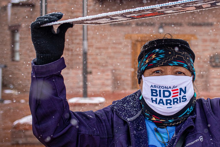


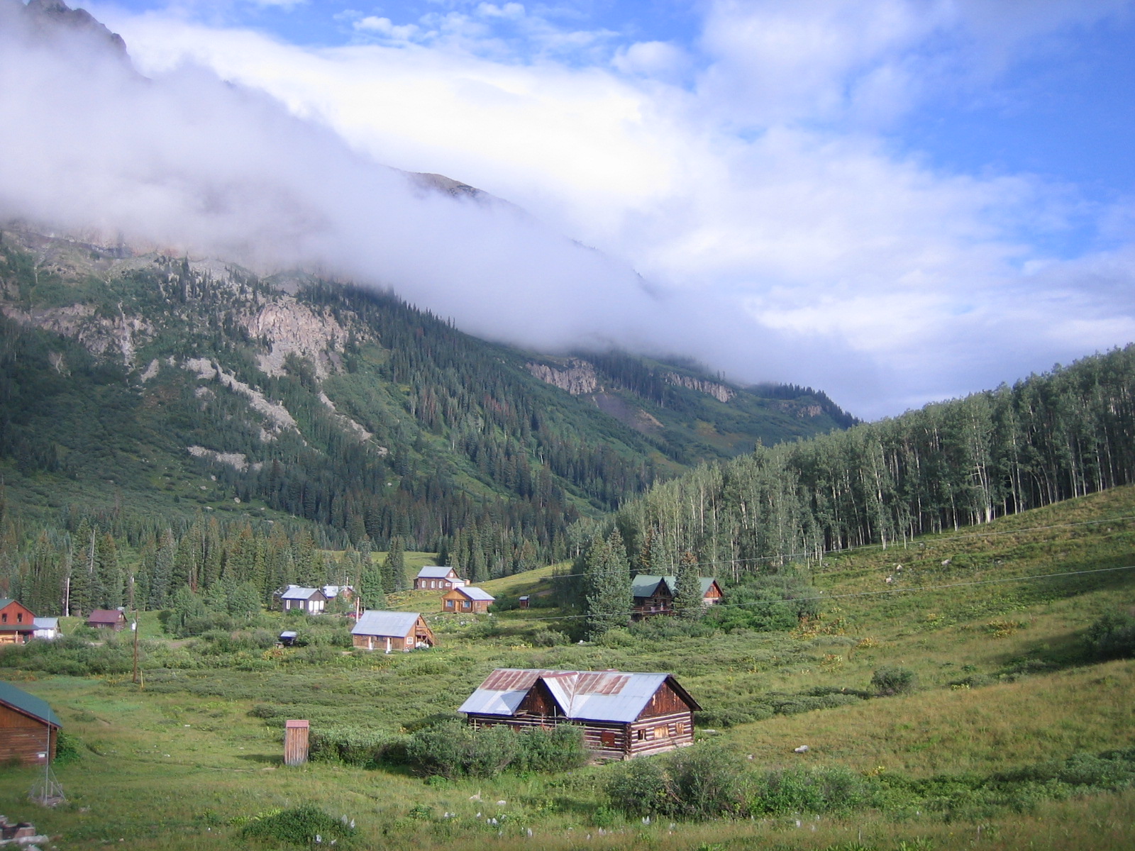


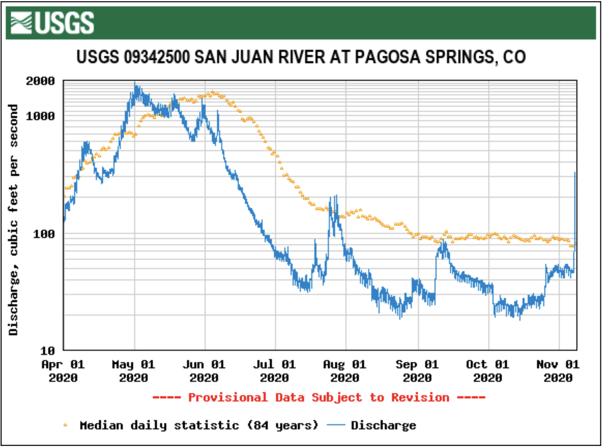
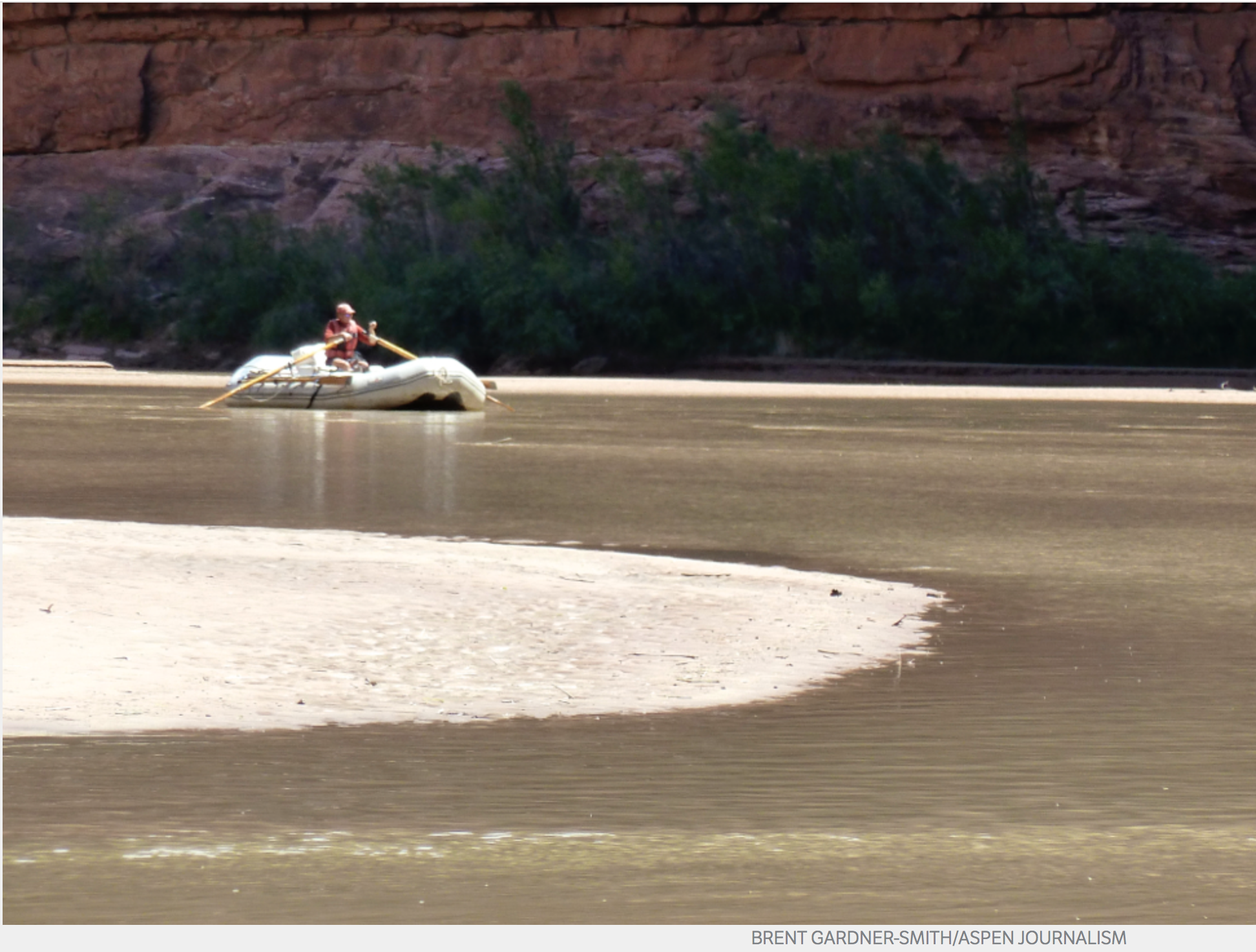

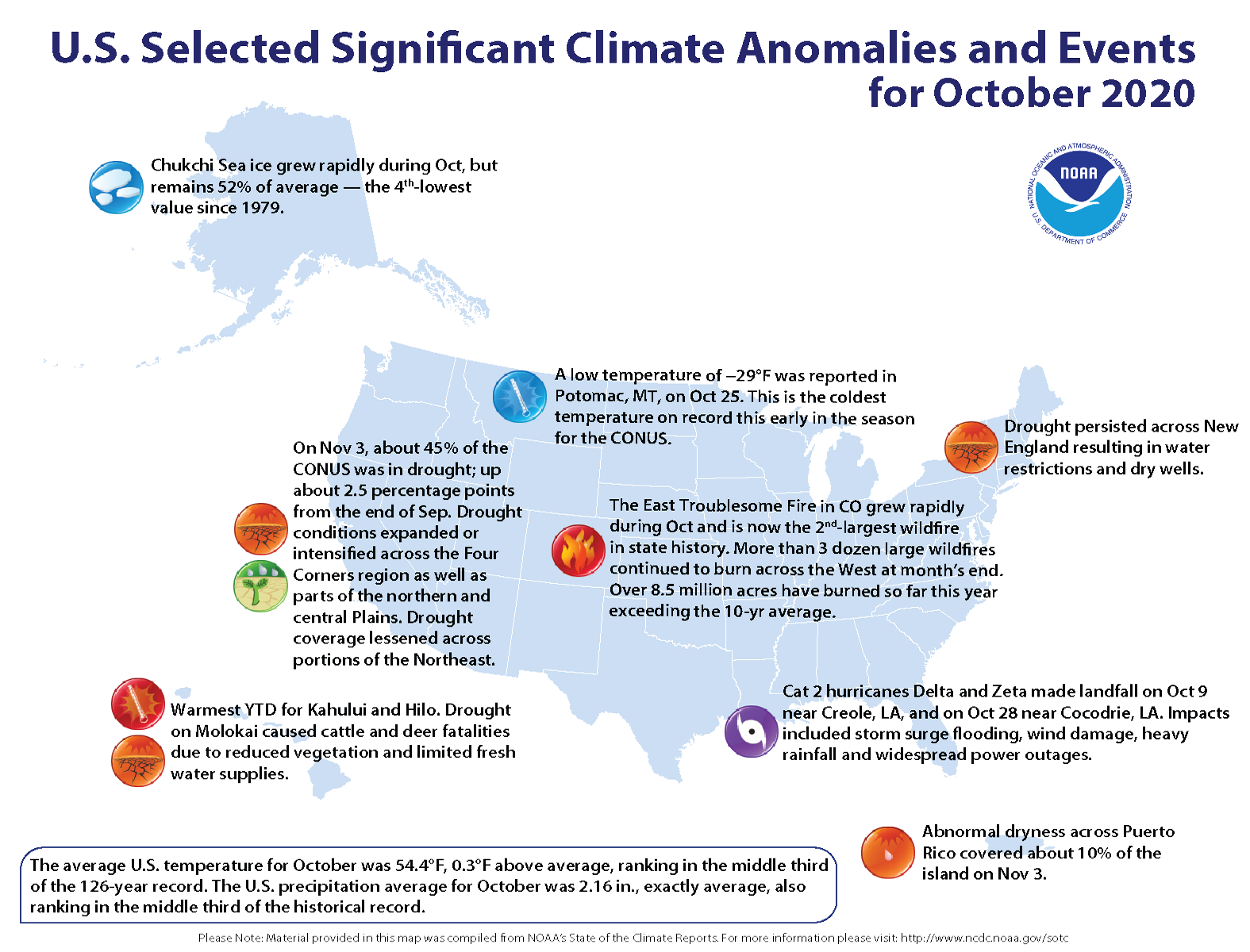
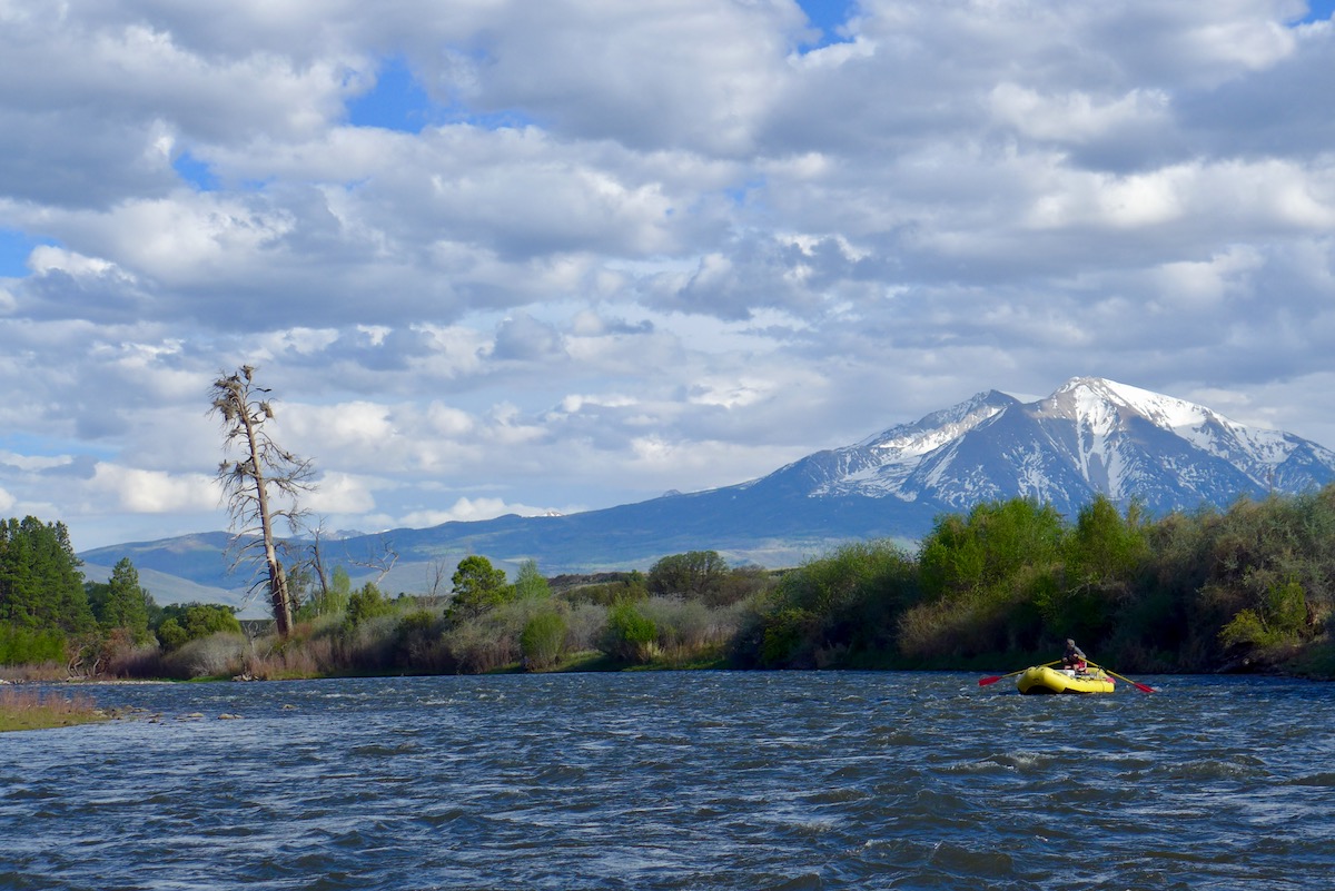


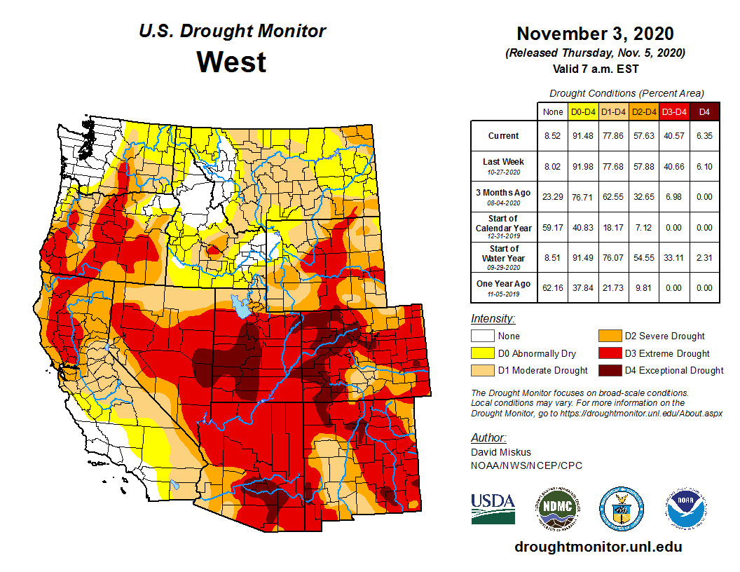

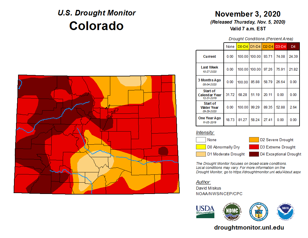


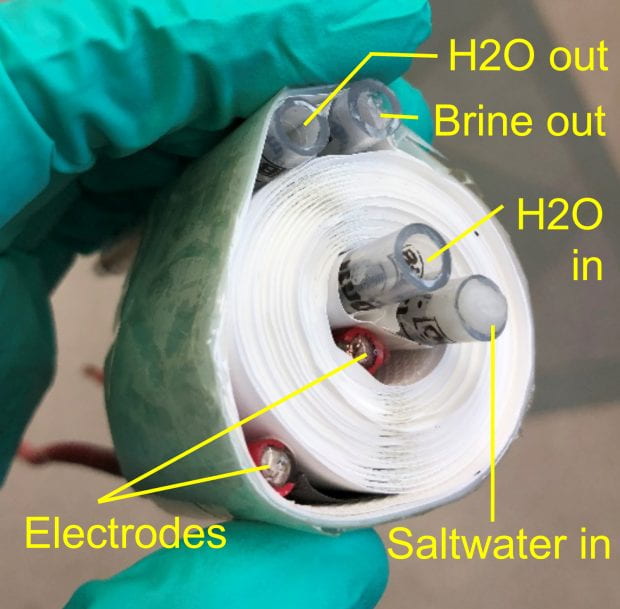
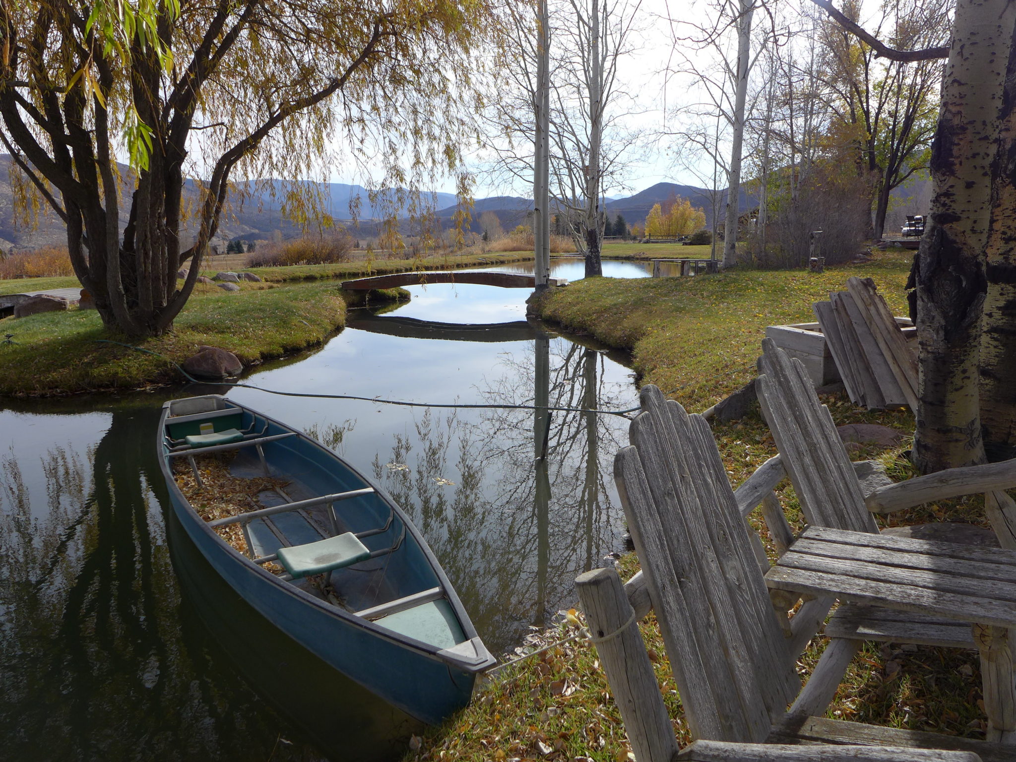
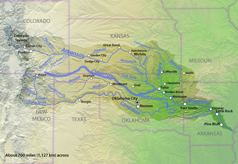
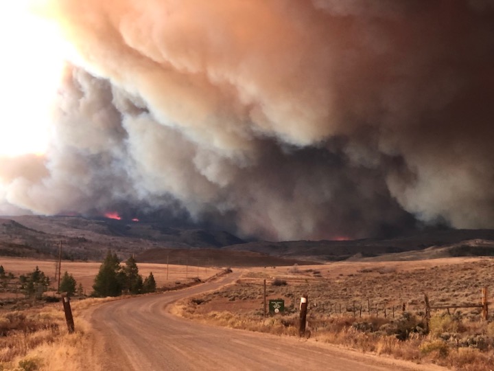
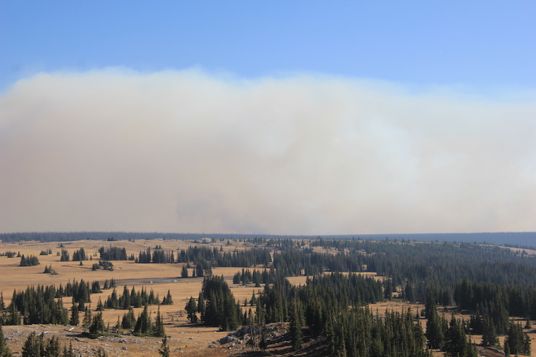
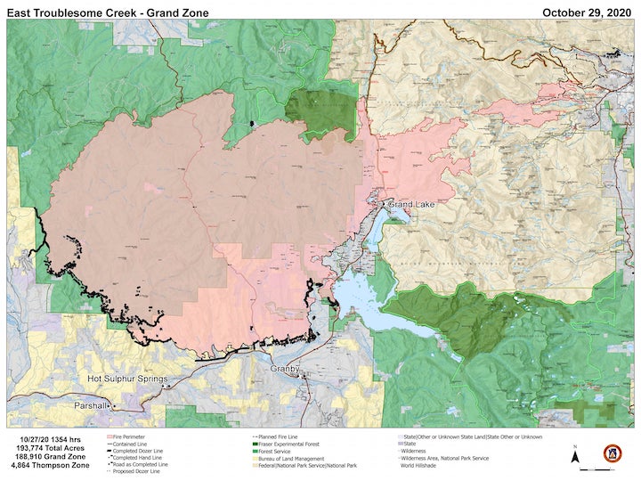


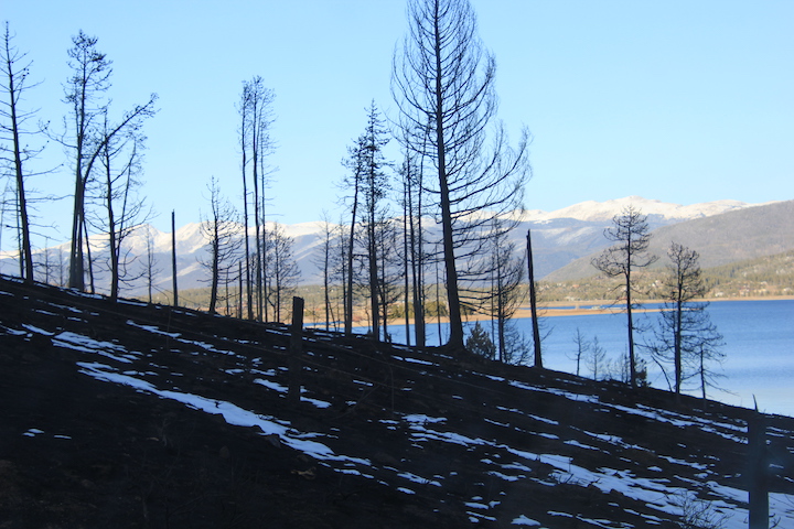
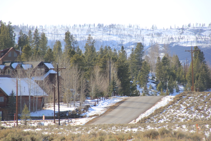
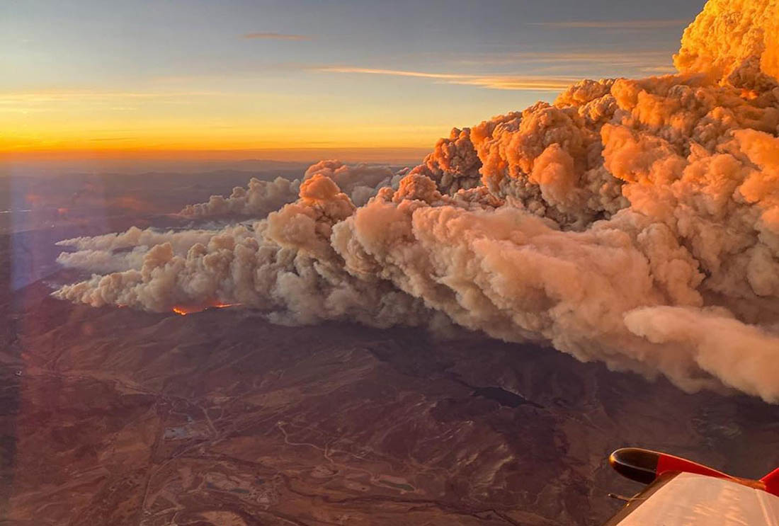

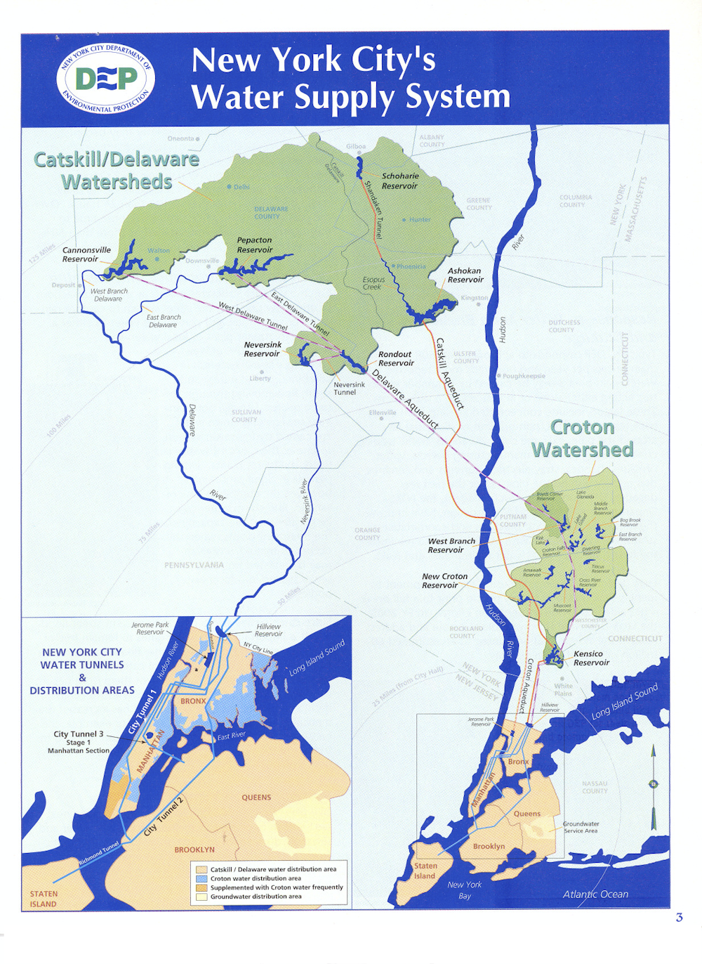

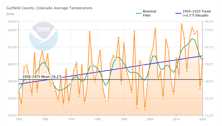
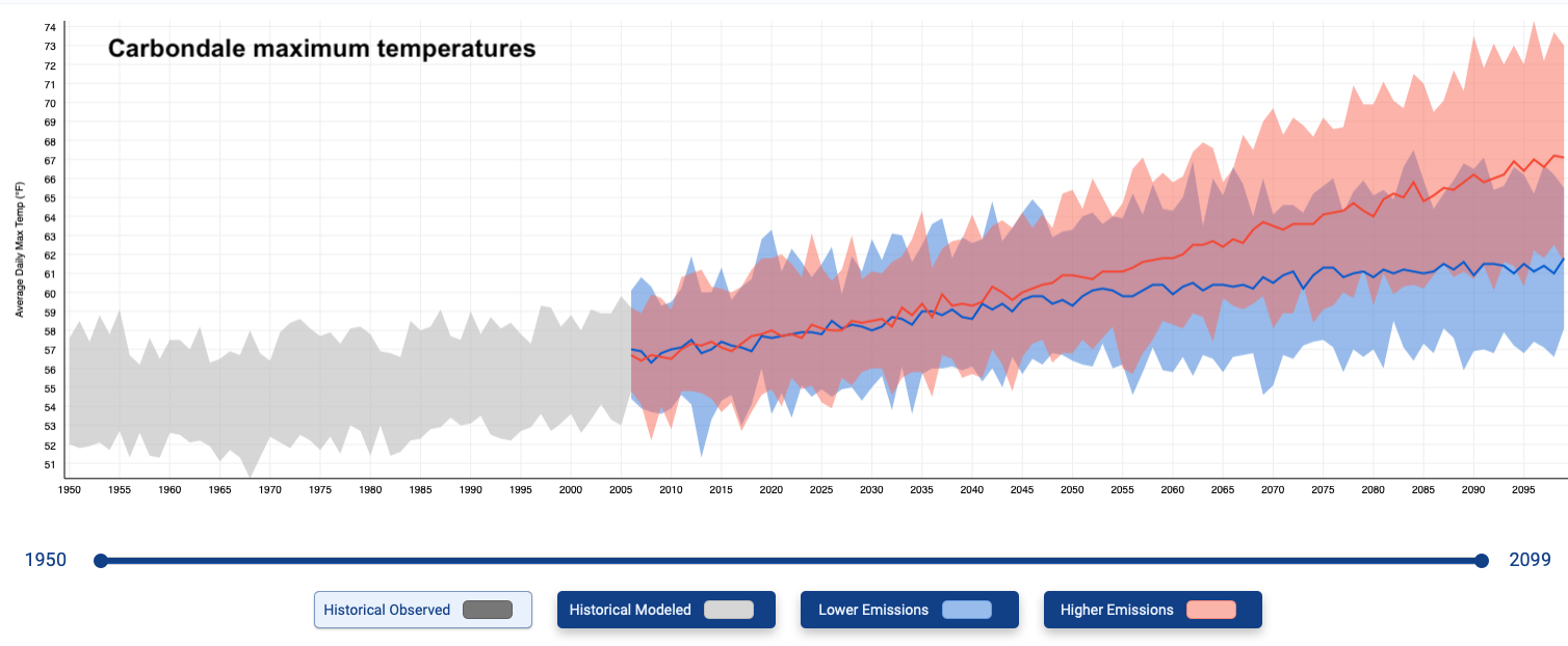


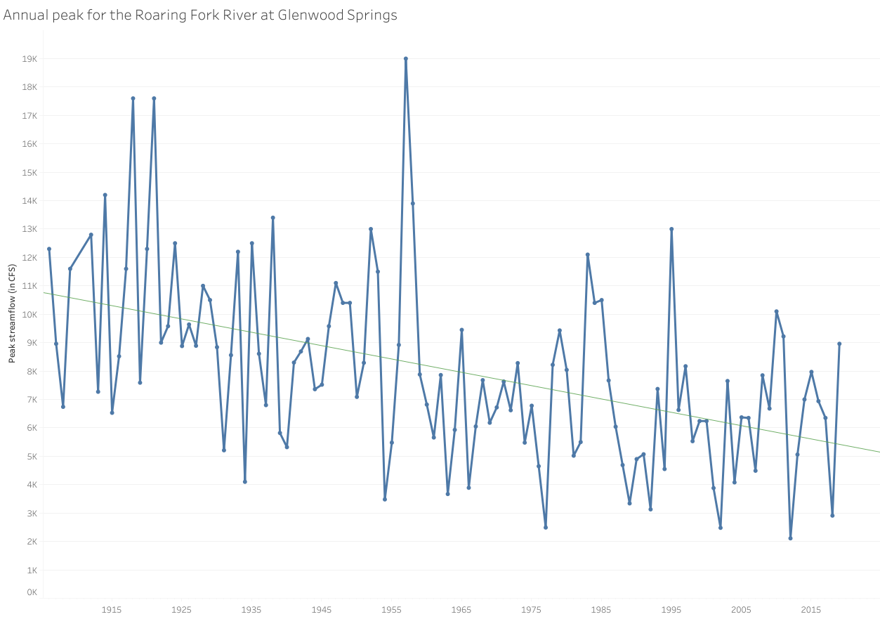

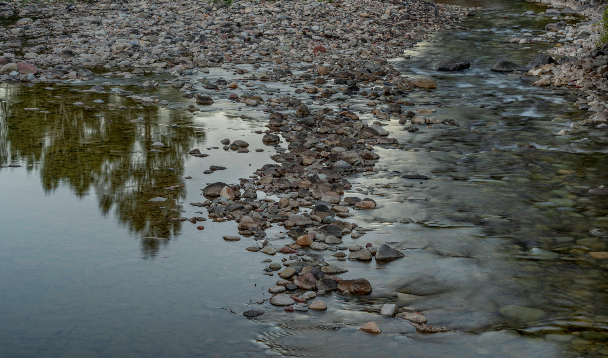


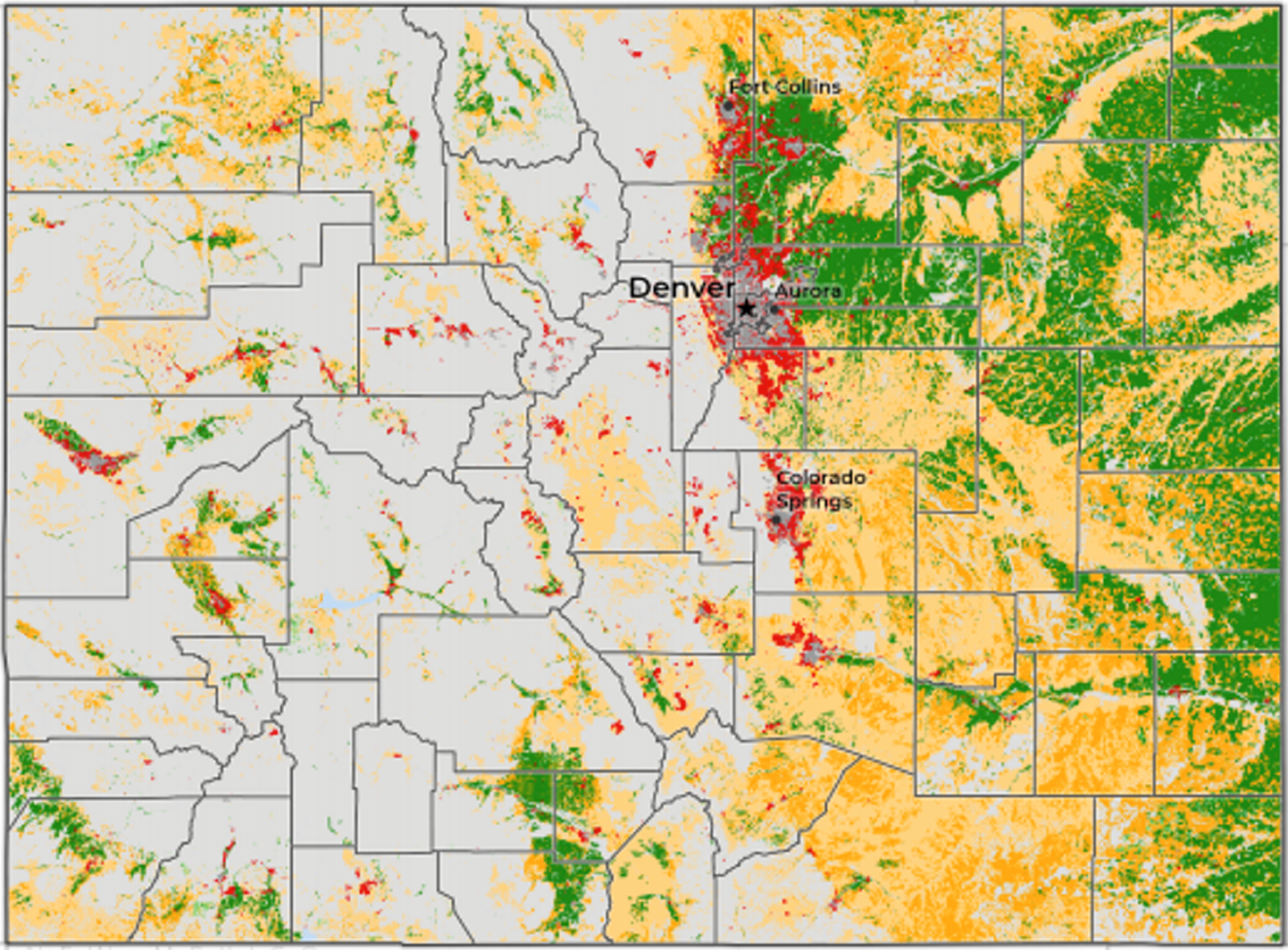


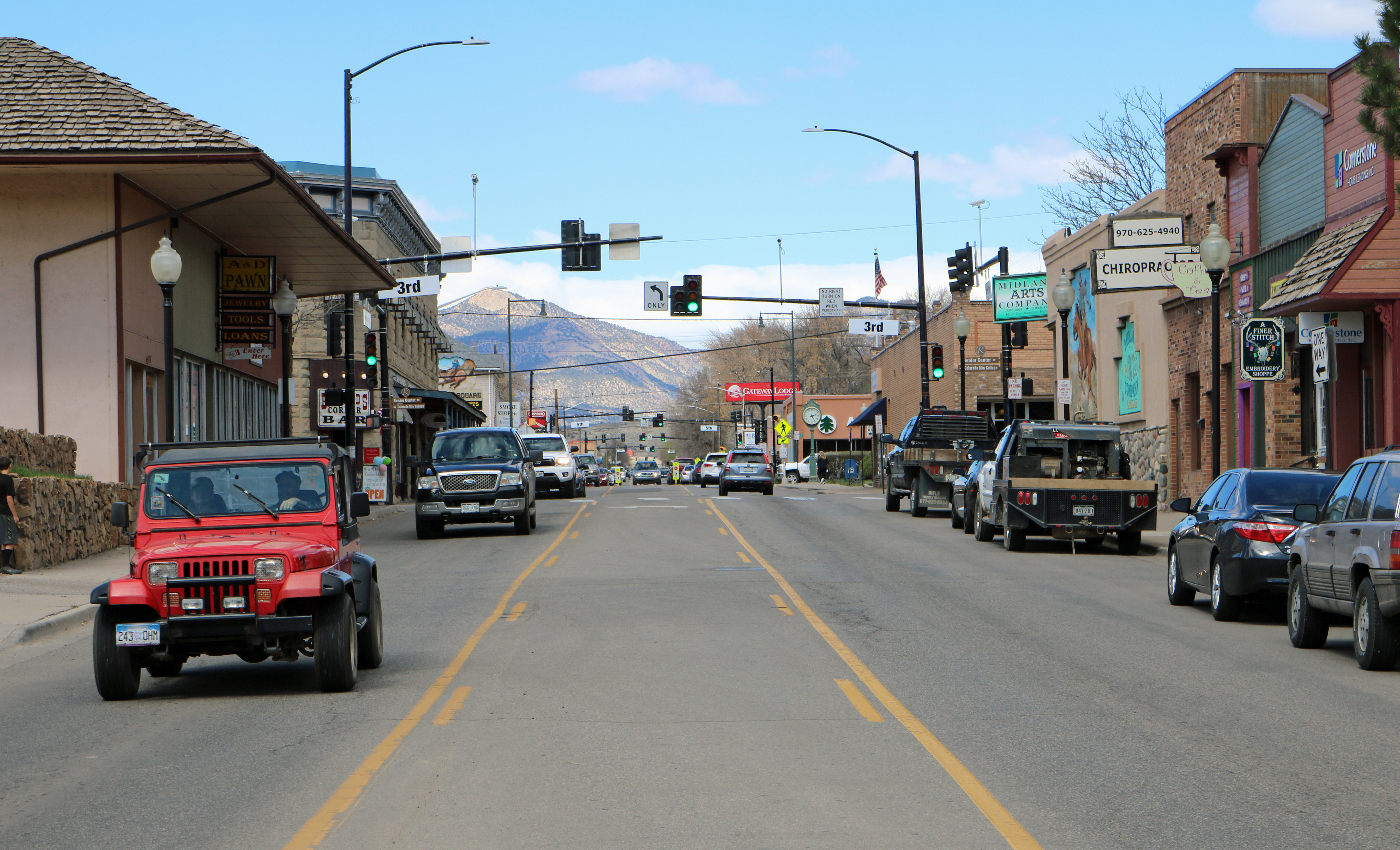
![Caption: Imperial Valley, Salton Sea, CA / ModelRelease: N/A / PropertyRelease: N/A (Newscom TagID: ndxphotos113984) [Photo via Newscom]](https://i0.wp.com/coyotegulch.blog/wp-content/uploads/2016/06/imperialvalleyfieldssaltonseawikipedia.jpg?w=591&h=443&ssl=1 "Imperialvalleyfieldssaltonseawikipedia")


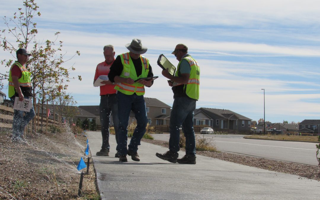


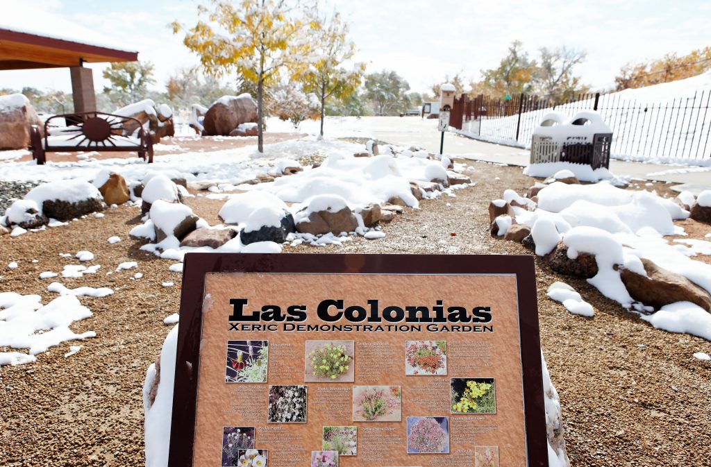


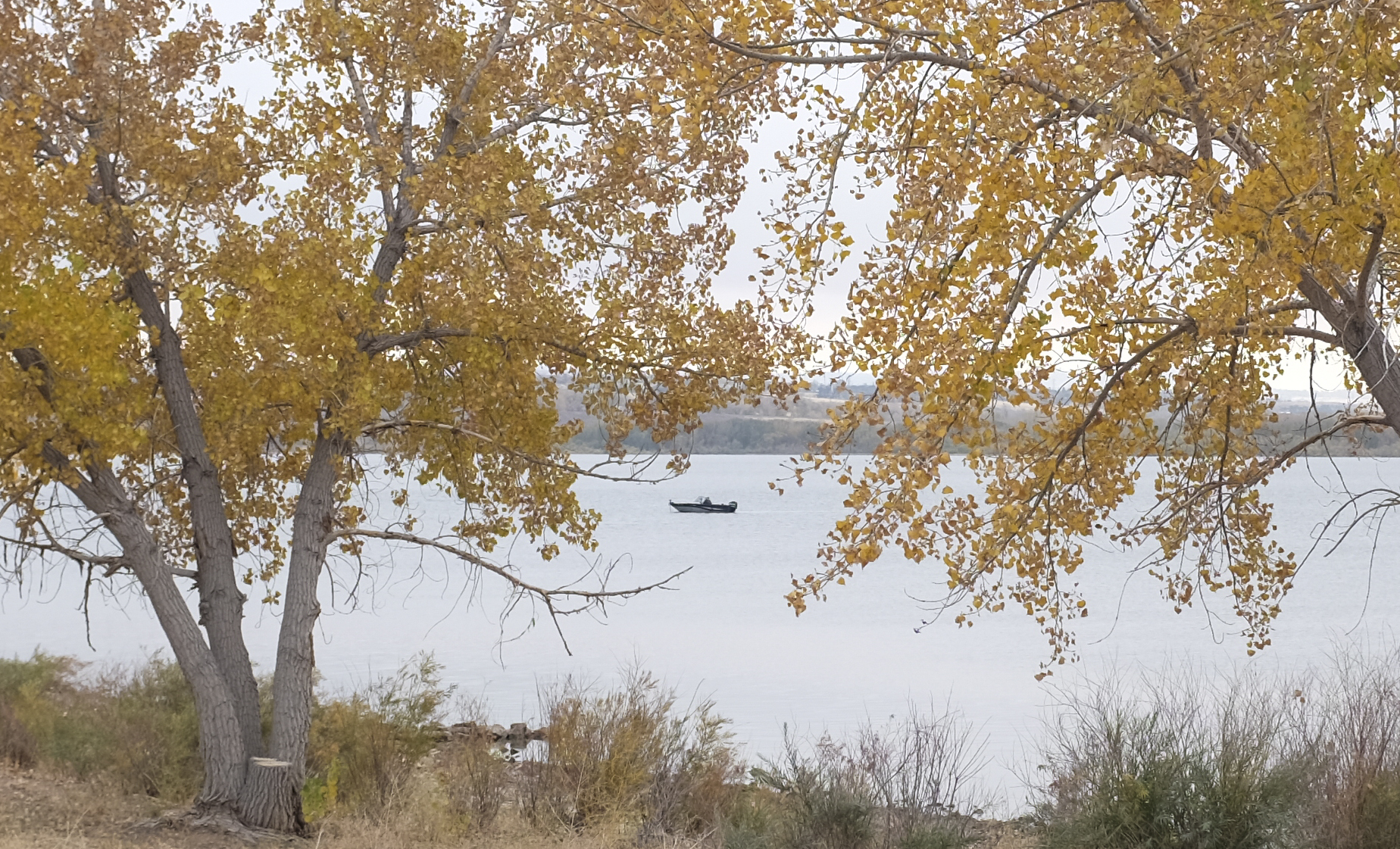

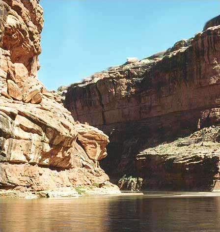

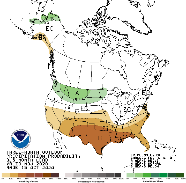


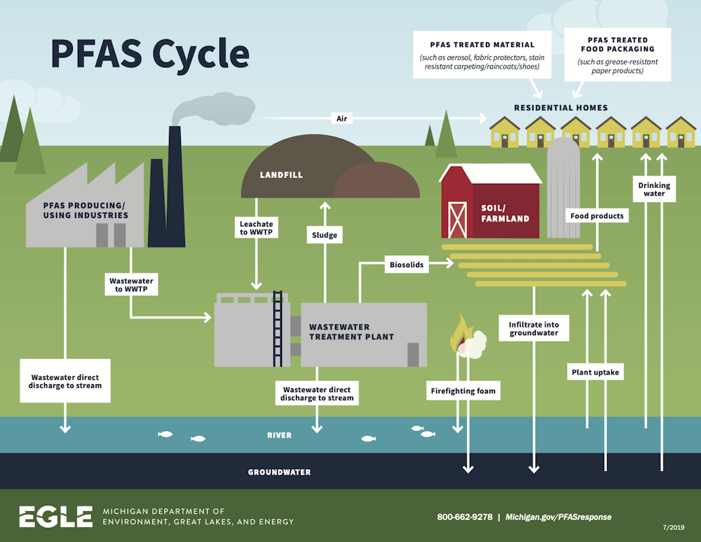


