FromThe Grand Junction Daily Sentinel (Dennis Webb):
In the world of surface water supply measurement and management, what’s known as the 2020 water year just came to an end, on Sept 30. And people in places like Colorado can only hope that when it comes to precipitation, water year 2021 has better things in store.
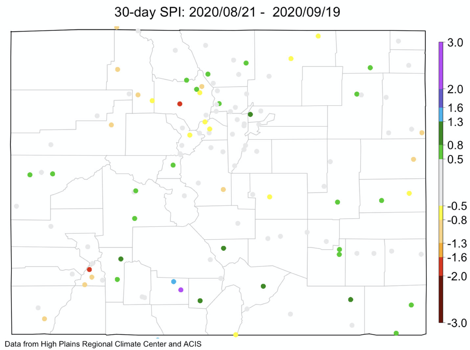
As of the weekly U.S. Drought Monitor update issued Thursday, more than 99% of Colorado was in some level of drought, and most of the Western Slope was in at least extreme drought. Worse yet, nearly 17 percent of the state — mostly on the Western Slope and including eastern and southern Mesa County and large parts of nearby counties — is now in exceptional drought, the worst drought category the Drought Monitor uses.
“What we’re seeing across the entirety of the Intermountain West following this brutal hot, dry summer is basically moderate drought to extreme drought,” Peter Goble, a climatologist with the Colorado Climate Center at Colorado State University, said in a webinar update on the drought situation Tuesday.
While there are pockets of exceptions, “things are certainly pointing dry for the most part,” Goble said.
Precipitation during the 2020 water year in most of the Upper Colorado River Basin was below 70% of normal, said Zach Schwalbe, a research associate at the Colorado Climate Center.
Insufficient snowpack in many areas was followed by a summer where monsoonal rains largely failed to arrive. Cumulative flows on the Colorado River near the Colorado/Utah line for the water year came in just under 3 million acre-feet, compared to more than 4 million in an average year.
Blue Mesa Reservoir, which managed to fill last year following a dry 2018, is now down to 71% of the 1981-2018 average for this time of year. Lake Powell and Lake Mead, the two largest reservoirs on the Colorado River storage system, are at 66 and 59% of average, respectively. Upper Colorado River Basin states rely on water in Lake Powell to meet water delivery obligations to downstream states and Mexico.
Some reservoir levels, such as at Lake Granby in the Colorado River’s headwaters, are doing better. Goble said local conditions can vary when it comes to reservoir storage…
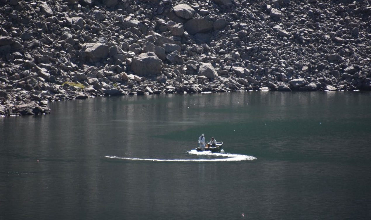
Streamflows also are suffering from the drought. Schwalbe said the Animas River was flowing through Durango Tuesday at a record-low level for that date.
Warmer-than-normal temperatures this summer have aggravated the impacts of below-average precipitation. Combined with other factors such as winds, the heat has driven up evaporative demand, which means how quickly plants and trees use water. Soil moisture conditions are also much drier than normal across much of Colorado, Goble said.
He noted that among other things, the drought conditions contributed to a disastrous fire season in Colorado that has included respectively the first- and third-largest wildfires in the state’s history, the Pine Gulch Fire north of Grand Junction and the Cameron Peak Fire west of Fort Collins.
Treste Huse, a hydrologist with the National Weather Service, noted in Tuesday’s webinar that possible precipitation is in the forecast in Colorado for this weekend, along with cooler weather that could result in snow in the mountains and some high mountain valleys. But she said that unfortunately drier- and warmer-than-normal conditions are expected in the eight- to 14-day outlook in Colorado. The outlook for the next month as a whole also shows above-average chances for above-normal temperatures and below-normal precipitation…
Goble noted that La Niña climate conditions also are developing and are generally associated with a dry fall in Colorado. Once winter arrives, La Niña conditions can be favorable when it comes to snowfall in the northern Rockies in Colorado and parts of Utah, and Wyoming, but a La Niña is “certainly not good news, fall or winter, for the southern portion of the Intermountain West,” he said.
Here’s the release from Utah State University (Lynnette Harris):
A team of scientists at Utah State University has developed a new tool to forecast drought and water flow in the Colorado River several years in advance. Although the river’s headwaters are in landlocked Wyoming and Colorado, water levels are linked to sea surface temperatures in parts of the Pacific and Atlantic oceans and the water’s long-term ocean memory. The group’s paper, “Colorado River water supply is predictable on multi-year timescales owing to long-term ocean memory” was published October 9 by Communications Earth and Environment, an open-access journal from Nature Research.
Researchers whose work on a tool a to predict Colorado River flows appears in Communications Earth and Environment, from left to right are climate scientists Simon Wang, Robert Gillies and Yoshi Chikamoto, agroclimate Extension specialist Matt Yost, and fire ecologist Larissa Yocom. Photo credit: Utah State University
The Colorado River is the most important water resource in the semi-arid western United States and faces growing demand from users in California, Arizona, New Mexico, Colorado and Utah. Because water shortages in the Colorado River impact energy production, food and drinking water security, forestry and tourism, tools to predict drought and low water levels could inform management decisions that affect millions of people.
Because water shortages in the Colorado River impact energy production, food and drinking water security, forestry and tourism, tools to predict drought and low water levels could inform management decisions that affect millions of people. Photo credit: Utah State University
Current drought forecasts focus on short-term indicators which limits their usefulness because short-term weather phenomena have too great an influence on the models.
“This new approach is robust and means that water managers, for the first time, have a tool to better estimate water supply in the Colorado River for the future,” Robert Gillies, professor in USU’s Department of Plants, Soils and Climate (PSC) and director of the Utah Climate Center, said. “The model can be run iteratively so every year a new forecast for the next three years can be created.”
In addition to ocean memory, water flows are impacted by land systems—including soils, groundwater, vegetation, and perennial snowpack—which play important roles in tempering the effects of short-term precipitation events. The researchers hypothesized that multi-year predictions could be achieved by using long-term ocean memory and associated atmospheric effects and the filtering effects of land systems.
The study’s lead author, Yoshimitsu Chikamoto, assistant professor of earth systems modeling in USU’s PSC department, said the components of the complex climate model include simulations of clouds and aerosols in the atmosphere, land surface characteristics, ocean currents and mixing and sea surface heat and water exchange.
“These predictions can provide a more long-term perspective,” Chikamoto said. “So if we know we have a water shortage prediction we need to work with policymakers on allocating those water resources.”
Simon Wang, USU professor of climate dynamics, said water managers and forecasters are familiar with El Niño and La Niña and the ocean’s connections to weather in the southwestern U.S. However, the upper basin of the Colorado River is not in the southwest and forecasts have not connected the dynamics of parts of the oceans with the Colorado River as the new forecasting tool does.
Matt Yost, PSC assistant professor and USU Extension agroclimate specialist, said having a two-year lead-time on preparing for drought could have a huge impact on farmers as they plan crop rotations and make other business decisions.
Co-author Larissa Yocom, assistant professor of fire ecology in USU’s Department of Wildland Resources, said a tool that can provide a long-term forecast of drought in areas impacted by the Colorado River could give managers a jump-start in preparing for wildland fire seasons.
Wang said Utah Climate Center researchers have developed models of drought cycles in the region and have recently studied the dynamics of river flows and shrinking water levels in the Great Salt Lake.
“In doing that work, we know that water managers don’t have tools to forecast Colorado River flows very long into the future and that is a constraint on what they can do,” Wang said. “We have built statistical models in the past, and Yoshi (Chikamoto) has expertise and in-depth knowledge of ocean dynamics so we talked about giving this idea a try because we found nothing in the literature to model these dynamics in the upper basin.”
“Using our tool we can develop an operational forecast of the Colorado River’s water supply,” Chikamoto added.
Improving the performance of water systems in western basins such as the Colorado River can entail a variety of expensive changes to infrastructure, policy, and management. Throughout much of the 20th century water development era, federal appropriations were sufficient to cover major investments. Today however, other sources of governmental and non-governmental funds and funding mechanisms are essential to improving water management and system performance. Determining the “how” and “who” of water financing raises several thorny questions about what approaches are most efficient, practicable, and equitable. In this webinar series, we will explore issues such as the rise of creative funding mechanisms, the role of private investments and water markets, leveraging the resources of the business community, and the linkages between healthy landscapes, climate adaptation, and improved water management resiliency.
Community members can now share comments about Denver Water’s Gross Reservoir expansion project proposal, which is being reviewed by Boulder County.
Although a postcard sent to property owners near Gross Reservoir said public comment about the proposed expansion project should be in by Oct. 14, county staff clarified that community members can comment at any point until the Boulder County Board of Commissioners makes a final decision.
The current Oct. 14 deadline is for referral agencies and even that may be pushed if enough agencies request an extension. If an extension is granted, a new postcard will be sent to property owners, according to Boulder County.
While Boulder County spokesman Richard Hackett said it’s helpful to have community comments in early, he stressed there is no official deadline or cutoff. Some adjacent property owners, such as Timberline Fire Protection District, also are referral agencies on the project, which Hackett said is part of the explanation for the postcard’s wording.
No public meetings or hearings have been scheduled yet, but the county will announce them to its Gross Reservoir Expansion Project news list. People who want to receive emailed or text messaged notifications can sign up at here.
Meanwhile, community members can submit questions or written comments to grossreservoir@bouldercounty.org.
Gross Reservoir — The Gross Reservoir Expansion Project will raise the height of the existing dam by 131 feet, which will allow the capacity of the reservoir, pictured, to increase by 77,000 acre-feet. The additional water storage will help prevent future shortfalls during droughts and helps offset an imbalance in Denver Water’s collection system. With this project, Denver Water will provide water to current and future customers while providing environmental benefits to Colorado’s rivers and streams. Photo credit: Denver Water
All week, the Animas River has recorded record lows at a gauge station in Durango, which has been tracking flows on the river for 107 years.
On Thursday, for instance, the Animas River was reportedly running at 117 cubic feet per second – under the previous record low of 138 cfs in 1957 and far below the average of 447 cfs for this time of year.
The low flows on the Animas River come as no surprise as the region has been gripped by a prolonged drought.
Since January, a weather station at Durango-La Plata County Airport has recorded just 5 inches or so of precipitation, a 7-inch departure from historic averages at the site.
On Thursday, the U.S. Drought Monitor released a report that showed all of La Plata County engulfed in the “extreme” and “exceptional” drought categories, the center’s highest listings for dryness in a region.
West Drought Monitor October 6, 2020.
And, several weather stations in the headwaters of the Animas River recorded the lowest precipitation levels in August and September based on about 40 years of record keeping.
“The combination of an extremely dry spring, lack of a monsoon and above-average summer and fall temperatures has resulted in very low flows on the Animas River,” said Ashley Nielson, a senior hydrologist with the Colorado Basin River Forecast Center…
Becky Bollinger, a research associate with the Colorado Climate Center, said 2020’s water year was the third-driest on record, behind only the infamous drought years of 2002 and 2018…
The high country of the San Juan Mountains received about normal snowpack this winter, but it melted fast and early. On top of that, soils were so dry they absorbed more water than usual.
San Miguel, Dolores, Animas, and San Juan Basin High/Low graph May 14, 2020 via the NRCS.
One issue that concerns Bollinger is that the atmosphere is so dry, it is causing rapid evaporation of what little moisture there is – called evaporative demand…
Bollinger wonders whether a lack of monsoons in Colorado is the new normal.
“This is the fourth year in a row we have not gotten the benefits of monsoon moisture,” she said. “It’s concerning to think that might be a trend. Or is it just really bad luck? I don’t know the answer to that right now.”
[…]
As of this week, Vallecito and Lemon reservoirs were at about 24% and 27% capacity. Ken Beck, superintendent of the Pine River Irrigation District, said in an email to constituents that outflows were reduced to 5 cfs on Thursday…
The main concern for water managers is whether the upcoming winter will bring enough snowpack to replenish reservoirs. In previous drought years, such as 2018, the next winter brought heavy snowfall.
But meteorologists say the region may be stuck in a La Niña cycle, which typically means less snow for Southwest Colorado. That could result in less water for livestock and municipalities, and spell disaster for next year’s wildfire season.
Click on a thumbnail graphic to view a gallery of drought data from the US Drought Monitor.
US Drought Monitor October 6, 2020.
West Drought Monitor October 6, 2020.
Colorado Drought Monitor October 6, 2020.
Click here to go to the US Drought Monitor website. Here’s an excerpt:
This Week’s Drought Summary
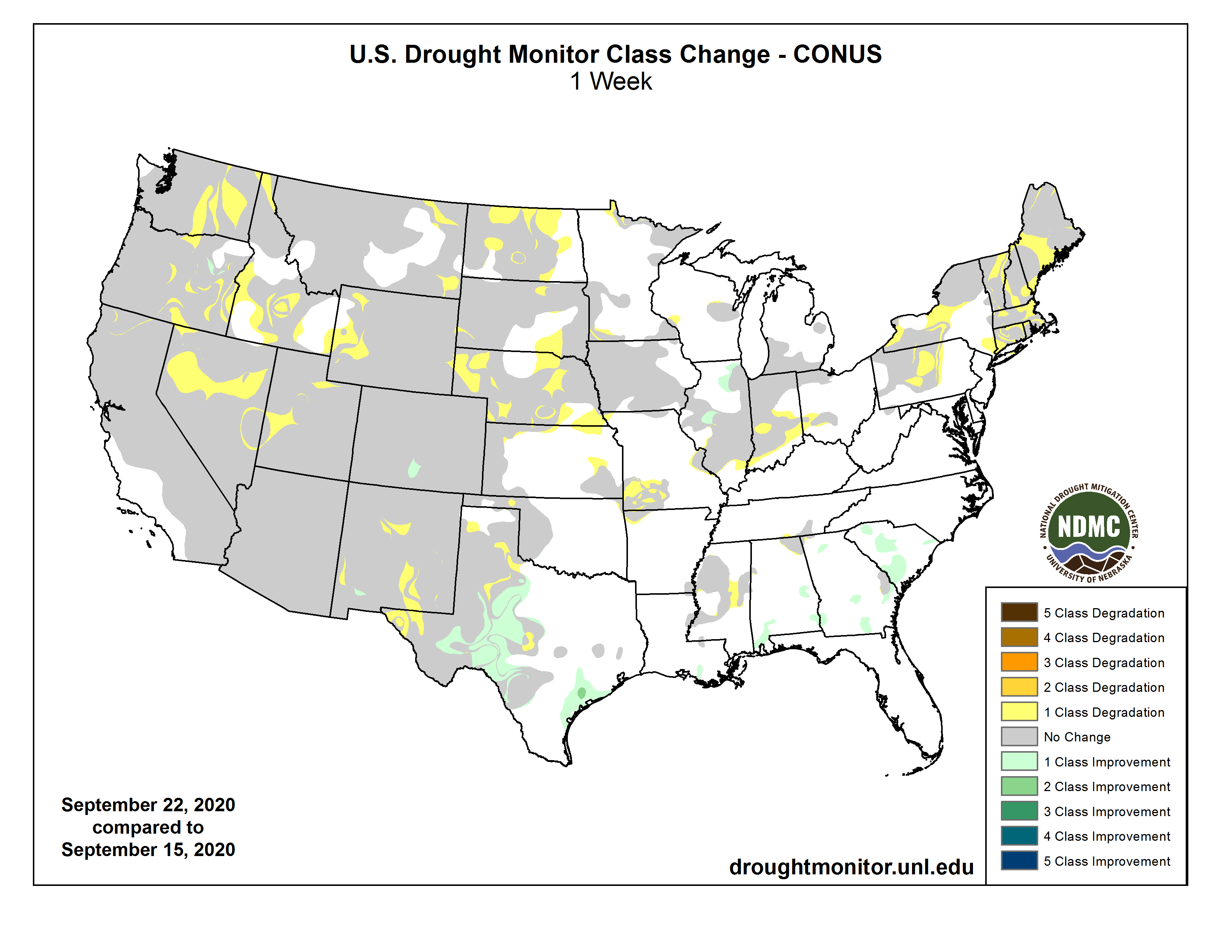
Temperatures for the week were below normal over much of the Plains, Midwest, South, Southeast and Mid-Atlantic, with departures of 5-10 degrees below normal for many locations. The West continued to be warm with temperatures near normal to slightly above through the Rocky Mountains and 5-10 degrees above normal over the West Coast. Temperatures in New England were also slightly above normal, with the greatest departures in Maine. Below-normal precipitation dominated almost the entire country. Precipitation amounts were greatest over the eastern seaboard, with the Northeast recording the most rain. Almost no precipitation was recorded in the western two-thirds of the country. In the next several days, eyes will be on Hurricane Delta and where it will make landfall along the Gulf Coast. Current projections are taking the storm ashore in Louisiana…
Cooler than normal temperatures dominated the eastern half of the region with departures of up to 6-8 degrees below normal while the western half was warmer than normal with departures of 4-6 degrees above normal. Precipitation was almost none existent in the region for the week, with only a few areas of light showers in portions of South Dakota and Nebraska. Moderate drought and abnormally dry conditions were expanded in portions of eastern North Dakota. In eastern, southwest and central Nebraska, severe drought expanded along with some expansion of moderate drought. Moderate, severe, and extreme drought also expanded in western Nebraska as the entire state continues to dry out. In South Dakota, moderate drought was expanded in the northwest while severe drought was expanded in the southeast. A new area of extreme drought was also introduced in southeast South Dakota. Extreme drought was introduced in far southwest South Dakota while moderate drought also expanded to the east. In northeast Wyoming, moderate drought expanded while severe drought expanded slightly in the southeast. Eastern Colorado had a large expansion of extreme drought conditions while severe drought expanded in the northeast…
Hot and dry continues to be the theme of the region and also the monsoon season that was minimal at best, all of which is providing the conduit for continued deterioration in the region. Over the last 6 months, Arizona and California have had their warmest April–September period ever in 126 years, with New Mexico and Nevada the 2nd warmest. During that same 6-month period, Utah and Arizona have also had their driest period ever, with New Mexico having their 2nd and Colorado their 3rd driest. In Arizona, the new established record for statewide precipitation was greater than 2 inches drier than the previous record. During the current week, temperatures were warmest along the coast, where departures were 5-10 degrees above normal for the week. Drought intensified and expanded over southeast Montana and into northwest Wyoming where moderate, severe, and extreme drought all increased in coverage. A new area of moderate drought was introduced in southwest Wyoming and into southeast Idaho. Western Colorado and eastern Utah had large expansions of exceptional drought, and this also went into northwest New Mexico. Extreme drought also expanded over north central Colorado. Western and northern New Mexico as well as northeast Arizona had severe and extreme drought expand while a new area of extreme drought was introduced in eastern portions of New Mexico. In southern Arizona, extreme and exceptional drought also expanded in coverage. In Idaho, abnormally dry conditions and moderate drought expanded over the southeast and southwest portions of the state as well as into southeast Oregon. Central and northeast Oregon also had expansion of severe and extreme drought this week…
Although most of the region received no precipitation during the week, cooler temperatures helped to reduce the amount of drought expansion this week as temperatures were generally 3-6 degrees below normal. Abnormally dry conditions and moderate drought were expanded over northern Oklahoma this week while extreme drought expanded over the southwest portions of the state. Abnormally dry conditions expanded over portions of southern Louisiana and eastern Mississippi while moderate drought and abnormally dry conditions expanded over northwest Arkansas. Texas continued to see conditions deteriorate over the panhandle and areas of the south Texas Plains and into the Hill Country.
US Drought Monitor one week change map ending October 6, 2020.
Golfers take shots on the green lawns of the City Park Golf Course in central Denver on Sept. 28 2020. Urban utilities this summer saw sharp increases in single-family home and outdoor water use, primarily due to drought. Photo credit: Lindsay Fendt/Aspen Journalism
The COVID-19 pandemic has dominated much of life and the economy in 2020, but when it comes to water use along the Front Range, drought is still the ruling force.
Most municipal water providers saw commercial water use plummet at the beginning of the pandemic, but those savings were quickly erased once the hot summer rolled in and the region’s residents switched on their sprinklers.
“The increase in residential and irrigation use have more than offset the decrease in commercial use, resulting in above normal water use across the service area,” said Todd Hartman with Denver Water. “The short story from our perspective is that we are seeing higher use this watering season because of very hot, dry conditions.”
The entire state of Colorado has been under some level of drought since early August, meaning that grass, shrubs and trees need more water than normal. To make up for that increased demand, Front Range communities have to rely more on the Western Slope water contained in their reservoirs.
In a typical year about 48% of Denver’s water comes from the Western Slope, while Colorado Springs pipes in about 75% of its water from the other side of the divide. Fort Collins typically gets more than half of its water from the Western Slope and Aurora Water gets 25% of its water from sources within the Colorado River basin.
Even though most of western Colorado is now in an extreme drought, Front Range water providers are able to rely on their storage from previous years to provide that additional water and then refill the reservoirs during the next snowmelt season.
Northern Water manages the Colorado Big-Thompson project, which pumps water from west of the Continental Divide to municipal and agricultural users along the northern Front Range. During a drought, the water district’s board generally increases the amount of water per share of the project that it doles out, known as a quota, allowing more water to be drawn from its reservoirs and increasing the amount of water delivered to shareholders. In a typical year, the project delivers about 217,000 acre-feet of water to its users. This year, to make up for drought, the board gave users an additional 31,000 acre-feet of water.
“The more water that’s available on the Front Range, like through soil moisture and local storage, the lower the quota we set because the rest of the demand can be furnished by local sources,” said Jeff Stahla with Northern Water. “The drier it is then the higher the quota, because we’re supplementing.”
Dillon Reservoir in late August 2020. The reservoir is the largest in Denver Water’s collection system, which delivers water to 1.5 million people. With drought leading to increased water use this year through August, Front Range water providers have had to rely more on water stored in reservoirs. Photo credit: Lindsay Fendt/Aspen Journalism
Outdoor watering dominates
The data from the year so far show just how overwhelming a factor outdoor water use is on overall water-use trends. Even in a pandemic, the watering needs of yards on the Front Range during drought seem to supersede any other behavior changes. In a typical year, 40% of urban water use on the Front Range is for outdoor use. That number often increases during a drought.
Preliminary consumption numbers for the year through August show single-family use up in Denver by about 20% and multi-family use up 5%. Industrial use is down 5%, office buildings are down 9% and restaurants — which remain under limited operations due to the pandemic — are down a whopping 31%. Altogether, Denver Water saw a 12% increase in water use system wide this year, through August. The increase in single-family use began in May when many home irrigation systems were likely first turned on. Other Front Range cities saw similar trends.
Because the pandemic overlapped with a hot, dry summer, it’s been difficult for utilities to determine how much of an effect either event had on overall water use. The most revealing data comes from the spring when businesses closed and most people had yet to turn on their sprinklers.
At Aurora Water, the water conservation team started pulling data early in the pandemic to see if any trends emerged. Between March and April — right as the state transitioned to a stay-at-home order — Aurora saw a commercial water use drop of 14.3% accompanied with an 8.8% increase in residential water use and a 4.6% increase in multi-family use.
But according to Tim York, a water conservation specialist at Aurora Water, the modest increases in residential water use skyrocketed once irrigation season began. Commercial use also ticked back up once businesses began reopening. According to York, Aurora Water saw a 10.3% system-wide increase from January to July that they attribute almost entirely to drought conditions.
“Indoor use kind of is what it is, right? I mean, you’ve got to use the toilet as many times as you need to, you’ve got to do dishes when they’re dirty, you’re going to take your showers just like you normally would, but people react differently to weather,” York said.
A couple sits at the edge of the lake at City Park in central Denver on Sept. 28 2020. In a typical year, about 48 percent of Denver’s water comes from the Western Slope. Photo credit: Lindsay Fendt/Aspen Journalism
‘People are home and wanting to work on their yards’
Most utilities had an adequate amount of water storage going into the summer to make up for the increased water use. Denver, Colorado Springs and Aurora have maintained their normal summer watering restrictions, which include guidelines on when and how often to water outdoors.
On Oct. 1, Fort Collins went under mandatory level IV water restrictions in order to avoid a water shortage in the fall. In most cases residents are no longer allowed to water their lawns and cannot wash their cars. The restrictions are due partially to drought conditions and some planned maintenance on water infrastructure, but the city is also taking preemptive measures to conserve water in case the Cameron Peak Fire begins to affect the water quality in the Poudre River.
Though the drought has been the driving factor in water use this year, water managers say that the pandemic likely did have some effect on behavior and might even pay dividends down the line. Abbye Neel, a water conservation specialist in Fort Collins, says the city has seen a large increase in its Xeriscape Incentive Program. The program provides rebates and project support for Fort Collins residents to redesign their yards to be more water-efficient.
“I have nothing to back this up, but I think it’s just like people are home and wanting to work on their yards,” she said. “There’s a high potential to do more projects this year as people actually get their ducks in a row and sign up.”
This story initially ran online in the Sky-Hi News on Oct. 3 and in print in the Summit Daily News Oct. 4.
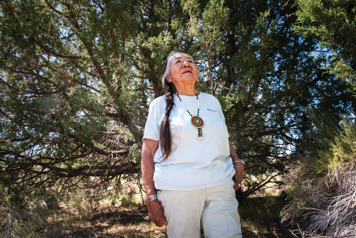
Water from an aquifer that lies below Colorado’s San Luis Valley flows through a center-pivot irrigation system, one of some 14,000 that draw water from below. Photo credit:Luna Anna Archey/High Country News
FromThe Grand Junction Daily Sentinel (Dennis Webb):
The Colorado Department of Natural Resources on Wednesday held the first meeting of the Anti-Speculation Law Work Group. The task force was established as a result of passage of a bill this year to consider ways to strengthen the current anti-speculation law and recommend any changes to a legislative committee by Aug. 15 [2021].
The bill was sponsored by state Reps. Dylan Roberts, D-Avon and Marc Catlin, R-Montrose, and Sens. Kerry Donovan, D-Vail, and Don Coram, R-Montrose. It was inspired by a growing number purchases of agricultural land and associated water rights by investment firms, including wide-scale purchases in the Grand Valley by Water Asset Management, which is based in New York.
Current state law prohibits water speculation by requiring water to be used for a beneficial purpose. An 18-member work group made up of state agency staff, water lawyers and others will be considering how the law might be tightened.
None of the bill sponsors participated in Wednesday’s meeting. But Scott Steinbrecher, an assistant deputy attorney general co-chairing the task force, said a clear purpose of the bill is to examine how the law should be strengthened to prevent situations where water rights are bought and leased back to farmers though the intent is to use the water like an investment.
Alex Funk, a task force member who is an agricultural water resource specialist with the Colorado Water Conservation Board, a state agency, voiced concern about approaches that might limit the value of assets to agricultural producers.
“There is certainly a tension here where land and water assets are extremely valuable to producers. In some cases these are sort of their only asset,” he said…Task force member Peter Fleming, general counsel for the Colorado River District, which has been watching some of the area water-related acquisitions by investment firms with concern, said agricultural producers looking to sell their assets are entitled to do that.
“I assume we don’t want to prevent that from happening,” he said.
He said what’s important under even the current law is the intent of the buyer of water rights. He said they can profit from the water’s use but their end goal in buying rights can’t be the pure value of the water, and he’s interested in looking at ways to determine intent.
Daris Jutten, a rancher in the Uncompahgre Valley, said his interest in serving on the task force is considering impacts on property rights.
“I want to keep the land value prices where they are but I also don’t want to see buy and dry,” he said.
He was referring to situations in which transactions result in water no longer being used to irrigate agricultural land and instead going for other uses such as by municipal utilities.
Task force member Joe Frank, general manager of the Lower South Platte Water Conservancy District, said the district sees entities buying up water there with the intent to dry up land in the future.
“In addition to that we do have those who want to sell, so water is a property right. … It’s a dilemma, but we don’t want to impact people’s property rights,” he said.
River system withdrawal 2020. Photo credit: Edvin Johansson via North Carolina State University
Here’s the release from North Carolina State University (Sankar Arumugam, Sudarshana Mukhopadhyay, Matt Shipman):
River systems are essential resources for everything from drinking water supply to power generation – but these systems are also hydrologically complex, and it is not always clear how water flow data from various monitoring points relates to any specific piece of infrastructure. Researchers from Cornell University and North Carolina State University have now developed a tool that draws from multiple databases to give water resource managers and infrastructure users the information they need to make informed decisions about water use on river networks.
“A streamgage tells you what the water level is at a specific point in the river – but that’s not really enough information,” says Sankar Arumugam, co-author of a paper on the work and a professor of civil engineering at NC State. “If you are an infrastructure operator, what you really need to know is how long it will take for that water-level information to be relevant to your infrastructure. How far away is the streamgage from your water intake along the river path, not just as the crow flies? How closely connected are those two things, hydrologically?”
“This information is important for managing water systems efficiently, for ensuring that infrastructure – such as power plants – are able to continue operating, and for protecting the infrastructure,” says Sudarshana Mukhopadhyay, first author of the paper and currently a postdoctoral researcher at Cornell University. “The information is particularly important during extreme conditions, such as flooding or drought.
“All of that data already exists, it’s just scattered across separate databases. We’ve developed an algorithm that efficiently pulls all of that information into one place and accounts for how the streamgages and the various infrastructure sites are hydrologically connected over a large watershed,” says Mukhopadhyay, who worked on the research as a Ph.D. student at NC State.
To demonstrate the tool’s utility, the researchers used the algorithm to create a connectivity network demonstrating the interconnectedness of about 1,400 reservoirs and 1,600 streamgages in the upper and lower Colorado River basins.
For this network, the algorithm used data from three sources: topographic information from the U.S. Geological Survey’s (USGS) National Hydrographic Dataset; streamgages from the USGS National Water Information System; and reservoir data from the National Inventory of Dams.
“This is a tool that can be used by power plant operators, reservoir operators, water resource managers – really it’s for anyone who draws water from the river system,” Mukhopadhyay says. “It can inform them about river conditions both upstream and downstream, and help them make decisions about where they should draw water from the system.”
The researchers have also made a template publicly available, allowing anyone to develop similar connectivity networks for other watersheds.
“It should be fairly easy for water resources professionals,” Mukhopadhyay says.
“We are currently working on a national version, which we think will help us better understand all of the ways that river basins connect infrastructures across the country,” Arumugam says.
The work was done with support from the National Science Foundation, under grants 1823111 and 1442909; and from the USGS Powell Center Working Group Project “A global synthesis of land-surface fluxes under natural and human-altered watersheds using the Budyko framework.”
Editors note: This is the first of a three-part series examining the proposal to renew the county 1041 permit for Nestlé Waters North America.
For two days later this month, Oct. 20 and 22, Chaffee County Commissioners will hear from citizens and organizations in public hearings on the proposal to renew a 1041 permit granted to international conglomerate Nestlé Waters North America. If approved, the permit would allow Nestlé to continue to pump and truck local spring water it later sells as bottled water.
The original permit, granted by then-commissioners in 2009 was a controversial decision and the renewal has also generated opposition from activists who want the county to end the agreement.
Basically, the company pumps millions of gallons of water from the Ruby Mountain Spring in the north county annually, pipes it to a collection tank and pump station at Johnson Village, where it is loaded onto tankers, driven to a Denver bottling plant, and sold as Arrowhead Spring Water in plastic bottles.
The original (and current) agreement allows Nestlé to withdraw as much as 65 million gallons of water from the aquifer. However, company officials say Nestlé draws less than half that amount currently.
The original permit granted to Nestlé in 2009 was opposed by many residents, and an organized resistance to renewing the agreement has recently been mounted.
Larry Lawrence, Resource Manager for Nestlé Waters North America spoke with Ark Valley Voice recently about the agreement, what it provided both the company and community, and how the company has met the 1041 permit requirements, which some opponents of renewal dispute.
An engineer by profession, Lawrence has been with Nestlé Waters since 2003, and came to Colorado in 2019. He says he was already aware of the project through technical reviews with earlier resource managers prior to joining this assignment.
Lawrence said an earlier resource manager (Bruce Lauerman) was assigned to this area, and Lawrence took over in 2019. Looking for a water source closer to Denver, he said was a priority.
“The Arrowhead brand was marketed in New Mexico, Colorado, Idaho and a portion of Montana, all from California,” said Lawrence. “In reviews of not only our physical footprint but our carbon footprint and other aspects, where would we want to locate another factory? So Denver was chosen because of the reach we would have from this factory and to cover this market, which was a pretty good size bottled water market,” he added.
The factory was built in 2006, producing Nestlé Pure Life, a purified water from the municipal water system in Denver. Nestlé soon realized they wanted to produce the Arrowhead spring water brand. The prior Nestlé representative reviewed area springs and contacted various water agencies to see if they knew of any potential spring sources.
The Hagen Fish Hatchery on the Arkansas River, no longer in operation, was identified by the Colorado Division of Water Resources. Nestlé reached out to the Hagen family and reached a letter of intent for purchase at that time.
Lawrence said that at that time, they did several different studies. These included hydrological, environmental, and biological, to determine the impact of water collection there, water level withdrawal potential, and to determine the sustainability and volume of the site.
“A-number one for us is we never want to be in a position to where we recommend to the company to purchase a spring source that is non-sustainable,” said Lawrence. “…that would be a huge mistake for us, and it’s not a good business decision at all.”
The sites were studied to confirm a reasonable withdrawal rate to allow for replenishment at a sustainable rate. Another site, Bighorn Spring was reviewed, and because it did not meet replenishment rates, was not developed with Nestlé opting in favor of Ruby Mountain Springs.
Prior to that, Lawrence said other resource managers had looked at many other sites but they were ruled out for various reasons. In some cases it was because the water rights had been sold, even though there was a viable spring. According to Lawrence, springs in the eastern and southern U.S. are quite different than those generally found in the west.
It is an understatement to say that water issues are complex, especially in the west. Once the local site was selected, Nestlé reviewed what local and state government rules were for the permitting process.
The 1041 process in Colorado and in Chaffee County at the time was fairly new, and Nestlé, said Lawrence, was one of the first companies to enter that process.
“The spring here at Ruby Mountain Springs is similar to other mountain springs we see in the west. One of the differences here is we do have the Arkansas River running adjacent to the spring source,” he said.
The Nestlé operation includes the pumping stations at the spring site and long lengths of piping underground connecting to the Johnson Village property. That facility includes a large 30,000-gallon storage tank and pumps. Here, the water is loaded to tanker trucks that weigh about 87,000 pounds when full, which make the trips to the Denver bottling facility.
According to the permit, about 25 truckloads are allowed to run on U.S. 285 daily.
Next, we’ll review some of the issues and local opposition to the Nestlé 1041 renewal.
A view of the White River between Meeker and Rangely. The Rio Blanco Water Conservancy District and the State of Colorado are headed to a water court trial because they can’t agree on whether the district actually needs the water it claims it does for a reservoir and dam project. Photo credit: Brent Garndner-Smith/Aspen Journalism
A water court case is headed toward trial because the state of Colorado and a water conservancy district still cannot agree on whether the district actually needs the amount of water it claims it does for a large dam and reservoir project in the northwest corner of the state.
Expert reports from an engineering firm, an aquatic ecologist and an economics firm outline how they say the Rio Blanco Water Conservancy District can and will put its water storage rights to beneficial use. But even after Rio Blanco reduced the amount of water it’s asking for by more than 23,000 acre-feet, a report from Colorado’s top water engineers indicates the district still largely has a project in search of a need.
In their expert report submitted Aug. 31, Deputy State Engineer Tracy Kosloff and Division 6 Engineer Erin Light outline 11 instances where they say Rio Blanco has not met the requirements of state law by showing it has a specific plan and intent for the water it says it needs.
According to the report, Rio Blanco has not shown a need for water above its current supply in the categories of irrigation, municipal use, recreation, maintenance and recovery of endangered species or a back-up water supply to protect against a compact call. State engineers are asking that part or all of the water claimed for these uses be removed from the court’s final decree and deducted from the total water rights claim.
A pre-trial readiness conference is scheduled for Nov. 13. The case is scheduled to go to a 10-day trial starting Jan. 4 in Routt County District Court in Steamboat Springs, but the parties could still reach a settlement before then.
In 2014 Rio Blanco applied for a 90,000 acre-foot conditional water-storage right on the White River and proposed a dam and reservoir between Rangely and Meeker, known as the White River storage project or the Wolf Creek project. The district has now reduced that claim to either 66,720 acre-feet for an off-channel reservoir or 72,720 acre-feet for an on-channel reservoir.
There are two proposed versions of the project: one that would construct a dam and reservoir on the White River (the scale of this project is now rare in Colorado) or an off-channel reservoir at the bottom of Wolf Creek gulch, in the arid sagebrush hills just north of the river.
The conservancy district would prefer to build the off-channel option: a 66,720-acre-foot reservoir, with a dam that is 110 feet tall and 3,800 feet long. An off-channel reservoir would involve pumping water uphill from the river into the reservoir.
Rio Blanco is a taxpayer-supported special district that was formed in 1992 to operate and maintain Taylor Draw Dam, which creates Kenney Reservoir, just east of Rangely. The district extends roughly from the Yellow Creek confluence with the White River to the Utah state line.
A view looking downstream of the White River in the approximate location of the potential White River dam and reservoir. The right edge of the dam, looking downstream, would be against the brown hillside to the right of the photo. Photo credit: Aspen Journalism/Brent Gardner-Smith
Disputed amounts and uses
Rio Blanco says the project should store 7,000 acre-feet annually for irrigation. But Light and Kosloff’s report says according to the 2019 Technical Update to the Colorado Water Plan, the irrigated acres in the White River Basin are projected to decrease in the future, and that this storage project, because it is situated low in the basin, cannot serve the majority of the irrigated lands anyway, which are concentrated upstream along the mainstem of the White River near Meeker and along tributaries like Piceance Creek.
“Per the proposed decree, the applicant is once again requesting the court award irrigation use,” the engineer’s expert report reads. “The engineers continue to contend there is no evidence to suggest that there is a future water need for this purpose.”
Rio Blanco says some of the water would also be used in a future augmentation plan to replace depletions within the district that are out of priority due to a Colorado River Compact curtailment.
Rio Blanco is proposing that 11,887 acre-feet per year be stored as “augmentation,” or insurance in case of a compact call. According to the 1922 Colorado River Compact, the upper basin states (Colorado, Utah, New Mexico and Wyoming) must deliver 7.5 million acre-feet a year to Lake Powell for use by the lower basin states (Arizona, California and Nevada). If the upper basin doesn’t make this delivery, the lower basin can “call” for its water, triggering involuntary cutbacks in water use for the upper basin.
By releasing this replacement water stored in the proposed reservoir to meet these compact obligations, it would allow other water uses in the district to continue and avoid the mandatory cutbacks in the event of a compact call.
But state engineers say compact compliance is a problem to be tackled by the state and not individual water users. And since no one knows exactly how compact compliance would unfold (that’s still to be decided by the Upper Colorado River Commission and the state engineer) it’s not possible for Rio Blanco to have a plan in place for this augmentation water.
Light and Kosloff’s report says there is no recognized beneficial use that allows a water right “to provide water to users outside of Colorado for the purpose of allowing ongoing diversions of water rights within Colorado.”
Rio Blanco claims it needs three years-worth of drought contingency storage for uses within the basin. But state engineers say that there has never been a call on the White River below the town of Meeker, even in the driest years, and the likelihood of the reservoir being able to fill during the runoff season every year is extremely high. Light and Kosloff point out that not even Denver Water or Aurora Water have three times their annual demand in reserve.
The state also says Rio Blanco has overestimated the amount of water the town of Rangely will need, and that the need for the full amount claimed for recreation water is unsubstantiated, as is the need for water for the recovery of endangered fish species.
A view of the White River foreground, and the Wolf Creek gulch, across the river. The Rio Blanco Water Conservancy District and the State of Colorado are headed to a water court trial because they can’t agree on whether the district actually needs the water it claims it does for a reservoir and dam project at this site. Photo credit: Aspen Journalism/Brent Gardner-Smith
No comment from engineers, district officials
State engineers declined to talk to Aspen Journalism about their expert report.
Rio Blanco District Manager Alden Vanden Brink also declined to comment on the state’s opposition, citing concerns about litigation. Vanden Brink also is chair of the Yampa/White/Green River Basin Roundtable and sits on the board of the Colorado River Water Conservation District.
But another roundtable member says the project doesn’t hold water. Deirdre Macnab owns 4M Ranch, which is adjacent to the proposed project site, and was until recently the sole remaining opposer in the case. She recently pulled out of the formal water court process, citing mounting legal costs, but still opposes the project.
“Families living in western Rio Blanco County should be aware that a project that the professionals say doesn’t show any justification would put them in debt for years, and not just paying for the hundreds of millions in construction costs, but also almost a million dollars every year in electricity costs to pump the water up and over the dam,” Macnab said in a written statement. “Do Rio Blanco citizens really think this is in our economic best interests?”
Despite the state opposing the current project proposal, since 2013 it has also given roughly $850,000 to Rio Blanco in the form of Colorado Water Conservation Board grants to study the project. The Colorado River Water Conservation District has also given Rio Blanco $50,000 to investigate the feasibility of the project.
River District General Manager Andy Mueller said the multi-purpose water uses outlined in the project is the way water projects should be put together.
“Identifying the right-size project for the White River is still very important,” he said. “The specifics about the White River storage project as it’s currently proposed I think are things that still need to be worked out.”
Aspen Journalism is a local, nonprofit, investigative news organization covering water and rivers in collaboration with The Steamboat Pilot & Today and other Swift Communications newspapers. This story ran in the Oct. 6 edition of The Steamboat Pilot & Today.
Construction has begun for the Fraser River improvement project in Granby. The project will improve fish and sediment flows at the Granby Diversion Dam. Courtesy Trout Unlimited via The Sky-Hi Daily News
From Colorado Trout Unlimited via The Sky-Hi Daily News:
A project designed to improve the Fraser River in Granby began construction Thursday.
Construction is expected to be completed by the end of November and the bridge across the Fraser River at Kaibab Park will be closed during the work.
The Granby Diversion Dam, which helps divert the town’s water supply and agricultural irrigation water, is an 80 foot wide, 3.5 foot high boulder structure that spans the Fraser River. At low flows, the dam is a barrier that prevents fish movement critical for a healthy fishery and blocks the movement of small non-motorized crafts that currently portage around it, according to a release from Trout Unlimited.
The project is the result of a partnership between Granby, Trout Unlimited and Grand County. Funds were contributed by the US Fish and Wildlife Service, the Colorado Water Conservation Board, and the Open Lands, Rivers and Trails Fund, with the Northern Colorado Water Conservation Board contributing most of the materials for the project and Colorado Parks and Wildlife providing assistance.
The goal of the project is to provide fish passage for trout and native species and for non-motorized boating recreation without interfering with water diversion for municipal and irrigation purposes. The project will also provide resilience for future flood events, facilitate natural stream processes like sediment transport and no rise in the 100 year floodplain.
This daagram shows fish passage from the proposed project on the Granby Diversion along Fraser River. Red represents fish passage during high flow and blue represents passage during low flow. Courtesy of Town of Granby via the Sky-Hi Daily News
Gross Reservoir — The Gross Reservoir Expansion Project will raise the height of the existing dam by 131 feet, which will allow the capacity of the reservoir, pictured, to increase by 77,000 acre-feet. The additional water storage will help prevent future shortfalls during droughts and helps offset an imbalance in Denver Water’s collection system. With this project, Denver Water will provide water to current and future customers while providing environmental benefits to Colorado’s rivers and streams. Photo credit: Denver Water
The Boulder County Community Planning and Permitting Department’s review of a planned expansion of Gross Reservoir in western Boulder County is underway, officials announced Thursday.
This is the latest in a years-long dispute between Boulder County and Denver Water, who owns and operates the reservoir and dam. A Boulder District Court judge in December 2019 affirmed the county’s right to require that Denver Water go through its 1041 land use review process in order to expand the reservoir…
“Denver Water put in a request to determine if the expansion project would be exempt from our land use code,” Boulder County spokesperson Richard Hackett said.
However, the water utility company in July dismissed that appeal soon after the Federal Energy Regulatory Commission granted approval for Denver Water to continue with design and construction after the county told the company it would not conduct the review while the litigation was ongoing. The regulatory commission’s approval stipulates that project construction begin within two years. The project in 2017 received the other permit it needed from the U.S. Army Corps of Engineers…
No public meetings or hearings have been scheduled yet, but the county will announce them to its Gross Reservoir Expansion Project news list. People who want to receive emailed or text messaged notifications can sign up at here. Hackett said the agencies reviewing the application have until Oct. 14 to return initial comments, although the county has the right to extend that deadline due to extenuating circumstances caused by the coronavirus.
In the meantime, community members can submit questions or written comments to grossreservoir@bouldercounty.org. There is no deadline for doing so. Comments will be accepted until the Boulder County Board of Commissioners makes a decision.
Denver Water’s collection system via the USACE EIS
West Drought Monitor September 29, 2020. The most recent Colorado drought map shows a portion of Garfied, Mesa and Delta counties in “exceptional” drought, shown in the darkest shade. Eagle County, just east of the top portion of the darkest shade, is in “extreme” drought, along with the rest of the Western Slope.
FromThe Vail Daily (Scott N. Miller) via The Aspen Times:
Every square mile of Eagle County is in “extreme” drought. That’s the second-most severe classification. Portions of Garfield, Mesa and Delta counties are in the worst category, “exceptional” drought…
Erin Walter, a meteorologist at the Grand Junction office of the National Weather Service, said a high-pressure system will move out of the area toward the end of this week. That movement, along with a low-pressure system moving in off the Pacific coast, will create a chance of precipitation starting Saturday and lasting into Oct. 12.
That’s about it, though. Weather forecasters don’t predict the weather with confidence more than about seven days in advance. But the climate prediction arm of the National Oceanographic and Atmospheric Administration is calling for a chance of warmer and drier than average conditions for most of the contiguous portion of the U.S…
Holly Loff, the director of the Eagle River Watershed Council, said the Eagle River below Gypsum was recently running at 150 cubic feet per second. Normal flow this time of year is 229 cubic feet per second. The Eagle River at Avon has been running at 58.6 cubic feet per second, 51% of normal.
“It’s scary right now,” Loff said. Loff lives along the river in Gypsum, and said she can see rocks in the middle of the stream that have never before been above water.
Autumn is usually a dry period, although this fall is much drier than normal.
Diane Johnson, the communications and public affairs officer for the Eagle River Water & Sanitation District, said that the agency just after Labor Day put out the word to its customers to start winterizing their irrigation systems…
A La Nina develops with cooler-than-average temperatures in that part of the Pacific. That tends to bring storms through the Pacific Northwest, and that generally benefits the northern Colorado Rockies. The Vail Valley tends to benefit from La Nina patterns, although that isn’t a sure thing…
Johnson noted that this year’s drought is just a continuation of a pattern that’s persisted for this century so far.
“We have a changing climate, and we’ve got more folks living here,” Johnson said. “And the outlook for winter isn’t great.”
Eric Hjermstad, field operations director, Western Weather Consultants, lights a cloud seeding generator north of Silverthorne, Colorado. Photo credit: Denver Water
FromThe Grand Junction Daily Sentinel (Dennis Webb):
The entity that operates a long-running cloud-seeding program aimed at boosting snowfall on Grand Mesa is seeking to have its state permit for the program renewed for 10 years.
The effort by the Water Enhancement Authority is one of a couple of permit renewal applications now before the Colorado Water Conservation Board.
Durango-based Western Weather Consultants is seeking a renewal of a program for Vail Corp.’s ski areas at Vail and Beaver Creek, and another permit renewal is being pursued in southwest Colorado.
Water Enhancement Authority proposes to continue conducting the Grand Mesa operation on behalf of entities including the city of Grand Junction, Grand Mesa Water Conservancy District, Grand Mesa Water Users Association, Ute Water Conservancy District, Powderhorn Ski Co. and Collbran Water Conservancy District.
Altogether, 16 organizations are involved, said Mark Ritterbush, the authority’s secretary and treasurer, during a recent online public hearing on the permit renewal conducted by the conservation board. Ritterbush also is water services manager for the city of Grand Junction.
The Grand Mesa program dates back decades, and irrigation companies originally pooled money to create it. It now targets some 320 square miles roughly above 8,000 feet in elevation.
Any of 13 manually operated seeders and five remotely operated ones can be used to send silver iodide particles skyward into storm clouds when factors such as wind direction and temperature are right, in an attempt to enhance snowfall as supercooled water attaches to the particles.
The Grand Mesa program estimates it has boosted snowfall by an average of 4% since 1990, and by 7% to 8% percent each of the last three years as it has improved its operations through measures such as more targeted seeding and more use of remote seeders. The remote devices can be located at higher elevations closer to clouds, making it easier to get silver iodide into those clouds.
The program estimates the amount of snowfall enhancement by comparing snowfall averages at Grand Mesa and non-seeded locations in the region to historic averages before Grand Mesa seeding began.
Ritterbush estimates that an 8% increase in snowpack on the Grand Mesa translates to about 2,000 additional acre-feet of water. An acre-foot is about 326,000 gallons.
Based on the program budget, it’s costing about $7 an acre-foot for that additional water, which Ritterbush said doesn’t just help municipal water supplier and irrigators, but also helps the environment by boosting stream flows, and supports recreation activities such as skiing and rafting…
Altogether, there are eight cloud-seeding programs in Colorado. Funding comes from a variety of sources, including Front Range municipal water entities and from within states in the Colorado River’s Lower Basin.
Andrew Rickert with the Colorado Water Conservation Board said at the Grand Mesa program hearing that new funding is allowing for three new remote seeders to be installed in Colorado, including one on Grand Mesa if the permit there is renewed. Statewide, some 112 manual seeders and 13 remote stations are in use now.
Here’s a deep-dive into the proposed Whitney Reservoir Project from David O. Williams that’s running in The Rocky Mountain Post. Click through and read the whole article. Here’s an excerpt:
With Wednesday’s move by the Trump administration to weaken one of the nation’s bedrock conservation laws – the National Environmental Policy Act (NEPA) – all eyes will increasingly be on local opposition and regulation when it comes to major infrastructure on federal lands.
That’s pretty much what Eagle County Commissioner Kathy Chandler-Henry told me when I asked about the proposed Whitney Reservoir project currently being scoped out by the U.S. Forest Service along Homestake Creek in southeastern Eagle County. The reservoir is being proposed by Colorado Springs and Aurora to pump Western Slope water to the Front Range.
All that’s currently being considered by the Forest Service is a test-drilling project to detect fatal flaws and see if one of four possible dam configurations is feasible, at which point an actual proposal for Whitney Reservoir would be submitted and considered by the feds, including a possible request to shrink the Holy Cross Wilderness by up to 500 acres to realign the road.
The Forest Service was flooded with more than 500 online comments opposing the drilling and the reservoir, demanding higher levels of environmental scrutiny for a special use permit for the drilling project that could be issued under what’s known as a “categorical exclusion.” Opponents are demanding an Environmental Assessment (EA) or Environmental Impact Statement (EIS)…
What didn’t make it into my Vail Daily story due to space constraints was the Eagle County angle. It’s important because way back in the 1990s, when I first moved to the Vail area, there was a huge battle going on over what was then called Homestake II – a reservoir proposed for the same area by the same cities, which still hold 20,000 acre-feet of water rights here.
Eagle County used its 1041 permitting powers, which give counties some degree of local control over infrastructure projects with regional or statewide impacts, to deny Homestake II – a move that wound up in court and went all the way to the Colorado Supreme Court before Eagle County ultimately won. Those 1041 regulatory powers were granted by a state law in the 1970s.
All of that led to the Eagle River Memorandum of Understanding (MOU) that outlines how all the various stakeholders in the Eagle River Basin would work together going forward to resolve their issues. But one important thing remains true: Eagle County, not a signatory to the MOU, still has 1041 permitting authority.
So Chandler-Henry, the water leader on the board, had some important things to say last spring. First, on any proposal that would require redrawing the boundaries of the Holy Cross Wilderness Area: “I can tell you that’s not anything that we would ever be supportive of is moving wilderness boundaries.” Then, on the importance of local permitting power:
Chandler-Henry points out that federal protections have been stripped away by the current administration, with fens and ephemeral streams recently being removed from the definition of Waters of the United States by the U.S. Environmental Protection Agency. Those changes, she said, are making it much easier for water providers to get their federal permits in place.
“Which means 1041 is all the more important for local considerations,” Chandler-Henry said, adding she believes her constituents oppose a dam. “I think that that is going to be a huge public sentiment, that we don’t want anything there.”
That being said, the county has to be somewhat diplomatic on both the test drilling and a possible future reservoir. Eagle County officials said they are working with the Forest Service on the test drilling proposal and may comment later…
“Eagle County cannot take a position regarding, and will not be commenting on, any future reservoir project because of its permitting authority powers,” county officials said in an email. “Eagle County must avoid prejudging a file based upon this authority.
“Eagle County plans to meet with the USDA USFS to discuss procedural questions regarding the proposed Whitney Creek Geotechnical Investigation project. Depending upon the outcome of that conversation, Eagle County may or may not choose to provide comment [to the Forest Service],” officials added.
Chandler-Henry, who talked to me well before the formal test drilling application and the recent Trump move to gut NEPA, said the county is keeping an open mind on 1041 permitting for whatever proposal eventually comes before the board. However, she reiterated that shrinking the Holy Cross boundary – something Congress would have to approve – is a non-starter.
“Sen. [Michael] Bennett’s office says that whenever they’re approached by Aurora Water about moving those boundaries in Holy Cross, they say, ‘You need to go see what Eagle County thinks.’” Chandler-Henry added. “To date they have not done that because I think they know what we think about that.”
An official with Bennet’s office confirmed they are aware of the wilderness adjustment plan but are not supportive of pulling back boundaries to make room for a proposed reservoir because there is not broad local backing. Bennet has been a strong advocate of wilderness expansion, not shrinkage…
Conservation groups see this as a key issue, linking the test drilling to an eventual dam proposal that could lead to less wilderness. The original Homestake II proposal would have been in the Holy Cross Wilderness Area…
Chandler-Henry said Eagle County is firm on the wilderness issue but staying openminded on 1041 so any proposal can be weighed fairly on its merits.
“One of the things that we’re doing, which is going to be really useful, is trying to tie our 1041 permitting in with the community water plan that [Eagle River Watershed Council] is working on … because a 1041 allows us to look at environmental impact, economic impact, infrastructure,” Chandler-Henry said, adding the utility has been modeling for future growth.
“Those are always our concerns with any sort of 1041 permit,” Chandler-Henry added. “What happens if water is dammed up in a reservoir? Then what happens to the Eagle River, to the environment, to the subdivisions that are relying on that water, to the recreation economy?”
Chandler-Henry said Aurora Water has been a part of that planning process…
These wetlands, located on a 150-acre parcel in the Homestake Creek valley that Homestake Partners bought in 2018, would be inundated if Whitney Reservoir is constructed. The Forest Service received more than 500 comments, the majority in opposition to, test drilling associated with the project and the reservoir project itself. Photo credit: Heather Sackett/Aspen Journalism
The U.S. Forest Service has been inundated with more than 500 online comments in opposition to a geotechnical and drilling study by the cities of Aurora and Colorado Springs to determine the feasibility of a second reservoir in the Homestake Creek drainage six miles southwest of Red Cliff, including objections from nearby towns and a local state senator…
Operating together as Homestake Partners, Aurora and Colorado Springs own water rights dating back to the 1950s that, under the 1998 Eagle River Memorandum of Understanding (MOU), ensure them 20,000 more acre-feet of average annual water yield. They’ve been studying four potential dam sites in the Homestake Valley several miles below the cities’ existing Homestake Reservoir, which holds 43,600 acre-feet…
Western Slope signatories of the Eagle River MOU were tight-lipped on the geophysical study and drilling. Jim Pokrandt, director of community affairs for the Colorado River District, declined to comment on the investigatory test work, saying only, “Yes, we have signed the MOU. That said … we are not participating in the Whitney Creek effort.”
Diane Johnson,communications and public affairs manager for the Eagle River Water & Sanitation District, said: “The short answer is we – [ERWSD] and Upper Eagle Regional Water Authority — support [Homestake Partners’] right to pursue an application for their yield. We trust the permitting process to bring all impacts and benefits to light for the community to consider and weigh in total.” Neither organization submitted a comment to the Forest Service…
Two prominent local conservation groups – the Eagle Valley Land Trust and the Eagle River Watershed Council – both submitted comments to the Forest Service expressing serious reservations about both the drilling and the possibility of a dam…
The Eagle River MOU was drawn up after a lengthy court battle that ended in the 1990s when Eagle County rejected the cities’ Homestake II reservoir proposal using its 1041 powers under a state law passed in the 1970s that gives counties permit authority over certain outside infrastructure projects that could impact the local economy and environment.
Besides Homestake Partners (the two cities), the MOU was signed by the Colorado River District, Climax Molybdenum Company, and the Vail Consortium consisting of the Eagle River Water and Sanitation District, Upper Eagle Regional Water Authority and Vail Associates (now Vail Resorts).
The two private companies signed onto the MOU – Vail Resorts and Freeport-McMoRan (Climax) – declined to comment on either the drilling study or Whitney Reservoir.
Any proposed water storage project by any of the signatories has to meet the objectives of the MOU, which are, “Develop a joint use water project in Upper Eagle River basin that minimizes environmental impacts, is cost-effective, technically feasible, can be permitted by local, state and federal agencies, and provides sufficient yield to meet the water requirements of project participants as hereinafter defined.”
ERWSD’s Johnson said the water provider can’t comment on Whitney Reservoir because its environmental impacts have yet to be defined, but she did have overall praise for the MOU.
“To date, water users in the Eagle River basin have received great benefits from the MOU,” Johnson said. “It has been the basis to develop key elements of the local municipal and snowmaking water supplies that have been essential to the economic vitality of our community.”
The MOU provides 20,000 acre-feet for the cities, 10,000 acre-feet of firm water yield for the Vail Consortium (meaning if there’s a shortage, those needs are met first), and 3,000 acre-feet of water storage for Climax. About 2,000 acre-feet were already developed with Eagle Park Reservoir, but that leaves 28,000 acre-feet of yield and 3,000 of storage undeveloped.
It’s the rare point of bipartisan agreement in Colorado politics where public spending is concerned: Since the Taxpayer’s Bill of Rights took effect in 1992, state lawmakers have increasingly turned to fees to fund government operations.
But how you feel about that development, depends on your politics. To the left, it’s an unfortunate side effect of the state’s strict restrictions on taxation. To the right, it’s a sign that TABOR, the state’s landmark constitutional amendment governing public spending, didn’t go far enough to restrain government growth.
This November, that debate goes to voters, as it so often does in Colorado, in the form of a complicated ballot measure that demands an up-or-down vote on the future of the state’s fiscal policy.
Proposition 117, supported by conservative anti-tax groups, would require voter approval for the creation of certain fee-funded state government programs known as “enterprises.” Traditionally, these are public entities, like water utilities, parks or toll roads, that operate like a business because they are funded primarily by user fees rather than taxes.
Existing enterprise programs would be exempt from the new requirements, and the referendum would apply only to new fees that generate $100 million over their first five years, or an average of $20 million annually. And unlike the voter-consent requirements found in TABOR, local governments would be exempt from additional requirements.
Nonetheless, if the proposition passes, it would represent a major expansion of voter control over Colorado fiscal policy that would reshape future budget fights and further limit the ability of state lawmakers to create government programs.
A nonpartisan legislative analysis found that had Proposition 117 been in effect previously, it would have triggered elections on seven of the 16 government-run state enterprises Colorado had in place in 2019, affecting as much as $7.6 billion in annual public spending by universities, state parks and prisons. It also would have required voter approval for a reinsurance program pushed by Gov. Jared Polis that imposed new fees on health insurance plans and hospitals.
Here’s an overview of what you should know about Proposition 117 and enterprise funds.
What are state enterprises, and why do they matter in Colorado?
State and local governments all over the country rely on so-called enterprise funds to pay for essential services. These are effectively government-run businesses that mostly operate with the fees they charge to users. In Colorado, state and local taxes can’t make up any more than 10% of an enterprise fund’s revenue.
Common examples include public water utilities, municipal airports and the entities that operate toll roads. But enterprises take on a special significance in Colorado because of the state’s unique restraints on taxation.
TABOR, added to the state constitution in 1992, does two key things that have contributed to the proliferation of enterprises.
One, TABOR requires voter approval for all new taxes — but not fees, which are legally distinct from taxes in that they can’t be used for general government services. Instead, courts have said they have to fund something that’s reasonably connected to the fee itself. For instance, toll fees can pay for road maintenance, and park fees can pay for parks upkeep, but neither could be used to pay for health care or courts. And because voters have rejected most new statewide taxes in the TABOR era, lawmakers tend to view fees as a more politically feasible way to boost spending on public services. Not all government fees are tied to enterprise funds, but that’s the purpose for many of them.
Two, TABOR prevents general government spending from increasing faster than a revenue cap, which limits the growth of the state budget to the rate of population growth plus inflation. Historically, this limit has not allowed the state to keep up with the growth in expenses such as Medicaid caseloads or schools. So to pay for new initiatives without cutting funding to other areas of the budget or asking for new taxes, lawmakers effectively have to set up programs as an enterprise, which TABOR explicitly exempts from its spending limit.
A legislative analysis published in the Blue Book ballot information guide shows examples of recent enterprise fees in Colorado that would need voter approval if Proposition 117 wins approval in November 2020. (Screenshot)
State lawmakers also have used this mechanism to prevent existing programs from crowding out other services. College tuition and student fees, for instance, were reclassified in 2004 and now make up the state’s largest enterprise, generating $5.1 billion in the 2019 fiscal year. More recently, lawmakers converted a hospital-bed fee that helps reimburse hospitals for uncompensated care to an enterprise fund; it now generates around $1 billion a year.
The case against Proposition 117
Opponents view Proposition 117 as an unnecessary restraint that will make it that much harder for lawmakers to fund public services. And they balk at the notion that lawmakers have turned to fees to circumvent TABOR. The constitutional provision explicitly allows lawmakers to create fee-funded enterprises without the same restraints it imposes on taxes.
Scott Wasserman, president of the Bell Policy Center, a progressive think tank, blames TABOR’s restrictions for the chronic underfunding of K-12 education, higher education and transportation — all in a state where, before the pandemic, the economy had consistently been rated among the nation’s strongest. He fears that placing new restrictions on enterprises will make matters worse.
And, he says, it’s simply not good government to continually put esoteric fiscal policy questions — like the $34 million petroleum storage tank enterprise, which charges fees to fund environmental clean-ups — on the ballot.
“Why do we want to make these very specific, technical, user-based issues politicized fights, where big money can come in and really distort the issue?” Wasserman said during the debate.
“This is why we send people to the state Capitol who are trying to operate government on our behalf,” he added.
State Sen. Dominick Moreno, the vice chairman of the Joint Budget Committee, also urged voters to reject it, saying that Proposition 117 would limit the state’s ability to respond to the ongoing financial crisis created by the coronavirus.
“Our teachers, doctors and nurses can’t afford more cuts and cannot be shut out of this recovery,” Moreno, a Commerce City Democrat, said in a statement. Proposition 117 and the Proposition 116 measure to cut income taxes “would stall our recovery and permanently harm our ability to provide critical state services.”
Notably, unlike TABOR and some of Colorado’s other constitutional fiscal constraints, Proposition 117 is a statutory change, meaning that lawmakers could override it by passing legislation. But there would be political risks in doing so if voters approved it on the ballot.
The case in favor of Proposition 117
To supporters, Proposition 117 is a natural extension of the voter protections provided by TABOR — protections that they argue lawmakers have undermined by leaning so heavily on enterprises.
There’s no doubt that the growth of enterprising has been staggering. Just after TABOR took effect in the 1993-94 fiscal year, enterprise funds generated $742 million, which was just a fraction of the state’s total budget. In 2017-18, according to an analysis by Colorado Legislative Council, they generated nearly $18 billion. But not all of the total comes from fees. In the 2018-19 fiscal year, according to a separate legislative analysis, fee revenue collected by state enterprises only made up around 20% of the state’s roughly $29 billion budget.
A graphic from a December 2018 state report from the Joint Budget CommitteeColorado Legislative Council shows how state revenue has shifted to sources outside TABOR in recent years. (Screenshot)
Michael Fields, the executive director of Colorado Rising State Action, a conservative advocacy group, said during a recent debate that enterprise funds were “used for good things in the beginning,” such as college tuition, the state lottery and state parks.
“What we’re concerned about is the things that it’s moving towards,” he said in the forum moderated by PBS12 and The Colorado Sun. “If you’re going to create a new program, you need buy-in from the people.”
One enterprise that Fields suggests goes too far and should have received voter approval is the state’s new reinsurance program, which lawmakers decided to fund through health insurance fees after the coronavirus pummeled the state’s coffers. Legislative analysts expect it to generate $94 million in the 2021-22 fiscal year and more than $100 million annually after that.
Colorado is more reliant on government fees than the average state, according to an analysis by Pew Charitable Trusts, ranking 9th nationally in the percent of its budget that comes from service charges. Still, comparing fees and taxes across states is tricky. For one thing, Pew’s analysis excludes insurance funds, like Colorado’s unemployment trust fund, which is among the state’s largest enterprises. For another, Colorado’s “hospital provider fee” is considered a “bed tax” in many states, illustrating the degree to which TABOR has shaped even the words lawmakers use in creating policy.
“The legislature has been going around our Taxpayer’s Bill of Rights,” Fields said. “If they label something a fee, they don’t have to go to voters for approval.”
Dignitaries from throughout the nation, including U.S. Secretary of the Interior David Bernhardt and Bureau of Reclamation Commissioner Brenda Burman, gathered at Lake Pueblo for the groundbreaking of a pipeline that will deliver clear water to the Lower Arkansas River Valley…
As the conduit will bypass the Arkansas River, including the portion on Pueblo’s lower East Side where the heavily polluted Fountain Creek dumps into the river, it is seen as a regional solution to drinking water quality problems facing rural communities of Southeastern Colorado…
It may be a decade or more before the conduit will be built, but the project is well on its way now.
When completed, the conduit will serve an estimated 50,000 people in Southeastern Colorado via some 260 miles of pipeline.
Bill Long, president of the Southeastern Colorado Water Conservancy District and former Bent County commissioner, said: “It’s kind of an emotional event because generations have actually worked on this project and to finally see this kind of progress where we can deliver safe water to folks, which also provides a great opportunity for economic development is close to unbelievable. It truly is a great day.”
John Singletary, former chairman of the Lower Arkansas Valley Water Conservancy District, agreed:
“As a young boy in the Arkansas Basin, I sold gold frying pans to support the effort that eventually lead to President Kennedy coming to Pueblo to sign the Fryingpan-Arkansas Project into a law,” Singletary said. “This was the first step in seeing the Arkansas Valley Conduit built. In the decades since, people like Senator Michael Bennet have never lost sight that this project is more than politics. The Conduit is a vision turned reality to help reduce dry-up of farm ground and provide clean drinking water for 50,000 people in 40 communities east of Pueblo.”
The total project cost is estimated at somewhere between $564 and $610 million to complete over a 15-year period and about $30 million a year for the next 15 years will need to be appropriated to see it finished.
Sen. Michael Bennet, D-Colorado, who also has spent a lot of time and effort on the project throughout his career, echoed Long’s comments about ground finally being broken for the conduit.
“It is a testament to the commitment of generations of people in the Lower Arkansas Valley to bring clean drinking water to communities that were promised it in the early ’60s and never had that promise fulfilled,” Bennet said. “One of the first things I heard about when I became a senator was the Arkansas Valley Conduit because of Bill (Long) and because of Ray Kogovsek, who had been the congressman for that area, and made the case about how important it was.”
Bennet said the progress made on getting the conduit built has been a true bipartisan effort in which Democrats and Republicans have worked hand-in-hand…
The conduit, part of the original Fryingpan-Arkansas Project, would bring water from Pueblo Dam to Lamar and Eads, serving about 40 communities along the route. As it will bypass the Arkansas River, including the portion on Pueblo’s lower East Side where Fountain Creek dumps into the river, it is seen as a regional solution to drinking water quality problems facing rural communities of Southeastern Colorado.
Many of those water providers are facing enforcement action for high levels of naturally occurring radionuclides in well water. A new source of clean water through the Arkansas Valley Conduit is the least expensive alternative, according to a 2013 Environmental Impact Statement.
While the project is breaking ground, there is still a long way to go, Bennet cautioned.
The total project cost is estimated at somewhere between $564 and $610 million to complete over a 15-year period and about $30 million a year for the next 15 years will need to be appropriated to see it finished.
“It’s not going to be easy to do but we’re going to fight for it,” Bennet said.
On the morning of Sept. 30, the flow rate of the San Juan River was listed at 30.3 cfs.
Based on 84 years of water records, the average flow rate for this date is 170 cfs. The highest recorded flow rate for this date was in 2014 at 902 cfs. The lowest rate was 12 cfs in 1953.
“The outcome will have profound consequences for the future of Earth’s climate.”
Whenever artist Michael Aschauer returns home after an extended stay in the United States, people here pepper him with questions about the direction America is heading.
With gallows humor typical of the city, they often ask, “Will it fall apart slowly, or very fast?” he said, adding that Vienna has plenty of experience with how rising and falling empires can destabilize global systems.
Aschauer is married to an American and keenly watches climate and energy politics on both sides of the Atlantic while trying to imagine a post-carbon future. In an informal social media art project, he documents gas stations that have been abandoned or converted to other uses.
He said it’s hard to imagine that Americans would re-elect the incumbent president, but that it can’t be ruled out, either, given the current volatility of U.S. politics. “The outcome will have profound consequences for the future of Earth’s climate,” he added.
Carbon budgets detailed in recent climate reports show that four more years of pro-fossil fuel policies in the U.S.would make it much harder for the world to reach the Paris climate agreement goal of preventing catastrophic global warming, he said. On the other hand, Biden’s decarbonization plan would accelerate demand for renewable energy in the world’s biggest consumer economy and speed the global shift to a zero-carbon economy.
He also said he’s noticed a brain drain away from the U.S. in fields like the arts and technology, and expects that to continue if Trump is reelected. Vienna, Berlin and other European cities are already full of American political refugees, he added.
In terms of climate policy, four more years of Trump would be damaging indeed, said Austrian-born Gernot Wagner, a climate economics professor at New York University. “We don’t have another presidential term to waste,” he said. “A Trump win would be devastating, especially since it’s not about emissions in any given year, but about the trajectory.”
And what happens in the U.S. affects China, Europe, India, Nigeria and elsewhere, he added. “A lot around climate policy is about momentum: ‘If you do something, then I will, too.’ A race to the top, rather than the bottom,” he said. “That’s what Paris was all about and still is. It’s also where a Biden victory can have the biggest impact.”
But China’s recently announced carbon neutrality goal could be a game-changer for global climate policy, he wrote in a recent commentary.
Political commentators in Europe say people care deeply about the American election because they understand it affects them, and not just because of climate policy. Some fear Trump, in a second term, could be prone to rogue actions that would trigger widespread economic and political instability.
There are also concerns about malignant U.S. influence in spheres like social media, trade and energy policy. Iran sanctions and differences over a gas pipeline from Russia to Germany are potential flashpoints. Recent polling shows America’s reputation has sagged under Trump.
Debate Debacle
But it’s not all fear and loathing—people here say they feel a cultural, social and economic affinity with the U.S. And the interest is even more intense this year, after extensive international media coverage of the escalating cycle of police violence and destructive protests, as well as wildfires, hurricanes, the botched pandemic response and potential election chaos all painted a picture of a country in turmoil.
Last week’s presidential debate reinforced global concerns about the direction of the U.S., said Reimund Schwarze, an environmental economist with the Helmholtz Centre for Environmental Research in Germany. Trump’s recent statements questioning the legitimacy of the election process raise the specter of widespread unrest, he said.
“It’s much deeper than environmental concerns. The motherland of democracy is stumbling, and this is a scary time,” said Schwarze, who has collaborated with the United States Environmental Protection Agency for 25 years, and whose daughter is currently a student at the University of Washington.
During the recent civil uprisings in Seattle, he said his daughter described scenes of arbitrary law enforcement actions that reminded him of the totalitarian regime in East Germany back in the 1980s. Through his contacts with the EPA he’s also seen how Trump is undermining government institutions at the deepest level, another warning sign of incipient authoritarianism, he said.
To explain why Germans perhaps are especially interested in the American election, he described the shared sense of elation in both countries at the fall of the Berlin Wall in 1989, as well as the intense alliance that formed in the preceding Cold War decades.
“We felt this would bring a period of prosperity, of freedom to the world, at least our part of the world,” he said, adding that the direction of the U.S. under Trump puts that security and stability at risk, just as his abandonment of international commitments, like withdrawal from the World Health Organization and the Paris climate agreement, threaten international order.
Global Governance
Those worries were underlined by United Nations Secretary General António Guterres in a Sept. 22 speech to the U.N. General Assembly, warning that the withdrawal of the U.S. and other countries into national shells does not bode well for pressing international policy questions.
Addressing climate and other environmental challenges requires more, not less, international cooperation, he said. The builders of the U.N. 75 years ago had lived through a global depression, a pandemic, genocide and world war, and “knew the cost of discord and the value of unity.”
In terms of climate, the future course of the U.S. is important because the country has emitted more total greenhouse gases than any other nation—29 percent, as much as the next four nations—China, Russia, Germany and the United Kingdom combined.
If the U.S. is not a big part of the push to limit the global temperature increase to less than 3.6 degrees Fahrenheit, that goal seems even farther away than it is already, regardless what the rest of the world does.
The world needs a U.S. president “who will value the lives of people across the world more than fossil fuels,” Ugandan youth climate activist Vanessa Nakate posted on Twitter recently.
Equally important, European analysts note that American technology and science are critical parts of the global push to limit global warming. But the past four years of anti-science rhetoric and efforts to suppress climate science by the Trump administration suggest that the U.S. at the national level has abandoned that goal, they say, making it easier for other countries to do the same.
Climate Finger-Pointing
“The number-one question I get asked is, why should we do something if the U.S. isn’t doing anything,” said climate scientist Cara Aisling-Augustenborg, a lecturer at University College Dublin who has also been a climate activist and climate adviser to the Irish government.
“Global climate policy is eking out an existence, barely, as it is,” she said. The lack of U.S. commitment and leadership may have encouraged other countries that already have motives to delay climate action. Australia wants to mine and export coal, and Brazil wants to slash forests so it can sell palm oil and cattle feed to Europe. “You can see why they would have an agenda,” she said.
The American withdrawal from the Paris agreement garnered a lot of media attention in Ireland and helped build climate consciousness in a way that may have been perversely beneficial. No politicians wanted to be associated with Trump’s outright climate denial, which led to more climate action from the Irish government, she said.
But if Trump is re-elected, the pendulum could swing further toward gloom, with an attitude of “we’re all going to hell anyway,” she said. “When you hear about how fast the ice is melting, and birds falling from the sky, it might be hard for me to continue advocating for climate action,” she said.
New Zealander Kevin Trenberth, a long-time climate scientist with the National Center for Atmospheric Research in Boulder, Colorado, is gloomy about U.S. prospects if Trump is re-elected. Climate policy is one thing, but he thinks survival of U.S. democracy is at stake in the election, he said.
“I don’t think the U.S. can survive four more years of Trump and there could be a civil war of sorts,” he said. “Democracy in the U.S. does not work, dark money dominates, the whole system is corrupt, and major changes are needed. Science priorities are wrong, and that is why I am in New Zealand.”
Global climate policy can’t take another four years of Trump, he added.
“No. After Paris in 2015, there was hope but it has been downhill ever since and no countries are meeting their goals,” he said. ” Real leadership is required from the U.S. and China. There are no penalties in the Paris agreement and so it is only peer pressure that matters.”
Trenberth said the “utter failure of the President and administration” in response to the pandemic was astounding, and a clear sign that the rest of the world can’t look to the U.S. for leadership as it once did.
American climate scientist Jason Box, a Greenland ice expert working for the Geological Survey of Denmark and Greenland, considers himself part of the brain drain from the U.S. He moved to Europe in 2013, partly spurred by a tax break that is part of Denmark’s “brain gain” policy, he said.
He wouldn’t move back to the U.S. if Trump is reelected, he said. “But that’s not the only reason. Others would include too many guns in the U.S.,” as well as general security and environmental concerns. “I mean, there was looting around where my folks live after the fire evacuations. I think too many folks are desperate,” he said.
Public interest in U.S. affairs is high, and the general reaction in the scientific community is a mixture of “shock and pity,” he said.
Cavalry No More?
The effect of the U.S. election on global climate policy can’t be separated from other policy areas, especially economic and energy policy, said Susanne Dröge, a senior fellow at the German Institute for International and Security Affairs in Berlin.
U.S. policies the past four years have rattled transatlantic relations more than any time since the post-World War II realignments, including the end of the Soviet Union, and interest in U.S. affairs in Germany remains high “due to the general interest in the little world order we still have,” Dröge said.
Even before Trump, the U.S. was signaling that Europe should take on more of a global leadership role, she added. “But even with that, there was a strong reliance that the U.S. will always be the cavalry that comes in when things go bad.”
Obama helped lead the charge for the Paris climate agreement, she said, in what turned out to be a “very short, exceptional period” for cooperative climate policy. She fears that with four more years of Trump, it could be very hard to find a way to return to a cooperative path forward.
In climate policy, Trump’s “u-turn in all dimensions” was not unexpected, but stunning nonetheless. And in spite of all that, to add complexity, U.S. emissions have generally declined the last few years, she added.
U.S. antipathy to global climate policy, in any event, is like an ill wind that spreads mistrust and triggers disengagement by other countries.
“Russia, China, Turkey, the Saudis are all saying, if the U.S. is not participating, why should we,” said Dröge, who closely monitors and analyzes global climate policy. “The bad example from the U.S. is more critical because it has such high leverage,” with the country still being a major economic power. If U.S. markets were to turn strongly to clean energy, it would help propel the rest of the world in the same direction.
Climate Blues
The U.S. has, for many years, determined war and peace at the global level. At the moment, the country’s policies are “moving the world towards climate disaster and possibly nuclear war,” said Helga Kromp-Kolb, director of the Global Center for Change and Sustainability at the University of Vienna.
“No wonder Europeans have a deep interest in the results of the U.S. elections, as do the people the world over. I believe a significant part of the scientific community sees the threats clearly and is deeply concerned, not only regarding what the U.S. does, but also who will take over if, or when, U.S. leadership is lost,” she said.
Trump’s emergence magnified an anti-science undercurrent that has always been part of U.S. culture, she said, adding that the real problem is that science has been misused, not only in the U.S., to support commercial products, like fossil fuels.
“Of course climate science is hit especially hard by the denialism of the present U.S. government at the time when the world needs all the data and the expertise it can get,” she said.
But a Biden win wouldn’t be a panacea for global climate policy, she cautioned.
“With the U.S. back as part of the effort, the world would no doubt be on a better path in the climate issue,” she said. “But to reach the climate goals takes more than Mr. Biden has so far committed to.”
Other Europeans also see a stormy political horizon for the U.S.
“The U.S. system is struggling right now, and it’s not too big a frame to ask if democracy itself is at stake,” said Austrian political scientist Paul Schuierer-Aigner, who became interested in U.S. politics when Barack Obama became president. Trump’s tilt toward authoritarianism is all the more frightening because the U.S., for whatever its other failings, used to be a bulwark against such political tendencies, at least in Europe, he said.
Now, just a few hundred miles east of Austria, Trump’s example has emboldened authoritarian leaders in Hungary and Poland, he said. “There are a lot of mini-Trumps in Europe, and we can learn a lot from those who are trying to defend democracy in the U.S. right now,” he added.
For Schuierer-Aigner, Trump is more a symptom of the root problem, which he says is growing existential stress caused by late-stage neoliberal capitalism, including wealth disparity and economic insecurity. He’s encouraged by strengthening backlash led by young people in the Sunrise Movement and the leadership and policy alternatives presented by U.S. Rep. Alexandria Ocasio-Cortez, the New York Democrat.
“From what I see in the Democratic Party, there is a lot of movement, a lot of mobilization from the other side.” Even with time running short for meaningful climate action, he said, there is a hopeful scenario that a generational shift in politics in the U.S. could upend the political landscape for many years to come, leading to fundamental changes in U.S. policy.
All over the world, people are waiting in suspense to see if Nov. 3 marks the start of that shift.
“I don’t want to put any pressure on anyone,” Austrian ecologist Sarah Höfler posted on Twitter recently, “but the American election will, in my opinion, decide whether humanity has still a chance in the #ClimateCrisis. It is as simple as that.”
Photo credit: Kim Bartlett via the Center for Biological Diversity
Here’s a guest column from Jennifer Molidor and Erik Molvar that’s running in The Vail Daily:
In the debate over grazing in the West, there’s a trend toward magical thinking. In “If you like fish and birds, hug a cow,” a Writers on the Range column from ranchers Pat and Sharon O’Toole, both indulge in unscientific flights of fantasy, claiming that irrigation and livestock are beneficial for native fish and wildlife.
Unlike cows, native wildlife in the West don’t need arid lands flooded with water to be productive. Prior to the agricultural colonization of the West (and its displacement of indigenous peoples and wildlife that made it possible), sage grouse flocked together by the thousands, and streams teemed with trout and salmon. America’s natural wealth of fish and wildlife hasn’t been sustained by the plague of cattle, sheep, and irrigated hayfields, it has been decimated by them.
Cattle are ecological misfits in the arid West, so dependent are they on water. Huddling along streams and riverbanks, trampling and gorging on streamside vegetation, cattle cause a massive influx of sediment into formerly crystalline waters.
In fact, livestock are a leading cause of stream degradation and trout population losses in the West. Trout reproduce by spawning in loose gravel and burying their eggs to protect them from scavengers. The eggs depend on a constant flow of oxygen-rich water to survive, and when livestock-related sedimentation smothers the nests with silt, the eggs die. This widespread problem is only made worse by cattle wallowing in shallow streams and rivers, crushing the eggs themselves.
The Colorado River system from which the O’Toole operation draws water has four species of endangered fishes: the Colorado pikeminnow, the razorback sucker, the bonytail, and the humpback chub. Their survival hangs by a thread because of the damaging water withdrawals of irrigators, and because overgrazing by cattle and sheep denudes the land, allowing salty sediment to wash into the water that remains.
Thanks largely to excessive irrigation withdrawals, the Colorado River doesn’t reach the sea anymore, leaving its once-biodiverse delta estuaries at the edge of the Sea of Cortez an arid wasteland. Yet the O’Tooles dismiss recent studies showing the devastating impact of irrigation on Western rivers like the Colorado without offering a scientifically valid rebuttal.
The O’Tooles’ Ladder Ranch runs domestic sheep in the Huston Park Wilderness, where their domestic sheep can transmit disease to the native bighorn sheep in the imperiled Encampment Herd. The O’Tooles also run cattle on BLM grazing leases along the Powder Rim, which has the worst cheatgrass infestations in the Red Desert.
And the damage goes beyond drought exacerbated by water withdrawals and streamside habitat destruction. The scientific community has called for a significant reduction in American livestock production to meet climate mitigation goals. In addition to methane emissions, grazing has a significant impact on the planet, causing desertification, spreading flammable invasive weeds, devastating rich streamside oases, polluting streams with fecal coliform, and wiping out native wildlife with deadly livestock diseases.
As professional wildlife conservationists, we are concerned.
We need to produce food in a genuinely sustainable way, not greenwash environmental degradation. Food production doesn’t have to rely on river-draining, habitat-destroying irrigation. Nor is food security enhanced by unsustainable production. We need better regulation over our public lands instead of allowing private industry to act with impunity by skirting ecological protections.
If it were up to the Western Watersheds Project and the Center for Biological Diversity, the O’Tooles write, these public lands would become urban sprawl. Presenting this tired claim — that vital wildlife habitat on public lands would become urban sprawl if it weren’t for livestock operators ignores the reality that much of the West is public land, not subject to urban development.
Let’s be clear that if it was up to Western Watersheds and the Center, western public lands would be conserved for wildlife and natural habitats as they are entitled to be under the law. Natural habitats would heal, native wildlife would repopulate, trout streams would recover with the heavy-handed impacts of livestock removed.
Only 1.9% of the U.S. beef supply comes from public lands cattle. Yet the damage cattle bring to these lands is catastrophic. The idea that invasive cattle hold Western landscapes together is a fairy tale. The real story is that western livestock producers need subsidies, handouts at taxpayer expense, and irrigated water to turn a profit — and wildlife and natural habitats pay the price.
It’s time to stop indulging in harmful livestock production and protect the wild spaces and native biodiversity of the West.
Erik Molvar is the executive director of Western Watersheds Project and is a wildlife biologist with 17 books on western public lands to his credit, as well as published scientific findings on the impacts of large herbivores on forage plants and ecosystem processes. He lives in Laramie, Wyoming. Jennifer Molidor is the senior food campaigner with the Center for Biological Diversity; she has a Ph.D from the University of Notre Dame and is a conservation writer in rural California.
Click here to view the story map that tells the story of the Upper Colorado River Endangered Fish Program. H/T to the Colorado Water Conservation Board.
Members of Learning By Doing tour the Fraser Flats on Sept. 27, 2016. Photo credit: Denver Water
Here’s a guest column from Stacy Chesney that’s running in The Sky-Hi Daily News:
When it comes to collaboratively managing water supplies on the West Slope, Denver Water understands that we must walk the talk.
When talking about our new era of doing business, Denver Water’s CEO/Manager Jim Lochhead regularly cites that “instead of platitudes, politics or parochialism, you need to sit down and work together.”
And that is exactly what has happened since the signatories of the Colorado River Cooperative Agreement sat down on Sept. 26, 2013, to put the new framework into action that ultimately benefits water supply, water quality, recreation and the environment on both sides of the Continental Divide.
From it came the Learning By Doing cooperative effort to maintain and enhance the aquatic environment in Grand County, which has already seen huge successes in the Fraser Flats River Habitat work, stream sampling programs and the removal of 2,500 tons of traction sand from Highway 40 before it could impact water quality and trout habitat downstream in the Fraser River.
We’re also aware that dry and hot summers, like we saw in 2018 and are experiencing again this year, bring added stress to the fisheries, environment and ultimately the entire communities of Grand and Summit counties.
When the rivers are low, talking the talk also becomes imperative.
Water efficiency is always top of mind for the Denver metro area, and during times like this, conservation dominates our communication channels. If you live on the West Slope, you may not see Denver Water’s communications about efficiency, but we are focusing on conservation measures and fostering appreciation for our source water where it matters: our customers.
We know that using less water means more water can be kept in the reservoirs, rivers and streams that fish live in and Coloradans enjoy. And ultimately, Denver Water’s customers are answering that call despite enduring what is turning out to be one of the hottest and driest years on record.
Overall, residents of the Denver metro area are using less water than they did in other summers when it was similarly hot and dry. We see them being cautious and judicious with their water use and adjusting based on the weather. In fact, Denver Water customers cut their water use in half in a matter of days when it snowed earlier in September.
This is nothing new though. After the 2002 drought, Denver Water’s conservation campaign led to our per-person reduction goal of 22% from pre-drought levels — one that we’ve continued to maintain since 2016. We’ve taken that momentum and are now working directly with our customers, sending water use reports along with rebates and tips to inefficient users on how to better use water wisely.
We also continue to evolve everything we do, from leading the way with new water reuse solutions, to upgrading our Water Shortage Plan – developed with feedback from our partners at Trout Unlimited, Grand County and other Learning By Doing stakeholders.
Denverites value where their water comes from. We live in this great state because of communities like Grand and Summit counties that provide resources precious to all of us. This benefit was made even more valuable because of the pandemic this year – a reality that we don’t take for granted and continually stress to the 1.5 million people we serve.
Stacy Chesney is Denver Water’s director of public affairs.
Denver Water’s collection system via the USACE EIS
Book Cliffs and Mt. Garfield (on right, approximate altitude 6,600′) in Mesa County, Colorado. By User Skez on en.wikipedia – Originally from en.wikipedia; description page is (was) here03:31, 2 March 2006 Skez 992×708 (137,232 bytes) (Near Grand Junction, CO Taken by Sean Davis http://flickr.com/photos/skez/32161524/), CC BY-SA 2.0, https://commons.wikimedia.org/w/index.php?curid=835434
FromThe High Country News [This story was originally published at High Country News (hcn.org) October 1, 2020] (Paige Blankenbuehler):
In Grand Junction, Colorado, the presidential election is a choice between two distinct energy futures.
On July 13, in Grand Junction, Colorado, a day after the coronavirus pandemic hit a local three-month peak, 45 elderly women flouted the state’s “safer-at-home” directive and withstood temperatures that reached 105 degrees Fahrenheit to meet at the Grand Vista Hotel for the Mesa County Republican Women’s Luncheon.
Officially, the event was meant to spotlight an issue on this year’s ballot in Colorado, a contentious measure on wolf reintroduction in the state. But as the women milled about the hotel’s conference room, discarding their masks and embracing each other, the scene looked more like a reunion. Although the group, which was founded in 1944, typically gathers monthly in Grand Junction, Mesa County’s largest city, the meetings had been on forced hiatus since March, and the women were excited to be together, excited by their shared disobedience.
The featured speaker was Denny Behrens, co-chair of the Colorado Stop the Wolf Coalition, but the true star of the day was Lauren Boebert, a feisty MAGA Republican who had just beaten a longtime incumbent, Rep. Scott Tipton, in the Republican primary. Boebert moved from table to table for introductions, handshakes and hugs, a sidearm holstered at her hip. At 33, she was the youngest there by decades. In Rifle, Colorado, where she has lived since the early 2000s, Boebert owns the Shooters Grill, where waitresses in tight flannel shirts and denim serve burgers and steaks with loaded handguns strapped to their hips or thighs. The Grill was shut down in May for repeatedly violating public health orders restricting in-person dining, but the publicity Boebert received from the conflict — and a GoFundMe petition for the Grill that raised thousands of dollars — assisted her bid for Congress.
After a lunch of barbecued chicken, potato salad and corn muffins, the group’s president officially began the meeting. She recited a prayer, quoted Abraham Lincoln, and led the room in the Pledge of Allegiance. Then she introduced key people in the room: candidates for the county commission, a representative from President Donald Trump’s Mesa County campaign office, and Boebert.
Speaking to the room, Boebert described a conversation she had had with Trump, who called her after she won. “President Trump said that he was watching this from the very beginning,” Boebert said. “He said, ‘I knew that something big was going to happen with you, and now I get to call and congratulate you.’ He said, ‘Every day I’m fighting these maniacs, but now I have you to fight them with me.’”
Her audience laughed and applauded. Boebert smiled brightly. “We are going to win this fight against the liberal socialist agenda and restore the potential for our community to develop our rich natural resources right here in the ground in Mesa County,” she said.
Boebert is partly right; this election could mean a change in how much fossil fuels are extracted from public lands. Currently, a quarter of the crude oil produced in the United States comes from federal lands, and almost three-quarters of Mesa County is federally owned. Public land also accounts for 20% of the country’s total greenhouse gas emissions, making it key to any national energy (or climate) policy.
If he wins in November, Trump promises to further his agenda of “energy dominance,” which has already opened millions of acres of federal land across the Western U.S. to energy extraction. But if his opponent, Joseph Biden, wins the presidency, he’ll bring with him the most progressive environmental platform ever proposed by a major party candidate. And, as with so many issues in this election, the stakes are high for communities that rely on public lands — and nowhere are these themes more amplified than in Grand Junction, the home of the new Bureau of Land Management headquarters.
The Government Highline Canal, near Grand Junction, delivers water from the Colorado River, and is managed by the Grand Valley Water Users Association. Photo credit: Brent Gardner-Smith/Aspen Journalism
THERE ARE 1,260 OIL WELL SITES scattered throughout Mesa County. The scene is not apocalyptic; the sites don’t dominate the landscape, and the machinery is tucked away from highways and out of view from the city center. In the rural communities that orbit Grand Junction, pumpjacks, compressors and pipes sit amid a mosaic of farms and ranchland, orchards and winery towns, and numerous biking and hiking trails.
Some 63,000 people live in Grand Junction, more than 80% of them white, and around 15% Latino. The city is named for its location at the junction of the Gunnison and Colorado rivers, and has a long history of mining, including uranium. In the 1970s, thousands of homeowners were warned that their homes had been built on non-mediated radioactive sites, marked by gray, sand-like waste from a defunct uranium mill downtown.
Over the last decade, Grand Junction has developed a reputation for outdoor recreation and wineries. It is a city defined by two distinct identities: new liberal-leaning outdoor enthusiasts and a more rooted, conservative population. The different groups coexist amid the expansive public land with all its multiple uses: hunting, fishing, hiking, mountain biking, motorized off-roading and skiing, as well as ranching and the extraction of oil, gas and coal.
Downtown Grand Junction is home to more than 20 outdoor gear stores. Photo credit: AHolidayAway.com
There are nearly 20 outdoor gear stores in the downtown vicinity alone, reflecting the myriad approaches to life here. Brochures, maps and pamphlets at places like Hill People Gear — a family-run institution that sells hand-sewn goods and promotes gun rights on its website — and Loki Outdoor gear — where an 18-year-old sales associate told me she was “definitely” voting for Biden — tout the many nearby places where one might recreate. About 73% of Mesa County is public land, but only 18% of it is protected from natural resource development. So far, Grand Junction has had enough room for a variety of perspectives and competing interests. Since Trump took office, however, he has offered more land for oil and gas development in his first two years as president than Obama did in his entire second term, auctioning off more than 24 million acres of public lands. If Trump is re-elected and continues to lease land at the rate of the last few years, opponents fear that land that could be managed for recreation, wildlife or conservation will wind up under the control of energy companies. At best, it will remain idle, but be inaccessible to the public. At worst, it will be immediately developed and directly contribute to greenhouse emissions in a world that is already nearing the critical threshold for the climate crisis.
Even as Grand Junction has changed, the Trump years have widened the political and cultural divide between liberals and conservatives here. Multiple use and the concept of space for all have given way to sharpened political ideologies and divisiveness, and attitudes have hardened around the pandemic and its restrictions, while protests have arisen concerning police brutality.
The Lunch Loops Trail System on the outskirts of Grand Junction, Colorado, was developed on public land by the Bureau of Land Management and the local mountain bike trail association. About 73% of Mesa County is public land, and about 18% of it is protected from natural resource development. Photo credit: Andrew Miller/High Country News
AFTER I LEFT THE REPUBLICAN WOMEN’S Luncheon, I drove west to the trailhead of Lunch Loops, a popular mountain biking trail network just outside Colorado National Monument. I was there to meet Sarah Shrader and Scott Braden, two of the town’s most prominent conservationists.
Shrader and Braden represent an alternate vision for Grand Junction, a future in which a sustainable economy is built around abundant access to public lands. Both are relative newcomers to the area, but they’ve invested their personal and professional lives in the Colorado canyon country.
I waited for them by a picnic table in the sweltering heat. Behind me, a rocky mesa hulked over the system of singletrack trails, extending out from narrow ledges and scarcely visible breaks in the canyons — the kind of landscape whose scale outflanks the mind’s ability to absorb it.
The area is managed jointly by the Bureau of Land Management and the city of Grand Junction. The local BLM office, with the help of the city and a number of other land-use agencies, is extending a connector trail all the way to the monument. Once it’s finished, a person will be able to bike from the heart of downtown Junction all the way to the monument in about 25 minutes.
Soon, Braden arrived and shared some relief: iced black coffee sweetened with agave nectar, which he poured from a glass jar into a tin mug for me. Braden is 44, with a friendly smile and a dark goatee. He has worked for many conservation organizations and served a stint on a resource advisory council for the BLM. Now, he runs his own firm where he provides advocacy-for-hire for Western environmental and conservation groups.
“Grand Junction is really the perfect place to be for me,” he told me as we drank. “This is a place with an economic identity built around cattle and sheep, oil and gas, uranium mining. But you look out on places like this, and you see the ability of outdoor rec as an industry to transform it.”
Just then, Shrader drove up, parked, and walked towards us. Shrader is the head of the Outdoor Recreation Coalition, a local interest group she founded in 2015 to help outdoor recreation businesses work together to market the area as an international destination.
The three of us stood on the sandy pavement drinking our coffee, using the picnic table to reinforce social distancing. The trails were empty except for one mountain biker, who was climbing a steep ascent to the edge of the ridge; we watched, half in awe, half concerned that the rider might collapse from heat exhaustion. Shrader thought she recognized the cyclist as a pro she knew. “I was riding my bike up the monument the other day, and she lapped me going up,” Shrader said, “and she lapped me again going down.”
Shrader’s cheeks were moist with perspiration above a royal blue bandanna that she pulled down to drink her coffee. She moved from Prescott, Arizona, to Grand Junction in 2004 with her husband. In addition to running the coalition, Shrader owns a company called Bonsai Design, which builds adventure courses — hard-core mountain playgrounds with ziplines, obstacle courses, Indiana Jones-type bridges — for resorts, state parks and adventure-recreation companies. She started it in her basement in 2005, and her business grew quickly. She bought a building downtown, but outgrew that space, too. Just recently, she broke ground on a new location by the Colorado River — part of a revitalization project that features a water park designed to accommodate low-income families and encourage them to recreate on the river.
Shrader said the Outdoor Recreation Coalition was formed to grow adventure-based industries and the higher quality of life that goes with them. “I did that to really start talking publicly and visibly about the outdoor rec economy here and to shift focus on primarily getting our wealth from the surface of the land, instead of underneath it,” she said.
Recently, the president of Colorado Mesa University asked Shrader to develop and head a new outdoor rec industry program, which offers students experience and coursework on adventure programming, guide services and the fundamental accounting and finance classes needed to run an outdoor recreation business. This fall is its first semester. Shrader serves as the program’s director and also teaches a few classes. “It came from the demand of so many outdoor industry businesses here saying, ‘We need a talented and skilled workforce,’ ” she said. “I really created the program classes to be a reflection of what businesses need and what businesses want.”
She envisions training a new workforce for outdoor-recreation businesses in what has become an $887 billion industry — creating stable, green, good-paying jobs in fields tied to conservation and landscape preservation.
Shrader views the coming election as a crucial moment for Grand Junction. “When we’re talking about the economy, we’re talking about creating a quality of life that is bringing people here,” she told me. “Location-neutral workers, doctors, manufacturing companies — they don’t have to work in the outdoor rec industry, but they’re coming here and raising their families here, buying houses, buying commercial property here, paying their employees here because of this” — she motioned to the rocky mesas surrounding us.
Braden and Shrader worry that Trump’s desire to develop more natural resources here could significantly alter the local landscape. “This place — along with Book Cliffs, Dolores Basin, Grand Mesa, the national monument — is the critical infrastructure of our community, if you’re thinking about creating that quality of life,” Braden said. “If an oil well and a surface oil truck is one picture of an economy future, this place would be the picture of the other economy future. We have a choice as a community, which one we want to run towards.”
As Shrader drank her iced coffee, Braden continued. “Grand Junction is an avatar for this choice,” he said. “This is a place that, not too long ago, our picture of our economic future was an oil field. Now we have a choice.”
FOR DECADES, the Bureau of Land Management has struggled to disentangle the two contradictory directives that make up its mission: management of the landscape for conservation, and a quota for sustained yield of that landscape’s natural resources. Its direction sways back and forth, reflecting the interpretation of the administration currently in charge of the agency’s mandate for multiple uses. The idea is that the political appointees who run the agency have a responsibility to take a balanced approach that keeps in mind the public land’s many resources — timber, energy, habitat and more — and its various other uses, including recreation, mining and grazing. The BLM’s mission, in its own words, is to balance these at-odds uses “for the use and enjoyment of present and future generations.”
But ever since the BLM was formed in 1946 by President Harry Truman, to act as the guardian of the public lands, it has served as more of a purveyor than a preserver of land, water and minerals. It was established to administer grazing and mineral rights, and it largely benefited ranching interests, officially combining the General Land Office and the U.S. Grazing Service — both of which aided in the exploitative conquest of the Western United States in the late 19th and early 20th centuries.
The agency has never found its balance. In 1996, President Bill Clinton made history by designating the 1.7 million-acre Grand Staircase-Escalante National Monument in southern Utah, the first national monument to be overseen by the BLM. Then, under George W. Bush, millions of acres of public land were leased for oil and gas drilling and logging, and “Drill, baby, drill!” became a 2008 Republican campaign slogan. Barack Obama’s tenure over Western public lands was marked by the implementation of policies meant to rein in extraction and focus on preservation. The result was a record of compromise and small gains: He delisted 29 recovered species, but weakened the Endangered Species Act; he designated over two dozen national monuments, more than any other president, but left other important public lands unprotected; he promoted tribal sovereignty, but failed to address systemic inequalities in Indian Country. And even though Obama is considered the first leader to seriously address climate change, he also oversaw surges in oil and gas production.
Neil Kornze, who served as BLM director under Obama, told me that the agency acted as crucial connective tissue in addressing climate change. “As we think about climate solutions and the way that plants and animals are reacting to these really strong changes in our environment, the BLM becomes the bridge to other areas of refuge,” he said. “Questions about sustainable use and conservation are going to be really, really important for the next administration.”
But while the Obama administration’s policies were aimed at protecting more public lands from energy development, the rollout of those regulations was difficult for Bureau of Land Management field offices across the West. Jim Cagney, the BLM’s former Northwest district manager, based in Grand Junction, told me that the administration was too ambitious, and it overreached. Effective land management, he said, happens over decades, not over the course of a single administration.
“I don’t want to burst any environmentalist bubbles or anything, but those guys were really calling the shots from up above,” Cagney said. “My feeling at that time was that we can’t take on this many battles and win them. We’re going to get more pushback than we can handle. Can we slow down and bring this along at a sustainable pace? The Obama administration would have none of that.”
Cagney, who worked for the BLM for three decades, retired before Trump became president. “It’s plainly obvious that (the Trump administration’s) public-lands approach is rooted in the denial of any science that conflicts with their extractive agenda,” Cagney said. “I’ve spent my lifetime trying to maintain a balanced, unbiased approach to public lands. I think both parties overplay their hand, and the ever-increasing pendulum swings associated with administration changes are making management of the public lands unaffordable and impractical.”
SINCE HIS INAUGURATION IN 2017, Trump has worked hard to undo Obama’s legacy, especially when it comes to the environment. I interviewed more than a dozen former Interior Department employees, BLM directors and staff, conservationists, environmentalists and Washington insiders, and by most accounts, Trump has narrowed the vision of the beleaguered agency far more than any of his predecessors. “Energy dominance is not the same thing as multiple use,” Nada Culver, vice president of public lands and senior policy counsel for the National Audubon Society, told me. “It’s a very, very radical tug on the balancing act. There is a thumb on the scale.”
Back in October 2016, I attended a campaign rally for then-candidate Trump on the tarmac of the Grand Junction airport. Ten thousand people waited more than four hours outside the arena. The scene was rowdy, joyous, like an energized fan base at a music festival. Although public lands account for nearly three-quarters of the land inside Mesa County’s limits, a place known as the gateway to the canyonlands and the home of Colorado’s first national monument, Trump never mentioned them explicitly. But he knew that energy development would resonate with his constituency. “We’re going to unleash American energy, including shale, oil, natural gas, clean coal,” he told the crowd. “That means getting rid of job-killing regulations that are unnecessary. … We’re going to put the miners right here in Colorado back to work.
“We are going to dominate,” he said, as his audience whistled and whooped.
Trump won Mesa County by 64% — 28 points more than Clinton. And so began what critics call his “frontal assault” on regulation and public-lands protections, and a chaotic remaking of the Bureau of Land Management. Just one week into his presidency, in his second executive order, Trump took aim at the National Environmental Policy Act — the bedrock environmental legislation that safeguards public land and resources for future generations by requiring thorough environmental impact analyses — and ordered expedited environmental reviews for high-priority infrastructure projects. A few months later, Trump ordered public-land agencies to remove regulatory burdens that blocked projects to develop the “nation’s vast energy resources,” giving agencies 45 days to review ongoing projects.
According to an analysis by The New York Times, in the past few years, Trump has reversed 68 environmental rules; more than 30 similar rollbacks are currently in progress. Many of these moves impact the BLM. In April 2017, Trump signed an executive order to review all designations under the Antiquities Act; later that year, he shrank the boundaries of both Grand Staircase-Escalante and Bears Ears national monuments. In December 2017, he scrapped a rule that required mines to prove that they could reclaim their mines; a month later, he ordered Interior to expedite rural broadband projects on public lands. Trump has exempted pipelines that cross international borders, such as the Keystone XL project, from environmental review. In April 2019, he lifted an Obama-era moratorium on new coal leases on public lands; that summer, he nixed a ban on drilling in Alaska’s Arctic National Wildlife Refuge.
The new headquarters of the Bureau of Land Management in Grand Junction, Colorado. Photo credit: Bureau of Land Management
Trump has also refused to hire a BLM director. Instead, he selected William Perry Pendley, a controversial conservative with a history of lobbying to transfer public lands to local private interests, to serve as acting director in 2019. Trump sidestepped the nomination process altogether until this June, when he formally nominated Pendley to lead the agency in an official capacity. After months of outrage and opposition — notably from vulnerable Western politicians like Colorado’s Republican senator, Cory Gardner, who is up for re-election this year — Trump withdrew the nomination. Still, Pendley remained at the helm of BLM until a federal judge in Montana ordered Pendley to leave his post in late September. The judge concluded that Pendley served unlawfully as acting director for 424 days.
By most accounts, Trump has been successful in advancing his agenda of energy dominance. Though American energy production set records during Obama’s tenure, according to the Interior Department, the revenue from federal oil and gas output in 2019 was nearly $12 billion — double that produced during Obama’s last year in office. The courts — and the uncertain economic situation — have acted to temper abrupt change, but Trump has done everything in his power to clear the way for development.
“Four more years of Trump means a steady stream of oil and gas lease sales and locking in leases and fossil fuel emissions when we can’t afford it,” Kate Kelly, public-lands director for the Center for American Progress, an advocacy organization for progressive policies, told me. “We will continue to see every acre that could potentially be leased, leased, and the hollowing out of the agencies that are there to protect these landscapes.”
In late summer, Trump revealed one of his most extreme changes yet: Amid the widespread economic crisis due to the coronavirus pandemic, his administration finalized a “top-to-bottom overhaul” of NEPA. Trump’s change would fast-track infrastructure and result in shorter reviews and a narrower comment process, thereby limiting what the public is allowed to scrutinize. Already, 17 environmental groups have sued. “(NEPA) is a tool of democracy, a tool for the people,” Kym Hunter, a senior attorney with the Southern Environmental Law Center, the firm representing the groups, wrote in the suit. “We’re not going to stand idly by while the Trump administration eviscerates it.”
And Trump has promised to continue what he started if he’s re-elected in November. He remains skeptical of climate change, calling the crisis a “make-believe problem,” a “big scam” and a “Chinese hoax.” In countering Trump on the issue, Biden has been able to make his most compelling argument for the presidency yet: “There’s no more consequential challenge that we must meet in the next decade than the onrushing climate crisis,” he said at a virtual town hall in July. “Left unchecked, it is literally an existential threat to the planet and our very survival. That’s not up for dispute, Mr. President. When Mr. Trump thinks of climate change, the only word he can muster is ‘hoax.’ When I think about climate change, the word I think of is ‘jobs’ — green jobs and a green future.”
Right now, and for the foreseeable future, the public lands are the battleground for the climate crisis. The United States is the world’s largest emitter of fossil fuels after China, meaning that the country must play an outsized role to curb the climate crisis. In order to keep rising temperatures within the critical 2 degrees Celsius threshold that scientists deem necessary to prevent the worst environmental impacts, the U.S. must decrease its total emissions by 25% by 2025. We are not on track to meet this benchmark, but reducing the 20% of emissions that occur on public lands would significantly help the nation to limit catastrophic ripple effects from the worsening crisis. The fight between Biden and Trump is really a fight over keeping fossil fuels in the ground.
IN LATE OCTOBER 2019, Joe Biden traveled to Raleigh, North Carolina, for a campaign rally. There, he encountered Lily Levin, an 18-year-old climate activist with the Sunrise Movement, an international coalition of more than 10,000 young people fighting for immediate action on climate change and skyrocketing inequality. “I’m Lily from Sunrise,” she said as Biden turned around to face her. “I’m terrified for our future. Since you’ve reversed and are now taking super PAC money — ”
Biden held up a phone, pointed it toward himself and Levin, and took a selfie, as Levin continued: “How can we trust that you’re not fighting for the people profiting off climate change?”
“Look at my record, child,” Biden responded.
A few days earlier, Levin had learned that Biden was walking back an earlier promise that his campaign would not accept dark money from super PACS — interest groups that influence politics without regulations to require disclosures of the identities of their donors. “This lack of transparency is a problem, because young people simply cannot trust that politicians — who have kicked the can down the road for decades when it comes to climate change — will be on our side, unless we also know that they’re not taking a single dollar from the merchants of our planet’s destruction,” Levin wrote in an op-ed for BuzzFeed News a few days after the encounter.
Biden has struggled to capture the support of the progressive arm of the Democratic constituency, and his exchange with Levin deepened the doubts of the Sunrise Movement, which, since its creation in 2017, has become an influential force in Democratic politics. The group was an early champion of the Green New Deal, which was initially mocked by politicians, including Nancy Pelosi, as being overly ambitious and impractical. By 2019, however, 16 of the Democrats running for president had endorsed it. Biden was not among them.
When Biden released his initial climate plan in June 2019, it fell far below what youth climate activists demanded, focusing more on market-driven changes rather than federal mandates to limit emissions. It shied away from a carbon tax, for example, instead favoring policies that finance emission-cutting efforts by the private sector. That December, the Sunrise Movement gave Biden an “F” rating, deriding his plan for its lack of specificity and saying it fell far short of promises made by other presidential candidates, such as Sens. Bernie Sanders and Elizabeth Warren. Polls from the time showed that Biden lost more than three-quarters of voters younger than 45. “We don’t have to beat around the bush,” one Sunrise member said. “Young people ain’t voting for Joe Biden.”
But in the months following the primaries, Biden abandoned his moderation in favor of a bolder, more progressive climate stance, largely as a result of pressure from the Sunrise Movement. In late July, Biden released a radically progressive, $2 trillion climate plan, the most ambitious blueprint ever released by a major party nominee and the culmination of months of collaborating with members of the Sunrise Movement.
Just days after releasing his plan, Biden held a virtual fundraiser. “I want young climate activists, young people everywhere, to know: I see you,” he said. “I hear you. I understand the urgency, and together we can get this done.”
In his plan, Biden calls for the complete elimination of carbon pollution by 2035. He also promises to rejoin the international Paris climate accord, which Trump withdrew the U.S. from in 2017. While Trump continues to dismiss the science behind climate change, Biden’s plan uses climate science and the projections of the Intergovernmental Panel on Climate Change as a foundation. Biden’s plan will focus on investing in renewable energy development and creating incentives for industry to invest in energy-efficient cars, homes and commercial buildings. Biden has pledged to end new oil, gas and coal leases on public land and has said he will emphasize more solar and wind energy projects on BLM land.
Despite their initial reservations, many environmental organizations and climate activists have been won over by Biden’s new approach. In August, the Sierra Club officially endorsed him. The Sunrise Movement, which agonized publicly over the choice, said that though it would not formally endorse Biden — the group has an endorsement process with specific benchmarks, including requiring candidates to sign a “no fossil-fuel money pledge,” in which lawmakers promise not to accept money from PACs or from donors in the extractive energy sector — it would campaign for him. “What I’ve seen in the last six to eight weeks is a pretty big transition in upping his ambition and centering environmental justice,” Varshini Prakash, co-founder and executive director of the group, told the Washington Post.
In August, Biden named Kamala Harris as his running mate — a signal to his constituency that she would bring accountability to the promises he has made regarding climate action. Harris, who has a strong record of environmental action, made it a centerpiece of her own failed run for the presidency. She and Alexandria Ocasio-Cortez, the progressive congresswoman from New York, introduced the Climate Equity Act, which would establish an executive team and an Office of Climate and Environmental Justice Accountability to police the impacts of environmental legislation on low-income and communities of color. Harris has also said that she wants to eliminate the filibuster — which is a tool most often used for hyper-partisan gridlock — in order to clear the way for the passage of the Green New Deal, a progressive package that aims to mitigate the worse impacts of climate change while transforming the U.S. economy toward equity, employment and justice in the country’s workforce.
If Biden is elected, his nomination to lead the Interior Department and the Bureau of Land Management will have great significance for his climate agenda. Potential nominees include Rep. Raúl Grijalva, a Democrat from Arizona and the chairman of the House Natural Resources Committee; Ken Salazar, Obama’s Interior secretary; and John Podesta, a lifelong Democratic operator and former chief of staff under Obama, who is credited with envisioning that era’s most memorable conservation and environmental achievements, such as the Climate Action Plan and an economic recovery bill that invested $90 billion in renewable energy and energy efficiency.
Biden has signaled that he’d name a preservation-minded Interior secretary. When Trump withdrew William Perry Pendley’s nomination, Biden responded on Twitter. “William Perry Pendley has no business working at BLM and I’m happy to see his nomination to lead it withdrawn,” Biden wrote. “In a Biden administration, folks who spend their careers selling off public lands won’t get anywhere near being tapped to protect them.”
FOLDED NEATLY ON THE COUNTERTOP that divides Tye Hess’s kitchen from his living room was a large navy flag decorated with stars and a bright red stripe and the declaration: TRUMP 2020, NO MORE BULLSHIT. It was a sunny afternoon in July in Redlands, a suburb of Grand Junction. The streets and culs-de-sac in Hess’ neighborhood are named after the local wine scene; Hess lives on Bordeaux Court.
“How many flags have you sold this week?” I asked. He exhaled loudly. “Quite a few, probably like 20,” he said.
Hess has short brown hair, bright blue eyes and a small gap between his teeth. He was wearing a Pink Floyd T-shirt and casually sipped a ruby grapefruit White Claw as we spoke.
“On Friday, I’m getting much more in, and I’m just going to start handing them out to people saying that if they want to donate to buy more, they can,” he told me. “I feel guilty, ya know?” He laughed. “It’s just something I believe in, so I don’t feel like charging for them. I’ve made plenty of money off these, and I can afford to give some away. But if somebody wants to donate money to buy another one, I’ll do that. Just keep it going.”
Hess typically sells the flags for $25. When I met him, he had already sold more than 200, hand-delivering each one, and setting up the deals through social media. Previously, he worked for a coal mine, overseeing methane flaring outside of Paonia, Colorado, and then working as an independent contractor, installing granite countertops, carpet and tile. He supplements his income by running his own e-commerce store. He views his flags project as a personal campaign trail. “We have to do everything we can to get him re-elected,” he said. Hess, who is 42, only registered to vote a few months before we met, and this election will be his first.
We were waiting for a customer named Eric Farr, who was picking up today’s flag. Hess threw away the White Claw, opened his refrigerator, and grabbed a Coors Light. The doorbell rang.
Farr seemed surprised to see me, even though Hess had told him a reporter would be at the handoff. “You’re not some super liberal lady who is going to spin everything I say, are you?” he asked. I promised him that I wouldn’t. “OK,” he said.
Farr was born in the mid-1980s at St. Mary’s Medical Center, in Grand Junction. He grew up riding a Yamaha YZ125 motorbike, honing a talent and a love for motocross on the dips and yaws of the town’s bluffs, managed for motorized use by the BLM. He had traveled widely, competing professionally on his Yamaha and sponsored by Jägermeister. “I have been all over the world, but never wanted to live anywhere else,” he told me. “I just want to keep the public lands open, like the BLM area. It’s just free and open space. I just want to keep a lot of it open for the motorcycles and side-by-sides.”
As we talked about the land, I asked Farr what he thought of Trump’s refusal to fill the position of director at the BLM. “With everything going on, I haven’t seen anything about (Trump’s) approach to public lands,” Farr replied, referring to the pandemic and the ongoing demonstrations for Black lives. “It seems like Trump is about letting the states do what they feel is best with their public lands. So I think he’s got enough on his plate that he doesn’t really have time. As important as public lands are, there are a million other things that are just as important that he’s focused on.”
I asked whether Farr was worried about future generations being able to mountain bike, e-bike and dirt-bike the rocky plateaus and canyons, the same lands that have been such a large part of his own life.
“I get real upset when people dump their trash out there, because that’s going to get them shut down quicker than anything probably,” he said. He thought Trump was the country’s best hope for a return to aspects of his childhood he values: “constitutional values,” he said, “what the founding fathers tried to instill into our country.” He told me that he wants his children — he has two children under 7 and a baby on the way — to experience the same freedom that he feels he grew up with. “I’m not a Democrat, I’m not a Republican,” Farr told me. “I’m a patriot. Trump is like our savior basically. He’s our only hope.”
“Yep, I just barely registered (to vote) because of Trump and seeing these idiots,” Hess said, referring to the social justice activists protesting in Grand Junction following the killing of George Floyd by police in Minneapolis. “I’ve had plenty of disagreements, and I never seen such rude comments (on social media). Then you fight back and they play the victim.”
Hess took another Coors out of the refrigerator and handed it to Farr. “It’s just ignorance and — like you said — victim mentality,” Farr said to Hess, taking the beer.
I tried to steer the conversation back to the Interior Department, but they wanted to focus on what they called the gall of the “radical socialist left.” Though both Hess and Farr’s lives have been intimately connected to the public lands in the Grand Junction area, the fate of those landscapes has not factored into their calculus for November’s election.
Firefighters on the march: The Pine Gulch Fire, smoke of which shown here, was started by alighting strike on July 31, 2020, approximately 18 miles north of Grand Junction, Colorado. According to InciWeb, as of August 27 2020, the Pine Gulch Fire became the largest wildfire in Colorado State history, surpassing Hayman Fire that burned near Colorado Springs in the summer of 2002. Photo credit: Bureau of Land Mangement-Colorado, via InciWeb and National Interagency Fire Center.
About a week later, a lightning bolt 18 miles north of Grand Junction ignited the Pine Gulch Fire, a blaze that became the largest wildfire in Colorado’s history. By early September, it had burned around 140,000 acres, mostly on BLM land. It pushed northwest, forcing evacuations for residents who live next to abandoned wells in the town of De Beque, down the road from Rifle, the home of Shooters Grill.
For weeks, Grand Junction was shrouded in wildfire smoke. Since we first talked, Hess and his fiancée had moved to the rural edges of the county. From Hess’ home, he could barely make out the rows of peach trees just beyond his property line under the dense sepia-toned sky. In a photo he sent me, the sun burned an electric scarlet; he told me he was worried for the wildlife.
I imagined what someone standing in the new headquarters of the BLM might be able to see. When I visited the office in July, the sky was bright blue and clear, with mere scraps of clouds offering a respite from the heat. From its north-facing windows, you could see the Grand Valley Off-Highway Vehicle Area, where Farr loves to ride. To the southeast was the place known as Lunch Loops, the mountain biking area that Shrader can pedal to in just minutes from her front door, and the entrance to Colorado National Monument.
Due to the pandemic, most employees were telecommuting, and very few people were there, save for a few construction workers fixing electrical issues on the third floor. They were from Shaw Construction, one of the BLM’s neighbors in the building. The BLM also shares the building with Chevron, the Colorado Oil and Gas Association, Laramie Energy and ProStar Geocorp, a mapping company. In the middle of a move, the BLM headquarters was a scene in flux, a place still trying to realize itself.
Along the halls of the BLM’s office, large murals of iconic scenery — Colorado National Monument, Black Canyon of the Gunnison — leaned against bare walls, waiting to be hung. I remembered talking to Hess about his city as a new nexus for public-lands management, and asking him what he thought about moving the BLM headquarters from Washington, D.C., to Grand Junction. Hess just laughed: “The BLM headquarters is here?”
Click on a thumbnail graphic below to view a gallery of drought data from the US Drought Monitor.
US Drought Monitor September 29, 2020.
West Drought Monitor September 29, 2020. The most recent Colorado drought map shows a portion of Garfied, Mesa and Delta counties in “exceptional” drought, shown in the darkest shade. Eagle County, just east of the top portion of the darkest shade, is in “extreme” drought, along with the rest of the Western Slope.
Colorado Drought Monitor September 29, 2020.
Click here to go to the US Drought Monitor website. Here’s an excerpt:
This Week’s Drought Summary
Tropical Storm Beta made landfall on September 21 about 10 pm CDT near Port O’Connor, TX, with sustained winds near 45 mph. Once inland, slow-moving Beta weakened and turned northeastward, crossing the Mississippi Delta before dissipating on September 25 over the Southeast. Nevertheless, heavy rainfall associated with Beta caused local flooding, especially along and near the middle and upper Texas coast. Beta’s heavy rain tracked across an area (centered on Mississippi) experiencing abnormal dryness (D0) and moderate drought (D1), leading to a significant boost in soil moisture. Mostly dry weather covered the remainder of the country, aside from a few showers in the upper Great Lakes region and some beneficial precipitation in the Northwest. Across much of the Plains and Midwest, open weather favored agricultural fieldwork but further reduced topsoil moisture in drought-affected areas. In fact, worsening drought remained a major concern across much of the western half of the country, with adverse impacts on rangeland and pastures. In addition, the return of hot, windy weather fanned several new Western wildfires. Near- or above-normal temperatures prevailed in the West, with the hottest weather occurring in the Four Corners States. As the drought-monitoring period ended on September 29, approaching heavy rain brought the promise of relief to the Northeast, enduring its second major drought in 5 years…
Dry, occasionally breezy weather led to a “flash-drought” situation, with rapid development or expansion of dryness and drought. Several days of summer-like warmth contributed to the drying; in Nebraska, daily-record highs rose to 95°F in Valentine (on September 22) and North Platte (on September 23). On September 24, East Rapid City, South Dakota, noted a daily-record high of 93°F. By September 27, topsoil moisture across the region rated very short to short ranged from 49% in Kansas to 77% in Colorado. Wyoming led the region with rangeland and pastures rated 64% very poor to poor. Colorado producers had planted 66% of their intended winter wheat acreage by September 27, leading the nation (and 9 percentage points ahead of the 5-year average), but only 19% of the crop had emerged (8 points behind average). These statistics—rapid planting but slow emergence—were indicative of dry conditions…
Precipitation in the Pacific Northwest aided wildfire containment efforts and brought slight improvement in the drought situation, mainly west of the northern Cascades. However, the remainder of the West remained warm and dry, with gusty winds and low humidity levels contributing to another round of dangerous wildfire activity in northern California. The much-needed Northwestern precipitation delivered daily-record amounts on September 23 in western Washington locations such as Hoquiam (1.32 inches); Olympia (1.23 inches); and Seattle (1.08 inches). Troutdale, Oregon, reported more than an inch of rain on September 18, 23, and 25—with totals of 1.13, 1.18, and 1.02 inches, respectively. Precipitation spread as far inland as the northern Rockies; in Idaho, daily-record totals included 0.55 inch (on September 25) in Stanley and 0.54 inch (on September 26) in McCall. Farther south, several new patches of exceptional drought (D4) were introduced or expanded in Colorado, New Mexico, Arizona, and Utah. As the water year (October 1, 2019 – September 30, 2020) came to an end, extreme drought (D3) was expanded in northern California and portions of neighboring states. California’s two most dangerous new wildfires were the Glass and Zogg Fires, both of which started on September 27. The Glass Fire, in Napa and Sonoma Counties, and the Zogg Fire, in Shasta County, both scorched about 50,000 acres of vegetation a couple of days, with little containment. Meanwhile, very poor to poor ratings were indicated by USDA on September 27 on at least 50% of rangeland and pastures in all Western States except Idaho, Nevada, and Utah, led by Oregon (82% very poor to poor). On the same date, topsoil moisture was at least 60% very short to short in every Western State except Arizona, led by New Mexico (86% very short to short)…
The remnant circulation of Tropical Storm Beta tracked across the area of abnormal dryness (D0) and moderate drought (D1) centered on Mississippi. September 21-24 rainfall topped 4 inches in locations such as Natchez, Mississippi (5.35 inches); Monroe, Louisiana (4.83 inches); and Texarkana, Arkansas (4.13 inches). Following Beta’s passage, D1 was eliminated from Mississippi. However, southeast of Beta’s area of influence, parts of eastern Mississippi saw mounting short-term precipitation deficits and a corresponding increase in D0 coverage. Farther west, parts of central Texas continued to benefit from recent heavy rainfall, while conditions rapidly worsened across the High Plains of Texas and Oklahoma. In fact, two new areas of exceptional drought (D4) were introduced in western Texas. Through September 29, year-to-date precipitation in Midland, Texas, totaled just 6.84 inches (59% of normal). In Texas’ northern panhandle, year-to-date precipitation had not yet reached the 9-inch mark in Borger and Dalhart. Borger’s 8.87-inch total was 48% of normal. On September 27, Texas led the country—among major production states—in cotton rated very poor to poor (35%). Oklahoma led the nation with 47% of its sorghum rated very poor to poor, according to USDA…
Looking Ahead
Unusually cold air will surge across the Midwest, eventually reaching much of the eastern half of the United States. By October 2-3, widespread freezes should occur from Nebraska and the Dakotas into the Great Lakes region. A secondary push of cold air will subsequently deliver additional freezes across the northern Plains and upper Midwest. In contrast, significantly above-normal temperatures west of the Rockies during the next 5 days will accompany completely dry weather. Elsewhere, periods of light precipitation may occur across much of the eastern half of the country, while locally heavy showers will linger for several days across Florida’s peninsula. A tropical wave over the western Caribbean Sea will continue to move generally westward with some potential for development during the weekend and beyond.
The NWS 6- to 10-day outlook for October 6 – 10 calls for the likelihood of near- or below-normal temperatures in the eastern United States, except across Florida’s peninsula, while warmer-than-normal weather will prevail from the Pacific Coast to the Plains and upper Midwest. Meanwhile, near- or below-normal precipitation across most of the country should contrast with wetter-than-normal weather in northern Maine, much of Florida, and the Pacific Northwest.
US Drought Monitor one week change map ending September 29, 2020.
Just for grins here’s a gallery of early October US Drought Monitor maps for several recent years.
Click here for all the inside skinny, and to register:
Meeting the Financial Challenges of Improved Water Management in the West: A GWC Webinar Series
Session Three
A Role for the Business Community
Wednesday, October 14th
12:00-1:00 p.m. Mountain Time
Zoom Webinar
Many members of the business community are increasingly concerned that western water scarcity is a threat to producing and selling their products, and more generally, to maintaining the healthy social and economic conditions that are needed to sustain strong economies. A variety of initiatives are now underway to address this concern, and to address water management issues both within and outside of their sphere of operations.
Registration (Webinar access will be sent to the email address provided)
View the full suite of sessions here: GWC Water Webinar Series
All session are free and open to the public.
The Tomichi Water Conservation Program involves regional coordination between six water users on lower Tomichi Creek to reduce consumptive use on irrigated meadows as a watershed drought management tool. The project will use water supply as a trigger for water conservation measures during one year in the three-year period. During implementation, participating water users would cease irrigation during dry months. Water not diverted will improve environmental and recreational flows through the Tomichi State Wildlife Area and be available to water users below the project area. Photo credit: Business for Water.
As Colorado is experiencing extreme drought conditions, and farmers and ranchers are facing significant challenges as a result, Gov. Polis is taking action by expanding Phase 2 activation of the Colorado Drought Mitigation and Response Plan for the state’s remaining 24 counties and is calling on the USDA to expedite disaster aid payments to support Colorado producers.
In June, Governor Polis activated Phase 2 of the Drought Mitigation and Response Plan for 40 of Colorado’s 64 counties. Due to increased drought conditions, he decided to expand this to the remaining 24, which includes Adams, Arapahoe, Boulder, Broomfield, Clear Creek, Denver, Douglas, Gilpin, Grand, Jackson, Jefferson, Lake, Larimer, Logan, Moffat, Morgan, Park, Phillips, Rio Blanco, Routt, Sedgwick, Summit, Teller, and Weld.
Colorado Drought Monitor September 22, 2020.
“Exceptional (D4) drought conditions returned to Colorado and continue to hold in Kiowa county; 50% of Colorado is currently experiencing extreme (D3) drought conditions; and 39% of the state is under severe (D2) drought (according to the Sept. 17th US Drought Monitor). As of the September 4th record, USDA drought disaster designations are active for 59 of 64 Colorado counties. Record breaking temperatures statewide are projected to persist over the next three months, meaning imminent relief is unlikely,” the Phase 2 activation Phase 2 activation letter reads.
The Governor also sent a letter to Secretary Perdue, encouraging the USDA to provide emergency relief for Colorado producers as a result of persistent drought conditions. “Colorado producers, in all four corners, continue to experience dire ecosystem conditions with depleted soil health, pest pressures, rangeland damage, and a heavy reliance on declining groundwater reserves,” the letter reads.
This field near Carbondale is irrigated with water that eventually flows into the Colorado River. The state has wrapped up the first year of an investigation into a program that could pay irrigators to reduce their consumptive use in order to send water downstream to a savings account in Lake Powell. Photo credit: Heather Sackett/Aspen Journalism
With another drought year draining the Colorado River system, a new economic study suggests that a wide-scale water conservation program in Colorado to reduce stress on the river could cost more than $120 million, depending on the amount of water saved for use in the program.
The study examined how much money it would take to adequately compensate ranchers and farmers who agree to temporarily remove water from Colorado’s West Slope hay meadows and corn fields using a practice known as fallowing. It also looked at how such a conservation program would affect the farm economy and the communities and workers who rely on it for jobs.
“Potentially the program could be beneficial to the participants,” said BBC Managing Director Douglas Jeavens, a principal with BBC Consulting, which conducted the work. “The payments have to be large enough to offset any losses,” he said.
The water saved would go into a special drought pool in Lake Powell. The pool is envisioned as a way for Colorado and other states in the Colorado River Basin’s Upper Basin—Wyoming, Utah and New Mexico—to further protect their ability to use the river’s water even as Lake Powell continues to shrink.
Kathleen Curry, a former lawmaker and rancher in the Gunnison River Basin, said the analysis covered all the variables at play.
“I thought they did a good job,” she said. “The numbers they came up with are reasonable.”
The study looked at two different scenarios. Under a moderate scenario it examined the impact of fallowing 25,000 acres of West Slope land annually over five years, and an aggressive scenario under which 100,000 acres of land would be fallowed for the same period of time.
The study, released Sept. 25, was sponsored by the Glenwood Springs-based Colorado River District, the Durango-based Southwestern Water Conservation District, and Tri-State Generation and Transmission. It adds important new detail to a statewide discussion about whether Colorado should participate in the drought pool.
Since the state began studying the pool’s feasibility in 2019, West Slope ranchers have said repeatedly that they can’t make a decision about whether to participate if they don’t know how much money they would be paid and how such a program would affect the local economy.
The study provides some preliminary answers.
Across the Yampa, Colorado, Gunnison and Dolores river basins, under the moderate scenario, ranchers would see a net benefit of nearly $9 million, while under the aggressive scenario, the net benefit would rise to $36 million over a five-year period. The water in the study was priced in a range starting at $194 an acre-foot and rising to $263 an acre-foot.
The Colorado, Yampa/White, Gunnison and Southwest basins were evaluated for secondary impacts of a demand management program that eventually could include the entire state. From the report: “Upper Basin Demand Management Economic Study in Western Colorado”. Source: Colorado River District
Individual ranchers who agree to fallow 100 acres of land could see an annual benefit, after expenses, of more than $50,000 under at least two scenarios, according to BBC’s analysis.
In modeling changes to the economy, the study found that 55 jobs would be lost under the moderate scenario, while 236 jobs would be lost under the aggressive scenario.
It also found that hay prices would rise 6 percent as supplies tighten and livestock populations would shrink by 2 percent.
Another key concern for ranchers and others is whether taking water off the fields could harm other water users on the river farther downstream.
“This is a critical issue,” said Jeavens. “But we think looking ahead we could design a program that either reduces or eliminates that risk.”
The pool would be filled with 500,000 acre-feet of water, roughly half of which would likely come from Colorado, should it, along with Wyoming, Utah and New Mexico, agree that filling the drought pool is doable.
Under a broader statewide study also underway, ranchers and cities would be asked to voluntarily set aside water for the drought pool and would be paid for whatever water they contributed to the program.
The Colorado Water Conservation Board, which is conducting the statewide feasibility analysis, declined to comment on the West Slope economic study.
Whether Colorado’s Front Range will embark on a similar study focusing on its contributions to the conservation program isn’t clear yet.
Previously Front Range cities have said they would be willing to contribute whatever water and/or cash is necessary to fill the drought pool in a way that is fair to cities and agricultural producers, as well as to different regions of the state.
Colorado River “Beginnings”. Photo: Brent Gardner-Smith/Aspen Journalism
The Colorado River, which starts high in Rocky Mountain National Park, supplies roughly half of the drinking water on the Front Range and is also used to irrigate millions of acres of hay meadows, corn fields and other crops on both the West Slope and Eastern Plains.
But if the drought-stressed river continues its decline, it could feasibly trigger involuntary cutbacks under the Colorado River Compact for the Upper Basin states, affecting both Colorado’s West Slope and Front Range.
Though such a scenario is still considered unlikely, policy makers and others want to see Colorado develop some kind of insurance against such a catastrophic event.
Who would pay for the conservation program remains to be decided. Some have suggested that thirsty state’s in the Colorado River’s Lower Basin—California, Nevada and Arizona—ante up any needed cash. Others believe that a new set of fees or taxes could fund the ambitious effort.
Don Schwindt, a rancher who sits on the board of the Southwestern Water Conservation District, said the study is a good step forward, but he wants more detailed analyses.
“These numbers are as good as any that have been generated. But the simple answer right now is that this is not enough money to generate the water. For my operation, I have to have a higher dollar than those averages or I am going to go broke.
“We’ve moved forward,” he said, “but we don’t have anything we can take to the bank yet.”
Jerd Smith is editor of Fresh Water News. She can be reached at 720-398-6474, via email at jerd@wateredco.org or @jerd_smith.
Brad Udall: Here’s the latest version of my 4-Panel plot thru Water Year (Oct-Sep) of 2019 of the #coriver big reservoirs, natural flows, precipitation, and temperature. Data goes back or 1906 (or 1935 for reservoirs.) This updates previous work with @GreatLakesPeck
Here’s a guest column from Hannah Holm that’s running in The Grand Junction Daily Sentinel:
Lately, I’ve been savoring clear skies like never before. My appreciation was magnified by days of feeling trapped in the smoke from California fires, even as our own Pine Gulch Fire calmed down. Meanwhile, friends and family in Washington and Oregon are choking on airborne soup thicker than anything we’ve had to deal with this summer.
I feel vaguely guilty that the same weather system that finally brought us rain, cooler temperatures and clear air earlier this month also fanned the heartbreakingly destructive flames farther west. We share the air, and that gives us in western Colorado a direct, tangible connection to the fate of West Coast forests and fires.
Water connects us, too, even if the connections aren’t as immediate and visible as wildfire smoke. Most of the water that flows into the Colorado River comes from Colorado’s mountains, so a bad snow year (or decade, or two) for us means less water for the 40ish million people that depend on the river, from Denver to Phoenix, Los Angeles and Mexico. Likewise, more snow in California’s Sierra Nevada Mountains and the eastern side of the Rockies reduces the draw on the river by giving Los Angeles and Denver more source water closer to home. Conservation actions in those cities benefit the river, and the whole river community, for the same reason.
Downstream conditions affect the headwaters in other ways, too, as desiccated, beat-up rangeland in the Four Corners area sends dust to the mountains that melts the snowpack earlier and reduces the amount of water that runs off into our streams.
Food also connects us, and food is very directly connected to water. If you like to eat salad in January, you need to keep water flowing to the Southern California farms that produce it.
Firefighters on the march: The Pine Gulch Fire, smoke of which shown here, was started by alighting strike on July 31, 2020, approximately 18 miles north of Grand Junction, Colorado. According to InciWeb, as of August 27 2020, the Pine Gulch Fire became the largest wildfire in Colorado State history, surpassing Hayman Fire that burned near Colorado Springs in the summer of 2002. Photo credit: Bureau of Land Mangement-Colorado, via InciWeb and National Interagency Fire Center.
To bring us back to where we started, fire and water are also connected, just as both fire and water connect far-flung communities. When the Pine Gulch Fire was at its most active, incident managers reported that the moisture content of the vegetation in the fire area was less than what you would typically find in a (perfectly flammable) piece of paper. That was a direct consequence of the same high temperatures and precipitation deficit that have diminished our streamflows and runoff into Lake Powell. Post-fire, we can expect ash and naked soil to run off into waterways, fouling fish habitat and drinking water intakes.
All of these connections are important to keep in mind as the states that share the Colorado River prepare to embark on a new round of negotiations over how to manage it. Representatives from all the states will face pressure to focus narrowly on enabling local water users to secure access to as much of the shrinking river as they can. That’s fair enough — no one wants to diminish their own future just to be the nice guy. But over the long term, it will help all of us to pursue actions that benefit the Colorado River system as a whole. That includes reducing the greenhouse gas emissions that are warming the atmosphere and intensifying both drought and wildfire.
Hannah Holm coordinates the Hutchins Water Center at Colorado Mesa University, which promotes research, education and dialogue to address the water issues facing the Upper Colorado River Basin. Support for Hutchins Water Center articles is provided by a grant from the Walton Family Foundation. Learn more about the center at http://www.coloradomesa.edu/water-center.
The Crystal River runs parallel to County Road 3 as it flows past the town of Marble. The Pitkin County Healthy Rivers board has expressed interest in a water quality monitoring program to see if the diversion of Yule Creek, a tributary of the Crystal, is having downstream impacts. Photo credit: Heather Sackett/Aspen Journlism
Pitkin County groups are keeping a close eye on a local marble-mining company that violated the Clean Water Act, as the company prepares to submit a permit application.
In March, the Army Corps of Engineers determined that Colorado Stone Quarries — the operator of the Pride of America Mine, above the town of Marble — violated the Clean Water Act when it relocated Yule Creek to make way for a mining road. CSQ is now retroactively applying for a permit from the Army Corps, which will require a 30-day public notice, public review and comments.
The Crystal River Caucus sent a letter to Gunnison County and Pitkin County commissioners on July 17 urging them to get involved during this upcoming public process to ensure the protection of local waterways Yule Creek and the Crystal River.
“Residents of the valley are concerned that future negligent or illegal actions taken by this company may put both Yule Creek and the Crystal River at additional risk,” the letter reads. “Even remedial actions, if not properly designed or carried out, could result in negative impacts downstream.”
Caucus chair John Emerick said that his group is supportive of protecting the water quality of the Crystal River and that the board plans to submit comments to the Army Corps.
“The place, to me, looks to be a mess, and they need to have a plan before they are allowed to operate,” Emerick said, referring to the state of the new channel.
Portals to the marble galleries of the Pride of America Mine can be seen in this still photo from drone footage. Quarry operators Colorado Stone Quarries relocated Yule Creek in 2018 to build an access road. Photo credit: Maciej Mrotek via Aspen Journalism
Creek diversion and diesel spill
In the fall of 2018, CSQ diverted a 1,500-foot section of Yule Creek from its natural channel on the west side of Franklin Ridge, a rock outcropping, to the east side of the ridge so it could build an access road. Operators piled the streambed with fill material, including marble blocks.
Although this move probably spared Yule Creek the impacts of a diesel spill last October, it was done without the proper permits or oversight, according to the Army Corps. CSQ was fined $18,600 by the state Division of Reclamation, Mining and Safety for the 5,500-gallon diesel spill.
Under Section 404 of the Clean Water Act, a project requires a permit from the Army Corps if it includes the discharge of dredged or fill materials into waters such as rivers, streams or wetlands. CSQ did not initially obtain a permit because company officials believed the work was exempt, citing the temporary nature of the access road and creek diversion.
Army Corp officials disagreed and determined the lack of a permit was a violation of the Clean Water Act.
CSQ now plans to submit a permit application next week, according to company spokesperson Lisa Sigler. The application will include alternative alignments for Yule Creek, including leaving the creek in the new channel or rerouting it back to the natural channel. At the Army Corps’ request, the application will include a biological assessment, cultural-resource survey and aquatic-resource delineation, Sigler wrote in an email.
The mine, known locally as the Yule Quarry, is owned by Italian company Red Graniti and employs 30 to 40 people. CSQ says there are enough marble reserves contained in its six galleries to continue mining at the current rate for more than 100 years. The quarry has supplied the pure white marble for renowned monuments such as the Lincoln Memorial, the Colorado Capitol building and the Tomb of the Unknown Soldier.
The creek diversion and access-road construction came after the quarry was granted a permit by DRMS in 2016 for a 114-acre expansion for a total of 124 permitted acres in the Yule Creek drainage.
This photo from September 2020 shows how quarry operators moved Yule Creek into a channel lined with marble blocks. Pitkin County groups are concerned the creek diversion could have downstream impacts. Photo credit: Heather Sackett/Aspen Journalism
Healthy Rivers concerns
Although the quarry sits in Gunnison County, about 3 miles up County Road 3 from the town of Marble, the relocation of the stream could have downstream impacts in Pitkin County. Yule Creek flows into the Crystal River, which flows through Pitkin County before it joins the Roaring Fork River in Carbondale.
Members of the Pitkin County Healthy Rivers board have said they support water-quality monitoring, especially regarding turbidity, or water clarity.
“We are concerned about sedimentation and water-quality impacts on the Crystal down in Pitkin County,” said Andre Wille, chair of the Healthy Rivers board. “We try to think on a watershed basis, so we don’t just focus on county lines.”
Heavy equipment in the streambed could kick up sediment, which is then suspended in the stream’s flow, Wille said.
“More concerning is probably the way those sediments then settle down and fill in the spaces in the gravel and in the rocks and smother insects,” he said. “If they are spawning, it smothers eggs of trout and fish, so it really kind of wrecks the habitat.”
CSQ general manager Daniele Treves said in a prepared statement that the quarry already has a water monitoring program at three locations on Yule Creek and has installed groundwater monitoring wells related to the diesel spill. The marble blocks placed in the new stream channel are intended to create step pools that encourage fine sediment to settle, he said.
“CSQ’s diversion of the Yule Creek simply redirected a portion of the creek from its then-present western channel to a historical channel approximately 200 feet to the east,” Treves said.
A video by Redstone resident and longtime local Maciej Mrotek shows how the area looked in May 2018, before the diversion, when Yule Creek was on the west side of Franklin Ridge. Drone footage from this past May shows the creek now running on the east side of the ridge in a channel filled with cut marble chunks and a road on the west side of the ridge where the creek used to be.
Mrotek, who said he has fond memories of playing in the area as a child, said the change was devastating.
“I took it very personally when I saw that, because I think it could have been handled in a much better way,” he said. “My goal is not to stop the mining. My goal is simply to channel the future activity of this mine in a positive fashion with a lot more oversight and respect.”
Aspen Journalism is a local, nonprofit, investigative news organization covering water and rivers in collaboration with The Aspen Times and other Swift Communications newspapers. This story ran in the Sept. 28 edition of The Aspen Times.
The Upper Gunnison River Water Conservancy District unanimously passed a Resolution in Support of Ballot Measure 7A. This measure from the Colorado River Water Conservation District, asks voters to approve a mill levy increase to continue it’s vital work protecting Colorado’s westslope water resources.
“We recognize the value of the River District as a voice for western Colorado water issues of importance to the Upper Gunnison River basin,” stated Sonja Chavez, General Manager, Upper Gunnison River Water Conservancy District.
The Colorado River Water Conservation District spans 15 Western Slope counties. River District directors are asking voters this fall to raise the mill levy.
With increasingly extreme summer temperatures and continued population growth in Northern Colorado, it’s no surprise that water supplies – and their users – are feeling the heat. Colorado’s arid climate has long defined water as a scarce and valuable resource, and increased water demand makes efficient water use an even greater priority. Northern Water offers a variety of programs to help our allottees conserve water where it counts: in landscapes.
Northern Water provides supplemental water to more than 1 million people in Northeastern Colorado and 615,000 acres of irrigated farmland. More than half of the region’s municipal water supplies are used for landscape irrigation. Although awareness of “Colorado-climate friendly landscapes” is growing, most residents cite lack of knowledge as their primary obstacle for not managing their landscape to use less water. Northern Water continues to develop creative ways to address both the financial and knowledge gaps that would otherwise prevent water users from pursuing outdoor water efficiency conversions. Our irrigation audits, landscape consultations and grant program aim to do just that.
Irrigation Audit Program
An irrigation audit is a great place to begin if you’re looking to reduce your outdoor water use. Northern Water’s irrigation audit program, offered in partnership with Resource Central and Irrigation Analysis, provides information to help property owners identify water waste within irrigation systems and offer direction for optimal water use. By diagnosing a variety of water-wasting issues, audits can provide a starting point for system tuning, a retrofit, or even landscape conversion project or other water-saving pursuit.
Audits offered through Northern Water are available to commercial and residential properties within district boundaries. The audit season runs from mid-June through early October. To request an appointment, please contact amazurek@northernwater.org.
Landscape Consultations
Envisioning the next steps for a landscape can be daunting, even if a property owner understands their specific irrigation inefficiencies and opportunities. Northern Water’s landscape consultations strive to educate and assist commercial property managers in planning a water efficient landscape conversion project
Landscape consultations are available to commercial water customers within Northern Water’s district boundaries. Consultations may include several topics, including plant selection, turf conversion, soil management and more. Appointments are typically 60 to 90 minutes and are first come, first served. To schedule a consultation, complete the intake form.
Grant Program
For those seeking to take the next step, Northern Water’s Collaborative Water-Efficient Landscape Grant Program is open to new or redeveloping landscapes at public or private facilities, including cities, enterprises, nonprofits, businesses, schools, multi-family complexes and HOA-managed landscapes. Potential grant applicants are required to take part in a consultation, and possibly an audit, prior to applying for funding. To schedule a pre-application consultation contact Chad Kuhnel at 970-292-2566. Consultations for the 2020 grant funding cycle must be scheduled prior to Oct. 1.
When it comes to outdoor water savings, replacing water-thirsty Kentucky bluegrass with low-water plant material provides the greatest impact, while maintaining a beautiful landscape. Our Water Efficiency programs are designed to provide resources, guidance and financial support to help customers reduce their outdoor water consumption.
Colorado River, Black Canyon back in the day, site of Hoover Dam
Hoover (Boulder) Dam photo credit Ansel Adams circa 1942 via Wikipedia.
President Franklin Roosevelt at dedication of Boulder (now Hoover) Dam, September 30, 1935
Rarely seen back of the Hoover Dam prior to first fill
US Flag at Hoover Dam as the Olympic Torch passed over the dam in 1996
Hoover Dam from the Arizona side. Photo credit: Allen Best/The Mountain Town News
The construction of Hoover Dam created Lake Mead in 1935, which serves as the primary storage reservoir in the lower Colorado River Basin. Water levels in Mead have declined significantly since 2000 when the reservoir peaked at more than 1,200 feet above sea level. As of October 2019, the reservoir is less than 40 percent full at just over 1,080 feet above sea level. Credit: Jirka Matousek / Flickr via Water Education Colorado
Arizona power house at Hoover Dam December 2019. Each of the 17 hydroelectric generators at Hoover Dam can produced electricity sufficient for 1,000 houses. Photo credit: Allen Best/The Mountain Town News
Hoover Dam has enough concrete fora four-foot-wide sidewalk around the Earth at the Equator. Photo credit: The Mountain Town News/Allen Best
Tower with sculptures of the purpose of Hoover Dam. I love the navigation purpose. Elevator to the interior of the dam is located here.
Arizona/Nevada border marker at the base of Hoover Dam.
Terminus of the access road at Hoover Dam.
Looking downstream of Hoover Dam. On December 13, 2019 they were not generating much power. They are using the power plants to balance grid load now since they can spin up quickly as demand dictates. They can also use power to spin up the turbines so that they can supply energy to the grid instantaneously according to Terry Fulp. He told us that the power customers in the grid are willing to pay for this flexibility.
Coyote Gulch in a borrowed hard hat on the deck of the Arizona powerhouse at Hoover Dam on December 13. 2019.
Looking downstream from the base of Hoover Dam. Concrete structure in the center of the photo is the outlet for the Nevada side emergency spillway.
Beautiful tile work at the Arizona power plant in Hoover Dam. Elements of Native American art and industrial influences.
The Hoover Dam Arizona power plant turbines.
Looking down on the power plants from the top of Hoover Dam.
Face of Hoover Dam looking towards Arizona.
Hoover Dam, straddling the border between Nevada and Arizona, holds back the waters of the Colorado River in Lake Mead. In 2016, Lake Mead declined to its lowest level since the reservoir was filled in the 1930s. Source: Bureau of Reclamation
Hoover Dam schematic via the Bureau of Reclamation.
Intake towers for power generation at Hoover Dam December 13, 2019.
Hoover Dam plugs the Colorado River on the Nevada-Arizona border. Photo December 2012/Allen Best
Hoover Dam. Photo credit: Air Wolfhound Flickr Creative Commons
Hoover Dam dedication September 30, 1935. Photo credit U.S. Bureau of Reclamation via the Arizona Department of Water Resources.
Back of Hoover Dam prior to first fill photo via Reclamation.
Hoover Dam during construction via Historical Photos.
Hoover Dam spilling back in the day.
Hoover Dam photo via the US Bureau of Reclamation
Herbert Hoover presides over the signing of the Colorado River Compact in November 1922. Members of the Colorado River Commission stood together at the signing of the Colorado River Compact on November 24, 1922. The signing took place at the Palace of the Governors in Santa Fe, New Mexico, with Secretary of Commerce Herbert Hoover presiding (seated). (Courtesy U.S. Department of Interior, Bureau of Reclamation)
Hoover Dam is a concrete arch-gravity dam in the Black Canyon of the Colorado River, on the border between the U.S. states of Nevada and Arizona. It was constructed between 1931 and 1936 during the Great Depression and was dedicated on September 30, 1935, by President Franklin D. Roosevelt. Its construction was the result of a massive effort involving thousands of workers, and cost over one hundred lives. Originally known as Boulder Dam from 1933, it was officially renamed Hoover Dam for President Herbert Hoover by a joint resolution of Congress in 1947.
Click here to read the update (Megan Holcomb/Tracy Kosloff):
As the end of the water year draws near, Colorado experienced the hottest August on record since record keeping began in 1895. As of September 15th, the entire state is covered in dry conditions with over 50% of our state in extreme or exceptional drought. Minor temporary soil moisture improvements were made with the September 9th snowfall. The early storm broke numerous records including a record low temperature, earliest freeze, and the shortest number of days between a 100 degree day and a measurable snowfall. This widespread precipitation event extended over the eastern plains and resulted in over 10 inches of snow in north central Colorado and the San Luis Valley ‐ with some areas logging up to 18 inches. While this event brought SNOTEL measures to near average precipitation for September, August and September are still extremely (or near record) dry months for the state. On September 21, 2020, Governor Polis expanded Drought Plan activation to all 64 Colorado counties.
Colorado Drought Monitor September 22, 2020.
The Sept. 24 U.S. Drought Monitor, logged 0.4% of the state in D4 (exceptional) drought conditions; D3 (extreme) drought in 50% of the state; D2 (severe) drought covering 38%; and D1 (moderate) drought covering 11% of the state.
The 90‐day Standardized Precipitation Index (SPI) (June 22 to Sept 19) shows consistent dryness across the state with deeper shortfalls more prevalent throughout north central Colorado and front range. Below average precipitation is expected to continue over the next two weeks.
Tropical Sea Surface Temperatures indicate La Niña conditions, and the CPC issued a La Niña Advisory. There is now a 75% chance that weak La Niña conditions will continue throughout the fall/winter, increasing the likelihood of warm extremes for the state and less snow for the southern mountains and eastern plains.
The NOAA Climate Prediction Center three month outlook maps indicate higher chances for above average temperatures over fall and winter with a slightly enhanced chance of below average precip.
Statewide reservoir storage is currently at 85% of average, down from 90% last month. Storage in the northern half of the state is near average while the southern half of the state ranges from 67% to 77% of average.
Municipal water providers continue to report increased demands and most municipalities are experiencing normal to slightly below normal storage. Water providers are monitoring conditions as they consider the need for future restrictions. Currently, the following municipalities have active watering restrictions, due to the compounding impacts of wildfire: Glenwood Springs (active Aug.15), Fort Collins (beginning Oct 1)
Here’s the release from the City of Boulder (Samantha Glavin):
The City of Boulder has kicked off its update to the Comprehensive Flood and Stormwater (CFS) Master Plan.
The master plan was last updated in 2004 and guides city policy for flood management; stormwater quality and drainage; emergency preparedness and resilience; regulations; project prioritization; and education and outreach.
To support the update to the plan, the city is seeking community members to join a Community Working Group (CWG). The CWG will provide feedback to city staff and the project consultant during the master planning process. It will be comprised of individuals who live in Boulder who bring a broad range of perspectives to flood and stormwater management (i.e., residents, property owners, community advocates, water professionals). The CWG will be asked to:
Identify and examine issues related to stormwater and flood management;
Review and comment on technical documents;
Provide feedback about plan completeness and alignment with community goals and values;
Assist with community outreach; and,
Participate at public events, including at advisory boards and City Council meetings.
Interested individuals can apply by submitting an application online by Oct. 14, 2020. Hard-copy applications can be requested by emailing cfsinfo@bouldercolorado.gov or calling Laurel Olsen at 720-456-8819. Chosen applicants will be informed of their selection by Nov. 30, 2020. Working group meetings will begin in early 2021.
The CWG is the first step in the CFS master planning process, which will also include a larger public process to gather ideas and feedback from the community. Learn more about Comprehensive Flood and Stormwater Master Plan and timeline at https://bouldercolorado.gov/flood/comprehensive-flood-and-stormwater-master-plan.
At the board’s Sept. 21 meeting, they heard recommendations from town staff and special legal counsel regarding the potential for using the sale of revenue bonds to fund major improvements to its water system over the coming years.
However, instead of revenue bonds, it was recommended Monument create an ordinance to enter a site lease agreement and lease purchase agreement to market Certificates of Participation (COPs) — an alternate form of financing…
Presently, the town has a 2A water fund and an enterprise water fund for its improvements. Formal revenue bonds would have the town fund improvements from just one fund, Richey said. Using Certificates of Participation is a way many municipalities, counties and school districts fund projects without having to raise taxes and is a financial structure approved by the Colorado Supreme Court, Richey said. The collateral for the agreement would be town-owned property, infrastructure and improvements.
With the agreement, Monument would lease its collateral property to BOK Financial in Denver, which would act as the financial trustee in exchange for an anticipated $22 million. BOK Financial then leases back the property to the town, and Monument pays “base rents” to pay off the $22 million over time, Richey said.
Richey said Certificates of Participation also carry added protection for the town since they involve leases over a particular term and not transfer of title. Monument would not lose title to any of its assets, he said.
While town staff plans on raising $22 million through marketing these COPs, other terms like interest rates and repayment amount will depend on market conditions when the certificates go to market. The agreement guarantees the interest rate would not exceed 4.5%, but with present rates it is expected to be just under 3%, Town Manager Mike Foreman said…
Terms for repayment would not exceed 30 years, but Richey said town staff is negotiating for lower terms. Richey also said as base rents are paid, subleased property in the agreement could be removed, which is the goal, or substituted with other property of equal or lesser value.
The board approved the ordinance 6-0 with no opposition from trustees, staff or the public…
Foreman noted the anticipated $22 million from the COPs would leave an additional $5 million in the 2A fund.
The Waldo Canyon Fire changed the way our community looks at natural disasters. A project designed in response to side effects of the blaze is now completed, and aims to be proactive, rather than reactive.
Near Garden of the Gods lies the Camp Creek Drainage Improvement Project. It’s a 17-acre floodwater detention and sediment collection facility…
After the Waldo Canyon Fire, the burned vegetation was not able to absorb moisture in the way it normally would. Consequently, the area saw flooding, with sediment rolling down the hillsides as well.
So, the Camp Creek Drainage Improvement Project was designed, with the help of federal, state, and local agencies. A Federal Emergency Management Agency (FEMA) grant for $8.9 million bankrolled the project, as well as $844,000 from the city.
Representatives from FEMA and the state visited the completed project on Monday. “If we could do more mitigation across the country, we’d be a much safer country, we’d be a much more resilient country,” said Peter Gaynor, the FEMA Administrator…
In addition, approximately 100 people no longer live in the floodplain. “We’re really not moving people out of the floodplain, we’re moving the floodplain right? And so, we’re changing the shape and the footprint of the floodplain,” said Klein.
The 169 acre-foot storage reservoir is estimated to hold around 360,000 gallons of water, according to the Stormwater Enterprise Manager for the City of Colorado Springs, Richard Mulledy.
Mulledy said the project has made around 100 residents who previously lived within the floodplain safer. He also said they now do not have to pay for floodplain insurance, which can be expensive.
Plus, it will create better evacuation routes during floods if necessary.
Releases from the Aspinall Unit will be decreased from 1350 cfs to 1250 cfs on Monday, September 28th. Releases are being lowered while the Crystal powerplant is offline for maintenance. Diversions into the Gunnison Tunnel have also dropped over the last part of September. The actual April-July runoff volume for Blue Mesa Reservoir came in at 57% of average.
Flows in the lower Gunnison River are currently above the baseflow target of 890 cfs. River flows are expected to stay at levels above the baseflow target after the release change has arrived at the Whitewater gage.
Pursuant to the Aspinall Unit Operations Record of Decision (ROD), the baseflow target in the lower Gunnison River, as measured at the Whitewater gage, is 890 cfs for September and 790 cfs for October.
Currently, Gunnison Tunnel diversions are 950 cfs and flows in the Gunnison River through the Black Canyon are around 450 cfs. After this release change Gunnison Tunnel diversions will be around 900 cfs and flows in the Gunnison River through the Black Canyon will be near 400 cfs. Current flow information is obtained from provisional data that may undergo revision subsequent to review.
Looking downstream from Chasm View, Painted Wall on right. Photo credit: NPS\Lisa Lynch
Rancher and fly fishing guide Paul Bruchez’s daughter and nephew sit in a hay field at the family ranch near Kremmling. Bruchez is helping spearhead a study among local ranchers, which could inform a potential statewide demand management program. Photo credit: Paul Bruchez via Aspen Journalism
FromThe Grand Junction Daily Sentinel (Dennis Webb):
The secondary economic impacts of paying western Colorado farmers to temporarily fallow fields in times of drought could be similar to the secondary benefits resulting from the spending of those payments, a new study has found.
But BBC Research and Consulting says the dollars from payment spending would flow to different businesses, potentially shifting from smaller, agriculturally focused communities to larger towns and cities.
In addition, the payments would only benefit the regional economy if they come from outside western Colorado, because payments originating on the Western Slope would only result in shifting money around within the region as opposed to creating a new economic benefit, the study says.
The research was commissioned by the Colorado River Water Bank Workgroup, which consists of the Colorado River District, the Southwestern Water Conservation District, The Nature Conservancy, the Tri-State Generation and Transmission Association, the Uncompahgre Valley Water Users Association, the Upper Gunnison River Water Conservancy District and the Grand Valley Water Users Association.
It’s intended to help gauge the impact on local agricultural economies should Western Slope farmers participate in voluntary, temporary, compensated fallowing as part of a demand management program involving Upper Colorado River Basin states including Colorado.
Such a program is being considered as a means for the states to be able to store extra water in Lake Powell so they can continue meeting their water delivery obligations to downstream states in times of drought, and head off potential mandatory curtailment of water uses under an interstate compact…
FARMING IMPACTS
The study looks at fallowing grass hay, alfalfa and corn. It estimates that regionally it would cost an average of $236 per acre-foot of water involved, or about $470 per fallowed acre, to get farmers to participate. It says producers also may require payments covering direct fallowing costs, such as weed and pest control, and payments also may have to be made to irrigation companies for lost revenues and added management costs.
The study evaluates a moderate, 12,700-acre hypothetical fallowing program involving 25,000 acre-feet of water a year for five years across western Colorado, and a more aggressive, 52,100-acre program that would involve 25,000 acre-feet a year for five years within each of four major Western Slope river basins.
The study finds that the moderate approach would result in a minimum of a $5.7 million annual reduction in crop production, and the aggressive approach, at least a $23.2 million reduction.
Those reductions would result in an estimated loss of at least 64 or 260 on-farm jobs, respectively, although most of those would involve the farmers themselves who are being compensated.
The study estimates that when comparing that compensation to their lost farm income, farmers collectively would come out at least $2.2 million ahead each year in the moderate scenario and $8.6 million ahead in the aggressive approach.
SECONDARY CONCERNS
The bigger focus of the study is what secondary effects would result from the fallowing due to impacts on businesses such as farm and ranch suppliers, and businesses providing household goods and services to affected workers.
In the moderate scenario, the study estimates at least 55 secondary jobs would be lost to reduced crop production, while there would be an increase of at least 27 jobs resulting from spending of fallowing payments.
Under the aggressive scenario, at least 236 secondary jobs could be lost from reduced production, compared to at least 109 new jobs being supported related to payment spending.
But the study says there could be a net annual gain of $546,000 in secondary income from the fallowing under the moderate scenario, and $2.4 million under the aggressive one.
Doug Jeavons, managing director at BBC Research and Consulting, said that despite the net job loss, the new jobs that would be created could tend to be in banking and finance, and those could pay more than the lost farm-related jobs.
The fallowing would mean fewer sales of seed, fertilizer, hauling services and labor, but could boost spending in areas such as purchase of vehicles and farm machinery, with some of the fallowing payments also being used for household consumption and reducing debt…
The study also says annual net secondary income also could fall with fallowing, by as much as $393,000 under the moderate scenario and as much as about $1.46 million under the aggressive one.
This could happen if farmers spend less of their fallowing money locally. It also accounts for the possibility that reduced forage production from fallowing could affect the livestock industry, driving up hay prices and causing ranchers to reduce herd sizes.
It says that based on what has been historically seen when it comes to hay production declines in the region, the moderate fallowing approach could result in just over a 0.5% drop in livestock production and a $3 million drop in annual livestock sales, and the aggressive approach, a possible 2.2% production drop and $13.4 million annual revenue loss.
GATHERING DATA
The Colorado River District said in its news release that its board hasn’t weighed whether a fallowing program is good for the Western Slope, but is gathering data through efforts such as the study to determine if it would have negative impacts, and if so, at what scale.
It also said if a demand management program is created in Colorado, Western Slope agriculture would only be part of the solution and Colorado River users in all parts of the state must contribute water to the program. This would include Front Range cities that divert that water across the Continental Divide…
Speaking on a river district webinar Thursday on the study, Sonja Chavez, general manager of the Upper Gunnison River Water Conservancy District, said any Western Slope fallowing program won’t be one-size-fits-all, and would have to be structured to address local concerns such as soil impacts…
One concern in her district is that parts of it may have such shallow soils that they could take three to five years to recover from fallowing.
Another consideration is that some western Colorado basins export substantial amounts of hay to other states, and even other countries.
If fallowing primarily reduced exports, effects on local livestock production might be minimal.
But BBC Research and Consulting’s report notes that hay exporters may be resistant to jeopardize customer relationships by fallowing fields…
BBC Research and Consulting says measures such as split-season versus full-season fallowing could reduce economic impacts from fallowing, and ensuring that participation is spread widely across and within various river basins could spread out the impacts.
Chavez likes the general idea of widely distributing fallowing, but says that could increase costs for monitoring such a program, evaluating results and ensuring that conserved water makes it downstream to be stored rather than being used elsewhere.
FromThe High Country News (Eric Siegel) [Originally published at High Country News (http://hcn.org) on 09/18/2020]:
For decades, the Great Basin Water Network has made a point of strange bedfellowing. Its ranks include ranchers, environmentalists, sportsmen, rural county commissioners, Indigenous leaders, water users from Utah, and rural and urban Nevadans. Over the years, these groups united against a single cause: the Southern Nevada Water Authority’s “Groundwater Development Project,” a proposal to pump 58 billion gallons of water a year 300 miles to Las Vegas from the remote rural valleys of Nevada and Utah. Nevadans called it the Las Vegas Pipeline; its ardent foes called it a water grab. In May, their three decades of resistance to the pipeline ended in victory: The project was terminated.
“Never give up the ship,” Delaine Spilsbury, an Ely Shoshone tribal elder who played a significant role in the Water Network, said in a recent interview. “Never. That’s the kind of feeling that I think most of us had. Just do the best we can and let’s make something happen, even if it does take forever.”
The Vegas Pipeline, had it succeeded, threatened to make a dust bowl of 305 springs, 112 miles of streams, 8,000 acres of wetlands and 191,000 acres of shrubland habitat, almost all of it on public lands. Major utilities in the West rarely fail in getting what they want (witness California’s Owens Valley, circa 1913), but the Water Network’s multipronged, intergenerational legal battle creates a different precedent, showing that diverse water interests can transcend any single approach or ideology — and win.
Delaine Spilsbury, an Ely Shoshone tribal elder who worked with the Water Network, stands at Swamp Cedars in Spring Valley, a site significant to her and the Western Shoshone that would have been threatened by groundwater pumping. Photo credit: Russel Albert Daniels/High Country News
UNEXPECTED ALLIANCES like this have their origins in the Cold War. In the late 1970s and 1980s, the Air Force sought to conduct hazardous testing of intercontinental ballistic missiles and supersonic military operations in eastern Nevada. This required deep drilling into newfound aquifers, and tribal nations, rural counties, ranchers and environmentalists became increasingly distrustful of the massive groundwater pumping. They put their differences aside to mobilize public opinion and beat back two federal projects — the Missile Experimental (“MX”) and the Electronic Combat Test Capability (“ECTC”).
Their single-minded focus on water and ability to tease out a strategy from a broad coalition of people proved an asset in resisting powerful entities. “We beat the federal government,” said Abby Johnson, who worked for a statewide environmental group fighting the MX project and later helped form the Great Basin Water Network. “It never would have happened had there not been such activism against it. The public opposition and outcry across rural Nevada was essential.”
This united front endured into 1989, when the Las Vegas Valley Water District filed 146 water right applications with the Nevada state engineer — the state’s top water regulator — to pump 800,000 acre-feet of groundwater from eastern Nevada. The former anti-nuclear coalition organized area residents again — this time against their own state, filing protests with the state engineer’s office. Great Basin National Park and the Bureau of Land Management, concerned that groundwater withdrawals could affect surface-water resources under their jurisdiction, also filed protests.
The water applications sat dormant for over a decade. But in 2002, in the face of worsening drought and looming supply shortages on the Colorado River, the newly formed Southern Nevada Water Authority (SNWA) reactivated the water filings. By 2005, the SNWA requested legal hearings. That was “when the project caught steam and really began,” said Steve Erickson, an organizer with the Water Network in Utah, who worked closely with residents in Baker, Nevada. “This was a feisty group of people, and they had worked on this stuff before. They knew they could win if they were persistent.”
In 2007, the Great Basin Water Network received nonprofit status, formalizing the coalition. It partnered with rural county governments to help pay for expert witnesses and legal representation in court, and established “water tours,” in order to teach Nevadans how the region’s landscape of springs, seeps and streams sustained a uniquely Nevadan way of life. These efforts helped establish the pipeline in the public imagination as another water grab.
But despite these advances, there was a breakdown in trust, as state and federal agencies greenlit the project, circumventing bedrock environmental laws. A 2004 federal wilderness bill included a rider granting the SNWA a public utilities right-of-way for the project, facilitating its approval. In 2006, the Department of Interior — including the Bureau of Indian Affairs, which failed to consult the tribes it represents — entered a closed-door agreement with the SNWA, dropping all federal protests in exchange for a contentious monitoring and mitigation plan.
A series of legal battles ensued at the state level. The Water Network’s initial legal strategy, which focused on due process rather than water law, ultimately prevailed in 2010 at the Nevada Supreme Court, which found that “the state engineer was ‘derelict in his duties,’ ” as Kyle Roerink, the Executive Director of the Water Network, said in a recent interview. The court’s decision voided SNWA’s water applications, forcing the Water Authority to re-file them with the state engineer, who in turn reopened the protest period.
The Water Network applied pressure from multiple angles, though, and the legal wins continued on other fronts. Activists successfully argued, for example, that the state engineer miscalculated the water levels in the basins where the Southern Nevada Water Authority wanted to pump, allowing for over-allocations. Their efforts convinced a district court to order the state engineer to recalculate.
Beyond its legal strategy, the Water Network built alliances geographically — notably with ranchers, farmers, and county commissioners in western Utah, who followed in lockstep with the Confederated Tribes of the Goshute there and the Church of Jesus Christ of Latter-day Saints, and public health, citizen science and conservation groups across the state. By 2015, their efforts convinced the Republican governor of Utah, Gary Herbert, to reject a bi-state water agreement that would have allowed the SNWA to pull water from the Snake Valley, in the Nevada-Utah borderlands. “The governor was getting pressure from all sides,” Erickson said. “At one time, he had three water lawyers and the director of the Utah Department of Natural Resources telling him to sign the agreement. But he listened to us.”
The Southern Nevada Water Authority, meanwhile, undertook its own political strategy — lobbying the state Legislature to change Nevada water law, then lobbying the Nevada congressional delegation to exempt the project from further federal environmental review, even as it aggressively promoted conservation measures and engineered a low-level intake pump at Lake Mead to secure its pumping capacities.
The Water Network’s continued pressure, applied from multiple angles, ultimately paid off. In March, the Nevada District Court denied the SNWA’s appeal for a final time — blocking it from pumping any water in eastern Nevada. After a string of seven straight legal losses, the SNWA announced that it would not appeal to the Nevada Supreme Court. In May, at its Board of Directors meeting, the Water Authority withdrew all its remaining water applications associated with the project, ending a 31-year battle.
Delaine Spilsbury, the Ely Shoshone leader, watched the board meeting via a video call. “I yelled at my son, Rick, ‘Get the champagne! — Get the champagne!’ It was hard to believe that it was happening. When it’s been that way for so long, you never think it will change.”
NEVADA HAS A LONG HISTORY of resource extraction, everything from gold, to rare earth minerals, to water. And the state is by no means a regulatory haven for environmental causes. But the defeat of the SNWA, along with other recent data, suggests that public opinion around natural resources, especially water, is changing. Since 2002, southern Nevada’s population has increased by 46%, but its per capita water usage has decreased 38%, and its consumption of Colorado River water is down 25%. The SNWA’s own partnerships up and down the Colorado River, and the Great Basin Water Network’s unexpected partnerships within the state, point to a larger shift.
Regardless of these changing attitudes, and the Water Network win, the decades-long battle produced collateral damage: deep mistrust between Nevada’s rural residents and the state, especially the Southern Nevada Water Authority.
Tom Baker, a fourth-generation rancher in the Snake Valley, understands as much. “We knew we could never let SNWA start at all,” he said recently, “because once they started, they would keep going. We knew that the amount of water they wanted wasn’t actually there. As soon as they figured that out too, they would have to keep expanding. Rural Nevada is very lucky that this project is finished.”
Such criticism is understandable, Simeon Herskovits, the Water Network’s longtime lawyer, said. “There is a long history of deceit and punitive actions taken by SNWA towards rural folks,” he said. As recently as 2019, for example, the agency tried to change state laws that protect senior water-rights holders in Nevada, such as farmers and ranchers in rural counties. The legislation would have allowed the state engineer to re-award the rights to junior users. “That meant there was no opportunity for trust. Rural interests knew there was no way they could take SNWA at its word.”
Pat Mulroy herself, former general manager of the Southern Nevada Water Authority and the architect of the now-failed project, agreed. Asked what she would have done differently on the Vegas Pipeline, she quickly responded: “Nothing we said or did was going to persuade them. We are city folk. People in the rural areas don’t trust us.” But then she paused, and turned the thought. “Look,” she said, “these battles are not going away. It is one of the divides, and there has to be bridges. Every move we made — whether with farmers in Utah or ranchers in White Pine County — they said no. That, to me, is the tragedy. This will never change unless people are willing to talk to one another.”
Eric Siegel is an editorial intern for High Country News. Email him at eric.siegel@hcn.org or submit a letter to the editor.
Map showing the Great Basin drainage basin as defined hydrologically. By Kmusser – Own work, Elevation data from SRTM, all other features from the National Atlas. Rand McNally, The New International Atlas, 1993 used as reference., CC BY-SA 3.0, https://commons.wikimedia.org/w/index.php?curid=12079426
According to the U.S. Geological Survey, on the morning of Sept. 23, the San Juan River was flowing at 38.8 cfs, not even half of the average rate of 175 cfs for this date.
Based on 84 years of water re- cords, the lowest recorded water flow for this date was 11 cfs in 1953. The highest recorded water flow was 1,480 cfs in 2013.
10th Annual Upper Colorado River Basin (virtual) Water Forum: Coming to Terms with Limits and Uncertainty November 4-5, 2020 An On-Line Gathering
Highlights
Keynote: Navajo Nation President Jonathan Nez
Panels of Upper and Lower Basin State and Tribal Leaders`
Multi-State Ag Producers’ Roundtable
Many thanks to these early-bird sponsors:
Four Corners Water Center a Fort Lewis College, Strategic by Nature, Chevron,
Laurian Unnevehr and the Walton Family Foundation!
The state cited as a reason the 14,000 public comments submitted in response to a draft environmental impact statement (EIS) released in June.
The U.S. Bureau of Reclamation was supposed to have the final EIS out by November, with a final decision in January, but that ambitious time frame is expected to be pushed back while a “supplemental” analysis is conducted, according to Todd Adams, director of the Utah Division of Water Resources.
“The extension will allow more time to consider the comments and complete further analysis, which will contribute to a more comprehensive draft and final EIS,” he said. “When you think about the sheer volume of comments, it’s going to take some time.”
Among those comments was a bombshell request by the six other states that rely on the Colorado River for water to refrain from completing the EIS until the states work out their differences regarding the legality of diverting the water across major drainages…
“The Bureau [of Reclamation] comes out with a draft that says, ‘We [in Washington County] need another source of water,’ but they don’t say why. The EIS failed to consider a water conservation alternative,” said Zach Frankel of the Utah Rivers Council
Frankel and other pipeline critics speculated that commenters or higher-ups in the Interior Department had identified “fatal flaws” in the draft study that could render the pipeline’s approval vulnerable to legal challenges that are sure to follow.
“The delay of the environmental review affirms that Nevada and the other Colorado River Basin States are having an impact in this process against Utah,” said Tick Segerblom, who represents Las Vegas suburbs on the Clark County Commission. “With climate change and drought threatening us every day, we must be vigilant until the end. We cannot let our water supply be sucked away for golf courses and green lawns in southern Utah.”
This $2+ billion project would pump 28 billion gallons of water 2,000 feet uphill across 140 miles of desert to provide just 160,000 residents in Southwest Utah with more water. Graphic credit: Utah Rivers Council
A hayfield near Grand Junction, irrigated with water from the Colorado River. Under demand management pilot programs, the state could pay irrigators to fallow fields in an effort to leave more water in the river. Photo credit: Brent Gardner-Smith/Aspen Journalism
From email from the Colorado River District (Alesha Frederick):
Study found demand management could result in fewer agricultural support jobs and reduce livestock production on the West Slope
The Colorado River Basin is in the 21st year of drought, and major reservoirs on the river are sitting at less than half full. There is growing concern that agricultural economies on the West Slope might be harmed if Colorado and other Upper Basin states (Wyoming, Utah and New Mexico) are unable to meet their obligations under the Colorado River Compact. With these concerns in mind, the state of Colorado is looking at ways to prevent such a crisis from occurring. One of the ideas Upper Basin states are discussing is paying water users to consume less water. The water saved would then be banked in Lake Powell. The states are calling it demand management.
The question is, if farmers and ranchers are paid to voluntarily fallow their fields, how would it change West Slope communities where agricultural businesses employ people, pay taxes and buy equipment? The recently released Upper Basin Demand Management Economic Study in Western Colorado sought to determine the secondary economic impacts that might occur if West Slope agricultural producers participate in a demand management program.
Consistent with its charge to represent and protect the Western Slope’s water interests, the Colorado River District has been actively engaged in statewide conversations about a potential Demand Management program. Through its participation in the Water Bank Workgroup, the District led the call for additional economic analysis that would help to inform the state’s decision whether or not to move forward with such a program.
“Our job is to protect West Slope water users. Studying the potential negative impacts of a new program such as demand management is vital to this work,” said Colorado River District General Manager Andy Mueller. “This secondary economic impact study ensures that agricultural producers on the West Slope have the information they need to make decisions about their farms and ranches. It’s part of the River District’s ongoing efforts to ensure water security for our farms, ranches, and rural communities.”
The Colorado River District’s Board of Directors has not weighed in on whether such a program is good for the West Slope. However, the Board is gathering data from efforts like this study to determine if such a program will have negative impacts, and if so, what the scale of those impacts is likely to be.
While the study examined the impacts of fallowing West Slope agriculture if a demand management program is created in Colorado, Western Colorado agriculture will only be one piece of the solution. If such a program is implemented, all types of Colorado River water users in all regions of the state must contribute water to the program. This study is not an endorsement of demand management but a study of its potential impacts.
The study examined two scenarios, a moderate and aggressive demand management program. The moderate demand management scenario considered a 25,000 acre-feet per year reduction in consumptive use by Western Colorado agricultural users for five years, while the aggressive scenario considered 25,000 acre-feet per year within each Western Slope river basin over a 5-year timeframe.
These are some of the key findings of the study:
* To pay producers at a level that they would incentivize participation in such a program, annual payments to irrigators are projected to range from an average of $194 per acre-foot under the moderate scenario to $263 per acre-foot under the aggressive scenario.
* For compensation payments and spending of those payments to benefit the regional economy, funding for those payments must come from outside of Western Colorado. If all that money was raised in Western Colorado, the payments would shift money around within the region, but it would not create a new economic benefit to offset the impacts.
* Growers producing forage crops including grass hay, alfalfa and corn are most likely to take part in such a program compared to fruit growers and small grain producers.
* Reduced production of forage crops, mostly hay, would require fewer purchases of items such as seed, fertilizer, labor, hauling and other services. This in turn could lead to a loss of an estimated 55 agricultural support jobs under a moderate scenario and 236 jobs under the aggressive scenario. Jobs supported by demand management payments could look very different from the jobs currently supported by hay production.
* Under an aggressive demand management scenario, a demand management program could increase local hay prices by about 6% and decrease the regional livestock inventory by about 2%. The potential price and livestock impact under the moderate demand management scenario would be much smaller.
The study was completed by BBC Research and Consulting and commissioned by the Colorado River Water Bank Workgroup made up of the Colorado River District, Southwestern Water Conservation District, The Nature Conservancy, Tri-State Generation and Transmission, the Uncompahgre Valley Water Users Association, Upper Gunnison River Water Conservancy District and the Grand Valley Water Users Association.
Heron Lake, part of the San Juan-Chama Project, in northern New Mexico, looking east from the Rio Chama. In the far distance is Brazos Peak (left) and the Brazos Cliffs (right), while at the bottom is the north wall of the Rio Chama Gorge. By G. Thomas at English Wikipedia – Transferred from en.wikipedia to Commons., Public Domain, https://commons.wikimedia.org/w/index.php?curid=1598784
Three agencies will use water from the Albuquerque Bernalillo County Water Utility Authority to protect Rio Grande silvery minnow habitat this fall.
On Wednesday, the water authority approved a lease of up to 7,000 acre-feet, or about 2.9 billion gallons, of its San Juan-Chama water to the U.S. Bureau of Reclamation at a cost not to exceed $700,000.
The San Juan-Chama project uses a series of tunnels and reservoirs to route Colorado River water into the Rio Grande Basin. Several cities, counties, pueblos and irrigation districts rely on the project for drinking water and agriculture.
The Bureau of Reclamation will pay $350,000 for the water. The Middle Rio Grande Conservancy District contributed $250,000 to the lease and the New Mexico Interstate Stream Commission contributed $100,000…
In 2016, the U.S. Fish and Wildlife Service released a new biological opinion regarding water management and endangered and threatened species such as the Rio Grande silvery minnow, southwestern willow flycatcher and the yellow-billed cuckoo.
Rio Grande Silvery Minnow via Wikipedia
Yellow-billed cuckoos have nearly been extirpated from the western U.S. Photo courtesy Rocky Mountain Bird Observatory.
Southwestern Willow flycatcher
Water agencies now manage the river to improve fish densities, but are not required to maintain certain river flow targets.
This year’s drought and minimal runoff have left water agencies scrambling to supply water to farmers and fish.
The MRGCD used 10,000 acre-feet from the water authority in June. The irrigation district had “repaid” that water to ABCWUA in late 2019 as a payment for a water loan from the early 2000s. But the district was forced to ask for the water payment back after running out of storage water.
Another release of stored water from El Vado Reservoir in July helped extend the irrigation season by nearly three months…
Under the lease, the water can be released from Abiquiu Reservoir through the end of 2022. Revenue from the lease will help fund the water authority’s program to plan for future water supply and demand.
The water authority has a contract with the U.S. Secretary of the Interior for about 15 billion gallons of San Juan-Chama water each year – making it the largest user of the project.
With five of Greeley’s six high mountain reservoirs in the burn area, erosion is expected to carry sediment into Greeley’s water supply. Left untreated, that could affect the city’s water quality. But officials are already planning to make sure that doesn’t happen.
The Cameron Peak fire ignited on August 13 on the Arapaho and Roosevelt National Forest near Cameron Pass and Chambers Lake. Credit: Inciweb
“When fires burn, if they’re hot enough, they can actually burn underbrush and soil,” said Adam Jokerst, Greeley’s deputy director of Water Resources, adding that vegetation is burned up as well. “With the lack of the vegetation … you can get increased erosion when it rains or when the snow melts.”
That erosion carries sediment into the Poudre River, which pulls water from the reservoirs to supply water for the city. Water with high sediment content can be harder to treat, Jokerst said, but it is possible to treat safely.
For better or for worse, Jokerst said, Greeley water officials have a lot of experience handling erosion into the water supply after dealing with the impacts of the High Park Fire in 2012. That fire burned more than 87,000 acres, making it the sixth-largest in state history.
There are at least a few steps to take to mitigate erosion impacts: aerial mulching, felling trees and adding flocculants during the treatment process. For aerial mulching, crews drop shredded wheat chips or straw from a helicopter. The mulch reduces erosion and helps with revegetation. Cutting down the burned trees and letting them fall into the gullies and rills — the channels created in the soil by water erosion — prevents stormwater and meltwater from carrying added erosion into the water supply.
Jokerst said it’s common to see the water get murkier during the runoff season every year. To provide clean, clear drinking water when that happens, crews use more flocculants, which are chemicals that help to separate the water from the sediment, in the treatment process. If there’s very high sediment content at the Bellvue Treatment Plant, officials can turn off the plant so it stop pulling water from the Poudre, Jokerst said. The city can then use the Boyd Treatment Plant…
If the fire keeps on into snowfall season in the winter, Jokerst said crews will have to wait until the spring to start on erosion control measures. Greeley officials are working with the city of Fort Collins, Northern Water and the Coalition for the Poudre River Watershed, a nonprofit Jokerst said will be a key entity in the post-fire recovery.
Long Draw Reservoir
Chambers Reservoir July 2016. Photo credit: Greg Hobbs
Marybeth Arcodia is an Atmospheric Science Ph.D. Candidate at the University of Miami Rosenstiel School of Marine and Atmospheric Science. She works with Dr. Ben Kirtman (previous ENSO Blog guest writer) studying climate variability and predictability. Along with a few members from her lab group, Marybeth helped create a subseasonal-to-seasonal forecasting blog called Seasoned Chaos, for scientists and non-scientists alike. Her research looks at how particular atmospheric and oceanic conditions in the tropical Indian and Pacific Oceans can affect weather and extreme events in the United States to lead to more confident climate forecasts on two week to two month time scales. She received her BA in Mathematics from Georgetown University in 2014.
The famous Beach Boys lyric “Catch a wave and you’re sitting on top of the world” has a lot more to do with atmospheric science than one may realize. Our latest research has found that two atmospheric wave patterns forced from tropical systems, ENSO and the Madden-Julian Oscillation, work together to affect rainfall patterns in the United States, sometimes leading to extreme flooding or drought events (Arcodia et al. 2020). Luckily, climate forecasters can analyze these large-scale waves to make predictions weeks and months in advance.
The MJO launches into action
Particularly important to U.S. weather and climate are atmospheric waves that start in the tropics and travel to the midlatitudes. One major source of these waves is the Madden-Julian Oscillation (MJO). The MJO sounds fancy and, let’s be honest, boring, but it’s not! The MJO is a system of very tall or deep convective clouds (storminess) that travels eastward along the tropical Indian and Pacific Oceans approximately every 30-60 days. The convective region of the MJO has enhanced storms and rainfall, and it is usually sandwiched to the east and west by dry, sunny areas.
Averages of all January–March MJO events from 1979–2016. Green shading shows below-average OLR (outgoing longwave radiation, or heat energy) values, indicating more clouds and rainfall, and brown shading identifies above-average OLR (drier and clearer skies than normal). The purple contours show the location and strength of the Pacific jet at the 200-hPa level (roughly 38,000 feet at that location). Note the eastward movement of the wet and dry areas. How far the Pacific jet extends past the international dateline also changes with the phase of the MJO. NOAA Climate.gov animation, adapted from original images provided by Carl Schreck.
These convective storms form from surface convergence of winds, which then rise and diverge at the top of the troposphere. The convection disrupts the air at the top of the atmosphere, which results in long, planetary scale (~5,000 miles) waves that travel away from their tropical source into the midlatitudes near the top of the troposphere, like waves that ripple away on top of a lake from skipping stones. (1) These large-scale waves, known as Rossby waves, are due to the rotation of the Earth and characterized by north-south undulations around high and low pressure systems. Like most waves, these waves carry signals: radio waves carry classic rock to your car, microwaves carry microwave radiation to heat your frozen dinner, and atmospheric waves carry temperature, pressure, and wind signals that can alter the weather.
The atmospheric waves produced by the MJO can have different effects on the mid-latitudes depending on where the MJO convection (storminess) is on its journey from the Indian Ocean to the central Pacific (2). Our study analyzed the influence of the MJO during the Northern Hemisphere winter months, November-April, as this is when the MJO is typically strongest. We specifically focus on U.S. rainfall impacts since both drought and flooding events have vast societal, economic, and environmental impacts. While most prior studies investigated influences from the MJO on the West Coast, we focused on a strong relationship we discovered in the Southeast U.S. When the MJO starts out in the Indian Ocean and makes its way across Indonesia, the ripples it causes in the upper atmosphere often lead to a change in U.S. pressure patterns. Warm, moist air from the Gulf of Mexico is pushed over the Southeastern states, leading to rainfall. As the MJO makes its way into the central Pacific, the opposite pressure patterns head cool, dry air from the north to cause dryness in the Southeast U.S.
Another defining characteristic of the MJO is the dryness on both the east and west sides of the enhanced rainfall on the equator. These dry regions also create waves because of the sinking motion at the top of the atmosphere. An exciting area of research that others in our field are working on is how the waves from the rainy and dry regions of the MJO interact and influence North American weather patterns as the MJO is travelling around the globe (Lin et al., 2010, Tseng et al., 2011).
The S.S. ENSO cruise ship and MJO speedboat making their way across the “harbor” of the tropical Pacific Ocean. The cruise ship represents the stationary ENSO pattern creating steady, rolling waves. The speedboat represents the rapidly moving MJO travelling through the waves created by the S.S. ENSO, altering the wake that the MJO speedboat is producing. The floating person represents the United States that feels the impact from the both the cruise ship’s wake and the speedboat’s modified wake. Note that United States refers to just a specific region in the U.S. that changes with time. The impacts from the MJO and ENSO wave interference can vary both in space and time. Climate.gov cartoon by Emily Greenhalgh.
MJO & ENSO synergy
Things get really choppy when we add ENSO to the mix. ENSO is a stationary pattern in the tropics, but the MJO is a traveling pattern roughly following the equator. In fact, ENSO is controlling the background through which the MJO is moving. Specific MJO events can vary depending on the state of ENSO. The strength of the MJO convection, how fast it moves eastward, and how far it travels all change based on ENSO conditions. These ENSO-modified MJO events then lead to varied impacts on U.S. rainfall.
Imagine a massive cruise ship very slowly making its way back and forth through a harbor. As it moves, it creates steady, rolling waves. The MJO is then a speedboat, passing through the wake of the cruise ship. There are now two boats forcing waves in the same water. ENSO (cruise ship) modifies the MJO (speedboat) by altering the environment that the MJO is moving through. Since the speedboat is moving through already wavy water, it changes the wake that the speedboat produces (3).
To complicate things further, these modified MJO waves and the ENSO waves are now both traveling at different speeds at the top of the atmosphere and interact with each other, in the same way the wakes from two boats interfere. The interaction of these waves and their signals plays a role in U.S. weather via changes in pressure, temperature, etc.
Two climate signals interfering (i.e., combining) with each other. Bold blue curve sketches the result of the combination. Horizontal bars indicate conceptual thresholds for occurrence of extremely wet and dry events. Animation adapted by Climate.gov from http://www.acs.psu.edu/drussell/Demos/superposition/superposition.html.
he waves from the MJO and the waves from ENSO together impact U.S. rainfall through constructive or destructive interference. Constructive interference occurs when two waves are in phase (4), and the resultant wave has a much larger amplitude, resulting in a stronger signal than either of the individual waves. The opposite, called destructive interference, occurs when two waves are out of phase and cancel each other (5). You may have experienced destructive signal interference when your radio signal gets interrupted by another station and you hear a mix of two stations or no sound at all.
We can analyze constructive and destructive interference from the MJO and ENSO by looking at each U.S. rainfall signal individually (6). We can specifically look at the U.S. rainfall contribution from both the MJO and ENSO, for example, when the enhanced MJO convection is over Indonesia and an El Niño is happening, or when the MJO convection is in the central Pacific and La Niña is occurring. Since the MJO changes phase much faster than ENSO, we often see U.S. conditions from ENSO persist for an entire season, whereas the rainfall from the MJO can change weekly.
Constructive interference from the MJO and ENSO occurs when either wet or dry conditions occur in the same region simultaneously from both phenomena. Their signals are added together and the result is a much wetter- or- drier-than-average region. Destructive interference occurs when the same region experiences opposite signals from the MJO and ENSO, partially or fully masking one another.
Precipitation in mm/day broken down by active MJO phase during the winter months (Nov-Apr) of the 1998-2001 La Niña event (cold ENSO phase). The plot shows MJO-only rain (left), ENSO-only rain (center), and MJO + ENSO rain (right). Black boxes denote prominent areas of constructive (top) or destructive (bottom) interference. This example shows that both constructive (amplified signal) and destructive (weakened signal) can happen during different MJO phases in the same ENSO event. Climate.gov image based on data from Arcodia et al. 2020.
Where have I seen this before?
Destructive interference can even lead to a total wipeout of a signal. We saw that during the 1998-2001 La Niña event. The wave from La Niña resulted in drier-than-normal conditions in the Southeast U.S., a common characteristic of La Niñas. However, when the MJO was either just forming or dissipating during the La Niña event, it brought wetter-than-average conditions to the same region. These two waves destructively interfered, essentially canceling each other out. (7) The result was simply average rainfall (no wetter- or drier-than-normal conditions) for that time period in the Southeast U.S.
Constructive interference can also have notable impacts since the result is an intensified signal. This occurred in December 2015 when both the MJO and ENSO signals brought large amounts of rain to the Mississippi basin region, leading to massive flooding (Arcodia et al., 2020) (8). Flash droughts, rapidly developing droughts that can persist for weeks to months, can also be attributed to constructive interference. One such example was the summer of 2000 flash drought in the Southern U.S. when an ongoing La Niña event and active MJO both likely contributed dry signals to the region.
Typical impacts of La Niña on U.S. winter temperature and precipitation. Such impacts have been associated with past episodes, but all impacts aren’t seen with every episode. NOAA Climate.gov drawing by Fiona Martin.
Analysis of these events shows just how connected the tropics and the United States can be. Understanding how these waves interfere can improve our one-to-two week and monthly climate forecasts of temperature and precipitation. A longer lead time in a forecast for massive flooding or drought events can save lives, property, and money if our climate models can catch the waves from the MJO and ENSO. These atmospheric waves may not have us sitting on top of the world like the Beach Boys told us, but they are traveling pretty close (top of the troposphere to be exact) and could still have a big impact on the California surf.
Lead edited by Tom Di Liberto
Footnotes
(1) This coupling between deep convection and a circulation pattern characterized by low-level convergence, upper-level divergence, and vice versa (sinking motion due to upper-level convergence and low-level divergence) is similar to the tropical Walker cell.
(2) The location of above-average and below-average tropical convection can be seen in this graphic on the CPC MJO page.
(3) It is also believed that since the MJO itself is altered, then so are the atmospheric waves it produces that travel to the U.S.
(4) In-phase waves have their highest and lowest points aligned.
(5) Out-of-phase waves will drastically reduce the amplitude, or height, of the waves which causes the resultant wave to be nearly flat and lose its signal.
(6) We analyze the signals based on the state of each system: location of convective storms for the MJO and sea surface temperatures for ENSO. We then calculate the amount of rainfall that each signal contributed during specific conditions in the tropics, that is whether each contributed to wetter or drier conditions than average.
(7) We saw this in California during the massive 2015-16 El Niño event. California often experiences much wetter-than-normal conditions during El Niños. During this event, however, the El Niño signal brought only a small amount of rain (Paek et al., 2017; Yang et al., 2018) and the MJO brought a dry signal to the California region. When the two are added together, the signals slightly cancel each other out and played a role in the drought in the California region during that time. During this particular case, El Niño did not bring the expected rain, and the MJO brought dryness, and the result contributed to a drought in California during a time when they expected a lot of rain.
(8) According to NOAA’s National Center for Environmental Information (https://www.ncdc.noaa.gov/sotc/national/201513 ), December 2015 was the only month in their 121-year period of record with both the title of warmest and wettest month. Furthermore, the severe precipitation events caused record flooding, severe weather, and heavy snowfall resulting in over 50 fatalities, the deadliest weather event of 2015.
Homestake Creek flows from Homestake Reservoir near Red Cliff. Starting Wednesday, Homestake Partners will be releasing water out of the reservoir to make sure that water can get to the state line as another option to fulfill the state’s upstream duties of delivering water to the lower basin states (Arizona, California and Nevada). Photo credit: Bethany Blitz/Aspen Journalism
Beginning Wednesday, Front Range water providers will release water stored in Homestake Reservoir in an effort to test how they could get water downstream to the state line in the event of a Colorado River Compact call.
Aurora Water, Colorado Springs Utilities and Pueblo Board of Water Works will each release 600 acre-feet from Homestake Reservoir, which is near the town Red Cliff, for a total of 1,800 acre-feet that will flow down Homestake Creek to the Eagle River and the Colorado River.
The release, scheduled to take place Wednesday through Sept. 30, will produce additional flows ramping up to 175 cubic feet per second.
That amount of water represents less than 0.3% of current systemwide storage for Colorado Springs Utilities and less than 0.4% of Aurora’s storage, according to a news release from Aurora Water.
The Front Range Water Council, an informal group made up of representatives from Front Range urban water providers and chaired by Denver Water CEO Jim Lochhead, approached the state engineer about running the experiment.
“The Front Range Water Council is, of course, concerned about what’s going on on the Colorado River in terms of climate change and the flows and compact compliance issues,” said Alexandra Davis, deputy director for water resources at Aurora Water. “We thought it would be helpful to do a pilot project to test some of those authorities and administration capabilities with the state engineer.”
The utilities are releasing water downstream that would have otherwise been sent to the Front Range in a water-collection system known as a transmountain diversion.
Two men fish the Eagle River just above its confluence with the Colorado River in Dotsero. Beginning Wednesday, Homestake Reservoir will begin releasing 1,800 acre-feet of water to flow into the Eagle River, then into the Colorado River and down to the Utah border. Photo credit: Bethany Blitz/Aspen Journalism
Compact-call scenario
A compact call could occur if the upper basin states (Colorado, Wyoming, Utah and New Mexico) can’t deliver the 7.5 million acre-feet of water per year to the lower basin states (Arizona, California and Nevada), as required by a nearly century-old binding agreement. This could trigger an interstate legal quagmire, a scenario that water managers desperately want to avoid.
A compact-call scenario could be especially problematic for Front Range water providers since most of their rights that let them divert water over the Continental Divide from the Western Slope date to after the 1922 Colorado River Compact. Many Western Slope consumptive water rights date to before the compact, so they are exempt from involuntary cutbacks under a compact call. That means those cutback obligations could fall more heavily on the post-compact water rights of Front Range water providers.
The goal of the pilot project is to see how the water could be shepherded downstream to the state line. Division of Water Resources engineers will have to make sure senior water rights holders don’t divert the extra water. Water commissioners are visiting dozens of irrigation headgates on the Eagle River to ensure this doesn’t happen, said Division 5 engineer Alan Martellaro.
“We will see how much work and time and pre-planning it is going to take to make sure these ditches don’t pick up the water,” he said.
But even with shepherding, it’s unlikely the entire 1,800 acre-feet will make it to the state line because of this year’s dry conditions. Water managers expect to see transit losses in the form of evaporation and thirsty riparian vegetation along the riverbanks sucking up the water. That’s OK because this year’s dry conditions could mimic the conditions that water managers would expect to see in a year with a compact call.
“Not coincidentally, if there’s a need to do this for compact administration in the future years, it’s probably going to be under dry conditions,” said Colorado State Engineer Kevin Rein.
Figuring out how much water actually makes it to Utah is one of the main questions this experiment will try to answer.
“That’s the perfect question to give validity to this pilot,” Rein said. “We will have a better answer for you on that after the pilot is done.”
Water managers will be closely monitoring stream gauges to track the release as it flows downstream. Martellaro estimates it will take the water about four days to get from the headwaters of Homestake Creek to the state line west of Grand Junction.
The release will be a big boost for streamflows in Homestake Creek and the Eagle River, which was running at 15 cfs near Red Cliff on Tuesday afternoon, according to the U.S. Geological Survey stream gauge. The Colorado River near Glenwood will rise from Tuesday’s reading of 1,920 cfs.
The release will begin at 9 a.m. [September 23, 2020] with an additional 25 cfs coming out of Homestake Dam and slowly ramp up to 175 cfs, reaching that level by Wednesday afternoon. It will stay there until Monday morning, then ramp down slowly over the final two days to keep fish from being stranded in side pools, Martellaro said. According to Greg Baker of Aurora Water Public Relations, streamflows will still be below spring runoff levels and there’s no concern about flooding.
The Eagle River, left, flows into the Colorado River in Dotsero. On Wednesday, Homestake Reservoir will begin releasing 1,800 acre-feet of water to flow into the Eagle River, then into the Colorado River and down to the Utah border. Photo credit: Bethany Blitz/Aspen Journalism
Demand-management implications
The reservoir release also could have implications for a potential demand-management program, the feasibility of which the state is currently investigating. At the heart of a demand-management program is a reduction in water use on a temporary, voluntary and compensated basis in an effort to send as much as 500,000 acre-feet of water downstream to Lake Powell to bolster water levels in the giant reservoir and, indirectly, to meet Colorado River Compact obligations.
Under such a program, agricultural operators could get paid to leave more water in the river, but the program stirs fears of Front Range water providers throwing money at the problem without having to reduce their own consumption, while Western Slope fields are fallowed.
Responding to those concerns, Denver Water’s Lochhead has said his agency would participate in a demand-management program by using “wet water.”
This week’s Homestake release is an example of how Front Range water providers could send water stored in Western Slope reservoirs downstream under a demand-management program.
“What we are trying to do is help the state engineer gather options and thinks through how these might operate in practice, which might be helpful to the state of Colorado,” said Pat Wells, general manager for water resources and demand management at Colorado Springs Utilities.
Aspen Journalism is a local, nonprofit, investigative news organization covering water and rivers in collaboration with The Aspen Times and other Swift Communications newspapers. This story ran in the Sept. 23 edition of The Aspen Times.
Click on a thumbnail graphic below to view a gallery of drought data from the US Drought Monitor.
US Drought Monitor September 22, 2020.
West Drought Monitor September 22, 2020.
Colorado Drought Monitor September 22, 2020.
Click here to go to the US Drought Monitor website. Here’s an excerpt:
This Week’s Drought Summary
Category 2 Hurricane Sally made landfall on September 16 near Gulf Shores, Alabama, around 4:45 am CDT, with sustained winds near 105 mph. Torrential rainfall across southern Alabama and western Florida sparked major to record flooding, while wind-related damage and power outages were common. Once inland over the Southeast, Sally quickly weakened but continued to produce heavy rain, extending as far north as southern Virginia. Mostly dry weather covered the remainder of the country, except for showers in the Pacific Northwest and heavy rain in the western Gulf Coast region associated with the arrival of Tropical Storm Beta along the middle Texas coast. Beta, the 23rd named storm of the Atlantic hurricane season—behind only 28 tropical cyclones in 2005—made landfall at 10:00 pm CDT on September 21 near Port O’Connor, Texas, with sustained winds near 45 mph. Meanwhile, drought remained entrenched across much of the western half of the country and parts of the Northeast. In the latter region, growing season-ending freezes (starting September 19) may limit re-growth of drought-stressed pastures, even if widespread precipitation returns during autumn. Western wildfires continued to degrade air quality across a vast area, with approximately six dozen fires in various stages of containment by September 22…
Western portions of the High Plains continued to experience serious drought impacts, including severely stressed rangeland and limited soil moisture for the germination and establishment of recently planted winter wheat. On September 20, according to USDA, topsoil moisture was rated at least one-half very short to short in Colorado (68%), Wyoming (65%), Nebraska (52%), and South Dakota (51%). On the same date, Wyoming led the region with rangeland and pastures rated 71% very poor to poor, followed by Colorado at 51%. Colorado led the nation—among major production states—in very poor to poor ratings for corn (35%). Most of the region’s weekly changes indicated worsening drought, amid mostly dry weather and above-normal temperatures…
Much-needed precipitation began to overspread the Pacific Northwest, signaling the change in seasons that should eventually deliver drought relief. For now, though, the Northwestern precipitation merely stabilized conditions in some areas and aided wildfire containment efforts. The Northwestern rain led to a daily-record sum of 1.14 inches on September 18 in smoke-plagued Eugene, Oregon. The National Weather Service office in Seattle, Washington, reported a record-setting total (1.35 inches) for September 19. However, the remainder of the West remained mostly dry. Ground reports and the Vegetation Health Index (VHI) continued to indicate severe stress on native vegetation, as well as rangeland. Very poor to poor ratings were indicated by USDA on September 20 on at least 40% of rangeland and pastures in every Western State except Idaho, led by Oregon (84% very poor to poor). On the same date, topsoil moisture was at least 60% very short to short in every Western State except Arizona, led by New Mexico (91% very short to short). Water Year 2020 (October 1, 2019 – September 30, 2020) will soon end, with preliminary summaries indicating a dire drought situation in much of the region and some areas continuing to observe drought expansion or intensification. More than six dozen wildfires remained active across the West, with the greatest concentration of fires (and poor air quality) persisting in the Pacific Coast States. The latest wildfires to surpass 100,000 acres of vegetation burned were both in California: Bobcat Fire, northeast of Pasadena, less than 20% contained, and the August Complex West Zone, near Covelo, about 40% contained…
Tropical Storm Beta made landfall on September 21 along the middle Texas coast, resulting in eradication of dryness (D0) and moderate drought (D1) in the western Gulf Coast region. Torrential rain fell mainly north of Beta’s center of circulation, including parts of the Houston metropolitan area. Numerous reports of at least 10 inches of rain were received from Harris County, Texas, where Houston’s William P. Hobby Airport netted 12.24 inches from September 20-22. Farther inland, additional improvements were introduced across central Texas in the wake of last week’s heavy rain, as drought impacts further faded. Meanwhile, a pesky area of dryness (D0) and moderate drought (D1) remained centered over Mississippi, with some further intensification noted. On September 20, USDA topsoil moisture in Mississippi was rated 56% very short to short. September 1-22 rainfall totals in Mississippi included 0.10 inch (5% of normal in Vicksburg and 0.22 inch (9%) in Meridian. (September 23-24 rainfall in Mississippi and neighboring states associated with the remnants of Beta fell too late to be considered for this week’s report.) Elsewhere, ongoing dry weather in western sections of Texas and Oklahoma led to some modest expansion of dryness (D0) and moderate to extreme drought (D1 to D3). For the year to date through September 22, precipitation in Midland, Texas, has totaled just 6.84 inches (62% of normal). Dalhart, Texas, is faring about as poorly, with 8.81 inches (60% of normal) falling from January 1 – September 22. The Vegetation Health Index (VHI) indicates that rangeland and pastures are significantly stressed across large sections of the southern High Plains, including much of western Texas…
Looking Ahead
The remnants of Tropical Storm Beta will drift generally northeastward and continue to weaken, although additional Southeastern rainfall could total 3 to 5 inches or more. Meanwhile, a series of cold fronts will cross the Midwest, generating scattered showers. Some of the most significant rain, 1 to 2 inches over the next 5 days, should fall in the vicinity of the Great Lakes. Farther west, mostly dry weather will continue during the next 5 days from California to the Plains and middle Mississippi Valley. In the Northwest, however, frequent showers—especially west of the Cascades—should provide relief from a dry summer and aid wildfire containment efforts. Aside from a surge of cool air into the Northwest, much of the country will experience near- or above-normal temperatures during the next several days.
The NWS 6- to 10-day outlook for September 29 – October 3 calls for the likelihood of above-normal temperatures in Maine and throughout the West, while cooler-than-normal conditions will cover most of the eastern half of the country. Meanwhile, near- or below-normal precipitation across most of the nation should contrast with wetter-than-normal weather in southern Florida and from the Great Lakes region into the northern and middle Atlantic States.
US Drought Monitor one week change map September 22, 2020.
Workers administer the plant-based chemical compound rotenone at Upper Sand Creek Lake in the Sangre de Cristo range. The chemical kills all fish in the waterway so that Rio Grande cutthroat trout, a native species, had be restored to the habitat. (Provided by Colorado Fish and Wildlife)
Here’s an in-depth look at the methods and motivation to restore Rio Grande Cutthroat trout in Sand Creek in the Sangre de Cristo from Kevin Simpson writing for The Colorado Sun. Click through and read the whole article, here’s an excerpt:
The multi-agency project to restore the native species has been years in the making. But the optics still can be shocking.
Colorado Parks and Wildlife, according to signs posted in the area, had used a chemical called rotenone to kill all the fish in the [Sand Creek] lakes and Sand Creek, which meanders south down the mountain before veering west to eventually disappear, after 13 miles, into the depths of the Great Sand Dunes.
The project is part of a long-planned strategy to restore the native Rio Grande cutthroat trout to waters where its numbers have dwindled toward the edge of extinction.
The Rio Grande cutthroat trout has dwindled in its native habitat. A multi-agency effort to restore it still can inspire anger and concern. (Provided by Colorado Fish and Wildlife)
Increasingly scarce in a dwindling native range and hybridized with other species like non-native cutthroats, which had been stocked alongside it many years ago, the Rio Grande cutthroat eventually will be reintroduced to the mountain lakes and streams where it once thrived…
The Sand Creek drainage was officially listed in a 2013 strategy document.
In 2019, meetings on both the Westcliffe and Alamosa sides of the mountain yielded no opposition — other than concern over the temporary loss of fishing — and little public comment. The project moved ahead, though a year later than originally scheduled due to a late fish spawn…
Joe Lewandowski, spokesman for CPW’s Southwest Region, which includes the Sand Creek drainage, notes that the state agency has done similar projects before and will do more of them throughout Colorado.
“We don’t get a great deal of pleasure having to poison a stream, but it is necessary to restore native species,” he said in an email to The Colorado Sun. “This has been done in waters to restore the Rio Grande, greenback and the Colorado River cutthroat; and these projects will continue…
After the 2003 conservation agreement, federal and state authorities started doing reconnaissance in 2004 to determine if the drainage could be restored. Geography that essentially isolated water flow, and therefore fish migration, proved fortuitous.
Sand Creek flows from its headwaters high in the Sangre de Cristo mountains to the Great Sand Dunes, where it disappears underground. (Provided by Colorado Fish and Wildlife)
Bunch points to several reasons why reintroduction of the Rio Grande cutthroat looms important. First, there’s federal policy that favors native species in national parks and preserves. Another has to do with the essential characteristics of a wilderness area. A third is for preservation of the species.
“This is an ideal opportunity to restore 13 miles of habitat for the Rio Grande cutthroat trout,” he said.
The stakeholders who signed the conservation agreement meet annually to discuss the status of its efforts. The key thing, Bunch said, is to prevent the listing of the Rio Grande cutthroat as an endangered species and ensure it has robust habitat…
Although the battle over listing the fish persists, all sides celebrate the ideas that in the case of the Sand Creek drainage, the area could become a refugium for the species, where the fish could naturally multiply and be used as a source for future stocking or restoration if some other habitat experiences problems — say, from wildfire.
The view from Music Pass in the Sand Creek drainage, where a multi-agency effort is unfolding to restore the Rio Grande cutthroat trout. (Provided by Colorado Parks and Wildlife)

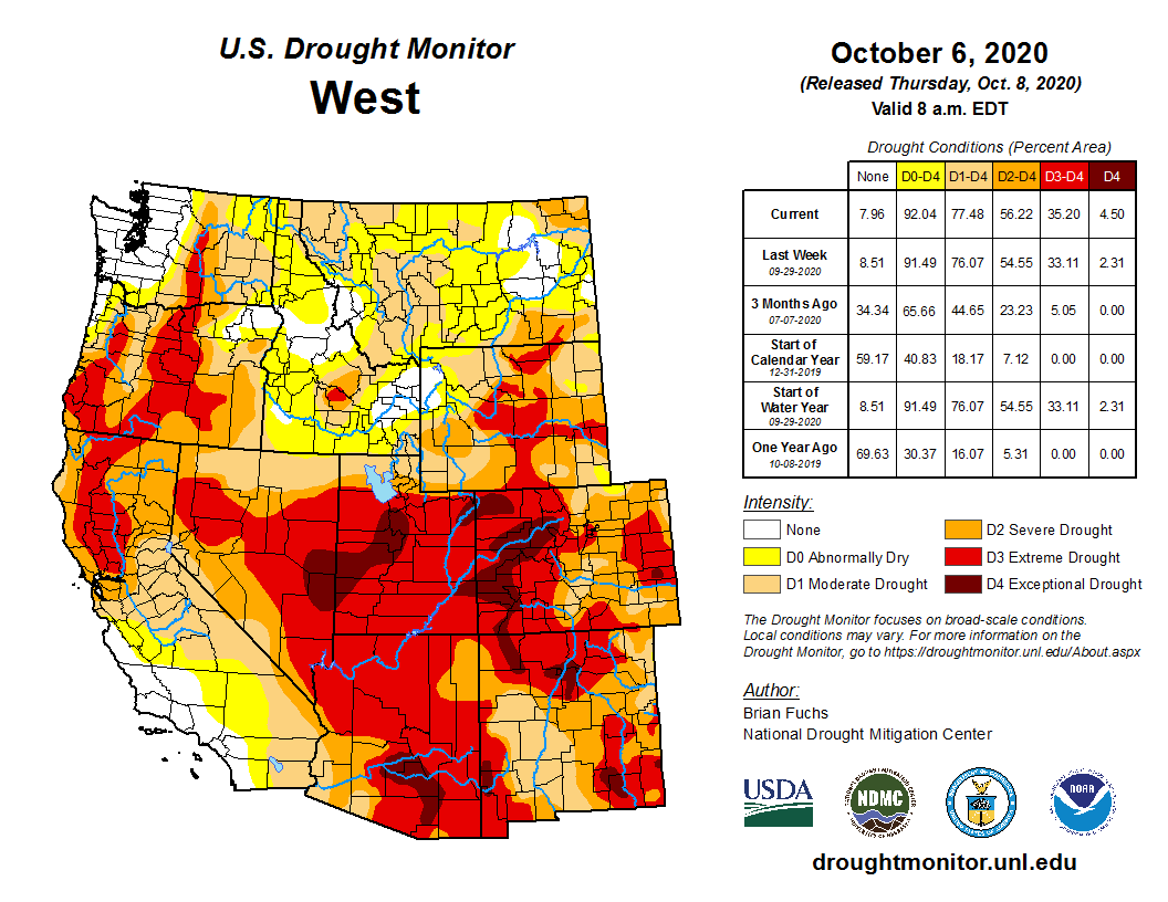
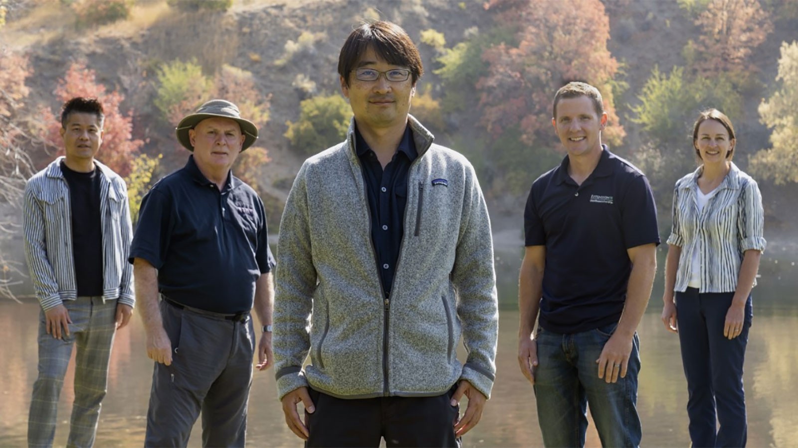
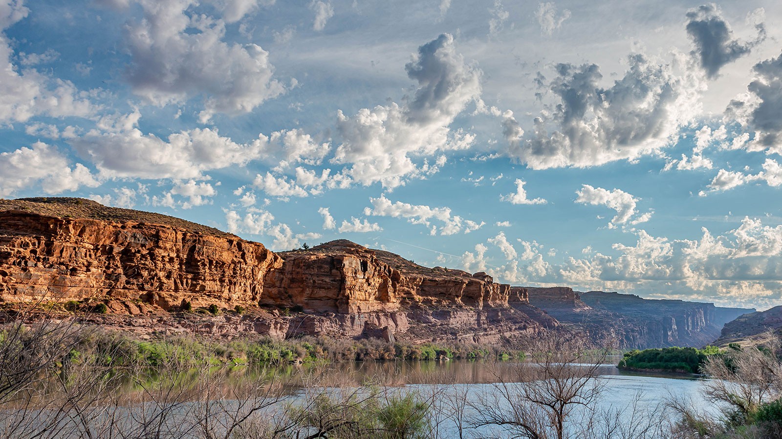
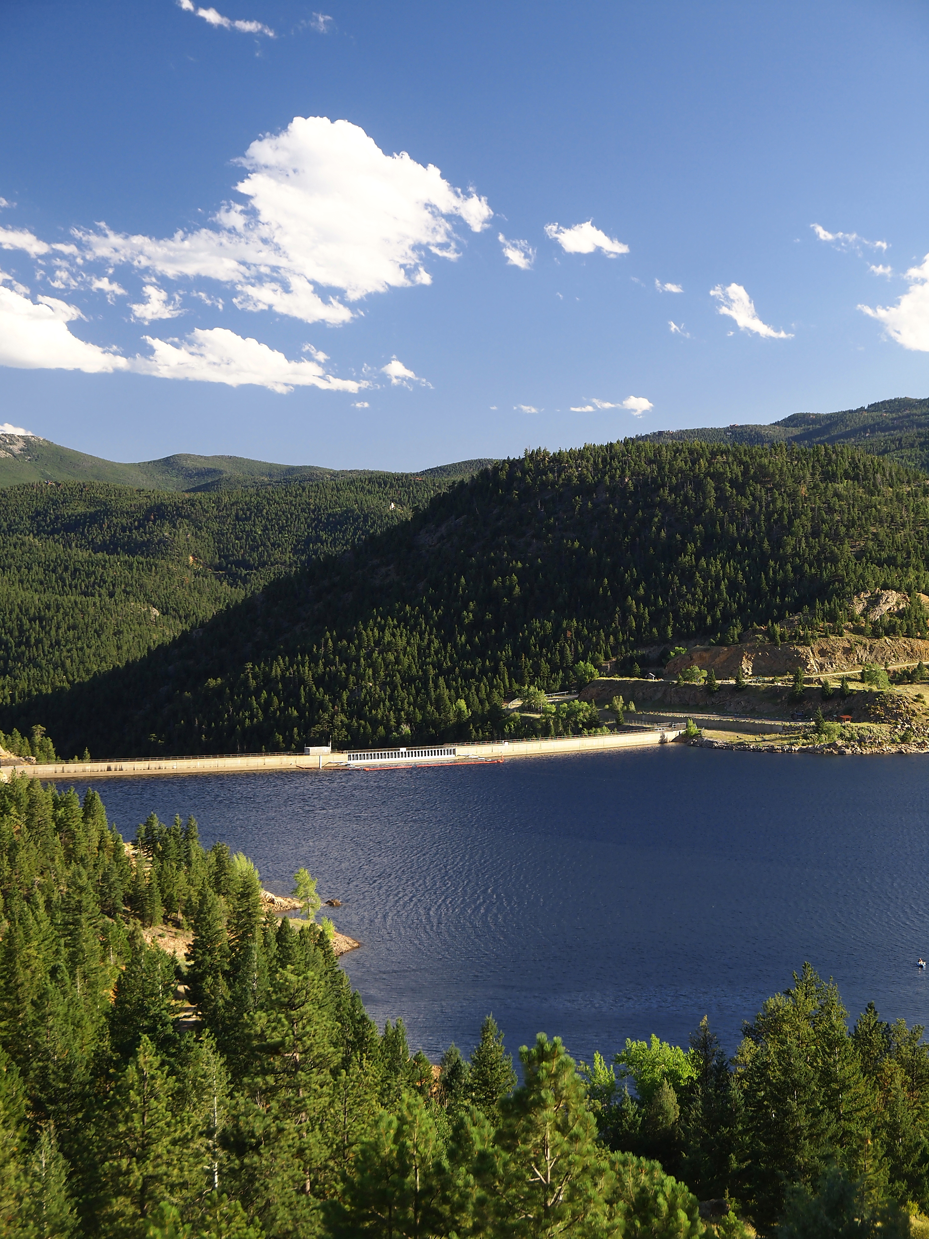

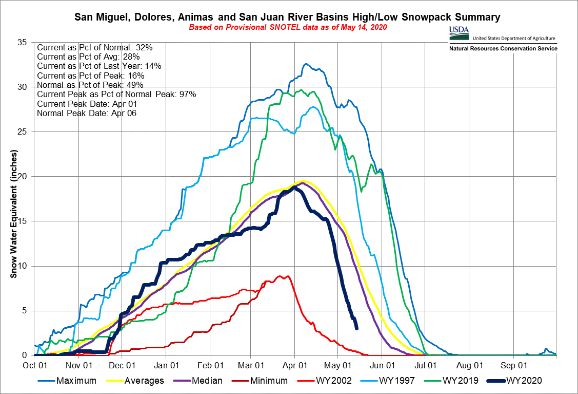


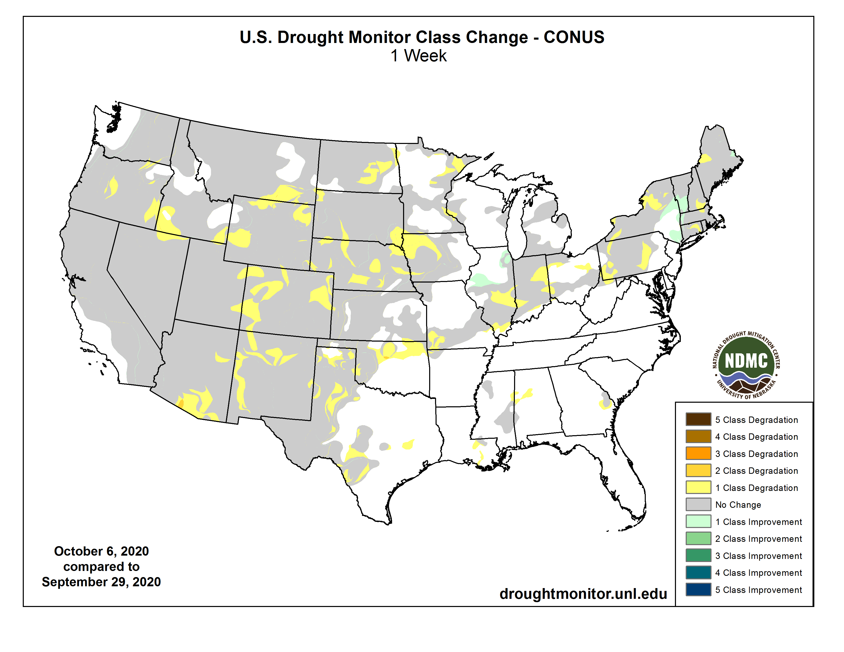

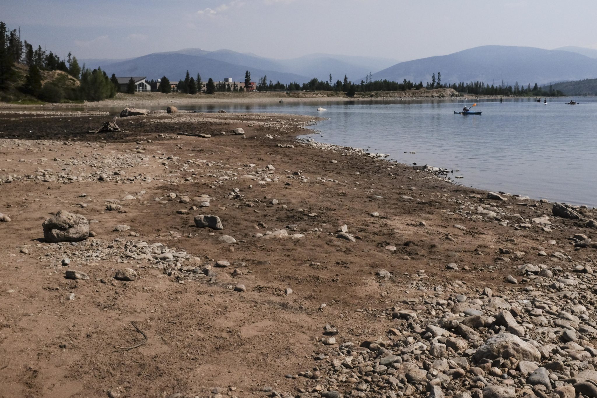

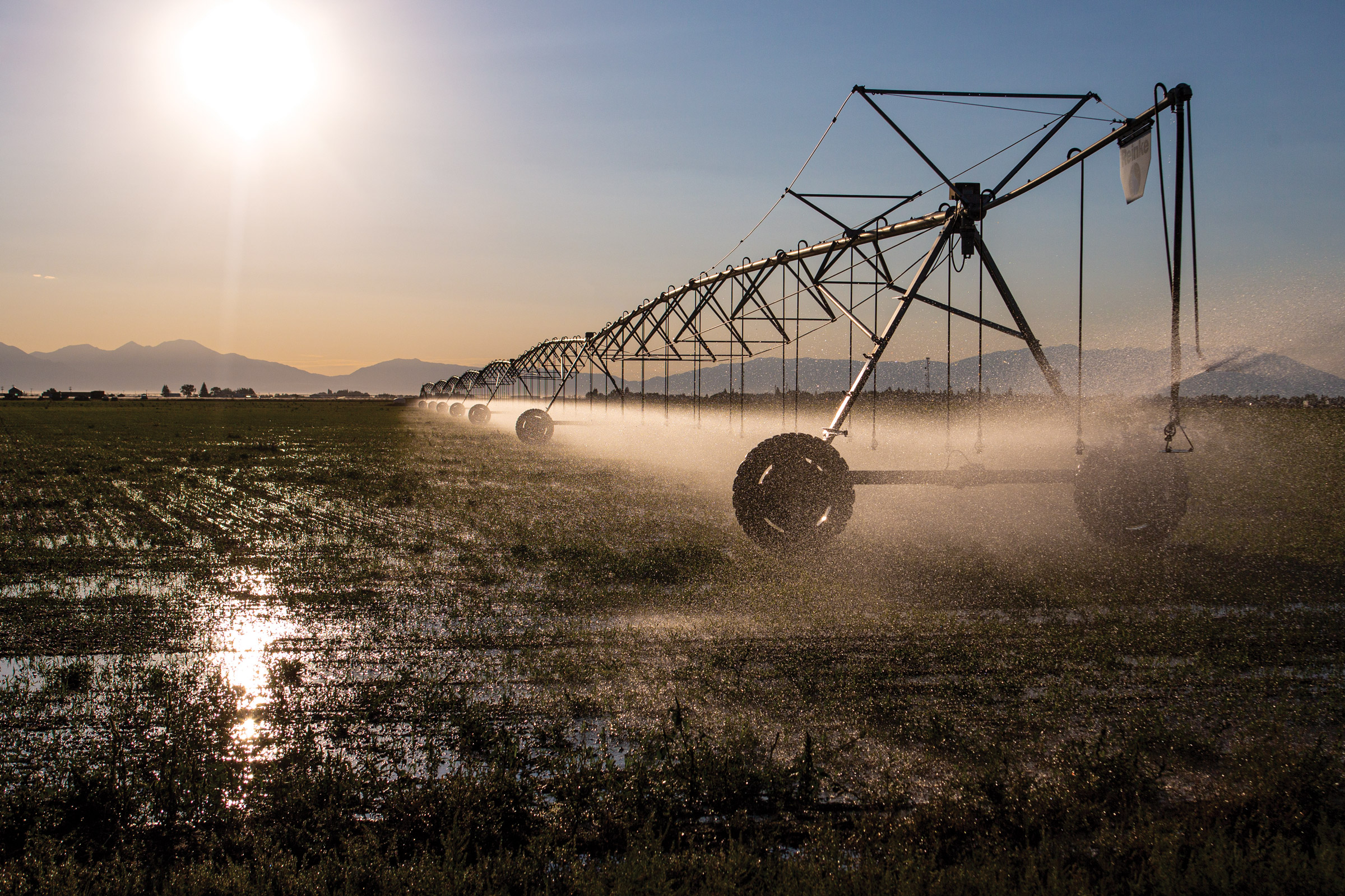


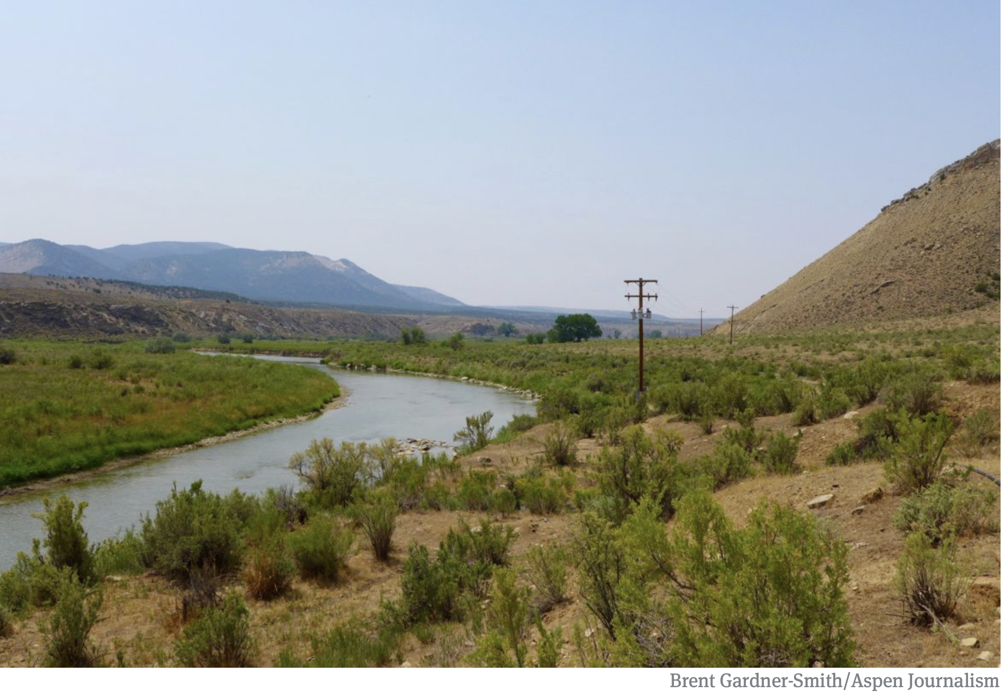


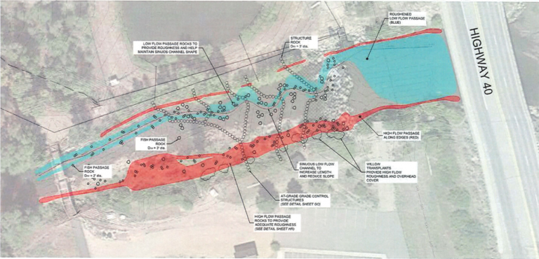

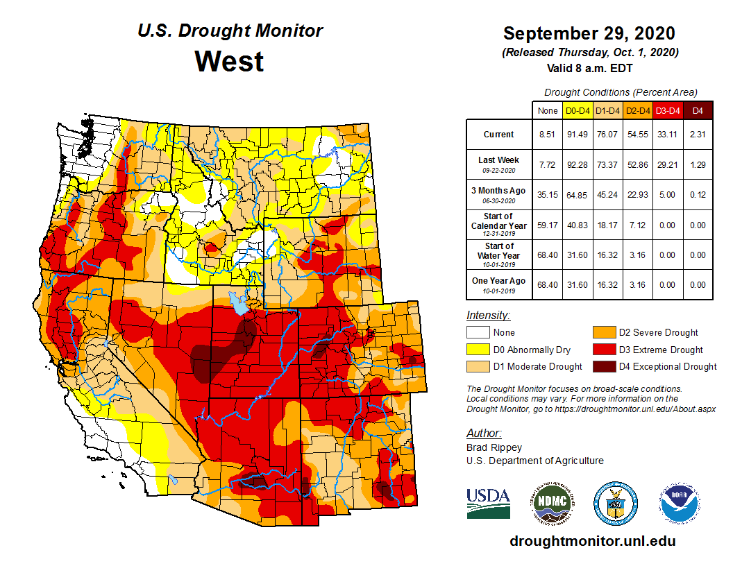


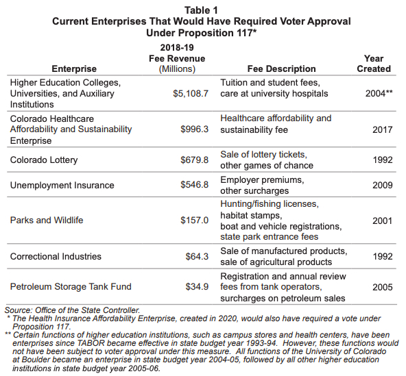
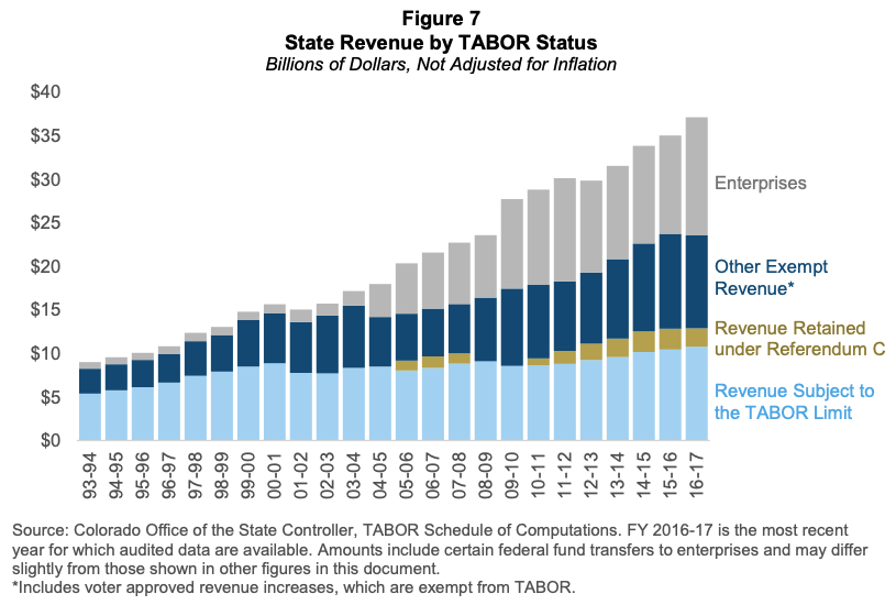

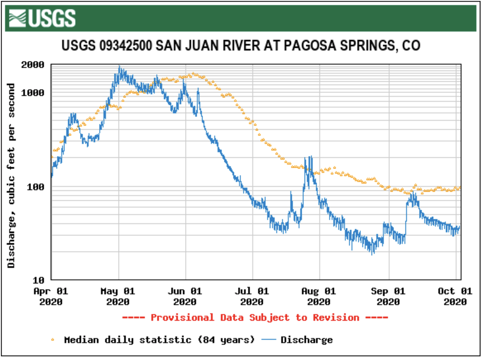

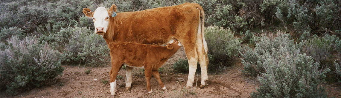


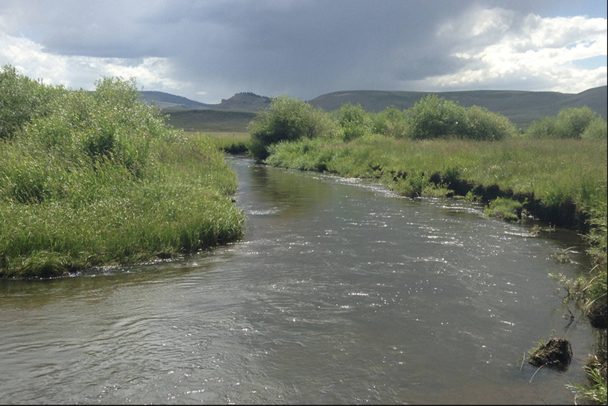

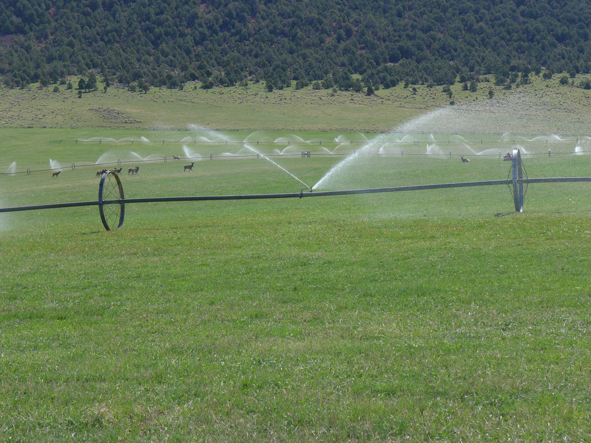
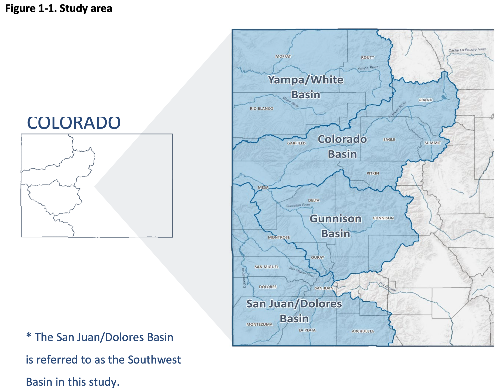


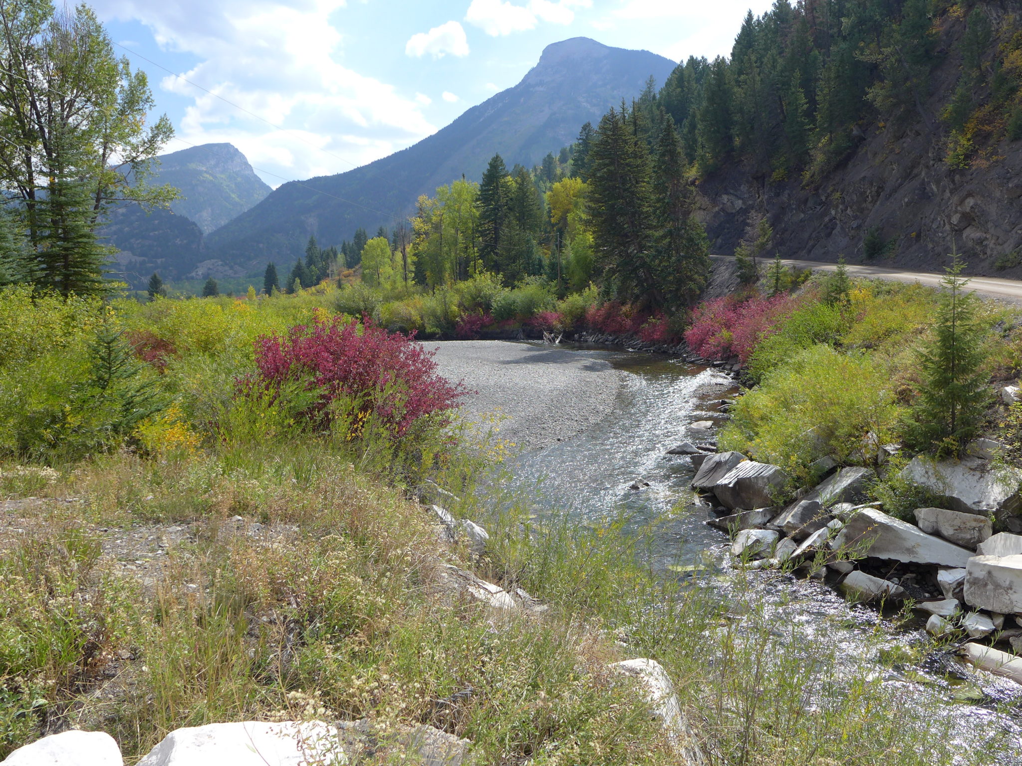

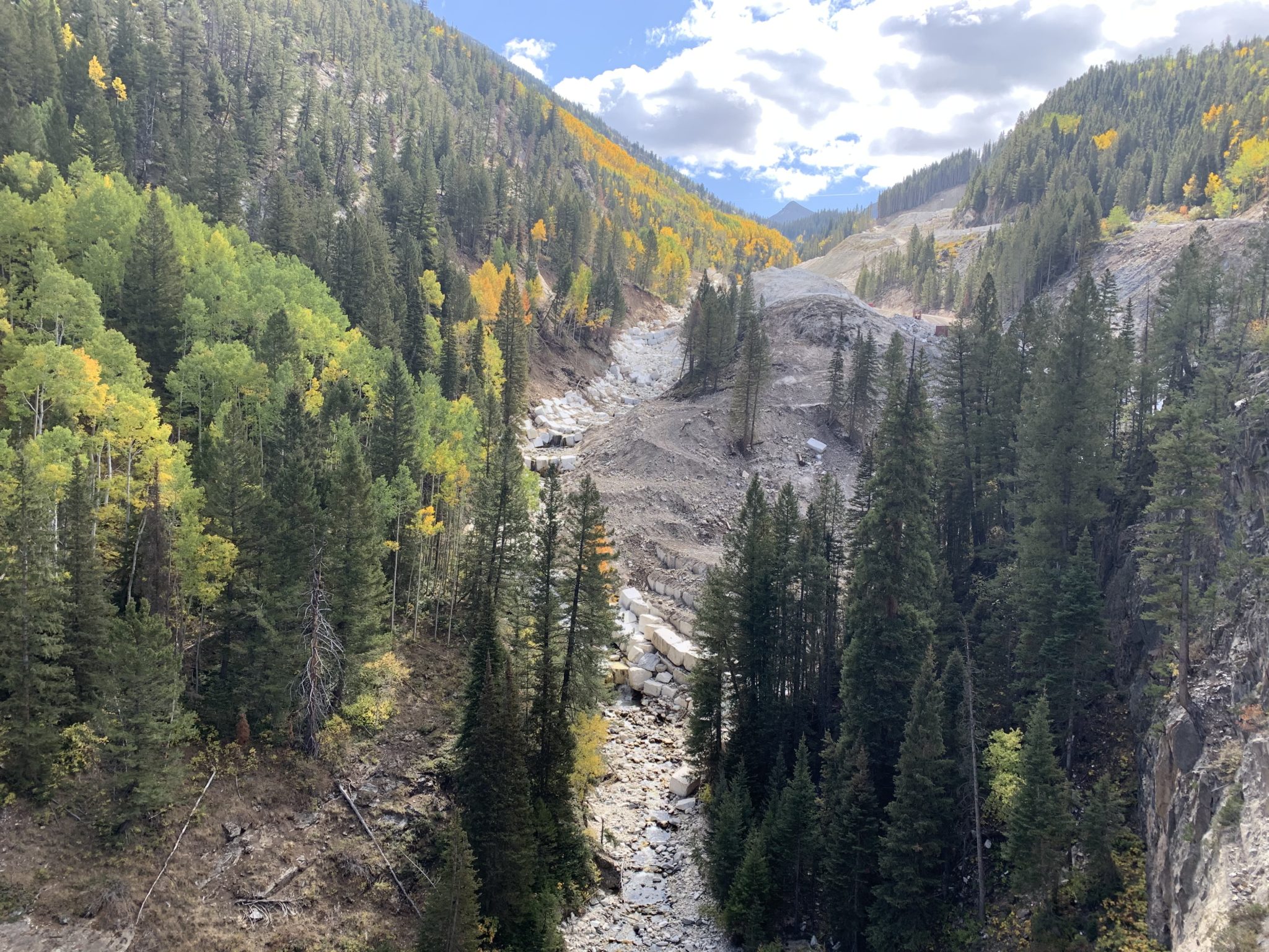

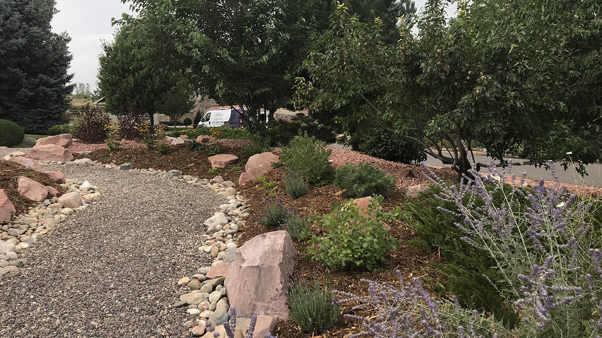


")