#LakePowell forecasts show hydropower generation is at risk next year as water levels drop — Shannon Mullane (Water Education Colorado) #ColoradoRiver #COriver #aridification

This 2023 diagram shows the tubes through which Lake Powell’s fish can pass through to the section of the Colorado River that flows through the Grand Canyon. Credit: USGS and Reclamation 2023

Click the link to read the article on the Water Education Colorado website (Shannon Mullane):

July 17, 2025

Federal officials reported Tuesday that the water level in Lake Powell, one of the main water storage reservoirs for the Colorado River Basin, could fall low enough to stop hydropower generation at the reservoir by December 2026.

The reservoirโ€™s water levels have fallen as the Colorado River Basin, the water supply for 40 million people, has been overstressed by rising temperatures, prolonged drought and relentless demand. Upper Basin officials sounded the alarm in June, saying this yearโ€™s conditions echo the extreme conditions of 2021 and 2022, when Lake Powell and its sister reservoir, Lake Mead, dropped to historic lows.

The basin needs a different management approach, specifically one that is more closely tied to the actual water supply each year, the Upper Colorado River Commissionโ€™s statement said.

The seven basin states, including Colorado, are in high-stakes negotiations over how to manage the basinโ€™s water after 2026. One of the biggest impasses has been how to cut water use in the basinโ€™s driest years.

โ€œYou canโ€™t reduce what doesnโ€™t come down the stream. And thatโ€™s the reality weโ€™re faced with,โ€ Commissioner Gene Shawcroft of Utah said in the statement. โ€œThe only way weโ€™re going to achieve a successful outcome is if weโ€™re willing to work together โ€” and not just protect our own interests.โ€

Lake Powell is seen in a November 2019 aerial photo from the nonprofit EcoFlight. The Upper Basin states are proposing two pools of stored water in Lake Powell: A Lake Powell protection account and a Lake Powell conservation account. Credit: EcoFlight

Lake Powell, located on the Utah-Arizona border, collects water from Colorado, New Mexico, Utah, Wyoming, part of Arizona and tribal reservations in the Colorado Riverโ€™s Upper Basin. Glen Canyon Dam releases the reservoirโ€™s water downstream to Lake Mead, Native American tribes, Mexico, and Lower Basin states, including Arizona, California and Nevada.

Lake Powell and Lake Mead make up about 92% of the reservoir storage capacity in the entire Colorado River Basin.

The U.S. Bureau of Reclamationโ€™s July report, called a 24-month study, shows the potential for Lake Powell to decline below two critical elevations: 3,525 feet and 3,490 feet.

It could drop below 3,525 feet in April 2026, which would prompt emergency drought response actions. Thatโ€™s in the most probable scenario, but the federal agency also considers drier and wetter forecast scenarios. The dry forecast shows that the reservoirโ€™s water levels would fall below this elevation as soon as January.

Lake Powell would have to fall below 3,490 feet in order to halt power generation.

Planning for emergency water releases

In 2021 and 2022, officials leapt into crisis management mode and released water from upstream reservoirs โ€” including Blue Mesa, Coloradoโ€™s largest reservoir โ€” to stabilize Lake Powellโ€™s water levels.

The emergency releases prompted some concerns about recreation at Blue Mesa.

The July 24-month study triggered planning for potential emergency releases, called drought response operations, at Lake Powell, and Flaming Gorge, Blue Mesa and Navajo reservoirs, said Chuck Cullom, executive director of the Upper Colorado River Commission.

โ€œThe Upper Division States and Reclamation have been monitoring the risks to Lake Powell since January 2025 due to the declining snowpack and runoff, and are prepared to take appropriate actions as conditions evolve through 2025 and spring of 2026,โ€ he said in an email to The Colorado Sun.

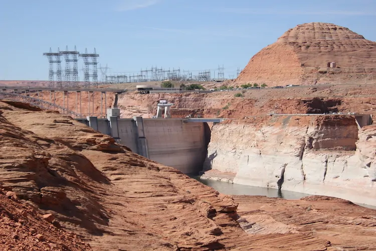
The back of Glen Canyon Dam circa 1964, not long after the reservoir had begun filling up. Here the water level is above dead pool, meaning water can be released via the river outlets, but it is below minimum power pool, so water cannot yet enter the penstocks to generate electricity. Bureau of Reclamation photo. Annotations: Jonathan P. Thompson

At-risk hydropower

Hydroelectric power generation takes a hit with lower water levels at Lake Powell and Lake Mead.

Reclamationโ€™s dry conditions forecast says Lake Powell could fall below 3,490 feet by December 2026, and Lake Meadโ€™s water level could fall below a key elevation, 1,035 feet, by May 2027. At that point, Hoover Dam would have to turn off several turbines and its power production would be significantly reduced, said Eric Kuhn, a Colorado water expert.

In more typical or unusually wet forecasts, neither reservoir would fall below these critical elevations in the next two years, according to the report.

Lake Powell and other federal reservoirs provide a cheap and consistent source of renewable energy. Without that, electricity providers would have to look to other, more expensive sources of energy or nonrenewable supplies. Some of those costs can get handed down to customers in their monthly utility bills.

Output capacity of the damโ€™s turbines decreases in direct proportion to the reservoirโ€™s surface elevation. As Lake Powell Shrinks, the dam generates less power. Source: Argonne National Laboratory.

Glen Canyonโ€™s hydropower is normally pooled with other power sources to serve customers in Wyoming, Colorado, Arizona, New Mexico, Nevada, Texas and Utah. Its power generation has already been impacted: Fourteen of the lowest generation years at the dam have occurred since 2000.

A strong monsoon season this summer could help elevate the water levels in the major reservoirs, as could a heavy winter snowpack in the mountains this coming winter.

โ€œIf next year is below average, then weโ€™re setting ourselves up for some very difficult decisions in the basin,โ€ said Kuhn, former general manager of the Colorado River District and author of โ€œScience Be Dammed,โ€ a book about the perils of ignoring science in Western water management.

Arizona power house at Hoover Dam December 2019. Each of the 17 hydroelectric generators at Hoover Dam can produced electricity sufficient for 1,000 houses. Photo credit: Allen Best/The Mountain Town News

Kuhn has also been tracking the releases from Lake Powell with big, interstate legal questions in mind.

If the riverโ€™s flow falls below a 10-year total of about 82.5 million acre-feet, it could trigger a legal mire. In that scenario, the Lower Basin could argue that the Upper Basin would be required to send more water downstream in compliance with the foundational agreement, the 1922 Colorado River Compact.

Some Upper Basin lawyers disagree about the terms of when states, like Colorado, would be required to send more water downstream. Thatโ€™s a big concern for water users, including farmers and ranchers, who say they already donโ€™t have enough water in dry years.

From 2017 to 2026, the 10-year cumulative flow is expected to be about 83 million acre-feet, Kuhn said.

โ€œWeโ€™re OK through 2026,โ€ Kuhn said. โ€œBut under the most probable and minimum probable [forecasts], itโ€™s almost a certainty that the flow will drop below 82.5.โ€

Lake Powellโ€™s ecosystems feel the strain

Bridget Deemer, a research ecologist for the U.S. Geological Survey, keeps her eye on how lower water levels impact ecosystems in Lake Powell.

In a recent study, she found that low dissolved oxygen zones grow larger as water levels fall and more sediment gets backed up in the reservoir over time. This sediment can spur more decomposition, which uses up oxygen in the water.

The zones can cut down on fish habitat. Fish donโ€™t want to be in the warm surface waters of the lake, but as they search for their preferred temperature and food source, they can end up in an area with low oxygen, Deemer said.

The effect is greatest right below Glen Canyon Dam. In 2023, there were 116 days when the oxygen was below 5 milligrams per liter, which is the threshold for trout. At 2 to 3 milligrams per liter, the fish can die.

Deemer also studies how these zones are impacted by algae blooms.

Lake Powell researchers noted toxic algae blooms around the Fourth of July and last fall. They donโ€™t know definitively what caused either bloom event, but research does show that warming water temperatures and increased nutrients are two leading causes of harmful algae blooms.

These blooms can impact fish, people, pets or anything that ingests the algae.

โ€œIn general, Lake Powell is doing well,โ€ she said. โ€œIts waters are really clear without a lot of nutrients and algal growth. These blooms are smaller scale and localized.โ€

More by Shannon Mullane

Map credit: AGU

Return of the Deadpool Diaries: The #ColoradoRiver news keeps getting worse — John Fleck (InkStain.net) #COriver #aridification

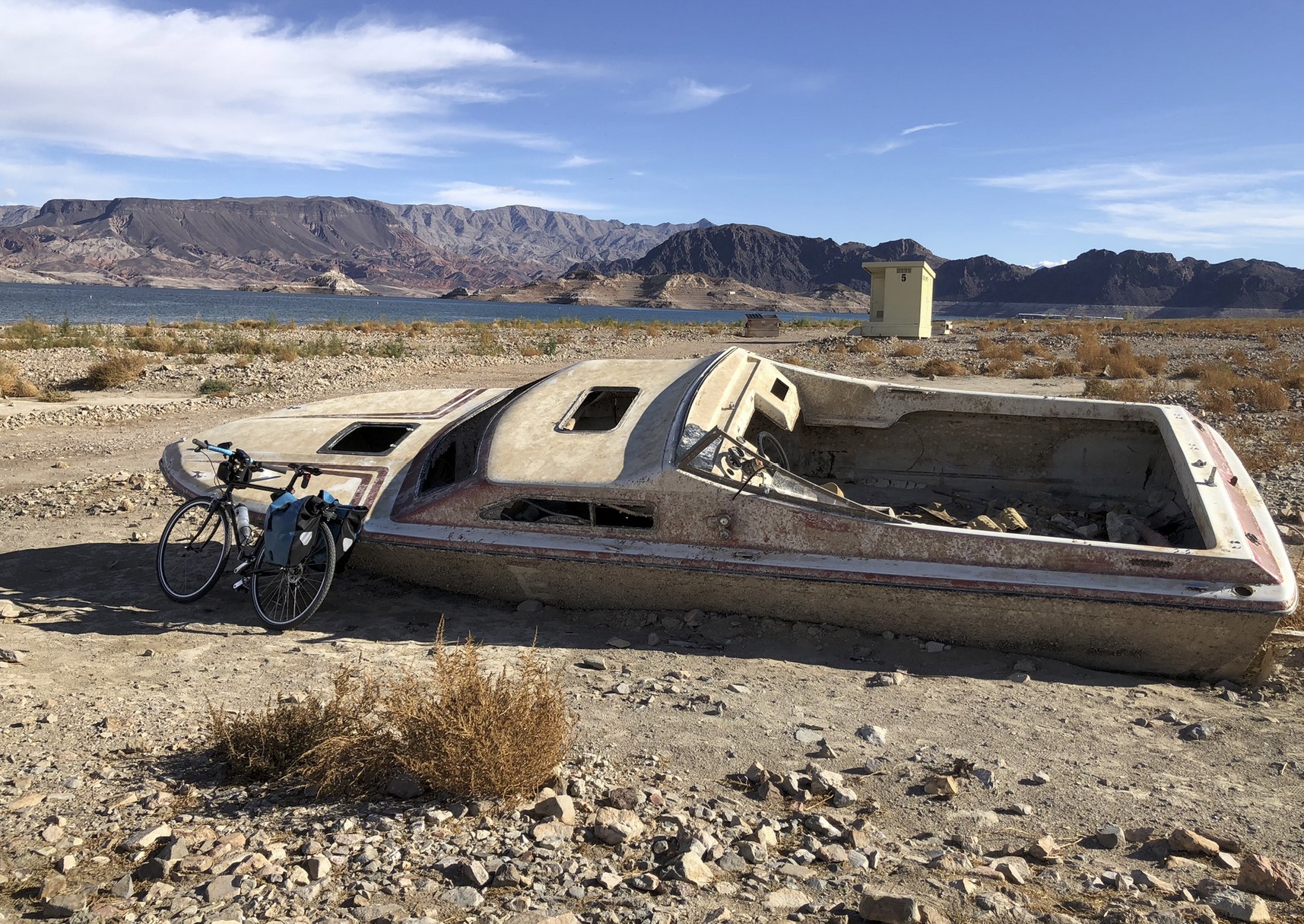
Lake Mead shipwreck. โ€œThat boat is totally fixable.โ€ โ€“ Greg. Photo credit: John Fleck

Click the link to read the article on the InkStain.net website (John Fleck):

July 17, 2025

With the latest Bureau of Reclamation model runs highlighting the serious risks posed by the declining reservoir levels that Utah Stateโ€™s Jack Schmidt has been warning about, there are signs that the closed-room discussions among the seven basin states, after brief glimmers of hope last month, are once again not going well.

The Reservoirs

The latest Bureau of Reclamation 24-month studies show a clear risk of Lake Powell dropping below minimum power pool in late 2026, with Lake Mead dropping to elevation 1,025 by the summer of 2027. This should be hair on fire stuff.

The โ€œclear riskโ€ here is based on Reclamationโ€™s monthly โ€œminimum probableโ€ model runs โ€“ what happens if we have bad snowpacks next year, and the year after? These are probabilistic estimates, not predictions. But the whole point of Reclamation doing this is so that we can be prepared. We need a robust public discussion about what our plan is if we end up on this fork in the hydrologic road.

The warning signs are clearly there in Jackโ€™s analyses. Frustrated by the delay in the traditional metrics we use for measuring and monitoring the Colorado River, Jackโ€™s been doing routine updates on reservoir storage contents. The traditional metrics we use โ€“ the Upper Basin Consumptive Uses and Losses Reports, the Lower Basin Decree Accounting Reports, the Natural Flow Database โ€“ have significant lags. The reservoir data is there in real time, integrating how much the climate system provides and how much humans use. The data here are all public. Jackโ€™s value add is to sum them up and slice and dice the resulting data structures.

The somewhat arcane but incredibly useful framework heโ€™s been using his his recent analyses is the period of accumulation, when reservoirs rise as river flows exceed human uses above them and extractions below them, following by the period of decline, when weโ€™re drawing down the reservoirs. This is a tool, or a way of thinking, that we could use in real time to adjust our behavior, noting bad reservoir conditions and reducing our use. This is not something our water allocation framework is well suited to do.

The Negotiations

For more than a year, those involved in the delicate interstate negotiations over future Colorado River water allocation rules have repeatedly asked that we give them space to have the hard conversations they need to have in private. The results, or lack thereof, have done nothing to earn our trust.

The potential path forward.

When Arizonaโ€™s Tom Buschatzke moved the up-until-then super secret โ€œsupply drivenโ€ allocation concept into public view a month ago, it seemed like a good sign along two dimensions. First, the idea of basing the amount of water delivered from Upper Basin to Lower Basin past Lee Ferry on actual hydrology, on a percentage of how much water the climate is actually providing, seemed like an eminently reasonable approach. Second, Buschatzke was talking about this in public.

Folks from the Upper Basin followed suit, and a round of positive press followed.

Talking to Alex Hager, I called it โ€œa glimmer of hope.โ€

But as this shifts from the brief sunshine of public statements back to the closed door negotiations, any glimmer appears dim indeed.

The problems were already visible in that brief, glorious bit of sunshine of public discussion last month.

There are two critical questions that need to be settled to make this work. The obvious one is the number โ€“ what percentage of the three year natural flow are we talking about shepherding down past Lee Ferry? The second is more subtle: What happens if the Lee Ferry flow falls short of that number?

Speaking to the Arizona Reconsultation Committee, Buschatzke was clear that whatever percentage number they settled on would be an Upper Basin โ€œdelivery obligationโ€ at Lee Ferry. Becky Mitchell, speaking on behalf of Colorado, (but effectively as the de-facto Upper Basin voice, the role the other Upper Basin states seem to have for all practical purposes ceded to her) said (per Heather Sackettโ€™s excellent reporting) it was in no way to be considered a delivery obligation.

When I suggested in a blog post that Upper Basin states might need to curtail water users in order to ensure the agreed-upon-percentage (whatever that is) is met, I got an angry call informing me that the Upper Basin was considering no such thing.

What this makes clear is that the same disagreement over the irreducibly ambiguous legal question in Article III of the Colorado River Compact โ€“ does the Upper Basin have a Lee Ferry delivery obligation or not? โ€“ is simply being shifted to a new modeling framework.

Never mind the equally intractable question of what the Lee Ferry donโ€™t-call-it-a-delivery-obligation percentage might be. I donโ€™t know anything more than gossip, but the gossip suggests the attempt to settle on a number, or even a range of numbers that Reclamation might model as part of its NEPA analysis, also is not going well.

If I was talking to Alex Hager today, I would no longer describe a glimmer of hope.

The Failure Mode

One of the most useful questions I learned to ask as a reporter covering water involved drilling down to the question of what happens when scarcity finally bites. What is the failure mode? Who actually doesnโ€™t get water? How does that work? [ed. emphasis mine]

The combination of Jackโ€™s analysis and Reclamationโ€™s latest 24-month study suggests that we need to be asking that question in the near term. When Powell approaches minimum power pool, and Mead drops below 1030, whose water use will be curtailed to protect the system? If your answer involves a defense of why your own water supply should not be reduced, youโ€™re doing this wrong. Everyone needs to be realistic about their risk of a legal outcome different from their agency lawyerโ€™s position. But we also need to recognize moral obligations here, to find ways to share in this shrinking river. How are we going to come together, as a community, to respond?

The longer term argument also needs to begin to take this form.

Let us imagine going to the Supreme Court to settle the question of whether the Upper Basin does or does not have a legal delivery obligation under Article III of the Colorado River Compact to deliver 75 million or 82.5 million acre feet per year past Lee Ferry. If you lose that litigation, what is the failure mode? Who actually doesnโ€™t get water? If your groupthink has convinced you that this is not a meaningful question, that youโ€™re sure to win, and the other basin is the one that needs to be thinking about failure modes, you need a second opinion, to get out of your groupthink bubble.

Whatever โ€œbring it onโ€ enthusiasm for litigation youโ€™re hearing from your groupthinkers needs to be tempered by an honest discussion about what happens to your communitiesโ€™ water supplies if you lose.

Iโ€™ll also make a modest pitch here for a need to recognize moral obligations, to find ways to share this shrinking river.

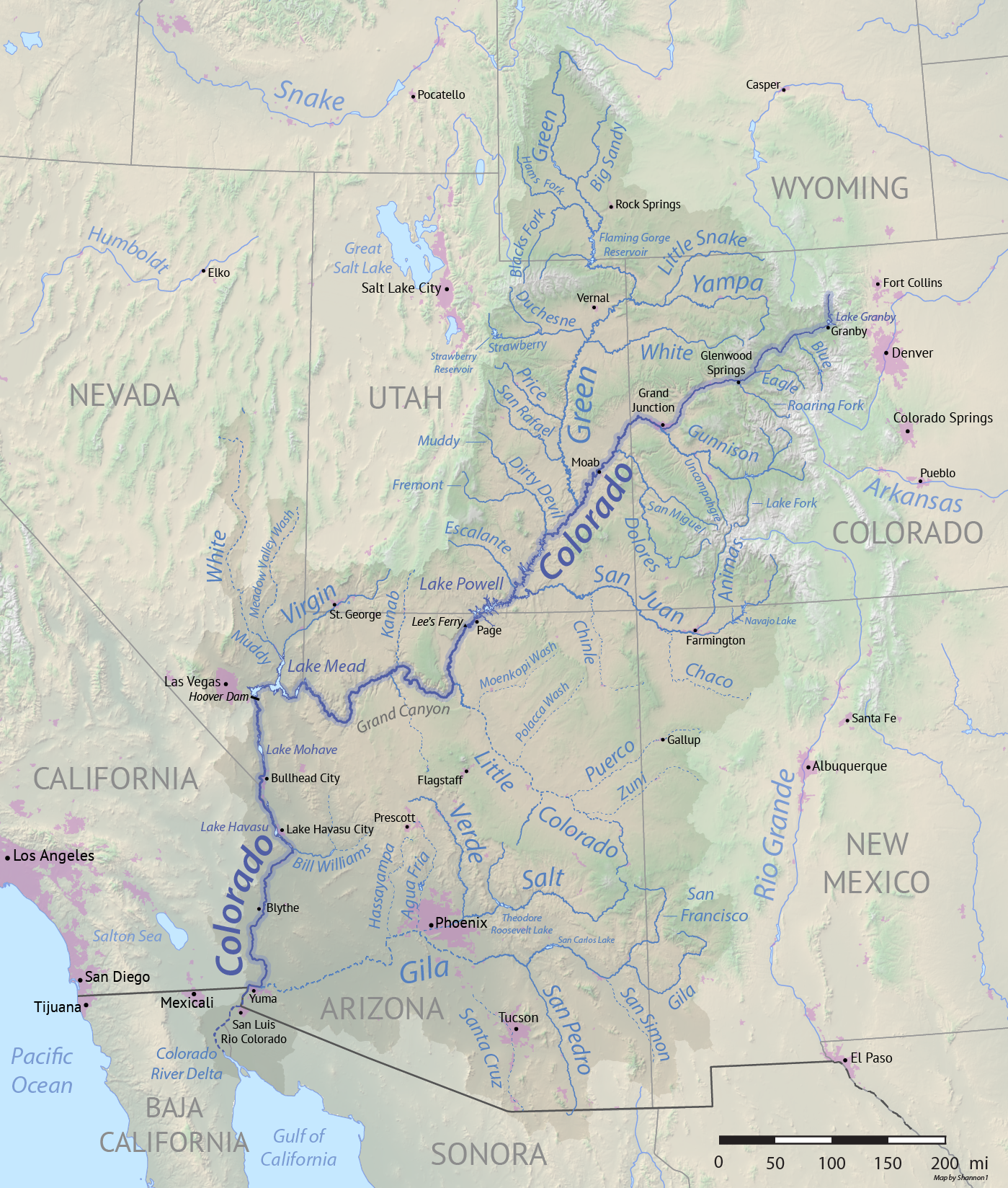
Map of the Colorado River drainage basin, created using USGS data. By Shannon1 Creative Commons Attribution-Share Alike 4.0

โ€˜We stand on the brink of system failureโ€™: Feds up pressure for states to reach deal on the future of the #ColoradoRiver — The Salt Lake Tribune #COriver #aridification

Click the link to read the article on The Salt Lake Tribune website (Leia Larsen). Here’s an excerpt:

June 26, 2025

The clock is ticking for seven states to figure out how theyโ€™ll share dwindling water in the Colorado River for the foreseeable future. In a meeting at the Utah State Capitol Thursday [June 26. 2025], the riverโ€™s four Upper Basin state commissioners further embraced the idea of a โ€œdivorceโ€ with their Lower Basin neighbors โ€” anย idea also floated at a meeting in eastern Utah last week, as reported by Fox 13.

โ€œToday we stand on the brink of system failure,โ€ said Becky Mitchell, the commissioner for Colorado. โ€œWe also stand on the precipice of a major decision point.โ€

…negotiations between the four Upper Basin states, which includes Utah, Colorado, Wyoming and New Mexico, have been in a standstill with the remaining three Lower Basin states for more than a year. The Interior Departmentโ€™s acting assistant secretary for water and science, Scott Cameron, has met with leadership in the seven states that use Colorado River water since April, working to broker a deal.

Udall/Overpeck 4-panel Figure Colorado River temperature/precipitation/natural flows with trend. Lake Mead and Lake Powell storage. Updated through Water Year 2024. Credit: Brad Udall

โ€œWe all have to live in the physical world as it is,โ€ he said, โ€œnot as we might hope it will be.โ€

On Thursday, Cameron presented water managers with a deadline. The Interior Department plans to release a draft environmental impact statement evaluating different alternatives for the riverโ€™s future in December, which will then open to public comment. The department will make its final decision on how to proceed by June of 2026.

โ€œThe goal is to essentially parachute in a seven-state deal as the preferred alternative,โ€ Cameron said.

For that to work, the states will need to reach an agreement by Nov. 11. By Feb. 14, theyโ€™ll need to hand over the details of their plan. Whatever the states decide on, Cameron reminded commissioners, will likely take an act of Congress and new policy adopted by most of the affected statesโ€™ legislatures…

The idea of framing the future relationship of the river users as a โ€œdivorceโ€ was first pitched by the Lower Basin states, Mitchell said. Under that proposal, the Upper Basin states would release water from Lake Powell based on the average natural flow measured at Leeโ€™s Ferry, a point just downstream of the reservoir and upstream of both Grand Canyon National Park and Lake Mead.

โ€œIf done correctly,โ€ Mitchell said, โ€œit should provide the opportunity for the Upper and Lower basins to manage themselves, with the only real point of agreement being the Powell release.โ€

The Colorado Water Conservation Board grants hearing over Shoshone Power Plant water rights deal — Shannon Mullane (Fresh Water News) #ColoradoRiver #COriver #aridification

Water runs down a spillway at the Shoshone hydro plant in Glenwood Canyon. Rockfalls, fires and mudslides in recent years have caused frequent shutdowns of plant operations. Credit: Heather Sackett/Aspen Journalism

Click the link to read the article on the Water Education Colorado website (Shannon Mullane):

July 3, 2025

{The Colorado Water Conservation Board] unanimously agreed Tuesday to hear out Front Range water operatorsโ€™ concerns about a Western Slope plan to purchase historic Colorado River water rights.

The Colorado River Water Conservation District, which represents 15 Western Slope counties, negotiated a $99 million deal to purchase water rights tied to the century-old Shoshone Power Plant, owned by a subsidiary of Xcel Energy.

The River District and the Front Range groups โ€” Aurora Water, Denver Water, Colorado Springs Utilities and Northern Water โ€” all want to maintain the historical flows past Shoshone to provide predictable water supplies long into the future. They mainly disagree about the amount of water involved. Front Range providers say, if the number is too high, it could hamper their ability to provide water to millions of people.

In June, the Front Range water managers asked the Colorado Water Conservation Board to hold a hearing to air concerns. That hearing will be held during the boardโ€™s meeting, Sept. 16-18.

โ€œWe look forward to the hearing, and we appreciate the effort and the time that you and the staff have put into this effort,โ€ Andy Mueller, the River Districtโ€™s general manager, said during the board meeting Tuesday. โ€œ[We] look forward to finishing this in September.โ€

The decision Tuesday also opened up a seven-day period, ending July 9, for others to ask to join the September hearing. The board will share updates with the public on its website.

The hearing is part of a larger [CWCB Instream and water court] process to decide whether Shoshone Power Plantโ€™s water rights can become an environmental water right, called an instream flow right. These rights aim to keep water in rivers to help aquatic ecosystems.

Photo: 1950 โ€œPublic Service Damโ€ (Shoshone Dam) in Colorado River near Glenwood Springs Colorado.

In this case, the environmental water right would focus on a 2.4-mile stretch between Shoshoneโ€™s intake dam, which takes water out of the Colorado River, and the end of its penstocks, which return all of Shoshoneโ€™s water to the river. The power plant is tucked into Glenwood Canyon along Interstate 70 a few miles east of Glenwood Springs.

At times, the power plant sucks nearly all of the Colorado Riverโ€™s flow โ€” depending on the amount of water in the river above the dam โ€” through its turbines before returning it to the river channel. When this happens, the 2.4-mile stretch immediately below the dam is reduced to a narrow channel of water.

The environmental flow right would allow water managers to keep more water in that stretch of the river to help fish and other aquatic species. If approved, it would be the largest, most influential instream flow right in the stateโ€™s portfolio. The Colorado water board has until Sept. 18 to make its decision.

The Colorado River District wants to purchase the water rights as part of a larger plan to permanently shore up water supplies for Western Slope communities, which have long worried that Shoshoneโ€™s flows could change if Xcel decided to shut down the power plant or sell the water rights.

The district has a purchase agreement with Xcel Energy to buy the rights and lease the water back to Xcel to generate electricity. One of the terms of the deal is getting the instream flow use approved by the state.

The Front Range water providers and water managers want to prevent any changes to Shoshoneโ€™s water rights from harming their water supplies.

Shoshoneโ€™s water rights are like the bottom blocks in a game of Jenga: change to the rights could cause ripple effects statewide, in part, because of their age, location and amount of water.

Shoshoneโ€™s oldest water right can impact up to 10,600 other upstream water rights because of the plantโ€™s geographic location, according to the Colorado Division of Water Resources. Those junior water users include Front Range water managers, like Denver Water and Northern Water, that send water to millions of people.

Colorado transmountain diversions via the State Engineer’s office

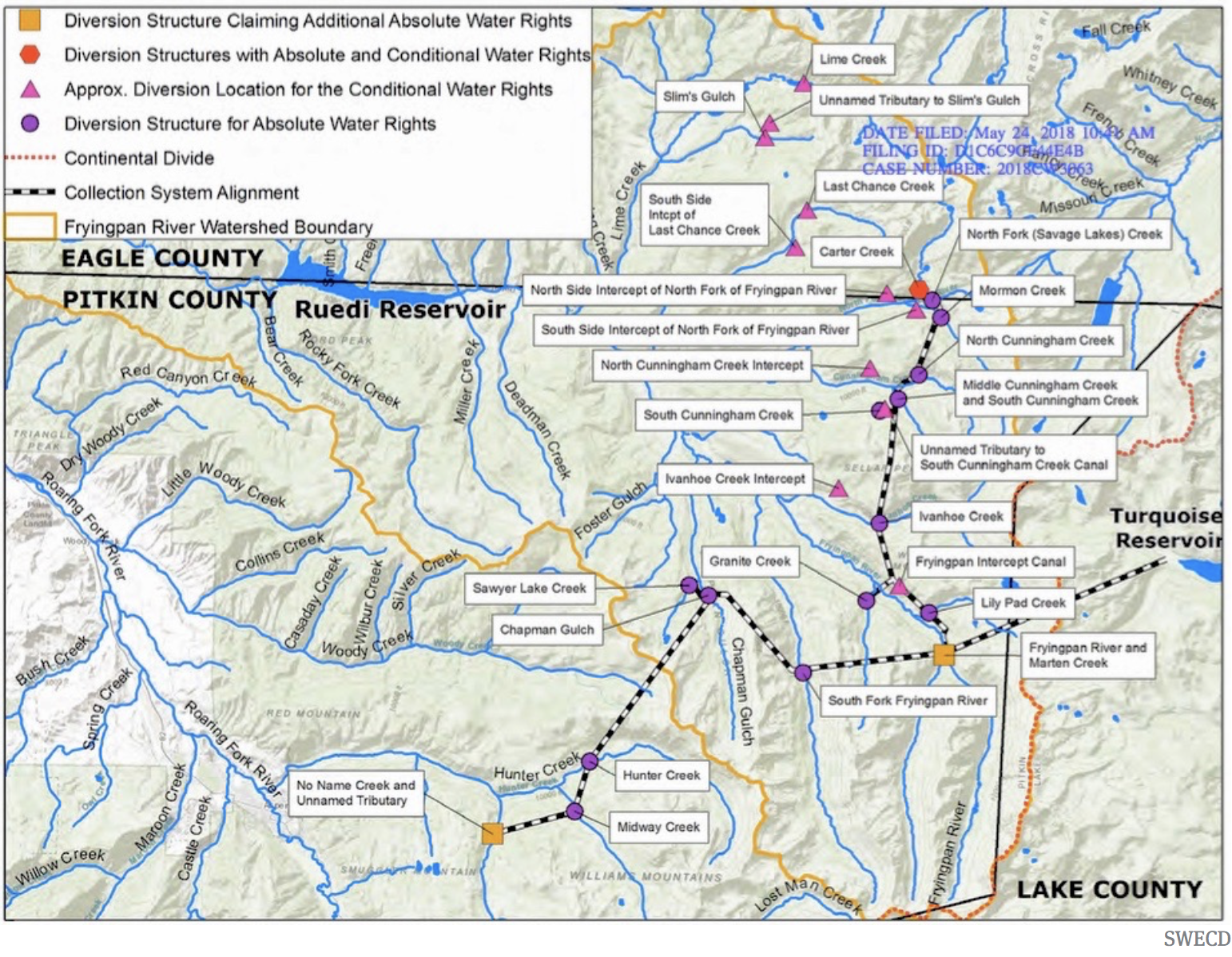
They are also tied to numerous, carefully negotiated agreements that dictate how water flows across both western and eastern Colorado.

The Front Range water operators want to resolve their concerns about the historical flows through Shoshone during the instream flow approval process this summer.

The Colorado River District says their questions can be resolved during the subsequent water court proceedings, where opposing parties will have another opportunity to voice their concerns and make sure their water supplies arenโ€™t negatively impacted.

โ€œWe are deeply concerned that the Front Range entities requesting this contested hearing are asking the CWCB to encroach on the jurisdiction of water court,โ€ the district said in a prepared statement Tuesday.

More by Shannon Mullane

Map credit: AGU

More Coyote Gulch Shoshone water right coverage here.

The secret double life of americaโ€™s public lands: And why you should know about it if you drink waterโ€ฆ — ย John Zablocki (AmericanRiver.org)

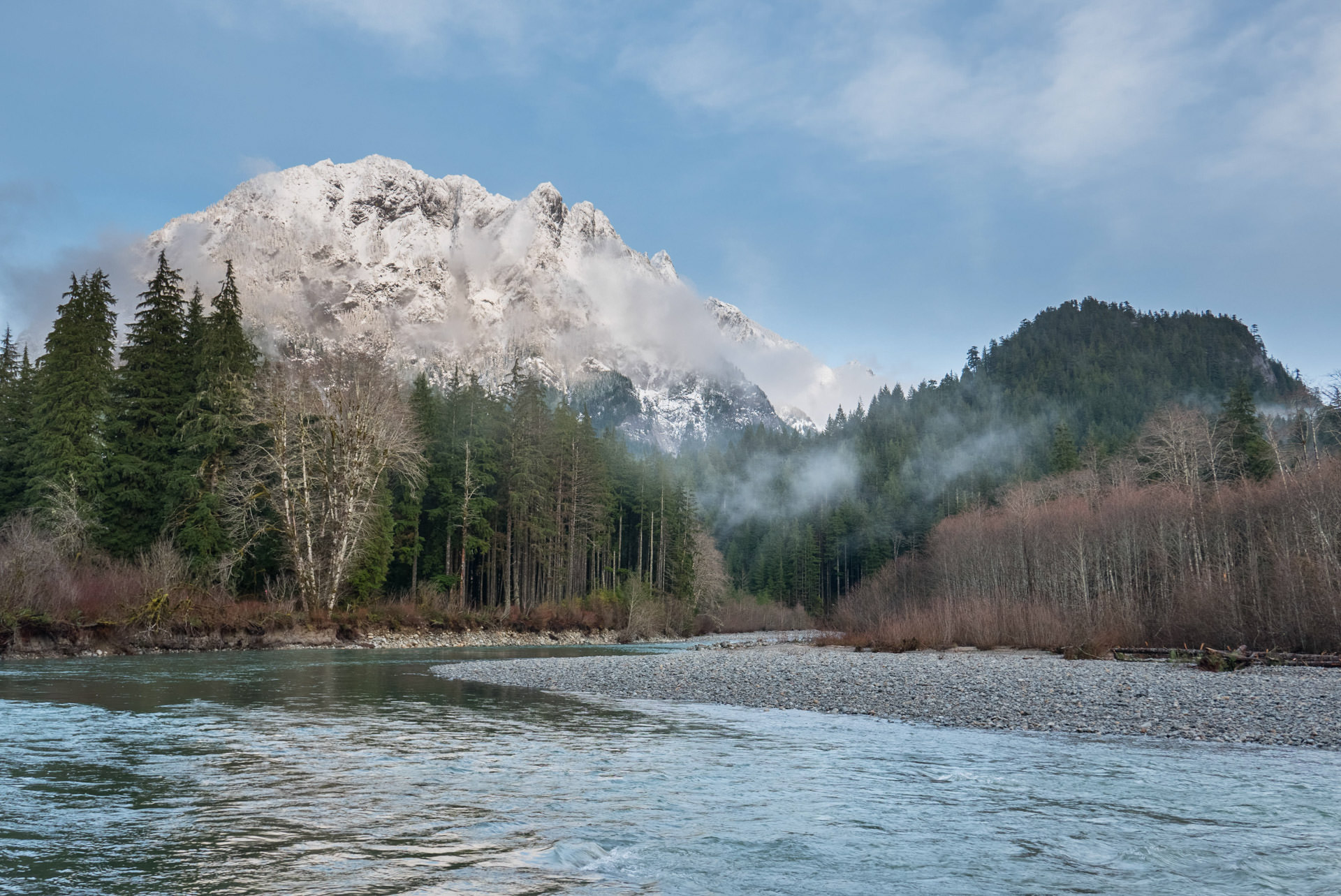
Middle Fork Snoqualmie River, Washington | Monty Vanderbilt

Click the link to read the article on the American Rivers website (John Zablocki):

January 21, 2025

Public lands are the birthright of every American. One of the great privileges of living in this country is the ability to access hundreds of millions of acres to enjoy the great outdoors โ€” all for free.

People care about and use public lands for many reasons. From hunters and anglers to miners and ranchers, hikers and mountain bikersโ€”there is something for almost everyone on public lands. But what if you live in a city and never set foot on public lands?  Why care about them then?

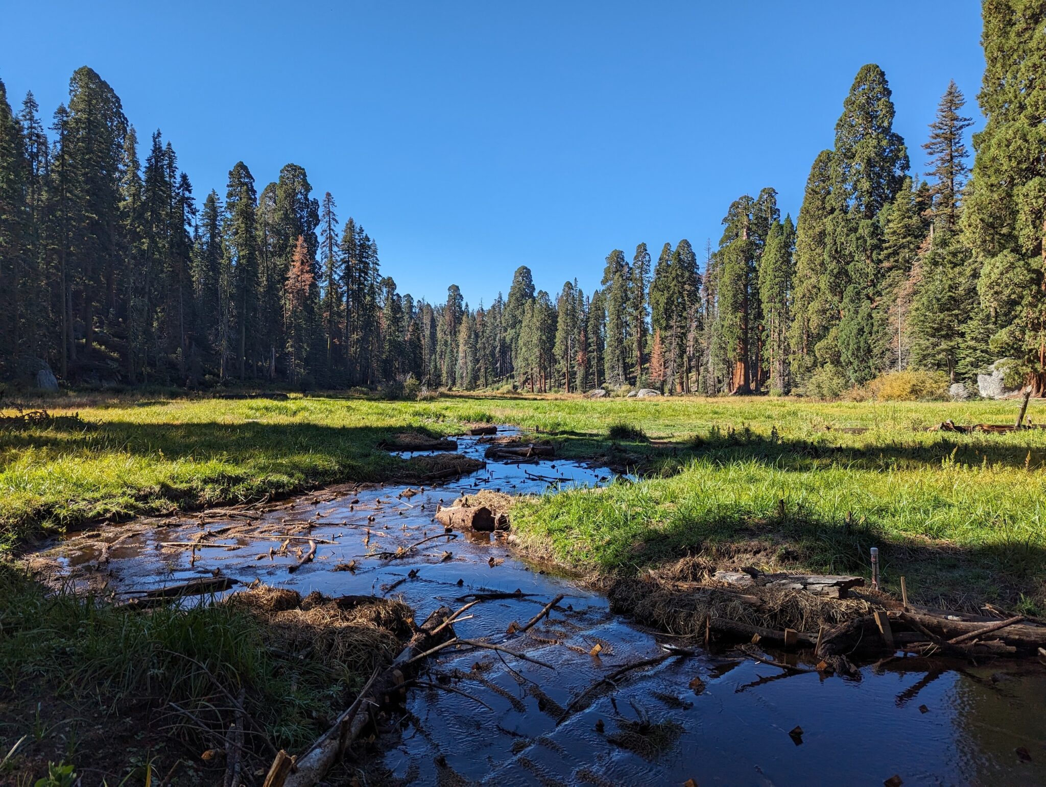
Log Meadow, California | Maiya Greenwood

Not everyone hunts, fishes, mines, ranches, hikes, or bikes; but everyone, truly everyone, depends on clean water. The big secret about public lands is that they are arguably the countryโ€™s single biggest clean water provider. According to the US Forest Service, National Forests are the largest source of municipal water supply in the nation, serving over 60 million people in 3,400 communities across 33 states. Many of the countryโ€™s largest urban areas, including Los Angeles, Portland, Denver, and Atlanta receive a significant portion of their water supply from national forests.

Healthy forests and grasslands perform many of the functions of traditional water infrastructure. They store water, filter pollutants, and transport clean water to downstream communities. And they do it naturally โ€” essentially for free. When rivers are damaged from land uses on public lands, we all pay the price โ€” literally; we all pay more in taxes and utility bills to clean up the water.

What happens on the publicโ€™s land also happens to the publicโ€™s water. The importance of managing public lands for the benefit of public water is so fundamental, it has been a pillar of public lands management agenciesโ€™ missions since their inception over a century ago. For example, The Organic Act of 1897[1]ย that created the US Forest Service stated:

Federal judge permits completion of #Denver Water dam work, citing safety concerns: Senior Judge Christine Arguello backed off of her prior rhetoric and acknowledged safety reasons for permitting the dam’s construction to proceed — #Colorado Politics

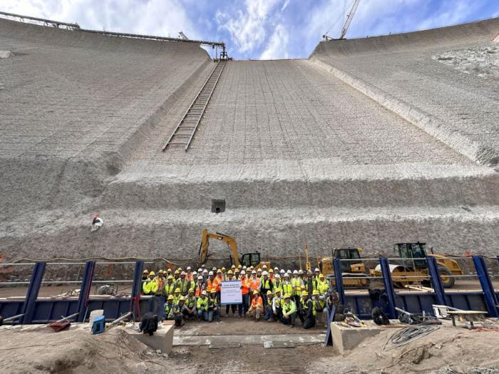
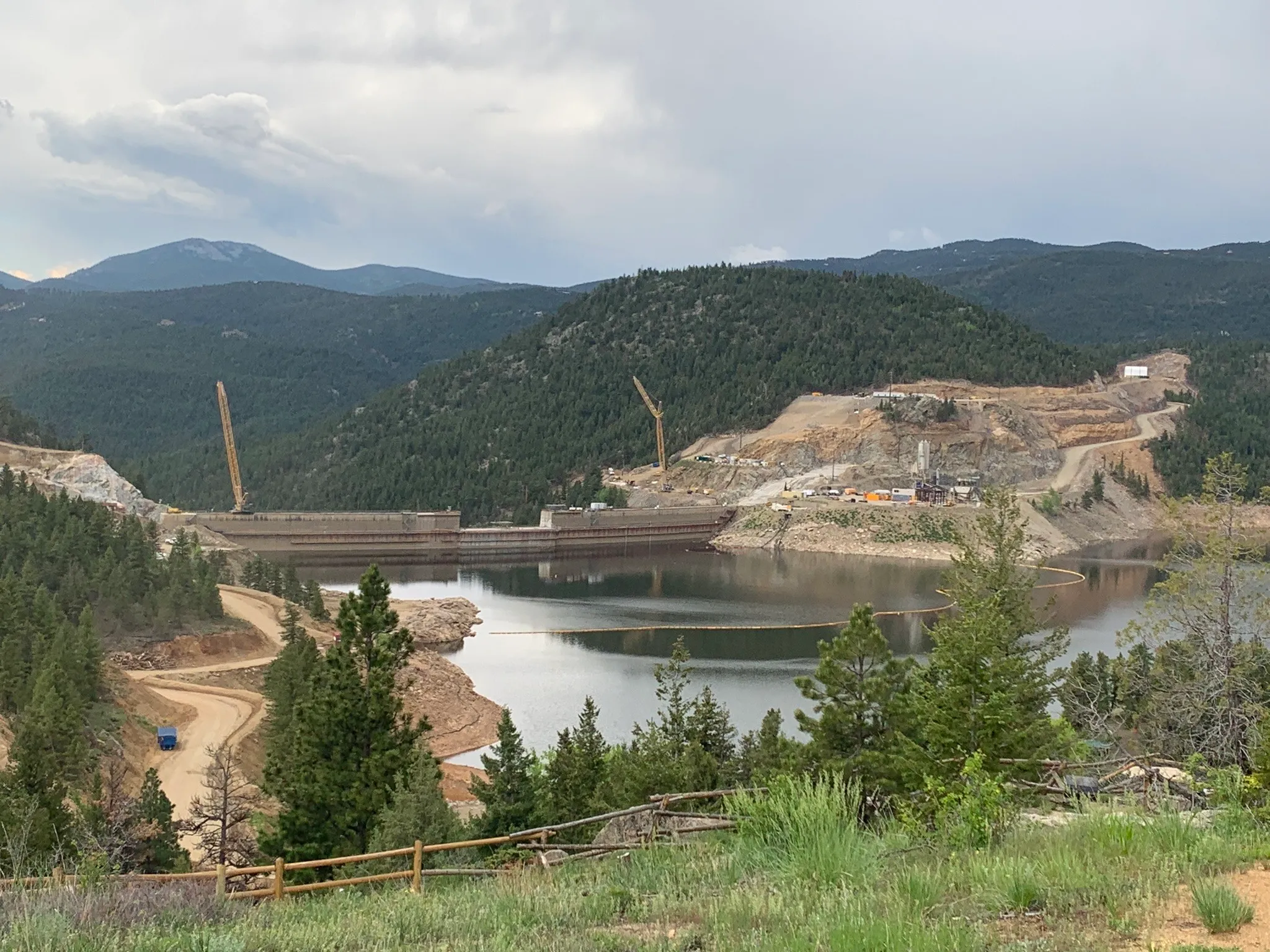
Workers from Denver Water and contractor Kiewit Barnard stand in front of Gross Dam in May 2024 to mark the start of the dam raise process. Photo credit: Denver Water.

Click the link to read the article on the Colorado Politics website (Michael Karik). Here’s an excerpt:

Although she stood by her prior determination that the project permit was unlawful, a federal judge last week decided construction on a major Denver Water infrastructure project should continue for safety reasons…Earlier this spring, U.S. District Court Senior Judge Christine M. Arguello found that, as a result of federal law violations,ย the expansion of Gross Reservoir and Dam should cease permanentlyย and any further construction on the ongoing project would stop temporarily. The pause on construction, Arguello explained, would give her time to hear from engineers and determine what work would need to occur to make the dam safe…

However, on May 29, Arguello retreated from her prior bellicose tone.

“There is a risk of environmental injury and loss of human life if dam construction is halted for another two years while Denver Water re-designs the structure of the dam,” she wrote in her latest order. “Furthermore, the evidence shows that enjoining dam construction would harm Denver Water and the general public by requiring Denver Water to lay off much of its specialized workforce (which also harms those workers), as well as interfere with Denver Waterโ€™s contracts with contractors supplying materials and labor for the Project, which in turn, would significantly increase the costs.”
Dillon Reservoir is expected to fill around the Fourth of July this year and could potentially support up to 2 weeks of raft-able flows on the #BlueRiver — Summit Daily #ColoradoRiver #COriver #aridification

Grays and Torreys, Dillon Reservoir May 2017. Photo credit Greg Hobbs.

Click the link to read the article on the Summit Daily website (Ryan Spencer). Here’s an excerpt:

May 25, 2025

Both the Dillon Reservoir and the Green Mountain Reservoir are expected to reach capacity this summer, Colorado Division of Water Resources division engineer James Heath said at the State of the River in Silverthorne on Thursday, May 22…An about-normal snowpack in Summit County this winter means both reservoirs are expected to โ€œfill and potentially spill,โ€ Heath said. While the snowpack levels were close to normal, the runoff has been slightly below normal because the county went into last winter with dry soils, he said…

The snowpack in the Colorado River Headwaters Basin peaked April 7, about a week earlier than normal, Heath said. At 89% of the 30-year-median…The Blue River Basin [peaked] April 8, at 108% of the 30-year-median, Heath said…

.Dillon Reservoir should reach an elevation of 9,012 feet by June 18, allowing both the Dillon and Frisco marinas to be fully operational by that time. Outflows…should exceed 500 cubic feet per second โ€” the level ideal for rafting the Blue River โ€” around the third week in June and continue until around the Fourth of July weekend, he said.

Green Mountain Reservoir. Photo credit: Colorado Parks & Wildlife

Front Range cities step up opposition to $99M #ColoradoRiver water rights purchase — (Shannon Mullane) #COriver #aridification

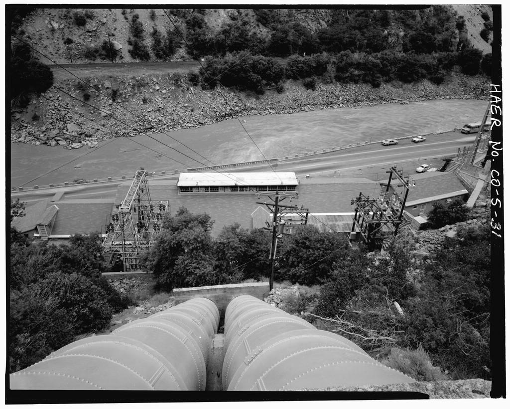
This historical photo shows the penstocks of the Shoshone power plant above the Colorado River. A coalition led by the Colorado River District is seeking to purchase the water rights associated with the plant. Credit: Library of Congress photo

Click the link to read the article on the Water Education Colorado website (Shannon Mullane):

May 22, 2025

Denver, Aurora, Colorado Springs and Northern Water voiced opposition Wednesday to the Western Slopeโ€™s proposal to spend $99 million to buy historic water rights on the Colorado River.

The Colorado River Water Conservation District has been working for years to buy the water rights tied to Shoshone Power Plant, a small, easy-to-miss hydropower plant off Interstate 70 east of Glenwood Springs. The highly coveted water rights are some of the  largest and oldest on the Colorado River in Colorado.

The Front Range providers are concerned that any change to the water rights could impact water supplies for millions of people in cities, farmers, industrial users and more. The Front Range providers publicly voiced their concerns, some for the first time,ย at a meeting of the Colorado Water Conservation Board, a state water policy agency.

The proposed purchase taps into a decades-old water conflict in Colorado: Most of the stateโ€™s water flows west of the Continental Divide; most of the population lives to the east; and water users are left to battle over how to share it.

โ€œIf this proposal were to go forward as presented in the application, it could harm our ability to provide water for essential use during severe or prolonged drought. I think itโ€™s important for the board to understand that,โ€ Jessica Brody, an attorney for Denver Water, told the 15-member board Wednesday. 

Denver Water, the oldest and largest water provider in Colorado, delivers water to 1.5 million residents in the Denver area.

The Colorado River District, which represents 15 Colorado counties west of the Continental Divide, wants to keep the status quo permanently to support river-dependent Western Slope economies without harming other water users, district officials said.

The overstressed and drought-plagued river is a vital water source for about 40 million people across the West and northern Mexico.

โ€œThat right is so important to keeping the Colorado River alive,โ€ Andy Mueller, Colorado River District general manager, said during the meetingโ€™s public comment period. โ€œThis is a right that will save this river from now into eternity โ€ฆ and thatโ€™s why this is so important.โ€

Over 70 people, nearly twice the usual audience, attended the four-hour Shoshone discussion Wednesday, which involved 561 pages of documents, over 20 speakers and a public comment period.

The Western Slope aims to make history

The water rights in question, owned by Public Service Company of Colorado, a subsidiary of Xcel, are some of the most powerful on the Colorado River in Colorado. 

Using the rights, the utility can take water out of the river, send it through hydropower turbines, and spit it back into the river about 2.4 miles downstream.

One right is old, dating back to 1905, which means it can cut off water to younger โ€” or junior โ€” upstream water users to ensure it gets its share of the river in times of shortage. Some of those junior water rights are owned by Denver Water, Aurora, Colorado Springs Utilities and Northern Water.

The rights are also tied to numerous, carefully negotiated agreements that dictate how water flows across both western and eastern Colorado. 

Bicycling the Colorado National Monument, Grand Valley in the distance via Colorado.com

Over time, Western Slope communities have come to rely on Shoshoneโ€™s rights to pull water to their area to benefit farmers, ranchers, river companies, communities and more. 

The Colorado River District wants to buy the rights to ensure that westward flow of water will continue even if Xcel shuts down Shoshone (which the utility has said, repeatedly, it has no plans to do). 

Theyโ€™ve gathered millions of dollars from a broad coalition of communities, irrigators and other water users. The state of Colorado plans to give $20 million to help fund the effort. 

The federal government might give $40 million, but that funding was tied up in President Donald Trumpโ€™s policy to cut spending from big Biden-era spending packages. It was unclear Thursday if the awarded funds will come through, the district said.

Supporters sent over 50 letters to the Colorado Water Conservation Board before Wednesdayโ€™s meeting. 

โ€œI wanted to just convey the excitement that the river district and our 30 partners have, here on the West Slope, to really do something that is available once in a generation,โ€ Mueller said. 

The Front Range water providers all said they, too, wanted to maintain those status quo flows. They just donโ€™t want to see any changes to the timing, amount or location of where they get their supplies.

Under the districtโ€™s proposal, the state would be able to use Shoshoneโ€™s senior water rights to keep water in the Colorado River for ecosystem health when the power plant isnโ€™t in use. 

The Colorado Water Conservation Board is tasked with deciding whether it will accept the districtโ€™s proposal for an environmental use. The meeting Wednesday triggered a 120-day decision making process.

โ€œAny change to the rights will have impacts both intended and unintended, and it is important for the board to understand those impacts to avoid harm to existing water users,โ€ Brody said. 

The water provider plans to contest the Colorado River Districtโ€™s plan within that 120-day period.

How much water is at stake?

The Front Range providers voiced another concern: The River Districtโ€™s proposal could be inflating Shoshoneโ€™s past water use.

Water rights come with upper limits on how much water can be used. Itโ€™s a key part of how water is managed in Colorado: Setting a limit ensures one person isnโ€™t using too much water to the detriment of other users.

For those who have a stake in Shoshoneโ€™s water rights โ€” which includes much of Colorado โ€” itโ€™s a number to fight over.

The River District did an initial historical analysis, which calculated that Shoshone used 844,644 acre-feet on average per year between 1975 and 2003. One acre-foot of water supplies two to three households for a year.

Denver Water said the analysis ignored the last 20 years of Shoshone operations. Colorado Springs, Northern Water and Aurora questioned the districtโ€™s math. Northern was the first provider to do so publicly in August.

โ€œWe think the instream flow is expanded from its original historic use by up to 36%,โ€ said Alex Davis, Aurora Waterโ€™s assistant general manager of water supply and demand.

She requested the board do its own study of Shoshoneโ€™s historical water use instead of accepting the River Districtโ€™s analysis โ€” which would mean the state agency would side with one side of the state, the Western Slope, against the other, Davis said.

The River District emphasized that its analysis was preliminary. The final analysis will be decided during a multiyear water court process, which is the next step if the state decides to accept the instream flow application.

Water court can be contentious and costly, Davis said. 

โ€œThis could be incredibly divisive if we have to battle it out in water court, and we donโ€™t want to do that,โ€ Davis said.

More by Shannon Mullane

Colorado transmountain diversions via the State Engineer’s office

Opinion: Protecting Northeastern #Coloradoโ€™s Water Supply Requires Cooperation, Transparency — Brad Wind (Northern Water) #NISP #PoudreRiver #SouthPlatteRiver

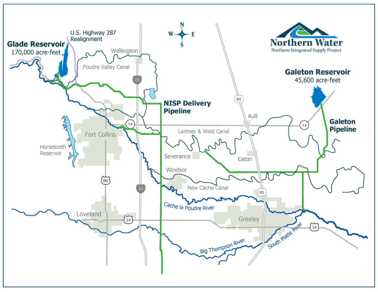
The Northern Integrated Supply Project, currently estimated at $2 billion, would create two new reservoirs and a system of pipelines to capture more drinking water for 15 community water suppliers. An environmental group is now suing the Army Corps of Engineers over a key permit for Northern Waterโ€™s proposal. (Save the Poudre lawsuit, from Northern Water project pages)

Click the link to read the column on the Northern Water website (Brad Wind):

May 20, 2025

You might have read recently about how the Northern Integrated Supply Project, or NISP, is contributing $100 million to a fund for projects to improve the Cache la Poudre River in northeastern Colorado. That funding is part of an agreement between the Northern Colorado Water Conservancy District, known as Northern Water, and the nonprofit group Save the Poudre that will conclude a federal lawsuit against the project.

Itโ€™s an outcome that both sides can accept because of the importance of both the Poudre River and a much-needed water supply to communities throughout the region.

The agreement should catch the attention of Denver metro-area water providers that are looking to export existing irrigation water supplies out of northeastern Colorado to serve their future customers. 

Brad Wind of Loveland is the general manager of Northern Water, which supplies water to more than 1 million people in northeastern Colorado.

For background, NISP was conceived in the 1990s and early 2000s to provide water to the emerging communities of the northern Front Range. The project will consist of two off-channel reservoirs, one located northwest of Fort Collins and one north of Greeley. It also anticipates exchanges of water with nearby farmers eliminating the dry-up of some agricultural land in the future. 

Throughout the lengthy permitting process for NISP, the public has had many opportunities to offer comments and concerns to federal, state and local officials. Some of the concerns were incorporated into mitigation and improvement requirements associated with the project, and all written comments were addressed specifically in the final Environmental Impact Statement produced by the U.S. Army Corps of Engineers.

The $100 million settlement of the federal litigation identifies even more improvements that can be made in the region beyond those required by permitting agencies.

Unfortunately, actions by certain Denver metro-area water providers that anticipate removing water from northeastern Colorado do not undergo such robust scrutiny. Oftentimes, advocates for water resources in the region learn about potential water transfers only when an item appears on a meeting agenda of a metro-area water provider. By then it is too late to consider the regional economic, environmental and social impacts that such a change could produce.

Frequently, these water deals are brokered by third parties who quietly accumulate water and land assets to present them behind closed doors in neat and tidy packages to thirsty cities. There are few, if any, opportunities to discuss how these water transfers will impact local communities in northeastern Colorado or how these impacts could be mitigated by those who seek to move water to the Denver metro area.  

The half-million residents who receive water from NISP participants are going to pay billions of dollars to develop water resources for their communities while addressing concerns in the Poudre River watershed. At the same time Denver metro communities are working to undercut the existing supplies that previous northeastern Colorado residents have invested in and relied upon for decades. 

Water providers in the Denver area need to be part of the long-term solution to how our northeastern Colorado communities remain vibrant, not distant parties to single point-in-time transactions that provide a perpetual benefit to communities beyond the horizon. 

If native water supplies must depart for the Denver metro area from northeastern Colorado, it is appropriate that the new water user should not just pay for the costs to acquire water but also offset the impacts to northeastern Coloradoโ€™s degraded quality of life, and diminished regional economy. 

All of our futures are diminished by the loss of water from our region. Public processes and mitigation can lessen, to a degree, the perpetual impacts such a loss will endure.

Spring #snowpack: Slightly better than advertised, weak statewide figures obscure more nuanced scenario for Denver Water as we enter runoff season — Todd Hartman (News on Tap)

North Fork Snake River. Melted snow is the primary source of drinking water for the 1.5 million people who rely on Denver Water every day. Photo credit: Denver Water.

Click the link to read the article on the Denver Water website (Todd Hartman):

May 16, 2025

News headlines this spring offered a bleak picture of Coloradoโ€™s snowpack heading into the spring runoff season. But, as always with headlines, it is best to also read the story that follows.

Because the story for Denver Water isnโ€™t quite so dour. 

Snowpack woes hit Coloradoโ€™s southern half hard. For Denver Water, positioned farther north, the water supply looks better.

First, letโ€™s do the numbers. 

Denver Water had a weak showing in the South Platte River Basin, with peak snowpack hitting just 84% of normal and โ€” most unhelpful of all โ€” peaking on April 6, 19 days earlier than typical.

The news was far better in the Colorado River Basin (north of the South Platte River Basin), which accounts for the other half of Denver Waterโ€™s supply. There, peak snowpack clocked in at 109% on April 25, right on the mark for a typical peak date.

โ€œOverall, not great, but not terrible either,โ€ summed up Nathan Elder, water supply manager for the utility. 

The best news for Denver Water: The utility is starting the runoff and reservoir-filling season with existing storage levels about 2% above average. 

Thatโ€™s a credit to its customersโ€™ efforts to conserve water and translates into a good chance that Denver Water will be able to fill its storage reservoirs that help 1.5 million people get through the summer hot season.

But โ€œfillโ€ doesnโ€™t mean โ€œspill.โ€ That is, there wonโ€™t be excess water to spill into rivers in what can make for dramatic visuals and provide an extra boost to river flows. 

โ€œWe hope to fill our reservoirs right to the brim, but thatโ€™s where it stops,โ€ Elder said.

Denver Waterโ€™s planners are concerned about a hot-and-dry trend taking hold in May, and emphasize the need for residents to adhere to the utilityโ€™s annual summer watering rules that allow irrigation only in the evening and morning hours (between 6 p.m. and 10 a.m.) and limit irrigation to no more than three days a week โ€” preferably just one or two days when springtime temperatures are lower.

And watch the skies. When we do get a good rainstorm, turn your sprinkler dial to โ€œoffโ€ for a few days.

The generally poor snowpack and early runoff in much of the state, including in the South Platte River Basin, also stokes concerns for a rough fire season, as 9News meteorologist Chris Bianchi pointed out in a May 13, 2025, story: 

โ€œThis yearโ€™s snowpack levels resemble those recorded in 2018, 2012, 2002 and 1992. All of which were marked by intense wildfire activity. Three out of those four years saw large-scale fires, raising concerns that 2025 could follow a similar trajectory unless weather patterns shift dramatically.โ€

And, on a too-long-didn’t-read basis, hereโ€™s Bianchiโ€™s tweet that summed up the story:

Denver Waterโ€™s watershed experts agree that conditions could increase wildfire risk.

โ€œThe risk of wildfire is relatively low when there is snow on the ground. When snowpack melts rapidly, vegetation can dry out quickly and become susceptible to wildfire ignitions,โ€ said Madelene McDonald, a watershed scientist and wildfire specialist for Denver Water.

Though McDonald notes that experts anticipate โ€œaverageโ€ wildfire behavior in Colorado in 2025, that still means thousands of fires that could collectively affect more than 100,000 acres in the state. 

โ€œItโ€™s important to stay vigilant and prepared to experience wildfire under any snowpack conditions or fire outlook scenarios,โ€ she said.

An April pivot

The current outlook is a pivot from what had been looking like a normal year for snowpack as recently as April 1, Elder said.

โ€œFor Denver Water, April is typically a month where we build snow,โ€ he said. 

But that didnโ€™t happen this year, and by mid-May the snowpack had shriveled to half its typical percentage.

The tepid spring in the South Platte River Basin also highlights the importance of Denver Waterโ€™s Gross Reservoir Expansion Project, which recently has been slowed in federal court. (Read Denver Waterโ€™s recent statement on a May 6 court hearing.) 

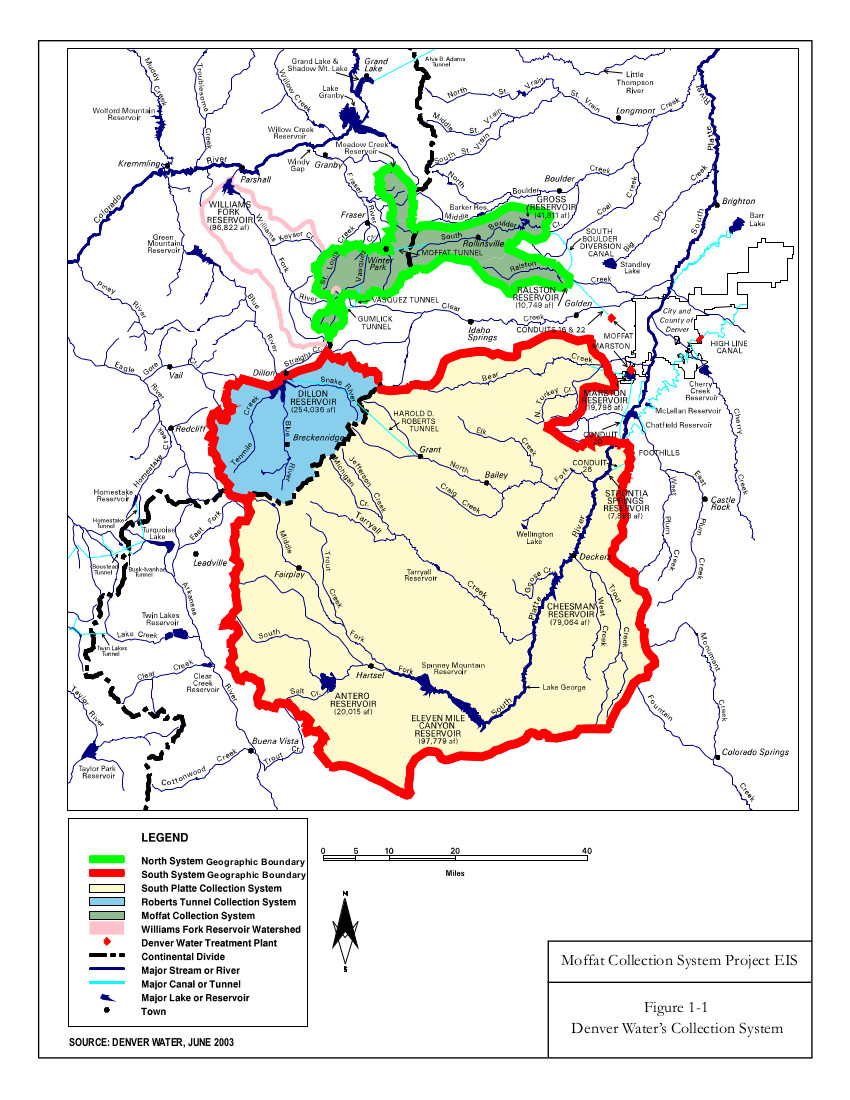
That project will expand the reservoir and add roughly 80,000 acre-feet of water storage capacity in the utilityโ€™s north system, which gathers snowmelt from the Upper Colorado River Basin. That additional water storage will provide a buffer to protect the utilityโ€™s customers from the effects of years when the snowpack is weaker, like this year, in Denver Waterโ€™s separate and unconnected south system.

โ€œOur system is robust but suffers from significant imbalance,โ€ Elder said. 

โ€œWe rely too heavily on our south system, on the South Platte, which accounts for 90% of our storage,โ€ he said. โ€œIncreasing storage to the north will give Denver Water far more flexibility to handle these weaker snowpack years on the South Platte.โ€

And years marked by a weaker snowpack in the South Platte River Basin have become more common. 

In four of the last five years, the South Platte snowpack above Denver Waterโ€™s collection system has peaked below normal. And in that fifth year โ€” last year โ€” it barely cleared the โ€œnormalโ€ bar at 101%. All of which amplifies the need for the Gross Reservoir Expansion Project.

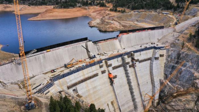
Raising Gross Dam, seen here on April 8, 2025, will nearly triple the water storage capacity of the reservoir behind it. The project has been in the permitting and review process for 23 years. Photo credit: Denver Water.

Now, as June approaches, water managers will turn their focus to runoff levels, temperatures and fire potential. And come summer, they will once again โ€” as always โ€” hope for a big dose of monsoonal moisture. 

Those big rainstorms not only deliver a boost to rivers and reservoirs but prompt attentive customers to turn off their irrigation system and let their grass and plants drink up natureโ€™s soaking bounty. 

Remember, the less you pour, the more your water utility can store.

And itโ€™s never a bad time to consider transforming your landscape, or even parts of it. 

Denver Water has a new guide to help: the DIY Landscape Transformation Guide, and it includes ways to eradicate grass in the areas where you want to remodel your landscape with native plants and other changes.

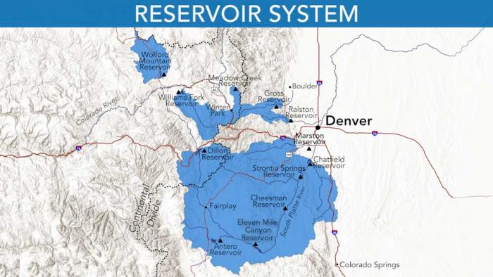
Denver Water relies on a network of reservoirs to collect and store water. The large collection area provides flexibility for collecting water as some areas receive different amounts of precipitation throughout the year. Image credit: Denver Water.

Northern #Colorado will soon have new reservoirs, but the cost to build them has skyrocketed — Alex Hager (KUNC.org) #PoudreRiver #SouthPlatteRiver

The Cache la Poudre River flows through Bellevue, Colorado on May 12, 2025. Water from the river will be used to fill the nearby Glade Reservoir once it’s built. The cost to build the new water storage project has grown from $400 million to $2.2 billion. Alex Hager/KUNC

Click the link to read the article on the KUNC website (Alex Hager):

May 15, 2025

This story is part of ongoing coverage of water in the West, produced by KUNC in Colorado and supported by the Walton Family Foundation. KUNC is solely responsible for its editorial coverage.

Thereโ€™s a stretch of highway in Larimer County where prairie grasses sway with each passing vehicle. Cars, horse trailers and semi trucks zip through the valley on their way between Fort Collins and Laramie. Soon, itโ€™ll be under more than 200 feet of water.

U.S. Highway 287 runs through the future site of Glade Reservoir. The Larimer county Board of County Commissioners approved the 1041 Land Use Permit for NISP in September, 2020. Photo credit: Northern Water

Itโ€™s the planned site of Glade Reservoir, the cornerstone of a massive new water storage system designed to meet the demands of fast-growing towns and cities in Northern Colorado. After more than two decades of permitting, planning and environmental lawsuits, itโ€™s closer than ever to breaking ground.

But along the way, some things changed. Over the years, costs to build the reservoir system โ€” and reroute seven miles of U.S. Highway 287 โ€” have ballooned. Price estimates for the Northern Integrated Supply Project, often referred to as NISP, went from $400 million to $2.2 billion. Because of that, some of the towns that signed up to use its water are cutting back on their involvement before the reservoir system stores a single drop.

Northern Water, the agency building NISP, has projected confidence that it will still get built as planned. The long road from idea to construction, and the things that have changed along the way, can tell us a lot about how Northern Colorado uses water, and how much it costs to keep taps flowing.

The Northern Integrated Supply Project, currently estimated at $2 billion, would create two new reservoirs and a system of pipelines to capture more drinking water for 15 community water suppliers. (Northern Water project pages)

Rising costs

When it was first pitched, in the early 2000s, NISP garnered support as a way to make sure small towns with fast-growing populations could host new housing developments without going dry.

For a tiny town like Severance, that was an attractive proposition. Just 11 years ago, about midway through the NISP planning process, the town had a population of about 3,000. Thatโ€™s when Nicholas Wharton took the job as town manager. Since then, heโ€™s overseen the installation of the townโ€™s first stoplight, the from-scratch development of its own police department and a homebuilding boom that has nearly quadrupled Severanceโ€™s population.

Signing on to NISP, he said, was a way to make sure Severance had enough water for all that growth.

โ€œI think for smaller towns,โ€ he said, โ€œIt was a great idea back when it was affordable to us.โ€

Wesley Lavanchy, the town administrator for Eaton, Colo., poses outside of his office on April 15, 2025. His town is one of four water agencies that reduced the amount of water it would store in NISP, and the amount it would pay to keep it there. Alex Hager/KUNC

Since then, Severance has cut back on the amount of water it will store in NISP, and the amount it will pay to be a part of the project. At one point, the town held 2,000 shares of the project. In 2024, it sold off 1,500 of those shares. Wharton said the town council might try to sell off even more.

And Severance isnโ€™t alone.

Due West, in Eaton, town officials also got cold feet. They were one of four NISP shareholders to offload a portion of their involvement in the new reservoir project on the same day in July 2024.

For years, the water agencies that were part of NISP were mostly focused on paperwork โ€” making sure the project had the permits it needed to get built. Then, there was a lawsuit from environmentalists standing in the way. But after NISPโ€™s proponents were mostly seeing green lights on permits and decided to settle a major lawsuit, the focus shifted to money.

โ€œI think the question for us now is, how do we afford this?,โ€ said Wesley Lavanchy, Eatonโ€™s town administrator. โ€œMoving forward, how much can we afford? It’s like chocolate cake. You like it, it tastes great, but you can’t eat the whole thing.โ€

Ultimately, Eaton decided to sell off more than half of its NISP shares.

โ€œI suspect that more entities would have been able to hold their commitment had the permitting process not drug on so long, the cost escalated, the litigation kind of wrapped things up,โ€ Lavanchy said.

Cheaper alternatives

While the cost to build NISP has gone up, the cost of other water sources has gone down. Eaton and Severance said itโ€™s getting easier to afford shares of the Colorado-Big Thompson project, which was a big motivator in their pullback from NISP.

That project, referred to as CBT, pipes water from the Colorado River across the continental divide. It flows underneath Rocky Mountain National Park and into major reservoirs along the Northern Front Range, such as Horsetooth Reservoir near Fort Collins and Carter Lake outside of Loveland.

Water from the Colorado-Big Thompson project is managed by Northern Water, the same agency building and operating NISP.

Boats cruise across Horsetooth Reservoir near Fort Collins, Colorado on May 12, 2025. The reservoir holds water from the Colorado-Big Thompson project, which has seen prices level off in recent years. Glade Reservoir is expected to be even larger than Horsetooth. Alex Hager/KUNC

For years, the CBT system was the main way for growing cities in Larimer and Weld Counties to get water for residential development. Typically, farms have sold their portion of CBT water to cities, towns, or developers. Occasionally, they are taken to auction, where cities bid against one another for water stored in those big reservoirs.

The cost of that water skyrocketed between 2010 and 2022. Estimated prices, adjusted for inflation, went from less than $20,000 per share, to around $100,000 per share, according to data from the consulting firm Westwater research. Since 2022, that soaring rise has leveled out.

โ€œWe believe that’s largely driven by a softening in the home construction sector,โ€ said Adam Jokerst, a Fort Collins-based regional director for Westwater. โ€œA lot of CBT purchases are by municipalities and developers who dedicate them to municipalities. And when new home construction slows, we see less demand for those shares.โ€

How did NISP get so expensive?

Northern Water said the price to build NISP has been climbing for about 15 years. Brad Wind, the agencyโ€™s general manager, cited inflation and rising interest rates as major drivers. He doesnโ€™t, however, expect that to stop or significantly change the reservoir project.

โ€œIt’s an expensive project,โ€ Wind said. โ€œWe and the participants advancing the project like it was envisioned.โ€

The lengthy process to get the projectโ€™s two reservoirs โ€” Glade, and a smaller one called Galeton reservoir โ€” from concept to construction gave time for the winds of economic change to shift direction. Itโ€™s not uncommon for a massive dam project like NISP to take more than fifteen years to attain a laundry list of environmental permits.

The project also faced opposition from local governments and nonprofits. At one point, Fort Collins voted to oppose the project. The most significant roadblock came from the environmental nonprofit Save the Poudre.

The group rallied local support and took legal action to try and stop NISP. At a 2015 event, Save the Poudre director Gary Wockner told a crowd of supporters that he would โ€œfight to stop the project for as long as it takes.โ€

In late February, Wocknerโ€™s group settled for $100 million dollars. Northern Water will pay that sum into a trust over the course of the next two decades, and the money will be used to fund river improvement projects. In the intervening time, though, the price tag to build NISP likely grew significantly.


New Northern Colorado reservoirs moving ahead after settlement of NISP lawsuit — Alex Hager, March 5, 2025.


Wind said Northern plans to hire a contractor that could find ways to bring down the price by changing construction methods, but doesnโ€™t expect โ€œsubstantial reductionsโ€ to building costs, especially with rising prices of imported construction materials.

Over the years, the towns and water agencies that wanted to use NISP signed periodic agreements to stay part of the project. Now, time is ticking for those participants to sign a binding contract.

Eatonโ€™s Lavanchy said that upcoming contract made his town take a harder look at their water needs, and whether those needs would be satisfied by NISP.

โ€œWe’re not dating anymore,โ€ he said, โ€œWe’re getting married, and there’s no way out. Divorce is not an option. So it’s like, โ€˜Let’s be smart and think about, what are these obligations going to run us?โ€™โ€

โ€˜Demand continues to increaseโ€™

Even as some entities cut back on their financial ties to NISP, the project still has momentum.

For one, those towns and water agencies looking to sell their shares found a willing buyer. Eaton, Severance, Fort Lupton and the Left Hand Water District all sold their shares to the Fort Collins Loveland Water District.

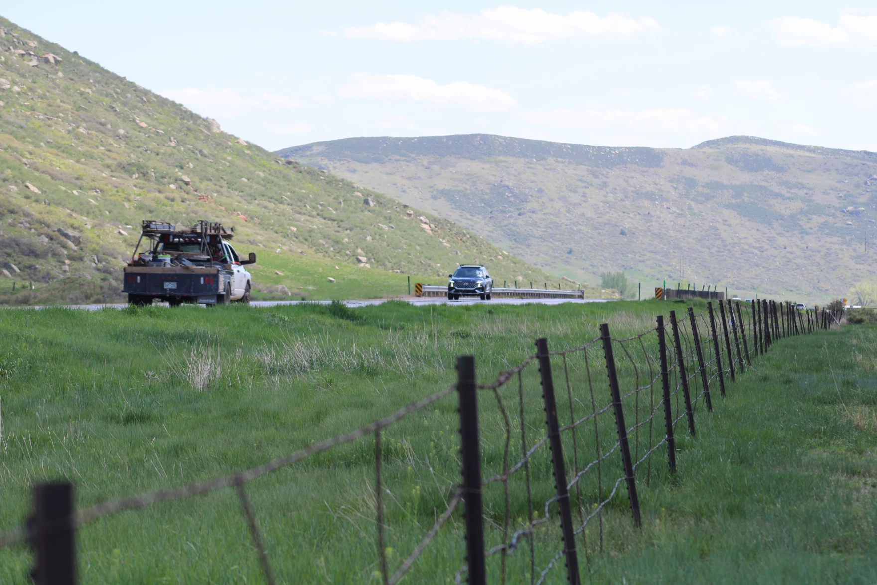
Vehicles drive on U.S. Highway 287, near Bellevue, Colo. on May 12, 2025. The highway will be rerouted to make way for a massive new reservoir. Alex Hager/KUNC

The Fort Collins Loveland Water District, which serves an area roughly between Harmony Road and State Route 34, declined to be interviewed for this story.

Second, NISP has a total of 15 participants, and many of them are still on board for the same amount of water they signed up for years ago.

โ€œNo matter what,โ€ Severanceโ€™s Wharton said, โ€œIn one way, you’ll see those 15 probably still continue to be a part of it no matter what, because everybody does realize how precious that water is and how this will be one of the last [big reservoirs.] I don’t think anybody’s discouraged.โ€

Even the towns that reduced the amount of water theyโ€™ll pay to use from NISP are keeping some. Severance and Eaton said they want to make sure theyโ€™re getting water from a diverse group of sources, especially with climate change and political bickering threatening their main source of water โ€” the Colorado River via the CBT.

Ultimately, the fast-growing region served by Northern Water โ€” from Boulder County to Fort Collins, and east to Fort Lupton โ€” will keep needing water for a future that will likely see plenty of new home construction.

โ€œIt doesn’t appear that folks are shying away from moving to Northern Colorado,โ€ Brad Wind said. โ€œEither from within our state or from outside of our state, so the demand continues to increase for a high quality water supply, which NISP will produce.โ€

Update on Gross Reservoir Expansion Project following May 6, 2025, testimony: Denver Water provides statement on the risk presented by delaying construction — News on Tap

Storm pattern over Colorado September 2013 — Graphic/NWS via USA Today

Click the link to read the release on the Denver Water website:

May 8, 2025

Following a day of testimony on May 6, Denver Water has been asked by U.S. District Court Judge Christine Arguello to provide the court with the utility’s final summary highlighting its position following the witness testimony and exhibits. There isnโ€™t a specific timetable set for this yet.

The focus of the hearing was for the judge to determine if construction can safely stop while Denver Water moves forward on an additional permitting review as the court ruled on April 3. Here is Denver Waterโ€™s statement on the risk presented by delaying construction:

Denver Water has already started the appeal process with the 10th Circuit Court of Appeals. As part of this, the project has been allowed to continue (under a temporary stay) while legal proceedings are underway.

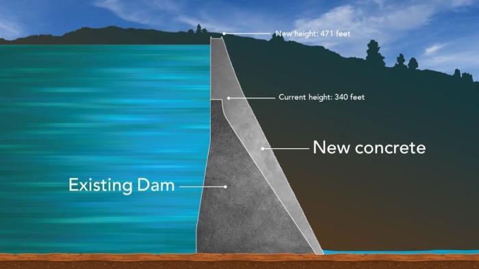
Roller-compacted concrete will be placed on top of the existing dam to raise it to a new height of 471 feet. A total of 118 new steps will make up the new dam. Image credit: Denver Water.

Regional Pool Allocation Set at โ€ฏ23,000โ€ฏAcre-feet; Sealed Bids Due 2 p.m. Thursday, May 22, 2025 — Northern Water

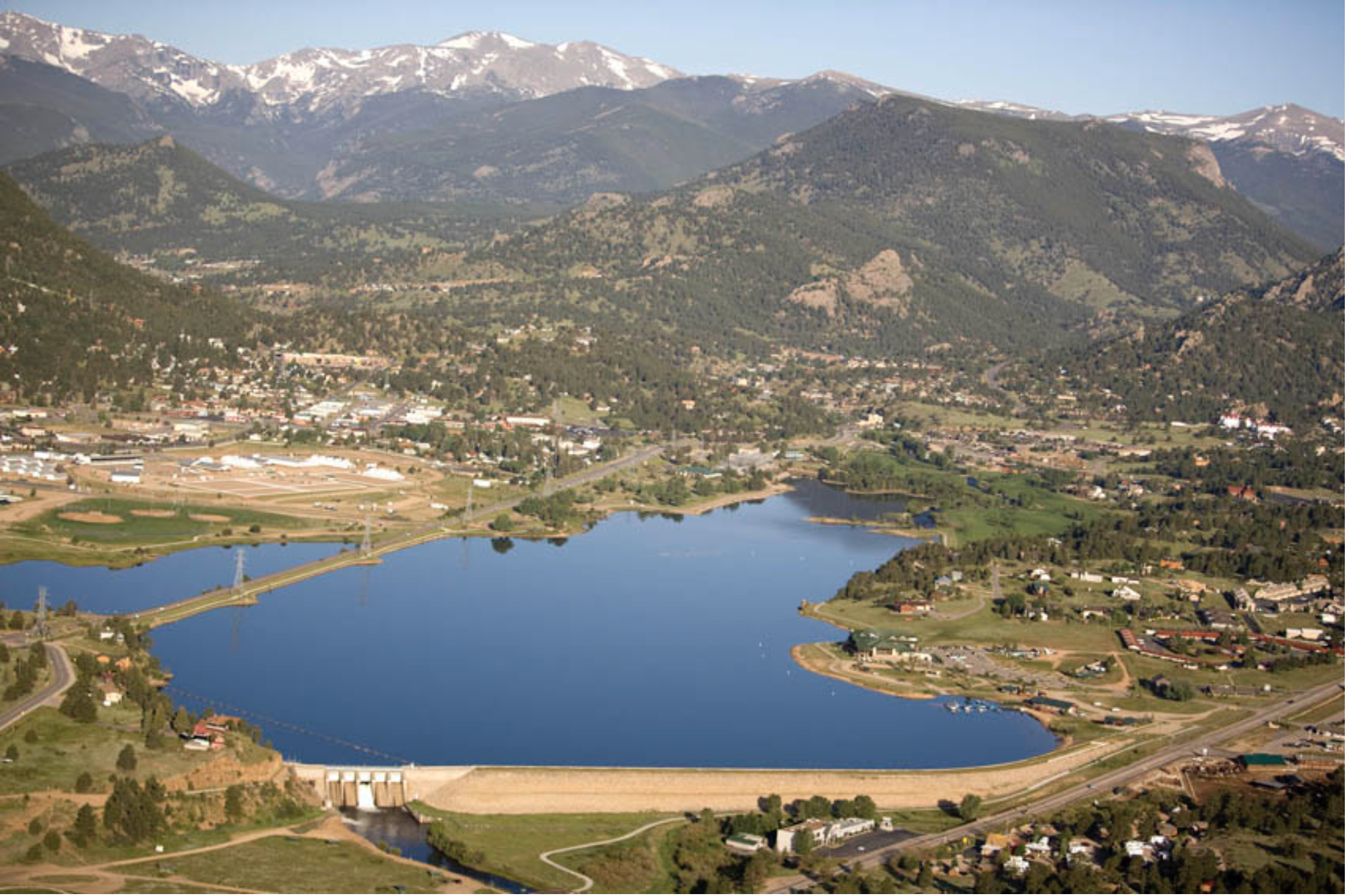
Aerial view of Lake Estes and Olympus Dam looking west. Photo credit Northern Water.

From email from Northern Water (Jeff Stahla):

May 9, 2025

The Northern Water Board of Directors allocatedโ€ฏ23,000โ€ฏacre-feet of Regional Poolโ€ฏProgram (RPP)โ€ฏwater during itsโ€ฏMayโ€ฏ8, 2025, Board meeting. RPPโ€ฏwater is available for lease byโ€ฏeligibleโ€ฏNorthern Coloradoโ€ฏwater users, withโ€ฏsealedโ€ฏbids due 2 p.m.โ€ฏMayโ€ฏ22, 2025. Bid prices per-acre-foot must be greater than or equal to $33.80, a floor price the Board selected based on theโ€ฏ2025โ€ฏagricultural assessment rate.โ€ฏLate bids will not be considered.

The allocation will be available to bidders from two subpools of 11,500 acre-feet each; one that delivers water from Horsetooth Reservoir, and a second that delivers to water users south of Horsetooth Reservoir, including the Big Thompson River, St Vrain Creek and Boulder Creek.

The following forms are required to submit a bid:โ€ฏ

  • Pre-Approval Formโ€ฏโ€“โ€ฏTo confirm eligibility, interestedโ€ฏbidders must email or mail the Pre-Approval Form to Northern Water. A new Pre-Approval Form is required each year.โ€ฏโ€ฏโ€ฏ
  • Carrier Consent Formโ€ฏโ€“โ€ฏIf the RPP water will be deliveredโ€ฏbyโ€ฏa carrier, such as a ditch or reservoir company, biddersโ€ฏandโ€ฏtheir carriers must complete the Carrier Consent Form or provide a signed agreement stating that the carrier will deliver the RPP water to the bidder. This form must also be emailed or mailed to Northern Water.โ€ฏโ€ฏ
  • Bid Formโ€ฏโ€“โ€ฏSealedโ€ฏbidsโ€ฏwill be accepted atโ€ฏNorthern Waterโ€™s headquarters throughโ€ฏaโ€ฏโ€œself-serveโ€โ€ฏprocess.โ€ฏBidders will sign inโ€ฏat a kiosk in the Building Aโ€ฏlobby at Northern Water, 220 Water Ave., Berthoud, and print aโ€ฏbid labelโ€ฏfor their sealed bidโ€ฏenvelope. Theโ€ฏlabelโ€ฏwillโ€ฏidentifyโ€ฏtheโ€ฏbidderโ€ฏname, date and time stamp,โ€ฏand bid number. Bidders are then asked to secure the label toโ€ฏtheโ€ฏbidโ€ฏenvelopeโ€ฏand place it in the drop box.โ€ฏSealed bidsโ€ฏmay alsoโ€ฏbe mailed to Northernโ€ฏWater, butโ€ฏbids must be receivedโ€ฏbefore the deadline.โ€ฏโ€ฏ

Sealed bids are due by 2 p.m.โ€ฏThursday, Mayโ€ฏ22,โ€ฏat Northern Waterโ€™s headquarters, 220 Water Ave., Berthoud, CO 80513.โ€ฏAs described above,โ€ฏsealedโ€ฏbids can beโ€ฏmailedโ€ฏor hand delivered; email and fax bid formsโ€ฏwillโ€ฏnotโ€ฏbeโ€ฏaccepted. RPP leases within each subpool will be awarded based on highest bids per acre-foot.โ€ฏSealed bids will be opened at 2:10 p.m. Thursday, May 22, in the Grand Lake Conference Room of Building A at Northern Water.

Questions regarding the Regional Pool Program and bidโ€ฏsubmittalโ€ฏcan be emailed toโ€ฏregionalpool@northernwater.orgโ€ฏor by callingโ€ฏSarah Smith at 970-622-2295 orโ€ฏWater Schedulingโ€ฏat 970-292-2500.

Designer of #Coloradoโ€™s Gross Dam expansion warns of possible flooding if judge halts project — Jerd Smith (Fresh Water News) #ColoradoRiver #SouthPlatteRiver

Denver Water is helping ensure its future water security with the Gross Reservoir Expansion Project. When the project is complete, it will nearly triple the Boulder County reservoirโ€™s capacity to 119,000 acre-feet. CREDIT: HEATHER SACKETT/ASPEN JOURNALISM

Click the link to read the article on the Water Education Colorado website (Jerd Smith):

May 8, 2025

Adam engineer who designed a major expansion of Gross Reservoir Dam in Boulder County told a federal judge Tuesday that the raising of the dam, facing a potential halt due to an April federal court ruling, needs to proceed to protect public safety.

Mike Rogers, the civil engineer who designed the $531 million expansion of the dam,  said bad weather could create flood conditions that would lead to a catastrophic failure similar to what occurred with the Oroville Dam failure in California in 2017.

But Stephen Rigbey, a Canadian dam safety expert testifying for Save The Colorado, said any issues with putting the construction project on hold, even in its partially-complete state, could be addressed, and that the risk of a catastrophic failure was โ€œnegligible.โ€

Workers from Denver Water and contractor Kiewit Barnard stand in front of Gross Dam in May 2024 to mark the start of the dam raise process. Photo credit: Denver Water.

Rogersโ€™ and Rigbeyโ€™s testimony Tuesday came during a federal hearing in Denver, after which U.S. District Court Judge Christine Arguello will determine whether to allow construction to move forward on the Denver Water project or whether the construction will be paused until new federal reviews she has ordered are completed and legal questions are answered.

But at the end of Tuesdayโ€™s hearing, Arguello said the parties to the case had not provided enough information for her to make a decision and ordered them to submit more data later this month.

The massive construction project has raised fierce opposition in Boulder County and prompted several legal challenges from Save The Colorado, a group that advocates on behalf of rivers. Though its early lawsuits failed, in 2022 the river defenders won an appeal that put the legal battle back in play. Despite months of settlement talks, no agreement was reached.

Denver Water’s entire collection system. Image credit: Denver Water.

Boulder County Commissioner Ashley Stolzmann was unmoved by Rogersโ€™ testimony, saying she hopes the judge halts the work to prevent further environmental damage in Boulder County and to protect the Fraser River, a tributary to the Upper Colorado River. The Fraser has served as the source of water for Gross Reservoir since the 1950s, when it was built.

โ€œItโ€™s incredibly disappointing that Denver has chosen to move forward,โ€ Stolzmann said. โ€œWith climate change, it really is a time for different entities to work together to repair the climate. I want to see Denver seek alternative solutions.โ€

Denver Water first moved to raise Gross Dam more than 20 years ago when the water provider began designing the expansion and seeking the necessary federal and state permits. Denver Water has said raising the dam and expanding the reservoir is necessary to ensure it has enough water throughout its delivery system and to help with future water supplies as climate change continues to reduce streamflows.

The Gross Reservoir Expansion Project involves raising the height of the existing dam by 131 feet. The dam will be built out and will have โ€œstepsโ€ made of roller-compacted concrete to reach the new height. Image credit: Denver Water

After years of engineering, environmental studies and federal and state analyses, Denver received a permit from the U.S. Army Corps of Engineers and construction began in 2022. It has involved taking apart a portion of the original dam and raising its height by 131 feet to nearly triple the reservoirโ€™s storage capacity to 119,000 acre-feet from 42,000 acre-feet.

The case took center stage again April 3, when Judge Arguello put a temporary halt to construction of the higher dam, at Save The Coloradoโ€™s request.

In that high-profile ruling, Arguello said, in part, that the Army Corps should have considered whether ongoing climate change and drought would leave the Colorado River and Western Slope waterways too depleted to safely allow transfer of Denver Waterโ€™s rights into a larger Gross Reservoir for Front Range water users.

At the same time, she ordered a permanent injunction prohibiting enlargement of the reservoir, including tree removal and water diversion, and impacts to wildlife.

Almost immediately, Denver Water filed for temporary relief from the order, saying, in part, that it would be unsafe to stop work as the incomplete concrete walls towered above Gross Reservoir.

Arguello granted that request, too, allowing Denver to continue work on the dam considered necessary for safety.

Denver Water has also filed an appeal with the U.S. 10th Circuit Court of appeals, seeking to permanently protect its right to continue building the dam. The appeals court is expected to wait for the lower court to rule, before considering Denver Waterโ€™s request.

More by Jerd Smith

Udall/Overpeck 4-panel Figure Colorado River temperature/precipitation/natural flows with trend. Lake Mead and Lake Powell storage. Updated through Water Year 2024. Credit: Brad Udall

The #ColoradoRiver needs some ‘shared pain’ to break a deadlock, water experts say — Alex Hager (KUNC.org) #COriver #aridification

Dusk falls on Lake Powell near Bullfrog Marina on July 15, 2024. A new letter from water policy experts gives negotiators some recommendations on how to sustainably manage the Colorado River in the future. Alex Hager/KUNC

Click the link to read the article on the KUNC website (Alex Hager):

May 3, 2025

This story is part of ongoing coverage of the Colorado River, produced by KUNC in Colorado and supported by the Walton Family Foundation. KUNC is solely responsible for its editorial coverage.

The seven states that use the Colorado River are deadlocked about how to share it in the future. The current rules for dividing its shrinking supplies expire in 2026. State leaders are under pressure to propose a new sharing agreement urgently, so they can finish environmental paperwork before that deadline.

Right now, they donโ€™t appear close to an agreement, so a group of prominent Colorado River experts co-signed a letter outlining seven things they want to see in the next set of rules.

The letter gives a clear, concise list of recommendations for ways to keep taps flowing while protecting tribes and the environment. Whether the states will listen is another matter entirely.

โ€˜Shared painโ€™

The letter, written by a group of academics and retired policymakers, makes no bones about it: states need to find a collective solution to their collective problem. And some of them might not be happy.

State leaders have been reluctant to volunteer cutbacks, and have largely stayed divided along a decades-old fault line. On one side, the Upper Basin โ€“ which consists of Colorado, Utah, Wyoming and New Mexico. The other side, the Lower Basin, is made up of California, Arizona and Nevada.

The recent letter is interesting in part because itโ€™s co-authored by people from both sides of the Colorado River debate. Eric Kuhn led an agency that defends Western Coloradoโ€™s water. Kathryn Sorensen led Phoenixโ€™s water department.

The letter was also written by Anne Castle, who has worked in federal water policy positions, and Jack Schmidt, a water researcher at Utah State University. Co-authors John Fleck and Katherine Tara research water policy at the University of New Mexico.

The authors write that states need to engage in some level of โ€œshared pain,โ€ meaning cutbacks to the amount of water that flows to farms, homes, and businesses.

โ€œโ€˜Sharedโ€™,โ€ the letter writes, โ€œDoes not mean equal, either in amount, triggers, or duration.โ€

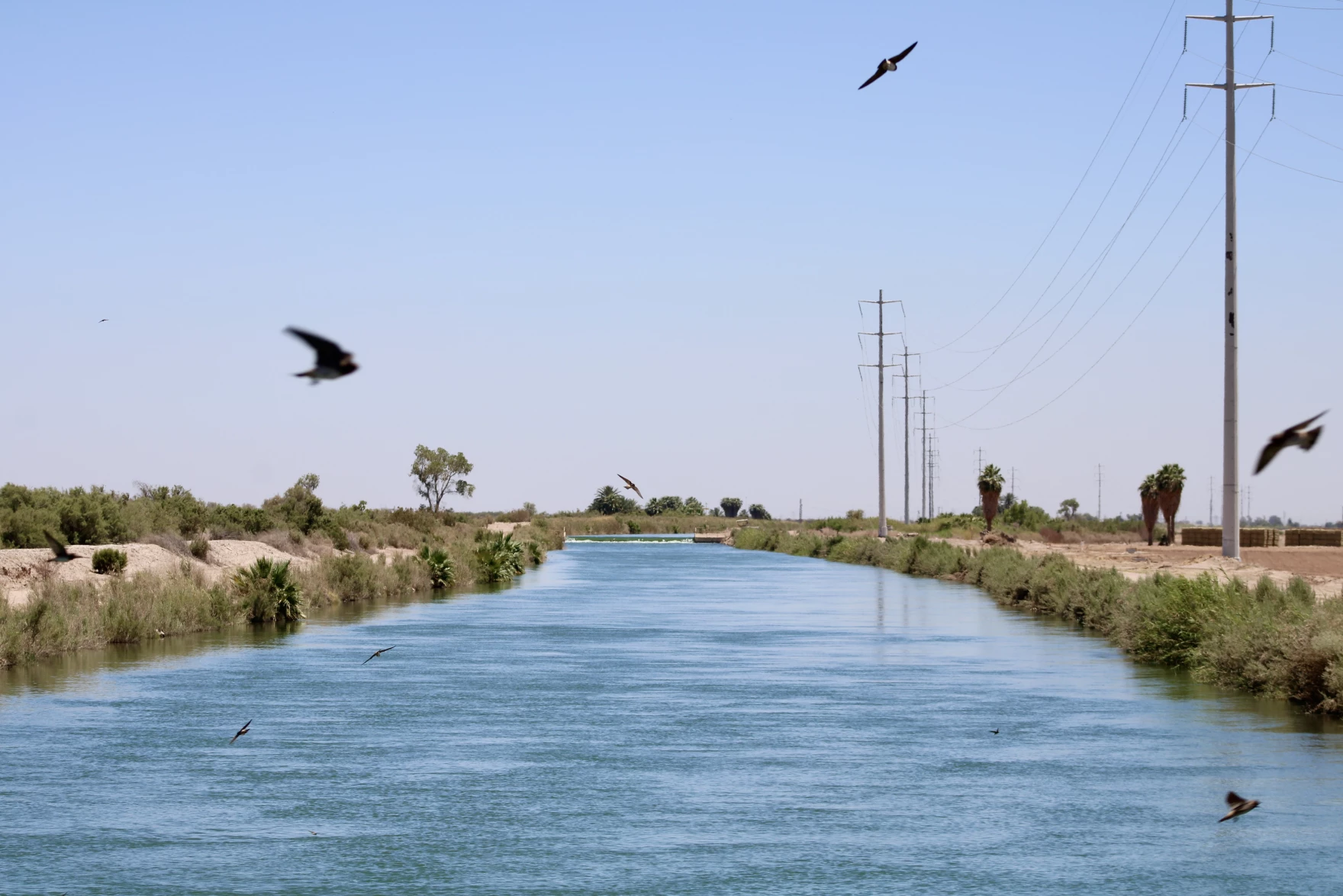
Water from the Colorado River flows through the East Highline Canal on its way to farms in the Imperial Valley on June 20, 2023. The Colorado River’s single largest user has taken federal money through incentive programs to cut back on water use. Alex Hager/KUNC

The Lower Basin states have already proposed relatively modest cutbacks, and the Upper Basin seems to be digging in its heels on the idea that they should not have to give up any water at all.

This letter pushes back on that stance.

โ€œThere’s lots of wonderful legal arguments about why it shouldn’t be me that needs to use less water,โ€ Anne Castle, one of the letterโ€™s authors, told KUNC. โ€œBut in order to have a viable and politically viable agreement, everybody has to do a share.โ€

Other recommendations

In addition to calling for states to put their heads together, the authors also warned against leaning too hard on federal checks as a way to conserve water. Money from the federal government has been a key part of avoiding catastrophe on the Colorado River in recent years. Hundreds of millions of dollars have gone to big water users, often farmers, as an incentive to use less water.

Those funds have come under threat during President Donald Trumpโ€™s second term. The letter says new rules for the Colorado River โ€œcannot assume that federal taxpayers will reimburse Western water users over the long term to forgo the use of water that does not exist.โ€

The letter goes on to advocate for groups that can sometimes be an afterthought in Western water policy. It essentially re-ups an earlier call from a group of tribes in the Colorado River basin, which are asking for a bigger seat at the table after more than a century of exclusion. It also pushes for new rules to be more flexible, which would make it easier to protect river ecosystems. That mirrors similar comments from a group of nonprofits.

The shortest and final recommendation in the letter says that any new Colorado River rules have to make sure thereโ€™s enough water to keep people safe and healthy.

โ€œThere must be absolute protection of domestic water deliveries for public health and safety,โ€ it reads.

In short, itโ€™s asking to make sure that a worst-case-scenario doesnโ€™t see drinking water reserves go dry, while agriculture and other industries keep their faucets flowing.

โ€œI don’t think that would happen,โ€ Castle said. โ€œI think the market would intervene and take care of this situation.โ€

The reaction

KUNC reached out to top water negotiators in Arizona and Colorado for this story. Their answers fell in line with oft-repeated talking points from each basin.

A spokesman for the Arizona Department of Water Resources wrote that its director, Tom Buschatzke, โ€œagreed with the authors that โ€˜every state and sector of the economy must contribute to the solution to this imbalance.โ€™โ€


Water policymakers from (left to right) Utah, New Mexico, Colorado and Wyoming speak on a panel at the Colorado River Water Users Association conference in Las Vegas on December 5, 2024. The Upper Basin states have been reluctant to volunteer cutbacks ahead of the next set of river-sharing rules. Alex Hager/KUNC

Coloradoโ€™s top water official, Becky Mitchell, wrote that the recommendations overlooked climate changeโ€™s impact on Upper Basin water supplies, and that states already take โ€œmandatory and uncompensatedโ€ cuts.

โ€œColorado water users do not enjoy a guaranteed delivery of the full amount of their water rights each year,โ€ she wrote.

Jennifer Gimbel, Coloradoโ€™s former top water official, did not contribute to the letter and also took issue with the suggestion that both basins could afford to make cutbacks.

โ€œAre the authors of the paper thinking that federal law should be enacted to override state law?โ€ Gimbel wrote to KUNC in an email. โ€œAre they thinking that users in the Upper Basin, who they say should not rely on federal compensation, should just give up their livelihoods voluntarily or be compensated by the state legislatures? I donโ€™t know because they donโ€™t say.โ€

Denver Water vows to take Gross Reservoir Dam expansion fight to the U.S. Supreme Court — Jerd Smith (Fresh Water News)

The dam raise process begins at the bottom of the dam using roller-compacted concrete to build the new steps that will go up the face of the dam. Photo credit: Denver Water.

Click the link to read the article on the Water Education Colorado website (Jerd Smith):

April 24, 2025

Denver Water vowed this week to take the high-stakes battle over a partially built dam in Boulder County to the U.S. Supreme Court if necessary to defend what it sees as its well-established right to continue construction and deliver water to its 1.5 million metro-area customers.

โ€œIt would be irresponsible not to do that,โ€ Denver Waterโ€™s General Manager Alan Salazar said in an interview Tuesday as a tense month of legal maneuvering continued.

Senior U.S. District Court Judge Christine Arguello on April 3 put a halt to construction of the $531 million Gross Reservoir Dam raise nearly four months after Denver Water and the river-defending nonprofit Save the Colorado failed to negotiate a settlement that would add new environmental protections to the project. When settlement talks stalled, Save the Colorado asked for and was granted an injunction.

Almost immediately, Denver Water filed for temporary relief from the injunction, saying, in part, that it would be unsafe to stop work as the incomplete concrete walls towered above Gross Reservoir in western Boulder County.

Arguello granted that request, too.

Now the water agency, the largest utility in the Intermountain West, has filed an emergency request with the federal appeals court, seeking to permanently protect its right to continue construction as the legal battle continues.

A decision could come as early as this week as a 10th Circuit Court of Appeals panel considers Denver Waterโ€™s emergency request, according to environmental advocate Gary Wockner. Wockner leads Save The Colorado, a group that has financed and led litigation against Denver Water and many other agencies seeking new dams or river diversions. Wockner said he is ready to continue the fight as well.

โ€œWe are prepared to defend the district courtโ€™s decision,โ€ Wockner said, referring to the construction halt.

Alan Salazar, who became Denver Water CEO/Manager in August 2023 Photo credit: Denver Water

The high-profile dispute erupted in Denver just weeks after Northern Water agreed to a $100 million settlement with Save The Colorado and its sister group, Save The Poudre, to allow construction of the Northern Integrated Supply Project, or NISP, to proceed.

The money will be used to help restore the Cache la Poudre River, including moving diversion points and crafting new agreements with diverters that will ultimately leave more water in the river. Northern Water, which operates the federally owned Colorado-Big Thompson Project for the U.S. Bureau of Reclamation, is overseeing the permitting and construction of NISP.

But two years of talks and negotiations between Save The Colorado and Denver Water failed to yield a similar environmental settlement over the Gross Reservoir Dam expansion project. It was after the talks failed that Federal District Court Judge Arguello agreed to halt construction on the dam.

Whether a new environmental deal will be forthcoming now isnโ€™t clear. Both sides declined to comment on whether settlement talks had resumed.

Salazar also declined to discuss whether a deal similar to the $100 million NISP settlement would emerge over the Gross Reservoir lawsuit.

โ€œI donโ€™t want to get into the cost of a settlement,โ€ Salazar said. โ€œBut the impact on ratepayers would beย significant.โ€

Case sets the stage for future water projects in Colorado

Across the state, water officials are closely watching the case play out.

For fast-growing Parker Water and Sanitation, the preliminary injunction to stop construction, though temporary, is worrisome.

Its general manager, Ron Redd, said he wasnโ€™t sure how his small district, which is planning a major new water project in northeastern Colorado, would cope with a similar injunction or a U.S. Supreme Court battle.

โ€œIn everything permitting-wise you need consistency in how you move projects forward,โ€ Redd said. โ€œTo have that disrupted causes concern. Is this going to be the new normal going forward? That bothers me.โ€

Denver Water first moved to raise Gross Dam more than 20 years ago when it began designing the expansion and seeking the federal and state permits required by most water projects.

After years of engineering, studies and federal and state analyses, construction began in 2022. It has involved taking part of the original dam, built in the 1950s, and raising its height by 131 feet to nearly triple the reservoirโ€™s storage capacity to 119,000 acre-feet from 42,000 acre-feet. An acre-foot of water equals 326,000 gallons, enough to serve up to four urban households each year.

The giant utility has said it needs the additional storage to secure future water supplies as climate change threatens stream flows in its water system, a key part of which lies in the Fraser River, a tributary to the Upper Colorado River in Grand County. The expansion was also necessary to strengthen its ability to distribute water from the northern end of its system, especially if problems emerged elsewhere in the southern part of its distribution area, as occurred during the 2002 drought.

And the judge agreed climate change is a factor but she said itโ€™s not clear the water would ever even materialize as flows shrink. She overturned Denver Waterโ€™s permits because she said the Army Corps had not factored in Colorado River flow losses from climate change, and whether Denver would ever actually see the water it plans to store in an expanded Gross. Arguello also ruled the Army Corps had not spent enough time analyzing alternatives to the Gross Reservoir expansion.

Wockner said forcing Denver Water and the U.S. Army Corps of Engineers to re-analyze water projections under new climate change scenarios, as his group has asked, is critical to helping protect the broader Colorado River and stopping destructive dam projects.

Whether the questions the case raises about permitting and environmental protections ultimately make their way to the U.S. Supreme Court isnโ€™t clear yet.

But James Eklund, a water attorney and former director of the Colorado Water Conservation Board, the stateโ€™s lead agency on water planning and funding, said Denver Water has the expertise and financial muscle to take it there.

โ€œThey have really sharp people over there,โ€ he said. โ€œI would say they are not only willing, they would have the facts to present a case they believe would be successful.โ€

[…]

More by Jerd Smith

The Gross Reservoir Expansion Project involves raising the height of the existing dam by 131 feet. The dam will be built out and will have โ€œstepsโ€ made of roller-compacted concrete to reach the new height. Image credit: Denver Water

#ColoradoRiver Basin states have just weeks left to agree on plan: Sen. John Hickenlooper said heโ€™s frustrated at slow pace of negotiations — Heather Sackett (AspenJournalism.org) #COriver #aridification

U.S. Sen. John Hickenlooper, D-Colo. stopped in Glenwood Springs on the bank of the Colorado River on April 15 for a roundtable with Western Slope water users. Many who spoke were promised federal funding for projects to address environmental and drought issues, which has now been frozen by the Trump administration. Credit: Heather Sackett/Aspen Journalism

Click the link to read the article on the Aspen Journalism website (Heather Sackett):

April 22, 2025

During a tour of the Western Slope last week, U.S. Sen. John Hickenlooper, D-Colo., said he was frustrated with the pace of negotiations that could determine how the Colorado River is shared in the future and that the Upper Basin states may be pushing back too hard.

A deal should have been reached last summer, he said.

โ€œColorado should have a right to keep the water that we have been using the way weโ€™ve been using it, and I donโ€™t think we should compromise that,โ€ Hickenlooper said. โ€œBut there are a lot of things we could do to give a little to be part of the solution to the Lower Basin and get to a collaborative solution. Again, Iโ€™m frustrated by our lack of progress.โ€

The remarks came during a Q&A with reporters April 15 after a roundtable in Glenwood Springs with Western Slope water managers, many of whom spoke about their projects that were promised funding through the Inflation Reduction Act, which was earmarked for environmental and drought issues. That funding has since been frozen by the Trump administration.

Hickenlooper added that Colorado River management decisions should not be coming from Washington and that the only path forward is an agreement among the seven states that comprise the two basins. Hickenlooper has supported conservation efforts in the Upper Basin (Colorado, New Mexico, Utah and Wyoming), including the System Conservation Pilot Program, which paid water users to cut back in 2023 and 2024.

The seven states that use water from the Colorado River โ€“ Arizona, California and Nevada comprise the Lower Basin โ€“ have just over a month left to agree on how the nationโ€™s two largest reservoirs would be operated and cuts shared in the future before the federal government may decide for them.

โ€œItโ€™s our understanding from Reclamation that they are going to start the impacts analysis in early June, so they are seeking a consensus alternative by the end of May,โ€ said Chuck Cullom, executive director of the Upper Colorado River Commission.

The current guidelines for the management of the Colorado River expire at the end of 2026, and new ones need to be in place by that August, when reservoir operations for the next water year are set. That means the clock is ticking on the National Environmental Policy Act (NEPA) process that will develop and adopt new guidelines. Without an agreement between the basins, the U.S. Bureau of Reclamation will move forward with its own management plan.

โ€œ[Reclamation] is targeting a record of decision in the summer of 2026 so that it is implementable on Oct. 1, 2026, when the next new water year starts,โ€ Cullom said.

From left, J.B. Hamby, chair of the Colorado River Board of California, Tom Buschatzke, Arizona Department of Water Resources; Becky Mitchell, Colorado representative to the Upper Colorado River Commission. From left, Colorado River negotiator for California JB Hamby, Arizonaโ€™s Tom Buschatzke and Coloradoโ€™s Becky Mitchell. Water managers from all seven Colorado River Basin states have just over a month left to reach a consensus on how the river will be shared in the future.Credit:ย Tom Yulsman/The Water Desk

Although water managers say coming to an agreement that all seven states can live with is better than the federal government imposing its own rules, the Upper Basin and the Lower Basin remain divided. Talks ground to a halt at the end of last year, but they have since resumed, according to Colorado officials.

Lead negotiator for Colorado Becky Mitchell said in a written statement that Colorado is focused on working with the basin states towards a consensus approach for the post-2026 operations of Lake Powell and Lake Mead that would fit within Reclamationโ€™s timeline for the NEPA process.

โ€œThe basin states share common goals: we want to avoid litigation, and we want a sustainable solution for reservoir operations,โ€ Mitchell said. โ€œIn light of these goals, I see the basin states working towards sustainable, supply-driven operations of Lakes Powell and Mead that are resilient across a range of hydrologic conditions experienced in the basin.โ€

In March 2024, each basin submitted competing proposals to federal officials. In January, the bureau released an alternatives analysis, which outlined five potential paths forward. It did not include either basinโ€™s proposal as an option and instead looked at a โ€œbasin hybridโ€ option, with elements from each basinโ€™s proposal.

A major sticking point that has not yet been resolved is that Lower Basin water managers say the Upper Basin states must share cuts under the driest conditions. Upper Basin officials maintain they already suffer annual shortages of about 1.3 million acre-feet because they are squeezed by climate change and shouldnโ€™t have to share additional cuts because their states have never used the entire 7.5 million-acre-foot apportionment given to them by the Colorado River Compact. Upper Basin officials, however, have offered to voluntarily conserve up to 200,000 acre-feet of water a year.

โ€œA lot of the difference in the two proposals is that the Lower Basin seems much more comfortable running the system at a lower volume of water in the reservoirs, and we view that as leading to crisis management,โ€ Andy Mueller, general manager of the Glenwood Springs-based Colorado River Water Conservation District, said at the districtโ€™s regular board meeting April 15. โ€œSo if you keep the system in a constant state of crisis, then itโ€™s one emergency after another, which should feel familiar to anybody whoโ€™s been following the Colorado River for the last 20 years, because thatโ€™s what has been happening.โ€

This 2023 diagram shows the tubes through which Lake Powell’s fish can pass through to the section of the Colorado River that flows through the Grand Canyon. Credit: USGS and Reclamation 2023

Of the five potential options in the bureauโ€™s analysis, the โ€œfederal authoritiesโ€ alternative may be the most likely way forward if a consensus between the two basins is not reached. That alternative includes up to 3.5 million acre-feet of cuts in the Lower Basin, no Upper Basin conservation and a focus on upstream reservoir releases to keep Lake Powell full enough to make hydropower at Glen Canyon Dam.

โ€œWe have to remember that creating your own solution for the consensus is always better than allowing somebody else to create it for you, so we are hopeful that will happen,โ€ Mueller said.

Adding to the urgency of finding agreement on future river operations is a rapidly diminishing snowpack and spring-runoff forecast that could once again drive reservoirs to crisis levels. Hot and dry conditions have pushed snowpack across the Upper Basin down to 74% of average โ€” a 27% loss in the past two weeks. Conditions may be beginning to resemble 2021 and 2022, when Lake Powell fell to its lowest point ever, threatening the ability to make hydropower and triggering emergency upstream reservoir releases and calls from federal officials for 2 million to 4 million acre-feet in conservation from the states.

โ€œItโ€™s the opposite of good,โ€ Cullom said of this yearโ€™s runoff forecast. โ€œNow through the first week of May, either weโ€™ll get some replenishment or the snowpack will collapse. My moneyโ€™s on collapsing, unfortunately, similar to 2021.โ€

Map of the Colorado River drainage basin, created using USGS data. By Shannon1 Creative Commons Attribution-Share Alike 4.0

#Nebraska’s $600 million water project faces resistance from #Colorado landowners — Colorado Politics #SouthPlatteRiver

Perkins County Canal Project Area. Credit: Nebraska Department of Natural Resources

Click the link to read the article on the Colorado Politics website (Marianne Goodland). Here’s an excerpt:

April 7, 2025

On or around April 17, six landowners in Sedgwick County will face a decision: whether to sell their land to the state of Nebraska for a canal that will be at least partially constructed in Colorado, or face what is likely to be an unprecedented land grab…The history of the proposed canal dates back more than 100 years, to the compact between Colorado and Nebraska regarding water from the South Platte River. Article VI of the compact states that Nebraska can divert 500 cubic feet per second during the non-irrigation season, as well as any additional available flows, into the canal. That non-irrigation season runs from Oct. 15 to April 1…

However, Nebraska claims that Colorado has increased its own diversions and related water uses during the non-irrigation season, leaving Nebraska with no choice but to construct the canal and claim its non-irrigation season water. The canal would start just east of Ovid, in Sedgwick County, and continue into Perkins County, just across the state line in Nebraska. The 1923 compact allows Nebraska to build the canal, using eminent domain, and to seek it in federal court if necessary.

People work on the Perkins County Canal in the 1890s. The project eventually was abandoned due to financial troubles. But remnants are still visible near Julesburg. Perkins County Historical Society

For one state to grab the land of another is unprecedented, Attorney General Phil Weiser told Colorado Politics earlier this year. While Colorado agreed to the canal in 1923, that’s not how Weiser sees it now. Weiser sent a letter to the Sedgwick County commissioners in January, stating that he is opposed to Nebraska’s potential action. He wrote that he had advised Nebraska’s attorney general that the project would provide little to no benefit to the state of Nebraska. However, if Nebraska moves forward, Colorado will defend its rights, he added.

Perkins canal drawing showing the Colorado portion, courtesy Nebraska Department of Natural Resources.

Judge allows Denver Water two more weeks of Gross Dam construction before court-ordered halt — The #Denver Post

The construction site at the bottom of Gross Dam with equipment used to place concrete and build the new steps. Photo credit: Denver Water.

Click the link to read the article on The Denver Post website (Elise Schmelzer). Here’s an excerpt:

April 7, 2025

The stateโ€™s largest water utility will have two weeks to complete any necessary work on its $531 million dam expansion project before a court-ordered construction halt takes effect, a federal judge ruled Sunday. The granting of a temporary window for construction followsย an order late Thursdayย by U.S. District Court Judge Christine Arguello blocking Denver Waterโ€™s expansion of Gross Reservoir outside Nederland and barring further construction work to raise the height of the dam…In response to the order, Denver Water asked the judge to allow dam construction to continue while the utility appealed her decision.

โ€œDenver Water faces enormous irreparable harm from the order stopping ongoing project construction, which may threaten the safety of the half-constructed dam; require Denver Water to quickly lay off hundreds of construction workers; impose millions in additional materials and equipment costs on Denver Water and its ratepayers; and increase the risk of water shortages,โ€ lawyers for the utility wrote in their request.

Arguello denied the utilityโ€™s request to allow construction to continue during the appeal but granted the 14-day stay on her order blocking all construction. After a yet-to-be-scheduled hearing, she will decide exactly how much more construction to allow to make the existing dam structurally sound…Arguello in her Sunday order reiterated herย criticism of Denver Waterโ€™s decision to start constructionย even though it faced challenges to the legality of the project.

โ€œThe financial concerns argued by Denver Water do not outweigh the irreparable injury of environmental harm,โ€ the judge wrote. โ€œDenver Water took a calculated risk when it decided to move forward with construction despite the lawsuit.โ€

Dancing with Deadpool on #NewMexicoโ€™s Middle #RioGrande — John Fleck (InkStain.net)

Dancing with Deadpool.

Click the link to read the article on the InkStain website (John Fleck):

April 4, 2025

We are heading into a remarkable year on New Mexicoโ€™s Middle Rio Grande. Here are some critical factors:

  1. The preliminary April 1 forecast from the NRCS is for 27 percent of median April โ€“ July runoff at Otowi, the key measurement gage for New Mexicoโ€™s Middle Rio Grande.
  2. Current reservoir storage above us is basically nothing.
  3. Reclamationโ€™s most recent forecast model runs suggest flow through Albuquerque peaked in February. It usually peaks in May.

We will learn a great deal this year.

What Iโ€™m Watching

New Mexico water projects map via Reclamation

City Water

At last nightโ€™s meeting of the Albuquerque Bernalillo County Water Utility Authorityโ€™s Technical Customer Advisory Committee, water rights manager Diane Agnew said the utility is planning to shut down its river diversions, shifting system operations to groundwater, by the end of April. Albuquerque invested ~half a billion dollars in its river diversion system, in order to make direct use of our San Juan-Chama Project water, to relieve pressure on the aquifer. This will be the fifth year in a row that Rio Grande flows have been so low that we canโ€™t use the new system for a substantial part of the year.

(For the nerds, Dianeโ€™s incredibly useful slides from last nightโ€™s TCAC meeting are here, the 4/3/2025 agenda packet.)

We have groundwater. My taps will still run, and Iโ€™ll be able to water my yard. But weโ€™ll once again be putting stress on the aquifer that weโ€™ve been trying to rest, to set aside as a safety reserve for the future. Is that future already here?

Reclamation operates pumps to move water from the Low Flow Conveyance Channel into the Rio Grande. The LFCC acts as a drain for the lower part of the Middle Rio Grande.

Irrigation

Middle Rio Grande Conservancy District irrigators who depend on ditch water are going to have a tough year, with supplies running short very early. The impacts here are a little weird.

Most of the relatively small number of the non-Indian full-on commercial farmers have supplemental wells. Smaller operators, who farm as a second income, will have to rely on their first income, whatever that is, and hope for some monsoon rains to get more cuttings of hay. Lots of hobby farmers will just run their domestic wells, or buy hay for their horses from out of state.

Native American farming is a more complicated story that I donโ€™t fully understand. State and federal law recognize the fact that they were here first โ€“ we really do kinda comply with the doctrine of prior appropriation here. Their priority rights โ€“ โ€œprior and paramountโ€ โ€“ were enshrined in federal law in the 1928 act of Congress that kicked in federal money through the predecessor of the Bureau of Indian Affairs โ€“ crucial money to get construction of the Middle Rio Grande Conservancy District started when no one else โ€“ neither the rest of the federal government, nor the bond market โ€“ was willing to pony up the money. (Buy our new book Ribbons of Green, as soon as UNM Press publishes it! It includes a deep dive into the critical role of the Pueblos in supporting the formation and early funding of the MRGCD, without which there likely would be no MRGCD.)

Is there a way to set aside some prior and paramount water for Pueblo farmers this year to keep their fields green?

Side channels were excavated by the Bureau of Reclamation along the Rio Grande where it passes through the Rhodesโ€™ property to provide habitat for the endangered silvery minnow. (Dustin Armstrong/U.S. Bureau Of Reclamation)

River Drying

The Rio Grande through Albuquerque will go dry, or nearly so, in a way we havenโ€™t seen since the early 1980s. That means a very tough year for the endangered Rio Grande silvery minnow. Weโ€™re testing the boundaries of the definition of โ€œextinctionโ€. (To understand the minnow story, I again commend you to my Utton Center colleague Rin Taraโ€™s terrific look at the minnow past and future.)

Do people care, either about the minnow or the river itself? Weโ€™ll find out!

Birds and water at Bosque de Apache New Mexico November 9, 2022. Photo credit: Abby Burk

Bosque

Our riverside woods, a ribbon of cottonwood gallery forest that took root in the mid-20th century between the levees built by the Bureau of Reclamation, will likely stay relatively green. The trees dip their roots into the shallow aquifer. As weโ€™ve seen with the more routine river drying that happens every year to the south, the bosque muddles through.

New Mexico Lakes, Rivers and Water Resources via Geology.com.

Denver Water statement regarding the April 3, 2025, court remedy order on Gross Reservoir Expansion Project #ColoradoRiver #SouthPlatteRiver

Roller-compacted concrete will be placed on top of the existing dam to raise it to a new height of 471 feet. A total of 118 new steps will make up the new dam. Image credit: Denver Water.

From email from Denver Water:

April 4, 2025

Denver Water is gravely concerned about this ruling and its ramifications for the future of metro Denver and its water supply. We plan to appeal and seek an immediate stay of this order that leaves a critical project that is 60% complete on hold and puts at risk our ability to efficiently provide a safe, secure and reliable water supply to 1.5 million people. Denver Water will do everything in its power to see this project through to completion.

Itโ€™s impossible to reconcile the judgeโ€™s order with what is clearly in the broader public interest.

โ€ฏWe view this decision as a radical remedy that should raise alarm bells with the public, not only because of its impacts to water security in an era of longer, deeper droughts, catastrophic wildfire and extreme weather, but because it serves as an egregious example of how difficult it has become to build critical infrastructure in the face of relentless litigation and a broken permitting process. In this case, the order is even more appalling with the project so deep into construction.ย 

Denver Water will abide by the judgeโ€™s order and temporarily halt construction on the dam pending a hearing with the judge and will rapidly appeal the decision. Work for the spring season was scheduled to begin April 10, and the final part of the dam raise was to be completed this year. Leaving the project incomplete creates ongoing safety and water supply issues, as Denver Water cannot fill the reservoir to capacity during construction and, as we have testified to the judge, the original gravity dam has been deconstructed and its foundation excavated, exposing steep rock slopes that depend on bolts to temporarily shore them up. These are among the issues that we will address with the judge in an upcoming hearing.  

This order is also exacting a significant human cost, as it comes just as Denver Water and its contractors were preparing for spring construction season. With an extended freeze on construction, hundreds of men and women will be thrown out of work, many with specific skillsets who relocated to the region to work on this specific project. It also required enormous effort over years from Denver Water and its contractors to build the workforce for this complex project. All of that now stands in jeopardy, causing immediate harm to our valued workers, their families, the dozens of business partners, and our local economy. 

Itโ€™s crucial to understand that Denver Water was granted all required local, state and federal permits to move ahead with the project after a regulatory oversight process stretching over nearly two decades, dating to 2002. Further, Denver Water has committed more than $30 million to over 60 environmental mitigation and enhancement projects on the Front Range and West Slope. The utility proceeded with construction on the expansion in 2022, under an order from the Federal Energy Regulatory Commission to complete the project by 2027.

On top of that legally binding FERC order, Denver Water has an enormous sense of urgency surrounding the project, considering increasingly variable weather and water supply patterns, how close we have come to falling short of water on the north side of our system in years past, our harrowing experiences with the threats and impacts of wildfire in our collection area and the need for system flexibility to ensure we can provide a critical public resource under crisis conditions. 

To be clear, these are not theoretical matters. Denver has seen the impact of drought and catastrophic wildfire before. The starkest example came in 2002, when extended drought and fast-moving wildfire struck the region in dramatic fashion. Denver Water came very close to being unable to provide our northern customers with safe, clean drinking water โ€“ an absolute human health and safety priority, and the responsibility of this utility, as the regionโ€™s water provider.  

Denver Water is also missing opportunities to store additional, critical water supplies. Had the expansion been complete in 2013, for example, Denver Water could have easily filled Gross Reservoir, including storing additional storm water during the catastrophic flooding that year. In 2015, water flowed out of state because existing Denver Water reservoirs were full and there was no place to capture and store it. In the hot, dry 2018 summer, we would have been able to provide extra water to the Fraser River or Williams Fork River basin to help enhance the conditions of these dry rivers. 

The expansion of Gross Reservoir is intended to protect the people who rely on us, now and in the future. The Gross Reservoir expansion reduces the significant pressure on our southern system, which delivers 80% of our water supply, depends heavily on the South Platte River and has seen a series of wildfires that threaten water delivery, water quality and water treatment. In both 1996 and 2002, sediment loads from deluges following the Buffalo Creek and Hayman fires created impacts to our southern system that challenged our ability to ensure water supply to our customers; we are still addressing these impacts to this very day. 

Denver Water is responsible for providing a safe and secure water supply for 1.5 million people in Denver and portions of the surrounding metro area and has understood the urgency of the Gross Reservoir expansion since the 1990s, when the environmental community recommended expansion of the reservoir as part of a plan to address future supply and water security. 

To repeat: The utility began working on permitting for this project in 2002, more than 20 years ago. The project has been analyzed and permitted in various forms by no fewer than seven state and federal environmental agencies, and Denver Water has consulted extensively with environmental organizations, nonprofits, the public and other stakeholders to identify efforts to enhance and reasonably restore resources on both the West Slope and Front Range. Denver Water is operating under a legally mandated deadline for project completion in 2027 from the Federal Energy Regulatory Commission, which is not part of this current lawsuit. 

Throughout the permitting process, Denver Water has been driven by these values: the need to do this expansion the right way and the safe way, by involving the community; upholding the highest environmental standards; providing a sustainable, high-quality water supply to our customers; and protecting and managing the water and natural environment that define Colorado. In keeping with these values, Denver Water designed and implemented the project to provide a net environmental benefit to impacted local watersheds. 

Denver Water looks forward to working with the agencies and the courts to move this critical project toward completion.

Judge orders Denver Water to halt expansion of Gross Reservoir over flawed environmental permitting: Water providerโ€™s $531 million project has been underway in Boulder County since 2022 — The #Denver Post #ColoradoRiver #SouthPlatteRiver

Workers from Denver Water and contractor Kiewit Barnard stand in front of Gross Dam in May 2024 to mark the start of the dam raise process. Photo credit: Denver Water.

Click the link to read the article on The Denver Post website (Elise Schmelzer). Here’s an excerpt:

April 4, 2025

Coloradoโ€™s largest water provider must stop construction on a $531 million dam expansion already underway in Boulder County after a federal judge found that assessments of how the project would impact the environment were flawed. U.S. District Court Judge Christine Arguello in an order late Thursday blocked Denver Water fromย enlarging Gross Reservoirย east of Nederland until major federal environmental permitting processes are redone. The judge found that allowing the reservoir expansion to continue without redoing the permits would cause irreparable environmental damage that cannot be compensated for by monetary payments. That harm would outweigh any financial costs Denver Water would incur from halting construction, she wrote.

โ€œEnvironmental injury is often the very definition of irreparable harm โ€” often permanent or at least of long duration,โ€ Arguello wrote. โ€œAll parties agree that there will be environmental harm resulting from completion of the Moffat Collection System Project, including the destruction of 500,000 trees, water diversion from several creeks, and impacts to wildlife by the sudden loss of land.โ€

She issued a preliminary injunction ordering Denver Water to halt construction on the dam until a further hearing when engineers can explain how much further construction is needed to make the partially built dam safe and structurally sound.ย Denver Water planned to raise the height of the dam by 131 feet, allowing the utility to store more water. She will then issue a permanent injunction on how much more construction will be allowed. The order is a huge victory for environmental groups that for years have opposed the controversial project. A coalition of environmental groups first filed suit in 2018 to stop the expansion of the reservoir, which they say would harm the health of the Colorado River system โ€” where the reservoirโ€™s water is sourced.

Aspinall Unit operations / #GunnisonRiver flow change — Erik Knight (USBR) #UncompahgreRiver

Grand opening of the Gunnison Tunnel in Colorado 1909. Photo credit USBR.

From email from Reclamation (Erik Knight):

March 17, 2025

Releases from the Aspinall Unit will be increased from 700 cfs to 1200 cfs Tuesday, March 18th. ย Releases are being increased to coincide with the start of diversions at the Gunnison Tunnel.

Flows in the lower Gunnison River are currently above the baseflow target of 1050 cfs. After this release change river flows are expected to remain above the baseflow target for the foreseeable future.

Pursuant to the Aspinall Unit Operations Record of Decision (ROD), the baseflow target in the lower Gunnison River, as measured at the Whitewater gage, is 1050 cfs for March through May.

Currently, Gunnison Tunnel diversions are 0 cfs and flows in the Gunnison River through the Black Canyon are around 650 cfs. After this release change Gunnison Tunnel diversions will be 450 cfs and flows in the Gunnison River through the Black Canyon will be around 700 cfs. Current flow information is obtained from provisional data that may undergo revision subsequent to review.

This scheduled release change is subject to changes in river flows and weather conditions. For questions or concerns regarding these operations contact:

Erik Knight at (970) 248-0629, e-mail eknight@usbr.gov

Take your children out into these landscapes” — Kevin Fedarko

My friend Joe’s son and the Orr kids at the top of the Crack in the Wall trail to Coyote Gulch with Stevens Arch in the Background. Photo credit: Joe Ruffert

Kevin Fedarko was the keynote speaker at the symposium and he is as inspirational a speaker as you could ask for. It doesn’t hurt that the landscape that he spoke about is the Grand Canyon. He urged the attendees to, “Take your children out into these landscapes so that they can learn to love them.” He is advocating for the protection of the Grand Canyon in particular but really he is advocating for the protection all public lands.
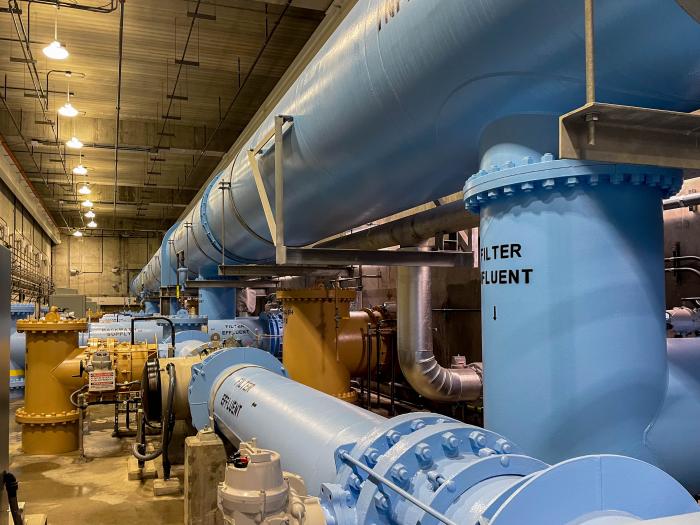
Kevin Fedarko and Coyote Gulch at the Rio Grande State of the Basin Symposium hosted by the Salazar Rio Grande del Norte Center at Adams State University in Alamosa March 29, 2024.

What an inspirational talk from Kevin. I know what he is saying when he speaks about the time after dinner on the trail where the sunset lights up the canyon in different hues and where, he and Pete McBride, his partner on the Grand Canyon through hike, could hear the Colorado River hundreds of feet below them, continuing its work cutting and molding the rocks, because the silence in that landscape is so complete. He and I share the allure of the Colorado Plateau. Kevin was introduced to it through Collin Flectcher’s book The Man Who Walked Through Time, after he received a dog-eared copy from his father. They lived in Pittsburgh in a landscape that was industrialized but the book enabled Kevin to imagine places that were unspoiled.

My introduction to the Colorado Plateau came from an article in Outside magazine that included a panoramic photo of the Escalante River taken from the ledges above the river. Readers in the know can put 2 and 2 together from the name of this blog — Coyote Gulch — my homage to the canyons tributary to Glen Canyon and Lake Foul.

Stevens Arch viewed from Coyote Gulch. Photo via Joe Ruffert

Kevin’s keynote came at the end of the day on March 29th after a jam-packed schedule.

Early in the day Ken Salazar spoke about the future of the San Luis Valley saying, “Where is the sustainability of the valley going to come from.” Without agriculture this place would wither and die.” He is right, American Rivers and other organizations introduced a paper, The Economic Value of Water Resources in the San Luis Valley which was a response to yet another plan to export water out of the valley to the Front Range. (Currently on hold as Renewable Water Resources does not have a willing buyer. Thank you Colorado water law.)

Claire Sheridan informed attendees that their report sought to quantify all the economic benefits from each drop of water in the valley. “When you buy a bottle of water you know exactly what it costs. But what is the value of having the Sandhill cranes come here every year?”

Sandhill Cranes Dancing. Photo by: Arrow Myers courtesy Monte Vista Crane Festival

Russ Schumacher detailed the current state of the climate (snowpack at 63%) and folks from the Division of Water Resources expounded on the current state of aquifer recovery and obligations under the Rio Grande Compact.

The session about the Colorado Airborne Snow Measurement Program was fascinating. Nathan Coombs talked about the combination of SNOTEL, manual snow courses, Lidar, radar, and machine learning used to articulate a more complete picture of snowpack. “You can’t have enough tools in your toolbox,” he said.

Coombs detailed the difficulty of meeting the obligations under the Rio Grande Compact with insufficient knowledge of snowpack and therefore runoff volumes. Inaccurate information can lead to operational decisions that overestimate those volumes and then require severe curtailments in July and August just when farmers are finishing their crops. “When you make an error the correction is what kills you,” he said.

If you are going to learn about agriculture in the valley it is informative to understand the advances in soil health knowledge and the current state of adoption. That was the theme of the session “Building Healthy Soils”. John Rizza’s enthusiasm for the subject was obvious and had me thinking about what I can do for my city landscape.

Amber Pacheco described how the Rio Grande Basin Roundtable and other organizations reach out to as many folks in the valley as possible. Inclusivity is the engine driving collaboration.

Many thanks to Salazar Rio Grande del Norte Center director Paul Formisano for reaching out to me about the symposium. I loved the program. You can scroll through my posts on BlueSky here

Orr kids, Escalante River June 2007

Romancing the River: Remembering Dick Bratton โ€“ and His Times — George Sibley (SibleysRivers.com)

Photo credit: Sibley’s Rivers

Click the link to read the article on the Sibley’s Rivers website (George Sibley):

February 17, 2025

Well, with the fate of constitution democracy in the courts where we know the mills grind slowly (as opposed to the grinders who break things quickly); and with the money frozen for farmers doing well by doing good in water conservation; and neither white smoke nor black smoke arising from the chimneys of the enclaves trying to envision the next decade or so for the Colorado River โ€“ Iโ€™ll take a break from my wonkish efforts to think outside the box, to remember a friend and mentor, and friend of the River, who thought outside the box often in the last half of the 20th century.

The cantankerous Colorado River water community recently lost a valued member, L. Richard Bratton, a water attorney in the Upper Gunnison River Basin from 1958 till his death January 28.

Dick Brattonโ€™s scope of influence went beyond the Upper Gunnison mountain valleys, however; he was a creative thinker who never met anyone he could not talk to โ€“ or listen to, or work with. A born โ€œconnector,โ€ he became an active player in events on the cusp of major changes in the development of water in the entire Upper Basin of the Colorado River.

Born in 1932 and raised in Salida, Dick Bratton came to Gunnison to attend Western State College, then went to the University of Colorado Law School. While at school in Gunnison, he had met Ed Dutcher, a somewhat legendary West Slope water attorney. Shortly after Bratton completed law school, Dutcher invited him to join his firm in 1958.

Aspinall Unit dams

Bratton joined Dutcherโ€™s firm that year โ€“ and in 1959, the Colorado River Storage Project (CRSP) came to the Upper Gunnison River Valley in a big way, with Congressional approval of funding for CRSPโ€™s Curencanti Project (Blue Mesa, Morrow Point and Crystal Dams, now renamed the Wayne Aspinall Unit), and he found himself plunged into all of the ongoing and emerging challenges faced by small communities with agrarian roots in an urbanizing and industrializing world.

The first challenge was Theodore Rooseveltโ€™s conservation vision. The โ€œFather of American Conservationโ€ had a different view of conservation than most of us have today; to him and his philosopher sidekick Gifford Pinchot, conservation meant first the orderly development of resources otherwise wasted โ€“ like the Colorado River pouring itself into the sea in a two-month uncontrolled and mostly unused flood of snowmelt. And when it came to what should be developed and by and for whom, their rule was โ€œthe greatest good for the greatest number,โ€ with โ€œfor the longest timeโ€ sometimes remembered, sometimes not.

In the Upper Gunnison, the Bureau of Reclamation had chosen the Curecanti Reservoir site not to benefit the small ranches and farms of the Upper Gunnison valleys, in accord with their original Rooseveltian mission. It was chosen because it was a great site for a major reservoir in a regional water development for four states that were paranoid over their obligation to make sure a set amount of water passed on to the three more populous states below the Colorado River canyons. The greatest good for the greatest number.

The Curecanti Reservoir as originally proposed, however, would have backed 2.5 million acre-feet (maf) of water almost up to the city limits of Gunnison, with the shallow end exposing major mudflats every summer as the reservoir was drawn down, and the prevailing westerlies would have turned Gunnison into a dust bowl. Brattonโ€™s partner and mentor Ed Dutcher had invested much of his career into opposing this local sacrifice for the greatest good for the greatest number โ€“ not just standard NIMBYism; the community was fighting for its life, and also for the life of two small towns that would be inundated along with 30 miles of legendary fishing stream, 23 small river resorts, and 6,000 acres of ranchland.

After much noisy negotiation with the Bureau of Reclamation for Dutcher and his โ€œCommittee of 39,โ€ the Bureau dropped the reservoir size to just under one million acre-feet, saving Gunnison from the dust inundation, but still losing the two smaller towns and their economic activities โ€“ and the great fishing.

Being sensitive to the cost the project was imposing on the ranchers and farmers that the Bureau was actually created to serve, however, an โ€œUpper Gunnison River Projectโ€ with seveeral small reservoirs was included as a future participating project in the CRSP Act, to be paid for partially by the revenues from the hydroelectric plant on the three largest CRSP dams: Glen Canyon, Flaming Gorge and the Curecanti Unit.

So one of Brattonโ€™s first jobs in Gunnison was helping talk the people of the valley into taxing themselves a little to create an Upper Gunnison River Water Conservancy District under state law, both to help the Bureau lobby for project funding in Washington, and to nudge and harass the Bureau into getting project planning and execution done. Creating the Conservancy was accomplished in an election in 1959, a busy year for Dutcher and Bratton.

In 1961 Dutcher was appointed to a judgeship, and Bratton took over the law firm. That same year, the Bureau opened an office in Gunnison, and began the preliminary work for the Curecanti Project โ€“ clearing the land of trees, relocating roads, and buying out all of the human occupants, an unpleasant and depressing process in the valley. The โ€œgreatest good for the greatest numberโ€ rule, applied in many areas other than conservation, has nothing in the formula for the โ€œlesser numbersโ€ โ€“ probably one source of our current urban-rural troubles.

As construction proceeded on the Curecanti dams, though, a โ€œbig pivotโ€ in the way the entire nation perceived the American West was becoming unignorable. The Bureau of Reclamation had depended on the willingness of the American people to continue investing in the โ€œreclaimingโ€ of arid lands to create more of the iconic โ€œfamily farmsโ€ and to otherwise further the development of raw resources to feed the people and industries of an increasingly urbanized and industrialized economy. But the increasingly urbanized, industrialized โ€“ and after the Second War, increasingly mobilized โ€“ American people were enjoying a rising standard of living that included more time for recreation โ€“ paid vacations! โ€“ and โ€œtheirโ€ western public lands were increasingly perceived not as a resource hinterland, but as a vacation paradise, to be kept as pure and pristine as possible with millions of people trampling through.

On Brattonโ€™s home front, the Crested Butte Ski Resort also opened in 1961 upvalley, forcing the beginning of a transition in the Upper Gunnisonโ€™s self-perception as part of the mining, farming and ranching โ€œworking west,โ€ as opposed to a service sector serving visitors to the great western playground. โ€œConservationโ€ was swinging from the Rooseveltian orderly development of otherwise โ€œwastedโ€ resources toward conservation as careful guarding of the Westโ€™s resources, including preservation of its residual wild magnificence, Wallace Stegnerโ€™s โ€œsociety to match its scenery.โ€

Bratton himself was the son of a โ€œworking westโ€ family, with a couple generations before him in Colorado engaged in mining and mining-related economic activities. But like the political creator of the Colorado River Storage Project, West Slope Congressman Wayne Aspinall, Bratton could see where things were going, and worked to make the transition at home as non-disruptive as possible for the โ€œOld Westโ€ yielding to the โ€œNew West.โ€ (Aspinallโ€™s CRSP Act included provisions for recreational facilities around the major dam sites โ€“ but also provisions for a number of โ€œOld Westโ€ valley-scale projects that could not meet cost-benefit analyses on their own without assistance from hydropower revenues.)

The Taylor River, jewel of the Gunnison River basin. Photo: Brent Gardner-Smith/Aspen Journalism

The creative quality of Brattonโ€™s work in that transition is probably best shown in the story of the resurrection of the Taylor River. The Taylor River collected runoff from some of the highest and snowiest peaks of the Continental Divide and came down to the Gunnison River through 25 miles of canyons โ€“ a beautiful mountain river with a reputation among โ€œanglersโ€ (donโ€™t even say โ€œbaitโ€) as a world-class fishery, even in the early 20th century.

But in the 1930s, the Bureau put a dam at the head of the canyons to store late-season water for farmers in the Uncompaghre River valley, more than a hundred miles downriver at the receiving end of the Gunnison Tunnel, the Bureauโ€™s first big transbasin water project. That project to make life better for distant farmers effectively killed the Taylor and its aquatic life as a river, reversing its natural wet and dry cycles and turning it into an irrigation canal that ran at the will of the Bureau. This was a great loss to the people of the Upper Gunnison, who knew that the best time for fishing was after work anyway. The loss of the Taylor was their first lesson in what the greater good for a greater number meant for the lesser number.

And the Curecanti Project was their second lesson, inundating another twenty-some miles of world-class fishery, along with two small towns and a fishing-resort community that made decent livings from the river. But the Upper Gunnison farmers and ranchers held out hope that, once the Curecanti Unit was in place to play its role in the larger world of Colorado River Basin policy and politics, the Bureau would at least fulfill its promise and begin work on the Upper Gunnison River Project to give them a little help with late-season water.

But just in the decade-and-a-half from the difficult passage of the CRSP Act in 1956 to the completion of the Curecanti Project, public support for expensive irrigation projects to develop western lands basically dried up, replaced by active opposition to anything disturbing the natural beauty and magnificence of The West. It became obvious to the Upper Gunnison Conservancy board and Bratton โ€“ attorney on retainer to the board for its first 40 years โ€“ that there would be no federal funds for an Upper Gunnison River Project.

But Bratton โ€“ a convener and collaborator who managed to maintain good working relationships even with opponents โ€“ started to play on the Bureauโ€™s guilt at not being able to fulfill their promise to the people of the Upper Gunnison. He found a willing collaborator in Bob Jennings, a Bureau manager in the West Slope office. Together, they devised a plan whereby the Bureau would let the Uncompaghre Valley Water Users Association store their Taylor Reservoir water in the Blue Mesa Reservoir โ€“ at least a day closer to where the water would be used. Then the water could be moved from the Taylor Reservoir down to Blue Mesa from in a schedule more in tune with the natural flow of a river. Maybe the Bureau could not create small upstream reservoirs for the โ€œOld Westโ€ agrarian economy, but it could facilitate the resurrection of a beautiful river for the โ€œNew Westโ€ economy taking shape (and Old West workers who liked to fish).

Taylor Dam. By WaterArchives.org – CO-A-0034, WaterArchives.org, CC BY-SA 4.0, https://commons.wikimedia.org/w/index.php?curid=36300145

This was accomplished with a 1975 agreement among the Uncompahgre Valley farmers, the Colorado River Water Conservation District, the Upper Gunnison River Water Conservancy, and the Bureau. The Bureau would manage the โ€œnewโ€ river, but with input from the other three parties โ€“ input that begins each spring with a meeting of an Upper Gunnison River โ€œLocal Users Groupโ€: representatives from Taylor River irrigators, whitewater recreation businesses, Taylor Reservoir flatwater businesses, anglers, and riparian residents. This group sits down with projections for the summer runoff, and compile suggestions for the Bureau on the operation of the Taylor River that will meet all their needs more or less (and being sure to get the Uncompahgre farmersโ€™ water down to Blue Mesa storage in a timely way). The Bureau and other parties can override their recommendations, but seldom need to. And the Taylor is a beautiful mountain river again โ€“ โ€œunnaturalโ€ only in being democratically operated by all of its Old West and New West users.

Bratton did not stop there. He led the Upper Gunnison River Water Conservancy District through the process of filing for rights on a secondfill of the Taylor Reservoir. Taylor Park above the reservoir gathers on average half again the 110,000 af needed for the Uncompahgre users first fill. Any water collected in a second fill would be left in the river, for wildlife and other environmental benefits downriver โ€“ a right consistent with Coloradoโ€™s 1973 instream flow law, to sustain the aquatic and riparian environment โ€œto a reasonable degree.โ€ This water right, inconceivable before the 1970s and NEPA awarenesss, was granted in 1990 โ€“ just in time to help thwart a proposal for a transmountain diversion to the Front Range from the adjacent Union Park.

Even then, Bratton was not yet done playing on Bureau guilt for imposing the Curecanti Unit on the Upper Gunnison with no compensatory project for the local water users โ€“ even though the Upper Gunnison community generates a lot of economic activity from the Curecanti National Recreation Area around Blue Mesa Reservoir. Early in the 21st century, Bratton wanted to develop some ranchland he owned adjacent to the City of Gunnison, with a tributary of the Gunnison River running through it. This development was not received by local residents with any great enthusiasm.

But Bratton remembered a โ€˜handshake agreementโ€™ with the Bureau from the Curecanti construction era, that the Bureau would replace the great sport fishery the reservoir would inundate with some good public access fishing streams elsewhere in the basin. So rather than developing a standard golf-course-rimmed-with-expensive-homes development, Bratton reminded the Bureau of its promise, and sold it the stream corridor through his land for public access, to be managed by Colorado Parks and Wildlife.

Bratton was also deeply committed to his alma mater, Western State College (now Western Colorado University). In 1975 โ€“ obviously a busy year in his life โ€“ he orchestrated the creation of the Western State College Foundation, with bequests from former Colorado Governor Dan Thornton and his wife Jessie, valley ranchers; the Foundation continues as an important support for program development at the University.

The following year, 1976, he collaborated with Western history professor Duane Vandenbusche on a water education course. The next year, 1977, that evolved into the โ€œWestern Water Workshop,โ€ to which Bratton invited an incredible lineup of speakers, including โ€“ in the same room โ€“ longtime West Slope Congressman Wayne Aspinall, Denver Waterโ€™s longtime chief counsel and bitter West Slope adversary Glenn Saunders, Assistant Bureau of Reclamation Director Cliff Barrett, former Governor John Vanderhoof, and a number of other luminaries of the โ€œwater buffalo era.โ€ Your author was privileged to sneak into those summer sessions โ€“ one of the most memorable of which was Bureau man Cliff Barrett trying to suss out the implications of President Carterโ€™s recently released โ€œhit list,โ€ a list of water projects, including a number of CRSP projects, that did not meet a new cost-benefit analysis โ€“ essentially the official end of the era of federally-funded western water development.

The Western Water Workshop continued for forty years; a place where East Slope and West Slope, Old West and New West participants could gather for a couple days of off-the-record escape from the physical and cultural heat of the cities in the summer. I sserved as director of the Workshop for six year after the turn of the century until I retired from Western, and I found Dick Bratton to still be a great resource and idea person. At that time he had been appointed by President G. W. Bush to be the federal representative on the Upper Colorado River Commission. He once took pains to save my Water Workshop job when I had inadvertently offended one of the old โ€œwater buffaloโ€ with a couple invitees to a session; Bratton reminded his old friend that the Workshop promised โ€œthe presentation of all reasonable points of view.โ€

The reader may feel this article is more a history lesson than the remembrance of a man.ย (A full obituary can be found in the Feburary 6ย Gunnison Country Times โ€“ย www.gunnisontimes.com)ย But it is my feeling that some people cannot be understood outside of the history they are part of, and Dick Bratton was such a person. Like his friend Wayne Aspinall, he tried to help Coloradoโ€™s West Slope (and the larger intermountain West) negotiate the difficult, inevitable, and ongoing transition from the โ€œOld West working economyโ€ to the โ€œNew West amenity economy.โ€ His heart may have been more with the former, but he became at home with the latter because, basically, he was at home in the world, whatever it was, and enjoying working with whomever he encountered there. And he was a fisherman as well as the son of a miner.

Greg Hobbs, Dick Bratton, Jim Pokrandt

Northern Water may be nearing settlement of lawsuit filed to stop $2 billion reservoir project — Jerd Smith (Fresh Water News) #NISP #PoudreRiver #SouthPlatteRiver

A stretch of the Cache la Poudre River, between Fort Collins and Greeley. Credit: Water Education Colorado.

Click the link to read the article on the Water Education Colorado website (Jerd Smith):

February 13, 2025

More than a year after an environmental group sued to stop a $2 billion northern Colorado water project, whispers of a settlement are being heard as the case winds its way through U.S. District Court in Denver.

Last January,ย Save The Poudre suedย to block the Northern Integrated Supply Project, a two-reservoir development designed toย serve tens of thousands of people in northern Colorado. The suit alleged that the Army Corps of Engineers had not adequately weighed the environmental impacts and less harmful ecological alternatives to the project…

Colorado-Big Thompson Project map. Courtesy of Northern Water.

Northern Water, which operates the federally owned Colorado-Big Thompson Project for the U.S. Bureau of Reclamation, is overseeing the permitting and construction of NISP. The agency also declined to comment on any potential settlement. Northern Water serves more than 1 million Front Range residents and hundreds of growers in the South Platte River Basin.

โ€œWeโ€™re still moving forward with what we need to do on the litigation,โ€ Northern spokesman Jeff Stahla said.

Northern Waterโ€™s board discussed the litigation in a confidential executive session last week at a study retreat and it is scheduled to discuss it in another private executive session Feb. 13 at its formal board meeting, according to the agenda.

Sources told Fresh Water News and The Colorado Sun that those discussions are related to the potential multimillion-dollar settlement.

Key developments this past year

In October, a federal judge deliveredย a favorable rulingย to Wocknerโ€™s Save the Colorado on a case involving Denver Waterโ€™s Gross Reservoir expansion project. Now [envisonmental groups] are seeking an injunction to force Denver Water to stop construction of theย dam, which began in 2022.

Workers from Denver Water and contractor Kiewit Barnard stand in front of Gross Dam in May to mark the start of the dam raise process. Photo credit: Denver Water.

Raising the Boulder County dam by 131 feet will allow Denver Water to capture more water from the headwaters of the Upper Colorado River on the Western Slope. In its ruling, the federal court said the U.S. Army Corps of Engineers had failed to consider the impact of climate change on the flows in the Colorado River.

What impact that ruling may have on the NISP case isnโ€™t clear, but [the environmental group that sued Denver Water] said they believe it will give his organization more leverage to push for changes in NISP.

In addition, the City of Fort Collins has dropped its formal opposition to NISP. And Stahla said Northern has continued to push forward with key parts of the development, including the design work needed to relocate a 7-mile stretch of U.S. 287 northwest of Fort Collins.

Fort Collins Mayor Jeni Arndt said the city changed its stance because most of its environmental concerns had been met through the 21-year federal permitting process.

โ€œThe EPA had signed off, and the Corps of Engineers had signed off,โ€ she said. โ€œIt was obvious that this was not going to be another Two Forks,โ€ referring to a massive dam proposed in the 1970s by Denver Water on the South Platte River near Deckers. It was rejected by the EPA due to environmental concerns.

Arndt said the city also planned to use a later review process, known as a 1041 review, to address other environmental concerns that might arise.

If NISP is ultimately built, and most believe it will be, it will provide water for 15 fast-growing communities and water districts along the Interstate 25 corridor, including the Fort Collins-Loveland Water District, Fort Morgan, Lafayette and Windsor.

The largest participant in the giant project is the Fort Collins-Loveland District. Board member Stephen Smith said he believes NISP will move forward one way or another and that it is critical to serving the water-short region.

โ€œNISP is going to get built and it will provide water to Fort Collins by 2033,โ€ he said.

More by Jerd Smith

The Northern Integrated Supply Project, currently estimated at $2 billion, would create two new reservoirs and a system of pipelines to capture more drinking water for 15 community water suppliers. An environmental group is now suing the Army Corps of Engineers over a key permit for Northern Waterโ€™s proposal. (Save the Poudre lawsuit, from Northern Water project pages)

Water experts: Crisis on #ColoradoRiver affects all Coloradans — The #Sterling Journal Advocate #COriver #aridification

Colorado transmountain diversions via the State Engineer’s office

Click the link to read the article on The Sterling Journal Advocate website (Jeff Rice). Here’s an excerpt:

February 11, 2025

Three of Coloradoโ€™s top water experts hammered home the idea that Coloradoโ€™s water situation id precarious, at best, and almost always on the brink of crisis. The day-long Voices of Rural Colorado symposium in Denver was the setting for an hour-long discussion of Colorado water. Attendees heard from, and interacted with, Rebecca Mitchell, former executive director of the Colorado Water Conservation Board and now Coloradoโ€™s representative on the Upper Colorado River Commission; Zane Kessler, director of government relations for the Colorado River District; and Jim Yahn, Logan County Commissioner and manager of the North Sterling Irrigation District. One of the points that was repeatedly made during the discussion was that the Colorado River is Coloradoโ€™s River. Besides watering most of the Western Slope of Colorado, the river is tapped for more than a half-million acre feet of water to the Front Range and eastern plains. Nearly half of that, about 200,000 acre feet per year, is fed directly into the Big Thompson River at Estes Park, primarily for irrigation in the South Platte River Basin. The remaining 330,000 acre feet is diverted to cities on the Front Range like Denver, Colorado Springs and Pueblo. That water ends up in the South Platte and Arkansas River basins…

Yahn told the attendees that continued drought in the Colorado River Basin will have an impact on the South Platte Valley, which is why projects like the Chimney Hollow Reservoir, nearing completion next to Carter Lake west of Berthoud, are important…Mitchell said that the crisis on the Colorado is easily seen in the water levels of the two largest reservoirs on the river, Lake Mead on the Nevada-Arizona state line near Las Vegas, and Lake Powell, halfway between Salt Lake City and Phoenix on the Utah-Arizona state line.

Rare earth elements found in #LincolnCreek raise new questions: Mineralized tributary and Ruby mine also source of rare earth elements in Lincoln Creek — Heather Sackett (AspenJournalism.org)

Lincoln Creek was orange just downstream of the mineralized tributary in July 2024. A team of scientists from the University of Colorado Boulder found that a mineralized tributary is also contributing rare earth elements to Lincoln Creek, in addition to other metals like aluminum. Credit: HEATHER SACKETT/Aspen Journalis

Click the link to read the article on the Aspen Journalism website (Heather Sackett):

January 25, 2025

Recent sampling shows that a high-alpine tributary of the Roaring Fork River, in addition to having high concentrations of certain metals, also contains rare earth elements. But what that means for human and aquatic health is unclear.

Scientists from the University of Colorado Boulder presented the preliminary results from water-quality sampling on Lincoln Creek over last summer at a public meeting hosted by the Roaring Fork Conservancy at the Basalt Regional Library on Thursday. 

Occupying a lesser-known corner of the periodic table, rare earth elements (which, despite their name, are commonly occurring in Earthโ€™s crust) are a set of 17 heavy metals that are used in making products such as cellphones, fiber-optic cables and computer monitors. With names such as yttrium, lanthanum and neodymium, they often turn up at sites in Colorado where there is acid rock drainage, such as upper Lincoln Creek.

โ€œYou get a phoneโ€™s worth of neodymium coming down the mineralized tributary about every 5ยฝ minutes,โ€ said Adam Odorisio, a graduate student and researcher at CUโ€™s environmental engineering department. โ€œThis translates to 96,000 phones per year. And what I think is the most striking fact in this is that this is for one tributary. You multiply this across hundreds of acid mine sites in Colorado and potentially thousands across the Western U.S. and itโ€™s very exciting for resource extraction.โ€ 

CU scientists are also monitoring other high alpine acid rock and mine drainage sites in Colorado, including the Snake River. Odorisio said the concentrations of rare earth elements in a mineralized tributary that feeds Lincoln Creek was in the middle of the pack when compared to other sites around the state.

Twin Lakes collection system

In addition to the potential for mining valuable rare earth metals, scientists are eager to learn more about their impacts to human health and aquatic environments. There are no state or federal water quality standards for rare earth elements. Lincoln Creek is a source of drinking water for Front Range cities, including Colorado Springs. 

โ€œThis is just wide open as an unknown area,โ€ said Diane McKnight, a professor at CUโ€™s Institute of Arctic and Alpine Research. โ€œItโ€™s not clear that itโ€™s something to worry about here. The water from (Lincoln Creek) that goes into the Twin Lakes system is highly diluted.โ€ 

Over nine days from June through October, the CU team collected 79 water samples from eight sites, took sediment core samples from the Grizzly Reservoir lakebed, and collected rock scrapings and bugs from the waterway. Early results also confirmed what the Environmental Protection Agency found in previous water-quality tests: The water is highly acidic, and concentrations of metals including zinc, copper and aluminum exceed standards for aquatic life. Scientists found that a groundwater source could also be adding metals to Lincoln Creek. They are still analyzing the data and plan to present more results at a spring meeting.

โ€œFor the greater scientific community, the fate of rare earth elements in aquatic systems is not well understood,โ€ Odorisio said. โ€œWe are hoping to change that.โ€

The headwaters of Lincoln Creek upstream from the Ruby Mine and mineralized tributary. Recent water sampling by scientists from the University of Colorado Boulder found rare earth elements in the creek downstream, but implications for human health and aquatic impacts are unclear. Credit: HEATHER SACKETT/Aspen Journalism

The results may be of use to the Lincoln Creek workgroup, an ad hoc group โ€“ composed of officials from Pitkin County, Colorado Parks and Wildlife, the U.S. Forest Service, Colorado Department of Public Health and Environment, Independence Pass Foundation, Roaring Fork Conservancy and others โ€“ that is trying to understand how contaminants are impacting Lincoln Creek and the Roaring Fork River. The group has hired consultants LRE Water to compile water-quality data collected by several different agencies last summer and propose options to clean up the waterways. 

โ€œThe rare earth metals is a group we havenโ€™t really thought through,โ€ said Kurt Dahl, Pitkin Countyโ€™s environmental health manager. โ€œThatโ€™s one of the things that we are talking through with the contractor, LRE Water.โ€ 

The water quality of Lincoln Creek has been under increased scrutiny in recent years as fish kills and discoloration of the water downstream of Grizzly Reservoir have become more frequent. In July, reservoir owner and operator Twin Lakes Reservoir & Canal Co. drained the reservoir for a planned dam-rehabilitation project, releasing an orange slug of sediment-laden water from the bottom of the reservoir downstream. Testing showed that the water had high levels of iron and aluminum, but not copper, which is toxic to fish.

An EPA report in 2023 determined that a โ€œmineralized tributary,โ€ which feeds into Lincoln Creek above the reservoir near the ghost town of Ruby, is the main source of the high concentrations of metals downstream. 

Prior to mining, snowmelt and rain seep into natural cracks and fractures, eventually emerging as a freshwater spring (usually). Graphic credit: Jonathan Thompson

The process that causes metals leaching into streams can be both naturally occurring and caused by mining activities. In both cases, sulfide minerals in rock come into contact with oxygen and water, producing sulfuric acid. The acid can then leach the metals out of the rock and into a stream, a process known as acid rock drainage. The contamination from acid rock drainage seems to be increasing at other locations around Colorado and may be exacerbated by climate change as temperatures rise. 

The recent water-quality-testing effort on Lincoln Creek is probably just the beginning of a long-term data-collection and monitoring program, Dahl said. 

โ€œI think thereโ€™s still a lot of energy around this,โ€ Dahl said. โ€œPeople are really invested in this, and itโ€™s going to take a couple of years to get it characterized.โ€

Aspen Journalism, which is solely responsible for its editorial content, is supported by a grant from the Pitkin County Healthy Community Fund.

This story ran in the Jan. 27 edition of The Aspen Times.

Map of the Roaring Fork River drainage basin in western Colorado, USA. Made using USGS data. By Shannon1 – Own work, CC BY-SA 4.0, https://commons.wikimedia.org/w/index.php?curid=69290878

Bone-dry winter in the San Juans — Allen Best (BigPivots.com) #SanJuanRiver #DoloresRiver #ColoradoRiver #COriver #aridification

Lee Ferry, the dividing line between the upper and lower basin states of the Colorado River Basin. Photo credit: Allen Best

Click the link to read the article on the Big Pivots website (Allen Best):

January 28, 2025

Itโ€™s part of a theme. Does Colorado need to start planning for potential Colorado River curtailments?

Snow in southwestern Colorado has been scarce this winter. Archuleta County recently had a grass fire. A store manager at Terryโ€™s Ace Hardware in Pagosa Springs tells me half as many snowblowers have been sold this winter despite new state rebates knocking 30% off the price of electric models.

Near Durango, snowplows normally used at a subdivision located at 8,000 feet remain unused. At Chapman Hill, the in-town ski area, all snow remains artificial, and itโ€™s not enough to cover all the slopes. A little natural snow would help, but none is in the forecast.

Snow may yet arrive. Examining data collected on Wolf Creek Pass since 1936, the Pagosa Sunโ€™s Josh Kurz found several winters that procrastinated until February. Even when snow arrived, though, the winter-end totals were far below average.

All this suggests another subpar runoff in the San Juan and Animas rivers. They contribute to Lake Powell, one of two big water bank accounts on the Colorado River. When I visited the reservoir in May 2022, water levels were dropping rapidly. The manager of Glen Canyon Dam pointed to a ledge below us that had been underwater since the mid-1960s. It had emerged only a few weeks before my visit.

That ledge at Powell was covered again after an above-average runoff in 2023. The reservoir has recovered to 35% of capacity.

A ledge that had been used in the construction of Glen Canyon Dam emerged in spring 2022 after about 50 years of being underwater.  Photo May 2022/Allen Best

Will reservoir levels stay that high? Probably not, and that is a significant problem. Delegates who wrangled the Colorado River Compact in a lodge near Santa Fe in 1922 understood drought, at least somewhat. They did not contemplate the global warming now underway.

In apportioning the river flows, they also assumed an average 17.5 million acre-feet at Lee Ferry, the dividing line between the upper and lower basins. Itโ€™s a few miles downstream from Glen Canyon Dam and upstream from the Grand Canyon. Even during the 20th century the river was rarely that generous. This century it has become stingy, with average annual flows of 12.5 million acre-feet. Some worry that continued warming during coming decades may further cause declines to 9.5 million acre-feet.

Udall/Overpeck 4-panel Figure Colorado River temperature/precipitation/natural flows with trend. Lake Mead and Lake Powell storage. Updated through Water Year 2024. Credit: Brad Udall

Colorado State Universityโ€™s Brad Udall and other scientists contend half of declining flows should be understood as resulting from warming temperatures. A 2024 study predicts droughts with the severity that formerly occurred once in 1,000 years will by mid-century become 1-in-60 year events.

How will the seven basin states share this diminished river? Viewpoints differ so dramatically that delegates from the upper- and lower-basin states loathed sharing space during an annual meeting in Las Vegas as had been their custom. Legal saber-rattling abounds. A critical issue is an ambiguous clause in the compact about releases of water downstream to Arizona and hence Nevada and California.

Colorado transmountain diversions via the State Engineer’s office

Might Colorado need to curtail its diversions from the Colorado River? That would be painful. Roughly half the water for cities along the Front Range, where 88% of Coloradans live, comes from the Colorado River and its tributaries. Transmountain diversions augment agriculture water in the South Platte and Arkansas River valleys. The vast majority of those water rights were adjudicated after the compact of 1922 and hence would be vulnerable to curtailment. Many water districts on the Western Slope also have water rights junior to the compact.

In Grand Junction last September, Andy Mueller, the general manager of the Colorado River Water Conservation District, the primary water policy agency for 15 of Western Slope counties, made the case that Colorado should plan for compact curtailments โ€” just in case. The district had earlier sent a letter to Jason Ullmann, the state water engineer, asking him to please get moving with compact curtailment rules.

Eric Kuhn, Muellerโ€™s predecessor at the district, who is now semi-retired, made the case for compact curtailment planning in the Spring 2024 issue of Colorado Environmental Law Review. Kuhnโ€™s piece runs 15,000 words, all of them necessary to sort through the tangled complexities. Central is the compact clause that specifies the upper basin states must not cause the flow at Lee Ferry, just below todayโ€™s Glen Canyon Dam, to be depleted below an aggregate of 75 million acre-feet on a rolling 10-years basis.

That threshold has not yet been met โ€” yet. Kuhn describes a โ€œrecipe for disasterโ€ if it is. He foresees those with agriculture rights on the Western Slope being called upon to surrender rights. He and Mueller argue for precautionary planning. That planning โ€œcould be contentious,โ€ Kuhn concedes, but the โ€œadvantages of being prepared for the consequences of a compact curtailment outweigh the concern.โ€

Last October, after Muellerโ€™s remarks in Grand Junction, I solicited statements from Colorado state government. The Polis administration said it would be premature to plan compact curtailment. The two largest single transmountain diverters of Colorado River Water, Denver Water and Northern Water, concurred.

Front Range cities, including Berthoud, above, are highly reliant upon water imported from the Colorado River and its tributaries. December 2023 photo/Allen Best

Recently, I talked with Jim Lochhead. For 25 years he represented Colorado and its water users in interstate Colorado River matters. He ran the stateโ€™s Department of Natural Resources for four years in the 1990s and, ending in 2023, wrapped up 13 years as chief executive of Denver Water. Lochhead, who stressed that he spoke only for himself, similarly sees compact curtailment planning as premature.

โ€œIt just doesnโ€™t make sense to go through that political brain damage until we really have to,โ€ he said. โ€œHopefully we wonโ€™t have to, because (the upper and lower basins) will come up with a solution.โ€

Lochhead does believe that a negotiated solution remains possible, despite the surly words of recent years…

โ€œWe need to figure out ways to negotiate an essentially shared sacrifice for how weโ€™re going to manage the system, so it can be sustainable into the future,โ€ he said. This, he says, will take cooperation that so far has been absent, at least in public, and it will also take money.

Instead, weโ€™ll have to slog along. The runoff in the Colorado River currently is predicted to be 81% of average. It fits with a theme. Unlike the children of Lake Wobegone, most runoffs in the 21st century have been below average.

Map of the Colorado River drainage basin, created using USGS data. By Shannon1 Creative Commons Attribution-Share Alike 4.0

Arkansas Valley Conduit awarded an additional $250 million — Chris Woodka (Southeastern #Colorado Water Conservancy District) #ArkansasRiver

Reclamation Commissioner Camille Calimlim Touton greets several members of the Southeastern District Board, from left, Bill Long, Kevin Karney, Howard โ€œBubโ€ Miller, Andy Colosimo and Justin DiSanti. Photo credit: Southeastern Colorado Water Conservancy District

January 8, 2025

Camille Calimlim Touton, Commissioner of the U.S. Bureau of Reclamation, traveled to Pueblo on Wednesday, January 8, to announce an additional $250 million for construction of the Arkansas Valley Conduit.

โ€œWe are proud to see the work underway because of President Bidenโ€™s Investing in America agenda,โ€ Commissioner Touton said. โ€œBut thereโ€™s much more work to be done and we are again investing in this important project to bring safe drinking water to an estimated 50,000 people in 39 rural communities along the Arkansas River.โ€

The $250 million is funded through the Bipartisan Infrastructure Law and is part of a $514 package of water infrastructure investments throughout the western United States under the BIL.

The additional funding brings the total federal investment in the AVC to almost $590 million since 2020, along with state funding guarantees of $90 million in loans and $30 million in grants.

โ€œAfter 25 years, I still almost canโ€™t believe itโ€™s happening, but I drive by and can see it with my own eyes,โ€ Southeastern Water Conservancy District President Bill Long told Commissioner Touton. โ€œThere are so many people who have worked so hard who would be so proud to see it being built. This money will get us to the area that has seen the most problems.โ€

The Southeastern District is the sponsor for the AVC, which is part of the 1962 Fryingpan-Arkansas Project Act. The 130-mile pipeline to Lamar will bring water to 50,000 people being served by 39 water systems when complete.

Several Southeastern Board members attended Wednesdayโ€™s announcement.

โ€œYou and your team are the ones who have gotten this off the ground,โ€ said Kevin Karney, a La Junta rancher, and at-large Board member.

โ€œPeople said it would never get built, but now weโ€™re getting it done,โ€ said Howard โ€œBubโ€ Miller, who represents Otero County on the Board.

The AVC will help 18 water systems that face enforcement action for naturally occurring radionuclides in their groundwater supplies, as well as communities struggling to meet drinking water and wastewater discharge standards.

Construction of the AVC began in 2023, and three major construction contracts have been awarded.

โ€œThis money really gets us further down the valley. It is very much appreciated,โ€ Long said.

Here is a link to the Bureau of Reclamation News Release: https://www.usbr.gov/newsroom/news-release/5074.

Below is a news release from Coloradoโ€™s Senators: https://www.bennet.senate.gov/2025/01/08/bennet-hickenlooper-welcome-additional-250-million-from-bipartisan-infrastructure-law-for-arkansas-valley-conduit/

Hickenlooper, Bennet Welcome Additional $250 Million for Ark Valley Conduit

Funding awarded from the senatorsโ€™ Bipartisan Infrastructure Law

In total, Hickenlooper and Bennet have helped secure $500 million in funding for the project

WASHINGTON โ€“ Today, Colorado U.S. Senators John Hickenlooper and Michael Bennet welcomed the Bureau of Reclamation (BOR)โ€™s announcement of $250 million in new funding from the Bipartisan Infrastructure Law for continued construction of the Arkansas Valley Conduit (AVC).

โ€œWe passed the Bipartisan Infrastructure Law to finally deliver on promises to rural communities,โ€ said Hickenlooper. โ€œIn Colorado that means finishing the long-awaited Ark Valley Conduit and bringing clean, reliable drinking water to 50,000 people.โ€

โ€œFor decades, Iโ€™ve worked to secure investments and pass legislation to ensure the federal government keeps its word and finishes the Arkansas Valley Conduit,โ€ said Bennet. โ€œThis major Bipartisan Infrastructure Law investment will be critical to get this project across the finish line to provide safe, clean water to tens of thousands of Coloradans along the Arkansas River.โ€

John F. Kennedy at Commemoration of Fryingpan Arkansas Project in Pueblo, circa 1962.

The AVC is a planned 130-mile water-delivery system from the Pueblo Reservoir to communities throughout the Arkansas River Valley in Southeast Colorado. This funding will continue ongoing construction. The AVC is the final phase of the Fryingpan-Arkansas Project, which Congress authorized in 1962.

Hickenlooper and Bennet have consistently and successfully advocated for increased funding for the AVC. Last year, Hickenlooper and Bennet wrote to President Biden to urge him to prioritize funding for the AVC in his fiscal year 2025 budget. The senators also called on Senate Appropriations leaders to provide more funding for the project. In January 2023, Hickenlooper and Bennet urged BOR to allocate additional resources through annual appropriations and Bipartisan Infrastructure Law funding.

As a result of their efforts, the senators have helped deliver $500 million from the Bipartisan Infrastructure Law for the AVC, including $90 million in 2024, $100 million in 2023, and $60 million in 2022. They also secured an additional $10.1 million in fiscal year 2024 and $10.1 million in fiscal year 2023 through the annual government funding bills.

More information on the funding is available HERE.

Arkansas Valley Conduit map via the Southeastern Colorado Water Conservancy District (Chris Woodka) June 2021.

Montrose Countyโ€™s 6th Annual West Slope Water Summit — KJCT

Uncompahgre River Valley looking south

Click the link to read the article on the KJCT website (Ja’Ronn Alex). Here’s an excerpt:

November 14, 2024

Over 300 people attended Montrose Countyโ€™s 6th Annual West Slope Water Summit…Water is a big part of the Western Slopeโ€™s identity. Montrose County held a water summit and invited everyone to drop by and hear speakers like Andy Mueller of the Colorado River District speak on the issues.

โ€œWe really want to make sure they understand where the situation is with the Colorado River, the things we have to do,โ€ said Sue Hansen, Montrose County Commissioner of District 2.

Rest assured, our state representatives in Denver are looking to keep water on the Western Slope,ย on the Western Slope. โ€œWe are the biggest water rights holder, and we need to make sure that we can protect that as we go forward. Downstream is continuing to want more and more and more. There is no way any of us can continue to supply them with what they think they want,โ€ commented Catlin.

Map of the Gunnison River drainage basin in Colorado, USA. Made using public domain USGS data. By Shannon1 – Own work, CC BY-SA 4.0, https://commons.wikimedia.org/w/index.php?curid=69257550

Extended Shoshone hydro plant outages add urgency to water rights campaign: Outage protocol not as reliable as water rights permanency — Heather Sackett (@AspenJournalsim) #ColoradoRiver #COriver #aridification

The twin turbines of Xcel Energyโ€™s Shoshone hydroelectric power plant in Glenwood Canyon can generate 15 megawatts. The plant was down for about a year and a half, according to the Colorado Division of Water Resources. Credit: Heather Sackett/Aspen Journalism

Click the link to read the article on the Aspen Journalism website (Heather Sackett):

October 31, 2024

The Shoshone Hydropower Plant in Glenwood Canyon was not operating for nearly all of 2023 and more than half of 2024, adding urgency to a campaign seeking to secure the plantโ€™s water rights for the Western Slope.

According to records from the Colorado Division of Water Resources, the Shoshone Hydropower Plant was not operating from Feb. 28, 2023 until Aug. 8, 2024. According to Michelle Aguayo, a spokesperson from Xcel Energy, the company that owns the plant, there was a rockfall which forced an outage as well as maintenance which impacted operations during that time period.

The Grizzly Creek Fire burning along the Colorado River on August 14, 2020. By White River National ForestU.S. Forest Service – Public Domain

In 2024 the plant has been down for 221 days; in 2023 for 307 days; in 2022 for 91 days and in 2021 for 143 days. Water Resources Division 5 Engineer James Heath said he began tracking Shoshone outages in 2021 when they began to happen more frequently, starting with the post-Grizzly Creek fire mudslides in Glenwood Canyon.

โ€œIt was all these extended outages and just being able to have some sort of record of what was going on,โ€ Heath said. โ€œI kept getting questions from the parties on how many days we were operating ShOP and what the priorities were on those different days.โ€

The recent extended outages of the plant increase the urgency of the effort by the Colorado River Water Conservation District to acquire Shoshoneโ€™s water rights, which are some of the oldest and most powerful non-consumptive rights on the main stem of the Colorado River. If the plant were to shut down permanently, it would threaten the Western Slopeโ€™s water supply. The water rights could be at risk of being abandoned or acquired by a Front Range entity.

At a tour of the Shoshone plant in October, hosted by the Water for Colorado Coalition, River District Director of Strategic Partnerships Amy Moyer explained why the Shoshone water rights are important for improving water security and climate resilience on the Western Slope.

โ€œAs weโ€™re sitting here in the iconic Glenwood Canyon. โ€ฆ It is a beautiful place, but we have an active highway, a railroad, a hydro power plant, all nestled in this tiny canyon that has experienced its fair share of natural hazards and risks over the years,โ€ Moyer said. โ€œWhen weโ€™re looking at the level of risk, that is why we are looking for permanent protections for these water rights, and why we have a willing partner in Xcel Energy realizing that they had an incredible asset that was meaningful to Coloradoโ€™s Western Slope and the Colorado River itself.โ€

Water runs down a spillway at the Shoshone hydro plant in Glenwood Canyon. Rockfalls, fires and mudslides in recent years have caused frequent shutdowns of plant operations. Credit: Heather Sackett/Aspen Journalism

According to the terms of ShOP, when it is on during the summer, the plant can call 1,250 cfs. In the wintertime, that number falls to 900 cfs. The agreement is in place for 40 years (with 32 remaining), a relatively short period in water planning, after which it could be renegotiated. And ShOP doesnโ€™t have the stronger, more permanent backing of a water court decree.

โ€œShOP came about as a band aid to kind of maintain the river flow and the river regime when the plant was out,โ€ said Brendon Langenhuizen, River District director of technical advocacy. โ€œShOP wasnโ€™t meant to be for year after year after year of the plant being down.โ€

The Shoshone hydro plant in Glenwood Canyon. The River District has made a deal with Xcel Energy to buy the water rights associated with the plant to keep water flowing on the Western Slope. Credit: Heather Sackett/Aspen Journalism

The River Districtโ€™s campaign to acquire the Shoshone water rights has been gaining momentum over the last year, with about $55 million in committed funding so far from entities across the Western Slope, the River District and the state of Colorado. The River District plans to apply for $40 million in funding from the U.S. Bureau Reclamationโ€™s B2E funding. This money from the Inflation Reduction Act is earmarked for environmental drought mitigation.

The River Districtโ€™s plan is to add an instream flow use to the water rights in addition to their current use for hydropower. That requires working with the Colorado Water Conservation Board, which is the only entity in the state allowed to hold instream flow rights which preserve the environment, as well as getting a new water court decree to allow the change in use.

That way, when the Shoshone plant is offline, the instream flow right would be activated to continue pulling water downstream, making ShOP obsolete and solidifying a critical water right for the Western Slope.

Xcel would lease the water right for hydropower from the River District for as long as the plant is in operation.

“New plot using the nClimGrid data, which is a better source than PRISM for long-term trends. Of course, the combined reservoir contents increase from last year, but the increase is less than 2011 and looks puny compared to the โ€˜holeโ€™ in the reservoirs. The blue Loess lines subtly change. Last year those lines ended pointing downwards. This year they end flat-ish. 2023 temps were still above the 20th century average, although close. Another interesting aspect is that the 20C Mean and 21C Mean lines on the individual plots really donโ€™t change much. Finally, the 2023 Natural Flows are almost exactly equal to 2019. (17.678 maf vs 17.672 maf). For all the hoopla about how this was record-setting year, the fact is that this year was significantly less than 2011 (20.159 maf) and no different than 2019” — Brad Udall

โ€œColoradoโ€™s Western Slope is truly at an epicenter of increased temperatures and decreased streamflows that are exacerbating temperature issues, creating water quality issues,โ€ Moyer said. โ€œSo itโ€™s imperative that we look for these legacy level, permanent solutions to build resiliency in our basin.โ€

Map credit: AGU

Southwest #Colorado tribes seek federal funds for Animas-La Plata water delivery — The #Durango Herald

Lake Nighthorse and Durango March 2016 photo via Greg Hobbs.

Click the link to read the article on The Durango Herald website (Maria Tedesco). Here’s an excerpt:

November 1, 2024

The Ute Mountain Ute Tribe has tried to obtain compensation for water rights from the Inflation Reduction Act, but the Bureau of Reclamation has not acted. U.S. Sens. John Hickenlooper and Michael Bennet, as well as Colorado Gov. Jared Polis, wrote a letter to the Bureau of Reclamation on Oct. 22 urging the bureau to work with the Ute Mountain Ute and Southern Ute tribes for alternative routes of funding, after they were not able to be compensated from the IRA.

โ€œWe strongly encourage you to explore other avenues for Coloradoโ€™s Tribal Nations to pursue funding related to drought response, recognizing that they are currently forgoing their water use not by choice, but resulting from a history of inequity reflected in their long-term lack of infrastructure,โ€ the letter said.

Combined, the Ute Mountain Ute Tribe and Southern Ute Tribe hold about 33,000 acre-feet of water rights in Lake Nighthorse. Lawmakers provided funds only for the construction of the A-LP and not a delivery system in 2000. Without a pipeline out of Lake Nighthorse, water flows downstream. Since the tribes are not compensated for the water to which they are entitled, but do not use, lawmakers asked the Bureau of Reclamation to explore alternative routes of funding…Aside from receiving compensation for water rights, the Ute Mountain Ute Tribe also needs $500 million for a water delivery project for water from Lake Nighthorse, said Manuel Heart, chair of the Ute Mountain Ute Tribe.

Understanding the #GunnisonRiver — Gunnison Basin Roundtable

Map of the Gunnison River drainage basin in Colorado, USA. Made using public domain USGS data. By Shannon1 – Own work, CC BY-SA 4.0, https://commons.wikimedia.org/w/index.php?curid=69257550

From email from the Gunnison Basin Roudtable (Savannah Nelson):

October 29, 2024

As residents of the Gunnison River Basin, we are privileged to live alongside one of Coloradoโ€™s most remarkable natural treasures. The Gunnison River is more than just a waterwayโ€”itโ€™s a vital part of our history, our environment, and our daily lives.

The Gunnison River was named after U.S. Army officer and explorer John W. Gunnison, who surveyed the area in the mid-19th century. However, long before Gunnisonโ€™s expedition, Indigenous peoples, including the Ute tribes, called this area home. They relied on the river as a source of food, water, and transportation, establishing deep connections with the land and its resources.

The East River Valley, northwest of the historic town of Gothic, home to the Rocky Mountain Biological Laboratory. The mountain with the pointed peak in the distance is Mount Crested Butte. Photo credit: Mark Stone/University of Washington

Our river begins at the confluence of the East River and Taylor River near Almont and flows for about 180 miles until it merges with the Colorado River in Grand Junction. Other tributaries include the North Fork, the Uncompahgre, Cimarron, and Lake Fork. Along its course, the Gunnison carves through some of the most dramatic landscapes in the state, including the striking Black Canyon of the Gunnisonโ€”its sheer cliffs dropping over 2,000 feet.

Recreation opportunities are a major piece of local life and tourism; fishing, rafting, swimming, kayaking, and boating are part of the culture surrounding the water.

The Gunnison River is also a lifeline for our local ecosystem. Its waters support a variety of fish species, such as brown and rainbow trout, which are great for anglers, but also contribute to the rich biodiversity of our area.

Sweet corn near Olathe, CO photo via Mark Skalny, The Nature Conservancy.

In addition to the fact that all of us rely on the Gunnison river and its tributaries for drinking water, they play a crucial role in the diverse agricultural activities of the basin. The agricultural uses vary and include a range of cattle and crops, including fruit production and Olathe sweet corn.

Our river is many things: a heritage that we share and a resource we must protect for future generations. To learn more about water and ways to get involved, head toย gunnisonriverbasin.org.

Aspinall Unit operations update October 30, 2024: Ramping down Gunnison Tunnel diversions for the season #GunnisonRiver

Gunnison Tunnel via the National Park Service

From email from Reclamation (Erik Knight):

On Wednesday and Thursday, October 30 and 31, diversions to the Gunnison Tunnel will be ramped down for the season. Releases from the Aspinall Unit will be adjusted in coordination with the ramp down schedule for Gunnison Tunnel diversions in order to keep Gunnison River flows near the current level of 370 cfs. There could be fluctuations in the river throughout these days until the Gunnison Tunnel is completely shut down.

On Wednesday, October 30, releases from the Aspinall Unit and Gunnison Tunnel diversions will be reduced by 300 cfs. On Thursday, October 31, releases from the Aspinall Unit and Gunnison Tunnel diversions will be reduced by 650 cfs and Tunnel diversions will be ended until next year.

Flows in the lower Gunnison River are currently above the baseflow target of 1050 cfs. River flows are expected to stay above the baseflow target for the foreseeable future. 

Pursuant to the Aspinall Unit Operations Record of Decision (ROD), the baseflow target in the lower Gunnison River, as measured at the Whitewater gage, is 1050 cfs for October through December.

Currently, diversions into the Gunnison Tunnel are around 980 cfs and flows in the Gunnison River through the Black Canyon are around 370 cfs. After the shutdown of the Gunnison Tunnel, flows in the Gunnison River through the Black Canyon will still be near 370 cfs. Current flow information is obtained from provisional data that may undergo revision subsequent to review.

This scheduled release change is subject to changes in river flows and weather conditions. For questions or concerns regarding these operations contact Erik Knight at (970) 248-0629 or e-mail at eknight@usbr.gov

Part III: #ColoradoRiver Compact curtailment — Allen Best (@BigPivots) #COriver #aridfication

Lake Powell has been about a quarter-full. The snowpack looks strong now, but itโ€™s anybodyโ€™s guess whether there will be enough runoff come April and May to substantially augment the reservoir. May 2022 photo/Allen Best

Click the link to read the article on the Big Pivots website (Allen Best):

October 24, 2024

Colorado River Basin states have scaled back their demands on the river. But agreement about solutions proportionate to the challenge remains distant as the 2025 deadline nears.

The story so far: Andy Mueller, the manager of the Colorado River District, the lead water policy body for 15 counties on the Western Slope of Colorado, used his organizationโ€™s annual seminar this year to call for the state to begin planning for potential curtailments of diversions. The river has delivered far less water in the 21st century than was assumed by delegates of the seven basin states when they drew up the Colorado River Compact in 1922. Might higher flows resume? Very unlikely, given what we know about climate change. See Part I of the series and Part II.

In 2009, I wrote a story for a magazine  about the possible need for curtailment of water diversions in Colorado because of the Colorado River Compact. It may have been the first such story in the popular press, but even in 1951 a legal advisor delivered a memo to state officials on this topic. For a sorting through of the legal issues published in 2012, see: โ€œDoes the Upper Basin have a Delivery Obligation or an Obligation Not to Deplete the Flow of the Colorado River at Lee Ferry?โ€

โ€œHaving a state plan for compact curtailment has been on the table for what seems like forever, likely 2005 to 2007,โ€ said Ken Neubecker. Now semi-retired, he has been carefully watching Colorado River affairs for several decades and has represented several organizations at different times.

Why hasnโ€™t Colorado moved forward with this planning? When I called him to glean his insights, Neubecker shared that he believes itโ€™s because such planning encounters a legal and political minefield.

โ€œItโ€™s not as simple as pre-1922 rights are protected and post-1922 rights are going to be subject to curtailment based on the existing prior appropriation system.โ€

Denver Water’s Moffat Tunnel diversion from the Fraser River to Boulder Creek. Most of water diverted to Coloradoโ€™s Front Range cities from Western Slope rivers and creeks have legal rights junior to the Colorado River compact. Photo/Allen Best

Front Range municipal water providers and many of Coloradoโ€™s agriculture diversions are post-1922 compact. And so are some agricultural rights on the Western Slope.

โ€œI think everybody thinks that well, weโ€™re on the slow-moving train and the cliff is getting closer but itโ€™s not close enough โ€“ and there are other things that we can do to slow the train down.โ€

Taylor Hawes, Colorado River Program director for the Nature Conservancy via Water Education Colorado.

Taylor Hawes, who has been monitoring Colorado River affairs for 27 years, now on behalf of The Nature Conservancy, suspects that Colorado doesnโ€™t want to show its legal hand or even admit the potential need to curtail water use in Colorado. She contends that planning will ultimately provide far more value.

โ€œThe first rule you learn in working with water is that users want certainty. Planning is something we do in every aspect of our lives, and planning is typically considered smart. It need not be scary,โ€ she told Big Pivots. โ€œWe have all learned to plan for the worst and hope for the best.โ€

Colorado can start by creating a task force or some other extension of the state engineerโ€™s office to begin exploring the mechanisms and pathways that will deliver the certainty.

โ€œWe donโ€™t have to have all the answers now,โ€ Hawes said. โ€œAnd just because you start the process for exploring the mechanism to administer compact compliance rules doesnโ€™t mean you implement them. It will give people an understanding of what to expect, how the state is thinking about it.โ€

Rio Grande near Monte Vista. Meeting Coloradoโ€™s commitments that are specified in the compact governing the Rio Grande requires constant juggling of diversions. Photo/Allen Best

Compacts have forced Colorado to curtail diversions in three other river basins: the Arkansas, Republican and Rio Grande. The Rio Grande offers a graphic example of curtailment of water use as necessary to meet compact obligations on a week-by-week basis.

The Republican River case is a more drawn-out process with a longer timeline and a 2030 deadline. In both places, farmers are being paid to remove their land from irrigation. The Colorado General Assembly this year awarded $30 million each to the two basins to bolster funding for compensation.

A study commissioned by the Nature Conservancy that involved interviews with water managers and others in those river basins had this takeaway message: โ€œthe longer (that) actions are delayed to address compact compliance, the less ability local water users have to tailor compliance-related measures to local conditions and needs and reduce their adverse impacts.โ€

In the Arkansas Basin, Colorado had to pay $30 million and water available to irrigators was reduced by one third.

โ€œThatโ€™s the first lesson in how not to do compact compliance: do not wait to be sued because (then you lose) the flexibility to do stuff the right way,โ€ said one unidentified water manager along the Arkansas River.

Neubecker points to another basin, the South Platte. Even in 1967, Colorado legislation recognized a connection between water drawn from wells along the river and flows within the river. The 2002 drought forced the issue, causing Hal Simpson, then the state engineer, to curtail well pumping, creating much anguish.

Ken Neubecker via LinkedIn

Creating a curtailment plan wonโ€™t be easy, Neubecker warns. โ€œIt could easily take 10 years. โ€™Look how long it took to create the Colorado Water Plan. It took a couple years and then we had an update five years later. And that was easy compared to this.โ€

All available evidence suggests the Colorado River Basin states are nowhere near agreement.

In August, Tom Wilmoth provided a perspective from Arizona in a guest opinion published by The Hill under the title of โ€œTime is running out to solve the Colorado River crisis.โ€ As an attorney he has worked for both the Arizona water agency and the Bureau of Reclamation before helping form a law firm in 2008.

โ€œIt has taken 24 years for the problem to crystalize, but less than 24 months remain to develop a solution,โ€ he wrote. โ€œYet there appears to be little urgency in todayโ€™s discussion among the Colorado River Basinโ€™s key players.โ€

Wilmoth said โ€Deferring hard conversations today increases the risk of litigation later.โ€ He, like all others, sees a reasonable chance it would end up before the Supreme Court โ€“ with the risk of the justices appointing a special master to adjudicate the conflict. โ€œIts recent tendency has been to appoint individuals lacking in subject matter expertise, a troubling prospect given the complex issues at play.โ€

The area around Yuma, Ariz., and Californiaโ€™s Imperial Valley provide roughly 95% of the vegetables available at grocery stores in the United States during winter months. February 2017 photo/Allen Best

Monitoring the conversations from Southwest Colorado, Rod Proffitt sees Mueller trying to prepare people in the River District for the challenges ahead.

โ€œI think he has tried to scare people. He is trying to get them prepared to make some sacrifices, and limiting growth is a sacrifice.โ€

Proffitt is a director of the Pagosa Springs-based San Juan Water Conservancy District.

A semi-retired water attorney, Proffitt is also a director of Big Pivots, a 501-c-3 non-profit.

Make no mistake, says Proffitt, more cuts in use must be made โ€“ and they need to be shared, both in the lower basin and in the upper basin. What those cuts need to be, he isnโ€™t sure. Nor do they necessarily need to be the same.

For example, he can imagine cuts that are triggered by lowering reservoir levels. At a certain point, lower basins must reduce their use by X amount and upper basin states by Y amount.

The federal government has mostly offered carrots to the states to reduce consumption, a recognition of the riverโ€™s average 12.4 million acre-feet flows, far short of the flows assumed by the compact. It also has sticks, particularly regarding lower-basin use, but has mostly avoided using its authority. Instead, the lower-basin has reduced use voluntarily, if aided by the federal subsidies.

The Inflation Reduction Act and the Bipartisan Infrastructure Act, have yielded a river of money for projects in the West that broadly seek to improve resiliency in the face of drought and climate change. The seeds have been planted in many places. For example, a recent round of funding produced up to $233 million for the Gila River Indian Community in Arizona for water conservation efforts.

The federal government has also offered incentives to reduce consumption in the upper basin. The System Conservation Pilot Program ran from 2015 to 2018. The 2024 program was funded with $30 million through the Inflation Reduction Act and had hopes for conserving about 66,400 acre-feet.

The federal government, through the Bureau of Reclamation, has clear authority to declared water shortages in the lower basin. It has warned that three million acre-feet less water must be used. The lower-basin argues that the upper basin should share in some of this burden.

Grand Junction has a maze of irrigation canals but the municipal water utility gets water from a creek that flows from the Grand Mesa. Some diversions in Colordo are pre-compact, but many others occurred after 1922. This is a scene from Grand Junction.ย Photo/Allen Best

Should the federal government get out the stick?

โ€œNobody wants to apply vinegar this close to the November election,โ€ said James Eklund when we talked in late September about the stalemate on the river.

Eklund has had a long association with the Colorado River. His own family homesteaded on the Western Slope near Colbran in the 1880s and the ranch is still in the family. He lives in Denver, though, and was an assistant attorney in the state attorney generalโ€™s office in 2009, when I wrote my first story. He later directed the Colorado Water Conservation Board, the lead agency for state policy.

For the last few years Eklund has been on his own, more or less, a water attorney now working for Sherman and Howard, a leading Denver firm, while trying to represent clients with diverse agriculture water rights.

โ€œLitigation is a failure,โ€ he said when I asked him about Muellerโ€™s remarks in Grand Junction. He contends the upper basin must come to the table with more ideas about how to solve the structural imbalance between supplies and demands than it has so far. And this, he said, will involves some pain.

Creating compact curtailment will involve rule-making, though, and that will take time and effort. Echoing Denver Waterโ€™s position, he says it will divert Colorado from the more important and immediate work of helping negotiate solutions.

Eklund suspects an ulterior motive of the River District: to get the state to play its cards on what curtailment could look like so that it can begin jockeying for position.

On the other hand, he believes cutbacks should be premised on two bedrock principles: voluntary and compensated. But Eklund also says that if the situation becomes desperate enough, water will continue to find its way to cities. โ€œThe Front Range is not going to bend its knee to alfalfa plants. Itโ€™s not going to do it.โ€

And then, Coloradoโ€™s Constitution allows municipalities to take water. It requires compensation.

The Bureau of Reclamation has said the same thing in the lower basin. Las Vegas and other cities will not be allowed to dry up.

The Bureau of Reclamation has said that Las Vegas and other cities will not be cut off from water in the Colordo River. . Photo/Allen Best

But what if compact curtailment means making the hard decision about who doesnโ€™t get water and does not get compensated โ€“ people like the farmers near Fort Morgan who, in 2002, had to cease pumping water?

Neubecker characterizes the position of Colorado as one of conflict avoidance. Look at where it got Neville Chamberlain, the British prime minster, in his negotiations with Hitler.

What Colorado must do is prepare for the worst-case scenario. โ€œItโ€™s a doomsday plan,โ€ Neubecker says of compact curtailment. โ€œMake the plan, involve all the people who are going to be effected by the plan, and put it on the shelf โ€“ but not too far back on the shelf, just in case you need itโ€

For now, water levels in the two big reservoirs are holding more or less steady.

Another winter like 2002 could trigger renewed clanging of alarm bells.

John Fleck at Morelos Dam, at start of pulse flow, used 4/4/14 as my new twitter avatar

In New Mexico, Fleck, the author, who also monitors Colorado River matters at his Inkstain blog, rejects the metaphor of the Titanic or the idea that conflict is inevitable. In 2002, California was still using 5.1 million acre-feet from the Colorado River, both for agriculture and to supply the metropolitan areas of Southern California. This was well above the stateโ€™s apportionment of 4.4 million acre-feet. โ€œThe rhetoric was that it will be a disaster to Californiaโ€™s economyโ€ to return to the allocated flows.

California eventually did cut back and it has done just fine. โ€œEverybody would prefer not to do the adaptation, but they have done it just fine. We see that over and over again in community responses to drought in the Western United States,โ€ he said.

Lake Powell currently has filled to 40% of capacity, a marked improvement from February 2023, when the reservoir had fallen to 22% of capacity. Mead is at 36% of capacity. The situation is not as tense as it was two years ago. That could change in the blink of another hot, dry runoff like that in 2002.

Figure 2. Graph showing reservoir storage between 1 January 2023 and 15 October 2024, highlighting the amount of reservoir recovery during each snowmelt season and the amount of reservoir drawdown during intervening periods. Credit: Jack Schmidt/Center for Colorado River Studies

Investing $1.8 billion into our water supply: How @DenverWater is building a strong, resilient water system for the future — News on Tap

Click the link to read the article on the Denver Water website (Cathy Proctor and Jay Adams):

October 23, 2024

Preparing a water system to meet future challenges means investing in a flexible, resilient operation thatโ€™s ready for just about anything โ€” such as a warming climate, pandemics, population growth, periodic droughts, competition for water resources, security threats and changing regulatory environments.

From meeting day-to-day challenges to addressing long-range issues, Denver Water is building and maintaining just such a system, one that stretches from the mountains to homes and businesses across the Denver metro area.

The goal: Ensuring a clean, safe, reliable water supply for 1.5 million people, about 25% of Coloradoโ€™s population, now and in the future.

To continue meeting that goal, Denver Water expects to invest about $1.8 billion into its water system during the next 10 years, from large projects to regular inspection and maintenance programs designed to ensure the system is flexible, resilient and efficient.


Read how Denver Water customers are investing in their water system.


In addition to rates paid by customers, funding for Denver Waterโ€™s infrastructure projects, day-to-day operations and emergency expenses, like water main breaks, comes from bond sales, cash reserves, hydropower sales, grants, federal funding and fees paid when new homes and buildings are connected to the system. The utility does not make a profit or receive tax dollars. 

In addition, major credit rating agencies recently confirmed Denver Waterโ€™s triple-A credit rating, the highest possible, citing the utilityโ€™s track record of strong financial management.

Hereโ€™s an overview of some of Denver Waterโ€™s recently completed and ongoing work: 

Northwater Treatment Plant

Denver Water in 2024 celebrated the completion of the new, state-of-the-art Northwater Treatment Plant next to Ralston Reservoir north of Golden. The new treatment plant was completed on schedule and under budget.

The treatment plant can clean up to 75 million gallons of water per day and the plantโ€™s design left room for the plant to be expanded to clean up to 150 million gallons of water per day in the future as needed.

A major feature of the site visible from Highway 93 is the round, concrete tops of two giant water storage tanks. Most of the two tanks are buried underground; each tank is capable of holding 10 million gallons of clean, safe drinking water. 

The plant is a major part of Denver Waterโ€™s North System Renewal Project, a multi-year initiative that included building a new, 8.5-mile pipeline between the Northwater Treatment Plant and the Moffat Treatment Plant. The new pipe, completed in 2022, replaced one that dated from the 1930s. 

The Moffat Treatment Plant, which also started operations in the 1930s, is still used a few months during the year and will eventually transition to a water storage facility. 

Lead Reduction Program

The water Denver Water delivers to customers is lead-free, but lead can get into drinking water as the water passes through old lead service lines that carry water from the water main in the street into the home.

The Lead Reduction Program, which launched in January 2020, is the biggest public health campaign in the utilityโ€™s history and considered a leader in the effort to remove lead pipes from the nationโ€™s drinking water infrastructure. 

Denver Water crews dug up old lead service lines from customersโ€™ homes for years of study that led to the utilityโ€™s Lead Reduction Program. Denver Water has replaced more than 28,000 old, customer-owned lead service lines at no direct cost to the customer. Photo credit: Denver Water. Photo credit: Denver Water.

The program reduces the risk of lead getting into drinking water by raising the pH of the water delivered and replacing the estimated 60,000 to 64,000 old, customer-owned lead service lines at no direct cost to the customer. Households enrolled in the program are communicated with regularly and provided with water pitchers and filters certified to remove lead to use for cooking, drinking and preparing infant formula until six months after their lead service line is replaced.

To date, Denver Water has replaced more than 28,000 customer-owned lead service lines at no direct cost to the customers. The program received $76 million in federal funding in 2022 to help accelerate the pace of replacement work in underserved communities, resulting in thousands of additional lines being replaced during 2023 and 2024. 

Water storage

Work on the Gross Reservoir Expansion Project, the subject of more than 20 years of planning, got underway in April 2022. Expected to be complete in 2027, the project will raise the height of the existing dam by 131 feet. 

The higher dam will nearly triple the amount of water that can be stored in Gross Reservoir, providing Denver Water with more flexibility to manage its water supply in the face of increasingly variable weather and snowpack patterns. 

The additional storage capacity also will provide a greater balance between Denver Waterโ€™s separate north and south water collection areas. (Read Denver Waterโ€™s statement on a recent court ruling here.)

Check out the work done on Gross Dam during summer 2024: 

After two years of preparation and foundation work, Gross Damโ€™s new look began to take shape in 2024 when workers began placing new, roller-compacted concrete at the base of the Boulder County dam in early May. 

Raising the dam involves building 118 steps on the downstream side of the dam. Each step is 4 feet tall with a 2-foot setback.

At the height of construction, there will be as many as 400 workers on-site, and when complete the dam will be the tallest in Colorado. 

Ongoing investments for the future

As the metro area grows and changes, itโ€™s often an opportunity for Denver Water to upgrade older elements of its system. 

Denver Water is continuing its investment in replacing about 80,000 feet of water mains under streets every year while also installing new water delivery pipe where needed. The utility has more than 3,000 miles of pipe in its system, enough to stretch from Seattle to Orlando.

In early 2025, Denver Water will wrap up a major project: replacing 5 miles of 130-year-old water pipe under East Colfax Avenue, from Broadway to Yosemite Street. The pipe replacement work was done in advance of the East Colfax Bus Rapid Transit project. That effort, led by the Denver Department of Transportation and Infrastructure, broke ground in early October.

In addition to replacing the water mains under Colfax, Denver Water crews are replacing any lead service lines they encounter during the project. 

Changing our landscapes

In recognition of the drought in the Colorado River Basin, Denver Water and several large water providers across the basin in 2022 committed to substantially expanding existing efforts to conserve water. 

Among the goals outlined in the agreement is the replacement of 30% of the nonfunctional, water-intensive Kentucky bluegrass in our communities โ€” like the decorative expanses of turf grass in traffic medians โ€” with more natural ColoradoScapes that include water-wise plants and cooling shade trees that offer more benefits for our climate, wildlife and the environment.

Denver Water supported a new state law passed in 2024 designed to halt the expansion of nonfunctional, water-thirsty grass by prohibiting the planting or installation of high-water-using turf in commercial, institutional, or industrial property or a transportation corridor. The bill takes effect Jan. 1, 2026. The new law doesnโ€™t affect residential properties. 

To help customers remodel their landscapes to create diverse, climate-resilient ColoradoScapes, Denver Water offered two workshops this year and is planning additional workshops in 2025. Photo credit: Denver Water.

Denver Water also is working with partners โ€” including local governments, fellow water providers and experts in water use and landscapes โ€” to develop programs that will help transform our landscapes and expand our indoor and outdoor conservation efforts. 

The utility in 2024 held water-wise gardening workshops and offered a limited number of customer discounts on Resource Centralโ€™s popular Garden In A Box water-wise garden kits and turf removal services. 


Get tips and information about rebates available for conserving water indoors and out at denverwater.org/Conserve.


The utility also has started work transforming its own landscapes, including about 12,000 square feet around its Einfeldt pump station near the University of Denver. Itโ€™s Youth Education program has helped Denver-area students remodel landscapes at their schools. 

And itโ€™s supporting partners, such as Denverโ€™s Parks and Recreation Department, which is replacing 10 acres of water-intensive Kentucky bluegrass covering the traffic medians on Quebec Street south of Interstate 70. The project is replacing the homogenous expanse of turf with a closely managed, water-wise Colorado prairie meadow filled with grasses and wildflowers that provide habitat to pollinators.

These projects are examples of how Denver Water is planning for a warmer, drier future by partnering with our community. Together, we can build a system and a landscape that supports our customers and creates a thriving, vibrant community now and in the future. 

Denver Water’s collection system via the USACE EIS

Part II: #ColoradoRiver Compact curtailment: The warming #climate may deliver more snow and rain. Or not. More certain will be rising temperatures. And that may cause continuing declines in decades ahead. — Allen Best (@BigPivots) #COriver #aridification

Roaring Fork River September 2022. Photo credit: Allen Best

Click the link to read the article on the Big Pivots website (Allen Best):

October 22, 2024

Our story so far: Andy Mueller used the Colroado River District seminar this year to call for Colorado to begin planning for potential curtailment of the Colorado River. The state engineer, who is legally responsible for such planning, it it occurs, pushed back, saying first things first.ย For Part I,ย  go here.

Andy Mueller, general manager of the Colorado River District, has used the districtโ€™s annual seminar in Grand Junction in years past to warn of a worsening situation in the Colorado River Basin. Two years ago, for example, he warned that flows were already well below the 20th century averages. Might those flows of 13.5 to 14 million acre feet further decline to 9.5 million acre-feet in decades ahead?

See: โ€œPick your Colorado River metaphor: The river is in deep doo-doo, and worse may very well come. So why such a sluggish reaction?โ€ Big Pivots, Sept. 30. 2022.

Even relatively healthy snowfalls donโ€™t necessarily produce robust volumes of runoff. For example, snow during the winter of 2023-24 was good but runoff just 84% of average.

โ€œA new differentโ€ is how Dave Kanzer, the River Districtโ€™s director for science and interstate matters, described the runoff numbers. [ed. emphasis mine]

โ€œWe are just kind of treading water, and where we are next year could be similar to where we are this year โ€” unless something changes,โ€ he added during the districtโ€™s seminar in Grand Junction. โ€œThereโ€™s a lot of uncertainty.โ€

Warming temperatures most likely will produce continued declines in river flows. That was a key takeaway of the presentation by Russ Schumacher, the state climatologist. Heโ€™s a careful scientist, clear to differentiate what is known from that which is not. Much of what he said was not particularly new. Some of the conclusions he offered were little changed from those of a decade ago โ€“ but with one key difference. Another decade of data has been compiled to support those conclusions.

Seven of Coloradoโ€™s nine warmest years have occurred since 2012. The rise can be seen most clearly in summer and fall records. This past summer was part of that trend. It was the sixth hottest summer in Coloradoโ€™s recorded history going back to the late 1800s.

Some places were hotter than others, though. In Grand Junction, gages at Walker Airfield recorded the hottest June-August period ever, an average of more than 80 degrees. Thatโ€™s the average temperature 24/7, day and night.

Precipitation? No clear trend has emerged. Levels vary greatly from year to year.

Graphic credit: Russ Schumacher/Colorado Climate Center

Integration of temperature and precipitation records tell a more complex and concerning story. Rising temperatures have produced earlier runoff. The warmth also exacerbates evapotranspiration, which is also called evaporative demand. The warmer it is, the more surface air draws water from the plants and dries out the soils.

The most powerful way of explaining all this was in two sequences of slides, one of which is reproduced here.

โ€œThe timing shift, even if the peak doesnโ€™t change all that much โ€“ the timing is quite important,โ€ said Schumacher. Colorado River flows at Dotsero, near Glenwood Canyon, have already declined 25% during late summer.

Schumacher and other scientists describe predictions with various degrees of confidence. There is, he said, high confidence of a future warming atmosphere that to an even greater degree reduces runoff no matter how much snow falls in winter. We can be sure of temperatures rising between one and four degrees F by mid-century, he said.

Unless Colorado gets far more snow and rain, the Colorado River will decline further. [ed. emphasis mine]

Future warming depends upon how rapidly greenhouse gas emissions rise globally. In mid-October, they were at 418 parts per million high on the slopes of Hawaiiโ€™s Mauna Loa. They were 315 when the first measurements were taken there in 1958 and roughly 280 at the start of the industrial era.

Graphic credit: Russ Schumacher/Colorado Climate Center

All of Schumacherโ€™s presentation is valuable, as is his slide deck. Both can be found on the River District website under the annual seminar heading.

And that returns us to the Colorado River Compact, the foundation for deciding who gets what and where in the basin โ€” and who doesnโ€™t.

In 1922, when the Colorado River Compact was drawn up at a lodge near Santa Fe, the Colorado River had been producing uncommonly robust flows. In their 2019 book, โ€œScience Be Dammed,โ€ Fleck and Eric Kuhn, the former general manager of the River District, explained that ample evidence even in 1922 existed of drier times just decades before. Later evidence documented lesser flows in the centuries and millennia before.

Not only were flows in the Colorado River during the 20th century much less than was assumed by the compact, the document failed altogether to acknowledge water rights for Ute, Navajo and 28 other Native America tribes in the basin who were to get water as would be necessary to sustain agricultural ways of life. Just how much had not been determined, although itโ€™s now estimated at 20% of the riverโ€™s total flow. Some claims still have not been adjudicated.

Mueller called it a โ€œflawed documentโ€ produced by a โ€œflawed processโ€ that had โ€œfaulty hydrological assumptionsโ€ and did not include โ€œmajor groups of people who reside in and own water rights in this basin.โ€

A March 31, 1922 photo of the Colorado River Commission. Standing left to right: Delph E. Carpenter (Colorado), James G. Scrugham (Nevada), R. E. Caldwell (Utah), Frank C. Emerson (Wyoming), Stephen B. Davis, Jr. (New Mexico), W. F. McClure (California) and W. S. Norviel (Arizona). Seated: Gov. Emmet D. Boyle (Nevada), Gov. Oliver H. Shoup (Colorado), Herbert Hoover (federal representative and chair) and Gov. Merritt C. Mecham (New Mexico). The governors were not members of the Commission. Photo: Colorado State University Library

For its time, though, the compact was a grand bargain. Coloradoโ€™s Delph Carpenter was a key negotiator. He had realized that if diversions from the Colorado River were determined by the doctrine of prior appropriation, the bedrock for water law in Colorado and most other states, the upper-basin states would lose out because they would develop the Colorado River more slowly. Instead, the compact created an equitable apportionment, essentially a 50-50 split of the water between upper and lower-basin states.

It was the foundation for what is now called the Law of the River, by which is meant the many laws, court decrees and agreements concerning both surpluses and droughts.

Dams were built, diversion structures constructed โ€“ including, because of a law of Congress in 1968, the Central Arizona Project (which also resulted in dams on the Animas and Dolores rivers in Western Colorado). That 1968 legislation, the Colorado River Basin Project Act, recognized that the river would be short by as much as two million acre-feet, said Mueller.

And then the agreements of the 21st century have tried to acknowledge lesser flows. But they have also deferred the really hard questions. The harder questions, as Mueller suggested, may yet provoke the states to get out their legal swords.

Central to the dispute is how much water should the upper basin states be releasing from Lake Powell? This is the key clause in the compact: โ€œThe States of the Upper Division will not cause the flow of the river at Lee Ferry to be depleted below an aggregate of 75,000,000 acre-feet for any period of ten consecutive years โ€ฆโ€

Lee Ferry, located in Arizona but a few miles downstream from Glen Canyon Dam, is the formal dividing point between the upper-basin states and lower-basin states in the Colorado River. It is also the put-in location for boaters rafting or kayaking the Grand Canyon.ย Photo/Allen Best

Flows from Colorado and other upper-division states have been about 86 million acre-feet over the last 10 years.

Lower-basin states say no, thatโ€™s not enough. They argue that the upper basin states need to accept cuts, too.

For now, there is no dispute that the upper basin states are meeting that obligation. But what if a string of years like those of 2002-2004 return? And what if the case ends up before the Supreme Court and that court ultimately rules against the upper basin?

This sets up the potential โ€“ Mueller characterized it as a certainty โ€“ for conflict, a court case that will have to go before the U.S. Supreme Court.

โ€œI donโ€™t believe weโ€™re violating the compact today, and I donโ€™t think weโ€™re going to be violating the compact necessarily if the river drops, if our delivery below Glen Canyon drops,โ€ he said. โ€œWhat I can tell you is weโ€™re going to have litigation.โ€

In May 2022, a couple paused at once had been the bottom of the boat put-in ramp in Antelope Canyon to lok down on the receding waters of Lake Powell. The reservoir at that point was 22% full. Photo/Allen Best

Colorado, Mueller asserted, must put together rules for how it will handle shortages if the state must curtail it diversions in order to allow water to flow downstream. He called it a painful process but warned that the โ€œfuture is not far away.โ€

The River District position is that the burden within Colorado cannot fall entirely on the Western Slope and its ag users. Programs designed to reduce compensation have been focused solely on the Western Slope and agriculture, says Lindsay DeFrates, deputy director of public relations.

โ€œIf we are looking to reduce water long term, we canโ€™t put it on the backs of West Slope users,โ€ she says. โ€œIt has to be a shared burden.โ€

Journalists insist that itโ€™s Western Slope. People in the water community invariably say โ€œWest Slope.โ€

Next: Colorado River Basin states have scaled back their demands on the river. But But agreement about solutions proportionate to the challenge remain distant as deadline near.

Colorado transmountain diversions via the State Engineer’s office

Part I: #ColoradoRiver Compact curtailments? Manager of Western Slope Colorado River District contends #Colorado should begin planning for potential curtailment of diversions. State official says first things first — Allen Best (@BigPivots) #COriver #aridification

Colorado River headwaters-marker. Photo credit: Allen Best/Big Pivots

Click the link to read the article on the Big Pivots website (Allen Best):

October 20, 2024

Andy Mueller, the general manager of the Colorado River District, delivered a strong message at the organizationโ€™s annual seminar in September. It was time, he declared, for Colorado to plan for potential curtailment of Colorado River diversions as necessary to comply with the compact governing the river among the seven basin states.

Colorado transmountain diversions via the State Engineer’s office

Compact curtailment, sometimes described as a compact call, means that those with water rights junior to or filed since the Colorado River Compact of 1922 would be vulnerable to having no water. That could potentially include most of Coloradoโ€™s Front Range cities, which get roughly half of their water from the Colorado River and its tributaries. It could also include some towns and cities on the Western Slope and even some farmers and ranchers on the Western Slope as well as some ag users reliant upon transmountain diversions.

The precise trigger for such a call, reduced flows to lower-basin states, is open to argument. An ambiguous clause in the compact could be hotly debated, and likely will be, if river flows continue to decline. Mueller spoke of legal saber rattling by lower basin states.

This is not entirely a new subject. Colorado has been talking about the potential for compact curtailment for about 20 years but has not pursued it. The state government disputes the immediate need. What almost everyone can agree upon, however, is that it will be foolish to assume that the near-average or better river flows of the last two years will prevail.

Reservoir levels in the basin have been sagging for most of the 21st century. Most dramatic was the runoff in 2002 when the river yielded only 3.8 million acre-feet. Delegates of the seven basin states who had gathered near Santa Fe in 1922 to apportion the river assumed average flows of at least five times that much.

“New plot using the nClimGrid data, which is a better source than PRISM for long-term trends. Of course, the combined reservoir contents increase from last year, but the increase is less than 2011 and looks puny compared to the โ€˜holeโ€™ in the reservoirs. The blue Loess lines subtly change. Last year those lines ended pointing downwards. This year they end flat-ish. 2023 temps were still above the 20th century average, although close. Another interesting aspect is that the 20C Mean and 21C Mean lines on the individual plots really donโ€™t change much. Finally, the 2023 Natural Flows are almost exactly equal to 2019. (17.678 maf vs 17.672 maf). For all the hoopla about how this was record-setting year, the fact is that this year was significantly less than 2011 (20.159 maf) and no different than 2019” — Brad Udall

Flows in 2003 and 2004 were only marginally better. Slowly, there was acceptance of extended drought unknown in the 20th century. In 2017, a study by Brad Udall and Jonathon Overpeck identified warming temperatures as just as important as drought in explaining the declines. They called it aridification.

By May 2022, the situation looked grim at Powell, the reservoir that the upper basin uses to fulfill its commitment to lower basin states as specified by the compact to the lower-basin states. Water levels had receded so much that tracks laid into the canyon wall to construct Glen Canyon Dam emerged. They had been underwater since the reservoir began filling in the mid-1960s.

It might have worsened. Modeling evaluated the risk of Powell having too little water to generate electricity by the next year. Some talked about potential for the reservoir to have too little water to pass any downstream, what is called dead storage.

Snow fell in prodigious quantities in the winter of 2022-2023 in Steamboat Springs andย  some other locations along the headwaters of the Colorado River and its tributaries, temporarily averting crisis on the Colorado River.ย Photo/Allen Best

Instead of further decline, snow fell in prodigious quantities during the next winter of 2022-2023 across parts of Colorado, which is responsible for 55% of total flows in the river, as well as in Wyoming and other upstream locations. Stock fences were entirely buried in some places of the Yampa Valley.

The runoff that resulted was the third-best in the Colorado River in the 21st century. Five more consecutive runoffs of the same magnitude would fill Powell and all the other reservoirs in the Colorado River Basin, according to Utah State Universityโ€™s Jack Schmidt.

What if, instead of epochal snows in the Rockies, pitiful runoffs parallel to those of 2002 to 2004 return?

โ€œLetโ€™s hope for the best and plan for the worst,โ€ Mueller said at the seminar in Grand Junction held by the River District. The Glenwood Springs-based district โ€” its official title is the Colorado River Water Conservation District โ€” was created in 1938 to represent the interests of 15 of the 20 counties on the Colorado River drainage.

Several people who heard Muellerโ€™s remarks applauded them. Colorado, they say, should not wait until the very last minute before devising a strategy. Curtailing water use will be a very difficult and lengthy process. Better to get on it now.

But there is also another level to the discussion, one of moral and ethical questions, according to one long-time Colorado Rive observer

โ€œHow do we, as a community of two nations, seven states and Mexico, and 30 sovereigns (Native American tribes) โ€” how do we come together to recognize that this is a shared resource, and climate change is changing the resource. We need to understand how to collaboratively share the resource in a way that will be necessary to live in a climate-altered world,โ€ says John Fleck, an Albuquerque-based author of several books, including โ€œWater is for Fighting Over: And Other Myths about Water in the West.โ€

Colorado and other upper basin states, he observes, are saying itโ€™s not their problem because they have met their commitments.

โ€That is morally wrong to me,โ€ he said in an interview. As a practical matter, itโ€™s also โ€œseems really dumbโ€ because in the political and legal system the upper basin states are unlikely to win that argument in a drier 21st century. โ€œThat just ainโ€™t gonna work.โ€

The Colorado River Compact of 1922 apportions waters between the upper and lower basins. Lee Ferry, just a few miles below Glen Canyon, along the Utah-Arizona border, divides the two. Water from the river is also exported outside the basin to agricultureal areas of eastern Colorado and cities of the Front Range as well as southern California, Albuquerque and other places. Map credit: AGU

The 1922 compact apportioned 7.5 million acre-feet for the upper basin states โ€“ Colorado as well as New Mexico, Utah and Wyoming โ€” and 7.5 million acre-feet for the three lower basin states of Arizona, California and Nevada. The compact assumed deliveries to Mexico would be required by a future compact, and they also realized significant evaporation. Altogether, they assumed more than 20 million acre-feet flows in the river. That has rarely happened.

The debated clause is called the โ€œnon-depletion obligation.โ€ It says the upper basin states must allow river flows of 75 million acre-feet over a rolling 10-year average at Lee Ferry. Lee Ferry is in Arizona, just below Glen Canyon and a few miles above the Grand Canyon.

Coloradoโ€™s position is two-fold. It argues that the lower basin overuse remains the primary problem coupled with climate change. And Colorado and its siblings in the upper basin didnโ€™t create either.

โ€œWe take the position that we are not the cause of trending lower flows over the past 20 years,โ€ said Jason Ullman, the state water engineer in a statement from the Colorado Department of Water Resources in response to a query by Big Pivots. โ€œClimate change and aridification impact snowpack and soil moisture, which in turn reduce flows into the Colorado.โ€

Colorado and other upper-basin states altogether use between 3.5 and 4.5 million acre-feet annually compared to roughly 10 million acre-feet by the lower-basin states.

Denver Water, which provides water for the city and many of its suburbs, warns that compact curtailment planning might distract Colorado from negotiations with other states.ย Photo/Allen Best

โ€œThis is why Colorado believes that the responsibility to bring the river back into balance primarily lies with the lower basin and the need to bring uses within their compact apportionment with a plan to use less during times of shortage,โ€ Ullman said.

Mueller, in his remarks at Grand Junction, didnโ€™t disagree with that stance. But he insisted that Colorado needs to prepare a backup plan if the state must releases more water downstream, forcing the curtailment of its diversions.

โ€œI think the best thing our state can do is, while continuing to make a very good case that weโ€™re not the cause of this and that climate change is causing it, we need to be prepared in the event it occurs,โ€ said Mueller

River District directors had recently asked Ullmann to โ€œplease get moving with compact curtailment rules,โ€ he said.

The state needs to come up with the โ€œright funds, have the right personnel, and get moving with our compact curtailment rules,โ€ said Mueller.

This, he added, should not be seen as a sign of weakness by Colorado in the interstate negotiations, but rather as a sign โ€œthat weโ€™re smart, that weโ€™re helping our water users and our communities plan for the future.โ€

Colorado and other basin states are in the midst of negotiating new guidelines that govern operation of the two big reservoirs, Mead and Powell. The first set of guidelines were adopted by the states and the Bureau of Reclamation in 2007.

The regulations were abetted by the  drought contingency plan, which brought cuts in water use to the lower basin and new water management tools to the upper basin.

The 2007 guidelines expire at the end of 2026. The states must come up with a new agreement that recognizes the shifted realities by the end of 2025.

Lake Powell was at 22% of capacity in May 2022 when this photograph was taken, revealing a ledge near the dam that had been used to construct Glen Canyon Dam. Photo/Allen Best
Lake Powell was at 22% of capacity in May 2022 a few weeks prior, a track used in that construction emerged from the receding waters, the first time it had been above water since Powell filled in the 1960s.ย Photo/Allen Best

State government does not absolutely reject the need for compact compliance rules, but the statement attributed to Ullman cites these negotiations.

โ€œIt would be imprudent to undertake any rule-making for compact compliance without knowing the terms of any seven-state consensus regarding operating guidelines that includes releases from Powell. Therefore, it is the position of the state engineer that undertaking compact compliance rule-making now would be premature.โ€

That sounds like no. But thereโ€™s more.

The state engineer has the exclusive authority to make and enforce regulations that enable Colorado to meet its compact commitments.

โ€œColorado recognizes that the first critical step in being able to administer to the compact, if necessary, is the ability to accurately measure diversions,โ€ said Ullman in the written statement. โ€œThe state engineer is pursuing measurement rules for diversions to establish accuracy standards and better define where measurement is necessary. The goals of this effort include increasing the consistency of water right measurement so that Colorado sends only what is required to maintain compact compliance and not more.โ€

How much Colorado might have to curtail would depend upon findings of the Upper Colorado River Commission, which is governed by a 1948 compact.

The state engineer has adopted rules for one of the four water divisions on the Western Slope, and work is progressing in a second district. The engineer plans to also adopt measurement rules in the other two districts.

What do the big Front Range diverters with post-compact water rights have to say?

Denver Water’s entire collection system. Image credit: Denver Water.

Denver Water falls in line behind the state position. It has major diversions from the Colorado River tributaries in Grand and Summit counties.

โ€œWe recognize interest from some in rules for compact administration, but itโ€™s very important that this effort be undertaken at the right time, with thoughtful collaboration among water interests statewide. We know that the State Engineer laid out a potential process a few years ago, with the first step being a focus on measurement rules. If and when it becomes necessary to take further action, we trust the State Engineer to so do. In the meantime, we think itโ€™s critical that states, including Colorado, should keep their focus on the post-2026 guidelines being negotiated now, and not be distracted during a process of the greatest importance to Coloradoโ€™s future.โ€

Northern Water, operator of the Colorado Big-Thompson diversions from the Colorado River headwaters in Grand County, says it will defer to the state. โ€œNorthern Waterย looks to the State of Colorado as the leader on matters related to interstate water agreements,โ€ said public information officer Jeff Stahla.

Map of the Colorado River drainage basin, created using USGS data. By Shannon1 – Own work, CC BY-SA 4.0, https://commons.wikimedia.org/w/index.php?curid=65868008

Windy Gap Reservoir nearly crashed an aquatic ecosystem. A $33 million water project is undoing the damage — Fresh Water News #ColoradoRiver #COriver #SouthPlatteRiver

The $33 million Colorado River Connectivity Channel diverts the river around the Windy Gap Dam to improve river health, fish passage and habitat in the upper headwaters of the Colorado River. (Northern Water, Contributed)

Click the link to read the article on the Water Education Colorado Website (Shannon Mullane):

October 17, 2024

With the snip of a ribbon Tuesday, Colorado water managers officially opened a new waterway in Grand County that reconnects a stretch of the Colorado River for the first time in four decades to help fish and aquatic life.

The milelong waterway, called the Colorado River Connectivity Channel, skirts around Windy Gap Reservoir, where a dam has broken the natural flow of the river since 1985. The $33 million projectโ€™s goal is to return a stretch of the river to its former health, a river where aquatic life thrived and fish could migrate and spawn. But getting to the dedication ceremony Tuesday took years of negotiations that turned enemies into collaborators and can serve as a model for future water projects, officials say.

โ€œIt speaks to the new reality of working on water projects, which is that it doesnโ€™t have to be an us-versus-them situation,โ€ Northern Water spokesperson Jeff Stahla said. โ€œPeople can get together and identify things that can help not only the water supply, but also help the environment.โ€

Windy Gap Reservoir and the new channel are just off U.S. 40 near Granby, a few miles southwest of popular recreation areas around Lake Granby and Grand Lake.

The reservoir was designed to deliver an average of 48,000 acre-feet of water per year from Grand County through numerous reservoirs, ditches, canals and pipelines to faucets in homes and sprinklers on farms across northeastern Colorado. One acre-foot roughly equals the annual water use of two to three households.

But soon after construction finished in 1985, locals and fly fishermen started noticing problems โ€” starting with the bugs.

Drivers used to cleaning insects out of their radiators suddenly had one less chore as certain types of mayflies, stoneflies and caddisflies disappeared. In 2011, state biologists calculated a 38% loss in diversity between the early 1980s and 2011.

The dam blocked fish passage, and the reservoir became a breeding ground for whirling disease, a deadly condition for local trout caused by a microscopic parasite.

Windy Gap Reservoir before construction started for the Colorado River Connectivity Channel. The dam, built in 1985, blocked the Colorado River and inhibited a healthy fishery. The new channel around the reservoir will improve the health of the Upper Colorado River. (Northern Water, Contributed)

It choked seasonal high flows. Without the flows to flush the sediment from between small rocks, the habitat for a fundamental food source, small organisms called macroinvertebrates, diminished. The sculpin, a small fish that often serves as an indicator of river health, disappeared entirely.

Macro Invertebrates via Little Pend Oreille Wildlife Refuge Water Quality Research

โ€œThe ecosystem started crashing,โ€ said Kirk Klancke, a longtime conservationist in the area. โ€œIt didnโ€™t die out completely, but it certainly started crashing. We lost all the sensitive, most important macroinvertebrates.โ€

The fisheryโ€™s gold medal status was threatened, and losing that would have been a blow to the local economy, he said.

The reservoir also couldnโ€™t reliably serve its main purpose: catching water and pumping it 6 miles to Lake Granby to eventually reach the Front Range. When the lake is filled to the brim in wet years, it canโ€™t store Windy Gapโ€™s water, leaving northeastern communities in the lurch, according to Northern Water.

Restoring a river channel in the Upper Colorado Basin. Graphic credit: Northern Water

The new channel is the fix.

To create the channel, the Northern Colorado Water Conservancy District started work in 2022, draining Windy Gap Reservoir and cutting its size in half. The result is a smaller reservoir and a floodplain through which the channel flows.

Crews built a new diversion headgate โ€” the main focus of the dedication this week โ€” that manages how much water enters the reservoir from the channel. They removed a small, upstream dam crossing the Fraser River that blocked fish passage.

After vegetation is established, the channel will open to fishing and recreation, likely around 2027.

Water has been flowing through the channel for about a year, and officials are already seeing benefits: Colorado Parks and Wildlife said Tuesday that the sculpin has been detected in that stretch for the first time in 20 years.

โ€œSeeing the project come to fruition, and then getting the bonus of having wildlife biologists tell you, โ€˜Yep, weโ€™re already seeing signs of biological healing,โ€™ was just mind blowing,โ€ said Tony Kay, former president of Trout Unlimited who has been working on connecting the river for 26 years.

It was emotional. Not everyone who started this process was able to see it through to the end, like Bud Isaacs, a downstream landowner who was one of the first to raise the alarm and who passed away in 2022, Kay said.

โ€œWe never actually thought that this would happen,โ€ he said.

The channel is also one facet of a sweeping, multimillion-dollar plan to fix multiple problems in one go.

Through the Windy Gap Firming Project, growing Front Range communities will have more reliable water storage in the form of Chimney Hollow Reservoir, which is under construction near Loveland and will work in tandem with Windy Gap to provide water supplies.

The effort to build the connectivity channel has seemed slow moving at times, but officials, environmentalists and urban areas are celebrating it as an example of hard-won collaboration.

โ€œIt was a gamble to partner with Front Range water diverters. There were a lot of people who told us you canโ€™t do deals with the devil. Youโ€™re going to end up really regretting it,โ€ Klancke said. โ€œThe connectivity channel has proved we went down the right road.โ€

Itโ€™s also just one step in addressing chronic low-flow issues along the upper Colorado River caused by drought and massive water diversions to Coloradoโ€™s Front Range, Klancke said.

In five years time, Kay hopes to see a healed river through the new channel and farther downstream. Heโ€™ll be saying โ€œthank youโ€ every time he drives past that stretch of the river.

โ€œBud would be over the moon,โ€ he said.

More by Shannon Mullane

Colorado transmountain diversions via the State Engineer’s office

U.S. Army Corps of Engineers’ approval of Gross Reservoir dam expansion violated environmental law, judge rules — The #Denver Post

The dam raise process begins at the bottom of the dam using roller-compacted concrete to build the new steps that will go up the face of the dam. Photo credit: Denver Water.

Click the link to read the article on The Denver Post website (Elise Schmelzer). Here’s an excerpt:

October 17, 2024

The U.S. Army Corps of Engineers violated the Clean Water Act and the National Environmental Policy Act when approving permits for the construction of the dam, U.S. District Court Judge Christine Arguello found in the ruling, issued Wednesday. The federal agency failed to sufficiently consider other options that could be less environmentally damaging than dam expansion,ย Arguello wrote in her order. Arguello did not order Denver Water to stop construction on the dam, in part because the utility already plans to halt construction in November for the winter season. An abrupt halt to the project could also affect the integrity of the dam, she wrote. The defendants and plaintiffs will now work to create a remedy for the improperly issued permits. Each side must submit briefs on proposed solutions to Arguello by Nov. 15. In a statement, Denver Water said it still hopes โ€œto move the project toward completion.โ€

[…]

Denver Water argued in its filings that the issues raised were moot since construction had already begun and one of the permits in question already used. Arguello, however, dismissed that argument, as the reservoir had not yet been expanded and the 400 acres of land and 500,000 trees it would drown still remained above water…

One of the Army Corps of Engineersโ€™ failures was its lack of analysis of how climate change could impact the project. As climate change shrinks the amount of water available in the Colorado River system, Arguello asked, is it practical and reasonable to build a reservoir to store water that doesnโ€™t exist? The lack of analysis shows that the USACE did not fully analyze the practicality of the dam project, as required by law, she wrote.

Opinion: Time is now for a new #ColoradoRiver Basin process to bring together and engage sovereigns and stakeholders — Lorelai Cloud #COriver #aridification

Animas River. Photo credit: The Southern Ute Indian Tribe

From email from John Berrgren:

August 15, 2024

The foundation of the laws, treaties, acts and policies that govern the Colorado River is the Colorado River Compact of 1922. Over the past 100 hundred years, dozens of additional agreements and decisions have been layered on top, providing for the management framework we know today. 

As we look to the future, and as individuals who represent Tribal and environmental interests in the Colorado River Basin, we believe it is time to return to โ€” and reimagine โ€” one of the primary stated purposes of the 1922 Compact: to provide for the equitable use of water.

For me, Lorelei, itโ€™s personal. Rooted in the Southern Ute Indian Tribe and raised on the Reservation in southwestern Colorado, my life has been deeply intertwined with water. 

We lived in one of the first adobe houses on the Reservation and did not have running water. We relied in part on groundwater, but the well often dried up. So, we hauled water once a week and my grandmother boiled ditch water for drinking water as needed. 

Water was a scarce resource, and we often had to choose between using water for drinking, taking showers or flushing the toilet. This scarcity is still a reality for many Native Americans today across the country.

I grew up knowing that water is a living, sacred being. Our Ute (Nuuchiu) culture centers around water, and we offer prayers for and with it. Water is the heart of our ceremonies. We were taught early on to take and use only what is needed. Above all else, we must care for the spirit of the water.

From the 2018 Tribal Water Study, this graphic shows the location of the 29 federally-recognized tribes in the Colorado River Basin. Map credit: USBR

When I was first elected to the Southern Ute Tribal Council in 2015, I was asked to participate in the Ten Tribes Partnership, or TTP, which is a coalition of the 10 Tribes along the Colorado River focused on securing and using tribal water. After one year, I was asked to chair TTP.

I drew on my personal and spiritual connection to water and started learning about the complex legal and technical issues related to managing water in the American West. I was stunned to learn that Tribes have historically delegated to have little to no role in managing Western water, and that tribal needs and interests are often marginalized.

In recent years, I have had the opportunity to work alongside many people from diverse walks of life to begin addressing these inequities: lack of inclusion in decision-making; lack of access to clean water; and lack of capacity to manage, develop and use water. 

I became a founding member of the Water and Tribes Initiative, or WTI, for the Colorado River Basin; was the first Native American appointed to the Colorado Water Conservation Board and the Colorado Chapter of The Nature Conservancy; co-founded the Indigenous Womenโ€™s Leadership Network, a program of WTI; and helped forge an historic agreement among the six tribes in the Upper Basin the Colorado River and the states of Wyoming, Colorado, Utah, and New Mexico to allow Tribes to be more meaningfully involved in collaborative problem-solving (but not decision-making per se).

Like Tribes, environmental interests have mostly taken a backseat to the use of the Colorado River for municipal and agricultural purposes. Most adjustments to address cultural and ecological values have been treated as subservient to the allocative laws that largely service municipal and agricultural interests.

Returning to the primary purpose of the 1922 Compact, we believe that providing for the equitable use of water includes substantive and procedural elements. Thereโ€™s a huge difference between how the Colorado River is managed for multiple values (substance) and how people who care about such issues determine what ought to happen (process). 

We are offering a process improvement. We believe itโ€™s time to establish an ongoing, whole-basin roundtable that would embrace the entire transboundary watershed, address the major water issues facing the basin, and, importantly, provide an equitable process to engage all four sets of sovereigns (United States, Mexico, seven basin states and 30 Tribal nations), water users and stakeholders. 

The late University of Colorado law professor David Getches, an astute observer of Colorado River law, noted in 1997 that โ€œthe awkwardness and the intractability of most of the Colorado Riverโ€™s problems reflect the absence of a venue to deal comprehensively with Colorado River basin issues.โ€ He called for โ€œthe establishment of a new entity that recognizes and integrates the interests and people who are most affected by the outcome of decisions on major Colorado River issues.โ€ 

Many other scholars and professionals have supported a whole-basin approach to complement, not duplicate, other forums for engagement and problem-solving in the basin. Establishing a whole-basin forum is also consistent with international best practices, as most transboundary river basins throughout the world have some type of river basin commission.ย 

A whole-basin forum would be a safe place to have difficult conversations, to exchange information, build trust and relationships, and to develop collaborative solutions. It should rely on the best available information, including Indigenous knowledge.

Addressing the historic inequities built into the fabric of governing the Colorado River requires innovative substantive tools as well as procedural reforms focused on engagement and problem-solving. We look forward to working with all of you to shape a more equitable, more sustainable future for the Colorado River.

Vice Chairman Lorelei Cloud lives on the Southern Ute Indian Reservation and is the first Native American appointed to the Colorado Water Conservation Board and the Colorado Chapter of The Nature Conservancy.

John Berggren lives in Boulder and is the Regional Policy Manager, Healthy Rivers for Western Resource Advocates.

Map credit: AGU

Lower #ArkansasRiver water districts, #Aurora prepare for talks over cityโ€™s controversial $80M farm water purchase — Jerd Smith (Fresh Water News)

Straight line diagram of the Lower Arkansas Valley ditches via Headwaters Magazine

Click the link to read the article on the Water Education Colorado website (Jerd Smith):

October 3, 2024

Arkansas Valley water districts and Aurora plan to open talks as soon as December aimed at providing aid to the region to offset the impact of a controversial, large-scale water purchase by Aurora that will periodically dry up thousands of acres of farmland.

The talks are likely to include renegotiating a hard-fought, 21-year-old agreement among water providers, Aurora, Pueblo, Colorado Springs and the U.S. Bureau of Reclamation, and others.

A map filed as part of Southeasternโ€™s diligence application that shows the extent of the Fry-Ark Project. On its southern end, it diverts water from creeks near Aspen. The conditional rights within the Holy Cross Wilderness are on its northern end.

The agreement is not set to expire until 2047, but Bill Long, president of the Southeastern Water Conservancy District, which manages the Fryingpan-Arkansas Project for the Bureau of Reclamation, said the districts and Aurora have agreed to reopen the pact early to find ways to compensate the valley for the new loss of farm water.

โ€œWe hope that this issue can be resolved in a way thatโ€™s beneficial to both parties,โ€ Long said. โ€œWhat that looks like at this point I am not sure. We strongly believe the agreement has been violated and appropriate mitigation, or them not taking the water out of the valley, needs to occur. In our minds, there is no gray area.โ€

Aurora declined an interview request, but spokesman Gregory Baker acknowledged via email that Aurora has agreed to the talks, though a firm date has not been set.

Baker also confirmed that the water rights have been placed in a special account and wonโ€™t be used for two years while negotiations are underway.

The original 2003 agreement helped settle a number of lawsuits and disputes with Aurora after it asked to use the federally owned Fryingpan-Arkansas Project and Pueblo Reservoir. The deal gave Aurora the right to use the federal system for moving farm water it owned at the time in exchange for $25 million in cash payments over the 40-year life of the deal, among other provisions. The contract with the federal government was finalized in 2007.

Catlin Ditch water serving the Arkansas Valley an Otero County Farm to be purchased by Aurora Water. The purchase allows for periodic water draws from the Arkansas River basin for Aurora, a unique water transfer proposal in Colorado, officials say. PHOTO COURTESY OF AURORA WATER

The latest battle erupted this spring shortly afterย Aurora announced its $80 million purchase of more than 5,000 acres of farmlandย and the irrigation water used to farm the land in Otero County.

Southeasternโ€™s board quickly voted unanimously in April to oppose the purchase, and others, such as Colorado Springs and the Lower Arkansas Valley Water Conservancy District in Rocky Ford, followed suit.

Jack Goble, general manager of the Lower Arkansas Valley district, said the planned talks should pave the way for ensuring the valleyโ€™s farmers and ranchers are better protected against urban water harvesting.

โ€œThis is a big deal,โ€ Goble said.

Aurora facing growth pressures

While Lower Arkansas officials argue that the 2003 agreement prohibits future water exports by Aurora, city officials have said previously that the purchase does not violate the pact, in part, because it involves leasing the water temporarily, rather than permanently removing it from the valley.

Fast-growing Aurora, Coloradoโ€™s third largest city, has had a controversial role in the history of agricultural water in the Arkansas Valley. In the 1970s and 1980s, it purchased water in several counties, drying up the farms the water once irrigated, and moving it up to delivery and storage systems in the metro area.

The Fryingpan-Arkansas project was built in the 1950s to gather water from the Western Slope and the headwaters of the Arkansas River and deliver it to the cities and farms of the Arkansas Valley. Local residents, via property taxes, have repaid the federal government for most of the construction costs and continue to pay the maintenance and operation costs of the massive project, according to Southeasternโ€™s Long.

Aurora isnโ€™t the only city that has moved to tie up agricultural water in the Lower Arkansas Valley. Recently, Colorado Springs inked a deal with Bent County and Pueblo Water has purchased water in the historic Bessemer Ditch just east of Pueblo.

At the same time, irrigated farm and ranch lands, the backbone of the stateโ€™s $47 billion agricultural economy, have been disappearing across the state. A new analysis by Fresh Water News and The Colorado Sun shows that 32% of irrigated ag lands have been lost to drought and urban development, and to other states to satisfy legal obligations to deliver water.

Long said the pending talks are โ€œa recognition by Aurora that when making deals to acquire ag water, they need to be responsible and make sure there are benefits for all the parties. When we get to the table they may play hard ball, but I truly do think they want to fix this issue. That is in the best interest of all of the parties.โ€

More by Jerd Smith. Jerd Smith is editor of Fresh Water News. She can be reached at 720-398-6474, via email at jerd@wateredco.org or @jerd_smith.

Map of the Arkansas River drainage basin. Created using USGS National Map and NASA SRTM data. By Shannon1 – Own work, CC BY-SA 4.0, https://commons.wikimedia.org/w/index.php?curid=79039596

U.S. House passes Curtisโ€™ #GreatSaltLake Stewardship act — #Utah News-Dispatch

The shores of the Great Salt Lake near Syracuse are pictured on Tuesday, May 21, 2024. (Photo by Spenser Heaps for Utah News Dispatch)

Click the link to read the article on The Utah News Dispatch website (Kyle Dunphey):

September 25, 2024

The U.S. House of Representatives passed a bill sponsored by Utah Republican Rep. John Curtis on Tuesday that includes the Great Salt Lake in the federal governmentโ€™s Colorado River water conservation plan, possibly freeing up federal funds to help the Beehive Stateโ€™s beleaguered saline lake. 

The Great Salt Lake Stewardship Act tweaks the Central Utah Project Completion Act, which takes water from the Colorado River basin in eastern Utah, and through a system of reservoirs, rivers and pipelines, diverts it to the Wasatch Front where itโ€™s used for municipal and industrial use. The project is described by the Department of Interior as Utahโ€™s โ€œlargest and most comprehensive federal water resource development project.โ€ 

Now, the secretary of the department can use their budget authority to take water conservation measures โ€œwithin the Great Salt Lake basin,โ€ according to the bill text.

Curtis says this will give water managers greater flexibility when making conservation decisions regarding the Great Salt Lake, allowing them to take steps to protect โ€œUtah and the West from the economic and public health risks of an ecological disaster.โ€

โ€œUtahns have worked tirelessly to protect the Great Salt Lake, but persistent drought conditions now threaten its long-term viability. Recognizing the urgency of this issue, the Great Salt Lake Stewardship Act would expand the Colorado River water conservation program to include the lake,โ€ Curtis said in a statement. 

The bill was co-sponsored by members of the Utah Delegation, including Republican Reps. Celeste Maloy, Blake Moore and Burgess Owens. 

Utahโ€™s Great Salt Lake Commissioner Brian Steed said the bill could have โ€œa huge impact on the lake and its future.โ€

โ€œIt is great to have partners in Congress who recognize these issues and are willing to collaborate to create innovative and effective solutions,โ€ Steed said in a statement.

Water levels at the Great Salt Lake have been in steady decline since peaking in May โ€” currently the south arm of the lake sits at about 4,192.5 feet, with the north arm, separated by a railroad causeway, at about 4,191.8 feet. 

Thatโ€™s a far rosier outlook than years prior, when the lake hit a historic low of 4,188.5 feet in November 2022. 

Still, according to the Great Salt Lake Strategic Plan released earlier this year, the lake needs between 471,000 and 1,055,000 acre-feet of additional water delivered each year for it to reach 4,198 feet in elevation, which is considered the โ€œlow endโ€ of the healthy range. An acre-foot is almost 326,000 gallons. 

Curtis, who has represented Utahโ€™s 3rd Congressional District since 2017, is not running for reelection, instead vying to replace outgoing Utah GOP Sen. Mitt Romney.

#Aspen proposes second turbine for Ruedi hydro plant: Increased fish flows make power production inefficient — @AspenJournalism #FryingPanRiver #RoaringForkRiver #ActOnClimate

Utilities Engineer for the City of Aspen Phil Overeynder at the hydroelectric plant at Ruedi Reservoir. Releases from the reservoir in recent years have been too high in the summer and too low in the winter for Aspen to make hydropower efficiently. Credit: Heather Sackett/Aspen Journalism

Click the link to read the article on the Aspen Journalism website (Heather Sackett):

September 18, 2024

The city of Aspen wants to add a second turbine and generator unit to its hydroelectric plant at the base of Ruedi Dam, which officials say will allow for more power generation during times of high and low flows. 

Officials say an additional turbine, which is estimated to cost about $4.6 million, will restore the plantโ€™s power production capacity to its originally intended 5 megawatts and allow the city to maintain its renewable energy goals. Since 2012, increased releases from Ruedi to benefit downstream endangered fish have meant that late summer and early fall flows are too high for the existing turbine to operate efficiently. 

Adding another turbine requires amending Aspenโ€™s license for the Ruedi facility with the Federal Energy Regulatory Commission. According to the cityโ€™s draft FERC application for an amendment posted on the Aspen Community Voice website, which officials say they plan on filing by the end of the month, the timing and amount of water released from Ruedi Reservoir has changed since the hydro project began operating in 1986. Power production has diminished in recent years to just 68% of what was originally intended.

Hydroelectric Dam

โ€œAfter 40 years of reservoir and hydroelectric operations, it is now clear that achieving power output (maximum capacity and energy values) that approximates the original level authorized under the license will require additional generation equipment,โ€ the application reads.

The City of Aspen has a hydroelectric power plant at the base of Ruedi Reservoir, which helps them meet renewable energy goals. Aspen officials want to add a second turbine to make power more efficiently. Credit: Heather Sackett/Aspen Journalism

The facility is most efficient at flows between 100 and 225 cfs. But summer and fall flows are often higher than this range and winter flows often lower. Aspen has no control over how much water is released from the reservoir, which is managed by the U.S. Bureau of Reclamation.

According to the cityโ€™s application, gross energy production has declined from an average of 18.5 million kilowatt hours annually from 1986 to 2004 to 15 million kWh over the last decade. 

โ€œThe equipment is kind of mismatched for whatโ€™s going on with those releases,โ€ said Phil Overeynder, utilities engineer for the city of Aspen. โ€œSo weโ€™re losing all of that energy above 225 cfs. If we have an additional turbine, weโ€™ll be able to hit the sweet spot for the releases and generate the full amount of energy when itโ€™s available.โ€

Also, an error in the design of the powerplant introduces air into the water column, reducing the efficiency of the turbine. Because of this flawed design, the hydro plant canโ€™t efficiently make power above about 225 cfs. The city looked at options to fix this problem, Overeynder said, including raising the floor of the building, but the least expensive solution is adding another turbine.

A new turbine would be rated for 1.2 megawatts of production and the original turbine would be downgraded to a 3.8 megawatt capacity, for a total of 5 megawatts โ€” the same as the plantโ€™s current rating, but split between two turbines. During periods of higher releases, about 230 cfs would be routed through the existing turbine and 70 cfs would be routed through the new turbine for about 92% efficiency.

The project would also upgrade the hydro plant so it can be operated remotely, and would let the city continue making hydropower with one turbine if the other one is down for maintenance. The total project cost including the new turbine would be around $8.6 million, according to Overeynder.

โ€œThe proposed second turbine at Ruedi, together with other planned actions, will enable Aspen to restore the balanced power supply, which will maintain grid reliability and resiliency while continuing to provide 100% renewable energy,โ€ the application reads.

Ruedi Reservoir on the Fryingpan River is operated by the U.S. Bureau of Reclamation. Releases for the Colorado River Endangered Fish Recovery Program have boosted late summer and fall river flows in recent years. Credit: Heather Sackett/Aspen Journalism

Fish flow

Releases out of Ruedi have changed since the hydro plant began operating, with the reservoir now one of the most important sources of water for the Colorado River Endangered Fish Recovery Program. The program, designed to get water into a chronically de-watered section of the Colorado River near Grand Junction known as the 15-mile reach, has about 15,000 acre-feet of water available most years in Ruedi. Entities that own water in Ruedi such as Garfield County, Caerus Energy, Grand Junction area water provider Ute Water and the Colorado River Water Conservation District have also in recent years leased their water to the recovery program to boost flows beyond the dedicated 15,000 acre-foot pool. 

All of the recovery programโ€™s releases are made in July through October, when streamflows naturally are reduced, but irrigation demands in the Grand Valley leave diminished river levels for endangered fish. According to numbers provided by recovery program staff, the Ruedi fish water releases increased from an average of 18,586 acre-feet in the time period from 1998 to 2012, to 20,460 acre-feet in the time period of 2013-2023. 

โ€œRuedi is an essential piece of our ability to manage water for the endangered fish,โ€ said Juile Stahli, director of the Upper Colorado Endangered Fish Recovery Program. โ€œRuedi has become really critical in helping us affect the ecology downstream.โ€

According to Tim Miller, a hydrologist with the U.S. Bureau of Reclamation who manages Ruedi, the current reservoir release pattern โ€” higher flows in the late summer and lower flows in the winter โ€” began after 2012 when the water in the reservoir was fully contracted. The owners of this contracted water (like those mentioned above) release it when they need it, and many lease it to the recovery program. Because more contract water is released from Ruedi, Miller said he has to make up that loss to the reservoir by releasing less water over the winter, resulting in low winter flows. 

โ€œI can tell you with absolute certainty that since Ruedi has been fully contracted we have released more water for fish augmentation than we did since the program started,โ€ Miller said. โ€œBecause weโ€™ve released more contract water, given an average fill, itโ€™s going to take more water to fill the reservoir the next year. So my releases during the winter were lower to recover that.โ€

According to data from USBR, the average flow out of the reservoir from July to October before the endangered fish recovery program started from 1980 to 1997 was 180 cfs. The average release after the program began in 1998 has been 204 cfs. The number of days releases have exceeded 225 cfs has also been trending upward since the recovery program began.

Aspenโ€™s 100% renewable energy goals

Aspen first achieved its goal of 100% renewable energy in 2015, when a project that retrofit the Ridgway Reservoir dam in the Uncompahgre River basin to generate hydroelectric power came online. The city of Aspen was integral in launching the project, funding a feasibility study in the early 2000s and signing a 10-year contract in 2012 to purchase about 10 million kwh a year from Ridgway once it became available. Ridgway now accounts for about one-seventh of Aspenโ€™s total power portfolio, according to Overeynder. In an effort to continue meeting its 100% renewable goal, the city is also looking to continue and potentially expand its hydroelectric power generation capacity on Maroon Creek. 

Aspen has begun the process of relicensing the project with FERC, which is smaller than the Ruedi project and has a capacity of 450 kilowatts. Aspen is also proposing to add additional units on Maroon Creek for a total of 500 kw. 

Hydropower, including energy Aspen buys from projects at Ridgway Reservoir and Western Area Power Administration, is supposed to make up about 45% of the cityโ€™s energy portfolio. But that percentage has dropped with the declining power production at Ruedi in recent years. The city also buys wind and solar power to achieve 100% renewable energy.

โ€œIf we do this (project at Ruedi) plus what we did already at Ridgway and are proposing to do at Maroon Creek, we will get back up to that 45%,โ€ said Justin Forman, Aspenโ€™s Utilities Director. โ€œFor us, every megawatt counts and if itโ€™s something local like this, weโ€™re super proud of it and it certainly fits into the values that we have.โ€

The FERC relicensing process will take several years, with sign-offs also needed from the Colorado Department of Public Health and Environment, the U.S. Army Corps of Engineers and Pitkin County. Overeynder expects the new turbine to be operating sometime in 2027.

The city of Aspen supports Aspen Journalism with a community nonprofit grant. Aspen Journalism is solely responsible for its editorial content.

Map of the Roaring Fork River drainage basin in western Colorado, USA. Made using USGS data. By Shannon1 – Own work, CC BY-SA 4.0, https://commons.wikimedia.org/w/index.php?curid=69290878

#LincolnCreek sediment release had high levels of aluminum, iron — Heather Sackett (@AspenJournalism)

These sediment traps of hay bales and tarps, seen on July 21, were placed in Lincoln Creek below Grizzly Reservoir. Pitkin County officials say that a July 16 release from Grizzly Reservoir that turned Lincoln Creek and the Roaring Fork River orange had minimal biological effects on fish and other aquatic life. Credit: Heather Sackett/Aspen Journalism

Click the link to read the article on the Aspen Journalism website (Heather Sackett):

August 30, 2024

Pitkin County officials say that a July release from Grizzly Reservoir that turned Lincoln Creek and the Roaring Fork River orange had minimal biological effects on fish and other aquatic life. 

Water quality testing results from the day of the sediment release, July 16, show high levels of iron and aluminum, but they do not show levels of copper high enough to be toxic to fish. 

Members of the Lincoln Creek workgroup, which is comprised of officials from Pitkin County, Colorado Parks & Wildlife, Colorado Department of Public Health and Environment, Independence Pass Foundation and others, met remotely on Wednesday to debrief the July 16 incident. The water quality samples were collected by staff from the Roaring Fork Conservancy and the results are available on River Watch, a statewide volunteer water quality monitoring program operated by CPW.

The released sediment was in particulate form and less able to be readily taken up by aquatic life, according to a press release from Pitkin County. There were no fish kills reported to CPW and the event is not expected to have a significant long-term impact on aquatic ecosystems. 

โ€œMost of this indicates that although visually the impact of the event was, you know, scary to look at, it does seem that at least from a copper and biological perspective that there was less of a copper biological risk to fish,โ€ said Megan McConville, CPW River Watch program manager. โ€œThe copper has a more toxic effect on aquatic life than the aluminum or the iron.โ€

Twin Lakes Reservoir & Canal Co., which operates Grizzly Reservoir, drained the reservoir this summer so it could make repairs to the dam and outlet works. On July 16, a pulse of sediment-laden water from the bottom of the reservoir was released down Lincoln Creek, turning it and the Roaring Fork River orange and alarming Aspen residents and visitors. 

A July 1 news release from Pitkin County had warned of the potential for temporary discoloration of the river as the reservoir was drawn down, but the severity of the event shocked many people. The U.S. Army Corps of Engineers is investigating whether the sediment release needed a permit under the Clean Water Act. 

Officials say the release is unlikely to pose any ongoing risk to people recreating in local waterways.

Local officials, residents and environmental groups have long been concerned about water quality on Lincoln Creek and the July 16 release came at a time of increased scrutiny. Officials have determined that a โ€œmineralized tributary,โ€ which feeds into Lincoln Creek above the reservoir near the ghost town of Ruby, is the source of the high concentrations of metals downstream. The contamination seems to have been increasing in recent years and may be exacerbated by climate change as temperatures rise. 

High levels of aluminum, iron at testing sites

Water quality samples were taken by Roaring Fork Conservancy staff at six locations on Lincoln Creek and the Roaring Fork on three dates: June 4, June 25 and July 16. The locations were the Grizzly Reservoir inlet, below Grizzly Dam, the Lincoln Gulch Campground on the creek just above the confluence with the the Roaring Fork, the Grottos day-use area and Difficult Campground. Control samples were also taken from the Roaring Fork just above the Lincoln Creek confluence. An additional location, below the sediment traps on Lincoln Creek about 50 yards below Grizzly Dam, was tested only on July 16. 

That data show sharply increasing concentrations of aluminum and iron on July 16, particularly just below the dam. On June 25, there were 258 micrograms (parts per billion) of aluminum in the water below Grizzly Dam, which is still exceeds the chronic water quality standard for aquatic life (on all but one date and location, the amount of aluminum exceeded either the CPW acute or chronic water quality standards for aquatic life). During the release on July 16, that jumped to 1.7 million micrograms. Testing at the second location below the dam, below the sediment traps placed by Twin Lakes, that number was down to 726,600. 

โ€œThere was a pretty significant drop from what was coming directly out of the dam,โ€ said Chad Rudow, water quality program manager with the Roaring Fork Conservancy. โ€œIt kind of shows the sediment traps were doing their job and helping to sequester some of that stuff.โ€

Map of the Roaring Fork River drainage basin in western Colorado, USA. Made using USGS data. By Shannon1 – Own work, CC BY-SA 4.0, https://commons.wikimedia.org/w/index.php?curid=69290878

By the time the release had made it downstream to the confluence of the Roaring Fork, the total iron levels had decreased by 97%, and total aluminum decreased by 98%.

Because there were additional elements in the water, the aluminum was not as toxic to fish as it could have been, McConville said. 

โ€œThe more carbon you have in the water, the less toxic it makes the aluminum,โ€ she said. โ€œBecause weโ€™ve got bottom lake sediments coming down, they were probably pretty high in carbon. โ€ฆ My guess is that a big slug of carbon came down along with the iron and aluminum and for aluminum in particular, it probably provided some protection for those aquatic organisms.โ€

The iron levels also exceeded state chronic water quality standards for aquatic life in eight of the 19 sites and days tested, but iron is a 30-day standard and the release was a roughly 36-hour event. 

โ€œIf that event had gone on for 30 days or a longer duration, then that standard would have been applicable,โ€ McConville said. โ€œBut because it was such a short-term event, that sort of clogging, smothering effect that we would expect from that precipitated iron just really didnโ€™t have a chance to occur.โ€

The reason copper levels below the reservoir were so low is probably because the entirety of Lincoln Creek above the reservoir โ€” the source of copper contamination โ€” is being diverted to the Arkansas River basin through the Twin Lakes Tunnel. 

A map of the Independence Pass Transmountain Diversion System, as submitted to Div. 5 Water Court by Twin Lakes Reservoir and Canal Co.

Lincoln Creek and Grizzly Reservoir are part of a highly engineered system that takes about 40% of the water from the headwaters of the Roaring Fork to cities and farms on the east side of the Continental Divide. Water is sent from the reservoir through Twin Lakes Tunnel into Lake Creek, which is then collected in Twin Lakes Reservoir.

Four municipalities own 95% of the shares of water from the Twin Lakes system: Colorado Springs Utilities owns 55%; the Board of Water Works of Pueblo has 23%; Pueblo West Metropolitan District owns 12% and the city of Aurora has 5%.

Officials said at Wednesdayโ€™s meeting that this is just the initial attempt at understanding the water quality testing data around one reservoir release event and there is still a lot of data that needs to be analyzed from other testing agencies. 

In addition to the Roaring Fork Conservancy, four other entities are conducting water quality sampling this summer: Pitkin County Environmental Health; the U.S. Forest Service; Colorado Parks and Wildlife; and the Institute of Arctic and Alpine Research at the University of Colorado Boulder. The workgroup has hired consultant LRE Water to review the data and an EPA report, make a site visit and comment on the sampling plans of the five different entities. 

โ€œThe initial plan was to have all of the data come to us at one time, the beginning of next year, but there became this ask for the data around this event; there was a concern around toxicity,โ€ said Kurt Dahl, Pitkin County environmental health director. โ€œThereโ€™s still a lot of data that we have out there. โ€ฆ The context of the entire year is going to have to wait until our intended timeframe of early next year to talk about how this looks in comparison to the various other times weโ€™re out there sampling.โ€ 

Prior to mining, snowmelt and rain seep into natural cracks and fractures, eventually emerging as a freshwater spring (usually). Graphic credit: Jonathan Thompson

Aspinall Unit operations update August 26, 2024: Bumping down to 400 cfs in Black Canyon

A double rainbow arches over the Painted Wall in Black Canyon at Gunnison National Park. Photo Credit: Dave Showalter

From email from Reclamation (Erik Knight):

Releases from the Aspinall Unit will be decreased from 1500 cfs to 1450 cfs in the afternoon of Monday, August 26th.  Releases are being decreased as flows on the lower Gunnison River are well above the baseflow target of 1050 cfs.

Flows in the lower Gunnison River are currently above the baseflow target of 1050 cfs. River flows are expected to remain above the baseflow target for the foreseeable future.

Pursuant to the Aspinall Unit Operations Record of Decision (ROD), the baseflow target in the lower Gunnison River, as measured at the Whitewater gage, is 1050 cfs for August through December.

Currently, Gunnison Tunnel diversions are 1050 cfs and flows in the Gunnison River through the Black Canyon are around 450 cfs. After this release change Gunnison Tunnel diversions will still be 1050 cfs and flows in the Gunnison River through the Black Canyon will be around 400 cfs. Current flow information is obtained from provisional data that may undergo revision subsequent to review.

Upper Basin states propose MOU with U.S. Bureau of Reclamation: โ€˜Provisional accountingโ€™ to understand how much water would be conserved — Heather Sackett (@AspenJournalism) #ColoradoRiver #COriver #aridification

These hay bales stand ready to be collected on a ranch outside of Carbondale. Upper Colorado River Basin officials are working on a memorandum of understanding with the U.S. Bureau of Reclamation so water saved as part of conservation programs can be tracked and stored in Lake Powell. Credit: Heather Sackett/Aspen Journalism

Click the link to read the article on the Aspen Journalism website (Heather Sackett):

August 13, 2024

Colorado River water managers are moving forward with a plan to track and get credit for conserved water.

The Upper Colorado River Commission on Monday voted unanimously to move ahead with the creation of a memorandum of understanding with the U.S. Bureau of Reclamation that would provide accounting and credit to the Upper Basin states (Colorado, New Mexico, Utah and Wyoming) for water saved through conservation programs. It would also identify qualifying criteria for water conservation projects. A draft of the MOU is expected by the end of September.

The states and the bureau would conduct this provisional accounting of water saved in Lake Powell and other Upper Basin reservoirs through 2026.

โ€œThe provisional accounting is exactly that,โ€ said UCRC Executive Director Chuck Cullom. โ€œIt is not an operational guide for Reclamation; it is a means for folks to understand how much water would be available in that account upon the implementation of a formal agreement or credit program.โ€

Credit for the stored water could be formalized in one of two ways: as part of the post-2026 guidelines for reservoir operations, which the seven Colorado River basin states are in the midst of negotiating, or by implementing the demand management storage agreement, which was part of the 2019 Drought Contingency Plan.

For the past two years, some Upper Basin water users have been participating in a federally funded program known as the System Conservation Pilot Program, where they are paid to voluntarily use less water. The program is projected to save about 101,000 acre-feet of water at a cost of $45 million.

Despite one of the stated intentions of SCPP being to protect critical reservoir levels, the program does not track the conserved water to see how much of it ultimately ended up in Lake Powell. This lack of accounting has been one of the criticisms of the program, with some water users saying water conserved in the Upper Basin was simply being sent downstream to enable what they say is overuse by the Lower Basin states (Arizona, California and Nevada). The MOU would be a step toward remedying that.

โ€œIf weโ€™re reducing demand and using taxpayer money to do it, then we have to make sure that itโ€™s meaningful,โ€ said Anne Castle, UCRC chair and the bodyโ€™s federal representative. โ€œIt needs to provide benefit to the states that created that conserved water. Thatโ€™s particularly important right now when the basin states are in difficult discussions about how to allocate the reductions in use that we all know are needed in the future.โ€

Upper Basin states are interested in โ€œgetting creditโ€ for stored water because it could protect them in the event of a compact call. As the effects of demand, drought and climate change push the Upper Basin closer to not being able to deliver the required amount of water to the Lower Basin under the terms of the 1922 Colorado River Compact, water managers have been grappling with the idea of an insurance pool in Lake Powell. From 2019 to 2022, the state of Colorado explored the contentious concept of demand management, which would pay water users to temporarily cut back and store the conserved water in Lake Powell. Water could be released from this pool instead of shutting off cities and irrigators.

There is urgency to figure out how the Upper Basin states can track, measure and get credit for conserved water because there will soon be more opportunities for water conservation programs. This fall, the Bureau of Reclamation plans to announce funding for what officials are calling โ€œBucket 2 Water Conservationโ€ projects. These are projects that would achieve verifiable, multiyear reductions in use or demand for water supplies.

The Colorado River near the state line in western Colorado. Representatives from the seven basin states that use the river are negotiating how future cuts will be shared in dry years. Credit: Heather Sackett/Aspen Journalism

Seven-state negotiations

Commissioners also gave an update on those difficult discussions with the seven basin states on how the river will be managed after 2026. Representatives from the UCRC, as well as from California, Nevada and Arizona, are in the midst of figuring out how the nationโ€™s two largest reservoirs will be operated after 2026 and which water users will be cut by how much in dry years.

In their proposal to the Bureau of Reclamation, the Lower Basin states demanded that the Upper Basin share in future cuts when reservoir levels dip. But Upper Basin commissioners stood by the counterproposal they offered in March, called the Upper Basin Alternative, which does not include mandatory cuts for Upper Basin water users.

โ€œThe upper division states continue to stand behind the alternative that we submitted and know that it provides a reasonable alternative for sustainable operations of Lake Powell and Lake Mead,โ€ said Colorado Commissioner Becky Mitchell.

Although the Upper Basinโ€™s proposal does not commit to sharing in cuts when reservoir levels fall, it does offer โ€œparallel activities,โ€ which would include voluntary, temporary and compensated reductions in use (as the SCPP does), which are separate from the post-2026 guidelines process.

โ€œWeโ€™re moving forward with our parallel actions like we have committed to do,โ€ said Utah Commissioner Gene Shawcroft. โ€œI think thatโ€™s significant.โ€

Although the Upper Basin and Lower Basin states have competing proposals, Upper Basin commissioners said Monday they are still committed to finding a consensus with their Lower Basin counterparts.

This story ran in the Aug. 15 edition of theย Grand Junction Daily Sentinel.

Map credit: AGU

Federal official: #Nevada, Lower Basin states meet key #ColoradoRiver water goals ahead ofย schedule — The Las Vegas Sun #COriver #aridification

“New plot using the nClimGrid data, which is a better source than PRISM for long-term trends. Of course, the combined reservoir contents increase from last year, but the increase is less than 2011 and looks puny compared to the โ€˜holeโ€™ in the reservoirs. The blue Loess lines subtly change. Last year those lines ended pointing downwards. This year they end flat-ish. 2023 temps were still above the 20th century average, although close. Another interesting aspect is that the 20C Mean and 21C Mean lines on the individual plots really donโ€™t change much. Finally, the 2023 Natural Flows are almost exactly equal to 2019. (17.678 maf vs 17.672 maf). For all the hoopla about how this was record-setting year, the fact is that this year was significantly less than 2011 (20.159 maf) and no different than 2019” — Brad Udall

Click the link to read the article on the Las Vegas Sun website (Kyle Chouinard). Here’s an excerpt:

August 15, 2024

A plan from water officials in Arizona, Nevada and California to cut back on the amount of water those states use from the Colorado River in exchange for money with hopes of saving 3 million acre-feet of water over three years is meeting conservation goals, a top water official said Wednesday. The 2023 agreementย has already seen 1.7 million acres of improvement less than one year into the effort, Bureau of Reclamation Commissioner Camille Touton said. She says she believes the states are on pace to reach their original goal.

โ€œThere is proof here that we can take on these hard moments, but we have to do it together,โ€ said Touton, who spoke during a summit hosted by U.S. Rep. Susie Lee, D-Nev., at Springs Preserve. โ€œWeโ€™ve been able to stabilize the system in the short term, and now we are focused on what this river looks like for the future.โ€

[…]

The $1.2 billion plan in 2023 called for half of the cuts to be made by the end of 2024 โ€” a benchmark that has already been hit. The agreement runs through 2026, when the 100-year legal document about how Colorado River water is shared will expire, and negotiations could bring deeper cuts in water usage based on climate modeling and future warming in the West.ย 

โ€œWe really were on the brink of catastrophe in this basin if we got another dry year,โ€ said Colby Pellegrino, Southern Nevada Water Authorityโ€™s deputy general manager of resources, of the Colorado River prior to the agreement. โ€œMother Nature was kind to us, and Congress was very kind to us. And those two things together are what enabled us to get there voluntarily.โ€

The search for enduring solutions on the #ColoradoRiver — Kathryn Sorensen, Sarah Porter and John Fleck (InkStain.net) #COriver #aridification

Colorado River “Beginnings”. Photo: Brent Gardner-Smith/Aspen Journalism

Click the link to read the article on the InkStain website (Kathryn Sorensen, Sarah Porter and John Fleck):

August 16, 2024

Colorado River Basin governance is increasingly struggling with a deep question in water management: When we reduce our use of water, who gets the savings?

If I install more efficient irrigation equipment, should I get credit for the saved water to expand my acreage, or save the water in an upstream reservoir as a hedge against next yearโ€™s drought? If I tear out lawns, can I use the saved water to help build the next subdivision, or save the water in an upstream reservoir as a hedge against that next year of drought?

Or should the savings contribute, not to my own resilience and well-being, but to the resilience and the well-being of the system as a whole by simply reducing overall water use?

In a deeply insightful 2013 book, British scholar Bruce Lankford bestowed the unfortunately wonky name of โ€œthe paracommonsโ€ to this question, and it dogs water policy management around the world.

This issue has been lurking in Colorado River management for a long time. Should we create legal structures that allow users to bank the savings for their own use later? Or should the reductions benefit the health of the system as a whole? There are advantages and disadvantages to both approaches, and we need to design new rules for managing the Colorado River with our eyes open on this question.

Assigned Water

In a new paper, we explore the implications of the two paths for the management of a post-2026 Colorado River.

One is to incentivize conservation by giving water users the chance to bank saved water for later use. Known most commonly as Intentionally Created Surplus (ICS), and more broadly in a series of increasingly creative implementations as โ€œAssigned Water,โ€ this creates short term savings.

The other involves permanent reductions โ€“ โ€œSystem Water.โ€ Water use is reduced for the benefit of the Colorado River as a whole.

In more than a decade of experimentation with these policy tools, we have seen the results. Investment in Assigned Water, attractive to water managers because of the allure of getting their water back, has crowded out investment in the more durable System Water reductions that will be needed to bring the Colorado River into balance.

As we develop new operating rules for the river, we need to be mindful of the differences involved.

Assigned Water does not solve the problem of overallocation because when it is deployed we are borrowing against our own bank.  Enduring solutions on the river can only be found by addressing overallocation.

  • Assigned Water creates critically important operational flexibility; it allows its owner to either forgo water deliveries in one yearโ€”or pay someone else toโ€”and take delivery of that water during another potentially desperate time.
  • Assigned Water is generally insulated from shortage, forfeiture and abandonment.
  • Protection from shortage and forfeiture has value; Assigned Water createsย individual resilienceย for its owner.ย Because of this, the availability of Assigned Water appears to crowd out investment inย collective resilienceย in the form of System Water.
  • In conversations about post-2026 operations negotiators are contemplating extending, enlarging and/or enhancing Assigned Water and/or creating an operationally neutral form called Top Water. In any form, Assigned Water lives outside of the existing priority system.ย  In this regard, the conversation involves the reallocation of water in Lakes Powell and Mead.

Critics of the Westโ€™s priority system of water delivery can rejoiceโ€”nearly 40% of the water in Mead in 2023 was Assigned Water, meaning that Assigned Water is replacing priority to a significant degree. But is the priority system like capitalism in that it has its warts but the alternatives are far worse?  As the expansion of the rights of municipal water providers, irrigation districts, foreign nations and tribes to own even more and different kinds of Assigned Water is contemplated for a post-2026 world, consideration should also be given to how these changes may also inure to the benefit of environmental non-governmental organizations, hedge funds and water speculators. Those who share John Wesley Powellโ€™s fears will understand the implications because the expansion of Assigned Water in Lakes Powell and Mead may bring about the ultimate divorce of priority-based water rights from arid lands in the Colorado River Basin.

There are important elements of transparency and fairness at play.  The large, powerful players on the River received Assigned Water through negotiations not available to othersโ€”meaning, there was no open bidding process or invitation to smaller entities to acquire this valuable water. Apparently, there still isnโ€™t.  Thought ought to be given to those other stakeholdersโ€”smaller cities, farmers, tribes and othersโ€”who have made investments and built economies based on the priority system.  Imagine a restaurant that operates on a first-come-first-serve basis and a hungry patron who waits patiently in line for the doors to open only to be told that the rules changed while he was waiting and all of the reservations have been claimed through a process from which he was excluded.

It is helpful to continue to deploy a tool as flexible and alluring as Assigned Water, particularly in the form of operationally neutral Top Storage, so thereโ€™s no need to throw the baby out with the bath water. A reasonable path forward may be to allow the creation of Top Storage with appropriate guardrails while including a 50% cut for System Water. Post 2026, Assigned Water will be so valuable that entities likely will be willing to take a big haircut to get it, and such a required contribution solves the problem of developing enduring funding for System Water to a significant degree.  Maybe ultimately environmental non-governmental organizations, hedge funds and water speculators get a piece, but if so, it will be at the price of protecting and respecting the priority system upon which so many depend.

Map credit: AGU