Trustafarians on the #ColoradoRiver: In #Denver, before a friendly crowd, a scathing description of the upper basin vs. the lower basin. Guess who was compared to ski town trustafarians? — @BigPivots #COriver #aridification

L to R: Becky Mitchell, Chuck Cullom, Lorelei Cloud and Amy Ostdiek. Photo credit: Allen Best/Big Pivots

Click the link to read the article on the Big Pivots website (Allen Best):

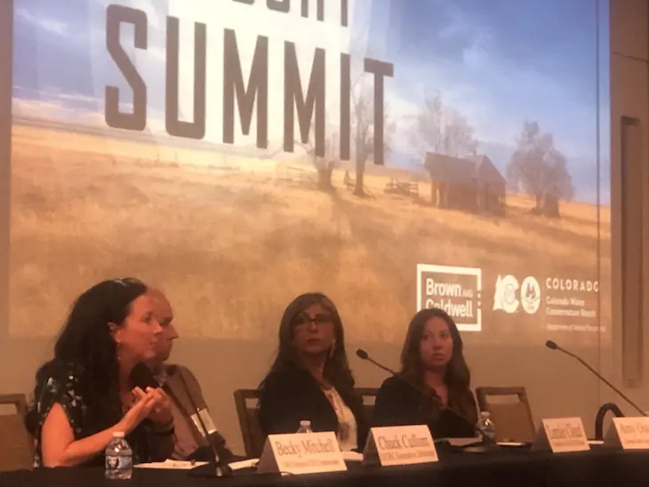
Chuck Cullom was speaking before a friendly audience on June 1 when he shared his perspective on the messy story in the Colorado River Basin.

“Is the press here?” he asked early in his remarks, surely knowing that the event, the Colorado Drought Summit, was being taped for later posting on the website of the Colorado Water Conservation Board, the sponsor of the two-day meeting. “Is anybody here from a ski town?”

Since 2021, Cullom has directed the Upper Colorado River Commission, which represents Colorado and three other upper-basin states of Utah, Wyoming, and New Mexico. This is distinct from the lower basin, which consists of Arizona, California and Nevada.

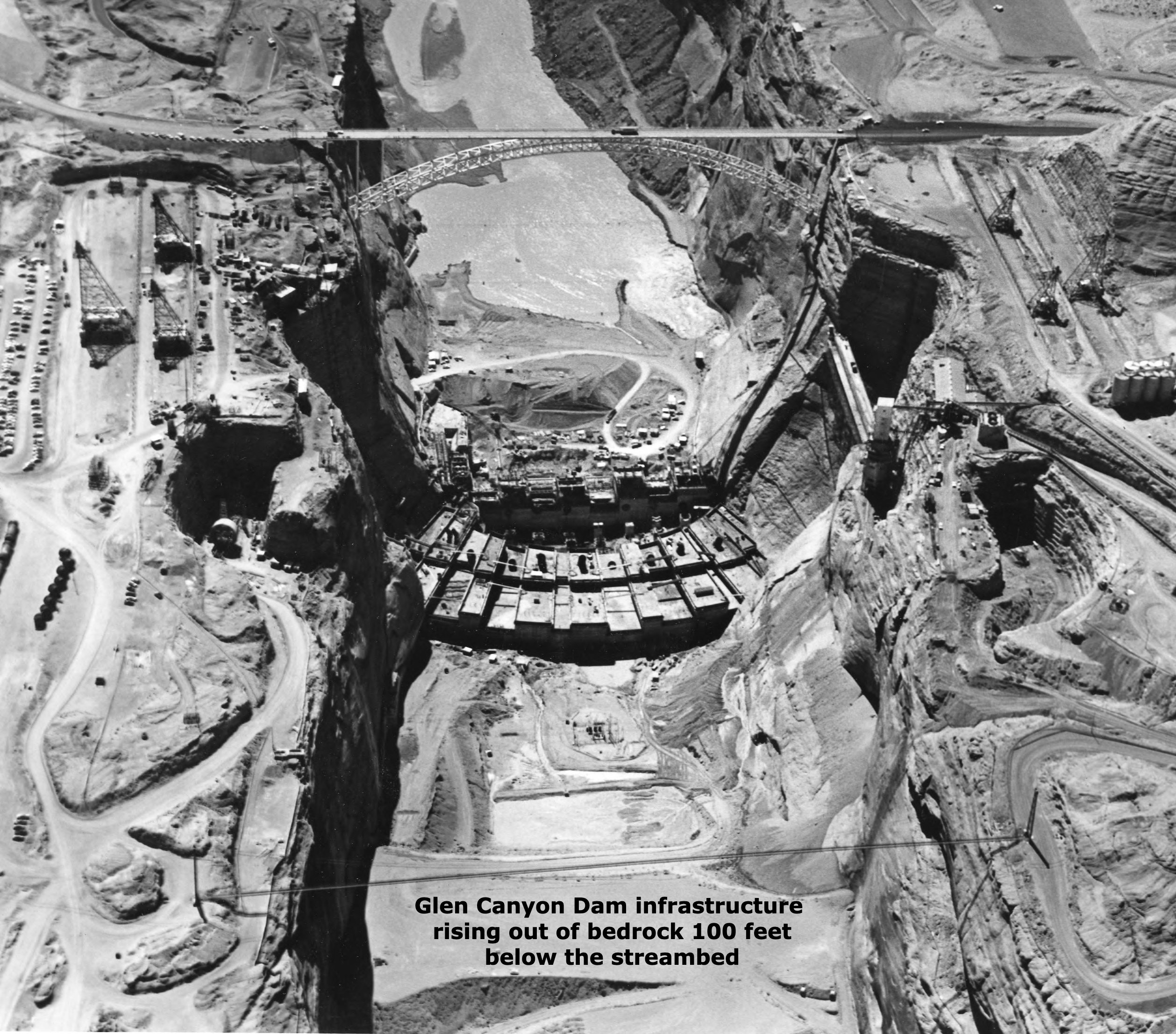
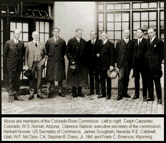
The bifurcation, primarily a legal one but a hydrologic one, too, was created by the Colorado River Compact in 1922. The division is marked by Lee Ferry, just below what is now Glen Canyon Dam and the launch point for boaters rafting the Grand Canyon. Most of the water in the Colorado River Basin comes from upstream, especially from snow and especially in Colorado.

For the 25 years prior to his current position, Cullom was in the lower basin, most immediately before at the Central Arizona Project. That giant straw, the last major one stuck into the Colorado River, delivers water to Phoenix, Tucson, and other cities as well as some agriculture users in Arizona. It’s also worth noting that there has always been friction between Arizona and California.

Now, from his base in the greater Salt Lake City area, he’s just across the hill from Park City, one of the top mountain resorts.

“So we have what are referred to as the trustafarians, which is a tribe of people who live off their trust funds,” he said. “Trustafarians tend to drive something between a new Subaru and a Range Rover, but with the latest kit bolted atop. I don’t know if they ever take it off, but they do have skis and mountains bikes and stuff—and they expect their paycheck every month from daddy or whomever. And they are insufferable.”

“You better be going someplace with this,” quipped another panelist, Becky Mitchell, the director of the Colorado Water Conservation Board, known in water circles by CWCB. She is also Colorado’s voice on Colorado River affairs.

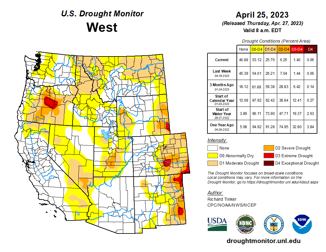
Mitchell had just wrapped up a critique of the recently announced agreement in which the federal government is to give lower-basin states $1.2 billion to curtail about 10% of their withdrawals from the Colorado River during the next three years. During that time, at least in theory, the basin states will have figured out how to solve their bad-math problem. During the 21st century, they’ve been withdrawing more water than the river has delivered. The two basins – upper and lower – do not share equal responsibility. The lower-basin has been drafting on the water banked during wetter times.

Like ski town trustafarians, Cullom explained, the lower-basin has a sense of entitlement. Trustafarians don’t have to get a job when the money runs out, and the lower-basin states for most of the last century have never had to live within the limitations of natural runoff.

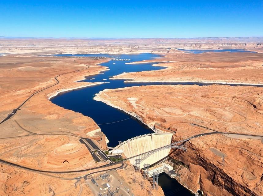
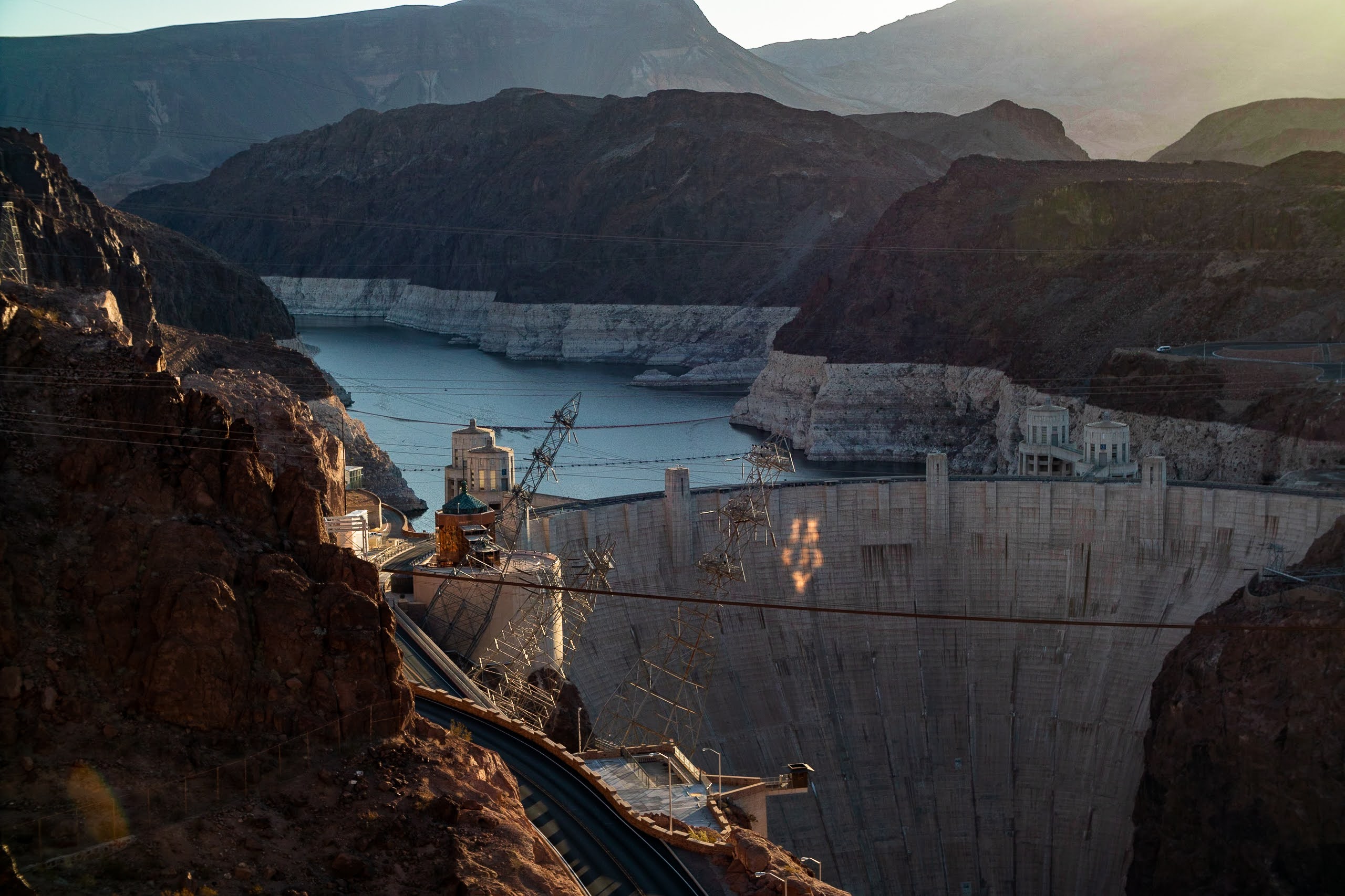
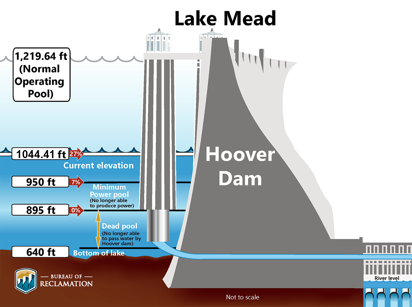
Upstream of the desert empires lies Hoover Dam and, above that, Glen Canyon Dam – plus a lot of other much smaller dams and reservoirs, about 50 million acre-feet in total capacity, which provide assurances that the water will be available, no matter what is happening in the headwaters. But what has been happening most years in the 21st century has been drought and its longer-term and less reversible component, aridification.

On May 17, Rabbit Ears Pass still had plentiful snow for Muddy Creek, a tributary to the Colorado, and for the Yampa River tributaries. Photo/Allen Best

Mitchell, who was first in the batting order in the program, has never been one to mince words. She seemed particularly animated as she described being in Phoenix the previous day to present the upper-basin’s perspective. The majority of the day was devoted to sharing “their concerns over security and certainty that they felt they were entitled to,” she said.

One can wonder how her message may have been delivered on the road as opposed to a home-court crowd.

“When we talk about security and certainty, the way that water is being used in the lower basin is damaging all of our security and certainty, not just their own.”

As did Cullom, Mitchell described a system that has shielded the lower-basin states from the hydrologic realities.

A field of produce destined for grocery stores is irrigated near Yuma, Ariz., a few days before Christmas 2015. Photo/Allen Best – See more at: http://mountaintownnews.net/2016/02/09/drying-out-of-the-american-southwest/#sthash.7xXVYcLv.dpuf

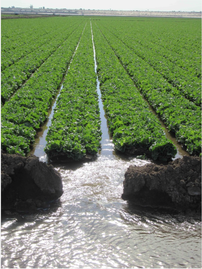
Colorado and other upper-basin states must largely live within the natural water budget, what falls from the sky. There are many dams and reservoirs, but even the largest are almost tiny in their capacities compared to the behemoths of Powell and Mead. Having those giant reservoirs above them allows California and Arizona to be certain that the water will be there for their cities and crops, be it lettuce in winter, or alfalfa and almond groves in summer. Agriculture, particularly in the Imperial Valley of California and the Yuma area of Arizona, has the most secure water systems.

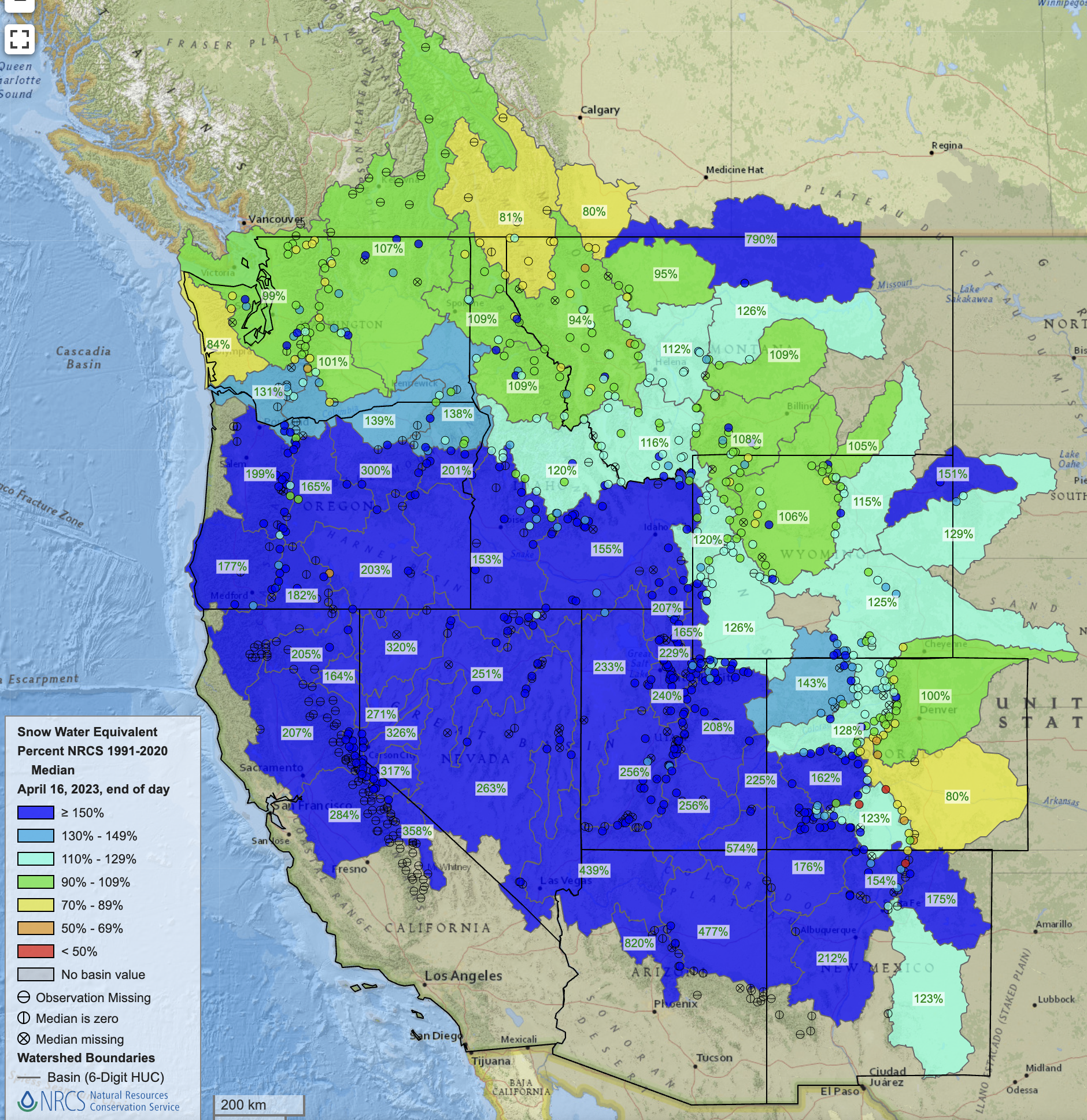
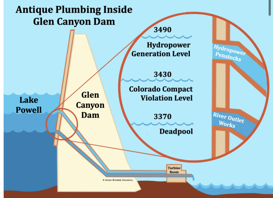
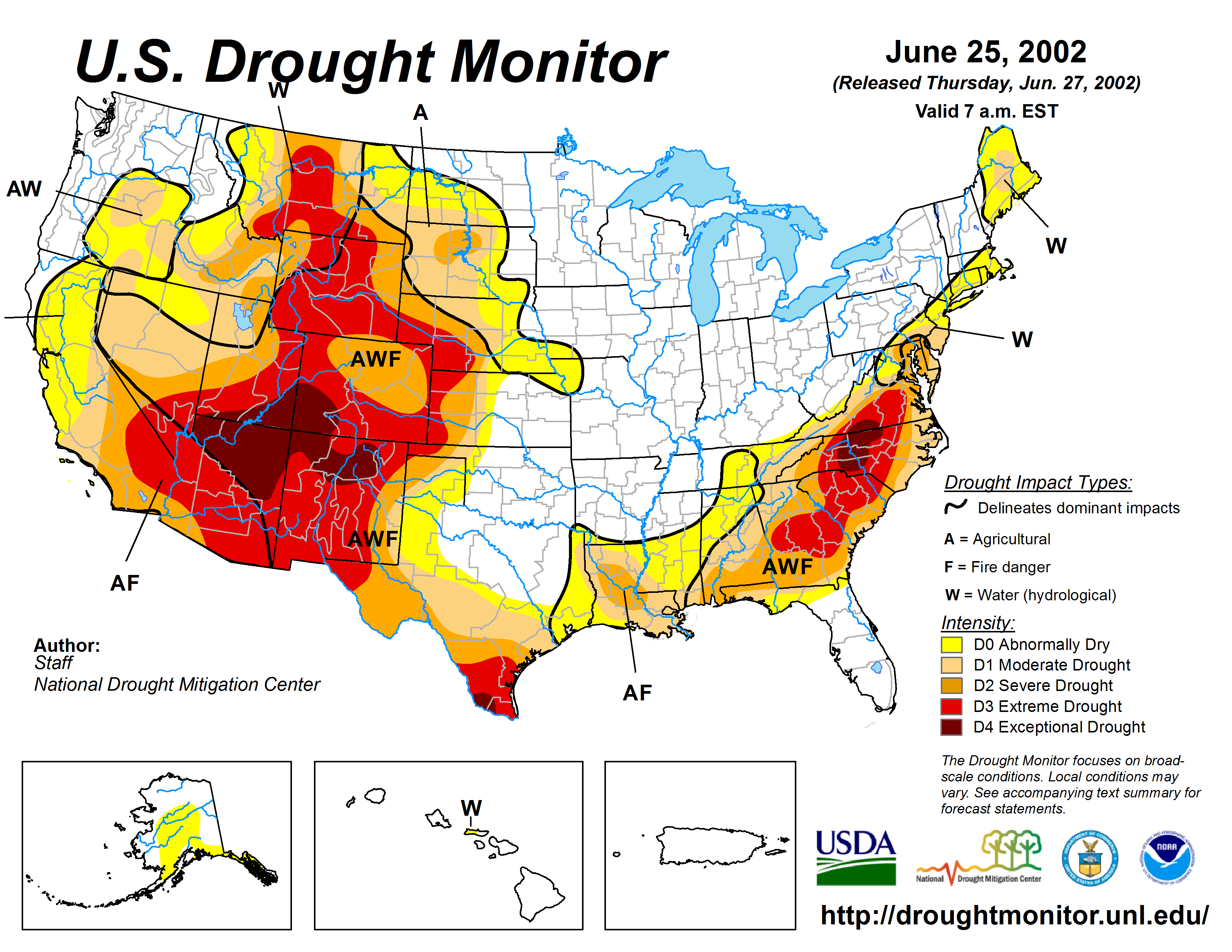
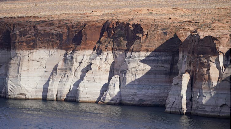
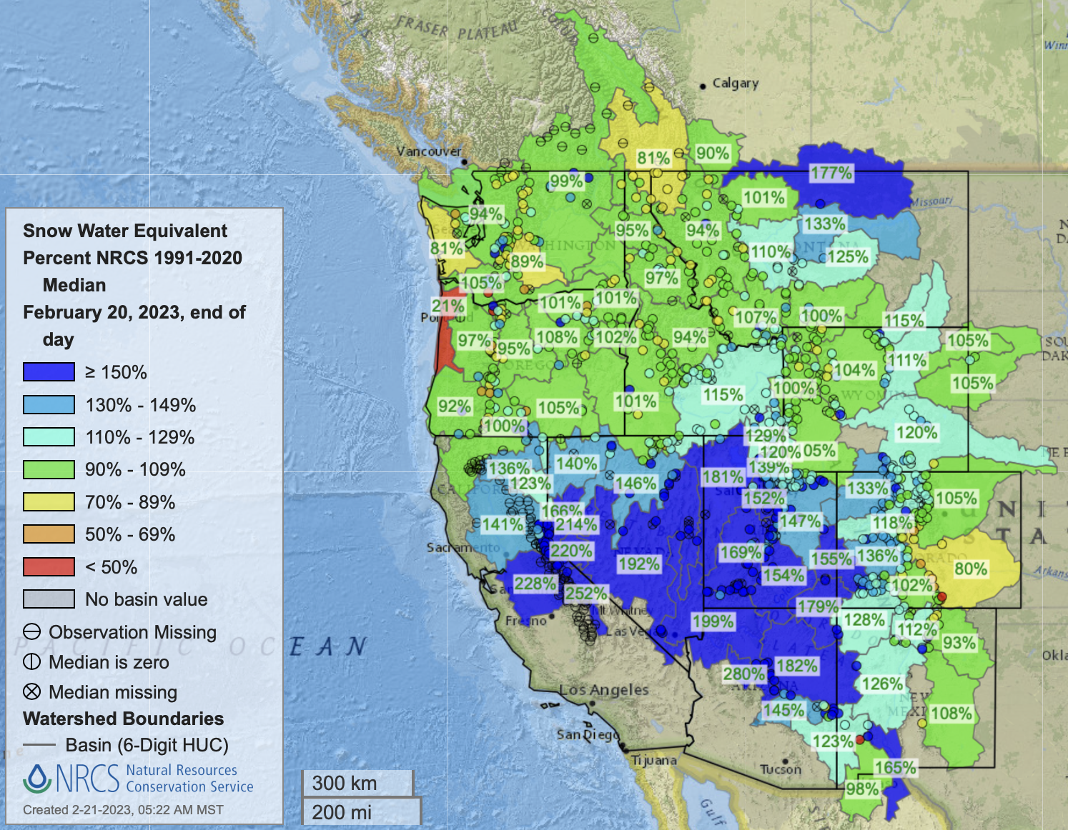
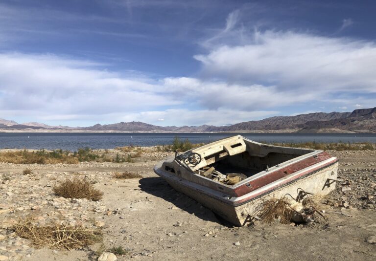
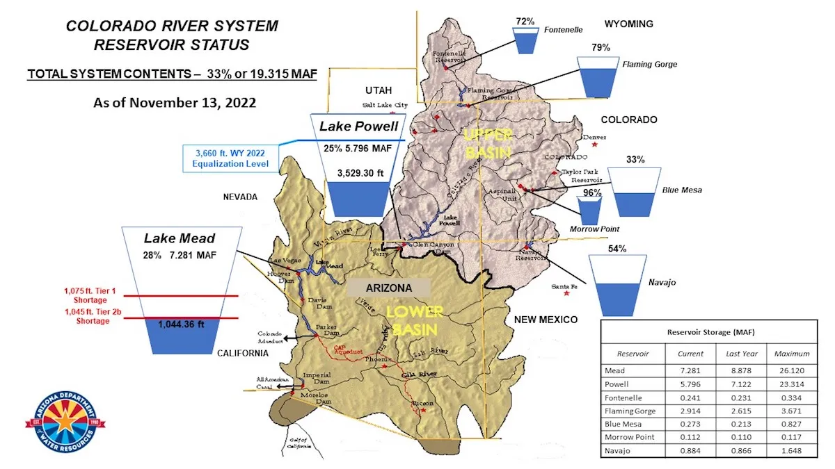
In a sense, Mead and Powell represent savings accounts. Now, as all of the nation understands, the result of new and devoted national media interest, those bank accounts have verged on functional depletion. Going into this winter, the two reservoirs were 26% and 23% full. There was legitimate worry that, given just another dry winter, hydroelectric production at Glen Canyon would cease and, with another dry winter or two, Powell might drop to levels such that it could not allow water to go downstream, a level called dead pool.

Graphic credit: Becky Mitchell/CWCB

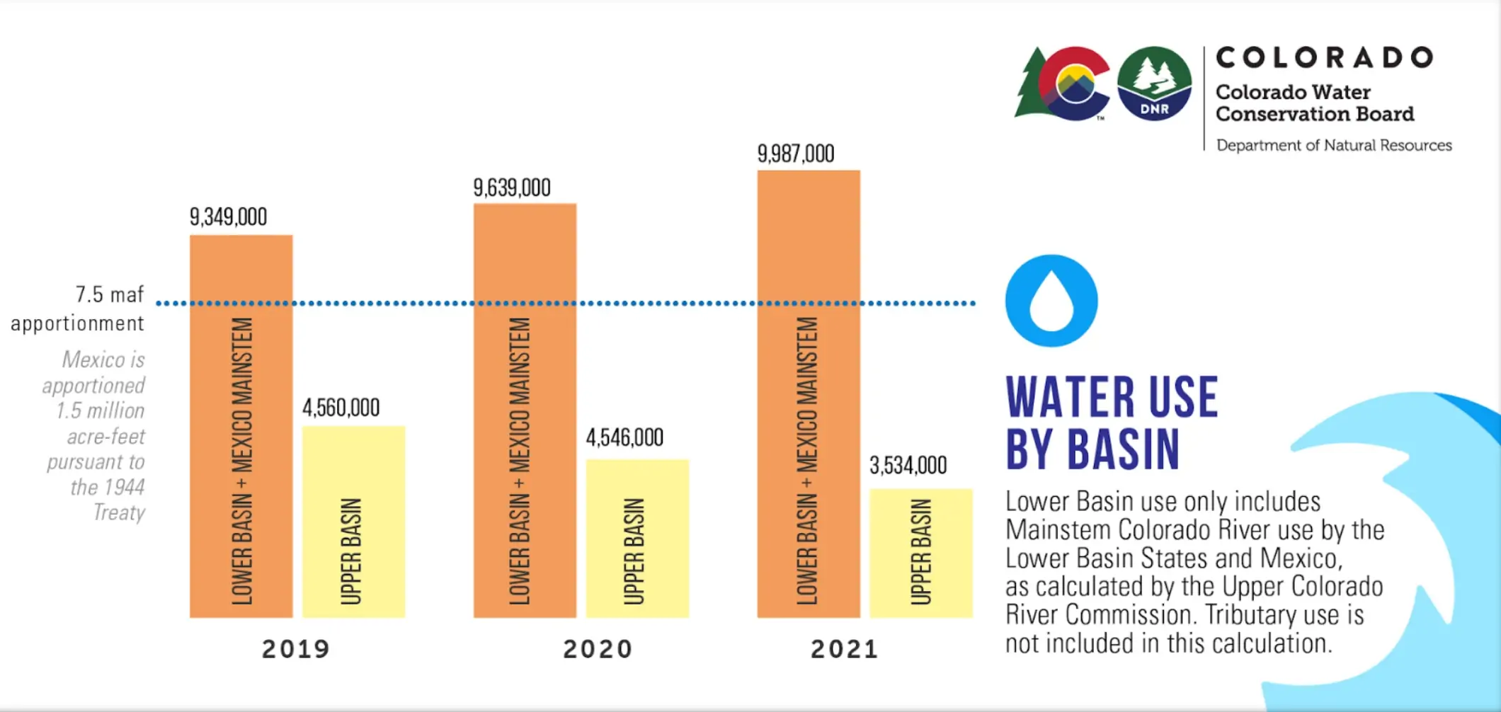
The marvel in all this is that California, especially, and to a lesser extent Arizona, have not fundamentally changed anything in the last 20 years. According to Cullom, the lower basin states have been consuming about 10 million acre-feet. This compares to about 3.5 to 3.75 million acre-feet by the upper-basin states.

The Colorado River Compact stipulates equal apportionment between the two basins of 7.5 million acre-feet on a rolling 10-year average.

Almost everybody has heard talk about whether the Colorado River Compact needs to be renegotiated, said Mitchell. It does not, she declared. Instead, it needs to be honored.

“The foundational principle of that compact is equity. Sit with that for a little bit,” she said.

“While these quantities are distracting and we know that the river is suppling less than it did a 100 years ago, that doesn’t take away from the foundation principles of this compact. With that being said, I believe that the compact is flexible enough to adapt to these conditions. We, as humans, are flexible enough to include other voices in these conversations,” added Mitchell, a reference to Lorelei Cloud, a representative of the Southern Utes who was also on the Colorado River panel at the conference.

Native Americas, if almost completely ignored when the waters of the Colorado River were being apportioned, in fact have the most senior of rights as determined by the U.S. Supreme Court in a 1908 case that yielded the Winters Doctrine. Those rights in the Colorado River Basin are estimated to be 20% to 25% of the river’s total flows. Tribes in Colorado and other upper-basin states have had their allocations determined, but the work remains incomplete in the lower basin.

Mitchell and Cullom also described efforts by upper basin states, if not always successful, to begin pruning water use in anticipation of possibly hotter, drier times ahead. Lower basin states have made some adjustments, but the question is whether they are remotely close to what is needed.

“When we saw the flags of a crisis coming, there was a choice by some to not make changes that are going to be painful,” said Mitchell, alluding to the lower basin.

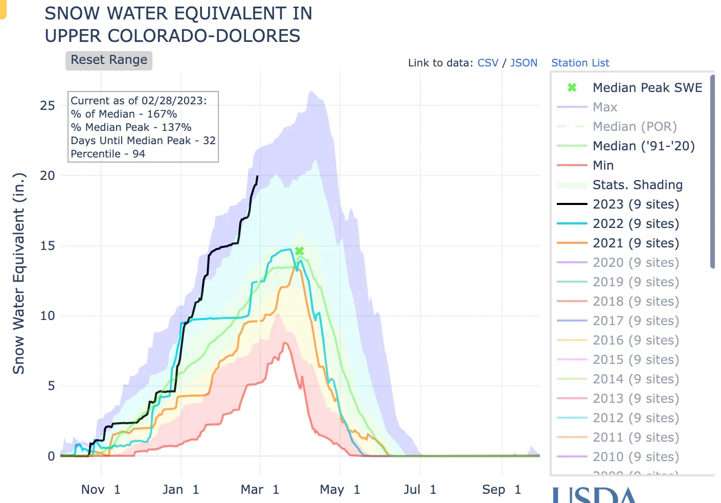
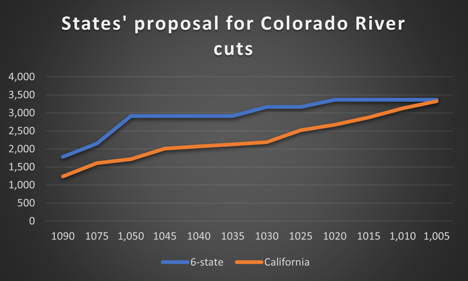
Upper-basin states, she went on to explain, did make choices. In her description, users in upper-basin states did suffer, pointing to the divergent numbers of the upper-basin and the lower basin. in a chart on the screen behind her. (See above).

“These numbers tell the story of how change has to happen. And so when people get tired of us sharing the numbers, we’re going to share them some more.”

Cullom made a similar point. “It’s a threshold difference when you live downstream of 50-plus million acre-feet of storage. Your concerns about your year-over-year precipitation and runoff in operations are pretty marginal. It’s very, very different up here. Last summer, fully one-third of Wyoming’s users on the Green (a tributary to the Colorado) were shut off, regulated off.”

That, he added, is not something understood in the lower basin. “It means you are out of priority.”

It means that you are out of priority that day, that week, that month. And the state engineer, who in Wyoming is a law-enforcement official, comes and shuts you off. That is not a thing in the lower basin. But in August and September (of 2022, fully one-third of growers in the Green were curtailed. Ninety percent of the Ute Mountain Ute water was curtailed, their agricultural productivity was reduced because of hydrology.”

There’s another difference,  he went on to say: the upper basin has tens of thousands of individual water users and “turnouts,” places where water is diverted. In the lower basin, there are probably 30 main-stem turnouts of which fewer than 10 really matter.

The upper basin, he said, is “small, messy and complicated. The lower basin is just a corporate machine of giant turnouts.”

Water levels in Lake Powell have been rising rapidly this year, but in May 2022 there was a very real risk that levels would drop too low for hydroelectric generation. Photo/Allen Best

A bit of history: The reservoirs entered the 20th century close to full. The 1990s had been good snow years and the upper basin states had not developed their full allocation of 7.5 million acre-feet. California famously had been allocated 4.4 but was using about 5.5

Then came the lean years, worst of all 2002. The river carried only 4.5 million acre-feet of water. Attorneys who framed the Colorado River Compact had assumed 20 million acre-feet of water on average. The thin “bathtub rings” on the sides of the reservoirs representing high marks widened considerably—and then widened more in subsequent years.

The first response was the Interim Guidelines of 2007. Then came other very small belt-tightening measures. California, for example, cut back to its legal entitlement.

By 2015, though, it had become clear that more would be needed. A modestly good water year allowed the lower-basin states to postpone any serious talk. Then came a bad year—and finally there was action. The result was the 2019 drought contingency plan.

Updated Colorado River 4-Panel plot thru Water Year 2022 showing reservoirs, flows, temperatures and precipitation. All trends are in the wrong direction. Since original 2017 plot, conditions have deteriorated significantly. Brad Udall via Twitter: https://twitter.com/bradudall/status/1593316262041436160

At the time, Brad Udall, who has family roots in Arizona but a lifetime mostly in Colorado, told me that he believed that 2019 agreement that was broadly heralded was not close to being enough. “I hope I’m wrong,” he said.

He wasn’t.

More lean years followed, the reservoirs shrank, and the small measures weren’t near enough.

In their remarks at the Drought Summit in Denver on June 1, Mitchell and Cullom mentioned several of those efforts in the upper basin, with Mitchell describing one as “clumsy.” Cullom said something similar, noting the call for accelerated action as not without risk. “Part of the challenge with picking up the pace is you stub your toe,” he said, alluding to mistakes made in the system conservation pilot program.

The Yampa River emerging from Cross Mountain Canyon in northwest Colorado had water in October 2020, but only the second “call” ever was issued on the river that year. Photo/Allen Best

Finally, in August 2021, the Colorado River story became national in a way that it had not been before. “In a First, U.S. Declares Shortage on Colorado River, Forcing Water Cuts,” announced the New York Times.

That cut off some farmers in Arizona. More  reduction was needed, though.

On June 14, 2022, Camille Calimlim Touton, the commissioner of the Bureau of Reclamation, which is sort of the task-master on the Colorado River because of its role in regulating the dams, told the Senate Committee on Energy and Natural Resources that between 2 and 4 million acre-feet of additional conservation was needed just to protect reservoir levels. She gave the basin states 60 days to come up with a plan.

To compare, the entire state of Colorado uses about 2.2 million acre-feet from the river each year.

“I wasn’t surprised by the two-million acre-feet,” recounted Mitchell last week. “It wasn’t rocket science. It was addition and subtraction. It’s not even multiplication and division. It didn’t  work. There was an overuse that was not sustainable.”

That deadline from the Bureau of Reclamation was missed, as was an extension.

Finally, in late January, something came out, if it also fell short. California wasn’t on board.

“Cut the crap,” Udall was quoted as saying in a Denver Post story in January.

Finally in late May, a new agreement was announced, getting front page attention from New York and Washington DC to Los Angeles (and, of course, in Denver).

Center-pivot sprinklers on the Ute Mountain Ute Reservation in southwestern Colorado were mostly sitting idle in May 2022 after another low-snow and warm year in the San Juan Mountains. Photo/Allen Best

“We’ve received a page and a half of bullet points saying what the lower-basin intends to do. We don’t know how they’ll do it. We don’t know where the water will come from (among existing uses). We don’t know if it will be binding and enforceable,” said Mitchell.

She said Colorado and other upper basin states are waiting to see a revised draft supplement environmental impact statement.

Mitchell was unsparing. “I think it’s also important to recognize that we don’t get paid for the conservation that happens in the upper-basin states, because it’s in response to hydrology,” she said.

There is yet another bone of contention, one that all but Colorado River wonks will have a hard time understanding. That is who takes responsibility for evaporation from the reservoirs as well as transmission loss.

Hydrologists estimate a million acre-feet of evaporation occurs on Lake Mead – but in the accounting of the lower-basin states, he said, it doesn’t exist.

“In the lower basin,” said Cullom, “they, uh, somehow , uh, there’s an atmospheric thing that prevents evaporation from being considered. Apparently physics doesn’t work (the same) everywhere.”

By that point, Cullom had left his metaphor for ski town trustafarians alone. Do you think he uses that when he speaks in Las Vegas, Phoenix or Needles?

Allen Best is a Colorado-based journalist who publishes an e-magazine called Big Pivots. Reach him at allen.best@comcast.net or 720.415.9308.

Map credit: AGU

Thoughts on the Lower #ColoradoRiver Basin #Water Deal — Sibley’s Rivers #COriver #aridification

Click the link to read the article on the Sibley’s Rivers website (George Sibley):

A short post, to catch up on Colorado River current events. As you probably know, if you haven’t been living in a media-free cave, the three Colorado River states below the canyon region have proposed another alternative plan for saving the River’s reservoir system.

Their proposal, for answering the Interior Department’s call for cuts of at least two million acre-feet (maf) of water annually, is to cut three maf total over the next three years – and they want 1.2 billion dollars from the federal government to execute their plan.

Their plan is basically to pay farmers to voluntarily fallow some of their land. They say they will do half of the cuts – 1.5 maf – in 2024, the remainder over the following two years. Beyond that, there are no firm details at this writing as to how much of the cuts will come from each state, how much they will be paying farmers, et cetera.

Basically, what it looks like on the surface of it, is that the Lower Basin states have countered the Bureau’s four existing scenarios – two from the Bureau of Reclamation, one from California, and one from the other six River states – with an offer to do half of the minimumcuts the Bureau said we need, and they want a billion dollars to do it. What a deal.

If their plan to pay farmers to leave the water in the system sounds familiar, that may be because the four Upper Basin States tried a similar plan this year, the System Conservation Pilot Program, with a fund of $125 million from the ill-named Inflation Reduction Act. Upper Basin farmers did not rush to take up the offer. Only 88 submitted applications to participate, of which around 20 percent were rejected; the remainder will, if things work out as projected, save 39,000 acre-feet at a cost of $16 million. That is a very small piece of two million acre-feet.

The High Line Canal is an irrigation ditch built in the 1880s. Denver Water still uses the canal to deliver irrigation water to customers when conditions allow. Photo credit: Denver Water.

It has been said that farming – especially irrigated farming – is a calling, not an occupation. I have heard farmers and ranchers talk about ‘a working contract with the land,’ and in the Upper Basin at least there seems to be something almost offensive to many farmers about the idea of being paid to not farm some of their land. Ranchers in the Upper Gunnison say it takes up to five years to bring a hayfield back to full productivity after a year of no water (or very little). We’ll see, I guess, if Lower River farmers have the same basic feelings….

A further reason for the low turnout for the Upper Basin’s System Conservation Program might be that Upper Basin farmers believe – correctly enough – that the two million acre-foot ‘structural deficit’ is not their problem and they should not be expected to exercise themselves to help deal with it. A logical enough response when working with a Compact that, as one of the Compact commissioners said, is ‘almost making two rivers out of one in the Colorado River.’ The ‘Glen Canyon Wall’ near Lee Ferry eliminated that ‘almost.’ There has been no indication from the Lower River states that they would be merciful to the Upper River states, should the drought (not ‘caused’ by the Upper States) drive the available flow past Lee Ferry below the Compact allotment; so why should the Upper River states feel empathy for the Lower Basin states?

It was reported in the national media, by the way, that the Upper Basin states have ‘accepted’ the Lower Basin’s proposal. They have not, yet. The four Upper states merely said it was okay for the plan to be evaluated along with the other four proposals in the Bureau’s ‘Supplemental Environmental Impact Study.’

West snowpack basin-filled map April 16, 2023 via the NRCS.

All that noted – the Lower Basin proposal will probably be accepted for a variety of reasons. One reason is that the runoff from a good snowpack is probably going to give temporary relief on the reservoir levels; we should end the water year with both Powell and Mead Reservoirs higher than they were at the beginning of the year (water year is October to October), and that provides a little breathing room. (Keep in mind, though, that the Bureau first issued its major warning and challenge in 2022, saying that big reductions had to happen beginning in 2023. Now, nothing big will happen until 2024. Pray for snow next winter too.)

Another reason the proposal will probably be accepted is because if any of the other four proposals were to be chosen by the Bureau, one or more of the Lower Basin states would sue the government. There might be an element of desperation to both the gambit of promising to try to deliver only half of the requested cuts, and to the threat to sue if asked to deliver the whole 2 maf/year. The Bureau wants the Lower River region that serves a tenth of the national population and produces most of our winter fresh green stuff to cut their water use by almost one third – and do it next year. That’s a big request, maybe an unreasonable request.

Never mind that, had the Bureau and the seven Basin states been living in the real world, they would have taken care of the ‘structural deficit’ decades ago, with a gradual drop in Lower River use, reflecting the growth of use in the Upper River states that was eating into the so-called ‘surplus’ that the Lower Basin had grown to depend on take care of its system losses, and also its half of the allotment to Mexico.

And a final reason why their proposal will probably be accepted? 2024 is a presidential election year, with the current administration on the line, and both Arizona and Nevada are important swing states. ‘Nuff said.

It will come down to whether, next year, the three Lower River states can find enough farmers and cities willing to voluntarily give up a million and a half acre-feet of water next year. Tucson and the Gila River Indians have already made commitments. Meanwhile – pray for snow next winter.

Map credit: AGU

#ColoradoRiver District hosts annual State of the River meeting in #Granby — Sky-Hi News #COriver #aridification

Colorado River “Beginnings”. Photo: Brent Gardner-Smith/Aspen Journalism

Click the link to read the article on the Sky-Hi News website (Kyle McCabe). Here’s an excerpt:

The river district’s Public Relations Director Marielle Cowdin spoke about the district’s work. She highlighted the Colorado River’s crisis, saying that the increased precipitation over the last year will not save the river…Cowdin talked about the water consumption differences between the upper and lower basin states, highlighting that upper basin states make cuts more effectively because they do not have massive reservoirs like Lake Mead or Lake Powell to rely on in drier years. 

“Between 2020 and 2021, the four upper basin states cut our water consumption by 1 million acre-feet — just on our own because the water wasn’t there,” Cowdin said. “Instead of about 4.5 million acre-feet of water use, in that year timeframe, we only used 3.5 (million).”

The lower basin states’ 2020-21 consumption went up 600,000 acre-feet from their average use, Cowdin said. The annual water usage split between the states has been about 60%, or around 8.8 million acre-feet, used by the lower basin versus 30%, or around 4.4 million acre-feet, used by the upper basin, with the remaining water going to Mexico…

The next speaker, Rebecca Mitchell, the Colorado Water Conservation Board director and Colorado’s commissioner to the Upper Colorado River Commission, was the special guest at the event. She spoke about the Bureau of Reclamation’s Draft Supplemental Environmental Impact Statement (SEIS) and news that broke about it the day of the meeting. Mitchell explained that the bureau’s SEIS came after the lower basin states did not respond to the bureau’s June 2022 announcement that states needed to cut 2-4 million acre-feet. That announcement, she said, was not a surprise to those working on the Colorado River…Differences between the upper and lower basin states came up several times in Mitchell’s talk. She mentioned that the six-state plan, which included all states besides California, acknowledged that the upper states have shortages annually because, unlike the lower states, they do not have huge reservoirs from which to draw…On May 22, the day of the meeting, the bureau announced a pause on the SEIS. Mitchell explained that the lower basin states had presented a plan which included temporary cuts that would amount to 3 million acre-feet from 2024-26 but provided few details on how cuts would be enforced.

“​​Instead of coming up with 2-4 million on an annual basis, they were like, ‘Hey, there’s all this money … we can kick the can a little bit more, and we can use this money and make some temporary changes,” Mitchell said of the lower basin states.

Romancing the River: #GlenCanyonDam and Another America — Sibley’s Rivers #ColoradoRiver #COriver #aridification

Glen Canyon Dam construction. Credit: Sibley’s Rivers

Click the link to read the article on the Sibley’s Rivers website (George Sibley):

We’re in a bit of a holding pattern along the Colorado River today, at least in the Upper Basin: on the one hand, waiting for the Bureau of Reclamation to weigh the options for big cuts in Lower Basin use; and on the other hand, seeing the Lower Basin states trying to come up with a less painful set of big cuts to impose on themselves over three years, taking advantage of the big snow year that relieves a little (but just a little!) of the immediate pressure.

At any rate, it’s an opportunity for me to step back a step and try to restore something of the perspective with which I started these posts – ‘learning to live in the Anthropocene.’ I’ve been calling the posts ‘Romancing the River,’ wanting to work in the spirit of Frederick Dellenbaugh in his book The Romance of the Colorado River: making the story of the First River of the Anthropocene something to engage in rather than deny. But the stories keep getting lost in the avalanches of mostly dispiriting details coming down these days….

So anyway, today – an unremembered part of the story of Glen Canyon Dam. Last post, we explored the structure of the dam itself, a good solid Early Anthropocene structure. But today I want to explore the infrastructure of the dam. As with most dams, what you can see is not the whole thing, even physically. To get a firm foundation on bedrock for ten million tons of concrete, the builders had to dig out more than a hundred feet of rock, rubble and sand from the natural streambed. That hundred feet of dam below the streambed is the physical infrastructure of the dam.

But even before that digging-down could begin, a political, economic, legal and philosophical infrastructure had be cobbled together on which to erect the physical structure. Recent articles about the river and its troubles that try to offer any river history at all tend to give credit (or blame) for the dam to a large mass of ego and bluster, Floyd Dominy, but he was just the Reclamation Commissioner when the dam was legislated, a guy who wanted to build dams as big as his ego. He built the structure, but he didn’t assemble the legal and political infrastructure that enabled it.

The larger story of Glen Canyon Dam’s infrastructure is mostly, but not entirely, a story of the Old West – a story of the most serious attempt to achieve a working truce between the Old West and the New West. And for those with my tendency toward an iconoclastic interpretation of history, it was one of the final episodes (thus far anyway) in America’s semi-civil westward war between the advance of the well-defined and well-funded Industrial Revolution and the retreat of a vaguely defined agrarian counter-revolution. For a review of that semi-civil war, go to ‘Westward the Curse of Empire,’ April 4, 2022.

When we talk about the Old West and the New West, we are talking about two very different cultures. Most (over)simply, we can say that the Old West is the west to which people went to live and make a living developing and marketing the natural resources of the West; and the New West is the west where people who live in the urban-industrial realm go to play, to ‘recreate’ themselves among the natural wonders and magnificent scale of the West.

It is useful to make a further distinction about the Old West: it was populated by ‘settlers’ and ‘unsettlers’: the unsettlers usually arrived first, the human equivalent of a plague of locusts with a mining mentality (mining gold and silver, other metals, old-growth timber and grass) – a drive to get there first, get the goods, and get rich. The settlers, on the other hand, came to farm or ranch with the intention of staying and making a life, settling down, homesteading. Some of the farmers tended to be soil miners, but the ones who stayed were true agrarians, the counterrevolutionaries to the industrial revolutionaries.

People of course do come to live in the New West too, not just to visit: they are usually either relatively well-off people retiring, or professionals working remotely with incomes from elsewhere, or they are mendicant people like I was sixty years ago (relatively poor, mostly by choice) who work for the recreation industries set up for the people who come to play, in exchange for getting to live and play themselves among the natural wonders of the West.

The story of Glen Canyon Dam, and the counterrevolutionary effort to co-opt it, began in the years immediately following World War II. The Lower Colorado River Basin had already been transformed into a desert empire through the 1928 Boulder Canyon Project, completed just in time for Southern California to grow explosively through the war effort. The four Upper Basin states figured that they would get their day after World War II. And in 1946 the Bureau – eager to follow the creation of Hoover Dam and the desert empire with more river miracles – came out with a pamphlet: ‘The Colorado River: A Natural Menace Becomes a National Resource.’ In it the engineers presented a smogasbord of 88 possible projects, large and small, all in the four states of the Upper Colorado Basin. They cautioned that there would not be enough water for all 88, so there must be some choosing.

Palisade peach orchard

The principal architect for the legal, political and economic infrastructure underlying what came to be the Colorado River Storage Project was no larger-than-life figure like Dominy, but an unprepossessing Congressman, Wayne Aspinall, from Colorado’s West Slope and the river’s largest headwaters catchments. Aspinall did not stand out in a crowd, but he was savvy, and absolutely committed to the Old West as an economy of working people engaged in the production of resources needed in the larger society – and with a deep love for irrigated agriculture, having grown up with his father’s peach orchard in the Grand Valley after the Bureau’s highline canal brought them water.

He was a Democrat, an unlikely representative from one of Colorado’s most conservative districts, but he began his political career in the late 1920s as a common sense alternative to the mess the Ku Klux Klan had made everywhere in Colorado, and he kept getting re-elected to state, then national offices because he got things done.

When the West Slope sent him to Washington in 1948, he got appointed to the House Committee on Interior and Insular Affairs, mastered the arcane procedures of the House, and as the district kept returning him to office, he gradually ascended to the chair of that committee, which gave him a lot of power over the budget and operations of the Interior Department and its Bureau of Reclamation. He exercised that power so vigorously and, in the opinion of many of his colleagues, so arbitrarily, that House committee rules were changed after he left, to diminish the power of chairs who took the time to learn the rules well enough to manipulate them.

A bust of Wayne Aspinall, in Palisade, facing the Colorado River. Photo: Brent Gardner-Smith/Aspen Journalism

He also knew which way the tide was running in America. The 1920 census for the first time showed more people living in the cities than in the rural areas, and by the end of World War II, that imbalance was accelerating. (‘How ya gonna keep’em down on the farm, after they’ve seen Paree?’) His Old West constituency was being diluted by newcomers aghast at learning a few eggs had been broken in making the omelet they took for granted. The cities they came from were also needing more water, and Aspinall was often caught between constituents angry about yet another transmountain diversion, and east-slope movers and shakers angry about what he could not deny but could often delay.

Nonetheless, his Old West constituents knew where his heart lay, and returned him to Congress 12 times. That might have continued indefinitely, but his own Democrat party outgrew its working-class roots, became a big city party, and gerrymandered him into a mostly urban district where he could not win; he was ‘primaried out’ in 1972. It was probably time; he had become a lightning rod for the early naive-environmentalist movement, and being aligned with that movement myself, I felt naively righteous in voting against him. I still think it was the right thing to do then; he had become increasingly reactionary and defensive, at least as he was being reported in the newspapers. But given what I’ve learned about him since, and my ambiguous feelings about the New West that has replaced the Old West, and about the staggering march of American history in general – I wish I had cast that vote a little more humbly.

In the 1950s, however, Aspinall was just hitting his stride when the Bureau was ready to finish remaking the First River of the Anthropocene, and he jumped on the opportunity to do something big and (he hoped) enduring for the West he and his constituents believed in. More than any other single person, he laid the infrastructure for the Colorado River Storage Project. For better or worse.

The Bureau of Reclamation prepared this ‘overview’ of its Colorado River Storage Project (CRSP) in the mid-1940s. Not all of it happened as planned. The big Cottonwood Reservoir on the Gunnison River became the much smaller Blue Mesa Reservoir after objections from Gunnison residents. And the big Echo Park Reservoir on the Green and Yampa Rivers caused a national uproar that resulted in dropping it entirely. Credit: USBR (Click to enlarge)

The Colorado River Storage Project had to first be a really serious storage project, to assuage Upper Basin water users’ fears of a Compact call, which they thought would come even if nature, not human overuse, caused a shortfall in Lower Basin deliveries. Another time we will take a look at the Upper Basin Compact created in 1948, and the knots the four states tied themselves into, due to their Caliphobia. So the first charge to the Bureau was to build some big ‘holdover’ reservoirs on the scale of Mead Reservoir – dams capable of storing at least two years of inflow.

But the Bureau and Aspinall also wanted big hydropower units in those dams – ‘humming the tunes of endless wealth,’ as a bit of precious Bureau prosody put it. ‘Cash register dams’ was a more prosaic nickname for the big power-generating dams: they wanted the wealth so generated to be applied not only to paying off the big dams, but also to pay for a lot of smaller dams in the higher country.

The biggest problem farmers and ranchers in the arid lands had in irrigating from a desert river fed primarily by snowmelt was the erratic flows – snowmelt floods early in the irrigating season and then almost no water in the late summer when it was most needed. Storage to even out the flows was the key, and storage was expensive. Every community of farmers could go out after harvest with shovels, black powder and mule scrapers, and dig canals to move water, but water storage required materials and equipment they couldn’t afford. Every irrigation district had sketch plans for dams and reservoirs, but for small communities, the Bureau’s cost-benefit analyses for dam repayment were impossible.

But – if a general fund for a big multi-unit project could be created, with power revenues pouring into it, and some small storage projects drawing on it, with cost-benefit analysis calculated for the whole multi-unit project, then the big dams could carry the otherwise unaffordable little dams…. Glen Canyon Dam would (‘twas hoped) assure that the industrial revolution’s desert empire got its water – but it would also provide storage for the counterrevolutionaries’ ‘headwaters republics.’ Win-win.

And that was essentially the Colorado River Storage Project Aspinall and his collaborators in the Upper Basin put together. They started in 1950 with a bill calling for nine big holdover dams and reservoirs, and a couple dozen ‘participating projects’ (the smaller storage dams for the local communities). By the time they finally got the project through Congress in 1956, they were down to three actual holdover dams (Glen Canyon Dam on the Colorado mainstem and Flaming Gorge on the Green River, both with full power generating units, and Navajo Dam on the San Juan with no power unit), the Curecanti unit of three dams on the Gunnison that was primarily for power production, and eleven ‘participating projects’ to be partially paid for from the power revenues – and another two dozen potential participating projects for further study.

And because Aspinall knew the New West was coming, like it or not, the Act included a requirement that every unit would include recreational facilities.

Did it work out as planned? Yes and no. The ‘cash register’ dams were all built, and facilitated the building of around a dozen of the small ‘participating projects.’ My great-grandparents would have been glad for the dam built on the North Fork of the Gunnison River above Paonia, the erratic river whose spring floods had forced them to move their house to higher ground. But they had sold the homestead by the time the dam was built because none of their offspring wanted to contend with the erratic water supply.

Animas-La Plata Project map via USBR

By the late 1960s, however, the nation had grown tired of building (and paying for) western water projects, and NEPA and the advent of the Environmental Impact Study after 1970 made even small water projects problematic. The last project done under CRSP auspices was an Animas-LaPlata project originally intended to help the Ute Indians develop agricultural lands, but it got so scaled down that it was not much use to anyone.

By the turn of the century, ‘reclamation’ was more likely to be interpreted as work to reclaim and restore land and waterways damaged by the collateral debris that the Old West’s heavier industrial unsettlement left behind. Then in the 1980s a large portion of the power revenue from the big holdover dams was diverted from further CRSP counterrevolutionary structures, to an all-out effort to restore four endangered fish species that, back in the 1970s, the U.S. Fish and Wildlife Service tried to kill off by poisoning the Green River. Mistakes have been made, and visions and dreams got carried out with the debris.

The recreation industries, and the accompanying real estate and construction industries, have pretty much overrun and occupied Aspinall’s would-be agrarian republic; but there are, nonetheless, still places in the West where small farms and ranches hang on, some of them ‘heritage cultures’ passed on through families predating CRSP, some of them new and serious about growing local food – and many of them served by CRSP facilities generated by Glen Canyon Dam. But the agrarian philosophy and vision they represent is largely unarticulated in the mainstream culture; I believe, however, that a careful and potentially difficult interrogation of a large number of rural MAGA supporters would reveal that a virulent form of the agrarian counterrevolution still lives, mute but mad, in a twisted variant of unarticulated hope.

Just call it all another story in the romance of the Colorado River – the story of how Glen Canyon Dam was, for a time, put in service to another America.

A high desert thunderstorm lights up the sky behind Glen Canyon Dam — Photo USBR

#Water saved through upper-basin program unlikely to move needle in #LakePowell: Western Slope projects are small and involve agriculture — @AspenJournalism #ColoradoRiver #COriver #aridification

The Grand River Diversion Dam, also known as the “Roller Dam”, was built in 1913 to divert water from the Colorado River to the Government Highline Canal, which farmers use to irrigate their lands in the Grand Valley. GVWUA is not participating the rebooted System Conservation Program after water managers couldn’t agree on how much farmers should be paid to cut back their water use. Photo credit: Bethany Blitz/Aspen Journalism

Click the link to read the article on the Aspen Journalism website (Heather Sackett);

Three of western Colorado’s biggest irrigation districts are not participating on a large scale in a federally funded program to conserve water, and the amount of water saved by the program overall won’t be enough to rescue depleted reservoirs.

The rebooted System Conservation Program was one of the legs of the Upper Colorado River Commission’s 5-Point Plan, announced in July and aimed at protecting critical elevations in Lake Powell and Lake Mead, which have fallen to record-low levels in recent years because of overuse, drought and climate change. System conservation will take place in the four upper Colorado River basin states — Colorado, New Mexico, Wyoming and Utah — and will pay water users to cut back. It’s being funded by $125 million from the federal Inflation Reduction Act.

The total water estimated to be saved across the upper basin for this year of the restarted, temporary and voluntary System Conservation Program is nearly 39,000 acre-feet. By comparison, Lake Powell when full holds more than 23 million acre-feet; Ruedi Reservoir, on the Fryingpan River, can hold about 100,000 acre-feet. (An acre-foot is the amount of water needed to cover an acre of land to a depth of 1 foot and can supply one to two households a year.)

Becky Mitchell, Colorado commissioner to the UCRC, said in a UCRC meeting last month that although the upper basin will do its part in response to last summer’s calls from the federal government that the seven Colorado River basin states needed to conserve 2 million to 4 million acre-feet of water, the majority of that needs to come from cuts in the lower basin (California, Arizona and Nevada).

“(System conservation) will not resolve the crisis in the reservoirs,” she said.

Last month the UCRC approved moving forward with executing agreements with program participants, which are still being finalized.

Although a goal of the program was to get participation across all water sectors — agricultural, municipal and industrial — all of the projects proposed in Colorado involve Western Slope agriculture. None of the state’s Front Range water providers, which collectively take about 500,000 acre-feet per year of the Colorado River’s headwaters across the Continental Divide to thirsty cities and farms, are participating.

Paying water users to irrigate less has long been controversial on the Western Slope, with fears that these temporary and voluntary programs could lead to a permanent “buy and dry” situation that would negatively impact rural farming and ranching communities.

Of the four upper basin states, Colorado has the largest number of projects (29) but the least amount of saved water (3,532 acre-feet). This is an indication that most of Colorado’s participants are proposing small projects. UCRC Executive Director Chuck Cullom said if the program is undertaken again, officials may consider a minimum size requirement because doing very small projects may not be worth it.

“From a practical standpoint of the cost of monitoring and administering a verification program for that (small number of) acres may not pencil out relative to the amount of water conserved,” Cullom said.

Of the 29 Colorado projects, most involve reducing water use for forage crops, according to information provided by UCRC. Eight involve fallowing grass hay as part of a cow-calf operation, saving 1,163 acre-feet of water; seven plan to fallow alfalfa and save 1,029 acre-feet; and eight propose switching to less-thirsty crops, saving 791 acre-feet.

The UCRC received 88 proposals across the four states, 72 of which met the qualifying criteria. Utah has 20 projects that meet preliminary criteria; Wyoming has 22 and New Mexico has one. The UCRC’s opening offer was $150 per acre-foot of saved water, but the average compensation will probably end up being higher — $434 per acre-foot, according to information provided by UCRC.

Grand Valley Water Users Association not participating

Although some water users in the Grand Valley Water Users Association participated in the original system conservation pilot program, which ran from 2015 to 2018 and conserved 47,000 acre-feet of water at a cost of about $8.6 million, they won’t be taking part this time around.

The Government Highline Canal flows past Highline State Park in the Grand Valley. CREDIT: BETHANY BLITZ/ASPEN JOURNALISM

GVWUA, whose Highline Canal delivers water to roughly 24,000 acres of farmland on the north side of the valley between Grand Junction and Mack, withdrew its application from the process after manager Tina Bergonzini said she couldn’t come to an agreement on the price with the UCRC. GVWUA had rejected the concept of paying farmers based on an amount of unused water, instead proposing to pay farmers for each acre of land they took out of production.

Individual farmers would have had to apply to the program through the association, which proposed to cap total member participation at 1,000 acres and 3,000 acre-feet of water.

GVWUA was asking for between $686 and $1,306 per each acre fallowed, depending on whether farmers reduced water use during the entire irrigation season or just part of it.

Bergonzini said the price represents what it would cost to administer the program in a way that provides equity and protection; at any lower price, the funding from system conservation would not be enough to cover the extra staff and engineering costs. Cullom said his organization was unlikely to approve those costs, so GVWUA withdrew its application.

“They were not wanting to pay per acre what we had requested,” Bergonzini said. “They had a line drawn in the sand and so did I.”

The Grand Valley Irrigation Company, which serves about 40,000 acres of farmland between Palisade and Mack, has four projects proposed within its service area, covering a total of 120 acres and 285 acre-feet of water savings.

“It’s not a very big amount,” said GVIC Assistant Superintendent Charlie Guenther. “I did hear from a handful of ag people that they didn’t want to be part of this because it sounded very technical and it was government involvement. That’s something that came up.”

Unlike GVWUA, individual water users within GVIC did not have to apply to the program through the irrigation company, and the company’s board did not take a stance on whether or not to support system conservation, according to Guenther.

There is just one conservation project proposed in the boundaries of the Uncompahgre Valley Water Users Association, the largest irrigation district in Western Colorado, at more than 83,000 acres of farmland in Delta and Montrose counties. The project would enroll about 33 acres in the program and would result in about 46 acre-feet of water savings.

UVWUA manager Steve Pope said the system conservation program didn’t get much interest from his water users because of the timing. Bergonzini agreed.

“They didn’t want to do a last-minute thing,” Pope said. “By the time this thing was rolled out, these guys had already made their decisions and they were already committed for the next season.”

Cullom has acknowledged that there were shortcomings with the program’s rollout. The UCRC unveiled details of the program in December, with an original application deadline of Feb. 1, which was later pushed to March 1 for this summer’s irrigation season.

“We need to do much better when we think about how to do this in the future, if we do this in the future,” he said. “We need more clarity on the data requirements, what we expect from a proposal. We need to give people more time to engage in understanding what the opportunity is and we need to start sooner. Start in the fall for an irrigation season instead of January.”

Conservation district concerns

The Western Slope’s two largest conservation districts — the Colorado River Water Conservation District and Southwestern Water Conservation District — submitted letters to the UCRC stating their concerns with the program. Mitchell had promised the districts that they could participate in the review and approval process for applications, thereby securing a measure of local control. But in March, she walked back that commitment, saying the UCRC had sole authority in the approval process.

The UCRC has released few details so far on project proposal specifics, and publicly available applications have been heavily redacted. In addition to redacting the applicants’ personal identifying information, nearly everything else has been blacked out: the precise location of projects; which streams and ditches are involved; details of the water rights involved; and how much the applicants are asking to be paid for their water.

The districts say this makes it impossible to meaningfully review them to determine whether the projects would cause injury to other water users. Their letters to the UCRC say the lack of transparency raises questions about whether public funds are being used wisely.

“In short, SWCD is very disappointed and concerned about the process that has been undertaken by the UCRC and the state of Colorado,” reads the letter from Southwestern General manager Steve Wolff.

In response, Amy Ostdiek, CWCB section chief for interstate, federal and water information, said that the review process respected project proponents’ privacy and that striking a balance between transparency and privacy is an ongoing effort.

“The Colorado State Engineer’s Office has been directly involved as implementation agreements and verification plans are developed to ensure no injury results from SCPP participation,” Ostdiek said in an email.

She said additional information will be available when the UCRC finalizes agreements with project participants, which should happen late this month, according to Cullom.

The 39,000 acre-feet of water across the four upper-basin states will do little to boost Lake Powell. It’s the proverbial drop in the bucket. But the political value of 39,000 acre-feet may be far greater than any benefit to the nation’s second-largest reservoir. The effort shows that upper-basin water managers are willing to do their part to prevent the system from crashing, but that part is small compared with the cuts they say are needed in the lower basin.

“It’s unlikely any system conservation stood up in the upper basin is going to move the needle,” Cullom said. “But it’s important for the upper basin to participate and contribute within the resources and the tools we have available, and what we are demonstrating in this process is that we do have tools, we do have resources. They are narrow in scope and small in volume.”

Aspen Journalism is a nonprofit, investigative news organization covering water, the environment and social justice. This story ran in the May 12 edition of The Aspen Times, the May 13 edition of the Glenwood Springs Post-Independent, the May 14 edition of the Summit DailySteamboat Pilot & Today, the Vail Daily, the May 15 edition of the Craig Press and the May 16 edition of the Grand Junction Sentinel.

Colorado River Allocations: Credit: The Congressional Research Service

Indigenous tribes were pushed away from the #ColoradoRiver. A new generation is fighting to save it — #Colorado Public Radio #COriver #aridification

Colorado River from Lee’s Ferry. Photo credit. Gonzo fan2007 – Own work, CC BY-SA 4.0, https://commons.wikimedia.org/w/index.php?curid=3631180

Click the link to read the article on the Colorado Public Radio website (Michael Elizabeth Sakas and Sarah Bures). Here’s an excerpt:

Here at Lee’s Ferry, seven southwestern American states divided up the Colorado River with the 1922 river compact. Every single drop was spoken for, between Wyoming, Colorado, New Mexico, Utah, Nevada, Arizona, California, and later Mexico. The water was destined for colonized farmland and cities. But crucially, that 1922 compact denied 30 different Indigenous tribes any share of the water that they needed to survive in the hot and dry southwest. While the federal government helped states build pipes, dams and reservoirs to access the water they were allocated, it didn’t do the same for Indigenous reservations, and many people living on those reservations didn’t know what water they could use.

From the 2018 Tribal Water Study, this graphic shows the location of the 29 federally-recognized tribes in the Colorado River Basin. Map credit: USBR

This was an abrupt departure from the way tribes had lived before white colonizers arrived in the West and forced the tribes onto reservations. For thousands of years, many Indigenous people moved with the river; they adapted to it and responded to it. This is how Daryl Vigil’s ancestors lived in communion with the river. 

“That’s the level of reverence you give that stream or that river,” Vigil, a member of the Jicarilla Apache Nation and of Jemez and Zia Pueblo descent, said. “The dances all revolved around this cyclical nature of the environment and most importantly, rain and snow in terms of what it meant to our existence.”

But as the colonizers built gigantic dams and carved up the river, filling Lake Mead and Lake Powell, the Jicarilla Apache and dozens of other tribes that rely on the Colorado River no longer had the same access to the water as they once did. This was the West that Vigil was born into and where he grew up on three different reservations – at times without indoor plumbing. He now lives on the Jicarilla Apache Reservation north of Santa Fe, New Mexico, and until recently was the tribe’s water administrator. He is among the most recent generation of leaders in a decades-long fight for tribes to regain rights to the water they had access to for thousands of years.

“Part of the need to build economies is also based in an ability to build a basic infrastructure that everybody else in this country is supposed to be entitled to: water, wastewater,” he said. “Native American communities [are] 19 times more likely to not have indoor plumbing.”

When the Colorado River Compact was written in 1922, tribes were left without a legal say in how the river should be shared and managed across the west. But slowly, over the last 100 years, they have pushed for legislation, court cases and settlements — some of which dragged on for decades — to take back their rights to the river…

Updated Colorado River 4-Panel plot thru Water Year 2022 showing reservoirs, flows, temperatures and precipitation. All trends are in the wrong direction. Since original 2017 plot, conditions have deteriorated significantly. Brad Udall via Twitter: https://twitter.com/bradudall/status/1593316262041436160

As tribes were fighting for their rights to the water, and a seat at the bargaining table, the total amount of water to go around was evaporating. Climate change was working hand-in-hand with exponential population growth in the West to deplete the supply of water in the river.

“My message for 20 years now has been: watch out,” said Brad Udall from his home near Boulder, Colorado. “We’ve overdone it, we need to cut back and this is going to get worse. And that’s not a message that, for years, anybody wanted to hear.”

Udall is senior water and climate research scientist and scholar at Colorado State University’s Colorado Water Center — a “delightful title,” he said. Udall studies the Colorado River and the climate change that’s impacting water levels. As part of his work, he often points out that the country’s largest dams, reservoirs and water projects will go dry if we continue using water as we are today

Remember the Colorado River water rights that took 20 years for the Jicarilla Apache Nation to win? They and other tribes have collectively secured rights to use 25 percent of the water in the river. That’s more than Arizona has rights to. But here’s the catch: reservoirs and canals the reservations need to access their full supplies of water don’t exist yet. Without that infrastructure, the water is still going to states, rather than the tribes. This is why many people, including Vigil and Udall, want tribes to have an equal say in how we save the Colorado River in the face of climate change.

Aspinall Unit Spring operations May 12, 2023: Forecasted April – July unregulated inflow volume to #BlueMesa Reservoir is 830,000 acre-feet #GunnisonRiver #ColoradoRiver #COriver #aridification

Blue Mesa Reservoir. MichaelKirsh / CC BY-SA (https://creativecommons.org/licenses/by-sa/4.0)

From email from Reclamation (Erik Knight):

May 12, 2023

The May 1st forecast for the April – July unregulated inflow volume to Blue Mesa Reservoir is 830,000 acre-feet. This is 131% of the 30 year average. Snowpack in the Upper Gunnison Basin peaked at 138% of average. Blue Mesa Reservoir current content is 434,000 acre-feet which is 52% of full. Current elevation is 7470.4 ft. Maximum content at Blue Mesa Reservoir is 828,00 acre-feet at an elevation of 7519.4 ft.

Based on the May forecasts, the Black Canyon Water Right and Aspinall Unit ROD peak flow targets are listed below:

Black Canyon Water Right

The peak flow target is equal to 6,400 cfs for a duration of 24 hours.

The shoulder flow target is 810 cfs, for the period between May 1 and July 25.

Aspinall Unit Operations ROD

The year type is currently classified as Average Wet.

The peak flow target is currently 14,300 cfs and the duration target at this flow is currently 2 days.

The half bankfull target is currently 8,070 cfs and the duration target at this flow is currently 20 days.

Pursuant to the Aspinall Unit Operations ROD, releases from the Aspinall Unit will be made in an attempt to match the peak flow of the North Fork of the Gunnison River to maximize the potential of meeting the desired peak at the Whitewater gage, while simultaneously meeting the Black Canyon Water Right peak flow amount. The latest forecast for flows on the North Fork of the Gunnison River shows a high peak flow occurring near the middle of next week. Flows in the tributaries downstream of the North Fork confluence are also very high, which will help with meeting the flow targets on the lower Gunnison River at the Whitewater gage.

Therefore ramp up for the spring peak operation will begin on Friday, May 12th, with the intent of timing releases with this potential higher flow period on the North Fork of the Gunnison River. Releases from Crystal Dam will be ramped up according to the guidelines specified in the EIS, with 2 release changes per day, until Crystal begins to spill. The release schedule for Crystal Dam is: 

The current projection for spring peak operations shows flows in the Gunnison River through the Black Canyon peaking at 6400 cfs in order to achieve the desired peak flow and duration at Whitewater. Actual flows will be dependent on the downstream contribution of the North Fork of the Gunnison River and other tributaries. Higher tributary flows will lead to lower releases from the Aspinall Unit and vice versa.

Aspinall Unit operations update May 11, 2023: May 1st forecast for the April – July unregulated inflow volume to Blue Mesa Reservoir is 830,000 acre-feet. This is 131%of the 30-year average — Reclamation

From email from Reclamation (Erik Knight):

The May 1st forecast for the April – July unregulated inflow volume to Blue Mesa Reservoir is 830,000 acre-feet. This is 131% of the 30 year average. Snowpack in the Upper Gunnison Basin peaked at 138% of average. Blue Mesa Reservoir current content is 434,000 acre-feet which is 52% of full. Current elevation is 7470.4 ft. Maximum content at Blue Mesa Reservoir is 828,00 acre-feet at an elevation of 7519.4 ft.

Based on the May forecasts, the Black Canyon Water Right and Aspinall Unit ROD peak flow targets are listed below:

Black Canyon Water Right

The peak flow target is equal to 6,400 cfs for a duration of 24 hours.

The shoulder flow target is 810 cfs, for the period between May 1 and July 25.

Aspinall Unit Operations ROD

The year type is currently classified as Average Wet.

The peak flow target is currently 14,300 cfs and the duration target at this flow is currently 2 days.

The half bankfull target is currently 8,070 cfs and the duration target at this flow is currently 20 days.

Pursuant to the Aspinall Unit Operations ROD, releases from the Aspinall Unit will be made in an attempt to match the peak flow of the North Fork of the Gunnison River to maximize the potential of meeting the desired peak at the Whitewater gage, while simultaneously meeting the Black Canyon Water Right peak flow amount. The latest forecast for flows on the North Fork of the Gunnison River shows a high peak flow occurring near the middle of next week. Flows in the tributaries downstream of the North Fork confluence are also very high, which will help with meeting the flow targets on the lower Gunnison River at the Whitewater gage.

Therefore ramp up for the spring peak operation will begin on Friday, May 12th, with the intent of timing releases with this potential higher flow period on the North Fork of the Gunnison River. Releases from Crystal Dam will be ramped up according to the guidelines specified in the EIS, with 2 release changes per day, until Crystal begins to spill. The release schedule for Crystal Dam is: 

Crystal Dam will be at full powerplant and bypass release on May 15th. Crystal Reservoir will begin spilling by May 16th and the peak release from Crystal Dam should be reached on May 18th. The flows in the Gunnison River after that date will be dependent on the timing of the spill and the level of tributary flow contribution. Estimates of those numbers will be determined in the upcoming days.

The current projection for spring peak operations shows flows in the Gunnison River through the Black Canyon peaking at 6400 cfs in order to achieve the desired peak flow and duration at Whitewater. Actual flows will be dependent on the downstream contribution of the North Fork of the Gunnison River and other tributaries. Higher tributary flows will lead to lower releases from the Aspinall Unit and vice versa.

Photo credit: Colorado Parks & Wildlife

Romancing the River: Is #GlenCanyon Dam an ‘Antique’? — Sibley’s Rivers #ColoradoRiver #COriver #aridification

Graphic credit: Sibley’s Rivers

Click the link to read the article on the Sibley’s Rivers website (George Sibley):

Yes, that diagram again. I was chastised by readers last week for using it – partly for the ‘Antique’ in the diagram’s title, but also for not adequately explaining what the diagram shows. I apologize for the latter. These posts tend to run long and demand a lot more of readers than the 15-second attention span for which Americans are derided. But just to keep them down to a couple thousand words or so, I find myself having to go through some things too quickly in order to get to whatever point I was aiming for. Brevity unfortunately is not the soul of my wit.

But having a sense of the structure and infrastructure of our big dams is critical to understanding what is going on along the Colorado River these days, where it is easy to confuse the river itself (which is experiencing chronic low flows but is not ‘drying up’) with the ‘river management system’ (which really could dry up critical stretches of the river under the current management regime). The ‘river management system’ is the integrated set of physical structures along the river for storing the river’s water and distributing it to users – and the operating systems whereby those structures are managed.

The ‘Supplemental Environmental Impact Study’ the Bureau of Reclamation is doing now is basically an analysis of its own operating systems for the big structures on the Colorado River, and how those systems might be radically changed with an equitable distribution of impacts on humans – systems that could have been changed gradually over the past several decades, the past century even, to reflect undeniable evolving realities, both natural and cultural, but now must be done with radical surgery – the call for an almost-immediate reduction in Lower Basin uses of two million acre-feet.

This might be what life in the Anthropocene will mostly be on many fronts: learning how to live well enough with the world we have imposed on the world we found here. A recreated world where some cultural works were done naively and maybe profligately, under assumptions now needing correction – which one might hope we will learn to begin sooner rather than later – or too late, period.

Graphic via Holly McClelland/High Country News.

So it is fitting to look critically at what we’ve done along the ‘First River of the Anthropocene’ – trying not to fall into hypocritical analysis, gnawing on the hands that feed us. And on that spectrum of critical analysis, I do need to explain, if not defend, using a diagram that calls the ‘plumbing’ of a major element in the management system we’ve imposed on the Colorado River ‘antique.’

I will say first that I do not necessarily think of ‘antique’ as a derogatory term (although that was probably intended by the creators of this diagram). If an automobile is fifty years old and still running, it qualifies for an ‘antique’ license plate; that’s cool, an achievement for those who kept the car functional. I think of the word as more descriptive than judgmental: an antique is an artifact whose time is past but which reflects that time, something old but with an element of class, something that summons memories of a previous time, a time we want to remember but not necessarily carry forward.

So, being more than 50 years old at this point – is Glen Canyon Dam an antique? We can start with an examination of its ‘plumbing,’ which says something about its life and times. (My doctor uses colonoscopies for a similar analysis.)

1983 – Color photo of Glen Canyon Dam spillway failure from cavitation, via OnTheColorado.com

One piece of plumbing not shown on the diagram is the dam’s spillways – two huge ‘drains’ up at the 3,700-foot elevation, near the dam’s 3,715-foot crest (for context, 583 feet above the original streambed). The purpose of the spillways is to keep the reservoir from filling to the point where it would go over the crest. Glen Canyon’s spillways have only been used once, in 1983, when a very wet May and hot June caught the dam managers unaware, with the reservoir already too full to perform its flood-control function. The spillways proved to be not up to the task of getting the flood waters past the dam; the water pouring down them caused a cavitation problem – a million tiny ‘air-hammers’ beating on the concrete with enough cumulative force to break it up. The managers knew there was a problem when large chunks of concrete, then sandstone, started washing out the bottom of the spillway outlets. That threatened the integrity of the dam itself; it was necessary to close off the spillways, lining the top of them with sheets of plywood four feet high and praying that the water would stop rising before it topped the plywood. It did stop in time, and the dam was saved. The spillways were rebuilt, hopefully resolving the cavitation problem, and have not been used since – and at this point, given the projections about climate change, it is hard to imagine the reservoir ever being that full again. The spillways alone might qualify as ‘antiques,’ built for a river that needed them (once) but may no longer exist. (Oh great river gods, please make me eat my words!)

During the 1983 Colorado River flood, described by some as an example of a “black swan” event, sheets of plywood (visible just above the steel barrier) were installed to prevent Glen Canyon Dam from overflowing. Source: Bureau of Reclamation

For the dam managers, however, to ‘spill’ water at all is a mark of bad management; their ideal is for every gallon of water contained by the dam to be released through openings 210 feet below the spillways, at hydropower generation level, the 3,490-foot elevation (see diagram). Those openings into the dam drop the water through pentstocks a couple hundred vertical feet to turbines in generators the size of small houses; on its way to its designated use downstream, the water generates electricity. The higher the reservoir level, the more pressure the water’s weight exerts in pushing the water through the turbines; with the reservoir at high levels, the Glen Canyon generators can produce annually up to five billion kilowatt-hours of electricity. In 2022, however, with the reservoir level only around 35 feet above the pentstock inlets, it only produced 2.6 kilowatt-hours. (Bureau figures)

The Bureau’s semi-panicky call in 2022 for massive reductions in use basin-wide was based on projections forward of another couple water years like the 2020-22 period; under the current river management regime, the level of the reservoir would have dropped below the level of the pentstock intakes in a couple years, and year-round power generation would have been impossible.

The back of Glen Canyon Dam circa 1964, not long after the reservoir had begun filling up. Here the water level is above dead pool, meaning water can be released via the river outlets, but it is below minimum power pool, so water cannot yet enter the penstocks to generate electricity. Bureau of Reclamation photo.

Even if that were to happen, however, it would still be possible to move water downstream from Powell Reservoir, through river outlet works with intakes 120 feet lower down in the dam, at the 3,370-foot elevation. The river outlets there are four big pipes, each eight feet in diameter, with a total flow capacity of 15,000 cubic feet per second – when there’s a lot of water in the reservoir to push water through them. If the water pressure stayed at that level, and all four tubes worked 24/7/365, it would be possible to move around 10 million acre-feet (maf) through the dam annually and down to Mead Reservoir, roughly the amount the Bureau has been releasing from Mead for Lower Basin and Mexican use – plus the system losses for which no one has wanted to claim responsibility.

That 10 maf leaving the system at the lower end obviously becomes problematic if only 6-8 maf are flowing into the system at the upper end, as has been the recent situation. For one thing, the Bureau is not sure the outlet works can stand that kind of constant use; they are getting old, and may not have been built for constant use anyway. So if the Bureau were able to keep only three tubes running all the time, with one in maintenance mode, the amount of water that could be moved at full pressure would drop to just about the Upper Basin’s Colorado River Compact commitment – 7.5 maf plus the Upper Basin’s share of the Mexican obligation (750,000 af).

But as the water level in the reservoir dropped closer to the outlet works intakes – 6-7 maf inflow minus 8 maf outflow equals a storage decrease of 1-2 maf/year – the water pressure through the tubes would also drop, and below the 3,430-foot elevation, it would no longer be possible to push the full Upper Basin commitment to the Lower Basin and Mexico through the tubes.

Map credit: AGU

Worst case – if the reservoir level dropped below the 3,370-foot elevation, it would no longer be possible to move any water at all past the dam, even though there would still be just under two million acre-feet left in storage – the ‘dead pool.’ At that point, the Lower Basin states would either have to do something completely nonconstructive like sue somebody (Upper Basin states? Interior Department? The Bureau?), or argue about which states should pay how much to Upper Basin water users to let their water (not federally controlled) flow to Powell to try to raise the level back above the 3,370-foot elevation. And most of the Upper Basin water rights junior to the Compact are not a bunch of rugged individualist farmers and ranchers; they are the big transmountain diverters – Colorado’s Front Range cities, the Santa Fe-Albuquerque corridor, the Salt Lake basin, who are already ‘lawyered up.’

The ramshackle ‘Law of the River,’ grounded in appropriation law and followed to the letter of the laws, would have nothing to offer to relieve that situation; it is easier to imagine Paolo Bacigalupi’s ‘Water Knife’ war commencing.

That is an overview of Glen Canyon Dam’s plumbing – pretty standard for a big 20th century dam, designed to operate optimally when the reservoir is more than two-thirds full and able to maintain a full power head in releasing water through the turbines for – oh yeah, not primarily power generation, but the dam’s main job of providing dependable water for agricultural and domestic users downstream. A specific warning in the Colorado River Compact (IV(b)).

Now to the question: is Glen Canyon Dam an ‘antique’? I think, at this point, given the prognostications for the future of the regional water supply, we could truly say that the dam was built for a different era, a different river – some of which river may have existed only in the minds of the dam builders. The ‘Hassayampa romance,’ carried along, like Deacon Holmes’ wonderful one-hoss shay, ‘for a century to the day’ – the day the Bureau finally abandoned its paper surplus calculations and called a shortage.

In addition to working on new river operation protocols, the Bureau now has a team working on ways to possibly modify the dam, undoubtedly at considerable cost, maybe enlarging the outlet works, maybe generating some flow of electricity through openings lower in the dam, and maybe constructing tunnels to bypass the dam entirely, leaving Mead Reservoir as the river’s major storage.

The latter concept could relieve a problem that the dam has created for ‘today’s river’ through the Grand Canyon: the beaches and sandbars that are essential as night stops for the billion-dollar Grand Canyon recreational boating industry are eroding away, with no replacement sand and silt getting past the dam. This is being dealt with now by occasional staged ‘floods’ like the one just recently: pouring 200,000-plus acre feet of water over 2-3 days down through the Grand Canyon to stir up sediment that has slumped from the beaches down into the riverbed, in hopes that it will be redeposited on a beach downstream. Ultimately this mostly just escalates the passage downstream of all the beach material with only irregular and inadequate deposits of new material from side streams. That this ultimate losing effort was done in April 2023, with Powell Reservoir under 30 percent full, but anticipating a runoff that might get it all the way up to half-full or only half-empty, depending on your psychological inclination…. There’s an underlying desperation there that is not goimng to let us look back on this period with any pleasant sense of nostalgia. But we might look back on antiquities like Glen Canyon Dam as a reminder of the consequences of operating on assumptions and standards not fully grounded in demonstrable reality.

A problem with this analysis, however, is that for better or worse, it evaluates Glen Canyon Dam out of context. To really understand why we have Glen Canyon Dam at all, it is necessary to see our river’s physical structures in the larger context of the less visible political and legal infrastructure that led us to pile five million yards of concrete (with internal plumbing) in the river’s path in that particular place. That is another great story in the evolution of this mixed bag we call America. Up next in a couple weeks; stay tuned.

Delph Carpenter’s original map showing a reservoir at Glen Canyon and one at Black Canyon via Greg Hobbs

2023 #COleg: #Colorado lawmakers “belly flop” on #water crisis, opting for further study of #ColoradoRiver over action, experts say — The #Denver Post #COriver #aridification

West Drought Monitor map April 25, 2023.

Click the link to read the article on The Denver Post website (Conrad Swanson). Here’s an excerpt:

Colorado’s legislative leadership promised this year that the state’s water problems would be the “centerpiece” of conservation efforts but their keystone proposal focused on the Colorado River and widespread drought plaguing the West is to study the issue further. At such a late stage in the drying American West, water experts tell The Denver Post that creating another study group amounts to procrastination while time is running out. And, they say, it’s unlikely that evaluating the drought – exacerbated and made permanent by climate change – yet again will yield any new ideas.

Lawmakers introduced the bipartisan bill, SB23-295, late in their session. It is on its way to clearing the Senate and heading to the House of Representatives. Behind the measure are Western Slope Sens. Dylan Roberts, an Avon Democrat, and Perry Will, a New Castle Republican, Speaker of the House Julie McCluskie, and Marc Catlin, a Montrose Republican. The bill would create a 16-member task force, plus an advisory member, consisting of a cross-section of water users including representatives of the Department of Natural Resources, the Colorado Agriculture Commission, members of the Ute Mountain Ute and Southern Ute tribes, water commissions and environmental organizations.

On a day in late May [2022] when wildfire smoke obscured the throat of an ancient volcano called Shiprock in the distance, I visited the Ute Mountain Ute farming and ranching operation in the southwestern corner of Colorado. Photo credit: Allen Best/Big Pivots

Officials in Colorado could be doing far more, though, than convening another task force, Dan Beard, a former U.S. Bureau of Reclamation commissioner, said. He lambasted the proposal.

“It isn’t a flop, it’s a belly flop,” Beard said.

Once formed, the task force would begin meeting by July and by December recommend ways Colorado could counter drought in the Colorado River Basin and related inter-state commitments. The group would have broad leeway for the types of recommendations it could offer…While Colorado isn’t the biggest water user in the Colorado River Basin, it could still contribute meaningful water savings, [Dan] Beard said. For example, lawmakers could work to curb the amount of water piped out of the basin, Beard said. Major urban centers along the Front Range (like Denver) draw water from the river and move it across the Continental Divide to their taps. Farmers and Ranchers east of the divide also rely on Colorado River water. Trans-basin water transfers like those are problematic because all the water taken out of the basin is lost to the Colorado River forever. On the contrary, water used within the basin to irrigate crops will ultimately flow back into the river if it’s not absorbed by the plants.

Colorado transmountain diversions via the State Engineer’s office

April 1 Brings Start of 2023 Canal Deliveries of Colorado-Big Thompson Project #Water — @Northern_Water #ColoradoRiver #SouthPlatteRiver

Click the link to read the article on the Northern Water website:

How many people does it take to get the Colorado-Big Thompson Project ready for the peak delivery season? For the Northern Water Operations Division, the answer is … just about everyone.

Crews have been working throughout the winter to maintain the 80-year-old infrastructure and make the necessary repairs. Sometimes just decades of freeze-thaw action will create the need for repairs and replacements.

Why work so hard in the winter? Because water users expect consistent and reliable deliveries throughout the spring, summer and fall, meaning there isn’t room on the schedule to make repairs during warm, long days.

Map of the Colorado-Big Thompson Project via Northern Water

The latest “E-Waternews” newsletter is hot off the presses from @Northern_Water #snowpack #runoff

The sun sets over the Never Summer Range in the headwaters of the Colorado River in 2020. Photo credit: Northern Water

From email from Northern Water (click to subscribe):

Strong winter snowpack has water managers optimistic

A parade of snowstorms through the American West this winter has water managers across the region cautiously optimistic about the near-term water supply.

According to data from the Natural Resources Conservation Service, the Upper Colorado River watershed is at about 113 percent of its annual average for precipitation. Further downstream in the Colorado River Basin, other tributaries such as the Gunnison River and San Juan River are showing even larger snowpack totals compared to historic averages. For communities throughout the basin, that is great news.

The above-average snowpack in the Upper Colorado River Basin means there is a strong chance that the Colorado-Big Thompson (C-BT) Project reservoirs will fill this summer, too. That’s good news for residents of Northern Colorado who depend on the supplemental water supply that it delivers, but it’s not as good for Windy Gap Project participants. They have an agreement with the U.S. Bureau of Reclamation that allows them to use available capacity in Lake Granby to store Windy Gap water for future delivery, but if Lake Granby is full of C-BT Project water, no storage capacity is available for Windy Gap water.

With the construction of Chimney Hollow Reservoir, Windy Gap Firming Project participants will have the opportunity to capture and store water for multiple-year deliveries with greater frequency and flexibility in years when Lake Granby would otherwise be full of C-BT Project water. The construction of reservoirs helps moderate the ups and downs of annual precipitation and has enabled Colorado’s population and food production systems to grow and prosper for more than a century.

Map of the Colorado-Big Thompson Project via Northern Water

Biden-Harris Administration breaks ground on Boone Reach trunk line of Arkansas Valley Conduit #ArkansasRiver

The outflow of the Bousted Tunnel just above Turquoise Reservoir near Leadville. The tunnel moves water from tributaries of the Roaring Fork and Fryingpan rivers under the Continental Divide for use by Front Range cities, and Pitkin County officials have concerns that more water will someday be sent through it.

Click the link to read the release on the Reclamation website (Anna Perea):

Major water infrastructure project funded by the Bipartisan Infrastructure Law to provide clean, reliable drinking water to 50,000 Coloradans once completed

PUEBLO, Colo. – The Bureau of Reclamation today broke ground on the Boone Reach trunk line of the Arkansas Valley Conduit (AVC), a major infrastructure project under President Biden’s Investing in America agenda that will bring clean, reliable drinking water to 39 communities in southeastern Colorado.

Deputy Assistant Secretary for Water and Science Gary Gold and Reclamation Commissioner Camille Calimlim Touton joined local and Federal leaders at the groundbreaking ceremony where they highlighted the $60 million investment provided through President Biden’s Bipartisan Infrastructure Law for the project. When completed, the project’s 230 miles of pipeline will deliver as much as 7,500 acre-feet of water annually from Pueblo to Lamar, where water providers in Bent, Crowley, Kiowa, Otero, Prowers and Pueblo counties will serve a projected future population of 50,000.

“The results of the historic investment from the Bipartisan Infrastructure Law are evident here today as we see this project moving forward,” said Deputy Assistant Secretary for Water and Science Gary Gold. “This project will bring a long-term, clean water supply to so many communities in southeastern Colorado.” 

“Through the President’s Investing in America agenda, Reclamation is now well positioned to help advance these important water projects that have been paused for decades,” said Bureau of Reclamation Commissioner Camille Calimlim Touton. “Our investment in this project, dedicated by President Kennedy more than 60 years ago, will provide the path forward for safe drinking water to so many residents of this area.”

“This long-awaited project is a vital step forward for the Arkansas Valley and shows what can be accomplished through a strong coalition of federal, state, and local partnerships,” said Jeff Rieker, Eastern Colorado Area Manager.

“Generations of people of the Lower Arkansas Valley have waited for the AVC for more than 60 years, and now with construction starting, we are seeing the realization of that dream,” said Bill Long, President of the Southeastern Colorado Water Conservancy District. “This is the culmination of years of determination on the part of Reclamation, the District and the AVC participants to get this job done.”

“This is a truly monumental achievement and marks the culmination of decades of hard work, dedication, and collaboration by those who have devoted their lives to the business of water,” said Seth Clayton, executive director of Pueblo Water. “Pueblo Water is proud to be an integral participant in this important time in history.”

The Arkansas Valley Conduit was part of the 1962 Fryingpan-Arkansas Project Act, and its construction represents the completion of the project. Once complete the project will replace current groundwater sources contaminated with radionuclides and help communities comply with Environmental Protection Act drinking water regulations. The connection point for AVC is at the east end of Pueblo Water’s system, at 36th Lane and U.S. Highway 50, and follows the Arkansas River corridor from Pueblo to Lamar, with spurs to Eads and Crowley County. Reclamation is building the trunk line, while the Southeastern District will build the spur and delivery lines. Estimated total cost is about $600 million.

The Bipartisan Infrastructure Law allocates $8.3 billion for Bureau of Reclamation water infrastructure projects over five years to advance drought resilience and expand access to clean water for families, farmers, and wildlife. The investment will repair aging water delivery systems, secure dams, and complete rural water projects, and protect aquatic ecosystems. The funding for this project is part of the $1.05 billion in Water Storage, Groundwater Storage and Conveyance Projects provided by the Law.  

Michael Bennet, Colorado Senator; Bill Long, Southeastern Colorado Water Conservancy District; Camille Calimlim Touton, Reclamation Commissioner; Rebecca Mitchell, Director Colorado Water Conservation Board stand with pipe for the construction of the Arkansas Valley Conduit. Photo credit: Reclamation

Click the link to read “Arkansas Valley Conduit project breaks ground” on The Pueblo Chieftain website (James Bartolo/USA Today). Here’s an excerpt:

Advocates of the Arkansas Valley Conduit celebrated the groundbreaking of the conduit’s Boone Reach 1 trunk line, which will connect Pueblo’s water system to Boone, on Friday, April 28, at Martin Marietta Rich Sand & Gravel east of Pueblo. The trunk line is the first 6-mile piece of the conduit’s planned 230mile project stretching from Pueblo to Lamar and Eads. Once completed, the conduit will send up to 7,500 acrefeet of Pueblo Reservoir water to about 50,000 southeastern Colorado residents. WCA Construction LLC., a Towaoc, Colorado-based company owned by the Ute Tribe, was awarded a $42.9 million contract from the U.S. Bureau of Reclamation in September 2022 to complete construction of the Boone Reach 1 trunk line.

Communities benefitting from the conduit include communities in eastern Pueblo, Crowley, Otero, Bent, Kiowa and Prowers counties. Drinking water in many of these communities currently contains contaminants like radionuclides and selenium, according to Bill Long, board president of the Southeastern Colorado Water Conservancy District…

Estimates for the total cost of the project are between $600 and $700 million, Long said. Project leaders hope to receive upward of $500 million more from the federal government. After receiving $60 million from the Bipartisan Infrastructure Package, the Arkansas Valley Conduit continues to be a competitive project in the fight for future federal funding, according to U.S. Bureau of Reclamation Commissioner Camile Touton.

Arkansas Valley Conduit map via the Southeastern Colorado Water Conservancy District (Chris Woodka) June 2021.

The very bad math behind the #ColoradoRiver crisis — Grist #COriver #aridification

Arizona Navy photo via California State University

Click the link to read the article on the Grist website (Jake Bittle & Daniel Penner):

California and Arizona are currently fighting each other over water from the Colorado River. But this isn’t new — it’s actually been going on for over 100 years. At one point, the states literally went to war about it. The problem comes down to some really bad math from 1922.

To some extent, the crisis can be blamed on climate change. The West is in the middle of a once-in-a-millennium drought. As temperatures rise, the snow pack that feeds the river has gotten much thinner, and the river’s main reservoirs have all but dried up. 

But that’s only part of the story: The United States has also been overusing the Colorado for more than a century thanks to a byzantine set of flawed laws and lawsuits known as the “Law of the River.” This legal tangle not only has been over-allocating the river, it also has been driving conflict in the region, especially between the two biggest users, California and Arizona, which are both trying to secure as much water as they can. And now, as a massive drought grips the region, the law of the river has reached a breaking point.

The Colorado River begins in the Rocky Mountains and winds its way southwest, twisting through the Grand Canyon and entering the Pacific at Baja California. In the late 19th century, as white settlers arrived in the West, they started diverting water from the mighty river to irrigate their crops, funneling it through dirt canals. For a little while, this worked really well. The canals made an industrial farming mecca out of desert that early colonial settlers viewed as “worthless.”

Even back then, the biggest water users were Arizona and California, which took so much water that they started to drain the river farther upstream, literally drying it out. According to American legal precedent, whoever uses a body of water first usually has the strongest rights to it. But other states soon cried foul: California was growing much faster than they were, and they believed it wasn’t fair that the Golden State should suck up all the water before they got a chance to develop. 

September 21, 1923, 9:00 a.m. — Colorado River at Lees Ferry. From right bank on line with Klohr’s house and gage house. Old “Dugway” or inclined gage shows to left of gage house. Gage height 11.05′, discharge 27,000 cfs. Lens 16, time =1/25, camera supported. Photo by G.C. Stevens of the USGS. Source: 1921-1937 Surface Water Records File, Colorado R. @ Lees Ferry, Laguna Niguel Federal Records Center, Accession No. 57-78-0006, Box 2 of 2 , Location No. MB053635.

In 1922, the states came to a solution — kind of. At the suggestion of a newly appointed cabinet secretary named Herbert Hoover, the states agreed to split the river into two sections, drawing an arbitrary line halfway along its length at a spot called Lee Ferry. The states on the “upper” part of the river — Colorado, Utah, Wyoming, and New Mexico — agreed to send the states on the “lower” end of the river — Arizona, California, and Nevada — what they thought was half the river’s overall flow, 7.5 million acre-feet of water each year. (An acre-foot is enough to cover an acre of land in a foot of water, about enough to supply two homes for a year.)

This agreement was supposed to prevent any one state from drying up the river before the other states could use it. The Upper Basin states got half and the Lower Basin states got half. Simple.

But there were some serious flaws to this plan. 

First, the Law of the River overestimated how much water flowed through the river in the first place. The states’ numbers were based on primitive data from stream gauges placed at arbitrary points on the waterway, and they took samples during an unusually wet decade, leading to a very optimistic estimate of the river’s size. The river would only average about 14 million acre-feet annually, but the agreement handed out 15 million to the seven states.

While the states weren’t able to immediately use all this water, it set in motion the underlying problem today: The states have the legal right to use more water than actually exists in the river.

And you’ll notice that the Colorado River doesn’t end in the U.S. — It ends in Mexico. Initially, the Law of the River just straight-up ignored that fact. Decades later, Mexico was squeezed into the agreement and promised 1.5 million acre-feet, further straining the already over-allocated river.

On top of all of this, Indigenous tribes that had depended on the river for centuries were now forced to compete with states for their share of water, leading to these drawn-out lawsuits that took decades to resolve.

But in the short-term, Arizona and California struck it rich — they were promised the largest share of Colorado River water and should have been primed for growth. For Arizona, though, there was a catch: The state couldn’t put their water to use.

The state’s biggest population centers in Phoenix and Tucson were hundreds of miles away from the river itself, and it would take a 300-mile canal to bring the water across the desert — something the state couldn’t afford to build on its own. Larger and wealthier California was able to build all the canals and pumps it needed to divert river water to farms and cities. This allowed it to gulp up both its share and the extra Lower Basin water that Arizona couldn’t access. California’s powerful congressional delegation lobbied to stop Congress from approving Arizona’s canal project, as the state wanted to keep the Colorado River to itself.

Arizona was furious. And so, in 1934, Arizona and California went to war — literally. Arizona tried to block California from building new dams to take more water from the river, using “military” force when necessary.

Arizona sent troops from its National Guard to stop California from building the Parker Dam. It delayed construction, but not for very long because their boat got tangled up in some electrical wire and had to be rescued.

For the next 30 years, Arizona and California fought about whether Arizona should be able to build that canal. They also sued each other before the Supreme Court no fewer than 10 times, including one 1963 case that set the record for the longest oral arguments in the history of the modern court, taking 16 hours over four days and involving 106 witnesses.

That 1963 case also made some pretty big assumptions: Even though the states now knew that the initial estimates were too high, the court-appointed expert said he was “morally certain that neither in my lifetime, nor in your lifetime, nor the lifetime of your children and great-grandchildren will there be an inadequate supply of water” from the river for California’s cities.

A few years after that court case, in 1968, Arizona finally struck a fateful bargain to ensure it could claim its share of the river. California gave up its anti-canal campaign and the federal government agreed to pay for the construction of the 300-mile project that would bring Colorado River water across the desert to Phoenix. This move helped save Arizona’s cotton-farming industry and enabled Phoenix to eventually grow into the fifth-largest city in the country. It seemed like a success — Arizona was flourishing! 

But in exchange for the canal, the state made a fateful concession: If the reservoirs at Lake Powell and Lake Mead were to run low, Arizona, and not California, would be the first state to make cuts. It was a decision the state’s leaders would come to regret.

US Drought Monitor June 25, 2002.

In the early 2000s, as a massive drought gripped the Southwest, water levels in the river’s two key reservoirs dropped. Now that both Arizona and California were fully using their shares of the river, combined with the other states’ usage, there suddenly wasn’t enough melting snow to fill the reservoirs back up. A shrinking Colorado River couldn’t keep up with a century of rising demand.

Today, more than 20 years into the drought, Arizona has had to bear the biggest burden. Thanks to its earlier compromise decades earlier, the state had “junior water rights,” meaning it took the first cuts as part of the drought plan. In 2021, those cuts officially went into effect, drying out cotton and alfalfa fields across the central part of the state until much of the landscape turned brown. Still, those cuts haven’t been enough.

This century, the river is only averaging around 12.4 million acre-feet. The Upper Basin states technically have the rights to 7.5 million acre-feet, but they only use about half of that. In the Lower Basin, meanwhile, Arizona and California are gobbling up around three and four million acre-feet respectively. In total, this overdraft has caused reservoir levels to fall. It’s going to take a lot more than a few rainy seasons to fix this problem.

So, for the first time since the Law of the River was written, the federal government has had to step in, ordering the states to reduce total water usage on the river, this time by nearly a third. That’s a jaw-dropping demand!

These new cuts will extend to Arizona, California, and beyond, drying up thousands more acres of farmland, not to mention cities around Phoenix and Los Angeles that rely on the Colorado River. These new restrictions will also put increased pressure on the many tribes that have used the Colorado River for centuries: Tribes that have water rights will be pressured to sell or lease them to other water users, and tribes without recognized water rights will face increased opposition as they try to secure their share.

And Arizona and California are still fighting over who should bear the biggest burden of these new cuts. California has insisted that the Law of the River requires Arizona to shoulder the pain, and from a legal standpoint they may be right. But Arizona says further cuts would be disastrous for the state’s economy, and the other five river states are taking its side.

Either way, the painful cuts have to come from somewhere, because the Law of the River was built on math that doesn’t add up.

Romancing the River: Beginning to Face Reality — Sibley’s Rivers #ColoradoRiver #COriver #aridification

Graphic credit: Sibley’s Rivers

Click the link to read the article on the Sibley’s Rivers website (George Sibley):

As you no doubt already know, if you follow Colorado River news, the Bureau of Reclamation and Department of Interior have issued a ‘Near-term Colorado River Operations: Supplemental Environmental Impact Statement’ (SEIS) analyzing two alternatives for making massive cuts in the consumptive use of the Colorado River’s waters, beginning in 2024. The SEIS analyzes strategies for cutting use by two million-acre feet (maf) next year, with cuts up to four maf in following years if the water supply in storage continues to decline – roughly a third of the total volume of the river as it has run since the turn of the century.

Table of Cuts
2025-26 cuts

​The alternatives discussed in the SEIS will look familiar to those who have followed the river news for the past couple months; they are similar to the plans for large reductions created by the seven River Basin states: one plan by six of the states, the other by the seventh, California. One of the Bureau’s ‘action alternatives’ divides the big cuts equitably among the three states based on the size of their allotments, like the six states’ plan; the other adheres mostly to priority of water rights in dishing out the cuts, like the California plan.

If there is anything to be learned for the future from the past, it should be noted now that this sudden dramatic need for really major cuts in consumptive use in the lower part of the river basin is the consequence of problems that could have been dealt with gradually – intelligently, one might say, far-sightedly – over at least the past 30 years, if not the whole last century since the discovery that the Colorado River Compact was based on false numbers.

​But through the 1940s and 50s, there was a lovely sense of abundant water in the Lower Basin. The four states of the Upper Basin were considerably slower in developing than the three in the Lower Basin, so a lot of the river was still flowing freely to the desert states below the canyons and eventually being ‘wasted’ to the ocean, then regarded as a sad end for freshwater.

​Even before Hoover Dam was completed, the Californians, with Bureau permission, decided to borrow some of that water to grow on – with really no firm plan about what to do when the Upper Basin developed its water. They did not really know how much (or how little) water the river really carried, and the spirit of the times decreed that the engineers would figure something out to solve the problems of the future. California’s 1931 ‘Seven Parties Agreement’ divvied up more than 900,000 af  of borrowed water – and built their permanent systems large enough to carry that along with their legal allotment.

The structural deficit refers to the consumption by Lower Basin states of more water than enters Lake Mead each year. The deficit, which includes losses from evaporation, is estimated at 1.2 million acre-feet a year. (Image: Central Arizona Project circa 2019)

The Lower Basin states were also, kind of semiconsciously, depending on that ‘surplus’ water to cover all of the substantial ‘system losses’ in the Lower Basin – evaporation and conveyance losses – and also the Lower Basin’s 750,000 af share of the commitment to Mexico: all told, at least 2 maf of water for which the Lower Basin states were accountable, but none of which was deducted from their allotments as set by the Boulder Canyon Project Act. They developed their 7.5 maf Compact allotment to the max, and this ambiguous but very real 2 maf became known as ‘a structural deficit,’ as though it were just inherent in the structure of the system and nothing could be done about it, not unlike an Act of God.

​But the Upper Basin states eventually got up to around 4 maf of consumptive use (including Upper Basina system losses) late in the century, with big out-of-basin projects like the Colorado-Big Thompson, San Juan-Chama, Dillion Reservoir, Homestake, and Arizona’s big Central Arizona Project came on line in 1993 – and everyone knew by then how little water the river actually carried, with no big river augmentation projects on the horizon…. Common sense would seem to dictate that, at least by the 1990s, the Californians would have begun a schedule for weaning themselves from the borrowed water, and all three Lower Basin states would have begun figuring out how to deal with the ‘structural deficit.’ But that kind of sense was of course completely contrary to the naive energies of the Early Anthropocene that still prevailed in the Basin, and the Lower Basin states – graciously enabled by the Bureau – continued using consumptively somewhere around 800,000 af of borrowed Upper Basin water in addition to their full 7.5 maf Compact allotments, and ignoring any responsibility for the 2 maf structural deficit.

During the 1983 Colorado River flood, described by some as an example of a “black swan” event, sheets of plywood (visible just above the steel barrier) were installed to prevent Glen Canyon Dam from overflowing. Source: Bureau of Reclamation

​The water, by then, was no longer flowing freely through the canyons to the Lower Basin, but was being released by the Bureau from Powell Reservoir, requiring some complex definitions of ‘surplus’ – possibly trying to disguise its decline – and some big water years in the 1980s and 90s allowed them to continue to cover the profligate release of more than 10 maf to cover Lower Basin’s legal allotments, plus borrowings, plus ignored system losses.

Updated Colorado River 4-Panel plot thru Water Year 2022 showing reservoirs, flows, temperatures and precipitation. All trends are in the wrong direction. Since original 2017 plot, conditions have deteriorated significantly. Brad Udall via Twitter: https://twitter.com/bradudall/status/1593316262041436160

But the climate and the river turned against them with the turn of the century. For the five water years 2000-2004, inflows into Powell Reservoir averaged a measly 6 maf, less than two-thirds the 20th-century average inflows. Meanwhile, however, the Bureau continued to release more than 8 maf annually from Powell to Mead, and then the usual Compact allocation plus borrowings from Mead to the desert states with no accounting for the system losses: basically, 6 maf in, and 10+ maf out of the system. Predictably enough, storage took a dive in both reservoirs, and everyone realized that something different needed to be done soon.

​The first thing done was in 2003; Interior Secretary Gale Norton, mustered the gumption to tell California that it was time to stop borrowing no-longer-existing surplus water. To the surprise of all the Caliphobics, California complied, and began to work its way back to its 4.4 maf allotment. But nothing was said then about the ‘structural deficit,’ so between their full consumptive use of their 7.5 maf Compact allotment, and the 2 maf of system losses and Mexican obligations for which they continued to decline responsibility, the Lower Basin states were still consuming between nine and ten million acre-feet annually; storage was still declining and something really different still needed to be done.

For two years representatives from the seven states and other stakeholders met with the Bureau, to address that need, and the result was a 2007 agreement called ‘Colorado River Interim Guidelines for Lower Basin Shortages and the Coordinated Operations for Lake Powell and Lake Mead.’ This was essentially an attempt to try out some ideas for more carefully coordinating the use of the two big reservoirs while encouraging Lower Basin users to cut their use and leave some of their water in Mead (‘Intentionally Created Surpluses), making it possible to draw less from Powell. The ‘interim’ for these temporary guidelines was the 20 years to 2026, at which time, according to plan or hope, the Bureau and the seven states would have developed a new longterm management regime that actually incorporated the realities of a desert river.

​The Interim Guidelines rely on a ‘balancing’ of the water in the two reservoirs, to keep both reservoir levels high enough so the generation of electric power can continue – an elevation of 3,490 feet (above sea level) for Powell Reservoir and 1,000 feet for Mead Reservoir. And if that proved to be impossible in an extended period of aridification, then the last-ditch effort would be to keep levels above each reservoir’s outlet works – an elevation of 3,370 feet in Powell and 895 feet in Mead. If the reservoirs fell below those outlet levels for either dam, then it would be impossible to convey any water at all beyond the dam. Dead pool.

A complex table of ‘Lake Powell Operational Tiers’ is the heart of the Interim Guidelines, defining the various levels at which releases from Powell should increase or decrease depending on both the level in Powell and how the level in Mead was increasing or (generally) decreasing. And if levels continued to decline (which they have), the grinding gut of the Interim Guidelines is a set of ‘shortage conditions’ – levels at which delivery cuts will be imposed on the Lower Basin states. In 2022, the Bureau finally acknowledged the reality of the situation and declared the first level of cuts, on Arizona and Nevada.

Hoover Dam’s intake towers protrude from the surface of Lake Mead near Las Vegas, where water levels have dropped to record lows amid a 22-year drought. (Source: Bureau of Reclamation)

​Why not California too? More history: Back in 1968, when Arizona was lobbying desperately for approval of the legislation that would finally enable the CAP, California had said that it would only support the project if Arizona would accept a junior status for the CAP to all of California’s Colorado River water rights. For Arizona, even in the late 1960s, that seemed like a gamble worth taking; who could imagine water shortages that might shut down Hoover Dam and the vast array of urban-industrial development it watered? So the Arizonans agreed to California’s condition – and half a century later the unimaginable happened.

But California did not entirely employ the Shylock gambit; they reluctantly agreed in a neighborly way to accept some Interim Guideline cuts before Central Arizona was completely dried up; their cuts begin at about the fourth level of escalating cuts for Arizona and Nevada.

​Everywhere in the Colorado River region today, it is entirely too easy to get lost in the numbers, all those abstract thousands and millions of acre-feet. Suffice it to say for now that under the Interim Guidelines, by the time the balanced levels of Powell and Mead Reservoirs dropped to within 30-40 feet of the power generation cutoff levels, central Arizona would be giving up 720,000 af, Nevada 30,000 af, and California 350,000 af, for a total of 1.1 maf. Substantial pain – but only about half of the 2 maf structural deficit, the number to keep in mind for this unfolding melodrama. Because there is simply no way, short of constant climate miracles, to avoid an eventual dead-pool situation if the Lower Basin continues ignoring the structural deficit, with inflows to Powell way below the outflows plus system losses from the Lower Basin storage and distribution systems.

What about the Upper Basin states? They get a bye on this round. For one thing, the federal government does not control their water supply, nature does; and they are also way under their 7.5 maf Compact allotment. Also since the beginning of the drought period, the Bureau had already let more than 10 maf of ‘their’ water flow down to Mead above and beyond the Compact requirement. They also have no ‘structural deficit’; their usage includes their system losses – although the half-million acre-feet, plus or minus, evaporated out of Powell should probably be included in the unaccounted-for reservoir system losses since it occurs after the measured inflow. But people in the Upper Basin know their opportunity to participate in the reductions will come.

Even as the first level of shortages was being executed on Arizona and Nevada in 2022 (with the second level promised for this year), Powell was in its third consecutive year of inflows of 6 maf or less with outflows and system losses from Mead still in excess of 9 maf, and the Bureau realized that even the Interim Guidelines reductions might not get them all the way to 2026. Facing that, the Bureau and Interior Secretary issued a somewhat desperate announcement that it would be necessary to quickly implement much heavier cuts – at least two and maybe four million acre-feet. The Bureau Director and Interior Secretary asked the seven states to come up with a plan for how that might happen – and said that if the states did not come up with a plan, they would impose one of their own.

Graphic credit: Colorado Water Wise

​They actually said this twice, midsummer in 2022, and midwinter in 2023; the first time I think the states were too stunned to respond, and no plans emerged from either the states or the Bureau. But now, after the second call, there are four alternatives on the table, two from the states and two from the Bureau. Two of these alternatives argue for using the foundational ‘Law of the River,’ the appropriation doctrine, to distribute the necessary cuts; a big faction (mostly those with senior water rights) believes appropriations law can and should resolve every issue involving water in the arid West.

The other two alternatives seem to see the 2 maf structural deficit as a foundational mistake that needs to be corrected outside or below the rules governing the use of the river’s water; the structural deficit is water that isn’t there to use, and therefore shouldn’t be dealt with through the laws for the use of water. It thus makes the most sense to share those ‘structural’ losses out proportionally among the three states rather than trying to apply the use-allocation law to them.

​It is clear enough that the resolution will have to involve a middle ground, similar to that arrived at in the Interim Guidelines, when California’s priority was acknowledged but the state conceded to take some cuts before completely drying up the CAP. The Bureau’s second alternative comes closest to seeking that middle ground. If it were implemented, that accommodation to seniority would be carried forward with reduced assessments to California despite their use of more than half the Lower Basin’s water. In getting to the 2.083 maf goal, Arizona would take the hardest hit (1.087 maf), more than a third of their 2.8 maf allotment; and California would lose 927,000 af, only a fifth of their 4.4 maf allotment. Nevada would lose 69,000 af, about a fourth of their 300,000 af allotment.

Ultimately something along those lines has to sound better to California than going to court on principle for the usual decade, and driving the river into a dead-pool status under which they would get no water at all much of the year. Laws that can’t bend or open up to fit changing situations eventually break under the stress.

​And then – well, the 20-year interim period for the water mavens to figure out what to do for the next century has shrunk to three years. And the last I heard, they are still trying to figure out who does and doesn’t get to sit at the table to figure it out the future.

​The Bureau encourages comments on the SEIS, by May 30: Crinterimops@usbr.gov.

Map credit: AGU

#ColoradoSprings seeks to keep #water rights tied to dams, reservoirs: Water court process for diligence filing enters eighth year — @AspenJournalism #BlueRiver #ColoradoRiver #CORiver #aridification

Colorado Springs Utilities is fighting to keep conditional water rights tied to three small reservoirs in the headwaters of the Blue River. Photo credit: Denver Water.

Click the link to read the article on the Aspen Journalism website (Heather Sackett):

A Front Range water provider is entering its eighth year of trying to keep water rights alive for three small reservoirs in the headwaters of the Blue River in Summit County to take more water from the Western Slope.

Colorado Springs Utilities has been mired in water court since 2015, fighting for its conditional water rights, which date to 1952 and are tied to three proposed reservoirs: Lower Blue Lake Reservoir, which would be built on Monte Cristo Creek with a 50-foot-tall dam and hold 1,006 acre-feet of water; Spruce Lake Reservoir, which would be built on Spruce Creek with an 80- to 90-foot-tall dam and hold 1,542 acre-feet; and Mayflower Reservoir, which would also be built on Spruce Creek with a 75- to 85-foot-tall dam and hold 618 acre-feet.

An acre-foot is the amount of water needed to cover an acre of land to a depth of 1 foot.

The water rights case has eight different opposers, including the town of Breckenridge; Summit County; the Colorado River Water Conservation District; agricultural and domestic water users in the Grand Valley; the Lower Arkansas Water Conservancy District; and a private landowner who has mining claims in the area. Most of the opposers say they own water rights in the area that may be adversely impacted if the Blue River project’s conditional rights are granted.

Representatives from the town of Breckenridge, Summit County and Colorado Springs Utilities all declined to comment on the case to Aspen Journalism.

The proposed reservoirs would feed into Colorado Springs’ Continental-Hoosier system, also known as the Blue River Project, which takes water from the headwaters of the Blue River between Breckenridge and Alma, to Colorado Springs via the Hoosier Tunnel, Montgomery Reservoir and Blue River Pipeline. It is the city’s first and oldest transmountain diversion project. The Hoosier Tunnel takes an average of about 8,000 acre-feet of water a year, according to state diversion records.

Colorado transmountain diversions via the State Engineer’s office

Each year, transmountain diversions take about 500,000 acre-feet from the Colorado River basin to the Front Range. Colorado Springs is a large part of this vast network of tunnels and conveyance systems that move water from the west side of the Continental Divide to the east side, where the state’s biggest cities are located.

Colorado Springs Utilities, which serves more than 600,000 customers in the Pikes Peak region, takes water from the headwaters of the Fryingpan, Roaring Fork, Eagle and Blue rivers — all tributaries of the Colorado River. Colorado Springs gets 50% of its raw water supply — about 50,000 acre-feet annually — from the Colorado River basin, according to Jennifer Jordan, public affairs specialist with Colorado Springs Utilities. The existing Blue River system represents about 9% of Colorado Springs’ total raw water supply, she said.

These wetlands, located on a 150-acre parcel in the Homestake Creek valley that Homestake Partners bought in 2018, would be inundated if Whitney Reservoir is constructed. The Forest Service received more than 500 comments, the majority in opposition to, test drilling associated with the project and the reservoir project itself. Photo credit: Heather Sackett/Aspen Journalism

CSU and the city of Aurora are working on another potential transmountain diversion project: a reservoir on lower Homestake Creek in the Eagle River basin that would hold between 6,850 acre-feet and 20,000 acre-feet.

The River District, which was formed in 1937, in part, to fight transmountain diversions that take water from the Western Slope, is opposing the Blue River water rights case.

“We are open to hear what the applicants have to say about the project, what their needs are and if they can provide meaningful compensation and mitigation of the impacts,” said Peter Fleming, River District general counsel. “At the end of the day, there might be a deal where the West Slope gets a result that hopefully makes sense.”

Proposee Blue River headwaters reservoirs. Credit: Colorado Springs Utilities via Laurine Lassalle/Aspen Journalism

A water rights place holder

In Colorado water law, the prior appropriation doctrine reigns supreme. Those with the oldest water rights get first use of the water, making the oldest rights the most valuable, or senior. Under the prior appropriation system, a water user has to simply put water to “beneficial use” — for example, irrigating land or using water in a home — to get a water right. The user can then ask a court to make it official, securing their place in line.

Conditional water rights are an exception to this rule, letting a water user, such as Colorado Springs Utilities, save their place in line in the prior appropriation system while they work to develop big, complicated, multiyear water projects. But they must file a “diligence” application with the water court every six years, proving that they have, in fact, been working toward developing the project and that they can and will eventually put the water to beneficial use. Hoarding water rights with no real plan to put them to beneficial use amounts to speculation and is not allowed.

In its 2015 diligence filing, CSU said during the previous six years that it had hired consultants — Wilson Water Group and its subcontractors — to do a water supply assessment; an engineering and geotechnical evaluation of each reservoir site; and an investigation of potential environmental effects of development of the reservoirs. CSU said it also acquired 28 undeveloped parcels of land to protect the project’s infrastructure and also performed maintenance work on other parts of the Blue River system that contributed to more than $4.2 million in spending on the overall Blue River Project.

Assistant Pitkin County Attorney Laura Makar is not involved in the Blue River case, but she is a legal expert in conditional water rights.

“The idea is that every six years, you address what the needs are, so you don’t have someone out there parking themselves in line for 100 years,” Makar said. “They must show that the project can and will be completed with diligence in a reasonable time and applied to the beneficial uses in the amounts they have claimed.”

The Wilson Water Group study concludes there is enough water physically and legally available to fill the reservoirs.

Declining snowpack will lead to more variable and unpredictable streamflow. Some of the snowmelt flowing in the Blue River as it joins the Colorado River near Kremmling, Colo., will reach the Lower Basin states. Dec. 3, 2019. Credit: Mitch Tobin, the Water Desk

Ancient fens and endangered species

According to the Wilson Water Group study, there are several environmental considerations. Soil samples indicate that at least a portion of the wetlands near the Lower Blue Lake Reservoir site contain fens, ancient and fragile groundwater-fed wetlands with organic peat soils.

“The presence of fen wetlands may result in permitting challenges,” the report reads.

The report also says the three reservoir sites may be home to endangered species, including Canada lynx and Greenback cutthroat trout. Construction access to the Spruce Lake Reservoir would be challenging and would require a new 2-mile-long road. A new 1.5-mile-long road would be needed for access to Mayflower Lake Reservoir.

The project would need permits from the U.S. Army Corps of Engineers, the Colorado Department of Public Health and Environment and the U.S. Forest Service, and a 1041 permit from Summit County.

Kendra Tully, executive director of the Blue River Watershed Group, said her organization’s main concern with the project is its potential impacts to the already-low flows in the Blue River.

“We do feel like there is an environmental concern already with how much water is allotted for environmental flows in the river, and if we remove anymore from the very, very top, we are just going to affect everything downstream,” she said.

Although the Blue River Watershed Group is not an opposer in the water court case, Tully said the group is encouraging Summit County to do its own environmental impact study of the project and to potentially use their 1041 powers, which allow local governments to regulate development. In 1994, Eagle County stopped Colorado Springs and Aurora from building the Homestake II reservoir project using its 1041 powers to deny permits.

“What we are asking (Summit County) to do is make sure they are really taking into consideration all the power they have with the 1041 permit, which is what CSU will need to actually develop any of their water right,” Tully said.

Timeline

But before permitting and construction of the reservoirs could begin, CSU first has to secure another six-year extension on its conditional storage rights. It has been eight years since CSU filed the diligence case — a lengthy but not totally unusual period of time, according to Makar. If CSU can’t work out agreements with each of the opposers with the help of a water referee, the case may go to a trial, which is not an ideal situation for any water user, Makar said.

“When you get on a trial track, then you are forced into discovery and a standard litigation posture, you’re taking depositions of everyone’s witnesses, and it tends to make people clam up,” she said. “It’s not a great model to allow for discussion and resolution of issues.”

The next status conference in the case is scheduled for April 13.

Aspen Journalism covers water and rivers in collaboration with The Aspen Times.

Map of the Blue River drainage basin in Colorado, USA. Made using USGS data. By Shannon1 – Own work, CC BY-SA 4.0, https://commons.wikimedia.org/w/index.php?curid=69327693

#Colorado is conflicted about cutting its #water use — Writers on the Range

Tom Kay in front of his John Deere tractor, image: Dave Marston

Click the link to read the article on the Writers on the Range website (David Marston):

In Colorado, farmers must enroll in a four-state program by March 1, if they want to get paid for fallowing their fields perhaps the best option to plump up the Colorado River’s giant reservoirs, Mead and Powell.

Andy Mueller, the general manager of the Colorado River District, speaking at the district’s annual seminar on the Colorado RIver, on Sept. 14, 2018 in Grand Junction. Muller expressed concerns about how the state of Colorado might deal with falling water levels in Lake Powell and Lake Mead. Photo credit: Brent Gardner-Smith/Aspen Journalism

Not everyone is a fan, including Andy Mueller, director of the Colorado River District. He doesn’t like programs that pay farmers to stop farming. Mueller also didn’t ask for the Inflation Reduction Act’s $125 million to pay the farmers he represents. Mueller’s organization exists to keep Western Colorado’s rural water away from growing cities across the Rockies.

State Sen. Dylan Roberts, D-Avon, who chairs the Committee for Agriculture and Natural Resources, has a more nuanced view. He says he understands that rural communities fear a “buy and dry” scenario. Where annual leases become routine, and once-verdant fields and farms wither. He insists that any water leasing must be temporary, voluntary and well compensated.

A water-leasing program called demand management was created for Colorado irrigators under former Colorado Gov. John Hickenlooper — it was tested, but never used. It would have allowed farmers to lease and store their water in a Lake Powell account under state control. Under Gov. Jared Polis’ administration, however, demand management was quietly shelved.

Now, this new, multi-state program for leasing agricultural water, called a “system conservation pilot program,” isn’t getting much traction. The program was announced two and a half months ago by Utah, Colorado, New Mexico, and Wyoming.

Its major drawback, says Tom Kay, an organic farmer in western Colorado, is that the Upper Colorado River Commission is offering a “stupid price of $150 an acre-foot.”

“Farmers like to farm; you have to pay them more than they make farming to interest them,” Kay adds. He gets around $650 per acre-foot of water growing mostly organic corn and dry beans on his 350-acre farm near the town of Hotchkiss.

Kay says he recently toured California’s Imperial Valley, where farmers are getting $679 an acre-foot. They sell their 200,000 acre-feet of Colorado River to the San Diego County Water Authority and consider the price reasonable.

Water prices are also rising. In California last summer, when the Bureau of Reclamation was looking hard for water, large irrigation districts in the Lower Basin were asking $1,500 per acre-foot to lease their water to cities, reported Janet Wilson of California’s Desert Sun.

If farmers got more money for their water under the new pilot program, says State Sen. Roberts, Colorado “could get more participation (and) show the federal government we are doing our part.” He also says that many state legislators think California and Arizona should bear the brunt of water cuts.

Getting farmers to fallow their land could build resilience in the Colorado River Basin, says Aaron Derwingson of The Nature Conservancy. A few years ago, he worked with grower Kay and Cary Denison, formerly of Trout Unlimited, to develop an “organic transition” program whose concept was simple: Lease two-thirds of your water for three years so pesticides and fertilizers leach off the land, then apply for organic certification. The demand management trial was largely funded by the Bureau of Reclamation.

So the question remains: Why is the Upper Colorado River Commission offering farmers so little for their irrigation water? The commission’s executive director, Chuck Cullom, explains: “$150 per acre-foot was chosen to discourage drought profiteering.”

Kay guesses that the low price was set to discourage participation. While $150 is the floor, and farmers can negotiate for more, commission representatives haven’t gone to agricultural communities to beat the drum for its program.

Kay says, “That $125 million is a lot of money, and it belongs to Upper Basin farmers.”

Meanwhile, in mid-November, 30 western cities agreed to cut “non-functional” turf grass by up to 36%, including big water guzzlers such as Utah’s Washington County, which wants to siphon more water out of Lake Powell.

What’s unclear is how much water from not watering grass stays in the river. Mueller points out that Aurora, a fast-growing Denver suburb, “is cutting water to sell more water taps. They’re building more houses.”

Kay admires Mueller’s rural leadership but thinks the way forward is clear: “Denver has a junior water right. Why isn’t it paying us in western Colorado to fallow ground, just like what Los Angeles and San Diego are doing?”

Dave Marston is the publisher of Writers on the Range, writersontherange.org an independent nonprofit dedicated to spurring lively conversation about the West. He owns a small, irrigated parcel in Western Colorado.

Map credit: AGU

Planning for the worst: The Southern #Nevada #Water Authority seeks power to limit residential water use — The Las Vegas Review Journal #ColoradoRiver #COriver #aridification

The Las Vegas Wash is the primary channel through which the Las Vegas Valley’s excess water returns to Lake Mead. Contributing approximately 2 percent of the water in Lake Mead, the water flowing through the Wash consists of urban runoff, shallow groundwater, storm water and releases from the valley’s four water reclamation facilities. Photo credit: Southern Nevada Water Authority

Click the link to read the article on The Las Vegas Review-Journal website (Colton Locchead). Here’s an excerpt:

While western states work to hash out a plan to save the crumbling Colorado River system, officials from Southern Nevada are preparing for the worst — including possible water restrictions in the state’s most populous county. The Nevada Legislature last week introduced Assembly Bill 220, an omnibus bill that comes from the minds of officials at the Southern Nevada Water Authority. Most significantly, the legislation gives the water authority the ability to impose hefty water restrictions on individual homes in Southern Nevada, where three-quarters of Nevada’s 3.2 million residents live and rely on the drought-stricken Colorado River for 90 percent of their water…

The bill, if approved and signed into law in its current form, would stand as another substantial step toward conserving Nevada’s tiny 1.8 percent share of the Colorado River, a river that has seen far less water in recent years than what current management plans allow to be taken out between the seven states that rely upon it for drinking water and agriculture irrigation…Under the bill’s current language, the water authority’s board of directors could limit residential water use to as little as 0.5 acre-feet per home annually, or about 163,000 gallons…

The average single-family home in Southern Nevada uses about 130,000 to 132,000 gallons annually, according to the water authority, meaning that such restrictions would be felt more by the valley’s larger residential water users…Such restrictions could be approved by the authority if the federal government declares water shortages in the Colorado River — which has been the case for each of the past two years, and projections for Lake Mead’s water levels show that shortage conditions likely will remain in place into the foreseeable future…

Bronson Mack, spokesman for the water authority, said the change would allow the agency to be more flexible and responsive in dealing with water shortage situations, especially if conditions along the river degrade to a point where the federal government was forced to impose restrictions across the entire basin and significantly limit water deliveries.

#Aurora residents restricted to watering lawns twice a week this summer — or face surcharge: Low reservoir levels trigger Stage 1 water restrictions — The #Denver Post

Homestake Reservoir circa 2010. Photo credit Aurora Water.

Click the link to read the article on The Denver Post website (Saja Hindi). Here’s an excerpt:

Aurora residents will have to decrease their lawn watering use by one day starting May 1 because of low water storage levels — the city is likely the first in Colorado to make such a decision so far this year. The reservoir levels are projected to get to about 48% capacity by mid-April, triggering the city’s Stage 1 drought restrictions. The City Council passed a declaration to move to “Stage 1 Water Availability” at a meeting earlier this month. Members also voted on first reading, 9-1, to implement a surcharge on lawn watering. A final vote is expected Monday, and the plan has received little opposition from members.

Residents will receive letters from the city’s water department alerting them to which days they can water their lawns, down from three to two — even-numbered home addresses will have different days than odd numbers and the department will advise residents to water within certain hours. Any properties that have watering variance allowances for irrigation will also have to reduce their consumption. Multifamily and commercial properties without irrigation variances will need to restrict watering to twice a week as well. City officials say that residents’ water bills should remain the same as their bills from last summer (when they could water three times a week) even with the surcharge in effect as long as they stick to watering their lawns twice a week. If they go beyond that, they could see higher costs that will make their bills go up…

The goal is to reduce outdoor water use by 20% citywide — officials hope the surcharge will incentivize lower use — and these restrictions would remain in effect until the City Council approves a change. If water conditions improve, city staff says the restrictions will be lifted.

Northern Water Begins New Source #Water Protection Program

Graphic credit: Northern Water

Click the link to read the release on the Northern Water website:

Northern Water is embarking on a new source water protection program to safeguard the high-quality water that comes from the watersheds that supply water to the Colorado-Big Thompson (C-BT) and Windy Gap projects, as well as the Northern Integrated Supply Project, and to reduce the risk of contamination of our water sources. Our source water program includes an initial planning phase, and we have begun the process of developing a strategic source water protection plan (SWPP) to help guide our efforts. 

By developing a SWPP, we will be part of a state and nationwide effort to protect water sources from the ground up. At the state level, Colorado’s Source Water Assessment and Protection (SWAP) Program is a voluntary program designed to help public water systems take preventative measures to keep their sources of drinking water free from potential contaminants. The SWAP program came about due to the 1996 Safe Drinking Water Act amendments.

By developing a SWPP, we will be part of a state and nationwide effort to protect water sources from the ground up. The typical development of a SWPP involves identifying a source water protection area(s), creating an inventory of potential contaminants to the water sources, and subsequently developing best management practices to help mitigate those potential contaminants. We anticipate that the SWPP development and process will span a few years and are currently kicking off the first phase with outreach to key constituents. Following the completion of our SWPP, we will move into the implementation phase which will involve execution of the BMPs identified in our SWPP. 

We will be communicating with various stakeholders throughout the process and providing periodic updates of the plan throughout various channels. Once the SWPP is finalized, it will be made available to the public via our website.  

If you have any questions or comments about this process, please contact Kimberly Mihelich, Source Water Protection Specialist by emailing kmihelich@northernwater.org or calling 970-622-2211.

New #Colorado #wildfire report calls for continuous disaster funding, liability protection — @WaterEdCO

The East Troublesome Fire burns in Grand County in October 2020. Credit: Northern Water

Click the link to read the article on the Water Education Colorado website (Jerd Smith):

To help watersheds recover quickly from catastrophic wildfires, federal and state funds need to be available continuously, rather than on an as-needed basis, and water districts and local governments need to be shielded from the liability that normally comes when working with federal wildfire recovery programs, according to a new report.

The draft report, 2020 Post-Fire Watershed Restoration: Lessons Learned, was presented two weeks ago at the annual convention of the Colorado Water Congress in Aurora. It focused on the post-fire recovery response to the East Troublesome and Cameron Peak fires in 2020. The fires are the largest in Colorado history and engulfed Northern Water’s system in Rocky Mountain National Park as well as water systems that serve Fort Collins, Larimer County and the city of Greeley. Those systems deliver water to more than 1 million people on the northern Front Range and help irrigate hundreds of thousands of acres of farmland.

Source: Northern Water

“Having predictable annual funding for wildfire recovery is urgent because these events are going to happen,” said Esther Vincent, who led the report team and who serves as director of environmental services at Northern Water.

After the two fires were contained, local communities and water districts began working quickly using funding from the U.S. Department of Agriculture’s Emergency Watershed Protection (EWP) Program. But that federal fund is replenished on an as-needed basis and is used by all 50 states when disasters occur. When it runs out, as it sometimes does, it can take years for Congress to approve more cash.

“Waiting until there is enough political will is an inefficient way to fund the EWP Program,” said Sean Chambers, who also served on the report team and who is the director of water and sewer utilities for the City of Greely. Greeley coordinated much of the recovery work on the Cameron Peak Fire.

“When we started recovering from Cameron Peak there was money available and we were able to start immediately addressing some high-risk slope stability issues on tributaries, around reservoirs, on private property. But then we ran out of money,” Chambers said.

More money was found in the EWP Program by asking other states to turn over unused funds, but it took months during a critical time window when the watershed restoration teams only had a few weeks to work before the burn scars were covered with snow and became inaccessible, Chambers said.

Nearly $70 million has been spent on the Emergency Watershed Protection (EWP) programs used to recover from these 2020 fires. The Natural Resources Conservation Service (NRCS) provided the majority of the funding, with local sponsors contributing matching funds. Source: Northern Water

Another issue that hampered the immediate post-fire recovery effort is the liability that must be assumed by those who partner with key federal programs that provide funding, including the EWP Program.

Northern’s Vincent said the Northern Water Board was deeply concerned about assuming the liability, which requires local partners to assume full financial responsibility for the work, which can cost millions of dollars. But ultimately the board agreed to do so.

As a result, the report recommends that Congress remove the liability requirement from its disaster contracts and also suggests that a new insurance pool be created to limit the liability of restoration partners, according to Peggy Montaño,  an attorney who serves as Northern’s legal counsel and who also served on the report team.

Todd Bolt is the state coordinator of the EWP Program and a member of the work group that wrote the report. He declined to comment on the federal funding and liability recommendations, but he said the report was “eye-opening.”

“It brought a lot of people together who have first-hand experience, state, federal, local. And it has opened everybody’s eyes that there are things we can do better with the post-fire effort in Colorado,” Bolt said.

Two additional recommendations that the report makes are to streamline data collection and modeling analyses and to refine them so that they can be used to make decisions faster. The second is to have “local navigators,” who are trained and ready to help immediately after a fire.

More than a half dozen agencies can be on the ground post-fire, gathering data and trying to understand what might happen with rain storms, sediment loads and debris flows. But agencies often use different parameters for collecting the data they use in their modeling. Some, for instance, might use only the burn area itself for modeling, when a broader watershed boundary is needed to understand what’s happening on streams above and below the burn scar.

Fire-stained debris from the East Troublesome fire gathers in Willow Creek Reservoir. It is part of Northern Water’s collection system. Source: Northern Water

Northern’s Vincent said there were so many different modeling and data collection efforts underway that it made it difficult to know which would be the best to use.

“Bringing all of this information together and digesting it when you are the practitioner on the ground and you have to make decisions about what these models mean and what mitigation strategies are going to work is difficult. We were swimming in this downpour of modeling outputs, with little guidance and understanding of ‘OK this is where we have a problem. This is where we need to take action and do mitigation.’”

Bolt said that a “local navigator” program would specialize in connecting local residents and local governments with the resources they need to begin restoration work post-fire.

“Someone who could lead them through the process would be helpful,” he said.

Looking ahead, report authors plan to share their findings with lawmakers and others who are working on protecting Colorado from the wildfires they say are sure to come.

“No matter how successful we are with forest management and helping our watersheds be more resilient, it is going to take a long time to do the projects that need to occur at a landscape scale,” Vincent said. “We are still going to have devastating, large-scale megafires. We need to focus on paths to being prepared and getting better at the post-fire recovery process.”

Jerd Smith is editor of Fresh Water News. She can be reached at 720-398-6474, via email at jerd@wateredco.org or @jerd_smith.

The East Troublesome fire as it tore through the Trail Creek Estates subdivision on Oct. 21, 2020. (Brian White, Grand Fire Protection District)

Upper Basin states want to pause some releases from a major #ColoradoRiver reservoir — KUNC #GreenRiver #ColoradoRiver #COriver #aridification

Utah, Colorado, Wyoming and New Mexico are asking the federal government to pause some releases from Flaming Gorge Reservoir, which straddles the border between Wyoming and Utah. The reservoir, pictured here in 2021, is the third-largest in the Colorado River system.

Click the link to read the article on the KUNC website (Alex Hager). Here’s an excerpt:

Utah, Wyoming, Colorado and New Mexico, which make up the river’s Upper Basin, voted to suspend additional releases starting March 1. Delegates from those states say the federal government should let heavy winter precipitation boost water levels in Flaming Gorge. The reservoir, which straddles the border of Wyoming and Utah, is the third largest in the Colorado River system, behind only Lake Mead and Lake Powell.

The Bureau of Reclamation, the federal agency which manages dams and reservoirs in the arid West, has turned to Flaming Gorge to help prop up Lake Powell, where record low levels are threatening hydropower production inside the Glen Canyon Dam. Under the 2019 Drought Response Operations Agreement, those states outlined plans for water releases that would be triggered by dipping levels in Lake Powell. This current schedule of releases was set to finish by the end of April, so this week’s vote is suggesting that releases end two months early. Utah’s top water negotiator, Gene Shawcroft, cited two reasons for the decision – the releases did their job and helped boost Powell, and this winter’s above-average snow totals will soon help refill Powell and decrease the need for water from Flaming Gorge.

“[Suspending releases] preserves all of our future options,” Shawcroft said. “I expect Reclamation to consider that, and recognize that we still have options if we need to reinstate the releases. But at this point, I think it’s fairly obvious that water left in Flaming Gorge makes more sense than to release it where we can never get it back.”

[…]

Wahweap Marina on Lake Powell at low water. Jonathan P. Thompson photo

The four Upper Basin states often claim that they must adapt their water use each year in response to the ebb and flow of mother nature, while the Lower Basin states of California, Arizona and Nevada can rely on a legally-obligated water delivery from the Upper Basin each year. Pausing these extra releases from Flaming Gorge, Shawcroft said, helps to send a message.

“The Upper Division states and Reclamation should be the ones that determine how and when that water gets released so that we don’t simply have the Lower Basin believing that they can access Upper Division storage at whatever time they want,” he said.

Citing success, Utah moves to stop sending Flaming Gorge #water downstream: The #ColoradoRiver Authority of #Utah #COriver #aridification

View below Flaming Gorge Dam from the Green River, eastern Utah. Photo credit: USGS

From email from The Colorado River Authority of Utah (Mary Carpenter):

Utah and its three sister states in the Upper Colorado River Basin voted to suspend additional releases at Flaming Gorge, starting March 1. 

“The releases from Flaming Gorge succeeded in protecting critical elevations at Lake Powell” said Utah’s River Commissioner Gene Shawcroft, who chairs the Colorado River Authority of Utah. “Given the operation’s success and improving hydrology, it’s time to stop sending water downstream and start focusing on restoring Flaming Gorge.” 

Now experts agree there is little chance that Lake Powell will fall to elevation 3,490 in the near term. 

The Bureau of Reclamation has yet to approve the modification.

Why it matters
For almost a year, water has flowed from Flaming Gorge to Lake Powell to protect critical infrastructure and continue the generation of electricity at Glen Canyon Dam. However, given wetter-than-average conditions in the Colorado River Basin and resulting increases in levels at Lake Powell projected to occur this spring, water managers in Utah say the releases achieved their intended purpose and now it is time to stop additional releases and begin putting water back into Flaming Gorge reservoir.

Go deeper
In March 2022, Lake Powell dropped below 3,525 feet in elevation, raising concerns water levels would soon drop to an elevation of 3,490 feet, limiting the release of water from Lake Powell and jeopardizing the ability to generate hydroelectric power. 

In response, Utah, Wyoming, Colorado and New Mexico, together with the U.S. Bureau of Reclamation, created a plan to release 500,000 acre-feet of water from Flaming Gorge to Lake Powell over a twelve-month period.  

The plan was authorized by the Drought Response Operations Agreement, an element of the Drought Contingency Plan passed by Congress in 2019 and signed into law by President Donald Trump, which outlines specific actions to avoid dangerously low water levels at Lake Powell. 

Colorado River Authority of Utah
Established in 2021, the Colorado River Authority of Utah is a state agency with a mission to protect, use, conserve, and develop Utah’s Colorado River system interests. The Authority collaborates with peer agencies in the six other Colorado River Basin states. Wyoming, Colorado, New Mexico, and Utah make up the Upper Division States, while Arizona, California, and Nevada are the Lower Basin States. Follow the Authority on Twitter @AuthorityUT

Map of the Colorado River drainage basin, created using USGS data. By Shannon1 Creative Commons Attribution-Share Alike 4.0

A reprieve for Powell?: The reservoir is at its lowest level since filling up — @Land_Desk #LakePowell #ColoradoRiver #COriver #aridification

Click the link to read the article on the Land Desk website (Jonathan P. Thompson):

The calamitous headlines have come fast and furious: Lake Powell’s water levels reach record low. The new low-water mark, the stories said, is emblematic of the Colorado River crisis and the dreaded dead pool — when Lake Powell gets so scraggly that its water can’t even make it through Glen Canyon Dam — is imminent.

I suggest taking this news with a grain of salt.

It’s true that the reservoir hasn’t been this low since 1968, five years after the Colorado River began backing up behind Glen Canyon Dam. It’s also true that the river on which some 40 million people depend is caught in what appears to be an irreversible decline. Dead pool is inevitable. But it’s not happening this year, because once that massive snowpack upstream from the reservoir starts melting, Lake Powell’s going to get a bit of a reprieve.

In fact, Lake Powell’s record low is actually a good sign — if looked at from a certain angle — because it indicates that water managers are confident enough in this year’s snowpack to release a bit more water from Lake Powell than they otherwise would. That has helped Lake Mead recover, slightly, with water levels climbing five feet since December.

So far 2023’s snowpack levels are tracking identically to snowy 2011’s on this date. But current trends will have to continue for two more months in order for this year to match the bounty of 2011. Source: USDA NRCS.

And the snowpack is looking good. Very good. As of Feb. 28, snow levels in the Upper Colorado River Basin were well above average and tracking similarly to 2011, one of the most bountiful water years of the last two decades. That spring and summer saw rivers swelling up, overflowing their banks, and giving river runners a good — yet dangerous — time. Lake Powell’s level climbed 45 feet that year, in spite of larger than average releases from the dam.

Note that this forecast is from Feb. 3. The snowpack has continued to grow, substantially, since then, meaning the forecasts are somewhat out of date. So far the snowpack is comparable to 2011, when 16.4 million acre feet ran into Lake Powell. Contrast that with 2021, when just 4 maf ran down the Upper Colorado River. Source: USBR.

It’s certainly too early to count on a repeat of the 2011 Colorado River runoff. Snowfall trends could flip. Early springtime temperatures could soar, as they did in 2021, which not only speeds up the runoff but also diminishes it by increasing evaporation. The parched ground could suck up some of the snowmelt, taking it away from the streams.

Yet there is still plenty of reason to be optimistic. Here’s one of them:

The Upper Dolores River watershed in southwestern Colorado, which has been especially hard hit by aridification and overallocation over the last couple decades, currently has 37% more snow than it typically does in early April, when snowpack normally peaks. The snowpack hasn’t been this good since 1993. That means if it stopped snowing now, there’d still be a healthy runoff into McPhee Reservoir, which would mean farmers would get their full share of water and the Lower Dolores might actually get enough water to be called a river.

And yet, aridification is not over. And even if snowfall trends do continue, officials must not backslide on efforts to cut water consumption. Nature has granted a reprieve — but only a temporary one.

#California Wants to Keep (Most of) the #ColoradoRiver for Itself — John Fleck via The New York Times #COriver #aridification

Lake Mead shipwreck. Photo credit: John Fleck

Click the link to read the guest column on The New York Times website (John Fleck). Here’s an excerpt:

Last month, six of the seven proposed a sweeping plan to share the burden and bring the river’s supply and demand into balance. But California, the river’s largest water user, refuses to play fair. As climate change shrinks the river, California argues, it’s Arizona that should take the biggest cuts. If the water in Lake Mead dips below 1,025 feet above sea level, California’s proposal would cut Arizona’s allocation in half, but California’s share, which is already larger, would be cut only 17 percent. That would mean central Arizona’s cities, farms and Native American communities would suffer, while California’s farmers in the large desert agricultural empire of the Imperial Valley — by far the region’s largest agricultural water user — would receive more water from Lake Mead than the entire state of Arizona…

California justifies this imbalance with an outdated interpretation of the river’s allocation laws, but it’s really just an excuse to hoard resources on behalf of the farmers who raise alfalfa, the valley’s most dominant crop, and the cows that eat it. Alfalfa and other animal feed crops are grown across the West, and other regions must decide whether to continue this use of water in an ongoing drought. But nowhere are the stakes as high as in California…

Photo credit: Kim Bartlett via the Center for Biological Diversity

Many Native American communities in Utah, Colorado, New Mexico, Arizona and California that were left out when the water subsidies were handed out in the 20th century deserve a much bigger share of the river than they have received. California’s intransigence is making it harder to meet that legal and moral challenge. The fish, birds and vegetation of the Colorado River also need water to survive. Collaboration among all seven basin states has, over the last decade, returned a modest supply to once-dry stretches of the river’s bed. California’s intransigence makes that harder, too…

If we approach the challenge with a sense of fairness and shared sacrifice it will be possible to save the West that we know and love. But this can only happen if California joins in, rather than trying to hoard the water for itself.

American White Pelican and Double-crested Cormorants at Bill Williams Wildlife Refuge in Arizona. Photo: Gary Moore/Audubon Photography Awards

Opinion: #California and its neighbors are at an impasse over the #ColoradoRiver. Here’s a way forward — Eric Kuhn in the Los Angeles Times @R_EricKuhn #COriver #aridification

What would this view look like if the Colorado River became Colorado Creek? | Nankoweep Straight on the Grand Canyon | Photo by Sinjin Eberle

Click the link to read the guest column on The Los Angeles Times website (Eric Kuhn). Here’s an excerpt:

What’s missing is a water-sharing agreement among the Lower Basin states. In contrast to the Upper Basin states — Colorado, New Mexico, Utah and Wyoming — the Lower Basin states never decided how to divvy up their part of the river.

A U.S. senator put it this way: The trouble is that there is not enough water in the river available to the Lower Basin to satisfy the demands of the Lower Basin states, particularly … Arizona and California. Somehow, somewhere, the issues must be settled.” Those were the words of California’s William Fife Knowland at the beginning of Senate committee hearings on the Colorado River 75 years ago…

The Upper Basin states completed that task in 1948. To deal with uncertainties in the water supply and the obligation to the Lower Basin states, the Upper Basin compact allocates water by share of what’s available. My home state of Colorado, for example, can consume 51.75% of the water available for use in the Upper Basin. If more water is available, Colorado can use more; if there is less, Colorado must use less. The Upper Basin compact did much more than that. It also includes provisions for assessing system reservoir evaporation and an interstate agency to administer the subcompact…

So what should California do? I believe the state has only two alternatives: Engage in another round of contentious and unpredictable litigation or, preferably, encourage its fellow Lower Basin states to get their house in order by finally negotiating their own subcompact. California, Arizona, Nevada and the tribal communities of the Lower Basin are in a position to take advantage of what has worked for the Upper Basin. A Lower Basin subcompact could allocate water based on how much is available, not what we thought we had decades ago. It could also include provisions for assessing evaporation and a commission to administer the deal. And it could encourage the cooperative banking, water recycling and agricultural efficiency projects that the Lower Basin desperately needs to meet future demand. To be successful, the negotiators for all parties would have to check their historical grievances at the door, make difficult compromises and be open to new and innovative solutions. Given that Arizona and California couldn’t agree on water use before, why is such a deal possible now? The answer is that no better option exists. This is the only way for California and its neighbors to control their own water destiny.

#EagleRiver Watershed Council #Water #Conservation Study

Map of the Eagle River drainage basin in Colorado, USA. Made using USGS data. By Shannon1 – Own work, CC BY-SA 4.0, https://commons.wikimedia.org/w/index.php?curid=69310517

Click the link to access the survey for the study:

As we keep seeing the lack of Western Water in the news, it’s time to start taking action to reduce outdoor water use. Eagle River Watershed Council is developing an outdoor water conservation program along with Eagle County Conservation District and we need your help. Through this survey, we will learn how our community wants to interact with programming and how we can help you make a measurable change in outdoor water use. Please take a few minutes to think about your outdoor water usage and take this survey. Those who take this survey will be entered into a drawing for a YETI Hopper soft cooler.

Click the link below to begin.

Eagle River Watershed Council Water Conservation Study


We encourage you to take the survey right now as it will be available for a limited time only.

Thanks again for your participation!

Your friends at the Eagle River Watershed Council!

Romancing the River: Caliphobia and the #ColoradoRiver — Sibley’s Rivers #COriver #aridification

All American Canal Construction circa. 1938 via the Imperial Irrigation District. The All-American Canal in far southern California under construction, to carry water to the Imperial Valley – so called because it lies entirely with the United States, unlike an earlier canal that was mostly in Mexico.

‘Caliphobia’ is a cultural germ that infects many Americans everywhere. ‘Caliphobia’ is fear and loathing of the State of California, the state that always seems to be ahead of everyone else in everything, bringing us everything from new entertainments and toys, to new laws on cultural frontiers the rest of us know we ought to be brave enough to embrace ourselves. I’m thinking of things like auto emission standards where the size of the California market brought the automobile industry to heel, with the nation eventually falling in line too. We hate them when they’re right.

Californians also occasionally take a big step backward in a deliberate way, and the nation eventually falls in step there too – remember ‘Proposition 13,’ California’s 1978 property tax revolution to protect existing homeowners at the expense of community health, a battle which ultimately generated the national ‘Tea Party’ and the Trumpian ‘I’ve got mine Jack’ culture. We hate them when they’re successfully wrong.

California always seems to be first with the worst as well as the best. For this they are generally disliked, even hated, in a subrational way that is often tinged with envy – Caliphobia. This leads to things like bumper stickers saying ‘Don’t Californicate us!’ and the perception of Californians as emigrants from the gridlock of their success, spreading through the West with fistfuls of money to drive up our housing prices.

California’s impact nationally has to do mostly with its size and population. Close to one of every eight Americans lives in California – approaching 40 million. One-eighth of our Congresspeople are part of the 53-person California delegation.

But where California – and Caliphobia – has had its largest and most ingrained impact may be in the Colorado River Region – the seven states through or between which the Colorado River meanders. California has close to twice as many people and Congressmen as the other six states combined.

We see Caliphobia rearing its head today on the Colorado, as six of the seven Basin states have put forward a plan for major cuts in water use in the Basin – cuts the Interior Department says are essential if their system of storage and distribution structures are going to remain functional. But California refuses to sign onto that plan, in which they would take a big hit; instead, they have put forward their own plan in which they would take a moderate hit, but only after Arizona and Nevada have taken big hits, demanding that their large senior priority rights be honored. This is engendering media headlines like ‘California Isn’t Playing Nice on the Colorado River’ or ‘Unlike California, Vegas isn’t gambling with its future by squandering water.’

Upper Basin States vs. Lower Basin circa 1925 via CSU Water Resources Archives

Caliphobia is nothing new along the Colorado River, however. It goes back to the early 20th century. All seven states in the Region – Arizona, California, Colorado, Nevada, New Mexico, Utah, and Wyoming – had adopted the first come, first served appropriation doctrine for the distribution of the use of water. Appropriation law – free water for free land, permanently if you get there early – became a powerful growth engine that contributed to growth in all seven states in the early 20thcentury, but California’s population quintupled in that time.

This gave the six ‘slower’ states reason to fear that, in an unchecked seven-state horse race to appropriate use of the Colorado River’s water, California had the pole position and a fast start, and might put most of the river’s water to use while they were still getting started. The fact that the developers of the Salton Sink, aka the Imperial Valley, down at the end of the river, had a 1901 appropriation filing for more than two million acre-feet of river water lent substance to their fear. Caliphobia spread along the river.

Herbert Hoover presides over the signing of the Colorado River Compact in November 1922. Members of the Colorado River Commission stood together at the signing of the Colorado River Compact on November 24, 1922. The signing took place at the Palace of the Governors in Santa Fe, New Mexico, with Secretary of Commerce Herbert Hoover presiding (seated). (Courtesy U.S. Department of Interior, Bureau of Reclamation)

Their Caliphobia led to the convening, in 1922, of the Colorado River Compact commission, with the original intention to make an equitable seven-way division of the use of the river that would override the appropriation doctrine at the interstate level, assuring each state of a share of the river to develop in its own good time. But a seven-way split proved impossible to attain; they lacked necessary information about how much water was even in the river, and the only information they had about their own futures came from their own overheated imaginations. So in something close to desperation, with time running out, they came up with a big sloppy broad stroke: dividing the river in two, an Upper Basin with the four states above the unsettled canyon region (Colorado, New Mexico, Utah, and Wyoming), and a Lower Basin with the three states below the canyons (Arizona, California, and Nevada). Basically, each Basin would get the consumptive use of 7.5 million acre-feet (maf), to further divide among themselves as their futures unfolded.

It is hard to see the Compact as a real success – certainly not an achievement deserving the reverence most water mavens hold it in today. It gave the four Upper Basin states relief from having to compete for water with California, but it left Arizona and Nevada in the cage with California, and Arizona refused to ratify the Compact as a result. California officials said their state would not ratify the Compact until there was solid assurance that the storage dam would be built. All the Compact really achieved was a minimum show of agreement by six out of the seven states, which Congress found acceptable enough, and proceeded with the Boulder Canyon Project Act that finally passed in 1929.

The Act itself relieved the Lower Basin states of the stress of dividing up their 7.5 maf – difficult given Arizona’s bad case of Caliphobia – by doing the division for them: 4.4 maf for California, 2.8 maf for Arizona, and 300,000 af for Nevada. Why so little for Nevada? All the action in Nevada then was in the western part of the state, in the relatively well-watered mining and ranching area just east of the Sierra Nevada Mountains, four hundred miles from the Colorado River. The only town in southeastern Nevada was Las Vegas, a little flag-stop collection of ranchers and prospectors.

Caliphobia was enough of a presence in Congress so that, before the representatives would vote on the Boulder Canyon Project Act, California was required to pass a state law that the state would limit its use of Colorado River water to the 4.4 maf specified in the Act. California passed that law docilely enough in 1929; the Act contained not just the big dam to control the river, but the weir dam and All-American Canal for getting water to their Imperial Valley, so they had a lot to gain by complying.

But then, once the Act was passed and construction had begun, the seven largest California users got together in 1931 to divvy up their 4.4 maf – and an additional 962,000 acre-feet that they said the Upper Basin wouldn’t be using for decades, so why shouldn’t they use it in the meantime?

They were, in other words, going to use the Upper Basin’s unused share of the river to grow on, in hopes that there would prove to still be excess undivided water in the Basin when the Upper Basin needed its water – or that the engineers would have figured out how to bring new water in from some other river with water to spare. Early Anthropocene thinking: something would come along to keep them from being limited to their 4.4 maf. The intrastate Seven-party Agreement became part of the ‘Law of the River,’ along with the 1929 California Limitation Law.

The Metropolitan Water District, created to serve the Los Angeles-San Diego metropolitan area with Colorado River water, bet on the permanence of that surplus water in a big way: they built the 250-mile Colorado River Aqueduct to carry twice their share of the 4.4 legal allotment – a concrete conviction that they would not be limited.

The Bureau went along with this, given California’s assurance that it would only use ‘surplus water’ so long as it existed; it was consistent with the Bureau’s optimistic outlook for the future of the river’s flow – even though in 1931, the river’s flow dropped to half of the allotted 15 maf, the beginning of a droughty decade. The myth of a surplus flow, above and beyond the Compact allotments, was born, and would persist on paper too – well, to the present: it has been the increasingly fictitious surplus that supposedly ‘paid’ the 1.5 maf of evaporation and other system losses on the lower river.

The surplus was also supposed to take care of most of the Mexican allotment too, once that was negotiated in 1944. Anticipating an eventual allotment to Mexico, the Compact had said that ‘such waters shall be supplied first from the waters which are surplus over and above the aggregate’ allotted to the states, and ‘if such surplus shall prove insufficient for this purpose, then, the burden of such deficiency shall be equally borne’ by the two basins. More about that in a moment.

Caliphobia in the Upper Basin states increased as it became increasingly obvious after the 1930s drought that there was probably never going to be enough water in the river consistently for them to get a full 7.5 maf share. Yet the Compact committed them to ‘not cause the flow at Lee Ferry (the division point) to be depleted’ below 75 maf in any 10-year period. So even though there was not enough for their full allotment, they had to let the Lower Basin’s full allotment go downriver, or else – well, the Compact said nothing about what would or should happen if the flow at Lee Ferry fell below the Compact minimum, but that only enabled the Caliphobic imagination to run wild on what California would do to Upper Basin users in such an instance.

September 21, 1923, 9:00 a.m. — Colorado River at Lees Ferry. From right bank on line with Klohr’s house and gage house. Old “Dugway” or inclined gage shows to left of gage house. Gage height 11.05′, discharge 27,000 cfs. Lens 16, time =1/25, camera supported. Photo by G.C. Stevens of the USGS. Source: 1921-1937 Surface Water Records File, Colorado R. @ Lees Ferry, Laguna Niguel Federal Records Center, Accession No. 57-78-0006, Box 2 of 2 , Location No. MB053635.

That clause could have been interpreted as a mere caution to make sure the Upper Basin users themselves were not responsible for a seriously diminished flow of the erratic river past Lee Ferry. But it could also be interpreted as a delivery commitment even if the diminished flows were caused by something other than human uses, like a two decade drought – which would already have seriously impacted the Upper Basin. Would the Lower Basin – California – add insult to injury by placing a call on them to further diminish their own uses to meet the 7.5 maf ‘obligation’? Letting the Lower Basin escape sharing any of the pain from the erratic river?

I find no evidence that California and Arizona ever officially threatenedthat, but the Caliphobic imagination believed it would happen, so the 1948 Upper Colorado River Compact in a sense codified it as a delivery obligation no matter what, and even included punishment in a ‘call’ situation, for Upper Basin states who might have had gone above their percentage of the river’s highly variable flows.

Why did the Upper Basin not take advantage instead of the Compact’s Article VI invitation, ‘should any claim or controversy arise between any two or more of the signatory States,’ to work out a more equitable modification to the Compact? Caliphobia: fear that California was so big and powerful that it would just roll right over the four states. The six Davids were basically too timid to take on their Goliath.

Lake Powell, a key reservoir on the Colorado River, has seen water levels drop precipitously as a result of two decades of drought. (Source: The Water Desk and Lighthawk Conservation Flying)

Another insult was added to the cumulative inequity to the Upper Basin in 1970 when, with Powell Reservoir filling behind Glen Canyon Dam, ‘Operating Criteria for Colorado System Reservoirs’ were developed that set a desired minimum release from Powell for the Lower Basin, not the 7.5 maf Compact allotment, but 8.23 maf, the Compact allotment plus half of the Mexican obligation, to be shared among the four states. But was the Lower Basin subtracting their half of the Mexican obligation from their allotments? No, they were still relying on ‘surplus’ flows, even though with ever increasing Upper Basin use, and the Central Arizona Project under construction, that surplus was steadily diminishing.

It wasn’t until 2003 that the Interior Department – perhaps also a little fearful of California – cleared its throat and told California that it was time to give up the use of a no longer existing surplus. To everyone’s surprise, California agreed that, yes, it probably was time, and the terms of the ‘California Quantification Settlement Agreement’ were worked out, and California is now back to 4.4 maf, sometimes even a little less.

Does this mean that the basic mythic story of the past century is no longer Goliath and the six Caliphobic Davids, but is more Gulliver getting tied down by the Caliphobic Lilliputians? How the current situation among the seven states shakes out will tell us more on that.

On the one hand, there are probably thousands of farmers on spreads of all sizes throughout the Basin quietly hoping that California’s stand for the primacy of appropriation law succeeds. The future of that body of law may hang in the balance. Too many people are asking questions like, how can we resolve anything with an appropriation law when everything is already appropriated? The farmers are probably happy to have one of the really big dogs making their case.

On the other hand, the six-state plan is not really an appropriation issue; it is primarily an effort to clean up an error left standing too long: the Lower Basin has no surplus left in the water bank to cover its system losses – or its Mexican obligation, for that matter. (Why has that not been mentioned yet?) The resulting ‘structural deficit’ is why Mead Reservoir outflow is exceeding available inflow, and the logical thing to do is the ‘Nevada solution’ of simply parceling out that deficit in some equitable way among the three states, reducing their allotments accordingly. There is not really a priority issue involved in the six-state plan.

However it all shakes out in the next several months, we might hope that the irrational aspects of Caliphobia might phase out, and no question about equity in the Basin be left unasked out of fear. There is not enough love for California anywhere, even on the national level, for it to get away with throwing its weight around.

As #ClimateChange and overuse shrink #LakePowell, the emergent landscape is coming back to life – and posing new challenges — The Conversation

The white ‘bathtub ring’ around Lake Powell, which is roughly 110 feet high, shows the former high water mark. AP Photo/Rick Bowmer

Daniel Craig McCool, University of Utah

As Western states haggle over reducing water use because of declining flows in the Colorado River Basin, a more hopeful drama is playing out in Glen Canyon.

Lake Powell, the second-largest U.S. reservoir, extends from northern Arizona into southern Utah. A critical water source for seven Colorado River Basin states, it has shrunk dramatically over the past 40 years.

An ongoing 22-year megadrought has lowered the water level to just 22.6% of “full pool,” and that trend is expected to continue. Federal officials assert that there are no plans to drain Lake Powell, but overuse and climate change are draining it anyway.

As the water drops, Glen Canyon – one of the most scenic areas in the U.S. West – is reappearing.

This landscape, which includes the Colorado River’s main channel and about 100 side canyons, was flooded starting in the mid-1960s with the completion of Glen Canyon Dam in northern Arizona. The area’s stunning beauty and unique features have led observers to call it “America’s lost national park.”

Lake Powell’s decline offers an unprecedented opportunity to recover the unique landscape at Glen Canyon. But managing this emergent landscape also presents serious political and environmental challenges. In my view, government agencies should start planning for them now.

A tarnished jewel

Glen Canyon Dam, which towers 710 feet high, was designed to create a water “bank account” for the Colorado River Basin. The U.S. Bureau of Reclamation touted Lake Powell as the “Jewel of the Colorado” and promised that it would be a motorboater’s paradise and an endless source of water and hydropower.

Lake Powell was so big that it took 17 years to fill to capacity. At full pool, it contained 27 million acre-feet of water – enough to cover 27 million acres of land to a depth of one foot – and Glen Canyon Dam’s turbines could generate 1,300 megawatts of power when the reservoir was high.

Soon the reservoir was drawing millions of boaters and water skiers every year. But starting in the late 1980s, its volume declined sharply as states drew more water from the Colorado River while climate change-induced drought reduced the river’s flow. Today the reservoir’s average volume is less than 6 million acre-feet.

Nearly every boat ramp is closed, and many of them sit far from the retreating reservoir. Hydropower production may cease as early as 2024 if the lake falls to “minimum power pool,” the lowest point at which the turbines can draw water. And water supplies to 40 million people are gravely endangered under current management scenarios.

These water supply issues have created a serious crisis in the basin, but there is also an opportunity to recover an amazing landscape. Over 100,000 acres of formerly flooded land have emerged, including world-class scenery that rivals some of the crown jewels of the U.S. national park system. https://www.youtube.com/embed/y7jm08U38c0?wmode=transparent&start=0 As Lake Powell recedes, it is uncovering formerly flooded land and things that past visitors left behind.

Bargained away

Glen Canyon made a deep impression on explorer John Wesley Powell when he surveyed the Colorado River starting in 1867. When Powell’s expedition floated through Glen Canyon in 1869, he wrote:

“On the walls, and back many miles into the country, numbers of monument-shaped buttes are observed. So we have a curious ensemble of wonderful features – carved walls, royal arches, glens, alcove gulches, mounds, and monuments … past these towering monuments, past these oak-set glens, past these fern-decked alcoves, past these mural curves, we glide hour after hour.”

A red rock cliff towers above trees and a small pool of water.
This side canyon emerged in recent years as Lake Powell shrank. The white ‘bathtub ring’ on the rock wall shows past water levels. Daniel Craig McCool, CC BY-ND

Glen Canyon remained relatively unknown until the late 1940s, when the Bureau of Reclamation proposed several large dams on the upper Colorado River for irrigation and hydropower. Environmentalists fiercely objected to one at Echo Park in Dinosaur National Monument on the Colorado-Utah border, alarmed by the prospect of building a dam in a national monument. Their campaign to block it succeeded – but in return they accepted a dam in Glen Canyon, a decision that former Sierra Club President David Brower later called his greatest regret.

New challenges

The first goal of managing the emergent landscape in Glen Canyon should be the inclusion of tribes in a co-management role. The Colorado River and its tributaries are managed through a complex maze of laws, court cases and regulations known as the “Law of the River.” In an act of stupendous injustice, the Law of the River ignored the water rights of Native Americans until courts stepped in and required western water users to consider their rights.

Tribes received no water allocation in the 1922 Colorado River Compact and were ignored or trivialized in subsequent legislation. Even though modern concepts of water management emphasize including all major stakeholders, tribes were excluded from the policymaking process.

There are 30 tribes in the Colorado River Basin, at least 19 of which have an association with Glen Canyon. They have rights to a substantial portion of the river’s flow, and there are thousands of Indigenous cultural sites in the canyon.

Another management challenge is the massive amounts of sediment that have accumulated in the canyon. “Colorado” means “colored red” in Spanish, a recognition of the silt-laden water. This silt used to build beaches in the Grand Canyon, just downstream, and created the Colorado River delta in Mexico.

But for the past 63 years, it has been accumulating in Lake Powell, where it now clogs some sections of the main channel and will eventually accumulate below the dam. Some of it is laced with toxic materials from mining decades ago. As more of the canyon is exposed, it may become necessary to create an active sediment management plan, including possible mechanical removal of some materials to protect public health.

The creation of Lake Powell also resulted in biological invasives, including nonnative fish and quagga mussels. Some of these problems will abate as the reservoir declines and a free-flowing river replaces stagnant still water.

On a more positive note, native plants are recolonizing side canyons as they become exposed, creating verdant canyon bottoms. Restoring natural ecosystems in the canyon will require innovative biological management strategies as the habitat changes back to a more natural landscape.

Finally, as the emergent landscape expands and side canyons recover their natural scenery, Glen Canyon will become a unique tourist magnet. As the main channel reverts to a flowing river, users will no longer need an expensive boat; anyone with a kayak, canoe or raft will be able to enjoy the beauty of the canyons.

Glen Canyon National Recreation Area, which includes over 1.25 million acres around Lake Powell, was created to cater to people in motorized boats on a flat-water surface. Its staff will need to develop new capabilities and an active visitor management plan to protect the canyon and prevent the kind of crowding that is overrunning other popular national parks.

Other landscapes are likely to emerge across the West as climate change reshapes the region and numerous reservoirs decline. With proper planning, Glen Canyon can provide a lesson in how to manage them.

Daniel Craig McCool, Professor Emeritus of Political Science, University of Utah

This article is republished from The Conversation under a Creative Commons license. Read the original article.

John Wesley Powell. By Painter: Edmund Clarence Messer (1842 - 1919) - Flickr, Public Domain, https://commons.wikimedia.org/w/index.php?curid=7299882

Falling #LakePowell #Water Levels Put #Wyoming Hydro Power at Risk — Public News Service

Glen Canyon Dam, January 2022. Jonathan P. Thompson photo.

Click the link to read the article on the Public News Service website (Eric Galatas):

Part of the deal Wyoming struck for sending its water down the Colorado River was that state residents would be able to tap electricity generated at Glen Canyon Dam. But that arrangement is becoming less tenable as water levels at Lake Powell required for hydro-power production continue to drop. 

Sinjin Eberle, southwest communications director with the group American Rivers, explained in order to be able to generate electricity, Lake Powell can drop no lower than 3,490 feet.

“Figuring out how we’re going to manage this system in the face of a much smaller river is what everybody in the Colorado River Basin, whether you are in Wyoming or California, need to be concerned about,” Eberle said. 

Glen Canyon Dam currently generates energy for nearly 6-million households in Wyoming, Arizona, Colorado, Nebraska, Nevada, New Mexico and Utah. Lake Powell water levels dropped to their lowest point since 1967 last summer, reaching 3,533 feet, and some warn the lake could dip below levels necessary for power generation as early as this spring, and have proposed demolishing the dam to help restore the Colorado River’s health and long-term viability.

If Lake Powell drops below Dead Power to Dead Pool status at 3,370 feet, water would no longer be able to flow through the dam to lower basin states. This year’s higher-than-average snow pack may provide short-term relief, but Eberle said it could take years of above-average precipitation to reverse decades of drought across the region, and added the challenges facing Lake Powell and Glen Canyon Dam are multi-faceted.

“Water-supply issues from a lingering 23-year drought, with impacts from climate change continuing to exacerbate those drought conditions,” Eberle said. “And then (we have) some of the fastest growing areas of the country demanding more water.”

When the Colorado River Compact was first negotiated in 1922, there were just 475,000 people living in the seven-state basin. Then-Commerce Secretary Herbert Hoover projected that population could swell to two million people over time. But there are now at least 40-million people across the basin that depend on water from the river, Eberle said. 

“This framework that was built in 1922 has lasted 100 years, but is also trying to support a system that is many, many times larger than the wildest imaginations of the framers when they built this compact,” he said. 

Disclosure: American Rivers contributes to our fund for reporting on Environment, Public Lands/Wilderness, Salmon Recovery, Water. If you would like to help support news in the public interest, click here.

#ColoradoRiver states seek solution for shrinking #water supply The #Gunnison Country Times #COriver #aridification

Updated Colorado River 4-Panel plot thru Water Year 2022 showing reservoirs, flows, temperatures and precipitation. All trends are in the wrong direction. Since original 2017 plot, conditions have deteriorated significantly. Brad Udall via Twitter: https://twitter.com/bradudall/status/1593316262041436160

Click the link to read the article on The Gunnison Country Times website (Bella Biondini). Here’s an excerpt:

“We can only save the Colorado River system if we act together,” Upper Colorado River Commissioner Becky Mitchell said in a press release. “The CBMA (Consensus-Based Modeling Alternative) approach appropriately distributes the burden across the Basin and provides safeguards for the Tribes, water users, and environmental values in the Upper Basin.” 

‘Who’s using all the water?’

Water use by basin has been historically uneven, but dry conditions along the Colorado River have continued to reduce the amount of water available for all users. While each basin is entitled to 7.5 million acre-feet per year under the 1922 compact, only the Lower receives that much. And its use has been steadily increasing.  At the same time, approximately 1.5 million acre-feet is lost to evaporation or in transit as it travels to large desert cities like Phoenix and Las Vegas. The Lower Basin gets to keep this bonus, and its total allocation is not charged with the losses.  Although Lower Basin users can pull more from large buckets of water upstream like Lake Powell in times of drought, those located at the headwaters of the Colorado River take their shortages directly from Mother Nature. Since 2019, use in the Upper Basin has declined by 22.5%, according to data from the Colorado Water Conservation Board.  The Upper Basin states have consistently argued that the source of the problem is overconsumption downstream, said John McClow, general counsel for the Upper Gunnison River Water Conservancy District. During the same time period that use in the Upper Basin declined, use in the Lower Basin increased by 7% —  equivalent to approximately 638,000 acre-feet or twice the current content of Blue Mesa Reservoir. 

“Who’s using all the water? It isn’t us,” McClow said. “But we have no choice. We can’t decide how much we’re consuming. We can only consume what melts into the rivers.”

[…]

Reclamation has committed $125 million to a voluntary consumption reduction program in the Upper Basin through a partnership with the Upper Colorado River Commission. The Commission will select projects for implementation beginning in 2023 — reimbursing selected water users per acre-foot of water saved for the greater system. Exactly how many users will participate is unknown.  There’s agreement that the Upper and Lower Basin states must work collectively to address the risk in the Colorado River system, said Executive Director Chuck Cullom.

“There’s also recognition that the Upper Basin activities are only effective if there’s companion action in the lower basin,” Cullom said. 

Changes needed to save second-largest U.S. reservoir, experts say — The Washington Post #LakePowell #ColoradoRiver #COriver #aridification #snowpack

Updated Colorado River 4-Panel plot thru Water Year 2022 showing reservoirs, flows, temperatures and precipitation. All trends are in the wrong direction. Since original 2017 plot, conditions have deteriorated significantly. Brad Udall via Twitter: https://twitter.com/bradudall/status/1593316262041436160

Click the link to read the article on The Washington Post website (Anumita Kaur). Here’s an excerpt:

“There’s too little supply and too much demand,” said Brad Udall, a water and climate scientist at Colorado State University. “Ultimately, I think what we’re going to see here is some major rewriting of Western water law.”

“We’re seeing a collision right now between 19th century water law, 20th century infrastructure and 21st century population and climate change,” Udall added. “And how this works out is anybody’s guess.”

[…]

West snowpack basin-filled map February 20, 2023 via the NRCS.

The snow and rain seen in the west this year isn’t enough to stabilize Lake Powell either, Andrechak said. “Now, the reality is, they’re all going to get a cut. Everybody should give,” he said.

“There’s no time left. The crisis is here. They don’t necessarily have to give it up forever. It might be temporary for several years until there’s improvements,” he said. But even if water levels do improve in the future, states cannot expect to return to former water usage entirely.

“Climate change is making sure that it’ll never get back to those levels,” Andrechak said.

At the heart of #ColoradoRiver crisis, the mighty ‘Law of the River’ holds sway — The Los Angeles Times #COriver #aridification

Colorado River from Lee’s Ferry. Photo credit. Gonzo fan2007 – Own work, CC BY-SA 4.0, https://commons.wikimedia.org/w/index.php?curid=3631180

Click the link to read the article on The Los Angeles Times website (Hayley Smith and Ian James). Here’s an excerpt:

At the heart of the feud is the “Law of the River,” a body of agreements, court decisions, contracts and decrees that govern the river’s use and date back to 1922, when the Colorado River Compact first divided river flows among the states. [ed. note: George Sibley argues the “Prior Appropriation” is the base of the Law of the River.] 

But as California argues most strongly for strict adherence to this system of water apportionment, the other states say it makes little sense when the river’s largest reservoir, Lake Mead, continues to decline toward “dead pool” level, which would effectively cut off the Southwest from its water lifeline. The Law of the River, they say, is getting in the way of a solution.

“We can argue about whether interpretations of the Law of the River match the physical reality,” said Tom Buschatzke, director of the Arizona Department of Water Resources. “But if you end up in a courtroom arguing these points and something isn’t done, the Colorado River system is going to crash.”

[…]

California’s legal position is based on several factors, said James Salzman, a professor of environmental law at UCLA and UC Santa Barbara. First, the authors of the original Colorado Compact made the “fateful decision” to divvy up water for the river’s lower-basin states of California, Arizona and Nevada in absolute quantities instead of percentages. That means upper-basin states are obligated to deliver 7.5 million acre-feet per year to the lower states, no matter what, which “turned out to be a tragically bad design,” Salzman said. Additionally, the massive Imperial Irrigation District in California established senior rights to the water before the Colorado River Compact — meaning it holds high-priority rights to deliver the single largest share of the river’s water to Imperial Valley farmlands. 

Arizona, by contrast, agreed to junior rights to the river in 1968 in exchange for building the Central Arizona Project, the system that transports river water through the state. 

In other words, according to the Law of the River, if there’s not enough water to go around, states like Arizona are supposed to be cut off before California.

The Salton Sea (pictured above ) straddles the Imperial and Coachella valleys and has long been a sticking point in Colorado River deals. But the federal government recently committed up to $250 million for restoration efforts at the sea. (Source: Water Education Foundation)

#ColoradoRiver District poll highlights voters’ #water concerns — The #GrandJunction Daily Sentinel #COriver #aridification

A lateral brings water from the Grand Valley Irrigation Company canal to this parcel of land, which is owned by private equity firm Water Asset Management, a company that has been accused of water speculation. A state work group has released its report on investment water speculation, but failed to come to a consensus and did not make recommendations to lawmakers. CREDIT: BETHANY BLITZ/ASPEN JOURNALISM

Click the link to read the article on the Grand Junction Daily Sentinel website (Dennis Webb). Here’s an excerpt:

About three-quarters or more of those polled identified as extreme or serious problems issues such as the levels of water in Colorado rivers, lower snowpack, availability of water for farming and ranching, wildfire conditions, and more frequent drought…Eight-four percent of respondents said they viewed out-of-state investment firms and hedge funds buying Colorado water rights, as has happened in Mesa County, as being very threatening to water availability on the Western Slope, and the same percentage consider out-of-state water interests like California to be very threatening. Seventy-eight percent said they consider foreign governments buying Colorado water rights to be very threatening, and 62% view water users from other parts of the state such as Denver and the Front Range as being very threatening…Four out of every five respondents said they would support a small tax increase dedicated to the river district to use easements to protect water, by employing land conservation agreements to pay willing agricultural producers to preserve their water right and keep that water in western Colorado…

Weigel said 53% of respondents in the eastern part of the district said water users from other parts of the state are very much a threat, even though it didn’t rank among their top-five perceived threats.

Deadpool Diaries: The chance of deadpool declines — John Fleck @jfleck #GreenRiver #ColoradoRiver #COriver #aridification

the Lower Basin “structural deficit”, reified. Photo credit: John Fleck

Click the link to read the article on the InkStain website (John Fleck):

First the bad news from the Colorado Basin River Forecast Center’s mid-February forecast – this year’s runoff into Flaming Gorge, which is at record low thanks to Drought Response Operations Agreement releases to prop up Lake Powell, is forecast to be below average this year, at 86 percent of average. At some point we’ve gotta refill this hole.

But the Lake Powell forecast continues to hover well above the “average” line, currently sitting at 117 percent.

Reclamation’s latest 24-month study “most probable” shows Powell bouncing back to above elevation 3,550. In the “olden days” (like, last year?) 3,550 would have been awful, but in the midst of our current crisis management fire drill it looks pretty good.

Mead stays awful in the current “most probable”, ending the water year at elevation1,034, another 10 feet below current levels, which should be enough for photojournalists to find some fresh wrecked pleasure boats, or possibly mob hits.

Under the “min probable”, Powell ends the water year at 3,544 and Mead ends at 1,021.

To help frame the current discussions, here’s the hypothetical Lower Basin cuts under the six-state and California SEIS proposals under elevations in the min probable forecast:

cuts, by state, at Mead elevation 1,020-1,0256-state proposalCalifornia proposal
California1,424,000750,000
Arizona1,252,0001,568,000
Nevada67,00082,000
total2,743,0002,400,000

#California Rejected a #ColoradoRiver #Water Use Plan and Now Has Its Own. But the Issue is Far From Settled — LAist #COriver #aridification

Lake Mead and the Hoover Dam on the border between Nevada and Arizona on the morning of Friday, April 8, 2022. (Tim Lenard/The Nevada Independent)

Click the link to read the article on the LAist website (Erin Stone), published Feb 1, 2023 2:44 PM:

This article was originally published by LAist on February 1, 2023

The seven states that draw from the Colorado River missed another deadline from the federal government to come up with an agreement to cut total water use by 2 to 4 million acre-feet.

Late Tuesday, California released its own plan after not signing on to a proposalagreed upon by six states to cut about 2 million acre-feet. Both plans agree we need to cut down a lot more on water use, but who shoulders the biggest cuts remains a question.

The Colorado River provides water to more than 40 million people and hundreds of thousands of acres of farmland in Wyoming, Colorado, New Mexico, Utah, Arizona, Nevada and California, plus two Mexican states (Baja California and Sonora).

California gets the most water from the river of any state, and the river’s main reservoirs — Lake Powell and Lake Mead — are two of our biggest water sources in the Southland (Lake Powell is also a major source of clean hydroelectric power). The river has long been overused — and the climate crisis is pushing a reckoning with a century-old water rights law that many say is outdated in our hotter and drier reality.

Complicated Legal Rights

Last year, the federal government told the seven U.S. states that rely on the Colorado River to come up with a voluntary plan to cut total water use by 2 to 4 million acre-feet — or face federal mandates. For context, California is legally entitled to 4.4 million acre-feet of water from the river every year.

The All-American Canal conveys water from the Colorado River to the Imperial Valley in Southern California. The Imperial Irrigation District is the largest user of Colorado River water. CREDIT: HEATHER SACKETT/ASPEN JOURNALISM

Most of the legal rights to that water are held by farmers in the arid Imperial Valley. The next biggest bucket goes to the Metropolitan Water District of Southern California, which serves 19 million people in cities across the Southland.

Lack of snowpack in the Sierra Nevadas and the crisis on the Colorado led to millions of people in Southland cities being put under outdoor watering restrictions. In Los Angeles, you can only water twice a week, though watering food gardens and trees by hand is allowed whenever needed. 

The crisis on the Colorado River could eventually bring more restrictions.

Two Proposals

After missing an initial deadline last August, on Tuesday six of the seven states released a proposal to cut water use by about 1.5 million acre-feet per year — calling on California to shoulder the biggest cuts.

California didn’t sign on, citing its senior water rights (the current rules say California is last to lose its water amid a shortage). In response, state officials released another plan that leaves the bulk of water cuts over the next few years to Arizona and Nevada (which have both faced unprecedented cuts to their usual shares over the last two years). California would curb its own water use 9% through 2026, when the current water shortage rules expire.

Both plans would lead to 2 to 3 million acre-feet of water cuts in 2024, but big disagreements remain on how to achieve those cuts.

That lack of consensus could spur federal mandates and lawsuits from the states, which could delay solutions. The current rules expire in 2026. By then, the states and federal government will need a more permanent plan for Colorado River water use. 

A final decision on the plan until then is expected by summer.

Does #Colorado need #water-use standards given the impacts of #aridification?: Agriculture uses the vast majority of water in Colorado, but its cities depend upon #ColoradoRiver diversions. That just might be a problem. Some solutions? @BigPivots #COriver

Leyden area lawn. Photo credit: Allen Best

Click the link to read the article on the Big Pivots website (Allen Best):

Let me give you a precise example of what we’re talking about. An infill housing development took shape a couple of years ago near the Arvada High School in metropolitan Denver.

My midnight walks—it’s safer to walk then—often take me up that hill above the baseball diamond where grass was planted next to a row of mini-mansions. Rarely, if ever, will anybody set foot on that basketball court-sized plot of grass save to mow it.

Why was the turf planted? Likely because that’s the way it was always done. What I know with greater certainty is that roughly 75% of the water for this municipality comes from tributaries of the Colorado River. And I also know that these water rights—Arvada gets water from Denver Water—are junior to the 1922 Colorado River Compact. Water did not begin flowing through the Moffat Tunnel until 1936.

Huffing up the hill past this ornamental turf, I ask myself, “Don’t they know that adding turf in metro Denver or, for that matter, Grand Junction, during this time of rapid climate change is deeply problematic? Doesn’t this qualify as either terribly ignorant or, just perhaps, arrogant?”

In Colorado, we’ve resumed our conversation about how we use water and, more broadly, the type of development we want to see. Gov. Jared Polis made housing a central portion of his state-of-the-state address in early January—and he cycled around again and again to frame it within an ecosystem of impacts and goals, including water. He mentioned water 24 times in his address:

“Let me be clear – housing policy is climate policy.

Housing policy is economic policy.

Housing policy is transportation policy.

Housing policy is water policy.”

On Jan. 26, in an address to the Colorado Water Congress, Polis made it a little more clear what he has in mind. He called for a “comprehensive approach to housing to preserve our water resources.” He cited multiple benefits for revised land-use policies: reduced traffic, saved money for consumers and – most important, he added, it “limits demand on water resources.”

Polis said the Colorado Water Conservation Board will lead a study on integrating land use and water demand.

Front yard in Douglas County’s Sterling Ranch are sparse on turf. Houses use well below the average volumes for Colorado. Photo/Allen Best

This 21-member Urban Landscape Conservation Task Force is to include representatives from 8 water utilities, 2 conservation districts, 2 environmental NGOs, with the balance to come from areas of expertise and interests such as stormwater, equity, and urban planning.

Looming over the three-day Water Congress conference was the future of the Colorado River. Attorney General Phil Weiser and Becky Mitchell, the director of the Colorado Water Conservation Board, both spoke from the same script. They said Colorado has kept within its limits as specified by the compact. The problems of the Colorado River are due very fundamentally to overuse by the lower-basin states, particularly California.

“Denial is not just a river in Egypt,” Weiser said.

Mitchell reported that Colorado and the three other upper-basin states in 2020 used altogether 3.5 million acre-feet compared to the 7.5 million acre-feet Colorado River Compact apportionment. The lower-basin states used on the order of 10 million acre-feet. The upper basin states live within what the climate delivers, she said, while the lower-basin states have lived beyond their means, steadily draining the federal reservoirs, both big and small. “They must do something, they must do it now,” Mitchell said.

On Jan. 30, an agreement was announced among six of the seven states – California was the hold-out. It didn’t impress many people.

“Let’s cut the crap,” Brad Udall, who has emerged in the last decade as one of the most insightful observers of the Colorado River, told The Denver Post. “We don’t have elevation to give away right now,” a reference to elevations of the two big reservoirs, Mead and Powell.

Some homes in Erie have almost football field-sized back yards. Photo/Allen Best

Sounds simple enough. We wear the white hats. Yet Eric Kuhn, a former long-time manager of the Colorado River Water Conservation District, said it’s not really that simple. He’s parsed the agreements at length in a book he co-authored called “Science Be Dammed,” a history of the Colorado River Compact, as well as various other papers and studies.

Kuhn said it’s not a given that Colorado municipal water providers—most of whom have water rights junior to the Colorado River Compact—will always be able to access the Colorado River and its tributaries. And having no water is not an option.

“Curtailment of those junior users is not acceptable at any time in the future,” said Kuhn.

But the only logical place for growing towns and cities to expand their water portfolios is from water users with senior appropriations, namely agriculture.

Kuhn and Jennifer Gimbel, the director of the Colorado Water Conservation Board from 2008 to 2013, in November completed a report commissioned by the Common Sense Institute. It’s called “Adapting Colorado’s Water Systems for a 21st Century Economy and Water Supply.”

When we spoke several days after the water conference, Gimbel reminded me that it was written for a business audience understanding that it needed to include the water community. “It was our opportunity to tell the business community ‘pay attention, because what happens with water is going to affect our economy one way or another.’”

This is from Big Pivots 67, a reader-supported e-journal covering climate change and the resulting energy and water transitions in Colorado.

Useful to this understanding is the Common Sense Institute’s mission statement:

“Common Sense Institute is a non-partisan research organization dedicated to the protection and promotion of Colorado’s economy. CSI is at the forefront of important discussions concerning the future of free enterprise in Colorado and aims to have an impact on the issues that matter most to Coloradans.”

The report cites the need for demand-mitigation measures such as removing non-functional turf in new development. They cite the examples of Sterling Ranch, a tiny project in Douglas County where the developers, because they had little water, were forced to figure out how to minimize water use. They also cite Aurora, which last year adopted regulations that dramatically ratchet down water for new development.

They say this must become more common as Colorado’s population grows.

“Lacking statewide or regional standards, home developers are free to choose cities with less strict conservation standards,” they wrote. “Regional approaches are needed.”

They suggest regional conservancy and conservation districts might be a vehicle in lieu of statewide standards. They also cite WISE, the project in metro Denver and several of its suburban water providers, particularly those on the south side.

Lake Powell has been about a quarter-full. The snowpack looks strong now, but it’s anybody’s guess whether there will be enough runoff come April and May to substantially augment the reservoir. May 2022 photo/Allen Best

The report, if broad-ranging and data-rich, also has a vagueness to it on this point. Gimbel says that lack of specificity was intentional. “The idea of demand-management measures in the report was left vague for a reason,” she says. “We purposefully did not develop it more, to allow discussion already taking place to maybe morph into broad action.”

“We have to do more with less,” said Kuhn. He cited projected population growth of 1.6 to 1.8 million new residents by 2050, most along the Front Range, but also the probability that the warming climate will make less water available, particularly from the Colorado River.

At several times during their Water Congress presentation, Gimbel and Kuhn acknowledged that state-wide standards would be an uphill struggle. In Colorado, towns, cities, and counties have traditionally called their own shots on land use and other development questions.

This is starting to shift, though. It is clear in Colorado’s agenda on reducing greenhouse gas emissions. But even here, there’s a balancing act. Legislators—with the consent of Polis—have told the investor-owned utilities they must meet carbon reduction goals. They have delivered the same mandate to Tri-State Generation and Transmission, which operates in ways that somewhat resemble those of Xcel.

But legislators left alone the municipal providers and the independent electrical cooperatives, instead choosing to persuade. It always helps, though, when the market is marching at a fast pace in the same direction.

In what I see as a direct parallel, the state recently has started to apply pressure to local jurisdictions to get ready for electrification in their building codes. There’s some wiggle room for local jurisdictions, but it’s not the free-for-all of yesteryear. Climate change forces a more urgent focus on issues we would have faced anyway but for other reasons.

Colorado has been having this water conversation for a while. In 2014, Ellen Roberts, then a state senator from Durango, and Don Coram, then a state representative from Montrose, introduced a conservation bill called “Limit Use of Ag Water for Lawn Irrigation.”

Local governments didn’t want the state stepping in. And there was pushback from the ag sector. “If it’s water intensive, are you going to tell us that we can’t grow that?” one agriculture sector representative responded.

In the end, the bill became a study bill, the idea directed to an interim committee for further study. That, notes Roberts, is where bills commonly get sent to die. In this case, though, the conversation continued—and that was what she had intended all along.

“My concern was that if we waited for that to happen naturally, it might never happen or it would be so slow that it would have no meaningful impact,” she says.

If the proposal was watered down, so to speak, even some legislators from the Western Slope who might not vote for it were “appreciative that somebody was willing to walk the plank on the topic.” In Durango itself, support ranged from those on the far left to those on the far right of the political spectrum.

The same issues that Roberts encountered are still very much alive.

Aurora, if lately a shining light for advocates of demand-management policies, harbors skepticism of mandates. “Aurora must retain control of what our city looks like,” says Greg Baker, the city’s spokesman. Guidelines could be acceptable—and smaller water municipalities could very well use help in delivering incentives.

This said, Aurora is open to discussion “and it needs to be a proportional discussion,” says Baker. “We don’t want to tell agriculture how to use their water, but they account for 85% of water use in this state.”

On Jan. 31, in a legislative forum sponsored by Empower our Future, a Boulder County energy-focused organization, I asked State Sen. Fenberg, the Senate president, if the legislative broad brushes to advance the Polis land-use agenda could be described. He didn’t deliver specifics, but he did a good job of describing the dynamics of what he called a “third-rail issue.”

“It will come down to what things should stay at the local level and I think the vast majority will remain at the local level.” That said, he continued, the question remains of how we go about this in ways to advance Colorado’s other goals.

More issues have become statewide in nature. More state funding has been advanced for funding to expand housing. Water use is associated with housing, so the state has a connected interest, he suggested.

“Because of that, I think people have started asking more questions. If it is a state problem, shouldn’t the state be more involved in either solving the problem or stopping the problem from getting worse?”

It will be, he concluded, a “tough conversation.” Laws governing water move slowly, and speakers at the Water Congress repeatedly said it is wise to move cautiously. Can the rapidly changing water story in the Colorado River Basin and the changing climate that is producing the crisis abide caution?

Six states release consensus framework for #ColoradoRiver cuts — with #California absent — The #Nevada Independent

Lake Mead and the Hoover Dam on the border between Nevada and Arizona on the morning of Friday, April 8, 2022. (Tim Lenard/The Nevada Independent)

Click the link to read the article on Nevada’s only non-profit newsroom The Nevada Independent website (Daniel Rothberg):

Six of the seven U.S. states that rely on the Colorado River released a framework Monday that outlines a potential strategy for federal water regulators tasked with making unprecedented cuts on an overused watershed that serves about 40 million people across the Southwest. 

The states released the plan, outlined in a letter sent to the U.S. Department of Interior, one day before a federal deadline to negotiate a consensus-based framework for cutting back. Years of drought, amplified by climate change, have exposed structural imbalances in how the Colorado River is used, as there are often more legal rights to use water than there is water to go around. 

What happens next is an open question. The plan shows a unified front among six states about how some of the cuts should be divided, but it is also a reflection of the unresolved tensions that have characterized seven-state negotiations over short-term cuts, which began last summer. 

Notably, the plan failed to gain the support of California, seen as critical to making meaningful cutbacks, as the state with the largest apportionment of the river and priority legal entitlements to use water. And it’s unclear how federal officials will regard a plan that leaves out a key state.

John Entsminger, who leads the Southern Nevada Water Authority, said in a statement Monday that while the goal remains a seven-state deal, the six-state plan was a “positive step forward.” 

Gov. Joe Lombardo also released a statement calling the six-state plan a “major step forward.”

The plan builds upon a framework Nevada outlined this year. The consensus-based approach would require states to account for water lost to evaporation and leaky infrastructure, resulting in significant cuts to overall use. Together, annual water losses make up about half of the water federal officials are looking to cut as a short-term measure to stabilize the river’s major reservoirs — Lake Mead and Lake Powell — until a longer-term deal can be negotiated. 

California negotiators said any plan to make major cuts should adhere to a foundational tenet of Western water law — that those who developed their water rights first have a priority to water in times of shortages. They have argued that any cuts should be dealt with under this system, a move that would require junior users, particularly in Arizona, to take potentially steeper cuts.

The proposal to cut back by dividing evaporation losses in proportion to water use, California has argued, would be an unfair way to shift the burden of cuts to some of the state’s oldest Colorado River users, including the Imperial Irrigation District, the largest single river user.  

“When you have a junior right, that’s what you do,” Tina Shields, an official with the farming district, recently told the Associated Press. “You try to share the problem with other users.”

In the coming weeks, federal water officials will review the plan and could incorporate parts of it in an environmental review process to evaluate the short-term cuts to annual water use. The federal government will likely announce a regulatory action later this year.

This graphic indicates Colorado River reservoir levels as of November 2022. (Arizona Department of Water Resources)

Calls grow for statewide #Colorado water #conservation standards; some cities skeptical — @WaterEdCO #ColoradoRiver #COriver #aridification

Castle Rock Water Conservation Specialist Rick Schultz, third from the right, inspects and tests a new landscape watering system in Castle Rock, one of many Douglas County communities reliant on the shrinking Denver Aquifer. In a Fresh Water News analysis of water conservation data, Castle Rock leads the state, having reduced its use 12% since 2013. Oct. 21, 2020. Credit: Jerd Smith, Fresh Water News

Click the link to read the article on the Water Education Colorado website (Allen Best):

With the Colorado River crisis deepening and the warming climate continuing to rob streams and rivers of their flows, talk in Colorado has resumed about how to limit growing water demand statewide for residential use.

A new report commissioned by the Common Sense Institute and written by Colorado water veterans Jennifer Gimbel and Eric Kuhn, cites the need for broader conservation measures such as removing non-functional turf in new development, among other things.

“Lacking statewide or regional standards, home developers are free to choose cities with less strict conservation standards,” they wrote in the November 2022 report, “Adapting Colorado’s Water Systems for a 21st century Economy and Water Supply.”

“Regional approaches are needed,” they added in their broad-ranging report. They suggest regional conservancy and conservation districts might be a vehicle in lieu of statewide standards.

Gimbel, a senior scholar at CSU’s Water Center and former director of the Colorado Water Conservation Board, and Kuhn, retired general manager of the Colorado River Water Conservation District, summarized their findings last Friday [January 27, 2023] in a presentation at the Colorado Water Congress Annual Convention. The water congress is a bi-partisan group representing dozens of water users across the state.

“We have to do more with less,” said Kuhn. He cited projected statewide population growth of 1.6 to 1.8 million new residents by 2050, most along the Front Range, but also the probability that the warming climate will make less water available, particularly from the Colorado River.

Kuhn warned that deliveries of water from the Colorado River Basin to the Front Range are by no means guaranteed. Several Front Range water providers, including Pueblo, Denver and Northern Water have at least some water rights that are younger, or more junior than those farther downstream in places such as California, and could be vulnerable if mandatory cutbacks ever occurred. Within individual states in the West, older water rights are typically fulfilled before younger water rights during times of scarcity, though it’s yet to be seen how mandatory cutbacks would materialize across the entire Colorado River Basin.

“Curtailment of those junior users is not acceptable at any time in the future,” said Kuhn.

Earlier during the conference, Colorado Gov. Jared Polis called for a “comprehensive approach to housing to preserve our water resources.” He cited multiple benefits for revised land-use policies: reduced traffic, saved money for consumers and – most important, he added, it “limits demand on water resources.”

Polis said the Colorado Water Conservation Board will lead a task force on integrating land use and water demand. This 21-member Urban Landscape Conservation Task Force is to include representatives of 8 water utilities, 2 conservation districts, 2 environmental NGOs, with the balance to come from areas of expertise and interest such as stormwater, equity, and urban planning.

Local control, a basic precept of Colorado’s form of government, will also likely be an issue. Towns, cities and counties who are authorized to govern themselves in most cases, often resist state control in matters they believe should remain in local hands.

Aurora, if lately a shining light for turf removal and strict water conservation policies, harbors skepticism of any potential statewide mandates. “Aurora must retain control of what our city looks like,” says Greg Baker, Aurora Water’s spokesman.

Aurora is open to discussion but “it needs to be a proportional discussion,” says Baker. “We don’t want to tell agriculture how to use their water, but they account for 85% of water use in this state.”

In 2014, when Ellen Roberts, then a state senator from Durango, introduced a conservation bill, she found significant opposition.

Roberts said she introduced the bill, which did not pass, to get the conversation going in Colorado about stepped-up conservation programs. “My concern was that if we waited for that to happen naturally, it might never happen or it would be so slow it would have no meaningful impact,” she says.

This latest report was designed for the business community, says Gimbel, but with the understanding that it needed to include the water community. “It was our opportunity to tell the business community ‘pay attention, because what happens with water is going to affect our economy one way or another.’”

Allen Best grew up in eastern Colorado, where both sets of grandparents were farmers. Best writes about the energy transition in Colorado and beyond at BigPivots.com.

As #ClimateChange and overuse shrink #LakePowell, the emergent landscape is coming back to life – and posing new challenges #ColoradoRiver #COriver #aridification

The white ‘bathtub ring’ around Lake Powell, which is roughly 110 feet high, shows the former high water mark. AP Photo/Rick Bowmer

Daniel Craig McCool, University of Utah

As Western states haggle over reducing water use because of declining flows in the Colorado River Basin, a more hopeful drama is playing out in Glen Canyon.

Lake Powell, the second-largest U.S. reservoir, extends from northern Arizona into southern Utah. A critical water source for seven Colorado River Basin states, it has shrunk dramatically over the past 40 years.

An ongoing 22-year megadrought has lowered the water level to just 22.6% of “full pool,” and that trend is expected to continue. Federal officials assert that there are no plans to drain Lake Powell, but overuse and climate change are draining it anyway.

As the water drops, Glen Canyon – one of the most scenic areas in the U.S. West – is reappearing.

This landscape, which includes the Colorado River’s main channel and about 100 side canyons, was flooded starting in the mid-1960s with the completion of Glen Canyon Dam in northern Arizona. The area’s stunning beauty and unique features have led observers to call it “America’s lost national park.”

Lake Powell’s decline offers an unprecedented opportunity to recover the unique landscape at Glen Canyon. But managing this emergent landscape also presents serious political and environmental challenges. In my view, government agencies should start planning for them now.

A tarnished jewel

Glen Canyon Dam, which towers 710 feet high, was designed to create a water “bank account” for the Colorado River Basin. The U.S. Bureau of Reclamation touted Lake Powell as the “Jewel of the Colorado” and promised that it would be a motorboater’s paradise and an endless source of water and hydropower.

Lake Powell was so big that it took 17 years to fill to capacity. At full pool, it contained 27 million acre-feet of water – enough to cover 27 million acres of land to a depth of one foot – and Glen Canyon Dam’s turbines could generate 1,300 megawatts of power when the reservoir was high.

Soon the reservoir was drawing millions of boaters and water skiers every year. But starting in the late 1980s, its volume declined sharply as states drew more water from the Colorado River while climate change-induced drought reduced the river’s flow. Today the reservoir’s average volume is less than 6 million acre-feet.

Nearly every boat ramp is closed, and many of them sit far from the retreating reservoir. Hydropower production may cease as early as 2024 if the lake falls to “minimum power pool,” the lowest point at which the turbines can draw water. And water supplies to 40 million people are gravely endangered under current management scenarios.

These water supply issues have created a serious crisis in the basin, but there is also an opportunity to recover an amazing landscape. Over 100,000 acres of formerly flooded land have emerged, including world-class scenery that rivals some of the crown jewels of the U.S. national park system. https://www.youtube.com/embed/y7jm08U38c0?wmode=transparent&start=0 As Lake Powell recedes, it is uncovering formerly flooded land and things that past visitors left behind.

Bargained away

Glen Canyon made a deep impression on explorer John Wesley Powell when he surveyed the Colorado River starting in 1867. When Powell’s expedition floated through Glen Canyon in 1869, he wrote:

“On the walls, and back many miles into the country, numbers of monument-shaped buttes are observed. So we have a curious ensemble of wonderful features – carved walls, royal arches, glens, alcove gulches, mounds, and monuments … past these towering monuments, past these oak-set glens, past these fern-decked alcoves, past these mural curves, we glide hour after hour.”

A red rock cliff towers above trees and a small pool of water.
This side canyon emerged in recent years as Lake Powell shrank. The white ‘bathtub ring’ on the rock wall shows past water levels. Daniel Craig McCool, CC BY-ND

Glen Canyon remained relatively unknown until the late 1940s, when the Bureau of Reclamation proposed several large dams on the upper Colorado River for irrigation and hydropower. Environmentalists fiercely objected to one at Echo Park in Dinosaur National Monument on the Colorado-Utah border, alarmed by the prospect of building a dam in a national monument. Their campaign to block it succeeded – but in return they accepted a dam in Glen Canyon, a decision that former Sierra Club President David Brower later called his greatest regret.

New challenges

The first goal of managing the emergent landscape in Glen Canyon should be the inclusion of tribes in a co-management role. The Colorado River and its tributaries are managed through a complex maze of laws, court cases and regulations known as the “Law of the River.” In an act of stupendous injustice, the Law of the River ignored the water rights of Native Americans until courts stepped in and required western water users to consider their rights.

Tribes received no water allocation in the 1922 Colorado River Compact and were ignored or trivialized in subsequent legislation. Even though modern concepts of water management emphasize including all major stakeholders, tribes were excluded from the policymaking process.

There are 30 tribes in the Colorado River Basin, at least 19 of which have an association with Glen Canyon. They have rights to a substantial portion of the river’s flow, and there are thousands of Indigenous cultural sites in the canyon.

Another management challenge is the massive amounts of sediment that have accumulated in the canyon. “Colorado” means “colored red” in Spanish, a recognition of the silt-laden water. This silt used to build beaches in the Grand Canyon, just downstream, and created the Colorado River delta in Mexico.

But for the past 63 years, it has been accumulating in Lake Powell, where it now clogs some sections of the main channel and will eventually accumulate below the dam. Some of it is laced with toxic materials from mining decades ago. As more of the canyon is exposed, it may become necessary to create an active sediment management plan, including possible mechanical removal of some materials to protect public health.

The creation of Lake Powell also resulted in biological invasives, including nonnative fish and quagga mussels. Some of these problems will abate as the reservoir declines and a free-flowing river replaces stagnant still water.

On a more positive note, native plants are recolonizing side canyons as they become exposed, creating verdant canyon bottoms. Restoring natural ecosystems in the canyon will require innovative biological management strategies as the habitat changes back to a more natural landscape.

Finally, as the emergent landscape expands and side canyons recover their natural scenery, Glen Canyon will become a unique tourist magnet. As the main channel reverts to a flowing river, users will no longer need an expensive boat; anyone with a kayak, canoe or raft will be able to enjoy the beauty of the canyons.

Glen Canyon National Recreation Area, which includes over 1.25 million acres around Lake Powell, was created to cater to people in motorized boats on a flat-water surface. Its staff will need to develop new capabilities and an active visitor management plan to protect the canyon and prevent the kind of crowding that is overrunning other popular national parks.

Other landscapes are likely to emerge across the West as climate change reshapes the region and numerous reservoirs decline. With proper planning, Glen Canyon can provide a lesson in how to manage them.

Daniel Craig McCool, Professor Emeritus of Political Science, University of Utah

This article is republished from The Conversation under a Creative Commons license. Read the original article.

Romancing the River: Deja Vu…. — George Sibley Sibley’s Rivers #ColoradoRiver #COriver #aridification

Colorado River Allocations: Credit: The Congressional Research Service

Click the link to read the article on the Sibley’s Rivers website (George Sibley):

Unless you’ve been living in a media-free cave somewhere, you are probably aware that the Colorado River is again prominent in the news. What’s not really noticed, but ought to be, is the extent to which we find ourselves today almost exactly where we were 101 years ago this winter, with six of the Colorado River states in tension with the seventh state over basically the same topic: the appropriateness of appropriation law as theonly legal means for allotting use of the river’s water.

​The line of conflict today is being drawn over the increasingly depleted state of the two big storage reservoirs on the Colorado River’s mainstream, Mead and Powell Reservoirs. The Bureau of Reclamation, the ever-optimistic manager of the river’s storage and distribution system, has finally acknowledged that its reservoirs are getting uncomfortably close to a ‘dead pool’ situation whereby it would not only be unable to generate electric power, but would even be unable to get any water at all downstream from the big dams for much of the year. So they have issued two moderately panicky mandates that the states have to cut their uses dramatically in order to save the system: two to four million acre-feet (maf) of cuts from a river currently running only around 12 maf a year on average under nature’s imposed burdens of aridification – cutting between a sixth and a third of current use.

Updated Colorado River 4-Panel plot thru Water Year 2022 showing reservoirs, flows, temperatures and precipitation. All trends are in the wrong direction. Since original 2017 plot, conditions have deteriorated significantly. Brad Udall via Twitter: https://twitter.com/bradudall/status/1593316262041436160

Part of the problem is probably a longer-than-usual dry spell in the natural order of fat and lean years. Another more permanent part of the problem is a warming climate that is depleting arid-land water supplies at a rate of around six percent for each additional degree Fahrenheit in average temperature. But a larger part of today’s problem is a century of increasingly bad management of the reservoirs, on the shaky infrastructure of a body of legislative acts, court decisions, environmental laws, and other interstate and intrastate agreements and contracts known as the Law of the River. 

​The Bureau has twice issued its mandate, first back in the summer of 2022 and again in December, saying that if the seven states cannot come up with a plan for such cuts, the Interior Department would do it for them. The states called its bluff the first time, but this second time – acknowledging the growing severity of the situation – six of the states came up with a plan for cutting usage by almost two million acre-feet. But a seventh state refused to sign on, and came up with its own plan. And it’s deja vu all over again.

Arizona, Colorado, Nevada, New Mexico, Utah and Wyoming submitted the six-state plan, proposing just under two million acre-feet in cuts, mostly through finally reducing usage by Lower Basin states to account for evaporation and other system losses from Lower Basin reservoirs and delivery canals and the Lower Basin’s share of the Mexico allotment. The Upper Basin would suffer no further cuts initially in the two million acre-foot reduction.

​California refused to participate in that plan, instead offering a nine percent reduction in use but wanting its massive senior water rights given priority, with Arizona accepting the junior status for all Central Arizona Project (CAP) water, agreed to the 1968 enabling legislation in exchange for California’s support for the CAP.

In 1922, remember, those seven states had gathered to try to work out a perceived problem, the same six against California. All seven states allocated use of the waters of the river through the appropriation doctrine, which had evolved on local watersheds everywhere in the arid and semiarid lands of the West – the down-on-the-ground rules that enabled individuals to appropriate from the public commons both the land and essential irrigation water they needed in order to make a life and a living, with rights to use the water determined by priority of use: first come, first served –  determinations often worked out vigorously in the early days at headgates, sometimes with deployment of shovels or shotguns. 

​This common law was evolved enough when territories became states, to enshrine it in state constitutions. But the ordering of prior appropriations became complicated as local watersheds had to fit their adjudications for priority of use with those of larger downstream confluences, with whole river basins eventually sorting out priorities that might result in senior users a hundred miles downstream placing calls on headwaters users who were seniors on their local stream but juniors on the larger river.

Southern Pacific passenger train crosses to Salton Sea, August 1906. Photo via USBR.

That situation was supercharged as free water and free land became a powerful engine for growth in the late 19th and early 20th centuries. All seven of the Colorado River states at least doubled their population in the first two decades of the 20th century – but California’s population quintupled in that same period. And all seven states also realized that the logic of the appropriations law meant that states sharing a river would have to acknowledge priority in each other’s appropriations – and one California development company, clear down by the delta, already had a 1901 decree for more than two million acre-feet of the river’s water for converting the barren Salton Sink into the Imperial Valley….

​The other six states feared that, with no law governing the distribution of water use other than the appropriation law, California’s uncontrolled growth might tie up most of the use of the river while they were still just getting started on their own uncontrolled growth. At best, it would be a seven-state horse race to appropriate as much water as possible as quickly as possible, in a competition that would hardly assure orderly and truly beneficial use. At worst, the slower states would simply be cut out of any significant water for development.

I think of it as ‘Caliphobia’: fear and loathing (and maybe a little envy) of California, the state that always seems to be ahead of everyone else in everything. Caliphobia occasionally still re-emerges today, and not just among western states. What the six states wanted was some kind of a mutual but enforceable agreement that would divide the use of the river’s water equitably among the seven states, independently of the appropriation laws; they seemed to wanted appropriation law to apply at the state level, but maybe not always at the interstate level.

Delph Carpenter’s original map showing a reservoir at Glen Canyon and one at Black Canyon via Greg Hobbs

​California had no fear of the other states, but they had a need of their own that prompted them to sit down with the other states to work out their problem. California needed the interstate river to be controlled by at least one large structure, capable of capturing and storing the river’s annual snowmelt flood and distributing the water more evenly through the rest of the year. The company developing the Salton Sink/Imperial Valley had been bankrupted by a rogue 1905 autumn flood that had managed to divert the entire river from the delta down into the Sink, turning part of it into the Salton Sea – the whole area was actually a segment of the Gulf of California that had been diked off by the debris moved by the river in grinding out the Grand Canyon; it had dried up leaving the Imperial Valley as much as 300 feet below sea (and river) level. An interesting irrigation challenge.

Upper Basin States vs. Lower Basin circa 1925 via CSU Water Resources Archives

​So California wanted a big dam that only the federal government had the resources and interstate authority to build – and the Interior Department and Bureau of Reclamation were chomping at the bit to take on that challenge. But westerners in Congress made it clear that there would be no funding for such a project until the other basin states were assured that they would each have an equitable share of the controlled river’s water to develop. The states themselves wanted to maintain as much control over the water as possible, so they sought permission under the U.S. Constitution’s compact clause to form a compact to divide the use of the river among themselves. Congress gave them a year to do that, and they assembled in Washington in January 1922, seven commissioners with Secretary of Commerce Herbert Hoover as chair, to create a Colorado River Compact.

​Their goal going into the compact meetings was to come up with a seven-way division of the consumptive use of the river’s water that would enable each state to grow to its full potential in its own good time. But that goal itself was basically impossible at that time. In the first place, they did not really know how much water the river had to divide; the guesstimates they had to work with varied between 13 and 17 million acre-feet per year.

And in the second place, and even worse: the only information about their own future needs they could bring to the table was their wild ambitious dreams; the sum of their estimates of each state’s irrigable land and the water needed to irrigate it added up to more than half again the Bureau of Reclamation’s always optimistic estimates of the river’s flow. They had nothing but vague rosy ideas of their potential industrial growth.

​The Bureau had its own more objective estimates of how much water each state could probably use, fitted to its own optimistic estimates of the river’s volume, but the states were not interested in those numbers; they would only accept their own estimates of their own glorious futures (while criticizing everyone else’s).

​Such a seven-way split could only have been done in a context of setting limits anyway, and that was against the spirit of the times. This was the Early Anthropocene: having discovered the apparently unlimited power of mineable carbon, and designing formerly unimaginable machines and systems fueled by those carbon fuels, the state engineers and the engineers in organizations like Interior’s Bureau of Reclamation were ready to go nose-to-nose with nature, impatient to teach natural forces like the rampaging Colorado River to stand in and push rather than cut and run. Welcome to the Early Anthropocene, when the sky was the limit only because no one was yet thinking about outer space. While six of the basin states feared California’s fast start and uncontrolled growth in developing the river’s water, what they basically all wanted was to be California in their own good time, experiencing uncontrolled growth and the resulting uncontained wealth.

The Compact’s Signers. Photo via InkStain

​After a frustrating week of working on that seven-way split, they were on the verge of abandoning the whole effort; but they all did want to get the federal government involved in developing the river (on their terms, of course), so they had to come up with something that would satisfy Congress that Caliphobia had been addressed. After a spring and summer of letter-writing and phone calls, they reconvened in Santa Fe in November, a month and a half from their deadline, in a do-or-die push to come up with a feasible compact.

We’ve looked in previous posts here at difficulties the Compact commission tried to address in that final eleven-day effort, and also at the difficulties their ‘alternate solution’ imposed on the river and its users for the century following: the division of a desert river into two basins, separating the source of water from the main flow of the water; the bad guess on the volume of flow, resulting in an unequal division; and perhaps worst of all, making the Upper Basin responsible for delivering a relatively even and constant flow to the Lower Basin regardless of what desert-river vagaries the upper states were experiencing. Most of that could have been avoided if they had been able psychologically to submit to the limiting aspect of the seven-way split of the river’s use they thought they wanted, measured and administered by a balanced river commission of their own making. They were just not up to that; it was too early in the Anthropocene. Without going into specifics, it is hard to find anything in the subsequent agglomeration of legislative acts, court decisions, interstate and intrastate agreements, and other things bundled with the Compact as ‘The Law of the River’ that did much to relieve those difficulties, until the environmental laws of the 1970s began to corral some of the random growth driven by appropriation law.

All of which may have something to with why, today, 101 years later, we find ourselves in roughly the same situation: the six states in a stalemate with California over alternatives to straight appropriation from the commons. But at this point – couldn’t we start by finally doing the division of the river among the states (and Mexico) that couldn’t be done in 1922? Aren’t we what Hoover, in the 21st Santa Fe meeting, called ‘those men (and women now) who may come after us, possessed of a far greater fund of information’ and capable of making ‘a further division of the river’? 

​More specifically – after a century of developing the river for use, with the river’s use almost certainly over-appropriated – can’t we acknowledge that the seven-way division has actually been accomplished? The seven states all have what they have and there isn’t any more to appropriate. All we need do at this point is to acknowledge that fact and put numbers on it – the actual numbers of what the states are all using and reusing today, no Compact fictions. There are those in each state who will say, but, but, but what about…. But – really.

I will not pretend that this would be a simple matter, and it would require a largeness of spirit we may still not be capable of bringing to it. Without even looking at any numbers, we can state with certainty that the four states (including Mexico) below the canyons are getting the use of approximately twice what the four states above the canyons get. This is not equal, but might it be equitable? The lower river agriculture is considerably more productive than upper river agriculture, and the lower river and out-of-basin diversions have the vast majority of the 40 million people needing some of the river’s water. And speaking only for myself, that’s fine with me; I’d rather see the water going to where the people are than see the people coming to where the water is. [ed. emphasis mine]

​What is not equitable, and would need to be changed (with a largeness of spirit), is a firm delivery for some users, with other equally worthy users bearing the brunt of both natural and cultural variability in flows. Once the numbers dividing our paltry 12 million acre-feet eight ways (including Mexico) are determined, they will need to be converted to percentages – the way the four upper states did in 1948, given their uncertainty about the available future flow. As the river loses water to rising temperature, the percentages could stay the same but the volume of water per state would drop accordingly.

All eight user-states would also have to take a share of the two million acre-feet of annual system losses, prorated by some no doubt complicated formula. And there would have to be a large-spirited agreement to leave some of the water from the occasional fat water years in the reservoirs, to build reserves for the probably abundant lean years as we move into our self-made future.

​The alternative to that kind of process at this point is probably a decade in the courts with those who want to stick with the appropriation laws as is, as the foundation Law of the River, versus those who realize it is time to move on to more equitable ways of allocating a scarce resource to millions who have no opportunity to appropriate the water they need. Heaven knows what might happen with the river in that decade. It is instead time to do some version of what the Colorado River Compact commissioners knew needed to be done, but could not bring themselves to do, so caught up were they in the romance of the Early Anthropocene. We are now, as the song goes, sadder but wiser. Or so we should hope.

​Expect some playing around with ideas for this in future posts. And I’d love to hear your thoughts on it: how should the river in the desert be distributed, respecting but beyond first come, first served?

Wetland on the west side of La Poudre Pass Colorado River Headwaters, July 2017. Photo credit: Greg Hobbs

Aspinall Unit operations update February 5, 2023 #GunnisonRiver #ColoradoRiver #COriver #aridification

#LakePowell: What is it good for? — @Land_Desk #ColoradoRiver #COriver #aridification #snowpack (February 2, 2023)

Click the link to read the article on The Land Desk website (Jonathan P. Thompson):

Absolutely nothing? 

Sometimes it seems that way, doesn’t it? Unlike other dams, Glen Canyon does not provide any meaningful flood control (except for in the Grand Canyon). It doesn’t regulate streamflow to stretch out the irrigation season (because there are virtually no fields to irrigate between Glen Canyon Dam and the upper end of Lake Mead). And it isn’t so great at storing excess water since, well, there is no excess water. At best it serves as an overflow basin for when Lake Mead fills up. But with both Lake Powell and Lake Mead holding only about 25% of their total capacity, the upper reservoir has become redundant — at least from a water storage standpoint.

Paddling Powell. Photo by Jonathan P. Thompson.

It is from this redundancy that the Fill Mead First philosophy has emerged. Wouldn’t it make more sense, adherents of this school ask, to drain Lake Powell and put what water remains there into Lake Mead, so that you’d have one half-full reservoir rather than two quarter-full ones? So that you’d have billions of gallons of water evaporating off just one reservoir rather than two? 

It’s a great question. And it brings up another one: Why Lake Powell? As in, what purpose does Glen Canyon Dam still serve in a climate-changed, diminished Colorado River world? 

Let me start by saying that I believe the construction of Glen Canyon Dam was a crime against Nature. It inundated countless cultural sites, killed 186 miles of the mainstem of the Colorado River along with hundreds of additional miles of side canyons and tributaries, and deprived everyone born after 1963 of the opportunity to experience one of our nation’s natural marvels. It radically altered the ecology of the Grand Canyon and further endangered already imperiled native fish.

Delph Carpenter’s original map showing a reservoir at Glen Canyon and one at Black Canyon via Greg Hobbs

For what was this sacrifice made? Primarily it was to enable the Upper Colorado River Basin states to comply with the Colorado River Compact

The Compact did two big things: First, it divided the assumed average annual flows of the river between the Upper Basin states (Colorado, Wyoming, Utah, and New Mexico) and the Lower Basin states (California, Arizona, Nevada). The Lower Basin got 8.5 million acre-feet per year; the Upper Basin got 7.5 million acre-feet per year. Mexico was added later, getting 1.5 million acre-feet. 

But there was something else: To ensure the Lower Basin would get its share, the Compact mandates that the Upper Basin “not cause the flow of the river at Lee Ferry to be depleted below an aggregate of 75 million acre-feet” for any 10-year period. In other words, the Upper Basin couldn’t merely take out its 7.5 MAF share each year and let whatever remained run down to their downstream compatriots. It had to deliver an annual average of 7.5 MAF. 

That’s no problem during big water years, but during years when less than 15 MAF is in the river, the Upper Basin would have had to reduce its take accordingly, while the Lower folks would still get their share. During some dry years, the total flow of the river has been lower than 7.5 MAF, meaning the Upper Basin States would be left high and dry.

September 21, 1923, 9:00 a.m. — Colorado River at Lees Ferry. From right bank on line with Klohr’s house and gage house. Old “Dugway” or inclined gage shows to left of gage house. Gage height 11.05′, discharge 27,000 cfs. Lens 16, time =1/25, camera supported. Photo by G.C. Stevens of the USGS. Source: 1921-1937 Surface Water Records File, Colorado R. @ Lees Ferry, Laguna Niguel Federal Records Center, Accession No. 57-78-0006, Box 2 of 2 , Location No. MB053635.

Unless they had a savings account. Or, in this case, a dam and reservoir above Lee Ferry capable of storing enough water during wet years to be able to release the Lower Basin’s 7.5 MAF during even the driest years, i.e. Glen Canyon Dam and Lake Powell. If not for Lake Powell, the Upper Basin States would have been in deep doo doo over the last couple of decades, because they would have had to substantially cut consumption or go to war with California for failing to deliver the required water to the Lower Basin. 

So you could say that the Colorado River Compact’s downstream delivery mandate is the main reason we now are cursed or blessed with Lake Powell. It’s also perhaps the biggest hurdle for Fill Mead First folks to clear: You can’t really get rid of Glen Canyon Dam without scrapping the Compact, for better or worse. 

The mandate and the reservoir have another consequence: It forces the Upper Basin States to count evaporation losses against its consumptive use of the River (because it has to deliver the 7.5 MAF after evaporation occurs). Meanwhile, the Lower Basin States can simply take their allotted share out of the river, regardless of evaporation: Another inequity baked into the system. 

Glen Canyon Dam serves other purposes, too, such as:

  • Silt Control: Well, control may not be the right word, since no one has control over the clay and mud and sand (and other less savory sediments) that are carried down the Colorado and San Juan Rivers. But Lake Powell does a good job of catching the silt and keeping it from continuing downstream to clog up Lake Mead. Silt was piling up in Mead at a rate of up to 137,000 acre-feet per year before Glen Canyon. Now it’s down to less than 10,000 acre-feet annually, thanks to that big silt-catcher upstream. 
  • Hydropower Production: We’ve written about this one a lot. The short version: If you did away with Glen Canyon Dam, you’d be depriving the grid of enough electricity annually to power about a quarter of a million homes in the Southwest. It would also drain between $100 million and $200 million annually from dam electricity sales, which helps fund endangered fish recovery programs. That said, by putting that water in Lake Mead, you’d offset some of that loss by increasing the generating capacity of Hoover Dam’s hydroelectric plant. 
  • Recreation: I will confess that when the Blue Ribbon Coalition announced its “Fill Lake Powell: The path to 3,588” initiative last year, I laughed. After all, the motorized recreation lobbying group was calling for massive consumption cuts by all of the Colorado River’s users not to save the River or keep the system from collapsing, but to keep Lake Powell boatable. That just seemed like some slightly lopsided prioritizing. But then a friend and Lake Powell lover called me out on it, and I do have to admit that I’ve done some recreating on Powell, myself, and loved it.

The first time I saw Lake Powell was in the mid-1970s when the reservoir was still filling up. My parents’ friends had rented a houseboat and we spent a week or so with them exploring side canyons, camping, swimming — which for me was floating around in my life jacket — in the warm waters, and hiking to out-of-the-way places that the reservoir and boat had made easily accessible. 

There’s something surreal, even shocking about this vast body of water within an arid sea of stone. It’s easy to imagine someone heading off from their houseboat for a hike, getting lost, running out of water, and dying of thirst on a precipice hanging out over a 300-foot vertical drop to a trillion gallons of water. It’s otherworldly in that it seems horribly out of place on this world, which maybe is why it played the part of a post-apocalyptic planet in the opening scene of Planet of the Apes.

But the otherworldliness is part of the appeal, I suppose. Over the years I would return to Lake Powell with friends to camp out on the sandstone shores, sometimes getting there with boats, other times taking creaky old cars on sandy backroads to sections of shoreline that are now miles from the water. We spent a Summer Solstice or two on the reservoir and it was so damned hot and the days so long that early each morning I’d peel myself out of my sun-cooked and sweat-soaked sleeping bag and head straight for the tepid water.

It was usually a lot of fun: A luxurious change from the death march backpacking trips I tended to go on and a sort of novelty to be able to go on a big swim behind the Slickrock Curtain. Well, besides that time that some friends and I encountered a half-submerged cow carcass in the murky water near shore, its legs jutting skyward out of a horribly bloated body, Coors Light cans floating nearby like offerings to a bovine God. But hey.

Back in 2006 or 2007 my wife Wendy headed to Powell for a different sort of trip, setting out from Halls Crossing Marina in sea kayaks for a three-day tour. There’s something eerie about being right down in the glassy, dark water like that. When out in the main channel I tried not to think about how those waters went down below me for hundreds of feet. I tried not to think about the story my cousins used to tell about how divers searching for one of the reservoir’s many victims didn’t find the body but did encounter 12-foot-long catfish in the depths. I tried not to think of what would happen if one of those monster houseboats crashed into me in my skinny little skiff. But all in all it was a marvelous trip and a great way to see that part of the world. I’ve been plotting a longer journey ever since, one in which maybe we hitch a ride with a motor boat up the Escalante or something.

My experiences notwithstanding, recreation at Lake Powell is not only big business, but has also become critical to the economies of the communities that have sprouted near its shores. A National Park Service study found nearly 3 million visitors to Glen Canyon National Recreation Area spent $332 million in and around the park in 2021 (down from $420 million in 2019 when reservoir levels were higher). 

Page, Arizona, was established to house the workers who constructed Glen Canyon Dam, and later became the park’s main gateway community, housing its employees, boats, and businesses that cater to park visitors. When the Navajo Generating Station coal plant shut down in 2019, a lot of folks worried that Page would collapse, economically. But it’s stayed afloat — pardon the pun — thanks in part to Lake Powell tourism. 

If you drained Lake Powell would tourism to the area dry up, too? I doubt it. Plenty of folks — myself included — would flock to the place to see what the actual canyon looks like, even if it is half silted over. Others, I’m sure, would want to witness the carnage of climate change wrought collapse. Hell, I’d pay good money to be on a house boat as the reservoir drained just to see the place revealed in real time. 

I suspect Powell will be drained or drain itself in the next few decades, but I doubt it will happen in the next few years. The Bureau of Reclamation is clearly intent on keeping reservoir levels viable for as long as possible, even if it means bringing the hammer down on the states and forcing cuts in consumption. Combine those efforts with a few good snow years and, who knows, the reservoir might just rebound somewhat.

The Land Desk is a reader-supported publication, which means we’ve got no advertisers, corporate sponsors or product placement deals. All we’ve got is you. So, if you’d like to support the Land Desk, sign up for a paid subscription.

West snowpack basin-filled map February 1, 2023 via the NRCS.

I don’t want to jinx it, but maybe, just maybe, this is going to be one of those good spring runoff years of yore. The snow is piling up at above average rates, but it is still early: We may be two-thirds of the way through meteorological winter (Dec-Feb), but not even halfway through the big snow season, which can stretch into May. There’s still time for the snow-deluge to turn to drought. 

Oh, and then there are the party poopers who are saying a good snow year is actually bad because it will cause people to let their guards down and ease up on efforts to conserve. 

But what the hell, I’m gonna celebrate. Because you know what? There’s a s%$t-ton of snow out there, which is great for the ski areas and the rivers, sure, but best of all it means even lowlanders can go nordic skiing at the golf course, just like in the good ol’ days. Here’s some of the graphs that really stood out for me:

Wait, what?! Not only is the snowpack in Southeastern Utah’s La Sal Mountains nearly double what it normally is this time of year, but it’s 15% above the median peak level for the entire year. More remarkable, it’s higher than ever for this date — there’s even more liquid than in the monster years of 1983 and 1984 (when Glen Canyon Dam had a little spillover problem).
The Dolores River Basin has suffered from a string of drought years which has left irrigators a bit high and dry and the Dolores River downstream from McPhee Dam even drier. So, it’s good to see things looking a bit better this year, albeit not quite as snowy as the La Sals (which also feed the lower Lower Dolores). If snowfall trends continue, it might mean McPhee will fill up enough that dam operators will release enough water to make a river downstream. Who knows, maybe there will be enough flow for a few days for boating? Cross your fingers.
And, finally, we have the Colorado River Basin above Lake Powell. It’s well above median levels, and far surpasses 2021. The question now is whether the black line for 2023 will keep climbing, or plateau like it did around this time last year. In any event, it should probably keep the reservoir from sinking below critical minimum power pool levels this summer.

Deadpool Diaries: The numbers in the states’ two proposals — John Fleck @jfleck #ColoradoRiver #COriver #aridification

States’ proposal for Colorado River cuts. Lake Mead elevation along the x axis, millions of acre feet of cuts along the y axis. Credit: John Fleck

Click the link to read the article on the InkStain website (John Fleck):

Getting ready for an interview this morning with Mark Brodie at KJZZ (waving at my Phoenix friends!) I put together a table to make it easier to compare the six-state proposal submitted Monday to reduce Lower Colorado River Basin water use, and the California proposal submitted yesterday (Tues. 1/31/23).

Perhaps worth sharing here? “Elevation” is Lake Mead elevation, the numbers are million acre feet of total cuts.

Two keys to note.

First, despite big disagreements about how to approach this, we have unanimity among all seven states that very deep cuts in Lower Basin water use are needed. At the lowest Lake Mead elevations, the numbers are similar.

The difference is in timing. California’s cuts don’t kick in until later – essentially a gamble on good hydrology once again helping us avoid conflict by letting us use more water in the short term.

The six-state proposal says “go big” any time Mead drops below 1,050. The California proposal doesn’t start “going big” until 1,025.

The six-state proposal yanks the bandaid off now.

Under the current “most probable forecast” for the coming year, we’d end up in 2024 with:

  • Six state proposal: 3,168 million acre feet in cuts
  • California proposal: 2,188 million acre feet in cuts
TierElevation6-stateCalifornia
Tier 010901,7841,241
Tier 110752,1561,613
Tier 2a1,0502,9181,721
Tier 2b10452,9182,013
Tier 2c10402,9182,071
Tier 2d10352,9182,129
Tier 2e10303,1682,188
Tier 3a10253,1682,525
Tier 3b10203,3682,675
Tier 3c10153,3682,875
1,0103,3683,125
1,0053,3683,325

There are other differences too – huge disagreements on how to approach the allocation of the cuts! No time for that this morning, I’ve a book to write, but I hope to get back to that in the next few days, stay tuned.

#Colorado joins five other #ColoradoRiver Basin states in #conservation plan — Sky-Hi News #COriver #aridification

Map credit: AGU

Click the link to read the article on the Sky-Hi News website (Kyle McCabe). Here’s an excerpt:

Six of the seven Colorado River Basin states agreed to a plan Monday, Jan. 30, to conserve water in the river and manage lakes Powell and Mead, a day before a federal deadline for the states to agree on voluntary water cuts passed. Politicians including Sen. Michael Bennet and Gove. Jared Polis applauded the six states’ collaboration…The six-state plan would not reach the 2 million acre-feet threshold, focusing many of its cuts on lower basin states, despite not having the approval of California, a lower basin state and the river’s largest consumer.

A news release from Bennet’s office quoted him as saying the plan “did exactly what was needed” and expressing his disappointment in California not agreeing to the plan. California instead submitted its own plan to the U.S. Bureau of Reclamation on Tuesday. Polis said in a news release that Colorado will also continue to follow the Upper Colorado River Commission’s 5-Point Plan from July 2022, which was the upper basin’s original response to the Bureau of Reclamation’s calls for conservation in June 2022.

Will basin states’ plans save operations at Glen Canyon, Hoover dams?: Federal government will mull proposals to save ailing #ColoradoRiver — The Deseret News #COriver #aridification

Glen Canyon Dam November 2022. Photo credit: USBR

Click the link to read the article on The Deseret News website (Amy Joi O’Donoghue). Here’s an excerpt:

Politics and threatened litigation are replacing what is left of the water in the Colorado River as the seven basin states that rely on the West’s largest river try to reach an agreement to cut flows so power generation can continue at Glen Canyon and Hoover dams. The directive to find some sort of definitive plan for dam operations by reducing flows was issued by the U.S. Bureau of Reclamation, which is tasked with making decisions to prop up the river that has been decimated by drought and over diversion through the years. The proposals do not change any of the states’ water allocations, for now, or affect any existing water rights. The plans will ultimately become part of a more comprehensive effort being worked on by the federal agency.

The Compact’s Signers. Photo via InkStain

It is more than a heavy lift for a river that was divided up under a compact forged more than 100 years ago in a remote location in New Mexico and subsequently shaped by regulations, court decisions and compacts that all coalesced into what is now known as the “Law of the River.”

[…]

“Instead of bending over backwards to prop up Lake Powell, officials should be making plans to save Lake Mead and utilize Glen Canyon as a backup facility,” said Eric Balken, executive director of Glen Canyon Institute. “There’s just not enough water to save both reservoirs, and Mead is more vital to the basin.”

The institute has long advocated for the draining of Lake Powell, the nation’s second largest reservoir behind Lake Mead.

On Monday, six of the states sharing the Colorado River — California later detailed its own plan — submitted what they described as a Consensus Based Modeling Alternative to the reclamation bureau. While not a formal agreement, they say it provides a step toward helping the federal agency as it crafts an environmental review going forward.

Among other things, the alternative details:

  • Additional combined reductions of 250,000 acre-feet to Arizona, California and Nevada at Lake Mead elevation 1,030 feet and below.
  • Additional combined reductions of 200,000 acre-feet to Arizona, California and Nevada at Lake Mead elevation 1,020 feet and below, as well as additional reductions necessary to protect Lake Mead elevation of 1,000 feet.

Those potential reductions are designed to keep Lake Mead’s Hoover Dam in operation.

6 #ColoradoRiver states submit a plan to cut #water use, but #California says ‘no deal’ — AZCentral.com #COriver #aridification

Colorado River “Beginnings”. Photo: Brent Gardner-Smith/Aspen Journalism

Click the link to read the article on the AZCentral.com website (Brandon Loomis). Click through for the photo gallery, here’s an excerpt:

Late last year, the federal government asked the seven states that share the Colorado River’s water to submit a plan by the end of January to rapidly cut their use of water or face mandatory cuts. Six of them found a consensus proposal andsubmitted their idea on Tuesday. The seventh — California — is an ominous exclusion, given that it is the largest water user on the river and could thwart efforts to preserve the system if it presses its rights in court. Even so, water policy experts found it encouraging that six states could come together to present the U.S. Bureau of Reclamation with a state-driven option, one that fast-forwards through a plan devised 15 years ago…One of the proposal’s authors, Southern Nevada Water Authority General Manager John Entsminger, said talks with California would continue.

“We absolutely intend to continue to work in good faith with California,” he told The Arizona Republic. “I don’t see the fact that that six states submitted a letter as any sort of declaration of failure.”

[…]

Reclamation officials have said river users must cut between 2 million and 4 million acre-feet to stabilize the system. Officials from the six states — Arizona, Colorado, Nevada, New Mexico, Utah and Wyoming — believe their plan will save 3.3 million. Each acre-foot contains about 326,000 gallons and is enough to supply two or three households, though roughly 80% of the river’s water is applied on farms…

Entsminger said the “no action” alternative is too risky in an age when a warming and drying climate has drained most of the reservoirs’ capacity.

“You’re just rolling the dice on an extremely high-percentage chance that these reservoirs are going to continue to decline and you could go below minimum-power pool at Lake Powell and dead pool at Lake Mead,” he said.

As the #ColoradoRiver dries up, [6 states and #California] can’t agree on saving #water — The Washington Post #COriver #aridification

Glen Canyon Dam, seen here in May 2022, was a major electrical generation but has produced less as volumes in Lake Powell have declined. Photo credit: Allen Best/Big Pivots

“This is what climate change + an out-dated law of the river looks like: ‘There’s a problem of aridification. But on top of that, there’s a problem with the rules…The rules governing the system are not sustainable.’ — Jonathan Overpack via Twitter

Click the link to read the article on The Washington Post website (Joshua Partlow). Here’s an excerpt:

The river’s biggest water user, California, didn’t join six states in a proposal to cut some 2 million acre feet of usage

For the second time in six months, states that depend on the Colorado River to sustain their farms and cities appear to have failed to reach an agreement on restricting water usage, setting up the prospect that the federal government will make unilateral cuts this year…

“Obviously, it’s not going swimmingly,” said Jeffrey Kightlinger, the former general manager of the Metropolitan Water District of Southern California, a water provider that is a major player in the talks. “It’s pretty tough right now.”

[…]

The proposal by the six states — Arizona, Colorado, Nevada, New Mexico, Utah and Wyoming — seeks to protect the major reservoirs in Lake Powell and Lake Mead from falling below critical levels, such as when the dams would no longer be able to generate electricity or at “dead pool,” when water would effectively be blocked from flowing out of these lakes. Before above-average snows in recent weeks, the Bureau of Reclamation was projecting that Lake Powell could start to reach such thresholds by this summer.

One of the central tensions of these complicated negotiations is how to balance cuts between farming regions against those in cities, including major population centers. Agriculture uses some 80 percent of the river’s water and also tends to have the most senior rights, some dating back to the 19th century. The way this “priority system” works, residents of Phoenix would lose water before vegetable farmers in Yuma. Those who grow alfalfa in Southern California’s Imperial and Coachella valleys would keep their water before people in parts of Los Angeles.

Kightlinger, along with many other water experts and officials, says cuts of this magnitude and severity have to be shared, rather than doled out according to seniority.

“They can’t follow the priority system. That would be a disaster. That would be: We’re basically going to put all the cuts on the major share of the economy. That just simply can’t be reality,” he said.

Map credit: AGU

As the #ColoradoRiver Shrinks, Washington Prepares to Spread the Pain — The New York Times #COriver #aridification

Water users are urgently trying to keep Lake Powell on the Utah-Arizona border from dropping to a point where Glen Canyon Dam can no longer generate electricity. (Source: Bureau of Reclamation)

Click the link to read the article on The New York Times website (Christopher Flavelle). Here’s an excerpt:

“Think of the Colorado River Basin as a slow-motion disaster,” said Kevin Moran, who directs state and federal water policy advocacy at the Environmental Defense Fund. “We’re really at a moment of reckoning.”

Negotiators say the odds of a voluntary agreement appear slim. It would be the second time in six months that the Colorado River states, which also include Colorado, New Mexico, Utah and Wyoming, have missed a deadline for consensus on cuts sought by the Biden administration to avoid a catastrophic failure of the river system. Without a deal, the Interior Department, which manages flows on the river, must impose the cuts. That would break from the century-long tradition of states determining how to share the river’s water. And it would all but ensure that the administration’s increasingly urgent efforts to save the Colorado get caught up in lengthy legal challenges. The crisis over the Colorado River is the latest example of how climate change is overwhelming the foundations of American life — not only physical infrastructure, like dams and reservoirs, but also the legal underpinnings that have made those systems work.

A century’s worth of laws, which assign different priorities to Colorado River users based on how long they’ve used the water, is facing off against a competing philosophy that says, as the climate changes, water cuts should be apportioned based on what’s practical. The outcome of that dispute will shape the future of the southwestern United States.

“We’re using more water than nature is going to provide,” said Eric Kuhn, who worked on previous water agreements as general manager for the Colorado River Water Conservation District. “Someone is going to have to cut back very significantly.”

The rules that determine who gets water from the Colorado River, and how much, were always based, to a degree, on magical thinking…But the premise that the river’s flow would average 17.5 million acre-feet each year turned out to be faulty. Over the past century, the river’s actual flow has averaged less than 15 million acre-feet each year. For decades, that gap was obscured by the fact that some of the river’s users, including Arizona and some Native American tribes, lacked the canals and other infrastructure to employ their full allotment. But as that infrastructure increased, so did the demand on the river. Then, the drought hit. From 2000 through 2022, the river’s annual flow averaged just over 12 million acre-feet; in each of the past three years, the total flow was less than 10 million.

Updated Colorado River 4-Panel plot thru Water Year 2022 showing reservoirs, flows, temperatures and precipitation. All trends are in the wrong direction. Since original 2017 plot, conditions have deteriorated significantly. Brad Udall via Twitter: https://twitter.com/bradudall/status/1593316262041436160

San Luis Valley counties band together to fight #water exportation — @AlamosaCitizen #RioGrande

Click the link to read the article on the Alamosa Citizen website (Chris Lopez):

SOMETIMES playing defense can be your most effective offense.

Anticipating another eventual push to export water from the San Luis Valley aquifers and the headwaters of the Upper Rio Grande, officials in each of the six counties are drafting an intergovernmental agreement and specific planning regulations they hope will legally block any water exportation project.

Through an intergovernmental agreement, the counties would look to establish a “Joint Planning Area” to protect the Valley’s water resources and then adopt specific 1041 planning regulations that address protecting the Valley’s water resources from exportation.

EARLIER COVERAGE: The Water Archives

“This might be our best opportunity to stop water exportation,” said Saguache County Commissioner Tom McCracken, who chairs the San Luis Valley Regional Council of Governments board. “I’m feeling really excited about it.”

It’s through the San Luis Valley Regional Council of Governments that county officials and city officials have been meeting to draft the intergovernmental agreement and eventually establish 1041 regulations specifically around water exportation proposals. Any proposal that would aim to take water out of the Valley, such as the Renewable Water Resources plan, would have to satisfy all the regulations in applying for the required county permits.

The city of Alamosa and the city of Monte Vista are expressing interest in being part of the water resources intergovernmental agreement as well.

In a speech last April where he addressed the RWR plan, Colorado Attorney General Phil Weiser encouraged the use of 1041 regulations so that communities have a “seat at the table in shaping the water projects that impact them.”

“Broadly speaking, a local government can use its 1041 powers to limit the negative impacts associated with the development of certain ‘areas’ or ‘activities of state interest.’ Such areas or activities might be related to everything from water infrastructure to buy-and-dry projects. Overall, these powers are intended to allow local governments to protect our lands, their value, and their use,” Weiser said.

CONVERSATIONS among county commissioners began in earnest early last summer following interest by Douglas County in the Renewable Water Resources proposal to pump 20,000 acre-feet every year out of the Valley to the Front Range bedroom community.

A visit by Douglas County Commissioner Abe Laydon last year to talk to RWR supporters in the San Luis Valley heightened concerns among county commissioners. Following Laydon’s visit, local county commissioners began conversations on how to counter both Douglas County’s interest and the ongoing efforts by Renewable Water Resources to export water from the Valley.

“I do still see a need and I feel good about the movement that’s been made,” said Alamosa County Commissioner Vern Heersink, who has been involved in the discussions from the beginning.

“I didn’t think we would have this much of a voice,” Heersink said, “and so it’s exciting to be working together with the other counties on a common goal.”

As headwater counties in the Upper Rio Grande Basin, there’s strength in numbers when it comes to battling water projects with smaller counties banding together to counter efforts by a large suburban county like Douglas County.

The Northwest Colorado Council of Governments offers a template to the approach in how that region battled the Two Forks project in the 1990s.

“The only way a region like the San Luis Valley can be successful and have a real say in the water world is if it bands together,” said attorney Barbara Green. Her law firm, Sullivan Green Seavy, is advising the San Luis Valley Regional Council of Governments in the drafting of the intergovernmental agreement. The agreement itself has no regulatory effect but simply forms the “Joint Planning Area,” Green explained to commissioners at a meeting last week in Alamosa.

It’s the 1041 regulations that provide the teeth.

THE strategy could also provide a checkmate to Douglas County’s own interest to get into the business of being a water provider, which it currently is not.

At a recent Douglas County Commissioner work session, Laydon raised the idea of creating a volunteer water commission, similar to a county planning commission, to help Douglas County plan forward on securing water for its future needs.

“We know that the state does not have a concrete water plan. I think that’s to come,” Laydon said. “In the west and certainly in Douglas County we know that water is a top priority issue, a scarce resource that we need to have some long-range, thoughtful planning around.

“I think we’re overdue in Douglas County to really activate a water commission and have a comprehensive plan much like we do in transportation and our comprehensive master plan in land use.”

Bill Owens, former Republican governor of Colorado and RWR pitchman, has been courting Douglas County to buy into Renewable Water Resources. Attorneys hired by Douglas County have outlined the significant legal and logistical hurdles to the RWR proposal.

Having each of the San Luis Valley’s six counties adopt specific planning regulations around water exportation and enter into intergovernmental agreements adds another layer of local regulation around water projects.

The effort is not so Valley counties can meddle in each other’s business, said Heersink, but a specific response to any plans for water exportation.

“We want to prevent a diversion that takes the water out of the Valley,” he said.

Potential Water Delivery Routes. Since this water will be exported from the San Luis Valley, the water will be fully reusable. In addition to being a renewable water supply, this is an important component of the RWR water supply and delivery plan. Reuse allows first-use water to be used to extinction, which means that this water, after first use, can be reused multiple times. Graphic credit: Renewable Water Resources