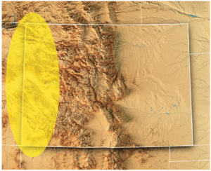
Arkansas Valley Conduit map via the Southeastern Colorado Water Conservancy District (Chris Woodka) June 2021.
Click the link to read the article on The Denver Post website (Kevin Freking and Nick Coltrain ). Here’s an excerpt:
January 8, 2026
Rep. Lauren Boebert, who sponsored bill, pushed president in November to release Jeffrey Epstein files
The U.S. House refused Thursday to override President Donald Trump’s vetoes of two low-profile bills — including one that would help pay for a water pipeline in Colorado — as Republicans stuck with the president despite their prior support for the measures. Congress can override a veto with support from two-thirds of the members of the House and the Senate. The threshold is rarely reached. In this case, Republicans opted to avoid a fight in an election year over bills with little national significance, with most GOP members voting to sustain the vetoes. The two vetoes were the first of Trump’s second term. One bill was designed to help local communities finance the construction of a pipeline to provide water to tens of thousands in southeastern Colorado. The other designated a site in Everglades National Park as a part of the Miccosukee Indian Reservation…
On the Colorado bill, 35 Republicans sided with Democrats in voting for an override — with all members of the state’s delegation from both parties supporting an override. On the Florida bill, only 24 Republicans voted for the override. The White House did not issue any veto threats prior to passage of the bills, so Trump’s scathing comments in his recent veto message came as a surprise to sponsors of the legislation. Ultimately, his vetoes had the effect of punishing backers who had opposed the president’s positions on other issues. The water pipeline bill came from Republican Rep. Lauren Boebert of Colorado, a longtime Trump ally who broke with the president in November to release files on convicted sex offender Jeffrey Epstein. The bill to give the Miccosukee Tribe of Indians more control of some of its tribal lands would have benefited one of the groups that sued the administration over an immigration detention center known as “Alligator Alcatraz.”
U.S. Senators John Hickenlooper and Michael Bennet issued the following statement after President Trump vetoed their bipartisan Finish the Arkansas Valley Conduit Act:
“Nothing says ‘Make America Great Again’ like denying 50,000 rural Coloradans access to clean, affordable drinking water. President Trump’s first veto of his second term blocks a bipartisan bill that both the House and Senate passed unanimously, costs taxpayers nothing, and delivers safe, reliable water to rural communities that overwhelmingly supported him. Trump’s attacks on Southern Colorado are politics at its worst—putting personal and political grievances ahead of Americans. Southeastern Coloradans were promised the completion of the Arkansas Valley Conduit more than 60 years ago. With this veto, President Trump broke that promise and demonstrated exactly why so many Americans are fed up with Washington. We will keep fighting to make sure rural Coloradans get the clean drinking water they were promised.”
Arkansas Valley Conduit map via the Southeastern Colorado Water Conservancy District (Chris Woodka) June 2021.
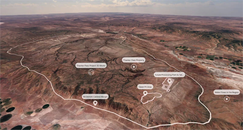
Karen Budd-Falen, the No. 3 at the Interior Department, didn’t disclose a $3.5 million water-rights contract between her husband and the developers of a Nevada mine, records show.
A high-ranking official in the Interior Department is drawing scrutiny from ethics experts because she failed to disclose her family’s financial interest in the nation’s largest lithium mine that had been approved by her agency, according to state and federal records. In 2018 Frank Falen sold water from a family ranch in northern Nevada to Lithium Nevada Corp., a subsidiary of Lithium Americas, for $3.5 million. The company was planning a $2.2 billion lithium mine nearby called Thacker Pass, and lithium mining requires significant amounts of water. The mine needed a permit from the Interior Department, where Mr. Falen’s wife, Karen Budd-Falen, worked as the deputy solicitor responsible for wildlife from 2018 until 2021. She returned to the agency last year and is now the associate deputy secretary, the third highest-ranking position. Mr. Falen’s sale of his water rights also depended on the mine getting a permit from the Interior Department. Without it, Lithium Nevada Corp. could have terminated its deal with him…In November 2019, about two years before the agency approved the mine, Ms. Budd-Falen met with Lithium Americas executives over lunch in the cafeteria at the Interior Department.
Tim Crowley, a spokesman for Lithium Americas, said executives did not discuss the mine or pending environmental reviews with Ms. Budd-Falen. “We haven’t worked directly with Karen Budd-Falen related to Lithium Americas,” he said in an email, “nor have we ever met with her in a formal capacity regarding our project.”
Ms. Budd-Falen did not respond to questions for this article. Her husband, who was not at the lunch, characterized it in a telephone interview as a social occasion, not a work meeting. He said his wife knew few details about the water contract and may not have known that the company was seeking approval from the Interior Department.
A mayfly loving trout — speckled, shiny and perfectly hand-sized for that Instagram hero shot. A five-foot-long torpedo of a predator, capable of powering through floodwaters and migrating hundreds of miles. A three-inch minnow, living only a couple of years and content with life in a small pool in an ephemeral creek. Which fish is the true Colorado native?
The answer is all of them. A state with waterways as diverse as Colorado’s has naturally produced a diverse assortment of native fish to match. We have cutthroat trout, lovers of pristine, high-elevation streams on both sides of the Continental Divide. Large, long-lived species like Colorado pikeminnow and humpback chub fight their way through the whitewater of the Western Slope. Tiny brassy minnows and redbelly dace ply the shallow, sandy creeks of the Eastern Plains. Each is adapted to its own ecological niche, body and behavior tailored to its particular home waters and the other aquatic creatures that evolved alongside it.
Humans have dramatically altered this delicate balance in a very short time span. While some native populations still thrive, many others struggle as their habitats and predators have changed. Starting a couple of hundred years ago, mining pollution, overfishing, and haphazard stocking of non-native fish led some Colorado species to plummet, or even go extinct. Today, native fish still grapple with climate change, dams, water diversions, and competition with invasive species. But humans are also working to turn back the clock and restore these native species. Follow along on this tour of Colorado’s waterways, meeting our home-state fish — and learning what it takes to help them endure.
Headwaters
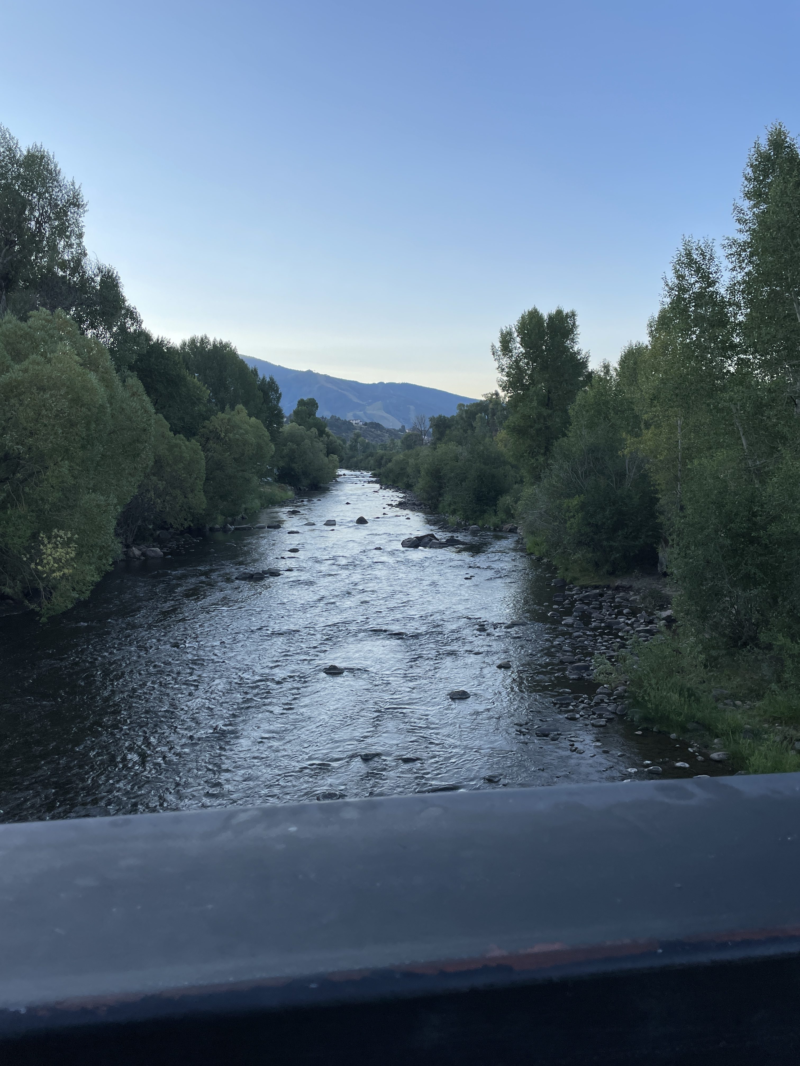
On the Yampa River Core Trail during my bicycle commute to the Colorado Water Congress’ 2025 Summer Conference August 21, 2025.
The headwaters region is the realm of the cutthroat trout. Credit: Water Education Colorado
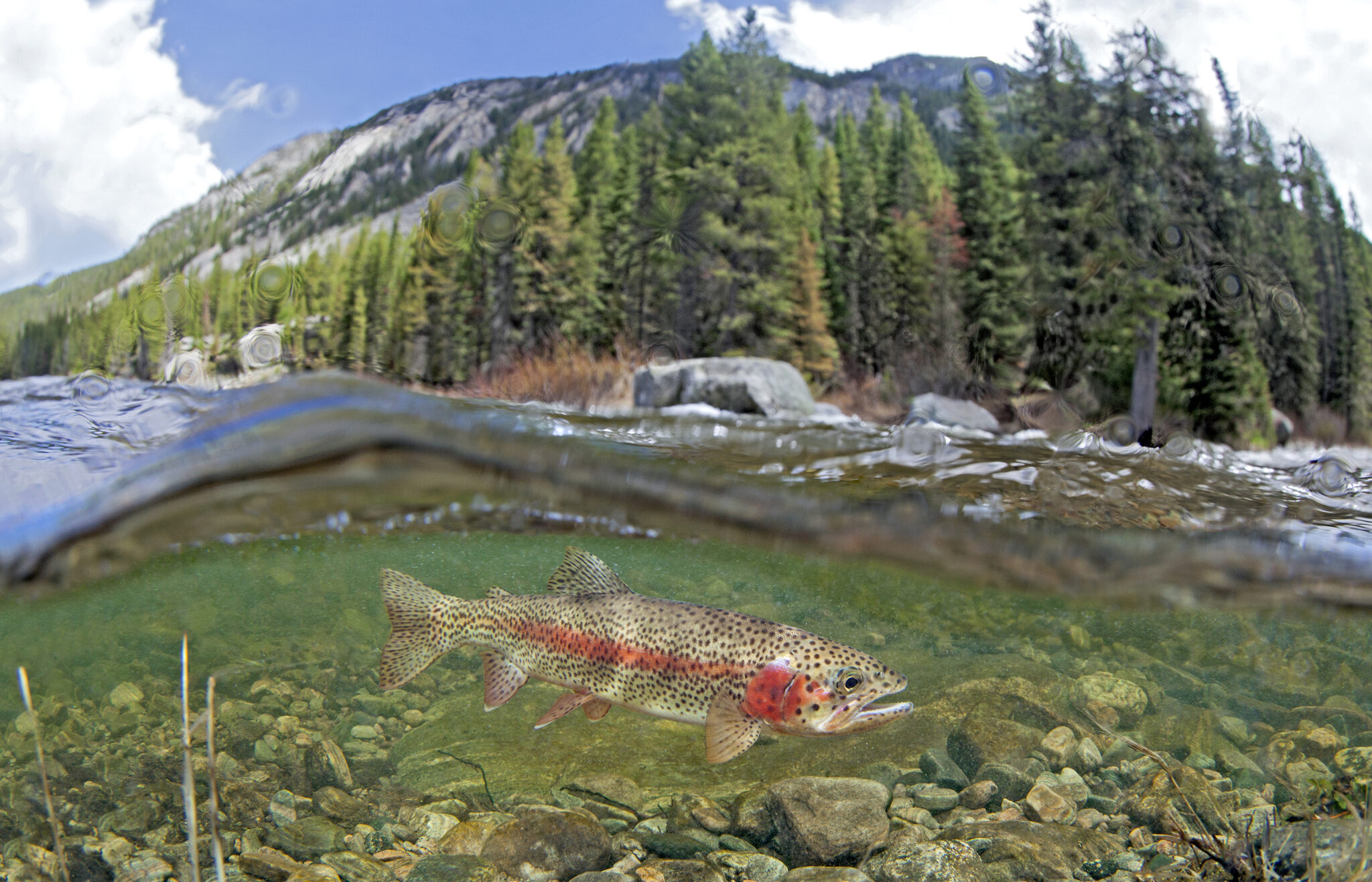
Let’s begin where the rivers do: high in the Rocky Mountains, where clean, cold streams form and flow downhill, eventually feeding the state’s largest rivers. This is the realm of Colorado’s poster fish, the cutthroat trout. Colorful, beautiful and beloved by anglers, cutthroats — recognizable by the iconic red slash markings under the jaw that give the species its name — live in the headwaters of almost every river basin in the state. Cutthroat trout are at home where there’s oxygenated water, gravelly bars for spawning, and good vegetative cover on stream banks.
“Cutthroat trout” isn’t just one type of fish in Colorado, but rather, six. There’s the greenback cutthroat trout, originally from the South Platte River Basin on the east side of the Divide. The yellowfin cutthroat came from the Arkansas River Basin, but is now considered extinct. Moving southwest, the Rio Grande cutthroat rose from the Rio Grande Basin. Then, on the Western Slope, the Colorado River cutthroat is further divided into three lineages: the Green River lineage, found in the Green, White and Yampa rivers; the Uncompahgre lineage, of the Dolores, Gunnison and Upper Colorado rivers; and the San Juan lineage, of the San Juan River Basin.
That’s not to say the average angler — or indeed, the average fish biologist — can tell the cutthroats apart just by looking at them. Nor can they be identified based on where they’re caught these days. Humans, from regular people trying to create new fishing opportunities to professional fisheries managers, spent much of the last couple of centuries moving cutthroats around the state with little understanding of the differences between subspecies. “It’s really hard to put the genie back in the bottle once that happens,” says Jim White, southwest senior aquatic biologist for Colorado Parks and Wildlife (CPW). “One of the great mysteries in cutthroat trout distributions was, what went where? What did these river basins look like before we started widespread stocking of cutthroats and non-natives?”
Biologists didn’t know the answer until 2012, when a landmark study led by University of Colorado Boulder researchers conducted DNA analysis on museum fish specimens gathered at the beginning of European contact with the West. Those results confirmed the existence of the six genetically distinct types of cutthroat — five previously known to science, and one brand-new one, the San Juan lineage trout. The study speculated that San Juan cutthroats had also gone extinct, but CPW biologists had to be sure. “We beat the bushes, surveyed all the populations, and conducted molecular tests on fin clips from all known cutthroat trout populations in the San Juan Basin,” says Kevin Rogers, CPW aquatic research scientist and co-author on the 2012 genetic study. “Indeed, there were about a half-dozen populations that [matched] the fish that had been collected in the mid- to late 1800s.”
One thing all five remaining Colorado cutthroat varieties have in common is a reduction in the amount of habitat they occupy. The state’s cutthroats are now relegated to just 12% of their historical habitat on the high end, down to half a percent on the low end, says Boyd Wright, native aquatic species coordinator with CPW. “Most of the lower elevations have been invaded by non-native trout, so cutthroats are persisting only in the headwaters,” Rogers says. Greenback cutthroats are federally listed as threatened, and Rio Grande and Colorado River cutthroats (occupying just 12% and 11% of their historic habitat, respectively) are state species of special concern. The culprits? What began with pollution, overharvesting and the stocking of non-native fish in the era of Western colonization continues today.
Non-native fish pose a major threat to native cutthroats, particularly the brown, brook and rainbow trout that have been stocked statewide and now thrive in Colorado’s waters. “To sum it up, there’s hybridization, there’s predation, and there’s competition,” White says. “All of those three things can interact to disadvantage our native fish populations.” Rainbow and cutthroat trout can breed, resulting in the hybrid cutbow. Non-native trout sometimes even eat the natives. They also compete with cutthroats for food, and often win. Brook and brown trout spawn in the fall and hatch in the spring — so when the cutthroat fry hatch in late summer, their non-native rivals have already had several months to grow bigger.
Climate change isn’t helping. “We have the two ugly stepchildren that come along with a changing climate: drought and wildfire,” Rogers notes. “The toll wildfire can take on cutthroat is substantial. The debris flows that invariably happen afterward can wipe out populations.” Drought can also lower or dry up streams, further contracting ranges.
But CPW and partner organizations like the U.S. Fish and Wildlife Service are actively working to conserve Colorado’s native cutthroats. Biologists raise the trout in hatcheries for stocking back in their native streams, but there’s a lot more to it than that. First, managers must prep the waterways by removing non-native trout, often by poisoning with natural fish toxicants, a process that can take years. Any present pathogens, like whirling disease, must be eradicated. Managers also have to make sure non-native fish can’t reinvade the stream, usually by building a barrier, like a waterfall. Despite the difficulty and expense, the state is actively working on recovery projects for all five cutthroat varieties. “That’s what we’re about, trying to preserve diversity for future generations to enjoy,” Rogers says.
Desert Rivers
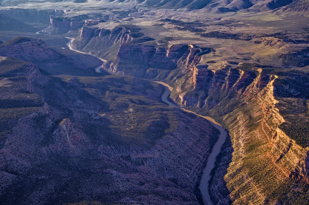
The Yampa River winds through towering cliffs on its journey west to meet the Green River in Dinosaur National Monument. Photo Credit: Dave Showalter
Credit: Water Education Colorado
As the mountain streams follow gravity into the western lowlands, they flow into larger networks: Rivers like the Yampa, White and Animas feed the desert arteries of the Green and San Juan, and these, together with the Gunnison, Dolores and others join the Colorado. The entire basin touches seven states, from Wyoming and Colorado up north to Arizona and California in the southwest.
The cold swift headwaters give way to rivers that historically swung between huge springtime floods and slow, turbid flatwater. And the trout give way to large, long-lived fish with bodies suited to big water and wild rapids.
Just over a dozen fish species evolved with the chops to survive in the larger rivers within the Colorado River system. Three of them, called just “the three species” by biologists, are the flannelmouth sucker, bluehead sucker, and roundtail chub. These omnivorous swimmers persist in today’s rivers, though managers keep a close eye on conserving their populations so that they don’t go the way of four other native species.
These four — all federally listed as endangered or threatened — have struggled in the face of drastic, human-caused changes to their habitats. The bonytail, a large-finned, skinny-tailed omnivore, is the worst off, with no sustainable wild populations left. Its relative, the humpback chub, sports a pronounced bump behind its head, all the better to stabilize the fish in whitewater. Its populations have stayed stable over the past few years, with most of them found near the Grand Canyon, and the species was downlisted from endangered to threatened in 2021. The Colorado pikeminnow, a powerful swimmer shaped like a missile, is the largest minnow in North America. It can migrate 200 miles annually and lives 40 years or more. Its numbers are slowly increasing in the Upper Colorado and San Juan subbasins, but are declining in the Green River. And the razorback sucker, a bug- and plankton-eater, features a similar keel behind its head that helps it maneuver through high flows.
All four populations have crashed in response to human water use and reduced water availability resulting from drought and climate change, which has altered the habitats they once inhabited. “We have cross-basin diversions that feed water from the Western Slope over to the Front Range,” says Jenn Logan, native aquatic species manager for CPW. “We don’t have the volume of water that we used to see in the spring. With dams and water going into ditches and filling reservoirs, runoff is nowhere near where it used to be. We don’t have sandbars formed in the way that we used to, and these systems relied on sediment to form complex habitats.” Not only that, but dams change water temperature, with released water alternately cooling or warming the river downstream depending on where in the reservoir it comes from. And of course, they form a physical barrier for fish that evolved migrating through a huge, interconnected river system.
Then there’s the non-native interlopers — primarily smallmouth bass, northern pike, walleye, and green sunfish — all introduced, either purposely or accidentally, by humans looking for expanded angling opportunities. “They’re predatory species — they get in the river and can really compete with and consume the native fish in the Colorado River,” says Josh Nehring, deputy assistant director, aquatic branch, of the CPW fish management team. All have found happy homes in the modern Colorado River Basin with its dams, reservoirs and warmer waters.
But just as in the mountain streams, fisheries managers on the Western Slope are working aggressively to protect the natives. The Upper Colorado River Endangered Fish Recovery Program and the San Juan River Basin Recovery Implementation Program oversee the recovery of the four fish species listed as threatened or endangered. The recovery programs are coalitions of water users, federal, state and tribal agencies, plus nonprofits and energy organizations. They take steps like installing nets at the edge of reservoirs to keep non-natives contained and stocking sterile non-native fish in reservoirs to keep them from establishing a population if they do get out. Other work looks like electrofishing stretches of river — that is, introducing a current that stuns fish in the water — and physically removing the non-natives, leaving the native fish to recover and swim another day; and gillnetting northern pike in their springtime spawning habitats. Water managers go so far as to recontour river channels on the upper Yampa to cut off access to northern pike’s spawning wetlands.
Dam management is another useful tool for both helping native fish and disadvantaging the non-natives. The Upper Colorado River Endangered Fish Recovery Program works with the U.S. Bureau of Reclamation at Utah’s Flaming Gorge Dam on the Green River on timed releases — releasing water when biologists detect the year’s razorback sucker larvae “to attempt to move them down to their wetland habitats,” Logan says. They’ll release water to disrupt smallmouth bass nesting, when possible. And in the Lower Basin downstream of Lake Powell, managers have begun releasing cooler water specifically to make the Colorado River there less hospitable to smallmouth bass. As long-term drought has dropped water levels in Lake Powell, “We’ve been seeing increases in water temperature releases coming through the dam,” says Ryan Mann, aquatic research program manager for the Arizona Game and Fish Department. Some smallmouth bass made their way into the river below the dam in years past, but the water had been cold enough to keep them from reproducing. But in 2022, biologists found baby bass. Last summer’s cold-water releases prevented widespread spawning, and managers may continue them into the future.
Today’s Colorado River Basin is a radically different place than in centuries past, and, “Unless there’s some amazing technology that comes along to remove all non-native fish or a way to return flows to historic conditions we’re not going to be able to move [major river systems] back to native fish,” Nehring says. But that doesn’t mean those species are doomed. CPW and its partners are actively raising threatened species in hatcheries and reintroducing them to targeted habitats. “We’re really focusing on the tributaries, to keep the natives alive in enough areas where we know they’ll persist,” Nehring says.
Eastern Plains
Here at the confluence of the Big Thompson and South Platte rivers near Greeley, a new conservation effort is underway. It restores wetlands and creates mitigation credits that developers can buy to meet their obligations under the federal Clean Water Act to offset any damage to rivers and wetlands they have caused. Credit: Westervelt Ecological Services
Credit: Water Education Colorado
As alpine streams flow east, they meander through Front Range cities, then spread across the arid plains. The water warms, rocky beds grow sandy, and habitats shrink as creeks dry up seasonally. Waters dominated by a single species explode with different fish. “We’ve got this melting pot of biological diversity along the transition zone,” says Wright. “You go from historically a one-species profile in the mountains to more than 28 as you go farther east. These [plains] are very harsh, unpredictable environments.”
The fish that evolved to thrive on the plains, from the region’s western edges in Colorado out into Kansas, Oklahoma and Nebraska, are largely the opposite of the big, long-lived species on the Western Slope. They’re a few inches long, live just a couple of years, and reproduce early. These fish are used to biding their time in small pools until rain or spring runoff reconnects the intermittent creeks, finally allowing them a change of scenery.
But the Eastern Plains haven’t escaped the challenges affecting Colorado’s other rivers — its native fish are struggling, too. “Most of our plains fishes are declining or locally extinct because of habitat modification or loss,” says Ashley Ficke, fisheries ecologist with engineering firm GEI Consultants. Humans have diverted water to farms and municipalities, redirected streams into straight channels lacking habitat complexity, and even drained some waters completely. That hits fish like the plains minnow particularly hard, as its semi-buoyant eggs float vast distances between spawning grounds and ideal nursery habitat. “It needs vast portions of unfragmented stream habitat,” Wright says. “We’ve really lost that in Colorado, and that’s a big reason why they’re very rare.”
As elsewhere in the state, though, fish managers are working to replenish the swimmers of the plains. At a hatchery in Alamosa, CPW breeds 12 rare native fish, half of them eastern species: plains minnow, suckermouth minnow, northern and southern redbelly dace, Arkansas darter, and common shiner. “We’re working with private landowners that have streams or ponds that would be suitable for these native fish, working with them to maintain or improve that habitat, and stocking those waters with the native fish,” Nehring says. By preserving and restoring enough of the plains’ stream habitats, managers hope to give back sufficient waters for these little fish to persist.
In May of 2023, the Supreme Court handed down a decision that significantly limited the scope of the Clean Water Act, undoing protections that safeguarded the nation’s waters for over 50 years. Specifically, it erased critical protections for tens of millions of acres of wetlands, threatening the clean drinking water sources for millions of Americans.
While the Biden administration amended rules to comply with the Supreme Court ruling, the Trump administration recently released a new draft rule that would go further than even the Supreme Court in limiting what waters can be protected.
Nooksack River, Washington | Brett Baunton
The Clean Water Act’s definition of “Waters of the United States” (WOTUS) is core to defining what waters are protected and which aren’t. Unfortunately, the Trump Administration’s newly proposed WOTUS rule would roll back protections for vast areas of wetlands and river tributaries. It’s estimated that close to 80% of America’s remaining wetlands would lose Clean Water Act protections. As written, the rule would leave many waterways vulnerable to pollution, degradation, and destruction, threatening water quality and community resilience across the country.
Blanca Wetlands, Colorado BLM-managed ACEC Blanca Wetlands is a network of lakes, ponds, marshes and wet meadows designated for its recreation and wetland values. The BLM Colorado and its partners have made strides in preserving, restoring and managing the area to provide rich and diverse habitats for wildlife and the public. To visit or get more information, see: http://www.blm.gov/co/st/en/fo/slvfo/blanca_wetlands.html. By Bureau of Land Management – Blanca Wetlands Area of Critical Environmental Concern, Colorado, Public Domain, https://commons.wikimedia.org/w/index.php?curid=42089248
Here are our top four concerns with the new WOTUS proposal
1. The rule requires streams and wetlands to have surface water “at least during the wet season” in order to qualify for protection. But it never defines what the wet season actually is.
What this means for rivers: Wet seasons vary dramatically from region to region, and without a clear, science-based definition, many healthy and ecologically important streams risk being excluded.
2. Narrow definitions and expanded exemptions shrink the scope of protected waters.
What this means for rivers: By redefining “tributary” to include only streams with year-round or steady “wet-season” flow, and expanding exemptions for wastewater and waste-treatment systems, the new rule would eliminate protections for many intermittent streams and man-made infrastructure that function like natural streams, opening the door to more unregulated pollution. Many rivers in the Southwest only flow for part of the year. This updated definition would put many of these rivers at risk.
3. The rule suggests any artificial or natural break in flow cuts off upstream protection.
What this means for rivers: Under the proposed rule, a culvert, pipe, stormwater channel, or short dry stretch can sever jurisdiction. This means upstream waters that feed larger rivers may no longer be protected, allowing pollution to still flow into nominally protected rivers and streams.
4. The rule significantly eliminates wetland protections by requiring “wetlands” to physically touch a protected water and maintain surface water through the wet season.
What this means for rivers: The new definition excludes many wetlands, which naturally store floodwater, filter pollutants, and safeguard communities. This puts the drinking water for millions at risk and increases the risks of flooding for many communities.
The health of our rivers depends on the small streams and wetlands that feed them. By discarding science, narrowing long‑standing definitions, and creating confusing jurisdictional tests, the Trump Administration’s proposed WOTUS rule risks undoing decades of progress toward cleaner, safer water. America’s rivers—and the communities that depend on them—deserve better.
These rollbacks will put our waterways and the life that depends on them in jeopardy. The public comment period to speak up and defend clean water protections is open until January 5. Please take action today and send a letter to the EPA urging them to keep the current definition of Waters of the United States in place!
Ephemeral streams are streams that do not always flow. They are above the groundwater reservoir and appear after precipitation in the area. Via Socratic.org
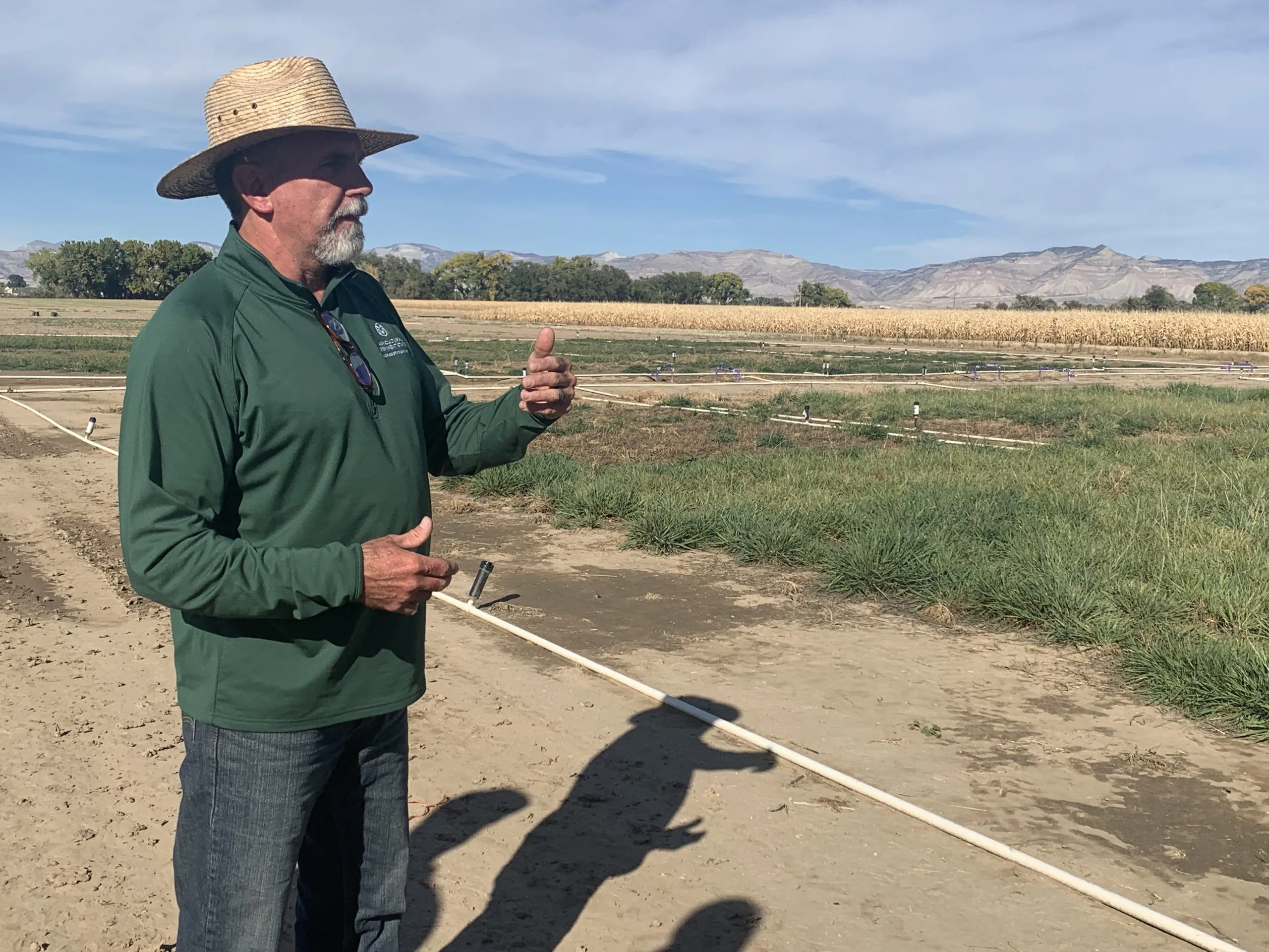
Colorado State University researcher Perry Cabot talks to a group about forage crops at the Fruita field station. Cabot studies the effects of irrigation withdrawal and forage crops that use less water. CREDIT: HEATHER SACKETT/ASPEN JOURNALISM
The findings of recent water-conservation studies on the Western Slope could have implications for lawmakers and water managers as they plan for a future with less water.
Researchers from Colorado State University have found that removing irrigation water from high-elevation grass pastures for an entire season could have long-lasting effects and may not conserve much water compared with lower-elevation crops. Western Slope water users prefer conservation programs that don’t require them to withhold water for the entire irrigation season, and having the Front Range simultaneously reduce its water use may persuade more people to participate. Researchers also found that water users who are resistant to conservation programs don’t feel much individual responsibility to contribute to what is a Colorado River basinwide water shortage.
“It’s not a simple economic calculus to get somebody to the table and get them to sign a contract for a conservation agreement,” said Seth Mason, a Carbondale-based hydrologist and one of the researchers. “It involves a lot of nuance. It involves a lot of thinking about tradeoffs.”
Udall/Overpeck 4-panel Figure Colorado River temperature/precipitation/natural flows with trend. Lake Mead and Lake Powell storage. Updated through Water Year 2025. Note the tiny points on the annual data so that you can flyspeck the individual years. Credit: Brad Udall
Over the past 25 years, a historic drought and the effects of climate change have robbed the Colorado River of its flows, meaning there is increasing competition for a dwindling resource. In 2022, water levels in Lake Powell fell to their lowest point ever, prompting federal officials to call on the seven states that share the river for unprecedented levels of water conservation.
The Upper Basin states (Colorado, New Mexico, Utah and Wyoming) have experimented for the past decade with pilot programs that pay agricultural water users to voluntarily and temporarily cut back by not irrigating some of their fields for a season or part of a season.
The most recent program was the federally funded System Conservation Pilot Program, which ran in the Upper Basin in 2023 and 2024, and saved about 100,000 acre-feet of water at a cost of $45 million. The Upper Basin has been facing mounting pressure to cut back on its use, and although some type of future conservation program seems certain, Upper Basin officials say conservation must be voluntary, not mandatory.
Despite dabbling in these pilot conservation programs, Upper Basin water managers have resisted calls for cuts, saying their water users already suffer shortages in dry years and blaming the plummeting reservoirs on the Lower Basin states (California, Nevada and Arizona). Plus, the Upper Basin has never used its entire allocation of 7.5 million acre-feet a year promised to it under the 1922 Colorado River Compact, while the Lower Basin uses more than its fair share.
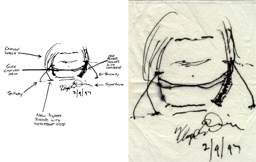
Sketches by Floyd Dominy show the way he’d end the Glen Canyon Dam. From the article “Floyd Dominy built the Glen Canyon Dam, then he sketched its end on a napkin” on the Salt Lake Tribune website
But as climate change continues to fuel shortages, makes a mockery of century-old agreements and pushes Colorado River management into crisis mode, the Upper Basin can no longer avoid scrutiny about how it uses water.
“We need a stable system in order to protect rivers,” said Matt Rice, director of the Southwest region at environmental group American Rivers, which helped fund and conduct the research. “(Upper Basin conservation) is not a silver bullet. But it’s an important contributing factor, it’s politically important and it’s inevitable.”
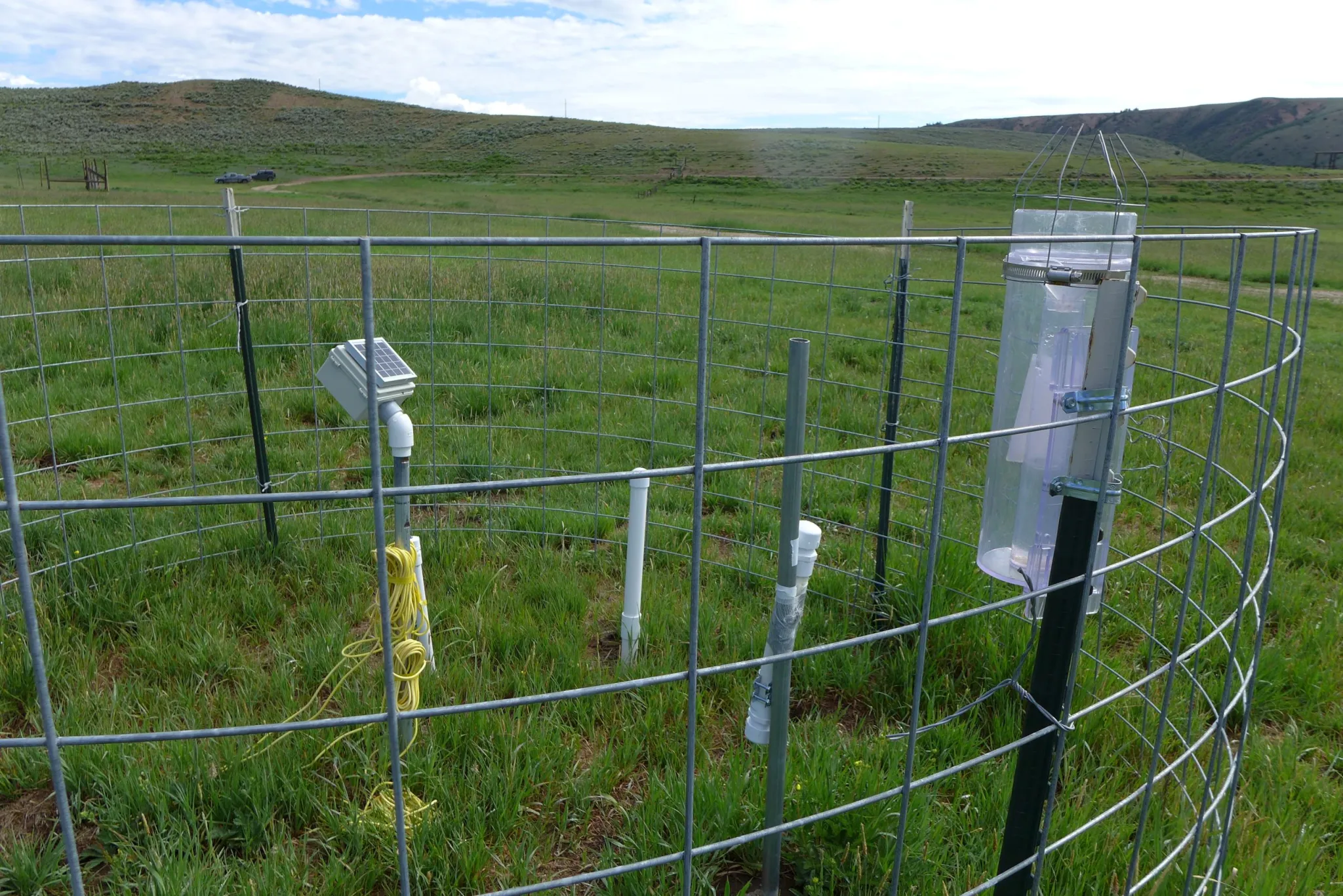
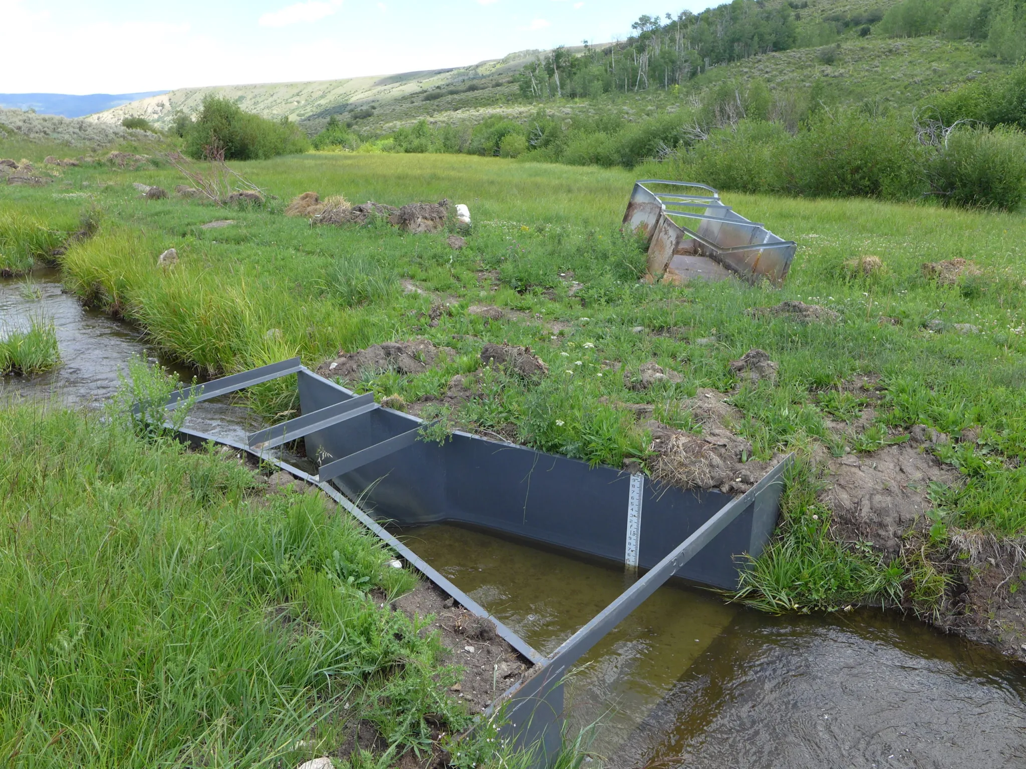
Researchers from Colorado State University used this monitoring station to track water use on fields near Kremmling. Researchers have found that Western Slope water users are more likely to participate in conservation programs if there is a corresponding Front Range match in water use reduction. CREDIT: HEATHER SACKETT/ASPEN JOURNALISM
Findings
Papers by the researchers outline how water savings on Colorado’s high-elevation grass pastures — which represent the majority of irrigated acres on the Western Slope — are much less than on lower-elevation fields with other annual crops. Elevation can be thought of as a proxy for temperature; fewer frost-free days means a shorter growing season and less water use by the plants.
“Our results suggest that to get the equivalent conserved consumptive-use benefit that you might achieve on one acre of cornfield in Delta would require five acres of grass pasture if you were up near Granby, for example,” said Mason, who is a doctoral candidate at CSU. “This is a pretty important constraint as we’re thinking about what it means to do conservation in different locations across the West Slope.”
In addition to the science of water savings, Mason’s research also looked at the social aspects of how water users decide to participate in conservation programs. He surveyed 573 agricultural water users across the Western Slope and found that attitudes toward conservation and tendencies toward risk aversion — not just how much money was offered — played a role in participation.
Many who said they would not participate had a low sense of individual responsibility to act and a limited sense of agency that they could meaningfully contribute to a basinwide problem.
If you don’t pay attention to the attitudes of water users, you could end up with an overly rosy picture of the likelihood of participation, Mason said.
“It may do well to think less about how you optimize conservation contracts on price and do more thinking about how you might structure public outreach campaigns to change hearts and minds, how you might shift language as a policymaker,” he said. “A lot of the commentary that we hear around us is that maybe this isn’t our problem, that this is the Lower Basin’s problem. [ed. emphasis mine] The more you hear that, the less likely you are to internalize a notion of responsibility.”
Mason also found that a corresponding reduction in Front Range water use may boost participation by Western Slope water users. The fact that Front Range water providers take about 500,000 acre-feet annually from the headwaters of the Colorado River is a sore spot for many on the Western Slope, who feel the growth of Front Range cities has come at their expense. These transmountain diversions can leave Western Slope streams depleted.
Western Slope water users often describe feeling as if they have a target on their back as the quickest and easiest place to find water savings.
“I think they tend to be appreciative of notions that have some element of burden sharing built into them,” Mason said. “So they aren’t the only ones being looked at to contribute as part of a solution to a problem.”
Perry Cabot, a CSU researcher who studies the effects of irrigation withdrawal and forage crops that use less water, headed up a study on fields near Kremmling to see what happens when they aren’t irrigated for a full season or part of a season. The findings showed that fields where irrigation water was removed for the entire season produced less hay, even several years after full irrigation was resumed. Fields where water was removed for only part of the season had minimal yield loss and faster recovery.
“In the full season, you can have a three-year legacy effect, so that’s where the risk really comes in if you’re a producer participating in these programs,” Cabot said. “For three years after, you’re not getting paid even though you’ve diminished that yield.”
At the CSU research station in Fruita, Cabot is studying a legume called sainfoin, a forage crop and potentially an alternative to grass or alfalfa. He said sainfoin shows promise as a drought-tolerant crop that can be cut early in the season, allowing producers to have their cake and eat it too: They could maintain the income from growing a crop, avoid some of the worst impacts of a full-season fallowing, and still participate in a partial-season conservation program.
“I’d like to see flexible options that allow us to think about conservation happening on fields that still have green stuff out there,” Cabot said.
This field near Kremmling participated in an early study on the effects of removing irrigation water. Researchers found the effects of full-season fallowing can have lasting impacts. CREDIT: HEATHER SACKETT/ASPEN JOURNALISM
Part of the solution
The Glenwood Springs-based Colorado River Water Conservation District has been one of the loudest voices weighing in on conservation in recent years, helping to fund Cabot’s and Mason’s studies, as well as conducting its own. The River District, which represents 15 counties on the Western Slope, is not a fan of conservation programs, but it has long accepted their inevitability. It has advocated for local control and strict guidelines around a program’s implementation to avoid negative impacts to rural agricultural communities.
River District General Manager Andy Mueller said there is still a lot of resistance to a conservation program in Colorado — especially if the saved water is being used downstream to fuel the growth of residential subdivisions, computer-chip factories and data centers in Arizona. In addition to wanting the Front Range to share their pain, Western Slope water users don’t want to make sacrifices for the benefit of the Lower Basin. [ed. emphasis mine]
“They want to be part of the solution, but they don’t want to suffer so that others can thrive,” Mueller said. “That’s what I keep hearing over and over again from our producers on the ground: They are willing to step up, but they want everybody to step up with them.”
Water experts agree Upper Basin conservation is not a quick solution that will keep the system from crashing. Complicated questions remain about how to make sure the conserved water gets to Lake Powell and how a program would be funded.
And as recent studies show, the tricky social issues that influence program participation, multiseason impacts to fields when water is removed and the scant water savings from high-elevation pastures mean the state may struggle to contribute a meaningful amount of water to the Colorado River system through a conservation program.
“If the dry conditions continue, it’s hard to produce the volumes of water that make a difference in that system,” Mueller said. “But are we willing to try? Absolutely. It has to be done really carefully.”
Map of the Colorado River drainage basin, created using USGS data. By Shannon1 Creative Commons Attribution-Share Alike 4.0
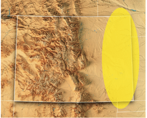
Arkansas Valley Conduit map via the Southeastern Colorado Water Conservancy District (Chris Woodka) June 2021.
Click the link to read the article on The Denver Post website (Nick Coltrain). Here’s an excerpt:
December 31, 2025
House Resolution 131, sponsored by U.S. Rep. Lauren Boebert and U.S. Sen. Michael Bennet, both of Colorado, sought to jumpstart a project that has languished since 1962. The bill, one of two vetoed by Trump on Tuesday, would extend the repayment period for the project and lower the interest rate. It passed both chambers of Congress by voice vote earlier this year…Trump, who has recently lashed out at Colorado for a slew of grievances, cited the project’s $1.3 billion price tag and said it was supposed to be paid for by local municipalities — not the federal government — in his veto statement…
9News first reported the veto. In a statement to the news station, Boebert said, “If this administration wants to make its legacy blocking projects that deliver water to rural Americans, that’s on them.” She also told the network that she hopes “this veto has nothing to do with political retaliation for calling out corruption and demanding accountability. Americans deserve leadership that puts people over politics.”
Boebert, a Republican representing Colorado’s 4th Congressional District and a longtime ally of the president, recently broke with him by voting to mandate the release of the so-called Epstein files, a trove of documents about the notorious sex criminal with longtime ties to Trump. Trump has also singled out Colorado for retribution over the state’s imprisonment of former Mesa County Clerk Tina Peters.
Chris Woodka, senior policy and issues manager at the Southeastern Colorado Water Conservancy District, which is overseeing the project, said his team is working with Colorado’s congressional delegation on next steps.
Arkansas Valley Conduit map via the Southeastern Colorado Water Conservancy District (Chris Woodka) June 2021.
Click the link to read the article on the Associated Press website (Michelle l. Price and Meg Kinnard). Here’s an excerpt:
President Donald Trump issued the first vetoes of his second term on Tuesday, rejecting two low-profile bipartisan bills, a move that had the effect of punishing backers who had opposed the president’s positions on other issues. Trump vetoed drinking water pipeline legislation from Republican Rep. Lauren Boebert of Colorado, a longtime ally who broke with the president in November to release files on convicted sex offender Jeffrey Epstein. He also vetoed legislation that would have given the Miccosukee Tribe of Indians of Florida more control of some of its tribal lands. The tribe was among groups suing the administration over an immigration detention center in the Everglades known as “ Alligator Alcatraz.” Both bills had bipartisan support and had been noncontroversial until the White House announced Trump’s vetoes Tuesday night…
Trump did not allude to Boebert in his veto of her legislation, but raised concerns about the cost of the water pipeline at the heart of that bill. Boebert, one of four House Republicans who sided with House Democrats early on to force the release of the Epstein files, shared a statement on social media suggesting that the veto may have been “political retaliation.” Boebert’s legislation, the “Finish the Arkansas Valley Conduit Act,” aimed to improve access to clean drinking water in eastern Colorado.
Chris Wright has argued that energy scarcity poses a greater threat to quality of life than climate change. Here, he speaks to reporters in April 2025 while Martin Keller, then the director of NREL, looks on. Photo/Allen Best. Top image/National Laboratory of the Rockies.
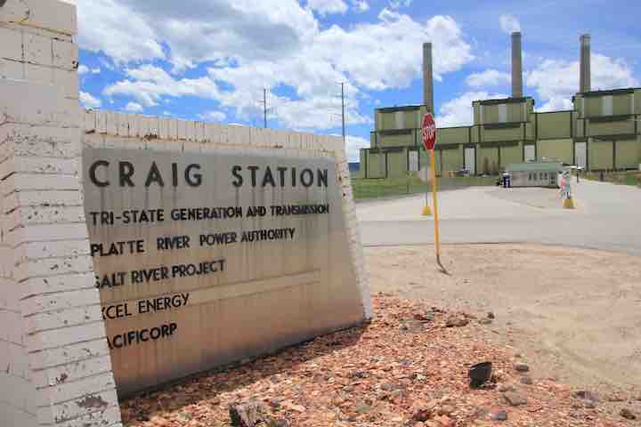
Following the Trump administration’s last-minute invocation of an energy “emergency” to order a Colorado coal plant to postpone its scheduled retirement, the electricity provider that co-owns the plant is warning that the high costs of continuing to operate it will be shouldered by Colorado utility customers.
Located in Moffat County, Craig Generating Station’s 446-megawatt Unit 1 had been scheduled to go offline on Dec. 31, 2025, part of a wave of coal retirements planned across Colorado through 2030. But an emergency order issued Dec. 30 by the Department of Energy requires the plant to “take all measures necessary to ensure that Craig Unit 1 is available to operate” until at least March 30, 2026.
Tri-State Generation and Transmission Association, co-owner of Craig Generating Station, said in a press release that the “additional investments in operations, repairs, maintenance and, potentially, fuel supply” required by the order will raise costs for the plant’s customers, which include dozens of electric utilities and rural co-ops. Unit 1 was already offline due to a mechanical failure on Dec. 19, Tri-State said.
“We are continuing to review the order to determine what this means for Craig Station employees and operations, and the financial impacts,” said Tri-State CEO Duane Highley. “As a not-for-profit cooperative, our membership will bear the costs of compliance with this order unless we can identify a method to share costs with those in the region. There is not a clear path for doing so, but we will continue to evaluate our options.”
The five-page DOE order, signed by Energy Secretary Chris Wright, cites “growing resource adequacy concerns” as justification for the move, which followed similar actions in Indiana and Washington.
Shortly after taking office last year, President Donald Trump declared a “national energy emergency” in an executive order blasted by environmental advocates as a pretext for advancing the interests of fossil-fuel companies. Despite the declaration’s stated concerns about “insufficient energy production,” the administration has continued to cancel and delay major wind and solar projects.
An analysis released in December by the Sierra Club estimated that keeping Craig’s Unit 1 open for 90 days would cost ratepayers at least $20 million. Critics of the administration anticipate that the DOE’s orders will continue to be renewed every 90 days under the authority granted to the department by Federal Power Act, raising costs by $85 million to $150 million annually.
“Keeping this dirty and outdated coal plant online will harm the health of surrounding communities and hurt all of our pocketbooks,” said Michael Hiatt of environmental group Earthjustice. “This unlawful order will benefit no one but the struggling coal industry.”
The DOE order comes amid a series of Trump administration actions targeting Colorado that are widely viewed as retaliation for the ongoing incarceration of Trump ally and former Mesa County Clerk Tina Peters, who was convicted on felony charges for her role in a breach of her own office’s secure election equipment in 2021.
Colorado U.S. Sen. Michael Bennet voted to confirm Wright, a former Denver oil executive, as Trump’s pick for Energy Secretary in January 2025, calling Wright “passionate about strengthening America’s energy independence and lowering costs for Colorado families.” In a statement Wednesday, Bennet, a Democrat who is running for Colorado governor, said he was “disappointed but not surprised by this continued revenge tour.”
“The DOE order is the latest in a string of attacks against Colorado, because we refuse to bend to the President,” Bennet said. “President Trump continues to take out his personal and political grievances on Coloradans who are already struggling to make ends meet.”
The three units of Craig Station were constructed from 1974 to 1984. Photo credit: Allen Best/Big Pivots
Above: The Colorado River in the Grand Canyon. Future water flows through the canyon are now highly uncertain due to complications from a very low water level in Lake Powell upstream of the canyon, and concerns about the structural integrity of the lowest dam outlets at Glen Canyon Dam. This situation threatens the water security of major cities and highly productive farmland, and imperils extraordinary freshwater ecosystems. Photo by Brian Richter
‘Sustainability’ is a foundational tenet of modern natural resource management. The concept of sustainable development gained global recognition in 1987 when the United Nations’ Brundtland Commission published its report on Our Common Future, in which sustainable development was defined as “meeting the needs of the present without compromising the ability of future generations to meet their own needs.” In simple terms, this means avoiding the depletion of natural resources and loss of species over time.
Brian Richter
Our research group has just published our third detailed assessment of water resources management in three major river basins in the western United States. Our three studies — focusing on the Colorado River, the Great Salt Lake basin, and the Rio Grande-Bravo — clearly document that water managers and political leaders are failing in their efforts to manage these water resources for long-term sustainability, meaning that they have not balanced water consumption with natural replenishment from snowmelt runoff, rainfall, and aquifer recharge. As a result, reservoir and groundwater levels are falling, rivers are shriveling, and numerous endangered species are in great jeopardy. The livelihoods and well-being of tens of millions of people dependent on these water systems, along with the extraordinary ecological systems and species sustained by these waters, are now at great risk.
As a Native American friend said recently, “our world is out of balance.”
These systemic failures share a common history with hundreds of other stressed river basins and aquifers around the planet. For thousands of years, the human populations dependent on each water source were small enough that water consumed for human endeavors had little to no impact on water sources and associated ecosystems, i.e., their use of water was ‘renewable’ and ‘sustainable.’ But over the course of the 20th century, the growth of human populations and associated food needs grew rapidly — largely without constraint or control — to the point of consuming all of the renewable annual water supplies in many river basins, including the three we studied. Then as we entered into the 21st century, climate warming began reducing the replenishment of rivers, lakes, and aquifers. The balance between water consumption and replenishment became overweighted on the consumption side as the replenishment side got lighter. Our world went out of balance.
The Risks of Continued Imbalance Are Very Frightening
The potential consequences of this imbalance are nothing short of horrific and dangerous in the three basins we studied. Here are some of the highlights from our trilogy of recent papers:
Colorado River “Beginnings”. Photo: Brent Gardner-Smith/Aspen Journalism
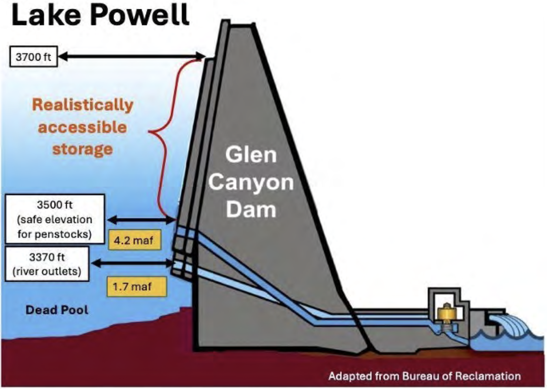
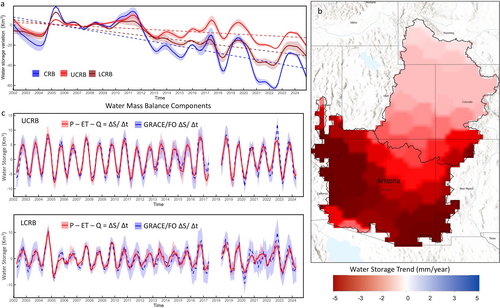
Colorado River Basin: Since 2000, more water has been consumed than replenished in this basin in three out of every four years, on average. These recurring deficits in the basin’s annual water budget has been offset by depleting water stored in the basin’s reservoirs and aquifers, analogous to pulling money out of a savings account to make up for overdrafts in a checking account. As a result, the basin’s two biggest reservoirs — Lake Powell and Lake Mead — are now 70% empty. There is great concern that if the water level in Lake Powell drops below 3490′ elevation (see graph below), it could become physically impossible to release sufficient water through the Grand Canyon to meet the water needs of ~30 million people downstream. In a worst case scenario, the volume of water flowing out of Glen Canyon Dam could intermittently shrink to a trickle if the dam’s managers determine that continuous use of the lowest river outlets is too structurally risky and releases into the Grand Canyon must be drastically reduced. This calamity would further imperil unique freshwater ecosystems and wipe out the $50 million/year whitewater rafting industry in the Grand Canyon. We estimate that average annual water consumption needs to be reduced immediately by at least 13% below the recent 20-year average to rebalance water consumption with natural replenishment in this basin.
Credit: Sustainable Waters
Sunset from the western shore of Antelope Island State Park, Great Salt Lake, Utah, United States.. Sunset viewed from White Rock Bay, on the western shore of Antelope Island. Carrington Island is visible in the distance. By Ccmdav – Own work, Public Domain, https://commons.wikimedia.org/w/index.php?curid=2032320
Great Salt Lake Basin: The lake has lost nearly half of its volume since 2000, dramatically shrinking the area of the lake’s surface and exposing extensive salt flats around the lake’s perimeter. Those salty soils are loaded with toxic heavy metals including arsenic, lead, and mercury. Recurring high winds blow that dangerous dust into the nostrils and lungs of more than two million people living in the Salt Lake City area. Brine shrimp living in the lake also suffer at low lake levels due to extreme salinity, greatly reducing the food supply for more than 10 million migratory birds along the Pacific Flyway and decimating production of brine shrimp eggs that are a critical feed source for the world’s aquaculture industry. The reduced evaporation from a shrinking lake also impacts the formation of storm clouds that drop the “world’s greatest snow” onto the Wasatch Mountains, site of the upcoming 2034 Winter Olympics. Water consumption in the basin needs to be rapidly reduced by 21% to stabilize the lake.
Credit: Sustainable Waters
Rio Grande, Colorado | National Park Service
Rio Grande-Bravo: Reservoir storage in this large international basin is now three-quarters empty. New Mexico’s reservoirs hold only 13% of their capacity, presenting a “Day Zero” scenario in which the remaining reservoir storage could be wiped out in just one or two more bad water years. This has created heated political conflict: New Mexico has been failing to deliver the volume of water it owes to Texas under the Rio Grande Compact, and Mexico has been unable to deliver sufficient water to the US under the terms of an international water treaty. Also of great concern is plundering of the vast groundwater reserves in the basin that has accelerated as surface water supplies have run short (see map of groundwater depletion below). Only half of the water being consumed for human endeavors in this basin is sustained by natural replenishment; the other half depends on unsustainably depleting reservoirs and groundwater aquifers and drying the river.
Credit: Sustainable Waters
Governance Failures
The response to these crises has been woefully inadequate. Instead of addressing these imbalances at the scale and speed necessary to avert catastrophe, political leaders and water managers have been unable or unwilling to mobilize sufficient corrective actions to rebalance these water budgets. From my observations, there are multiple interacting causes of these governance failures:
There is continuing belief among many political leaders and water users that more bountiful replenishment years in the future will restore the massive accumulated deficits in reservoir and aquifer volumes. This belief runs contrary to the evidence of 25+ years of declining water trends and many scientific assessments warning that replenishment will continue to decline due to climate warming and aridification.
Water users have not been adequately or truthfully educated about the potential consequences of continued depletion of reservoirs and aquifers, and the rapid rate at which risks are increasing. The lack of honest communication and misunderstanding of pending dangers perpetuates complacency and inaction. What is needed is full and honest disclosure about the degree to which water consumption is out of balance with replenishment, and which water users and economic sectors are at great risk from deepening water shortages in future years.
Fearing hostile reaction to any mandated cutbacks in water consumption, political leaders lack the will to force or incentivize the actions required to rebalance consumption with (diminishing) replenishment. There are no plans in the three basins described above for correcting imbalances at the necessary scale and speed. Legislative appropriations to address these crises have been orders of magnitude smaller than what is needed. These meager appropriations serve to placate the general public by giving the impression that responsible actions are being taken, serving as a smoke screen hiding the monstrous dangers on the horizon.
Instead of facing the reality that consumption needs to be speedily reduced, water managers continue to flout pipe dreams for augmenting water supplies such as long distance water importation schemes (bring water from the Great Lakes! bring water from the Yukon!), or desalinating ocean water, or recycling water ‘produced’ from oil and gas fracking operations. There is no truthful reporting of how much additional water can be secured by these schemes, how much that water will cost, and who will be able to afford it. Irrigated agriculture is by far the dominant water consumer in the three basins we studied, but there is no way that farmers are going to be able to afford these water augmentation dreams.
The Way Forward: Sustainability Principles
Throughout my career I’ve always said that one should not deliver criticism without also offering solutions. In my Chasing Water book I outlined seven principles for sustainable water management.
I continue to believe in this recipe for water sustainability. But I need to offer some important clarifications:
Principle #1 is arguably the most important. Given that water consumed on farms is typically much greater than is consumed in cities, it is critically important to meaningfully engage farmers in water planning because they will bear the greatest burden of any limitations placed on water consumption. They can bring their best ideas forward, and in doing so help to ensure that water plans address both their concerns and their abilities to adapt. But it is essential that any water plans be built upon an honest and technically credible assessment of how much water will be available in the future.
Principles #2 and #3 should not be permanent, static volumes. Under a changing climate, the imposed limits need to be adaptive to changing water availability; during wet periods more water can be consumed, but lesser volumes should be allocated during dry times. I believe that the best way to do this is to set a 5-year fixed volume (a “cap“) on annual consumption based on an average of how much water has been available in the recent 5 years, and then allocate portions or shares of that volume to each user (i.e., to each geopolitical unit, community, or individual water user). The cap volume needs to be updated every five years. I like a 5-year adaptive cap because it gives water users enough time to plan and implement changing allocations while not allowing any overconsumption to cause severe problems before readjusting the cap.
Principle #6 acknowledges the reality that water conservation measures can be costly for both rural and urban users, and can impact the profitability of farms. Subsidization of these expenses or losses will be essential in rebalancing these water systems for sustainability, enabling both urban and rural communities to transition to lower water use as rapidly as possible, and with least economic and social impact. The price tags may seem exorbitant or impossible at first blush, but the costs of continued unsustainable water use will be much, much greater.
Principle #7 requires investment in continuously monitoring reservoir, aquifer, and river levels, and enforcement of water allocations. One of the most important indicators of management performance is whether reservoir or aquifer levels or annual river flow volumes are declining. If this is the case, allocations need to be adjusted until balance returns.
Passing the Torch to a New Generation
Today is my retirement day.
In my Chasing Water book, I mused about the fact that when I was born in 1956, the western US was in the grips of one of the longest and most severe droughts in American history. It seems fitting to have spent my professional life focusing on water scarcity and environmental flows.
But I now find it quite depressing to acknowledge that our society has still not become any better at sustainable water management. Many river basins, including the three summarized above, are now facing their most dangerous crises.
When I was teaching water sustainability at the university level, I would point out to my students that in my birth year of 1956 virtually all of the Colorado River’s water was being consumed. Why we allowed greater and greater use of water in that river basin for another half-century continues to astonish and bewilder me to this day. Why is our species so incapable of recognizing clear and present dangers and so inept at responding accordingly?
But I leave you eternally hopeful. The students that I’ve taught, and the many younger adults I’ve met through my work in more than 40 countries, have the intellect and the passion to bend the arc of water management back towards sustainability, if we give them the chance. I urge them to take up this charge, to find ways to gain positions of authority and power to lead toward better days ahead.
I’ll leave these next generations with one bit of advice: The management of water cannot remain solely in the hands of hydrologists and engineers and economists. We need legions of young new professionals that understand social science, political science, behavioral science. And we need artists.
After all, managing water is about people, and the human spirit.
Colorado River water could enable a pumped storage hydropower project intended to make the region’s electric grid more resilient.
KEY POINTS
One of the longest-duration pumped storage hydropower projects in the country is proposed for Navajo Nation land in the Four Corners region.
The project received a $7.1 million Department of Energy grant this year for feasibility studies.
Pumped storage hydropower is the largest form of energy storage in the U.S.
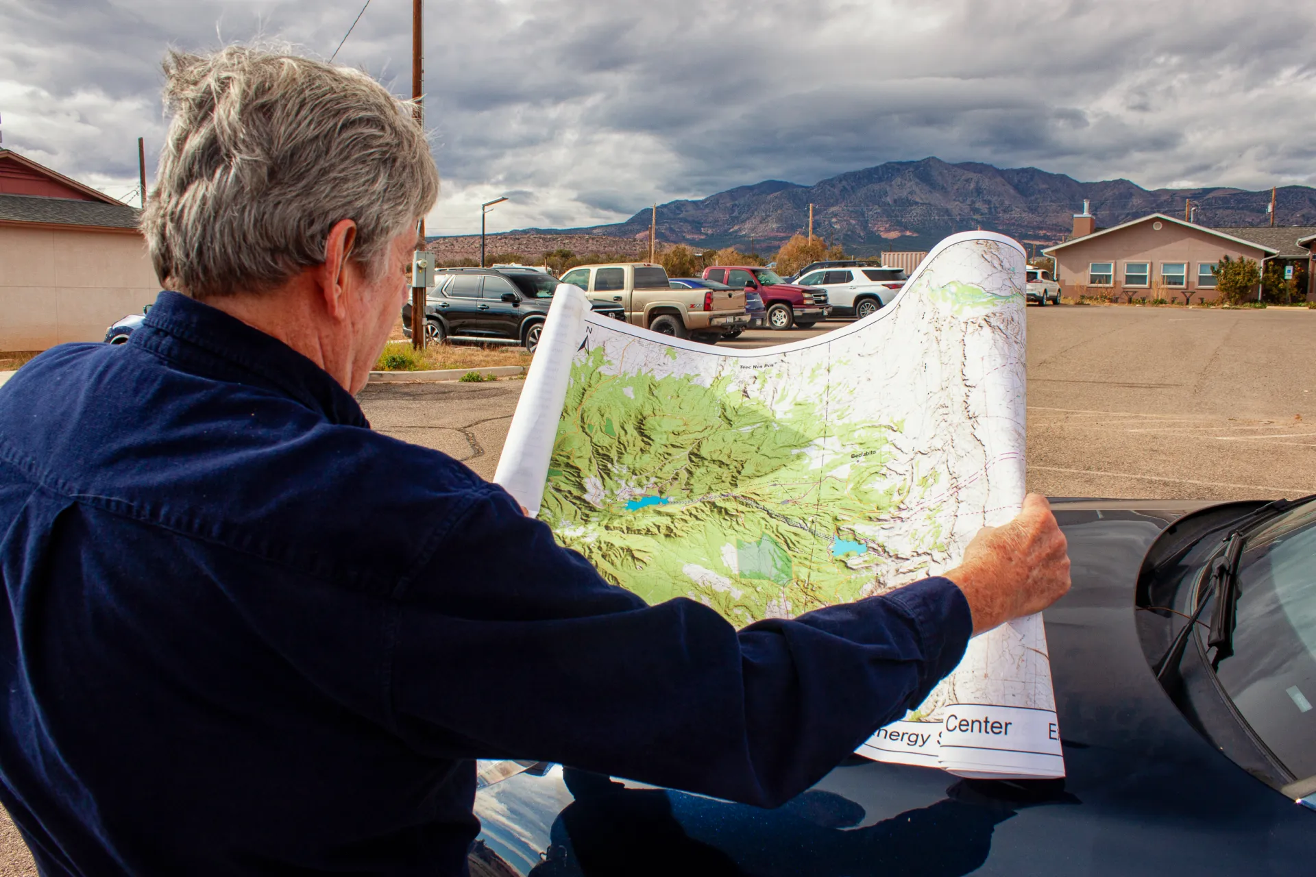
Standing in a breezy parking lot on Navajo land in the state’s far northwest corner, Tom Taylor looked toward the western horizon and then upwards at the furrowed mass of the Carrizo Mountains less than 10 miles away.
If all goes to plan, the infrastructure that could one day spill from the mountain’s flanks and through its core will become an essential piece of the region’s electric grid, able to store surplus electricity from renewable energy and other power sources for when it is needed later.
Fighting the wind that chilly November morning, Taylor used both hands to pin a detailed map against the hood of his Porsche Macan. A jumble of dashed lines and blue splotches representing proposed power lines, reservoirs, a water-supply pipeline, and access roads were printed atop the real-world geography on display in front of us.
“This will be a battery that lasts a long time,” Taylor said, holding tightly to the map.
JOAN CARSTENSEN
The project is the $5 billion Carrizo Four Corners Pumped Storage Hydro Center, which is designed to be one of the largest long-duration energy storage projects in the country. Pumped storage moves water between two reservoirs at different elevations. Water is pumped uphill when excess electricity is available and released to generate electricity when power demand warrants it.
Taylor, a former mayor of Farmington and a state House representative from 2000 to 2014, is employed by Kinetic Power, the three-person, Santa Fe-based outfit behind the Carrizo proposal. The company sees the project as a way to make the region’s electric grid more durable and cost-effective, not only by smoothing the intermittent nature of wind and solar but also as a bulwark against energy emergencies like the winter storm in 2021 that caused blackouts and 246 deaths in Texas. The twinned reservoirs, using water sourced from a Colorado River tributary nearby, would have the capacity to generate 1,500 megawatts over 70 hours – a form of battery that could provide the equivalent output of a large nuclear plant for nearly three days.
“We believe that the key is delivering economic value,” said Thomas Conroy, Kinetic Power’s co-founder, who has four decades of experience developing energy projects.
What seems straightforward when placing lines on a map is much less so in three dimensions. Carrizo Four Corners, which is still in the exploratory stage and is at least five years away from breaking ground, has nearly as many questions as answers at this point. What is the geology within the Carrizo Mountains? Will it support a 3,300-foot-deep shaft, a subterranean powerhouse, and dam abutments? How will drought affect the water supply? What cultural sites and wildlife might be at risk from construction? What are the power market dynamics?
Answering those questions is the goal of a $7.1 million, two-and-a-half-year Department of Energy grant that Kinetic and its six university and research partners secured in August. (The state of New Mexico and the research partners are also contributing $7.1 million.) On the political side, will future Navajo administrations feel as favorably toward Carrizo as current president Buu Nygren?
The technical questions are but one piece of an ambitious project that touches many of the most pressing questions about natural resources in the American West today: energy development, water use, and the relationship between federal law and tribal law.
Connecting Water and Energy
Though the details are still to be worked out, the project can be described in broad strokes.
The Federal Energy Regulatory Commission, which oversees federal hydropower licensing, granted Kinetic a preliminary permit in 2021. In February 2025 FERC extended the permit, which allows for site investigations but no construction work, for another four years.
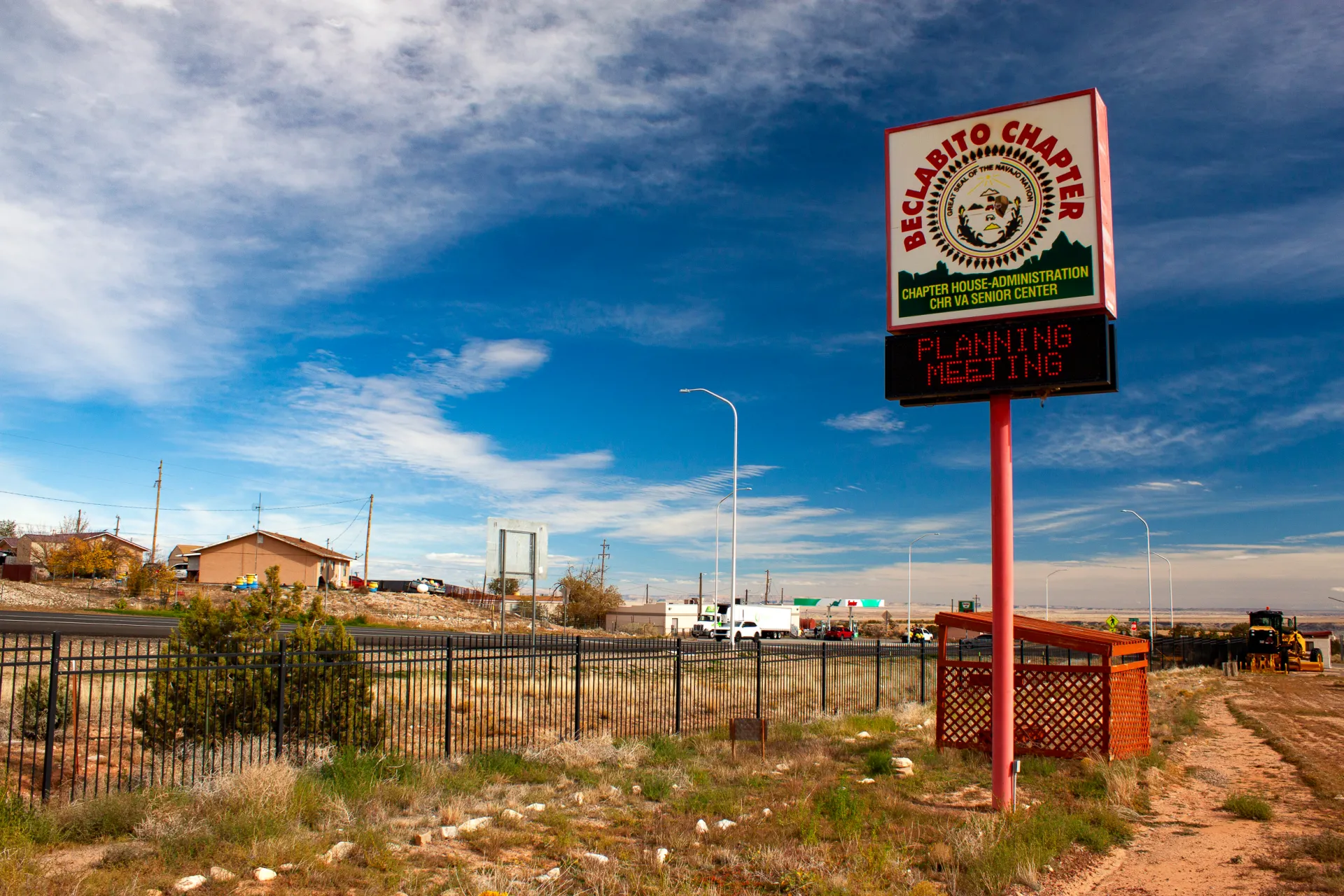
The company envisions two “off-channel” reservoirs that would not dam a flowing river. The lower reservoir will be near Beclabito. The upper, in the high reaches of the Carrizo Mountains. Both are on Navajo land, but on different sides of the Arizona-New Mexico border.
The powerhouse that holds the electricity-generating turbines will be located underground, some 3,300 feet below the upper reservoir. Some of the longest pumped storage tunnels in the country will be required to connect the reservoirs and the powerhouse.
Despite the geotechnical challenges, Conroy is particularly enthused by the site, which he said is the most optimal in Arizona and New Mexico – and possibly the entire country – to locate a pumped storage hydropower project.
The site stands out for four reasons, he said. It is near existing transmission corridors and grid connections due to the region’s legacy of enormous coal-fired power plants. And it will have a comparatively low capital cost for the energy it will produce.
The other two reasons relate to water. Because of the extreme height differential between the upper and lower reservoirs – almost three Empire State Buildings – less water will be required to produce a unit of energy than for reservoirs with a gentler gradient. And because the upper reservoir site is a deep canyon, surface area and thus evaporation will be minimized.
“Water is just top of mind here in the Southwest,” Conroy said. “And our project is as water-efficient as can be made.”
Water to fill the reservoirs would be drawn from the San Juan River, a tributary of the Colorado, via pipeline. The water would come from the Navajo Nation’s San Juan rights, which have been quantified but are not fully used.
How much water? In its FERC permit application, Kinetic estimated that the initial fill, which will take one and a half to two years, would require 38,300 acre-feet. To cover subsequent evaporation losses, the reservoirs would need to be topped up with 2,635 acre-feet per year. Those numbers will be refined in the feasibility studies.
“It’s what, about 1,300 acres of corn?” Taylor said, doing a rough mental calculation of the equivalent water consumption for the annual evaporation loss. “I think this is more valuable than 1,300 acres of corn.”
Saving for Tomorrow
So far the project has threaded the federal government’s fraught energy politics. The Trump administration is hostile to wind and solar, which in their eyes reek of liberal values. Two water-based technologies – hydropower and geothermal – have escaped condemnation and are listed in the administration’s energy dominance documents. The DOE grant that Carrizo secured is a holdover from the Biden administration’s infrastructure bill, which provided up to $10 million for feasibility studies for pumped storage projects that would store renewable energy generated on tribal lands.
Storage is the holy grail of renewable energy. Human civilization has advanced, from the dawn of agriculture to the artificial intelligence revolution today, by being able to carry a surplus from one season and one year to the next. So it is with wind and solar. To maximize their utility and counteract their intermittent nature, engineers have been searching for cost-effective ways to store energy when the sun shines and when the wind blows for the days when neither of those things happen.
“If you want to improve the resiliency of the system, you either build more firm capacity instead of more renewable, or you build longer storage,” said Fengyu Wang, a New Mexico State University assistant professor who is the principal investigator for the DOE grant.
Storage has taken many forms. Some are fantastic mechanical configurations – lifting heavy objects and dropping them, or forcing air into caverns and releasing it. Thermal options use molten salt to trap the sun’s heat. The most familiar are batteries, which leverage chemical energy. But the most common, at least in the U.S., is pumped storage hydropower.
The 43 pumped storage facilities in the U.S. represent the bulk of the country’s utility-scale energy storage. They accounted for 88 percent of the total in 2024, according to Oak Ridge National Laboratory. That is changing quickly, however, as more battery storage comes online. The share for pumped storage was 96 percent in 2022.
Still, long-duration storage is where pumped storage shines. According to Oak Ridge, the median battery storage is two hours. For pumped storage, it is 12 hours. Longer duration provides more buffer, not only from day to day but also season to season.
In that regard, Carrizo would signify a huge leap. The only comparable pumped storage project under consideration in the U.S. is Cat Creek, in Idaho. Even though its duration is 121 hours, its generating capacity is less than half, at 720 megawatts.
Carrizo will have a different use case than other U.S. pumped storage projects, Conroy said. Many facilities have one customer and one generator. A nuclear plant, for instance, might be paired with a pumped storage system so that the nuclear plant can run continuously.
For Carrizo, there might be a consortium of utilities that have multiple generating sources feeding into this project and moving the water uphill. They would take delivery of that power across a large region with different climatic conditions and different needs for when and how they use the stored power. That means operating the facility will be more complicated than a traditional pumped storage project. One thing is certain, Conroy said: the Navajo will have an equity stake.
Tribal Outlook
Caution on the part of the Navajo would be understandable. The tribe’s lands have long been the center of energy developments with environmentally ruinous but economically helpful outcomes.
Uranium mining to fuel the Manhattan Project and then the nation’s reactors polluted rivers and groundwater, as did the coal mines that fed Four Corners Power Plant and the now-shuttered Navajo Generating Station and San Juan Generating Station. On the other hand, these developments provided employment and income. Navajo Mine, which supplies Four Corners Power Plant, accounts for about 35 percent of the Navajo Nation’s general fund.
Navajo and other tribal lands in the Four Corners region have been the target for a handful of pumped storage proposals in recent years. The Navajo Nation opposed three projects proposed for the Little Colorado River watershed, which were either withdrawn by the developer or denied a permit by FERC. Two other projects – Carrizo and Sweetwater, both using San Juan River water – are still in development. Sweetwater, a smaller project with eight hours duration, is being co-developed with the Ute Mountain Ute Tribe. A third project, Western Navajo Pumped Storage, which would be located near the former Navajo Generating Station, received a FERC preliminary permit in August.
Carrizo has not run into the same level of opposition as the other proposals. In part that is due to the proposed use of the San Juan River instead of groundwater, said Erika Pirotte, an assistant attorney general in the Navajo Nation’s water rights unit. Many Navajo communities rely on groundwater, and using it for pumped storage was viewed as unreasonable.
The lack of strong opposition is also because of Kinetic’s engagement with the Navajo Nation. The company has held meetings with the Beclabito, Red Valley, and Teec Nos Pos chapters, in addition to meetings with Navajo Nation agencies and Buu Nygren, the Navajo Nation president. Kinetic has a memorandum of understanding with Nygren, who also signed a letter of support for the project’s DOE grant application.
“We have the support of the council,” Conroy said. “We have a very high level of support from the president, and he is just extraordinarily interested in this project and seeing that it moves forward.”
From the Navajo perspective, what is interesting are the “ancillary benefits” that could come from the water supply pipeline, Pirotte said. Once the reservoirs are filled and the pipeline’s full capacity is not needed, the extra space could be repurposed for tribal water supply uses.
“That’s why the feasibility studies are really important for the Nation, because they help us understand to what extent Navajo Nation resources would be used for the project,” Pirotte said.
None of this is immediately around the corner, Conroy cautions. The DOE grant extends for more than two years. The FERC permitting process could be another two to four years. With Congress and the Trump administration talking about faster permitting and better coordination, that timeline is a best guess.
And then there is the question of tribal authority in the permitting process, not just for the Carrizo project but for other such developments. Will FERC abide by its 2024 stance that preliminary permits for hydropower projects on tribal lands require tribal consent? The Trump administration would like to see that policy scrapped. If FERC approves a project must a tribe assent to all the associated infrastructure? Will the Navajo be allowed to conduct reviews and issue permits?
And then there is construction, the biggest component. That will take four to six years, Conroy said.
Even on an ambitious timeline, Carrizo is not operating until the mid-2030s.
“I’m 77,” Taylor said. “I probably won’t see it.”
This story was produced by Circle of Blue, in partnership with The Water Desk at the University of Colorado Boulder’s Center for Environmental Journalism.
Map of the San Juan River, a tributary of the Colorado River, in Arizona, Colorado, New Mexico and Utah, USA. Made using USGS National Map data. By Shannon1 – Own work, CC BY-SA 4.0, https://commons.wikimedia.org/w/index.php?curid=47456307
Despite the escalating threats to rivers, this past year brought real progress worth celebrating. To highlight the positive strides being made across the country, we’ve curated a list of 10 exciting wins for rivers, community safety, people, and wildlife. From proposed Wild and Scenic protections for nearly 100 miles of the Gallatin and Madison rivers, to major investments in river restoration and wildfire resilience in California, and stronger permit safeguards for the Rappahannock River, 2025 proved to be a year of meaningful breakthroughs for waterways nationwide.
In no particular order, here’s a snapshot of 10 of our biggest river wins of 2025:
Secured major wins for America’s Most Endangered Rivers® of 2025
Our 2025 America’s Most Endangered Rivers® report ranked the Tijuana River #2 due to toxic pollution threatening border communities. This designation, developed with partners Surfrider Foundation and Un Mar de Colores, helped catalyze swift federal action. Within three months of the April report release, American Rivers and others were invited to meet with EPA Administrator Lee Zeldin in southern California, which helped build momentum for a landmark agreementbetween the United States and Mexico to address the ongoing public health crisis. This demonstrates how strategic advocacy, combined with persistent community leadership, drives solutions for rivers and their communities.
The Rappahannock River’s designation as one of America’s Most Endangered Rivers® of 2025 brought crucial national attention to the threats facing Virginia’s longest free-flowing river. But this spotlight did more than raise awareness; it galvanized action that delivered tangible results. Working alongside our dedicated partners, The Friends of the Rappahannock, the Rappahannock Tribe, and the Southern Environmental Law Center, we achieved a significant victory for the river and the communities that depend on it. This collaborative effort secured permit changes for a proposed data center, banning industrial cooling withdrawals and reducing drought withdrawals by millions of gallons.
Mobilized action to protect Public Lands and Roadless Areas
The Trump administration is looking to rescind the Roadless Rule, which protects clean water and wildlife habitat by preventing road construction and timber harvest on roughly 45 million acres of national forests. This would be a significant setback (100,000 river miles) to our goal of protecting one million miles of rivers. Our team is making sure decision makers understand the impacts to clean drinking water supplies and we are mobilizing our supporters (we’ve collected more than 10,000 signatures so far) in support of these important river protections.
Rainbow trout in the Gallatin River, Montana.
Safeguarding Montana’s Gallatin and Madison Rivers
Rep. Ryan Zinke (MT) introduced the Greater Yellowstone Recreation Enhancement and Tourism Act (GYREAT Act) – Wild and Scenic legislation to protect nearly 100 miles of the Gallatin and Madison rivers and their tributaries in southwestern Montana. This legislation was developed through collaboration with American Rivers and our partners. If passed, these protections would create a vital corridor linking the rivers of Yellowstone National Park to the headwaters of the Missouri River.
Defending healthy rivers and Tribal sovereignty
American Rivers helped rally national, regional, and local partners in urging the Department of Transportation to protect aquatic connectivity programs — efforts that restore fish passage, reconnect rivers and wetlands, and replace outdated culverts and road crossings. The joint comment letter was signed by 140 groups — including Tribes, anglers, businesses, universities, research institutions, conservation organizations, community leaders, agencies, faith groups, and planners — all united for healthier, more connected waterways.
Additionally, when the Department of Energy urged the Federal Energy Regulatory Commission to roll back its 2024 policy protecting Tribal sovereignty in hydropower permitting, American Rivers acted fast. Working with Tribal attorneys, Native networks, and partner organizations, we mobilized national opposition and filed formal comments — demonstrating our deep commitment to Tribal leadership and ensuring healthy rivers. We’ll continue working alongside Tribal partners to ensure these protections remain strong.
Restoring mountain meadows in California
American Rivers is a key member of The Sierra Meadows Partnership, a coalition of environmental organizations working together to restore 30,000 acres of mountain meadows by 2030. These meadows act as natural sponges that store water, improve drought resilience, and provide essential wildlife habitat. Through this collaborative effort, we successfully secured a $24.7 million block grant from the Wildlife Conservation Board to support our restoration work.
Restored Wilson Ranch Meadow, California | Allison Hacker
Advanced critical protections for New Mexico’s waterways
After naming New Mexico’s waterways #1 on America’s Most Endangered Rivers® of 2024 list, we’re celebrating significant wins across the state. In the Pecos watershed — home to elk, black bears, Rio Grande cutthroat trout, and generations-old acequia farms — the Department of Interior paused new mining claims across 165,000 acres while pursuing longer-term protections. Through advocacy with our partners, we helped secure Outstanding National Resource Waters protection for over 250 miles of rivers across five watersheds, including the Rio Grande. And now, Senator Heinrich (NM) and the All Pueblo Council of Governors are championing protection of the Caja del Rio — a 107,000-acre landscape along the Rio Grande and Santa Fe rivers that holds deep cultural significance for Puebloan and Hispanic communities while supporting diverse wildlife.
Furthering community safety through dam awareness
American Rivers spoke on panels and hosted webinars addressing the deadly threat of low head dams, generating hundreds of participants from across the dam removal and safety industries. A low head dam is a human-made structure that spans the full width of a river and is designed to allow water to continuously flow over it, creating a dangerous hydraulic and earning them the nickname “drowning machines.” Our educational workshops brought together leading experts to discuss solutions for addressing these public safety hazards while advancing river restoration solutions.
Building momentum for dam removal across the Northeast
American Rivers is celebrating a wave of funding that will free multiple rivers across the Northeast. We were awarded $220,000 to remove the Yopp Pond dam on the Fourmile River in Connecticut — the first barrier blocking this coastal river that drains to Long Island Sound. Fisheries biologists note this removal will be transformational for alewife runs in this critical watershed. Additionally, New Hampshire Fish and Game committed $150,000 to support two strategic dam removals: North Branch Gale dam in the Upper Connecticut River watershed and Mead Brook dam in the Contoocook River watershed. Both dams impact excellent cold-water habitat and are scheduled for removal in 2026. Additionally, the Davis Conservation Foundation granted $20,000 for our hydropower relicensing work in Maine.
Defended Idaho’s Salmon River
Along with our partners at Advocates for the West and coalition members in Idaho, American Rivers and our Action Fund filed a lawsuit against the Forest Service to prevent a massive open-pit gold mine at the headwaters of the South Fork Salmon River. This important waterway is a national treasure that provides critical spawning habitat for the longest-distance, high-elevation salmon migration on Earth, as well as world-class whitewater recreation and fishing. It has been listed as one of America’s Most Endangered Rivers® for three consecutive years.
Improved wildfire resilience in California
American Rivers and our partner, Terra Fuego Resources Foundation, completed prescribed fire burns on 160 acres as part of a 570-acre fuel reduction and prescribed fire project — a critical effort to protect the South Yuba River and the communities of Nevada City and Grass Valley from catastrophic wildfire. In a major boost for river restoration, the California Wildlife Conservation Board approved nearly $5 million to launch the Pickel Meadow Restoration Project on the West Walker River. Construction begins this summer, marking an exciting next chapter for this important watershed.
Created by Imgur user Fejetlenfej , a geographer and GIS analyst with a ‘lifelong passion for beautiful maps.’ It highlights the massive expanse of river basins across the country – in particular, those which feed the Mississippi River, in pink.
Click the link to read the article on the AZCentral website (Debra Utacia Krol). Here’s an excerpt:
December 29, 2025
Key Points
A new intertribal land trust has acquired 10,000 acres of land along the Klamath River from former dam operator PacifiCorp.
The land transfer is a key step in restoring the river basin’s ecosystem following the removal of four dams.
Indigenous values and traditional practices will guide the restoration of the land, which includes important salmon habitat.
Another milestone in restoring the Klamath River Basin has been reached. A new land trust received title to land on Dec. 22 that includes important salmon habitat and lands upstream of and adjacent to four now-removed dams and the shallow reservoirs that impeded fish and nurtured deadly algae in northern California and southern Oregon. The Klamath Indigenous Land Trust was formed by a coalition of members from four basin tribes after the historic 2002 fish kill to remove the dams as the beginning of a long-term effort to restore health to one of the West’s most imperiled rivers. PacifiCorp, the previous landowner and former hydropower operator, agreed to sell 10,000 acres to the land trust to return stewardship to the tribes who fought for decades to remove the dams as the first step in river recovery. Indigenous values and millennial-long practices which once made the basin one of the West Coast’s largest salmon habitats will direct the job of restoring the ecology of the area, which is the size of West Virginia. The Catena Foundation, the Community Foundation of New Jersey and an anonymous donor provided the funding for the purchase, which is one of the largest such purchases by an Indigenous-led land trust to date…
“Dam removal allowed the salmon to return home,” said Molli Myers, the land trust’s board president and member of the Karuk Tribe. “Returning these lands to Indigenous care ensures that home will be a place where they can flourish and recover.”
“PacifiCorp is pleased to see these lands transition to a stewardship model that honors their cultural and ecological significance,” said Ryan Flynn, president of Pacific Power, the division of PacifiCorp that serves customers in the Northwest.
Workers raise dam 109 feet in 2025. Next year’s goal: Reaching the top.
The Denver Water team working on Gross Dam in Boulder County is celebrating a successful year after the dam raise is 95% complete.
“In 2025, we raised the height of the dam by 109 feet above the original structure,” said Jeff Martin, Denver Water’s program manager for the Gross Reservoir Expansion Project. “We have 22 feet left to go to reach the new height and we’re on track to reach that in 2026.”
The dam-raising aspect of the Gross Reservoir Expansion Project wrapped up for the season on Nov. 14, due to the drop in temperatures. The project is designed to nearly triple the water storage capacity of Gross Reservoir.
In 2025, workers raised the height of Gross Dam by 109 feet. The final 22 feet will be completed in 2026 to reach the dam’s new height of 471 feet. Photo credit: Denver Water.
“We have to stop placing roller-compacted concrete when the temperatures drop below freezing,” said Casey Dick, deputy program manager for the Gross Reservoir Expansion Project.
“To prepare for winter, we put blankets on top of the new concrete to keep it from getting too cold. That’s because if the concrete freezes while it is still curing, it can lead to a weakened final product.”
Work associated with the dam raise will resume in spring 2026, when the weather warms up enough to complete the final 22 feet.
Protective “blankets” were placed on top of the dam to insulate the new concrete, so it does not fully cure over the cold, winter months. Photo credit: Denver Water.
Once that work is complete, the dam will be 471 feet tall, which is 131 feet higher than the original. The completed dam also will be longer across its crest, or top. The original crest was 1,050 feet long; the higher dam will have a crest that stretches 2,040 feet from one side of the canyon to the other.
This year marked the second year of dam raising construction work at Gross.
As of December 2025, workers had placed more than 730,000 cubic yards of concrete. To put that in perspective, Empower Stadium at Mile High, where the Denver Broncos play their home football games, required just 29,000 cubic yards of concrete to build, about 4% of the concrete placed so far on Gross Dam.
Protective “blankets” were placed on top of the dam to insulate the new concrete, so it does not fully cure over the cold, winter months. Photo credit: Denver Water.
Roller-compacted concrete is a special mix of concrete that allows crews to place it on the dam and then spread it out. The concrete is firm enough to be able to drive machinery on top of it. The process is a fast and efficient method of raising the dam. During the construction work, crews raised the height of the dam by about 1 foot per day.
Construction crews use GPS technology and survey equipment to keep track of how high they’ve raised the dam.
“The way we keep track of the elevation gain is that the bulldozers are equipped with GPS-grade control technology, which ensures that each layer of concrete is spread to the correct thickness,” Dick said.
“Once the concrete is rolled and vibrated into place, each layer ends up being 1 foot thick. It’s then checked by surveyors with their equipment to verify the exact elevation.”
The bulldozers are equipped with GPS-grade control technology to monitor the height of the concrete as it is spread across the top of the dam and keep track of the elevation. Photo credit: Denver Water.
Work won’t completely stop over the winter.
Mechanical and pipe work will be done inside the dam, and crews will build a stilling basin at the base of the dam. The basin’s function is to slow the speed of water coming down the dam’s spillway and safely redirect the water into South Boulder Creek.
Work on the stilling basin at the base of the dam will continue over the winter. The stilling basin is designed to slow the flow of water coming down the spillway and channel it into the creek. Photo credit: Denver Water.
“This season was a huge success, and our team met a ton of challenges in raising Gross Dam,” Martin said. “We had legal challenges and adverse weather challenges. We also had wildfire safety operation challenges that shut down our power supply up here. Despite all those setbacks, the dedicated team of 500 men and women rose to the challenge. I’d just like to thank everybody who committed themselves to this project and helped us make 2025 a success.”
Jeff Martin, Denver Water’s program manager for the Gross Reservoir Expansion Project, stands at the south side of the dam. Once completed, the dam will reach up to white line on the rock wall. Photo credit: Denver Water.
The Colorado River Water Users Association annual conference met in Las Vegas [December 16-18, 2025]. Each year, over a thousand government officials, members of the press, municipal water district leaders, water engineers, ranchers, and tribal members meet to discuss the management of the mighty Colorado River. Hanging over the three-day conference was a stalemate between the upper and lower basin states over how to manage the Colorado River after current operational guidelines expire at the end of 2026.
Throughout the conference, the states’ inability to reach a consensus deal produced ripple effects. The stalemate held back progress on both near term shortage concerns (experts predict that Lake Powell will be only 28% full at the end of the ’25-’26 water year) and long-range planning, such as the development of the next “Minute” agreement between the United States and Mexico.
The closing act of CRWUA 2025 was an orderly (and familiar) report from each of the basin states’ principal negotiators that their state is stretched thin but remains committed to finding a consensus agreement. This final session had no discussion or Q&A. The basin states now have until February 14th to provide the Bureau of Reclamation with their consensus deal, which would presumably be added to an Environmental Impact Statement (EIS) draft that is expected to be released in early January. With time running short, many worry that public participation in the EIS process – vital to informed decision-making – will be greatly reduced.
Still, as Rhett Larson of Arizona State University said on the first day of the conference, “Desert rivers bring people together.” Tribal governments continue to innovate in the areas of conservation and storage, even in spite of ongoing challenges to meaningful access of federally reserved tribal water rights. For instance, the Colorado River Indian Tribes, or CRIT, shared news of a Resolution and Water Code recently passed by their Tribal Council which work together to recognize the Colorado River’s personhood under Tribal law. This provides CRIT with a holistic framework for on-reservation use and requires the consideration of the living nature of the Colorado River in off-reservation water leasing decisions. John Bezdek, who represented CRIT at the conference, put it this way: “If laws are an expression of values, then this tribal council is expressing to the world the importance of protecting and preserving the lifeblood of the Colorado River.” Among others, Celene Hawkins of The Nature Conservancy and Kate Ryan of the Colorado Water Trust also shared about the unique, and often unlikely, partnerships formed to protect stream flows and the riparian environment across the Colorado River basin.
Notwithstanding the basin states’ current deadlock, one theme rang true at CRWUA 2025: Despite the dire hydrologic and administrative realities facing decision-makers today, the Colorado River continues to bring unlikely parties together.
Left to right: Becky Mitchell, Tom Buschatzke, Brandon Gebhart, John Entsminger, Keith Burron, Gene Shawcroft, JB Hamby, Estevan López. Photo credit: Yes To Tap via X (Twitter)
The single most important gathering of Colorado River Basin officials came and went — with no significant announcements regarding the often frustrating yet crucial seven-state negotiations for how to divvy up the river over the next 20 years…Here are three takeaways as the states wrestle with basinwide overuse of water, declining river flows due to a warming world and how to meet the federal government’s Valentine’s Day deadline for a consensus-based deal.
States far from deal — with less than 60 days left
Unlike last year’s conference, the seven states agreed to sit on a panel that was added to the agenda for the last day. The ballroom was still packed for the early morning session. That’s because the stakes are high for states to meet Burgum’s Feb. 14 deadline for a seven-state agreement. Should they not deliver one, Burgum could intervene and states are likely to sue. The Lower Basin states have agreed to shoulder the brunt of a massive deficit the system faces that totals 1.5 million acre-feet, or almost 489 billion gallons. However, the Upper Basin states of Colorado, Utah, New Mexico and Wyoming say they don’t have more water to give should cuts in their jurisdictions become necessary. Conflicts exist with state laws, too…
Temporary deal could be on the table to avoid courtroom
Nevada’s governor-appointed negotiator, John Entsminger, spoke last on the panel and called out the other six states for failing to cede any ground on further conservation in their remarks. Without some compromise from each state on these long-standing arguments, the negotiations are “going nowhere,” he said. While the states have been expected up until this point to deliver a 20-year deal, Entsminger suggested on the panel that a temporary, five-year deal could be on the table to comply with the Feb. 14 deadline.
Udall/Overpeck 4-panel Figure Colorado River temperature/precipitation/natural flows with trend. Lake Mead and Lake Powell storage. Updated through Water Year 2025. Note the tiny points on the annual data so that you can flyspeck the individual years. Credit: Brad Udall
Poor outlook sending shockwaves throughout basin
The underlying issues of the Colorado River are making this moment much more precarious. Several experts presented a dismal picture for the system at large. Carly Jerla, senior water resource program manager at the Bureau of Reclamation, said the agency’s most recent projections place flows into Lake Powell anywhere between 44 percent to 73 percent of average this upcoming year. And since 2006, that replenishment of the reservoir has declined about 15 percent because of poor snow years, evaporative losses and more…
The back of Glen Canyon Dam circa 1964, not long after the reservoir had begun filling up. Here the water level is above dead pool, meaning water can be released via the river outlets, but it is below minimum power pool, so water cannot yet enter the penstocks to generate electricity. Bureau of Reclamation photo. Annotations: Jonathan P. Thompson
Jack Schmidt, who leads the Center for Colorado River Studies at Utah State University, has published several papers this year alongside a group of experts throughout the basin. By his estimation, should snowpack in the Rocky Mountains fail to impress again this winter, water managers may be blowing through a crucial buffer that ensures water can be released from Lake Powell into Lake Mead — and that hydropower generation can continue.
Map of the Colorado River drainage basin, created using USGS data. By Shannon1 Creative Commons Attribution-Share Alike 4.0
A private development company is investing $150 million in an ambitious plan to harvest groundwater lying beneath sprawling northern Colorado ranches to serve fast-growing towns along the Interstate 25 corridor.
FrontRange H2O, backed by a Texas oil and real estate company, is behind the venture. The firm has been operating in Colorado for more than 20 years, treating and delivering wastewater from oil wells for oil industry reuse on the West Slope, and overseeing extensive real estate holdings in Denver and elsewhere, according to Brent Waller, who is president of the Loveland-based company.
“We were recycling produced water before it was cool,” Waller said. Produced water describes wastewater that is generated through oil production.
Experts say the large-scale, private urban water development is the first of its kind in Colorado and could help thirsty towns like Fort Collins and Loveland shore up their water systems.
But others worry that the privatization of water in the state could lead to price hikes and might also, because of its reliance on nonrenewable groundwater, undermine the state’s future water security.
Still, Front Range H20 believes its system will deliver water at less cost and sooner than other government-backed projects.
Until now, Colorado communities have relied on water that is captured, stored and treated by public, nonprofit water utilities, such as Denver Water. The agency is an independent entity governed by commissioners who are appointed by the Denver mayor. In other cases, cities operate their own water systems. Public entities such as these are required by law to regulate water rates, to issue bonds to finance their work, and they are subject to oversight by elected or appointed bodies.
But FrontRange H2O is a private company that is using millions of dollars in private financing to secure the water rights, obtain state permission to drill the groundwater wells, and to build a water treatment system and pipeline to carry the water. Although it must obtain state permission to drill the wells and build the water treatment plant, it is not subject to the same public oversight as a public government system would be.
“This kind of thing is common in Texas and Arizona, particularly with groundwater, but it is unique in Colorado,” said Adam Jokerst, Rocky Mountain regional director for WestWater Research, based in Fort Collins. Jokerst is a groundwater expert who has consulted with Front Range H2O on its northern Colorado plans.
FrontRange H2O refers to its current project as VitaH2O. Nine wells drilled into the aquifer are expected to generate up to 5,000 acre-feet of water initially, Waller said. An acre foot equals nearly 326,000 gallons of water and is eough to serve to two to four urban households for one year. The water will be treated at a new plant north of Nunn and then delivered down to Cobb Lake, a reservoir owned by the Fort Collins-Loveland Water District, or FCLWD.
The district was in the news earlier this year when it opted out of a large-scale water and reservoir project run by Northern Water known as NISP, the Northern Integrated Supply Project. It will instead partner with VitaH2O.
Typical water well
As the project moves forward, Waller said FCLWD will contribute an additional $150 million to help complete the new water supply project. Chris Pletcher, general manager of FCLWD, declined an interview request. The water district was NISP’s largest customer and was on track to pay $400 million to help build the giant system.
Colorado derives most of its water supplies from melting snows that fill its streams and rivers, but large swaths of the state, including Douglas County, rely heavily on wells drilled deep into aquifers, many of which are not recharged through rain and snow.
As the state grows, the pressure to tap these nonrenewable waters is growing as well.
According to the Colorado Division of Water Resources, interest in drilling high producing groundwater wells in northern Colorado is growing.
“There has been more activity in this area in the last 10 years,” said Tracy Kosloff, deputy state engineer at Colorado’s Division of Water Resources.
Major players in the area include Front Range H2O and the city of Greeley, among others.
The interest in nonrenewable groundwater worries people like Steve Boand, a former Douglas County commissioner and water consultant who has watched his region’s nonrenewable groundwater supplies shrink as they are used by fast-growing towns like Parker and Castle Rock.
Any project that relies on nonrenewable groundwater is problematic, Boand said.
“In general, sustainable water supplies are the preferred source,” Boand said, noting that Douglas County water providers are spending hundreds of millions of dollars to recycle water and tap rivers and streams to wean themselves off nonrenewable groundwater. Their hope is, eventually, to use their aquifers only in drought years when surface supplies are scarce.
And that is part of the plan with VitaH2O, Waller said. The project will use surface supplies that the Fort Collins-Loveland district already owns to recharge the aquifers they plan to withdraw water from, in hopes that the treated water being pumped back into the ground in wet years will extend the life of the nonrenewable aquifers.
Under Colorado water law, groundwater can be drilled by whomever owns the land above the aquifer, but they must demonstrate that they are extracting water gradually and must prove it will last at least 100 years.
Waller said he believes the surface supplies that VitaH2O will inject back into the aquifers in wet years will extend the life of the system beyond 100 years, to 300 years or more.
The location of the wellfield as seen in a PDF provided by the Vita H20 Project.
East of Waller’s development, the city of Greeley has already invested $85 million in developing an aquifer system under the Terry Ranch that will supply water in drought years and will also store treated water, according to Sean Chambers, Greeley’s director of water and sewer utilities.
“What you are seeing now is a new approach to diversifying surface water supplies with this deep aquifer, nonrenewable groundwater … and there is a rush on that,” Chambers said.
Looming in the background is Northern Water’s NISP project. It was originally designed to serve 15 entities, but three have already pulled out, including the largest, the Fort Collins-Loveland district. Waller said he is in talks with several other communities, including Wellington and Eaton, who are looking for an alternative to the costly $2.7 billion NISP, which will rely on renewable water supplies from the Poudre and South Platte rivers.
Brad Wind, general manager of Northern Water, said NISP’s growing cost is prompting long-time supporters to rethink their participation and that some will inevitably go with other providers, such as VitaH2O.
“People have some hard choices to make,” Wind said.
How much water is available to be mined from these aquifers isn’t clear yet, though developers such as Waller and Greeley have invested heavily in doing the hydrological analysis that gives them an estimate of what is available.
But overuse is a major concern and Chambers says that is a key issue the city is addressing as it develops its system.
“Collectively we will have to find ways over time to make sure that northern Colorado and other communities that rely on this water don’t just mine it to extinction … Greeley goes into this effort with our eyes very wide open about that,” Chambers said.
“This is a resource that should last for 10 generations or longer and provide a runway for public officials to figure out how to build resilience into all of our sources of supply,” he said.
Boand isn’t convinced that the recharge technologies and state rules designed to make the water last longer are going to be enough to protect the aquifers.
“Recharge has been somewhat successful but everybody has talked about it as if it is the great salvation, even though it is very much in the testing phase,” Boand said. “And it takes the same attention to detail that running a nuclear power plant takes … lots of engineers and lots of scientists.”
Another concern with having a private company develop a major public water supply is the stability of the company and the water system if the company should fail.
Waller says his company’s contracts provide protection for that possibility.
“If we go belly up, five years or 10 years down the road, the water districts and participants have the right to step in and take over the system. There are controls in place,” Waller said. They expect to deliver water in the first quarter of 2029.
As with most new water projects, developers go through a special court review where they must prove their water estimates are accurate and that their water use won’t harm others. Waller said his company’s water court application was filed in October.
And it is being closely watched.
Chambers, with the city of Greeley, is concerned that the VitaH2O project may impact the Terry Ranch project, which lies nearby. He said he expects to fight to defend Greeley’s rights and will object to anything he sees as threatening.
“We intend to be an objector in the water court process to protect our decree and our investments,” he said.
A new report from Colorado Law’s Colorado River Research Group warns the Colorado River Basin is “out of time,” describing conditions so severe they threaten the region’s water supply, economy and governance. Called “Colorado River Insights 2025: Dancing with Deadpool,” the report details a dire assessment of the basin’s worsening crisis and offers options for reform. According to the report, reservoirs that once stored four years of river flows are now more than two-thirds empty. The authors note a single dry year or two could push Lake Powell and Lake Mead below critical thresholds, jeopardizing hydropower, water deliveries, and even physical conveyance downstream. The report concludes that current operating rules through 2026 are unlikely to prevent this scenario.
“This report underscores that the basin is out of time, the crisis is no longer theoretical,” said Douglas Kenney, director of the Western Water Policy Program of the Getches-Wilkinson Center at the University of Colorado Law School and chair of the Colorado River Research Group.
“Post-2026 negotiations must produce durable, equitable, climate-realistic solutions — and they must do so urgently. The message is stark: the Colorado River system is now dancing with Deadpool.”
Among the key challenges:
Severe shortage risk: The authors warn that if the next two winters are dry, combined usable storage in Powell and Mead could fall below 4 million acre-feet — far short of what’s needed for water supply and compact obligations.
Climate-driven decline: Rising temperatures, shrinking snowpack efficiency and ocean-atmosphere interactions are reducing runoff and precipitation.
Safety nets collapsing: Groundwater reserves are rapidly depleting, while federal capacity — funding, staffing and science programs — are eroding. Interstate cooperation is fraying, and litigation may be on the table.
Authors stress that many challenges are self-inflicted and, in their view, solvable with technical, legal and financial tools already available.
Colorado River Basin Plumbing. Credit: Lester Doré/Mary Moran via Dustin Mulvaney and Twitter
The year is ending with the Colorado River at a critical juncture.
Figure 4. Graph showing active storage in Lake Powell, Lake Mead, and in Powell+Mead between January 1, 2023, and November 30, 2025. Credit: Jack Schmidt/Center for Colorado River Studies
The big reservoirs Mead and Powell remain perilously low and the seven states that share the basin have been unable to agree on cuts that would reduce their reliance on the shrinking river.
Reservoir operating rules expire at the end of 2026. If no agreement is reached the federal government could step in, or the states could take their chances in court. It’s a risky move that no one in principle seems to want. Yet brinkmanship and entrenched positions have stymied compromise.
Native America in the Colorado River Basin. Credit: USBR
The basin’s Indian tribes, which collectively have rights to more than a quarter of its recent average annual flow, are adamant that their interests – and more broadly, the river itself – be protected. “Any progress made in the negotiations to date is merely rationing a reduced supply, not actively managing and augmenting it as a shared resource with strategies and tools that can benefit the entire basin,” the leaders of the Gila River Indian Community wrote on November 12.
At Lake Mead National Recreation Area in Nevada, “the National Park Service’s focus remains on sustaining boating access and visitor services across the park, including operations at Hemenway Harbor, Callville Bay Marina, Echo Bay, Temple Bar Marina, and South Cove to the extent feasible,” the National Parks Traveler was told.
“As part of that effort, construction began at Hemenway Harbor last summer to extend the launch ramp and help maintain access as conditions change. Lake levels are closely monitored, and NPS operations continue to be adjusted as needed to support safe recreation while protecting park resources,” the Park Service said.
Two years ago Lake Mead officials adopted a plan to “maintain recreational motorboat access in the event water declines to 950 feet.” As of Tuesday, the elevation was 1061.76 feet, according to the U.S. Bureau of Reclamation. At Glen Canyon National Recreation Area, which straddles the Utah-Arizona border, the Park Service has spent more than $100 million in recent years to extend boat ramps and relocate a takeout for river runners coming down the Colorado River through Canyonlands National Park.
Colorado River negotiators are seen, from left to right: Becky Mitchell (Colorado), Tom Buschatzke (Arizona), Brandon Gebhart (Wyoming), and John Entsminger (Nevada). (Photo by Jeniffer Solis/Nevada Current)
Western states that rely on the Colorado River have less than two months to agree on how to manage the troubled river – and pressure is mounting as the federal government pushes for a compromise and a troubling forecast for the river’s two biggest reservoirs looms.
Top water officials for the seven Colorado River Basin states — Arizona, California, Nevada, Colorado, New Mexico, Utah, and Wyoming — gathered for the three-day Colorado River Water Users Association conference at Caesars Palace in Las Vegas last week.
Colorado River states have until Feb. 14 to reach a new water sharing agreement before current operating rules expire at the end of 2026 —or the federal government will step in with their own plan.
Despite the fast-approaching deadline, states reiterated many of the same issues they did during previous years at the conference, namely, which water users will need to sacrifice more water to keep the Colorado River stable as overallocation, climate change, and rising demand sucks the river dry.
Nevada’s chief river negotiator and general manager of the Southern Nevada Water Authority John Entsminger offered a succinct but sharp assessment of the negotiations during a panel discussion Thursday.
“If you distill down what my six partners just said, I believe there’s three common things: Here’s all the great things my state has done. Here’s how hard/impossible it is to do any more. And here are all the reasons why other people should have to do more,” Entsminger said.
“As long as we keep polishing those arguments and repeating them to each other, we are going nowhere,” he continued.
The seven states that share the river’s flows have been deadlocked for nearly two years over how to govern the waterway through the coming decades — even as water levels at Lake Mead and Lake Powell are forecasted to reach record lows after two straight years of disappointing snowpack across the West.
The Colorado River’s headwaters saw a weak snowpack last winter, contributing to one of the worst spring runoff seasons on record. Water flow into the river this year was only 56% of average, leading to significant reductions in Lake Powell, according to the Interior Department’s Bureau of Reclamation.
Federal officials also released a troubling forecast of expected flows for the river in 2026, which were significantly lower than previous predictions. Projections from the Bureau of Reclamation found the Colorado River’s inflow next year would likely be 27% lower than normal, with worst-case scenarios predicting even lower flows.
Without a strong winter snow season, it’s possible Lake Powell’s levels could drop low enough to cease hydropower production by next October — a scenario that would also limit the department’s ability to send water downstream to Arizona, California and Nevada.
The federal government has refrained from imposing its own plan for the river, preferring the seven basin states reach consensus themselves. But the Interior Department has ramped up pressure on states to reach a deal.
The Bureau of Reclamation’s Acting Commissioner Scott Cameron said he and other federal officials have intensified efforts to bring states to a consensus, flying out West every other week since early April to meet with the seven states’ river negotiators.
“The expiration of the current agreements is not a distant horizon. It’s less than a year away. The time to act is now,” said Cameron.
Within the next few weeks, the Bureau of Reclamation will release a range of proposals to replace the river’s current operating rules, but said they would not identify which set of operating guidelines the federal government would prefer
During the conference, negotiators for the seven states repeated that they are still committed to finding a consensus despite missing previous deadlines. California’s biggest water districts said they were willing to “set aside many of their legal positions” in order to reach a seven-state agreement.
However, a long-term multidecade strategy for managing low river flows is likely out of reach.
“I went into this process…advocating strenuously for a 20- to 30-year deal,” said Entsminger. “I no longer believe that’s possible with the time we have left and with the hydrology that we’re facing.”
Entsminger said the “best possible outcome at this juncture” is a short-term five-year deal that sets new rules around water releases and storage at Lakes Powell and Mead.
During a panel of state negotiators, states highlighted water conservation efforts they have undertaken to reduce water use and protect the river, but all explained why their state can’t take on more cuts.
Figure 4. Graph showing active storage in Lake Powell, Lake Mead, and in Powell+Mead between January 1, 2023, and November 30, 2025. Credit: Jack Schmidt/Center for Colorado River Studies
“Our savings accounts are totally depleted,” said Utah’s’s river negotiator, Gene Shawcroft. “Reserviours were full when we started this process. They’re empty now.”
One of the biggest disagreements between the Upper and Lower Basin states is over which faction should have to cut back on their water use during dry years.
The Lower Basin – Nevada, Arizona, and California – have agreed to take the first 1.5 million acre-feet in water cuts needed to address deficits and evaporation that are reducing flows in the river, but say any additional cuts during dry years must be shared with upstream states. Under the current agreement, Lower Basin states must take mandetory cuts when water levels in Lakes Powell and Mead are low.
The Upper Basin, which is not subject to mandatory cuts under the current guidelines, say they already use much less water than downstream states and should not face additional cuts during shortages.
Any more cuts to water users in downstream states during dry years will be politically perilous, explained Arizona’s top negotiator, Tom Buschatzke. Arizona requires the state legislature to approve any changes to Colorado River management rules impacting the state.
Buschatzke called for the Upper Basin – Colorado, Wyoming, New Mexico, and Utah – to split any additional water cuts with the Lower Basin states 50-50.
“We need conservation in the Upper Basin that is verifiable and mandatory,” Buschatzke said, during the panel.
“I have to go to my legislature and get that approval,” he continued. “And I will say right now, I do not think there is anything on the table from the Upper Basin that would compel me to do that today.”
New Mexico’s river negotiator, Estevan López, responded, “I think we’ve been pretty clear. We are unwilling to require additional mandatory reductions on our water users.”
This story was originally produced by Nevada Current, which is part of States Newsroom, a nonprofit news network which includes Stateline, and is supported by grants and a coalition of donors as a 501c(3) public charity.
Map of the Colorado River drainage basin, created using USGS data. By Shannon1 Creative Commons Attribution-Share Alike 4.0
Click the link to read the report from “Dancing with Dead Poll” on the Getches-Wilkinson website (Jack Schmidt1, Anne Castle2, John Fleck3, Eric Kuhn4, Kathryn Sorensen5, Katherine Tara6) Here’s Chapter 1:
In Brief
The rains of mid-October caused significant flooding in the San Juan River basin and increased reservoir storage throughout that basin and in Lake Powell.7 However, basinwide reservoir storage remains low, and the October rainfall offerings were insufficient to alleviate the peril of declining overall water supply.
While the attention of the Basin’s water management community remains focused on the thus far unsuccessful effort to forge a seven-state agreement on future long-term operating rules, the Basin continues to face the risk of short-term crisis. If winter 2025-2026 is relatively dry and inflow to Lake Powell and other Upper Basin reservoirs is similar to that of 2024-2025, low reservoir levels in summer 2026 will challenge water supply management, hydropower production, and environmental river management. Under such a scenario, it is likely that less than 4 million acre feet in Lake Powell and Lake Mead would be realistically available for use during the nine months between late summer 2026 and the onset of snowmelt runoff in 2027. If winter 2026-2027 is also dry, water supply would be further constrained. The present reservoir operating rules that remain in place through 2026 are insufficient to avert this potential water supply crisis. Action to further reduce consumptive water use across the basin is needed now.
How did we get here?
The Basin’s reservoirs were nearly full in late summer 1999,8 acting as a buffer against dry years and serving their fundamental purpose. At that time, the 46 Colorado River Basin reservoirs tracked by the Bureau of Reclamation in its Hydro database held 59.5 million acre feet (maf) in active storage,9 more than four times the Basin’s average consumptive uses and losses in the 1990s (Fig. 1).10 Beginning in 2000, five years of below average runoff11 resulted in a 46% reduction in storage in the Basin’s reservoirs.12 During that time, the reduction in storage in Lake Powell and Lake Mead accounted for 90% of the Basin’s total loss in storage, because most of the Basin’s water was stored in those two reservoirs.
Figure 1. Graph showing active storage in Colorado River basin reservoirs between January 1, 2021, and November 30, 2025. Credit: Jack Schmidt/Center for Colorado River Studies
During the next fourteen and a half years, the amount of storage in the Basin’s reservoirs changed little, despite four years of large runoff (2005, 2011, 2017, and 2019). The increase in storage during the few wet years was nearly completely consumed during the more frequent dry years, and active storage in Powell and Mead was only 5% greater in late July 2019 than it had been at the beginning of 2005.13 When dry years of low runoff returned between 2020 and 2022,14 the Basin’s water users had little of the buffer that they had at the beginning of the 21st century. Combined active storage of Powell and Mead was halved again between mid-July 2019 and mid-March 2023,15 reducing the combined contents of these two reservoirs to only 27% of what it had been in late summer 1999.16 If next winter’s runoff is as low as it was in 2025 17 and consumptive use is not significantly reduced, Powell and Mead will drop below the previous unprecedented low stand of mid-March 2023.
How much of active storage is realistically available?
One of the challenges of the current water supply crisis is uncertainty over how much water is actually available in the reservoirs for use. Although Reclamation regularly reports the amount of water in active storage, our analysis identifies realistically accessible storage as the more appropriate metric of the amount of water that is available for use without challenging the integrity of the dam structures, efficient production of hydroelectricity, or implementation of environmental river management protocols, especially in Grand Canyon.
The back of Glen Canyon Dam circa 1964, not long after the reservoir had begun filling up. Here the water level is above dead pool, meaning water can be released via the river outlets, but it is below minimum power pool, so water cannot yet enter the penstocks to generate electricity. Bureau of Reclamation photo. Annotations: Jonathan P. Thompson
Reservoir water that can be physically released from a dam is termed active storage. In virtually all reservoirs, there is a small amount of water below the elevation of the lowest outlets–the infamously named dead pool. Active storage is everything above dead pool–water that can be physically released through the reservoir’s lowest outlets.
We know, however, that not all the water above dead pool is readily usable. Engineering assessments have indicated that infrastructure constraints at Hoover and Glen Canyon Dams require that higher reservoir elevations be maintained, thereby constraining utilization of the lowest part of the active storage. We defined realistically accessible storage as the volume of water whose release does not impact previously identified engineering or hydropower-production constraints.
At Glen Canyon Dam, for example, the lowest release tubes, called the “river outlets,” are at elevation 3370 ft. Reservoir water below that elevation cannot be released and constitutes the dead pool. Above the river outlets, at elevation 3490 ft, are the intakes for the power generating turbines, known as the penstocks. The penstocks are the conduits that withdraw water from the reservoir into the powerplant to generate electricity, and thereafter discharge the water to the Colorado River downstream from the dam. When the reservoir falls below the elevation of the penstocks, the river outlets are the only means of discharging water through the dam (Fig. 2). The river outlets are not routinely used to release water; virtually all normal releases go through the penstocks.
Experience has shown that the river outlets were not designed for continuous release at the discharge rates required to meet downstream obligations. If the river outlets were to be used continuously, there is significant concern that structural damage to those outlets could occur.18
Accordingly, Reclamation has determined that it will take steps to avoid Lake Powell elevation declining below 3500 ft, considered a safe elevation for continuous withdrawal of water through the penstocks without risk of harm caused by cavitation to the turbines that produce electricity.19 Similarly at Lake Mead, Reclamation has indicated its intent to protect the reservoir from going below elevation 1000 ft.20
Figure 2. Diagram showing schematic of Glen Canyon Dam elevations at which Lake Powell’s waters can be released downstream, and the volumes of water defined by these elevations. Active storage between 3370 and 3500 ft is not realistically accessible for continuous downstream release without risk to engineering infrastructure at the dam and powerplant. Hydroelectricity cannot be produced below 3490 ft, and 3500 ft has been established as a minimum safe level for intake through the penstocks.
The total volume of active storage in Lake Powell above dead pool but below elevation 3500 ft is 4.2 maf. Release of this stored water is constrained, because it cannot be safely withdrawn through the penstocks, and continuous use of the river outlets is considered unwise. At Hoover Dam, there is 4.5 maf of active storage below elevation 1000 ft, also not realistically accessible. In these two largest reservoirs of the Colorado River Basin, there is a total of 8.7 maf of active storage below the elevations required for safe and efficient operation of the infrastructure (Fig. 3). Thus, of the 14.9 maf of active storage at Lake Powell and Lake Mead on November 15, 2025, only 42% of that active storage, 6.2 maf, was realistically accessible.
Figure 4. Graph showing active storage in Lake Powell, Lake Mead, and in Powell+Mead between January 1, 2023, and November 30, 2025. Credit: Jack Schmidt/Center for Colorado River Studies
Implementation of environmental river management protocols at Glen Canyon Dam are constrained when the elevation of Lake Powell is low. Since 1996, controlled floods, administratively termed High Flow Experiments (HFEs), have been conducted at Glen Canyon Dam to rebuild eddy sandbars along the river’s margin and conserve sediment. HFEs are now an essential component of the Long Term Experimental and Management Plan for Glen Canyon Dam.21 Reclamation did not, however, release an HFE in 2021 or 2022 when sediment conditions were sufficient to trigger implementation of the HFE Protocol because Lake Powell was low. In early October of those years, when decisions about implementing HFEs were made, active storage in Lake Powell was 7.3 maf (elevation 3545.3 ft) and 5.8 maf (elevation 3529.4) in 2021 and 2022, respectively. Reclamation cited low storage as the reason not to release those controlled floods.22 Although administrative decisions change with time, it is doubtful that any HFEs would be released if Lake Powell fell below elevation 3500 ft.
Low reservoir levels also impact Reclamation’s ability to control the invasion into Grand Canyon of smallmouth bass, and other warm water reservoir fish species, that dominate the recreational fish community of Lake Powell. These nonnatives are significant predators and competitors of endangered or threatened native fish species and live near the surface of Lake Powell. At moderate and low reservoir elevations, water withdrawn through the penstocks (termed fish entrainment) includes some fish that survive passage through the powerplant turbines and are delivered into the Colorado River downstream from the dam. These fish have the potential to successfully spawn downstream from the dam if river temperatures are relatively warm, such as occurs when Lake Powell is low and water is only released through the penstocks.
This infographic shows how as Lake Powell water levels decline, warm water containing smallmouth bass gets closer to intakes delivering water through the Glen Canyon Dam to the Grand Canyon downstream. Credit: U.S. Geological Survey
Reclamation has implemented a protocol to eliminate the potential of smallmouth bass population establishment in Grand Canyon by releasing some cooler water through the river outlets when the water released through the penstocks is warm. The objective of these Cool Mix releases is to disrupt smallmouth bass spawning downstream from the dam. Water released through the river outlets bypasses the powerplant and does not produce electricity, and Western Area Power Administration (WAPA) must purchase electricity on the open market to replace electricity that the agency contractually committed to provide. WAPA estimated that the cost of replacing contracted electricity was $18.9 million23 and $6.5 million24 during the Cool Mix releases of 2024 and 2025, respectively. The risk of fish entrainment from Lake Powell increases significantly as Lake Powell’s elevation drops, and the need to implement the Cool Mix protocol therefore increases. The risk is minimized if Lake Powell is higher than 3590 ft (10.8 maf active storage) and significantly increases when Lake
Powell is below 3530 ft (5.8 maf active storage).25 When water is no longer withdrawn through the penstocks, the risk of entrainment decreases, because all water passes through the lower elevation river outlets.
What would happen if the coming winter and spring snowmelt is similar to 2024-2025?
In an analysis released in September 2025, we reviewed what might happen in the coming year if runoff is the same as it was last year and Basin consumptive uses and losses are the average of the past four years. We used a simple mass balance approach and estimated the available water supply and consumptive uses and losses, and calculated the difference between the two. The available water supply is the sum of the natural flow of the Colorado River at Lees Ferry plus inflows that occur in the Lower Basin, primarily in Grand Canyon. Consumptive uses and losses are those associated with diversions that support irrigated agriculture, municipal and industrial use, water exported from the Basin by trans-basin diversions, and reservoir evaporation. The difference between supply and use is the net effect on reservoir storage. We then estimated the effect of the Basinwide imbalance between supply and use on the combined realistically accessible storage in Powell and Mead, i.e., above elevations 3500 and 1000 ft in Lake Powell and Lake Mead, respectively.
In the scenario that we considered, we assumed that natural flow at Lees Ferry in the coming year will be 8.5 maf, the same as in Water Year 2025,26 and inflow in the Grand Canyon is 0.8 maf. Thus, we assumed a total supply in the coming water year of 9.3 maf. We analyzed a scenario wherein consumptive uses and losses in the United States portion of the Colorado River would be the average of the most recent four years (2021-2024), namely 11.5 maf,27 and we assumed that 1.4 maf would be delivered to Mexico.
The gap between supply and use under this scenario is 3.6 maf, which would have to be met by additional withdrawals from reservoir storage. Assuming that 75% of this deficit would be withdrawn from Lake Powell and Lake Mead (2.7 maf), then the realistically accessible storage in these two reservoirs would be reduced to 3.5 maf, slightly less than the 21st century low that occurred in mid-March 2023 (Fig. 3). Our analysis of this one realistically low inflow scenario–the coming year’s supply is just like last year’s and consumptive uses and losses are the average of the past four years–is consistent with, but less dire than, Reclamation’s most recent 24-Month Study minimum probable forecast28 for the coming year. That study projects that total storage in Lake Powell and Lake Mead will be drawn down by 3.8 maf during the next year, 2.9 maf from Lake Powell alone. Under Reclamation’s minimum probable projection, the elevation of Lake Powell would drop below 3500 ft in August 2026. All of the remaining realistically accessible storage, 2.5 maf in the scenario modeled by Reclamation, would be in Lake Mead. Under the assumption that the current operating rules remain in effect in 2027, Reclamation’s projection is that the elevation of Lake Powell would stay below elevation 3500 ft through at least July 2027.
Further complicating the situation is that the status and ownership of water in Lake Mead at very low storage levels is unclear. Lake Mead holds (a) water available for allocation in the Lower Division under the prior appropriation system, (b) at least some amount of the water due to Mexico under treaty obligations, and (c) assigned water. Assigned water, commonly known as Intentionally Created Surplus or ICS, is water that can be delivered independent of the Lower Basin’s prior appropriation water allocation system and that is held in Lake Mead by the Secretary of the Interior for the benefit of a specific entity. Assigned water also includes delayed water deliveries held for the benefit of the Republic of Mexico that can be delivered subsequently in amounts in excess of the U.S. treaty obligation to Mexico of 1.5 maf/year. Owners of assigned water have the right to withdraw that water when Lake Mead water levels are above 1025 ft, but entitlement holders in the priority system also have a right to water deliveries, as does Mexico via treaty.
Sketches by Floyd Dominy show the way he’d end the Glen Canyon Dam. From the article “Floyd Dominy built the Glen Canyon Dam, then he sketched its end on a napkin” on the Salt Lake Tribune website.
So long as there is water in Lake Mead adequate to fulfill all required and requested deliveries, no conflict arises. However, as the amount of water in Lake Mead decreases, the potential for a clash increases. International treaty obligations take precedence over deliveries pursuant to the priority system within the U.S., but it is unclear how competing priorities and entitlements will be resolved within the U.S. Holders of higher-priority entitlements would likely contest the Secretary’s authority to reduce their deliveries while withholding assigned water from the priority system. As of the end of 2024, there was approximately 3.5 maf of assigned water in Lake Mead, almost the same as the amount of realistically accessible water in storage above elevation 1000 ft. If Lake Powell ever became a “run of the river” facility, the potential for conflict over access to water in Lake Mead would also increase.
Implications
We are not weather forecasters and have no crystal ball that reveals the coming winter snowpack. We are not predicting that our assumptions about the gap between supply and use/losses and the resulting drawdown of Lake Powell and Lake Mead will inevitably occur. Our scenario is merely one of many possibilities, but our assumptions are sufficiently realistic to serve as a warning of how close the Basin is to a true water crisis. Our results should serve as a call to action. We need to adopt additional and immediate measures across the Basin to reduce water consumption even further during the next year, well before any new guidelines are in place.
Taking steps now to decrease consumptive uses across the Basin will reduce the need to implement draconian measures next summer or in the following years. Every acre foot saved now is an acre foot available for our future selves, slowing the rate of reservoir decline and creating more room for creative Colorado River management solutions. If, on the other hand, we delay reducing water usage and addressing reservoir drawdown, we may find ourselves in more significant distress at the beginning of the Post-2026 guidelines. As we wrote in October, continued reduction in Lake Powell releases also brings the Basin perilously close to the Colorado River Compact “tripwire,” the point at which the ten-year rolling total of water delivered from the Upper Basin to the Lower Basin might trigger litigation asking the U.S. Supreme Court to interpret long avoided ambiguities in rules written a century ago by the drafters of the Colorado River Compact.
We do not presume to make specific recommendations about the steps that should be taken immediately to reduce consumptive use in the Basin. There are many smart and experienced individuals in the Colorado River community whose sole focus is on the mechanics of operating the Colorado River water system and the impacts of operations on their particular constituencies.
We can, however, highlight the available mechanisms for reduction of consumptive use that should be explored for their immediate utility in diminishing the looming jeopardy to the overall system. Such mechanisms include:
Releases from federal reservoirs upstream of Lake Powell to stabilize storage in Lake Powell.
Such releases would be made pursuant to the Drought Response Operations Agreement or similar successor agreement or pursuant to the Secretary of the Interior’s inherent authority to operate federal water projects. Obviously, such releases do nothing to solve the imbalance between supply and demand and will create additional depletions in the system when these reservoirs are refilled. Such releases can, however, provide a temporary bulwark against exceptionally low levels in Lake Powell.
Additional reductions in deliveries from Lake Mead under the Secretary’s Section 5 delivery contracts in the Lower Basin, as authorized by Section II.B.3 of the decree in Arizona v. California, 376 U.S. 340 (1964).
By reducing deliveries from Lake Mead, releases from Lake Powell could also be reduced without the risk of causing exceptionally low storage in Lake Mead.
Extension of system conservation programs in the Lower Basin, and facilitation of an Upper Basin water conservation program, both funded through compensation from federal or state governments or other water users in the Basin, and requiring specific quantities of saved water.
Relying on compensated annual forbearance alone is unsustainable, however, because it is not feasible to pay water users in the long term to forgo the use of water that nature no longer supplies. Permanent reductions in consumptive use are both necessary and also the most productive use of limited funding. In addition, to be effective, changes to state law in some Upper Basin states may be necessary, including recognition of water conservation as a beneficial use for the purpose of avoiding litigation concerning the Colorado River Compact. Finally, authorization for shepherding of saved water to the intended place of storage is essential, including across state borders.
Reductions in deliveries to Mexico through negotiation of a new minute.
Reductions in consumptive use by federal water projects in the Upper Basin, if allowable pursuant to the Secretary’s authority.
It should be noted, however, that in order to benefit the Colorado River system, any such reductions must be recognized at the point of diversion and shepherded to the intended place of storage.
It is obvious that any long-term agreement for future Colorado River operations among the Basin States should be evaluated based on its immediate ability to reverse the storage declines experienced in recent years and anticipated in the future under similar hydrology. An agreement that does not reliably balance supply with uses and losses is not sustainable. Similarly, any operational alternative proffered by the Department of the Interior must achieve the same objectives. When our reservoir storage is as low as it is now, we have very little buffer to rely on–we simply cannot use more water than nature provides.
The focus within the Basin and among its principal water users and state negotiators has been on the formulation of the Post-2026 guidelines for operation of the river. But action is necessary now to avoid creating conditions that will doom the next set of operating principles by initiating their implementation when the Basin is in full crisis mode. No governmental administration, state or federal, wants to see the Colorado River system fail on its watch. Negotiators have worked tirelessly to reach agreement, yet have come up short. The hour is late. The Secretary must take decisive action.
Photo Credit: John Weishei via the Colorado River Research Group
Footnotes
1 Director, Center for Colorado River Studies, Utah State University, former Chief, Grand Canyon Monitoring and Research Center.
2 Senior Fellow, Getches-Wilkinson Center, University of Colorado Law School, former US Commissioner, Upper Colorado River Commission, former Assistant Secretary for Water and Science, US Dept. of the Interior.
3 Writer in Residence, Utton Transboundary Resources Center, University of New Mexico.
4 Retired General Manager, Colorado River Water Conservation District.
5 Kyl Center for Water Policy, Arizona State University, former Director, Phoenix Water Services.
6 Staff Attorney, Utton Transboundary Resources Center, University of New Mexico.
7 Between 9 October and 8 November, five reservoirs in the San Juan River basin gained 204,000 af in total storage, especially in Navajo and Vallecito Reservoirs. Between 9 October and 20 October, Lake Powell gained 105,000 af in active storage, and the total contents of Lake Powell and Lake Mead increased by 108,000 af between September 25 and October 27.
8 Schmidt, J.C., Yackulic, C.B., and Kuhn, E. 2023. The Colorado River water crisis: its origin and the future. WIREs Water 2023;e1672.
9 Total active storage in the Basin’s 46 reservoirs was at its maximum on 24 August 1999.
10 Total Basin consumptive uses and losses, including deliveries to Mexico, averaged 14.2 maf/yr between 1990 and 1999.
11 Average natural flow of the Colorado River at Lees Ferry, estimated by Reclamation, was 9.5 (Water Year, WY) and 9.6 (Calendar Year, CY) maf/ yr between 2000 and 2004. Average natural flow for the preceding ten years (1990-1999) was 15.0 maf/yr (WY, CY). Average natural flow for the entire 21st century between 2000 and 2025 was 12.3 maf/yr (WY, CY).
12 Total active storage of the Basin’s reservoirs was 32.0 maf on 19 October 2004.
13 Total active storage in Lake Powell and Lake Mead was 23.0 maf on 1 January 2005 and was 24.2 maf on 28 July 2019, a 5% increase.
14 Average natural flow at Lees Ferry averaged 9.0 (WY) and 9.2 (CY) maf/yr between 2020 and 2022.
15 Total active storage in Lake Powell and Lake Mead was 12.7 maf on 14 March 2023, 48% less than it had been on 28 July 2019.
16 Total active storage in Lake Powell and Lake Mead was 47.7 maf on 19 September 1999.
17 Reclamation estimates that natural flow at Lees Ferry was 8.5 (WY, CY) maf in 2025.
18 Bureau of Reclamation, Establishment of Interim Operating Guidance for Glen Canyon Dam during Low Reservoir Levels at Lake Powell (2024).18
19 Bureau of Reclamation, Supplement to 2007 Colorado River Interim Guidelines for Lower Basin Shortages and the Coordinated Operations of Lake Powell and Lake Mead, Record of Decision (2024) (SEIS ROD).
20 Id.
21 U.S. Department of the Interior, Record of Decision for the Glen Canyon Dam Long-Term Experimental and Management Plan, Final Environmental Impact Statement, December 2016.
22 Salter, G. and 7 co-authors, 2025, Reservoir operational strategies for sustainable sand management in the Colorado River. Water Resources Research 61, e2024WR038315.
23 Ploussard, Q., Pavičević, M., and Yu, A. 2025. Financial analysis of the smallmouth bass flows implemented at the Glen Canyon Dam during Water Year 2024. Argonne National Laboratory report ANL 25/44, 17 pp.
24 C. Ellsworth, Western Area Power Administration, pers. commun.
25 Eppenhimer, D. E., Yackulic, C. B., Bruckerhoff, L. A., Wang, J., Young, K. L., Bestgen, K. R., Mihalevich, B. A., and Schmidt, J. C. 2025. Declining reservoir elevations following a two-decade drought increase water temperatures and non-native fish passage facilitating a downstream invasion. Canadian Journal of Fisheries and Aquatic Sciences 82:1-19.
26 During the 21st century, natural flow at Lees Ferry was lower than this amount in 2002, 2012, 2018, and 2021, meaning that this is not a worst case scenario.
27 In 2024, consumptive uses and losses in the Upper and Lower Basins totaled 11.4 maf.
28 October 2025 24-Month Study Minimum Probable Forecast. For a discussion of why the Minimum Probable forecast has become a more reliable indicator of the future than the Most Probable 24-Month Study, see Awaiting the Colorado River 24-Month Study, Aug. 14, 2025.
Map of the Colorado River drainage basin, created using USGS data. By Shannon1 Creative Commons Attribution-Share Alike 4.0
Anne Castle, Jeff Kightlinger, Jim Lochhead at the 2025 CRWUA Conference. Photo credit: Water Mark (@OtayMark)
Click the link to read the article on the Aspen Daily News website (Austin Corona). Here’s an excerpt:
December 17, 2025
Federal officials have released a “sobering” forecast of 2026 water levels in the Colorado River, with expected flows plummeting from previous predictions. Precipitation later in the winter could turn those dire forecasts around, officials say, but the current outlook is grim for a river already flirting with crisis. Officials published the new forecast on Monday, only a day before negotiators and stakeholders from the river’s basin states gathered in Las Vegas for a three-day conference. The federal government has given states until February to agree on a longer-term strategy for managing low river flows. The Colorado River’s flow in 2026 (specifically, the unregulated inflow to Lake Powell) could be 27% lower than normal, according to the most probable scenario in the December forecast, with worst-case scenarios predicting even lower flows. The projection has worsened estimates released in November (16% lower than normal in most probable scenarios).
“We all know Mother Nature is a trickster and can often confound our expectations. We certainly hope she intends to do that this year,” said Wayne Pullan, the Bureau of Reclamation’s regional director for the Upper Colorado River Basin, on Tuesday. “But December’s outlook is troubling.”
The bureau, which manages federal dams, will delay water releases at Lake Powell to conserve supplies in the reservoir during the dry winter months in 2026, Pullan said. Even with those efforts, however, the lake’s water levels could fall to critical levels in 2027 as another disappointing year hits the basin. A bad water year in 2026 would compound already poor conditions from 2025, when river flows have been less than half of normal. The new forecast increases the possibility that water levels in Lake Powell could drop below the intakes for hydropower turbines and that releases from the lake could fall below the annual average required to meet the requirements of the 1922 Colorado River Compact, which governs water allocation between the seven states that use the river. Without above-average flows in future years to bring averages back up, or an interstate deal on how to manage drought, those low releases could set the stage for a legal battle on the river.
The back of Glen Canyon Dam circa 1964, not long after the reservoir had begun filling up. Here the water level is above dead pool, meaning water can be released via the river outlets, but it is below minimum power pool, so water cannot yet enter the penstocks to generate electricity. Bureau of Reclamation photo. Annotations: Jonathan P. Thompson
Colorado Senate Bill 24-005 (SB5) seeks to reduce unnecessary outdoor water use by limiting high-water landscaping in commercial areas to conserve water amid mounting drought concerns. Beginning Jan. 1, 2026, the legislation will restrict non-functional turf (irrigated grass areas used for decoration), artificial turf and invasive plant species in non-residential settings.
Implementing SB5
SB5 requires changes to land-use code to specify these restrictions for the following applications:
Commercial, institutional and industrial properties
Homeowner association common-interest community areas
Public spaces such as street right-of-way, medians, parking lots and transportation corridors
Restrictions and Applications
Due to the value and appropriateness of higher water use and activity they support, SB5 does not apply to areas considered functional or recreational, including turf for athletic fields, parks and golf courses.
The bill does not impact existing development; it applies only to new developments and certain redevelopment projects that require building or landscaping permits and disturb at least 50 percent of a site’s landscape. It excludes single-family residential properties, focusing instead on public and commercial areas where landscaping serves primarily for aesthetic purposes.
New Landscape Rules Matter for Colorado’s Future
Landscapes play a vital role to communities, but historical turf-heavy designs consume significant resources to meet social expectations. Today, more sustainable solutions exist that use less water while still delivering functionality. Allocating water budgets to landscape formats that provide the highest social value for the water invested is a sensible application to managing this scarce resource.
Areas that are primarily ornamental can be designed to use less water than traditional turf grass while still providing important non-recreational functionality. For spaces that require turf-like groundcover, multiple alternatives exist that use less water than cool season Kentucky Bluegrass, including Tahoma31 warm season grass, Dog Tuff grass and a variety of native grass combinations that thrive in this climate with minimal supplemental needs. These alternatives support stormwater management, provide cooling and pollution mitigation, while also delivering enhanced benefits of habitat for Colorado’s native flora and fauna. Non-turf areas such as gardens and groves have plentiful options for perennials, groundcovers, shrubs and trees that use less water than turf while providing essential livability features to our region.
Northern Water’s Role
To support SB5 implementation, Northern Water has been providing training to regional municipalities, including the Growing Water Smart program from the Sonoran Institute. These workshops introduce new sustainable landscape options that meet municipal needs while also providing flexibility for cities to determine a unique sense of place for their regions. Northern Water and its partners also provide tools such as landscape designs and demonstrations at our Berthoud Conservation Campus so city planners and consultants can experience ColoradoScapes and understand their resource uses as they update land use codes. Many cities are excited to modernize the message their landscapes convey and have begun showcasing these features on their own properties.
Lower Water, Higher Value Landscapes
SB5 ensures that water resources are dedicated to areas with the highest essential and recreational use, while maintaining high quality, aesthetically pleasing commercial, industrial and transportation areas that require less water. These changes will create communities that show our region’s natural beauty and restore ecosystem services to our pollinators, birds and other animals, while offering an authentic Colorado experience. Learn more about all of our water efficiency services that support this water-wise future.
North Weld County Water District Service Area. Graphic via NWCWD.
Here’s the release from the North Weld county Water District:
December 10, 2025
North Weld County Water District implements modest 4% rate increase for 2026 – still among lowest in region
WELD COUNTY, COLORADO (Dec. 10, 2026) –North Weld County Water District (NWCWD) announced a comparatively modest 4 percent rate increase for 2026 – which is less than the previous year and significantly lower than the surrounding region.
“Maintaining our water service infrastructure continues to be a priority for the district and one that we balance with our fiduciary responsibility to our rate payers,” said Eric Reckentine, General Manager, North Weld County Water District.
A diligent infrastructure improvement plan is highlighted in these key District projects designed to ensure a clean, robust, and affordable water supply:
Weld County West Transmission Line: The District will start construction of the Weld County west 42-inch transmission line and new 6 million gallon treated water tank in 2026 with a project cost of $20 million dollars.
Eastern Zone Distribution Line: The District will continue construction of the eastern zone 30-inch distribution line with the project’s third phase starting in 2026 and to be completed in 2027.
Soldier Canyon Water Treatment Plant Expansion: The SCWTP treatment plant capacity was expanded from 60 million gallons per day to 68 million gallons in 2025. In collaboration with the Soldier Canyon Water Treatment Authority and nearby District partners (such as Fort Collins-Loveland Water District and East Larimer County Water District), NWCWD is finalizing the Soldier Canyon Filter Plant Master Plan, and will begin design on a plant expansion for additional treatment capacity for the District to begin in 2029.
With these improvements, the district says it can meet growth needs well into the future.
“Upgrades to our aging water delivery system allow the District to meet new treatment standards and accommodate the record-breaking growth in Northern Colorado,” Reckentine said. “A stable revenue stream from water rates enables us to accomplish that.”
About North Weld County Water District:
Weld County is the fastest growing in the state. North Weld County Water District’s cities, residents, and businesses rely on the safe, reliable, and affordable water we have been delivering for over 64 years. The District constantly plans for growing communities, which now span from agricultural to rural to urban, ensuring that all future water needs are met and we can continue to deliver the highest quality water in the growing region for decades to come. To learn more, visit NWCWD.org.
The South Platte River originates in South Park and then wanders northeast, entering Nebraska just a few miles west of Colorado’s northeast corner. The red line here distinguishes the upper South Platte Basin in Colorado from the lower basin. Image: U.S. Geologic Survey.
The seven states that rely on the Colorado River to supply farms and cities across the U.S. West appear no closer to reaching a consensus on a long-term plan for sharing the dwindling resource. The river’s future was the center of discussions this week at the annual Colorado River Water Users Association conference in Las Vegas, where water leaders from California, Nevada, Arizona, Colorado, New Mexico, Utah and Wyoming gathered alongside federal and tribal officials. It comes after the states blew past a November deadline for a new plan to deal with drought and water shortages after 2026, when current guidelines expire. The U.S. Bureau of Reclamation has set a new deadline of Feb. 14. Nevada’s lead negotiator said it is unlikely the states will reach agreement that quickly.
“As we sit here mid-December with a looming February deadline, I don’t see any clear path to a long-term deal, but I do see a path to the possibility of a shorter-term deal to keep us out of court,” John Entsminger of the Southern Nevada Water Authority told The Associated Press.
The Colorado River Basin spans seven U.S. states and part of Mexico. Lake Powell, upstream from the Grand Canyon, and Lake Mead, near Las Vegas, are the two principal reservoirs in the Colorado River water-supply system. (Bureau of Reclamation)
The federal government continues to refrain from coming up with its own solution — preferring the seven basin states reach consensus themselves. If they don’t, a federally imposed plan could leave parties unhappy and result in costly, lengthy litigation. Not only is this water fight between the upper and lower basins, individual municipalities, tribal nations and water agencies have their own stakes in this battle. California, which has the largest share of Colorado River water, has over 200 water agencies alone, each with their own customers.
“It’s a rabbit hole you can dive down in, and it is incredibly complex,” said Noah Garrison, a water researcher at the University of California, Los Angeles.
Lower Basin states pitched a reduction of 1.5 million acre-feet per year to cover a structural deficit that occurs when water evaporates or is absorbed into the ground as it flows downstream. An acre-foot is enough water to supply two to three households a year. But they want to see a similar contribution from the Upper Basin. The Upper Basin states, however, don’t think they should have to make additional cuts because they already don’t use their full share of the water and are legally obligated to send a certain amount of water downstream.
“Our water users feel that pain,” said Estevan López, New Mexico’s representative for the Upper Colorado River Commission.
Udall/Overpeck 4-panel Figure Colorado River temperature/precipitation/natural flows with trend. Lake Mead and Lake Powell storage. Updated through Water Year 2025. Note the tiny points on the annual data so that you can flyspeck the individual years. Credit: Brad Udall
Lake Powell is seen from the air in October 2022. The December 24-month study from the U.S. Bureau of Reclamation projects Powell could drop below the threshold needed to make hydropower in 2026. CREDIT: ALEXANDER HEILNER/THE WATER DESK
Federal water officials addressed the increasingly grim river conditions and laid out their options for dealing with plummeting reservoir levels over the first two days of the largest annual gathering of water managers in the Colorado River Basin.
On Monday, the U.S. Bureau of Reclamation released its monthly report, which projects a two-year hydrology outlook for the operation of the nation’s two largest reservoirs: Lake Powell and Lake Mead. The report provided a sobering backdrop to the Colorado River Water Users Association conference at Caesar’s Palace in Las Vegas.
Westwide SNOTEL basin-filled map December 18, 2025. via the NRCS.
With the slow start to winter in the Upper Basin (Colorado, New Mexico, Utah and Wyoming), the report showed a drop in Lake Powell’s projected 2026 inflow of 1 million acre-feet since the November forecast. Under the “minimum” possible inflow, Lake Powell would fall below the surface-elevation level of 3,490 feet needed to generate hydropower by October 2026 and stay there until spring runoff briefly bumps up reservoir levels in summer 2027; but the water level would again dip below 3,490 in the fall of 2027.
Under the “most probable” forecast, the reservoir’s level stays above minimum power pool, but falls below the target elevation of 3,525 until the 2027 runoff. (Reservoir levels below the target elevation trigger more drastic emergency actions.) The reservoir is currently about 28% full, down from 37% at this time last year.
Wayne Pullan, regional director for the bureau’s Upper Basin, called the December projections troubling.
“That outlook is sobering for all of us,” Pullan said at Tuesday’s meeting of the Upper Colorado River Commission.
Snowpack, which is lagging across the Upper Basin, hovered at around 61% of median Wednesday. Snowpack in the headwaters of the Colorado River was 53% of median.
The Colorado River basin has been locked in the grip of a megadrought since the turn of the century. Climate change and relentless demand have fueled shortages, pushed reservoirs to all-time lows and sent water managers scrambling.
Pullan laid out four tools that the Bureau of Reclamation can use to respond to the projected low water levels to prevent the surface of Lake Powell at the Glen Canyon Dam from falling below 3,500 feet in elevation.
This 2023 diagram shows the tubes through which Lake Powell’s fish can pass through to the section of the Colorado River that flows through the Grand Canyon. Credit: USGS and Reclamation 2023
The first tool is shifting some winter releases to the summer months when runoff into the reservoir will compensate for those releases. The second is releasing water from upstream reservoirs to boost Lake Powell. The third is reducing releases when water levels hit a certain trigger elevation.
Representatives from the Upper Basin and Lower Basin (Arizona, California and Nevada), which share the river, have been in talks for two years — with long periods of being deadlocked in disagreement — about how to manage the river after the current guidelines expire at the end of 2026. The 2007 guidelines set annual Lake Powell and Lake Mead releases based on reservoir levels and did not go far enough to prevent them from being drawn down during consecutive dry years.
“We have learned that if we failed at all in these last 25 years, it might have been that our vision wasn’t sufficiently pessimistic,” Pullan said.
States’ representatives have said they are still committed to finding a consensus after they blew past a Nov. 11 deadline to come up with an outline of a plan. Federal officials have set a second deadline of Feb. 14 for the states to submit a detailed plan.
While water managers across the basin wait for an agreement from the states, federal officials are moving ahead with the National Environmental Protection Act review process and crafting an environmental impact statement for future reservoir operations. Reclamation officials said that they plan to release a draft EIS around the end of the year and that the alternatives analyzed in the EIS will be broad enough that they would capture any seven-state agreement. The draft EIS will not choose a preferred alternative.
“Probably all of you have heard us say, ad nauseum, this emphasis on creating a broad range of alternatives,” Carly Jerla, a senior water resource program manager at the Bureau of Reclamation, said Wednesday. “We really went about this by taking input over the last almost two years from you all … to craft a broad range that really reflects the ideas on how to operate the system.”
Wayne Pullan, Reclamation’s Upper Colorado Basin Regional Director, speaks at the meeting of the Upper Colorado River Commission at the Colorado River Water Users Association Conference on Tuesday in Las Vegas. CREDIT: HEATHER SACKETT/ASPEN JOURNALISM
Not a routine water source
This isn’t the first time the basin has experienced dire straits. In 2021, as Lake Powell flirted with falling below minimum power pool, the Bureau of Reclamation made 181,000 acre-feet in emergency releases from three Upper Basin reservoirs — Flaming Gorge, Navajo and Blue Mesa — to protect critical Lake Powell elevations.
These reservoirs are part of the Colorado River Storage Project, and their primary purpose is to control the flows of the Colorado River. But the unilateral action by the feds rubbed Upper Basin water managers the wrong way. The 36,000 acre-feet released from Blue Mesa cut short the boating season on Colorado’s largest reservoir, which is on the Gunnison River.
On Tuesday, Colorado’s representative, Becky Mitchell, said Upper Basin reservoirs are not a routine water source for the Lower Basin.
“I appreciate as we’re in critical and dire situations how we use our resources to protect our infrastructure, but we have to shift,” Mitchell said. “Our biggest resource is post-2026 and figuring out how do we do this in a way that doesn’t create those to be routine water sources.”
Udall/Overpeck 4-panel Figure Colorado River temperature/precipitation/natural flows with trend. Lake Mead and Lake Powell storage. Updated through Water Year 2025. Note the tiny points on the annual data so that you can flyspeck the individual years. Credit: Brad Udall
So far, the basin has avoided the worst outcomes by getting last-minute reprieves in the form of wet years in 2019 and 2023. But overall, Jerla said, the Colorado River can expect to see persistent dry years and challenging conditions in the future, and water managers will need more adaptive, flexible solutions.
“(This is) really our last year together operating under the existing agreements, kind of stretching the flexibilities and the bounds and stability which those agreements provide,” she said.
The Colorado River Basin spans seven U.S. states and part of Mexico. Lake Powell, upstream from the Grand Canyon, and Lake Mead, near Las Vegas, are the two principal reservoirs in the Colorado River water-supply system. (Bureau of Reclamation)
The Colorado River fills Glen Canyon, forming Lake Powell, the nation’s second-largest reservoir. The reservoir could drop to a new record low in 2026 if conditions remain dry in the Southwestern watershed. (Alexander Heilner/The Water Desk with aerial support from LightHawk)
Click the link to read the article on the Inside Climate News website (Wyatt Myskow, Blanca Begert, Jake Bolster):
December 19, 2025
At the Colorado River Water Users Association annual conference in Las Vegas, Colorado River Basin states remain at an impasse over how to cut their water use as Lake Mead and Lake Powell verge on record lows.
The Colorado River Basin is, quite literally, 50 feet away from collapse, and an agreement to save it is nowhere in sight.
Water titans clashed at Caesars Palace in Las Vegas this week, where negotiators from each of the seven Colorado River Basin states outlined what they have done to protect the river—and pointed fingers at each other, demanding more.
Udall/Overpeck 4-panel Figure Colorado River temperature/precipitation/natural flows with trend. Lake Mead and Lake Powell storage. Updated through Water Year 2025. Note the tiny points on the annual data so that you can flyspeck the individual years. Credit: Brad Udall
Talks over how to manage the river after 2026, when current drought mitigation guidelines expire, began two years ago. Federal deadlines have come and gone, and the stakes are higher than ever as climate change and overuse continue to push the river that 40 million people rely on to the edge. Still, the states are refusing to budge.
“It’s now 2025, we’re here in a different hotel a couple years later and the same problems are on the table. In the last two years, we’ve been spinning our wheels,” said JB Hamby, California’s lead negotiator, at the annual Colorado River Water Users Association conference.“Time has been wasted, and like water, that’s a very precious resource.”
The back of Glen Canyon Dam circa 1964, not long after the reservoir had begun filling up. Here the water level is above dead pool, meaning water can be released via the river outlets, but it is below minimum power pool, so water cannot yet enter the penstocks to generate electricity. Bureau of Reclamation photo. Annotations: Jonathan P. Thompson
The Colorado River flows from Wyoming to Mexico, supplying water to seven U.S. states, two Mexican states and 30 tribes. But the bedrock law guiding its management, the 1922 Colorado River Compact, overestimated how much water the river could provide, leading to state allocations that promised more than was ultimately available. The nation’s two largest reservoirs, lakes Mead and Powell, which for decades have met the excess demand driven by overly optimistic allocations, are at the brink. Lake Mead is 33 percent full; Powell is just 28 percent full. If the latter’s water levels drop by an additional 50 feet, the water behind Glen Canyon Dam would be trapped, limiting deliveries to California, Arizona and Nevada, and preventing the dam from generating hydropower.
The federal government’s data indicate that Lake Powell could drop to that level, known as “deadpool,” by the summer of 2027 if significant cuts aren’t made.
Yet, the states remain stuck on the same points that, for years, have prevented any of them from agreeing to reduce their long-term use enough to prevent the collapse of the Colorado River system.
The structural deficit refers to the consumption by Lower Basin states of more water than enters Lake Mead each year. The deficit, which includes losses from evaporation, is estimated at 1.2 million acre-feet a year. (Image: Central Arizona Project circa 2019)
In a proposal to the federal government from March 2024, Arizona, California and Nevada, the three states that make up the Lower Basin, which uses the greatest amount of the river’s water and has historically over-consumed its allotments, put annual cuts of 1.5 million acre feet of water on the table for a post-2026 agreement. [ed. This includes 1.2 MAF for the “Structural Deficit”. The Lower Basin has never been charged for shrink in Lake Mead and in the Colorado River mainstream. USBR said earlier in the Post-2026 guideline negotiations that the LB would have to be charged for shrink going forward.] They want to see any necessary reductions after that, which experts estimate could range from another 2 to 4 million acre-feet per year, divided among all seven states. One acre-foot of water is enough to supply somewhere between two and four households for a year.
The Upper Basin states of Colorado, New Mexico, Utah and Wyoming have proposed taking voluntary reductions. They argue they should not face mandatory cuts because the Upper Basin has never used the full amount of water it was allocated under the 1922 compact, which apportions 7.5 million acre-feet to each basin. Due to climate change and a lack of storage infrastructure, they say they’re already living with cuts while delivering the required water to the Lower Basin.
— Colorado River Water Users Association (@CRWUA_water) December 18, 2025
In closing comments on Thursday, which provided a rare opportunity for the public to hear what have otherwise been behind-closed-doors conversations, negotiators expressed frustration, rehashing the same talking points they have used for years.
“As long as we keep polishing those arguments and repeating them to each other, we are going nowhere,” said John Entsminger, Southern Nevada Water Authority’s general manager, and that state’s negotiator. He added that at this point, the best he could envision was an interim five-year operating plan agreement, not the multi-decadal deal that would be necessary to bring certainty to the region. Even a short-term deal still requires resolving debates about what each state can commit to.
The impasse heightens the risk that the federal government will have to step in to implement a plan to protect its infrastructure. Many fear that a failure to reach state consensus could lead to exorbitantly expensive litigation, delay needed action for years and cause uncertainty throughout the region.
The federal Bureau of Reclamation has told the basins to develop a plan by Feb. 14, 2026, after the states blew past a previous Nov. 11 deadline, so it can include their agreement in the federal government’s environmental analysis of a post-2026 plan to operate Lakes Mead and Powell and oversee their dam releases.
Lorelei Cloud, Vice-chair of the Southern Ute Tribal Council, and Southwest Colorado’s representative of the Colorado Water Conservation Board, which addresses most water issues in Colorado. Photo via Sibley’s Rivers
Lorelei Cloud, chair of the Colorado Water Conservation Board and co-founder of the Indigenous Women’s Leadership Network, cautioned against federal intervention. The federal government has fallen short of its trust responsibility to the tribes by failing to provide water, she said.
”All the people on the ground really need to step up and provide a solution,” she said.
Bill Hasencamp, manager of Colorado River Resources for the Metropolitan Water District of Southern California, said that federal intervention would mean reverting to pre-2007 operating guidelines under which water allocations are determined annually. That would make it harder for Metropolitan, which serves 19 million people across Southern California, to plan for the future.
“We might invest in sources that we don’t need, but also we may have to restrict water deliveries from time to time, as we’ve done in the past,” said Hasencamp. “For us, that’s a fail.”
But Tom Buschatzke, the director of the Arizona Department of Water Resources and the state’s lead negotiator, told Inside Climate News that federal leadership could break the deadlock between the states, a move that Arizona Gov. Katie Hobbs has called for recently.
Buschatzke feels that nothing the Upper Basin has proposed would withstand scrutiny from Arizona legislators, who would have to approve it. Visibly upset, he said the Upper Basin’s claim that they can’t take more cuts is “absurd” and is based on them not getting their “paper” water—a term used to refer to water that exists legally but has never been put to use or proven to currently be available.
“They need mandatory conservation that results in more water being in Lake Powell that can be moved to Lake Mead,” he said.
From left, J.B. Hamby, chair of the Colorado River Board of California, Tom Buschatzke, Arizona Department of Water Resources; Becky Mitchell, Colorado representative to the Upper Colorado River Commission at #CRWUA2023. Hamby and Buschatzke acknowledged during this panel at the Colorado River Water Users Association annual conference that the lower basin must own the structural deficit, something the upper basin has been pushing for for years. CREDIT: TOM YULSMAN/WATER DESK, UNIVERSITY OF COLORADO, BOULDER
Upper Basin negotiators counter that it is not their responsibility to cut their use to accommodate Lower Basin users who have long overdrawn the system. “We cannot subsidize overuse,” said Becky Mitchell, Colorado’s negotiator.
Lower Basin water use since 1964. 2025 data provisional, based on USBR projections Oct. 29, 2015.
At one point, the Lower Basin used several million acre-feet more water per year than it was allocated, but it has since reduced its consumption and now uses less than it is legally entitled to. California, the river’s biggest user, touted drastic conservation measures that have reduced water use to its lowest levels since the 1940s, despite booming growth in the state. Lower Basin leaders argue, too, that the region’s biggest cities, farms and economic outputs from the river are within the three states.
Upper Basin officials argue they have the right to grow as the Lower Basin has, and it’s unfair for those four states to sacrifice their future.
— Colorado River Water Users Association (@CRWUA_water) December 17, 2025
Earlier this week, leaders in both basins saw a preview of the federal government’s draft environmental review, which included a range of options for managing Lake Powell and Lake Mead. Some in the Lower Basin expressed concern that the options relied too heavily on them making future cuts. Hamby, California’s negotiator, emphasized that if the basin states eventually reach an agreement, it will determine how the federal government manages the river.
“Ultimately, none of it should matter if we get to a seven-state consensus,” said Hamby, who is also a board member of Southern California’s Imperial Irrigation District, the river’s single-largest water user. “But as part of the [environmental review] process, what we look forward to seeing from California is an equally balanced risk across the basin that motivates people to develop a seven-state consensus.”
Brandon Gebhart, Wyoming’s state engineer and Colorado River negotiator, called the analysis “broad enough to accommodate any seven-state consensus agreement” in an email.
Andrea Travnicek, assistant secretary for water and science at the Interior Department, said the government expects to publish the environmental impact statement in the last week of December or first week of January.
Despite the urgency, conference attendees weren’t surprised that negotiations remain stalled and no deal appeared imminent.
Cynthia Campbell, the director of policy innovation for the Arizona Water Innovation Institute at Arizona State University, said she expects one of two outcomes in the next 18 months, and perhaps both: the system will collapse or there will be litigation.
The public, she said, will then ask what happened, and leaders will have no good answers.
“I came with very low expectations, and they were met,” she said.
The Colorado River Basin spans seven U.S. states and part of Mexico. Lake Powell, upstream from the Grand Canyon, and Lake Mead, near Las Vegas, are the two principal reservoirs in the Colorado River water-supply system. (Bureau of Reclamation)
Bureau of Reclamation’s Acting Commissioner Scott Cameron speaks at the annual Colorado River Water Users Association’s conference. (Photo: Jeniffer Solis/Nevada Current)
In the next few weeks, the public will get their first look at a critical document two and a half years in the making that will define how the Colorado River is managed for the next decade.
The Bureau of Reclamation – which manages water in the West under the Interior Department – is on track to release a draft environmental review by early January with a range of options to replace the river’s operating rules, which are set to expire at the end of 2026.
Several elements of the draft were shared during the annual Colorado River Water Users Association’s conference in Las Vegas at Caesars Palace Wednesday.
Negotiations between federal officials and the seven western states that rely on the Colorado River have largely remained behind closed doors since 2023, but any new operating rules will be required to go through a public environmental review process before a final decision can be made.
Interior Department Assistant Secretary for Water and Science, Andrea Travnicek, said the agency is committed to meeting the self-imposed January deadline in order to finalize new rules before the current ones expire.
“The Department of the Interior recognizes a shrinking timeline is in front of us in order to operate under a new potential agreement,” Travnicek said.
In an unusual move, federal water officials said the draft will not identify which set of operating guidelines the federal government would prefer, which is typically included in environmental reviews.
“We will not be identifying a preferred alternative, but we anticipate the identification of that between the draft and the final,” said Bureau of Reclamation’s senior water resource program manager, Carly Jerla.
Instead, the draft environmental review will list a broad range of possible alternatives designed to enable states to continue working towards a seven-state consensus agreement on how to share the river’s shrinking water supply.
“We want to continue to facilitate, but not dictate these operations. The goal here is to inform decision makers and encourage parties to adopt agreements that put consultation and negotiation first,” Jerla continued.
The Colorado River Basin spans seven U.S. states and part of Mexico. Lake Powell, upstream from the Grand Canyon, and Lake Mead, near Las Vegas, are the two principal reservoirs in the Colorado River water-supply system. (Bureau of Reclamation)
Lower Basin states — California, Arizona, and Nevada — and Upper Basin states — Colorado, Wyoming, Utah and New Mexico — have been at an impasse for months over how to manage the Colorado River’s shrinking water supplies.
Last month, the states missed a federally-imposed deadline to submit a preliminary seven-state consensus plan that could replace the river’s operating guidelines after days of intense closed-door negotiations.
States’ last chance to share a final consensus-based plan will be mid-February 2026 in order to reach a final agreement in the summer with implementation of the new guidelines beginning in October 2026.
The Bureau of Reclamation’s Acting Commissioner Scott Cameron said he and other federal officials have intensified efforts to bring states to a consensus, flying out West every other week since early April to meet with the seven states’ river negotiators.
“There are a number of issues from decades past that some people are having some difficulty getting past,” Cameron said, adding that states must “be willing to set aside previous perceived inequities and unfairness.”
One of the biggest disagreements between the Upper and Lower Basin states is over which faction should have to cut back on their water use, and by how much.
Lower Basin states want all seven Colorado River states to share mandatory water cuts during dry years under the new guidelines. The Upper Basin, which is not subject to mandatory cuts under current guidelines, say they already use much less water than downstream states and should not face additional cuts. [ed. Also, the UB states face cuts every year from Mother Nature with the variability, but generally lower, snowpack each season.]
Despite states missing past deadlines, Cameron said he was “cautiously optimistic” states will reach a consensus deal by the February deadline.
“It’s not unusual in the negotiating process that tougher decisions get made the closer you get to the deadline. And frankly, there are tough decisions that have to be made,” Cameron said.
On Tuesday, California’s biggest water districts said they were willing to “set aside many of their legal positions” in order to reach a seven-state agreement.
The Bureau of Reclamation provided a broad overview of the components that will be included in draft’s range of options, including guidelines to reduce water deliveries from Lake Mead during shortages, coordinated reservoir operations for Lake Mead and Lake Powell, and storage and delivery mechanisms for conserved water.
Jerla, Reclamation’s senior water resource program manager, said the draft alternatives will include some components previously proposed by states.
She said the agency has adopted a number of temporary operational agreements since 2008 to address changing conditions on the river. Those agreements have served as test runs for a long term agreement and emphasized the need for more flexibility when managing the river from year-to-year.
“We want to preserve ourselves the flexibility to come back to the table, to do reviews, to make consensus adjustments if needed,” Jerla said.
That flexibility to operations will likely be needed again this year due to a less-than-average upcoming snow season, that combined with a dry spring or early summer in 2026, could create conditions for another low runoff year.
“We’re monitoring the forecast, and we’re seeing not a great start to water year 2026. It’s still early in the year, but the way things are setting up it isn’t looking good,” Jerla said.
Figure 1. Graph showing active storage in Colorado River basin reservoirs between January 1, 2021, and November 30, 2025. Credit: Jack Schmidt/Center for Colorado River Studies
The two biggest reservoirs in the country, Lake Powell and Lake Mead, are currently at a fraction of their full capacity. Lake Mead is at 32% capacity, while Lake Powell is at 28%.
Additionally, water inflow into the reservoirs in 2026 are projected to most likely be 75% of the average, according to the federal agency. The minimum probable inflow forecast for 2026 is 44% of average, indicating a potentially very dry year.
As the 80th annual Colorado River Water Users Association (CRWUA) conference wraps up, SNWA General Manager John Entsminger reflects on the shared responsibility of everyone on the river, emphasizing collaboration while continuing to protect Southern Nevada’s water future. pic.twitter.com/JjuvUrHwuR
I apologize, I missed the first Session Friday, “Near-term analysis of Colorado River Basin Storage” with Eric Kuhn, Sarah Porter, and Jack Schmidt. Here’s the link to “Colorado River Insights 2025: Dancing with Deadpool“. Their contribution is in Chapter 1, “Colorado River Reservoir Storage – Where We Stand”.
LAS VEGAS — About [1,700] people from every corner of the Colorado River Basin flocked to the palm tree-lined Caesars Palace casino in Las Vegas this week thirsty for insights into the stalled negotiations over the future management of the river.
New insights, however, were sparse as of Tuesday morning.
The highly anticipated Colorado River Water Users Association conference is the largest river gathering of the year. It’s a meet up where federal and state officials like to make big announcements about the water supply for 40 million people, and when farmers, tribal nations, city water managers, industrial representatives and environmental groups can swap strategies in hallway chats.
The meetings started Tuesday morning before the conference officially kicked off. Officials from basin states, including Colorado, set the tone by digging into their oft-repeated rhetoric about the worrisome conditions in the basin, impacts in their own states and conservation efforts. Conference-goers pushed state leaders for more transparency and progress in the discussions over the river’s future.
The basin’s main reservoirs, lakes Mead and Powell, have fallen to historic lows despite pouring state and federal dollars into broad conservation efforts, said Commissioner Becky Mitchell, Colorado’s governor-appointed negotiator on Colorado River issues.
“We’re in a precarious time because none of that is enough,” Mitchell told hundreds of audience members during an Upper Colorado River Commission meeting Tuesday. “It has not been enough.”
Natural flows — which is a calculation of how much water would pass Lees Ferry without upstream human intervention — has trended downward since the mid-1980s. Even before that, however, the river rarely carried as much water as the drafters of the 1922 Colorado River Compact presumed it did. They based the Compact on a median flow of 20 million acre-feet. The 1906-2025 median flow has actually been just 14.3 MAF, while the most recent six-year average has been just over 10 MAF. Data source: Bureau of Reclamation via The Land Desk.
As the river’s water supply is strained by a 26-year drought and human demands, officials are trying to replace an expiring agreement from 2007, which manages how Mead and Powell capture water from upstream states and release it downstream for water users in Arizona, California, Nevada and Mexico.
The Department of the Interior is managing the effort, dubbed the post-2026 process, but deciding new rules is simpler said than done: Basin officials will have to address a changing climate and decide on painful water cuts going forward.
The Interior Department has given the seven basin states until Feb. 14 to reach a consensus. If they can agree, the feds will use the states’ proposal to manage the basin’s reservoirs. If not, the federal officials will decide what to do.
Udall/Overpeck 4-panel Figure Colorado River temperature/precipitation/natural flows with trend. Lake Mead and Lake Powell storage. Updated through Water Year 2025. Note the tiny points on the annual data so that you can flyspeck the individual years. Credit: Brad Udall
Officials from the Upper Basin states — Colorado, New Mexico, Utah and Wyoming — did not share examples of progress in the post-2026 negotiations. They said the basin’s water cycle, not its legal issues, are the main problem.
“It’s not political positions. It’s not legal interpretations,” Brandon Gebhart, Wyoming’s top negotiator, said. “It’s the hydrology of the entire basin.”
Native America in the Colorado River Basin. Credit: USBR
Others, including some of the 30 tribes in the basin, saw it differently. Some tribal representatives called for more transparency. Others said they couldn’t support a plan that is geared toward sending water to downstream states.
“Despite those that think hydrology is the problem, it’s not, and it can’t always be the scapegoat,” said Kirin Vicenti, water commissioner for the Jicarilla Apache Nation, located within New Mexico just south of the Colorado state line. “Our planning and policies must allow flexibility, and innovative and dynamic solutions.”
Portion of a Roman aqueduct Barcelona, Spain, May 2025.
A basin divided by a Rome-inspired wall
Relationships between upstream states and Lower Basin states — Arizona, California and Nevada — have been strained since the post-2026 effort kicked into gear in 2022 and 2023.
On the other side of the casino wall from the Upper Basin meeting, the Colorado River Board of California met Tuesday morning. Each audience could hear muffled clapping from the other room as the officials spoke to their constituents.
“We know one thing for sure, which is that we have a smaller river and that requires less use,” JB Hamby, chairman of the Colorado River board and California’s top negotiator, told the gathering.
He lauded California’s “massive” and expensive efforts to address the river’s shrinking supply while still growing the state’s economy and agriculture industry.
Lower Basin water use since 1964. 2025 data provisional, based on USBR projections Oct. 29, 2015.
California has cut its water use to 3.76 million acre-feet, the lowest it has been since 1949, state officials said. It has a proposed plan to conserve 440,000 acre-feet of river water per year.
One acre-foot roughly equals the annual water use of two to three households.
“We hear lots of applause lines from our friends next door, and we encourage them to take some examples from what California has been able to put together,” Hamby said. “We must all live with the resources we have, not the ones that we wish for.”
Crossing basin lines
While the states might be divided in water politics, conference attendees like Ken Curtis of Colorado moved between the rooms to hear each group’s discussion.
“We appear to be talking past each other,” said Curtis, the general manager of the Dolores Water Conservancy District in southwestern Colorado.
Some water managers from central Utah said they were already looking beyond the current negotiations to the next few decades. The basin’s challenges don’t end next fall — this is just a speed bump in a long future ahead, they said.
Others were waiting for updates from federal officials, scheduled for Wednesday. The Department of the Interior is set to release a highly anticipated look at different options for how to manage the basin around the end of the year.
Curtis said he is at the conference mainly to learn how other states were grappling with the tough water conditions and to get more insight into the negotiations beyond what’s in the media, he said.
“Squeezing it (water) out of the Upper Basin isn’t going to make enough water for the Lower Basin demands,” Curtis said. “And that may be a biased view, obviously, so I’m trying to get a little bit beyond my own biases.”
September 21, 1923, 9:00 a.m. — Colorado River at Lees Ferry. From right bank on line with Klohr’s house and gage house. Old “Dugway” or inclined gage shows to left of gage house. Gage height 11.05′, discharge 27,000 cfs. Lens 16, time =1/25, camera supported. Photo by G.C. Stevens of the USGS. Source: 1921-1937 Surface Water Records File, Colorado R. @ Lees Ferry, Laguna Niguel Federal Records Center, Accession No. 57-78-0006, Box 2 of 2 , Location No. MB053635.
The Colorado River Basin spans seven U.S. states and part of Mexico. Lake Powell, upstream from the Grand Canyon, and Lake Mead, near Las Vegas, are the two principal reservoirs in the Colorado River water-supply system. (Bureau of Reclamation)
Palm trees in the Imperial Valley 2017. Photo credit: Allen Best/Big Pivots
Click the link to read the article on the Big Pivots website (Brian McNeece):
December 15, 2025
Where Colorado and other Upper-Basin states need to retreat from trying to develop full compact allocation. But Lower Basin states need to acknowledge Mother Nature.
This was published on Dec. 13, 2025, in the Calexico Chronicle, a publication in California’s Imperial Valley. It is reposted here with permission, and we asked for that permission because we thought it was an interesting explanation from a close observer who was reared in an area that uses by far the most amount of water in the Colorado River Basin.
This week is the annual gathering of “water buffaloes” in Las Vegas. It’s the Colorado River Water Users Association convention. About 1,700 people will attend, but probably around 100 of them are the key people — the government regulators, tribal leaders, and the directors and managers of the contracting agencies that receive Colorado River water.
Anyone who is paying attention knows that we are in critical times on the river. Temporary agreements on how to distribute water during times of shortage are expiring. Negotiators have been talking for several years but haven’t been able to agree on anything concrete.
I’m just an observer, but I’ve been observing fairly closely. Within the limits on how much information I can get as an outsider, I’d like to propose some principles or guidelines that I think are important for the negotiation process.
A. When Hoover Dam was proposed, the main debate was over whether the federal government or private concerns would operate it. Because the federal option prevailed, water is delivered free to contractors. Colorado River water contractors do not pay the actual cost of water being delivered to them. It is subsidized by the U.S. government. As a public resource, Colorado River water should not be seen as a commodity.
B. The Lower Basin states of Arizona, California, and Nevada should accept that the Upper Basin states of Colorado, New Mexico, Utah, and Wyoming are at the mercy of Mother Nature for much of their annual water supply. While the 1922 Colorado River Compact allocates them 7.5 million acre-feet annually, in wet years, they have been able to use a maximum of 4.7 maf. During the long, ongoing drought, their annual use has been 3.5 maf. They shouldn’t have to make more cuts.
C. However, neither should the Upper Basin states be able to develop their full allocation. It should be capped at a feasible number, perhaps 4.2 maf. As compensation, Upper Basin agencies and farmers can invest available federal funds in projects to use water more efficiently and to reuse it so that they can develop more water.
D. Despite the drought, we know there will be some wet years. To compensate the Lower Basin states for taking all the cuts in dry years, the Upper Basin should release more water beyond the Compact commitments during wet years. This means that Lake Mead and Lower Basin reservoirs would benefit from wet years and Lake Powell would not. In short, the Lower Basin takes cuts in dry years; the Upper Basin takes cuts in wet years.
E. Evaporation losses (water for the angels) can be better managed by keeping more of the Lower Basin’s water in Upper Basin reservoirs instead of in Lake Mead, where the warmer weather means higher evaporation losses. New agreements should include provisions to move that water in the Lower Basin account down to Lake Mead quickly. Timing is of the essence.
H. In the Lower Basin states, shortages should be shared along the same lines as specified in the 2007 Interim Guidelines, with California being last to take cuts as Lake Mead water level drops.
I. On the home front, Imperial Irrigation District policy makers should make a long-term plan to re-set water rates in accord with original water district policy. Because the district is a public, non-profit utility, water rates were set so that farmers paid only the cost to deliver water. Farmers currently pay $20 per acre foot, but the actual cost of delivering water is $60 per acre foot. That subsidy of $60 million comes from the water transfer revenues.
J. The San Diego County Water Authority transfer revenues now pay farmers $430 per acre-foot of conserved water, mostly for drip or sprinkler systems. Akin to a grant program, this very successful program generated almost 200,000 acre-feet of conserved water last year. Like any grant program, it should be regularly audited for effectiveness.
K. Some of those transfer revenues should be invested in innovative cropping patterns, advanced technologies, and marketing to help the farming community adapt to a changing world. The Imperial Irrigation District should use its resources to help all farmers be more successful, not just a select group.
L. Currently, federal subsidies pay farmers not to use water via the Deficit Irrigation Program. We can lobby for those subsidies to continue, but we should plan for when they dry up. Any arrangement that rewards farmers but penalizes farm services such as seed, fertilizer, pesticide, land leveling, equipment, and other work should be avoided.
M. Though the Imperial Irrigation District has considerable funding from the district’s QSA water transfers, it may need to consider issuing general obligation bonds as it did in its foundational days for larger water efficiency projects such as more local storage or a water treatment plant to re-use ag drain water.
Much progress has been made in using water more efficiently, especially in the Lower Basin states, but there’s a lot more water to be saved, and I believe collectively that we can do it.
The Colorado River Basin spans seven U.S. states and part of Mexico. Lake Powell, upstream from the Grand Canyon, and Lake Mead, near Las Vegas, are the two principal reservoirs in the Colorado River water-supply system. (Bureau of Reclamation)
Native America in the Colorado River Basin. Credit: USBR
State leaders seek durable post-2026 plan and make significant contributions
December 16, 2025
Las Vegas – California’s water, tribal, and agricultural leaders today presented a comprehensive framework for a durable, basin-wide operating agreement for the Colorado River and highlighted the state’s proposal for conserving 440,000 acre-feet of river water per year.
At the annual Colorado River Water Users Association conference, California underscored the state’s leadership in conservation, collaboration, and long-term stewardship of shared water resources that inform its approach to post-2026 negotiations.
California takes a balanced approach, relying on contributions from the upper and lower basins to maintain a shared resource. California supports hydrology-based flexibility for river users, with all states contributing real water savings. Any viable framework would need to include transparent and verifiable accounting for conserved water, along with several other elements outlined in the California framework.
State leaders also noted that they are willing to set aside many of their legal positions to reach a deal, including releases from Lake Powell under the Colorado River Compact, distribution of Lower Basin shortages, and other provisions of the Law of the River, provided that there are equitable and sufficient water contributions from every state in the Basin and the country of Mexico.
Constructive California
“California is leading with constructive action,” said JB Hamby, chairman of the Colorado River Board of California. “We have reduced our water use to the lowest levels since the 1940s, invested billions to modernize our water systems and develop new supplies, partnered with tribes and agricultural communities, and committed to real water-use reductions that will stabilize the river. We are doing our part – and we invite every state to join us in this shared responsibility.”
Despite being home to 20 million Colorado River-reliant residents and a farming region that produces the majority of America’s winter vegetables, California’s use of Colorado River water is projected at 3.76 million acre-feet in 2025 – the lowest since 1949.
That achievement comes on top of historic reductions in water use over the past 20 years, led by collaborative conservation efforts. Urban Southern California cut imported water demand in half while adding almost 4 million residents. And farms reduced water use by more than 20% while sustaining more than $3 billion in annual output. Tribes also have made critical contributions, including nearly 40,000 acre-feet of conserved water by the Quechan Indian Tribe to directly support river system stability.
Going forward, California is prepared to reduce water use by 440,000 acre-feet per year – in addition to existing long-standing conservation efforts – as part of the Lower Basin’s proposal to conserve up to 1.5 million acre-feet per year, which would include participation by Mexico. When conditions warrant, California is also committed to making additional reductions to address future shortages as part of a comprehensive basin-state plan.
The state’s history of conservation illustrates what can be accomplished through collaboration, and all Colorado River water users in California are preparing to contribute to these reductions – agricultural agencies, urban agencies, and tribes.
Framework for a Post-2026 Agreement
In addition to conservation contributions, California provided a framework of principles for the post-2026 river operating guidelines to advance a shared solution for the seven Basin States, the tribes and Mexico. More specifically, California outlined the following key components for a new framework:
Lake Powell releases – California supports a policy of hydrology-based, flexible water releases that protects both Lake Powell and Lake Mead. Flexibility must be paired with appropriate risk-sharing across basins, avoiding disproportionate impacts to any one region.
Upper Initial Units (Colorado River Storage Project Act) – Releases should be made when needed to reduce water supply and power risks to both basins.
Shared contributions – The Lower Basin’s proposed 1.5 million acre-feet per year contribution to address the structural deficit, including an equitable share from Mexico (subject to binational negotiations), is the first enforceable offer on the table. When hydrology demands more, participation by all seven Basin States is essential.
Interstate exchanges – Interstate exchanges need to be part of any long-term solution to encourage interstate investments in new water supply projects that may not be economically viable for just one state or agency.
Operational flexibility – Continued ability to store water in Lake Mead is vital to maintain operational flexibility. California supports continuation and expansion of water storage in Lake Mead as a long-term feature of river management and to encourage conservation. We also support Upper Basin pools for conservation, allowing similar benefits.
Phasing of a long-term agreement – California supports a long-term operating agreement with adaptive phases. Tools like water storage in Lake Mead and Lake Powell need to extend beyond any initial period due to significant investments required to store conserved water in the reservoirs.
Protections and federal support: Any agreement should be supported with federal funding and any necessary federal authorities, allow agriculture and urban areas to continue to thrive, protect tribal rights, and address the environment, including the environmentally sensitive Salton Sea.
“There are no easy choices left, but California has always done what is required to protect the river,” said Jessica Neuwerth, executive director of the Colorado River Board of California. “We have proven that conservation and growth can coexist. We have shown that reductions can be real, measurable, and durable. And we have demonstrated how states, tribes, cities, and farms can work together to build a sustainable future for the Colorado River.”
What California agencies are saying:
“The future of the Colorado River is vital to California – and our nation. As the fourth largest economy in the world, we rely on the Colorado River to support the water needs of millions of Californians and our agricultural community which feeds the rest of the nation. California is doing more with less, maintaining our economic growth while using less water in our urban and agricultural communities. We have cut our water use to its lowest levels in decades and are investing in diverse water supply infrastructure throughout California, doing our part to protect the Colorado River for generations to come. We look forward to continued discussions with our partners across the West to find the best path forward to keep the Colorado River healthy for all those who rely on it.” – Wade Crowfoot, Secretary, California Natural Resources
“Metropolitan’s story is one of collaboration, of finding common ground. We have forged partnerships across California and the Basin – with agriculture, urban agencies and tribes. And through that experience, we know that we can build a comprehensive Colorado River Agreement that includes all seven states and the country of Mexico. We must reach a consensus. That is the only option.” – Adán Ortega, Jr., Chair, Metropolitan Water District Board of Directors
“California’s leadership is grounded in results, and the Imperial Valley is proud to contribute to that record. Our growers have created one of the most efficient agricultural regions in the Basin—cutting use by over 20% while supporting a $3 billion farm economy that feeds America. Since 2003, IID has conserved more than nine million acre-feet, and with the Colorado River as our sole water supply, we remain firmly committed to constructive, collaborative solutions that protect America’s hardest-working river.” – Gina Dockstader, Chairwoman, Imperial Irrigation District
“The path to resiliency requires innovation, cooperation, and every Basin state’s commitment to conservation. The San Diego County Water Authority supports an approach that provides flexibility to adapt to changing climate conditions. That means developing a new framework that allows for interstate water transfers to move water where it’s most needed and incentivizes the development of new supplies for augmentation.” – CRB Vice Chair Jim Madaffer, San Diego County Water Authority
“Palo Verde Irrigation District is committed to maintaining a healthy, viable river system into the future. We at PVID have always gone above and beyond in supporting the river in times of need. Since 2023 our 95,000-acre valley, in collaboration with Metropolitan and the U.S. Bureau of Reclamation have committed over 351,000 acre-feet of verifiable wet water to support the river system and Lake Mead. It is important to our stakeholders in the Palo Verde Valley and all of California that Colorado River water continues to meet the needs of both rural and urban areas. We must find workable solutions that keep food on people’s plates and water running thru the faucets of homes.” – Brad Robinson, Board President, Palo Verde Irrigation District
“California continues to lead in conservation and collaboration, setting the standard for innovation and sustainability. Together, we strive to ensure reliability for millions of people, tribes, and acres of farmland. For decades, CVWD has invested in conservation efficiency, alongside investments from growers. Additionally, we have saved more than 118,000 acre-feet of Colorado River water since 2022 — underscoring our shared commitment to long-term sustainability. CVWD remains dedicated to finding collaborative solutions to protect the river’s health and stability.” – Peter Nelson, Board Director, Coachella Valley Water District
“As stewards of the Colorado River since time immemorial, our Tribe is committed to protecting the river for the benefit of our people and all of the communities and ecosystems that rely on it. We believe partnerships and collaboration, such as our agreement with Metropolitan Water District and the Bureau of Reclamation to conserve over 50,000 acre-feet of our water in Lake Mead between 2023 and 2026, are essential to ensure that we have a truly living river.” – President Jonathan Koteen, Fort Yuma Quechan Indian Tribe
“Bard Water District remains committed to continued system conservation and responsible water management. While small in size, the District continues to make meaningful contributions to regional sustainability efforts on the Colorado River.” – Ray Face, Board President, Bard Water District
“LADWP is dedicated to delivering and managing a water supply that prioritizes resilience, high quality, and cost-effectiveness. These investments illustrate that achieving urban water resiliency is indeed feasible.” – Dave Pettijohn, Water Resources Director, Los Angeles Department of Water & Power
Water shooting out of Glen Canyon Dam’s river outlets — as opposed to the penstocks and hydroelectric turbines — in autumn 2025. The releases were part of the Cool Flow project that is intended to lower the temperature of the river downstream of the dam to protect native fish by disrupting non-native smallmouth bass spawning. The releases diminished hydroelectric output, forcing the Western Area Power Administration to spend over $25 million over two years to purchase replacement electricity on the open market. Jonathan P. Thompson photo.
A new report from the Colorado River Research Group, aptly named “Dancing with Deadpool,” paints a grim picture of the critical artery of the Southwest. Reservoir and groundwater levels are perilously low, the 25-year megadrought is likely to persist — perhaps for decades, and the collective users of the river have yet to develop a workable plan for cutting consumption and balancing demand with the river’s dwindling supply.
Amid all the darkness however, the report also delivers a few glimmers of hope, noting that mechanisms do exist to avert a full-blown crisis, and that humans do have the power to slow or halt human-cased global heating, which is one of the main drivers of reduced flows in the river.
Udall/Overpeck 4-panel Figure Colorado River temperature/precipitation/natural flows with trend. Lake Mead and Lake Powell storage. Updated through Water Year 2025. Note the tiny points on the annual data so that you can flyspeck the individual years. Credit: Brad Udall
Those reduced flows seem like a good place to start, since the Colorado River Basin is experiencing the very phenomenon that Jonathan Overpeck and Brad Udall write about in the second chapter, “Think Natural Flows Will Rebound in the Colorado River Basin? Think Again.”
Natural flows — which is a calculation of how much water would pass Lees Ferry without upstream human intervention — has trended downward since the mid-1980s. Even before that, however, the river rarely carried as much water as the drafters of the 1922 Colorado River Compact presumed it did. They based the Compact on a median flow of 20 million acre-feet. The 1906-2025 median flow has actually been just 14.3 MAF, while the most recent six-year average has been just over 10 MAF. Data source: Bureau of Reclamation.
The authors call the Southwest “megadrought country,” since tree rings and other sources show that severe, multi-decadal dry spells — like the one gripping the region currently — have occurred somewhat regularly over the last 2,000 years. The current drought, then, is likely a part of this natural climate variability.
But there’s a catch: The previous megadroughts most likely resulted from, primarily, a lack of precipitation. The current dry-spell is also due to lack of precipitation, but it is intensified by warming temperatures, which are the clear and direct result of climate change. They also find evidence that climate change may also be exacerbating the current climate deficit.
The takeaway is that even when we move through the current dry part of the cycle, the increasingly higher temperatures will offset some of the added precipitation and continue to diminish Colorado River flows. And, when the natural cycle comes back around to the drought side, it’s going to be even worse thanks to climate change.
Westwide SNOTEL basin-filled map December 16, 2025.
Water year 2026 is so far looking like an example of the former, with normal to above-normal precipitation accumulating, but as rain, not as snow, leaving much of the West with far below normal snowpack levels.
If the trend continues, it will not bode well for the Colorado River, according to the chapter written by Jack Schmidt, Anne Castle, John Fleck, Eric Kuhn, Kathryn Sorensen, and Katherine Tara. In an updated version of a paper they put out in September, they find that if water year 2026 (which we’re about 2.5 months into) is anything like water year 2025, Lake Powell is in trouble, and “low reservoir levels in summer 2026 will challenge water supply management, hydropower production, and environmental river management.”
The top water users on the Lower Colorado River Basin. Imperial Irrigation District in southern California once again tops the list. But it’s notable how much consumption they’ve cut since 2003; the IID is expected to use even less water in 2025. Nevada is broken out as a state here because of the way the accounting works. Nearly all of Nevada’s Colorado River allocation goes to Southern Nevada and the Las Vegas metro area. Data source: Bureau of Reclamation.
In order to avoid a full-blown crisis in the near-term, Colorado River users must significantly and quickly cut water consumption — independent of whatever agreement the states come up with for dividing the river’s dwindling waters after 2026.
While there is a long-running debate over whether the Upper Basin or the Lower Basin will have to bear the brunt of those cuts, the math makes it indisputable that the agricultural sector in both basins will have to pare down its collective consumption. That’s because irrigated agriculture accounts for about 74% of all direct human consumptive use on the River, or about three times more than municipal, commercial, and industrial uses.
Chart showing how water from the Colorado River is used. Source: “New accounting reveals why the Colorado River no longer reaches the sea,” by Brian Richter et al.
That’s why, in recent years, the feds and states have paid farmers to stop irrigating some crops and fallow their fields. While this method has achieved meaningful cuts in overall water use in those areas, it is in most cases not sustainable because the deals are temporary, and because they rely on iffy federal funding. So, in another of the report’s chapters, Kathryn Sorensen and Sarah Porter offer a different proposal: The federal government should simply purchase land from willing sellers and stop irrigating it (or at least compensate landowners for agreeing to stop or curtail irrigation permanently).
They emphasize that this is not a “buy-and-dry” proposition, where a city buys out the water rights of farms to serve more development. That doesn’t actually save any water, since the city is still using it, and it wrecks farms and communities. Instead, this proposal would actually convert the farmland into public land, and put the water back into the river. This proposed program would target high-water-use, low economic-water-productivity land in situations where the water savings would benefit the environment and the land transfer would help local communities.
Even then, this would be disruptive, in that it would take land out of agriculture and potentially remove farms — and the farmers — from the community. There would also be the question of how to manage the freshly fallowed fields so that they don’t become weed-infested wastelands or sources of airborne, snow-melting dust.
In the following chapter, a quartet of authors suggests a slightly softer approach, in which farmers adapt to dwindling water amounts by shifting crops or to reduce cattle herd sizes or approaches.
The report concludes with a call for a basin-wide approach to managing the Colorado River, and the creation of an entity that would address Colorado River issues in a more comprehensive, transparent, and inclusive way. The current approach, which arbitrarily cuts the watershed in half along an imaginary line, pitting one set of states against another while excluding sovereign tribal nations, and trying to operate within an outdated framework known as the Law of the River, is an opaque mess that has thus far resulted only in gridlock.
The authors propose, instead:
And, finally, a little smidgeon of hope from the report’s second chapter, although it’s hard to be hopeful about reversing climate change in times like these and with a presidential administration intent on burning more and more fossil fuels …
Remote camera image of a wolf pup taken during the summer of 2025. Source: Colorado Parks & Wildlife.
🦫 Wildlife Watch 🦅
The News:Colorado Parks and Wildlife last week thanked New Mexico wildlife officials for successfully capturing gray wolf 2403, a member of Colorado’s Copper Creek pack that had roamed over the state line. The wolf was re-released in Grand County, Colorado, where officials hope it will find a mate.
The Context: WTF!? Are these folks trying to bring an extirpated species back to a state similar to the one that existed before it was systematically slaughtered — i.e. the “natural” state — or are they running a zoo?
The CPW said that the wolf’s capture was in compliance with an agreement with bordering states that is purportedly intended to “protect the genetic integrity of the Mexican wolf recovery program, while also establishing a gray wolf population in Colorado.”
I’m no wildlife biologist, but it sure does seem to me that if a gray wolf from Colorado heads to New Mexico in search of a mate, as is their instinctual tendency, then that’s a good thing. And trying to confine the wolves to artificial and arbitrary political boundaries is counterproductive.
“Historically, gray wolf populations in western North America were contiguously distributed from northern arctic regions well into Mesoamerica as far south as present day Mexico City” explained David Parsons, former Mexican Wolf Recovery Coordinator for the US Fish and Wildlife Service in a written statement. “The exchange of genes kept gray wolf populations both genetically and physically healthy, enhancing their ability to adapt and evolve to environmental changes.” He added that 2403’s walkabout, along with that of “Taylor,” the Mexican gray wolf that has defied attempts to constrain him to southern New Mexico by traveling into the Mt. Taylor region, were “simply retracing ancient pathways of wolf movements. Rather than being viewed as a problem, these movements should be encouraged and celebrated as successful milestones toward west-wide gray wolf recovery efforts.”
Amen to that.
It’s clearly very tough to run a predator reintroduction program in the rural West, fraught as it is with political and cultural complications. And I respect and admire the folks that are running the project, and understand they are working within serious constraints. Still, there has to be a better way to let nature run its course.
Screenshot from Kestrel Kunz’s presentation at the CRWUA 2023 Annual Conference.
I’m in Las Vegas for the 2025 Colorado River Water Users Association annual conference! Follow along on the CRWUA Twitter (X) feed: https://x.com/CRWUA_water. Take a look back at our LinkedIn, blog, and Instagram posts from this year.
Colorado River “Beginnings”. Photo: Brent Gardner-Smith/Aspen Journalism
December 15, 2025
The effort to permanently protect the historic Shoshone water rights gained additional momentum as two more west slope communities committed funding in their 2026 budgets toward the Colorado River District’s $99 million purchase agreement with Xcel Energy. The Town of Breckenridge has pledged $100,000, and the Town of Gypsum has committed $15,000, underscoring the importance of reliable Colorado River flows for communities from the headwaters to the state line and beyond.
By committing financial support for the Shoshone Water Rights Preservation Project, Breckenridge and Gypsum join a large and growing coalition of Western Slope partners working to safeguard flows that support local economies, healthy rivers, and long-term water security for Colorado.
Breckenridge circa 1913 via Breckenridge Resort
“The Shoshone water rights are a cornerstone of the Colorado River system and a critical part of protecting our quality of life in the high country,” said Breckenridge Mayor Kelly Owens. “Breckenridge is proud to stand with partners across the West Slope and headwaters region to keep water in the river, support our outdoor recreation economy, and protect this vital resource for generations to come.”
Town of Gypsum via Vail.net
“Look, in Gypsum we see it every single day, our local ranches, our jobs, our families all depend on the Eagle and the Colorado running strong and flowing,” said Gypsum Mayor Steve Carver. “Backing Shoshone just makes sense. It gives us some certainty when water gets tight. We’re happy to jump in with everybody else and keep that water right here on the Western Slope.”
The Shoshone Water Rights Preservation Coalition, led by the Colorado River District, now includes 35 local governments, water entities, and regional partners across the Western Slope, as well as support from across the state. Together, these partners have committed over $37.3 million toward the $99 million purchase price, in addition to state and federal investments to protect a critical piece of Colorado’s water security.
“Communities across the West Slope continue to step up together in a powerful way,” said Andy Mueller, general manager of the Colorado River District. “Support from Breckenridge and Gypsum reflects a shared understanding that Shoshone is about more than one community or region. It’s about working together to keep the Colorado River and its tributaries flowing for the environment, agriculture, recreation and local communities across Colorado that rely on this water.”
Shoshone Hydroelectric Plant back in the days before I-70 via Aspen Journalism
The Shoshone hydroelectric plant, located in Glenwood Canyon, holds nonconsumptive senior water rights that date back to 1902. These rights are essential for supporting flows in the Colorado River, benefiting agriculture, recreation, rural economies, and water users across the West Slope and beyond.
In December 2023, the Colorado River District entered a purchase and sale agreement with Xcel Energy to acquire and permanently protect the water rights, with plans to negotiate an instream flow agreement with the Colorado Water Conservation Board. This agreement would safeguard future flows, regardless of the Shoshone plant’s operational status.
In January 2025, the Bureau of Reclamation awarded $40 million in federal funding through a program authorized by the Inflation Reduction Act. The River District continues to work with the Bureau and remains optimistic that the project’s broad support and clear public benefit will secure the necessary federal funds to complete this once-in-a-generation investment.
Learn more about the Shoshone Water Rights Preservation Project & Coalition at KeepShoshoneFlowing.org.
The Colorado River Water Conservation District spans 15 Western Slope counties. Colorado River District/Courtesy image
Aldo Leopold, Colorado River delta, Baja California, Mexico Credit: Courtesy Aldo Leopold Foundation and the University of Wisconsin-Madison Archives
Click the link to read the article on the AZCentral.com website (Brandon Loomis). Here’s an excerpt:
December 15, 2025
Key Points
Seven states and 30 tribes that depend on the Colorado River are looking for ways to share a shrinking resource, but environmental groups fear little will be left for the river itself.
A wetlands at the end of the river and a fishery at its midpoint show what can happen when water is managed to preserve nature’s needs.
Growing demand on the river and competing interests, including electric power providers, could force negotiators for the states to confront difficult decisions.
CIÉNEGA DE SANTA CLARA, Mexico — The rusty observation tower at the edge of this wastewater-fed marsh offers an osprey-eye view of two possible futures for the parched and overworked Colorado River. To one side, the marsh spreads across more than 20 square miles of pools and islands choked with cattails and phragmites, convoys of pelicans descending and splashing down for a rest on their journey south from the Great Salt Lake or other western waters. Dragonflies hover below, while a fish hawk circles above, scanning the open water between the reeds. This is a vision of a future in which partners across the Western United States and Mexico save enough water that they can spare some for nature, even if it means irrigating it with the salty dregs. On the tower’s other side, boundless flats of sand and cracked mud spread to the horizon across what was, prior to the river’s damming a century ago, one of Earth’s great green estuaries.
Colorado River Dry Delta, terminus of the Colorado River in the Sonoran Desert of Baja California and Sonora, Mexico, ending about 5 miles north of the Sea of Cortez (Gulf of California). Date: 12 January 2009. Source http://gallery.usgs.gov/photos/10_15_2010_rvm8Pdc55J_10_15_2010_0#.Ur0mcvfTnrd. Photographer: Pete McBride, U.S. Geological Survey
Jennifer Pitt leaned against a rail atop the tower and scanned that dusty horizon. A century ago, she said, the river had meandered so widely and soaked so much verdant ground there that the naturalist Aldo Leopold had written in “A Sand County Almanac” that “the river was nowhere and everywhere,” unable to “decide which of a hundred green lagoons offered the most pleasant and least speedy path to the Gulf (of California).”
Now the Grand River’s delta supports just a handful of green lagoons, all fed either by wastewater or by targeted environmental irrigation. Pitt leads the Audubon Society’s Colorado River program. She has toiled for decades alongside American and Mexican conservationists to rebuild slivers of living delta from what’s left of the water after dams, farm ditches and growing cities divert most of the great river along its 1,450-mile route from the Rocky Mountains toward its dry mouth on the Sea of Cortez near here. A century ago, the river would have wandered a soaked delta teeming with birds, jaguars and legendary biodiversity. Now, a wastewater marsh must do the ecological heavy lifting.
Jennifer Pitt and Brad Udall at the Getches-Wilkinson Center/Water and Tribes Initiative conference June 5, 2025. Photo credit: Allen Best/Big Pivots
“If we can’t prioritize taking care of a place like this, I fear for our ability to take care of ourselves,” Pitt said.
Udall/Overpeck 4-panel Figure Colorado River temperature/precipitation/natural flows with trend. Lake Mead and Lake Powell storage. Updated through Water Year 2025. Note the tiny points on the annual data so that you can flyspeck the individual years. Credit: Brad Udall
The next few months will be a turning point in efforts to preserve a measure of nature here and across the river’s length, as the seven U.S. states that split the bulk of the water struggle to reach a new deal among themselves that could also determine how much water is available to nurse a remnant of the river’s own environment. Federal officials have said Interior Secretary Doug Burgum is prepared to impose his own cuts if the states can’t reach their own deal, and have said they need a negotiated plan by late winter to avoid that outcome. More than two decades of “megadrought,” unprecedented in U.S. history, have left little wiggle room for year-to-year operations. Reservoirs that were near their 58.48 million-acre-foot capacity in 2000 began the 2026 water year on Oct. 1, with just 21.8 million acre-feet behind the dams. Each acre-foot contains about 326,000 gallons and is roughly enough to support three households for a year, though the bulk of the water flows to the region’s farms.
Jennifer Pitt, the National Audubon Society’s Colorado River program director, paddles a kayak through a restoration site. (Source: Jesus Salazar, Raise the River)
The rhetoric of the so-called sagebrush rebels, members of the Wise-Use movement, the anti-federal land management crowd, public lands ranchers, and the like gives a certain impression: They are salt-of-the-earth folks who are just trying to eke out a meagre living and feed the nation from the hostile land of the Western U.S., and they are doing battle with the coastal elites and moneyed environmentalists who have the federal bureaucrats in their pockets.
There are certainly instances in which this holds true, when a rancher can’t afford pasture of their own, so they rely on the public lands, the public forage, and the taxpayer-subsidized fees to stay afloat. But just as often, these “cowboys” are actually millionaires — sometimes even billionaires — who are accumulating even more cash with the help of the American taxpayers. (And sometimes the public land ranchers and the moneyed environmentalists are one and the same).
Two recent pieces from the folks over at Public Domain — which is run by long-time public lands reporters Jimmy Tobias and Chris D’Angelo — shed more light on this phenomenon. Tobias and ProPublica’s Mark Olalde looked into how ultra-wealthy ranch-owners were benefitting from absurdly low federal grazing fees for High Country News. When you get a chance, check it out.
And it turns out one of those millionaires is high-ranking Interior Department official Karen Budd-Falen. Public Domain managed to pry her financial disclosure from the Trump administration and they posted it online. The Land Desk dove into it and followed a few segues to find not only that Budd-Falen and her husband Frank have done quite well for themselves, amassing large amounts of acreage in the process, but that their ranches have also benefitted from federal subsidies — even as they battled the federal government.
As Land Desk readers are likely aware, Wyoming attorney Budd-Falen built a career fighting federal and state land management agencies on behalf of sagebrush rebels and members of the Wise-Use movement. She and her husband, Frank Falen, once argued that a public lands grazing permit actually conveyed a “private property right” protected by the Constitution. She described land-management agencies as part of “a dictatorship” and in the 1990s helped draft a New Mexico county’s resolution declaring that federal and state land-management officials “threaten the life, liberty, and happiness of the people of Catron County … and present danger to the land and livelihood of every man, woman, and child.”
But Budd-Falen has also been a part of the federal land-management bureaucracy. She worked in Ronald Reagan’s Interior Department under James Watt, and then signed on as deputy Interior solicitor for wildlife and parks under the first Trump administration. Now she is the department’s associate deputy secretary, which gives her plenty of power and influence without the need to be confirmed by the Senate. Notably, she headed up a closed-door meeting early this month aimed at giving Utah more sway over national park management.
The financial disclosure, which is missing the usual signature from an Interior ethics official to verify it is in compliance with the law, shows that Budd-Falen’s firm — which is now owned entirely by her husband — continues to represent clients that her department may regulate. She holds stock in oil and gas companies that operate on public land. And she and her husband own millions of dollars worth of land in Nevada and Wyoming.
Here’s a rundown of their land-holdings, per the disclosure:
A ranch in Big Piney, Wyoming, valued between $1 million and $5 million, leased out to a 3rd party for between $50,000 and $100,000 annually. Karen Budd-Falen owns this several-thousand-acre spread with her siblings and says they reinvest the proceeds back into the property
Home Ranch LLC in Orovada and UC Cattle Company LLC in McDermitt, Nevada, each valued at over $1 million, and each with a livestock operation that brings in over $1 million in income annually. Together, Home Ranch and UC Cattle Company cover about 11,740 acres in northwestern Nevada.
The ranches were previously owned by Frank’s parents, John and Sharon Falen. The late John Falen, who once leased nearly 300,000 acres of public land for grazing, was featured in a 1991 Newsweek story titled “The War for the West” due to his conflict with the BLM for requiring him to fence off streams that provided habitat for imperiled Lahontan cutthroat trout. “I never figured I’d be fighting my own government to defend my way of life,” he told the reporter.
But they also relied pretty heavily on the feds for their livelihood. Not only did they pay well below-market rates for grazing on public land, but the elder Falens’ livestock operation received over $1.3 million in USDA subsidies between 1995 and 2015, according to the EWG Farm Subsidy Database.
Home Ranch LLC in Nevada received an additional $580,000 in federal farm subsidies between 2016 and 2024, while Home Ranch LLC and UC Cattle Company — both registered by Frank Falen at the Budd-Falen law office’s address in Cheyenne — received yet another $871,000 from 2022-2024.
Both Home Ranch and UC Cattle are listed as grazing permittees under the BLM’s Humboldt River Field Office. And in 2020, Home Ranch applied for a grazing permit renewal on the 106,000-acre Jordan Meadows allotment, but after a rangeland health analysis found that several categories did not meet standards, the process was canceled. Currently the allotment is listed as active and permitted for 11,720 animal unit-months, with 8,939 suspended AUMS.
L-F Enterprises LLC, a cattle operation and rentals, in Cheyenne, Wyoming, valued at $1 million to $5 million that brings in between $100,000 and $1 million annually. A note on the disclosure says Budd-Falen is a “passive” owner of this entity.
Divide Ranch, a cattle operation covering about 2,800 acres in Wheatland, Wyoming, valued at $1 million to $5 million. There is a lot of loopy stuff in this disclosure: This one has a footnote that says L-F Enterprises grazes cattle on land owned by Divide Ranch, meaning the Budd-Falens are leasing land from themselves.
Five residential properties in Cheyenne and Laramie, Wyoming, each valued between $250,000 and $500,000 that together bring in a rental income of between $50,000 and $165,000 annually.
Two commercial properties in Cheyenne, each valued between $500,000 and $1 million, that together bring in between $115,000 and $1.1 million annually.
And then there are the stocks:
Budd-Falen has held between $15,000 and $50,000 worth of shares in Enterprise Products Partners L.P. That’s the midstream oil and gas company that owns and operates the pipeline that spilled about 97,000 gallons of gasoline near Durango, Colorado, last December. The spill contaminated groundwater, forced people to move out of their homes, and is still being cleaned up — recently the EPA joined the effort.
And she held between $15,000 and $50,000 shares in Exxon Mobil Corp., the oil and gas giant that drills on the same public lands Budd-Falen oversees.
I know it’s cliche, but I can’t help but think that this is yet another example of the foxes guarding the henhouse, something that the Trump administration seems to specialize in.
🤖 Data Center Watch 👾
The Big Data Center Buildup continues, with larger and larger projects put on the table every day, many in places that one wouldn’t expect. This has sparked a backlash of growing intensity, both among those worried about the centers’ electricity and water consumption, and those who see AI — which is driving much of the growth — as a threat.
This week, a group of more than 200 environmental, social justice, and consumer organizations sent a letter to Congress calling for a nationwide ban on new data centers. It says, in part:
Given the Trump administration’s fondness for AI, and donations from Big Tech, I don’t see the GOP-dominated Congress acting on this.
More news tidbits:
As if to verify the opposition groups’ concerns, the developers of the massive proposed Project Jupiter data center complex near Santa Teresa, New Mexico, recentlyy asked state regulators for permission to generate more power than the state’s largest utility and emit more greenhouse gases than both Albuquerque and Las Cruces combined, according to a Source NMreport. The latter figure was so high that many observers assumed it was a typo. But then, given its purported size — developers say the complex will cost $165 billion — and ginormous energy consumption, fueled by methane, it surely will emit a lot of carbon, typo or not.
Then there’s Beale Infrastructure’s Project Blue, the hyperscale data center planned for 290 acres outside of Tucson that was originally slated to be occupied and operated by Amazon Web Services. From the outset, it has run into stiff local opposition, nixing plans to annex it into Tucson so it could use recycled wastewater for cooling. The developers shifted gears, saying they would use air-cooling instead to save water in the very water-constrained area. But that was a no-go for Amazon, which pulled out of the deal last week. Beale says other tenants have lined up in the tech giant’s stead. Meanwhile, the Arizona Corporation Commission approved the data center’s power purchase deal with Tucson Electric Power.
And in the places-you-wouldn’t-expect-a-data-center beat: An obscure UK-based developer has proposed building a $10-billion, 1-gigawatt data center on 500 acres of land it plans to purchase from the city of Page, Arizona.
The purple dot in the green grid marks the approximate location of the proposed data center in Page, Arizona. Local opposition is growing, based on power use, water use, noise, and proximity to Horseshoe Bend.
Details remain sketchy: It’s not clear who, exactly, the developer is; a land-purchase agreement indicates the data center might generate its own power, but no fuel source is listed — and 1 GW is the capacity of a big coal or natural gas plant; they plan to “acquire, develop, construct, and use water in a sufficient quantity and quality to continuously serve the Data Center and Energy Project,” yet don’t say where they would get this water; and the developer said the project would create 500 permanent jobs, which is a rather large staff to oversee a bunch of computer processing units. A majority of the city council has supported the $7 million land sale, which is contingent on a successful feasibility study, and the attendant tax revenues and jobs. That is not a surprise given the economic blow dealt by Navajo Generating Station’s 2019 closure and lower visitor numbers at Lake Powell and Glen Canyon National Recreation Area. But local opposition is growing and may derail the plans — if the lack of water doesn’t.
A shuttered uranium mine and its waste dump just below the burn scar left by the July 2025 Deer Creek Fire near old La Sal, Utah. Jonathan P. Thompson photo.
Another uranium project is coming to the Lisbon Valley in southeastern Utah, though this one is a bit unconventional. Last month, Mandrake Resources signed onwith Disa technologies to use its “high-pressure slurry ablation,” or HPSA, technology to “recover saleable uranium and other critical minerals” from old mining waste piles on Mandrake’s 94,000 project area south of La Sal.
The Nuclear Regulatory Commission’s environmental review of the Disa’s proposal to remediate abandoned mine dumps with HPSA describes the technology as involving …
Because the process is separating uranium and thorium fines from ore, it is considered a form of milling, not mining. And that’s an important distinction, because when you mill uranium ore, you leave behind mill tailings, which must be disposed of according to NRC and Environmental Protection Agency standards. Instead, the “coarse material,” as the waste is described, would be reintegrated into the mine site — even though it may contain radioactive and other harmful materials.
Nevertheless, the NRC granted Disa a license to use HPSA to remediate waste rock at abandoned uranium mines. “The NRC failed to define and regulate the wastes that would be produced by the HPSA process at former uranium mine sites in accordance with the Atomic Energy Act and NRC and EPA regulations applicable to the wastes from the processing of any ore for its uranium content,” said Sarah Fields, of Uranium Watch.
Also of concern is water use: Disa says it would obtain water from offsite, trucking it in at volumes between 10,000 and 40,000 gallons daily. Most likely this would come from a nearby municipal water supply, but it’s not clear which municipality that would be for the Mandrake/Lisbon Valley project.
Mandrake originally acquired and staked hundreds of mining claims on federal and state lands in the Lisbon Valley to extract lithium. But when its drilling samples showed high levels of uranium — and when lithium prices crashed — the Australian company switched gears, or perhaps just broadened their scope. The firm’s website still refers to the land-holdings as its “Utah Lithium Project.”
🗺️ Messing with Maps 🧭
This is a pretty cool tool released by the U.S. Census Bureau a little while back. It shows how many housing units were added (or lost), along with the percent change, from each state, county, town, and even census tract between 2020 and 2025. Assuming it’s accurate, it could really help inform discussions about housing supply and demand, about the drivers of the housing affordability crisis, and whether land-use regulations and NIMBYism are really shutting down housing construction.
Check it out here and play around with it a little. Here are some screenshots of more detailed views of Phoenix and Durango.
Longtime public servant and former state senator died December 10, 2025 at 94
Lewis H. Entz was one of those public servants who never stopped serving. The former state legislator was revered up until his death, which came Wednesday evening, December 10, 2025. He was 94.
Entz was Mr. San Luis Valley. Born in Monte Vista and a farmer from Hooper, he represented the Valley in the Colorado House of Representatives for 16 years from 1982-98, and then in 2001 became state senator when he succeeded then-State Sen. Gigi Dennis following her resignation.
He served in the state senate until 2006, and before any of that served for 14 years as an Alamosa County Commissioner.
“Five young Republicans talked me into running,” he told the Monte Vista Journal of how he got his start in politics.
Even out of office, Entz maintained his public service. Every year he was part of the annual Alamosa Veterans Day Parade as a former U.S. Marine who fought in the Korean War, and was a regular in the Ski-Hi Stampede Parade and all the parades and gatherings across the Valley.
He was part of the Early Iron Club, which afforded him the opportunity to display his passion of restoring and maintaining vehicles. His baby was his 1943 Ford jeep, which he drove in all the parades year after year.
One of his final meetings was at breakfast in November with state Sen. Cleave Simpson of Alamosa, and former state senators Gigi Dennis and Larry Crowther. It was an occasion to gather together all the former Republican state senators who have represented the San Luis Valley to mingle and enjoy each other’s company.
“So glad we had breakfast together a few weeks ago. Such an honorable public servant, I am so proud to have known him and work with him on important Valley issues,” Simpson said.’
The tributes to Entz on Alamosa Citizen Facebook, which first reported the news of his death, are extensive. “Lew was a great fellow and solid friend of the Upper Arkansas Water Conservancy District. He will be missed,” wrote Ralph Scanga. Wrote Ronald W. Jablonski Jr., “Enjoyed working with Mr. Entz during my time at Rio Grande NF. He was a fair and honest champion for his SLV constituents.”
The lasting question of his legacy is the H in his name, which he always used in life and on the extensive number of legislative bills he authored.
“When my twin sister and I were brought home from the hospital, we went by Homelake. It’s been in my mind ever since,” he told a magazine writer in 2004.
Lewis H. Entz is preceded in death by his wife, Lorie Entz, who passed away Sept. 7, 2014. They married on Nov. 24, 1952.
He is survived by his wife, Kathryn “Kitty” Bigley-Entz. Funeral arrangements and obituary are pending through Rogers Family Mortuary.
Travis Smith and past Aspinall Award Recipients at the 2017 Aspinall Award Luncheon. L to R: David Robbins; Harold Miskel, Eric wilkinson; Ray Kogovsek; Gale Norton; Lewis Entz; Don Ament, Travis Smith; Hank Brown. Photo credit: Greg Hobbs.
Click the link to read the article on the Big Pivots website (Allen Best):
December 12, 2025
New ‘book’ explores the evolving thoughts about an increasingly dire situation
To put that into perspective, the Colorado River Compact assumed an average 16.5 million acre-feet at that site, Lees Ferry. The river this century has produced far less. Since 2020, the river flows have declined even more, to an average of 10.8.
September 21, 1923, 9:00 a.m. — Colorado River at Lees Ferry. From right bank on line with Klohr’s house and gage house. Old “Dugway” or inclined gage shows to left of gage house. Gage height 11.05′, discharge 27,000 cfs. Lens 16, time =1/25, camera supported. Photo by G.C. Stevens of the USGS. Source: 1921-1937 Surface Water Records File, Colorado R. @ Lees Ferry, Laguna Niguel Federal Records Center, Accession No. 57-78-0006, Box 2 of 2 , Location No. MB053635.
Might it get worse?
“Dancing With Deadpool,” a new product from the Colorado River Research Group, delivers the short answer.
“Another year or two of low inflows and we will completely blow through the cushions provided by reservoir storage,” says the document’s executive summary. The word “crisis” litters the 64-page production. It has eight chapters written by 22 authors from Colorado and three other Colorado River Basin states.
The Colorado River has fascinated journalists since at least the 1980s. Then, the river was still delivering water to Mexico’s Sea of Cortez but troubles were evident on the horizon. The river now, except for specially engineered releases from upstream dams, disappears entirely after crossing into Mexico.
Since 2022, the Colorado River had become a national story. Empty seats at the annual Colorado River Water Users Association conference in Las Vegas have disappeared, press credentials harder to secure.
The tension even in the last year has grown. The river runoff this year was only 55% of long-term average. The seven basin states remain at an impasse about solutions proportionate to the problem.
“We have now entered a new era: Dancing with Deadpool,” says the report.
Deadpool is the point at which reservoirs can release no water. In 2022, that moment seemed imminent as sandstone walls of Glen Canyon were exposed directly to sunlight after being submerged since shortly after Lake Powell began filling. Then a miracle winter arrived, water levels in the two big reservoirs, Powell and Mead, rose once again, the emergency receded.
Now the crisis is back — and looming larger.
You can scare yourself to death with what-ifs, but we may need something akin to a miracle to avoid full-blown crisis. We cannot have another winter and then runoff like 2002-2003. Or, as several authors point out, runoff like we had in 2025.
As it is, we need another miracle winter, something akin to what diehard Denver Broncos fans remember as “the drive” in a 1987 playoff game. John Elway led his football team 98 yards down the field in Cleveland to tie the game with 37 seconds left. They won in OT.
Brad Udall and Jonathan Overpeck warn against too much optimism. Mother Nature can be stingy. She has been in the past, with one drought period as long as 80 years during the last 2,000 years. Now, the evidence grows that our monkeying with Mother Nature has produced this drought.
Udall/Overpeck 4-panel Figure Colorado River temperature/precipitation/natural flows with trend. Lake Mead and Lake Powell storage. Updated through Water Year 2025. Note the tiny points on the annual data so that you can flyspeck the individual years. Credit: Brad Udall
In 2017, Udall and Overpeck issued the results of their study that showed that warming alone was responsible for roughly half of the reduced natural flows of the Colorado River, at that point 17%. They delivered a new phrase: “hot drought” as distinguished from “dry drought.” The warmer temperatures were robbing the Colorado River Basin of water.
Precipitation in the basin has also declined 7% in the 21st century, as compared to the 20th century. In their chapter, Udall from Colorado State and Overpeck now at the University of Michigan (but with a summer cabin in San Miguel County), cite two new studies that together provide evidence “suggesting” complicity of humans. Greenhouse gases explain the declined precipitation, too.
As science is never 100%, Udall and Overpeck use cautious language. The studies, they say, “strongly suggest we are in for extended dry periods in the Colorado headwaters in the decades ahead.”
If there is less water, then isn’t the solution simple? Use less!
Easy to say. And for the last 20 years, efforts have been made to nibble away at uses. Cities have been working to make less water-intensive urban landscapes popular. But the far larger story lies in agriculture.
In Colorado and the three upper basin states, for example, about 70% of all the Colorado River water (after trans-basin diversions for irrigation are accounted for) goes to agriculture. How can ag use less water?
Two of the chapters work on this. A trio of academics from Wyoming and one from Colorado take aim specifically at the upper basin states. “The relevant questions are not whether or when cuts will happen, but how deep will they go, how will they be distributed, and how well can the consequences be mitigated?” they ask.
The four upper-basin researchers argue that evidence already exists for success. With creativity and collaboration, they say, farmers and ranchers can sustain crop and livestock production even as water becomes scarce. They get into the details, talking about adjustments of cow-calf operation, for example, to reduce water-dependent needs. They call for more research into limited irrigation, crop switching and other practices.
Two other academics, both from Arizona State, take a somewhat broader view, acknowledging the challenge.
“In a landscape of poor choices, in a failing river system in which all solutions are deeply unpopular to some or other powerful constituency, potentially harmful to one community or another or inordinately expensive and founded on unreliable funding, it is at least worth considering another option,” write Kathryn Sorensen and Sarah Porter.
They see cuts of up to 4 million acre-feet in the basin annually being necessary. Again, that’s about 25% of what those who created the Colorado River Compact expected would be annual flows for the seven basin states.
How to get there? They introduce a new concept, “economic water productivity,” a measure of the value of water. Instead of buy and dry programs, they see need for a federally financed effort to pivot uses through incentives to reduce water use on those agricultural lands.
Similar buy-down of high-volume irrigated agriculture is underway in two groundwater depletion areas in Colorado, the San Luis Valley and the Republican River Basin. Some federal money is providing help in the latter basin. They contend federal money will be needed, and lots of it, to pay for this big pivot in the Colorado River Basin. That, they say, would be fitting, because it was federal money that financed the infrastructure for this hydraulic empire.
GRACE TWS trend map. (a) The time series of nonseasonal GRACE/FO TWS (km3/year) over UCRB and LCRB for the period (4/2002–10/2024). (b) Spatial variation in TWS trends for the Colorado River Basin for the investigated period (mm/year) (c) Time series comparison of the change in storage ΔS/Δt derived from the water balance equation (Equation 1) and GRACE/FO. ΔS/Δt calculated from GRACE/FO TWS anomalies in km3. The light shading represents uncertainties.
As for groundwater, that part of the Colorado River story has been generally overlooked. A study released several months ago found that nearly two-thirds of storage — both surface and groundwater — lost from 2002 to 2024 in the Colorado River actually came from groundwater depletion, mostly in Arizona.
Whoa!
“Simply shifting unsustainable surface water uses to unsustainable groundwater uses does nothing to address the core mismatch of supplies and demands,” observes Doug Kenney, who directs the Western Water Policy Program at University of Colorado Law School.
Other contributors dissect the complexities of what would seem to be simple, common sense solutions. For example, Eric Kuhn, the former general manager of the Colorado River District, works through the concept of water sharing among the states based on a percentage basis. The Colorado River Compact divides water between the upper and lower basins, a mistake in retrospect although even in 1922, when it was adopted, there had been an argument for using a percentage.
Later, when the upper-basin sates adopted a compact among themselves, they did use a percentage basis.
Kuhn goes deep into the history, as he has done with book-writing (“Science be Dammed,” 2019, with John Fleck) to sort through the thinking of this idea over the last century. It came up again earlier this year as the seven basin states tried to figure out how to share the river given the changed realities. The states, however, could not agree on what percentages should be used for sharing. It may have been just too much of a transformational change for some states to accept, he says.
However, the idea may come back if the stalemate between the upper and lower basins of the Colorado River ends up in the federal courts. Or failing that, what exactly would federal intervention look like? That’s an impolite question, but one of those what-ifs that must be wondered about. (For the record, the water people I know seem to have high regard for people in the Department of Interior in charge of looking after the Colorado River).
The large story here is that the states, with enormous aid from the federal treasury, created the infrastructure and expectations of water that no longer exists and, as per the studies of scientists, will almost certainly not return within the lifetimes of any of us. What, then, should be the federal role in defining the future balance? Once again, might the dismantling of Glen Canyon Dam be such a wild idea after all?
Thoughts in this book will likely be part of the conversations next week in Las Vegas when representatives of the seven basin states gather, as they always do, at the Colorado River Water Uses Association conference. Might a hallway conversation lead to a breakthrough?
Like huge snowstorms in the Rockies and then cool temperatures during runoff, there might be miracles, but I wouldn’t count on it. This deadpool dance might end sooner than anybody actually likes.
Map of the Colorado River drainage basin, created using USGS data. By Shannon1 Creative Commons Attribution-Share Alike 4.0
Graphic credit: Colorado River Research Group from the report “Dancing with Deadpool”
Click the link to access the report Dancing with Deadpool on the Getches-Wilkinson Center website (Doug Kenney1):
The rapid loss of storage in Lakes Mead and Powell is certainly deserving of the attention and angst it has generated and continues to generate, but it is the tip of larger trends altering the landscape of risk in the basin. The dismantling of many other “safety nets,” defined broadly, is happening at a pace far surpassing the already unprecedented declines in reservoir storage. Presumably that’s not an immediate problem if new post-2026 rules are able to recover and protect storage in Mead and Powell (and some of the other upstream facilities), but does anyone have that much faith in the power of new reservoir operating rules to combat the forces that have brought us to this point? What about when we have a 10 million acre-feet/year river?
GRACE TWS trend map. (a) The time series of nonseasonal GRACE/FO TWS (km3/year) over UCRB and LCRB for the period (4/2002–10/2024). (b) Spatial variation in TWS trends for the Colorado River Basin for the investigated period (mm/year) (c) Time series comparison of the change in storage ΔS/Δt derived from the water balance equation (Equation 1) and GRACE/FO. ΔS/Δt calculated from GRACE/FO TWS anomalies in km3. The light shading represents uncertainties.
From Groundwater to Governance
Perhaps the most obvious of those other diminishing safety nets is groundwater. Data on groundwater reserves throughout the basin is spotty at best. One approximation of a truly regional assessment comes from a creative use of satellite-based tools—namely NASA’s GRACE (Gravity Recovery and Climate Experiment) system that can detect tiny changes in gravitational forces associated with the fluctuating mass of aquifers losing (or gaining) storage. Those findings paint a truly disturbing picture. Despite the familiar (and troubling) images of bathtub rings emerging at Mead and Powell, researchers using GRACE data now estimate that, from 2002 to 2024, nearly two-thirds of storage—both surface and groundwater—lost in the Colorado River Basin actually came from groundwater depletions.2 Significant groundwater losses have occurred throughout the basin, but the problem is particularly acute in Arizona and is likely to accelerate as shortages in Central Arizona Project (CAP) deliveries are likely offset by groundwater pumping—an ironic outcome given that CAP was originally proposed as the solution to groundwater mining in the region. Simply shifting unsustainable surface water uses to unsustainable groundwater uses does nothing to address the core mismatch of supplies and demands.
A very different and multi-faceted trend undercutting the regional safety nets is happening within the federal government, where federal agencies, programs and science programs are being systematically dismantled under the guise of “efficiency.” It’s hard to understate the significance of these actions, as it is the federal government that, presumably, has the scope, mandate and resources to oversee the entirety of the River and the full diversity of its roles and values. Interior Department agencies in 2025, like much of the overall federal bureaucracy, have been tasked to achieve significant staffing reductions, and to eliminate (or significantly scale back) spending on key water conservation programs—including programs under the Inflation Reduction Act (IRA) and WaterSMART.3
Additionally, agencies across the federal landscape have mobilized to coerce and shut down climate-related science and scientists, despite the nearly universal acknowledgment among water managers of the central role of climate change in the unfolding crisis.4 Collectively these efforts constitute a systematic effort to discredit and hide the primary cause of the broken water budget, while sabotaging the most effective coping mechanisms available. As members of the research community, the Colorado River Research Group (CRRG)unfortunately has a front-row seat to this culling of the people and programs essential to long-term data collection and analysis. It defies logic, and is dangerous.
Unfortunately, hostility toward the people and programs essential to responding to the Colorado River crisis is not the full extent of federal obstruction. One largely unappreciated threat to the water budget resulting from federal policy shifts comes from efforts to “re-carbonize” (and accelerate) water-intensive energy generation, in part to meet the demands of AI, a particularly troubling trend given that the previous emphasis on renewable energy generation and enhanced energy conservation was one of the few positive trends working to repair the regional water budget.5 Attempts to weaken or dismantle bedrock environmental laws, such as NEPA and the Endangered Species Act, are an additional wildcard likely to inflict irreparable harm on already strained species and ecosystems.6
Given the turmoil at the federal level, it’s tempting to absolve the States for stubbornly clinging to a policy making system reliant on 7-state dealmaking, but that would ignore the reality that the governance of the river has been a problem for decades. A seemingly never-ending series of crisis-inspired negotiations, held in largely secretive forums without direct tribal involvement or tools for meaningful public or scientific engagement, is an uninspired way to manage and protect the economic, cultural and environmental heart of the American Southwest. The river is too big and too important to govern in such an ad hoc and primitive manner. [ed. emphasis mine]
That this approach mostly ”worked” to keep deliveries flowing for so long—except, of course, for the tribes and the environment—rested, in part, on the accepted norm that decisions would emerge collaboratively from the States and would not spill over to the federal courts. But even that governance safety net is eroding, as the States seem to be increasingly resigned—and almost “comfortable”—with the notion that the resolution of existing conflicts may not emerge from a negotiated 7-state agreement. For those parties and viewpoints that have historically been left out of the state-dominated processes and the resulting agreements, then maybe this prospect is welcome. But all would concede that would be a stunning outcome with ramifications that are difficult to predict.
Ever since the Arizona v. California experience, the use of litigation to resolve interstate (and/or interbasin) conflicts in the basin has been a third rail issue, and for very good reasons. As shown by the basin’s earlier foray into Supreme Court action, the process would undoubtedly be lengthy, expensive, and likely to create as many issues and questions as it resolves. It certainly wouldn’t reduce risk, as the states, and the water management community more broadly, would lose control over the process of managing the shared resource. In fact, judicial intervention might be the impetus to trigger yet another traditionally feared decision pathway to be invoked—a Congressional rewrite of river allocation and management—either before or after the litigation concludes. In this setting, the extreme disparity in political influence—as measured by the number of Congressional representatives—between the Upper and Lower Basin is an obvious concern, as is the realization that congressional involvement means the future of the Colorado now becomes a national issue and, potentially, a bargaining chip to be used in the political logrolling necessary to enact legislation in dozens of otherwise unrelated areas.
Screenshot from Kestrel Kunz’s presentation at the CRWUA 2023 Annual Conference.
Rowing in the Wrong Direction
Managing water in the arid and semi-arid West is often more about risk than water. From the seniority concept in prior appropriation to the sizing of infrastructure based on low probability events, the goal of water management is often to clearly define and then minimize the risks of running out. Given that, you’d think that the communities dependent upon Colorado River water would be more committed to protecting (and enhancing) the safety nets that are increasingly critical as storage in Lakes Mead and Powell—the basin’s primary risk management tools—increasingly flirt with deadpool. But at the basin scale, that’s typically not what I see. Sure, individual water managers serving major cities or districts have their own risk management plans focusing on everything from new infrastructure to market solutions, but that’s far from a comprehensive or integrated approach, and safety nets designed by and for the “established players” only deepen the inequities that increasingly divide the Colorado River community.
There’s a lot of work left to do in this basin, both prior and after the 2026 deadline. Viewing the problems through the lens of risk management is not a bad place to start. But if doing so, it’s also not a bad idea to remember that poor risk management often comes at expense of diminished equity—an indispensable element of an equitable apportionment. Numerous examples around the world remind us that water scarcity can be the impetus for joint problem-solving in a spirit of camaraderie and mutual support, or it can sharpen and refine alliances that further distance the powerful from the weak. In this regard, I’m inclined to think we are rowing in the wrong direction. ●
Footnotes
1 Director, Western Water Policy Program, Getches-Wilkinson Center, University of Colorado Law School; and Chair, Colorado River Research Group.
2 Abdelmohsen, K., Famiglietti, J. S., Ao, Y. Z., Mohajer, B., & Chandanpurkar, H. A. (2025). Declining freshwater availability in the Colorado River basin threatens sustainability of its critical groundwater supplies. Geophysical Research Letters, 52, e2025GL115593. https://doi.org/10.1029/2025GL115593.
3 Finding accurate data on federal workforce reductions is challenging; see Competing numbers emerge on federal workforce reductions. Between “incentivized retirements,” RIF (reduction in force) layoffs, recently resumed terminations of employees losing court-ordered protections, remaining planned cuts, and the ongoing hiring freeze, the total workforce of the Department of Interior could drop by over a third in 2025. The Interior Department is taking steps to implement layoffs – Government Executive. Similarly, data on efforts to reduce agency budgets is difficult to compile, particularly given the complex back and forth between the administration, Congress, and, increasingly, the courts. The President’s 2026 budget request cuts Reclamation’s budget approximately by a third (Fiscal-Year-2026-Discretionary-Budget-Request.pdf (see page 28 and Table 2); Briefly: Budget proposal defunds Western water conservation grants – Water Education Colorado). Overall, proposed cuts to the Department of Interior total over $5 billion, or 30.5% of the 2025 enacted budget (Table 2). To this point, that request has not been embraced by Congress.
4 For example, within NOAA, the administration’s 2026 budget request “terminates a variety of climate-dominated research, data, and grant programs,” and “cancels contracts for instruments designed for unnecessary climate measurements,” while also cutting National Science Foundation support of research “with dubious public value, like speculative impacts from extreme climate scenarios” (Fiscal-Year-2026-Discretionary-Budget-Request.pdf; see pages 24-25, and 38).
5 Data Center Energy and Water Use Trends Explained – Circle of Blue
6 Regulatory Tracker – Environmental and Energy Law Program
Colorado River “Beginnings”. Photo: Brent Gardner-Smith/Aspen Journalism
On the evening of November 19, a packed conference room in the Denver West Marriott erupted in cheers when the Colorado Water Conservation Board approved one of the largest ever dedications of water for the environment in Colorado’s history. This new deal, if completed, will ensure that water currently running through the aging Shoshone Hydropower Plant on the Colorado River, deep in the heart of Glenwood Canyon, will keep flowing through the canyon when the plant eventually goes off-line. It’s not a sure thing yet – water court wrangling over the details and financial hurdles remain. But the Board’s action was a crucial step forward.
Currently, when the plant is running full steam, 1,400 cubic feet/ second (think 1,400 basketballs full of water passing by every second) is diverted out of the river into a tunnel and then into massive pipes visible against the canyon walls, where the power of falling water spins turbines to generate electricity. The water is then returned back to the river. Under the new deal, when the plant stops operating (it is over 100 years old and vulnerable to rockfall), the water would instead stay in the river, vastly improving conditions for fish and the bugs they eat in the 2.4-mile reach between the diversion and the powerplant’s return flows. The dedication of the plant’s water rights to that stretch of river would bring benefits that ripple hundreds of miles up and downstream because of the crucial role these water rights play in controlling the river’s flow through Western Colorado.
Shoshone Power Plant, Colorado | Hannah Holm
In Colorado, as in most of the West, older water rights take priority over newer ones when there’s not enough water to satisfy everyone’s claims. On the Colorado River, the Shoshone Hydropower rights limit the amount of water that can be taken out of the river upstream by junior rights that divert water from the river’s headwaters through tunnels under the Continental Divide to cities and farms on the eastern side of the Rocky Mountains. The new deal to enable the Shoshone rights to be used for environmental flows would preserve those limitations on transmountain diversions in perpetuity.
Upstream from the power plant, near the ranching town of Kremmling, Colorado, the river carries less than half the water it would without the existing transmountain diversions. This stresses fish populations and the iconic cottonwood groves that line the river. The Shoshone rights downstream prevent these diversions from being even larger. Because the power plant returns all the water it uses to the river without consuming it, the water continues to provide benefits downstream from the plant to rafters, farms, cities and four species of endangered fish that exist only in the Colorado River Basin. Securing these flows for the future is particularly important as climate change continues to reduce the river’s flow, which has already declined by roughly 20% over the past two decades.
The people cheering in the hearing room represented cities, towns, counties and irrigation districts from up and down the Colorado River. Their entities had pledged ratepayer and taxpayer dollars to help secure the rights in the complex transaction spearheaded by the Colorado River Water Conservation District. Environmental organizations, including American Rivers, Audubon, Trout Unlimited and Western Resource Advocates, were also parties to the hearing and supportive of the deal, but were vastly outnumbered.
The Coloradans cheering in that room were there because their constituents’ livelihoods, clean drinking water and quality of life depend on a living Colorado River. American Rivers is proud to stand with them and will continue advocating for the completion of this historic water transaction.
The year is ending with the Colorado River at a critical juncture.
The big reservoirs Mead and Powell remain perilously low and the seven states that share the basin have been unable to agree on cuts that would reduce their reliance on the shrinking river.
Reservoir operating rules expire at the end of 2026. If no agreement is reached the federal government could step in, or the states could take their chances in court. It’s a risky move that no one in principle seems to want. Yet brinkmanship and entrenched positions have stymied compromise.
The basin’s Indian tribes, which collectively have rights to more than a quarter of its recent average annual flow, are adamant that their interests – and more broadly, the river itself – be protected. “Any progress made in the negotiations to date is merely rationing a reduced supply, not actively managing and augmenting it as a shared resource with strategies and tools that can benefit the entire basin,” the leaders of the Gila River Indian Community wrote on November 12.
In a collection of essays and research summaries, eleven members of the Colorado River Research Group (with eight guest contributors) touch on issues as diverse as plummeting reservoir storage, climate change trends, risk management, agricultural water conservation, equity, and governance, all against the backdrop of the need to fashion post-2026 reservoir operating rules.
Chapter 1. Colorado River Reservoir Storage – Where We Stand Jack Schmidt, Anne Castle, John Fleck, Eric Kuhn, Kathryn Sorensen, and Katherine Tara
Chapter 2. Think Natural Flows Will Rebound in the Colorado River Basin? Think Again. Jonathan Overpeck and Brad Udall
Chapter 3. The Erosion of the Colorado River “Safety Nets” is Alarming Doug Kenney
Chapter 4. Water Equity in the Colorado River Basin Bonnie Colby and Zoey Reed-Spitzer
Chapter 5. The Tale of Three Percentage-Based Apportionment Schemes Eric Kuhn
Chapter 6. A Humbly Proffered Proposal to Aid the Colorado River System: Conservation Easements & Land Purchases Kathryn Sorensen and Sarah Porter
Chapter 7. Facing the Future: Can Agriculture Thrive in the Upper Basin with Less Water? Kristiana Hansen, Daniel Mooney, Mahdi Asgari, and Christopher Bastian
Chapter 8. Towards a Basinwide Entity: Moving from Vision to Action Matthew McKinney, Jason Robison, John Berggren, and Doug Kenney
Contributors
Colorado River Research Group (CRRG) Members
Bonnie Colby, Professor, University of Arizona.
John Fleck, Writer in Residence, Utton Transboundary Resources Center, University of New Mexico.
Kristiana Hansen, Professor, Department of Agricultural and Applied Economics, University of Wyoming.
Doug Kenney, Director, Western Water Policy Program, Getches-Wilkinson Center, University of Colorado Law School; and Chair, Colorado River Research Group.
Eric Kuhn, Retired General Manager, Colorado River Water Conservation District.
Matthew McKinney, Co-director, Water & Tribes Initiative; Senior Fellow, Center for Natural Resources & Environmental Policy, University of Montana; Fulbright Specialist 2025-2027.
Jonathan Overpeck, Dean, School for Environment and Sustainability, University of Michigan.
Jason Robison, Professor of Law and Co-Director, Gina Guy Center for Land & Water Law, University of Wyoming.
Jack Schmidt, Director, Center for Colorado River Studies, Utah State University, and former Chief, Grand Canyon Monitoring and Research Center.
Kathryn Sorensen, Kyl Center for Water Policy, Arizona State University; and former Director, Phoenix Water Services.
Brad Udall, Senior Water and Climate Research Scientist/Scholar, Colorado Water Center, Colorado State University.
Guest Contributors
Mahdi Asgari, Postdoctoral Scholar, Department of Agricultural and Applied Economics, University of Wyoming.
Christopher Bastian, Professor, Department of Agricultural and Applied Economics, University of Wyoming.
John Berggren, Regional Policy Manager, Western Resource Advocates.
Anne Castle, Senior Fellow, Getches-Wilkinson Center, University of Colorado Law School; former US Commissioner, Upper Colorado River Commission; and former Assistant Secretary for Water and Science, US Department of the Interior.
Daniel Mooney, Associate Professor of Agricultural and Resource Economics, Colorado State University.
Sarah Porter, Director, Kyl Center for Water Policy, Arizona State University.
Zoey Reed-Spitzer, Research Assistant, North Carolina State University (formerly University of Arizona).
Katherine Tara, Staff Attorney, Utton Transboundary Resources Center, University of New Mexico.
Here’s the preface:
Welcome to the Colorado River Research Group’s (CRRG) inaugural Colorado River Insights report. This publication marks a new (and still evolving) direction for the CRRG, transitioning away from the group-authored policy briefs of the past to more personal “Individual Submissions” that allow members to be more focused, direct and sometimes prescriptive than in the past efforts authored jointly and requiring unanimous consent. While each of the Individual Submissions (i.e., Chapters) that follows is unique in structure and tone and detail, each member was given the same charge: to speak directly about issues on the river where they have been directing much of their current focus, and where feasible, to identify a path forward on those issues. Given this approach, each Individual Submission is truly individual—or, in several cases, the product of small groups—and thus should not be attributed to the entire body, although in practice there is usually very little internal conflict on any of the major themes featured throughout these pages. One byproduct of this approach is that it shines a light on some of the CRRG’s most glaring holes in terms of disciplines and substantive expertise, helping to steer us to new potential members (and guest contributors) and, perhaps, new approaches. Unless or until that happens, we readily acknowledge that our collective snapshot of current and emerging basin issues is far from comprehensive. But how could it be? That’s an impossible standard for a river as vast in size, importance and complexity as the Colorado.
We are hopeful that this new approach can be helpful in better funneling the knowledge emerging from the research community into the hands of decision-makers, journalists, NGOs, water users, and other concerned parties in a more hands-on position to implement the changes needed to restore the economic and environmental sustainability of the River. Clearly, we are in an era screaming for new ideas and new approaches; the status quo isn’t working. — Doug Kenney, CRRG Chair
Map of the Colorado River drainage basin, created using USGS data. By Shannon1 Creative Commons Attribution-Share Alike 4.0
Negotiations among the Magnificent Seven representing the seven states of the Colorado River region begin to resemble the ongoing negotiations between the military and diplomatic representatives for North and South Korea, where negotiations for something beyond an armistice have been going on for more than sixty years. Here, as there, the negotiations have reached a stalemate, and both sides are now engaged in an information war. Between the two Koreas, this war takes the form of everything from huge arrays of speakers blasting pop music across the demilitarized zone to smuggled USB drives with movies and TV shows. Here, it is mostly just propaganda bombs tossed over our ‘DMZ,’ the Grand Canyons, about each side’s virtue and the other side’s obstinacy, depending on their regional media’s love of conflict and tendency to support the home team. The missed November deadline has been seamlessly replaced – as we all suspected it would be – by a February deadline. But otherwise – nothing new on that front. We can just hope it doesn’t go on for another fortysome years.
So I’m going to take advantage of the stalemate to ask the reader to think about a bigger picture that may be more interesting. It stems from a comment from my partner Maryo, from whom I learn too much to dismiss anything she says. ‘Why are you “romancing the river”?’ she asked the other day. ‘Romance is such a cheapened concept today – bodice-ripping stories of ridiculous antagonistic love. You’re undermining the value of your work, calling it a “romance.”’
‘Well,’ I said – figuring that if she feels that way, maybe my readers raise the same question – ‘maybe one of the things a writer ought to try to do is restore the value of words and the concepts they once represented that have become devalued through misuse.’ Spoken like a true Don Quixote, another old man who took arms, sort of, against abuse of the concept of ‘romance.’
I do think that one of the things that ‘civilization’ does in civilizing us is to simplify things for us, including words whose complexity and depth embrace concepts, ideas and feelings that can be inconvenient to an orderly civilized society. A ‘romance,’ from the medieval era on into the early 20th century, was a story of an adventure in pursuit of something mysterious, exciting, challenging, something beyond everyday life. That could be the pursuit of a love relationship that was life-changing (and maybe life-endangering) for its participants – Tristan and Isolde, Launcelot and Guinevere, Romeo and Juliet, Bonnie and Clyde.
But on a much larger scale, the romantic adventure can be establishing a relationship with anything outside of ourselves that intrigues or challenges us. The relationship can emerge with a place, a house, a horse, a car, a continent, a river, an idea, as well as another person, anything that intrigues us, wakes up our imagination – arational or prerational relationships that make the civilizing forces nervous. The relationship can run the quick dynamic spectrum from arational love to its flip side arational hate, through all the intermediary love-hate variations. It can also have a mythically selective or even creative attitude toward the gray-zone relationship between ‘truth’ and fact. Which leads those trying to develop an orderly civilization to dismiss anything (ad)venturing into the mythic as a lie. It just seems simpler that way.
The Powell survey on its second trip down the Colorado River, 1871. Photo credit: USGS
The first comprehensive study of the Colorado River region was uncivilized enough to state upfront its romantic origins: Frederick Dellenbaugh’s Romance of the Colorado River. Dellenbaugh’s book (available online for a pittance) delved as deeply as was possible at that time into both the First People prehistory in the region and the early history of the Euro-American invasion, from the Spanish trying to work their way up the river from its contentious confluence with the Gulf of California (‘Sea of Cortez’ to them) to the trappers imposing the first major Euro-American change on the river, stripping its tributaries of their beavers which increased the size and violence of the river’s annual spring-summer runoff of snowmelt. But the heart of the book is John Wesley Powell’s explorations to link the upper river and the lower river through its canyons.
Dellenbaugh, as a seventeen-year-old, accompanied Powell on his second Colorado River expedition, a ‘baptism under water’ (often literally) that shaped his ‘romantic’ vision. In his ‘Introduction,’ after observing that most of the great rivers that humans encountered in exploration and settlement gradually became like foster parents to those who settled along them, carrying goods for them and generally watering and growing their settlements, he says of the Colorado:
Dellenbaugh’s Romance was published in 1903. That same year, another great southwestern writer, Mary Hunter Austin came out with her Land of Little Rain, a fascinating collection of her explorations in the deserts of the lower Colorado River region. In that book she offered what might be a cautionary note about ‘romancing the river,’ in an observation about a small Arizona tributary of the Colorado River, ‘the fabled Hassayampa… of whose waters, if any drink, they can no more see fact as naked fact, but all radiant with the color of romance.’
I will now indulge my tendency to take a ‘tectonic’ look at history – looking for large chunks colliding or grating together or subducting under each other. I see the history of our engagement with the Colorado River dividing into three ‘tectonic romances’: first, the Romance of Exploration, which is chronicled in a couple different ways by those two explorers, Dellenbaugh and Austin; their 1903 publications summarize that age and put a semi-colon at the end of the period, as it were.
Second, the Romance of Reclamation: 1903 also marks the year the U.S. Reclamation Service came into being, an organization created almost specifically for settling the Colorado River deserts. Civilized people on both sides of the question would deny that there was any ‘romance’ to reclamation, but one early Bureau engineer would publicly disagree, writing in 1918 about ‘the romance of reclamation’:
C.J. Blanchard of the U.S. Reclamation Service authored that steaming verdure. The Service at that time was under the U.S. Geological Survey, a scientific organization disciplined to the ‘look before you leap’ methods of science, discerning the reality of a situation and adapting to that; but the Reclamation Service, frustrated by the seasonal flood-to-trickle flows of the Colorado, thought that changing that reality (through storage and redistribution) was a more promising route than adapting to it, and so was on its way to becoming independent of the USGS when Blanchard wrote his ‘romance of irrigation’ for an educational journal called The Mentor(thanks, Dave Primus, for calling it to my attention).
Members of the Colorado River Commission, in Santa Fe in 1922, after signing the Colorado River Compact. From left, W. S. Norviel (Arizona), Delph E. Carpenter (Colorado), Herbert Hoover (Secretary of Commerce and Chairman of Commission), R. E. Caldwell (Utah), Clarence C. Stetson (Executive Secretary of Commission), Stephen B. Davis, Jr. (New Mexico), Frank C. Emerson (Wyoming), W. F. McClure (California), and James G. Scrugham (Nevada) CREDIT: COLORADO STATE UNIVERSITY WATER RESOURCES ARCHIVE via Aspen Journalism
The best-known document of the Romance of Reclamation was of course the Colorado River Compact – a document in which the romance of reclamation overrode any relationship to ‘naked fact’ about the river and its flows, a situation that is now biting our collective ass.Yet an Arizona water maven said recently that any Bureau of Reclamation solution to the seven-state impasse would have to cleave closely to the Compact…. The history of the Romance of Reclamation has been written in the gaggle of Congressional acts, court decisions, treaties, regulations and directives that make up the ‘Law of the River’ (recitations of which never seem to include the 1908 Winters Doctrine allocating assumed water to federal reservations, including to the First Peoples).
The end of the Romance of Reclamation would be in the 1960s, pick your date: publication of Rachel Carson’s Silent Spring in 1962, passage of the Wilderness Act in 1964, passage of the Environmental Policy Act in 1969 – a decade in which the general American perception of the West underwent a sea change, from seeing it as a workplace for producing the resources to feed the American people and industries, to seeing it as a great natural playground to which America’s predominantly urban population could go to recharge, with a resulting desire to protect it from the very industrial consumption that supported the American ‘lifestyle.’.
This was the dawn of the third romantic epoch in our relationship with the river (and the continent in general) – the Romance of Restoration and Revision, driven by a belief that we have sinned against capital-N Nature – with many naked facts as evidence – and can only expiate our sins by preserving what remains of the nonhuman environment, restoring what we can of the damage we’ve done, and revising our own systems for consuming nature (e.g., renewable energy).
Aesthetics are at the root of our romance with capital-N Nature, aesthetics best served by the (increasingly rare) opportunity to be alone with and ‘silent on a peak in Darien,’ as Keats put it. We have a large (and growing) number of excellent writer[s] who work to elaborate on that aesthetic – Ed Abbey first, Craig Childs, Heather Hansman, Kevin Fedarko, to name a few.
But the aesthetic yearning to ultimately ‘put it back the way it was’ does not extend to other equally naked facts, like the dependence of the outdoor recreation industries on the creation of big mountain-highway traffic jams pumping big quantities of carbon and nitrogen gases into the already overladen atmosphere, as we all load up our cars with expensive gear to go off to commune with Nature. Or the naked fact that maintaining civilization-as-we-know-it for 300 million people involves a lot of nonrewable extraction from Nature that it will be very difficult to move away from entirely – unless we figure out how to control our breeding.
Just as significant achievements were achieved under the Romance of Reclamation, so significant achievements have been achieved under the Romance of Restoration and Revision – the setting aside of millions of acres of still-sort-of-wild land, instream flow laws, increasingly responsible forest management, et cetera. But we are clearly still in the early transition – half a century later – to a more realistic romance with restoring and revising to a kinder gentler relationship with the nonhuman systems of nature. And right now, we are experiencing a major counter-attack from the societal forces whose aesthetics still imagine a ‘working landscape’ of derricks, mines and other industrial-scale harvests, all suffused with the ‘smell of money,’ societal forces that believe the best of times were before we woke up to the increasingly fragile finitude of our planet under the burden of us. Let’s all go back and make America great again!
The back of Glen Canyon Dam circa 1964, not long after the reservoir had begun filling up. Here the water level is above dead pool, meaning water can be released via the river outlets, but it is below minimum power pool, so water cannot yet enter the penstocks to generate electricity. Bureau of Reclamation photo. Annotations: Jonathan P. Thompson
I cannot now imagine when and how this third epoch of our romance with the river will end. I think this aesthetic romance might peak with the ‘breaching’ of Glen Canyon Dam, an action that has taken on a somewhat mythic quality for today’s river romantics. I don’t think we will tear it down – let it stand as a monument to…something. But I suspect that even the Bureau of Reclamation is exploring some way of tunneling around it at river level, as we continue to flirt with the disaster of dead pool behind the dam. It will not be easy, due to the silt already piled up at the dam – but really, nothing is going to be easy anymore; that blessed civilization is now in the rear-view mirror.
I’m going to take advantage of the lull in the short-term news about the river’s management for maybe the next decade, to take a look at each of these three epochs of ‘romancing the river’ and their relationship to the ‘naked facts’ of the river – mostly see if there might be something there we’ve overlooked that might help us move forward in our ever-emerging relationship of this ‘First River of the Anthropocene.’ Onward and outward.
Map of the Colorado River drainage basin, created using USGS data. By Shannon1 Creative Commons Attribution-Share Alike 4.0
Click the link to read the article on the KUER website (David Condos). Here’s an excerpt:
December 3, 2025
Price Mayor Michael Kourianos drew an imaginary line in the air between two scrubby desert hills. His hand traced the path of a planned 100-foot dam for a new reservoir just north of the city in Carbon County. The project, which Kourianos described as vital to the area’s future, would provide irrigation to farmers and shore up the city’s water supply. It’s a big deal in a drought-prone area, and it could be built within five years, he said — if the federal funding that’s supposed to pay for it doesn’t disappear.
“I’m very much worried about that,” Kourianos said. “That could be at risk. That’s the unknown.”
To finish the project’s environmental impact study by next spring, he said the city and county had to scrape together about $215,000. That was after they were told there were no more federal funds to help with it due to the Trump administration’s recent cuts. The next step will be designing the reservoir, which he said is supposed to be paid for by the Natural Resources Conservation Service, part of the U.S. Department of Agriculture. The agency is set to pay 75% of construction costs, too. In all, the project will cost around $200 million. For a city of 8,216 people, that’s just not in the budget…
Price’s reservoir isn’t the only one threatened. In January, for example, the Biden administration awarded more than $70 million to 10 proposals in Utah and another $50 million to four on the Navajo Nation and Ute tribal land within the state’s watersheds. The projects range from improving wetland habitat for endangered fish to removing invasive plants, such as Russian olive trees, from riverbanks. It was part of a $388.3 million effort to improve drought resilience across the Colorado River Basin with money from the Inflation Reduction Act. Just a few days after the money was awarded, however, President Donald Trump took office and paused it. Several months later, recipients are still waiting…One of the impacted proposals is a collaboration between the Utah Division of Wildlife Resources and conservation organizations Trout Unlimited and The Nature Conservancy that would pay people to voluntarily leave water in the Price River rather than use it.
This Parshall flume measures the water in the Alfalfa Ditch on Surface Creek near Cedaredge. The Colorado Division of Water Resources estimates there are 2,800 diversions of more than 1 cfs without measuring devices across the Western Slope. CREDIT: HEATHER SACKETT/ASPEN JOURNALISM
The state of Colorado is ramping up an effort to measure water use on the Western Slope, developing rules and standards and rolling out a grant program to help water users pay for diversion measurement devices.
With input from water users, officials from the Colorado Division of Water Resources are creating technical guidance for each of the four major Western Slope river basins on how agricultural water users should measure the water they take from streams. The state is now doling out $7 million from the U.S. Bureau of Reclamation to eligible water users with faulty or missing devices to install structures such as flumes, weirs and pumps at their point of diversion.
Twenty-five percent of the funding is earmarked for each of the four river basins: Gunnison (Division 4); Colorado River mainstem (Division 5); Yampa-White-Green (Division 6); and San Juan-Dolores (Division 7). The first round of funding will go to Divisions 6 and 7, and applications close at the end of January. The goal is to have all the projects complete by 2029.
Measurement rules for Divisions 6 and 7 have been finalized and are in effect; rules for Division 4 are in the draft phase, and state officials are accepting comments until Dec. 19 on the draft rules in Division 5.
With thousands of diversions from small tributaries across rural, remote and mountainous areas, figuring out precisely how much water is used in Colorado has historically been challenging. According to state officials, there are about 2,800 diversions of more than 1 cubic foot per second from Western Slope rivers and streams that are not currently being measured. Historically, the state has required measuring devices on only diversions that have been involved in calls. When a downstream senior water rights holder is not getting the full amount of water they are entitled to, they can place a “call,” which forces junior upstream water users to cut back.
This Parshall flume measuring device is being installed on a ditch on Morrisania Mesa near Parachute. The state of Colorado has $7 million in federal funds to distribute to water users to install measuring devices on their diversions from waterways. CREDIT: HEATHER SACKETT/ASPEN JOURNALISM
Compact compliance
The push for more-accurate measurement comes at a time when there is increasing competition for dwindling water supplies, as well as growing pressure on the Colorado River’s Upper Basin states (Colorado, New Mexico, Utah and Wyoming) to conserve water. Whether through forced cuts under the terms of the 1922 Colorado River Compact or through a voluntary conservation program that pays water users to cut back, the state will almost certainly face future cuts to its water use.
According to Jason Ullmann, who is the state engineer and director of the division of water resources, accurate and consistent water measurement is a prerequisite for making basinwide cuts related to the compact.
“While we’ve always been in compliance with the [1922 Colorado River] compact, we haven’t had to do a West Slope-wide administration,” Ullmann said. “We just don’t want to be in the position of having to do that on an emergency basis. We want to be proactive and provide people consistent and reliable standards for what we expect and work with them to get to a point where we do have that more accurate measurement network before that happens.”
Although the Colorado River Compact splits the river’s water evenly between the Upper Basin and the Lower Basin (California, Arizona and Nevada) with 7.5 million acre-feet each annually, the agreement says nothing about what happens when there’s not enough water to meet these allocations. A “compact call” is a theoretical legal concept, whose definition is hotly debated among water managers.
One way it could play out is that the Upper Basin states would have to cut off some water users in order to send enough water downstream to meet their obligations to the Lower Basin. If that happens, Colorado would need a plan for who gets cut off first. Under the strict application water law known as prior appropriation, the oldest water rights get first use of rivers and junior water rights are the first to be cut.
Michael Cohen, a senior fellow at the Pacific Institute, where he has written about the uncertainties of water use and measurement in the Upper Basin, said collecting better data will help water managers figure out where cuts should come from.
“Moving forward, it looks more and more likely that there’s going to be some kind of compact call,” Cohen said. “Then the state of Colorado, as well as the other Upper Basin states, need to figure out how they’re going to enforce that kind of call.”
This Parshall flume was installed in the Yampa River basin in 2020 and replaced the old rusty flume seen in the background. The state of Colorado is working toward creating measurement rules and installing measurement devices across the Western Slope. CREDIT: HEATHER SACKETT/ASPEN JOURNALISM
Managing scarcity
But compact compliance is not the only reason that water measurement is needed. Scientists have shown that climate change has contributed to a 20% decline in flows from the 20th century average, and that every 1 degree Celsius of warming results in a 9% reduction in flows. The combination of climate change and a historic drought means that rivers that had never before experienced shortages or calls have started experiencing them in recent years. In the past few years, the Yampa and White rivers, in the northwest corner of the state, have had first-ever calls and have been designated “over-appropriated,” meaning there’s more water demand than supply at certain times.
“Even if you toss the compact situation out, it’s just the practical reality that we’re seeing less snowpack and we have more calls,” Ullmann said. “We’re just in need of improving that measurement accuracy because of the need for administration.”
John Cyran, an attorney who worked on developing the measurement rules for the South Platte River basin and is now a senior attorney with the Healthy Rivers department of Boulder-based environmental group Western Resource Advocates, uses the analogy of a pizza party with too-few pizzas where hungry partygoers are allowed only two slices each to illustrate how measurement is needed in times of scarcity.
“Just like sharing a shrinking pizza or Thanksgiving pie, our water supply is declining,” Cyran said. “The pie is getting smaller. So it is increasingly important to make sure that people don’t take more than their share. But we can’t manage what we don’t measure.”
Tightening up water measurement across the Western Slope could also help Upper Basin water managers as they grapple with a future conservation program that pays water users to cut back and then stores that water in a pool in Lake Powell. A criticism of past pilot programs was that the saved water was not tracked to Lake Powell. Water users downstream of a conservation project could pick up the extra water, with no guarantee that any of it reached the reservoir. Measurement rules and devices could help ensure that this conserved water is “shepherded” to Lake Powell.
Measurement is the first step toward management of a scarce public resource, Cyran said.
“The first step is measuring how much water is being diverted,” Cyran said. “The next step is management – making sure that folks only divert their share and that water we conserve stays in the stream and is not diverted by another user.”
Colorado River Basin map via the Babbit Center for Land and Water Policy/Lincoln Institute of Land Policy
January date scrapped in favor of June 29, 2026, after ‘key witness unavailability’ — four years after Fourth Amended Plan of Water Management was first approved by Subdistrict 1 and with the unconfined aquifer still in a historic decline
The San Luis Valley’s highly-anticipated district water court case — the water trial of this century if you will — originally scheduled to last five weeks beginning in January has been pushed back six months to the summer of 2026 due to the departure of a key witness in the fallout from a series of contentious October emails.
The Fourth Amended Plan of Water Management by Subdistrict 1 in the Rio Grande Water Conservation District has lived a precarious life without ever being implemented, going back to 2022 when it was originally crafted by subdistrict managers and January 2023 when it was adopted by Rio Grande Water Conservation District board.
Later came approval by the state engineer, and then after objections were filed against the new amended plan, Colorado Water Court Division 3 Judge Michael Gonzales set a trial date to commence on Jan. 5, 2026, and to last five weeks.
That is, until the week before Thanksgiving when Gonzales scrapped the January date in favor of June 29, 2026, some four years after the plan was first approved at the subdistrict level and the unconfined aquifer still in a historic decline. The judge did so after a series of emails sent by a key expert witness for the main objectors to the plan surfaced.
The effect is that a new plan to recover the Rio Grande’s unconfined aquifer, which has been approved at the local and state levels but still requires sign-off from district water court, remains in limbo.
Following filings by the Northeast Water Users Association and Sustainable Water Augmentation Group requesting a six-month continuance to the start of the trial, and the Rio Grande Water Conservation District and state Division of Water Resources objecting to the request, Gonzales ruled the two main objectors challenging the new aquifer recovery plan had good reason to ask for a six-month continuance after Taylor Adams, an environmental and water resources engineer for Hydros Consulting in Boulder, resigned from the case due to “personal and family circumstances.”
Adams was set to challenge the Subdistrict 1 water plan on a variety of engineering fronts until a series of emails he sent in October to State Engineer Jason Ullman and Senior Assistant Attorney General Preston Hartmann came to light. In one email, he tells Ullman, “Also, GFY.” In another, he emails that he is “no longer interested in anything other than publicly exploding the rampant corruption at DWR and the AG Office.”
And in an email sent Sunday, Oct. 19, to Attorney General Phil Weiser, Adams writes, “We haven’t met, but I understand that you’re running for governor of Colorado. You should know that if you continue this pursuit without addressing the persistent and laughable perjury that has been carried out in your name by Preston Hatman (sic) and Jason Ullman, you will be the subject of my attention throughout your campaign…”
The Rio Grande Water Conservation District asked Gonzales not to delay the water court proceedings due to the urgency to recover the unconfined aquifer and the lack of “credible evidence that demonstrates that Mr. Adams is unavailable. Rather, they now assert that he ‘should not be pressured into returning to the case at the risk of further harm to his mental health.’”
“In any event,” district water attorneys argued in their objection to a trial delay, “none of this changes the fact that the unconfined aquifer is still over 1.3 million acre-feet below the water levels measured in 1976, and more than 830,000 acre-feet below the water levels previously determined by this Court and the Colorado Supreme Court to be sustainable.”
State Engineer Jason Ullman, consultant Taylor Adams, Colorado Water Court Division 3 Judge Michael Gonzales
Subdistrict 1 is home to the San Luis Valley’s richest crops of potatoes, barley and alfalfa. Without recovery of the shallow aquifer, the state is threatening mass shut down of groundwater pumping wells and requires both a master plan and annual replacement plans to show recovery efforts.
The subdistrict’s proposed Fourth Plan of Water Management is its most drastic effort yet to meet the state’s orders. The new plan, crafted in 2022 and adopted by the Rio Grande Water Conservation District in January 2023, is designed to “match the amount of groundwater pumping to the amount of water coming into the subdistrict.”
It does this through a 1-to-1 augmentation, meaning for every acre-foot of water used, an acre-foot has to be returned to the unconfined aquifer through recharging ponds. The amended plan relies on covering any groundwater withdrawals with natural surface water or the purchase of surface water credits.
Farmers in the subdistrict have expressed support for the plan, which includes a $500 per acre-foot overpumping fee that farmers would pay if they exceed the amount of natural surface water tied to the property in their farming operations.
Objections are coming from farmers who do not have natural surface water coming into their property and around the steep fee for purchasing surface water credits from a neighboring operation to offset groundwater pumping irrigation. Both proponents and opponents of the plan say the $500 per acre-foot overpumping fee could put farmers who rely on groundwater pumping out of business.
The five-week water trial will sort through these issues in much more granular detail. With the trial date pushed back six months, any new strategy to recover the Valley’s ailing aquifer will shift into 2027 at the soonest.
San Luis Valley farm. Photo credit: Allen Best/Big Pivots