Republicans are rallying around former New Mexico Rep. Steve Pearce, Trump’s nominee to oversee the land management agency
Conservation groups in Montana and across the West are raising concerns about Steve Pearce, a former New Mexico representative who is President Donald Trump’s newest nominee to lead the Bureau of Land Management.
In Montana and the two Dakotas, the BLM manages more than 8.3 million acres of federal land. Nationwide, the BLM oversees 245 million acres of federal land, along with 700 million acres of subsurface rights for extraction and energy development, putting the position directly in the crosshairs of energy developers and outdoor industry groups.
According to the Center for Western Priorities, Pearce amassed a “lengthy anti-public lands record,” sponsoring bills to shrink national monuments and increase extraction on national forest land.
Many conservation groups are specifically honing in on Pearce’s long record of advocating to sell off federal lands, including sponsoring legislation in Congress to authorize land sales or exchanges with local governments.
In a letter to then-House Speaker John Boehner in 2012, Pearce wrote that of the federal lands located in the West, “most of it we do not even need.”
“We cannot afford to hand the keys to 245 million acres of our public lands over to someone who has spent his career trying to auction them off to the highest bidder,” Aubrey Bertram, staff attorney and federal policy director at Wild Montana, said. “Steve Pearce’s record is crystal clear: he believes public lands should be privatized for billionaires’ benefit, not protected for the people’s.”
But Pearce’s nomination has been greeted with enthusiasm by mining and energy companies that operate on federal land, as well as by many Republican officials, including Montana Sen. Steve Daines.
“I knew Steve in the House days, and Steve is a great pick. And I particularly like the fact that it’s a Westerner,” Daines said in an interview. “I think it’s helpful when we have leaders in those important positions that come from the West, when they understand uniquely the challenges we face as it relates to federal land, state land, private land. And Steve Pearce has lived it and breathed it.”
Daines is a member of the newly formed Senate Stewardship Caucus, which is co-chaired by Montana Sen. Tim Sheehy.
The two Montanans also bucked their party earlier this year by joining Senate Democrats in a resolution that would have prevented the use of public land sales to reduce the deficit.
Representatives for Daines and Sheehy did not respond to questions about Pearce’s nomination.
Sheehy has not publicly stated whether he will support Pearce.
But Montana’s federal delegation has been supportive of increasing coal and energy extraction in the state.
In eastern Montana, Congress recently voted to overturn a Biden-era restriction on resource extraction on federal land, reopening nearly 1.7 million acres to future coal leasing.
All members of the state’s delegation supported the move calling it vital to the state’s economy and the nation’s energy security.
Pearce has roots in the oil and gas industry that stretch beyond his political work.
Starting in 2003, he represented New Mexico in Congress for seven terms.
He lost races for the U.S. Senate in 2008 and governor in 2018.
While conservation and public land advocates have pushed back against Pearce’s nomination, industry groups have applauded Trump’s pick.
The National Cattleman’s Beef Association said Pearce’s experience makes him “thoroughly qualified to lead the BLM and tackle the issues federal lands ranchers are facing.”
The Western Energy Alliance, comprising oil and gas companies across nine western states, also put out a statement of support for Pearce.
“As a westerner coming from a state that’s nearly 20 percent BLM land, he understands the bureau’s mission. As a former congressman and chair of the Congressional Western Caucus, his record shows he’s been a champion of multiple-uses of public lands. Steve has been a longtime friend who understands the value of energy development among other uses,” the Alliance said.
This story was originally produced by Daily Montanan, which is part of States Newsroom, a nonprofit news network which includes Utah News Dispatch, and is supported by grants and a coalition of donors as a 501c(3) public charity.
In Brief Unusually wet conditions in the Basin in October and November 2025, combined with reduced releases from some reservoirs, led to a basin-wide increase in storage for the two-month period. The combined contents of Lake Powell and Lake Mead increased during the two months for only the second time since 2010, and storage in the San Juan River basin increased by 19%, especially in Vallecito and Navajo Reservoirs. These changes were a welcome respite from the relentless depletion of storage that has dominated the last few years. Nevertheless, the upcoming winter snow season is predicted to be below average, and total active storage in the Basin is less than a 2 year supply when compared with recent Basin-wide consumptive uses and losses.
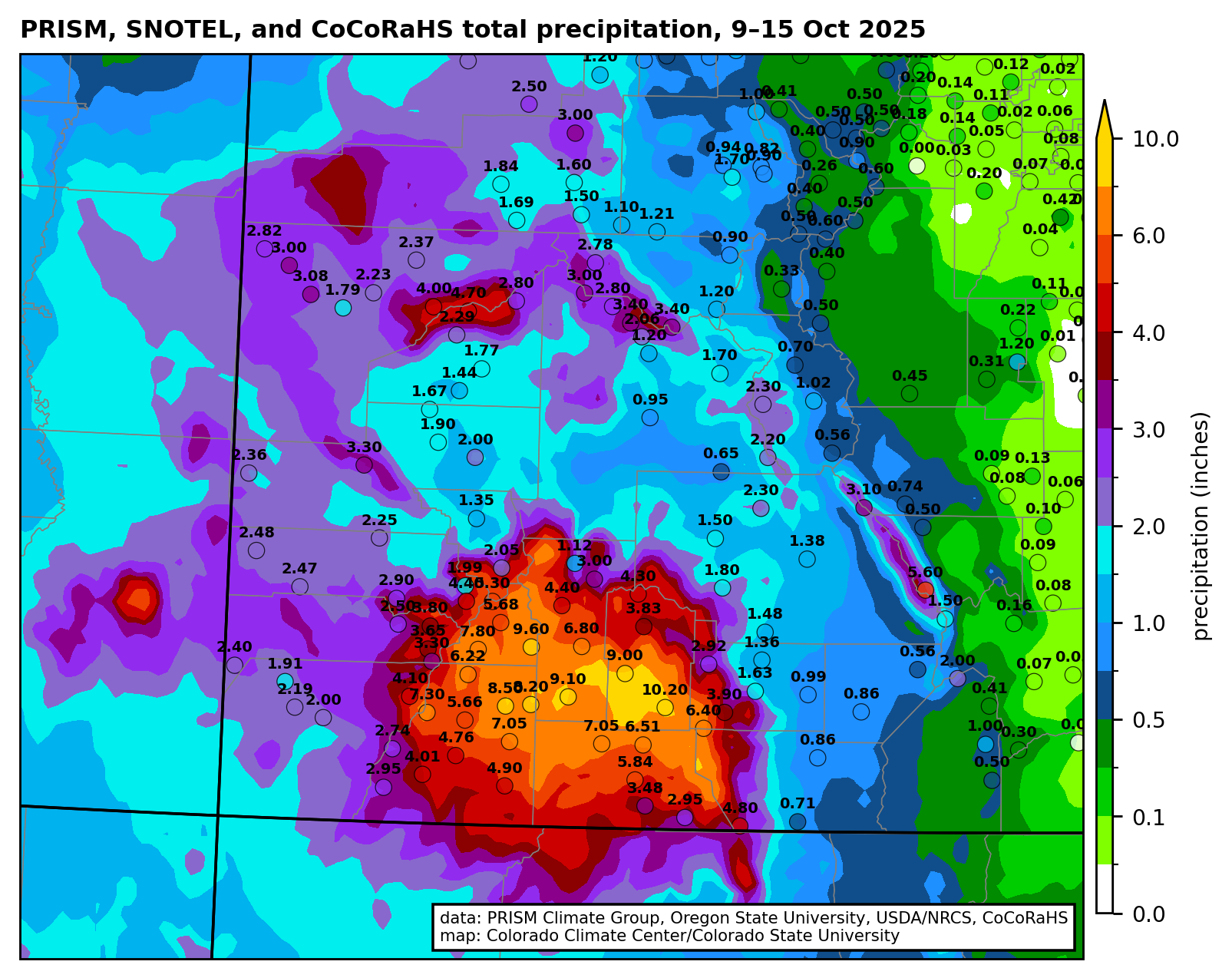
Total precipitation (inches) from 9-15 October 2025 with gridded data from the PRISM Climate Group and observations from the Community Collaborative Rain, Hail, and Snow (CoCoRaHS) network. Credit: Russ Schumacher/Colorado Climate Center
The Details
The rains of October and November 2025 slowed depletion of the Colorado River’s reservoirs due to increases in stream flow and reduced reservoir releases in some places. Water levels rose in a few reservoirs, and autumn’s rains provided a small bit of flexibility for water managers at the beginning of what is likely to be a below-average winter snow season.
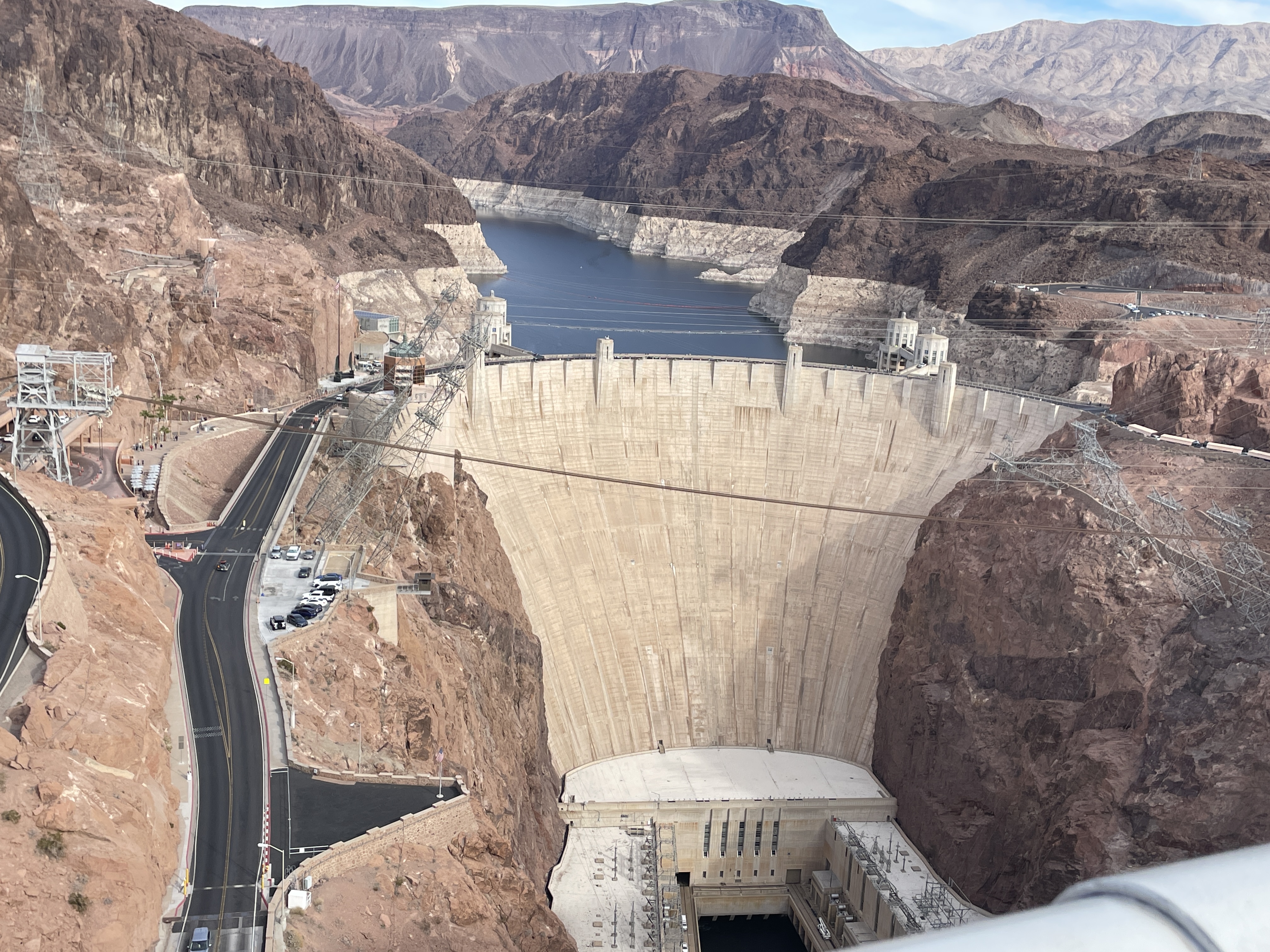
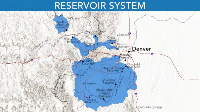
As of November 30, the Basin’s 46 reservoirs held 24.63 million af (acre feet) of active storage[1], of which 90% was in 12 federal reservoirs,[2] including 15.00 million af in Lake Powell and Lake Mead (hereafter, Powell+Mead) and 4.88 million af in 8 federal reservoirs upstream from Lake Powell (Fig.1). This amount of storage is similar to conditions in early 2022, a situation that was described at that time as a crisis. If we divide the total active storage in the Basin’s 46 reservoirs by the basin-wide total annual rate of consumptive use and loss that was 12.7 million af in 2024, the basin-wide reservoir water supply would sustain Basin-wide use for less than 2 years. We continue to live at the doorstep of crisis.
Figure 1. Graph showing active storage in Colorado River basin reservoirs between January 1, 2021, and November 30, 2025. Credit: Jack Schmidt/Center for Colorado River Studies
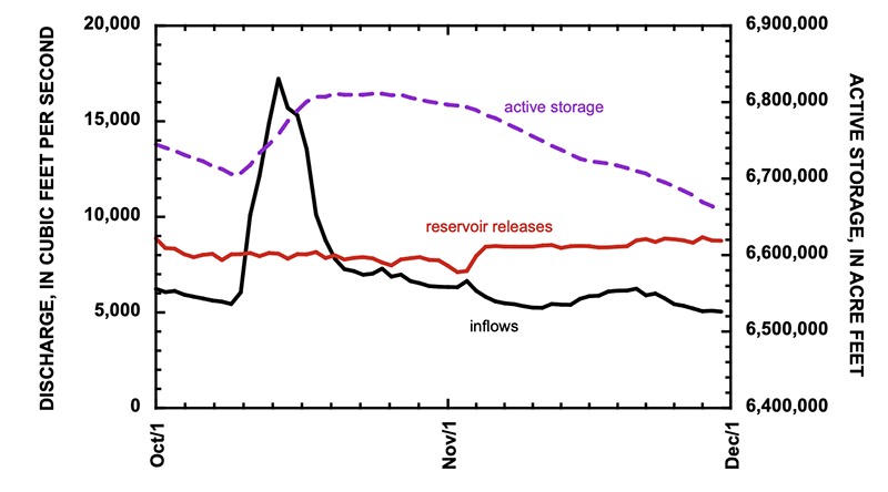
Basin-wide reservoir storage stabilized in October and November, because Powell+Mead storage stabilized and storage in the San Juan River basin increased. Total Inflow to Lake Powell exceeded releases for more than one week between October 11 and October 18, when Lake Powell increased by 105,000 af[3] which is a 1.6% gain (Fig. 2). Approximately 40% of the total inflow came from the San Juan River, and the monthly October inflows were the largest since 2015. The gain in storage in Lake Powell during this weeklong period exceeded depletions during the rest of the month, and Lake Powell gained approximately 52,000 af during the month. Lake Powell lost 147,000 af in November.
Figure 2. Graph showing inflow and outflow from Lake Powell and active storage between October 1 and November 30, 2025. Total monthly flow at Lees Ferry, representing the total releases from Lake Powell, were 490,000 af in October and 501,000 af in November. Credit: Jack Schmidt/Center for Colorado River Studies
In contrast, the autumn rains did not significantly increase inflow to Lake Mead, because most of the inflows come from scheduled releases from Lake Powell. These reservoir releases were supplemented by 101,000 af of inflows downstream from Lees Ferry[4] and 8000 af from the Virgin River.[5] The most significant changes in Lake Mead occurred at the end of November when releases from Hoover Dam were significantly reduced (Fig. 3).
Figure 3. Graph showing inflow and outflow from Lake Mead and active storage between October 1 and November 30, 2025. Total monthly flow inflow of the Colorado River, representing the total releases from Lake Powell and inflows within Grand Canyon, were 574,000 af in October and 550,000 af in November. Reservoir releases from Hoover Dam were 485,000 af in October and 415,000 af in November. Withdrawals and return flows of the Southern Nevada Water Authority were not included in these data. Credit: Jack Schmidt/Center for Colorado River Studies
Together, total active storage in Powell+Mead increased by 63,000 af during October,[6] and decreased by only 38,000 af in November (Fig. 4).[7] More significant than the gains, however, was that the the pace of reservoir depletion was significantly slowed. Storage in Powell+Mead increased by approximately 25,000 af in October and November, only the second time since 2010 that total storage in these two reservoirs increased during these two months.[8]
Figure 4. Graph showing active storage in Lake Powell, Lake Mead, and in Powell+Mead between January 1, 2023, and November 30, 2025. Credit: Jack Schmidt/Center for Colorado River Studies
Reservoir storage in the San Juan River basin increased more than in any other part of the Colorado River Basin. Five San Juan basin reservoirs increased by 197,000 af in October and November, mostly in Navajo and Vallecito Reservoirs.[9] Not much happened elsewhere, however. The 21 reservoirs of the upper Colorado River watershed lost 57,000 af during October and November, and 16 reservoirs in the Green River watershed lost 10,000 af during the same period.
[2] Taylor Park, Blue Mesa, Morrow Point, Crystal, Fontenelle, Flaming Gorge, Vallecito, Navajo, Lake Powell, Lake Mead, Lake Mohave, and Lake Havasu.
[3] Inflow to Lake Powell was computed as the sum of mean daily discharge of the Colorado River at Gypsum Canyon near Hite (gage 09328960), Dirty Devil River above Poison Springs near Hanksville (09333500), Escalante River near Escalante (09337500), and San Juan River near Bluff (09379500), as reported by the U.S. Geological Survey. Outflow from Lake Powell was computed as the mean daily discharge of the Colorado River at Lees Ferry (09380000), because stream flow is measured 15 miles downstream from the dam and includes ground-water seepage around the dam. Lake Powell storage increased between October 10 and October 20, as reported by Reclamation.
[4] Inflows within Grand Canyon were calculated as the difference between measurements of the Colorado River at Lees Ferry (09380000), Colorado River above Diamond Creek near Peach Springs (09420000), and Diamond Creek nr Peach Springs (09404208).
[5] Virgin River below confluence Muddy River near Overton (09419530)
[6] Between October 1 and November 1, 2025, active storage in Lake Powell increased 52,000 af and 11,000 af in Lake Mead.
[7] Between November 1 and November 30, active storage in Lake Powell decreased by 147,000 af and increased by 109,000 af in Lake Mead.
[8] During the previous 15 years between 2010 and 2024, total storage in Powell+Mead increased by 36,000 af in 2011. During the other 14 years of that period, the median depletion of Powell+Mead was 436,000 af.
[9] Storage in Navajo Reservoir increased 126,000 af between October 9 and November 8 and increased by 114,000 af in October and November. Active storage in Vallecito Reservoir gained 68,000 af in October and November. At the end of November, Navajo Reservoir was 60% of its 1.65 million af capacity. Vallecito Reservoir was 77% of its 125,400 af capacity.
Map of the San Juan River, a tributary of the Colorado River, in Arizona, Colorado, New Mexico and Utah, USA. Made using USGS National Map data. By Shannon1 – Own work, CC BY-SA 4.0, https://commons.wikimedia.org/w/index.php?curid=47456307
The project will be on 480 acres of degenerated land, in between Stanley Road, the 105, and the 106. The property sits within Subdistrict 1, and its water rights, all groundwater access and wells, were sold to the Rio Grande Water Conservation District in December of 2024. Credit: The Citizen
Down the Stanley Road looking north in central Alamosa County are the massive solar panels that offer an unusual but common skyline in the high mountain desert west of Mosca. In the foreground of the solar structures, on 480 acres of degenerated land, is a grand new experiment by the Colorado Land Board that promises to offer new insights into carbon, the Valley’s soil, and the growing but complicated “carbon market.”
In September the state land board inked a partnership with Land & Carbon Inc., a carbon project development company, to revegetate and restore the land under an initial 15-year partnership, and then a 40-year monitoring period to determine long-term success.
This is the first contract of its kind in the Valley, but it definitely won’t be the last. With more land and water being retired from irrigation every year, the question of how to revegetate only becomes more urgent. Revegation helps not just to improve carbon sequestration, but also to prevent dangerous dust-bowl conditions that threaten an increasingly dry Valley. The water on the Stanley Road property was retired to the Rio Grande Water Conservation District in 2024, and the partnership has committed to using only the allotted 18 inches of water over the first 3 years for revegetation. This project will illuminate the possibilities for revegetation in the Valley, and is likely to lead the way for more innovative partnerships and projects focused on both land restoration and carbon sequestration in the coming years.
The Colorado State Land Board manages lands that were granted to the state in a public trust from the federal government back in 1876. It operates as the second-largest land owner in the state, holding 2.8 million acres of surface land and 4 million acres of subsurface assets. Its land management practices aim to both steward the land and produce reasonable and consistent income, a majority of which gets distributed to the Colorado Department of Education’s Building Excellent Schools Today (BEST) program.
The Land Board established an ecosystem services program, focused on generating revenue from nontraditional products, like wetland and carbon credits, as opposed to more traditional products like agriculture, grazing, mining, oil and gas, hunting, recreation and renewables. A few years ago, through this program, the Land Board started exploring the prospect of carbon sequestration and carbon credits.
“We hired a group of consultants to help us enter this market. It’s new and not well understood by most people. It’s kind of on the leading edge of being developed, what we sometimes call an emerging market,” said Mindy Gottsegen, the State Land Board’s Stewardship and Ecosystem Services manager.
The carbon market has emerged as a viable way to simultaneously restore damaged lands, while generating valuable revenue. While there are government regulations around carbon emissions and compliance with certain environmental standards, the carbon market is an entirely voluntary system that operates without large government oversight. Companies buying and selling carbon credits can join the market, and participate, as long as they meet certain standards, set by third-party organizations.
While it is a complicated system, this is generally how it works for soil carbon credits in the Valley: Every piece of land has some amount of carbon in the soil because plants take in CO2 from the atmosphere, photosynthesize, and store it. Through plant roots, and the decay of other organic matter, the soil ends up holding on to a certain amount of carbon. Different land management practices can increase or decrease the amount of carbon sequestered.
To quantify carbon sequestration and sell credits, verified companies (or land owners) must first establish a baseline carbon measurement. Then, carbon gains are estimated over time using a combination of measurements and modeling. These numbers are reviewed, and based on the additional amount of carbon stored, carbon registries issue a proportionate amount of carbon credits. These credits can be sold on the market to entities looking to offset their carbon emissions. The revenue from carbon credits helps to fund and sustain carbon sequestration and land restoration projects.
“The Biological Carbon Program framework that our board approved in April of this year was kind of saying ‘This is how we’re going to get involved in the carbon market,’” said Gottsegen.
The program allows agricultural and land lessees to partner with board-approved Qualified Project Developers (QPDs) to create and implement restorative project plans. These companies work as the middle man between land owners and the carbon market, helping to make successful and sustainable changes, while also navigating the approval and acquisition of carbon credits.
Enter Land & Carbon Inc. Founded by Dave Lawrence in 2023, Land & Carbon is an innovative project development company, restoring highly degraded lands with low-cost, science-driven solutions. The company works to regenerate and revegetate land while offsetting and storing CO2 in the soil, using carbon credits to help pay for the projects.
“I used to — well I still do — drive around the country quite a bit. I’ve observed just how much degraded and barren land there is, without healthy crops or native vegetation — brown trampled land all around the country,” said Lawrence.
Lawrence had previously served as both the chairman of the Yale Climate & Energy Institute and the executive director of the Salk Institute Harnessing Plants Initiative. In these roles, he was actively involved in carbon projects, and realized that reducing atmospheric carbon would require more than just emissions reduction.
“I recognized that there were a number of different solutions available, and that they could be used in combination,” said Lawrence. “I started Land & Carbon with this idea that we would use a combination of practices, and collaborate with communities, ranchers, farmers, land holders, and experts — local, regional, national, and global — pulling all of this together to do the best job that we could restoring degraded land, and at the same time taking carbon out of the atmosphere.”
A significant amount of the degraded land across the West is largely agricultural and sits with different state land boards. Land & Carbon reached out to the Colorado State Land Board with hopes of collaborating to regenerate these lands in a way that was mutually successful, taking advantage of best practices to sequester carbon, restore ecosystem health, and help fund the state’s public education system.
Land & Carbon got approved as the Land Board’s fourth QPD in August and the deal, officially titled Grassland Carbon Ecosystem Services Production Lease, ES 117611, came soon after.
Of the land in the State Land Board’s portfolio, the Stanley Road property was selected because of a combination of factors. The property consists of 480 acres, in between Stanley Road, the 105, and the 106. It sits within Subdistrict 1, and its water rights, all groundwater access and wells, were sold to the Rio Grande Water Conservation District in December of 2024. This means moving forward there are severe limitations to the amount of water that can be used to revegetate. The land is highly degraded from decades of agricultural use, and has been barren for years. In that time, a takeover of invasive weeds, along with harsh soil and climate conditions, have prevented any sort of natural recovery.
This property had been a challenge for the Land Board, because of the amount of damage. While this level of degradation can be seen as a deterrent for other QPDs, these types of highly degraded properties are exactly what Land & Carbon seek out. When the Land Board asked if it would be interested in taking on the challenge, the answer was a resounding “Yes.”
In any project for Land & Carbon, the first steps include a “scope and discovery” research deep dive, to better understand what has already been done, and learn how its efforts will be situated in the broader context of work in the region. In the Valley, this means looking at CSU Extension information, published papers, USDA, State Land Board and Conservation District data, conducting their own boots-on-the-ground field visits, and also engaging with the community. All of it is pulled together to assess initial land characteristics.
“We’re a big believer in talking with people and learning from people who are actually doing the work. So we participated in workshops, convened by Colorado State, that allowed us to get to know different individuals and people and groups who were already doing things,” said Lawrence. “We don’t believe we have the corner on the market on all expertise. We really try to tap into as much local knowledge as we can, as to what has worked, what hasn’t worked and why.”
After that, an exhaustive evaluation of all available data and information is done, pulling in literature, field data, and models to create an initial plan, taking into consideration resource availability and supplies. Then they take baseline measurements to determine the starting amount of carbon in the soil that is crucial to then quantify improvements and carbon credits.
The Stanley Road project is still in these early stages, and they are working to collect data, determine land characteristics, and establish a carbon baseline, before considering different solutions and strategies.
“We tailor our solutions to the land. Not everything grows everywhere and not all grazing practices work everywhere. So how can we tailor the best combination to this land?” said Lawrence.
The next steps will come in the spring, at the start of the growing season, when Land & Carbon plans to establish what it has trademarked as Innovation Sites. These five- to 20-acre patches on the property are used to test out new ideas and different combinations, seed mixes, and technologies, in order to learn what works best on this specific land. These experimental sites will run for three to five years, after which the best, most successful techniques will be used on the larger property. Many of the tests will not work, but some will, and those are what get implemented broadly.
In the years to come, these plans will continue to develop. Final decisions around irrigation, and how to use the 18 inches of water allocated for the first 3 years of the project, have not yet been made. Nor have more definitive restoration plans, though in the press release by the Land Board, it was stated that the property is expected to support regenerative grazing within four to eight years.
The project is estimated to sequester greater than 10,000 metric tonnes of CO2 in the first 15 years, which is when the initial contract ends. This will be followed by a 40-year monitoring period to ensure the permanence of the soil carbon storage.
With the state of water in the Valley, and efforts to retire agricultural land for water conservation purposes, the amount of land in need of revegetation and restoration will only continue to grow over the next few years.
Both the State Land Board and Land & Carbon expressed interest in expanding the reach of this project and methodology, once it has been established. But that will take time.
“I always think it’s good to try to do one thing very well, and to kind of get a proof point. We are very focused on this property, and of course we would love to work with others as we move along in this, and show what we have going,” said Lawrence.
“We’re just getting started. The first few take extra time, but we’re hoping that once we get these few under our belt, we’ll be able to expand,” said Gottsegen. “Hopefully we can continue to build the carbon program with more leases in the coming years.”
Lawrence emphasized that Land & Carbon aims to make this project the template for affordable, quality land regeneration using carbon credits, that will work for people in the Valley.
“The idea is that what we learn, we share. We can serve as just advisors if that’s what somebody who has all the capabilities wants, and there’s a ton of people with capabilities, or we can actually do the work,” said Lawrence. “I think we all know the challenges that we face with water in the San Luis Valley. It’s important that we take whatever we learn, in collaboration with others, and work with them to try to implement this at scale.”
Evan Arvizu is a recent graduate of Colorado College with a degree in Environmental Anthropology and minor in Journalism. She is a former intern with the Rural Journalism Institute of the San Luis Valley. More by Evan Arvizu
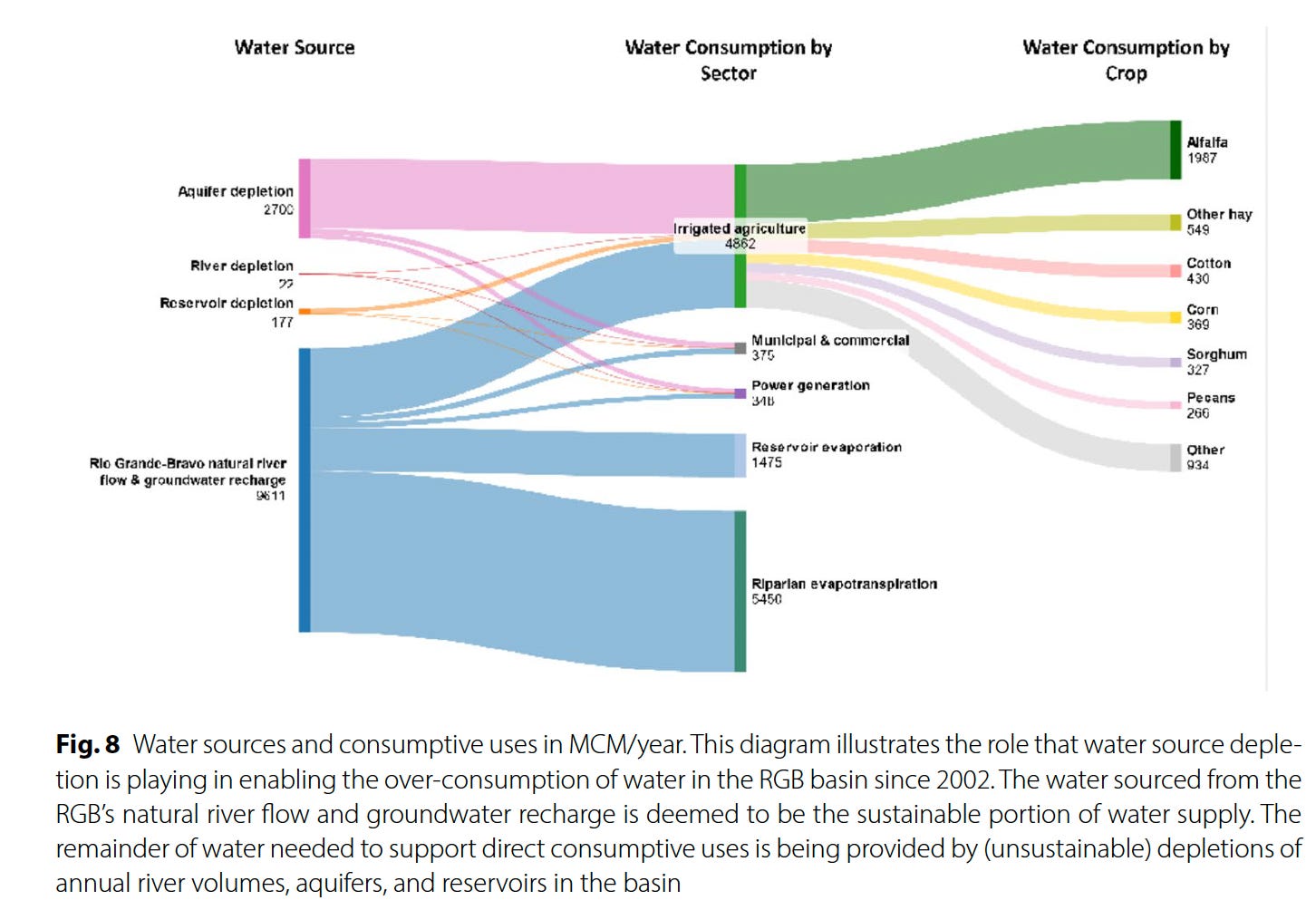
The Colorado River and its woes tend to get all of the attention, but the Southwest’s “other” big river, the Rio Grande, is in even worse shape thanks to a combination of warming temperatures, drought, and overconsumption. That’s become starkly evident in recent years, as the river bed has tended to dry up earlier in the summer and in places where it previously had continued to carry at least some water. Now Brian Richter and his team of researchers have quantified the Rio Grande’s slow demise, and the conclusions they reach are both grim and urgent: Without immediate and substantial cuts in consumption, the river will continue to dry up — as will the farms and, ultimately, the cities that rely on it.
The Rio Grande’s problems are not new. Beginning in the late 1800s, diversions for irrigation in the San Luis Valley — which the river runs through after cascading down from its headwaters in the San Juan Mountains — sometimes left the riverbed “wholly dry,” wrote ichthyologist David Starr Jordan in 1889, “all the water being turned into these ditches. … In some valleys, as in the San Luis, in the dry season there is scarcely a drop of water in the riverbed that has not from one to ten times flowed over some field, while the beds of many considerable streams (Rio la Jara, Rio Alamosa, etc.) are filled with dry clay and dust.”
San Luis Valley farmers gradually began irrigating with pumped groundwater, allowing them to rely less on the ditches (but causing its own problems), and the 1938 Rio Grande Compact forced them to leave more water in the river. While that kept the water flowing through northern and central New Mexico, the Rio Grande’s lower reaches still occasionally dried up.
Then, in the early 2000s, the megadrought — or perhaps permanent aridification — that still plagues the region settled in over the Southwest. [ed. emphasis mine] Snowpack levels in the river’s headwaters shrank, both due to diminishing precipitation and climate change-driven warmer temperatures, which led to runoff and streamflows 17% lower than the 20th century average, according to the new study. And yet, overall consumption has not decreased.
“In recent decades,” the authors write, “river drying has expanded to previously perennial stretches in New Mexico and the Big Bend region. Today, only 15% of the estimated natural flow of the river remains at Anzalduas, Mexico near the river’s delta at the Gulf of Mexico.” Reservoirs, the river’s savings accounts, have been severely drained to the point that they won’t be able to withstand another one or two dry winters. As farmers and other users have increasingly turned to groundwater pumping, aquifers have also been depleted. The situation is clearly unsustainable.
Something’s gotta give on the Rio Grande, and while we may be tempted to target Albuquerque’s sprawl, drying up all of the cities and power plants that rely on the river wouldn’t achieve the necessary cuts.
Source: “Overconsumption gravely threatens water security in the binational Rio Grande-Bravo basin” by Brian Richter et al.
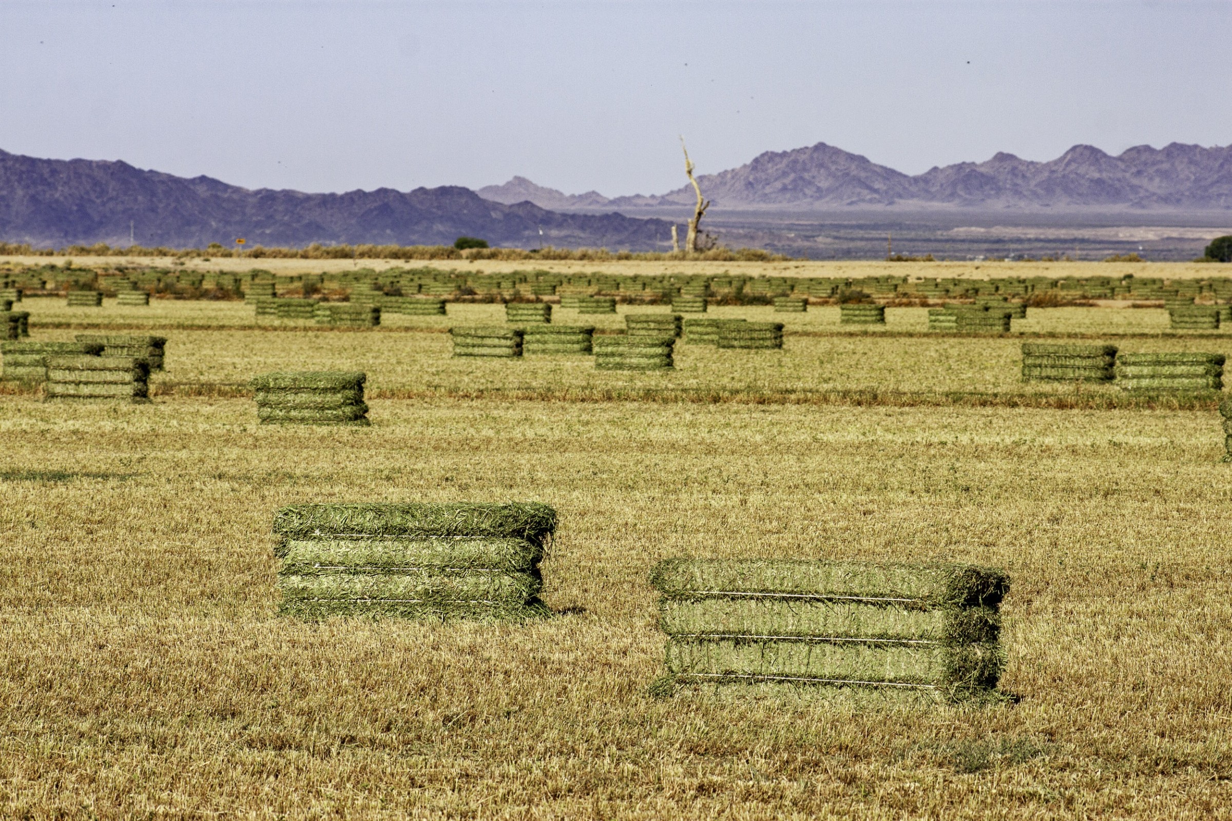
It will come as little surprise to Western water watchers that agriculture is by far the largest water user on the Rio Grande — taking up 87% of direct human consumption — and that alfalfa and other hay crops gulp up the lion’s share, or 52%, of agriculture’s slice of the river pie. This isn’t necessarily because alfalfa and other hays are thirstier than other crops, but because they are so prevalent, covering about 433,000 acres over the entire basin, more than four times as much acreage as cotton.
Source: Overconsumption gravely threatens water security in the binational Rio Grande-Bravo basin
This kind of math means farmers are going to have to bear the brunt of the necessary consumption cuts — either voluntarily or otherwise. In fact, they already have: Between 2000 and 2019, according to the report, Colorado lost 18% of its Rio Grande Basin farmland, New Mexico lost 28%, and the Pecos River sub-basin lost 49% (resulting in a downward trend in agricultural water consumption). Some of this loss was likely incentivized through conservation programs that pay farmers to fallow their fields. But it was also due to financial struggles.
Yet even when farmers are paid a fair price to fallow their fields there can be nasty side effects. Noxious weeds can colonize the soil and spread to neighbors’ farms, it can dry out and mobilize dust that diminishes air quality and the mountain snowpack, and it leaves holes in the cultural fabric of an agriculture-dependent community. If a field’s going to be dried up, it should at least be covered with solar panels.
Another possibility is to switch to crops that use less water. This isn’t easy: Farmers grow alfalfa in the desert because it’s actually quite drought tolerant, doesn’t need to be replanted every year, is less labor-intensive than other crops, is marketable and ships relatively easy, and can grow in all sorts of climates, from the chilly San Luis Valley to the scorching deserts of southern Arizona.
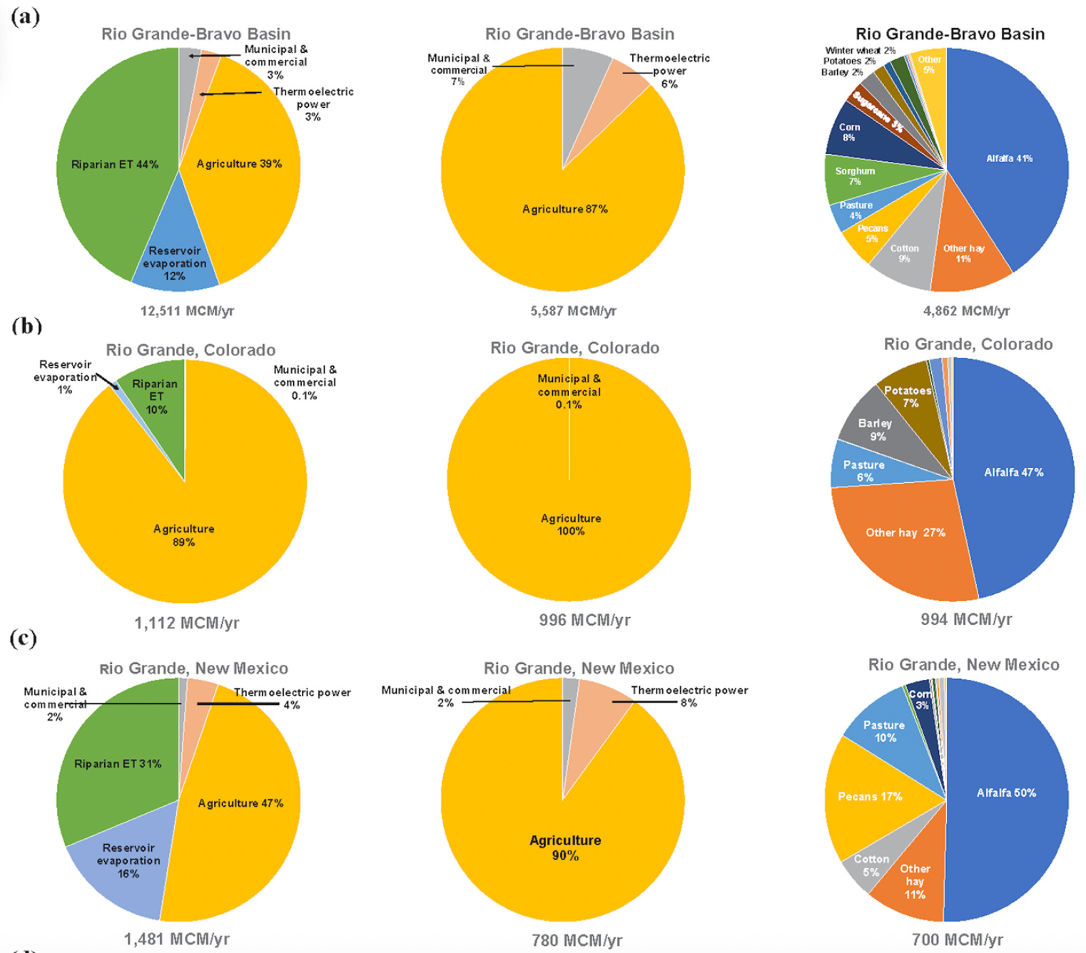
Still, it can be done, as a group of farmers in the San Luis Valley are demonstrating with the Rye Resurgence Project. This effort is not only growing the grain — which uses less water than alfalfa, is good for soil health, and makes good bread and whiskey — but it is also working to create a larger market for it. While it’s only a drop in the bucket, so to speak, this is the sort of effort that, replicated many times across the region, could help balance supply and demand on the river, without putting a bunch of farmers out of business.
Photo credit: The Rye Resurgence Project
***
Oh, and about that other river? You know, the Colorado? Representatives from the seven states failed to come up with a deal on how to manage the river by the Nov. 15 deadline. The feds had mercy on them, giving them until February to sort it all out. I’m not so optimistic, but we’ll see. Personally, I think the only way this will ever work out is if the Colorado River Compact — heck, the entire Law of the River — is scrapped, and the states and the whole process is started from scratch, this time with a much better understanding of exactly how much water is in the river, and with the tribal nations having seats at the table.
⛏️ Mining Monitor ⛏️
There are a bunch of wannabe uranium mining companies out there right now, locating claims and acquiring and selling claims and touting their exploratory drilling results. But there are only a small handful of firms that are actually doing anything resembling mining. One of them is the Canada-based Anfield, which just broke ground on its Velvet-Wood uranium mine in the Lisbon Valley, even without all of the necessary state permits.
Now Anfield says it has applied for a Colorado permit to restart its long-idle JD-8uranium mine. The mine is on one of a cluster of Department of Energy leases overlooking the Paradox Valley from its southern slopes, and was previously owned and operated by Cotter Corporation. The mine has not produced ore since at least 2006. Anfield says it will process the ore at its Shootaring Mill near Ticaboo, Utah, which has yet to get Utah’s green light.
🏠 Random Real Estate Room 🤑
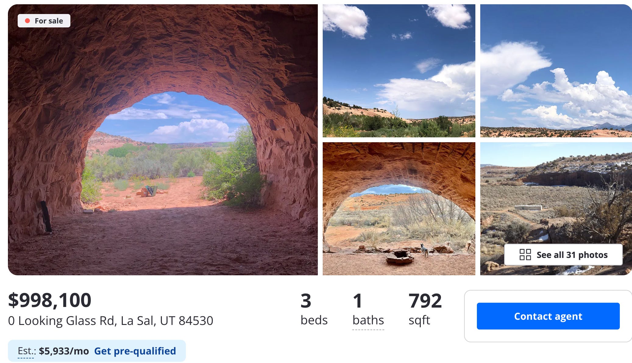
Look! Affordable housing near Moab! Sure, it’s a cave, but it’s only $99,000. Oh, what’s that? $998,000? They’re selling a cave for a million buckaroos? But of course they are. To be fair, it’s not just a cave. It’s several of them, plus a trailer. Crazy stuff.
📸 Parting Shot 🎞️
A work train in the Animas River gorge just below Silverton. Jonathan P. Thompson photo.
Rio Grande and Pecos River basins. Map credit: By Kmusser – Own work, Elevation data from SRTM, drainage basin from GTOPO [1], U.S. stream from the National Atlas [2], all other features from Vector Map., CC BY-SA 3.0, https://commons.wikimedia.org/w/index.php?curid=11218868
The city of Aspen’s drought response committee is recommending the city maintain a stage 2 water shortage that was declared in August. Monsoonal moisture and cooler temperatures that came since Aspen City Council activated the stage 2 restrictions have helped drought conditions, but not changed them, according to an information memo sent to city council this week. As of Nov. 6, Aspen and Pitkin County remained in severe and extreme drought categories, according to the U.S. Drought Monitor.
“Pitkin County has experienced its second driest year to date (January — September 2025) in 131 years of record with a precipitation deficit of 6.84 inches from normal,” the memo states.
Data collected from a National Weather Service station at the city’s water treatment facility recorded 1.52 inches of rain in August and 1.89 inches of rain in September. It brought the city’s precipitation deficit to 3.43 inches. Water demand typically decreases in Aspen during the winter when irrigation systems are turned off, but it is when streams are at their lowest point in the year, according to the memo. Councilman John Doyle, a staunch supporter of water conservation, said restrictions are especially important now as ski seasons get shorter and less snow falls…The stage 2 water shortage declaration came two months after the city declared a stage 1 water shortage with a goal to cut overall water consumption by 10% within city limits. Well below-average stream flows led the city to enact the second stage of water shortage, which represents severe drought conditions…The city relies primarily on streamflow from Castle and Maroon creeks for its water supply. It depends on consistent release of water from snowmelt. The city’s stage 2 water restrictions are mandatory. Watering of any lawn, garden, landscaped area, tree, shrub or other plant is prohibited from 9 a.m. to 6 p.m. Household watering schedules are also mandatory.
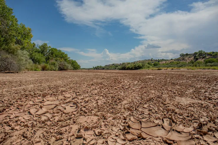
For the second time in the 21st century, this segment of the Rio Grande in Albuquerque went dry, leaving this image of cracked sediment on a blistering afternoon on Aug. 7, 2025. Photo (and copyright)/WWF-us, Diana Cervantes
Click the link to read the article on the Associated Press website (Susan Montoya Bryan). Here’s an excerpt:
November 20, 2025
Research published Thursday says the situation arguably is worse than challenges facing the Colorado River, another vital lifeline for western U.S. states that have yet to chart a course for how best to manage that dwindling resource. Without rapid and large-scale action on both sides of the border, the researchers warn that unsustainable use threatens water security for millions of people who rely on the binational basin. They say more prevalent drying along the Rio Grande and persistent shortages could have catastrophic consequences for farmers, cities and ecosystems…The study done by World Wildlife Fund, Sustainable Waters and a team of university researchers provides a full accounting of the consumptive uses as well as evaporation and other losses within the Rio Grande-Bravo basin. It helps to paint the most complete — and most alarming — picture yet of why the river system is in trouble…The research shows only 48% of the water consumed directly or indirectly within the basin is replenished naturally. The other 52% is unsustainable, meaning reservoirs, aquifers and the river itself will be overdrawn…
Irrigating crops by far is the largest direct use of water in the basin at 87%, according to the study. Meanwhile, losses to evaporation and uptake by vegetation along the river account for more than half of overall consumption in the basin, a factor that can’t be dismissed as reservoir storage shrinks…The irrigation season has become shorter, with canals drying up as early as June in some cases, despite a growing season in the U.S. and Mexico that typically lasts through October. In central New Mexico, farmers got a boost with summer rains. However, farmers along the Texas portion of the Pecos River and in the Rio Conchos basin of Mexico — both tributaries within the basin — did not receive any surface water supplies…The analysis found that between 2000-2019, water shortages contributed to the loss of 18% of farmland in the headwaters in Colorado, 36% along the Rio Grande in New Mexico and 49% in the Pecos River tributary in New Mexico and Texas. With fewer farms, less water went to irrigation in the U.S. However, researchers said irrigation in the Mexican portion of the basin has increased greatly.
Rio Grande and Pecos River basins. Map credit: By Kmusser – Own work, Elevation data from SRTM, drainage basin from GTOPO [1], U.S. stream from the National Atlas [2], all other features from Vector Map., CC BY-SA 3.0, https://commons.wikimedia.org/w/index.php?curid=11218868
Chart showing water use trends in US and Mexico. Credit: Overconsumption gravely threatens water security in the binational Rio Grande-Bravo basin. Map via Springer Nature.
major new study on the nearly 1,900-mile long Rio Grande Basin — from the San Luis Valley into the Gulf of Mexico — shows a “severe water crisis emerging” with total reservoir storage in decline at around 4.24 million acre-feet or 26 percent of capacity.
The study brings together detailed water consumption estimates of surface and ground water use throughout the basin and concludes “a likely outcome will be continued loss of farmland due to financial insolvency from lowered crop production and other factors including the aging of farmers and lack of affordable farm labor,” without urgent action.
“Climate scientists have reframed the long-running drought as the onset of long-term aridification and are forecasting additional river flow diminishment of 16-28% in coming decades as the climate continues to warm,” the study notes.
The authors’ analysis shows that during 2000–2019, Colorado lost 18 percent of its farmland in the Upper Rio Grande Basin, New Mexico lost 28 percent along its Rio Grande sub-basins, and the Pecos River sub-basin lost 49 percent.
Further drying puts farmers and cities who rely on the Rio Grande in an “existential water crisis.”
Brian Richter, one of the authors of the study, says San Luis Valley farmers are central to the development and implementation of solutions for the rapidly drying Rio Grande given that “the vast majority of the direct human consumption of water in the SLV takes place on irrigated farms.”
Researchers estimate that the present level of over-consumption of both surface and groundwater in the Valley is approximately 11 percent. “That means that water consumption needs to be reduced by that percentage,” Richter said.
Richter is president of Sustainable Waters and senior freshwater fellow for the World Wildlife Fund. The two organizations teamed with researchers to provide a full accounting of the consumptive uses as well as evaporation and other losses within the Rio Grande Basin.
The Rio Grande stretches nearly from the San Luis Valley through New Mexico, El Paso, Texas, and empties into the Gulf of Mexico. It provides drinking water for more than 4 million in Colorado, New Mexico and Texas, and 11 million people in Mexico, the study notes. More than 1.9 million acres of irrigated farmland is tied to the Rio Grande.
The study, “Overconsumption gravely threatens water security in the binational Rio Grande-Bravo basin,” relies on data from annual runoff volumes, municipal and commercial consumptive use estimates from the U.S. Geological Survey, and reservoir storage levels, among other data sets.
Snowmelt runoff has decreased 17 percent over the past 25 years, according to the report. At the same time, total direct water consumption has been increasing since 2000, largely due to increasing water usage by farmers in Mexico.
When comparing challenges of Colorado River users to the Rio Grande, researchers say the “water crisis facing the RGB is arguably more severe and urgent than the CRB,” given the fact groundwater in the San Luis Valley has been depleted at a rate of 89,000 acre-feet per year; New Mexico has a water debt to Texas; and Mexico has a mounting water debt to the U.S. under a 1944 treaty that is causing political tension between the two countries.
The Upper Rio Grande here at the end of 2025 is benefitting from heavy October rainsthat materialized across the southwest and provided a stopgap to what were some of the worst summer river flows ever recorded on the river.
Management of the Upper Rio Grande Basin will be back in the spotlight come January 2026 when Colorado Water Court Division Three takes up the Fourth Amended Plan of Water Management for Subdistrict 1 of the Rio Grande Water Conservation District. The new strategy calls for a groundwater overpumping fee of $500 per acre-foot any time an irrigator in Subdistrict 1 exceeds the amount of natural surface water tied to the property of their operation. The rule punishes farmers who do not have natural surface water coming into their fields but instead rely solely on groundwater pumping for their crops.
The whole point of the plan for the agricultural-rich area of the San Luis Valley is to let Mother Nature dictate the pattern of how irrigators in Subdistrict 1 restore the unconfined aquifer and build a sustainable model for farming in the future.
Richter credits Colorado and irrigators in the Valley for taking steps to address the Rio Grande. The proposed $500 fee for overpumping in Subdistrict 1, he says, “is going to set off a lot of change in the Valley, because many/most farmers won’t be able to continue producing the same crops they’ve been growing in recent years.”
“Colorado has definitely taken some important steps, and manages its water resources far better than New Mexico or Texas,” Richter says. “But Colorado still has not been able to reduce pumping to anywhere near the needed degree, so it’s no surprise the aquifer continues to decline.”
The study looks at crops grown along the Rio Grande and how agricultural fields account for 87 percent of direct water consumption.“Overall, agricultural consumption is nearly seven times the volume of all other direct uses combined.”
Alfalfa and grass hay – water-intensive crops that dominate the landscape in the Valley and in Northern and the Middle Rio Grande of New Mexico – account for nearly 45 percent of the irrigation water consumed along the Rio Grande Basin. A shift to less-intensive crops, as the Rye Resurgence Project advocates, and a moratorium on new wells in over-drafted areas of basin in New Mexico and Texas, are necessary first steps to addressing the Rio Grande’s challenges, according to researchers of the study.
“Potatoes might be one of the few crops that remain sufficiently profitable to persist in the Valley,” says Richter. “If those transitions to other crops or to permanent farmland retirement lead to reduced water consumption to the level needed (11 percent), there is hope that the (unconfined) aquifer can be rebalanced with natural replenishment. However, it will require a greater level of pumping reductions to enable the aquifer to recover to the level required by the state engineer.”
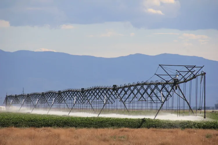
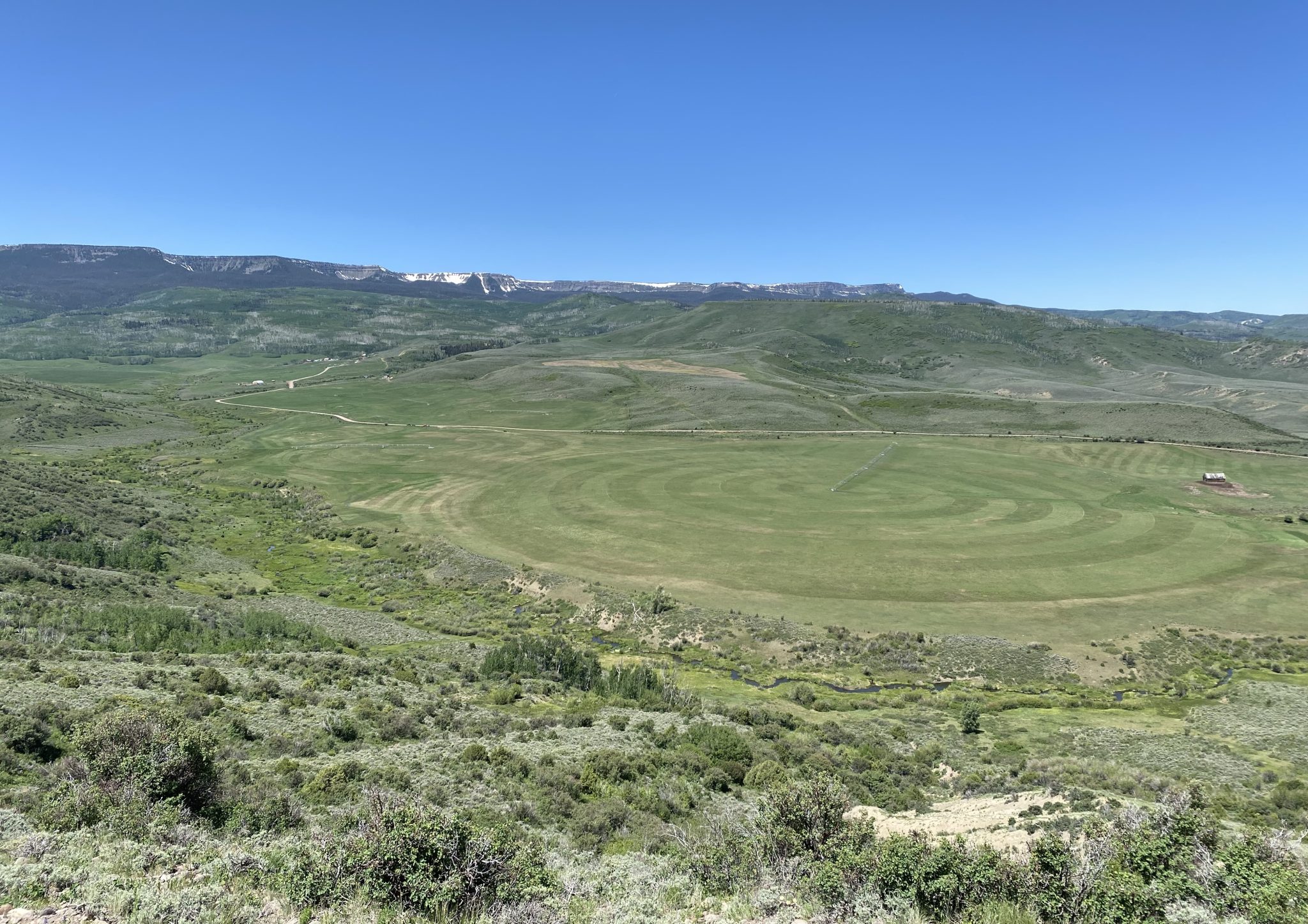
San Luis Valley center pivot August 14, 2022. Photo credit: Allen Best/Big Pivots
Click the link to read the report on the NOAA website. Here’s an excerpt:
1.2.2 Water Year 2025 Snowpack Accumulation and Water Supply Forecast Evolution
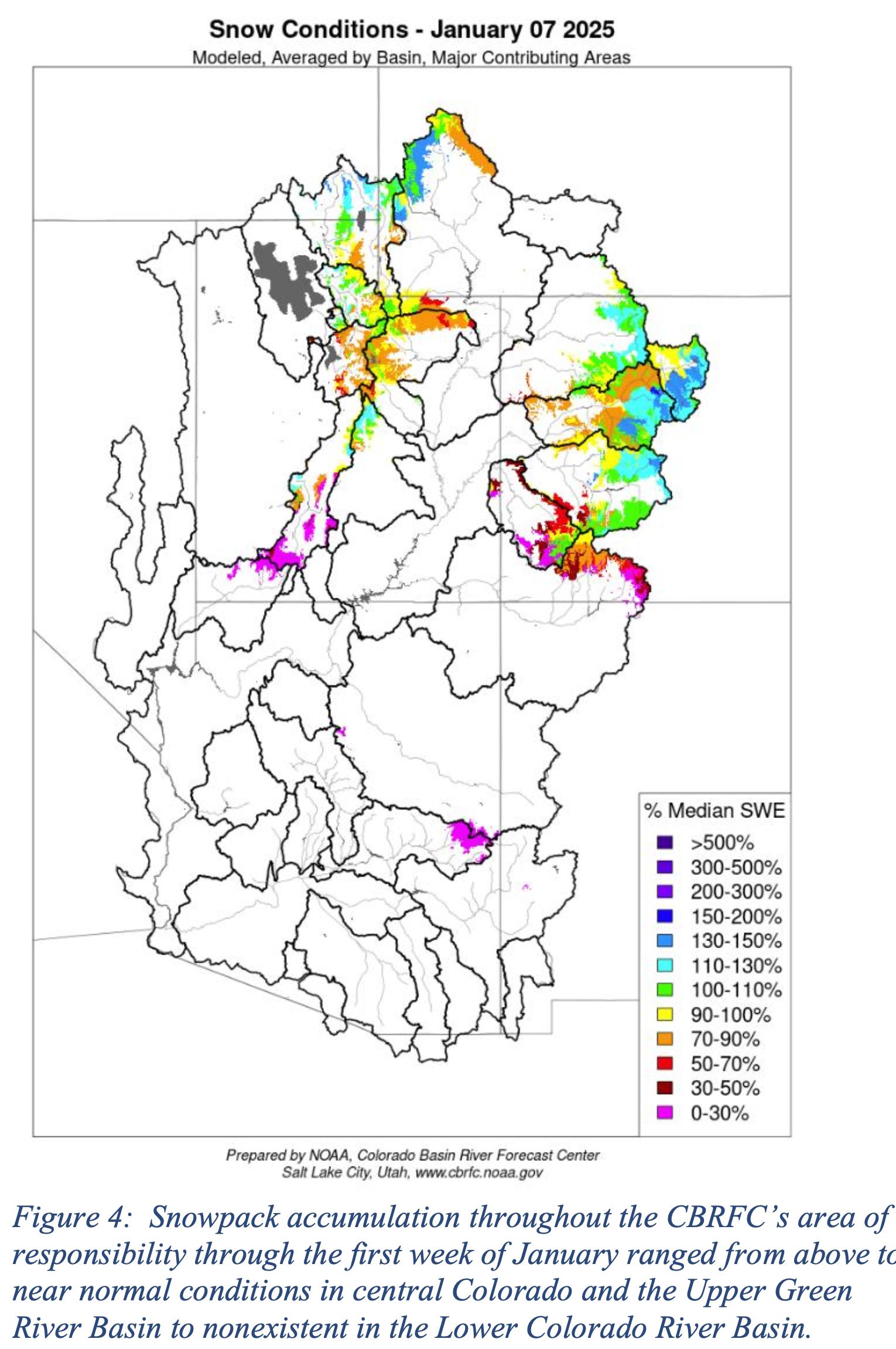
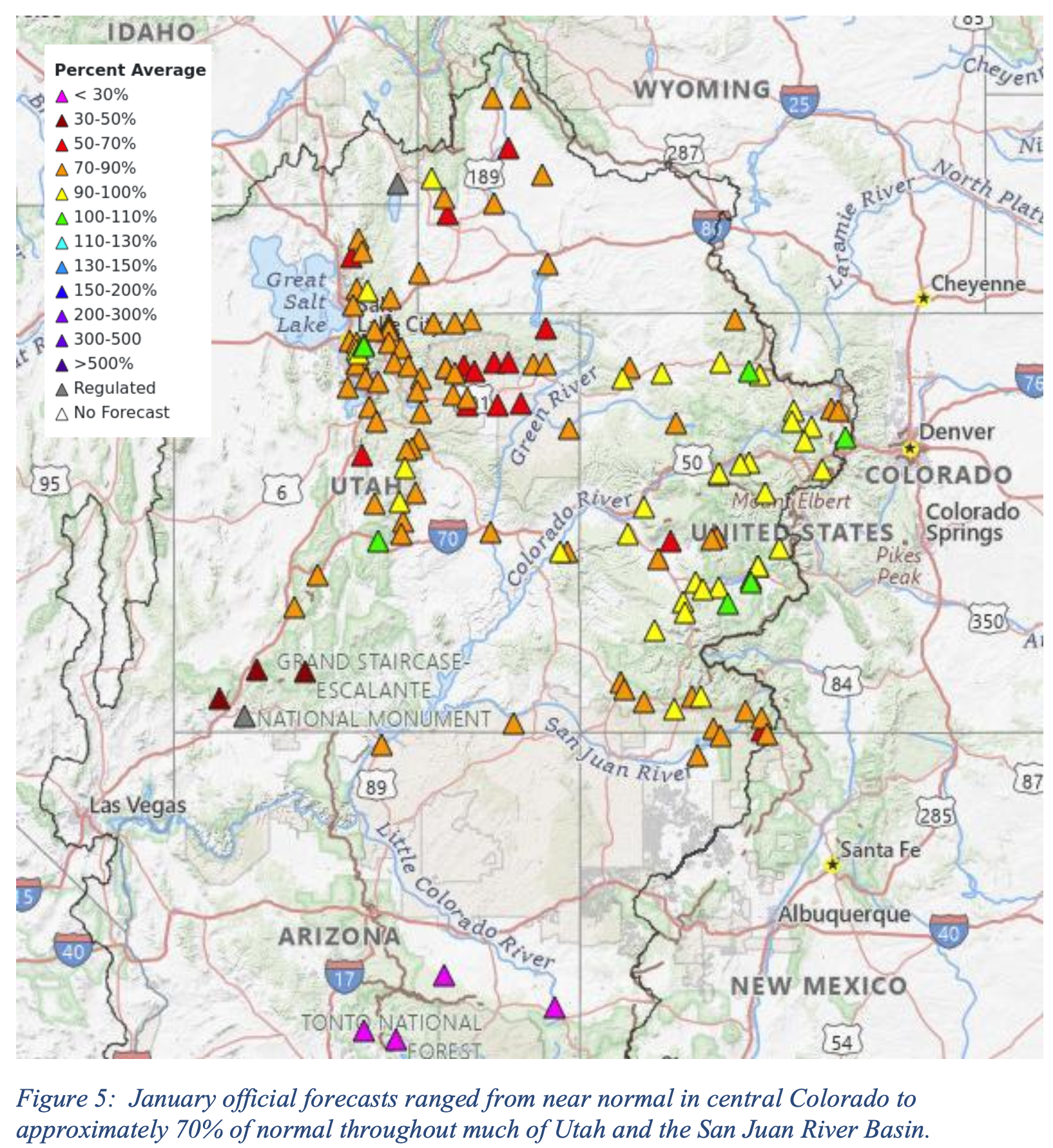
Early season snowpack accumulation through the first week of January throughout the Upper Colorado River Basin and Great Basin ranged from near to slightly above normal throughout much of central Colorado and the headwaters of the Green River Basin and much of far northwestern Utah. Snowpack accumulation values were below normal in the San Juan and Dolores River Basins. In the Lower Colorado River Basin, early season snowpack accumulation was essentially non-existent, with the highest snowpack amounts observed in the northern portion of the Virgin River Basin at 10% of average. Other areas were at, or very close to, 0% of normal (Figure 4).
Snowpack is a dominant driver of seasonal water supply forecasts. As a result of relatively near normal snowpack conditions throughout much of the Upper Colorado River Basin and Great Basin regions and generally dry soil moisture conditions, official January Forecasts ranged from near average throughout much of the wetter portions of Colorado to approximately 70% of average throughout much of Utah and the San Juan River Basin (Figure 5).
Generally dry conditions continued through February, with numerous NRCS SNOTEL stations located in the southern portion of the Upper Colorado River Basin and Great Basin regions their lowest precipitation accumulation on record for the December through February period. These record setting conditions corresponded with generally well below average water year precipitation values from October through February (Figure 6).
It is important to note that while some areas saw beneficial It is important to note that while some areas saw beneficial precipitation, particularly in the Green River Basin, warmer than normal temperatures at the end of January and into early February resulted in snowmelt at lower elevation zones (Figure 7).
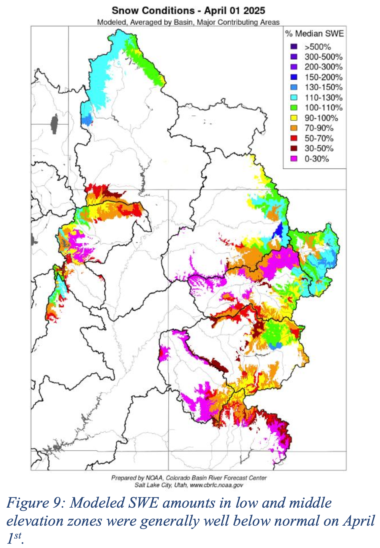
These generally dry conditions resulted in below normal water supply forecasts throughout the CBRFC’s area of responsibility. Snowpack accumulation over the Colorado River Basin and Great Basin region typically peaks near April 1st. Snowpack conditions varied throughout the Colorado River and Great Basin regions, but were generally near to slightly above average in the northern portions of the Green and Yampa River Basins, and Colorado River headwaters. Drier conditions were apparent throughout much of the Gunnison and San Juan River Basins, as well as central and southern Utah. Lower Colorado River Basin snowpack conditions remained essentially at zero. Many NRCS SNOTEL locations indicated snow water equivalent (SWE) amounts that were near average (Figure 8).
However, while peak SWE values at NRCS SNOTEL locations generally located at higher elevations indicated near normal peak snowpack conditions, CBRFC modeled SWE at lower and middle elevation zones over major contributing areas showed below to well below normal SWE conditions (Figure 9).
As a result of generally below normal SWE conditions and dry soil moisture conditions, April official forecasts ranged from near normal in portions of the Colorado River Headwaters, to approximately 50% of normal in the Dolores and San Juan River Basin. The official April forecast for Lake Powell was 67% of normal.
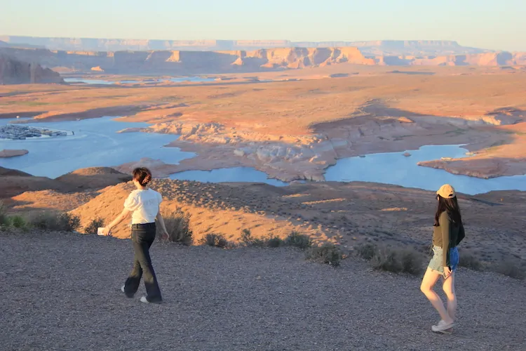
Colorado River “Beginnings”. Photo: Brent Gardner-Smith/Aspen Journalism
The states that share the Colorado River have failed to agree on how to protect it, leaving 35 million people without a clear path forward. We still have a chance to protect the river – but we must act now. Our communities need a plan that responds to climate change, proactively prepares for water shortages, promotes conservation across the Basin, and protects river health.
One in 10 Americans depend on a healthy Colorado River. For the last two years, their future has been hotly debated behind closed doors.
The states that share the river have failed to agree on how to protect it, missing a critical deadline to provide a plan for managing the river – leaving our communities high and dry.
It’s time to put the river before politics. Our communities need results and a plan that saves water across the West.
One in 10 Americans, along with countless fish and wildlife, depend on a healthy Colorado River. For years, our future has been hotly debated by a handful of state officials behind closed doors. The river has faced escalating threats from climate change and unsustainable water demands. River flows are declining, and our two major reservoirs are less than one-third full. That is why it was so disappointing when officials finally emerged from two years of negotiations empty-handed.
The guidelines for managing the Colorado River expire in 2026, and the Bureau of Reclamation has been working with the Basin states, Tribes, and stakeholders on a new plan for the dry years ahead. Reclamation gave the states until Nov. 11 to outline their framework for the new guidelines with the details due Feb. 14.
Map of the Colorado River drainage basin, created using USGS data. By Shannon1 Creative Commons Attribution-Share Alike 4.0
What is the hold up? The Colorado River Basin states are divided into two camps — the Lower Basin (Arizona, California, and Nevada) and the Upper Basin (Colorado, New Mexico, Utah, and Wyoming). The two Basins are at odds over a variety of fundamental issues, including who should take water shortages, how much these should be, and whether shortages are mandatory or voluntary. The Lower Basin has agreed to take the majority of the shortages in most years, but there is significant disagreement over who bears responsibility for the remaining shortages. Both Basins argue that the other is responsible. The threat of interstate litigation over the river looms large. These court battles would take decades to resolve, cost millions of dollars, and plunge the region into a state of uncertainty — all while the river system continues to crash.
The states held numerous confidential meetings in an attempt to reach an agreement while communities throughout the West anxiously awaited the outcome. On Nov. 11, the states released a joint statement that offered a commitment to continue negotiating, but little else.
The Colorado River is not going to wait for process or politics. Drought and climate change are reshaping the West. The window to secure the river’s future is closing fast.
Decision makers need to start making real progress. If we have another dry year like this one, water demands could exceed the river’s natural flow by 3.6 million acre-feet, which is enough water to sustain over 7 million families for an entire year. Such a shortfall could mean water levels in Lake Powell drop so low that Glen Canyon Dam can no longer produce hydropower and it raises serious concerns about whether the dam can safely operate at all.
This problem is too big for one state or sector to solve on its own. Everyone in the Basin must do more to save water and protect the river. Every drop matters.
Decision makers are trying to solve a complex problem with difficult trade-offs, but the challenges will only grow with each passing day. We simply can’t do our best work if we wait until the last minute. A plan that is hastily put forward at the eleventh hour leaves little room for public input or creative solutions. Instead, it risks perpetuating a status quo that hasn’t been working for anyone.
We must allow time to incorporate input from the 30 Basin Tribes, many of whom have long been excluded from key negotiations and lack access to clean water. We also need to leave room to build in solutions that protect the health of the river that sustains the West.
The future of our region — from families in Denver to raft guides in Moab to communities on the Navajo Nation to farmers in Yuma — depend on a healthy river.
We need a plan for the dry years ahead, and we need it now. While state negotiations remain important, the Bureau of Reclamation cannot let the ongoing impasse stand in the way of meaningful solutions. Reclamation must press on and work with Tribes and stakeholders across the West to develop robust and equitable guidelines that protect the river we all depend on.
At WRA we are continuing to advocate for policies that:
Base management decisions on the best available science, including how much water is actually flowing in the river
Expand water conservation efforts across the Basin and create flexible water storage accounts so that we can store water to protect river health and meet our needs in dry years
Ensure Tribes have meaningful opportunitiesto shape decisions on the river and can access their fair share of the river’s water
Invest in projects to maintain the river’s infrastructure, incentivize water conservation, build water security, and restore irreplaceable fish and wildlife habitat
Enable ongoing collaboration across the region
Adopt policies that prioritize the health of the river so that future generations can build a life in the West
Photo credit: Lighthawk
The next few months will determine the future of the river for years to come. By the end of this year, Reclamation is expected to publish a draft environmental impact statement analyzing alternatives for managing the river. This will be followed by a public comment period where you can make your voice heard. Reclamation’s final record of decision is expected late next summer.
We are up against hard deadlines enforced by the federal government and Mother Nature. The clock is ticking. We still have a chance to protect the river — but we must act now.
This historical photo shows the penstocks of the Shoshone power plant above the Colorado River. A coalition led by the Colorado River District is seeking to purchase the water rights associated with the plant. Credit: Library of Congress photo
The acceptance of the Shoshone water rights marks a landmark partnership between the State of Colorado and the western slope.
Today, Wednesday, November 19, the Colorado Water Conservation Board (CWCB) voted unanimously to accept the joint offer by the Colorado River District and Public Service Company of Colorado (PSCo) of a perpetual interest in the use of the Shoshone Water Rights for instream flow purposes.
Once confirmed by water court, this acquisition will create the largest environmental water right in the state’s history and permanently protect the historic flow of the Colorado River.
“The importance of today’s vote cannot be overstated as a legacy decision for Colorado water and the western slope. It secures an essential foundation for the health of the Colorado River and the communities it sustains,” said Andy Mueller, General Manager of the Colorado River District. “We continue to be impressed by, and thankful for, the broad coalition of voices that have come together in support of protecting the Shoshone Water Rights. Without them, we would not have been able to meet this historic milestone.”
“Today, the CWCB demonstrated its deep commitment to Colorado’s water security by taking bold, permanent action to protect our namesake river. We are proud to stand with the State and with our many partners across the West Slope in securing these flows for the benefit of all Coloradans,” said Sen. Marc Catlin, president of the Colorado River District Board of Directors. “This agreement strengthens water security for hundreds of communities within our state and represents a proactive, durable solution for the 40 million people who rely on the Colorado River downstream. The Shoshone Water Rights Preservation Project keeps the river as whole as possible, keeping water in its natural basin and safeguarding this lifeline for generations to come.”
The board’s decision today was the final step in the instream flow acquisition process that began with the formal offer in May 2025. Following a contested hearing in September – requested by four Front Range water entities – the Colorado River District and PSCo granted the CWCB additional time to continue deliberations and fully consider the historic proposal and partnership at their November meeting.
35 entities filed for party status in support of the Shoshone Water Rights ISF proposal. These include West Slope towns and counties, water districts, as well as local and regional non-profits. Over 400 positive public comments were also submitted over the summer.
“Today’s decision by the CWCB is a tremendous step forward for the health of the Colorado River and the communities that rely on it,” said Senator Dylan Roberts. “The Shoshone Permanency effort reflects years of collaboration and a shared commitment to protecting our headwaters, and I’m grateful to all the partners who brought us to this point. There is still important work ahead, but this vote positions Colorado to take advantage of the years of effort and protects these flows for generations to come.”
“The Shoshone water rights are a lifeline for western Colorado,” said Mesa County Commissioner Bobbie Daniel. “Our farmers, ranchers, recreation enthusiasts, and energy producers depend on this water, and we are proud to see the CWCB support this project. These flows are the future of our families and communities, and now, more than ever, it is critical that we are doing everything we can to protect them.”
Xcel Energy provided the following statement: “Xcel Energy recognizes the significant collaboration and effort that brought us to today’s decision by the Colorado Water Conservation Board. We appreciate the engagement from all parties throughout this process and look forward to continuing the work ahead. This agreement represents an important step in ensuring reliable, clean energy for the communities we serve while supporting responsible stewardship of Colorado’s water resources.”
In December 2023, the Colorado River District and Public Service Company of Colorado (PSCo), a subsidiary of Xcel Energy, entered into a $99 million Purchase and Sale Agreement (PSA) to acquire the historic Shoshone Water Rights, senior (1902) and junior (1929) non-consumptive rights that stabilize flows on the upper Colorado River. The PSA is the product of decades of work by the statewide Shoshone Water Right Preservation Coalition.
To close the transaction, the PSA requires four conditions: execution of an Instream Flow Agreement with the CWCB (approved today), receipt of a water court decree approving the change of water rights, securing commitment of full project funding ($99 million), and approval from the Colorado Public Utilities Commission. So far, the Shoshone Water Rights Coalition has secured commitments of over $57 million from West Slope entities, the State of Colorado, and the Colorado River District’s Community Funding Partnership. The Bureau of Reclamation awarded the project $40 million through the Inflation Reduction Act Funds in January 2025 – those funds remain under review by the current administration.
Today’s CWCB decision fulfills that critical Instream Flow Agreement requirement, moving the project significantly closer to final completion and the permanent protection of the Shoshone flows. The River District, PSCo, and the CWCB will be initiating the water court process to add instream flow use to the Shoshone water rights. The River District and its full coalition of supporters will also be turning their focus on fully securing the previously awarded federal funds.
Colorado River Basin in Colorado via the Colorado Geological Survey
In a momentous decision for the Western Slope, state water officials unanimously approved a controversial proposal to use two coveted Colorado River water rights to help the river itself.
Members of the Colorado Water Conservation Board voted to accept water rights tied to Shoshone Power Plant into its Instream Flow Program, which aims to keep water in streams to help the environment.
The decision Wednesday is a historic step forward in western Colorado’s yearslong effort to secure the $99 million rights permanently. But some Front Range water providers pushed back during the hearings, worried that the deal could hamper their ability to manage the water supply for millions of Colorado customers.
For the state, the two water rights will be a crown jewel in its five-decade environmental effort to help river ecosystems. It’s one of several steps in the agreement process, and it could take years before the river feels that environmental benefit.
“The Shoshone acquisition makes a lot of sense to me, and I’m very proud of the work that everybody’s put into it,” said Mike Camblin, who represents the Yampa and White river basins on the Colorado Water Conservation Board. “I hope that our children and our grandchildren look back at this and realize we made the right decision.”
Over 100 Colorado water professionals and community members gathered in Golden for a six-hour hearing about the environmental proposal, brought forward by the Colorado River District, which represents 15 counties on the Western Slope.
The small hydropower plant off Interstate 70 near Glenwood Springs has used Colorado River water to generate electricity for over a century. But the aging facility has a history of maintenance issues, and Western Slope water watchers have long worried about what happens to the rights if it were to shut down for good.
The Colorado River District wants to add the environmental use as part of a larger plan to maintain the “status quo” flow of water past the power plant, regardless of how long it remains in operation.
Western Slope communities, farms, ranches, endangered species programs and recreational industries have become dependent on those flows over the decades and broadly supported the district’s proposal.
From left, Hollie Velasquez Horvath, Kathy Chandler-Henry, and Andy Mueller, general manager of the River District, at the kickoff event Tuesday [December 19, 2023] for the Shoshone Water Right Preservation Campaign in Glenwood Springs. CREDIT: HEATHER SACKETT/ASPEN JOURNALISM
“I’m good. I’m much more relaxed now,” Andy Mueller, the district’s general manager, said after the vote Wednesday. “The reality is, we have set up our state, through this instream flow agreement, for success for centuries on the Colorado River.”
Some powerhouses in Colorado water support the general permanency effort but oppose parts of the agreement. Northern Water, Colorado Springs Utilities, Denver Water and Aurora Water said the proposal would give the Colorado River District too much sway in decisions that would impact them.
These water managers and providers are responsible for delivering reliable water to millions of people, businesses, farms and ranches across the Front Range. Any change to Shoshone’s water rights could have ripple effects that would affect over 10,000 upstream water rights, including some held by Front Range water groups.
The negotiations over the agreement continued throughout the meeting. Board members had about 24 hours to review a stack of documents marked with tweaked phrasing and proposed edits.
Both sides are concerned that the other could get a water windfall through the agreement, said Taylor Hawes, who represents the Colorado River on the board. Those concerns can be addressed in the next step of the process: Water Court.
“That has been the heart of all of this,” Hawes said. “I hope we can all trust that the water court’s process will give us a result where we don’t have to worry about that.”
Who will control the flow of water?
The Colorado Water Conservation Board was supposed to make its final ruling on the environmental use proposal in September. Then Public Service Company of Colorado, the Xcel subsidiary that owns the rights, and the Colorado River District filed an 11th-hour extension to delay until the meeting Wednesday.
That’s, in part, because they needed more time to address a central conflict in the agreement: Who makes the final decisions when managing the powerful rights?
Shoshone uses two rights to access the Colorado River: one for 1,250 cubic feet per second that dates back to 1905, and a right to 158 cubic feet per second that dates back to 1940.
They amount to a big chunk of water. Plus, these rights can be used year-round, and they supersede more recent, junior rights like several held by Front Range water providers.
Under the agreement, the water rights will be co-managed by the Colorado River District and the Colorado Water Conservation Board.
Western Slope parties were adamant about this. Several speakers said they would pull their funding, and there would be no agreement if the River District did not have a say in how the water rights would be used.
“If joint management is not adopted, Mesa County will withdraw its support for this acquisition,” Bobbie Daniel, Mesa County Commissioner, said. “It’s not out of anger or politics, but because anything less would fail the people that we serve.”
The Front Range groups said the state should make the final decision if Colorado River District staff and CWCB staff disagreed over how to manage the water rights. They argued the board has exclusive authority under state law.
Alex Davis with Aurora Water said her team was pushing for a “hammer” — an entity, preferably the state, that could force water providers on either side of the Continental Divide to come to the negotiating table or that could make the final decision, especially in times of crisis.
Aurora pulls about 25,000 acre-feet of water from the Western Slope, through mountain tunnels and into its water system each year, she said. (An acre-foot of water is about what two to three households use in a year.) But when Shoshone is using its 1905 water right to its fullest, nearly all of Aurora’s transmountain diversions are turned down or turned off.
The city might want to ask Shoshone to use less water to provide some relief in an emergency. The agreement seems to give the Colorado River District a veto, Davis said.
“By the River District having that decision-making power, it may lead to less incentive on the West Slope side in those emergency situations,” Davis said in an interview with The Sun. “That’s what we were worried about.”
Colorado Water Conservation Board members decided to continue with the co-management approach, saying they were not giving up authority or working outside of state statute by doing so.
Mueller said the agreement is a win for the river and the entire state. It will protect endangered fish and a critical 15-mile stretch of habitat near Grand Junction. It includes exceptions that will protect cities during multi-year droughts and emergency situations, he said.
“The CWCB and the River District can act together for the best interest of the state,” Mueller said in an interview. “We’ll have to earn some trust in that realm over the years, but I’m quite convinced we can do it.”
About that $99 million bill…
The Colorado River District has entered into a $99 million agreement with Xcel Energy to buy the Shoshone water rights.
The state’s decision to accept Shoshone’s water rights into its environmental program met one of four key closing conditions of that purchase agreement, Amy Moyer, chief of strategy for the Colorado River District, said.
The deal still needs approval by Colorado’s Public Utilities Commission. It’ll be weighed in Water Court, where Western Slope and Front Range representatives will wade through another thorny issue: What has Shoshone’s “status quo” water use been over the last century?
The Colorado River District and its Western Slope supporters need to pay up. Although they’ve pulled together over half the asking price, they’re still waiting to hear about whether a request for federal funding will be approved.
If the deal passes those hurdles, then the resulting purchase and instream flow agreement will go on indefinitely. It will provide more predictability for water users across the state, and it will continue to factor into how Colorado communities grow, officials said Wednesday. “We’re making some very far-reaching decisions here,” Nathan Coombs, the board’s Rio Grande Basin representative, said. “I still think this is the right choice right now with the information we have.”
Click the link to read the article on the Big Pivots website (Oliver Skelly):
November 18, 2025
Colorado water transfers rarely come easily. State water law ensures that every last drop of water is accounted for, litigated, and litigated some more.
It is no surprise then that the attempted Shoshone purchase by the Colorado River Water Conservation District has snagged on a couple of thorny legal and policy issues. Whether those issues will prove fatal to the purchase will be taken up at a meeting tomorrow afternoon, Nov. 19, in Golden.
The Shoshone rights
The transferred water rights from Xcel Energy to the Glenwood Springs-based River District have huge implications. Xcel uses the water rights for hydroelectric production at the Shoshone plant in Glenwood Canyon. The hydro plant produces relatively little power. As in real estate, though, location matters entirely.
Xcel’s water rights of 1902 and 1929 are senior to most other water rights upstream of Glenwood Canyon. They are also high-volume water rights, at 1,250 and 158 cubic feet per second, respectively. Additionally, they are entirely non-consumptive, meaning that all water taken out of the river (to spin the turbines) soon returns to the river for downstream use. As such, they have tremendous power to influence flows along the entirety of the Colorado River through Colorado.
If Xcel were to cease making electricity there, junior users upstream could divert more water. Many of those users would be the state’s transmountain diversions, which extend from Rocky Mountain National Park to Independence Pass. They benefit farmers and now mostly cities from Fort Collins to Colorado Springs. Any water that is diverted to the Front Range, however, is water that does not flow westward.
Because of this, both the River District and the Front Range diverters have had their eyes on those water rights for decades. What happens at Shoshone matters greatly both on the Western Slope, where the river naturally flows, and on the Front Range, where some of the river is now diverted.
Will the River District get that water right? It plans to keep the senior, high-volume hydropower water rights but also add an environmental instream flow right to the original decree, a class of water right approved by state legislators in 1973.
The district has already inked a purchase-and-sale agreement with Xcel and has raised $57 million of the $99 million price. It has been promised an additional $40 million from the Bureau of Reclamation, although the Trump administration has now frozen that money.
The Colorado Water Conservation Board (CWCB), a state agency responsible for water policy and funding, plays several major roles. In addition to agreeing to contribute $20 million, the CWCB has the sole authority under state law to own instream flow rights. For this deal to work, the River District also needs the agency’s board approval. That approval would seem to be a given because of the board’s commitment of $20 million to the purchase. But there are complications.
Not so simple
You are likely not shocked that Front Range water providers have not been thrilled with this pending transfer. In June, they asked the CWCB to hold a hearing to express their concerns.
At a September 19th meeting held on the campus of Fort Lewis College in Durango, the two primary parties testifying fell along predictable geographical lines: the Front Range (water providers) and the Western Slope (River District). CWCB staff also presented findings.
The question before the CWCB was a simple one: Does the acquisition “preserve the natural environment to a reasonable degree?” If the answer is yes, the water right is suitable as an instream flow right. By law, the board must consider 11 factors when making this determination. These factors are found in the instream flow law’s implementing regulations and range from whether this transfer will cause injury to other water users, the impact on interstate water compacts, and the cost of the transaction.
At the hearing, a host of messy realities surfaced. The first came after the CWCB staff presentation on the environmental importance of the 2.4-mile instream flow segment (i.e., whether the acquisition would in fact “preserve the natural environment to a reasonable degree”) in Glenwood Canyon.
The Front Range and Western Slope parties then trumpeted the many but competing public benefits afforded by the Shoshone rights: rafting in Glenwood Canyon, orchard irrigation at Palisade, hospitals in Aurora.
Public interest…in Colorado?
Nearly all other Western states have incorporated some form of public interest requirement during water transfers. Although a difficult term to pin down, public interest reviews involve the consideration of public goods, such as healthy rivers or recreational amenities. The presiding bodies, when evaluating transactions, must weigh the private interests against the broader public benefits (or lack thereof).
Colorado has no requirement. In 1995, the Colorado Supreme Court found the public interest theory conflicts with the prior appropriation doctrine. Without any legislative developments or a judicial about-face, that is that.
So, if we don’t have a public interest review, why the parade of testimony?
The most obvious answer is politics. When seeking approval (or denial) from an administrative body, it’s not a bad bet to show pretty pictures and tell compelling stories. But “politics” in this context can also be seen as a sub-in for those public interest principles.
The eighth factor governing the CWCB’s deliberations requires consideration of the “effect of the proposed acquisition on the maximum utilization of the waters of the state.” Maximum utilization and the public interest, although not direct parallels, both share a principle of the “greatest good.”
This backdoor introduction of the public interest gave listeners a glimpse of what the judicially disapproved principle might look like in Colorado water transfers.
Whose right is it, anyway?
That introduction at the hearing spurred perhaps the trickiest legal and policy issue of the day: Who has authority to enforce the instream flow agreement? That is, who can make the legal call instructing other water users to forgo their diversion so that the instream flow right gets its full water allocation. Is that a Western Slope political entity, the River District, or the statewide agency, the CWCB?
And if it is the CWCB, does it have authority to grant its enforcement power to the River District? While the law appears to say yes, the River District can be granted authority, there is enough ambiguity in the 1973 law to perhaps send this to Colorado Supreme Court.
The policy question, however, quickly returned parties to the realm of the public interest.
The Front Range parties, arguably the most averse to any sniff of public interest requirements, ironically now found themselves supporting the idea that the broader public benefits should be under consideration.
They contended that the CWCB should preserve its discretion to use and operate the instream-flow right. That, they said, would be sound public policy. Or if you will, “in the public interest.”
Meanwhile, the River District, as the purchasing party and longstanding practitioners of Colorado water law, understandably wants to get what they are paying for: full control over exercising their water rights. Retaining enforcement powers under the agreement was, in fact, “the one sword that the West Slope” was prepared to fall on.
Filings from both parties on Monday suggest that there is ongoing disagreement on this issue, meaning the CWCB will have a big decision to make.
The Colorado River flows through Glenwood Springs, paralleled by Interstate 70 and the Union Pacific tracks, at sunset in March 2024. Photo credit: Allen Best
Can’t you just compromise?
The next display of messiness came when it was time for the Board to apply the 11 factors.
To those listening, it was quickly apparent that such a contested hearing had not been before these board members before. Few of the directors seemed to understand how each factor was to be applied to the proposal in front of them. Although no fault of the board members, the misalignment between their understanding of their roles and the consequences of the decision to be made felt almost incommensurate.
That unpreparedness may have resulted in the Board’s parting directive to the parties to “compromise”: surely a favorable idea aimed at inspiring creative strategies and good faith negotiating.
But in the adversarial world of Colorado water law, what might result from this directive?
Such directives are common enough in water disputes. Recently, in the case of the Gross Reservoir expansion, a federal court, the 10th Circuit, told Denver Water and Save the Colorado to do the same.
In matters of purely Colorado domain, however, such directives are normally reserved as an outcome of the water court process. Ordering it before litigation seemed premature, perhaps even subversive.
The parties’ reactions were revealing here. The Front Range interests will certainly see it as a tally in their favor because it suggests the River District needs to move away from its hardline position. Perhaps their aversion to the public interest doctrine is not so set in stone, after all.
For the River District, it is hard not to imagine some frustration. This was a contracted-for acquisition under Colorado’s longstanding, private property water rights regime. But here, too, the water is muddy. Recall that the CWCB is providing 20% of the purchase price. What kind of leverage, tacit or otherwise, does that commitment provide?
Nov. 19th hearing
These are all difficult questions, and they are being asked amidst a backdrop of high stakes, interstate Colorado River negotiations. Answering them will be no easy feat, and as the filings on Monday indicate, those questions remain unanswered. Whether it is indeed a “compromise” at the CWCB meeting on Wednesday, Nov. 19, or back to the drawing board for the River District is anyone’s guess. But the uncomfortable positions and contortions on display at the contested hearing gave an insightful glimpse into the messy realities of today and stress tests of the future for Colorado water law.
Oliver Skelly is a 2025 graduate of the University of Colorado Law School, a former river guide, and follower of Western water happenings. He has worked at various law practices around Colorado and is now clerking for a judge on the Western Slope.
Colorado transmountain diversions via the State Engineer’s office
Click the link to read the article on the Summit Daily website (Town of Silverthorne):
November 17, 2025
Starting Jan. 1, 2026, the metered water service rate for a normal rate building from $19.55 per equivalent residential unit per month to $22 per equivalent residential unit per month.
Also effective Jan. 1 2026, the town will increase its water system development fees by $276 per equivalent residential unit. This will bring the one-time fee to connect new development to the town’s water from $9,200 to $9,476.
“That’s really just to keep up with inflation,” Finance Director Laura Kennedy said. “Despite the fact that we are growing as a town, water usage really hasn’t grown as much as we’ve seen the number of units come on.”
Residential storm water management fee will also increase, taking the fee from $7.50 per month to $7.57 per month. The sewer opportunity fee — which is applicable to properties outside of town that receive sewer services from the town or will receive service because of a planned annexation — will increase in 2026 as well from $2,700 to $2,750.
This photo from the Uncompahgre Valley Water Users Association website shows some of its water infrastructure. The association is facing a lawsuit from some of its shareholders who say they aren’t getting a fair share of their irrigation water.
Some shareholders have sued the Uncompahgre Valley Water Users Association, contending they aren’t receiving their fair share of irrigation water and their livelihoods are being harmed…The plaintiffs have been “deprived of consistent and proportional water deliveries during critical irrigation periods since 2022,” which is when new association management took over, the suit says. Over that period plaintiffs also have been deprived of water owed to them based on priority water rights, the suit says.
“These failures have occurred even in years with above-average snowpack and available water. Despite Plaintiffs’ repeated requests to the UVWUA to correct these deficiencies, Plaintiffs continued to receive disproportionate, inconsistent, and insufficient water deliveries during the 2025 irrigation season,” the suit says…The suit says the plaintiffs have experienced problems including weeks without delivery during planting and growing seasons. One plaintiff, Tom Gore, reported going 60 days last year without expected water deliveries. Another, Frank Gilmore, has been able to run only two irrigation pipes simultaneously instead of the normal five and has lost entire cuttings of hay. Delayed irrigation last year left a third of plaintiff Dan Varner’s newly reseeded 34-acre hayfield unproductive, requiring costly reseeding, the suit says. It says the impacts to shareholders have included things such as failed crop rotations, increased cattle feed costs, reduced soil health, and loss of profit from hay and sweet corn yields…
The plaintiffs are shareholders receiving water from the Ironstone Canal system, one of the project’s primary delivery systems. The suit says the association’s delivery practices have deprioritized the Ironstone system and intentionally favored the East Canal system instead. The suit says that last March, Pope admitted in a meeting that the association was intentionally and disproportionately routing water to the East Canal system before delivering to Ironstone System shareholders, contrary to historical practice. It says that in July, Pope also acknowledged that the delivery of 10 cubic feet per second of priority water rights had been mismanaged that irrigation season. Pope said that corrective action would be taken, but as of August, the association had failed to restore full delivery of that water, the suit says. The suit says the association also has failed to regularly maintain association ditches by burning or clearing debris.
The Uncompahgre River flows from Colorado’s San Juan mountains through the towns of Ouray and Ridgway and then into Ridgway Reservoir, which stores water for farms and households downstream. The river is beautiful, but also troubled; runoff from old mines carries heavy metals into the river, and it is pinched into an unnaturally straight and simple channel as it passes from mountain canyon headwaters into an agricultural valley.
As the river moves through the modified channel, it carves deeper into the valley floor and less frequently spills over its bank. As a result, the local water table has dropped, and riverside trees such as cottonwoods have died, impoverishing this important habitat. Water users on the Ward Ditch at the top of the valley were also struggling with broken-down infrastructure, making it difficult to access and manage water for irrigation. This confluence of challenges created a landscape of opportunity for the Uncompahgre Multi-Benefit Project, which addresses environmental problems along the river and water users’ needs, while also improving water quality and reducing flood risks downstream.
Uncompahgre River, Colorado | Hannah Holm
The Project, managed by American Rivers, took an integrated approach to restoring a one-mile stretch of the river, which included replacing and stabilizing the Ward Ditch diversion, notching a historic berm to reconnect the river to its floodplain, and placing rock structures in the river that both protect against bank erosion and improve fish habitat. Meanwhile, ditch and field improvements make it easier to spread water across the land for agriculture and re-establish native vegetation.
Photo credit: American Rivers
Photo credit: American Rivers
In addition to the direct benefits this project delivers for on-site habitat and landowners, the enhanced ability of the river to spread out on its floodplain, both through the ditch diversion and natural processes, also provides downstream benefits. As the water slows and spreads across the floodplain during high flows, its destructive power to erode banks and damage infrastructure downstream is diminished. The same dynamics enable pollutants and sediment from upstream abandoned mines or potential wildfires to settle out before the river flows into the downstream reservoir.
Uncompahgre River, Colorado | Hannah Holm
With construction wrapping up in November 2025, the transformation of this stretch of river and its adjacent floodplain is nearly complete. Fields of flowers and fresh willow plantings are replacing invasive species and dead cottonwoods, and new pools, sandbars, and riffles are providing instream habitat, complementing other organizations’ work to remediate old mines upstream. As a bonus, when the water level is right, the reach has become an inviting run for skilled whitewater boaters.
Northern Water will further delay an initial partial filling of its new Chimney Hollow Reservoir into next year to allow time for expanded groundwater tests in the area to make sure unexpected uranium leaching inside the planned pool would not migrate to other supplies.
After spending years permitting and constructing the dam west of Loveland, Northern Water was surprised in June that routine water quality tests ahead of the filling go-ahead found natural uranium leaching out of rocks exposed from a quarry used for dam fill. Initial water fill-up was then delayed for testing, to see how long the leaching might last, and how the uranium would be diluted when water diverted under the Continental Divide by the Colorado-Big Thompson system eventually fills Chimney Hollow.
Now Northern Water says it needs more time to test groundwater outside the reservoir to provide background levels of naturally occurring uranium, and determine whether a filled reservoir would “influence” nearby groundwater with uranium-tainted water. A Northern Water spokesperson used “influence” rather than “leaking” to describe what engineers would be watching.
“Influence or mixing of surface and groundwater can vary greatly, depending on many factors, scenarios and even locations,” spokesperson Amy Parks said. “Without adequate baseline data, we are not able to assess those future conditions, so this short delay allows us to do that work.”
Map from Northern Water via the Fort Collins Coloradan.
Similar-sized Carter Lake Reservoir is just over a ridge that makes up the east edge of Chimney Hollow.
“At this time, due to the existing bedrock, we do not think that migration of water from Chimney to Carter is likely. However, additional monitoring will help us ensure that can be detected in the future,” Parks said.
Filling of a small portion of the reservoir had been planned for this month, but now is “expected in early 2026,” according to the agency.
The 12 Northern Water members that bought into the project, including the cities of Broomfield and Loveland, are already paying for construction bonds through their rates. The delay in filling the reservoir is not expected to affect their finances, the utility said.
Members were not scheduled to receive Chimney Hollow water for years. “This doesn’t affect water deliveries or anything that project participants have been expecting, so it’s a good time” to widen testing protocols, Parks said in an interview.
“It’s really just an abundance of caution and making sure we’re putting the health and safety of our public and neighbors into priority, and making sure we’re crossing our t’s and dotting our i’s before we take that step of adding water,” she said.
What mitigation is necessary remains unknown
Northern Water still does not know the scale of mitigation required to keep uranium in Chimney Hollow water at safe levels. The agency earlier this year said it believed uranium leaching would decrease over time as stored water stopped penetrating farther into the naturally occurring seams. Excavators have now capped some unused construction materials that will eventually be underwater with a clay layer that will prevent some leaching.
If uranium levels in the filled pool do not drop far enough, other mitigation measures could include a water treatment plant or system below the reservoir, Parks said. Northern Water does not yet have a cost estimate on how much the testing, delays or treatment will cost, until more testing is complete, she said.
Engineering and testing teams decided “it’s best to delay this for a few months to make sure that we have the groundwater samples from the reservoir, from around the reservoir, before that water goes in there,” Parks said. “We just want to make sure that any water that goes into the reservoir now doesn’t influence groundwater around it.”
Chimney Hollow was built to store 90,000 acre-feet of water for 11 northern Colorado communities and water agencies and the Platte River Power Authority. The project was meant to “firm” or store water rights Northern Water owns in the Windy Gap project near Granby, which collects and pumps Colorado River water into the Adams Tunnel for Front Range buyers. Windy Gap and Chimney Hollow allow the Front Range communities to take advantage of their water rights in wet years when Lake Granby is too full to contain their portion of the river. Northern Water has also suffered setbacks this year on its other major project, the proposed $2.7 billion twin-reservoir Northern Integrated Supply Project. Some members of NISP, a slightly different list than Chimney Hollow members, are warning they will pull out of the two-dam and pipeline construction plan after decades of permitting because costs have risen too high and delays raise uncertainty.
Rebecca Mitchell, John Entsminger, Estevan Lopez, Gene Shawcroft, JB Hamby, Tom Buschatzke at the Getches-Wilkinson Center/Water and Tribes Initiative Conference June 6, 2024. Photo credit: Rebecca Mitchell
Click the link to read the article on the Deseret News website (Carter Williams). Here’s an excerpt:
November 12, 2025
Utah and the six other Colorado River states reached a tentative agreement to continue working together on a plan to share the river’s water, but failed to secure a consensus plan ahead of an important Tuesday deadline. Utah, Arizona, California, Colorado, Nevada, New Mexico and Wyoming, all of which rely on the river for water, agreed to continue to meet until they have a “framework solution” by mid-February 2026, said Gene Shawcroft, chairman of the Colorado River Authority of Utah.
“We were able to have enough of a framework put together that the federal government agrees with us that the framework can be continued to be refined in order for us to have a deal by the middle of February,” he told reporters in a negotiations update briefing on Wednesday…
The basin states have had agreements in place on how Colorado River water has been allocated for over a century, and the post-2026 plan seeks to be the largest operational update since a 2007 plan to address how water is stored and pulled from Lake Powell and Lake Mead, the nation’s two largest reservoirs. Its users agree that prolonged drought and low reservoir conditions remain persistent challenges facing the river, but there’s still division on how to handle the discrepancy between water needs and what’s available in the system within one of the fastest-growing regions of the country. Lower Basin states have called for mandatory reductions during dry years. In a public letter to Interior Secretary Doug Burgum on Tuesday, Arizona Gov. Katie Hobbs and other Arizona leaders called it “alarming” that Upper Basin states, including Utah, “have repeatedly refused to implement any volume of binding, verifiable water supply reductions.”
[…]
Upper Basin states don’t believe those types of cuts are necessary because they use less water than Lower Basin states, largely because of how water rights are allocated, favoring senior rights holders like California, Shawcroft said. These are the types of arguments still holding up a long-term deal.
“The major sticking point is there’s a whole lot less water in the system than we anticipated, or there’s historically been,” he said. “The question is, how do you divide a pie that’s significantly smaller than it has been, when everyone’s used to getting that big piece of the pie?”
The Colorado River Compact divided the basin into an upper and lower half, with each having the right to develop and use 7.5 million acre-feet of river water annually. (Source: U.S. Geological Survey via The Water Education Foundation)
There’s still no plan for how the seven states that use water from the Colorado River will allocate the scarce resource after 2026. Tuesday, November 11, marked a deadline set by the federal government for the states to share a framework for new operating guidelines—another deadline that’s come and gone with no agreement. The river’s supply has drastically decreased since the original Colorado River Compactwas signed in 1922, due to climate change and overallocation of water. In 2007, the states agreed to interim operating guidelines, but those expire in 2026. Because Lake Powell and Lake Mead, the basin’s two biggest reservoirs, are federal projects managed by federal agencies, those agencies will need to do an environmental review and public comment period, as required by law. The federal government needs input from the states in a timely fashion to complete the review and public comment process, in order to have new rules in place by October 2026. On Tuesday night, the seven states, along with the Department of Interior and Bureau of Reclamation, issued a statement on the negotiations…
“A supply-based proposal is the only way to move forward,” [Becky Mitchell] told attendees at the Colorado River District’s Across Divides conference on October 3. “We all have to be responding to supply.”
That means that the new guidelines should be based on actual streamflows, rather than demand from water users.
“We need to set aside building an operations plan that meets the needs as they are currently,” she said. “We need to let go of that dream and be able to figure out how to respond, and I think that’s been a bit of a struggle.”
Udall/Overpeck 4-panel Figure Colorado River temperature/precipitation/natural flows with trend. Lake Mead and Lake Powell storage. Updated through Water Year 2025. Note the tiny points on the annual data so that you can flyspeck the individual years. Credit: Brad Udall
The Colorado State Land Board gave final approval Thursday to the three-way transfer of 45,950 acres that make up the La Jara Basin, which includes La Jara Reservoir in Conejos County.
The decision came with plenty of apprehension around the federal government and whether the Trump Administration is a reliable partner in the deal. In the end, state land board commissioners agreed to “roll the dice” and hope for the best.
In the end, Commissioner Josie Heath was the lone no vote.
The La Jara Basin land transfer will net the state land board $49.6 million, or $1,000 per acre for the land transferred to the U.S. Forest Service and BLM, and $2,500 per acre for the La Jara Reservoir area which will be managed by Colorado Parks & Wildlife.
The deal includes $43.5 million from the coveted Land and Water Conservation Fund, which sits with the U.S. Department of Interior and is used to “safeguard natural areas, water resources and cultural heritage.”
Pressure mounted on the state land board to approve the transfer as U.S. Sens. Michael Bennet and John Hickenlooper urged final approval. Former U.S. Secretary of the Interior Ken Salazar compared the transfer to the establishment of the Great Sand Dunes National Park.
“This is the project of the 21st Century for the San Luis Valley,” Salazar said.
State land board commissioners acknowledged their apprehension for giving final approval centered around mistrust for the Trump Administration and whether the current federal administration would abide by the deal. The commissioners hoped that even though the funds were appropriated that they would actually “materialize” in the future.
When Alamosa Citizen published this story on the state land board’s hesitation on a final deal, the state agency found itself under pressure to give final approval. The state land board spent more than three hours hearing support for the deal from San Luis Valley local officials and the federal agencies that will assume management of the public lands once the land transfer is completed.
The state land board had three options – approve the land transfer to the federal agencies and CPW; keep the property with the state land board; or approve the La Jara Reservoir transfer to Colorado Parks & Wildlife and keep the portion of the property that the U.S. Forest Service and BLM sought.
A trove of local officials and residents spoke in-person and over Zoom of their support for the approval of the land transfer. Alongside ranchers, farmers and recreationists, local officials provided their input, including Conejos County Commissioner Mitchel Jarvies and district manager for the San Luis Valley Water Conservation District Heather Dutton.
Representatives of the two federal agencies told state land board members that it was doubtful they could muster support in Congress to approve money for the acquisition again if the current deal wasn’t accepted.
With the deal finalized, the U.S. Forest Service will take over 21,821 acres and BLM will manage 21,704 acres of the La Jara Basin. Colorado Parks & Wildlife will take management of La Jara Reservoir.
The federal Office of Budget and Management still has to free up the money for the Bureau of Land Management’s portion of the sale, according to BLM officials.
Water managers from the seven states that share the Colorado River have blown a deadline given to them by the federal government to come up with a rough plan on how the drought-stricken river will be shared in the future.
The Upper Basin (Colorado, New Mexico, Utah and Wyoming) still cannot find agreement with the Lower Basin (California, Arizona and Nevada) about how the nation’s two largest reservoirs — Lake Powell and Lake Mead — will be operated and how cuts will be shared in dry years.
In June, Scott Cameron, the U.S. Bureau of Reclamation’s acting assistant secretary for water and science, said federal officials would need to know the broad outlines of a plan from the states by Nov. 11. Despite frequent meetings in recent months, negotiators were unable to hammer out a deal by Tuesday, leaving future management for the water supply for 40 million people in the Southwest cloaked in uncertainty.
Instead, the states, the Interior Department and the federal Bureau of Reclamation released a short joint statement Tuesday afternoon, noting that serious and ongoing challenges face the Colorado River.
“While more work needs to be done, collective progress has been made that warrants continued efforts to define and approve details for a finalized agreement,” the statement reads. “Through continued cooperation and coordinated action, there is a shared commitment to ensuring the long-term sustainability and resilience of the Colorado River system.”
Wahweap Marina at Lake Powell when water levels were at near-historic lows in 2021. The seven states and the federal government must figure out how to share the Colorado River after the current guidelines expire in 2026. CREDIT: HEATHER SACKETT/ASPEN JOURNALISM
Environmental groups disappointed
The failure to come up with a plan by the deadline has sparked criticism from the basin’s environmental groups.
“I’m really disappointed with how yesterday played out; the states did not have anything to meet the Nov. 11 deadline,” said John Berggren, a regional policy manager with Western Resource Advocates. “The fact that they didn’t have a basic framework for how to manage the system after 2026 is really unfortunate, and I think they missed a good chance to put forward something that we can all consider and examine as a basin.”
Representatives from the seven states have been in talks for two years about how to manage the river after the current guidelines expire. After a long standoff without much progress throughout 2024, state representatives in June offered a glimmer of hope for a way forward, floating a concept for sharing the river based on natural flows at Lee Ferry, the dividing line between the Upper and Lower basins, instead of water demand. But that hope evaporated like water off Lake Mead, with negotiators reportedly deadlocked again by the end of the summer.
A statement from environmental groups Great Basin Water Network and Living Rivers called the Nov. 11 deadline arbitrary and ineffectual, and said the inaction symbolizes the overall dysfunction on the river and in government. They chastised the states and federal government for the lack of transparency and lack of public participation surrounding negotiations.
“The states don’t deserve the kid-glove treatment any longer,” Kyle Roerink, executive director of the Great Basin Water Network, said in a prepared statement. “They have a behavioral problem as much as they do a hydrology problem. Any entity that wants to increase use is unfit to manage our most precious resource.”
A group of influential environmental organizations, including American Rivers, National Audubon Society, Environmental Defense Fund, The Nature Conservancy, Theodore Roosevelt Conservation Partnership, Trout Unlimited and Western Resource Advocates, released a joint statement Wednesday saying that they were deeply disappointed the states did not find consensus and that federal leadership will be essential.
The statement called for solutions that ground management decisions in the best available science, expand conservation programs, modernize infrastructure and ensure that Native American tribes — which have underutilized rights to a large share of the river’s water — play a meaningful role in shaping the river’s future.
“We understand the extraordinary complexity of this challenge and the difficult tradeoffs the states are working hard to navigate — but the river isn’t going to wait for process or for politics,” the statement said. “Drought, intensified by increasingly extreme conditions, is reshaping the basin, and the window to secure the river’s future and move beyond crisis-driven policymaking is closing fast.”
Udall/Overpeck 4-panel Figure Colorado River temperature/precipitation/natural flows with trend. Lake Mead and Lake Powell storage. Updated through Water Year 2025. Note the tiny points on the annual data so that you can flyspeck the individual years. Credit: Brad Udall
Since the turn of the century, the Colorado River basin has been locked in the grip of a megadrought. Climate change has robbed Western rivers of their flows, with the basin seeing a 20% decline from the 20th century average, according to scientists. Those factors, as well as unrelenting water demands, have pushed Lake Powell and Lake Mead to record-low levels in recent years and thrown river management into crisis mode.
The current negotiations between the seven states are aimed at replacing the 2007 Interim Guidelines, which lay out how the reservoirs will be operated and shortages shared, and which expire at the end of 2026. New guidelines would need to be in place by the beginning of the next water year, Oct. 1, 2026, leaving little time to complete the required National Environmental Policy Act (NEPA) review process.
The 2007 guidelines set annual Powell and Mead releases based on reservoir levels and do not go far enough to prevent them from being drawn down during consecutive dry years. In 2022, Lake Powell flirted with falling below a critical elevation to make hydropower, and may be headed there again next year if conditions don’t improve.
(Left to right) John McClow, Rebecca Mitchell, Gene Shawcroft, Tom Bucshatzke at the Colorado Water Congress 2022 Annual Summer Conference. Colorado representative Becky Mitchell, second from left, and Arizona representative Tom Buschatzke, farthest right, speak on a panel at Colorado Water Congress in 2022. The positions of the two states have emerged as one of the main sources of disagreement between the Upper Basin and Lower Basin. CREDIT: HEATHER SACKETT/ASPEN JOURNALISM
Sticking points
Over the past few months, the positions of two of the states — Colorado and Arizona — have emerged as one of the main sources of disagreement. Water from the Colorado River has fueled the exponential growth in recent decades of Arizona’s cities, which are the economic and political powerhouse of the state, along with some of the most productive farmland in the basin. But Arizona’s reliance on the junior water rights of the Central Arizona Project means it is first on the chopping block for cuts.
Arizona representatives have said that the deepest cuts should be shared basinwide, including by the Upper Basin. Gov. Katie Hobbs and other state lawmakers said in a Nov. 11 letter to Interior Secretary Doug Burgum that Arizona’s Colorado River allocation is important to the nation’s growth and independence and that Colorado River reliability is a matter of national security. The letter highlighted how the state plays a critical role in manufacturing semiconductors and information-technology products.
“With such high stakes for Arizona and the nation, we find it alarming that the Upper Basin states have repeatedly refused to implement any volume of binding, verifiable water supply reductions,” the letter reads. “This extreme negotiating posture — four of the seven basin states refusing to participate in any sharing of water shortages — has led to a fundamental impasse that is preventing the successful development of a seven-state consensus plan for the management of the Colorado River.”
This shows that Colorado’s Western Slope is the biggest supplier of water to the Colorado River. Source: David F. Gold et al, Exploring the Spatially Compounding Multi‐Sectoral Drought Vulnerabilities in Colorado’s West Slope River Basins, Earth’s Future (2024). DOI: 10.1029/2024EF004841
Water managers from Colorado — which is the de facto leader of the Upper Basin with a 51.75% share of the water allocated to the four Upper Basin states — have pushed back on the notion that their states should contribute to cutbacks in water use since their water users already suffer shortages in dry years and the four states have never used their entire allocation of the river, while the Lower Basin overuses its share. Colorado representative Becky Mitchell has repeatedly said that any cuts the state makes must be voluntary, not mandatory.
However, the Upper Basin states have been experimenting for years with conservation programs that pay water users to cut back, most recently in 2023 and 2024 with the federally funded System Conservation Pilot Program. In a proposal submitted in March 2024, the Upper Basin states offered up a potential conservation pool in Lake Powell of up to 200,000 acre-feet a year, and most water users accept that some type of future conservation program for the Upper Basin is inevitable.
What happens now?
Federal officials had previously set a second deadline of Feb. 14, 2026, for the states to present details of a plan. They have repeatedly said that if the seven states fail to come up with an agreement, Reclamation will exercise its authority to protect critical reservoir levels. That could include releases from upstream reservoirs to prop up Powell and Mead, including releasing water from Colorado’s Blue Mesa Reservoir on the Gunnison River.
Reclamation is moving forward with its NEPA process and said in early October that it plans to have a draft environmental impact statement by the end of the year. Representatives from the bureau were not available for comment Wednesday due to the government shutdown. Cameron has said that the alternatives analyzed in the EIS will be broad enough that they would capture any seven-state agreement, which they could then plug in as the preferred alternative — assuming the states come up with something.
“The basin states remain committed to collaboration grounded in the best available science and respect for all Colorado River water users,” Mitchell said in a prepared statement. “We are taking a meaningful step toward long-term sustainability and demonstrating a shared determination to find supply-driven solutions.”
Map of the Colorado River drainage basin, created using USGS data. By Shannon1 Creative Commons Attribution-Share Alike 4.0
Udall/Overpeck 4-panel Figure Colorado River temperature/precipitation/natural flows with trend. Lake Mead and Lake Powell storage. Updated through Water Year 2025. Note the tiny points on the annual data so that you can flyspeck the individual years. Credit: Brad Udall
Utah and six other states along the Colorado River blew past their deadline Tuesday to reach a new deal on managing the dwindling river, but negotiations aren’t over.
“We will continue to engage with our partners across the Basin to develop a framework that protects water users and the system as a whole,” Utah Gov. Spencer Cox said Tuesday afternoon on the social media site X.
The river contributes 27% of Utah’s water supply, and provides water to 40 million people across the U.S. and Mexico. Drought, overuse and hotter temperatures tied to climate change have all combined to shrink its flow.
The federal government had said it would step in and make its own plan if states failed to reach broad consensus by Tuesday, but the states agree they don’t want that to happen, Cox said.
“While the Basin States did not finalize an agreement today on post-2026 Colorado River operations, our commitment to a state-led path remains,” the governor said.
The U.S. Department of the Interior did not respond to questions from Utah News Dispatch Tuesday evening about the timeline and whether it would intervene. The current agreement runs through late 2026.
The federal agency and Utah’s negotiator Gene Shawcroft issued the same prepared statement, saying the talks yielded “collective progress.” They did not give any details on sticking points.
The seven states, the Department of the Interior and the U.S. Bureau of Reclamation, which manages water in the West, all “recognize the serious and ongoing challenges facing the Colorado River,” their statement says. “Prolonged drought and low reservoir conditions have placed extraordinary pressure on this critical water resource that supports 40 million people, tribal nations, agriculture, and industry.”
They said the states and federal agencies share a commitment to ensuring the river’s long-term sustainability.
“While more work needs to be done, collective progress has been made that warrants continued efforts to define and approve details for a finalized agreement,” the statement says.
The four Upper Basin states — Utah, Colorado, New Mexico and Wyoming — and the Lower Basin states of Nevada, Arizona and California presented competing plans to the federal government last year.
The Upper Basin states have sought to fend off mandatory cuts in dry years, saying they generally use much less than they’re allocated. The Lower Basin states have insisted that all seven absorb cuts in dry years.
In part to prepare for the possibility of mandatory cuts, Utah has been investing in measuring and monitoring water use in recent years.
In 2023, the Legislature set aside $1 million for a Colorado River measurement infrastructure project and $650,000 in ongoing yearly funding, according to the Utah Division of Water Rights.
Map of the Colorado River drainage basin, created using USGS data. By Shannon1 Creative Commons Attribution-Share Alike 4.0
Metropolitan General Manager Deven Upadhyay issues the following statement regarding the seven Colorado River Basin states continued efforts to reach consensus on post-2026 rules governing operation of the Colorado River:
“The only path to developing a sustainable Colorado River is through collaboration and consensus. We are grateful that the seven states that rely on the river remain at the table, along with the federal Department of Interior, but more work needs to be done, and quickly.
“The work ahead will require every state and water user to look beyond just their own needs and work toward the greater good of the Southwest. If reductions in water use are shared equitably across the Basin, no one state or sector will bear the burden alone.
“Metropolitan remains committed to forging such a consensus, and we look forward to the opportunity to participate in the ongoing discussions in a meaningful way. An agreement that includes tools allowing for smart water management, like flexible storage in Lake Mead and opportunities for shared investments across states, will minimize the pain of living with the new, lower flows of the Colorado River. If we focus on building solutions – rather than legal arguments – we can develop new guidelines that allow water users to have access to the water they need, when they need it most.”
“Metropolitan is preparing to live with less imported water in urban Southern California, building on decades of lower water use. But we cannot solve the problem alone. We cannot lose our access to the Colorado River entirely. Our region – home to half of the people and half of the economic activity in the Basin – relies on the river. And we are committed to its success.”
Click the link to read the article on the AZCentral website (Debra Utacia Krol). Here’s an excerpt:
November 10, 2025
The Colorado River Indian Tribes have formally accorded personhood status to the Colorado River, creating a powerful new mechanism to protect the eponymous river that makes life possible in their arid homelands. The resolution was approved by the CRIT Tribal Council on Nov. 6 in Parker. The nearly 4,300-member tribe has long been alarmed at the state of its life-giving waterway, CRIT Chairwoman Amelia Flores wrote in a statement shared with The Arizona Republic.
“The Colorado River is in jeopardy,” she said. The tribe, which holds the largest quantity of senior water rights in the state, regards the river as a living being, so the resolution codifies that belief and the tribe’s commitment to protecting its needs and ability to provide water for future generations.
sUdall/Overpeck 4-panel Figure Colorado River temperature/precipitation/natural flows with trend. Lake Mead and Lake Powell storage. Updated through Water Year 2025. Note the tiny points on the annual data so that you can flyspeck the individual years. Credit: Brad Udall
This story was originally published by CalMatters. Sign up for their newsletters.
The clock is ticking down to a federal deadline Tuesday for California and six other Western states to reach the broad strokes of a deal portioning out supplies from the parched Colorado River.
Officials at the U.S. Bureau of Reclamation, the federal stewards for the river under the Department of the Interior, have threatened to impose their own plan if the states can’t agree how to manage the river after 2026, when the river’s current rulebook expires.
Dire projections that another dry year could send the basin’s major reservoirs plummeting to alarmingly low levels have ramped up the urgency, and the tensions.
But, after two years of fraught negotiations, the states remain at an impasse. Those in the river’s lower basin — California, Arizona, and Nevada — are clashing with Colorado, Wyoming, Utah and New Mexico upstream. A key point of contention is how much each basin must scale back their use of the overtapped river as climate change further squeezes supplies.
“We’ve been in a holding pattern, and we need to land this plane by Tuesday,” J.B. Hamby, California’s chief negotiator as chairman of the Colorado River Board of California, told CalMatters.
California’s dependence on the Colorado River raises the stakes. The state takes more than half of the power generated at Lake Mead’s Hoover Dam, and more water from the main stem than any other in the basin. Half a million acres of alfalfa, winter vegetables and other crops in the Imperial Valley all rely on the Colorado River, which also supplies urban Southern California via the Metropolitan Water District.
But California has also been relatively impervious to shortages on the river, with senior water rights long seen as bulletproof. Now, the questions hanging over the last days of negotiations are — how real is the threat of missing the deadline? And what exactly would the consequences be for California?
Blown deadlines on the Colorado River
For decades, federal officials have threatened to intervene if states in the Colorado River basin fail to reach agreement. The threat — and the inevitable lawsuits water suppliers fear would follow — have motivated major deals that now govern the river’s operations.
Actual federal intervention is far rarer — though the U.S. government has stepped in in the past, on a smaller scale.
In the early 2000s, Southern California was forced to stop using surplus Colorado River water when other states began clamoring for their fair share. The Interior Department set a deadline of December 31st, 2002 for California’s water agencies to cut a deal weaning themselves off the surplus water, or face immediate cutbacks.
The Imperial Irrigation District — by far the biggest user of Colorado River water in California — balked. So the Interior Secretary cut California’s supplies, leading to court battles and, ten months later, a deal.
But deadlines and threats seem to have lost their teeth in recent years, when states in the Colorado River basin have blown deadline after deadline, with little federal response.
Last week, Arizona Governor Katie Hobbs urged the Trump administration to be more assertive. “As we approach critical deadlines, we need the Trump administration to step in, exert leadership and broker a deal,” she said in remarks prepared for a water conference.
Elizabeth Koebele, a political science professor at the University of Nevada, Reno, said negotiations may have become too contentious for deadlines to matter. She attributed it to fracturing relationships between the basin states as devastatingly dry conditions on the river ratchet up the stakes.
“We have less water, and it’s caused more rippling problems,” Koebele said. “You’re cutting a smaller pie, for more people.”
A strike against storage
The Veteran’s Day deadline isn’t the final deadline; it’s an interim milestone as federal officials race to lock in a plan before the current rulebook expires.
Scott Cameron, now acting head of the Bureau of Reclamation, said at a conference in June that in the absence of a deal, Interior Secretary Doug Burgum was prepared to take charge as water master. The position gives him the power to declare the river in shortage and call for cutbacks in the lower basin.
But the Trump administration declined to specify what exactly it might do. “At this stage, all parties should remain focused on the difficult but necessary work required to reach a seven-state agreement,” an unidentified Interior Department spokesperson said, in an emailed statement.
If there is still no plan by late 2026, the rulebook could revert to one from the 1970s, according to an analysis by Arizona State University’s Kyl Center for Water Policy.
That worries Metropolitan Water District’s Bill Hasencamp, because it would upend Metropolitan’s ability to continue banking water in the Colorado River basin’s Lake Mead, the largest reservoir in the country, for dry spells.
The water giant imports water from Northern California and from the Colorado River to supply 19 million people in six Southern California counties.
Right now, Hasencamp, manager of Colorado River resources at Metropolitan, says that the district has socked away about 1.5 million acre-feet of water in the reservoir over the last 20 years. It’s enough to supply 4.5 million households for a year.
Metropolitan saves Colorado River water in Lake Mead when water from Northern California reservoirs is abundant, and draws on these stores when state supplies dry up. But, under the 1970s-era rules, suppliers would no longer be able to add water to this savings account. Metropolitan would need to use its banked stores over the next ten years, or risk losing the water.
Hasencamp estimates that banked water could disappear more quickly if California faces greater cuts.
“Under a new regime, the feds — if things get dry enough — could cut us back,” Hasencamp said. “We could access that storage, but we might need it to offset cuts on the river that could come to us. So it’s a very undesirable situation.”
Ultimately, experts agree that the most undesirable situations, and the greatest risks to the basin states, will likely come from nature itself.
The Colorado River is in the grips of a megadrought; Brad Udall, a senior water and climate research scientist at Colorado State University’s Colorado Water Institute, called August’s projections for reservoirs Lake Powell and Mead “beyond awful.”
Udall said the latest projections for the reservoirs remain dire. One scenario shows “both Powell and Mead entering uncharted territory by (the) end of Water Year 2026,” Udall said in an email.
“That’s the new reality,” Cameron, the acting head of Reclamation, said at a meeting in Arizona over the summer. “There are real risks to both the lower basin states and the upper basin states if we don’t collectively do something differently than we’ve done in the past.”
People at Lake Powell May 25, 2022. Photo credit: Allen Best/Big Pivots
Click the link to read the article on the Big Pivots website (James Eklund):
November 11, 2025
If the seven basin states can’t lead, Washington and the courts will. The West deserves better than to surrender its future out of inertia and pride.
The River at a Crossroads
Today, November 11, the seven states that share the Colorado River face a deadline they’re unlikely to meet. The Department of the Interior has asked them to agree on the bones of a post-2026 management plan — the rules that will decide who gets cut, when, and by how much as the river keeps shrinking.
If they fail, Washington will write the rules for them. And if Washington falters, unelected judges will. Either way, the West loses control of its own destiny. That’s not leadership; that’s abdication.
The Lower Basin is braced for federal action. The Upper Basin is bracing for blame. Both are right to be worried — and both are missing the point. The river doesn’t care about politics or priority dates. It only responds to snow, sun, and science.
Udall/Overpeck 4-panel Figure Colorado River temperature/precipitation/natural flows with trend. Lake Mead and Lake Powell storage. Updated through Water Year 2025. Note the tiny points on the annual data so that you can flyspeck the individual years. Credit: Brad Udall
Hydrology Has Changed; Leadership Hasn’t
We built the Colorado River system for a climate that no longer exists. Reservoirs that once promised endless growth now sit half-empty — Lake Powell at roughly 29%, Lake Mead near 31%. The math is unforgiving: less water is coming in than going out.
Yet our governance still pretends otherwise. The Law of the River — that tangled mix of compacts, decrees, and deals — assumes a river of at least 16.5 million acre-feet. Nature is now giving us perhaps 12, maybe less. We’re overdrawn every year, and the overdraft is accelerating.
This isn’t a failure of hydrology; it’s a failure of adaptation. The West has always been proud of its self-reliance, but we’re behaving like a bureaucracy waiting for someone else to make the hard call. We need leaders, not hall monitors.
And if you want to know what failure of adaptation looks like, glance halfway around the world. Tehran, Iran, a city of more than eight million, is on the brink of evacuation. Its reservoirs are nearly dry, some below 10% capacity. Rainfall has fallen 40% below average. Iran’s president recently warned that if the skies don’t open, the capital may have to be moved. Moved. Imagine Washington, D.C. abandoned because the Potomac went dry. That’s not science fiction — that’s what happens when water governance waits too long to face reality. The Colorado River isn’t there yet, but the trajectory rhymes. Tehran is a mirror we should study before it shows our reflection.
The Blame Game vs. Shared Responsibility
At Arizona State University’s recent Law of the Colorado River: The View from the Lower Basin conference, one thing was clear: the Lower Basin has its legal arguments loaded and ready. So does the Upper Basin. Both are preparing for a fight neither side can win.
Arizona’s governor calls the Upper Basin’s stance extreme; the Upper Basin counters that it can’t conserve water that isn’t there. California points to its billions in saved water and asks why others won’t match it. Colorado replies that it’s already living within its snowpack. Every argument is technically correct — and collectively disastrous.
Finger-pointing won’t refill a reservoir. The real crisis isn’t between the basins; it’s between the past and the future. The river is shrinking faster than our imagination.
The Case for State-Led Solutions
We know how to do this. We’ve done it before. In 2019, when both Lakes Mead and Powell were circling the drain, the Basin States pulled together the Drought Contingency Plan. It wasn’t perfect, but it kept the system alive long enough for the recent recovery years to matter. That’s proof we can still ride together when it counts.
Utah and Wyoming are finally taking first steps toward real demand-management programs — voluntary, compensated conservation that could bank water in Powell. They’re six years too late, but they’re at least facing forward. The Lower Basin, to its credit, has cut deeply — usage there is down to about 5.9 million acre-feet, the lowest since 1983. The economies of Phoenix, Las Vegas, and Los Angeles didn’t collapse. They adapted. That’s the model.
A state-led deal is the only way to keep Western hands on the reins. Federal control would be blunt; court control, brutal. Every day we delay, we invite both. The West should never outsource its destiny to Washington or to a judge in black robes who’s never stood in an irrigation ditch with a shovel.
The Call of the Saddle
This river built the modern West. It carved our canyons, powered our farms and ranches, lit our cities, and defined our sense of possibility. But it can’t survive our paralysis.
The next agreement — whatever we call it — won’t be about dividing abundance. It will be about managing scarcity with grace and intelligence. That means each state giving up a little sovereignty to save the system that sustains us all. It means governors and commissioners finding the courage to sign something imperfect but real.
Our basin remembers how to ride — hell, we practically invented it. The horse is saddled. The trail is narrow. And the storm is moving in fast.
Either we climb back on together, or we’ll watch someone else take the reins.
L to R, Anne Castle, Don Coram, James Eklund, and Jim Pokrandt
James Eklund is a Colorado water lawyer, rancher, former director of the Colorado Water Conservation Board, and formerly Colorado’s Colorado River principal. He advises public and private clients across the West on water, land, and natural-resources issues at Taft/ Sherman & Howard.
On the far edge of suburban Phoenix, a giant concrete arch spans the Central Arizona Project, dubbed a “Bridge to Nowhere” by developers and neighborhood activists alike. Nobody can use it; even pedestrians are barred by a chain-link fence sporting a huge “Road Closed” sign. To the bridge’s north, the desert sits as raw as ever.
The bridge was built in recent years to connect an existing subdivision to the planned North Star Ranch and its proposed 9,600 homes. North Star was to be the latest of many new master-planned communities in Buckeye, one of the fastest-growing cities in one of the nation’s fastest-growing metro areas.
But now, this development is on hold over concerns that there’s not enough groundwater to supply the community. And it’s not the only project: High Country News found that almost half a million homes, including thousands in North Star, are currently on pause, far more than developers or local elected officials have acknowledged publicly.
Developments like North Star have long represented the future of housing for local developers and prospective homebuyers. Phoenix has sprawled endlessly in every direction since World War II, a beacon of the Sun Belt. The city’s rampant growth has transformed former agricultural fields and open desert into homes and tested the bounds of the water supply in Maricopa County, which usually ranks as one of the nation’s fastest-growing counties. The proposed new developments would stretch past the White Tank Mountains, a low-slung collection of peaks that has long served as Phoenix’s unofficial western boundary, making them the most remote developments yet.
But then, in June 2023, state modeling studies concluded that Phoenix and the surrounding areas had “reached the anticipated limits of growth on groundwater supplies,” and the Arizona Department of Water Resources (ADWR) made the stunning decision to stop issuing new water supply certificates to developments served by groundwater in the city’s outer ring of suburbs. Nowhere on Phoenix’s edges did this moratorium hit harder than in Buckeye, where many of the halted projects were slated to be built.
The decision stemmed from a provision in the state’s pioneering 1980 Arizona Groundwater Management Act that required metro areas and developers to prove that new subdivisions have enough water to last 100 years.
A slew of sensational headlines followed. The New York Times said it likely signaled the “beginning of the end to the explosive development that has made the Phoenix area the fastest growing metropolitan region in the country,” a prediction echoed by other outlets. The number of homes halted due to unsustainable reliance on groundwater is a striking indication of how widespread the practice has become — and of the state’s determination to rein it in.
The moratorium’s impacts heightened a political crisis that had been building in Phoenix for years as the demand for cheap housing and the limits on its water supply collided. Not only did the moratorium come during the worst drought to hit the Southwest in at least 1,200 years, it also hit in the midst of a nationwide housing crisis that has impacted even the Phoenix area, once a bastion of affordability. Developers and their supporters argue that it has caused real economic harm to homebuyers, because they say growth has stopped where the housing is most affordable. But the moratorium could also encourage denser growth in the city — something urban planners say would be healthy for Phoenix and also preserve desert habitat, conserve water and bolster the sense of community.
In the two years since the moratorium began, the housing and water pressures on the area have only increased. Phoenix has become trapped between a demand for affordable homes that meet people’s expectations for a good middle-class life and what government officials say is the dwindling amount of water available to supply those homes. And decision-makers have splintered along partisan lines, seemingly intractably, divided over the best way forward. Republican legislators have pushed hard for bills that would ease or lift the moratorium, while Democratic Gov. Katie Hobbs, whose administration introduced it, and most Democratic legislators have continued to stand by it.
Phoenix is at an inflection point, Tom Buschatzke, Arizona’s water chief, said at a June 2023 press briefing announcing the new restrictions. The question remains: In which direction will Phoenix tip?
Locals call this bridge over the Central Arizona Project canal in Buckeye, Arizona, the “Bridge to Nowhere.” Caitlin O’Hara/High Country News
ONCE A QUIET FARMING COMMUNITY, Buckeye has rapidly mushroomed; town officials say about 125,000 people live here today, making it about 19 times larger than it was in 2000. That’s nothing, though, compared to the future growth already approved by the Buckeye City Council — enough new development to push the city’s population to more than 1 million.
State officials and local governments like Buckeye’s have routinely enabled this kind of growth through zoning and planning policies that treat sprawl as a way of life. Homes built within the urban core typically use less land, consume less water and require less infrastructure. Although they’re more expensive to build due to land costs, their urban location preserves desert habitat. But development on the edges has long been seen as the quickest, simplest way to meet people’s housing needs.
“In Phoenix, land development has always been as natural as breathing,” Andrew Ross observed in his 2011 book Bird on Fire, one of the few works that has ever taken a critical look at the region’s growth practices. “Any corner of the landscape is a parcel, begging for a contract; each building is a renovation opportunity, every open space a ‘vacant lot,’ awaiting its approver, and, with a little backing, it could be you.”
Efforts to rein in sprawl have run into economic — and political — walls. Growth-related industries such as construction and real estate account for a substantially larger share of the area’s economic base than they do in the U.S. as a whole — nearly 19% compared with 14.3% nationally. In 2000, the Sierra Club led a high-profile ballot initiative to compel Arizona cities to form growth management plans and impose urban growth boundaries on all cities with more than 2,500 people. A sizable majority of voters favored it initially, but the effort ultimately crashed at the polls, crushed by the real estate industry’s over $4 million opposition campaign.
Kathleen Ferris, a former state water director who is now a senior researcher studying water supply issues at Arizona State University, takes a particularly cynical view of the local attitude toward development — the “god of growth,” as she calls it.
An architect of the 1980 law that, years later, would halt North Star Ranch and the hundreds of thousands of other new suburban homes, she sees the restrictions as a protection against the worst of Arizona’s past excesses. “We are not going to have growth without water,” she said. “We will have water in hand before growth is allowed.”
Today, Ferris, at 76, is a key player in the ongoing struggle over the city’s water issues — one part water lawyer, one part researcher and one part crusader. She regularly talks with legislators and gives ADWR a piece of her mind about pending bills and regulations. As a water expert and a prominent voice speaking against groundwater-based development, her presence has become almost obligatory in discussions of Arizona’s water troubles.
Kathleen Ferris has spent her career working toward water security in Arizona as the state’s population doubled. Caitlin O’Hara/High Country News
In 1980, her presence loomed even larger: She was at the center of Arizona’s seemingly intractable groundwater wars. Back then, when lawmakers were drafting the bill that would ultimately spawn the current moratorium, the state’s groundwater levels were already nearing a crisis point: There were essentially no limits on groundwater pumping in any sector of the state’s economy, which was booming with the same intensity as it is today. Cities, farms and mines were at one point pulling at least 1.9 million more acre-feet a year out of the state’s aquifers than rainfall and snowmelt could replenish. In some areas, the aquifers were so depleted that they were collapsing, causing the land to sink and subside.
Around 200 miles of earth fissures caused by this subsidence have been mapped across Arizona. In both rural and suburban areas, earth fissures have undermined and closed roads, power lines, irrigation canals and sewer systems. In 2007, a horse fell into a 10-foot-deep, 15-foot-wide fissure in suburban Phoenix and died before it could be rescued.
Arizona already had a well-earned national reputation as a haven for land fraud. Legendary swindlers like Nathan Waxman, the self-proclaimed godfather of land fraud, were behind the sale of lots without any water supplies, roads or a clear understanding of who even owned the land. In the 1960s and 1970s, Waxman, working secretly with some of Arizona’s most prominent businessmen, “had scammed millions of dollars from Easterners who thought they were buying a retirement home rather than a chunk of barren desert,” reporters for the Arizona Project wrote.
“It just seemed horrible to me,” Ferris recently recalled. “Growth was really starting to happen big-time in Arizona. We were using way too much groundwater.”
In late 1979 and into 1980, then-Gov. Bruce Babbitt and more than a dozen lobbyists and legislators gathered in a downtown Phoenix law office for a closed-door meeting to hammer out details of what would become the state’s Groundwater Management Act. Ferris, one of the state’s preeminent groundwater authorities, and one of her staff members were the only women in the room.
Ferris was a few months shy of 31, but she was already regarded as an authority on groundwater. She had been intimately involved in day-to-day negotiations and politicking over the groundwater law. She spent countless mornings and evenings with Babbitt, the law’s prime architect, sifting through the bill’s fine points and hashing out the details.
As director of the Arizona Groundwater Management Study Commission, she spent nearly two years during the late 1970s traversing the state, seeking public comments on how to cobble together a new law regulating groundwater pumping. The committee’s recommendations would form the basis of the negotiations over the 1980 law.
Congress authorized construction of the $4 billion Central Arizona Project (CAP) in 1968, hoping to ease the groundwater deficit and deliver Colorado River water to Phoenix and Tucson. It was still under construction in the late 1970s, but a report commissioned by then-State Water Engineer Wes Steiner predicted that CAP would only bring in enough river water to fill two-thirds of central Arizona’s total overdraft — even if substantial farmland was retired.
Ferris agreed. She worked with Babbitt to orchestrate a quiet, successful effort to induce then-Interior Secretary Cecil Andrus to threaten to cut off federal funding for finishing CAP’s construction unless Arizona enacted a groundwater law.
But at one spring 1980 meeting, Bill Stephens, an attorney for the Arizona Municipal Water Users Association, made it clear that his group had strong objections to the assured water supply rule. And his association, which represented water utilities in Phoenix and its largest suburbs, had plenty of influence. Many of its members were already formalizing contracts to buy very expensive CAP water, and Stephens felt the rule was unfair.
“We were late in the negotiations, and I just remember Babbitt saying something like ‘I guess we’re going to have to put the issue aside. We’re not going to resolve this one,’” Ferris said.
“I just lost it,” Ferris recalled. “Tears were starting to flow down my face. I gathered up my books and my papers, and I walked out of the room. I was demoralized; I was so sad. I just had to get out of the room. I left while all those men were sitting around the table watching me.”
Within days, though, cooler heads prevailed. Ferris’ supporters among the negotiators convinced her to stay. If she walked out, it would permanently sink the bill. Some crafty negotiating got the cities back on board with the assured supply provision.
After the law was passed, Ferris became the first chief counsel of the Arizona Department of Water Resources, which the law created, then the director. These days, she sits on a water policy council that Gov. Katie Hobbs appointed shortly after taking office.
Kathleen Ferris holds a copy of the 1980 Arizona Groundwater Management Act at her office in Paradise Valley, Arizona.
Caitlin O’Hara/High Country News
WHEN NEWS BROKE OF THE STATE’S 2023 BAN on new groundwater-based subdivisions, sparking apocalyptic national coverage, local and state officials switched into defense mode.
“It seems in some ways like there’s criticism for us for doing planning and smart development,” Phoenix Mayor Kate Gallego told the Arizona Republic after the ADWR moratorium was announced. “It is a strength, not a weakness. We are planning ahead. We have a very simple principle: Water first, then development.”
While the moratorium is unlikely to stop the area’s runaway growth — 80,000 lots had already been approved — the initial response far downplayed the number of homes on hold, according to a High Country News review of state records.
Developers had filed for confirmation that they had enough water to move ahead on roughly 300,000 home lots when the state decision came down. Another 162,000 home lots on state-owned land from Phoenix west to Buckeye also remain undeveloped due to water shortfalls, ADWR records show. Arizona’s Constitution mandates that such lands be sold or leased to help fund public schools, meaning it’s usually developed with housing. But the application process for the assured water supply certificates started in the 2000s and never came through. The development plans were halted.
Among the biggest developments currently on hold are Teravalis and Belmont. Both have been in the works more than two decades. The aftereffects of the 2008 real estate crash delayed them, but they had recently been revived.
Teravalis, at 100,000 homes on nearly 37,000 acres, heralds itself as “the community of your future” and “the nation’s next premier master planned community.” Its website is packed with photos of sunset-drenched saguaros and chollas, and it promises to reduce water use by promoting native landscaping and to set aside 7,000 acres as natural open space, parks and trails. To its west runs Sun Valley Parkway, a seldom-traveled, 30-mile-long four-lane road, itself long known as the Road to Nowhere. Belmont would be only a little less grandiose, building 80,000 homes on 24,000 acres in unincorporated Maricopa County, along with data centers and autonomous vehicles, according to a 2017 press release.
In 2022, developers began construction on 8,000 homes in Teravalis that already had a guaranteed water source. Some are now listed for sale; model homes are already up and the first homes could be occupied by early 2026. But since none of the other planned homes were certified prior to the ruling, the rest of the project is on hold.
THE MORATORIUM CAME AS A COLLECTIVE SHOCK to the Phoenix-area homebuilding industry. But it shouldn’t have: For more than two decades, Arizona water officials had been sending out warnings, echoed by Ferris’ high-profile criticism. Time after time, they concluded that far less groundwater was available for proposed subdivisions than the developers claimed.
Belmont’s original developers, for example, wanted permission to use 39,000 acre-feet of groundwater per year. But back in 2003, ADWR determined that barely half that amount was physically available. Around the same time, Tartesso’s developer asserted that 26,000 acre-feet was available, while ADWR said it was actually only about 19,000 acre-feet. Similar discrepancies arose around proposed developments across the West Valley.
Then, in 2021 and 2022, ADWR told the developers of several subdivisions, including Festival Ranch and North Star Ranch, that it was finalizing a computer model for the West Valley area that showed the subdivisions’ groundwater demands likely exceeded known supplies.
But then-Gov. Doug Ducey’s Republican administration was said to have prevented the model’s public release. The day after Gov. Hobbs took office in January 2023, Ferris urged the new governor to release the study in an opinion piece for the Arizona Republic. Hobbs did so six days later. Alarm bells began to go off for developers and builders.
The moratorium that ADWR declared five months later “had pretty devastating impacts to housing,” homebuilder lobbyist Spencer Kamps told an ADWR advisory committee meeting a few weeks after its release. “We are the only land use that does meet the 100-year requirements,” since apartment, commercial and industrial development were not covered by the 1980 law.
Emilie Myth and her dog, Piper, at home in September. Caitlin O’Hara/High Country News
He estimated that developers and homebuilders were sitting on at least $2 billion worth of investments in infrastructure in the Buckeye area, including roads and sewer and water lines, along with the Bridge to Nowhere. His estimate rose to $4 billion as the moratorium continued. Kamps also said it contributed to rising housing costs as well, adding to the existing 45,000-unit housing shortage in the metro area.
The moratorium has also intensified the isolation of suburban areas where new development had been planned. Emilie Myth moved to Tartesso, a subdivision of Buckeye, well over three years ago. She had been living in Torrance, south of Los Angeles, but found herself stressed by the cost and concerned about the safety of her neighborhood. Late one night, for example, she found a woman sleeping in her garage and was barely able to wake her and get her to leave.
So she moved to Tartesso, where the mortgage for a four-bedroom house costs the same as the rent for her one-bedroom apartment back in California: about $1,600 a month.
The downside is being marooned on a service-less island. Tartesso, with its 3,400 homes housing 10,000 residents, is about 10 miles east of the nearest gas station and 20 miles west of the nearest place to buy groceries. A convenience store is expected to open a few miles away at the end of this year. The only food service available comes from the handful of food trucks that spend evenings in one of Tartesso’s many parks. Similarly, North Star Ranch would lie an hour’s drive north of downtown Buckeye. Just south at one of Festival Ranch’s subdivisions, there’s a lone restaurant attached to a golf course, and a single Subway outlet and convenience market at the development’s entrance. The nearest grocery store is a Safeway 20 miles east.
The Festival Ranch housing development in Buckeye, Arizona. Caitlin O’Hara/High Country News
Yet, in some ways, Myth enjoys the isolation. “I like the quiet,” she said. “The only things you hear are cars going by, people talking and dogs barking, whereas in cities it was traffic, 24-7.
“I never felt at peace.”
But it’s been an adjustment, too. She grew up in South Sacramento, where she could take the bus to the movies or walk to the convenience store to get a candy bar. “What do kids do around here? What do teenagers do around here?” she wondered. “I just feel like as a kid I could be more independent than a child is here.”
The very thing she struggles with now contributes to her new neighborhood’s low cost: Since World War II, homebuilders have hopped over the urban fringe and alfalfa and cotton fields to develop the vast swaths of cheap desert land beyond them. This made the housing more affordable; denser construction would have cost more per unit, as would including commercial services.
Buckeye, for example, is among the handful of areas in the Phoenix area where homeowners can find a new home for under $400,000, a study by longtime Phoenix economic consulting firm Elliott D. Pollack and Co. found. Between June 2019 and June 2025, the median home price in Maricopa County jumped 65% to nearly $474,000, according to one real estate company, putting home ownership out of reach for much of the working class. In a 12-month stretch, though, more than a quarter of the 2,700 homes that sold for less than $400,000 were in Buckeye. According to Pollack, “There are few suitable alternatives for affordable homes in the region if Buckeye cannot continue to develop homes.” Pollack’s study was commissioned by the Home Builders Association of Central Arizona.
Other reports, though, suggest that the moratorium may have had less of an impact than developers claim. There are dozens of homes listed in Tartesso, Festival Ranch and Buckeye in general for under $400,000. And a variety of other factors affect housing prices, according to a recent study from ASU’s Kyl Center for Water Policy: federal interest rates, inflation, supply chain interruptions, migration patterns, remote work, labor markets, inventory and local, state and federal government policies and regulations.
For example, the single-family, low-density zoning that covers most of the metro area can discourage lower-cost housing development and increases the cost of infrastructure such as roads and utilities. Macroeconomic influences account for much of the housing costs and availability, the study found. “In the absence of economic studies, it is difficult to say whether or how the (ADWR) moratorium might impact housing affordability.”
But it does mean that residents like Myth will likely continue to live in suburban isolation. “In a lot of ways, it sucks,” said Myth. “I understand why the governor wants to do that. We don’t want to turn off water for some people and have other people have it. But at the same time, when I moved here, I was told there is going to be more housing soon and eventually there will be a grocery store. That looks like it’s not going to happen for decades now.”
Some Tartesso homeowners told HCN they were leaving, or at least considering it, due to the long bus rides for schoolchildren and the onerous drives to get basic groceries. Not Myth, though. “I’ll probably stay here,” she said, since anywhere else, her mortgage bill could easily double.
Clouds catch the last light of the day behind a sign for the Tartesso development in Buckeye, Arizona. Caitlin O’Hara/High Country News
WITH TIME, THE FIGHT OVER THE MORATORIUM has hardened along familiar lines. Republican legislators have essentially accused ADWR of waging war against affordable housing, while ADWR and its backers say they’re standing firm on behalf of the state’s 45-year-old tradition of responsible groundwater management. A complicated history and a challenging present, distilled into a simple fight: affordability versus environment.
Duane Schooley Jr. bought two houses in Tartesso to rent out at first back in 2018 and 2019 because “we figured that Arizona was going to be a hot spot.” But Schooley, a local Republican party activist, is now openly disdainful of the state’s decision to stop allowing new homes to be built on groundwater supplies. He even doubts the state’s talk of a water shortage.
“When I moved here, it was all farmland, all of it,” Schooley recalled “Now, you have the Walmarts, the Boeings, the distribution centers. You displaced 1.3 million square feet of farmland for a concrete warehouse. Where did the water rights go? How much water were they using?” ADWR’s model found, however, that even those kinds of reductions in water use — moving away from farming, cutting back water use — hadn’t been enough.
Arizona officials are “playing with fire” and are “kind of short-sighted” by stopping so much development simply because of water, he added. “It seems kind of heavy-handed.”
Homebuilders began looking for a way around the moratorium just weeks after it was implemented. Industry representatives argued that developments that had been in process should be allowed to move forward, but state legislation on that got nowhere. After that and other efforts to overturn the moratorium failed, they pushed for a bill to allow new subdivisions to be built on retired farmland, since homes generally guzzle less water than cotton fields. The Legislature passed it in 2024, but Hobbs vetoed it after ADWR officials claimed it could actually lead to more water use in those areas. Developers have also challenged the accuracy of the forecasts made by ADWR’s groundwater model, saying its forecasts make faulty assumptions about where wells would be placed, overestimate future demands and underestimate supplies. Their consultant prepared an alternative model that projected groundwater supplies would more than suffice for 100 years. ADWR, however, pushed back on its findings.
For now, the department has focused instead on extending the responsibility to restrict groundwater use to some cities as well, by requiring them to cut groundwater use once renewable supplies arrive. While the rule’s backers say this provision is essential for reducing dependence on native groundwater, homebuilders and Republican legislative leaders have claimed it is an illegal “tax.” (ADWR has denied this, saying that it isn’t a tax.)
In early 2025, the Home Builders Association of Central Arizona joined two lawsuits against ADWR. One was filed on their behalf by the Goldwater Institute, a conservative think tank. This complaint challenged ADWR’s decision to stop issuing certificates for development, while the other, which was filed along with the Arizona Senate and House of Representatives, went after the requirement that cities importing renewable water cut groundwater use by 25%.
The Goldwater Institute lawsuit alleges that ADWR lacked the authority under state law to impose its moratorium in the first place, arguing that ADWR’s rules have become “insurmountable obstacles” to obtaining state certification of a 100-year supply.
In response, ADWR filed to have that lawsuit dismissed. “What is at stake in this lawsuit is the ability of the state to protect the Arizonans that are here today, by ensuring that their water supplies don’t run out or water levels fall to alarming depths of 1,000 feet due to new groundwater pumping,” Buschatzke, a defendant in the Goldwater lawsuit, wrote in an op-ed. “The Goldwater lawsuit would create a policy directive to rubber-stamp new developments if water was available beneath them, while forcing ADWR to ignore any potential impacts to neighboring homeowners or communities.”
The various factions have found one area of compromise, however: Legislation was passed this summer that could allow several hundred thousand new homes to be built on farmland. New subdivisions can only be built if they use as much as 1.5 acre-feet of groundwater per acre of developed land — enough water to serve three Phoenix-area homes for a year but far less than the farms themselves would have used.
But the new law won’t help the hundreds of thousands of planned homes in Buckeye and other suburbs in the desert. Instead, it focuses on developments that are less likely to move quickly.
Developers of master-planned communities want to build in lush desert mountain landscapes because they are selling atmosphere, said Sarah Porter, director of ASU’s Kyl Center. “They are designed from top to bottom, and everything is beautifully designed for a look, to work well together. It’s very hard to do that in an old farming town.”
A roofer works on a home in a housing development in Buckeye, Arizona, in September. Caitlin O’Hara/High Country News
WHATEVER THE OUTCOME of the various debates and lawsuits, Phoenix’s future growth ultimately depends on the public’s willingness to pay. “For enough money, people can dig a trench between Phoenix and the ocean to bring water. It might cost a trillion dollars, but it can be done,” said Brett Fleck, a water resources manager for the city of Peoria, northwest of Phoenix. “It’s not about running out. It’s about: Are you willing to pay for what it costs?”
Even relatively straightforward solutions are expensive and quickly run into problems. The city of Buckeye, for instance, agreed in early 2023 to pay $80 million to buy rights to 5,926 acre-feet of groundwater a year — enough to serve more than 17,000 homes annually — from a company that represents farms west of Phoenix. The town of Queen Creek spent $30 million for about 5,000 acre-feet from farms in the same area a year earlier.
In July, ADWR allowed the cities to take the water. But they still need the Central Arizona Project’s permission to put the water into the canal to bring it about 60 miles to the Phoenix area. That won’t be easy, since the water will require costly treatment: Much of it is contaminated with unsafe levels of naturally occurring arsenic and nitrates from crop fertilizers. If it’s put in the canal untreated, it would make water flowing to other houses and farms unusable.
And the CAP canal itself may very well be carrying less water soon. It has delivered renewable Colorado River water supplies to the state’s hot, dry interior since 1985, but with officials of the seven river basin states locked in tense negotiations over how to apportion the water supply from the oversubscribed river, the prospect of cuts looms large. Water officials of five Phoenix-area suburbs that get Colorado River water told HCN that they may have to scale back their future growth plans if the region sustains a significant cut to CAP deliveries.
Another proposal is to raise the Bartlett Dam on the Lower Verde River northeast of Phoenix so it can store an additional 323,000 acre-feet of water for metro-area cities in central Arizona. But one projection estimated it will cost about $1 billion, needs congressional authorization and wouldn’t go online until the late 2030s. The city of Phoenix is considering a facility that would treat upward of 80 million gallons of wastewater per day to make it drinkable — projected to cost $4 billion to build, and that’s a decade away.
Former Gov. Ducey proposed spending more than $1 billion for seawater desalinization plants on the Gulf of California and a pipeline to ship the treated seawater 200 miles north to the CAP canal. Ducey proposed this billion-dollar allocation toward the cost of such a project to the Arizona Legislature in 2022, but major state revenue shortfalls in 2024 led to a more than $400 million cut to the funding, leaving the prospect for water imports uncertain at best.
Myth would like to see some of these options considered more seriously. Why not, she asks, if the question is having enough water for people to drink and to bathe and to live?
“I would say that we are not being as imaginative about water as we could be,” she said. “If we could pipe oil from Canada to the Gulf of Mexico, why can’t we pipe water from the Great Lakes here, or bring water up from the Sea of Cortez and treat it up here?”
Tom Berry at home in the Festival Ranch housing development in Buckeye, Arizona in September. Caitlin O’Hara/High Country News
But for some residents the moratorium has offered unexpected benefits. They have come to love their subdivisions marooned in the desert and dread the revival of the growth machine. Tom Berry began thinking of moving to Arizona more than a decade ago but dismissed Phoenix’s rural suburbs as an option. “I thought, ‘Who in their right mind would ever live out there?’ It was so remote.” But after years living in a booming neighborhood of northern Peoria west of Phoenix, he grew concerned about all the development he could see coming. “It was really going to impact our lifestyle.” So he drove to Festival Ranch “on a whim,” and bought a new home there in September 2021. Like many Festival Ranch residents, he was delighted that the state had blocked North Star Ranch.
“(The city is) enamored with the high growth rate of Buckeye,” he said. “It is growth at any cost, and too bad if you already live here.”
Just across the Sun Valley Parkway from his neighborhood lies the huge White Tank Mountains Regional Park, he noted. The parkway drive passes through open desert where cattle that graze on neighboring state land occasionally break through fences and stroll onto the road. Authorities have posted signs between Festival Ranch and Surprise warning drivers to “Watch for cattle.”
“So one of my friends said, ‘How about we put signs on the fenceline facing the desert that says ‘Watch for cars?’” Berry said.
A few streets over, Billy Ryan, a 39-year-old paramedic and Phoenix-area native whose four-bedroom house lies a block away from the bridge, was also cautiously celebrating the halt on new homes.
“I don’t want any development up there. It’s more traffic, more people, more everything,” said Ryan. “The whole reason I moved out here was to get away from that.
“You go five miles down the road and you’re in open desert. You see snakes and bugs. There’s nothing to the north of us, to the east or to the west. We’re kind of like an island,” he added. “If you like being outside, in nature, it’s ideal.”
Still, he tempers his relief at the indefinite delay imposed on the North Star Ranch project with the intuitive awareness of someone born in the state that “you can’t stop progress.
“It will happen,” he said. “The developers always get their way. At the same time … if people want to develop here, they need to find a better way to get the water.
“I don’t know where they are going to get the water, it is a finite resource, to be sure. But at the end of the day, developers are the ones with cash. If not this election cycle, not now, four years later, five years later, 15 years later, it will get done.”
Development meets the desert in suburban Phoenix, Arizona. Caitlin O’Hara/High Country News
The unofficial results of Tuesday’s election are in, with Town of Pagosa Springs voters voting in favor of a 1 percent sales tax rate increase for sewerage and wastewater reuse facilities beginning Jan. 1, 2026. The following vote totals were accurate as of late Wednesday morning, Nov. 5. Election results will remain unofficial until Nov. 26, which is the deadline for county canvass boards to complete the canvass and submit the official election abstract to the Colorado Secretary of State’s Office.
“The voters confirmed loud and clear that we need to fix our ailing sewer collection and forced main system and to provide a long-term solution,” Pagosa Springs Town Manager David Harris wrote in a statement to The SUN. “We appreciate those who understand the necessity of this system and how it relates to the economic vitality of our community and region.”
According to the ballot issue, the increase is to “construct, reconstruct, improve, repair, better, extend, operate and maintain sewerage and wastewater reuse facilities to serve the town, including facilities of the Pagosa Springs Sanitation General Improvement District.
The aging LaPrele Dam is seen in Converse County on Jan. 31, 2025. Late last year, the state ordered the 115-year-old concrete structure to be breached and eventually demolished to avoid possible catastrophic failure. (Dan Cepeda)
Bill Brewer with the Wyoming Water Development Office told the Select Water Committee that work on the replacement dam in the LaPrele Irrigation District is progressing rapidly…Weather permitting, December 2025 will see access roads and laydown areas begin to pop up around the construction site. Project managers will also order specialized equipment around this time, like valve piping. March 2026 will mark the start of excavation work, alongside the creation of a foundation for the dam. By 2027, construction of “the main portion of the dam” will have started. Come 2028, engineers plan to perform a “partial refill” of the reservoir. If it all goes according to plan, a fully functional dam will begin operation in 2029.
An image of the ruins of Chetro Ketl in Chaco Canyon (New Mexico, United States); shown is the complex’s great kiva. By National Park Service (United States) – Chaco Canyon National Historical Park: Photo Gallery, Public Domain, https://commons.wikimedia.org/w/index.php?curid=1536637
The Bureau of Land Management informed Navajo President Buu Nygren that it intends to revoke a ban on new mining claims and mineral leases on more than 300,000 acres surrounding Chaco Canyon.
Then-President Joe Biden withdrew the land from mining and mineral activity in 2023, a move meant to protect land and cultural resources in the region.
The ban on new activity upset many people who live near the canyon and who rely on mineral leases or mining claims for income. The issue has also divided tribal leaders in Arizona and New Mexico.
The Bureau of Land Management is moving to revoke a 2023 order that had prevented new mining claims and mineral leases for 20 years on more than 300,000 acres of public land surrounding Chaco Culture National Historical Park. In a letter to Navajo Nation President Buu Nygren, the BLM’s Farmington Field Office said it would initiate government-to-government consultation to fully revoke Public Land Order 7923, which was issued under former President Joe Biden. The order withdrew approximately 336,404 acres of public land in a 10-mile radius surrounding Chaco Culture National Historical Park in New Mexico from new mining claims and mineral leasing, while preserving valid existing rights. It has been controversial among many Navajo Nation members living near the area who rely heavily on gas and oil leasing of their property…That decision has also created tension between the Navajo Nation and Pueblo tribes that share deep cultural and ancestral connections to Chaco Canyon.
The San Juan Basin in northwestern New Mexico and southwestern Colorado is known for producing oodles of fossil fuels over the last century. But it is really so, so much more than that: An epicenter of cultures, lovely landscapes, and geological wonders. It is also a hotspot for fossils, some of which recently have yielded new information about the dinosaurs’ last days on earth.
While it’s generally accepted that non-avian dinosaurs were wiped out by an asteroid some 66 million years ago, researchers have long debated whether the big reptiles were doing well leading up to the cataclysmic event, or were already in decline and headed for extinction. A study published last month in Science, based on the fossil record of the San Juan Basin, finds that a diverse array of dinosaurs were actually flourishing at the end of the Cretaceous period. Had it not been for that asteroid, they might have stuck around for quite a bit longer.
And that’s not all for San Juan Basin dinosaur news! In September, a team of researchers announced they had identified a new species of duck-billed dinosaur in northwestern New Mexico. The Ahshiselsaurus, an herbivore, weighed up to nine tons and spanned up to 35 feet from bill to tail.
In a news release, the New Mexico Department of Cultural Affairs notes that the bones that led to the identification were unearthed in 1916 in what is now the Ah-shi-sle-pah Wilderness in San Juan County. “In 1935, the fossils were classified as belonging to another hadrosaurid called Kritosaurus navajovius. However, this new research identified distinctions between these fossils and all known hadrosaurids, including several key differences in the animal’s skull.”
Cottonwood trees in full autumn splendor in the Paradox Valley, Colorado. Jonathan P. Thompson photo.
🥵 Aridification Watch 🐫
This past weekend, my sister held the annual garlic-planting and apple cider-making ritual at her farm in the North Fork Valley in western Colorado. Folks from all around gather to help put thousands of garlic cloves into the ground. At the same time, a handful of us crank the handle and toss apples into the 125-year-old cider press that my ancestors brought to the Animas Valley from Pennsylvania in the early part of the century.
It was a lovely day, with an intensely blue, cloudless sky and high temperatures in the 60s. We felt lucky to have such conditions in early November, but they weren’t wildly abnormal. Though a few places in the region set daily high temperature records, at least as many also set daily low temperature records as the mercury dipped down to around 22° F, even in the lowlands, overnight.
More striking to me was when I stopped in Silverton on the trip back to Durango to take a bike ride on the new trails on Boulder Mountain. That mountain biking is even an option in Silverton in early November is a little odd. That the trails were bone dry at 10,600 feet in elevation is even odder. And that I was not just warm, but downright hot and sweaty in just short sleeves and shorts felt downright weird.
A cursory look at the data reveals that this has been one of the wettest — and least snowiest — starts to a water year on record, at least in southwestern Colorado. The huge, flood-spawning rains of October pushed the accumulated precipitation levels up into record high territory. But most of that liquid abundance fell as rain, not snow, even at high elevations. And the warm temperatures that followed has deteriorated what little snowpack existed. It’s striking to see only a thin layer of white painting its designs on north-facing slopes at 12,000 or 13,000 feet. And without a radical shift in weather (which is certainly possible), it’s hard to imagine ski areas opening by Thanksgiving.
Still, we’re only about one month into the 2026 Water Year, so it’s far too early to draw any conclusions from the data. Last year started out as one of the snowier seasons on record, before fading out into a pretty sparse snow year.
North-facing peaks in the San Juan Mountains, late October 2025. There’s snow, but a lot less than one would expect. Jonathan P. Thompson photo.
📖 Reading Room 🧐
Nick Bowlin and ProPublica just published an extensive investigation into oil and gas field “purges,” which is when injecting produced wastewater underground forces toxic water to spew out of old wells in mind-blowing volumes, killing vegetation and trees and contaminating the earth.| Bowlin’s investigation focuses on Oklahoma — where regulators are doing little to address it — but these purges occur anywhere that produced wastewater is injected into the ground as a way to dispose of it, which is to say every oil and gas field from Wyoming to New Mexico. Each barrel of oil pulled from the ground is accompanied by anywhere from three to 30 barrels of brackish wastewater that can be contaminated with an assorted soup of hazardous chemicals. This means that hundreds of billions of this stuff must be disposed of each year, usually by deep injection. As oil production continues, and as more and more wells are “orphaned” or abandoned without being plugged, the purge problem will only grow worse.
KUNC’s Alex Hagar has a nice, good-news piece on how beavers are returning to Glen Canyon and its tributary canyons as Lake Powell’s water levels recede. It’s yet more evidence that if — when — Lake Powell disappears, the canyons it and ecosystems it drowned will eventually recover, and may do so far more quickly than might be expected.
🔋Notes from the Energy Transition 🔌
Those of you who watch Denver television will certainly recognize longtime Denver 7 weather forecaster. He retired a little while back and has taken on a sort of second career advocating for a Super Grid — an integrated, nationwide, direct current, underground power grid designed to move power from where it’s generated to where it’s needed when it’s needed.
It’s a cool idea, but also a very, very ambitious one. Instead of rehashing all of the details, I’ll let you watch this video of his presentation, which gives a very informative overview of the whole energy situation.
Colorado is in its first year of responding to a zebra mussel infestation in a big river, the Colorado River. State staff say they have what they need to handle the high-priority needs — they just need their funding to stay off the chopping block.
The fast-reproducing mussels, or their microscopic stage called veligers, were first detected in Colorado in 2022. Since then, the state’s aquatic nuisance species team and its partners have been working to monitor water, decontaminate boats, and educate the public to keep the mussels from spreading. That effort logged a serious failure this summer when state staff detected adult zebra mussels in the Colorado River, where treatment options are limited.
CPW sampling on the Colorado River found zebra mussel veligers. The river is now considered “positive” for zebra mussels from its confluence with the Roaring Fork River to the Utah state line. CREDIT: PHOTO COURTESY OF COLORADO PARKS & WILDLIFE
“We’re continuing to sample the Colorado from below the Granby Dam all the way out to the [Utah-Colorado] state line,” said Robert Walters, who manages the invasive species program for Colorado Parks and Wildlife.
Adult zebra mussels, about the size of a thumbnail with a zebra-striped shell, reproduce quickly and can clog up pipes, valves and parts of dams, costing millions of dollars to remove. They also suck up nutrients, out-eating other native aquatic species, and their razor sharp shells cause headaches for beachgoers.
The state’s first adult zebra mussel showed up in Highline Reservoir near Grand Junction in 2022. But even after the lake was drained and treated, the mussels appeared again.
Colorado has been working to keep these invasive species out of its waters since 2007, when a task force was created to coordinate management efforts.
In 2008, Colorado approved a law that makes it illegal to possess, import, export, transport, release or cause an aquatic nuisance species to be released.
Now, the program completes over 450,000 inspections each year, according to Colorado Parks and Wildlife’s website. The teams have intercepted 281 boats with zebra or quagga mussels attached.
But their treatment options are limited on the Colorado River. CPW does not intend to treat the main stem of the Colorado River due to multiple factors, including risk to native fish populations and critical habitat, the length of the potential treatment area and complex canal systems, the agency said in a mid-September news release.
The goal continues to be educating the public — including lawmakers who are scheduled to hear an update on the zebra mussel issue during the Oct. 29 Water Resources and Agriculture Review Committee meeting.
“What I think that we really need to help us more effectively tackle this issue is a higher level of public awareness,” Walters said.
The first year of infestations
For invasive species teams, the first year involves a lot of monitoring, according to Heidi McMaster, the invasive species coordinator for the U.S. Bureau of Reclamation.
Quagga mussels were discovered in Lake Mead, Lake Mojave and Lake Havasu on the Colorado River in January 2007. The mussels were later confirmed in Lake Powell in 2013, according to the Bureau of Reclamation.
Hoover Dam with Lake Mead in the background December 3, 2024.
Colorado River water from Colorado’s mountains eventually collects in Lake Powell before flowing through the Grand Canyon to downstream states, Lake Mead and Mexico.
“I would think that the first response is probably panic, especially if people are not prepared for it,” McMaster said. “Once that initial panic wears off, it is tapping into the existing resources, the preparedness plans that state or managers have on how to deal with it.”
During the first year, specialists are looking at existing rapid response plans, vulnerability assessments and communication plans. They take samples and track life cycles to try to understand how the mussels reproduce, how environmental conditions impact breeding and what kinds of treatments might work to stop the spread.
In the Southwest and along the Colorado River, the temperature of the water allows invasive species to breed multiple times a year, McMaster said. Each one can produce a million larvae. Not all survive: There are turbulent waters, areas with fewer nutrients, and other threats, like predators. But if they grow to adulthood they can layer on top of each other on underwater surfaces.
If left unchecked, invasive mussels could clog up pipelines that carry cooling water to turbines used to generate hydroelectric power. Without the cooling effect of the water, the turbine would “burn up” and power generation would shut down, McMaster said.
The goal at the end of the first year is mainly to inform the public. That means repeating the “clean, drain, dry” refrain as often as possible to anyone moving watercraft from one body of water to another, she said.
After that, a successful first-year response will also include setting up inspection and decontamination stations. Then, specialists move onto treatment options, McMaster said.
At Hoover Dam and Lake Mead, on the Nevada-Arizona border, managers took an aggressive treatment approach to avoid damage to the dam, she said. They used UV lights to stun and temporarily paralyze the microscopic veligers so they cannot attach inside the dam.
“Prevention is still the No. 1 goal,” McMaster said.
It’s the cheapest and least risky option, she said. Once an invasive mussel species arrives in an area, however, the costs can ramp up exponentially into the millions of taxpayer dollars. The goal is always to keep them at bay as much as possible, she said.
“They might be in the state of Colorado,” McMaster said, “but if you look at the overall percentage of uninfested areas, that’s still a lot of maintenance that’s not having to happen.”
Pest control on a private lake
On July 3, Colorado Parks and Wildlife staff discovered adult zebra mussels in a privately owned lake in western Eagle County, according to a news release.
CPW also identified additional zebra mussel veligers in the Colorado River near New Castle, Highline Lake and Mack Mesa Lake at Highline Lake State Park, the release said.
There were too many mussels in the Eagle County lake to count, Walters said in late August. Any hard structure in the lake and any underwater rocks were relatively covered in adult mussels, he said.
An invasive species specialist said in July that they believed the lake was an upstream source of the mussels in the Colorado River, and that an outlet from the lake was bringing zebra-mussel-infested water into the Colorado River, according to news reports.
Walters said that has not been confirmed.
“We are just continuing to try to monitor,” Walters said during an interview Aug. 29. “What I can say is that, to the best of our knowledge, there currently is no connection from this privately owned body of water into any of the river systems of the state.”
The state’s team spent about eight hours on Aug. 25 treating the lake with a copper-based molluscicide, a substance used to kill mollusks, he said.
Staff also sampled the private lake’s water Aug. 27 to make sure the treatment’s concentration was at the right level and planned to continue monitoring and treating the water throughout September, Walters said.
No boats or other watercraft were entering or exiting the lake, he said.
“It’ll be a long time before we know if it was truly effective at eradicating the zebra mussels,” he said.
Zebra mussels. Photo credit: Colorado Parks & Wildlife
The state focuses its monitoring efforts on public waters, mainly those with high recreational use. Motorboats and other types of boats are the main way the mussels spread, he said.
However, that doesn’t mean the teams don’t survey private ponds and lakes, Walters said.
After the state discovered zebra mussel veligers in the Colorado River and Grand Junction area, they started asking landowners if they could survey private lakes, ponds, gravel pits and more near the river. They often survey privately owned recreational areas, like water skiing clubs, he said.
“We have been trying to work with those private landowners to allow us access to come out and sample them for invasive species,” Walters said.
We need to keep our existing funding
But with thousands of private and public water bodies in the state, CPW alone is never going to be able to monitor all of them as frequently as the high-risk water bodies, he said.
The staff normally work in teams of two to inspect reservoirs and lakes. They pull fine mesh nets through the water to try to find microscopic veligers. They do shoreline surveys to look for razor sharp shells and other signs of invasive species.
On a small pond, the process can take one to two hours. On a big reservoir like Blue Mesa, Colorado’s largest reservoir, it would take six to eight hours, he said.
“I don’t think that there is ever going to be capacity to monitor every public and private body of water in the state of Colorado. And I don’t think that that’s ever going to be our expectation,” Walters said.
The aquatic nuisance species program has more resources than ever, but there’s always room for more, Walters said.
“At this time, we feel like we do have a good amount of resources to be able to sample the waters that we consider to be the highest priority,” he said.
Formerly, the team was based in Denver. Now, the state has established a traveling team to cover the Western Slope and another focused on the Grand Junction area.
They don’t need more authority to monitor private water bodies, he said.
“What we need is to continue to receive the funding that we are receiving today, and hope that does not get threatened if there’s any sort of budget cuts that are considered,” Walters said.
Aquatic nuisance species stamp sales cover about $2.4 million, or 50%, of the program’s annual funding needs. All motorboats and sailboats must have this stamp before launching in state waters, according to the CPW website.
Colorado state law calls on federal agencies, like the Bureau of Reclamation and U.S. Forest Service, to cover the other half of the funding needs since many high-risk waters in Colorado are federally owned or managed.
How are other water providers responding?
Zebra mussels go with the flow. They naturally move downstream with the river’s current, but boats traveling from one lake to another can carry them upstream.
That has upstream water managers, like Northern Water and Denver Water, keeping a close eye on developments along the Colorado River.
The Northern Colorado Water Conservancy District works with the federal government to transfer Colorado River water on the Western Slope through a series of reservoirs, pump stations and tunnels — called the Colorado-Big Thompson Project — to farmland and over 1 million residents from Fort Collins across northeastern Colorado.
Horsetooth Reservoir looking west from Soldier Dam. Photo credit: Norther Water.
Zebra mussels are such prolific reproducers they can clog up water delivery pipelines, the main concern for a water manager like Northern Water, spokesman Jeff Stahla said.
The C-BT project is no stranger to invasive species. In 2008, quagga mussels showed up in several reservoirs, including Grand Lake, Lake Granby and Shadow Mountain Reservoir. Another reservoir, Green Mountain, was also positive for quagga mussels in 2017.
All of the lakes are mussel-free and delisted, Stahla said. Now they’re tightening up security.
“The biggest task we can right now is to inspect those boats going into the reservoirs to make sure that they’re not going to be causing the problem,” he said.
Dillon Reservoir in Summit County is Denver Water’s largest reservoir. Photo credit: Denver Water.
Denver Water, which serves 1.5 million people in Denver and nearby suburbs, is also focused on inspecting and decontaminating boats.
“It’s a little unnerving. That’s for sure,” Brandon Ransom, recreation manager for Denver Water, said. “It’s certainly not welcome news that anybody in the state wants to see.”
The water provider also transfers Colorado River water through mountain tunnels and ditches to Front Range communities. Not only are the invasive mussels a concern for gates, valves, pipes and tunnels, they also cause problems for recreation. The shells are sharp enough to cut feet and the decaying mussels and old shells “smell to all heck,” Ransom said.
They haven’t launched new prevention efforts in response to zebra mussels reports, but that’s because the provider and its partner agencies already had fairly controlled boat launch and inspection procedures, he said.
A view of part of Eleven Mile State Park in Park County, Colorado. The view shows the Eleven Mile Canyon Dam and part of the Eleven Mile Canyon Reservoir. By Jeffrey Beall – Own work, CC BY 4.0, https://commons.wikimedia.org/w/index.php?curid=154086653
They already intercepted adult zebra mussels on boats this year, he said. The latest catch was at Eleven Mile Reservoir in early October.
They’re trying to get the word out to people to make sure their boats and gear are clean, drained and dry. The zebra mussels like to hide in dark cavities, particularly around motors.
The good news is that Denver Water’s reservoirs, pipelines and tunnels on the Western Slope are upstream from the main infested areas, Ransom said.
“It doesn’t help me sleep at night, let’s put it that way,” he said. “We know that it’s closer and closer, and we’re trying to be extra vigilant when it comes to prevention in our waters.”
The Colorado State Board of Land Commissioners (State Land Board) has approved the acquisition of the approximately 800-acre Lake Fork Ranch, located just west of Leadville in Lake County. The purchase represents a strategic reinvestment of trust land proceeds into a high-quality property with strong natural and agricultural values, diverse income potential, and long-term value-appreciation prospects. Through this acquisition, continued agricultural use and carefully planned recreation access will ensure that the ranch remains an active and productive part of the local economy.
“With this acquisition, we are protecting a special and amazing outdoor space in Lake County, expanding recreational opportunities, investing in Colorado students, and supporting economic success in our rural communities. Today’s announcement highlights our work to bolster local communities, protect Colorado’s natural resources and lands, and ensure long-term funding and preservation for the next generation and in Lake County,” said Governor Polis.
“I’m proud of the work the State Land Board is continuing to do to preserve agricultural use and to thoughtfully plan recreation activities,” said Dan Gibbs, Executive Director of the Colorado Department of Natural Resources.
“Lake Fork Ranch exemplifies how we’re building a more resilient and forward-looking land portfolio for Colorado’s public schools,” said Dr. Nicole Rosmarino, Director of the State Land Board. “It’s an investment in both the economic and ecological future of our trust lands—balancing water, recreation, and natural-capital assets that will generate returns for generations to come.”
A Strategic Investment
The acquisition aligns with the agency’s current strategic plan—to grow recurring, diversified revenue through entrepreneurial, non-extractive ventures.
Located three miles west of Leadville and framed by dramatic views of Mt. Elbert and Mt. Massive, Lake Fork Ranch includes irrigated meadows, creek bottomland, and forested uplands served by numerous water rights. The property is one of the last large, intact, non-eased ranches near Leadville and offers year-round access via state and county roads.
The purchase was funded through Non-Simultaneous Exchange (NSE) proceeds—funds generated from prior trust-land dispositions that must be reinvested into new properties within two years. If NSE proceeds are not invested in real property within this timeframe, the funds are transferred to the Permanent Fund—an inviolate fund invested in financial instruments.
Building a Modern Land-Use Portfolio
The State Land Board will implement a phased business plan for Lake Fork Ranch through 2028, designed to engage multiple lines of business and with the goal of achieving recurring annual yields of 2 percent or greater, with the potential for outsized one-time returns through ecosystem-services projects. “This acquisition reflects the significant collaboration and analysis by our dedicated team working group that looked closely at how Lake Fork Ranch could strengthen our portfolio as a long-term asset,” said Matt LaFontaine, Acquisition and Disposition Manager for the State Land Board. “Our staff will continue to meet and develop the business plan for this property. I’m particularly proud to add a property that not only fits our investment strategy, but will also generate future opportunities for the schoolchildren of Colorado—the ultimate beneficiaries of every decision we make.”
Potential future initiatives on the property include:
Mitigation Banking: Lake Fork Ranch has strong potential for ecosystem services projects and associated revenue. In particular, the west side of the property contains significant riparian area and wetland soils.
Soil Carbon Sequestration: Staff believes that implementing a soil management carbon protocol can provide a reasonable income stream.
Biodiversity Voluntary Market Project: The property has the potential to generate biodiversity credits and soil carbon credits, due in part to the property’s two fens and several areas of high priority wildlife habitat.
Agritourism-Ecotourism and Short-term Rentals: Agritourism/ecotourism is an increasingly desirable recreation opportunity. The existing residential structures can provide a nucleus, and select development of a few small cabins and a two-unit bathhouse would ideally position the property for this use.
Traditional Recreation: One of the property’s greatest natural resources is Lake Fork Creek. A rod-fee based fishing lease on the creek to outfitters would be easy to implement in the Board’s first year of ownership. In addition, Staff believes that a small campground could be ideally located on the north side of the property.
Water Development: Lake Fork Ranch benefits from numerous water rights. There are potential leasing opportunities for the rights including for the irrigation of the property to produce hay.
Cultural Resource Preservation: The property’s historic ranch structures, including improvements dating to the 19th century, add cultural depth to its natural and financial value. Their restoration could support heritage tourism, interpretive programming, or similar offerings, complementing recreation and agritourism uses. Staff will assess the feasibility of these efforts.
Initial capital improvements—estimated at $2 to $3 million—could address infrastructure needs and position the property for these new revenue streams. Staff will return to the Board in the future to request expenditure authorization once project scopes are finalized.
A Smart Investment in Colorado’s Future
Through thoughtful management, Lake Fork Ranch will serve as an example of how working lands can produce income for Colorado’s public schools while simultaneously advancing the State’s broader goals for recreation, biodiversity, and water conservation.
“From wetland restoration to fishing access, Lake Fork Ranch gives us a living laboratory for nature-based enterprise,” said Eliot Hoyt, Assistant Director for Sustainability and Working Lands. “It’s part of our commitment to generate dependable revenue while protecting the landscapes that define Colorado.”
Future investments in habitat restoration and wetland protection will not only enhance the property’s long-term value, but also position the State Land Board for participation in emerging conservation markets that reward landowners for measurable ecological outcomes. Meanwhile, continued agricultural use and carefully planned recreation access will ensure that the ranch remains an active and productive part of the local economy.
Arkansas River Basin — Graphic via the Colorado Geological Survey
The Colorado River fills Glen Canyon, forming Lake Powell, the nation’s second-largest reservoir. The reservoir could drop to a new record low in 2026 if conditions remain dry in the Southwestern watershed. (Alexander Heilner/The Water Desk with aerial support from LightHawk)
This story is produced and distributed by The Water Desk at the University of Colorado Boulder’s Center for Environmental Journalism.
Heavy autumn rains brought relief to drought-plagued portions of the Southwest, but across the Colorado River basin ongoing water supply concerns still linger amid tense policy negotiations and near record-low reservoir storage.
Even after accounting for the heavy rain, 57% of the Colorado River watershed remains in severe drought, according to the U.S. Drought Monitor. More than 11% of the basin is in extreme drought.
A less than average upcoming snow season combined with a dry spring or early summer in 2026 could create conditions for another low runoff year. The Colorado River’s headwaters saw a weak snowpack last winter, which contributed to one of the worst spring runoff seasons on record in 2025. Drought conditions spread and worsened into summer throughout the southern Rocky Mountains.
Peter Goble, Colorado’s assistant state climatologist, explained that the recent rainfall “certainly recharged soils,” in some watersheds.
Streamflow in the Animas River and Rio Grande increased significantly following the October rains and flooding. Rain in southwest Colorado, particularly around Pagosa Springs, brought flooding that damaged homes and downtown businesses. Rain gauges near the San Juan Mountains recorded 7 to 10 inches of precipitation from October 9-15.
“We would love to see this rain come over a more steady incremental period,” Goble said. “But oftentimes it is these flooding events that kind of put the kibosh on a drought more locally.”
The flooding erased drought designations on the Drought Monitor map in those localized areas, but basinwide drought conditions tell a different story. Dry soils, depleted reservoirs and winter weather forecasts continue to cause water managers to worry.
Even with the recent rain, soils in many parts of the Colorado River basin remain dry. Soil absorbs moisture almost like a sponge. When the soil moisture is low, spring runoff soaks into the soil, saturating the ground first. Soils that are more saturated lead to more water filtering into streams and reservoirs when runoff occurs, making the process more efficient.
“We’re still going to need a good snowpack in order to be set up nicely, but this (rain) improves our outlook for the efficiency of that snowpack,” Goble said.
La Niña causes the jet stream to move northward and to weaken over the eastern Pacific. During La Niña winters, the Southwest tends to see warmer and drier conditions than usual. Since La Niña conditions are more common during the negative phase of the Pacific Decadal Oscillation, a negative PDO is likewise associated with warmer, drier conditions across the Southwest. (Image credit: NOAA)
Federal forecasts show the possibility of a mild La Niña through February. The climate pattern occurs when Pacific Ocean waters cool down and alter global weather conditions. La Niña patterns often impact the amount of snowpack accumulation in the coming year. The southern part of Colorado is often drier in a La Niña year while northern areas, around Steamboat Springs, typically see snowier conditions.
The stakes for an above average runoff next year are high. The two biggest reservoirs in the country, Lake Powell and Lake Mead have steadily declined over the last 25 years. Powell is currently at 29% of its capacity and Lake Mead is at 32%. A lessened runoff could push them dangerously low.
While the rain slightly alleviates local drought, it’s “only a drop in the bucket when it comes to refilling Lake Powell and Lake Mead,” Goble said. “We’re still going to see those regional water shortages persist.”
Glen Canyon Dam holds back the waters of Lake Powell, which has reached critically low levels in the last three years. The reservoir serves downstream water use in Arizona, California, Nevada and Mexico. (Mitch Tobin/The Water Desk)
If water levels continue to decline in these larger reservoirs, the dams’ infrastructure is threatened and the hydropower turbines can’t be used. Lake Powell, for example, has different outlets installed so water can be released in low conditions, however they are not designed to be the main outlet source. New federal projections show it’s possible Powell’s levels could drop low enough to cease hydropower production as early as October 2026, if conditions remain dry.
“They could reach levels they have never reached before and potentially reach catastrophic levels,” said John Berggren, regional policy manager for Western Resource Advocates.
In response to extremely low water conditions, it’s possible water from upstream reservoirs in Colorado, Wyoming and New Mexico could be released to support Powell’s hydropower turbines.
“We are seeing a new normal because of climate change, because of aridification,” Eric Kuhn said, former general manager of the Colorado River District, on the state’s Western Slope. In 2022, the basin saw similar drought conditions.
“We are back where we were just a few years later,” Kuhn said. “The system is slipping away.”
The basin states are also engaged in negotiations for new operating guidelines for the Colorado River, set to be in place by 2027. Given the ongoing drought conditions, water experts say the two reservoirs cannot wait for new guidelines.
“Don’t forget the short term problem while you are focused on a long-term agreement,” Kuhn said. A recent research paper, co-authored by Kuhn, highlights the need for urgent consumptive cuts basinwide. “We have got to figure out what’s going to happen next year if next year happens to be dry.”
Map of the Colorado River drainage basin, created using USGS data. By Shannon1 Creative Commons Attribution-Share Alike 4.0
Udall/Overpeck 4-panel Figure Colorado River temperature/precipitation/natural flows with trend. Lake Mead and Lake Powell storage. Updated through Water Year 2024. Credit: Brad Udall
Click the link to read the article on the Tucson.com website (Tony Davis). Here’s an excerpt:
November 5, 2025
Gov. Katie Hobbs blasted officials of the four Upper Colorado River Basin states for what she called their “extreme negotiating position” in refusing to offer curbs on their water use to help save the depleted river.
“This river is shared by seven states, and it benefits seven states. Therefore there must be water conservation efforts in all seven states within the Colorado River Basin,” Hobbs said Wednesday in Tucson at a gathering of the National Water Resources Association Meeting Leadership Forum.
Arizona Governor Katie Hobbs. Photo credit: Arizona Office of the Govenor
“Yet as I stand before you today, after years of negotiations and meeting after meeting after meeting, and time running short to cut a deal, we have yet to see any offer or real, verifiable plan to conserve water from the four Upper Basin States who rely upon this shrinking river,” Hobbs said in a talk at Loew’s Ventana Canyon resort on the northeast side…
The seven states this century have been using far more river water for farms, homes and businesses than is provided by Mother Nature, with the overuse now reaching 3.6 million acre-feet a year, or more than one-fourth of the river’s annual average flow. Those annual flows have declined at least 20% since the turn of the century due to drought and human-caused climate change, many scientists have said. The Upper Basin states have so far not retreated from their position that they see no reason to conserve any additional water because they say many of their farmers, in particular, have already suffered many shortages in recent years when flows in the river and its tributaries aren’t enough to satisfy demand. The Upper Basin states also note that they use significantly less water than they have rights to use under the 1922 Colorado River Compact, while the Lower Basin states typically use more than their allocated rights, particularly when evaporation of water in the Lower Basin’s stretch of river and its tributaries is considered…In a brief interview Wednesday, Hobbs noted that Arizona has one of the fastest growing economies in the US and that could be undercut by an unfavorable CAP allotment. Hobbs went on to say the state maintaining a leadership role in the chip manufacturing industry is not only an economic issue, but also one of national security because some of the most advanced computer chips in the U.S. are being manufactured here. In her speech Hobbs said, “We see time and time again, Arizona, California and Nevada coming to the table, offering significant water cutbacks, and seeing nothing from the Upper Basin.
Fig. 1. The Colorado River Basin covers parts of seven U.S. states as well as part of Mexico. Credit: U.S. Geological Survey
Lower Basin water use since 1964. 2025 data provisional, based on USBR projections Oct. 29, 2015.
Click the link to read the article on the InkStain website (John Fleck):
October 31, 2025
California’s projected use of Colorado River water this year, 3.76 million acre feet as of Reclamation’s Oct. 29 modeling runs, would be, as near as I can tell, the state’s lowest use since 1949.
Also notable:
Nevada’s 197,280 acre feet would be the lowest since 1992.
The two lowest years in Imperial Irrigation District’s history (my dataset goes back to 1941) were last year and this year.
This will be the third year in a row that Arizona’s main stem use has been below 2 million acre feet. The last time that happened (three consecutive years below 2maf) was in the 1980s.
Total take by the US Lower Basin states is projected to be 5.917 million acre feet, the lowest total US main stem use since 1983.
A few things to note.
First, the tenuous fabric of the Basin States negotiations is predicated right now, in part, on the Lower Basin cutting 1.5 million acre feet of annual use. They’ve already done that.
Second, the current cuts are enabled by significant federal payments to compensate the water agencies for their cuts. As my colleagues and I wrote back in September, counting on that money in the future would be unwise.
Third, the economies of Arizona, southern Nevada, and southern California are chugging along just fine right now. As I have written in the past, having less water does not mean scary doom. We can do this.
A note on the data:
The projection of total 2025 use by Lower Basin water users is based on model runs done by the Bureau of Reclamation every few days. It’s a rich source of data, with detailed accounting of the various conservation programs being run by the Lower Basin agencies. PDF here.
The comparison with prior years is based in part on the Lower Basin accounting reports, prepared each year since 1964. For prior years, I have a dataset I got years ago from the technical staff at the Metropolitan Water District of California, who had pieced together California numbers back to 1941. (Thanks, Met!)
Riparian ecologists David Cooper, left, and David Merritt take stock of the tree root crowns collected from the banks of the Crystal River the last week in October. They will take the trunks back to the lab in Fort Collins to study the tree rings, the first step in understanding how floods impact riparian vegetation. CREDIT: HEATHER SACKETT/ASPEN JOURNALISM
Over three sunny-but-cool October days, a team of scientists and volunteers dug up and hauled away the root crowns of trees along the Crystal River, a first step toward a potential strategy to protect flows on one of the last free-flowing rivers in Colorado.
David Cooper, a senior researcher on wetland and riparian ecology at Colorado State University, studies how spring floods affect riparian vegetation. His van was full of the tree samples that he would take back to the lab in Fort Collins to study their rings.
“We want to know the year the plant was established because once we know the year the plant was established, then we could relate that to the flow record that’s recorded by gauges,” Cooper said. “Then we can speak to the role of floods, which is important for the public to understand and for river managers to understand.”
The banks of the Crystal just upstream from Redstone are lined with narrowleaf cottonwood and blue spruce. Cottonwoods in particular need the rushing flows of spring runoff for their seeds to germinate and have evolved to disperse their seeds just after the high point of snowmelt each year. The seeds, carried along the wind by a bit of fluff, land in the bare, wet, mineral soil of streambanks where some of them take root.
Peter Brown with Rocky Mountain Tree Ring Research takes a core sample from a tree on the banks of the Crystal River. A type of instream flow water right that protects peak flows could help maintain spring floods, which are essential for growing new cottonwoods. CREDIT: HEATHER SACKETT/ASPEN JOURNALISM
Cooper’s work, which is estimated to cost $26,300, was commissioned by a subcommittee of the Crystal River Wild and Scenic and Other Alternatives Feasibility Steering Committee, which is looking at different tools that could be used to protect the river. The Crystal, which flows about 40 miles from its headwaters in the Maroon Bells-Snowmass Wilderness through the towns of Marble, Redstone and Carbondale before its confluence with the Roaring Fork, is one Colorado’s last undammed major rivers.
Environmental and recreation advocates and local municipalities, as well as many residents of the Crystal River Valley, have long sought to protect the river from future dams and diversions — infrastructure projects that have left many other Western Slope rivers depleted.
Those who want to protect the Crystal River have for the past few years been exploring the best ways to do that. Although proponents say a federal Wild and Scenic designation would do the best job of protecting the river, that has been met with resistance from some property owners, leading the steering committee to explore other options, in addition to pursuing Wild and Scenic.
Scientists dug up this root crown next to the Crystal River in order to study the tree rings and how they relate to flood years. The Crystal River Wild and Scenic Instream Flow Subcommittee is looking at how to protect spring peak flows in the river. CREDIT: HEATHER SACKETT/ASPEN JOURNALISM
Instream-flow subcommittee
After a year’s worth of meetings with a facilitator, the steering committee chose to pursue three potential ways forward: a “peaking” instream-flow water right; an intergovernmental agreement; and a federal Wild and Scenic designation. None of the methods would preclude the others; there could eventually be layers of protections for the Crystal.
The instream-flow subcommittee, which includes representatives from American Whitewater, and local governments and residents, is exploring how to keep water in the river by using the Colorado Water Conservation Board’s instream-flow program.
The CWCB is the only entity allowed to hold water rights that keep water in rivers and are designed to preserve the natural environment to a reasonable degree. A “peaking” instream-flow water right would keep in the stream all of the water not claimed by someone else during years with high spring runoff, thereby maintaining these periodic floods, which are essential for growing new cottonwoods.
The idea is that if these peak spring flows are already spoken for by the environment, they can’t be claimed by future reservoir projects, which also tend to capture water at the height of spring runoff and store it for use later in the year.
“If you want to be a little more objective about it, it’s an argument for or against floods and natural river processes,” said David Merritt, a riparian ecologist and former instream flow coordinator for the U.S. Forest Service who has worked on other instream-flow projects around the state. “The dam goes in, it’s going to interrupt that and you’ll end up with a different ecosystem.”
If there is less water available to develop, it could make a particular river less attractive for building a reservoir, said Laura Belanger, a senior policy adviser with Western Resource Advocates. The environmental nonprofit has worked on these types of peak instream-flow projects in the Gunnison River basin.
“Infrastructure is expensive, so you need to get a certain yield out of it,” Belanger said. “That could potentially make a project not be cost effective and not have sufficient yield to be pursued. … Around the state, so much water is already claimed, and so, for a lot of new reservoir projects, the peak is the only thing that’s available.”
So far, this tool for protecting the peak is little used, but there are three recent examples on streams that drain the Uncompahgre Plateau: Cottonwood Creek, Monitor Creek and Potter Creek. In 2024, these three creeks secured an instream-flow water right for their spring peak flows in years with high runoff. All three still allow for some amount of future water development.
“They don’t kick in every year; they’re definitely unique,” Belanger said. “It doesn’t kick in until you hit a certain high flow and then it protects the hydrograph all the way up and then back down to a certain value.”
Wetland and riparian ecologist David Cooper, left, and campaign director at Wilderness Workshop Michael Gorman look for the best place to cross the Crystal River. Scientists and volunteers collected tree root crowns from the riverbanks the last week of October, the first step in understanding how floods impact riparian vegetation. CREDIT: HEATHER SACKETT/ASPEN JOURNALISM
Subcommittee still looking at Wild and Scenic
The steering committee’s work, including the tree-ring study, is funded by Pitkin County Healthy Rivers, by the Mighty Arrow Family Foundation, and in-kind donations from Western Resource Advocates and American Whitewater. But the majority of the funding – $99,699 according to Hattie Johnson, southern Rockies restoration director with American Whitewater and member of the instream flow and Wild and Scenic subcommittees – is through the state’s Wild and Scenic Rivers Fund.
The CWCB generally advocates for using state mechanisms such as the instream-flow program to protect rivers because it would rather avoid a federal Wild and Scenic designation. With increasing competition for dwindling water supplies, the state has been reluctant to support Wild and Scenic designations, which could lock up water and prevent it from being developed in the future.
The U.S. Forest Service determined in the 1980s that portions of the Crystal River were eligible for designation under the Wild & Scenic River Act, which seeks to preserve, in a free-flowing condition, rivers with outstandingly remarkable scenic, recreational, geologic, fish and wildlife, historic, and cultural values. Wild and Scenic experts say the “teeth” of the designation comes from an outright prohibition on federal funding or licensing of any new Federal Energy Regulatory Commission-permitted dam. A designation would also require review of federally assisted water resource projects.
Any designation would take place upstream from the big agricultural diversions on the lower portion of the river near Carbondale.
The subcommittee that is still looking at a Wild and Scenic designation has hired a facilitator team from the Keystone Policy Center to help the group produce a report of its findings at a cost of about $45,000. And the instream-flow subcommittee has also hired Ecological Resource Consultants to do a sediment-impacts study, which is set to begin before winter and is estimated to cost about $30,000.
Wild and Scenic subcommittee chair Michael Gorman said members have taken a deep dive into policy and legislation, and have learned a lot from stakeholders along the river.
“We’ve got more work to do and we’re excited to have the skilled facilitators at Keystone to help us compile what we’ve learned about how Wild and Scenic legislation ties into our specific priorities on the Crystal River,” Gorman said in a prepared statement. “We look forward to having a report that we can share with our community and inform future discussions.”
With a newly approved grant of over $30,000 from the Colorado Basin Roundtable, the Blue River Watershed Group will install cameras and measuring devices on the river to report on stream conditions.
A news release stated the group will use a technical consultant to create a webpage with a community-facing geographic information system map to share water quality data, as well as information about how the data affects the Summit County community.
The database will share locations, data types, collection purposes and data quality objectives from each of the Blue River watershed’s collecting entities.
The grant was part of the more than $180,000 of spending the Colorado Basin Roundtable approved in its September meeting. The rest of the money is funding projects around the state.
The Colorado Basin Roundtable has awarded $20,000 to Rivers Edge West and the Desert Rivers Collaborative to support restoration planning and coordination in the Gunnison and Colorado river basins, according to a news release. De Beque received $50,000 for improvements it is making to its 24.4-acre River Park on the Colorado River. Rivers Edge West and the Desert Rivers Collaborative plan to use their money to help identify priority restoration sites, develop a geospatial database and story map, and contribute to regional initiatives including the Grand Valley River Corridor Initiative, supporting health riparian ecosystems in Mesa County, according to the release. De Beque received the $50,000 to support engineering and design work needed for riverbank stabilization. The park is going to include an amphitheater, pavilion, parking areas, boat ramp and arboretum…Other allocations approved by the roundtable are:
$15,000 for the Middle Colorado Watershed Council’s Grand Tunnel Ditch flume replacement project;
$30,600 for the Blue River Watershed Group’s Blue River water quality monitoring dashboard and GIS resources;
$30,000 for the Eagle River Coalition’s Homestake Valley stream crossings project;
$30,000 for the Center for Snow and Avalanche Studies, for dust-on-snow data collection and cosmic ray evaluation, with this funding being contingent on the project receiving similar support from the state’s eight other basin roundtables.
The Colorado River is pictured where if flows near Hite, just beyond the upper reaches of Lake Powell, on Friday, Sept. 19, 2025. (Photo by Spenser Heaps for Utah News Dispatch)
Utah and six other states along the Colorado River are pushing up against a deadline to figure out as a group how to manage the river and its reservoirs.
If they can’t reach an agreement by Nov. 11, the federal government is set to intervene and make its own plan. The existing agreement expires at the end of next year.
“There’s still hope,” Marc Stilson, principal engineer for the Colorado River Authority of Utah, said Thursday. “They’re working hard, and they’re close.”
The upstream Upper Basin states — Utah, Colorado, New Mexico, and Wyoming — and the Lower Basin states of Nevada, Arizona and California pitched competing plans to the federal government last year.
Now, in the home stretch of negotiations, the seven states are working through questions including which reservoirs would be managed under the new agreement, how they’ll measure water use and whether the plan will include mandatory cuts to water allocations, Stilson said.
The Upper Basin states have resisted the idea of mandatory cuts in dry years, saying they typically use much less than their yearly allocation.
Lower Basin states have said all seven should share water cuts during dry years under the new plan, warning if they don’t, downstream states could face cuts that aren’t feasible for them to absorb, the Nevada Current reported.
The river provides water to 40 million people across the U.S. and Mexico, and contributes 27 percent of Utah’s water supply. Hotter temperatures tied to climate change have mixed with drought and overuse to reduce its flow.
Utah isn’t waiting to prepare for potentially significant changes to how it manages water, said Michael Drake, deputy state engineer with the Utah Division of Water rights.
It’s been investing in expanding its use of tools to better measure and monitor water use since 2023, Drake told reporters Thursday.
That year, the Legislature poured $1 million into a Colorado River measurement infrastructure project and approved $650,000 in annual funding to monitor water use, according to the division.
Whether the state ends up facing cuts as part of the new plan or just working toward new targets, Drake said, it sees a need “to be able to manage water better, and you can’t regulate what you can’t measure.”
“As we get close here, I think reality is starting to hit and so we want to put out the messaging, you know, we can do this,” Drake told Utah News Dispatch.
He noted the possibility of forced cuts is troubling to many of the state’s farmers.
“What we’re going to be asking people to do is to see water running in a stream, and to not take it, to leave it there,” Drake said. “It’s a hard pill to swallow.”
Scott Thayn, who farms alfalfa and the grain sorghum in unincorporated Carbon County, agreed.
“If something happens with this new treaty and they drop it 10, 15, 20%,” Thayn said, “most of the years we’re going to be hurting.”
With new agreements and programs and decades of responsible management, theUpper Basin is preparing for future Colorado River operations
The Upper Colorado River Commission (UCRC) is highlighting the real and measurable actions being taken by the Upper Division States — Colorado, New Mexico, Utah and Wyoming — to live within the means of the Colorado River and secure a sustainable future. The Upper Basin is adapting to a drier, more variable river system.
The Upper Basin exemplifies responsible, supply-based water management through an innovative provisional accounting agreement with the Bureau of Reclamation, coupled with decades of intensive water management and uncompensated mandatory reductions. These actions lay a transparent foundation for post-2026 Colorado River operating rules.
For more than 20 years, the Upper Division States have taken real actions, including fulfilling Drought Contingency Plan commitments, modernizing measurement systems, accounting for and reporting of all consumptive uses, implementing aggressive conservation programs, supporting advancements in irrigation efficiency and enforcing mandatory reductions through strict water rights administration. These actions go beyond the obligations in the 1922 Colorado River Compact, reflecting a shared commitment to the long-term stability of the Colorado River.
The new provisional accounting framework, now underway across the Upper Basin, will enable transparent, real-time documentation of voluntary reductions. Moving forward, this technical backbone will ensure future river operations continue to be grounded in facts.
“The Upper Basin is developing solutions that work not only for the Upper Basin but for the entire Colorado River system,” said Chuck Cullom, UCRC Executive Director. “The Upper Basin states and water users are already taking verifiable, on-the-ground actions to live within the river’s means.”
State Leadership in Action
Colorado: Strategic Reductions and Long-Term Investments
Colorado is leading with deep, uncompensated reductions and forward-looking investments to continue to adapt its water systems to a drier future. Farmers and municipalities adjust operations to match real supply, while the state funds millions in watershed health and data-driven conservation programs. Highlights include:
Investing $22 million in headwaters and watershed restoration.
Launching a diversion measurement installation program, which will provide no-cost structures to increase accuracy and transparency in water use and management on the Western Slope.
Committing $25 million in new CWCB conservation and resiliency grants and $110 million in Water Plan grants.
Implementing strict water rights administration, with the Dolores Project operating at just 30% of normal supply, the Ute Mountain Ute Farm and Ranch Enterprise receiving only half its typical allocation and senior water rights dating to the 1800s being curtailed.
Exploring temporary, voluntary, compensated conservation and strategic upstream releases.
Reducing municipal demands through turf removal, water recycling, rate restructures, public education and aggressive conservation. Denver Water has seen more than a 40% reduction in residential per capita use and a 16% reduction in total deliveries despite growing more than 29% since 2000. Colorado Springs has seen a 41% reduction in residential per capita water use and about a 20% drop in total water deliveries despite growing 39% since 2000.
“Colorado water users are taking deeper cuts than required under the Compact. This is not because they’re being paid to, but because they must,” said Commissioner Becky Mitchell. “These are real impacts happening right now, and we’re coupling them with smart investments to prepare for the future.”
New Mexico: Innovative Partnerships and Data-Driven Leadership
New Mexico has long been at the forefront of adaptive management, integrating advanced measurement networks and modeling tools to support efficient operations and now provisional accounting projects. Highlights include:
Jicarilla Apache Nation’s 20,000-acre-foot lease and strategic Navajo Reservoir releases (2024–2026) to balance flexibility and supply.
Implementing the 2023 Water Security Planning Act for regional scarcity planning and funding prioritization.
Establishing the Strategic Water Reserve statute to balance Compact deliveries and environmental needs.
Installing a river measurement network and implementing Active Water Resource Management initiatives.
Developing the San Juan RiverWare model to enable precise tracking of diversions, return flows and conservation gains.
Municipal partners, including Albuquerque and Santa Fe, are leading the nation’s urban conservation by achieving significant per-capita use reductions under a joint conservation MOU. Albuquerque has cut residential per-capita use by 32% and total deliveries by 17%, despite 40% population growth since 2000.
“New Mexico has built the partnerships and tools that make transparent management possible,” said Commissioner Estevan Lopez. “We’ve been planning for a drier river for decades, and now we’re implementing those tools to lead by example.”
Utah: Operational Adaptation and Demand Reduction
Utah is aligning operations and policy to hydrologic conditions, applying provisional accounting principles to on-the-ground management. Highlights include:
Launching a $5 million, two-year Demand Management Pilot Program in 2025-2026 to compensate agricultural producers for temporarily and voluntarily reducing consumptive use in the Colorado River system in Utah (estimated total conservation of ~20,000-30,000 acre-feet).
Leveraging $1 billion state conservation appropriations to expand statewide turf conversion and municipal conservation programs: More than 7 million sq. ft. already converted, saving 200+ million gallons annually.
Developing an operational accounting and forecasting model of the Colorado River and its subbasins in the state to serve as a planning tool to evaluate impacts of drought mitigation measures, including demand management based on actual supply.
Employing state-of-the-art satellite-based, remote sensed Open ET data to measure consumptive water use from field to basin scale
Pioneering the first Airborne Snow Observatories (ASO) flights in Utah in the Uintah Mountain headwaters to inform reliable water supply forecasting.
Implementing a farm-scale subsurface drip irrigation (SDI) pilot program to compare water consumption of a study alfalfa field using SDI against a sprinkler irrigated field.
Partnering with Utah State University and agricultural producers to develop irrigation management plans that identify suitable water conservation methods and programs for individual producers.
“Even our most senior users are taking deep cuts,” said Commissioner Gene Shawcroft. “We’re integrating provisional accounting into operations and moving toward rules rooted in reality, not history.”
Wyoming: Conservation and Transparency at Scale
Wyoming is demonstrating what large-scale, uncompensated reductions look like in practice while developing the technical foundation for provisional accounting and long-term conservation.
Highlights include:
In 2025, regulating off water rights to 164,000 acres, which were mandatory and uncompensated reductions.
Enforcing necessary reductions even though Wyoming has only developed about 30% of what it was promised under the Compact.
Securing $15 million in state and federal funding for consumptive use research and drought resilience.
Coordinating releases from Fontenelle Reservoir in August 2025 to study transit losses in the Green River and to advance accurate water accounting.
Promoting irrigation efficiency and long-term conservation across the Green River Basin.
Pursuing legislation to implement a voluntary, compensated conservation program.
Developing operational models for tracking and optimization of uses on the Upper Green River and tributaries.
“Wyoming’s regulation of water rights is real, mandatory and necessary when faced with dry hydrology,” said Commissioner Brandon Gebhart. “Wyoming has, and continues to investigate and implement, meaningful tools to help our water users and the entire system to deal with the hydrologic circumstances we are facing.”
About the Upper Colorado River Commission (UCRC)
The UCRC is an interstate administrative agency made up of duly appointed representatives from the four Upper Division States — Colorado, New Mexico, Utah and Wyoming.
Map of the Colorado River drainage basin, created using USGS data. By Shannon1 Creative Commons Attribution-Share Alike 4.0
Seven states in the Colorado River Basin are days away from a Nov. 11 deadline to hash out a rough idea of how the water supply for 40 million people will be managed starting in fall 2026. And they’re still at loggerheads over what to do.
The rules that govern how key reservoirs store and release water supplies expire Dec. 31. They’ll guide reservoir operations until fall 2026, and federal and state officials plan to use the winter months to nail down a new set of replacement rules. But negotiating those new rules raises questions about everything from when the new agreement will expire to who has to cut back on water use in the basin’s driest years.
And those questions have stymied the seven state negotiators for months. In March 2024, four Upper Basin states — Colorado, New Mexico, Utah and Wyoming — shared their vision for what future management should look like. Three Lower Basin states — Arizona, California and Nevada — released a competing vision at the same time. The negotiators have suggested and shot down ideas in the time since, but they have made no firm decisions.
This shows that Colorado’s Western Slope is the biggest supplier of water to the Colorado River. Source: David F. Gold et al, Exploring the Spatially Compounding Multi‐Sectoral Drought Vulnerabilities in Colorado’s West Slope River Basins, Earth’s Future (2024). DOI: 10.1029/2024EF004841
As the clock ticks down, onlookers have been increasingly frustrated and critical of the lack of progress in the closed-door negotiations.
“They seem to have been stuck basically on the same stuff for the last two-plus years,” said Jim Lochhead, former CEO/manager for Denver Water, the state’s largest water provider. “Part of why it’s so frustrating is they keep circling around to the same conversations over and over again.”
The Department of the Interior is managing the process to replace the set of rules, established in 2007, that guide how key reservoirs — lakes Mead and Powell — store and release water.
The federal agency plans to release a draft of its plans in December and have a final decision signed by May or June. If the seven states can come to agreement by March, the Department of the Interior can parachute it into its planning process, said Scott Cameron, acting head of the Bureau of Reclamation, during a meeting in Arizona in June.
Colorado River Storage Project map. Credit: Reclmation
If they cannot agree, the feds will decide how the basin’s water is managed. The federal government already has significant authority in the Lower Basin. But federal officials have also said they could leverage their authority over federal water projects in the Upper Basin, like Blue Mesa and the Colorado River Storage Project, to manage water in coming years.
The states could also take the matter to court, which could take decades to resolve and would put water management in the hands of judges instead of Colorado River communities, experts say.
“I think, if the definition of failure is that they don’t come to an agreement, we’ll know on Nov. 11,” said Sarah Porter, director of the Kyl Center for Water Policy at Arizona State University. “My sense is that they’ve all tried really hard.”
So what exactly is holding up progress? [Shannon Mullane] reached out to nine water professionals, from state negotiators to water experts, to break down the sticking points.
Water cuts in the Upper Basin (yes, that includes Colorado)
One of the top sticking points in the negotiations is whether the four Upper Basin states will commit to making firm water cuts or conservation goals during the basin’s driest years, experts said.
Colorado, New Mexico, Utah and Wyoming officials say the states regularly do not use their full legal allocation of Colorado River water, about 7.5 million acre-feet per year. The four states’ usage usually hovers closer to 4.5 million acre-feet per year and can fall to 3 million acre-feet in drier years, according to Upper Basin accounting.
They’re already cutting off junior water users early in dry years, like 2022. Water sharing is based on “first in time, first in right,” which means more recent, or junior, water rights are cut off before older, senior rights.
The officials argue that they’re already cutting back, and using less than their share, so why commit to cutting more? Conserving more water is also dependent on how much water is flowing through rivers and streams in any given year, Commissioner Becky Mitchell, Colorado’s governor-appointed negotiator, said.
Rebecca Mitchell, John Entsminger, Estevan Lopez, Gene Shawcroft, JB Hamby, Tom Buschatzke at the Getches-Wilkinson Center/Water and Tribes Initiative Conference June 6, 2024. Photo credit: Rebecca Mitchell
“We cannot conserve water that is not there,” she said.
In March 2024, the states proposed voluntary, temporary cuts, but that doesn’t work for the Lower Basin officials.
The downstream states proposed in March 2024 that they could take the first cuts — up to 1.5 million of their 7.5 million-acre-foot legal allocation — if reservoir storage is 38% to 69% of its capacity. After that, the Upper Basin and Lower Basin could evenly split additional cuts, according to the Lower Basin proposal.
That was a nonstarter for the Upper Basin officials, who balked when the Lower Basin asked them to cut up to 1.2 million acre-feet, or about a quarter to a third of the typical water use in the upstream states. Some of the Upper Basin states also say they do not currently have the legal authority to impose mandatory water cuts within their states when it comes to interstate water sharing agreements. [ed. emphasis mine]
This is one of two major disagreements in the negotiations, according to California Commissioner JB Hamby. The other is how and when water is released from the Upper Basin at Glen Canyon Dam to the Lower Basin, he said.
“There’s been lots of proposals bandied about back and forth between the basins and the feds,” Hamby said. “We’re not any closer at this point in time because those are the two most critical sticking points.”
Arizona officials declined to comment for the story. Nevada’s representative did not respond to requests for comment.
The political sticking point
Each of the seven negotiators is accountable to their home state. They have to be able to sell a deal to their water users and state lawmakers in a way that feels like a win, Porter of Arizona State University said.
In Arizona, Commissioner Tom Buschatzke must strike a deal that water users and the state legislature can get behind.
“There may be a situation where no deal is better than trying to sell a deal to your water users that you know they will utterly hate,” Porter said.
There are certain nonstarters for Arizona: Everyone expects to see water cuts for communities, like Phoenix, that rely on the Central Arizona Project, a 336-mile federal system that supplies Colorado River water to the most populated regions in Arizona. But it’s hard to see a benefit for Arizona in a deal with no water, or not enough water, for the project, Porter said.
And water users can sue if they don’t like the seven-state deal or if senior water users are asked to cut back on water to help junior water users. That would run counter to how the legal priority system has worked for over a century. Such lawsuits would tie up Colorado River water management in court for years, Porter said. [ed. emphasis mine]
Udall/Overpeck 4-panel Figure Colorado River temperature/precipitation/natural flows with trend. Lake Mead and Lake Powell storage. Updated through Water Year 2024. Credit: Brad Udall
“We’re really on the precipice of significant new, bigger shortages, and so the likelihood of a water user bringing legal action because of cuts outside of the priority system … is much higher than it was in 2019,” Porter said.
In past meetings, Cameron of the Bureau of Reclamation has called on water users to be more flexible so their state commissioners have room to negotiate.
“I urge you to continue to work with Tom (Buschatzke), embrace his leadership and give him the freedom to maneuver to strike an appropriate deal with his six colleagues in the other states,” Cameron said during an Arizona Reconsultation Committee meeting in June.
In Colorado, Mitchell said she is still working closely with water users within the state.
“We have firmly sat in the negotiating room with the principles we have always had,” she said. “That is something I have promised Coloradans: The principles that we developed are still the principles that I am taking into the room with me. Those are factored in as we are negotiating.”
What experts want to see
Water experts and professionals have been stuck on the outside of the closed-door negotiations, waiting on updates with greater frustration as the deadline draws near.
Now the states have less than two weeks to agree, at a high-level, on how to manage the water supply for millions of people, two countries, 30 Native American tribes, key food supplies and multibillion-dollar industries.
“They have the most thankless task that anyone in the Colorado basin could have,” Porter said.
Lochhead, formerly of Denver Water, said it seems impossible to reach any kind of comprehensive agreement before Nov. 11. They might be able to reach a conceptual outline, he said. They might be able to find a way forward if they were less entrenched in the Upper Basin versus Lower Basin dynamic, he added.
Jennifer Pitt and Brad Udall at the Getches-Wilkinson Center/Water and Tribes Initiative conference June 5, 2025. Photo credit: Allen Best/Big Pivots
Jennifer Pitt, Colorado River Program Director for the National Audubon Society, suggested that states work toward making the most out of water supplies instead of legal questions that are tough to resolve.
“Once the rules of the game become clear, people are going to lean hard into those solutions,” she said. “And there are many of them.”
John Berggren, regional policy manager for Western Resource Advocates, said the basin needs to see compromise as a win, not a loss. Officials need to educate their constituents that compromising empowers people to choose their destiny, instead of having courts or the federal government dictate it for the basin.
“A compromise is not a bad thing,” Berggren said. “Coming to agreement, coming to the table is actually a good thing for us.”
10 sticking points
The Colorado River water experts and negotiators highlighted 10 key sticking points:
The term of the agreement: The negotiators have weighed different options for how long the new agreement should last and whether there should be a short-term period for states to ramp up conservation programs and water use reductions. This is a lower-level sticking point where states might be able to find consensus more easily.
Reservoir management: The states have also debated which reservoirs will be managed under the new agreement. The Lower Basin wants to include upstream reservoirs, including Blue Mesa Reservoir in Colorado. The Upper Basin only wants Lake Mead and Lake Powell involved and worries that including upstream reservoirs will change how water flows through the basin or encourage Lower Basin overuse.
Rebuilding reservoir storage: Commissioner Mitchell of Colorado was adamant that the new plan needs to prioritize rebuilding reservoir storage, since key reservoirs — Lake Mead and Lake Powell — are falling closer to critical levels. Commissioner Hamby of California said the states can figure out how to handle reservoir storage, and other issues, like water cuts, pose a greater challenge.
Operating Lake Mead and Lake Powell: The current operational rules are mainly based on reservoir levels and river forecasts. When Lake Mead reaches a certain water level, it triggers adjustments in Lake Powell. The state officials agree these rules did not work. Colorado wants to prioritize the health of Lake Powell and base operations on real water levels — not forecasts. The states almost came to an agreement on how to do this earlier in the summer, but the idea was re-shelved.
Cutting back on water: This is a particularly thorny issue. Would the Upper Basin commit to firm water conservation goals or mandatory cuts? Is the Lower Basin doing enough to address the Upper Basin’s concerns about overuse in the three downstream states? Officials in both basins say large cutbacks to their water supply would be an existential threat to their communities now and in the future.
Basic accounting: The states disagree on key numbers. How does each state count its water use, shortages and conservation efforts? How much water is the Upper Basin supposed to send down to Mexico, or is that the Lower Basin’s job? How do downstream states count water use from tributaries, like the Gila River?
100-year-old issues: The states are also bolstering their legal arguments when it comes to unclear language in the Colorado River Compact of 1922, which laid out how the two basins were supposed to share water. Does it say the four upstream states are required to deliver a certain amount of water to the three downstream states? Or does it say the upstream states aren’t supposed to cause the water deliveries to go below a certain level? Some Upper Basin lawyers say they can argue that climate change, not the states’ water use, is the cause.
Distrust: The basin states have thrown plenty of barbs at each other during the negotiations. Each has accused the other of gaming the system in some way. Lower Basin and Upper Basin officials have said other states could time reservoir releases from lakes Mead or Powell to benefit their state. The Lower Basin has questioned whether the Upper Basin has inflated shortage calculations. The Upper Basin has long complained about Arizona’s practice of taking Colorado River water out of Lake Mead and storing it underground.
Group dynamics: The basin has split into Team Lower Basin and Team Upper Basin. Could states make more progress if they operated more independently, threw out ideas, formed coalitions and convinced others to join?
In-state politics: Even if the state officials can work out the details of an agreement, they still have to take it home and convince their states it’s a good idea. That can be complicated. In Colorado alone, there are decades-old conflicts over water between the Western Slope and Front Range, farmers and cities, tribal and non-tribal water users.
The snow season in Colorado’s high country is off to a slow start, but snowmaking at the ski resorts? That’s going gangbusters.
As October draws to a close, ski resorts are cranking out the snow due to a combination of the resorts’ annual race to opening day, this year’s unusually compressed window for the right meteorological conditions, and long-standing water supply agreements with Denver Water.
Snowmaking underway on the slopes at Breckenridge Ski Resort, one of six ski resorts in Denver Water’s watershed with agreements in place to use some of the utility’s water to make snow in the winter. Photo credit: Denver Water.
This year’s race to be the first ski resort to open ended over the weekend, when Keystone opened Saturday for three hours of afternoon skiing, followed by Arapahoe Basin, which opened for a full day of skiing on Sunday.
Denver Water collects water from across 4,000 square miles of mountain watershed, an area that’s also home to six major ski resorts: Arapahoe Basin, Breckenridge, Copper Mountain, Frisco Adventure Park, Keystone and Winter Park.
And stream gauges operated by Denver Water act as a proxy measure for snowmaking activity.
For example, the gauges monitoring streams affected by snowmaking at Winter Park and Keystone showed big overnight dips in recent days, as the resorts diverted water from the streams to their snowmaking equipment to get a head start on the ski season.
“The snow guns are blasting — and we can really see it reflected in those stream gauges,” said Nathan Elder, manager of water supply for Denver Water. “This appears to be one of the bigger starts to snow-making at the resorts as they gear up for opening day.”
The series of big drops in the amount of water flowing through the Moffat Tunnel last week indicates water being diverted to make snow at Winter Park Resort. Image credit: Colorado Water Conservation Board, Division of Water Resources.
It’s a reference to the impact of evaporative cooling in the dry Colorado air. In essence, the low humidity of the cold and dry air allows resorts to make snow even if the actual air temperature is above freezing.
“These ‘wet bulb’ conditions that are ideal for snowmaking have come later in the year than usual, so the resorts have had less time to make snow and are going strong now,” Elder said.
Water managers can see the activity in places like gauges on the Snake River, where overnight on Oct. 21, the stream that was flowing at 21 cubic feet of water per second plunged down to 6 cubic feet per second for several hours, then jumped back up to 32 cfs when the snowmaking at Keystone stopped the next day.
Importantly, the snowmaking machines couldn’t work their magic without the water the ski resorts are able to divert from high country streams. And the resorts can do that thanks to agreements with Denver Water that get the most use out of every drop of water.
Denver Water has very senior water rights in Grand and Summit counties, dating back to the 1920s and 1940s, before the ski resorts were open or made snow.
Agreements between Denver Water and the six ski resorts — Arapahoe Basin, Breckenridge, Cooper Mountain, Frisco Adventure Park, Keystone and Winter Park —allow the resorts to capture and use water for snowmaking, helping get the ski season off to an earlier start than they likely would be able to do otherwise.
The resorts use water that would otherwise get collected and stored in Denver Water reservoirs.
But it all evens out in the end. When the machine-made snow melts, it will flow downstream and wind up in the utility’s reservoirs on its way to customer taps next spring and summer.
Providing water for snowmaking is just one way Denver Water helps improve recreation in our collection system.
And those agreements are crucial this year, due to a late start to the snowfall season.
The average amount of snow measured at mountain tracking sites (called SNOTELs) as of Oct. 23 was 0 inches. There have only been seven other years, in the 46 years since SNOTELs began tracking data in 1979, when the average measurement was zero that late in October.
However, says Elder, do not despair.
A slow October roll-out does not automatically translate to a bad snow year overall.
“A slow start does not mean the peak snowpack in April will be low,” he said. “In some of those years the peak was well above average.”
And forecasts indicate that ‘wet-bulb’ temperatures are looking good for the remainder of this week, meaning more snowmaking will be underway.
So, if you haven’t already, get ready to break out those skis.
Denver Water relies on a network of reservoirs to collect and store water. The large collection area provides flexibility for collecting water as some areas receive different amounts of precipitation throughout the year. Image credit: Denver Water.
A major question looms over Colorado’s energy future: why does geothermal energy — a natural renewable resource — remain virtually untapped?
Professor Bri-Mathias Hodge. Photo credit: University of Colorado Boulder
Professor Bri-Mathias Hodge, based in the Department of Electrical, Computer & Energy Engineering, along with Assistant Teaching Professor Shae Frydenlund from the Center for Asian Studies, will examine the technological and social barriers that have held back geothermal development in Colorado.
Geothermal energy comes from the natural heat stored beneath the Earth’s surface. It’s harnessed by tapping underground reservoirs of steam or hot water to produce electricity or provide direct heating.
Colorado is home to significant geothermal areas including the areas of Mount Princeton Hot Springs, Waunita Hot Springs and the San Luis Valley — yet no geothermal power plants currently operate in the state. That could soon change, thanks to growing collaboration among researchers, energy companies and policymakers.
Assistant Teaching Professor Shae Frydenlund. Photo credit: University of Colorado Boulder
“We know there is an abundant amount of geothermal energy potential in our state,” said Hodge, who brings two decades of experience in renewable energy integration and power systems simulation. “What we need is a better understanding of the social, economic and regulatory factors that influence its development.”
Bridging technology and community
Frydenlund’s work with Indigenous communities in Indonesia, some of whom oppose geothermal projects due to environmental justice concerns, sparked an interdisciplinary collaboration with Hodge.
“I became very interested in bringing together physical science and social science perspectives,” Frydenlund said, “and to understand why a place as geothermal-rich as Colorado hasn’t tapped into this natural resource.”
Her research, together with Geography Professor Emily Yeh, revealed that struggles over geothermal projects emerge in and through the politics of indigeneity, land tenure and uneven development.
“There are concerns over land rights, sacred territories, livelihoods and environmental justice,” she said. “We need to bring those perspectives as we think about using geothermal here.”
To capture both the human and technical sides of geothermal development, the CU Boulder team will combine tools, such as power systems modeling, spatial statistics and GIS mapping along with community forums, surveys and interviews. Gaining community input will be integral for this project.
One of their main goals is to create an interactive map tool of Colorado showing potential geothermal sites, layered with data on social and technological factors.
“Just because an area has strong potential doesn’t mean it’s a good place to develop geothermal energy,” Frydenlund said. “If it’s not culturally appropriate or desired by the community, resources can be wasted and projects can fail.”
The issue isn’t unique to Colorado.
“We’ve seen this already in the U.S.,” Hodge said. “Hawaii has been a leader in decarbonization goals and has great geothermal resources. Yet, there’s very little being developed there because you have to be mindful of the traditions in Hawaiian culture.”
The planning phase for the project includes three major steps: campus-wide town halls to connect with geothermal experts, identifying industry and community partners across the state and gathering preliminary data through stakeholder engagement. Between January and March 2026, Frydenlund will conduct fieldwork at six sites across Colorado, including Steamboat Springs, Buena Vista and Sterling Ranch in the South Metro area.
Building toward carbon neutrality
Geothermal exploration speaks directly to CU Boulder’s goal of carbon neutrality by 2050 and the Western Governors Association’s Heat Beneath Our Feet initiative, which announced $7.7 million in funding in May 2024 to advance geothermal technology in Colorado.
Geothermal technologies can operate at multiple scales from single buildings to community thermal networks to large-scale power generation.
“What’s really interesting from a power systems standpoint is that geothermal affects not only electricity supply, but also demand,” Hodge said. “If ground-source heat pumps became widespread, Colorado’s power grid could shift from a summer to a winter peak system.”
However, these technological advances alone can’t drive an increased transition to geothermal.
“Understanding the intimate relationships that people have with land and with energy and with each other will make for a much richer picture of what kind of future geothermal energy has in this state,” Frydenlund said.
The intake structure for the Snowmass Water and Sanitation District sits about 20 feet downstream of the Maroon Bells-Snowmass Wilderness Area boundary along East Snowmass Creek. The proximity to the wilderness area is beneficial for water quality but complicates wildfire planning efforts. Photo credit: Aspen Journalism
If Snowmass Village ran an ad for its tap water, it might feature snow-covered, pristine high peaks above the town. Winter snowflakes gather on Baldy and Willoughby mountains and trickle through alpine tundra and conifer forests into East Snowmass Creek, where icy clear water tumbles past the U.S. Forest Service Wilderness Area sign. Snow to the river to the village’s faucets. In real life, after the water is diverted from East Snowmass Creek — just about 20 feet downstream from the boundary of the Maroon Bells-Snowmass Wilderness area — it makes a quick detour through the town of Snowmass Village’s filtration systems at the water-treatment facility on Fanny Hill. (The ad might as well include smiling skiers.)
“We get our water basically from a super-pristine source, so we’re literally drinking out of the mountain stream,” said Darrell Smith, water resources manager for Snowmass Water and Sanitation.
There are clear benefits to having a water supply come directly from wilderness, especially in terms of water quality. But it also means that the town is limited in how it can mitigate risks arising in a protected landscape from natural disasters such as wildfire and postfire flooding, debris flows and erosion.
The Roaring Fork Valley Wildfire Collaborative is leading work on a Wildfire Ready Action Plan (WRAP) for the Roaring Fork watershed that can help local communities identify the risks of and prepare for these postfire hazards.
With a goal to make the Roaring Fork Valley more wildfire resilient, the collaborative is also undertaking several large-scale wildfire mitigation projects that aim to reduce the risk of wildfire near communities and critical infrastructure. The nonprofit recently secured a grant for $850,000 from the Colorado Division of Homeland Security and Emergency Management to complete wildfire-mitigation work in Snowmass Village.
The town of Snowmass Village and the wildfire collaborative hired Hussam Mahmoud, a wildfire risk expert, to complete advanced modeling work that will identify the homes and areas that are most at risk, how a fire might spread in the village and the most effective mitigation strategies.
The recent grant will enable work to begin on key projects as soon as the modeling work is completed, as soon as this spring, according to Angie Davlin, executive director of the Roaring Fork Valley Wildfire Collaborative.
Alongside such mitigation work aimed at preventing wildfire from reaching communities, the collaborative is working to ensure that if a fire occurs, there’s a proactive plan for recovery and reducing damage to infrastructure. That’s the focus of WRAP.
During a September tour of key sites in the watershed, engineers with Wright Water Engineers heard from local stakeholders about infrastructure systems and provided updates on data collection and highlighted some key areas — such as in Snowmass Village — that might be susceptible to postfire hazards.
“There are some quite vulnerable systems in the Roaring Fork Valley — Snowmass being at the very top of that list — that really need some advance planning,” said Natalie Collar, senior hydrologist with Wright Water Engineers and who is heading up the report.
Collar and engineer Madison Witterschein presented initial mapping results that illustrate postfire risks and hazards, and the message for Snowmass Water was clear.
“You need a plan prefire,” Witterschein told a group gathered at the Snowmass Water and Sanitation District’s office in Snowmass Village. “Especially with the wilderness area, if there was a fire, there’s not much you can do after. You have to have a plan before it starts.”
Darrell Smith, water resources manager for Snowmass Water and Sanitation, discusses Snowmass Village’s water infrastructure and vulnerabilities as part of the Roaring Fork Valley Wildfire Collaborative’s work to create a Wildfire Ready Action Plan for the valley. CREDIT: ELIZABETH STEWART-SEVERY/ASPEN JOURNALISM
One-source water supply in Snowmass
Kit Hamby, director of Snowmass Water and Sanitation, said about 96% of Snowmass Village’s water is gravity-fed from the roughly 6-square-mile watershed of East Snowmass Creek, which is nestled in the Maroon Bells-Snowmass Wilderness Area.
Such designated wilderness areas receive the highest protection under federal law, the 1964 Wilderness Act, which requires that land is managed for preservation, such that it “generally appears to have been affected primarily by the forces of nature, with the imprint of man’s work substantially unnoticeable.”
The water that comes from East Snowmass Creek is also primarily untouched by contaminants; the 2024 annual water-quality report shows contaminant levels far below limits set by the Environmental Protection Agency across the board.
“There’s not much above us other than elk and marmot, some bear,” Smith told the group assembled to discuss WRAP. “It doesn’t mean you want to drink out of the stream, for obvious reasons, but from an industrial or commercial standpoint, there’s nothing happening upstream from us.”
There is both a bubbling spring and a mountain stream in the East Snowmass Creek valley, and each contributes to turbidity — or suspended material — in the water supply. Much of the turbidity is caused by high oxygen content in the water and can be a challenge for the filtration system.
“In the summertime, during runoff, our filters are needing to be backwashed a lot, just because of entrained air in the water. Those bubbles become barriers to filtration in our water-treatment plant,” Smith said. “We have to take the water, reverse the flow, send it back through the filter, get the filters to kind of burp, essentially, and then it all settles back and we run again.”
A second intake system brings water from Snowmass Creek, which is below the confluence of East Snowmass Creek and the mainstem near the base of the Campground chairlift on Snowmass Ski Area. Because that diversion is downstream of the confluence of the streams, any pollutants from East Snowmass would also be present there, though somewhat diluted by the addition of Snowmass Creek.
That water is pumped up over a hill into Ziegler Reservoir, which holds about 82 million gallons of water and is primarily used for irrigation and snowmaking purposes.
Snowmass Water and Sanitation has three possible sources to provide water to Snowmass Village, but about 96 percent of the water comes from the East Snowmass Creek watershed, marked in blue. Water from Brush Creek, marked in purple, is high in turbidity and rarely used. Water pulled from Snowmass Creek can be pumped to either Ziegler Reservoir or to the water treatment facility on Fanny Hill. CREDIT: COURTESY OF DARRELL SMITH
There is an additional intake on Snowmass Ski Area; Snowmass Water and Sanitation can divert from the west fork of Brush Creek, but it isn’t often used because of poor quality due to the geography of the area. That stream comes down from the Cirque zone on the ski area and has high levels of sediment from the clay soils, according to Hamby.
Hamby, Smith and others at Snowmass Water have long known there are vulnerabilities for the system that relies so heavily on one drainage for its water. A wildfire in the East Snowmass Creek valley could raise myriad issues, some of which are reflected in challenges the utility has seen through other natural disasters and weather events.
Avalanches, including a large one that came down Garrett Peak in 2019, have left downed trees and lots of debris that has the potential to cause issues.
“I was concerned that it would change the water quality, though it didn’t,” Hamby said. “As some of the timber degrades and decomposes, it releases the heavy metals that are contained in the timber.”
This can also happen to downed timber after a wildfire.
Even large rain events can cause turbidity that is difficult for the system’s filtration systems to manage.
“That alone can deliver a slug of turbidity down the water course that means we have to turn off a particular intake and just draw from one of the others,” Smith said.
In these types of instances, Snowmass Water and Sanitation can turn to the storage in Ziegler Reservoir. Smith noted that it is rare that the water authority draws entirely from the reservoir because of taste and odor issues that can arise from algae growth in the hot summer months.
“We’re very fortunate to have Ziegler, and I personally believe it needs to be expanded,” Hamby said. “Ziegler is one of our strengths. Very few communities have 80 million gallons stored above the water treatment plan that could be gravity-fed to supply the town and also used to fight wildfire.”
The aftermath of a significant wildfire in the Snowmass area would present major challenges. The same filters that struggle to manage turbidity from sediment or oxygen bubbles after a heavy rain could be overcome by ash, runoff, pollutants or debris after a fire or rain following the burn.
“We don’t have a lot that we can do to prevent it,” Smith said.
If the utility were unable to use native streams, Smith said, Ziegler Reservoir could provide between three and six weeks of water to the town, a number that could probably be extended with water restrictions.
But still, Smith said, “It’s a short term tool, and a partial tool. I don’t think it’s really designed as an exclusive source. That’s not the goal.”
East Snowmass Creek runs through the Maroon Bells-Snowmass Wilderness Area; the creek provides the vast majority of Snowmass Village’s water supply. CREDIT: COURTESY OF DARRELL SMITH
Postfire debris-flow danger compounded by wilderness area
Although WRAP is still in the data-gathering phase, Wright Water Engineers has completed drafts of maps that show the likelihood of a postfire debris flow and the volume of debris that those might produce.
There are several drainages around the Roaring Fork watershed that show a high likelihood of postwildfire debris flows, given a hard rain that would happen, on average, every two years. That includes the lower basin of East Snowmass Creek, where Snowmass Water’s headgate sits.
“A debris flow from a side drainage could come in and impact your headgate, could destroy it,” Witterschein said. “If there was enough material, it could be completely demolished, or it could be blocked with material.”
Wright Water Engineers, which expects to complete the analysis work by the end of this year, recommends actions for predisaster planning and mitigation this spring. But it’s already clear to Collar that some best-practices to mitigate risk might be off the table for Snowmass Village.
“There is, at least for Snowmass, very little we can prescribe because they are so high up in the watershed,” Collar said, and because so much of the drainage area is wilderness.
The Colorado Water Conservation Board, which provides funding for Wildfire Ready Action Plans, lists several possible measures to help protect water infrastructure in the aftermath of a wildfire, such as setback levees, debris nets and planned overflow channels. Those interventions are typically spread out upstream from critical infrastructure, but in the case of Snowmass Water and Sanitation, everything upstream of the intake structure is in a wilderness area.
Such postfire projects would need to go through the Forest Service’s minimum requirements analysis to ensure that there are no other less-impactful actions that could be taken, according to former White River National Forest Supervisor Scott Fitzwilliams. He said temporary actions, like nets that stabilize a hillside for a few years until vegetation regrows, have a better chance of approval than permanent structures.
In planning for postfire impacts, Collar said the community may need to rely on steps to take outside the wilderness area.
“They might be stuck to installing a debris basin right before their intake, versus having more distributed best-management practices,” Collar said.
Past assessments of Snowmass Water’s infrastructure have yielded a recommendation that the utility upgrade its filter system, Hamby said. Such work would be costly, and Hamby estimated Snowmass Water might revisit the issue in five to 10 years.
Because of the location of Snowmass Village — up so high in the watershed, with one primary source — Collar said it’s particularly important to plan ahead.
“It’s not uncommon to have a population that is vulnerable to destruction of the water supply after a wildfire,” Collar said. “But it’s a bit unique to have someone positioned so high up in the watershed where it’s a long straw that you’d have to install to get to another source of water.”
In the event of an emergency, Snowmass Water and Sanitation does have some existing water rights on the Roaring Fork River, but no infrastructure in place to utilize that water, which would need to be pumped about 1,400 vertical feet and about 5 miles up the valley to reach the treatment facility.
Any kind of protective project would take time, from a filtration system to a debris catchment basin or a new water-supply line.
“Truly just from a time perspective,” Collar said, “thinking through these things and installing some of these projects before a wildfire occurs is the best way to get a project that’s designed well, that’s not installed in an emergency rush and that has adequate funding.”
Utah’s high court has backed that state engineer’s decision to reject a proposal to pipe water from the Green River to Colorado’s Front Range. The project’s proponent is viewing the ruling as only a temporary setback.
“Look, the court gave us a C-minus on a couple homework issues. We’ll resolve it and get our thesis straightened up and get on down the road,” Aaron Million, founder, CEO and chair of Water Horse Resources, LLC., said Friday in an interview…
In 2018, Water Horse filed a water export application with the Utah state engineer. Million wants to divert 55,000 acre-feet a year of water from two points on the Green River south of Flaming Gorge Reservoir in Daggett County in northeastern Utah…In 2020, Utah State Engineer Teresa Wilhelmsen rejected Million’s latest proposal, in part citing uncertainty over whether it would count against Colorado’s allocation of Colorado River water or Utah’s under a 1948 compact between Upper Colorado River states. Million says it would count against Colorado’s because that’s where the water would be used. A lower court had upheld Wilhelmsen’s findings. The state’s Supreme Court ruled in part that before the state engineer can grant Water Horse an export appropriation, the company must show the appropriation will be beneficially used in Colorado. Million indicated in comments to the Sentinel on Friday that meeting the beneficial use requirement won’t be a problem. He said the court in its ruling was helpful in showing that the state’s water export statute has a low bar for exports to be allowed. In upholding the Utah state engineer’s determination, both the lower court and Utah Supreme Court noted that Water Horse hasn’t filed any application in Colorado for approval of its water appropriation or project and hasn’t asked the state of Colorado or Upper Colorado River Commission to have the appropriation counted against Colorado’s Upper Colorado River Compact allocation…Water Horse had argued that the Upper Colorado River Compact required the Utah state engineer to approve its application even as the state export statute required it to be rejected, and that the compact pre-empts the state law. But the state Supreme Court disagreed that they were in conflict. Million voiced confidence that Water Horse will be starting construction on the project “in the near term” and the ruling won’t affect that.
USDA forecasts the largest U.S. corn planting, by acreage, since the Great Depression, and record production.
At the same time, the EIA notes that U.S. ethanol exports are at a record high, pushing ethanol production higher even as domestic consumption is flat.
Salt water continues to move up the Mississippi River.
EPA intends to approve a carbon sequestration permit for a company operating in eastern Indiana.
And lastly, a Senate committee advances a bill on water research and forecasting.
“Recent weather events across the country have highlighted the need for advanced water prediction.” – Excerpt from a Senate committee report on a bill that would expand the responsibility of the National Water Center, a federal program that uses computer modeling to forecast river flows and levels. “These models are crucial for predicting and managing water-related hazards and enabling timely and informed decision-making by emergency managers and water resource planners,” the Commerce, Science, and Transportation Committee noted. It voted to send the Water Research Optimization Act to the full Senate.
By the Numbers
River Mile 56: Estimated location, as of October 24, of the saltwater “wedge” pushing up a weakened Mississippi River. The Army Corps of Engineers just completed an underwater dam at river mile 64, in southern Louisiana, to impede the salty water’s upstream movement. Because it is denser than fresh water, the salt wedge moves along the river bottom. The wedge travels upstream when the river is weakened by drought. Two weeks ago the wedge was at mile 53.
News Briefs
Carbon Sequestration Permit The EPA says it intends to issue a permit to One Carbon Partnership that would allow the company to inject carbon dioxide deep underground at a site in eastern Indiana.
Indiana and other midwestern states are centerpieces in a regional expansion of carbon dioxide pipelines and underground storage.
This carbon sequestration project would be located in Randolph County and store carbon generated by the Cardinal Ethanol production facility. One Carbon, a joint venture between Cardinal Ethanol and Vault44.01, a carbon-capture specialist, will be required to monitor the Class VI injection well so that the carbon does not pollute aquifers used as drinking water.
The injection zone is between 3,100 and 3,659 feet deep.
The EPA is taking public comments on its proposed permit approval through December 8. Submit them here.
Studies and Reports
Rising Ethanol Production The Energy Information Administration reports that U.S. ethanol production has exceeded its pre-pandemic peak. Rising output is not due to domestic consumption, which is flat.
Exports instead are fueling the industry.
At the same time, U.S. corn production, a main input for the ethanol industry and a major source of groundwater demand in the High Plains, is breaking new ground.
The U.S. Department of Agriculture forecasts that corn plantings, by acreage, in 2025-26 will be the largest since the Great Depression. Production is expected to be around 16.8 billion bushels, which would be roughly equal to this year’s record output.
The two trend lines point to ethanol production remaining “near record highs” in 2026, according to the EIA forecast.
On the Radar
Carbon Sequestration Hearing The EPA will hold a public meeting on December 4 in Winchester, Indiana, to take comments on the proposed carbon injection project.
The meeting is from 5:30 p.m. to 9:00 p.m. at Winchester Community High School Commons.
Federal Water Tap is a weekly digest spotting trends in U.S. government water policy. To get more water news, follow Circle of Blue on Twitter and sign up for our newsletter.
The Colorado Cattlemen’s Agricultural Land Trust brokered a new 2,348-acre conservation easement with the Snyder family on Fish & Cross Ranch west of Yampa.
CCALT/Courtesy photo
The Colorado Cattlemen’s Agricultural Land Trust has completed a new 2,348-acre conservation easement with the Snyder family on Fish & Cross Ranch, a working cattle ranch located at the base of the Little Flattops west of Yampa.
The ranch is in an area known as “The Gateway to the Flat Tops” where landscape-level conservation investments through the Routt County Purchase of Development Rights program have created a “stronghold of interconnected agricultural lands and habitat corridors,” according to a land trust media release.
This new conservation easement adds to Routt County’s commitment to conserve working landscape and allows the family owners to continue taking care of the agricultural lands and wildlife habitat. In exchange for county funds, the landowner grants a perpetual conservation easement, or deed restriction, on the property, protecting the land from development.
Ownership of the property remains vested with the landowner, who can use and manage the property consistent with the terms of the conservation easement.
“Their commitment to agricultural conservation will carry on to future generations of their family and continue to support the rural economy in South Routt County,” CCALT Conservation Manager Monica Shields said.
“As was evident this summer, agricultural lands not only provide important wildlife habitat and scenic views, but the hay meadows and wetlands act as critical wildfire breaks during times of drought. The Fish and Cross Ranch, nestled up against the Flat Tops Wilderness area, serves all these critical community functions,” added Shields.
Routt County Commissioner Tim Redmond noted the “property links together U.S. Forest Service, BLM and state lands, as well as existing conservation easements, to form a pristine tract that protects views and critical wildlife corridors.”
Lands within the easement include sagebrush rangelands, aspen woodlands and irrigated pastures with senior water rights along Watson Creek tied to those lands through the conservation easement. The property is utilized as part of a larger cattle and hay operation operated by the Snyders as well as natural habitat. Allen Snyder and his family purchased the ranch in 2006, and four generations currently live and work on the ranch.
“We would like to thank everyone who helped make this easement possible, from the PDR board and county commissioners to the CCALT team and Natural Resources Conservation Service,” said Tyler Snyder. “We are very blessed to be able to take a step forward in continuing to pass down the generational legacy of ranching in the Yampa Valley to generations to come.”
Since the initiation of the program in 1997, Routt County has helped fund the purchase of conservation easements on 68,535 acres for approximately $32 million. Funding for the program comes from a 1.5 mill levy in county property tax approved by voters through 2035.
The Colorado Cattlemen’s Agricultural Land Trust brokered a new 120-acre conservation easement with landowner Susan Larson on Wild Goose Ranch south of Steamboat Springs. CCALT/Courtesy photo
In addition, earlier in October the land trust and the county program worked with landowner Susan Larson to conserve 120 acres of Wild Goose Ranch south of Steamboat Springs.
The easement secures irrigated hay meadows and riparian habitat and fulfills the conservation vision of Susan and her late husband, Jim Larson. The Wild Goose Ranch is comprised primarily of irrigated hay meadows with 92% of the easement area in active hay production.
“Since our arrival in the Yampa Valley full time, our family has always felt a duty to protect the land and the water, especially here in the South Valley,” Larson said. “We have felt even more strongly about this responsibility with all the growth that has occurred in the last several years all over Colorado and notably here in Routt County.”
This protection safeguards valuable wildlife habitat for elk, mule deer, moose, black bear and species of special concern such as the Columbian sharp-tailed grouse and greater sandhill crane, while also securing scenic views along Colorado Highway 131 and U.S. Highway 40, according to a media release.
Routt County Commissioner Sonja Macys noted, “Nestled in the highly scenic South Valley floor corridor, the ranch is a vital part of the iconic landscape of working agriculture and conserved lands that residents and visitors alike enjoy when descending Rabbit Ears Pass.”
The land trust has conserved more than 820,000 acres of farmland, ranchland, wildlife habitat and open space across Colorado, including more than 83,000 acres in Routt County.
From email from the Kansas Department of Water Resources (Kevin Salter):
October 23, 2025
The 2025 ARCA Annual Meeting will be held on Tuesday, December 9, 2025 at:
Historic Cow Palace Inn, 1301 N Main St, Lamar, CO 81052
Meetings of ARCA are operated in compliance with the federal Americans with Disabilities Act. The meeting room is on the second floor with no elevator access, if you will need accommodations to attend this meeting please contact Stephanie Gonzales at (719) 688-0799.
The ARCA committee meetings will be held on Monday, December 8, 2025 at this same location. Draft agendas for the ARCA Annual and committee meetings will be provided in advance of these meetings.
For those needing lodging at the Historic Cow Palace Inn, there has been a block of rooms reserved for $100 per night (plus taxes); just mention “ARCA” when making reservations. The hotel phone number is (719) 691-6167 and their website is https://www.historiccowpalaceinn.com/.
No trespassing signs line a section of the Fryingpan River flowing through private property upstream of Basalt. The Fryingpan is a popular stream for anglers, though public access is limited. CREDIT: HEATHER SACKETT/ASPEN JOURNALISM
A group of recreation advocates are hoping Colorado lawmakers will settle the state’s legal gray area surrounding public river access. The Colorado Stream Access Coalition is fighting for the public’s right to use the state’s waterways for recreation, a right they say is guaranteed in the Colorado Constitution.
“Our position is that under the Colorado Constitution, it’s always been understood that there was a public easement,” said Mark Squillace, a law professor at the University of Colorado Boulder and an expert on water and natural resources policy. “And if there’s a public easement, even though it’s private property, the public gets to use it. We would like to see legislation that basically guarantees the right to both wade and float through private property.”
Squillace was referring to a clause in the state constitution that declares all unappropriated water in every natural stream to be the property of the public and dedicated to the use of the people of the state.
Kestrel Kunz, southern Rockies protection director at American Whitewater, testified at the Water Resources Committee in August, asking legislators to guarantee public access to rivers for all Coloradans, while respecting landowners’ property rights. Kunz said American Whitewater gets regular reports of conflicts between boaters and property owners.
American Whitewater is seeking legal public protections for boating on Colorado’s rivers, to portage around hazards and to scout when needed.
“Colorado offers no clarity, no protection and no certainty for landowners or the public,” Kunz said. “That lack of clarity is dangerous.”
The issue of stream access highlights a basic tension in Colorado’s laws and values: Are rivers just another category of property that can be privately owned and fenced off? Or are they so central to the state’s culture, identity and outdoor recreation economy that they should be considered public resources open to public use?
“There are a lot of very wealthy landowners in this state that are strongly opposed to the public having any rights in what they consider to be their rivers,” Squillace said. “And we don’t believe they own the rivers. We think those are public resources that should be held in common for all the people to use.”
Paddlers float through North Star Nature Preserve on the Roaring Fork River upstream of Aspen. Some river access advocates want the state to clarify the right of boaters to touch the beds and banks of streams, and the ability to portage and scout for safety. CREDIT: HEATHER SACKETT/ASPEN JOURNALISM
The public’s right to use waterways was codified in a 19thcentury U.S. Supreme Court decision that said states own the beds of “navigable” rivers, meaning rivers that were used for commerce at the time of statehood. But Colorado does not consider any of its rivers to be navigable, meaning the streambeds belong not to the state — and therefore the public — but to adjacent property owners. A 1979 Colorado Supreme Court decision in People v. Emmert ruled on the side of property owners, saying that the public could not float through private property.
A subsequent Colorado attorney general opinion said boaters can float through private property, and as long as they don’t touch the streambed or banks, they won’t be charged with criminal trespass. But stream-access supporters say this informal policy needs to be clarified into law and should also make allowances for boater safety.
Kent Vertrees, a board member and staffer for Friends of the Yampa, said any new law should make it OK for people to get out of their boats to scout hazards and rapids, and portage around obstacles without fear of getting in legal trouble or being harassed by landowners.
“If there is a new tree that’s fallen or something that’s blocking such as a fence, I believe I can get out of the river to safely get around,” he said. “All I’m doing is portaging for this safety element. And that’s the gray area that needs to be figured out.”
Vida Dillard, president of the Roaring Fork Kayak Club, agrees. Her organization is part of the coalition supporting clarity around stream-access laws. The club, which has 53 active memberships, focuses on improving access to the sport for everyone, especially beginners. She said situations such as helping a swimmer or scouting could cause tensions with landowners, and that uncertainty disproportionately affects newcomers to kayaking.
“We teach our students to scout hazards and make really conservative choices,” she said. “And if you’re afraid you’re going to be trespassing or have a confrontation, it might make you less likely to hike out or make choices on the river that you need to make to be safe.”
Private property signs line a section of the Fryingpan River upstream of Basalt. Some advocacy groups a pushing for more public river access for anglers. CREDIT: HEATHER SACKETT/ASPEN JOURNALISM
Wading into murky waters
According to Squillace, stream access is ripe for legislation because of the case of Roger Hill, a fly fisherman on the Arkansas River, which thrust the issue into the national spotlight.
Hill had baseball-size rocks thrown at him by a property owner and later sued the state on the basis that he believed the river was navigable when Colorado became a state in 1876, and therefore the streambed he was standing on while casting his line was public. But the Colorado Supreme Court ruled in June 2023 that Hill had no legal standing in the case.
“I think it reflects the controversial nature of this issue,” Squillace said. “I think maybe the court was trying to duck the hard question of finally declaring that maybe the Arkansas River is navigable, in fact, and so should be open to public access.”
Coalition members will have to address a widening schism in their membership: those who think any new legislation should include the right of anglers, such as Hill, to wade and those who think it should remain more narrowly focused on the right to float. Some see the right to wade as an additional, expanded use and is where some landowners draw the line.
American Whitewater recently left the coalition and together with Colorado Whitewater and the American Canoe Association, is pursuing legislation that would grant just the right to float. Vertrees said the right to float and the right to wade are two separate issues that shouldn’t be lumped together.
“I personally cannot support [the right to wade] because I believe it will tank the whole thing,” he said. “I just personally believe that it’s going to be hard to do them both at once.”
Anglers want to be able to walk up and down a streambed to fish, but only after entering the river through a public access point and not trespassing across private property to get there. This right to wade is particularly relevant to the Fryingpan River, which is a popular Gold Medal trout fishery where only about half of the river below Ruedi Reservoir is public and no trespassing signs line stretches of the waterway.
Bill Nein, of Salida, prepares to release a brown trout he caught back into the Fryingpan River. Some river access proponents want the state to clarify rules regarding public use of streambeds and banks for fishing. CREDIT: HEATHER SACKETT/ASPEN JOURNALISM
More education needed
Opponents of a law expanding access say that this is a private property issue and that landowners have the right to exclude others from their property. Garin Vorthmann testified on behalf of the Colorado Farm Bureau at the Water Resources Committee meeting in August. She said she was also working with a broad coalition of landowners, private businesses and real estate agents.
“Depriving a landowner of the right to exclude people from their private property without just compensation is considered a taking,” she told lawmakers. “Legislation that would change the ownership of the bed or bank to be public or owned by the state obligates the government to provide just compensation to the landowner and will embroil the state in expensive litigation.”
Other experts say addressing this issue through legislation might only make it worse. A report released in September by the conservative-leaning Common Sense Institute said that “the path to clarification is fraught with innumerable bad outcomes where both sides and ultimately the state of Colorado will be worse off than they are now” and that “attempts by either side to expand those rights at the expense of the other are likely to create more problems than they solve.”
Greg Walcher, former director of the Colorado Department of Natural Resources and co-author of the report, said a better approach would be a public education campaign so that boaters know exactly where they are allowed to float: through land that is already owned by the state or federal government and therefore public. The study notes the importance of rivers to Colorado’s outdoor recreation economy, and the millions that the Great Outdoors Colorado (GOCO) grant program has invested in stream access and conservation projects in recent years.
“The floating industry has become huge in Colorado, so we need to find a solution,” Walcher said. “And part of that is making sure people understand where they can and can’t float.”
Proponents of stream access agree that education is important, and to that end, Steamboat Springs-based advocacy organization and content studio Rig to Flip is releasing a short film by Cody Perry called “Common Waters,” which features the Hill case and outlines the issue as they see it: that Colorado is one of the worst states for providing public access to streams, and in a place that prides itself on an outdoor lifestyle, increased access and clarity on the rules are needed.
With proponents still hashing out differing options on what a policy proposal should call for, any new legislation for the 2026 session won’t be introduced by the Water Resources and Agricultural Review Committee, but there’s still a chance lawmakers could take it up. Coalition members say they are continuing to meet with stakeholders and figuring out the best way forward.
“At American Whitewater, we believe that people are really only going to protect the resource if they have the opportunity to explore that place and understand and experience a river,” Kunz said. “So our hope is that by allowing people to access these rivers in Colorado that we will ensure future generations of river stewards.”
The Northern Integrated Supply Project, currently estimated at $2 billion, would create two new reservoirs and a system of pipelines to capture more drinking water for 15 community water suppliers. Credit: Northern Water
Eaton and Evans recently announced they are backing away from the Northern Integrated Supply Project, or NISP, due to rising costs.
The news comes months after Fort Collins-Loveland Water District, NISP’s largest participant, announced its hopes to sell its 20% share in the project.
Despite some growing reluctance, Northern Water plans to move forward with the full project.
Over the years, the project has grown in both scope and price. As NISP’s once conceptual designs met reality, the scale of its reservoirs, pipelines and pump stations increased and the relocation of U.S. Highway 287 to accommodate Glade Reservoir proved to be “more complex and expensive than originally planned,” according to a staff presentation to Evans City Council on Oct. 7.