by Jonathan Thompson, High Country News April 25, 2024
Welcome to the Landline, a monthly newsletter from High Country News about land, water, wildlife, climate and conservation in the Western United States.Sign up to get it in your inbox.
On March 27, Interior Secretary Deb Haaland signed an order withdrawing nearly 222,000 acres of federal land in western Colorado’s Thompson Divide area from future mining claims and oil and gas leases. The protected area includes aspen forests, alpine ridges, piñon-juniper-dotted mesas and high-country meadows — diverse habitat that is home to an array of big game species and other wildlife. It stretches from Glenwood Springs to Crested Butte and over to Paonia, home of High Country News’ headquarters.
The move was a big deal for the eclectic ensemble of local ranchers, environmentalists and recreational users who had spent the last two decades fighting proposed mining and fossil fuel development in the area. It solidified a decade-old ban on new oil and gas leases while also driving a nail into the coffin of a thwarted bid to mine molybdenum on the “Red Lady,” a wildflower-strewn mountain outside Crested Butte.
The Thompson Divide protections cover just one-tenth of 1% of the land administered by the Bureau of Land Management. So a cynic might see this temporary withdrawal — it expires in 2044 — as little more than a mildly consequential attempt by President Joe Biden to further differentiate himself from his Republican rival and perhaps regain the support of voters disillusioned by his administration’s failure to end or significantly curtail fossil fuel development on public lands.
Zoom out a bit, though, and a much different picture reveals itself: The Thompson Divide withdrawal, like the Chaco region leasing ban, is merely one piece in a far larger policy puzzle. Taken alone, they’re not terribly significant. But the whole is far greater than the sum of the parts: It’s the most significant shift in public-land management since Congress passed the Federal Land Policy and Management Act of 1976, which mandated multiple use and sought to rid the BLM of its reputation as the “Bureau of Livestock and Mining,” in the process rocking the Western political landscape and sparking the Sagebrush Rebellion.
Marcelina Mountain in the Raggeds Wilderness is seen from Gunnison National Forest’s Horse Ranch Park trail, Colorado. A portion of the scene is part of a withdrawal of nearly 222,000 acres of federal lands in Colorado’s Thompson Divide area from future mining claims and oil and gas leases.
The administration has issued so many public-lands-related orders, rules and protections over the last several weeks that I’ve had a tough time keeping up. Tracking the environmentalists’ fluctuating responses — along with the growing outrage from Republican officials — has been downright exhausting, and at times exasperating. The recent acts include:
The BLM finalized its methane waste prevention rule on March 27, requiring operators on public lands to find and repair leaks and to reduce flaring and venting of the potent greenhouse gas. Each year, oil and gas facilities on federal land lose about 44.2 billion cubic feet of methane — i.e., natural gas — and other associated gases to venting and flaring alone. This equates to burning 2.7 million tons of coal, and it also robs American taxpayers of as much as $32 million per year in lost royalties. The rule will not only require drillers to capture or reuse methane when feasible, it will also charge royalties on wasted gas, bringing in tens of millions of dollars annually in additional revenue.
The administration blocked new oil and gas leases on 13 million acres — or just over half — of the National Petroleum Reserve-Alaska. The move is a bittersweet victory for environmentalists; it doesn’t affect the gargantuan Willow Project, which the Biden administration approved last year, or any other active leases in the reserve. Alaska Republicans slammed Biden nonetheless, calling his action an “illegal” blow and a “one-two punch” to the state’s economy.
The administration revoked a Trump-era approval for the proposed 211-mile Ambler industrial road through northwestern Alaska wilderness, saying it would violate environmental laws and harm wildlife and Indigenous subsistence hunters. The road would give mining companies access to a massive copper deposit buried beneath ecologically sensitive lands.
The Biden administration also blocked new mining claims and oil and gas leases on 4,200 acres of federal land near Placitas, New Mexico, for the next 50 years. The Pueblos of San Felipe and Santa Ana consider the land in question sacred.
The administration finalized rules raising royalty rates and reclamation bonding amounts for oil and gas drilling on federal land. Environmentalists welcomed the new rules, which mark one of the most significant changes to the Mineral Leasing Act since it became law in 1920. However, some argued that they did not go far enough to reduce hydrocarbon production — or reduce the resulting emissions — from public lands. And a ProPublica/Capital & Main investigation found that the new bonding amounts, which were based on flawed math, would not be nearly enough to cover the actual costs of cleaning up all the wells. Meanwhile, New Mexico’s oil and gas industry, which has enjoyed record-high profits in recent years, whined: “The new anti-oil and gas development policies will substantially handcuff production opportunities for small producers.”
The Biden administration just blocked new oil and gas leases on over half of Alaska’s National Petroleum Reserve.
Probably the most intense reactions — of both elation and anger — came in response to last week’s finalization of the public-lands rule, designed to put conservation on a par with oil and gas development, grazing and other extractive uses. The rule directs the agency to prioritize landscape health and creates a mechanism enabling outside entities to lease public land for restoration projects, much as a rancher or oil and gas company might lease BLM land. It also allows firms to lease land for mitigation work to offset impacts from development elsewhere on public lands, and it clarifies the process for designating areas of critical environmental concern, or ACECs, where land managers can add extra regulations to protect cultural or natural resources. And it directs the agency to incorporate Indigenous knowledge into decision-making, particularly when considering ACECs.
Environmentalists lauded the decision. In a written statement, Wilderness Society President Jamie Williams called it a “generation-defining shift in how we manage our shared resources.” It was met by an equally fervent but entirely opposite response from conservative lawmakers. Rep. Lauren Boebert, a Colorado Republican, denounced it as a “land grab” that would “end federal grazing” and block access to public lands — a misguided worry that was echoed by a variety of her GOP colleagues.
Both responses are likely to prove excessive. The rule doesn’t add any new restrictions or put any public land off-limits to development, nor does it give greens the power to expel a legitimate drilling, mining or grazing operation in order to do a restoration project. It simply provides new tools to help the BLM uphold the multiple-use charge that Congress mandated nearly 50 years ago, before the agency went astray during the Reagan and successive Bush administrations. And Boebert’s notion that it will hurt grazing is especially off-base: While Biden has occasionally stood up to the oil industry, he has done nothing to reform public-lands grazing policy, much to conservationists’ dismay.
Again, taken on its own, the new rule is hardly radical or revolutionary. But combined with the administration’s other actions — from significantly reducing the amount of land leased to oil and gas companies, to restricting energy development via resource management plans, to establishing new and restoring shrunken national monuments — it begins to amount to something important. At long last, a coherent — if imperfect — public-lands climate policy has begun to take shape.
This article first appeared on High Country News and is republished here under a Creative Commons license.
Downy serviceberry in Mrs. Gulch’s landscape April 25, 2024.
Jessica Thrasher from the Colorado Water Center shares five tips on creating your own earth-friendly, sustainable yard to conserve water and support pollinators and surrounding wildlife. Watch all videos in our How To Be A Better Earthling series: • How to Be a Better Earthling
WASHINGTON — The Department of the Interior’s Bureau of Reclamation and Indian Health Service (IHS) today announced a new Memorandum of Understanding to further develop safe drinking water and community sanitation infrastructure projects across Indian Country. Principal Deputy Assistant Secretary for Water and Science Michael Brain made the announcement at the White House’s first-ever Clean Water Summit, alongside Indian Health Service Deputy Director Benjamin Smith and Yakama Nation Chairman Gerald Lewis. Reclamation Commissioner Camille Calimlim Touton also spoke on a panel at the event to uplift Reclamation’s investments in climate and drought resilience across the West.
Through the Memorandum of Understanding, the agencies will collaborate to complete studies, planning and design to be used in constructing domestic water infrastructure projects. The collaboration is aimed at accelerating completion of such facilities in Tribal communities. The MOU follows President Biden’s Executive Order 14112, which directs federal agencies to work together to remove barriers and streamline Tribal access to resources.
“At the Interior Department, we know that having modern water infrastructure is not only crucial to the health of our kids and families – it’s also important for economic opportunity, job creation and responding to the intensifying effects of climate change,” said Principal Deputy Assistant Secretary for Water and Science Michael Brain. “Through this new agreement, and historic resources from President Biden’s Investing in America agenda, we are taking a significant stride towards ensuring essential water and sanitation infrastructure throughout Indian Country.
“This Administration’s all-of-government approach allows us to leverage funds from historic investments through President Biden’s Investing in America Agenda to go even further for Tribal communities,” said Commissioner Camille Calimlim Touton. “Reclamation is pleased to work with the Indian Health Service in exploring opportunities for projects with the Yakama Nation and other Tribes to initiate implementation of this MOU.”
A potential pilot project under this agreement has been identified on the Yakama Reservation in Washington State. After an IHS engineering investigation confirmed high levels of arsenic in the water system of the small community of Georgeville, the Yakama Nation and IHS agreed to construct a treatment system to remove arsenic from the water supply using Bipartisan Infrastructure Law funding. The MOU allows the Bureau of Reclamation to provide technical support for this and future projects.
“Having access to safe and reliable water systems is an essential matter of public health,” said Indian Health Service Director Roselyn Tso. “Unfortunately, far too many Native American communities are still awaiting these basic services. The Indian Health Service appreciates the Biden Administration’s historic multi-billion-dollar investment in water and sanitation infrastructure in Indian Country. This agreement with the Bureau of Reclamation will accelerate completion of these critical projects and reduce barriers for our tribal nations to partner with our agencies.”
In 2022, Reclamation joined the Federal Infrastructure Task Force to Improve Access to Safe Drinking Water and Basic Sanitation to Tribal Communities. With new resources provided through the Bipartisan Infrastructure Law and Inflation Reduction Act, the Bureau has committed significant funding towards Tribal water infrastructure projects. Earlier this month, the Bureau made $320 million available for Tribal domestic water supply projects, as part of an overall $550 million allocated through the Inflation Reduction Act and as part of President Biden’s Justice40 Initiative for domestic water assistance for disadvantaged communities. The Indian Health Service is currently in its third year of funding water and sanitation projects through a $3.5 billion investment from the Biden-Harris administration, and today announced allocation decisions of $700 million in Fiscal Year 2024.
President Biden’s Investing in America agenda represents the largest investment in climate resilience in the nation’s history and is providing much-needed resources to enhance Western communities’ resilience to drought and climate change, including providing significant resources towards expanding access to clean water in Tribal communities. The Bureau of Indian Affairs has also dedicated $250 million from the Bipartisan Infrastructure Law towards repairing Tribal water infrastructure – including dams, irrigation, and water sanitation systems.
Native land loss 1776 to 1930. Credit: Alvin Chang/Ranjani Chakraborty
Utah’s streams and reservoirs are in good shape heading into the spring, with the snowpack likely seeing its peak for the season and runoff expected to bring more water down from the mountains in the coming weeks.
The Utah Division of Water Resources on Thursday reported the state’s reservoirs at about 85% capacity, which officials say is “impressive” for this time of year. The announcement comes on the heels of an above average winter, with Utah seeing about 132% of the normal snow water equivalent — essentially how much water is in the snowpack — at the beginning of April.
March alone brought 150% of normal snow water equivalent, and 156% of normal precipitation.
That brings the water year, which is defined as the 12-month period from Oct. 1 to Sept. 30, to about 117% above normal. Across the state, the snowpack appears to have reached a peak of 18.8 inches in early April.
“The timing and magnitude of our snowpack peak plays a crucial role in our water management strategies,” said Candice Hasenyager, director of the Division of Water Resources, in a statement. “We have all this snow still in the mountains, and we need to pay attention to how it melts.”
Reservoirs around the state are currently averaging about 20% above normal capacity for this time of year, with many reservoirs releasing water to make way for spring runoff. Deer Creek reservoir is currently at 96% capacity, with Strawberry at 92%, Echo at 85% and Jordanelle at 81%.
That’s a stark contrast to last year, when the statewide reservoir capacity was around 50%.
“Spring runoff is really where the magic happens for water supply,” Hasenyager said. “Knowing how much water to release and estimating how much water will make its way into the reservoir requires continual monitoring.”
State data also points to 60% of Utah’s streams flowing at normal to above-normal levels. That water is giving a needed boost to the Great Salt Lake, which hit a historic low of 4,191.3 feet in 2021. The division on Thursday reported a 2.5 foot rise in levels since October, bringing the elevation of the lake’s south arm up to 4,194.5 feet as of Friday.
Most of Utah’s water supply — an estimated 95% — comes from the snowpack. Spring runoff will continue to result in above-average, sometimes dangerous, flows near streams and rivers. The state is urging residents to be cautious, with the high volume resulting in “treacherous” conditions, especially for children and pets.
“Rising temperatures, while beneficial for spring runoff, require careful monitoring. A balance must be maintained to avoid both flooding from rapid melting and inadequate water replenishment from slow melting,” reads a press release from the Division of Water Resources.
Utah News Dispatch is part of States Newsroom, a nonprofit news network supported by grants and a coalition of donors as a 501c(3) public charity. Utah News Dispatch maintains editorial independence. Contact Editor McKenzie Romero for questions: info@utahnewsdispatch.com. Follow Utah News Dispatch on Facebook and Twitter.
Click the link to read “Nine practices from Native American culture that could help the environment” on The Washington Post website (Samuel Gilbert). Here’s an excerpt:
Zuni waffle gardens
Certain ancient practices could mitigate the deleterious effects of global warming. From building seaside gardens to water management in desert terrain, these time-honored practices work with the natural world’s rhythms. Some might even hold the key to a more resilient future and a means of building security for both Indigenous communities and other groups disproportionately impacted by climate change.
Edward S. Curtis photographed the waffle garden design, an example of subsistence farming practiced by the Zuni in the American Southwest, during the 1920s. (Edward S. Curtis/Library of Congress)
[jim] Enote has continued this ancient garden design, creating rows of sunken squares surrounded by adobe walls that catch and hold water like pools of syrup in a massive earthen waffle. The sustainable design protects crops from wind, reduces erosion and conserves water…
UC Davis students, academics and members of the local Native American community take part in a collaborative cultural burn at the Tending and Gathering Garden at the Cache Creek Nature Preserve in Woodland, Calif. Photo: Alysha Beck/UC Davis
‘Good fire’
Before European settlers traveled to the American West, Indigenous people managed the landscape of northern California with “cultural burns” to improve soil quality, spur the growth of particular plants, and create a “healthy and resilient landscape,” according to the National Park Service.
“The Karuk have developed a relationship with fire over the millennia to maintain and steward a balanced ecosystem,” said Bill Tripp, director of natural resources and environmental policy for the Karuk Tribe. “A good portion of the resources that we depend on, in the natural environment, are dependent on fire.”
[…]
Acequia cleaning prior to running the first water of the season
Ancient irrigation
In New Mexico, there are 700 functioning acequias, centuries-old community irrigation systems that have helped the parched state build water resilience. These acequias — a design from North African, Spanish and Indigenous traditions — were established during the 1600s. The name can refer to both the gravity-fed ditches filled with water and the farmers who collectively manage water. Unlike large-scale irrigation systems, water seepage from unlined acequias helps replenish the water table and reduce aridification by adding water to the landscape. The earthen ditches mimic seasonal streams and expand riparian habitats for numerous native species…
Some of the flora in the Giant Tree Forest August 4, 2022.
The original carbon capture technology
U.S. forests are carbon sinks, sequestering up to 10 percent of nationwide CO2 emissions. Indigenous forestry can play a critical role in reducing global warming by restoring biodiversity and health to these ecosystems, including the management of culturally significant plants, animals and fungi that contribute to healthier soil…
Granadian fields, view from La Calahorra castle. Dryland farming in the Granada region of Spain. Jebulon – Own work CC BY-SA 3.0
Dryland farming
The Hopi nation in Arizona receives an average of 10 inches of rain per year — a third of what crop scientists say is necessary to grow corn successfully. Yet Hopi farmers have been cultivating corn and other traditional crops without irrigation for millennia, relying on traditional ecological knowledge rooted in life in the high desert…
Salmon Weir at Quamichan Village on the Cowichan River, Vancouver Island. By Dally, Frederick – Library and Archives Canada. See Category:Images from Library and Archives Canada., Public Domain, https://commons.wikimedia.org/w/index.php?curid=1718515
Restoring salmon runs
In recent decades, an Indigenous-led plan has begun to restore salmon runs on the Klamath River. The salmon began to disappear in 1918 when the first of five dams blocked the path of the Chinook salmon as they made their way upstream to spawn…
Maíz de concho from Almunyah Dos Acequias.Viejo San Acacio, CO
Photo by Devon G. Peña
Resilient seeds
Seventy-five percent of global crop diversity has been lost in the past century, further threatening food security as agriculture becomes increasingly vulnerable to climate change…
Stylized cross section of a clam garden like the ones located along northern Hunter Island. Credit: Húy̓at
Swinomish clam gardens
When Swinomish fisherman Joe Williams walked onto the shore of Skagit Bay in Washington to help build the first modern clam garden in the United States, he was overwhelmed with a sense of the past and present colliding. “It was magic, really,” said Williams, who also serves as the community liaison for the Swinomish tribe. “I could feel the presence of my ancestors.”
In the field of architecture, Indigenous knowledge and technologies have long been overlooked. Julia Watson’s book “Lo—TEK: Design by Radical Indigenism,” published in 2019, examines Indigenous land management practices that represent a catalogue of sustainable, adaptable and resilient design, from living bridges able to withstand monsoons in northern India to man-made underground streams, called qanats, in what is now Iran…
Click the link to read the obit from The New York Times (Alex Williams). Here’s an excerpt:
Dickey Betts, a honky-tonk hell raiser who, as a guitarist for the Allman Brothers Band, traded fiery licks with Duane Allman in the band’s early-1970s heyday, and who went on to write some of the band’s most indelible songs, including its biggest hit, “Ramblin’ Man,” died on Thursday morning at his home in Osprey, Fla. He was 80…
Despite not being an actual Allman brother…Mr. Betts was a guiding force in the group for decades and central to a sound that, along with the music of Lynyrd Skynyrd, came to define Southern rock. Although pigeonholed by some fans in the band’s early days as its “other” guitarist, Mr. Betts, whose solos on his Gibson Les Paul guitar seemed at times to scorch the fret board, proved a worthy sparring partner to Duane Allman, serving as a co-lead guitarist more than a sidekick…
With his chiseled facial features, Wild West mustache and gunfighter demeanor, Mr. Betts certainly looked the part of the star. And he played like one.
As state negotiators haggle over who will reduce their use of the over-allocated Colorado River, the farmers who ultimately have to implement the inevitable cuts to water consumption are strategizing how to meet that challenge. Why aren’t farmers just planting crops that use less water? That’s what Greg Peterson, executive director of the Colorado Agriculture Water Alliance called “the big question” during a panel on innovative solutions for agriculture Wednesday at the Southwestern Water Conservation District’s 40th annual water seminar…
But large-scale crop-switching “ain’t pretty.” New crops demand new labor skills, expensive new equipment and different processing facilities. And the market for new, water-efficient crops might be small or nonexistent.
“(It’s a) misconception that farmers are market-makers,” said Perry Cabot, a research and extension leader with Colorado State University. “Farmers are market-takers.”
Greg Vlaming runs a soil health consulting business in Lewis, north of Cortez, and works with farmers to take advantage of some of the state’s incentives. Farmers who install soil moisture sensors see the water-saving benefits of improved soil health, he said. The programs help purchase new equipment that minimize the number of passes a farmer must make over a field, or introduce diverse crops with different rooting characteristics…
“You’re wasting everybody’s time if you’re saying, ‘Hey all of you, let’s go grow some Kernza,’” he said.
Instead, the entities pushing for the adoption of more drought-resistant crops need to teach farmers how to farm them. Peterson points to Colorado Mills in Lamar as an example. The company struggled for five years to teach producers to grow sunflowers for sunflower oil before the operation really succeeded.
A bumblebee pollinates a prairie clover. (Erin Anfinson/NPS/Public domain)
Here’s the release from the Colorado Farm & Food Alliance:
Paonia, CO. (April 9, 2024) – The Colorado Farm & Food Alliance is kicking off our Spring Workshops just as the growing season begins, this weekend (April 13) at our new learning center on Lamborn Mesa, just outside Paonia, Colorado.
Miles Filipeli will lead the inaugural offering this Saturday – Natural Farming with Local Amendments, April 13 – provided to the community by the CO Farm & Food Alliance on a gift model by donation with $20 suggested but none required. The following Saturday will showcase Building Soil and Families: Holistic Grazing, April 20, with Jason Wrich of Wrich Ranches.
Workshops continue May 4 with Cover Crops with Jon Orlando of Rock n Roots Farm and Colorado Farm & Food Alliance’s Elizabeth Agee, May 18 with Native Pollinators in the Market Garden with Paige Payne of Online Landscape Design, and May 25, with our final offering, Alley Cropping with Elizabeth Agee. Information on the series and the full schedule can be found at colofarmfood.org/blog.
Colorado Farm and Food Alliance is excited to bring this series to the Regenerative Agriculture Gardens and Classroom, which is back at its new location in partnership with our host, Arbol Farm, a working farm with a multi-generational legacy of hosting educational events as well as the early days of the local farmers market on-site. (The market has since moved but has kept the Arbol name).
The practices these workshops cover, and that will be demonstrated at our Gardens & Classroom, can offer many benefits to Colorado’s producers. These include market benefits like improved yields and nutrition, as well as more system resilience, habitat enhancements and boosted ecosystem services, and increased adaptation to and mitigation of the effects of climate change.
The Regenerative Ag Gardens and Classroom is the centerpiece of our Just Good Food program, and includes both an indoor and outdoor learning space. Workshops mostly feature a classroom component followed by a hands-on project or planting to solidify the learning in action. The Just Good Food program works to teach, model and advance practices and to promote engagement to further food security, farm resilience, and rural equity. Through these workshops, participants can creatively engage with and explore ways to incorporate some of these practices in their operations.
Colorado Farm and Food Alliance is grateful to continue the educational legacy of Arbol Farm by offering a fun and engaging space for learning, with demonstration and food gardens, workshops of regenerative agriculture principles, movie nights and pizza parties this summer, and more!
View of West Tennessee Creek from Northern Lode inholding. Photo credit: USFS
From email from the USFS:
LEADVILLE, Colo., April 9, 2024 – The Leadville Ranger District of the Pike-San Isabel National Forests & Cimarron and Comanche National Grasslands in partnership with the Wilderness Land Trust, announce the acquisition of the 10.2 acre Northern Lode inholding located in Lake County near Leadville, Colorado. The entire property is within the boundary of the Holy Cross Wilderness. Acquisition of the inholding is under the authority of the Organic Act of August 3, 1956. Under the Wilderness Act of September 2, 1964, this parcel will be automatically designated as wilderness and will be precluded from development.
Wilderness areas provide a natural environment for plant and animal species, protect watersheds that provide clean drinking water to surrounding communities, filter and clean the air, sequester carbon and offer opportunities for solitude and recreation in a place mostly undisturbed by modern human development. The acquired parcel is only accessible by foot or horse travel and does not have any roads or trails. It has scenic views of the West Tennessee Creek drainage and the Continental Divide. Part of it straddles the ridgeline that runs between Galena Mountain and Homestake Peak, about a half mile from the West Tennessee Creek Lakes Trail #1499 and 3.25 miles from National Forest System Road 131. Historically, this parcel was utilized for mining and mineral exploration consisting of prospecting pits and horizontal passages for the purposes of access or drainage.
“The Wilderness Land Trust worked with the landowner for over a year before we were able to acquire the property in February 2022. This property was important for us to pick up firstly because it was a true wilderness inholding,” said Kelly Conde, lands specialist with Wilderness Land Trust. “It is located on a very steep slope, just below 13,000-foot Homestake Peak. Any mineral development would have had a big impact on the landscape. Secondly, this was the second to last private inholding on the Pike-San Isabel side of the Holy Cross Wilderness. As an organization that is dedicated to filling in the holes in our wilderness areas, it was exciting to be able to pick up and transfer the inholding to the U.S. Forest Service.”
“This is a great acquisition because wilderness inholdings can change the character and solitude of an area if developed,” said Leadville District Ranger Patrick Mercer. “Just by consolidating the land ownership, current and future preservation of the Holy Cross Wilderness takes a big step forward. I’m really pleased that the team was able to get this across the finish line.”
The acquisition of the parcel falls within one of the categories that may be excluded from documentation in an Environmental Impact Statement or Environmental Analysis. A project or case file and decision memo are not required under 36 CFR 220.6(d)(6). Through the process of scoping and interdisciplinary review, no extraordinary circumstances significantly affecting the environment were found to exist.
One soldier with team of six dogs and sled at foot of Homestake Peak. Wikane, J. Harry (John Harry), 1915-1999. Date: 1943 via Denver Public Library Digital Collections
The White River National Forest hired two interns with funds from Pitkin County Healthy Rivers and Streams to study beaver utilization of Roaring Fork Watershed headwaters. U.S. Forest Service/Courtesy photo
The White River National Forest and Pitkin County Health Rivers and Streams gathered habitat data on the native keystone species in the Roaring Fork watershed throughout the summer of 2023.
“We didn’t have a huge sample size, but we feel like we learned enough to take some stabs at things. My impression is that there is some greater capacity on the landscape than what we have at the moment,” said Clay Ramey, a wildlife biologist with the U.S. Forest Service (USFS). “And there are places on the landscape that we might be able to make a little better by putting posts or BDAs, or structures in the creek, that beavers can glom on to, we could put beavers in those places and they might be likely to do well.”
[…]
At the random sites, they identified 47 dams and 6 lodges. Only about half, 53 sites, showed signs of current or past beaver utilization, through damns, chewed trees, and other evidence. The team concluded that the dispersion of beavers in the subwatersheds was wide and sparse. Vegetation at the sites varied if the site was occupied or unoccupied by beavers. Aspens, willows, and cottonwoods were prevalent on occupied sites. Conifers were more prevalent on unoccupied sites…Occupied sites were flatter with wider banks, flatter slopes, and lower elevation, but Ramey said that these high-elevation beavers did not always avoid high elevation…
[Lisa] Tasker and Ramsey said that a long-term goal of this study is to help the public learn to live among beavers, while also identifying potential relocation spots as necessary.
American beaver, he was happily sitting back and munching on something. and munching, and munching. By Steve from washington, dc, usa – American Beaver, CC BY-SA 2.0, https://commons.wikimedia.org/w/index.php?curid=3963858
Beavers have constructed a network of dams and lodges on this Woody Creek property. Pitkin County is betting big on beavers, funding projects that may eventually reintroduce the animals to suitable habitat on public lands. CREDIT: HEATHER SACKETT/ASPEN JOURNALISMBeaver. Photo credit: Oregon State UniversityA beaver dam on the Gunnison River. Photo: Brent Gardner-Smith/Aspen JournalismNorth American beaver (Castor canadensis)
WASHINGTON — The Department of the Interior today announced that up to $320 million is available under President Biden’s Investing in America agenda through the Bureau of Reclamation to assist federally recognized Tribes and Tribal organizations as they plan and construct domestic water infrastructure.
“Investing in water infrastructure projects is crucial to ensuring the health, safety and prosperity of Indigenous communities,” said Secretary Deb Haaland. “Through President Biden’s Investing in America agenda, we are making targeted investments throughout Indian Country to repair and revitalize key infrastructure facilities, which will help support our trust responsibilities, advance economic opportunities and expand access to clean, reliable drinking water for Indigenous communities.”
“Reclamation is working hard on projects that support water conservation and infrastructure improvements across Indigenous communities,” said Reclamation Commissioner Camille Calimlim Touton. “These efforts funded by the Investing in America agenda are integral to helping ensure Tribes have clean, reliable drinking water and upgraded infrastructure to support their communities.”
The Inflation Reduction Act invests an overall $550 million to expand domestic water supplies in historically disadvantaged communities. Projects may be funded for up to 100 percent of the cost of planning, design or construction. There is a maximum funding limit of up to $3 million for planning studies, including environmental compliance; up to $5 million for design projects, including environmental compliance; and up to $50 million for construction projects.
This funding is also advancing President Biden’s Justice40 Initiative, which aims to ensure that 40 percent of the overall benefits of certain climate, clean energy, and other federal investments flow to disadvantaged communities marginalized by underinvestment and overburdened by pollution.
This funding opportunity is open to Tribes in the 17 western U.S. states served by Reclamation, which will implement the program in two phases: phase one funding will be for planning, design or construction in fiscal year 2024; and phase two funding will be for construction in fiscal years 2027 and 2028. Receiving phase one funding is not a prerequisite for receiving phase two construction funding. However, all project proposals for construction must show that the planning and design have been successfully completed, and priority will be given to those funded under phase one. To be eligible, at least 80 percent of a project’s annual average deliveries must be for domestic water purposes.
Tribes interested in obtaining assistance under this program must submit a proposal to Reclamation’s Native American Affairs Office. Proposals will be accepted until August 4, 2024.
For more details on the application and award process, visit Reclamation’s Tribal Domestic Water Supply Projects Funding Announcement webpage.
Utah’s Bears Ears National Monument rarely leaves the news. The political tussle over this stunning expanse of red rock canyons exemplifies all the cultural dissonance in the rural West.
Three presidents have signed Bears Ears proclamations. Barack Obama established Bears Ears National Monument in 2016, but supporters were devastated when Donald Trump eviscerated the monument the following year, reducing its area by 85%. In 2021, President Joe Biden restored the original boundaries and then some.
Elders of the Bears Ears Inter-Tribal Coalition gather for an overnight ceremony.
Photo Credit: Dave Showalter
What’s clear is that Bears Ears remains reviled by Republican officials and cherished by Indigenous tribes and conservationists.
The monument, 1.36 million acres in southeast Utah, lies within San Juan County. The Navajo Nation covers 25% of the county, and Native people account for more than half of the 14,200-person population. Just 8% of the county is private land while another 5% is state trust land.
The rest — 62% of the county — is federal land owned by the people of the United States and administered by the Departments of Agriculture and Interior. This immense commons testifies to the sublime difficulty of the place — beautiful enough to warrant preservation as national parks, monuments and forests. But it’s also arid enough to attract only a few 19th-century settlers to what had been Indigenous homeland for millennia.
I think it’s fair to say that San Juan County’s white residents never envisioned challenges to their political power. But in 2009, the feds came down hard on generations of casual pothunting by local white families. Then, after a century of oppressing their Indigenous neighbors, lawsuits strengthened Native voting rights. The county commission became majority Navajo from 2018 to 2022.
Native influence keeps expanding. The five tribes of the Bears Ears Inter-Tribal Coalition first envisioned a national monument and became co-stewards for these 1.36 million acres. They have a champion in Secretary of the Interior Deb Haaland, an enrolled member of the Laguna Pueblo tribe, but such historic changes make the dominant culture uneasy.
In February, Utah Governor Spencer Cox dramatically withdrew from a Bears Ears land exchange poised for completion. This swap of state trust lands for Bureau of Land Management lands would hugely benefit the state. Details were already negotiated; each side compromised; the stakeholders were largely content.
But in 2024, Utah politics are stark, compounded by distrust and disinformation.
At statehood in 1896, Utah received four sections per township to support public schools and universities. The Utah Trust Lands Administration manages these scattered lands — blue squares on ownership maps — but blocking up these blue squares into manageable parcels means trading land with federal agencies.
Such trades aren’t rare and can be grand in scale. A 1998 negotiation between Interior Secretary Bruce Babbitt and Utah Governor Mike Leavitt traded Grand Staircase–Escalante National Monument’s 176,000 acres of school sections for BLM land elsewhere — along with a hefty $50 million payment to Utah from the U.S. Treasury. Utah Trust Lands still brags about the deal on its website.
Motorized vehicle limited and closed zones under the preferred alternative. It marks a fairly minor shift from the status quo, but significantly closes Arch Canyon to OHVs. Note the squares scattered about: They are sections of state land that would be traded out in a land exchange. Right now it is on hold, however, thanks to Utah lawmakers. Via Jonathan P. Thompson/The Land Desk
But the old guard is up in arms about the draft Bears Ears Resource Management Plan released for public comment on March 8. The BLM’s preferred alternative emphasizes traditional Indigenous knowledge and land health.
Any such gestures toward conservation elicit local outrage about the feds “destroying” the pioneer way of life. The subtext: the people long in charge don’t want to lose power.
Denouncing federal overreach is always a sure win for Utah politicians. In this year’s Republican primary, San Juan County-based legislator Phil Lyman is challenging the incumbent governor with fierce anti-public lands rhetoric. Governor Cox will need to protect his right flank.
Meanwhile, school trust lands within Bears Ears remain at risk. The tallest structure in Utah, a 460-foot telecom tower with blinking red lights, could rise on state land in the heart of the monument. It’s been approved by county planners, and the Trust Lands Administration could add poison pills on other lands proposed for exchange.
The elected leaders of Utah have decided that the monument’s integrity and the needs of the state’s children matter less than political gamesmanship.
Stephen Trimble: Photo credit: Writers on the Range
The five tribes of Bears Ears know better: “It is our obligation to our ancestors…and to the American people, to protect Bears Ears.” Their big hearts will win in the end.
Stephen Trimble is a contributor to Writers on the Range, writersontherange.org, an independent nonprofit dedicated to spurring lively conversation about the West. He lives in Utah and will publish the 35th anniversary edition of his book The Sagebrush Ocean: A Natural History of the Great Basin next winter.
With the climate warming, leaves and blooms are popping out ahead of schedule. A wide-ranging new study shows why this trend is troubling for a variety of bird species.
For migrating birds, timing is key. Their journeys require massive amounts of energy, so they need plenty of fuel on their way, and after they get to their breeding grounds, they’ll have hungry chicks to feed, too. “Every day during migration, they’re just on this trade-off between starving to death and being able to continue forward,” says Morgan Tingley, an ornithologist at UCLA. “When they’re not flying, they’re mostly voraciously eating.”
These travelers rely on the newly-available resources brought by spring, such as leaves, flowers, and the insects that come out to munch on them. But that abundance of resources dies down later in the season—and if birds arrive at a stopover or breeding site after this peak period of “spring green-up,” they might miss out on the feeding frenzy.
Climate change is raising the risk of this kind of timing mismatch. As temperature and precipitation patterns shift, and spring’s “green-up” arrives earlier and earlier, a major question for scientists has been: Can birds keep up by changing their migrations? According to a sweeping study published this week in the journal PNAS, a wide range of species may already be falling behind.
“We’re used to thinking about warming with climate change,” says study author Scott Loss, an ecologist at Oklahoma State University. “But we’re changing the seasons, the seasonality, all across Earth.” Just this year, following a mild winter and record-warm February, leaves and blooms are already popping out, in some cases weeks ahead of their usual schedules; parts of the West Coast are seeing some of their earliest spring leaf-outs on record.
The new study shows this isn’t an anomaly. Loss and his team analyzed the migratory routes of 150 bird species, from hawks to hummingbirds, that breed in North America. They found that spring green-up was indeed moving earlier across birds’ flight paths, according to satellite observations between 2002 and 2021.
They then stacked those spring shifts against birders’ observations compiled from eBird, and found that migrators generally weren’t keeping pace: “Most of these species were more in sync with past long-term averages of green-up than with current green-up,” says author Ellen Robertson, who worked on the study as a postdoctoral researcher at Oklahoma State University. It’s a concerning mismatch, she says, since it suggests certain birds may not be flexible enough to adapt to a rapidly changing climate. Rather than deciding when to travel based on current conditions, some species may have migratory behavior that is hard-wired into their genes or learned from other birds—factors that could take generations to shift.
These findings add to a growing body of evidence suggesting spring migration is falling out of sync with food sources, says Stephen Mayor, an ecologist at the Ontario Forest Research Institute who was not involved with the study. “This paper expands on previous work to show that the phenomenon is not unique to songbirds, but is common across bird groups,” Mayor says in an email. The analysis covered everything from ducks and geese to kites and woodpeckers.
While the pattern of mismatch showed up across the board, longer-distance migrants—such as vireos and warblers that winter in Central or South America—seemed to have extra trouble adjusting to year-to-year changes. Their schedules appeared to be more tied to the calendar, possibly relying on cues like changing daylight to tell them when to set off, Loss says.
Tingley, who was not involved with this new study, has seen similar patterns in his research: “Most birds can’t keep up well, but there’s a real range,” he says. Short-distance migrants like Eastern Phoebes can more closely track conditions on the ground, which could help them adapt when those conditions change. But “if you’re a bird that’s wintering in South America, you have no understanding, no ability to know whether or not it’s an early spring or late spring here in North America,” Tingley says. “Those are the birds that are really falling behind.”
If migrants can’t find enough sources of food, they may not be able to survive their journeys, or could produce fewer offspring when they arrive, Loss says. And these earlier springs are part of a broader set of challenges for birds and other migratory animals, Robertson points out, ranging from sea turtles to wildebeest. A recent United Nations report found that one out of every five migratory species they tracked was at risk of extinction, battered by threats like habitat loss and overhunting, as well as other risks brought by climate change.
Still, more research is needed to understand exactly how shifting seasonal schedules are affecting bird survival. “The consequences for bird populations are potentially catastrophic, but also not yet entirely clear,” Mayor adds.
There is hope, for example, that even if they can’t shift their migrations, birds can adapt in other ways, like by shortening the window of preparation before they lay eggs—which some species are already doing, Tingley points out.Chicks in particular need to eat lots of insects, so it’s important that their hatches line up with periods of bug abundance. “They’re advancing their breeding, even when they cannot advance their migration,” he says, but it’s not known to what extent these kinds of changes can make up for lost time.
“It could be that even by trying in all these different ways to adapt to climate change, it’s still not enough,” Tingley says. “And at what point that becomes really, really bad for populations is a really big remaining question.”
Map showing the global routes of migratory birds. Credit: John Lodewijk van Genderen via Reseachgate.net
In panel a, the orange circles denote the total count of dead trees in each national forest. Supplementary Table 3 provides the lookup table for national forest abbreviations. The underlying map represents the percentage of tree mortality, which is the count of detected dead trees against the count of all trees in 2011 within 240 × 240 m grids43. Only forests, shrublands, and grasslands that are contained in the National Land Cover Database 201963 and ESA WorldCover 202064 are included in the mapping (Methods). b Total number of dead trees and spatial coverages for 16 main logical ecological groupings of forest types in California44. c Box plots of percentages of tree mortality per ha for each forest-type group. The boxes represent the interquartile range (IQR) which is between the 25th and the 75th percentile of the percentages of tree mortality. The whiskers represent 1.5 times the IQR. The white lines inside the boxes represent the medians. The notches inside boxes represent the 95% confidence intervals for the medians. Random selection of 30% of the pixels per forest-type group was applied to mitigate the spatial auto-correlation. The colour scheme used in panels a, b is consistent with the forest-type group map (Supplementary Fig. 7), representing different forest-type groups.
In recent years, large-scale tree mortality events linked to global change have occurred around the world. Current forest monitoring methods are crucial for identifying mortality hotspots, but systematic assessments of isolated or scattered dead trees over large areas are needed to reduce uncertainty on the actual extent of tree mortality. Here, we mapped individual dead trees in California using sub-meter resolution aerial photographs from 2020 and deep learning-based dead tree detection. We identified 91.4 million dead trees over 27.8 million hectares of vegetated areas (16.7-24.7% underestimation bias when compared to field data). Among these, a total of 19.5 million dead trees appeared isolated, and 60% of all dead trees occurred in small groups ( ≤ 3 dead trees within a 30 × 30 m grid), which is largely undetected by other state-level monitoring methods. The widespread mortality of individual trees impacts the carbon budget and sequestration capacity of California forests and can be considered a threat to forest health and a fuel source for future wildfires.
There’s a place in South Dakota, about 25 miles north of Wall Drug, that some locals still call “Jew Flats.”
More than 100 years ago, the United States gave my great-great grandparents and their children, cousins and friends, around 30 Jewish families, free land in the West under the Homestead Act.
All of the recently arrived immigrants spoke Yiddish; most escaped Russia with their lives but less so their livelihoods. These federal homesteads of 160-acre parcels were theirs to keep if they could turn wild prairie into farmland.
My family told their children that owning land in South Dakota made them feel like real Americans. Coming from Russia where Jews weren’t allowed to own land, their ranch on Jew Flats allowed my ancestors to shake off their suspect immigrant status.
The land also had serious economic impact. Between 1908 and 1970, when my grandmother and her sisters sold the last chunk of Jew Flats, my ancestors took out $1.1 million in mortgages, in today’s value, on their free land. With that money, they were able to start other businesses, buy more land and move away.
Yet this land that paved my family’s pathway to the middle class came at great cost to the Lakota. Throughout the second half of the 19th century, the United States signed treaties with the Lakota Nation reserving tens of thousands of acres in the Dakotas —in perpetuity—for the Lakota Nation.
But when the railroad companies, the largest corporations of their time, wanted to connect a line between California and the East Coast, promises made became promises broken. By 1908, when my ancestors were planting their first crop, Congress had taken or stolen around 98% of the land that an 1851 Treaty said would always be for the Lakota.
To attempt to further eradicate Native American connection to the land, the United States made it illegal for Native Nations like the Lakota to practice their religion, culture and speak their language. Lakota children were taken from their parents, sometimes forcibly or under threat of jail time, to be educated in boarding schools that would convert them to Christianity. These schools taught an “industrial education” training Native children for a trade that didn’t rely on land.
None other than Adolf Hitler was inspired by this American model of dispossession. When crafting laws to diminish the rights of European Jews, Nazi lawyers studied U.S. laws. Hitler not only admired American reservations, which he equated to cages, but he publicly praised the efficiency of America’s attempts to exterminate its Indigenous populations.
“Your people and our people went through the same thing,” Doug White Bull, a Lakota elder and former teacher told me. “But our people had a holocaust that started 400 years ago. Americans condemn Hitler, which you should… but at the same time, they should condemn themselves.”
Unlike Germany, which has grappled (albeit imperfectly) with its genocidal past, the United States has made little efforts to reconcile its thefts from Indigenous people. Yet filling this vacuum of federal leadership are efforts at the local level.
Just recently, the Quaker church paid one Alaska Native community $93,000 in reparations, the amount the federal government had paid the church to forcibly assimilate their ancestors. Throughout the country, other churches have returned land to Native Nations. And in some cities, residents pay voluntary land taxes to the Native Nations that originally lived there.
Following the guidance of Lakota elders, my family has started a fund at the Indian Land Tenure Foundation, a Native-led nonprofit that has spent decades helping Native Nations buy and reclaim their traditional lands. I’ve set our fundraising goal at $1.1 million, the amount we received in mortgages on our free land. Anyone can donate and many people have.
Rebecca Clarren
Indigenous elders have taught me that our job in life is to be a good ancestor, to act in a way that doesn’t create a mess for our children or grandchildren to clean up. For me, for my family, attempting to acknowledge and own the damage that was done to the Lakota—at great benefit to us—is a small step towards ending this cycle of harm.
Rebecca Clarren is a contributor to Writers on the Range, writersontherange.org, an independent nonprofit dedicated to spurring lively conversation about the West. An award-winning journalist about the American West, her latest book is The Cost of Free Land: Jews, Lakota and an American Inheritance (Viking Penguin).
A U.S. Department of Interior flyer from 1911. / Courtesy Burton Historical Collection, Detroit Public Library
Click the link to read the article on the Grist website (Tristan Ahtone, Robert Lee, Amanda Tachine, An Garagiola, and Audrianna Goodwin):
February 7, 2024
This project was supported by the Pulitzer Center, the Data-Driven Reporting Project, and the Bay & Paul Foundation.
Alina Sierra needs $6,405. In 2022, the 19-year-old Tohono O’odham student was accepted to the University of Arizona, her dream school. She would be the first in her family to go to college.
Her godfather used to take her to the university’s campus when she was a child, and their excursions could include a stop at the turtle pond or lunch at the student union. Her grandfather also encouraged her, saying: “You’re going to be here one day.”
“Ever since then,” said Sierra. “I wanted to go.”
Then the financial reality set in. Unable to afford housing either on or off campus, she couch-surfed her first semester. Barely able to pay for meals, she turned to the campus food pantry for hygiene products. “One week I would get soap; another week, get shampoo,” she said. Without reliable access to the internet, and with health issues and a long bus commute, her grades began to slip. She was soon on academic probation.
“I always knew it would be expensive,” said Sierra. “I just didn’t know it would be this expensive.”
Alina Sierra poses for a photo while wearing a locket containing the ashes of her godfather. “He would tell me, like, ‘Further your education, education is power,’” she said. “Before he passed away, I promised him that I was going to go to college and graduate from U of A.” Bean Yazzie / Grist
She was also confused. The university, known as UArizona, or more colloquially as U of A by local residents and alumni, expressed a lot of support for Indigenous students. It wasn’t just that the Tohono O’odham flag hung in the bookstore or that the university had a land acknowledgment reminding the community that the Tucson campus was on O’odham and Yaqui homelands. The same year she was accepted, UArizona launched a program to cover tuition and mandatory fees for undergraduates from all 22 Indigenous nations in the state. President Robert C. Robbins described the new Arizona Native Scholars Grant as a step toward fulfilling the school’s land-grant mission.
Sierra was eligible for the grant, but it didn’t cover everything. After all the application forms and paperwork, she was still left with a balance of thousands of dollars. She had no choice but to take out a loan, which she kept a secret from her family, especially her mom. “That’s the number one thing she told me: ‘Don’t get a loan,’ but I kind of had to.”
Cacti grow behind a sign for the University of Arizona. Bean Yazzie / Grist
Established in 1885, almost 30 years before Arizona was a state, UArizona was one of 52 land-grant universities supported by the Morrill Act. Signed into law by President Abraham Lincoln, the act used land taken from Indigenous nations to fund a network of colleges across the fledgling United States.
By the early 20th century, grants issued under the Morrill Act had produced the modern equivalent of a half a billion dollars for land-grant institutions from the redistribution of nearly 11 million acres of Indigenous lands. While most land-grant universities ignore this colonial legacy, UArizona’s Native scholars program appeared to be an effort to exorcise it.
But the Morrill Act is only one piece of legislation that connects land expropriated from Indigenous communities to these universities.
In combination with other land-grant laws, UArizona still retains rights to nearly 689,000 acres of land — an area more than twice the size of Los Angeles. The university also has rights to another 705,000 subsurface acres, a term pertaining to oil, gas, minerals, and other resources underground. Known as trust lands, these expropriated Indigenous territories are held and managed by the state for the school’s continued benefit.
A parcel of land in Willcox, Arizona, granted to the University of Arizona. Eliseu Cavalcante / Grist
State trust lands just might be one of the best-kept public secrets in America: They exist in 21 Western and Midwestern states, totaling more than 500 million surface and subsurface acres. Those two categories, surface and subsurface, have to be kept separate because they don’t always overlap. What few have bothered to ask is just how many of those acres are funding higher education.
The parcels themselves are scattered and rural, typically uninhabited and seldom marked. Most appear undeveloped and blend in seamlessly with surrounding landscapes. That is, when they don’t have something like logging underway or a frack pad in sight.
In 2022, the year Sierra enrolled, UArizona’s state trust lands provided the institution $7.7 million — enough to have paid the full cost of attendance for more than half of every Native undergraduate at the Tucson campus that same year. But providing free attendance to anyone is an unlikely scenario, as the school works to rein in a budget shortfall of nearly $240 million.
UArizona’s reliance on state trust land for revenue not only contradicts its commitment to recognize past injustices regarding stolen Indigenous lands, but also threatens its climate commitments. The school has pledged to reach net-zero emissions by 2040.
The parcels are managed by the Arizona State Land Department, a separate government agency that has leased portions of them to agriculture, grazing, and commercial activities. But extractive industries make up a major portion of the trust land portfolio. Of the 705,000 subsurface acres that benefit UArizona, almost 645,000 are earmarked for oil and gas production. The lands were taken from at least 10 Indigenous nations, almost all of which were seized by executive order or congressional action in the wake of warfare.
Over the past year, Grist has examined publicly available data to locate trust lands associated with land-grant universities seeded by the Morrill Act. We found 14 universities that matched this criteria. In the process, we identified their original sources and analyzed their ongoing uses. In all, we located and mapped more than 8.36 million surface and subsurface acres taken from 123 Indigenous nations. This land currently produces income for those institutions.
“Universities continue to benefit from colonization,” said Sharon Stein, an assistant professor of higher education at the University of British Columbia and a climate researcher. “It’s not just a historical fact; the actual income of the institution is subsidized by this ongoing dispossession.”
Indigenous landgranted to universities
The amount of acreage under management for land-grant universities varies widely, from as little as 15,000 acres aboveground in North Dakota to more than 2.1 million belowground in Texas. Combined, Indigenous nations were paid approximately $4.7 million in today’s dollars for these lands, but in many cases, nothing was paid at all. In 2022 alone, these trust lands generated more than $2.2 billion for their schools. Between 2018 and 2022, the lands produced almost $6.7 billion. However, those figures are likely an undercount as multiple state agencies did not return requests to confirm amounts.
This work builds upon previous investigations that examined how land grabs capitalized and transformed the U.S. university system. The new data reveals how state trust lands continue to transfer wealth from Indigenous nations to land-grant universities more than a century after the original Morrill Act.
It also provides insight into the relationship between colonialism, higher education, and climate change in the Western United States.
Nearly 25 percent of land-grant university trust lands are designated for either fossil fuel production or the mining of minerals, like coal and iron-rich taconite. Grazing is permitted on about a third of the land, or approximately 2.8 million surface acres. Those parcels are often coupled with subsurface rights, which means oil and gas extraction can occur underneath cattle operations, themselves often a major source of methane emissions. Timber, agriculture, and infrastructure leases — for roads or pipelines, for instance — make up much of the remaining acreage.
By contrast, renewable energy production is permitted on roughly one-quarter of 1 percent of the land in our dataset. Conservation covers an even more meager 0.15 percent.
However, those land use statistics are likely undercounts due to the different ways states record activities. Many state agencies we contacted for this story had incomplete public information on how land was used.
“People generally are not eager to confront their own complicity in colonialism and climate change,” said Stein. “But we also have to recognize, for instance, myself as a white settler, that we are part of that system, that we are benefiting from that system, that we are actively reproducing that system every day.”
Students like Alina Sierra struggle to pay for education at a university built on her peoples’ lands and supported with their natural resources. But both current and future generations will have to live with the way trust lands are used to subsidize land-grant universities.
In December 2023, Sierra decided the cost to attend UArizona was too high and dropped out.
UArizona did not respond to a request for comment on this story.
Acreage now held in trust by states for land-grant universities is part of America’s sweeping history of real estate creation, a history rooted in Indigenous dispossession.
Trust lands in most states were clipped from the more than 1.8 billion acres that were once part of the United States’ public domain — territory claimed, colonized, and redistributed in a process that began in the 18th century and continues today.
The making of the public domain is the stuff of textbook lessons on U.S. expansion. After consolidating states’ western land claims in the aftermath of the American Revolution, federal officials obtained a series of massive territorial acquisitions from rival imperial powers. No doubt you’ve heard of a few of these deals: They ranged from the Louisiana Purchase of 1803 to the Alaska Purchase of 1867.
Backed by the doctrine of discovery, a legal principle with religious roots that justified the seizure of lands around the world by Europeans, U.S. claims to Indigenous territories were initially little more than projections of jurisdiction. They asserted an exclusive right to steal from Indigenous nations, divide the territory into new states, and carve it up into private property. Although Pope Francis repudiated the Catholic Church’s association with the doctrine in 2023, it remains a bedrock principle of U.S. law.
Native land loss 1776 to 1930. Credit: Alvin Chang/Ranjani Chakraborty
Starting in the 1780s, federal authorities began aggressively taking Native land before surveying and selling parcels to new owners. Treaties were the preferred instrument, accompanied by a range of executive orders and congressional acts. Behind their tidy legal language and token payments lay actual or threatened violence, or the use of debts or dire conditions, such as starvation, to coerce signatures from Indigenous peoples and compel relocation.
By the 1930s, tribal landholdings in the form of reservations covered less than 2 percent of the United States. Most were located in places with few natural resources and more sensitive to climate change than their original homelands. When reservations proved more valuable than expected, due to the discovery of oil, for instance, outcomes could be even worse, as viewers of Killers of the Flower Moon learned last year.
The public domain once covered three-fourths of what is today the United States. Federal authorities still retain about 30 percent of this reservoir of plundered land, most conspicuously as national parks, but also as military bases, national forests, grazing land, and more. The rest, nearly 1.3 billion acres, has been redistributed to new owners through myriad laws.
A waste pond on a land-grant parcel in Carlsbad, New Mexico. Eliseu Cavalcante / Grist
When it came to redistribution, grants of various stripes were more common than land sales. Individuals and corporate grantees — think homesteaders or railroads — were prominent recipients, but in terms of sheer acreage given, they trailed a third group: state governments.
Federal-to-state grants were immense. Cram them all together and they would comfortably cover all of Western Europe. Despite their size and ongoing financial significance, they have never attracted much attention outside of state offices and agencies responsible for managing them.
The Morrill Act, one of the best known examples of federal-to-state grants, followed a well-established path for funding state institutions. This involved handing Indigenous land to state legislatures so agencies could then manage those lands on behalf of specifically chosen beneficiaries.
Many other laws subsidized higher education by issuing grants to state or territorial governments in a similar way. The biggest of those bounties came through so-called “enabling acts” that authorized U.S. territories to graduate to statehood.
Every new state carved out of the public domain in the contiguous United States received land grants for public institutions through their enabling acts. These grants functioned like dowries for joining the Union and funded a variety of public works and state services ranging from penitentiaries to fish hatcheries. Their main function, however, was subsidizing education.
Since time immemorial, Indigenous peoples have lived with, and cared for, the lands they call home. But as settlers moved west, U.S. government and military officials forced those communities from their lands, sometimes through the signing of treaties, sometimes through military action. Once ceded, those lands became territories and then states. With statehood, those lands became part of America’s real estate system.
Lands inside newly formed states were overlaid with the Public Land Survey System — a rectangular survey system designed by early colonists to map newly acquired Indigenous lands. One 6-by-6 mile square on the grid is known as a township. Inside each township are 36 more 1-by-1 mile squares called sections.
In most states, sections 16 and 36 of every township were automatically set aside to fund K-12 schools, known as common schools at the time. From the remaining 34 sections, states could choose which lands would benefit other public institutions, like hospitals, penitentiaries, and universities.
In the years since statehood, some of these lands have been sold or swapped, but most Western states have held onto their trust lands. Spread across the Western U.S. land grid, trust lands are often unseen, landlocked, and anonymous on the landscape.
Primary and secondary schools, or K-12 schools, were the greatest beneficiaries by far, followed by institutions of higher education. What remains of them today are referred to as trust lands. “A perpetual, multigenerational land trust for the support of the Beneficiaries and future generations” is how the Arizona State Land Department describes them.
Higher education grants were earmarked for universities, teachers colleges, mining schools, scientific schools, and agricultural colleges, the latter being the means through which states that joined the Union after 1862 got their Morrill Act shares. States could separate or consolidate their benefits as they saw fit, which resulted in many grants becoming attached to Morrill Act colleges.
Originally, the land was intended to be sold to raise capital for trust funds. By the late 19th century, however, stricter requirements on sales and a more conscientious pursuit of long-term gains reduced sales in favor of short-term leasing.
The change in management strategy paid off. Many state land trusts have been operating for more than a century. In that time, they have generated rents from agriculture, grazing, and recreation. As soon as they were able, managers moved into natural resource extraction, permitting oil wells, logging, mining, and fracking.
Land use decisions are typically made by state land agencies or lawmakers. Of the six land-grant institutions that responded to requests for comment on this investigation, those that referenced their trust lands deferred to state agencies, making clear that they had no control over permitted activities.
Credit: Grist
State agencies likewise receive and distribute the income. As money comes in, it is either delivered directly to beneficiaries or, more commonly, diverted to permanent state trust funds, which invest the proceeds and make scheduled payouts to support select public services and institutions.
These trusts have a fiduciary obligation to generate profit for institutions, not minimize environmental damage. Although some of the permitted activities are renewable and low-impact, others are quietly stripping the land. All of them fill public coffers with proceeds derived from ill-gotten resources.
For a $10 fee last December, anyone in New Mexico could chop down a Christmas tree in a pine stand on a patch of state trust land just off Highway 120 near Black Lake, southeast of Taos. The rules: Pay your fee, bring your permit, choose a tree, and leave nothing behind but a stump less than 6 inches high.
“The holidays are a time we should be enjoying our loved ones, not worrying about the cost of providing a memorable experience for our kids,” said Commissioner of Public Lands Stephanie Garcia Richard, adding that “the nominal fee it costs for a permit will directly benefit New Mexico public schools, so it supports a good cause too.” The offer has been popular enough to keep the program running for several years.
The New Mexico State Land Office, sometimes described by state legislators as “the most powerful office you’ve never heard of,” has been a successful operation for a very long time. Since it started reporting revenue in 1900, it’s generated well over $42 billion in 2023 dollars.
All that money isn’t from Christmas trees.
For generations, oil and gas royalties have fueled the state’s trust land revenue, with a portion of the funds designated for New Mexico State University, or NMSU, a land-grant school founded in 1888 when New Mexico was still a territory.
New Mexico State University, as seen in an aerial view, is a land-grant school founded in 1888. Eliseu Cavalcante / Grist
The oil comes from drilling in the northwestern fringe of the Permian Basin, one of the oldest targets of large-scale oil production in the United States. Corporate descendants of Standard Oil, the infamous monopoly controlled by John D. Rockefeller, were operating in the Permian as early as the 1920s. Despite being a consistent source of oil, prospects for exploitation dimmed by the late 20th century, before surging again in the 21st. Today, it’s more profitable than ever.
In recent decades, more sophisticated exploration techniques have revealed more “recoverable” fossil fuel in the Permian than previously believed. A 2018 report by the United States Geological Survey pegged the volume at 46.3 billion barrels of oil and 281 trillion cubic feet of natural gas, which made the Permian the largest oil and gas deposit in the nation. Analysts, shocked at the sheer volume, and the money to be made, have taken to crowningthe Permian the “King of Shale Oil.” Critics concerned with the climate impact of the expanding operations call it a “carbon bomb.”
As oil and gas extraction spiked, so did New Mexico’s trust land receipts. In the last 20 years, oil and gas has generated between 91 and 97 percent of annual trust land revenue. It broke annual all-time highs in half of those years, topping $1 billion for the first time in 2019 and reaching $2.75 billion last year. Adjusted for inflation, more than 20 percent of New Mexico’s trust land income since 1900 has arrived in just the last five years.
“Every dollar earned by the Land Office,” Commissioner Richard said when revenues broke the billion-dollar barrier, “is a dollar taxpayers do not have to pay to support public institutions.”
Credit: Grist
Trust land as a cost-free source of subsidies for citizens is a common framing. In 2023, Richard declared that her office had saved every New Mexico taxpayer $1,500 that year. The press release did not mention oil or gas, or Apache bands in the state.
Virtually all of the trust land in New Mexico, including 186,000 surface acres and 253,000 subsurface acres now benefiting NMSU, was seized from various Apache bands during the so-called Apache Wars. Often reduced to the iconic photograph of Geronimo on one knee, rifle in hand, hostilities began in 1849, and they remain the longest-running military conflict in U.S. history, continuing until 1924.
In 2019, newly elected New Mexico Governor Michelle Lujan Grisham began aligning state policy with “scientific consensus around climate change.” According to the state’s climate action website, New Mexico is working to tackle climate change by transitioning to clean electricity, reducing greenhouse gas emissions, supporting an economic transition from coal to clean energy, and shoring up natural resource resilience.
“New Mexico is serious about climate change — and we have to be. We are already seeing drier weather and rising temperatures,” the governor wrote on the state’s website. “This administration is committed not only to preventing global warming, but also preparing for its effects today and into the future.”
No mention was made of increasingly profitable oil and gas extraction on trust lands or their production in the Permian. In 2023, just one 240-acre parcel of land benefiting NMSU was leased for five years for $6 million.
NMSU did not respond to a request for comment on this story.
More than half of the acreage uncovered in our investigation appears in oil-rich West Texas, the equivalent of more than 3 million football fields. It benefits Texas A&M.
Take the long drive west along I-10 between San Antonio and El Paso, in the southwest region of the Permian Basin, and you’ll pass straight through several of those densely packed parcels without ever knowing it — they’re hidden in plain sight on the arid landscape. These tracts, and others not far from the highway, were Mescalero Apache territory. Kiowas and Comanches relinquished more parcels farther north.
A flare glows on a land-grant parcel in Pyote, Texas, associated with Texas A&M. Eliseu Cavalcante / Grist
In the years after the Civil War, a “peace commission” pressured Comanche and Kiowa leaders for an agreement that would secure land for tribes in northern Texas and Oklahoma. Within two years, federal agents dramatically reduced the size of the resulting reservation with another treaty, triggering a decade of conflict.
The consequences were disastrous. Kiowas and Comanches lost their land to Texas and their populations collapsed. Between the 1850s and 1890s, Kiowas lost more than 60 percent of their people to disease and war, while Comanches lost nearly 90 percent.
If this general pattern of colonization and genocide was a common one, the trajectory that resulted in Texas A&M’s enormous state land trust was not.
Texas was never part of the U.S. public domain. Its brief stint as an independent nation enabled it to enter the Union as a state, skipping territorial status completely. As a result, like the original 13 states, it claimed rights to sell or otherwise distribute all the not-yet-privatized land within its borders.
Following the broader national model, but ratcheting up the scale, Texas would allocate over 2 million acres to subsidize higher education.
Texas A&M was established to take advantage of a Morrill Act allocation of 180,000 acres, and opened its doors in 1876. The same year, Texas allocated a million acres of trust lands, followed by another million in 1883, nearly all of it on land relinquished in treaties from the mid-1860s.
Today, the Permanent University Fund derived from that land is worth nearly $34 billion. That’s thanks to oil, of course, which has been flowing from the university’s trust lands since 1923. In 2022 alone, Texas trust lands produced $2.2 billion in revenue.
The Kiowa and Comanche were ultimately paid about 2 cents per acre for their land. The Mescalero Apache received nothing.
Texas A&M did not respond to a request for comment on this story.
For more than a century, logging has been the main driver of Washington State University’s trust land income, on land taken from 21 Indigenous nations, especially the Confederated Tribes and Bands of the Yakama Nation. About 86,000 acres, more than half of the surface trust lands allocated to Washington State University, or WSU, are located inside Yakama land cessions, which started in 1855. Between 2018 and 2022, trust lands produced nearly $78.5 million in revenue almost entirely from timber.
But it isn’t a straight line to the university’s bank account.
“The university does not receive the proceeds from timber sales directly,” said Phil Weiler, a spokesperson for WSU. “Lands held in trust for the university are managed by the Washington State Department of Natural Resources, not WSU.”
In 2022, WSU’s trust lands produced about $19.5 million in revenue, which was deposited into a fund managed by the State Investment Board. In other words, the state takes on the management responsibility of turning timber into investments, while WSU reaps the rewards by drawing income from the resulting trust funds.
“The Washington legislature decides how much of the investment earnings will be paid out to Washington State University each biennium,” said Weiler. “By law, those payouts can only be used to fund capital projects and debt service.”
This arrangement yielded nearly $97 million dollars for WSU from its two main trust funds between 2018 and 2022, and has generally been on the rise since the Great Recession. In recent decades, the money has gone to construction and maintenance of the institution’s infrastructure, like its Biomedical and Health Sciences building, and the PACCAR Clean Technology Building — a research center focused on innovating wood products and sustainable design.
That revenue may look small in comparison to WSU’s $1.2 billion dollar endowment, but it has added up over time. From statehood in 1889 to 2022, timber sales on trust lands provided Washington State University with roughly $1 billion in revenue when Grist adjusted for inflation. But those figures are likely higher: Between 1971 and 1983, the State of Washington did not produce detailed records on trust land revenue as a cost-cutting measure.
Meanwhile, WSU students have demanded that the university divest from fossil fuel companies held in the endowment. But even if the board of regents agreed, any changes would likely not apply to the school’s state-controlled trust fund, which currently contains shares in ExxonMobil, Shell, Chevron, and at least two dozen other corporations in the oil and gas sector.
“Washington State University (WSU) is aware that our campuses are located on the homelands of Native peoples and that the institution receives financial benefit from trust lands,” said Weiler.
In states with trust lands, a reasonably comfortable buffer exists between beneficiaries, legislators, land managers, and investment boards, but that hasn’t always been the case. In Minnesota’s early days, state leaders founded the University of Minnesota while also making policy that would benefit the school, binding the state’s history of genocide with the institution.
Those actions still impact Indigenous peoples in the state today while providing steady revenue streams to the University.
Henry Sibley began to amass his fortune around 1834 after only a few years in the fur trade in the territory of what would become Minnesota, rising to the role of regional manager of the American Fur Company at just 23. But even then, the industry was on the decline — wild game had been over-hunted and competition was fierce. Sibley responded by diversifying his activities. He moved into timber, making exclusive agreements with the Ojibwe to log along the Snake and Upper St. Croix rivers.
His years in “wild Indian country” were paying off: Sibley knew the land, waterways, and resources of the Great Lakes region, and he knew the people, even marrying Tahshinaohindaway, also known as Red Blanket Woman, in 1840 — a Mdewakanton Dakota woman from Black Dog Village in what is now southern Minneapolis.
Sibley was a major figure in a number of treaty negotiations, aiding the U.S. in its western expansion, opening what is now Minnesota to settlement by removing tribes. In 1848, he became the first congressional delegate for the Wisconsin Territory, which covered much of present-day Minnesota, and eventually, Minnesota’s first governor.
But he was also a founding regent of the University of Minnesota — using his personal, political, and industry knowledge of the region to choose federal, state, and private lands for the university. Sibley and other regents used the institution as a shel corporation to speculate and move money between companies they held shares in.
n 1851, Sibley helped introduce land-grant legislation for the purpose of a territorial university, and just three days after Congress passed the bill, Minnesota’s territorial leaders established the University of Minnesota. With an eye on statehood, leaders knew more land would be granted for higher education, but first the land had to be made available.
That same year, with the help of then-territorial governor and fellow university regent Alexander Ramsey, the Dakota signed the Treaty of Traverse De Sioux, a land cession that created almost half of the state of Minnesota, and, taken with other cessions, would later net the University nearly 187,000 acres of land — an area roughly the size of Tucson.
Among the many clauses in the treaty was payment: $1.4 million would be given to the Dakota, but only after expenses. Ramsey deducted $35,000 for a handling fee, about $1.4 million in today’s dollars. After agencies and politicians had taken their cuts, the Dakota were promised only $350,000, but ultimately, only a few thousand arrived after federal agents delayed and withheld payments or substituted them for supplies that were never delivered.
The betrayal led to the Dakota War of 1862. “The Sioux Indians of Minnesota must be exterminated or driven forever beyond the borders of the state,” said Governor Ramsey. Sibley joined in the slaughter, leading an army of volunteers dedicated to the genocide of the Dakota people. At the end of the conflict, Ramsey ordered the mass execution of more than 300 Dakota men in December of 1862 — a number later reduced by then-president Abraham Lincoln to 39, and still the largest mass execution in U.S. history.
That grisly punctuation mark at the end of the war meant a windfall for the University of Minnesota, with new lands being opened through the state’s enabling act and another federal grant that had just been passed: the Morrill Act. Within weeks of the mass execution, the university was reaping benefits thanks to the political, and military, power of Sibley and the board of regents.
Between 2018 and 2022, those lands produced more than $17 million in revenue, primarily through leases for the mining of iron and taconite, a low-grade iron ore used by the steel industry. But like other states that rely on investment funds and trusts to generate additional income, those royalties are only the first step in the institution’s financial investments.
Today, Sibley, Ramsey, and other regents are still honored. Their names adorn parks, counties, and streets, their homes memorialized for future generations. While there have been efforts to remove their names from schools and parks, Minnesota, its institutions, and many of its citizens continue to benefit from their actions.
Less than half of the universities featured in this story responded to requests for comment, and the National Association of State Trust Lands, the nonprofit consortium that represents trust land agencies and administrators, declined to comment. Those that did, however, highlighted the steps they were making to engage with Indigenous students and communities.
Still, investments in Indigenous communities are slow coming. Of the universities that responded to our requests, those that directly referenced how trust lands were used maintained they had no control over how they profited from the land.
And they’re correct, to some degree: States managing assets for land-grants have fiduciary, and legal, obligations to act in the institution’s best interests.
But that could give land-grant universities a right to ask why maximizing returns doesn’t factor in the value of righting past wrongs or the costs of climate change.
“We can know very well that these things are happening and that we’re part of the problem, but our desire for continuity and certainty and security override that knowledge,” said Sharon Stein of the University of British Columbia.
That knowledge, Stein added, is easily eclipsed by investments in colonialism that obscure university complicity and dismiss that change is possible.
Though it’s a complicated and arduous process changing laws and working with state agencies, universities regularly do it. In 2022, the 14 land-grant universities profiled in this story spent a combined $4.6 million on lobbying on issues ranging from agriculture to defense. All lobbied to influence the federal budget and appropriations.
But even if those high-level actions are taken, it’s not clear how it will make a difference to people like Alina Sierra in Tucson, who faces a rocky financial future after her departure from the University of Arizona.
In 2022, a national study on college affordability found that nearly 40 percent of Native students accrued more than $10,000 in college debt, with some accumulating more than $100,000 in loans. Sierra is still in debt to UArizona for more than $6,000.
“I think that being on O’odham land, they should give back, because it’s stolen land,” said Sierra. “They should put more into helping us.”
In January, Sierra enrolled as a full-time student at Tohono O’odham Community College in Sells, Arizona — a tribal university on her homelands. The full cost of attendance, from tuition to fees to books, is free.
The college receives no benefits from state trust lands.
CREDITS
This story was reported and written by Tristan Ahtone, Robert Lee, Amanda Tachine, An Garagiola, and Audrianna Goodwin. Data reporting was done by Maria Parazo Rose and Clayton Aldern, with additional data analysis and visualization by Marcelle Bonterre and Parker Ziegler. Margaret Pearce provided guidance and oversight.
Original photography for this project was done by Eliseu Cavalcante and Bean Yazzie. Parker Ziegler handled design and development. Teresa Chin supervised art direction. Marty Two Bulls Jr. and Mia Torres provided illustration. Megan Merrigan, Justin Ray, and Mignon Khargie handled promotion. Rachel Glickhouse coordinated partnerships.
This project was edited by Katherine Lanpher and Katherine Bagley. Jaime Buerger managed production. Angely Mercado did fact-checking, and Annie Fu fact-checked the project’s data.
Special thanks to Teresa Miguel-Stearns, Jon Parmenter, Susan Shain, and Tushar Khurana for their additional research contributions. We would also like to thank the many state officials who helped to ensure we acquired the most recent and accurate information for this story. This story was made possible in part by the Pulitzer Center, the Data-Driven Reporting Project, and the Bay & Paul Foundation.
The Misplaced Trust team acknowledges the Tohono O’odham, Pascua Yaqui, dxʷdəwʔabš, Suquamish, Muckleshoot, puyaləpabš, Tulalip, Muwekma Ohlone, Lisjan, Tongva, Kizh, Dakota, Bodwéwadmi, Quinnipiac, Monongahela, Shawnee, Lenape, Erie, Osage, Akimel O’odham, Piipaash, Očhéthi Šakówiŋ, Diné, Kanienʼkehá:ka, Muh-he-con-ne-ok, Pαnawάhpskewi, and Mvskoke peoples, on whose homelands this story was created.
The amount of acreage under management for land-grant universities varies widely, from as little as 15,000 acres aboveground in North Dakota to more than 2.1 million belowground in Texas. Combined, Indigenous nations were paid approximately $4.7 million in today’s dollars for these lands, but in many cases, nothing was paid at all. In 2022 alone, these trust lands generated more than $2.2 billion for their schools. Between 2018 and 2022, the lands produced almost $6.7 billion. However, those figures are likely an undercount as multiple state agencies did not return requests to confirm amounts.
The Bureau of Land Management and National Forest Service released the draft Bears Ears National Monument management plan last week and I don’t think I exaggerate when I say it is potentially history-making. That’s because the agencies’ preferred alternative “maximizes the consideration and use of Tribal perspectives on managing the landscape” of the national monument, and is intended to “emphasize resource protection and the use of Traditional Indigenous Knowledge and perspectives.”
When it was established by President Obama in 2016, Bears Ears became the first national monument to be conceived of, proposed, and pushed to realization by Indigenous tribal nations. Now it is set to become the first to have a management plan centered around Indigenous knowledge. The Bears Ears Commission, made up of representatives from each of the five tribal nations that made up the inter-tribal coalition, will have an active managing role under the preferred alternative.
National monument proclamations typically are overarching documents that set the general framework for what kind of protections they will offer the resources within their boundaries. The management plan, however, is where the rubber meets the road, as they say, and lays out more detailed regulations on recreation, grazing, off-road use, camping, and other activities.
Creating a plan that covers 1.36 million acres of wildly varying landscapes is never going to be easy. But the Bears Ears process has been especially fraught. Before the agencies could even begin fashioning a framework for the Obama-era boundaries, the Trump administration eviscerated the national monument, dividing it into two separate units and shrinking the acreage substantially. A 2020 management plan functioned more like an anti-management plan, hardly bothering to protect what remained and replacing a tribal commission with a slate of vocal anti-national monument picks.
So, after President Biden restored the national monument in 2021, the agencies and the tribal commission had to start from scratch. The two-volume draft plan, covering about 1,200 pages, is the fruit of that labor. The agencies will accept public input for 90 days, after which they will finalize the plan.
What the preferred alternative does — and doesn’t do
In February, Utah lawmakers nixed a proposed land exchange that would have swapped state lands within the national monument for more valuable federal lands outside the monument. Their stated reason: They had received “signals” that the Bears Ears management plan would be unduly restrictive.
It appears that they were tuned into the wrong channel.
In the draft plan, the agencies considered five alternatives, ranging from taking “no action,” or keeping the status quo, to Alternative D, the most restrictive, which would shut down grazing on about one-third of the monument, ban wood harvesting on another third, and close nearly 1 million acres to OHV use. And even that option doesn’t go nearly as far as many environmentalists would like.
The agencies’ preferred plan, or Alternative E, is decidedly less restrictive than Alternative D in most respects. Here are some of the details:
It would manage recreation based on four zones: Front Country, Passage, Outback, and Remote.
Front Country, consisting of about 19,000 acres, would be the “focal point for visitation and located close to communities and along major paved roads.” Visitor infrastructure development — restrooms, trails, campgrounds, interpretive signs — would be allowed there.
The 7,500 acres of Passage Zone would be along secondary travel routes such as maintained gravel roads. New facilities would be allowed here, but designed to be less obtrusive.
The Outback Zone (265,299 acres) would “provide a natural, undeveloped, and self-directed visitor experience.” New facilities or campgrounds would not be allowed.
The 1.07 million acres in the Remote Zone would emphasize “landscape-level protections” and would include wilderness areas and other wilderness quality lands. No new sites, facilities, or trails would be developed here.
Recreational shooting would be banned throughout the national monument. This may seem somewhat arbitrary. But based on my observations, shooting is the number one form of vandalism to rock art panels. Yes, some people actually use ancient paintings and etchings for target practice. Whether they do it out of depravity or because they have an IQ of a fence post, I do not know. (Apologies to fence posts.)
Livestock grazing would be allowed on 1.2 million acres and will be banned on just under 170,000 acres. Ranchers’ fears that a national monument would destroy their livelihood are clearly unfounded, as the preferred alternative represents very little change. Most of the non-grazing acreage under this plan was already off-limits to cattle prior to the monument designation. Livestock was banned in Arch Canyon, Fish Creek, and Mule Creek years ago, for example, after grazing cattle wrecked riparian areas and damaged cultural sites. And it’s not allowed in Grand Gulch, Dark and Slickhorn Canyons and other areas, either. Those prohibitions will remain in place.
Two new areas of critical environmental concern — including the John’s Canyon Paleontological ACEC — would be added under this alternative.
Forest and wood product harvest would be allowed to continue through an authorization system in designated areas. The managing agencies and the Bears Ears Commission would establish harvesting areas where cultural resources could be avoided, and where harvest could protect and restore vegetation, wildlife, and ecosystems. Certain areas might be closed permanently or seasonally if monitoring by the agencies and Bears Ears Commission determines they need a rest.
Vegetation and fire management would emphasize traditional indigenous knowledge and fuels treatments would give precedence to protecting culturally significant sites.
Motorized aircraft takeoffs and landings would be limited to the Bluff Airport and Fry Canyon Airstrip. Drones (aka UASs) would generally be banned (with exceptions for formally permitted operations).
About 570,000 acres would be managed as OHV closed areas and 794,181 acres as OHV-limited areas (where OHVs would be limited to designated routes, as is currently the case). This represents very little change from the status quo since nearly all of the new “closed” areas would be in areas that don’t have any designated routes now, meaning they are already effectively closed to motorized travel. The one significant exception is Arch Canyon, which would be closed — at last! — to OHVs under the preferred alternative.
Dispersed camping would continue to be allowed in most of the monument, but would be prohibited within one-fourth of a mile from surface water, except in existing or designated campsites. Camping would also be prohibited in cultural sites. Managers would be allowed to close additional areas to dispersed camping if it is found to be having an adverse effect on water bodies. Campfires would be limited to fire pans or restricted to metal fire rings when available.
Swimming or bathing in “in-canyon stream/pool habitat” will be prohibited.
Climbing will be allowed to continue on existing routes, but would not be permitted near cultural sites, to access cultural sites, or where it may interfere with raptor nests.
The dark gray areas would be off-limits to grazing under the preferred alternative (E). Nearly all of these areas are already no-grazing zones. Alternative D, not shown, would nearly triple the acreage of no-grazing zones. Via Jonathan P. Thompson/The Land Desk
Motorized vehicle limited and closed zones under the preferred alternative. It marks a fairly minor shift from the status quo, but significantly closes Arch Canyon to OHVs. Note the squares scattered about: They are sections of state land that would be traded out in a land exchange. Right now it is on hold, however, thanks to Utah lawmakers. Via Jonathan P. Thompson/The Land Desk
This is merely a sampling of a few of the details of the preferred alternative, which is not necessarily the final choice. There are four other alternatives, as well, with varying levels of restrictions and different provisions, and they may be blended or borrowed from for the final plan. While plowing through the entire two volumes may not be your cup of tea, if you’re interested in this kind of thing I would recommend skimming through and checking out the tables comparing the alternatives in volume 1. And then check out the maps in volume 2 which also compare alternatives cartographically. You have until early June to comment.
Interested parties may check out the plan and related documents and submit comments through the “Participate Now” function on the BLM National NEPA Register or mail input to ATTN: Monument Planning, BLM Monticello Field Office, 365 North Main, Monticello, UT 84535.
⛏️ Mining Monitor ⛏️
Remember how we wrote about a potential lithium extraction boom coming to Utah and how water protectors and advocates were concerned about its impacts? It turns out they were right — to be concerned, that is. Last week one of A1/Anson/Blackstone’s exploratory drilling rigs encountered a subterranean pocket of carbon dioxide, leading to a bit of a blowout. Now water is apparently spewing from the drill hole and could wind up in the Green River.
I learned about this incident from a new news outlet, the TheGreen River Observer, which comes in a print form and as a Substack e-mail newsletter. I’ve long thought the Substack platform would be a good one for hyperlocal coverage in so-called news deserts, and now Kenny Fallon’s doing just that with the Observer. So far it has covered uranium and lithium mining, proposed water projects, housing, a local branding campaign, and more. Plus, it alerted readers to the blowout, complete with pictures and videos. Check it out!
Bears Ears. Photo credit: Chris Winter/Getches-Wilkinson Center
Bears Ears National Monument in Utah. By Bob Wick – By the Bureau of Land Management published on Flickr under a CC licence., CC BY-SA 4.0, https://en.wikipedia.org/w/index.php?curid=52982968Elders of the Bears Ears Inter-Tribal Coalition gather for an overnight ceremony. Photo Credit: Dave ShowalterFour Corners potato (Solanum jamesii) growing in sand at the base of slick rock waterfall, just above site 42SA244, a two-story cliff dwelling in Bears Ears. The species reproduces only by tubers that have very limited dispersal capability. The situation repeats itself among archaeological sites in southern Utah, Arizona, and New Mexico. Photos by Kari Gillen via the paper “Plant species richness at archaeological sites suggests ecological legacy of Indigenous subsistence on the Colorado PlateauElk Ridge, Utah. Photo credit: Tim Peterson via the Bears Ears Inter-Tribal CoalitionFrom Bears Ears National Monument. Photo credit: Jonathan ThompsonButler Bridge. Photo credit: Jonathan ThompsonEnergy Fuels’ White Mesa Mill from inside Bears Ears National Monument. Photo credit: Jonathan ThompsonBears Ears Protest in Salt Lake December 2, 2017. Photo credit: Mother Jones MagazineProposed Bears Ears National Monument July 2016 via Elizabeth Shogren.
Why do trees need sunlight? – Tillman, age 9, Asheville, North Carolina
Trees need sunlight for the same reason you need food. The energy from the Sun’s rays is a crucial ingredient in how plants make their own food that helps them power all their cells. Since trees don’t harvest or hunt food, they have to produce their own. The way they make their food is a unique and important chemical process called photosynthesis.
The cells in plants and all other living things have microscopic components called organelles. One type of organelle in plant cells is the chloroplast, and it contains the pigment chlorophyll, which is what makes leaves green. When chlorophyll receives sunlight, it starts the photosynthesis reaction.
The name photosynthesis comes from the ancient Greek words “photo,” which means light, and “synthesis,” which means to make. During this food-making process, plants take carbon dioxide from the air and water from the ground, and with the energy from sunlight, make glucose. Glucose is a very simple type of sugar. Because it is a simple compound, it is simple to make.
Most of the time, photosynthesis occurs in leaves, and leaves take in sunlight to make food. There are some special plants, though, that actually absorb sunlight on their stems. Some of these include cactuses like the balloon-shaped golden barrel cactus, the spiky Munz’s Cholla and the paddle-shaped prickly pear. Some plants even have roots that can photosynthesize, like the rare palm Cryosophila albida.
Sunlight gives plants the energy to turn water and carbon dioxide into carbohydrates – the food their cells need to live and grow. At09kg/Wikimedia, CC BY-SA
Photosynthesis is billions of years old
Photosynthesis evolved more than 3.5 billion years ago. Initially, only single-celled organisms, kind of like today’s algae, could make sugar this way. Oxygen is a waste product from the photosynthesis process, and over time, these single-celled organisms released enough oxygen to change the Earth’s atmosphere. Ultimately, we and all other animals needed this to happen to be able to live and breathe.
Over time, aquatic plants developed, and gradually plants moved to land around 500 million years ago to better access their most vital resource: sunlight. Plants eventually got taller by around 350 million years ago. This is when the first tree evolved, which grew up to 150 feet tall. These trees looked like the evergreen trees we see today – sort of like pines, firs and spruce. And about 125 million years ago, trees that looked like the maples, oaks and beech trees we see today shared the landscape when dinosaurs ruled the Earth.
Not just good for plants
The Sun provides energy for the Earth. However, we humans are not capable of taking in the sun directly and using it to power our bodies. So how do we make use of the Sun’s energy? Plants do it for us.
Plants take in that energy and make food for us and other animals to eat and oxygen for us to breathe. We wouldn’t exist without plants and photosynthesis.
Like the ancient tiny single-celled organisms from 3.5 billion years ago, some microorganisms today use photosynthesis. Specifically, the algae that you might see living on top of lakes and the ocean do. Chlorophyll is why algae is green.
There are aquatic plants that use sunlight to grow. They typically make use of less sunlight because sunlight does not travel well through water.
In addition, there are a very few animals that can photosynthesize. The pea aphid uses pigment to harvest sunlight to make energy. The Oriental hornet uses a pigment in its exoskeleton to make energy from sunlight. The emerald-green sea slug eats algae and then incorporates chlorophyll from the algae into its body to photosynthesize. Because of this strategy, the sea slug can go nine months without eating.
So the answer to this question – why do trees need sunlight – is to make their food. And thanks to trees and other plants turning sunlight into their food, most of the rest of the living things on Earth get to eat, too!
Hello, curious kids! Do you have a question you’d like an expert to answer? Ask an adult to send your question to CuriousKidsUS@theconversation.com. Please tell us your name, age and the city where you live.
And since curiosity has no age limit – adults, let us know what you’re wondering, too. We won’t be able to answer every question, but we will do our best.
Click the link to read the report on the USGS website (Rebecca J. Frus, Cameron L. Aldridge, Michael L. Casazza, Collin A. Eagles-Smith, Garth Herring, Scott A. Hynek, Daniel K. Jones, Susan K Kemp, Thomas M. Marston, Christopher M. Morris, Ramon C. Naranjo, Cee S. Nell, David R. O’Leary, Cory T. Overton, Bryce A. Pulver, Brian E. Reichert, Christine A. Rumsey, Rudy Schuster, and Cassandra D. Smith). Here’s the executive summary:
In 2022, the U.S. Geological Survey (USGS) established the Saline Lake Ecosystems Integrated Water Availability Assessment (IWAAs) to monitor and assess the hydrology of terminal lakes in the Great Basin and the migratory birds and other wildlife dependent on those habitats. Scientists from across the USGS (with specialties in water quantity, water quality, limnology, avian biology, data science, landscape ecology, and science communication) formed the Saline Lake Ecosystems IWAAs Team. The team has developed this regional strategic science plan to guide data collection and assessment activities at terminal lakes in the Great Basin.
The U.S. Congress requested the USGS to establish the Saline Lake Ecosystems IWAAs in response to historically low water levels at terminal lakes and associated wetlands across the Great Basin. Not all Great Basin terminal lakes have high salinity; however, all terminal lakes occur in endorheic, closed, basins with no surface-water outflow. Low lake levels across the Great Basin are the result of increased water use for agriculture and municipalities, drought conditions, and a warming climate. Great Basin terminal lake water extents have decreased by as much as 90 percent over the last 150 years, and terminal lake wetlands have decreased in area by as much as 47 percent since 1984. Lake elevations and wetland areas are primarily supported by freshwater inputs from snowmelt feeding upgradient rivers, streams, and springs. These freshwater inputs have been severely reduced because of continued and increased surface-water diversions and surface-water capture through groundwater pumping for agriculture, mining, and public supply as well as unprecedented drought conditions and warming temperatures related to climate change.
Water quality, specifically salinity, is highly variable for terminal lakes of the Great Basin, and this variability is a result of the balance between freshwater inflow and evaporation. Variability of salinity at each of the terminal lakes can be affected by lake morphology, hydrogeologic features of the basin, annual variability in weather patterns, and changes in upgradient water use. Hypersaline terminal lakes provide abundant food resources such as brine shrimp and brine flies that support nesting and migrating birds. The density and composition of invertebrates are closely tied to lake salinity. Increased salinity can exceed the tolerance of invertebrates, severely limiting their biomass. In contrast, decreased salinity can lead to altered invertebrate community composition, reducing the abundance of optimal avian prey resources.
Great Basin terminal lake ecosystems, including open-water and adjacent aquatic and terrestrial environments, provide resources necessary to sustain many animal populations throughout the year. Although a variety of taxa use terminal lakes, these ecosystems are of acute importance for the millions of migratory waterbirds (for example, shorebirds, wading birds, and waterfowl) dependent on the network of terminal lakes and their associated wetlands. Migratory birds transiting the Pacific and Central Flyways use Great Basin terminal lake ecosystems throughout the year to feed, nest, and transit between wintering and breeding ranges. As such, successful conservation of birds and their habitats requires coordinated management of water and habitats across the Great Basin network of terminal lakes and wetlands.
The linkages between water availability and ecosystem vulnerability of terminal lakes in the Great Basin are not well understood. The vulnerability of terminal lakes is related to the factors driving change and adaptive capacity of the lake ecosystem. Saline lake ecosystems are vulnerable when changes in water quantity affect ecosystem function. Water quantity affects salinity, which affects food webs and habitat; these linkages can be investigated with water-quality and food web monitoring. Water quantity also affects inundated habitat, which can be quantified through remote sensing. It is necessary to quantify hydroclimatic and water use controls on water availability to terminal lakes to assess the response of the ecosystems. Remotely sensed data can provide a broad-scale and long-term synoptic view of terminal lake hydrologic characteristics, but ground observations are required to interpret changes in water quality and ecological functions. Some terminal lake basins have ongoing monitoring and modeling efforts within the Great Basin (for example, Great Salt Lake, Carson River Basin), yet most monitoring locations are hydrologically upgradient and too far away from lake inflows to provide an accurate assessment of hydrological trends for the lake ecosystems. Other terminal lakes have no long-term hydrological monitoring in their respective watersheds (for example, Lake Abert).
Ecological data collection in the Great Basin is also insufficient to understand how many birds exist on the landscape, how birds use the mosaic of terminal-lake habitats as an interconnected system, and how Great Basin terminal lakes are linked to the larger continental system of the Pacific and Central Flyways. Across agencies and organizations, tracking bird movement, abundance, and diversity is inconsistent, with some lakes having once- or twice-a-year bird survey efforts and a few locations having more intensive ecological data-gathering efforts (for example, Great Salt Lake, Lake Abert). Bridging hydrological and ecological information gaps will improve understanding of the trends in water supply and water quality, habitat availability and usage, and impacts on vulnerable waterbird species, all of which would be used by managers in coordinated conservation of this unique network of terminal-lake habitats.
The terminal lakes of the Great Basin are part of the Basin and Range physiographic province that extends from the Colorado Plateau on the east to the Sierra Nevada on the west, and from the Snake River Plain on the north to the Garlock fault and the Mojave block on the south. The Great Basin is larger than 650,000 square kilometers and encompasses most of the State of Nevada but also extends to western Utah, eastern California, southeastern Idaho, southwestern Wyoming, and southeastern Oregon. The climate is arid to semiarid with a hydrologic regime that is snowmelt dominated, providing as much as 75 percent of total annual runoff for the region. Terminal lakes of the Great Basin occupy the lowest areas of closed (endorheic) drainage basins, such that lake levels and water quality respond rapidly to surface-water inflow. Terminal lakes provide local and regional economic value to the States in the Great Basin, including mineral extraction, aquaculture, public works, and recreational uses. As an example, assessments of Great Salt Lake’s ecological health and economic impact find hemispheric importance for the former and regional importance for the latter. Great Salt Lake creates about 7,000 jobs and $2 billion of economic output per year, most of which would be lost with further declines in lake level.
The objectives of this Science Strategy are threefold: (1) to identify how changing water availability affects the quality, diversity, and abundance of habitats supporting continental waterbird populations; (2) to highlight the scientific monitoring and assessment needs of Great Basin terminal lakes; and (3) to support coordinated management and conservation actions to benefit those ecosystems, migratory birds, and other wildlife. There are long-term hydrological, ecological, and societal challenges associated with terminal lakes ecosystems in the Great Basin. This Science Strategy benefits partners by providing a conceptual model, nested at different spatial extents, that identifies key scientific information needs to inform coordinated implementation of management and conservation plans within and among hydrologic basins to address these complex challenges.
I often go into great detail about these adventures around the state but I just want to say that charging is not a worry any longer for non-Tesla EV travelers in Colorado. The Colorado Welcome Center in Alamosa is a great location to bump your charge. They have DC fast chargers, restrooms, Wi-Fi, and space where you can set up and doomscoll through the Internet. If you get a chance stop for food at Mojo’s Eatery in Salida and charge while you dine.
Over on Twitter Karl Kistner asked if the precipitation in the San Luis Valley was doing well this season after viewing the video above. Snowpack is below average in the Upper Rio Grande Basin and the snow in the video above was from a beautiful snow storm the night before that dropped 0.41″ of precipitation on the valley floor.
How is snow made? – Tenley, age 7, Rockford, Michigan
The thought of snow can conjure up images of powdery slopes, days out of school or hours of shoveling. For millions of people, it’s an inevitable part of life – but you may rarely stop to think about what made the snow.
Clouds form when air near the Earth’s surface rises. This happens when sunlight warms the ground and the air closest to it, just like the Sun can warm your face on a cold winter day.
When temperatures are well below freezing on the ground, the clouds are primarily made of water in the form of ice. Under 32 degrees Fahrenheit – that’s zero degrees Celsius – the frozen water molecules arrange themselves into a hexagonal, or six-sided, crystalline shape. As ice crystals grow and clump together, they become too heavy to stay aloft. With the help of gravity, they begin to fall back down through and eventually out of the cloud.
What these ice crystals look like once they reach land depends on the temperature and humidity of the atmosphere. As the humidity – or the amount of water vapor in the cloud – increases, some of the ice crystals will grow intricate arms at their six corners. That branching process creates what we think of as the characteristic shapes of snowflakes.
No two ice crystals take the same path through a cloud. Instead, every ice crystal experiences different temperatures and humidities as it travels through the cloud, whether going up or down. The ever-changing conditions, combined with the infinite number of paths the crystals could take, result in a unique growth history and crystalline shape for each and every snowflake. This is why you’ve likely heard the saying, “No two snowflakes are exactly alike.”
Many times, these differences are visible to the naked eye; sometimes a microscope is required to tell them apart. Either way, scientists who study clouds and snow can examine a snowflake and ultimately understand the path it took through the cloud to land on your hand.
When snow falls from the sky, you don’t usually see individual ice crystals, but rather clumps of crystals stuck together. One way ice crystals aggregate is through what’s called mechanical interlocking. When ice crystals bump into each other, crystals with intricate branches and arms intertwine and stick to others.
This mechanism is the main sticking process in cooler, drier conditions – what people call a “dry snow.” The result is a snow perfect for skiing, and easily picked up by the wind, but that won’t hold together when formed into a snowball.
The second way to stick ice crystals together is to warm them up a bit. When ice crystals fall through a region of cloud or atmosphere where the temperature is slightly above freezing, the edges of the crystals start to melt. Just a tiny bit of liquid water allows ice crystals that bump into each other to stick together very efficiently, almost like glue.
The result? Large clumps of ice crystals falling from the sky, what we call a “wet snow” – less than ideal for hitting the slopes but perfect for building a snowman.
Snow formed in clouds typically reaches the ground only in winter. But almost all clouds, no matter the time of year or location, contain some ice. This is true even for clouds in warm tropical regions, because the atmosphere above us is much colder and can reach temperatures below freezing even on the warmest of days. In fact, scientists who study weather discovered that clouds containing ice produce more rain than those that don’t contain any ice at all.
Hello, curious kids! Do you have a question you’d like an expert to answer? Ask an adult to send your question to CuriousKidsUS@theconversation.com. Please tell us your name, age and the city where you live.
And since curiosity has no age limit – adults, let us know what you’re wondering, too. We won’t be able to answer every question, but we will do our best.
A curriculum funded by the NMBCA combines taxonomy and traditional knowledge for Indigenous students from San Antonio del Chamí, Colombia. Photo: Andrés Estefan
Birds are everywhere at the school in Cañaveral, Colombia. Their songs fill the air. Their nests perch in flowerpots. And each Tuesday every classroom celebrates birds, from the short tales children write in Spanish class to science lessons about migratory journeys.
Since 2021 around 450 kids at 8 schools in Colombia’s coffee belt have been immersed in these lessons that seek to build support for conservation. “Kids now know about the worms that birds bring to their chicks and the birds’ scientific names,” says John Edison Martínez Delgado, academic coordinator at Cañaveral school. “They’re always drawing them in their notebooks.”
Audubon and a local university developed the curriculum for one of more than 700 projects funded through the U.S. Neotropical Migratory Bird Conservation Act (NMBCA), the only federal grant program dedicated to conserving birds across the Americas. Since 2002 it has pumped $89 million—$440 million, if you count matching funds—into habitat protection, research, and education in 43 countries. It has delivered three-quarters of that funding outside the United States to regions where some 390 long-distance migratory species spend much of their lives. And though the NMBCA is designed to benefit birdlife, advocates say it also supports people on the front lines of conservation, from Canada to Chile.
While the act’s geographic scale is vast, advocates say it needs more cash to help stem population declines driven by climate change, habitat destruction, and other threats. That’s why supporters are urging lawmakers to pass bipartisan legislation to increase funding and make it accessible to more communities. “It’s a perfect time to look back at this program, to work with Congress, and provide some options about how to address some of these steep declines,” says Erik Schneider, policy manager at Audubon.
Before Congress passed the NMBCA in 2000, wildlife managers across the Americas were alarmed by mounting evidence that development in migratory birds’ winter habitats was eroding populations. They saw the need for coordinated action—and for funding to make it happen.
To help foster that collaboration, the act required recipients to come up with $3 to match every $1 in U.S. government grants. As a result, organizations have banded together across borders to work with locals at key sites, says Ingrid Arias, development director at the nonprofit FUNDAECO. Using NMBCA funds, the group has partnered with the American Bird Conservancy (ABC) to purchase and protect more than 16,000 acres of forest habitat for Wood Thrush, Baltimore Oriole, and other species on Guatemala’s Caribbean Coast.
Setting aside protected areas, however, is not enough. Since many neotropical migrants winter on farms and other working lands that people rely on for their livelihoods, NMBCA projects also nurture connections with often remote communities, supporters say. Along with their work at schools in Colombia’s coffee belt, Audubon Americas and local partners have inked conservation agreements with growers there who commit to respect the biodiversity corridors running through their coffee farms. And in Guatemala, FUNDAECO and ABC have established native tree nurseries and bird-friendly cardamom farms run by community members.
The program also protects habitat in more urban areas. In Chile, Audubon Americas and nearly 80 partners used NMBCA funds to create the first conservation plan for a wetland, now being engulfed by the growing city of Concepción, where shorebirds like Baird’s Sandpiper and Hudsonian Godwit overwinter. Now another grant is helping to build support for the plan and to train locals as coastal stewards.
As effective as the act’s cost-share requirement has been at spurring teamwork, proponents argue that it could be lower and still serve that function—while opening the door to more partners. The proposed Migratory Birds of the Americas Conservation Enhancements Act would set the match at two-to-one, a change Arias says is especially needed today: “Since the pandemic, many environmental organizations’ fundraising ability has suffered a lot.”
What’s more, the bill would double the program’s annual budget to $10 million by 2028. That would be a big step, supporters say, toward the goal of making it a habitat-protecting force comparable to the North American Wetlands Conservation Act. That program has funded projects on more than 32 million acres, or nearly 10 times the scale of the NMBCA, and is widely credited with reversing declines in waterfowl populations. Other migratory birds desperately need—and could soon have a better shot at—a similar rebound.
This story originally ran in the Winter 2023 issue as “Ready for a Rebound.”
Map showing the global routes of migratory birds. Credit: John Lodewijk van Genderen via Reseachgate.net
Coyote Gulch on the Yampa River Core Trail August 2022 during the Colorado Water Congress Annual Summer Conference.
2000 days ago WordPress decided to keep track of the number of days in a row that I (and maybe all WordPress users) posted. I think they were hoping to motivate bloggers to post often. Coyote Gulch’s 21st blog birthday is coming up on March 29th and so far I’ve published 28,784 posts, according to the WordPress stats, with no plans to let up. Thank you to all the Coyote Gulch readers — you are my motivation! When I’m up early in the morning looking for stuff to inform Coyote Gulch fans it is good to know that someone reads the blog.
The Getches-Wilkinson Center and the Getches-Green Clinic recently teamed up with 29 law professors from around the country to submit an important amicus curiae brief in a case that could undermine the integrity of the Antiquities Act.
In 2021, President Biden issued two proclamations restoring Bears Ears and Grand-Staircase Escalante National Monuments in southern Utah. Both landscapes are rich in cultural, ecological, and paleontological objects that reflect millennia of human occupation and provide a living laboratory for scientific study. Professor Charles Wilkinson played a key role in the work that led to the original designation of both monuments, and scholars from the University of Colorado Law School have advanced the study of the Antiquities Act for many years.
The State of Utah and other parties challenged President Biden’s proclamations in the District of Utah, alleging that the President designated ineligible objects and protected too much federal public land in creating the monuments. The district court dismissed the lawsuit holding that there was no right to judicial review of a monument proclamation. The plaintiffs appealed the case to the 10th Circuit Court of Appeals.
Chris Winter, Executive Director of GWC, and Sarah Matsumoto, Director of the Getches-Green Clinic, worked on the amicus brief, which was signed by 29 environmental law professors from across the country. The law professors encouraged the 10th Circuit to refine the district court’s approach to judicial review of monument proclamations to align with how the D.C. Circuit court has addressed the issue. The D.C. Circuit Court allows for a limited form of facial review to ensure that the President acted within the authority delegated to the office by Congress. Here, it is clear that President Biden’s proclamations should be upheld under this limited form of review as a valid exercise of Presidential discretion.
Prof. Mark Squillace, Raphael J. Moses Professor of Law at Colorado Law School, and John Leshy, Distinguished Professor Emeritus, University of California College of the Law San Francisco, contributed extensive time and energy to the effort. We are also grateful for the key assistance of the clinical students – Lizzie Bird, Mariah Bowman, and Mike McCarthy.
You can also read a Bloomberg article discussing the amicus brief here.
Plastic pollution is one of the most serious environmental crises facing the world today. Between 1950 and 2015, over 90% of plastics were landfilled, incinerated, or leaked into the environment. Plastic waste is ubiquitous—from our rivers, lakes, and oceans to roadways and coastlines. It is in “the air we breathe, the food we eat, and the water we drink.” One study estimates that humans ingest up to five grams or the equivalent of one credit card worth of plastic per week. Some of the largest oil and gas companies are among the 20 petrochemical companies responsible for more than half of all single-use plastics generated globally. ExxonMobil, for example, is the world’s top producer of single-use plastic polymers.
Underpinning this plastic waste crisis is a decades-long campaign of fraud and deception about the recyclability of plastics. Despite their long-standing knowledge that recycling plastic is neither technically nor economically viable, petrochemical companies—independently and through their industry trade associations and front groups—have engaged in fraudulent marketing and public education campaigns designed to mislead the public about the viability of plastic recycling as a solution to plastic waste. These efforts have effectively protected and expanded plastic markets, while stalling legislative or regulatory action that would meaningfully address plastic waste and pollution. Fossil fuel and other petrochemical companies have used the false promise of plastic recycling to exponentially increase virgin plastic production over the last six decades, creating and perpetuating the global plastic waste crisis and imposing significant costs on communities that are left to pay for the consequences.
Big Oil and the plastics industry—which includes petrochemical companies, their trade associations, and the front groups that represent their interests—should be held accountable for their campaign of deception much like the producers of tobacco, opioids, and toxic chemicals that engaged in similar schemes. This report lays the foundation for such a claim.
• Part II provides an overview of the well-established technical and economic limitations of plastic recycling.
• Part III describes how—in response to repeated waves of public backlash against plastic waste and subsequent threats of regulation—the plastics industry has “sold” plastic recycling to the American public to sell plastic.
• Part IV outlines the evidence of the plastics industry’s fraudulent and deceptive campaigns, which are more fully detailed in Appendix C.
Petrochemical companies and the plastics industry should be held liable for their coordinated campaign of deception and the resulting harms that communities are now facing. True accountability will put an end to the industry’s fraud of plastic recycling and open the door to real solutions to the plastic waste crisis that are currently out of reach.
Like so many hikes close to Boulder, the hike over Arapahoe Pass is slightly jarring for the first couple hours. It takes 45 minutes to go from the Tesla-bespeckled, yoga pants-wielding city to a view that looks completely untouched by people. To the right of this extraordinary view is the Arapahoe Glacier, which previously covered much of the area but is melting so fast it was claimed by the city of Boulder as an official municipal water source. Though it will be hard to restore the glacier, its looming absence serves as a reminder to do our absolute best to preserve the rest of the area, as we have already changed so much of the landscape.
University Distinguished Professor Ellen Wohl is being honored for her exceptional research and publication record that has expanded understanding of fundamental river and watershed processes in diverse environments ranging from the Arctic to the tropics. Image provided by the National Academy of Sciences. Graphic credit: Colorado State University
Colorado State University Geosciences Professor Ellen Wohl is so at home in rivers and streams that if you manage to catch her in her office on campus, she might be listening to stream sounds while she works.
The prolific field scientist and University Distinguished Professor has studied rivers and watersheds from ephemeral desert channels to torrents in the tropics on every continent except Antarctica. Today, the National Academy of Sciences announced that it will honor Wohl with the G.K. Warren Prize for her expansive research and advancements in river and watershed sciences.
“Her work has dramatically influenced and guided river management and restoration worldwide,” the academy said in its announcement. “Wohl is the author of an extensive number of publications and books, introducing broad audiences to river science, and is an extraordinary mentor and role model for women in science.”
Wohl is what’s known as a fluvial geomorphologist, or a scientist who studies river processes and physical characteristics. She was drawn to CSU by its legacy of water research and its location, where she would have quick access to mountain streams.
“We have such a great community of people to work with at CSU who are focused on all different aspects of water,” Wohl said. “If I have a question about water chemistry, fish, macro-invertebrates, riparian plants, whatever, there’s somebody I can talk to on campus.”
Ellen Wohl kayaks on the Great Slave Lake in Canada. Courtesy of Natalie Anderson
Respect for rivers
Wohl said that she couldn’t resist studying rivers and called them a delightful environment in which to work. They are also critically important, she added.
“Our survival absolutely depends on them. Particularly in Colorado,” Wohl said. “All our drinking water in the West, certainly in Fort Collins, comes from surface water. That’s not going to change.”
Her recent research examines how rivers respond to wildfire. After a fire, excess water and sediment rush down denuded slopes, causing flash floods, debris flows and sedimentation in drinking water reservoirs. Wohl’s goal is to improve river resilience for all the living things that rely on the water.
“What can we do that will make these systems better able to recover after fire and that will have downstream impacts on the communities that drink that water?”
Wohl said the answer lies in understanding the complexities, or as she calls it “messiness,” of river networks. Many U.S. rivers have been simplified to single channels that flush everything downstream very effectively. Her work has found that restoring some of the historic messiness, including floodplains, branching channels, fallen trees in the water and beaver activity, enhances river resilience.
Slowing downstream transport also gives microbes that live in the floodplain and underneath streams time to clean the water. Microbes and plants can break down excess nitrate, which is a serious issue along the Front Range, Wohl said.
Nitrate from agricultural fertilizer, feedlots and burning fossil fuels is transported in the atmosphere and falls as rain, snow or dry deposition on the eastern side of the Continental Divide, ending up in surface water. Consuming excess nitrate in drinking water is detrimental to human health. Excess nitrate in reservoirs also can lead to algae blooms that can be toxic to people and other organisms. Additionally, algae blooms can deplete oxygen in the water, causing fish kills.
“It’s a great concern for water quality managers to try and do what we can to reduce nitrate levels,” Wohl said.
Ellen Wohl does what she calls the “logjam limbo” to avoid portaging around a blockage – an occupational hazard. Courtesy of Ellen Wohl
Dry outlook
Wohl said Colorado’s future holds “more rainfall, but generally less water” due to continued warming and drying of the climate and human consumption. Snowpack, which supplies water to communities and feeds river ecosystems, will decline, along with river flows throughout the state.
“The good news is we have some wiggle room because we waste an awful lot of water, so we can conserve a lot more than we use,” she said. “But there’s a limit to how much you can conserve.”
The 1922 Colorado River Compact, which was renegotiated 100 years later to account for declining flow and a rapidly growing population, was based on a limited record of stream measurements taken during anomalously wet years, Wohl said, so the river’s water was overallocated from the start. Fluvial geomorphologists can extend the streamflow record and estimate long-term water supply by looking at geologic indicators – information that could help with future allocations.
Benefiting those downstream
Across the diverse environments in which Wohl has worked, the common thread is that they were all shaped by flowing water, the same force that has shaped a career she thoroughly enjoys.
“In addition to going to all the amazing natural places, by far one of the highlights of my career is working with really motivated, enthusiastic, capable people,” Wohl said.
The National Academy of Sciences will present Wohl with the G.K. Warren Prize April 28 during the NAS 161st Annual Meeting. The prize is awarded once every five years.
Wohl plans to use the $20,000 prize to establish a graduate student research fellowship through the Geological Society of America, in honor of her Ph.D. advisor Victor R. Baker.
When it comes to the country’s climate change culprits, the biggest offenders lurk in the transportation sector: Altogether, planes, trains and automobiles, etc., emit 28% of the nation’s greenhouse gases, plus other nasty pollutants that harm anyone who lives near highways and airports. Industrial sources — factories, cement plants, steel mills, etc. — spew nearly one-fourth of our climate-warming pollutants, while commercial and residential buildings are responsible for 13%, and agriculture contributes 10%.
Experts generally agree that the best way to reduce all these emissions is to electrify everything: Just replace petroleum-powered vehicles, natural gas-fired heaters and stoves and coal-fired cement kilns and steel furnaces with their electric analogs. After all, an electric vehicle’s tailpipe emits zero greenhouse gases or other pollutants. In fact, electric vehicles don’t even have tailpipes.
There is one nagging little detail, though: The energy producing all that electricity has to come from somewhere, generally from greenhouse gas-emitting fossil fuels. The electric power sector is the nation’s second-largest emitter of greenhouse gases, after transportation. Electrifying everything might do little more than redistribute emissions from buildings and cars to the power grid. Unless, that is, the power grid is decarbonized, a simple — but monumental — task: The electric power sector needs to quit fossil fuels, cold turkey. And that requires massive investments in new power sources and innovation to remake the grid for a carbon-free world.
SOURCES: Energy Information Administration, Environmental Protection Agency, Oregon Solar Dashboard, California Independent System Operator, Harvard Kennedy School Belfer Center, National Renewable Energy Laboratory. Illustrations by Hannah Agosta/High Country News
$3.5 million Funding the New Mexico Mortgage Finance Authority has allocated to help install rooftop solar on low-income households.
21,894 megawatt-hours Amount of electricity produced by utility-scale solar facilities in Oregon in 2015.
1.69 million megawatt-hours Amount produced in 2022.
500 megawatts Amount of battery storage on California’s grid in 2018.
8,000 megawatts Amount of battery storage on California’s grid today.
SOURCES: Energy Information Administration, Environmental Protection Agency, Oregon Solar Dashboard, California Independent System Operator, Harvard Kennedy School Belfer Center, National Renewable Energy Laboratory. Illustrations by Hannah Agosta/High Country News
103.5% Amount of California’s total demand met by solar power on May 8, 2022, a record.
16,044 megawatts Amount of solar generation on the California grid on Sept. 6, 2023, just after noon, the all-time record so far.
1,000 Feet of irrigation canal to be covered by solar panels at a Gila River Indian Community project in Arizona.
SOURCES: Energy Information Administration, Environmental Protection Agency, Oregon Solar Dashboard, California Independent System Operator, Harvard Kennedy School Belfer Center, National Renewable Energy Laboratory. Illustrations by Hannah Agosta/High Country News
1.05 billion tons Amount of coal burned for electricity generation in the U.S. in 2007.
469 million tons Amount burned in 2022.
7.1 trillion cubic feet Amount of natural gas burned for electricity generation in the U.S. in 2007.
12.4 trillion cubic feet Amount burned in 2022.
SOURCES: Energy Information Administration, Environmental Protection Agency, Oregon Solar Dashboard, California Independent System Operator, Harvard Kennedy School Belfer Center, National Renewable Energy Laboratory. Illustrations by Hannah Agosta/High Country News
371.5 million metric tons Carbon dioxide emissions from burning natural gas to generate electricity in 2007.
661 million metric tons Amount emitted in 2022.
2.33 billion 2007 total emissions (natural gas and coal).
1.5 billion 2022 total emissions.
SOURCES: Energy Information Administration, Environmental Protection Agency, Oregon Solar Dashboard, California Independent System Operator, Harvard Kennedy School Belfer Center, National Renewable Energy Laboratory. Illustrations by Hannah Agosta/High Country News
The U.S. Supreme Court is scheduled to hear arguments on January 17 in a pair of cases that could weaken the ability of federal agencies to confront the wide array of challenges the modern world throws at us, from protecting clean air and water to assuring the safety of food and medicines to preventing stock fraud and other financial scams, and more.
The cases narrowly involve the management of the Atlantic herring fishery. The stakes, though, are much broader: whether the courts will continue to respect the decisions of the expert agencies, or whether judges will be set free to impose their own preferences on agency actions and decisions. [ed. emphasis mine]
The result could put hundreds of such decisions in the hands of unelected lower-court judges rather than agency professionals who have deep expertise in their appointed fields and who are accountable to the elected branches of government—the president and Congress.
At issue is a legal doctrine called Chevron deference. It came out of the 1984 case of Chevron USA v. Natural Resources Defense Council. In that case, the U.S. Supreme Court ruled that both agencies and courts must follow Congress’s laws when they are clear and unambiguous. But when laws have more than one reasonable interpretation, courts must defer to the reasonable choices made by the expert agencies that Congress has tasked to administer those laws.
NRDC lost that case. In the four decades since, NRDC has both lost and won other cases that have been decided based on the Chevrondoctrine. But NRDC respects the legal framework that the doctrine provides and the important values it serves.
Congress passes the laws the federal agencies administer. And Congress gives agencies the responsibility to administer those laws.
Federal agencies are directly accountable to the U.S. president, the only public official elected nationally to serve the entire country. They are also accountable to Congress, which controls their funding and, through the Senate, decides whether to confirm each agency’s senior leadership nominees.
It is these publicly accountable federal agencies, not unelected judges, that have the responsibility, as well as the legal and technical expertise, to administer our laws in a way that ensures they achieve the purpose Congress intended.
Below are answers to key questions about this foundational legal doctrine and the important stakes these new cases have for the country.
What’s the Chevron case all about?
Federal agencies have both the responsibility and the expertise to administer the laws passed by Congress, to ensure that those laws achieve their intended purpose. For well over a century, the Supreme Court has given great weight and respect to agency interpretations of the laws that Congress told them to carry out.
Under long-standing precedent, when Congress has decided a specific policy issue, agencies and courts must carry out the legislature’s decisions. But when Congress has tasked an agency to flesh out Congress’s policy choices and the agency has made a reasonable determination, then the courts are supposed to respect those determinations.
Forty years ago, the Supreme Court affirmed this doctrine in the Chevron case, saying that federal courts generally must defer to an agency’s reasonable interpretation on points where a statute leaves room for an agency to fill in details or has more than one reasonable interpretation. In such cases, unelected federal judges, lacking the same technical expertise, may not substitute their personal policy preferences for agency interpretations.
Why is the doctrine of Chevron deference so important?
It protects the essential role of federal agencies in writing the rules and standards required to administer laws passed by Congress to protect, for example, public health, worker safety, the integrity of financial markets, or the quality of our air, food, water, and medicine.
It allows federal agencies—which are accountable to elected officials and have developed decades of expertise in the tasks that Congress has assigned to them—to do their duty on the public’s behalf, without having their reasonable policy choices second-guessed by unelected judges.
It provides judges with clear guidelines for resolving legal disputes regarding the administration of laws intended to safeguard the public.
And it clarifies the roles of the three branches of federal government (legislative, executive, and judicial) so as to promote nationwide consistency in the administration of our laws and minimize the number of conflicting court decisions due to diverse policy inclinations from individual judges.
That entire legal framework—and the protections, assurances, guidelines, and clarity it provides—is now being challenged before the U.S. Supreme Court.
How is this doctrine being challenged?
In both Loper Bright Enterprises v. Raimondo and Relentless Inc. v. Department of Commerce, several herring boat owners have asked the Court to do away with or weaken the doctrine of Chevrondeference, and the essential public protections it provides. If the Court decides to overturn Chevron, it will have to set a new test for judges reviewing agency decisions.
A ruling that weakens or reverses the Chevron deference doctrine could allow hundreds of unelected lower court judges to make decisions based on personal preferences, disregarding the expertise of the federal agencies that are accountable to the public through the elected branches of the president and Congress.
That could undermine safeguards the public has counted on for decades and the ability of federal agencies to administer the laws that Congress passes.
How might this case put public safeguards and protections at risk?
In confronting the complex challenges of the modern world, Congress doesn’t have the bandwidth, expertise, or foresight to address every detail, answer every question, or anticipate every new development that might arise in administering its laws.
So, when Congress enacts a law to advance some national purpose—protecting clean air, for example—Congress makes the big decisions and then relies on federal agencies to administer the law. That means crafting the detailed and technical rules and standards needed to achieve the law’s intended purpose, and to adapt those rules to keep pace with unforeseen and evolving risks.
This ensures that policy decisions are enacted into law and administered by the two branches of government—legislative and executive—that are accountable to the public, because they are composed of or responsible to elected officials. And it further ensures that laws are administered to achieve the purpose that Congress intended and are not thwarted by unelected judges inserting their personal policy choices.
How is that approach threatened by these cases?
This approach had been the foundation of sound governance in this country for many decades, but the Chevron deference doctrine affirmed it in 1984.
Reversing or weakening Chevron deference could upend that approach by opening the door to rulings in lower courts around the country that reflect the personal policy preferences of unelected judges who lack expertise in the relevant subject matter. That could unleash a torrent of litigation ai med at weakening or eliminating rules and standards we’ve relied on for decades to ensure the efficient functioning of society and protect us all from needless risk.
What was NRDC’s argument in the original Chevron USA v. Natural Resources Defense Council?
We argued that the Clean Air Act was unambiguous on the specific issue involved in that case. But the Supreme Court decided that Congress had given the U.S. Environmental Protection Agency (EPA) the authority to make a policy choice on that issue, and the Court later told the lower courts that in such situations, they should respect the agencies’ reasonable choices.
The Court’s ruling upheld a deregulatory decision by the Reagan administration (a decision by Justice Neil Gorsuch’s mother, Anne McGill Gorsuch, who was Reagan’s first EPA administrator). The Court’s decision was widely hailed by conservative judges and legal scholars—including conservative justices such as Antonin Scalia—as the right way for courts to conduct themselves. The Chevron doctrine has been followed for 40 years since in literally thousands of lower court decisions.
Now, however, an alliance of billionaire businessmen and conservative groups has turned against this useful doctrine. They want judges, not the agencies Congress has tasked to carry out its laws, to make these policy decisions. The small herring boats are out front in these cases, but siding with them in court are big business interests that want to avoid the safeguards our environmental, health, and financial laws demand of them.
Aren’t judges supposed to interpret our laws? Isn’t that why we have an independent judiciary?
Yes. It’s the job of federal courts to ensure that federal agencies carry out the will of Congress, as expressed in the passage of laws.
That means federal courts must first determine whether Congress has already decided the policy question at issue in a case. If so, that’s the end of the story. The court’s job then is to compel the agency to do what Congress intended.
But, when Congress decides to task an agency with choosing the right approach, within a certain range, the courts have a duty to respect that congressional choice. In such cases, the judge’s job is to determine whether an agency’s choice falls within the bounds Congress has set. If so, the court’s duty is to uphold that reasonable agency decision. If not, the court’s duty is to overturn the agency’s actions and make the agency stay within those bounds.
Does the Chevron doctrine undermine judicial authority?
No. It gives courts clear guidelines for resolving legal disputes involving laws that agencies implement that are ambiguous or lend themselves to more than one reasonable interpretation.
Sometimes, for instance, a law will provide an agency with a range of options, or a range of parameters, and leave it up to the appropriate federal agency to determine the best way to carry out what Congress intended. Other times, a law will be imprecise as to the specific actions required to administer it, in the expectation that such determinations will be made by the agency that has the expertise to make those decisions.
It is in those instances, where the law leaves room for reasonable interpretation, that the Chevron deference doctrine provides courts with clear guidelines: Defer to the expertise of the appointed agency, which is accountable to the public, not the personal preferences or predilections of an unelected judge who lacks the appropriate expertise.
Does the Chevron doctrine place too much power in the hands of agency bureaucrats?
No. Federal agencies are accountable to the two elected branches of government—the president and Congress.
Congress controls the funding of federal agencies. Congress tasks these agencies to administer the laws passed by Congress. And Congress, through the Senate, decides whether to confirm a president’s appointments to each agency’s senior leadership positions.
Why is agency expertise important?
Federal agencies are staffed by professionals with technical, legal, and scientific expertise in areas relevant to their field, whether that involves, for instance, defending federal ocean waters from the hazards of oil and gas drilling; protecting savings and investments by ensuring the integrity of capital markets; or safeguarding the public from dangerous chemicals in our air, water, or food.
Agency expertise therefore represents a significant public asset, accrued at substantial public investment. Taxpayers expect, and have a right, to benefit from the judgment and knowledge a staffer acquires over the course of a career devoted to, for example, food safety, water quality, or public health.
What else informs agency decisions and rulemakings?
Agency decisions and rulemakings are informed by a transparent process of public comments, hearings, and inquiry, all of which must be conducted in accordance with the U.S. Administrative Procedure Act. That ensures public input in agency decisions. It further ensures that agency actions are supported by the best available science, economic analysis, and other relevant information.
Once rules or standards are put into place, the politically accountable branches can amend or even repeal them, as conditions warrant.
Finally, federal agencies are accountable to both the president, the only public official elected through a national vote to represent the entire country, and to Congress, through its powers of oversight, funding, and authority to amend or repeal laws and regulations.
Is this what some conservatives call the administrative state?
We rely on the federal government to help advance and defend the national interests, values, and aspirations that gather us as a nation. Providing responsible public oversight—to ensure the efficient functioning of our society and to protect us all from needless risk—is an essential part of its job.
To perform those duties effectively, the executive branch operates federal agencies staffed by professionals with expertise appropriate to their appointed fields.
Congress controls the funding for those agencies and passes the laws that the agencies administer, subject to judicial overview. The agencies are directly accountable to the president, who is directly accountable to the public. Where the system falls short, oversteps its bounds, or requires updates, the Constitution provides the legislative, judicial, and executive branches sufficient tools to make needed adjustments.
What some wrongly call the administrative state is actually our federal system of governance at work. The doctrine of Chevron deference provides a legal framework that helps to make our government more effective at serving the public.
The Women in Wildland Fire Crew led in line by Ashlynn Buschschulte, Apache-Sitgreaves National Forests, 2023. (USDA Forest Service photo by Julianne Nikirk)
Click the link to read the article on the USFS website (Julianne Nikirk):
January 5, 2024
Last summer, when a wildfire started near her hometown, McClane Moody saw groups of scruffy men running around in dirty yellow shirts, green pants and muddy boots. They were wildland firefighters working to control the blaze. Moody was intrigued. She wanted to help her community when it faced emergencies, too, but wasn’t exactly sure how. It never occurred to her that women also serve as wildland firefighters.
This would all change when she came across a wildland firefighter training program specifically for women in the rolling mountains of Alpine, Arizona where she, herself, got a taste of the physical and mental challenges that come with being a wildland firefighter. And learned that she could do it.
A Women in Wildland Fire cadet practices hoselays during Women in Wildfire Training, 2023. (USDA Forest Service photo by Julianne Nikirk)
“I didn’t even know this was a career field up until this past summer. I am definitely going to apply for a job in the field,” Moody said after completing the week-long intensive program that introduces wildland firefighting to women.
With under 15% of wildland fire employees identifying as women, the Women in Wildfire Training Program aims to overcome barriers to equity that are still very much present in the industry. For participants, the intentional inclusion of women signals a “safe space” to learn and be among peers, encouraging people to explore a career in wildland fire management. In fact, many program participants, called cadets, would not have applied for the program if it was not geared specifically towards women.
“Representation matters. When you see yourself represented, you feel more welcome inherently and know you’ll learn how to overcome some of those obstacles together,” said Aubrey Hoskins, a recent program cadet.
Women in Wildland Fire cadets construct fireline during a training exercise, Apache-Sitgreaves National Forests, 2023. (USDA Forest Service photo by Julianne Nikirk.)
The obstacles Hoskins refers to include hours of digging handline, pushing through exhaustion while managing stress and demonstrating personal responsibility – all skills needed for the job. The program forms women into firefighting crews to give them an “authentic experience” of working on a real wildfire incident. Even in this simulated emergency environment, by design, the mental and physical fortitude required is very real.
According to the training organizers, known as the cadre, this is all part of the “type two fun,” a reference to the entry-level firefighter (type 2) qualifications the cadets are seeking. After successfully completing the program, these women leave with certifications that allow them to apply for wildland firefighter jobs. They also connect with an ever-expanding network of like-minded people and strong support structures.
“It was great to learn together and not have gender be a barrier,” recalled Cheyenne Lopez, a program cadet. “Everyone was super open to making connections and building relationships. I hope to see these people again someday.”
And she very well may. Many of the people that organize the training were once standing in the cadets’ boots. Over several years the program has hosted 65 students, half of whom gained employment in the Forest Service wildland fire program immediately upon completion. Now these same firefighters are sharpening their own leadership skills while giving back to the women following in their footsteps.
Ashlynn Buschschulte, a former cadet, now Squad Boss Trainee and member of the training cadre, shared her reflections.
“The transition from cadet to cadre has been an opportunity to find a leader in myself and that capability of being able to make sure what I’m doing is safe and effective for my crew. I have a better sense of responsibility for my crew. It’s made me more confident in my choices and the way I think about fighting fire,” she said.
Women in Wildland Fire cadets observe fire behavior on a prescribed burn, 2023. (USDA Forest Service photo by Julianne Nikirk)
While getting accepted into the program is competitive due to the limited number of cadet spots, the Apache-Sitgreaves National Forests, which hosts the training, is working to keep up with the growing applicant pool. Placing new recruits in wildland fire jobs across the country is critical to addressing the nation’s wildfire crisis. And with the U.S. Forest Service employing more than 11,000 firefighters each year, the need is never-ending.
As Jasper Lanning, a training cadre member, explained, “To get people that are passionate and actually want to be involved in this line of work takes time to build those experiences and give them a taste of what they’re getting into.”
Women in Wildland Fire cadets practice medical evacuation procedures, 2023. (USDA Forest Service photo by Julianne Nikirk)
The hope is investments like this will pay off by building a more inclusive future in an industry dominated by men. For the women who seek the challenge of the Women in Wildfire program they come away ready to help their communities by doing one of the most difficult jobs – a calling that, regardless of gender, comes from deep inside. Colville National Forest, Employee Resources, Fire, Fire Prevention, Firefighters, employees, employment, women, women firefighters
In February 2020, Dave Herrero drove into the canyon country here in southeastern Utah to visit a slice of land that was up for sale — a 320-acre ranch that stretched deep into the red-rock canyon near the small town of Bluff…In July, his California-based employer, the nonprofit Wildlands Conservancy, purchased the ranch for $2.5 million from the family that owned it and began writing a deed that it hopes will become a model for working with tribes to protect wilderness in the American West from real estate developers, mining companies and oil drillers. In what would be a novel arrangement, the deed is expected to include a coalition of five tribes as co-owners and managers with Wildlands — an effort to acknowledge the history of the land, which the conservation group named Cottonwood Wash.
“There are once tribes that lived in these areas that were forcibly removed,” said Davina Smith, a member of the Diné, or Navajo, who has worked with different organizations to protect land in the Four Corners region. “We have to recognize that.”
[…]
The traditional model of conservation in the West has long followed the lead of environmentalists such as John Muir— the “father of the national parks” — who saw untracked wilderness as a sort of Eden that would fall to corruption under man’s influence. His model of conservation was simple: Keep people out…That school of thought feels foreign to Natives such as [Davina] Smith, 49.
“You have all these prominent writers writing about the West, but they focus on the landscape,” she said. “They don’t think about the Native tribes who have always actually been living in this landscape.”
[…]
In 2015, a coalition of five tribes — Hopi, Navajo, Uintah and Ouray Ute, Ute Mountain Ute and Zuni — sent a letter to then-President Obama proposing the creation of the Bears Ears National Monument in Utah on land known as the Colorado Plateau. Under a novel co-management scheme, the tribes would have direct say in ecological stewardship and how to regulate economic activity and recreation…Less than a year after Obama issued a presidential proclamation creating the monument on Dec. 28, 2016, then-President Trump undid it at the urging of the Utah state government, which wanted to leave the land open to uranium mining, oil drilling and cattle grazing. When President Biden took office in 2021, one of his first acts was reestablishing Bears Ears…The Cottonwood Wash lies within the boundaries of the Bears Ears Monument, but because it’s private property, it wasn’t included as part of the monument. That gave Wildlands a playbook. In 2022, its leaders approached the Bears Ears Inter-Tribal Coalition, the official alliance of the five tribes, to say they were considering buying the Cottonwood Wash and were interested in joint ownership and management. As part of their push, Herrero and Haney drove to four reservations to meet with tribal leaders. Some were suspicious at first. Anthony Sanchez, the head councilman for the Pueblo of Zuni, explained that non-Native groups will sometimes use supposed ties to tribes to boost their own PR.
In a rather predictable — but still maddening — move, the off-road-vehicle lobby is suing the Bureau of Land Management over the agency’s Labyrinth Canyon and Gemini Bridges travel plan for off-highway vehicle use.
The BlueRibbon Coaltion, Colorado Off-Road Trail Defenders, and Patrick McKay are challenging the “illegal and arbitrary” closure of 317 miles of motorized routes on about 468 square miles of public land north and west of Moab between the Green River and Highway 191. The off-road coalition was already shot down once by the Interior Board of Land Appeals; now they’re taking their gripes to federal court, using the same spurious arguments.
Of course, these groups have every right to challenge federal agencies’ decisions; environmentalists do it all the time. But what’s maddening about these motorized-access groups is their intransigence — even arrogance — and stubborn unwillingness to compromise. They promise to “Fight for Every Inch” of motorized access to public lands, not for any real reason but as an end in itself, damn the consequences to the environment, the public, and wildlife.
The kerfuffle over the Labyrinth/Gemini plan is a perfect example.
Over the last couple of decades, vehicle traffic — and the impacts — have burgeoned on some 1,100 miles of motorized routes in the management plan’s area. The type of traffic has changed, too, shifting from the relatively slow-going and quiet jeeps and SUVs to the dune-buggyesque side-by-sides that have become increasingly popular in recent years. They go faster, are noisier, and kick up more dust than other vehicles. They also carry more people into the backcountry than a motorcycle or old-school ATV, thus multiplying the adverse effects.
For years, river runners, public lands advocates, and local residents and elected officials have been pushing the agency to get a handle on the traffic on the 300,000-acre slickrock expanse. Last year, the BLM came up with four alternatives, ranging from keeping the status quo to closing up to 437 miles of trails. Yes, the strictest alternative would have closed less than half of the routes to vehicles, leaving almost 700 miles open to some form of motorized travel. In other words it was a compromise that favored the motorized crowd.
But even that went too far for the BLM, which ultimately shut down just 317 miles of motorized routes, while limiting motorized travel (to motorcycles or smaller ATVs, for example) on 98 miles. In other words, you can still burn gasoline and spew exhaust on more than 800 miles of routes on this one relatively small swath of public land. Meanwhile motorized travel remains mostly unrestricted on more than 10,000 miles of roads, two-tracks, and old trails in southeastern Utah.
There are still a lot of roads open under the new travel plan. Credit: The Land Desk
That’s not enough for the BlueRibbon Coalition and friends, however; it’s never enough for them. They are ideologically opposed to decommissioning even the most insignificant road spur, and they and their allies in local and state government will squander millions of taxpayer dollars to fight the closures. Their reasoning? Because OHV recreation is, in the words of the lawsuit, “a way of life in the American West.”
Really? I mean, it’s the same trope rolled out whenever someone tries to get a coal plant to stop belching pollution all over folks or a mine to stop defiling the streams. In those instances it may have some validity: The move could affect the miners’ or the coal plant workers’ livelihoods, and therefore their way of life. But these folks will still be able to ride their noisy machines around on hundreds of miles of roads. Believe me: Nothing about this plan will affect their way of life.
I highly doubt the motorized coalition will prevail; even the most conservative judges are unlikely to fall for their faulty legal reasoning. And so, the plan likely will remain in place, as it should. It’s a compromise, and an admittedly crappy one for those of us who would like to see a lot fewer vehicles — and people — trampling the landscape. After all, it still leaves the sprawling road network mostly intact. But maybe it’s the best we can expect, and at least it does something. And it will make it just a little easier for the quiet users, the bighorn sheep, the coyotes, and the silence to find a bit of refuge from the incessant whirr of combustible engines and the humans driving them.
Bighorns, along the Colorado River. Photo: Brent Gardner-Smith/Aspen Journalism
Kit Carson Peak, right, and Challenger, also a 14,000-foot peak, as seen from the area near Moffat, in the San Luis Valley. Photo/Allen Best
Click the link to read the article on the Big Pivots website (Allen Best):
December 24, 2023
It’s called Kit Carson, but a state advisory board in January will review alternatives more acceptable to the Diné and others
My hike up Kit Carson Peak in June 2000 began with great ambition and ended with confusion. Confusion remains now, almost 24 years later, if in a different way. We’re not sure what to call the 14,167-foot summit in the Sangre de Cristo Range.
My 12 hours above treeline that day left me hypoxic, my brain suffering from too little oxygen. I insisted that the route down took us the west side of Willow Lake, but my companions knew better.
Now I contemplate what to call Kit Carson from the floor of the San Luis Valley. A proposal before the Colorado Geographic Naming Advisory Board would have us call it Frustum Peak. A frustum is a flat-topped cone or pyramid.
Still others prefer Crestone, as was considered — but rejected — by a federal board in 2011. Two other 14,000-foot peaks, Crestone Peak and Crestone Needle, lie a short distance away. Three 14ers named Crestone? One stone too many. Other names may yet be considered.
Colorado also has a town and a county named Kit Carson, but neither is up for change as they are not on federal land.
The state advisory board members will resume their discussion on Jan. 24. They will also review alternatives to Garfield County’s Dead Mexican Gulch, Jefferson County’s Redskin Creek and Redskin Mountain, and Montezuma County’s Negro Draw.
Sloans Lake with Mount Blue Sky in the background April 2, 2021.
Whatever they recommend will be just that. The U.S. Board of Geographic Names has final authority for names on federal lands as Colorado seeks to cleanse its geographic drawers of names with tawdry historical footnotes. Earlier this year, the 14er west of Denver gained a new name, Blue Sky. It had been called Evans, after the territorial governor in 1864 who seemingly turned a blind eye to the Sand Creek Massacre.
Christopher Houston “Kit” Carson has a more confused and interesting story. Born in Kentucky, reared in Missouri, he fled an apprenticeship in leathermaking for western adventures. As a fur trapper, he was quite successful. He survived.
Like other trappers, he found friends – and foes – among the native Americans, taking two of them as spouses. One called it quits, putting his belongings outside their teepee, as was the custom.
Taos was his favored home. His remains are buried there along with those of Josefa, his final wife. They both died in southeastern Colorado, at Boggsville, near today’s Las Animas. By then, he was General Carson in the U.S. Army.
Kit Carson and his third wife, Josefa, both died in southeastern Colorado but are buried in Taos, which he considered home. Photo credit: Allen Best/Big Pivots
Consult “Blood and Thunder,” by Hampton Sides, for an immensely rewarding read about Carson. Sides acknowledges the complexities of Carson and other frontiersmen. “The mountain men lived with Indians, fought alongside and against them, loved them, married them, buried them, gambled and smoked with them,” he writes.
Trappers unwittingly left a more damning legacy.
“As the forerunners of Western civilization, creeping up the river valleys and across the mountain passes, the trappers brought small pox and typhoid, they brought guns and whiskey and venereal disease, they brought the puzzlement of money and the gleam of steel. And on their liquored breath they whispered the coming of an unimaginable force, of a gathering shadow on the eastern horizon, gorging itself on the continent as it pressed steadily this way.”
That is the conundrum of Carson. It‘s also the question many of us ask ourselves. Will we leave the world a better place – or worse? Or both?
While in the U.S. Army, Carson was responsible for corralling the recalcitrant Navajo, who had long been feared by Spanish, Hispanic and Anglo settlers because of their persistent raiding and sometimes killing. He complained to superiors about the lack of provisions for the Navajo as he marched them to an encampment in eastern New Mexico. Once there, a third died.
Afterward, although gravely ill, Carson accompanied Ute leaders to Washington D.C. at their request to represent them in meetings with President Ulysses Grant and others.
Kit Carson was photographed in 1868 in Washington D.C., shortly before his death in southeastern Colorado at the age of 59. Photo/Wikipedia
His story was complicated.
Carson was mythologized in his own time. Today, we tend to idealize Native Americans even while we fail, in some important ways, to pay them their due, such as their water rights in the Colorado River Basin.
A former newspaper columnist in Colorado Springs responded to my ruminations on Facebook with this: “In our re-naming craze, we should not name anything after humans any more. It turns out that all humans put their pants on one leg at a time.”
Conquerors generally name things in their own honor. Sometimes, we do honor the vanquished. To honor Utes, among Colorado’s 14ers we also have Antero, Shavano, and Tabeguache. We have none to honor Navajos, who call themselves Diné. If they emphatically dislike Kit Carson, so far they have not proposed an replacement.
Some days I want to fill my pockets with everything I’m afraid of losing. How much milkweed to save the monarch? How many foil blankets to keep an ancient redwood alive?
I worry about finches. Smaller than a fist, wingspan no bigger than an open hand. I keep thinking of what it took for them to get here, flying all those miles up to Oregon. I keep thinking of heat. Cities hitting triple digits. London for god sake. Italy on fire.
There’s smoke again in Ashland, like the time Kay and I went for a getaway. All we had were bandanas, useless against that stench and ash. We walked the streets like grandmotherly bandits, drank gin with the Airbnb windows shut. By then I knew she was terminal. Still, it felt impossible she could die.
I worry about beetle kill and rivers missing their fish, the dry tinder of California as creeks in Kentucky rage. I read that finches can live on thistles, as if to say, There’s hope. The ancients thought finches carried souls to the afterlife, and the sound of one finch singing meant an end to grief.
Last week a brush fire ignited within sight of my porch — just like that — flames leapt from slash and grass to standing firs. Two thousand acres burned. Where did the birds go then?
I miss my friend. I want to know those finches are somewhere. Safe and singing. From meadow rush and ditch shrubs, calling to their kind.
Click the link to read the post on the NOAA website (Amy Butler and Laura Cisato):
We are excited to announce that NOAA Climate.gov, home of the highly popular ENSO Blog, is venturing into a colder, darker, and windier corner of the atmosphere with the new Polar Vortex Blog. We plan to explore various facets of the winds, climate, and chemistry within the fascinating region of the atmosphere known as the polar stratosphere, and explain how this region can sometimes drive big changes in our weather patterns!
While ENSO may be the seasoned celebrity in the seasonal forecasting world, in recent years the stratospheric polar vortex has become a rising star: constantly making headlines and being stalked by the paparazzi, but often misunderstood or misrepresented. We hope to clear up misconceptions, highlight new research, and discuss what the polar vortex is up to and how it may affect our winter’s weather. We expect there to be 1-2 posts per month between December and March, with the initial focus on the Northern Hemisphere polar vortex (yep, there’s one down south, too!).
So who’s on the team?
Amy Butler is a research scientist at the NOAA Chemical Sciences Laboratory and an expert on the stratosphere and its influence on weather;
Laura Ciasto is a meteorologist at the NOAA Climate Prediction Center. She leads the development of stratospheric and teleconnection forecast products, but is also a Week 3-4 forecaster (NOAA’s description for forecasts of weather conditions 3-4 weeks in the future);
The Climate.gov graphics and data visualization team and managing editor, Rebecca Lindsey, with the NOAA Climate Program Office.
While we [Amy & Laura] are the lead editors of the blog, we hope to have guest contributors who can share their own perspectives and research on the polar vortex and related topics. And of course, this blog will not succeed without active engagement from you, our readers. We are happy to hear your constructive feedback and suggestions, and are excited to engage with you on this topic!
After reading this introduction, the first question you might have is likely: What is the polar vortex? And so, that’s where we’ll begin!!
What is the stratospheric polar vortex?
In recent years, most people have heard the phrase “the polar vortex”, which has made regular appearances in media headlines, often with an exciting, albeit sometimes ominous “Day after Tomorrow”, flavor:
“Get ready: here comes the polar vortex”
“Northeast U.S. latest to experience polar vortex temperatures”
But the “polar vortex” is not actually a synonym for “cold snap”; rather, it’s a well-known feature of Earth’s atmosphere that describes the high-altitude winds that blow around the pole every winter, miles above us in a region called the stratosphere.
The polar vortex is in the polar stratosphere, above the layer of the atmosphere (the troposphere) where most weather, including the jet stream, occurs. NOAA Climate.gov graphic.
The stratospheric polar vortex forms in the winter hemisphere when the Earth’s pole is pointed away from the sun. The polar stratosphere enters darkness and becomes cold relative to the tropical stratosphere [footnote 1]. The temperature contrast makes for strong winds in the stratosphere that blow from west to east. This wintertime stratospheric wind is what we call the Arctic polar vortex [footnote 2].
An atmosphere dance party: who’s the wallflower, and who’s the extrovert?
If we were at a dance party, your first impression might be that the stratospheric polar vortex is the wallflower standing alone on the upstairs balcony, while the tropospheric jet stream is showing off on the dance floor with its flamboyant troughs, ridges, and cut-off lows. But as is so often true, first impressions are not always correct: while the polar vortex often doesn’t mind doing its own thing, it is not a passive watcher of the atmospheric dance down below. With some encouragement, polar vortex can actually become one of the most dynamic dancers there.
Making an impression
Why does the polar vortex matter to us, given it is so high and far away in the polar atmosphere? That’s one of the things we hope to explore in much more detail on this blog. But one of the main reasons is because the vortex does not always sit quietly by itself. Though it might (literally) need a little push from the troposphere to get its groove on, it can really break down with a move called a “sudden stratospheric warming”.
In this move, the polar vortex may wobble, swing far from its normal position over the pole, or stretch itself way out, sometimes even splitting in two (doing the “splits”? We can hear the groans from here…). And when this happens, the chances of cold weather across many populated regions can increase for many weeks afterwards.
When the Arctic polar vortex is especially strong and stable (left globe), it encourages the polar jet stream, down in the troposphere, to shift northward. The coldest polar air stays in the Arctic. When the vortex weakens, shifts, or splits (right globe), the polar jet stream often becomes extremely wavy, allowing warm air to flood into the Arctic and polar air to sink down into the mid-latitudes. NOAA Climate.gov graphic, adapted from original by NOAA.gov.
Alternatively, sometimes the vortex does another extreme move where it becomes super fast and stable, encouraging the cold air at the surface to stay over the pole, which increases the chances of winter heat extremes in some regions. We will be getting into all the details of these events and their influence on our weather in future blog posts.
Polar vortex groupies
It’s hard to not be fascinated by the strong silent type that suddenly wows you with its awesome dance moves, particularly when those moves can cause extreme weather impacts, so scientists and forecasters have increasingly appreciated the need to monitor what the polar vortex is doing. We usually start by looking at the zonal (east-west) winds at 60N (the latitudes near Anchorage, AK or Oslo, Norway) at around 19 miles (30 kilometers) in altitude, where the air is so thin that the pressure is only 10 millibars (10 hectoPascals). By looking at a time series of these zonal winds we can get an idea of whether the polar vortex is really strong and stable, or weakening and ready to bust into its sudden stratospheric warming moves.
In early December 2023, NOAA’s Global Ensemble Forecasting System (GEFS for short) began hinting that the winds of the Northern Hemisphere polar vortex might be about weaken. The spread of the individual forecasts is still pretty wide (thin pinkish-purple lines), but the average (heavier, bright purple line) predicts that winds will be weaker than average (royal blue line) in December. Climatology of highest and lowest daily values is from Climate Forecast System Reanalysis. NOAA Climate.gov graph, adapted from original by Laura Ciasto.
In addition to the strength of the vortex, we often want to know more about its shape. A great way to do this is by simply looking at a map of the thickness of the atmosphere. Throughout the winter, the polar vortex can shift, stretch, or just wobble from its usual spot over the pole, kind of like dancing in place. During strong events or sudden stratospheric warmings, these moves become much more distinct. Seeing the shape shows us which areas are poised to feel the biggest impacts of any unusual polar vortex behavior. There are other cool ways to see what the polar vortex is up to and whether it’s interested in tangoing with the troposphere but we’ll leave that for another post.
The polar vortex on December 4, 2023. Because the air within the polar vortex is generally much colder than the air outside of it, the polar vortex shows up on maps of atmospheric thickness (“geopotential height”) as a region of low thickness. The 10-hectoPascal geopotential height is the altitude at which the pressure is 10 hectoPascals. NOAA Climate.gov image, based on Global Forecasting System (GFS) data from Laura Ciasto.
So what’s the polar vortex doing now? For the last few weeks it’s been embracing its wallflower persona as it sits over the polar region with stronger than average westerly winds. However, it does look like the stratosphere is at least thinking about joining the winter dance. If we look at the average of all the model forecasts from NOAA’s operational forecasting system (known as the Global Ensemble Forecasting System, or GEFS), it predicts that the zonal winds will weaken through the start of the new year.
The real question is whether the polar vortex just wants to dance in place (like it often does) or really show its steps. If we look at the individual forecasts that make up the average, some indicate that those polar vortex westerlies will not only weaken but change direction to blow from east to west [footnote 3], which is how we define a sudden stratospheric warming. In addition, the leading forecast system for Europe (the ECMWF model, short for European Centre for Medium-range Weather Forecasting) shows an even higher likelihood that the vortex will be weaker than normal during December. These hints of a shift towards a weaker polar vortex means we will keep a close eye on whether the polar vortex wants to join an early winter party or sit this one out.
Further Reading
If you can’t wait for the next post to learn more about the polar vortex, our friends at the ENSO blog and at Climate.gov have posted several primers on the polar vortex and some of its most recent disruptions.
Now, you might be thinking, “But isn’t the stratosphere always colder at the poles than it is at the equator? No! In the summer, it’s actually warmer. We’ll cover this in a future post.
Most of our descriptions in this post are talking about the Arctic polar vortex, but there is also an Antarctic polar vortex at 60S. It has some of the same features as its Arctic counterpart, but the Antarctic polar vortex is also unique, often dancing to the beat of a different song. We’ll delve into that more in future posts.
When the winds blow from west to east, as is typically the case with the stratospheric polar vortex, this is said to be “westerly” flow, and is marked by zonal wind speeds that are positive in sign. When the winds blow from east to west, which is what happens when a sudden stratospheric warming occurs, the flow is instead called “easterly” and is denoted by zonal wind speeds that are negative in sign.
Abraham Lincoln has an almost saintly place in U.S. history: the “Great Emancipator” whose leadership during the Civil War preserved the Union and abolished slavery.
Often overlooked among his achievements is legislation he signed June 30, 1864, during the thick of the war – but only marginally related to the conflict. The Yosemite Valley Grant Act preserved the Yosemite Valley and Mariposa Grove in California as a park “held for public use, resort, and recreation … for all time.”
It was the first time the federal government had set aside land for its scenic value, and it created a model for U.S. national parks, which are themselves hallowed sites in American culture. Originally granted to the state of California, Yosemite formally became the third U.S. national park in 1890, joining a system of picturesque lands that hold spiritual and patriotic significance for millions of Americans.
At the same time, however, the establishment of national parks had severe consequences for Native American peoples across the continent. My research on the religious history of U.S. national parks illustrates how religious justifications for establishing parks contributed to the persecution of Indigenous tribes, a reality that the National Park Service has begun to redress in recent decades.
US civil religion
With more than 300 million annual visitors, the U.S. National Park System is a much-valued treasure. It encompasses stupendous scenery, opportunities for encounters with wildlife, outdoor recreation and commemoration of important places and events.
But the parks’ significance goes beyond this. The national parks, historic sites, battlefields and other sites of the National Park Service are sacred places in U.S. civil religion: the symbols, practices and traditions that make the idea of a nation into something sacred, seemingly blessed by a higher power.
First brought attention by sociologist Robert Bellah, civil religion flourishes alongside conventional religious traditions, like Christianity or Buddhism, with its own sacred figures, sites and rituals. In the U.S., these include George Washington and Martin Luther King Jr., the U.S. flag and Pledge of Allegiance, and national holidays such as Independence Day.
I have observed that many of the most sacred places of the nation’s civil religion are found in sites cared for by the National Park Service, from Independence Hall in Philadelphia and the Statue of Liberty in New York to Mount Rushmore in South Dakota.
In addition, the National Park System is a testament to Manifest Destiny, a prominent feature of U.S. civil religion. This 19th-century notion held that Americans had divine blessing to expand the borders of the nation. As historian Anders Stephanson writes in his book about Manifest Destiny, it became “a catchword for the idea of a providentially or historically sanctioned right to continental expansionism.”
This westward expansion came at the expense of Native Americans and other groups that previously inhabited the territory. For many Protestant Christian Americans, the superlative scenery of natural sites like Yosemite and Yellowstone affirmed their belief that God intended for them to conquer and settle the American West in the decades following the Civil War – as I write about in my forthcoming book.
Products of Manifest Destiny
The earliest national parks were established as products of Manifest Destiny, amid the national push to bring land from the Mississippi to the Pacific into the United States, which many white Americans viewed as a mission to expand settled Christian society.
Beginning with Yellowstone in 1872, followed by Sequoia, Yosemite and Mount Rainier, the early parks created in the 19th century had symbolic significance for U.S. civil religion. In many Americans’ eyes, the sites’ beauty affirmed their belief that the U.S. was exceptional and divinely favored.
Westward expansion had severe consequences for American Indian nations, and the earliest national parks played a role in forcing their removal, as historian Mark David Spencehas documented. Transforming lands into national parks for visitors’ enjoyment meant dispossessing communities whose ancestors had valued those places for generations.
Following the creation of Yellowstone, the world’s first national park, a band of Shoshone people who had been there for generations – the Tukudika, or Sheep Eater – were relocated to a reservation in Wyoming. A similar situation involved the Nitsitapii, or Blackfeet people, whose treaty rights were abrogated with the establishment of Glacier National Park in 1910.
In contrast, the Yosemite Indians of California, who were mainly a band of Miwok people known as the Ahwahneechee, remained in Yosemite long after it became a national park. By 1969, though, they had been eliminated from the park through decades of onerous regulations, economic pressures and attrition.
The site of a former Miwok village in Yosemite Valley is now an outdoor museum display of traditional shelters. Thomas S. Bremer, CC BY-ND
A new era
Over the past few decades, the National Park Service has made progress in acknowledging Native American connections to parklands, beginning to address the history of Manifest Destiny and Indigenous peoples’ exclusion.
The agency is a key contributor to the Interior Department’s recent initiative to facilitate tribal co-management of federal lands. Though much still needs to be done, national park managers are increasingly consulting and cooperating with tribal authorities on a range of issues.
Deb Haaland, the first Native American in U.S. history to hold a cabinet position, initiated a process to review and replace derogatory names on federal lands – one of her earliest actions as secretary of the interior. For example, she specifically identified the term “squaw” – a slur often directed at Indigenous women – as offensive, declaring that “racist terms have no place in our vernacular or on our federal lands.” Within a year of her directive, 24 places in the National Park System had new names.
Tribes have also cooperated with a variety of national parks to restore bison herds. Historically, these animals were central for many tribes not only as a source of food and materials for tools, clothing and blankets but also in traditional spirituality. The Interior Department’s 2020 Bison Conservation Initiative and partnerships with the InterTribal Buffalo Council have helped begin to restore herds on Native American lands with bison from national parks, including Yellowstone, Badlands and Grand Canyon.
I am most thankful today for all the folks (particularly my children) that have and are helping me to work through a most difficult year of losses. Thank you from the bottom of my heart.
Click the link to read the article on The Los Angeles Times website (Alex Wigglesworth and Ian James). Here’s an excerpt:
The expanse of Sierra National Forest near Shaver Lake is a relic of the climate before global warming. Scientists believe that the conifers won’t be able to survive the current conditions. Researchers at Stanford University found in a recent study that roughly one-fifth of all conifer forests in the Sierra are mismatched with the warmer climate and have become “zombie forests.”
[…]
The findings indicate that these lower-elevation Sierra conifer forests, which include ponderosa pine, sugar pine and Douglas fir, are no longer able to successfully reproduce. Conditions have become too warm and dry to support conifer saplings, whose shallow roots require plenty of water if they are to survive into adulthood, Hill said. Giant sequoias also grow in lower-elevation areas of the Sierra Nevada, but the researchers didn’t analyze the risks specific to those trees.
When these forests burn in high-severity wildfires — or are wiped out by drought, disease or pests — they will likely be replaced by other types of trees and brush, the scientists said. That could dramatically slash how much carbon the region can store; provide a habitat for invasive species; and displace plants and animals that call the forests home.
October 2023 | Beyond Plastics & International Pollutants Elimination Network (IPEN)
Chemical recycling — or what the industry likes to call “advanced recycling” — is increasingly touted as a solution to the plastic waste problem, but a landmark new report from Beyond Plastics and IPEN shows this technology hasn’t worked for decades, it’s still failing, and it threatens the environment, the climate, human health, and environmental justice. This comprehensive report features an investigation of all 11 constructed chemical recycling facilities in the United States, their output, their financial backing, and their contribution to environmental pollution.
The petrochemical and plastics industries have been aggressively working across America to pass state laws that reclassify chemical recycling facilities as manufacturing rather than waste facilities, which reduces regulation of these polluting plants and allows the companies to grab more public subsidies. As of this report’s release, 24 states have passed such laws. Just like mechanical recycling, chemical recycling is an industry marketing tactic to distract from the real solution to the plastic problem: reducing how much plastic is produced in the first place.
Deregulating and incentivizing chemical recycling is a dangerous trend with environmental and human health repercussions, though it’s not surprising when you consider how little information is publicly available about what chemical recycling actually does, how it does it, who it affects, how little plastic it removes from the waste stream, and how little product is actually produced.
This report unmasks chemical recycling’s history of failure, its lack of viability, and its harms so that others, especially lawmakers and regulators, can see this pseudo-solution for what it is: smoke and mirrors.
New plot using the nClimGrid data, which is a better source than PRISM for long-term trends. Of course, the combined reservoir contents increase from last year, but the increase is less than 2011 and looks puny compared to the ‘hole’ in the reservoirs. The blue Loess lines subtly change. Last year those lines ended pointing downwards. This year they end flat-ish. 2023 temps were still above the 20th century average, although close. Another interesting aspect is that the 20C Mean and 21C Mean lines on the individual plots really don’t change much. Finally, the 2023 Natural Flows are almost exactly equal to 2019. (17.678 maf vs 17.672 maf). For all the hoopla about how this was record-setting year, the fact is that this year was significantly less than 2011 (20.159 maf) and no different than 2019.
Also from Brad in email:
“You asked about Social Media. I’m disgusted with Elon and have been completely quiet on Twitter. It is only a matter of time before I delete my account for good. I have both BlueSky and Threads accounts but both have only about 10 followers as I have not posted. Mostly the world gets me down these days and I have a hard time thinking Social Media is a force for the good. Feel free to post this.”
Brome grass, treated with a herbicide, stands dead in the Kelly hayfields region of Grand Teton National Park. Next year, the land will be tilled and reseeded with a mix of native species that includes sagebrush. (Mike Koshmrl/WyoFile)
Click the link to read the article on the WyoFile website (Mike Koshmrl):
Sagebrush-steppe — the ecological backbone for iconic species like pronghorn and sage grouse — is in decline. How to restore it depends on where you are and who you ask.
GRAND TETON NATIONAL PARK—Laura Jones spoke from the grassy flats at the base of Blacktail Butte, a place where Mormon settlers made a go at homesteading the 6,600-foot-high heart of Jackson Hole nearly a century and a half ago.
A vegetation ecologist for the National Park Service, Jones was showcasing Teton Park’s long-running effort to do away with one undesired relic of the homesteading era: non-native smooth brome grasses planted by the cattle-raising newcomers who plowed up this slice of the valley. Park managers are trying to go back to what was, reestablishing the natural sagebrush-steppe plant community that elk, bison and other native species evolved alongside over millennia.
Laura Jones, Grand Teton National Park vegetation ecologist, guides Second Gentleman Doug Emhoff through native sagebrush habitat in Grand Teton National Park in August 2023. (Angus M. Thuermer Jr./WyoFile)
Their task isn’t straightforward or easy.
“There’s no blueprint,” Jones told the Park Service’s regional director, Kate Hammond, and a host of others for a Wyldlife for Tomorrow promotional field trip in late June. “What works? We don’t really know that. Some say, ‘It’s not rocket science — it’s harder.’”
Weeks later, members of Wyoming’s Sage Grouse Implementation Team, who met 70 miles away in Pinedale, spoke confidently about developing a “white paper roadmap” for successful sagebrush restoration. The process, team leader Bob Budd said, starts with ensuring healthy soils, reestablishing perennial flowers and grasses and then waiting patiently for sagebrush and other native shrubs to reemerge.
Bob Budd, who chairs Wyoming’s Sage Grouse Implementation Team, addresses a Sublette County audience during a July 2023 meeting to gather public feedback on sage grouse core area revisions. (Mike Koshmrl/WyoFile)
“That will be a game-changer for us, because now we’re looking at areas of the state where we can go in and do restoration,” Budd told residents who gathered for a sage grouse-focused meeting. “I think [the blueprint] is going to be a big step forward for us as far as reclamation and restoration.”
Which is it? Harder than rocket science or a simple process that requires patience? WyoFile asked around and found that land managers in Wyoming have had markedly different experiences attempting to bring back sagebrush-steppe where the embattled ecosystem has been degraded or lost, whether it was from a historic cattle pasture or expansive natural gas fields.
In the uninterrupted sagebrush sea of the Green River Basin, which remains dominated by native species, reviving tracts of sage lost to well pads and other industrial activity has come somewhat easier than it has in Teton Park, where millions of annual visitors potentially fling nonnative seeds from mud caked to their tires. Regardless, it’s unlikely that sagebrush restoration is the silver bullet solution to holding the line of a biome that’s in decline, along with its inhabitants.
Sagebrush-steppe within 13 western states is disappearing and degrading at a rate of 1.3 million acres a year, recent research has found. There’s no better place to preserve what’s left than Wyoming.
“The core of the biome is Wyoming,” said Matt Cahill, who directs The Nature Conservancy’s sagebrush sea program. “It has the largest, most intact, least disturbed expanse of productive, resilient sagebrush sea, period.”
Sagebrush-dominated landscapes, home to 350 species of conservation concern, are declining in the West at a rate of 1.3 million acres per year. Wyoming is a stronghold for remaining sagebrush. (U.S. Fish and Wildlife Service)
Wyoming’s prized, still-uncompromised sagebrush expanse could benefit from more “preventative restoration,” he said. That includes measures like controlling the spread of cheatgrass. “We’ve got to get comfortable with the uncomfortable story of using chemicals to protect biodiversity,” Cahill said.
But Cahill was less convinced that “intensive traditional restoration” — putting seeds in the ground — is so important today in Wyoming on the landscape level. “There isn’t a huge footprint in Wyoming right now that needs those kinds of tools,” he said, “because there aren’t big expanses that are fully degraded.”
While Wyoming’s sagebrush range is impressively intact, there are places where the biome was decimated or retreated, like in Grand Teton National Park. Along the eastern edge of the park, roughly 4,500 acres — about 7 square miles — of sagebrush was eliminated and replaced with non-native pasture grass a century or so ago.
Teton Park ecologists have made progress scrubbing out brome and other exotic plants from the Kelly hayfields, as that part of the park is known. But the process has proven costly, long-lasting, labor-intensive and full of ecological wrinkles. Since making hayfield restoration a goal in a 2007 bison and elk management plan, roughly 1,400 acres have been reseeded. That means about a third of the project has been completed some 16 years into the effort, putting it on pace for a half-century completion time.
The fence line separating sagebrush and historic pastureland marks the north end of of the state of Wyoming’s school trust parcel in Grand Teton National Park, a tract known as the Kelly Parcel. (Mike Koshmrl/WyoFile)
There’s no one reason why Teton Park’s sagebrush restoration efforts have been so slow going. Typically, between 50 and 100 acres are being restored annually. But one constraining factor is the availability of native seeds. There’s no commercial market for buying native forb, grass and shrub seeds, and even if there was, Jones isn’t convinced it’d be wise to bring in seedstock from outside the region.
“We take our seeds, we hand collect it, we grow it out just for us,” Jones said. “It’s expensive.”
Grand Teton National Park harvests by hand the native seed mix used to replant pastureland that’s being slowly converted to native sagebrush-steppe. (Mike Koshmrl/WyoFile)
Teton Park does get outside help on the costs. The Wyldife for Tomorrow program — which lets businesses chip in to support environmental causes — has chipped in about $25,000, according to its website. And the Grand Teton National Park Foundation has been a steady supporter, partnering on the project since 2016 and providing nearly $1 million to date, communications manager Maddy Johnson said.
Still, the most recent annual budget for the restoration program eclipsed $350,000, meaning it’s running tens of thousands of dollars per acre to bring sagebrush back in Grand Teton Park.
However slowly, the remnant pastureland is gaining more semblance to what would have otherwise grown there, if not for the cattle-rearing residents of the park’s ghost town, once called Grosvont.
“It’s really difficult to do, but at the same time these fields of brome aren’t going to replace themselves,” said University of Wyoming botany professor Dan Laughlin, who’s experimenting with tilling and other techniques to try to get more sagebrush established.
Where Jones and Laughlin stood at the park’s “Slough South 1” restoration site, brome had been killed off with a herbicide, the ground tilled and the soil subsequently reseeded with the park’s native seed mix.
Oftentimes the first plants that emerge from treated, plowed and seeded hayfields in Grand Teton National Park aren’t the desired species. Instead, non-native plants like prickly lettuce and pennycress can dominate during the early years of sagebrush restoration. (Mike Koshmrl/WyoFile)
In places the native species were indeed coming back, but mostly the bare ground was sprouting with non-native plants that weren’t in the Park Service’s seed mix, like prickly lettuce and pennycress. Those “low priority” species aren’t particularly noxious, and they’re largely left to live and even dominate plots in the early years of restoration.
“They’re so interspersed that you’d be hard pressed to treat them,” Jones said. “That would be expected — that you’re going to have these ‘first arrivers.’”
Meanwhile in gas country
The spread of unwanted plants that aren’t in the seed mix has been less of a factor in the Green River basin, a sagebrush sea stronghold where restoration goes hand-in-hand with natural gas extraction.
“We’ve been very successful in the Sublette County gas fields at getting sagebrush reestablished,” said Mike Curran, an ecologist who’s worked with Jonah Energy and other companies on restoration research. “The good thing there is we don’t really have a lot of non-natives in that system to begin with.”
Reclamation teams have had success reestablishing sagebrush on gas pads in the Green River basin, like this site pictured. (Mike Curran)
Curran, who’s studied how insect communities have responded to reclaimed gas pads, said that industry reclamation teams have found success steering early successional plant communities, especially with one native flower called Rocky Mountain bee plant. Those flowers, which thrive in disturbed soil, fade as sagebrush sprouts and matures — which has happened relatively rapidly in places like the Jonah Field’s reclaimed pads, he said.
“We’ll see sagebrush come up in year one, year two, but it’s year three, four, five when you actually see it put on height and mass,” Curran said. “By year seven, eight, we have pretty good stands.”
About 91% of the plant cover in reclaimed swaths of the Jonah Field is taken up by native species, Curran said. Another 8% are non-natives that aren’t particularly concerning, like Russian thistle, he said, and the remaining percent or so are “invasive weeds.”
“So that’s pretty darn good, I think,” Curran said.
Tracts of unbroken sagebrush in the Green River basin, pictured, are part of the core of the biome. Restoration efforts have gone relatively smoothly in areas like Sublette County where non-native species haven’t gained major ground. (Mike Koshmrl/WyoFile)
Curran, who’s spearheading the in-the-works restoration white paper for the Wyoming Sage Grouse Implementation Team, is optimistic that sagebrush restoration is a tool that can be deployed widely to help hold the line of a declining ecosystem. About half of the shrubland biome has been eliminated from North America since the European settlement era, and roughly 14 million acres of what remains has been lost in the last quarter century, according to a 2022 multi-agency research report.
“The Green River basin, that is one of the harshest environments in the Lower 48,” Curran said. “We’re getting less than 50 frost-free days a year and 4 to 7 inches of precip on average down in the Jonah [Field]. If we’re able to do it there, I feel like it should be easier to do it in places like Colorado and Nevada, which are at a lower latitude and have longer growing seasons.”
Room for improvement
Wyoming has also been the setting for ongoing experiments intended to optimize sagebrush restoration. Maggie Eshleman, a restoration scientist for The Nature Conservancy’s Wyoming office, has spent years working with the Wyoming Department of Environmental Quality and Bureau of Land Management on seed technologies and habitat modifications to improve sagebrush establishment.
“There’s a bunch of areas throughout Wyoming that have been reclaimed, and generally speaking grass comes back pretty well, and sagebrush hasn’t,” Eshleman said. “Are there ways we can make grass less competitive in those areas so that we can get sagebrush to establish?”
Sagebrush seeds are “super small, really weak, and love to fail,” said Cahill, Eshleman’s Nature Conservancy colleague.
And what Eshleman and others are trying to do is give sagebrush seeds a leg up in the race to establish amid grasses and weeds in soils with limited water and nutrients. They are experimenting with packaging small amounts of fertilizer with small amounts of seeds, ideally so that the added nutrients benefit the sagebrush plant and its root systems without stimulating weeds. It worked in the lab, but less so in their field sites: reclaimed mine land in the Gas Hills east of Riverton.
The trouble has been getting sagebrush seeds to emerge from their fertilizer-based pellet encasement: “Sagebrush needs light to germinate, and when they do germinate, they don’t have a lot of push-power to break out of anything,” Eshleman said.
Sagebrush seeds germinated better when seeds were bathed in a thin fertilizer film, she said, but that method couldn’t really deliver enough nutrients to stimulate germination and emergence.
Sagebrush has succesfully matured in one of Grand Teton National Park’s oldest reclamation sites, pictured. (Mike Koshmrl/WyoFile)
The latest method being tested uses “fertilizer balls.” Seeds are essentially painted onto the outside, so they don’t have to break out of anything and have access to light. Results are pending: the sagebrush seed-coated balls are going into the soil this fall.
“We’ll have some results next summer when we go on our hands and knees and look at tiny sagebrush seedlings that could be there or not,” Eshleman said. “But it could be that next spring and summer there is a horrible drought and then you don’t have seedlings.”
Then they’ll have to try again.
Whatever Eshleman and her partners devise could someday help improve restoration outcomes in Grand Teton National Park or any number of places in Wyoming. Although Cahill is emphasizing preservation and “preventative restoration” to ensure the persistence of Wyoming sagebrush — the “core of the biome” — he said there are places where more intensive, traditional restoration could play an important role. Sagebrush resources in the Bighorn Basin, for example, are in rough shape and under siege by cheatgrass.
“It looks like Nevada,” Cahill said. “People aren’t necessarily thinking proactively about what is the risk to the rest of the state? What is the risk to Pinedale, or the Bear River valley?
It’s worthwhile, Cahill said, to think about putting seeds in the ground in the “connecting corridors” that bridge and buffer compromised areas like the Bighorn Basin from the sagebrush-steppe biome’s intact core. Potential areas to consider, he said, include the Atlantic Rim and the Owl Creek Mountains.
“You’re going to put a ton of money on a few acres,” Cahill said. “So make sure that those [restoration] acres are just absolutely critical to a much bigger landscape strategy. I think Wyoming has those options in spades.”
Leaders sprout from a sagebrush plant on the flats east of Washakie Reservoir on the Wind River Indian Reservation. (Mike Koshmrl/WyoFile)
Full sequence of the annular solar eclipse at Shiprock, New Mexico. This was a dream composition of mine. So much time, energy, and money went into making it happen. I'm forever grateful to the Navajo for letting me shoot it from sacred ground. An experience I'll never forget. pic.twitter.com/NlmVnQeUFG
Click the link to read the article on the Big Pivots website (Allen “You got the story right, without going too long” Best):
Colorado’s Just Transition legislation intends to help coal-dependent communities like this one ease into an economy after coal
Yampa, the town of 400 near the headwaters of the river of the same name in northwest Colorado, recently got a small grant from the state’s Just Transition program designed for coal-reliant communities.
You won’t immediately see the presence of coal in Yampa. You will quickly recognize that for hunters, wilderness hikers, and anglers, it’s a gateway to the Flat Top mountains with all of their wilds and mysteries plus the reservoirs that store their melted snow. At the head of one of the creeks is a narrow bridge of land above timberline called the Devil’s Causeway. Those with acrophobia need not cross.
Yampa also lies amid a valley of hay ranches, emerald in some seasons but always comforting in their relative emptiness. This is a valley that to some is best described as “Colorado as it used to be.” It’s not crowded, nor is there a rush. Not surprisingly, Yampa is on a Colorado Scenic and Historic Byway.
The coal is less obvious. The closest active mine, Twentymile, Colorado’s fourth largest, is actually about 50 minutes to the north along sometimes winding roads choked by oak brush.
Yampa’s economy is intertwined closely with that of coal extraction at Twentymile. Some coal miners and others directly associated with the mine live in Yampa. Others work on the railroad. There’s even a motel for railroaders built in the 1990s and a café, Penny’s Diner, created specifically to ensure that railroaders can get a square meal at all hours of the day.
The coal economy of northwest Colorado is on the decline. Most of the coal mined at Twentymile travels only a short distance, to be burned at the two units at Hayden operated by Xcel Energy. The same is true for mines in Moffat and Rio Blanco counties, whose coal mostly if not entirely gets burned at the three units of the Craig Generating Station. That plant is operated by Tri-State Generation and Transmission.
All five coal-burning units are scheduled to cease operations from 2025 to 2030.
Will the coal mines continue operations? That’s unclear. Peabody Energy, the owner of Twentymile, has not said for certain what it plans.
Without reservation it can be said that the shipments of coal from Routt County through Yampa and to markets elsewhere have significantly declined in the last 20 years. The official evidence is scant. Coal companies don’t release such reports. But the anecdotal evidence—what locals can report about the frequency of passing trains —is abundant.
In recognition of this impact, Colorado has awarded Yampa a $105,000 grant for implementation of a business support program. The money is to be used for purchase of new and upgraded equipment for local businesses.
Some of the money will also be used to install signs along Highway 131, which passes on the edge of town. Many travelers use the highway to get between Steamboat Springs and the I-70 corridor.
Colorado also awarded a $600,000 grant to the Pioneers Medical Center in Meeker for implementation of a new electronic medical health record system. That was identified as the first step to expand healthcare services and long-term plans to develop medical tourism. See: “Medical tourism in a land of fishing poles & orange vests”
Both grants come from state funding allocated to smooth the transition of coal-dependent communities during the energy pivot underway in Colorado.
New jobs will be the end result of the grants, according to a press release issued by Gov. Jared Polis’s administration.
“As the economy moves away from the high cost of coal power, Colorado is helping local communities diversify their economies and creating new opportunities for their residents to be successful,” said Polis.
Yampa, the town, lies at the head of the Yampa River drainage on the eastern flanks of the Flat Tops. Top, Twentymile Mine in 2022 was Colorado’s four largest coal producer Photos/Allen Best
Paul Bonnifield, a resident, rejects the characterization of the new grant for Yampa as being a “nod of the hat.” In the context of Yampa’s municipal government, “it’s a pretty danged big chunk of money,” he said when asked for his on-the-ground observations.
As a history professor at a college in Oklahoma, he had several books to his credit, including “Dust Bowl: Men, Dirt and Depression,” which was published in 1979.
While never completely abandoning his interest in history, Bonnifield decided to pursue a life of railroading on Colorado’s Western Slope. He was based in the nearby railroad community of Phippsburg for 25 years while working as a conductor on trains from Grand Junction to Denver before retiring in 2002. This writer became familiar with him when we met during the early 1990s at the Turntable, a railroad restaurant located adjacent to newspaper offices of The Vail Trail in Minturn. Both of us were regulars there for awhile.
At one time, far more trains traveled through Yampa, he said. A train from northwest Colorado, for example, delivered coal to a plant along the South Platte River near downtown Denver. That plant, Arapahoe Station, ceased electrical production in 2014. Trains also delivered coal from northwest Colorado to Texas.
Now, maybe one train a month exports coal out of the Yampa Valley. One train a week may travel through the town ferrying wheat and other goods from northwestern Colorado and delivering pipes and other supplies.
But the valley no longer has a maintenance crew and other railroad employees like it once did. As for the diner for railroad employees, it has had trouble finding enough local help to maintain reliable hours.
At the same time, local governments will enormously suffer from the eroded tax base if the mine closes.
These grants are an expression of Colorado’s commitment to ease coal-dependent communities economically as the era of coal, now more than 125 years old in Colorado, ebbs even more rapidly through the end of this decade. By 2031, the state’s remaining last eight coal-fired electricity-generating plants will be closed, casting doubt on the viability of Colorado’s six remaining coal mines.
The legislative roots were in 2019, when Colorado adopted what was then seen as ambitious—too ambitious, in the minds of at least some Republican legislators—decarbonization goals: 50% economy-wide decarbonization by 2030 and 90% by 2050, both compared to 2005 levels. The law was HB 19-1261.
In HB 19-1314, Colorado legislators declared that they did not want to throw coal workers in the mines, power plants, or on the railroad under the energy transition bus. Colorado had been mindful of impacts, the law said, and state government had a role in helping provide a transition for those people and their communities.
The state, Colorado’s law declared, had a “moral commitment to assist the workers and communities that have powered Colorado for generations” by supporting a “just and inclusive transition” away from coal.
It also noted that resources existed at neither the state nor federal levels sufficient to assist workers and communities impacted by the transition. That included the absence of coordinated leadership within Colorado’s state government.
The law appropriated a thin sum for staffing, not quite $157,000, with the understanding that more would come. Wade Buchanan, a veteran of several state positions, was hired to run the new Office of Just Transition.
Meetings in early March 2020 were held in Craig and Hayden. I attended all three. In Craig that first evening, I heard anguish and dismay about the announcement two months before by Tri-State Generation and Transmission that the three coal units it operated there would all be closed by 2030. Only one had been announced previously.
The third day, the governor arrived in Craig. First he toured a small shop, Good Vibes, that produces gear for river boaters. It was just the governor by himself with the two co-owners and me the observer.
That afternoon, he sat in the Hayden Town Hall listening to testimony when the news arrived. One coal miner from Twentymile pleaded with the governor to see a future that included coal. Polis seemed to be listening, but likely he had been told just a few hours before that Colorado had its first case of covid. Surely, he was thinking many thoughts.
Colorado put together a 20-page action plan by the end of 2020 that outlined 13 strategies for communities, workers, and funding. It also gained state funding.
Between the Office of Just Transition and its parent agency, the Office of Economic Development & International Trade, $9.62 million in funding in the form of coal transition community grants had been issued. They were:
Yampa Valley, $5,152,538
West end of Montrose County (Nucla and Naturita), $3,058,192
Pueblo County, $471,423
Morgan County, $471,423
$471,423 for Delta, El Paso, Gunnison, La Plata and Larimer counties collectively
So, money is getting distributed, lots and lots of meetings are being held now, and the Office of Just Transition is no longer a one-man office, as it was for the first year.
Antlers began operating in 1904, shortly before the rails of what many called the Moffat Road arrived. The principle figure in the railroad was David Moffat, whose name lingers on the tunnel through the Continental Divide, the county in northwest Colorado — and the street on which this business is located. Photo credit: Allen Best/Big Pivots
Yampa’s main street, Moffat Avenue, is wide and still largely without pavement. It has never had a large population, hovering between 300 and 400 in recent decades. None of the busyness of Steamboat Springs 40 miles to the north, or the Vail Valley communities, 40 miles to the south, can be found in Yampa. To most locals, that’s fine.
Still, a little more activity would also suit the locals, and that is how the town intends to use the money, to bolster business activity. Part of that plan is to ensure that the community has a restaurant open to the public on a year-round, not just seasonal basis.
Yampa has had a very fine restaurant called Antlers. The business was established in 1904, just before the rails arrived from Denver through the Moffat Tunnel on their way to Moffat County, and has been in operation continuously since then with the exception of 2005-2009.
The restaurant has now returned to operating hours year-round with some help from the town government.
The opening of Yampa Garage Eatery is another bright spot in the town’s economic story. The money will also help expand the space and variety of goods at the local grocery store and mercantile.
But 90% of the town’s workers leave to work elsewhere, points out Mary Alice Page-Allen, the town planner and treasurer.
The goal of her work, she said, is to “retain what we have, but also to expand and attract.” The town core lies just a block off the highway, but for many travelers, there may be no particular reason to pause on their journeys.
Oak Creek, a one-time coal-mining town 10 miles to the north, which Page-Allen formerly managed, has had some success in creating more buzz in its commercial district. It even has a parking problem a couple days a week.
That’s a hard problem to imagine for Yampa, but a few more cars on that big, broad street would be welcome.
We found that the average age of farmers was fairly consistent across the country, even though the general population’s age varies quite a bit from place to place.
To be fair, we did find some local differences. For example, in New York County – better known as Manhattan – the average farmer is just north of 31. Next door in Hudson County, New Jersey, the average farmer is more than 72.
On the whole, though, America’s farming workforce is getting older. If the country doesn’t recruit new farmers or adapt to having fewer, older ones, it could put the nation’s food supply at risk. Before panicking, though, it’s worth asking: Why is this happening?
A tough field to break into
To start, there are real barriers to entry for young people – at least those who weren’t born into multigenerational farming families. It takes money to buy the land, equipment and other stuff you need to run a farm, and younger people have less wealth than older ones.
Young people born into family farms may have fewer opportunities to take them over due to consolidation in agriculture. And those who do have the chance may not seize it, since they often report that rural life is more challenging than living in a city or suburb.
The overall stress of the agriculture industry is also a concern: Farmers are often at the mercy of weather, supply shortages, volatile markets and other factors entirely out of their control. https://player.vimeo.com/video/693568425 The ups and downs of farm life take center stage in “On the Farm,” a docuseries produced by Mississippi State University.
In addition to understanding why fewer younger people want to go into agriculture, it’s important to consider aging farmers’ needs. Without younger people to leave the work to, farmers are left with intense labor — physically and mentally – to accomplish, on top of the ordinary challenges of aging.
In other words, the U.S. needs to increase opportunities for younger farmers while also supporting farmers as they age.
Congress could do just that when it reauthorizes the farm bill – a package of laws covering a wide range of food – and agriculture-related programs that get passed roughly every five years.
Also in 2024, the USDA will release its next Census of Agriculture, giving researchers new insight into America’s farming workforce. We expect it will show that the average age of U.S. farmers has reached a new all-time high.
If you believe otherwise – well, we wouldn’t bet the farm.

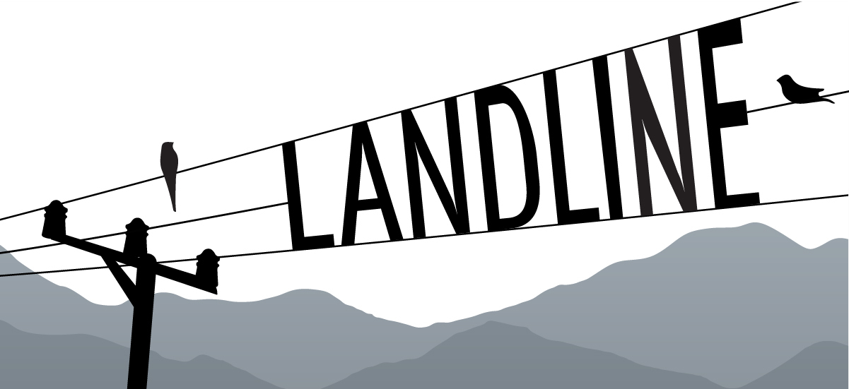
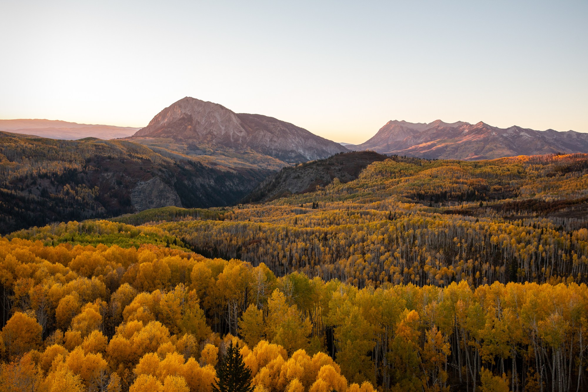
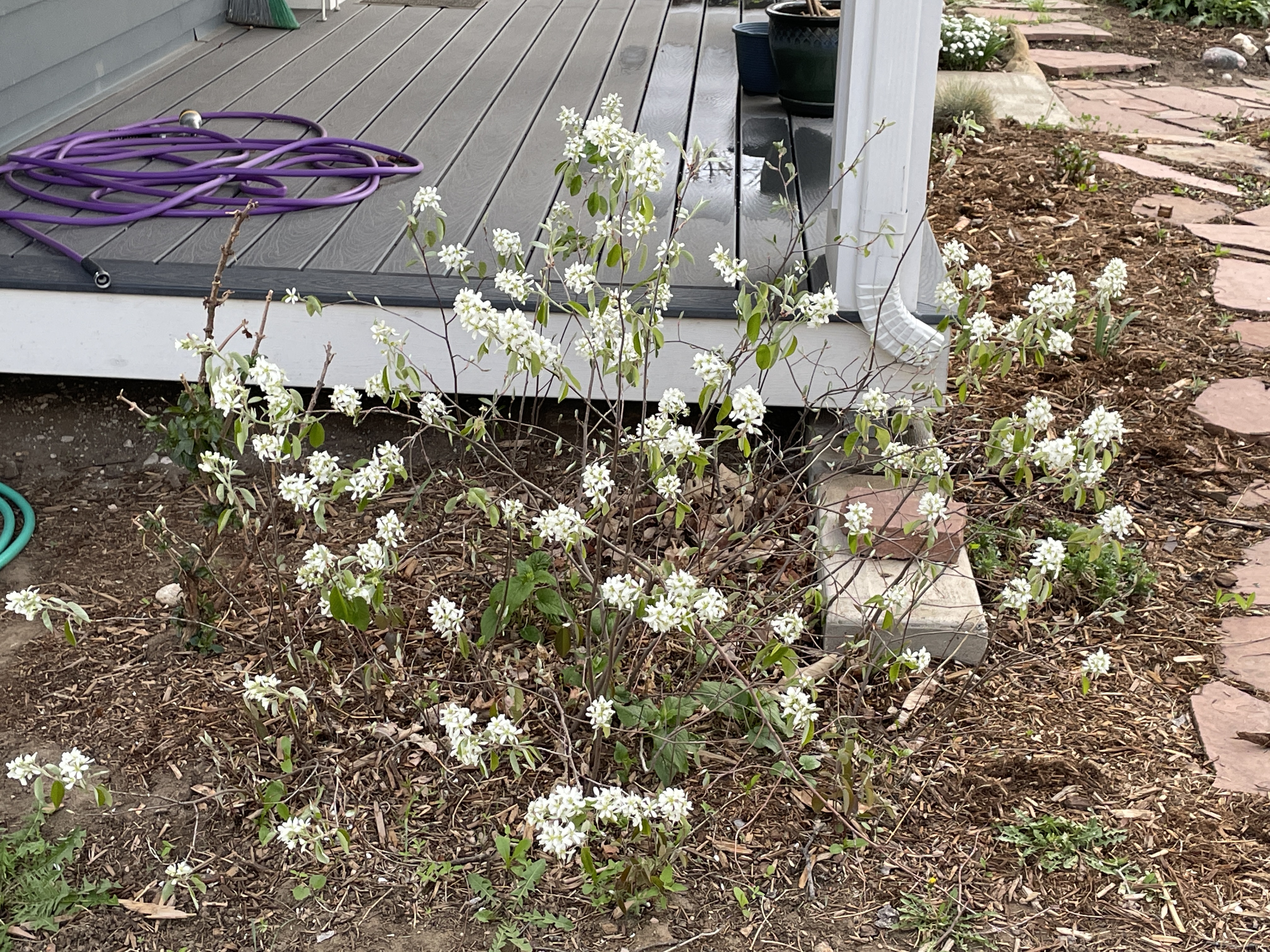

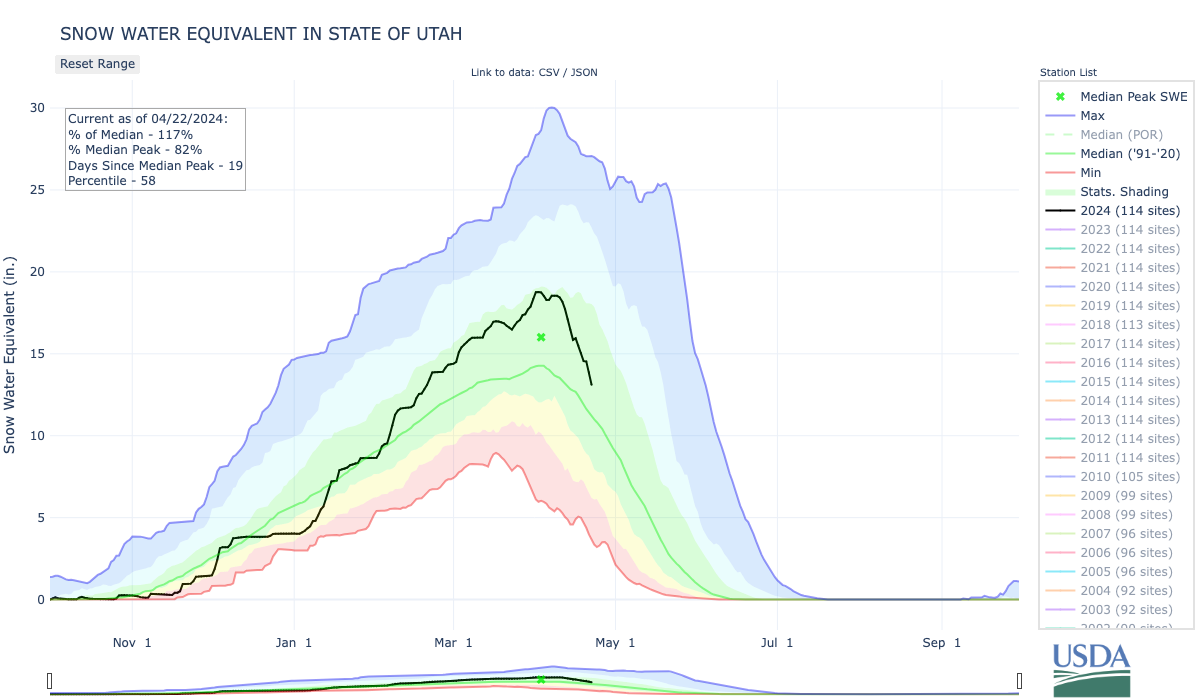

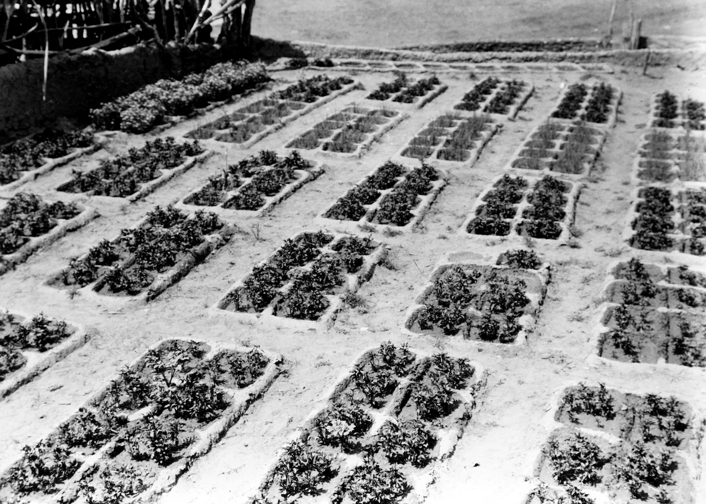
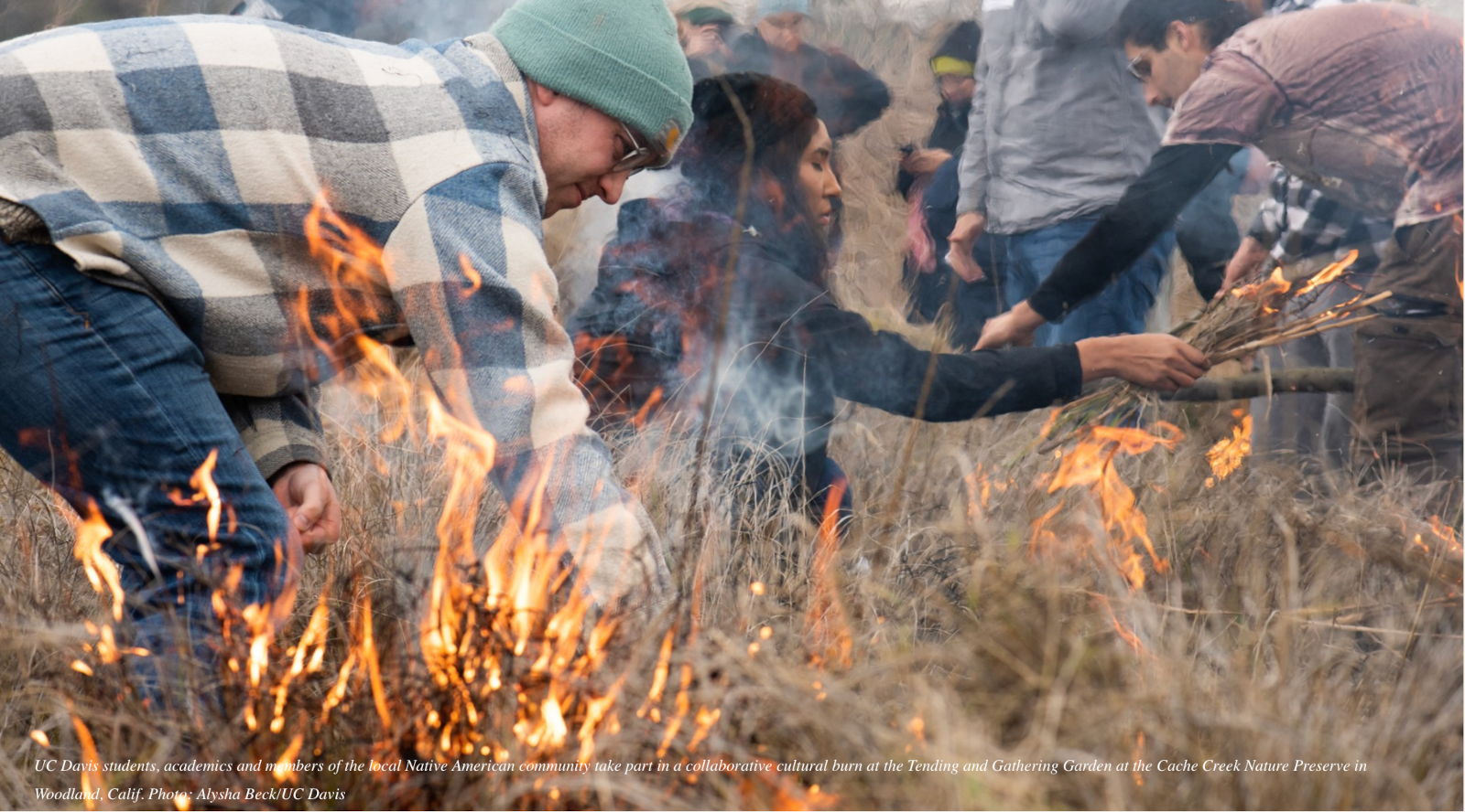
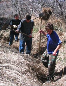


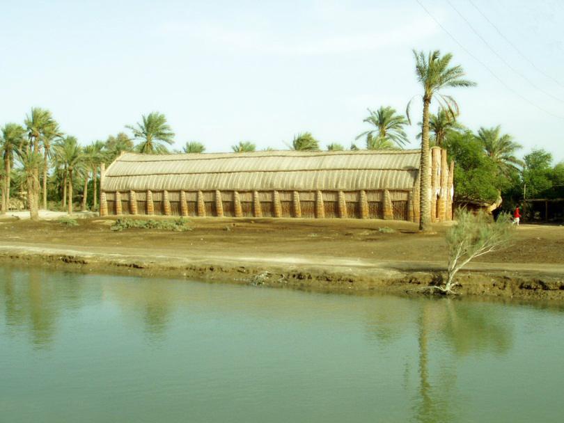


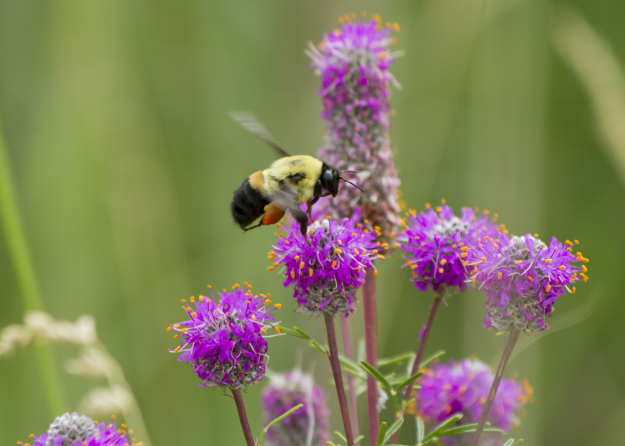

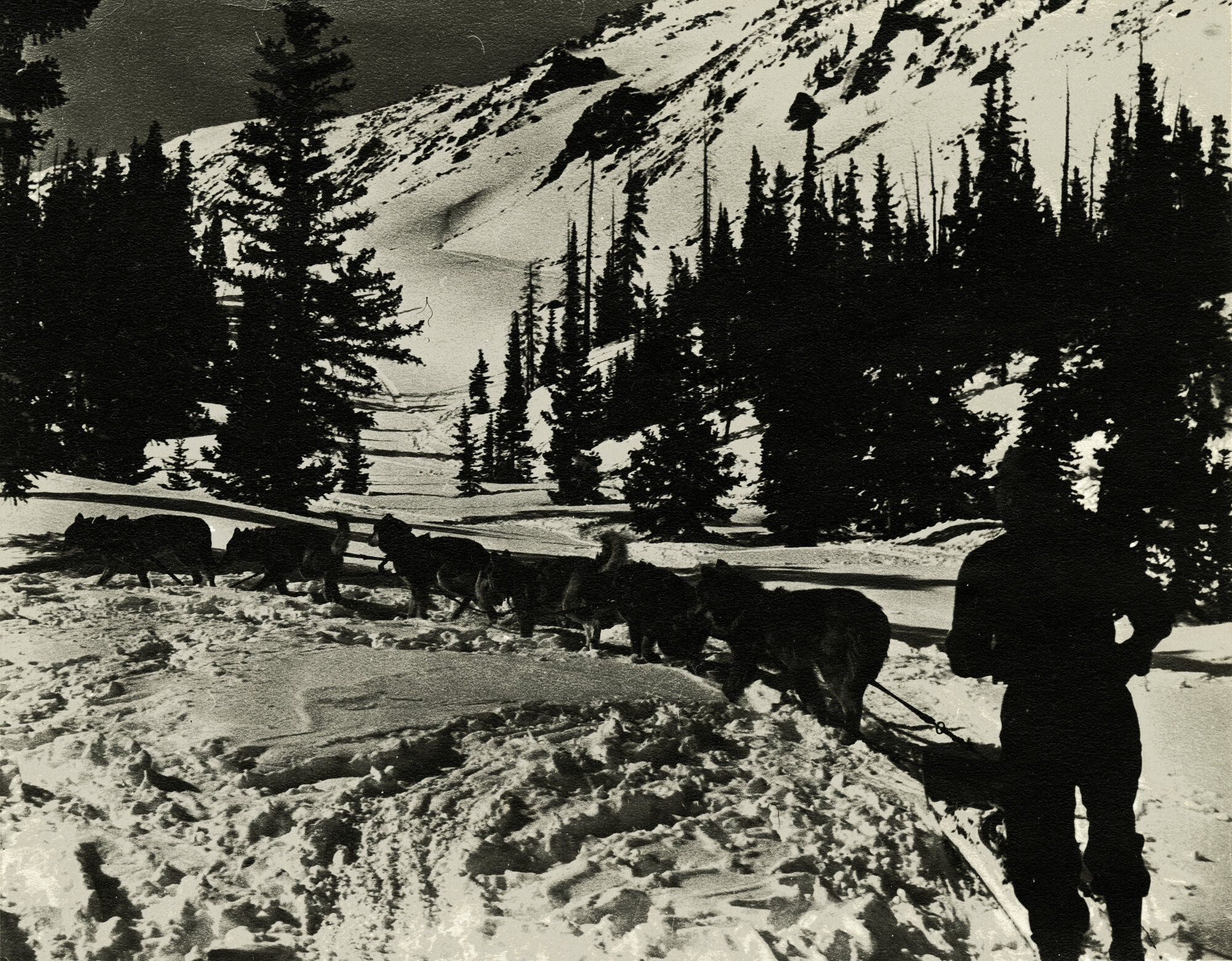
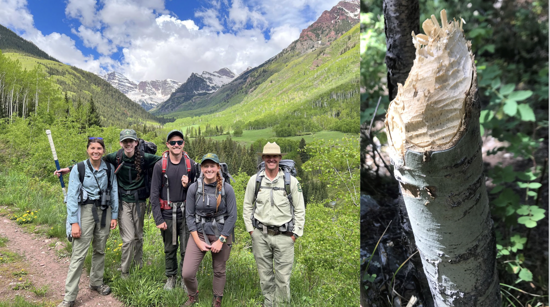


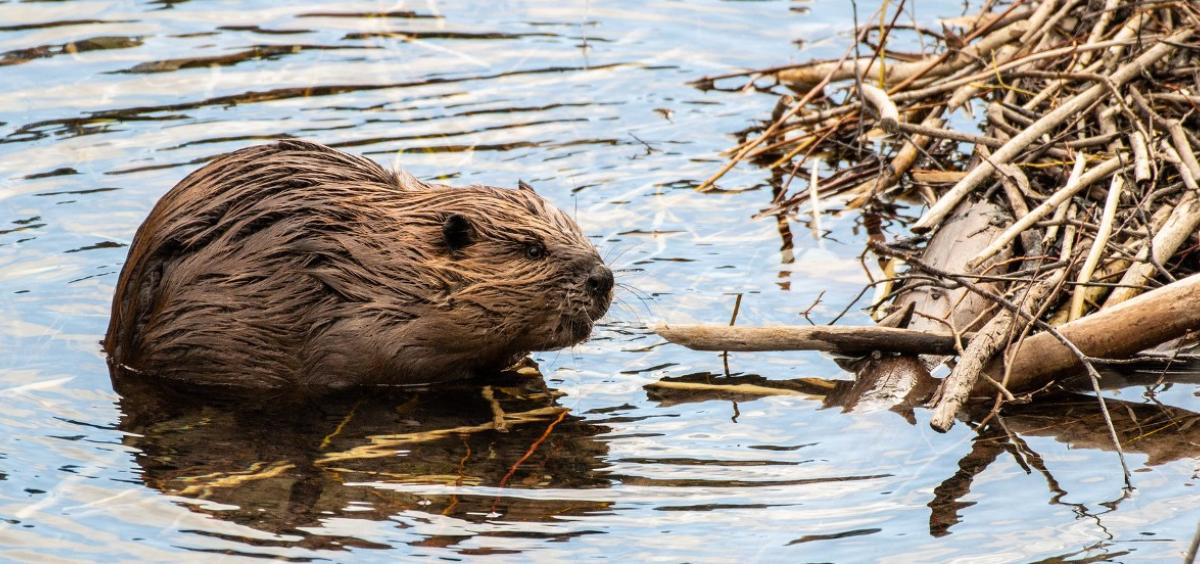


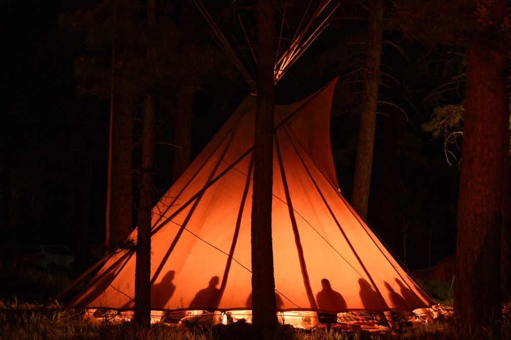
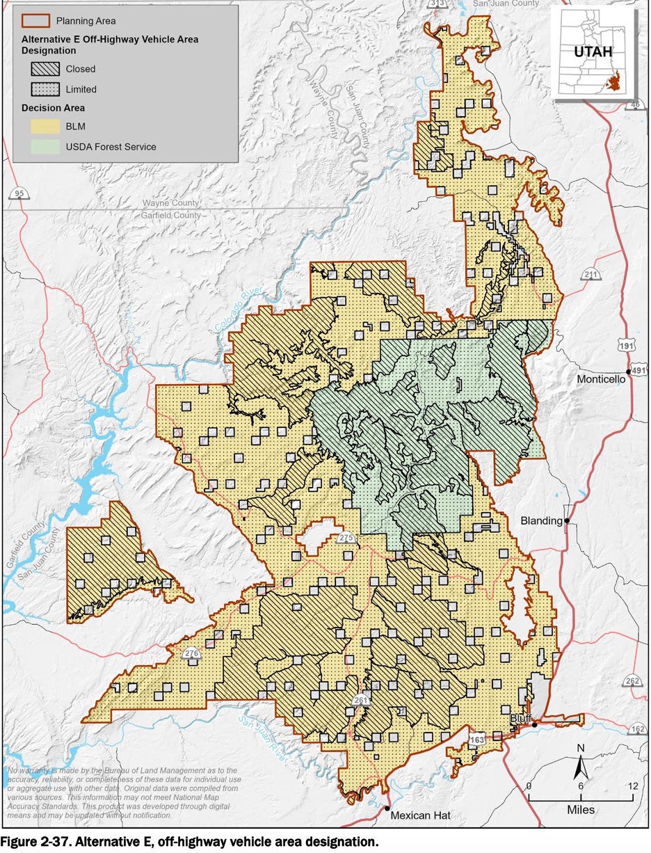

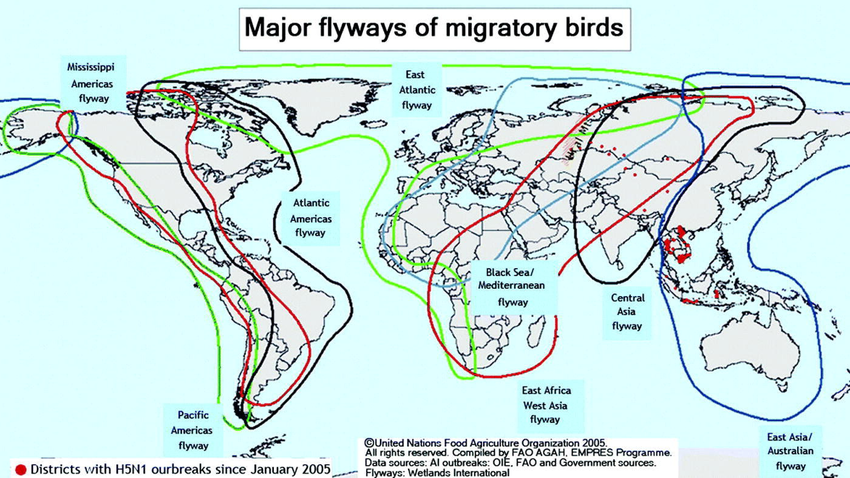
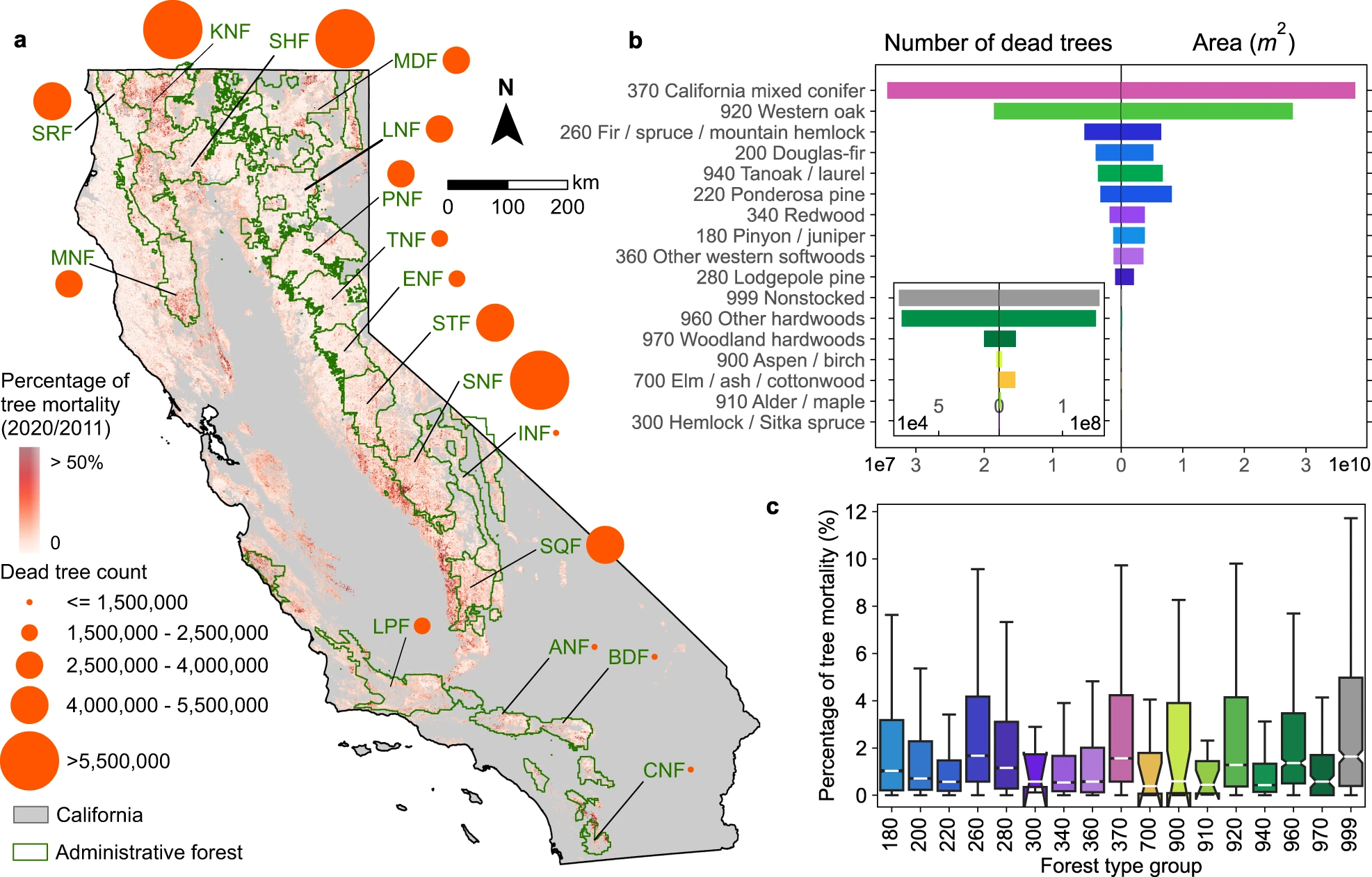


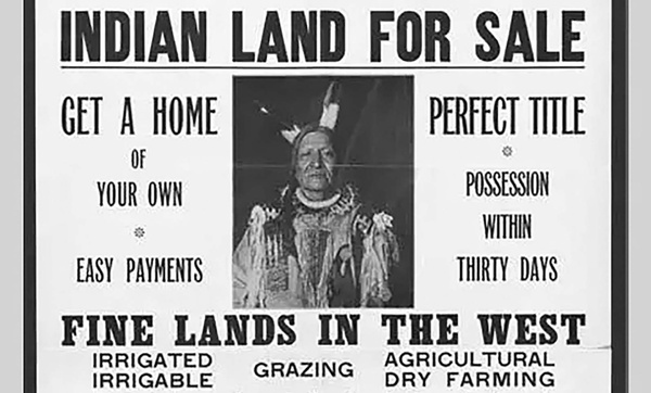
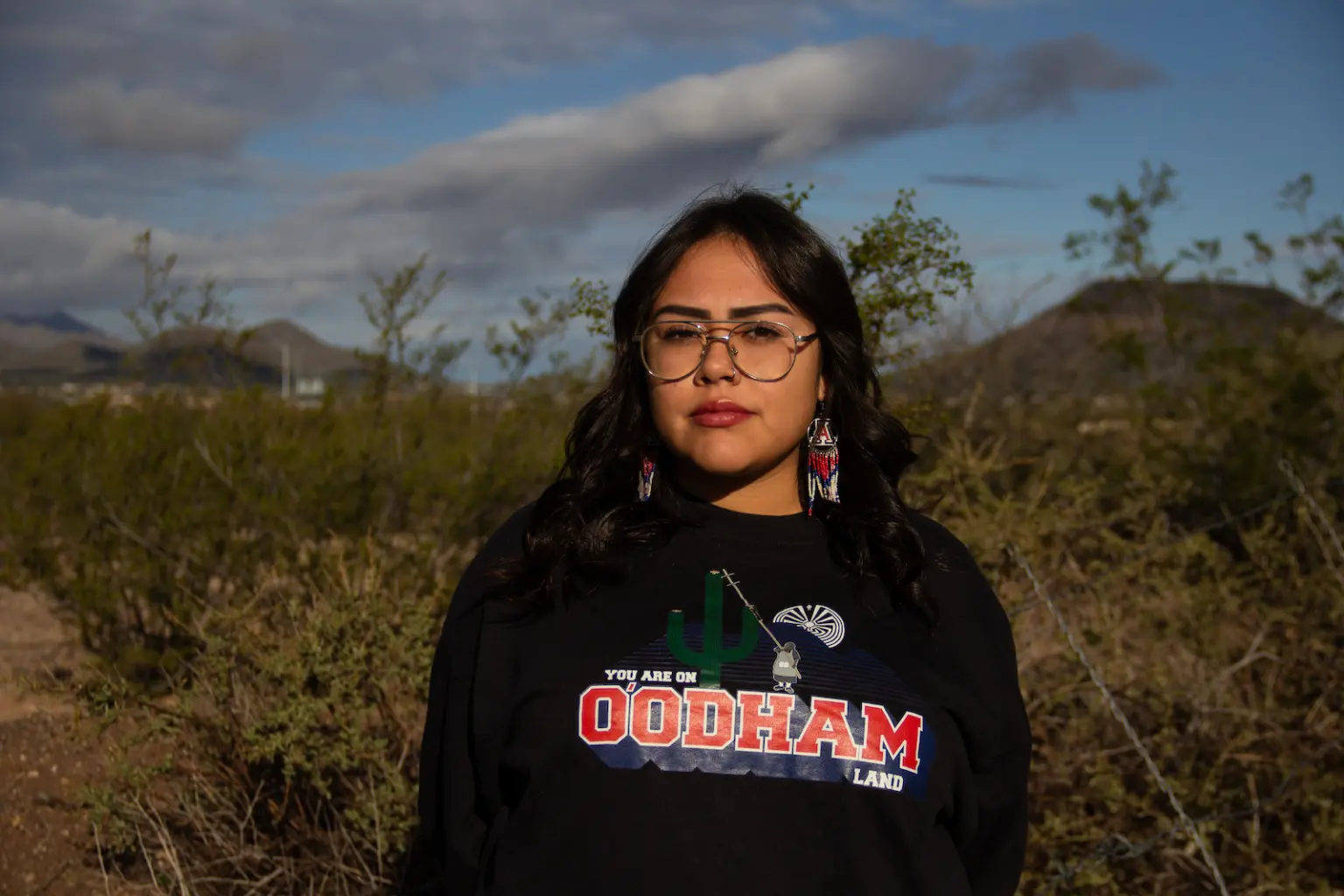


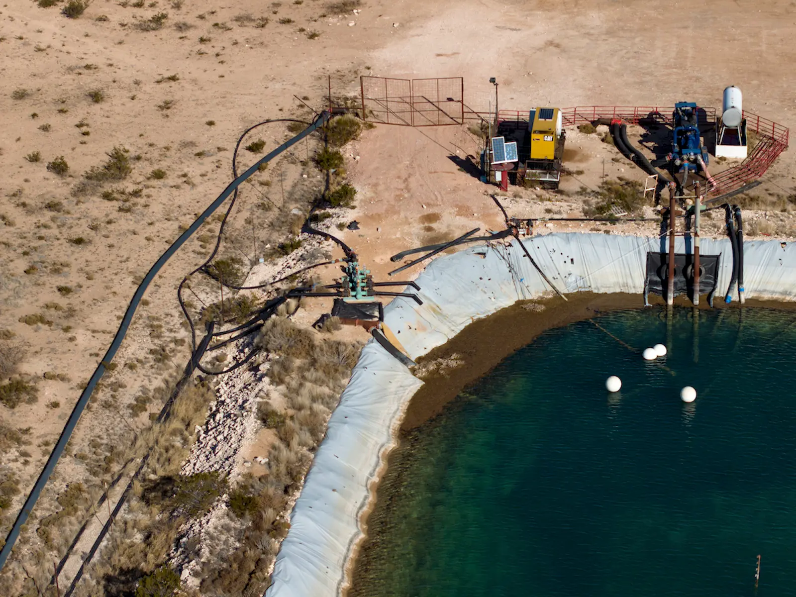

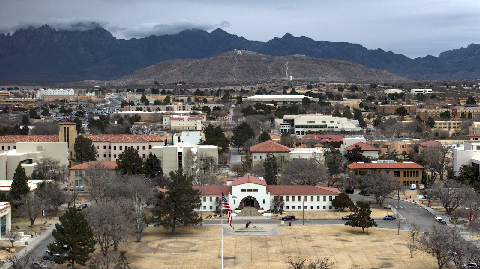
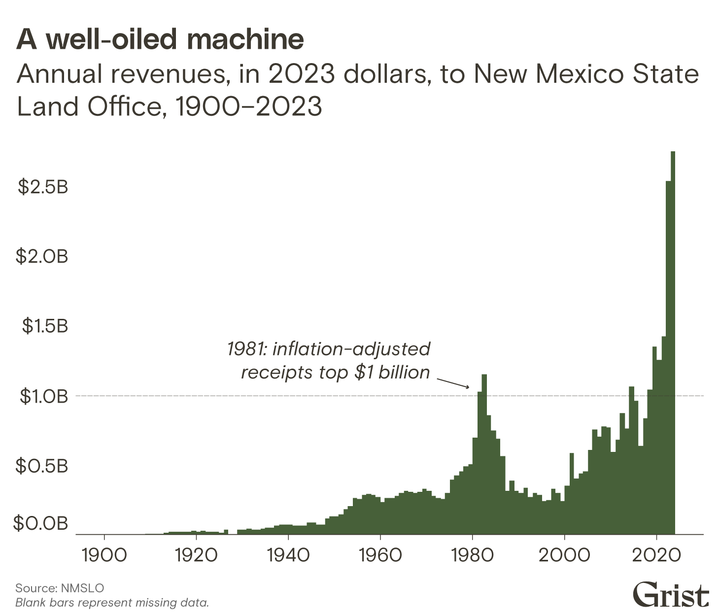


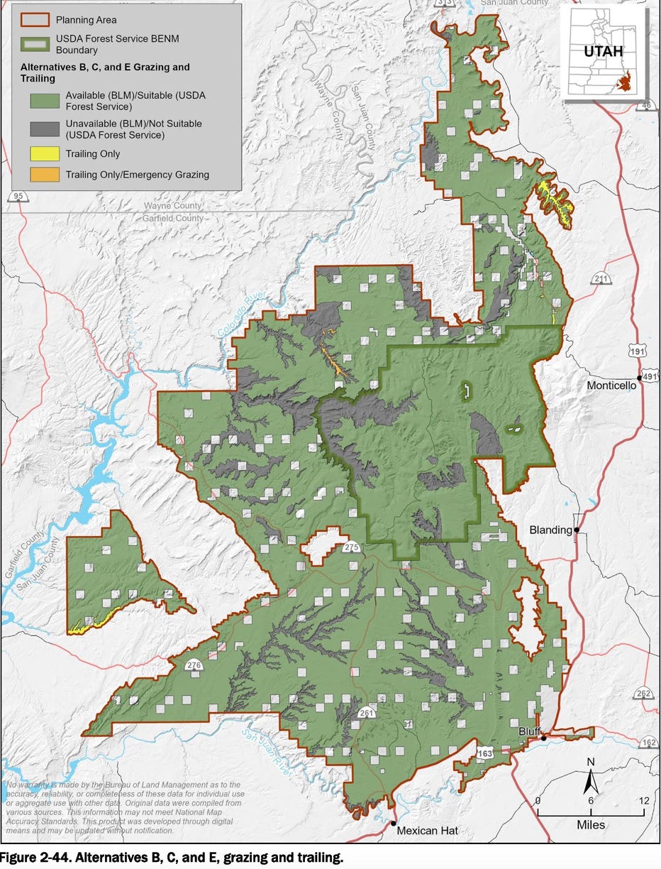

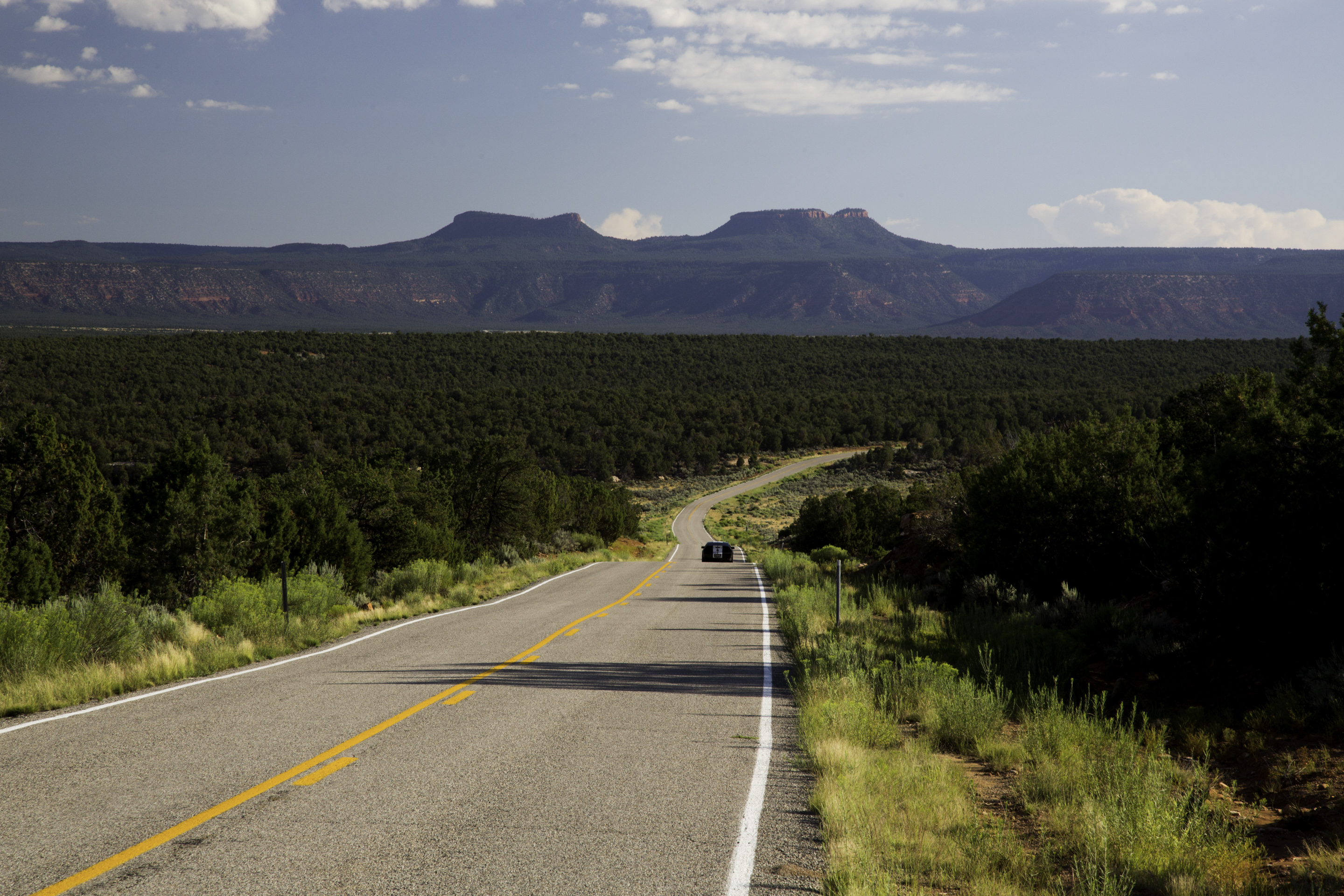
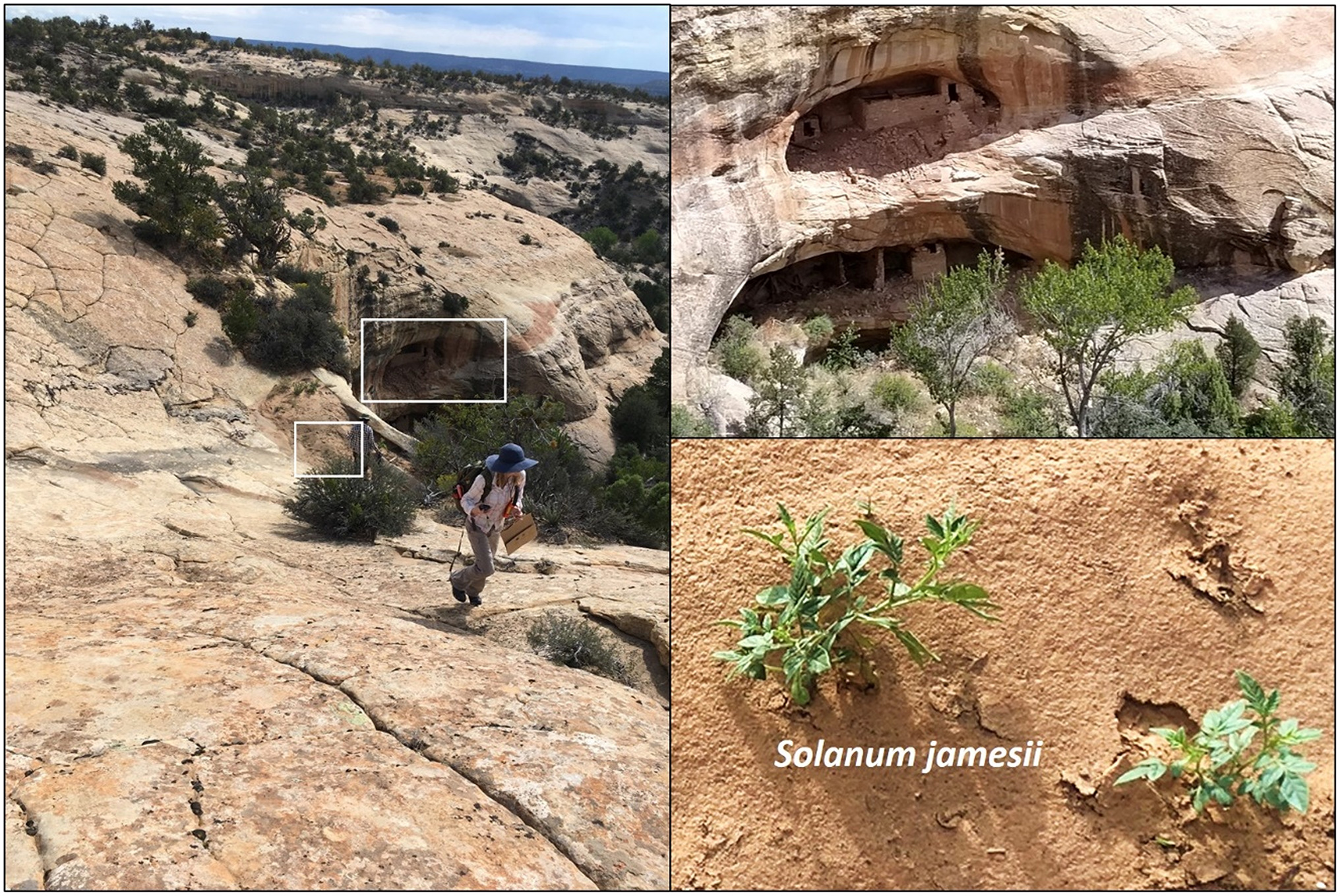

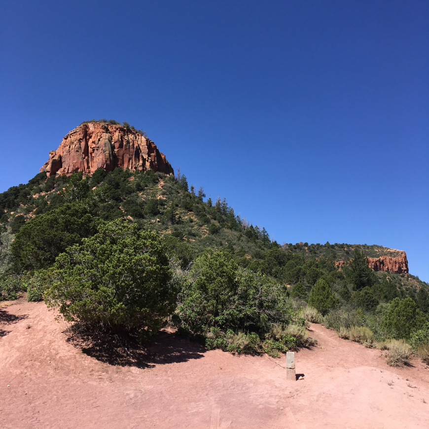
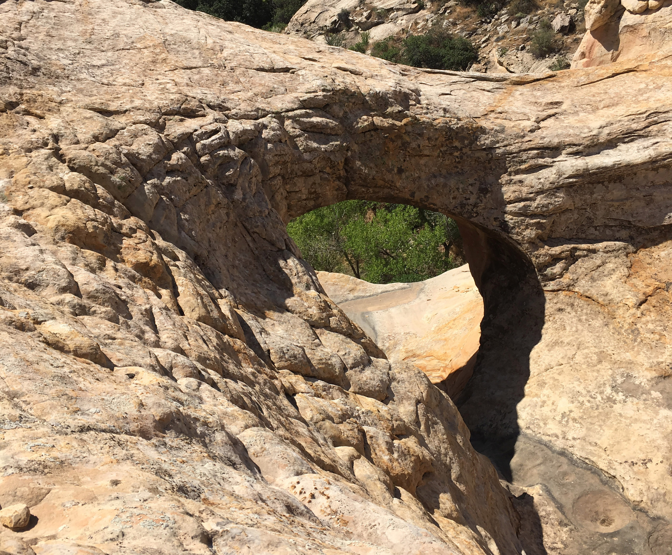


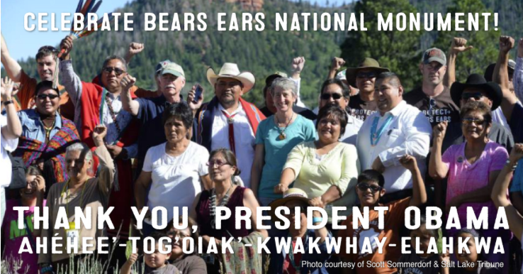
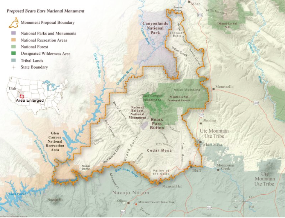


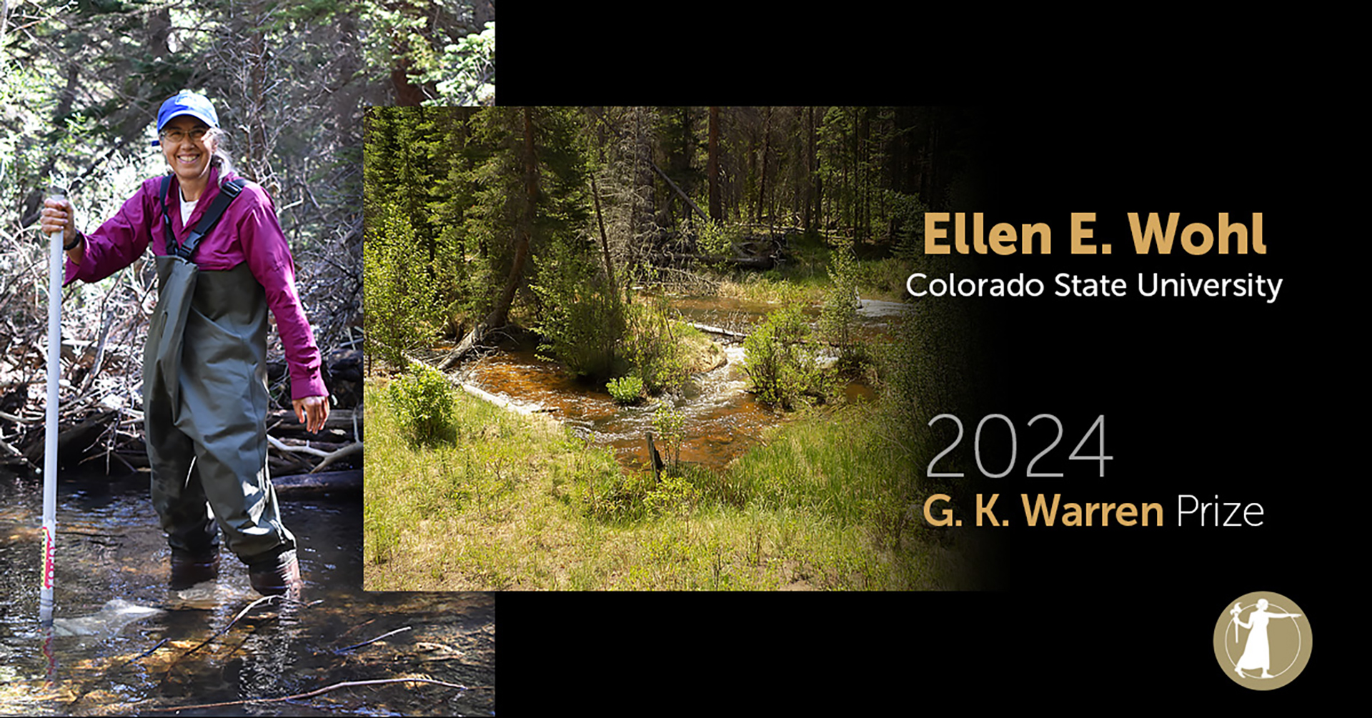


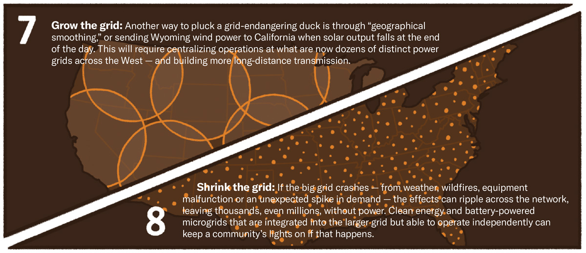

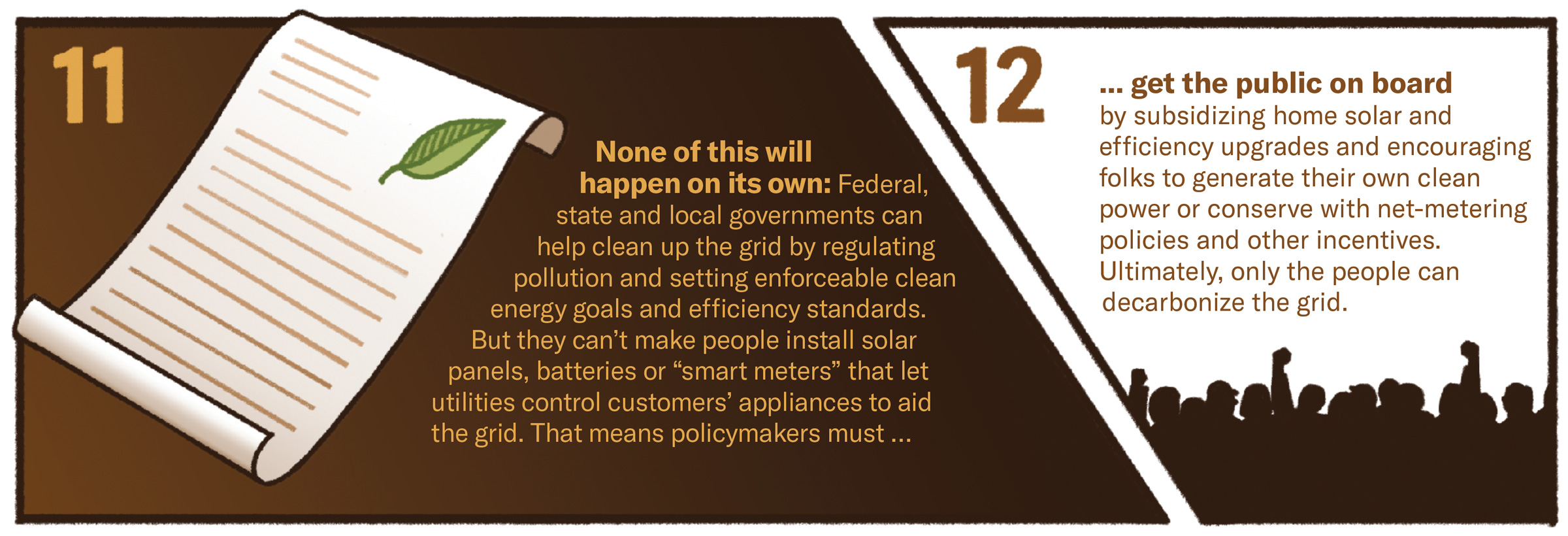


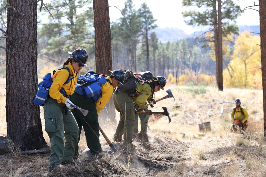
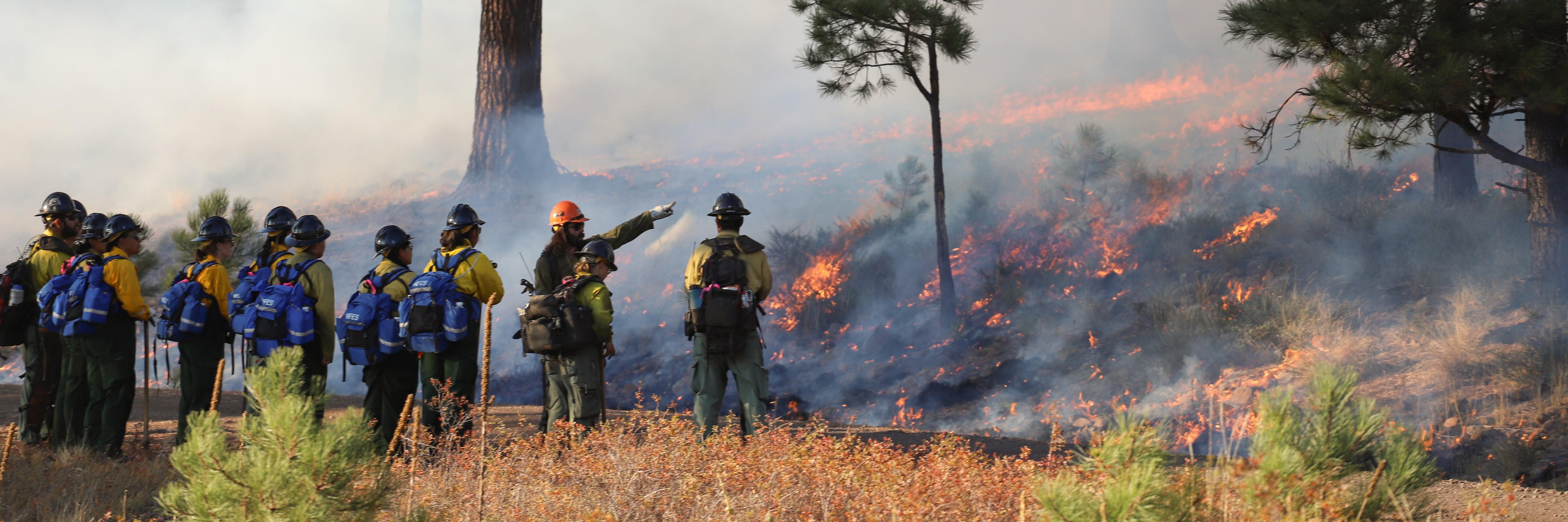
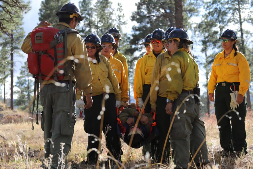
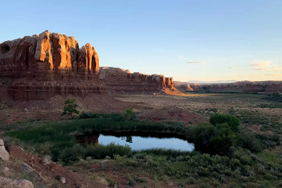
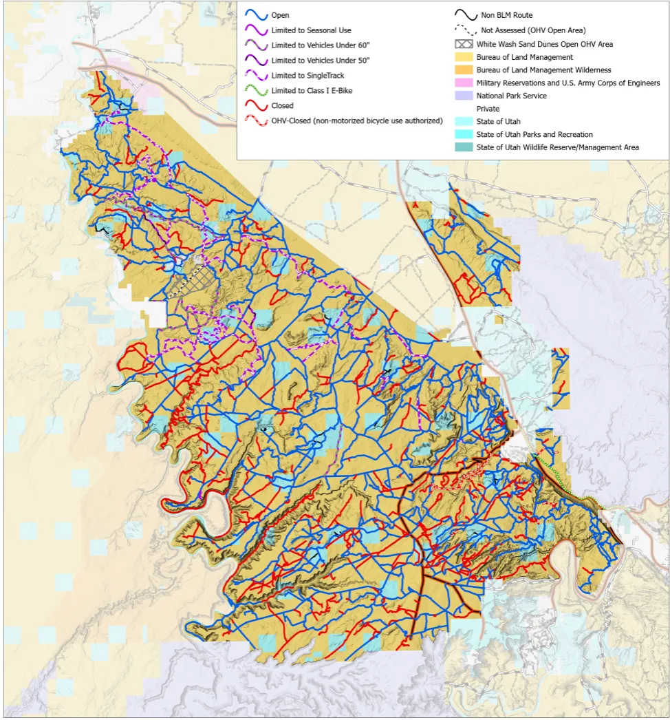


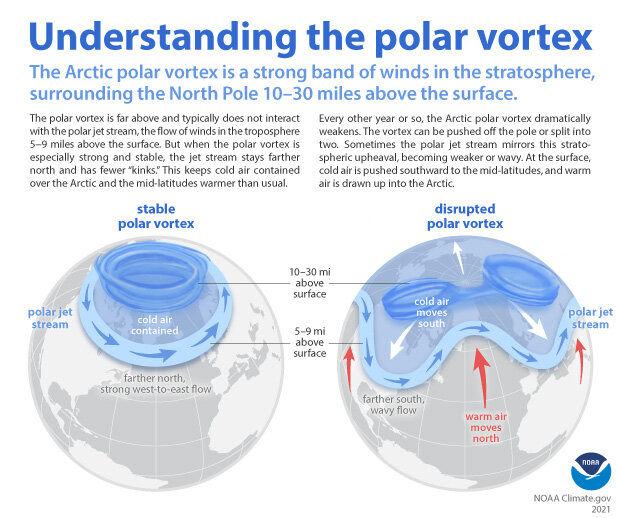
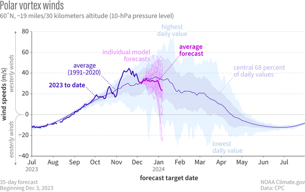
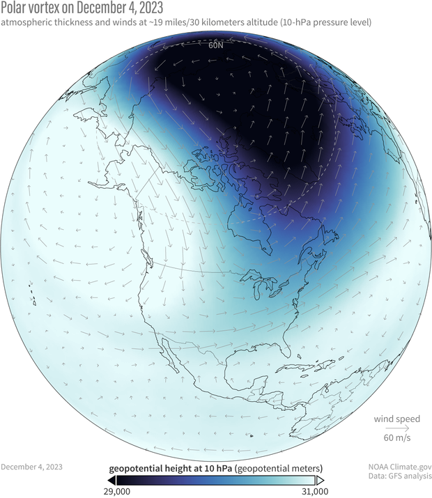

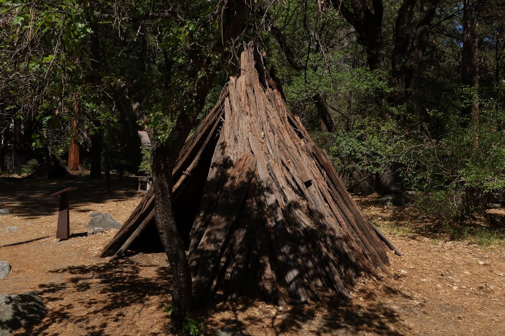


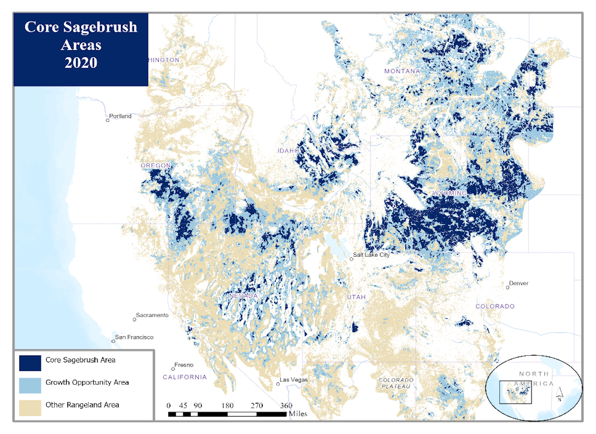


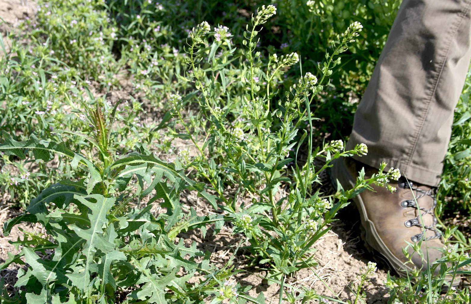
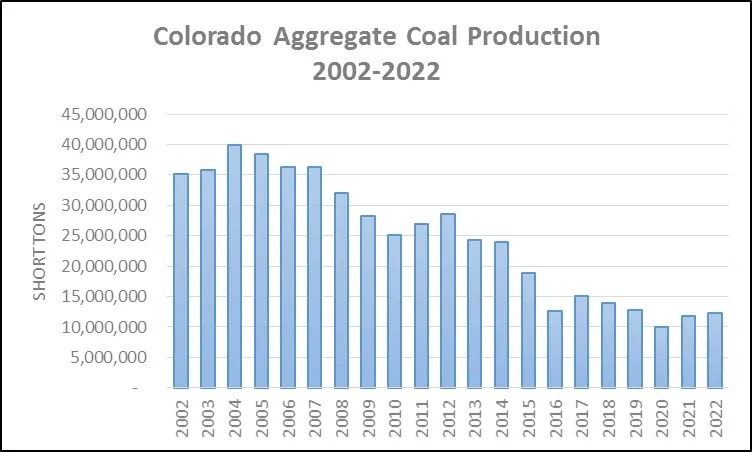

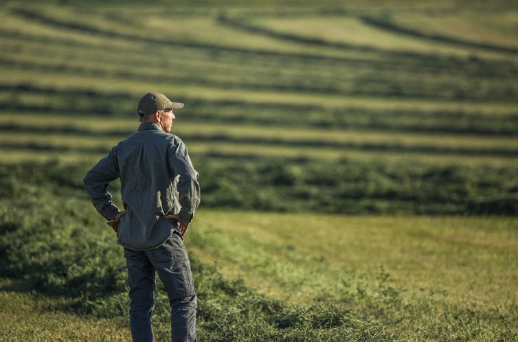
