
Happy #PiDay


This coyote was skating back to a recent city goose kill yesterday afternoon at Sloans Lake in North Denver.

Click the link to read the article on the LandDesk.org website (Jonathan P. Thompson):
February 7, 2025
🌵 Public Lands 🌲
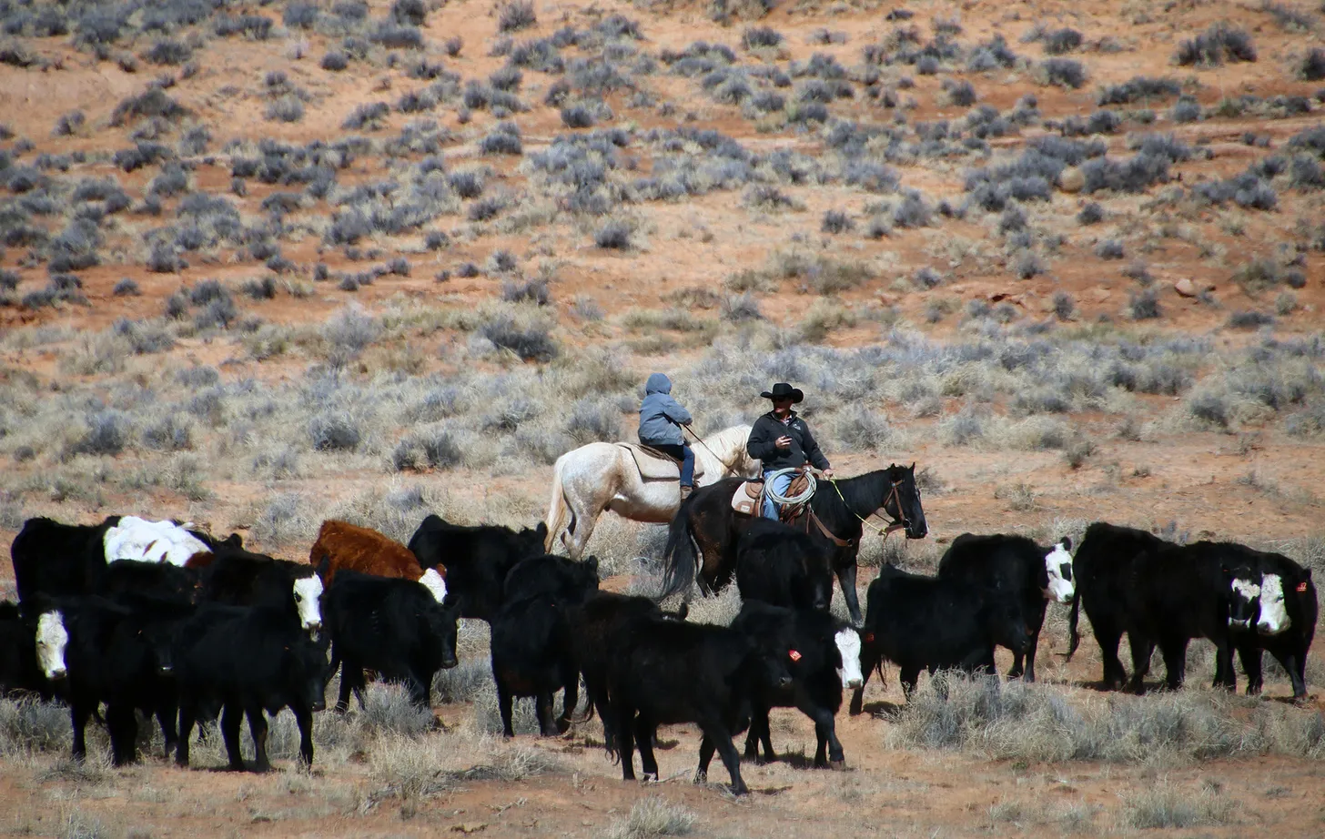
The News: Last week, administrative judge Dawn Perry halted the Bureau of Land Management’s approval of The Nature Conservancy’s plan to build 13 reservoirs and erect five fences on the Indian Creek grazing allotment within Bears Ears National Monument. Perry ruled in favor of Western Watersheds Project, Jonathan B. Ratner, and Sage Steppe Wild, who had appealed the approval, and found that the agency had failed to adequately analyze impacts of the plan.
The Context: The Indian Creek allotment and the Dugout Ranch that runs cattle on it are integral to the West’s ranching history, and a perfect example of how public land grazing is complicated as an environmental issue, and how a certain sentimentality shades society’s — and land management agency’s — views of it.
The ranch is probably one of the more spectacular chunks of private land in the West, covering 5,000 acres in the Indian Creek drainage adjacent to the Needles District of Canyonlands National Park and surrounded by towering Wingate sandstone cliffs and formations. It was first settled by white folks in the 1880s, although BLM records suggest the homestead wasn’t patented until 1915 by David Cooper.
Three years later Al Scorup — known as the “Mormon Cowboy” — and his brother Jim teamed up with Moab’s Somerville family to purchase the Indian Creek Cattle Company and the Dugout Ranch. They had a rough go of it: cattle prices crashed, the Spanish Flu killed Jim and his wife, and a hard winter killed 2,000 head of the company’s cattle.
But the Mormon Cowboy held on and by 1927 had permits to graze 6,800 cattle on U.S. Forest Service land, more than any other permittee in the nation. In 1936, two years after the Taylor Grazing Act was passed, Scorup’s company recorded 4,000 or so cattle on federal Grazing Service (now BLM) land, including in Beef Basin, Dark Canyon, White Canyon, and Grand Gulch.
In 1965, a year after Congress designated Canyonlands as a national monument, Charlie Redd acquired the Scorup-Somerville Cattle Company, which included the Dugout Ranch and its associated grazing leases.1 Soon thereafter, Redd’s son Robert, along with his wife Heidi, took over the ranch. Heidi Redd, legendary in southeast Utah and beyond, sold the ranch to the Nature Conservancy in 1997, though she continued to operate the ranch until her son and daughter-in-law took over. In 2016, then President Barack Obama designated the Bears Ears National Monument, which included the entirety of the 272,000-acre Indian Creek allotment.
For some folks it might seem strange that an environmental group, The Nature Conservancy, is running cattle on a national monument — especially in Utah’s high desert, where the land is especially fragile and cultural sites are plentiful. After all, green groups aren’t taking over oil and gas wells and trying to run them in a more environmentally-friendly way.
But this is part of the $9.9 billion nonprofit corporation’s method. Rather than taking land out of livestock production, TNC looks to work with folks in the “beef supply chain to adopt a sustainability framework that keeps grasslands ecologically intact and economically productive, safeguarding the future ranching families and feeding a growing world.”2 Meanwhile, by acquiring the Dugout Ranch, it saved it from being developed as a desert glamping resort or some billionaire’s hideaway — triggering the “I’d rather see a cow than a condo” meme — and also established the Canyonlands Research Center there, which studies climate change and works to develop sustainable grazing practices.
Of course, many biologists and environmentalists would say that the only sustainable way to graze public lands is not to do it at all. In theory, TNC could have purchased the ranch, continued to run cattle (albeit far fewer) on private land, and bought out the public land grazing permits and retired them, as the Grand Canyon Trust did in Grand Staircase-Escalante National Monument in the late 1990s.3
The Conservancy’s Dugout Ranch’s Indian Creek permit is for just over 8,500 animal unit months, meaning they can run about 1,000 cows on the allotment from early October to mid-June. While the allotment is vast, the sections in the Dark Canyon and Beef Basin areas are harder to access, so grazing is more intensive in the 56,000 acres of pastures surrounding the private ranch. In 2018, the ranch proposed constructing 13 reservoirs, one well, and five fences on those public land pastures in an effort to distribute the cattle more evenly across the parcel and take some pressure off existing water sources, such as Indian Creek and in Davis and Lavender Canyons. It also aimed to increase livestock productivity and “improve grazing management in changing climate conditions.”
Last year the BLM approved the project (minus the well), saying it would spread the cattle out and lessen their impacts, thereby protecting the recognized “objects” of the national monument. The agency’s review, and justification for the approval, emphasizes TNC’s intent to graze its cattle sustainably and its diligence in controlling its cattle, almost as if this is a reason to approve the project, regardless of impacts. However, BLM emails obtained by Ratner show that the agency scolded the ranch for allowing cows to graze off-season in the Dark Canyon and Beef Basin areas, resulting in springs being “heavily trampled,” calling it a “livestock trespass situation,” and urging TNC to more diligently control their cows.
Western Watersheds, Sage Steppe Wild, and Ratner appealed the approval, arguing that the BLM had failed to take a hard look at potential impacts. “How would bulldozing 13 reservoirs for the sole benefit of the private interests of a massive corporation protect, preserve and restore the Bear’s Ears landscape?” Ratner wrote in his appeal. The foundational problem, he argued, is that the number of cattle exceed the pastures’ carrying capacity, not uneven distribution of cattle, and implementing the project as a solution was equivalent to putting “a tiny band aid on multiple gunshot wounds.”
The project might keep the cattle from concentrating in one area, but it would also broaden the area of impact to parts of the pasture that may have seen little grazing. The BLM predicted that the reservoirs’ construction would destroy valuable biocrusts and native vegetation, and that subsequent grazing would lay waste to everything within a 50- to 300-foot radius from each reservoir. But Western Watersheds pointed out that the BLM’s basis for this finding is shaky, and that most peer-reviewed research has found that grazing’s impacts extend for one to two miles from a water source.
Furthermore, the appellants argued, the BLM provides no evidence that building new water sources will reduce impacts on or lead to the restoration or healing of the existing water sources.
In a written statement, Laura Welp, of the Western Watersheds Project, pointed out that BLM signs and literature warn recreationists not to “bust the crust,” yet in giving grazing a virtual blank check, the agency is ignoring the impacts a thousand half-ton bovines have on the fragile soil, native vegetation, and cultural resources.
The Department of Interior’s administrative judge, largely agreed with the appellants, finding that the agency’s environmental review included “barely any rangeland health data specific to the pastures or locations where the new reservoirs and fences will be constructed.” She put a stay on the approval and the project, which doesn’t necessarily kill the project, but does require the agency to redo its review.
“Given that the only stated purpose in the EA for constructing thirteen reservoirs and five fences is to redistribute livestock, BLM had an obligation to analyze how optimized livestock distribution would impact rangeland health,” Judge Perry wrote in her ruling. “When viewed together, the immediate and irreparable impacts associated with construction activities, concentrated use, and livestock redistribution support the imposition of a stay.”
I guess sentimentality only goes so far.
The West’s Sacred Cow: https://www.landdesk.org/p/the-wests-sacred-cow — Jonathan P. Thompson
Buried within the Trump administration’s “unleashing American energy” executive order was a mandate for the Interior Department to “review and, as appropriate, revise all withdrawn public lands, consistent with existing law, including 54 U.S.C. 320301 and 43 U.S.C. 1714.”
It so happens that 54 U.S.C. 320301 is the Antiquities Act. So this means that all the national monuments created by presidents under the law — and not later designated by Congress — are in play. This could mean that Trump will try not only to shrink Bears Ears and Grand Staircase-Escalante National Monument, but could bring his illegal monument wrecking ball to places like Aztec Ruins, Hovenweep, Natural Bridges, and even Devils Tower national monuments.
I’m thinking that it probably won’t go that far. Trump is motivated by spite and revenge, and I doubt he has any bone to pick with ol’ Warren G. Harding4, who established Hovenweep and Aztec Ruins national monuments in 1923, or Teddy Roosevelt, who established Devils Tower and Natural Bridges national monuments in 1906 and 1908, respectively.
But I’m not so optimistic about the fate of Bears Ears, GSENM, and Baaj Nwaavjo I’tah Kukveni-Ancestral Footprints of the Grand Canyon National Monument. Still, it’s not worth freaking out about this yet, since we don’t know what Interior Secretary Doug Burgum might do on these things. Plus, any reduction of the monuments is very vulnerable to legal challenges, since they would be, well, illegal. There’s plenty of other outrageous things the administration — and Elon Musk — are actually doing now that are worth freaking out about.
I’ve been doing a lot of that lately — freaking out, that is — but also trying not to be overwhelmed by the firehose of absurdity, much of which is mere bluster aimed at distracting us from the real damage being inflicted or simply to aggravate the “libs.”
And damage is being done, from the attempted purge of federal employees (including a freeze on federal firefighter hiring); to canceling diversity, equity, and inclusion programs along with environmental justice initiatives; to the spending freeze on Infrastructure and Inflation Reduction act funds, which threatens to crush nonprofits and kill programs aimed at helping low- and moderate-income folks, small businesses, and farms install rooftop solar.
A lot of people are going to lose jobs, and the nation will be irreparably harmed if Musk’s rampage isn’t stopped soon. Meanwhile, eggs and energy won’t be any cheaper. The only thing you can count on is that billionaires and corporations will pay less in taxes.
🦫 Wildlife Watch 🦅

I really hate to be the bearer of bad news, especially in these f#$%ed up times. But here it is: the annual Western Monarch Count reported a peak population of just 9,119 of the butterflies this winter, the second lowest overwintering population recorded since tracking began in 1997.
The population’s size is extremely concerning,” said Emma Pelton, an endangered species biologist with the Xerces Society for Invertebrate Conservation, in a written statement. “We know small populations are especially vulnerable to environmental fluctuations, and we think that’s what happened this year. The record high late summer temperatures and drought in the West likely contributed to the significant drop-off we saw in the third and fourth breeding generations.”
The good news is that it could be an anomaly. The last three years’ counts recorded 200,000 butterflies. The monarch is being considered for protections under the Endangered Species Act, which might help. Of course, you know who’s administration is the decider on that one, so …
Vanishing Butterflies and Solar Scuffle: https://www.landdesk.org/p/vanishing-butterflies-and-solar-scuffle — Jonathan P. Thompson
⛈️ Wacky Weather Watch⚡️
It’s safe to say there is some serious weather whiplash going on all over the West. Southern California caught fire; now it’s getting deluged by atmospheric rivers. Southwest Colorado was slammed with snow in October and November; then suffered from an unusually dry December and January (I just received news that the Durango Nordic Center near the base of Purgatory Resort is shutting down until further notice due to lack of snow). This was the hottest January globally on record; but it was downright arctic in parts of Colorado (Durango had three successive nights of -10° F lows, daily records). And now the February thaw has set in, with record daily high temperatures being recorded from Grand Junction (71°), to Bluff (68°), to Albuquerque, to Denver (68°), to Phoenix (86°), to Las Vegas (80°), which hasn’t seen measurable precipitation for months.
Meanwhile, at Big Sky ski area in Montana, a sizable in-bounds avalanche broke loose during mitigation work (when the slopes were closed) and partially buried a lift terminal building.
Just some songs for your listening pleasure for these messed up times…
1 Grazing is generally banned in national parks, but in Canyonlands it was allowed to continue for 11 years after the park’s establishment, or until 1975 in the original park boundaries and 1982 in expanded zones.
2 The first “West’s Sacred Cow” piece opened with the Joe Lott-Fish Creek allotment in southwestern Utah. The main permittee is a ranch owned by the Ensign Group, which is helmed by Chris Robinson, a Utah Nature Conservancy trustee and a board member of Western Resource Advocates.
3 This is a bit more complicated than it sounds. The problem is that federal law doesn’t allow normal BLM allotments to be permanently retired, and efforts to pass legislation opening the door to buyouts from willing sellers have run up against the livestock lobby, conservative lawmakers, and the romanticization of the ranching culture. However, when then-President Biden restored the boundaries of Bears Ears National Monument, he added a provision that permanently retires allotments within the monument if the current permit holders willingly relinquish or sell their permits.
4 Well, actually, Harding is considered by many to be the worst U.S. president ever, and his Interior Secretary, Albert Bacon Fall, was the only cabinet member to go to prison (for his role in the Teapot Dome scandal). So maybe Trump has a bit of a rivalry going with ol’ Harding.

Click the link to read the article on the LandDesk.org website (Jonathan P. Thompson):
January 31, 2025
🌵 Public Lands 🌲

The Joe Lott-Fish Creek grazing allotment sprawls across nearly 78,000 acres of U.S. Forest Service land in western Utah. It contains a variety of ecosystems, ranging from arid juniper-piñon forests in the lower elevation sections that straddle I-70, to aspen and conifer glades, to 11,000-foot peaks, as well as several streams.
Until just over a decade ago, the primary grazing permittee was Missouri Flat LLC, which was allowed to run 744 cow-calf pairs on the land. Another rancher had a maximum herd of 40. The cattle were supported by 14 cattle ponds and troughs.
Sometime between 2013 and 2016, Missouri Flat’s permit was taken over by Pahvant Ensign Ranches. Over a period of about three years around the same time, the Fishlake National Forest upped the maximum number of cattle allowed to graze the allotment by 604, to a total of 1,388 cow-calf pairs, without notifying the public until 2021. The Forest Service said favorable conditions following the 2010 Twitchell Fire justified the increase, but they didn’t provide any scientific backing for the decision. Then, last April, the Forest Service approved a proposal to add 17 water troughs and 13 miles of new pipeline to the Pahvant Ensign allotment, granting the project a “categorical exclusion,” meaning it isn’t subjected to the usual environmental review.
“Functionally,” wrote Mary O’Brien, a botanist and longtime defender of public lands, ecosystems, and pollinators, “Joe Lott-Fish Creek Allotment is being transformed into a private ranch.”
O’Brien brought the story of the Joe Lott allotment to my attention several months ago. She wanted to show me, in part, that while environmentalists tend to focus on the Bureau of Land Management when pushing back on public lands livestock grazing, they shouldn’t forget that grazing is also widespread on Forest Service lands. And that the Forest Service is no better at managing it than the BLM.
I also find it to be a sort of snapshot of how public lands grazing — under any agency — has come to be the West’s untouchable sacred cow, something that neither Democrats nor Republicans dare to mess with or reform, no matter how obsolete the current regulations or how much harm is being done. I’m not just talking about the Biden or Trump administrations, either: This bipartisan inaction has been going on since the Taylor Grazing Act was passed in 1934.
Data Dump: Cows, cows, cows… (Jonathan P. Thompson): https://www.landdesk.org/p/data-dump-cows-cows-cows
When the white colonial-settlers invaded the Western U.S. in the 19th century, they brought along oodles of cattle and sheep. In some places, the settlers were even preceded by the giant herds of big-time cattle companies and their minders. A good portion of southeastern Utah, for example, was once blanketed by grass that reached an elk’s belly. But then the huge livestock operations, including New Mexico and Kansas Land and Cattle Company and the Carlisle outfit, brought in tens of thousands of head of sheep and cattle beginning in the 1870s. Before long the Hole-in-the-Rock Mormon settlers also got into the livestock business, pasturing their cows and sheep on Elk Ridge near the Bears Ears buttes.
By the 1890s, as many as 100,000 sheep and cattle were chomping their way across San Juan County, reducing large swaths of the formerly abundant grasslands to denuded, dusty, gullied, flash-flood-prone wastelands. Plus, the sheepmen and the cattlemen were constantly fighting over who got access to what portion of range, a conflict that had disastrous outcomes. At one point, allegedly out of spite, the Carlisle livestock concern turned out thousands of sheep on the upper branches of Montezuma Creek, Monticello’s source for drinking water. Bacteria from the sheep feces contaminated the water, leading to a typhoid outbreak in Monticello that killed eleven people.
This sort of free-for-all and its consequences was not unique to the region; it was being repeated all over the West. The destruction and chaos inspired the federal government to try to get a handle on things, and in 1891 Congress passed the Forest Reserve Act (which would later become the Forest Service), giving the president the authority to withdraw areas from the public domain where grazing and other activities would be regulated. In response to the typhoid outbreak, Monticello residents petitioned the feds to create a forest reserve in the La Sal and Abajo Mountains. This would become the Manti-La Sal National Forest.
That still left millions of acres in the virtually lawless public domain, where livestock operators continued to run cattle and sheep without restraint. Finally, in 1934 Congress passed the Taylor Grazing Act to “stop injury to the public grazing lands by preventing overgrazing and soil deterioration,” to impose order, and to stabilize the livestock industry. A new agency, the Grazing Service (which was merged with the General Land Office to become the BLM in 1946), would manage a permitting and fee system on about 140 million acres of land, mostly sagebrush country, in the arid West. The lands were divided into grazing districts, each of which had an advisory board mostly made up of ranchers within that district, thus giving it an element of home rule and easing concerns that the federal landlord was taking too much control.
Nearly 12 million animals were permitted to graze on Taylor Act land across the West that year, yielding just $1 million in revenue—meaning ranchers were paying, on average, just eight cents per year to fatten up each of their bovines or ungulates on taxpayer-owned grass. Seventy-five percent of the revenue went back to the states and grazing districts, where the advisory boards determined how it would be spent. Nearly all of the funds went to so-called range improvement projects, which ultimately benefitted the ranchers, such as killing predators and rodents and construction of stock trails and diversion dams.
Still, even though many ranchers were in denial regarding the true causes of the ruination of the range—they attributed it to drought—they were generally ambivalent towards the act because it imposed order on the chaos that resulted from competing uses of the public domain. But the good feelings would soon vanish as the cattlemen felt threatened by proposals to designate new national monuments on public lands, including on a 4.5-million-acre swath roughly following the Colorado River in southern Utah. Back then, after all, grazing was generally prohibited in national monuments and parks.
And in the mid-1940s, when the Bureau of Land Management endeavored to raise grazing fees, the National Wool Growers Association and the American National Livestock Association gathered in Salt Lake City and launched a revolt with the backing of Western lawmakers. They demanded not only that grazing fees be capped, and national monument and park designations be halted, but also that all of the lands governed by the Taylor Act be transferred to the states or privatized. It was an early version of the Sagebrush Rebellion that is now being repeated by Utah and Wyoming. In a 1947 Harpers column, Bernard DeVoto reminded his readers, “Cattlemen do not own the public range now; it belongs to you and me,” adding that because federal grazing fees were so much lower than those for private land, they amounted to a subsidy.
The land-grab legislation that grew out of this revolt died. And grazing fees were raised, jumping from the original five cents per animal-unit-month1 for cattle to eight cents. The revolt did halt the giant Utah national monument, however, and the BLM continued to bow to the demands of the livestock industry.
It looked like things might change in the 1970s, however, when Congress passed the Federal Lands Policy Management Act, or FLPMA, which required the BLM to manage public land for multiple uses, including recreation and conservation. And in 1977, then President Jimmy Carter named Cecil Andrus as Interior Secretary. Andrus came into office with a bang, noting in a 1977 speech: “The initials BLM no longer stand for Bureau of Livestock and Mining. The days when economic interests exercised control over decisions on the public domain are past. The public’s lands will be managed in the interest of all the people because they belong to all the people. For too long, much of the land where the deer and the antelope play has been managed primarily for livestock often to the detriment of wildlife.”

And yet, public land grazing reform has been minimal, at best, in the ensuing five decades. The grazing fee, is only one small piece of the public lands grazing controversy, but it’s good proxy for the situation as a whole. In 1978, Congress established a formula for setting grazing fees, but also said they couldn’t drop below $1.35 per AUM (or $6.82 in 2024 dollars, if you were to adjust for inflation). While the fee climbed as high as $2.31 in 1981, it has remained at or near the minimum nearly every year since (in 2024 it was $1.35 once again). Nearly everyone agreed that the forage was worth far more than that, and the data made clear that fees would have to be substantially higher for the grazing program to pay for itself.
Cows, climate, and public land grazing: And more (Jonathan P. Thompson): https://www.landdesk.org/p/cows-climate-and-public-land-grazing
And yet, efforts to increase the fee and bring it in line with market rates have consistently flopped. The Clinton administration proposed upping the base charge to $3.96 per AUM (along with a host of other reforms). That sparked widespread outrage amongst ranchers and Western politicians, yet went nowhere. Obama wanted to tack an administrative charge on top of the regular fee. It never happened.
Early in its term, the Biden administration launched a review of and promised reforms to the public lands grazing program. For conservationists, this was an opportunity for the feds to re-implement environmental reviews before renewing lapsed grazing leases, to allow leases to be bought out and permanently retired, to use rangeland health to determine whether grazing can continue on a specific allotment, and to consider grazing’s impacts on climate change. While the administration made admirable moves to set aside public lands and regulate oil and gas drilling, it quietly smothered any effort to reform grazing.
Instead, the administration not only kept grazing fees at $1.35 during all four years, but it also included active grazing lands under its “30 by 30” program. And, in creating the management plans for Grand Staircase-Escalante and Bears Ears national monuments, it essentially leaves livestock grazing untouched. In fact, in the case of Bears Ears, the land may have had more protection from livestock before it became a monument. The same amount of land is available to grazing now, and the plan only makes vague prescriptions to manage grazing in a way that “ensures consistency with protection of monument objects.” It’s a good goal, but is totally subjective, and leaves plenty up to overworked monument managers and rangeland conservationists. That’s in spite of the fact that numerous studies have found that unfettered grazing not only damages soil, native plants, riparian areas, and wildlife habitat, but also takes a big toll on cultural and archaeological resources. If a national monument plan is not going to close all sensitive areas to grazing, it should at least set tangible, science-based minimum land health standards.
This same sort of willful ignorance of grazing’s impacts is repeated across BLM-managed national monuments, including Canyon of the Ancients in southwestern Colorado.
Bears Ears final management plan drops as lawsuit drags on (Jonathan P. Thompson): https://www.landdesk.org/p/bears-ears-final-management-plan
So why do politicians of all stripes bend over for these public lands ranchers? I suppose it could be that Big Beef is throwing around its financial and political heft and buying off policymakers in Washington D.C. Maybe. But I suspect the multi-administration inaction has more to do with culture and myth — the old Cowboy Myth, to be specific — and their leeriness of being seen as harming it.
There’s a widespread perception — which is partly accurate — that the folks grazing their cattle on public lands are small-time family farmers who are carrying on a multi-generational tradition and livelihood and producing the nation’s food — even though only about 2% of U.S. beef comes from public lands cows. They’re also sustaining a certain rural culture, i.e. cowboy culture.
Keeping federal grazing fees low, and regulations lax, is therefore a sort of social or cultural subsidy — socialism, if you will. It’s not meant to support the livestock industry, per se, or even food production. Rather, it supports a certain culture. A 1947 amendment to the Taylor Grazing Act appears to codify this concept, directing fees to be set partly according “to the extent to which such [grazing] districts yield public benefits over and above those accruing to the users of the forage resources for livestock purposes.” If you try to raise the fees to match private or state fees, you’ll make ranching too expensive for family ranchers, and make it an exclusive domain for the wealthy and corporations. If you look to make the program pay for itself, you’re monetizing public lands at the expense of rural culture and communities. Or so the argument goes.
For an Obama or Biden, who are already portrayed as coastal elites, to do anything that might be construed as damaging or stifling that culture or livelihood — or devaluing those “public benefits” — does not make for good optics. They instead have used their political capital to (hesitantly) push back against Big Oil, while trying to get folks to forget about grazing.
I’m all for this type of socialism, especially when it’s supporting family farmers, and for pushing back against the notion that public lands programs have to pay for themselves2. I also support the idea of considering public benefits above and beyond the value of the forage or anything else on public lands. But if you do, you also have to consider the public costs of whatever that use is, whether it’s a new trail, an oil and gas well, or a grazing lease renewal. And grazing’s costs on the land and climate can be every bit as high as an oil well or a surge in recreational use.
The Joe Lott-Fish Creek story I opened this piece with also demonstrates that the beneficiaries of the public lands grazing socialism and subsidies aren’t always struggling families. The biggest leaseholder on that allotment, Pahvant Ensign Ranches, is owned by the Ensign Group, which is in turn owned by the Freed and Robinson families. The Ensign Group is a Utah-based investment firm, whose stated mission is to “build and manage a portfolio of primarily real estate-based businesses that are profitable, durable, environmentally sensitive, and of high reputation in their respective fields.”
So, yes, we, the taxpayers, are subsidizing family farmers and ranchers. But our taxes are also helping out the Robinson-Freed families. They are the nation’s 33rd largest landholder, according to the Land Report, and own 350,000 acres in Utah, Idaho, and elsewhere, run more than 10,000 head of cattle, and hold grazing permits on more than 1 million acres of private and public lands.
1 The amount of forage required to feed a cow and her calf for one month.
2 If Elon Musk’s DOGE initiative is honest — and I’m not saying it is — it will seemingly have no choice but to kill the public lands grazing program, since it spends far more money on rangeland improvements (for grazers’ sake) than it brings in from grazing fees.
Click the link to read the article on the Landdesk.org website (Jonathan P. Thompson):
January 14, 2025
The latest public-land grab attempt is dead — at least for now. On Monday, the U.S. Supreme Court refused to hear Utah’s lawsuit attempting to seize control of 18.5 million acres of “unappropriated” federal lands in the state. This effectively ends Utah’s bid to take its case directly to the Supreme Court1, albeit not before it had spent over $1 million of the state taxpayer’s cash on legal expenses and a goofy PR campaign that included this bizarre ad aimed at inducing nostalgia for an era that never really was.
One might hope that this defeat at the hands of a conservative court would teach Utah’s elected officials to give up and be grateful for the abundance of public land in their state, which is actually the envy of folks everywhere. But alas, I kind of doubt they’d be that wise, because, well … Utah. So after licking their wounds, they’re likely to come back with some other strategy for purloining public lands.
Perhaps they’ll follow the lead of the Wyoming legislature, which just introduced a resolution “demanding that the United States Congress … extinguish federal title in those public lands and subsurface resources in this state that derive from former federal territory.” Which is to say that Wyoming is ordering the U.S. — i.e. all Americans — to surrender public lands within the state, with the exception of Yellowstone National Park, to the state, thus opening it up to be privatized.
Yes, the hard-right Freedom Caucus has taken control of the Wyoming legislature and, according to reporting by WyoFile, they plan to introduce “bold policies that probably have never had the opportunity to see the light of day” and that are based upon “godly principles.”
This would include public land grabs and repealing gun-free zones because, you know, Jesus was all about AR-15s. And it includes the — I kid you not — “Make Carbon Dioxide Great Again” law that would bar the state from designating or treating carbon dioxide as a pollutant. It would also nix Gov. Mark Gordon’s efforts to establish the state as a leader in carbon capture and sequestration technology and actually would relinquish any primacy over carbon storage to the feds. Go figure.
And just in case Congress isn’t cowed by the threat of a Wyoming-lawmaker-led revolt, then Rep. Harriet Hageman will step in with her own federal legislation. While it doesn’t attempt to transfer public land, it is aimed at neutering the Bureau of Land Management by nullifying management plans that have been years in the making. Hageman recently introduced a bill that would block implementation of the Rock Springs and Buffalo field office resource management plans.
Stay tuned. I’m sure we haven’t heard the last of these shenanigans.
⛏️ Mining Monitor ⛏️
For the past few years, Western Uranium & Vanadium, based in Canada and Nucla, Colorado, has been making a lot of noise about plans to bring its Sunday Mine Complex in the Uravan Mineral Belt into production. It’s also proposing to establish a new uranium mill just outside Green River, Utah — thereby furthering the industrialization of the melon-farming town. So far, however, the mine has not produced any ore, nor has the mill progressed beyond the “baseline data collection” stage.
But that hasn’t stopped the company from keeping the hype going. Yesterday it announced it would begin data collection at the former Piñon Ridge uranium mill site in the Paradox Valley, which it’s now calling the Mustang Mineral Processing Facility.
You may recognize the Piñon Ridge name. Back in 2007, Energy Fuels — the current owner of the White Mesa Uranium Mill — purchased the site and proposed building a uranium mill there. At the time, George Glasier, who currently helms Western Uranium & Vanadium, was Energy Fuel’s CEO. A lot of locals were not so psyched about having a new radioactive site in their midst, and opposition to the proposed mill was fierce.
A twisted saga ensued, finally ending when the state revoked the mill’s permit in 2018. In the interim, Glasier had stepped down from the helm of Energy Fuels, which had acquired the White Mesa Mill, started his own company, and purchased the Piñon Ridge project. Last year, Western U&V acquired the Piñon Ridge project from Glasier’s company. And now Glasier seems to think he can get a newly designed mill permitted (he has yet to apply for a permit). Or maybe he’s just fishing for more investors’ dollars. In any case, the folks who led the resistance to the mill last time are ready to push back once again if necessary.
📖 Reading Room 🧐
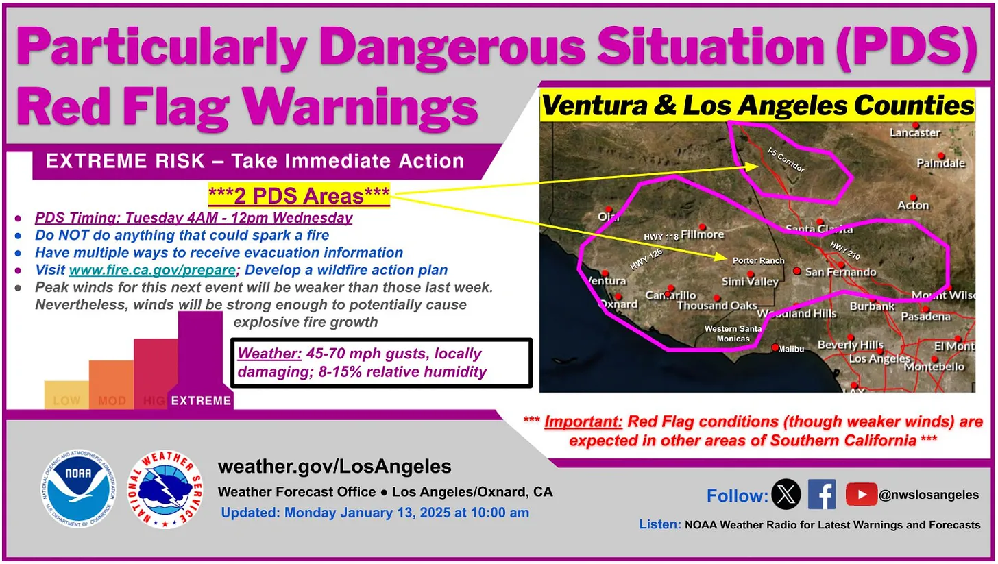
Here come those Santa Ana winds again …
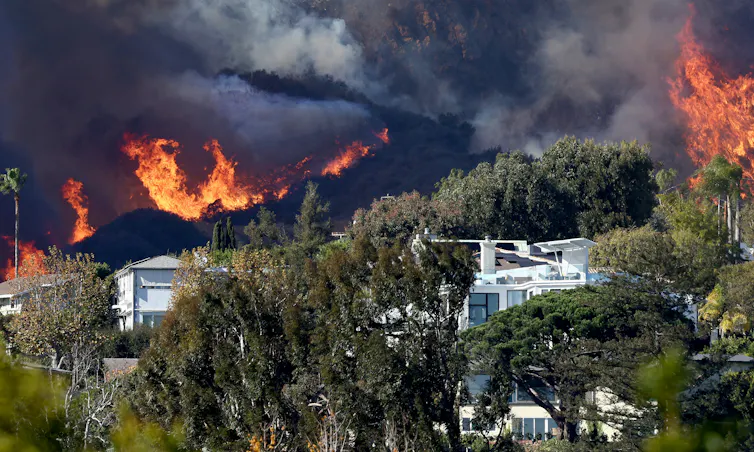
The National Weather Service has issued an extreme fire danger bulletin for a good chunk of the greater Los Angeles metro area, including a “particularly dangerous situation” alert, through tomorrow as the Santa Ana winds kick up again. This as the Palisades and Eaton fires continue to burn, having already taken 24 lives and an estimated 12,300 structures.
It’s been stunning to watch the destruction from afar and heartbreaking to imagine the collective sense of loss rippling across the sprawling metropolis of 18 million. The immensity of it all, the rate at which the fires spread, and the way the Santa Anas send flaming embers into the air to spawn their own blazes miles away is horrifying. Equally baffling is the way the tragedy seems to have opened up a firehose of stupidity, finger-pointing, and grandstanding, issuing forth from the President-elect, Elon Musk, political pundits, and and even Rep. Marjorie Taylor Greene, who asked: “Why don’t they use geoengineering like cloud seeding to bring rain down on the wildfires in California? They know how to do it.”2
I considered spending a bunch of words explaining how and why these folks are wrong. But even acknowledging their existence and repeating their inane lies makes me vomit a bit in my mouth, and trying to debunk even a fraction of the claims is to play a futile game of whack a mole, though that’s not stopping California’s government from trying. As an antidote, I’ve been reading some smart things about the fires, the Santa Ana winds, and Los Angeles, and I figured it would be nice to share some of them with you.
Start out with Joan Didion’s essay on the Santa Ana winds, in which she reminds us that this month’s raging Santa Anas aren’t entirely unprecedented. A two-week long Thanksgiving-time Santa Ana event in 1957 included 100-mph gusts that toppled oil derricks, propelled heavy objects through the air (some of which killed people), and drove a blaze through the San Gabriels for well over a week. She writes:

Then check out the opening lines of Raymond Chandler’s Red Wind (and how can you stop reading after this!?):

And the late Mike Davis’s “The Case for Letting Malibu Burn” should be required reading in these times. And yes, it’s quite a bit more nuanced than the title might suggest. Davis gives a good history of post-colonial fires in the Malibu area and explains how in 1930 Frederick Law Olmsted, Jr., called for turning 10,000 acres there into a public park (that could have burned in natural cycles, without destroying homes).
Alas, that didn’t happen. Instead, Malibu was developed, and fires roared through there in 1930, 1935, 1936, 1937, and 1938. The city had the opportunity to acquire 17,000 acres for just $1.1 million and turn it into a preserve in 1938 — it passed up the chance. Housing came, instead, along with more destructive fires. He writes:

Each fire, then, was followed by reconstruction on a larger, more exclusive scale. Malibu went from being a ranching, rural area, to a bohemian enclave, to a high-end suburb. “Two kinds of Californians will continue to live with fire:,” Davis writes, “those who can afford (with indirect public subsidies) to rebuild and those who can’t afford to live anywhere else.”
Joshua Frank mentions Davis’s essay in a poignant piece for CounterPunch in which he asks folks to stop their victim-blaming and have a bit of compassion, even if they don’t like L.A.. He writes:

At his Public Lands Media Substack, George Wuerthner talks about how these are really urban wildfires, not forest fires, and so the old mitigation and prevention techniques don’t necessarily apply.

He argues that prescribed burns and thinning wouldn’t have worked, because the fires started in the chaparral, which has a natural fire regime of about 30 to 100 years. Prescribed burns tend to eliminate native species that are then replaced by more flammable grasses.
In an interview with the Los Angeles Times, fire experts Jack Cohen and Stephen Pyne also talk about how these fires don’t fit into conventional notions of wildfire. In both the Palisades and Eaton fires, there were unburned trees sitting right next to homes that had been totally destroyed. Cohen:

Here’s hoping for an ember-free day for Los Angeles.
1 This was corrected from saying it effectively ended their legal bid. As reader Slickrock Stranger pointed out, that’s not necessarily the case. Utah could still take its case to the lower courts and keep losing until it ends up at the Supreme Court (which could again decline to hear the case, or something else). But SCOTUS did shoot down this particular strategy of going straight to the Supreme Court for a decision.
2 Oh, that’s right, because “they” modified the weather so that Hurricane Helene would wreck the southeast and keep all those Republicans from voting. Yeah. No. First off, Marge, while the theory behind cloudseeding is legit, there is scant evidence that it significantly increases precipitation. And, even so, it only works if there are already moisture-laden clouds present to seed. Thus the name. Now, maybe if They sent a hurricane to L.A. blowing inland from the Pacific, it would cancel out the Santa Anas, which blow toward the ocean, and then we’d be fine. Alas, They can’t control the weather.

Click the link to read the obituary on The New York Times website (Guy Trebay). Here’s an excerpt:
February 2, 2025
She was a figure out of fiction, right down to her Jane Austen name. The daughter of a baroness and a British major (a spy during World War II), Marianne Faithfull — who died this week at 78 — was discovered by the Rolling Stones’ manager, Andrew Loog Oldham, at a record release party in the 1960s while still in her teens. “My first move was to get a Rolling Stone as a boyfriend,” she was often quoted as having said. “I slept with three and decided the lead singer was the best bet.” The bet paid off for both parties. Mick Jagger and Ms. Faithfull dated from 1966-70 and during that time she recorded a series of pop songs, most memorably “As Tears Go By.” Mr. Jagger wrote imperishable Stones hits like “Wild Horses” under the direct inspiration of Ms. Faithfull — lovely, feckless, druggie and unfettered. She was “a wonderful friend,” Mr. Jagger wrote on Instagram this week, “a beautiful singer and a great actress.” She was also a style paragon from the outset…A British journalist once described Ms. Faithfull, in the late 1960s, as “the flowing-haired, miniskirted, convention-knocking epitome” of a “drug generation” that her elders were challenged to understand. What more accurately she epitomized was a spirit of bohemian laissez-faire better located in class than any particular era.
I’m at the Colorado Water Congress Annual Convention. The next 3 days should be a hoot!
Speaker Bios and Agenda: https://coloradowatercongress.growthzoneapp.com/ap/CloudFile/Download/pMmYw69p
Click the link to read the obit on The New York Times website (Peter Applebome). Here’s an excerpt:
January 21, 2025
Garth Hudson, whose intricate swirls of Lowrey organ helped elevate the Band from rollicking juke-joint refugees into one of the most resonant and influential rock groups of the 1960s and ’70s, died on Tuesday in Woodstock, N.Y. He was 87 and the last surviving original member of the group…Mr. Hudson, Canadian-born, did far more than play the organ. A musical polymath whose work room at home included arcana like sheet music for century-old standards and hymns, he played almost anything — saxophone, accordion, synthesizers, trumpet, French horn, violin — in endless styles that could at various times be at home in a conservatory, a church, a carnival or a roadhouse.
He was the one who set up, installed and maintained the recording equipment in the pink ranch house in Saugerties, N.Y., where Bob Dylan and the Band recorded more than 100 songs that came to be known as the basement tapes…When the Band became a force on its own, he arranged the music on the group’s albums and painstakingly tweaked and honed its recordings. He added brass, woodwinds and eclectic flourishes that accentuated the group’s homespun authenticity, a quality that set it apart from the psychedelia and youthful posturing of the rock of its era.
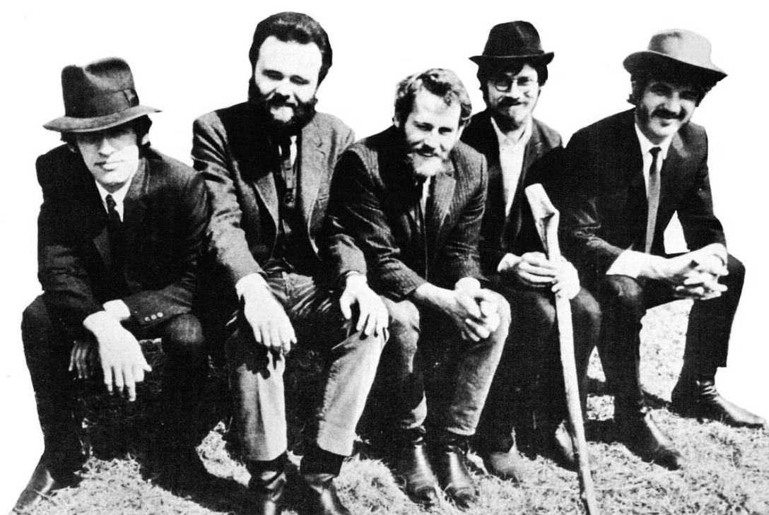
Mr. Robertson, quoted in Barney Hoskyns’s 1993 book, “The Band: Across the Great Divide,” called him “far and away the most advanced musician in rock ’n’ roll.”
“He could just as easily have played with John Coltrane or the New York Symphony Orchestra as with us,” Mr. Robertson said.

Click the link to read the release on the High Line Canal Conservancy website (Suzanna Fry Jones):
DENVER, CO – January 23, 2025 – The High Line Canal Conservancy announced today that Harriet Crittenden LaMair, the organization’s founding CEO, will step down after 11 years of visionary leadership. Harriet will remain in her role until mid-2025 to ensure a seamless transition as the Conservancy begins its next chapter.
“The preservation and protection of the High Line Canal have been my passion for the past 11 years,” said LaMair. “It has been an honor and joy to work with so many friends and partners to secure a vital future for the old Canal. Given the Canal safeguards that we have put in place, I am confident this is the right time to step away from leading the Conservancy. Together with Denver Water, local governments and private support, we have permanently protected the Canal under a conservation easement, improved community access and safety and established a strong stewardship endowment, forever ensuring improved care along all 71 miles,” said LaMair.
LaMair’s impact is significant, having spearheaded the creation of the High Line Canal Conservancy in 2014, transforming it from a startup nonprofit into a trusted regional leader. Under LaMair’s leadership, the Conservancy has achieved historic milestones: securing over $33 million in private investment matched by public funds for more than $100 million in Canal improvements, establishing a Canal Collaborative that unites 14 jurisdictions, launching impactful community programs and protecting the Canal with a conservation easement.

“Harriet has been a trusted leader and champion for the Canal over the years and has set us up for success,” said Arapahoe County Commissioner Carrie Warren-Gully. “We would not be where we are today without her tenacity, vision and commitment to the long-term protection and stewardship of the Canal. She is leaving a lasting legacy and big shoes to fill — and a collective awareness that we all have a responsibility to care for this regional treasure now and forever.”
LaMair’s contributions have garnered regional and national acclaim, including the 2017 Jane Silverman Ries Award and the 2022 Denver Regional Council of Governments Metro Vision Award.
“Harriet’s leadership has been nothing short of transformative, shaping the High Line Canal Conservancy into a trusted and respected regional leader,” said Alan Salazar, CEO of Denver Water. “Her unwavering passion for the natural world and her exceptional ability to bring people together have united communities and organizations around a shared vision for the Canal’s future. Denver Water is proud to have partnered with Harriet and the Conservancy in this remarkable journey, and her legacy will undoubtedly inspire continued stewardship and collaboration for generations to come.”
Paula Herzmark, Chair of the High Line Canal Conservancy Board, credited LaMair with being the driving force behind the Conservancy’s success: “Through her vision and determination, she not only built an organization but also inspired a regional movement that will benefit communities for generations. We owe her an incredible debt of gratitude for her leadership and passion for this remarkable resource.”
As the Conservancy moves forward, it remains steadfast in its mission to preserve and enhance the 71-mile High Line Canal. Over the next three years, the organization will implement more than 30 improvement projects, expand community programs and advance natural resource management initiatives. Herzmark reiterated the Board’s commitment to building on LaMair’s legacy, stating, “As Harriet transitions from her role, we remain committed to carrying forward the legacy she created.”
The Conservancy’s Board is actively preparing for this leadership transition and is committed to identifying a new CEO who will continue advancing the Conservancy’s mission and vision. More information about the job posting will be shared in the coming weeks. In the meantime, interested parties can contact employment@highlinecanal.org for inquiries.
About the High Line Canal Conservancy
The High Line Canal Conservancy is a nonprofit dedicated to preserving, protecting and enhancing the 71-mile High Line Canal. Since its founding in 2014, the Conservancy has led a regional effort to ensure the Canal remains a vibrant and enduring resource. Learn more at HighLineCanal.org.

Click the link to read the article on the Land Desk website (Jonathan P. Thompson):
January 17, 2024
🤯 Crazytown Chronicle 🤡
You really can’t make this stuff up: The Garfield County board of commissioners really wants to name a highway in their midst after President-elect Donald Trump. They will consider two options at their Jan. 27 meeting, with the first one being to change the “Burr Trail Scenic Backway” to the “Donald J. Trump Presidential Burr Trail Backway.”
Oy frigging vey.
The Burr Trail, which runs from Boulder, Utah, through Grand Staircase-Escalante National Monument, the Waterpocket Fold, and Capitol Reef National Park, ending up just outside Ticaboo, started out as a livestock trail in the 1880s and is named after rancher John Atlantic Burr. It is now not only a spectacularly scenic drive, but also one of the most controversial roads in the West.
Portions of the trail became a road in 1948, when the Atomic Energy Commission bulldozed the switchbacks through the Waterpocket Fold to provide motorized access to uranium mining claims. According to a National Park Service history, the road was widely used by uranium miners throughout the ‘50s and into the ‘60s. In 1967 the federal government funded improvements to the route as part of a project to provide road access to the new Bullfrog Marina on Lake Powell (which started filling up in 1963)
Ever since, Garfield County has wanted to continue to improve the road and, ultimately, pave its entire 66 miles, thinking it would attract a more conventional, bigger-spending brand of tourists than the dirtbag backpackers that frequented the region in the 70s and 80s. The county was in tough shape economically, largely because market forces were crushing the uranium mining industry and small-scale ranching, and so it was looking to fill the void with tourism. In 1983, Wayne County Commissioner and paving advocate H. Dell LeFevre told the New York Times:


Environmental groups and the National Park Service, however, have pushed back, saying paving the gravel, washboarded route would encroach on federal lands and increase access — and impacts — to the backcountry. Conservationists launched lawsuits countering county claims that it owns the road and should control how it’s maintained.
The Burr Trail thus became yet another symbol in the long-running culture war over roads, federal land management, and an arcane federal mining law statute known as RS-2477.
In 1987, as an environmental lawsuit seeking to block blacktopping made its way through the courts, someone poured sugar into the fuel tanks of Garfield County bulldozers being used to work on the Trail, a la the Monkey Wrench Gang. A local uranium miner and founding member of what would become the Southern Utah Wilderness Alliance was charged with the crime but acquitted.
Shortly thereafter, a district judge ruled against the environmentalists and allowed the BLM to greenlight Garfield County’s bid to blacktop the section of road from Boulder to the western boundary of Capitol Reef National Park.
That didn’t end the battle, however. Garfield County has continued its crusade to pave the remainder of the route, and the Burr Trail has been featured in many a court case. In 1996, the National Park Service dragged the county to court after its crews bulldozed a hill to fix a blind corner. And in 2019, Trump’s Bureau of Land Management permitted it to chip-seal a seven-mile section on the other side of Capitol Reef NP; the county carried out the work before environmentalists had a chance to challenge it. A judge ultimately let the asphalt remain.2
The Burr Trail, in other words, is almost as polarizing as a certain president-elect, which could be one reason a rural Utah county wants to rename the backroad after a Manhattan real estate baron and reality TV show host who has never set foot in that part of the world and sure as hell couldn’t tell a juniper from a piñon tree even if a giant coyote whacked him over his orange head with it.
But Garfield County Commissioner Leland Pollack says he wants to rename the route to show his appreciation for Trump’s first-term policies, including shrinking Grand Staircase-Escalante National Monument, telling KSL: “This is just a sign of appreciation. This guy right here was good to Garfield County and he was good to all of the Western public land counties.” Sure, Leland.
The Grand Staircase-Escalante Partners opposes the renaming, even going so far as to refuse to utter the proposed new name in its press release. The statement notes:

🌵 Public Lands 🌲
In its waning days, the Biden administration has been quite active on the public lands front. In a future post I’ll get into Biden’s environmental legacy, but for now here’s a quick rundown of some of the administration’s latter-day moves:
- Biden’s designation of the Chuckwalla National Monument in southern California adds another link to what is now being called the Moab to Mojave Conservation Corridor, a strip of protected lands that follows the Colorado River from southeastern Utah to the Mojave Desert. Prior to Chuckwalla, Biden bolstered the corridor by restoring Grand Staircase-Escalante and Bears Ears national monuments and by establishing the Baaj Nwaavjo I’tah Kukveni and Avi Kwa Ame national monuments.

- The administration finalized the management plans for both Grand Staircase-Escalante and Bears Ears national monuments. I’m not going to give a full rundown on the plans here, because they are so similar to the draft plans, which I detailed in earlier dispatches (GSENM & Bears Ears). There are a few modifications, however. Perhaps most significant is that a ban on recreational shooting throughout Bears Ears was scaled back to apply only to campgrounds, developed recreation sites, rock writing sites, and structural cultural sites. Meanwhile, both plans, especially Bears Ears, take an overly laissez faire approach to livestock grazing, perpetuating impacts on ecological and cultural resources.
- The federal Bureau of Land Management terminated Utah’s right of way for a proposed four-lane highway across the Red Cliffs Conservation Area outside St. George. The state and Washington County have been trying for years to build the road in order to “accommodate” the area’s breakneck growth. In 2020, the Trump administration finally issued a right of way, but conservationists sued and forced the BLM to reconsider. In December, the agency sided with the conservationists, revoking the right of way and suggesting St. George expand the existing Red Hills Parkway rather than build a new road through desert tortoise habitat.
- The Interior Department launched the process of banning new mining claims and mineral leases on about 270,000 acres of federal land (plus an additional 40,000 acres of private land the feds hope to acquire) near Ash Meadows National Wildlife Refuge in Nevada. Conservationists had been looking to get added protections on the area after lithium mining and geothermal energy companies began eyeing it.
***
Republican lawmakers have launched their latest bid to diminish a president’s power to protect landscapes and cultural resources. This week, Rep. Celeste Maloy, of Utah (and who happens to be Ammon Bundy’s cousin), and Rep. Mark Amodei, of Nevada, introduced the Ending Presidential Overreach on Public Lands Act, which would gut the 1906 Antiquities Act and end a president’s power to establish national monuments. I doubt this will make it very far, since national monuments and parks are pretty damned popular, and Grand Canyon, Zion, Arches, and many other national parks were first established as national monuments under the Antiquities Act.
***
On that note, the Senate held hearings on Trump’s nominee for Interior Secretary, Doug Burgum. Burgum is the former governor of North Dakota, which, by the way, is not considered a public lands state. So it’s a bit bizarre that he’s even being considered for this position — except he is big on fossil fuels and is clearly on board with Trump’s “drill, baby, drill-energy dominance” approach. In the clips I saw, Burgum displayed a lack of knowledge on the public lands he will probably soon oversee. For example, he talked about timber harvesting on public lands, when most public-land logging occurs on U.S. Forest Service land, which is overseen by the Agriculture Department, not Interior. Then he responded to a question about the aforementioned Antiquities Act, saying: “The 1905 Antiquities Act … it’s original intention was to protect … antiquities … areas like Indiana Jones type archaeological protections.” Uhhh… that would be the 1906 act, buddy. And what the hell are Indiana Jones type archaeological protections? Do we really want an Interior Secretary who gleans his knowledge from the movies? Oy.
Energy Fuels — the owner of the White Mesa uranium mill and the Pinyon Plain mine — is perhaps the most active of all the uranium companies making a lot of noise about exploration and reopening long-idled facilities. They are also the most vocal, telling reporters that current safety and environmental standards and regulations and enforcement are far better than during the Cold War era when the industry ravaged lives and the landscape.
As if to prove the point, the federal Mine Safety & Health Administration recently issued 16 citations to Energy Fuels and its contractors working on the company’s La Sal Mines Complex in southeastern Utah. Violations related to radon concentration and radon monitoring requirements, worker training, personal protection equipment use, and explosive material storage.
Sarah Fields, of Uranium Watch, says she’s “never seen this many violations of this nature at an operating uranium mine from a single inspection.”
One of the contractors, Three Steps Resources, is run by Kyle Kimmerle, holder of numerous mining claims throughout southern Utah and a party to Utah’s lawsuit seeking to revoke Bears Ears National Monument.
1 LeFevre would become an outspoken opponent of Bill Clinton’s 1996 designation of Grand Staircase-Escalante National Monument. Interestingly, many opponents of that and the Bears Ears designation worried that they would increase industrial-scale tourism.
2 Garfield County also wants to pave a portion, at least, of the Hole-in-the-Rock road, which also crosses a section of GSENM near Escalante. Conservationists are also pushing back.


Click the link to read the article on the High Country News website (Natalia Mesa):
January 17, 2025
As a child, herding her grandmother’s sheep, Teracita Keyanna unknowingly wandered onto land contaminated with radioactive waste from three abandoned uranium mine and mill waste sites located near her home on the Navajo Nation.
Keyanna and other Diné citizens have been living with the consequences of uranium mining near the Red Water Pond Road community since the 1960s. But now, uranium waste rock that has sat for decades at a Superfund site will finally be moved to a landfill off tribal land.
“This is a seismic shift in policy for Indigenous communities,” said Eric Jantz, an attorney for the New Mexico Environmental Law Center.
On Jan. 5, in a first-of-its-kind move, the Environmental Protection Agency signed an action memo to transport 1 million cubic yards of low-grade radioactive waste from the Quivira Mining Co. Church Rock Mine to a disposal site at the Red Rock Regional Landfill. The Northwest New Mexico Regional Solid Waste Authority owns and operates the landfill, which is located about 6 miles east of Thoreau, New Mexico.
“I feel like our community has finally had a win,” Keyanna said. She is a member of the Red Water Pond Road Community Association, a grassroots organization made up of Diné families that have been advocating for the waste removal for almost two decades. “It’ll help the community heal.”
Companies extracted an estimated 30 million tons of uranium ore on or near the Navajo Nation from 1944 to 1986, largely to fuel the federal government’s enormous nuclear arsenal. When the mines were abandoned in the 1980s, the toxic waste remained. Today, there are hundreds of abandoned mines in plain sight on the Navajo Nation, contaminating the water, air and soil. Altogether, there are an estimated 15,000 uranium mines across the West — 1,200 of them on the Navajo Nation alone — with the majority located in the Four Corners region.
The impact of all this mining on Diné communities has been devastating. A 2008 study found uranium contamination in 29 water sources across the Navajo Nation, while other studies show that people living near waste sites face a high risk of kidney failure and various cancers.
At Quivira, the cleanup is set to begin in early 2025 and will continue for six to eight years, according to an EPA news release. The permitting process, which will provide opportunity for public comment, will be overseen by the New Mexico authority that manages the proposed waste site and is responsible for its long-term safety monitoring.

The EPA had considered multiple options for waste remediation. But for years, Red Water Pond Road advocates and other local organizations continually pushed it to simply remove the waste, a course of action that the EPA has never taken before, even though the Navajo Nation has repeatedly called for the federal government to move all uranium waste from Diné tribal land.
Throughout the Navajo Nation, said Jantz, “prior to this decision, EPA’s primary choice in terms of remediation of mine was to bury the piles under some dirt and plant some grass seeds on top, called cap in place.” But studies have shown that this approach is not effective at containing radioactive waste in the long term, he said.
The agency took a similar approach when addressing the other uranium waste in the Church Rock area. In 2013, the EPA and the Nuclear Regulatory Commission, which oversees uranium mine-waste cleanup, dumped 1 million cubic yards of waste from the Northeast Church Rock Mine — a different waste site, roughly 3 miles from the Quivira Mine — on top of existing tailings located half a mile from the Red Water Pond Road communities.
But the EPA plans to handle the Quivira Mine’s waste differently, placing it in geoengineered disposal cells with a groundwater leak protection system after it is moved off-site, an approach that Jantz called “state-of-the-art.”
The Quivira Mine cleanup is part of the 2014 Tronox settlement, which provided $5.15 billion to clean up contaminated sites across the United States. The settlement allocated $1 billion of those funds to clean up 50 uranium mines across the Navajo Nation.
There is a lot more to be done, said Susan Gordon, coordinator for the Multicultural Alliance for a Safe Environment, a grassroots organization led by uranium-impacted communities. Hundreds of abandoned mines pepper the Navajo Nation, and the EPA has not formulated a broader plan to clean up the majority of them. Funding is also an issue, she added.
What the EPA’s decision means for the future of uranium mine waste remediation is unclear. Under other circumstances, Jantz said that the decision would signal a sea change for the EPA’s policy of removing waste from the Navajo Nation. But the incoming Trump administration has not indicated its policy on hazardous waste disposal.
As Jantz put it, “All bets are off.”

Justin Angle, University of Montana
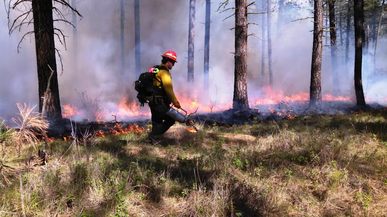
The fires burning in the Los Angeles area are a powerful example of why humans have learned to fear wildfire. Fires can level entire neighborhoods in an instant. They can destroy communities, torch pristine forests and choke even faraway cities with toxic smoke.
Over a century of fire suppression efforts have conditioned Americans to expect wildland firefighters to snuff out fires quickly, even as people build homes deeper into landscapes that regularly burn. But as the LA fires show, and as journalist Nick Mott and I explored in our book “This Is Wildfire: How to Protect Your Home, Yourself, and Your Community in the Age of Heat” and 2021 podcast “Fireline,” this expectation and our society’s relationship with wildfire need to change.
Over time, extensive fire suppression, home construction in high fire-risk areas and climate change have set the stage for the increasingly destructive wildfires we see today.
The way the U.S. deals with wildfires today dates back to around 1910, when the Great Burn torched about 3 million acres across Washington, Idaho, Montana and British Columbia. After watching the fire’s swift and unstoppable spread, the fledgling U.S. Forest Service developed a military-style apparatus built to eradicate wildfire.
The U.S. got really good at putting out fires. So good that citizens grew to accept fire suppression as something the government simply does.
Today, state, federal and private firefighters deploy across the country when fires break out, along with tankers, bulldozers, helicopters and planes. The Forest Service touts a record of snuffing out 98% of wildfires before they burn 100 acres (40 hectares).
One consequence in a place like Los Angeles is that when a wildfire enters an urban environment, the public expects it to be put out before it causes much damage. But the nation’s wildland firefighting systems aren’t designed for that.
Wildland firefighting tactics, such as digging lines to stop a fire from spreading and steering fires toward natural fuel breaks, don’t work in dense neighborhoods like Pacific Palisades. Aerial water and retardant drops can’t happen when high winds make it unsafe to fly. At the same time, the region’s municipal firefighting forces and water systems weren’t designed for this sort of fire – a conflagration engulfing entire neighborhoods quickly overwhelms the system.
Long ago, Southern California’s scrub-forest ecosystems would periodically burn, limiting fuel for future fires. But aggressive fire suppression and inattention to urban overgrowth have left excessive, easy-to-ignite vegetation in many areas. It’s unclear, however, whether prescribed burning could have prevented this catastrophe.
This is primarily a people problem. People have built more homes and cities in fire-prone areas and done so with little regard for wildfire resilience. And the greenhouse gases released by decades of burning fossil fuels to run power plants, industries and vehicles have caused global temperatures to rise, compounding the threat.
The relationship between climate and wildfire is fairly simple: Higher temperatures lead to more fire. Higher temperatures increase moisture evaporation, drying out plants and soil and making them more likely to burn. When hot, dry winds are blowing, a spark in an already dry area can quickly blow up into dangerous wildfire.
Given the rise in global temperatures that the world has already experienced, much of the western U.S. is actually in a fire deficit because of the practice of suppressing most fires. That means that, based on historical data, we should expect far more fire than we’re actually seeing.
Fortunately, there are things everyone can do to break this cycle.
First, everyone can accept that firefighters can’t and shouldn’t put out every low-risk wildfire.
Remote fires that pose little threat to communities and property can breathe life into ecosystems. Frequent, natural fires can also help avoid catastrophic fires that occur when too much underbrush has built up for fuel. And they create fuel breaks on the landscape that could halt the advance of future flames.
Fire managers have advanced mapping technology that can help them decide when and where forests can burn safely. Thoughtful prescribed burning – meaning low-intensity fires intentionally set by professionals – can offer many of the same benefits as the flames that historically burned in forests and grasslands.
The Forest Service is aiming to ramp up its prescribed burning on more acres in more areas across the country. However, the agency struggles to train adequate staff and pay for the projects, and environmental reviews sometimes cause yearslong delays. Other groups offer beacons of hope. Indigenous groups across the country, for example, are returning fire to the landscape.
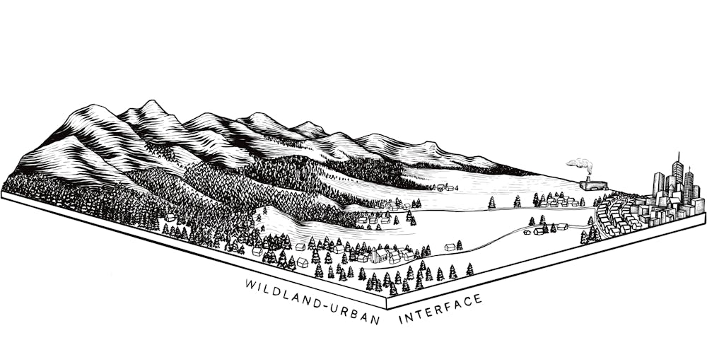
More than one-third of U.S. homes are in what’s known as the wildland-urban interface – the zone where houses and other structures intermingle with flammable vegetation. This zone now includes many urban areas where wildfire risk was not considered when their cities were developed.
The biggest risk to homes comes from burning embers blowing on the wind and landing in weak spots that can set a house ablaze. Those embers can ride high winds for multiple miles to nestle in dry leaves or pine needles clogging a gutter, a wood-shingle roof, or shrubs, trees and other flammable vegetation close to a structure.
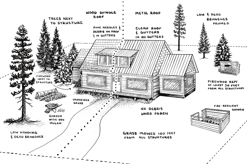
Some of these vulnerabilities are easy to fix. Cleaning a home’s gutters or trimming back too-close vegetation requires little effort and tools already around the house.
Grant programs exist to help harden homes against wildfire. But enormous investment is needed to get the work done at the scale the fire risk requires. For example, nearly 1 million U.S. homes in wildfire-prone areas have highly combustible wooden roofs. Retrofitting those roofs will cost an estimated US$6 billion, but that investment could save lives and property and reduce wildfire management costs in the future.
Homeowners can look to resources such as Firewise USA to learn about the “home ignition zone.” It describes the types of vegetation and other flammable objects that become high risks at different distances from a structure and steps to make properties more fire resilient. https://www.youtube.com/embed/M9sel3wcBLg?wmode=transparent&start=0 The fire chief for Spokane, Wash., explains ways to protect your property from wildfires.
For example, homes should not have flammable plants, firewood, dried leaves or needles, or anything burnable, on or under decks and porches within 5 feet (1.5 meters) of the house. Between 5 and 30 feet (9 meters), grasses should be mowed short, and the tree canopy should be at least 10 feet (3 meters) from the structure.
The key takeaway is that homeowners must begin to view their homes as potential fuel for a wildfire.
A possible outcome of California’s devastating fires is that states and communities could enact forward-looking wildfire resilience policies. These can include developing zoning rules and regulations that require developers to build with fire-resistant materials and designs. Or they might prohibit building in areas where the risk is too high.
California’s move to fast-track reconstruction, if it isn’t planned with wildfire safety requirements, will just set up the state for more fire disasters. The International Wildland-Urban Interface Code, which provides guidance for safeguarding homes and communities from wildfire, has been adopted in jurisdictions in at least 24 states. California is not one of them.
Prevention and suppression will always be critical pieces of wildfire strategy. Though promising new firefighting technologies are being developed, adapting to a fiery future means everyone has a role.
Educate yourself on how wildfire is managed in your area. Understand and address risks to your home and community. Help your neighbors. Advocate for better wildfire planning, policy and resources.
Living in a world where more wildfire is inevitable requires that everyone see themselves as part of solving the problem. It means we must accept that some fire is natural and essential and that some places we love might be too dangerous to protect.
This is an updated version of an article originally published Aug. 22, 2023.
Justin Angle, Professor of Marketing, University of Montana
This article is republished from The Conversation under a Creative Commons license. Read the original article.

Click the link to read the article on the High Country News website (Christine Peterson, Photography — Louise Johns:
The prairie dog caught in Trap 69 was angry. And who could blame her? After waking up in her burrow on a mid-September morning, she’d waddled innocently outside for a breakfast of mini marshmallows and carrots, only to find herself stuck in a wire cage and carried across the prairie. Then a pair of human hands had gripped her like a burrito while two more hands put a black rubber tracking collar around her neck.
The situation was worse than she realized: Prairie dogs are among the most maligned and persecuted animal species in the Western U.S. So maligned, in fact, that a 2020 survey in northern Montana found that well over half the area’s landowners believed prairie dogs should not live on public land.
To make matters even grimmer, this particular prairie dog had fleas. And those fleas could have been carrying the bacteria that causes plague — the Black Death. “It’s not great,” commented researcher Jesse Boulerice as he adjusted his gentle grip around her midsection.
The rodent responded by biting into Boulerice’s leather glove, hanging on with her two front teeth while researchers swiped a black streak of Clairol’s Nice’n Easy hair dye down her back.
Though black-tailed prairie dogs have a long-standing reputation as pests, their ingenious tunnel systems and industrious prairie pruning make them one of the West’s primary ecosystem engineers. Some researchers call them the “chicken nuggets of the prairie”; if a prairie species eats meat, it almost certainly eats prairie dogs. Without prairie dogs, black-footed ferrets would never survive outside zoos and breeding facilities, and we would have far fewer mountain plovers, burrowing owls, swift foxes, and ferruginous hawks.
Before 1800, an estimated 5 billion prairie dogs lived from Canada to Mexico, covering the West with underground apartment complexes that shifted over the centuries like sand dunes. The Lakota, Dakota and other Indigenous peoples of the prairie shaped and depended on the ecosystems prairie dogs created. Some relied on prairie dogs for nourishment during thin times, or used them as a ceremonial food.
But European settlers were remarkably effective at shooting and poisoning prairie dogs and plowing up their burrows. Today, the five prairie dog species occupy just 2% of their historic range, and some occupy even less.
Prairie dogs still survive in many of their historic territories: Black-tailed prairie dogs, known for their especially large, dense colonies, persist in isolated pockets of the prairie east of the Rocky Mountains from Canada to Mexico. White-tailed prairie dogs live in parts of Montana, Wyoming, Utah and Colorado. Gunnison’s prairie dogs eke out an existence in southern Colorado, and Utah prairie dogs live in, well, Utah. Mexican prairie dogs still hang on in small slices of northern Mexico. But many of these populations are too small to serve their ecosystems as they once did.
Within this familiar story of colonization and species decline, however, are more hopeful stories of creativity and adaptation: Researchers are using pedometer-like devices to map prairie dogs’ underground tunnels, remote-controlled badgers to understand prairie dog alarm calls and Kitchen-Aid mixers to craft solutions to deadly disease. After decades of restoration work by tribal wildlife managers, prairie dogs, black-footed ferrets, swift foxes and bison are once again roaming the Fort Belknap Indian Reservation in north-central Montana, one of the few places in the world where all four species coexist. Some private landowners, meanwhile, are finding ways to tolerate the rodents. Together, these researchers, managers and landowners are striving to conserve the West’s remaining prairie dogs and the prairie that depends on them.

ONCE THE COLLARED prairie dog was returned to her Tru Catch wire cage to await release, Boulerice reached into the next trap in line.
Boulerice is part of a team from the Smithsonian’s National Zoo and Conservation Biology Institute that is collaring and tracking prairie dogs at American Prairie — formerly the American Prairie Reserve — in central Montana. Each collar measures the animal’s acceleration and angle; by triangulating with locations picked up by sensors posted on poles throughout the colony, researchers can determine where and how far the prairie dogs travel both above and below ground. The Clairol dye patterns provide one more way to tell who’s who in a colony of look-alikes.
Though other researchers have studied prairie dogs’ aboveground lives, no one really knows what they do underground. Satellite imagery can be used to track Arctic terns over Alaska or grizzly bears deep in the wilderness, but it can’t penetrate the Earth. Decades ago, researchers laboriously excavated a white-tailed prairie dog burrow in southern Montana, revealing features like “sleeping quarters,” hibernacula, and a “maternity area” — but such work is invasive and yields little data on the animals’ movements.
At American Prairie in September, the Smithsonian team was joined by researchers from Swansea University in Wales who had developed the tracking collars Boulerice used. The collars were originally designed to study penguins underwater, an environment similarly resistant to conventional satellite tracking.
Prairie dogs aren’t the only occupants of prairie dog burrows. The mazes of tunnels and rooms also provide shelter for black-footed ferrets, swift foxes and untold numbers of insects. Burrowing owls shimmy their puffball bodies into the tunnels, where they raise their chicks on the plentiful bugs. Prairie rattlesnakes, tiger salamanders, horned lizards and badgers use them, too.
And as climate extremes become more common aboveground, these burrows may become even more important.
“By creating tunnels, they’re also creating a thermal refuge,” said Hila Shamon, the director of the Smithsonian’s Great Plains Science Program and principal investigator of the colony-mapping project. “The prairie can be so hot in the summer or brutally, brutally cold in the winter. You don’t have any shade or place to hide from the cold … and conditions in the tunnel systems are consistent.”
Prairie dogs spend much of the day and all night in their burrows, living in family coteries composed of one male, three or four females and the year’s young. Their tunnel systems, which can extend across an area larger than a football field, are like bustling apartment complexes where every family has its separate unit. Residents periodically pop out of doors to grab food, gossip about the neighbors and scan for danger.
“In the prairie,” Shamon said, “there’s a whole world that’s happening beneath the ground that we can’t see. But it exists, and it’s very deep, and it’s important.”
Aboveground, the effect of prairie dogs on the landscape is more obvious. “Prairie dogs create an entirely novel habitat type,” said Andy Boyce, a Smithsonian research ecologist. “They graze intensely. They increase the forbs and flowering plants, and they clip woody vegetation. They will eat and nibble on a new woody plant until it tips over and dies.”
The landscape created by prairie dogs may look barren, but the reality is more nuanced. A healthy prairie isn’t an uninterrupted sea of grass; it’s made up of grass and shrubs, wetlands and wildflowers and even large patches of bare dirt that allow prairie dogs — and other species — to spot approaching predators.
Bison like to wallow in the dirt exposed by prairie dogs, and graze on the nutritious grass and plants that resprout after a prairie dog pruning. Mountain plovers and thick-billed longspurs frequently nest on the grazed surface of prairie dog towns. (Both birds have declined along with prairie dogs; the mountain plover has been proposed for protection under the Endangered Species Act.)
Prairie dog colonies may also provide other species with a home-alarm system. “You have 1,000 little pairs of eyeballs constantly searching for predators all around you and then vocalizing loudly when they see them,” Boyce said. To test this hypothesis, Boyce’s Ph.D. student Andrew Dreelin attached a taxidermied badger to a remote-controlled car and drove it near long-billed curlew nests in Montana prairie dog colonies. He then measured how nesting curlews responded to the badger with and without a warning from the prairie dogs.
Results are pending, said Dreelin, but he’s certain that “we’ve only just started to scratch the surface on the multifaceted ways that prairie dogs could shape the lives of birds on the prairie.”

IN EARLY OCTOBER, about 500 miles south of American Prairie, Colten Salyer also donned thick leather gloves to protect himself from an angry mammal’s teeth. Then he opened a cat carrier filled with paper shavings and a member of a species once considered extinct.
The young black-footed ferret inside bared its long white canines. Bred at the National Black-Footed Ferret Conservation Center in northern Colorado, she was one of 20 about to be reintroduced to southcentral Wyoming’s Shirley Basin.
The black-footed ferret is North America’s only native ferret and one of only three ferret species in the world. And if there’s one thing black-footed ferrets need, it’s prairie dogs. They eat them almost exclusively, and they use their tunnels to live, hunt and reproduce, slipping in and out of burrows as they move like water across the landscape.
In 1980, black-footed ferrets were declared extinct, most likely extinguished by disease, development and endless prairie dog poisoning campaigns. But in 1981, a northern Wyoming ranch dog proudly presented his owners with his most recent treasure: a dead ferret. A local taxidermist confirmed that it was, in fact, a black-footed ferret, a member of a tiny remnant population.
The newly discovered ferrets lived in the wild until 1985, when biologists discovered that disease had killed all but 18. At that point, they scooped up the remaining ferrets and took them to captive breeding facilities. Only seven successfully reproduced, but those seven now have more than 11,000 descendants. In 2020, researchers used DNA from a wild-caught ferret with no surviving offspring to produce the first cloned ferret. Since then, they have created two more cloned individuals, and this past November, the U.S. Fish and Wildlife Service announced that one had given birth to healthy kits.
Captive-bred ferrets have now been released across the West. But to survive long-term, they need prairie dog colonies. And prairie dogs aren’t popular with their human neighbors.
Because they eat the same grass cows do. And they make holes.
“I was running to rope a yearling once, and I stood up in the saddle and was about to open my hand — and all of a sudden the horse’s front end disappeared,” said Salyer, a ranch manager in Shirley Basin who volunteered to help with the releases. His horse had sunk a hoof into a prairie dog hole, a misstep that sent Salyer tumbling to the ground.
Both Salyer and his horse were fine, and he shrugged after telling the story.But most ranchers have, or have heard, similar stories, many of which end with a valued horse breaking a leg. There’s no way to know how frequently horses injure themselves in burrows, but the stories spread as fast as a prairie fire.
What’s certain is that prairie dogs eat grass. Quite a bit of grass: A single prairie dog can devour up to 2 pounds of green grass and non-woody plants every week, according to Montana State University. For ranchers who use that vegetation to feed their cows, prairie dogs look like competition. Researchers, however, say the effects of prairie dogs on livestock forage are mixed. Black-tailed prairie dogs’ propensity to clip and mow, for instance, results in plants with higher fat and protein and lower fiber. “Across years, enhanced forage quality may help to offset reductions in forage quantity for agricultural producers,” a study published in 2019 by Rangeland Ecology and Management reported.
This uncertainty has led to some bureaucratic contradictions. The Wyoming Department of Agriculture labels prairie dogs as pest species and offers training in properly using pesticides to kill them; at the same time, the Wyoming Game and Fish Department lists the black-tailed prairie dog as a species of greatest conservation need.
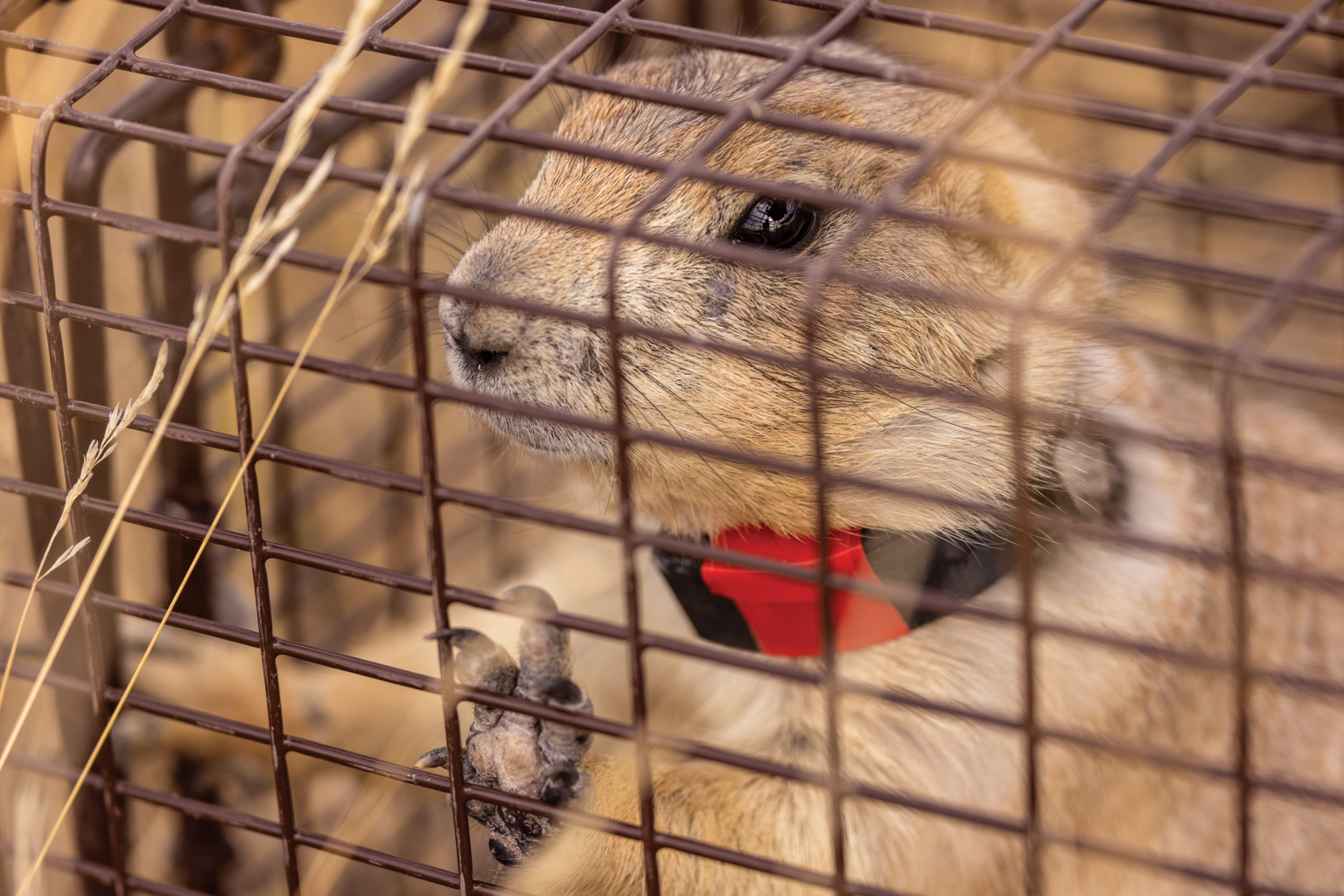
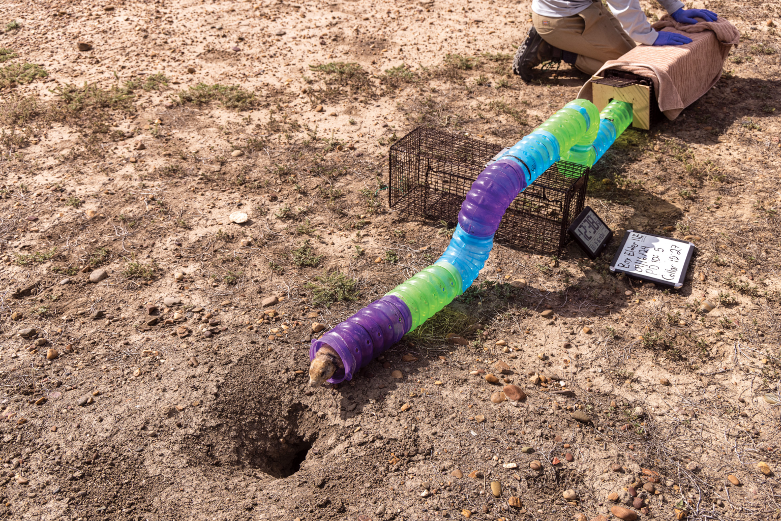
Until the 1990s, said Randy Matchett, a Fish and Wildlife Service biologist in central Montana, prairie dogs were so despised in places like Phillips County, Montana, that the Bureau of Land Management produced maps of their colonies designed for sport shooters. Attitudes haven’t changed much: In 2020, 27 years after an initial survey of attitudes toward black-tailed prairie dogs and black-footed ferrets in Montana, researchers found that feelings about them had barely budged.
Matchett said that when he tells his Montana neighbors that only 2% of prairie dogs remain, a common attitude is: “What the hell’s the holdup getting rid of that last 2%?”
Chamois Andersen, a Defenders of Wildlife senior field representative, has spent decades working with landowners in prairie dog-rich places, and she’s persuaded some to allow researchers to survey their land for black-footed ferrets in exchange for funds for noxious weed removal. She speculates that younger generations of ranchers are more open to prairie dog conservation and to partnerships with public agencies and wildlife groups.
Matchett is less optimistic. Even the U.S. Forest Service and National Park Service, which together manage one of the largest black-footed ferret colonies in the world in South Dakota’s Conata Basin, poison some prairie dogs on federal land to prevent the population from moving onto private property.
Not all prairie dogs are equally reviled. White-tailed prairie dogs like those in Shirley Basin live at lower densities and tend to clip plants farther up the stems, making them less obvious to the casual observer. Landowners, as a result, are often more tolerant of them than their black-tailed cousins, said Andrew Gygli, a small-carnivore biologist for Wyoming Game and Fish.
Bob Heward, whose family started ranching in Shirley Basin more than a century ago, understands that a disliked species can also be useful.
He invites recreational shooters to target prairie dogs on his land, but he won’t use poison to kill the rodents because he knows they provide food for other species. Prairie dogs are a “nuisance,” he said, but they’re also as inevitable as the wind: “We’ve learned to live with them. They’ve been here longer than I have.”
THE MALE SWIFT FOX at the end of the trap line was chunky, at least by swift fox standards: Though he weighed only about 5 pounds, his belly was round beneath his fluffy fur. His black eyes carefully followed Smithsonian researcher Hila Shamon as she loaded him into the backseat of her four-door pickup, covering the trap with a blanket as she prepared to transport him from this ranch north of Laramie, Wyoming, to a new home on the Fort Belknap Indian Reservation in Montana.
Unlike black-footed ferrets, swift foxes can survive without prairie dogs, but when prairie dogs are scarce they suffer from the loss of food, Shamon said, and are deprived of the shelter they find in prairie dog burrows. So they, too, declined as prairie dogs were exterminated and prairie habitat was converted into cropland. By the early 1900s, they had disappeared from Canada, Montana, North Dakota, Nebraska, Kansas and Oklahoma.
But swift foxes still live in parts of the West — and in some places, their populations are being restored. For the last five years, Shamon and her team have trapped swift foxes in Wyoming and Colorado and trucked them to Fort Belknap. This rectangle of grassland, buttes and prairie breaks near the Canadian border is home to the Nakoda (Assiniboine) and A’aninin (Gros Ventre), both Great Plains peoples. Today, it is one of the only places in the world where prairie dogs, swift foxes, black-footed ferrets and bison co-exist.
Montana State Sen. Mike Fox (Gros Ventre), D, who served as Fort Belknap’s director of Fish and Wildlife from 1991 to 2001, oversaw early efforts to restore buffalo, swift foxes and black-footed ferrets to the reservation. The goal was to “create a steady, healthy population of native animals that were driven to extinction because of the different uses of the land,” he said. “Like when they started poisoning the prairie dogs off in the ’30s and ’40s and wiped out the ferrets that were native here, and the same with the swift fox. We want to make as complete an ecosystem as we can, along with the buffalo.”
The tribes worked with the Fish and Wildlife Service to reintroduce black-footed ferrets, and, with researchers at the Smithsonian, World Wildlife Fund and other organizations, to bring back the swift fox. The collaborators spent two years planning the swift fox capture and translocation, Shamon said, considering factors like habitat quality, community attitudes and the overall risk to a re-established population.
Swift foxes had already been reintroduced in parts of Alberta and Saskatchewan and on the Blackfeet and Fort Peck reservations. The reintroduction at Fort Belknap continued the tribes’ restoration efforts and added a possible point of connectivity for other populations.
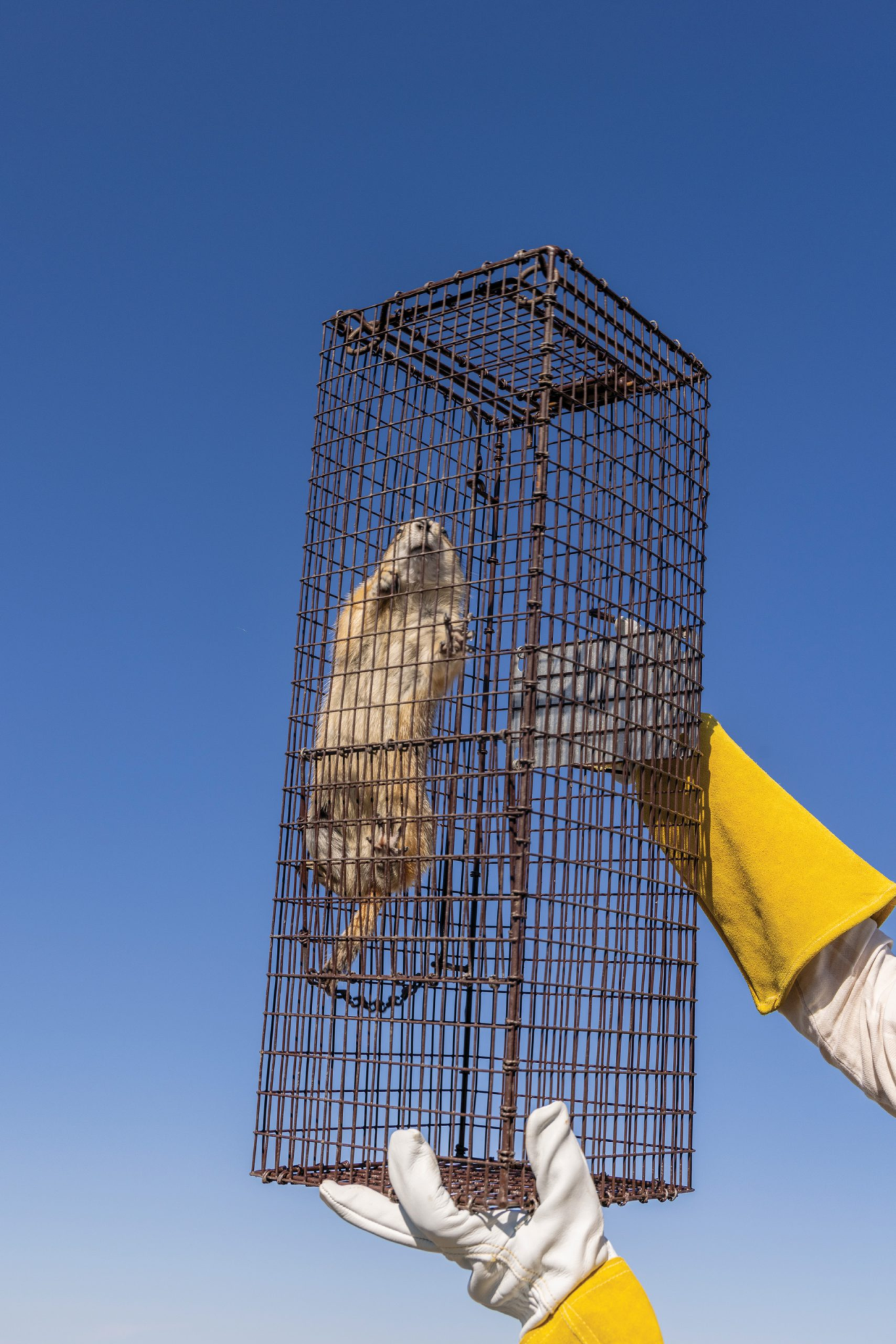
Tribal members living on and near the Fort Belknap Reservation have largely supported the reintroduction of native prairie species, especially after prairie dog numbers were diminished by an outbreak of disease in the late ’90s, Fox said. Now that the population is recovering and has started to clear larger areas of grass, however, some tribal members who raise cattle have begun expressing frustration to the tribal council.
“Wildlife and cattle will graze prairie dog colonies because of the new growth coming back throughout the year,” said Fox. “It makes it look even worse because it’s attractive to wildlife and domestic cattle, and they do their part. When it starts looking like a moonscape is when we get people noticing the most.”
He tells people that the little grass-eating rodents are necessary, and notes that the “moonscapes” aren’t as widespread as they may seem. But like non-Native ranchers across the West, some tribal members equate abundant prairie dogs with fewer cows. Fox doesn’t believe the council will allow widespread prairie dog poisoning on tribal lands — especially since the reservation now hosts black-footed ferrets — but he does worry that opposition could intensify.
Bronc Speak Thunder (Assiniboine), director of the Fort Belknap Buffalo Program, has also heard people complain about prairie dogs, though he added that “people complain about a lot of stuff.”
The tribes aren’t actively restoring prairie dogs, he said; they’re simply refraining from poisoning and shooting them. He sees that prairie dogs benefit tribal land by creating more habitat for ground-nesting birds and serving as food for swift foxes, coyotes, hawks and eagles. They also encourage the growth of nutritious grass for bison. “Like life, it’s a big circle, and that’s where it fits,” he said. “They’re part of the ecosystem that exists, and if you take something out, it throws everything off.”
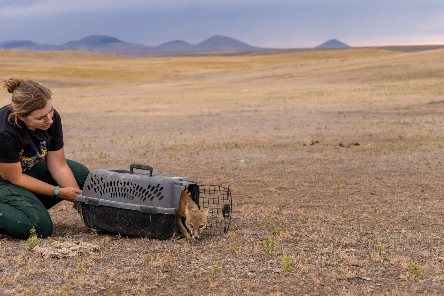
WHEN I MET Randy Matchett, the Fish and Wildlife Service biologist, he sported a cowboy hat and graying horseshoe mustache and carried a handful of Smurf-blue flea-control pellets, each slightly smaller than a marble. The pellets, which Matchett produced in his workshop at the Charles M. Russell National Wildlife Refuge headquarters in Lewistown, Montana, are his latest attempt to protect prairie dogs from a fatal disease.
The pellets contain Fipronil, an insecticide used in treatments likeFrontline to keep fleas and ticks away from household pets, and are flavored with peanut butter and molasses to increase their chances of ending up in prairie dog bellies. Matchett dyes them blue because research shows prairie dogs are attracted to the color, and because the dye stains their feces, making it easy to estimate how many animals have consumed the pellets. Once ingested, Matchett hopes, his “FipBits” will kill the fleas that land on and bite prairie dogs, including the fleas carrying the bacteria that causes plague.
Yes, that plague. The bacte-ria Yersinia pestis causes bubonic plague, which became known as the Black Death after it killed at least 25 million Europeans during the 14th century.
In 1900, the disease arrived in North America via San Francisco, carried by rats stowed away on ships. During the following decades, the development of antibiotics controlled the disease in humans, but plague continued to spread among rodent species, affecting black-footed ferrets, rabbits and squirrels. First detected in prairie dogs in 1936, it devastated populations already hit hard by the conversion of the prairie to agriculture — and it remains a major threat to prairie dogs.
“Once colonies have plague, they can disappear in two weeks,” said Shamon. “There will be thousands of acres chirping with thousands or tens of thousands of animals and in two weeks, you will go map it, and they’re gone.”
A plague vaccine does exist, and is used to protect highly endangered species like black-footed ferrets. But it’s simply not possible to jab every prairie dog in the West. Matchett, who as a Fish and Wildlife biologist is responsible for conserving endangered species, got involved in plague prevention in the early 1990s, initially dusting prairie dog colonies for fleas. In 2013, he began testing oral vaccines in Montana colonies, working in parallel with researchers in seven other states. The first-generation vaccines were red, peanut-butter flavored cubes with a biomarker that tinted prairie dog whiskers pink. Matchett and his colleagues in Colorado also developed vaccine pellets that they mass-produced using a Lithuanian carp bait-making machine. Matchett helped craft a pellet shooter that could be bolted to the front of a four-wheeler.
With the new vaccines primed to launch, Matchett felt hopeful. The World Wildlife Fund, which helped fund some of the work, felt hopeful, too. But in 2018, after years of trials with thousands of prairie dogs, he and other researchers concluded that even when a colony was given oral vaccinations, the number of prairie dogs that survived a plague outbreak was too small to support a black-footed ferret population.
So Matchett pivoted. If he couldn’t inoculate prairie dogs against plague, maybe he could kill the fleas that carried the bacteria. What if he could persuade prairie dogs to eat Fipronil?
He made a new set of pellets with the same bait machine, this time using his wife’s grandmother’s Kitchen-Aid mixer to blend various types of flour, vital wheat gluten, peanut butter, molasses and other food-grade ingredients with a soupçon of flea killer. Early results have been promising: While adult fleas aren’t affected until they bite a prairie dog that’s ingested a pellet, not every flea needs to be killed; studies have shown that in general, fleas don’t trigger plague outbreaks until they reach a critical mass. And flea larvae appear to die when they crawl into or consume treated prairie dog poop, suggesting that the pellets could tamp down flea reproduction as well as kill the adult insects.
FipBits aren’t the only way to reduce the toll plague takes on prairie dogs, but Matchett believes they’re the most likely to work. In his office, perched on stacks of files, are the remnants of another of his many assaults on the problem: dozens of vials of alcohol, each containing bits of prairie dog ears. In 2007 and 2008, Matchett and his colleagues collected the snippets from prairie dogs that had survived plague outbreaks, hoping genetic analysis would explain their fortitude. The material has yet to be analyzed owing to a “combination of lack of funding, interest, time and capability,” Matchett said, but he hopes new funding will allow him and his collaborators to return to the project.
Despite the setbacks, Matchett believes researchers can find a way to control plague in prairie dogs. Human intolerance, as he sees it, is a more stubborn problem. Places like Fort Belknap and the Conata Basin of South Dakota — where prairie dogs are, at least for now, allowed to flourish — remain few and far between.


DRIVE SOUTH from Fort Belknap down Highway 191, head east on a straight gravel road, and you’ll find one more place where prairie dogs are left in peace.
American Prairie began in 2001 as an effort to protect and restore Montana’s grasslands. The nonprofit now manages more than 527,000 acres of private land and federal and state leases. Its ultimate goal is to connect 3.2 million acres of prairie, providing habitat for an array of species from bison to mountain plovers to black-footed ferrets. To the casual observer, American Prairie’s lands may already look like intact prairie, though ecologists like Daniel Kinka can’t help noticing the nonnative crested wheatgrass and the hundreds of miles of fencing.
“This is kind of like the Field of Dreams model: If you build it, they will come,” said Kinka, American Prairie’s director of rewilding. “A better habitat houses more wildlife, and the wildlife that are here are perfectly capable of restoring themselves.”
American Prairie prohibits the poisoning and shooting of prairie dogs on its land, and it regularly hosts research projects such as the Smithsonian’s burrow mapping — which may help explain how plague spreads within colonies — and Matchett’s tests of plague-mitigation tools. Prairie dogs, said Kinka, are the “unsung heroes of a prairie ecosystem,” important to all the other species American Prairie is trying to foster. And as researchers have found, the woody plants that prairie dogs chew down to clear their line of sight tend to be replaced by nutritious grasses and wildflowers, suggesting that even cattle may benefit from their presence.
The possibility that prairie dogs could be good for cattle, or at least not as bad as generally believed, is met with skepticism by American Prairie’s neighbors, many of whom see the nonprofit as a threat to ranching. Signs posted along highways in Phillips County, Montana, read “Save the American Cowboy. Stop American Prairie Reserve.” For now, Kinka isn’t trying to convince anyone to like or even appreciate prairie dogs, aiming instead for tolerance.
The black-tailed prairie dog complex studied by the Smithsonian team at American Prairie is a noisy place, filled with the barks and trills of hundreds of creatures. As I stood beside researcher Jesse Boulerice, listening, it was easy to imagine that the rodents were doing just fine. But they’re not. Will they ever be allowed to exist in numbers like this throughout their historic range?
Boulerice surveyed the surface of the colony, which was covered with dried plant nubs and bare mounds of dirt, and said he wasn’t sure.
Then he released a collared prairie dog who wagged her chubby butt in the air as she scurried into a nearby hole. She promptly popped back up, chirping out a message we’ll never understand. Perhaps she was warning her colony-mates to watch out for those marshmallows and carrots; they hide a nasty trap.
Or maybe she was scolding us — telling us exactly what she thought of our species before she disappeared into her burrow, leaving us to decide the future of hers.

This story is part of High Country News’ Conservation Beyond Boundaries project, which is supported by the BAND Foundation.
We welcome reader letters. Email High Country News at editor@hcn.org or submit a letter to the editor. See our letters to the editor policy.
This article appeared in the January 2025 print edition of the magazine with the headline “The prairie dog conundrum.”

Click the link to read the article on the Boise State Public Radio website (Daniel Spaulding). Here’s an excerpt:
January 13, 2025
Rising seas are forcing Indigenous communities to move. Higher temperatures are causing drought and loss of traditional foods. Michael Charles, a Navajo professor at Cornell University, is trying to quantify the impact of climate change on Indigenous life in North America. Our Living Lands producer Daniel Spaulding spoke to Charles about his work. Charles’ research includes a number of environmental issues impacting Indigenous communities, including air pollution, mining, and migration. To do this, Charles is focusing on Indigenous knowledge of traditional foods, land, and climate patterns.
“We’ll continue to see those knowledge systems evolving, but we’re also going to see continued disconnect on how well we can use our past knowledge systems,” Charles said. “So it’s going to be an interesting path forward to see how we adapt and evolve.”
Click the link to read the article on the WyoFile.com website (Angus M. Thuermer Jr.):
January 14, 2025
It took the U.S. Supreme Court 12 words and one period to dismiss more than 300 pages of legal arguments in which Utah, Wyoming and other Western states sought to establish control and ownership of millions of acres of federally managed public land.
Utah, Wyoming’s lone U.S. Rep. Harriet Hageman, state legislators, Gov. Mark Gordon and many others sought an emergency hearing to argue that the federal government illegally owns property that rightfully belongs to Western states. Wyoming and other parties filed briefs of their own supporting the Beehive State’s assertion that federal ownership was detrimental to those commonwealths.
The filings appear to be unappreciated by the justices.
“The motion for leave to file a bill of complaint is denied,” the court said in an order filed Monday.
Utah’s petition generated another 424 pages of legal entreaties by its supporters and critics, a count that includes rebuttals by the United States and the Ute Tribe.
Utah claimed the federal government could not own and control “unappropriated lands,” which are those not specifically designated for use by an enumerated federal power. Utah targeted 18.5 million acres of Bureau of Land Management property belonging to all Americans.
Beehivers first said they wanted the court to “dispose” of the BLM property, then clarified that the state just wanted the court to say it is unconstitutional for the government to hold “unappropriated” acreage.
Hageman claimed that federal ownership is an occupation equivalent to a casus belli, a situation that justifies war or conflict between nations. “[T]he standard is whether the federal government’s actions would amount to an invasion and conquest of that land if—assuming a counterfactual—Utah were a separate sovereign nation,” Hageman’s filing states.
Twenty-six Wyoming lawmakers also saddled up for Utah, urging the court to take up the case and saying their support does not mean they will not seek other federal property for the Equality State. The perturbed posse said its claims could extend to “all former federal territorial lands … now held by the United States … [including] parks, monuments, wilderness, etc.”
Six of the sympathetic signatories — Sens. Tim French (R-Powell), Larry Hicks (R-Baggs), Bob Ide (R-Casper), John Kolb (R-Rock Springs), Dan Laursen (R-Powell) and Cheri Steinmetz (R- Lingle) — voted for a draft bill that would allocate $75 million for the Legislature, independent of the executive branch or other state entities, to litigate against the federal government. Senate File 41 “Federal acts-legal actions authorized” will be considered when the Legislature convenes today.
Gordon was more reserved in Wyoming’s official state plea, alleging “harms that federal ownership … uniquely imposes on western States on a daily basis” as a reason for the Supreme Court to immediately take up the case.
Click the link to read the article on the Land Desk website (Jonathan P. Thompson):
January 7, 2025
🥵 Aridification Watch 🐫


About 18,000 years ago, Lake Bonneville spread across about 20,000 square miles of what is now northwestern Utah. It was some 1,000 feet deep in places during its maximum extent, was fed by snowmelt and runoff from the mountains, and discharged into the Snake River in Idaho. Over the millennia, climate change shrunk the lake, leaving behind the Great Salt Lake and vast salt flats — shimmering plains of light and ghosts of that ancient water body.
In 1847, upon seeing the remnants of Lake Bonneville, Brigham Young declared it the “right place” for the nascent Church of Jesus Christ of Latter Day Saints to set up its base. Perhaps that was simply because he and his followers were tired of traveling, or maybe he sensed the more-than-passing resemblance to the Dead Sea in the Judeo-Christian holy lands. In any event, the new settlers eventually introduced large-scale agriculture, a rapidly growing population, and industry to the valley — all of which consumed water that would otherwise run into the lake — and eventually the Great Salt Lake began shrinking yet again. In 2022 it reached a record low level, covering just 860 square miles, compared to 2,500 back in the late 1980s.
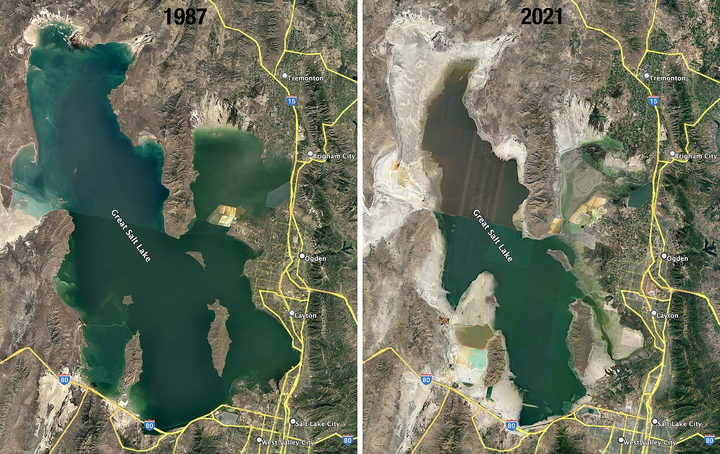
One culprit is the climate change-exacerbated mega-drought that has dragged on for over two decades. The other is the same infliction that plagues nearly every other Western water body: overconsumption. And a new, detailed accounting of consumption on the lake’s feeder streams finds that the biggest consumer is agriculture, and the crops responsible for guzzling the most water are cattle feed crops such as alfalfa and grass hay.
Though it’s not surprising, it’s always a bit of a downer to be reminded that my Chunky Monkey, green-chile cheeseburger, and yogurt habits are contributing to the depletion of not just the Colorado River, but also the Great Salt Lake.

The new study, “Reducing irrigation of livestock feed is essential to saving Great Salt Lake,” by Brian D. Richter, Kat F. Fowler, et al, and published in Environmental Challenges, builds upon other works, including “Emergency measures needed to rescue Great Salt Lake from ongoing collapse,” by Benjamin W. Abbot et al. The titles say it all: The largest saline lake in the Western hemisphere, which nourishes a rich ecosystem, is a major stop along the Pacific Flyway, and supports some 9,000 jobs and $2.5 billion in economic output each year, is in serious trouble.
And rescuing it, the authors say, will “require a massive transformation of agricultural production in the basin, particularly in cattle-feed production. Failure to implement the agricultural adjustments needed to arrest the decades-long decline of the lake will lead to serious and escalating threats to regional-scale public health, a continental-scale migratory flyway, and global-scale shocks in seafood production.”

The new study’s findings include:
- “The lake’s shrinkage is attributable to anthropogenic consumption of 62% of river water that would have otherwise reached and replenished the lake.”
- The Great Salt Lake reached its highest level in more than a century in 1987, following a series of extremely wet winters, but has been dropping by about four inches per year on average since then. From 1989 to 2022, the lake lost 10.2 million acre-feet and the surface level dropped 14 feet.
- Lake shrinkage is bad for human health because it mobilizes dust containing toxic heavy metals such as arsenic, copper, lead, zinc, cadmium, mercury and other metals, many of them from mining runoff.
- Great Salt Lake is the world’s largest supplier of brine shrimp eggs, a key food source for the aquaculture industry. As the lake shrinks, salinity increases, stressing the brine shrimp and lower production.
- The lake is a crucial nexus within Pacific Flyway, and the birds eat brine shrimp and brine flies. Wilson’s Phalaropes and Eared Grebes are threatened by the decline of GSL, and they could be listed under the Endangered Species Act, which could impact industry around the lake.
- Aggregate water consumption from both anthropogenic and environmental (riparian evapotranspiration and lake evaporation) sources exceeded lake inputs from river inflows and direct precipitation by 309,664 acre-feet per year on average from 1989-2022.
- Irrigated farms now cover 791 square miles within the basin, with 70% of the acreage dedicated to growing cattle feed crops. There’s also public land grazing leases, which cover more than half of the 21,000-square-mile Great Salt Lake basin and provide additional forage for about 10% of all cattle in the basin.
- The 2022 U.S. Agricultural Census counted nearly 1 million cattle within the basin; about 70% were beef and 30% dairy.
- Alfalfa farms within GSL basin produce an average of 3.7 tons per acre, for a total of 951,889 tons per year, or a little over half of all the alfalfa grown in Utah.
- Alfalfa water use per year is estimated at 617,034 acre-feet and other hay use 291,695 acre-feet, for a grand total of more than 900,000 acre-feet (or about 57% of all anthropogenic uses in the basin).
- About 38% of the cattle feed grown in the basin stays in the basin, with about 25% exported to the Snake River basin in Idaho, and 13% going to California, the nation’s leading milk producer. An estimated 17% is exported internationally, primarily to China and the Middle East.
- Cattle feed crops in the basin produced an estimated $162 million in cash receipts in 2021, or about .07% of Utah’s GDP. But alfalfa prices jumped about 85% between 2000 and 2021, mainly driven by rising demand from dairy as Americans eat more yogurt and cheese. That makes alfalfa a more lucrative crop for its growers, and ceasing production would have an outsized local impact.
Currently the lake is suffering from an annual water deficit of about 310,000 acre-feet. But researchers believe the strains of climate change will keep driving the deficit higher, and point to the need to bring the lake back up from its diminished levels. Some are pushing for up to 1 million acre-feet in consumption cuts per year, but Richter and company are suggesting a more politically palatable 650,000 acre-feet per year. Still, that’s a boatload of water.
So how to get there? Once again the obvious solution — stop growing alfalfa — is also the most contentious, and far more complicated than it appears. The economic impact would be devastating locally, and would also change the communities’ cultures. Farmers tend to hold the most senior water rights, meaning they legally can continue to use that whatever however they please. And paying farmers to fallow that much land would not only be prohibitively expensive, but also would create other problems, such as dust and noxious weed proliferation.
The authors present a range of less drastic, but still ambitious — and painful — options, including:
- They found they could reduce crop water consumption by 91,500 acre-feet per year by replacing alfalfa with winter wheat. Split-season irrigation, or reducing the number of cuttings from three to one, could save another 477,130 acre-feet (but would reduce alfalfa and hay production by 61%).
- Combining split-season irrigation and partial fallowing could achieve the 650,000 acre-feet target, but it would cost $76 million per year for foregone alfalfa production plus $21 million for reduced grass hay production.
- If the municipal and industrial and mineral extraction sectors cut consumption by 20%, it could reduce the deficit by about 110,000 acre-feet, leaving agriculture to pick up the remaining 550,000 acre-feet through the above strategies.
- Temporary leasing of agricultural water rights would cost as much as $423 million annually, but would give farmers more flexibility over what they do with the land (and it would only be temporary).
“Ultimately the debate about whether to save the GSL will be about cultural issues, not economics or food security,” the authors conclude. “The potential solutions outlined here implicate lifestyle changes for as many as 20,000 farmers and ranchers in the basin. In this respect the GSL serves as a microcosm of the socio-cultural changes facing many river basin communities in the increasingly water-scarce wester U.S. and around the globe.”
Think like a watershed: Interdisciplinary thinkers look to tackle dust-on-snow
November 5, 2024

Emily Wakild, Boise State University
The Department of the Interior was created in 1849 as the United States was rapidly expanding and acquiring territory. It became known as “the department of everything else” for its enormous portfolio of missions, which ranged from western expansion to oversight of the District of Columbia jail.
Interior handles natural resources and domestic affairs – primarily managing 480 million acres (200 million hectares) of federal lands and developing the assets that they hold. Many of these lands are officially open for multiple uses, including energy development, mining, logging, livestock grazing and recreation. Those activities have numerous constituencies, whose interests can clash.

The Interior secretary’s main job is to promote thoughtful planning that balances resource development and conservation. One strategic role has been expanding energy production, including oil, natural gas, wind and solar power, on federal lands.
Under Republican administrations, the focus often swings toward resource development. Democratic administrations often put greater emphasis on conservation and nonextractive land uses, such as recreation. The secretary’s actions can play a big role in setting direction for the agency.
Since Interior controls access to valuable natural resources, secretaries also get sued a lot over issues ranging from endangered species protection to water rights.
Interior has about 70,000 employees whose missions fall largely into three buckets: managing public lands and wildlife; meeting U.S. trust responsibilities to Native American communities; and regulating energy, water and mining resources on federal lands and in federal waters offshore.
These functions are spread among 11 bureaus whose activities can conflict. For example, there has been heated debate within Interior about how to manage the scenic Bears Ears National Monument in Utah. This site was designated as a monument by President Barack Obama in 2016, drastically reduced by President Donald Trump in 2017, and then restored to its original size by President Joe Biden in 2021. Reflecting these shifts, Interior’s priorities for Bears Ears have toggled between opening it for mining, co-managing it with area tribes and preserving it for public enjoyment.
Many of Interior’s offices have changed dramatically over time in response to evolving environmental and cultural values. For example, the Bureau of Land Management was widely known for years as the “Bureau of Livestock and Mining” because its decisions closely reflected the interests of those industries.
Even now, ranchers can graze sheep and cattle on public lands at rates generally lower than comparable fees on state or private ranges. And mining companies don’t pay royalties to the Treasury for producing gold, silver, copper and other valuable minerals on federal lands.
However, today the bureau also manages land for conservation – including a 35 million-acre (14 million-hectare) system of National Conservation Lands. In 2024, the agency adopted a public lands rule that explicitly recognizes the importance of protecting clean water, managing for land health and restoring degraded lands.
When Congress created the Interior Department, the young United States was in the process of nearly doubling its size after the U.S.-Mexican War. Gold had just been discovered in California, triggering a huge migration west. The scramble to occupy these lands and convert them into stable revenue sources drove Interior’s early activities.
As the U.S. government removed Native peoples from their ancestral homes and folded largely arid and unsettled lands into the public domain, Interior became a landlord and an agent of development in the West. The federal government gave millions of acres to white settlers in an effort to populate these new territories.
But not all lands met settlers’ needs, especially in dry zones. As a result, much of the arid West remained under federal control. Given this legacy, it is not surprising that most senior officials at Interior have come from western states.
U.S. national parks, monuments, wildlife refuges and other Interior lands have become economic engines for many western towns, attracting private ranches, hotels, restaurants and businesses. In this way, federal lands return tremendous wealth to adjacent communities, particularly with the growth of the outdoor recreation industry.
Nonetheless, many western states resent federal control over broad swaths of territory within their borders and periodically make claims to these lands. Since states don’t have the financial resources to manage roads or fight fires on such large expanses, it is likely that they would sell off large portions of these lands, privatizing them.
For this reason, many conservation groups and outdoor sporting organizations oppose transferring federal lands to the states. Interior secretaries may be called on to mediate these disputes or defend federal interests in court. https://www.youtube.com/embed/iUnV9CLsbO8?wmode=transparent&start=0 The state of Utah is suing the U.S. government for control over 18.5 million acres of federal land – about one-third of the territory in the state.
Over the past half-century, there has been ongoing debate about whether the royalties and fees the agency charges for federal land use return fair value to taxpayers, or if the agency has been “captured” by extractive industries such as mining, ranching, logging, and oil and gas production. The secretary can send important signals about which way an administration tilts.
Another central Interior role is managing U.S. government relations with American Indian and Alaska native tribes. The department’s Bureau of Indian Affairs, created in 1824, works with 574 federally recognized tribes with more than 2 million enrolled members.
Interior manages 55 million acres of land and 57 million acres of subsurface mineral rights in trust for the tribes. This essentially means that Interior agencies earn revenue and disperse funds to tribal members, in part to make up for depriving Native Americans of their rightfully held resources over 150 years of displacement.
Even after federal policy became more supportive of Tribal governance and self-determination in the 1970s, Interior did a poor job of fulfilling its key trust responsibilities. In 2009 the agency settled a US$3.4 billion class-action lawsuit, acknowledging that for decades the federal government had mismanaged tribal resources and failed to pay revenues to Indian landowners for resources produced from their lands.
Well into the 1970s, Interior also was charged with trying to assimilate Native Americans into U.S. society by forcibly removing children from their homes and families and placing them in boarding schools. These institutions punished children for speaking native languages and separated them from their cultural traditions.
Starting in 2021, under Secretary Deb Haaland – the first Native American to lead the Interior Department – the agency launched an initiative to document and interpret the experiences of survivors and the intergenerational effects of this policy on Native Americans whose ancestors were sent to the schools. https://www.youtube.com/embed/Ui9jCp1yuws?wmode=transparent&start=0 In a 2022 report, the U.S. government acknowledged for the first time its role in carrying out forced assimilation of Native American children at government-run boarding schools.
Interior’s reach is vast, but the resources that it controls and the investments it makes in keeping large landscapes connected provide tremendous services. Debate about the merits of public versus private management of these lands is likely to continue.
Growing interest in outdoor recreation and the rise of remote work are putting new pressure on public lands. Finding solutions will require many different land users, as well as state governments and gateway towns, to collaborate. The Interior secretary can play an important role in helping strike those balances.
This story is part of a series of profiles of Cabinet and high-level administration positions.
Emily Wakild, Cecil D. Andrus Endowed Chair for the Environment and Public Lands, Boise State University
This article is republished from The Conversation under a Creative Commons license. Read the original article.
November 21, 2024
Liam Courtney-Davies, University of Colorado Boulder; Christine Siddoway, Colorado College, and Rebecca Flowers, University of Colorado Boulder
Around 700 million years ago, the Earth cooled so much that scientists believe massive ice sheets encased the entire planet like a giant snowball. This global deep freeze, known as Snowball Earth, endured for tens of millions of years.
Yet, miraculously, early life not only held on, but thrived. When the ice melted and the ground thawed, complex multicellular life emerged, eventually leading to life-forms we recognize today.
The Snowball Earth hypothesis has been largely based on evidence from sedimentary rocks exposed in areas that once were along coastlines and shallow seas, as well as climate modeling. Physical evidence that ice sheets covered the interior of continents in warm equatorial regions had eluded scientists – until now.
In new research published in the Proceedings of the National Academy of Sciences, our team of geologists describes the missing link, found in an unusual pebbly sandstone encapsulated within the granite that forms Colorado’s Pikes Peak.

Solving a Snowball Earth mystery on a mountain
Pikes Peak, originally named Tavá Kaa-vi by the Ute people, lends its ancestral name, Tava, to these notable rocks. They are composed of solidified sand injectites, which formed in a similar manner to a medical injection when sand-rich fluid was forced into underlying rock.
A possible explanation for what created these enigmatic sandstones is the immense pressure of an overlying Snowball Earth ice sheet forcing sediment mixed with meltwater into weakened rock below.

An obstacle for testing this idea, however, has been the lack of an age for the rocks to reveal when the right geological circumstances existed for sand injection.
We found a way to solve that mystery, using veins of iron found alongside the Tava injectites, near Pikes Peak and elsewhere in Colorado.

Iron minerals contain very low amounts of naturally occurring radioactive elements, including uranium, which slowly decays to the element lead at a known rate. Recent advancements in laser-based radiometric dating allowed us to measure the ratio of uranium to lead isotopes in the iron oxide mineral hematite to reveal how long ago the individual crystals formed.
The iron veins appear to have formed both before and after the sand was injected into the Colorado bedrock: We found veins of hematite and quartz that both cut through Tava dikes and were crosscut by Tava dikes. That allowed us to figure out an age bracket for the sand injectites, which must have formed between 690 million and 660 million years ago.
So, what happened?
The time frame means these sandstones formed during the Cryogenian Period, from 720 million to 635 million years ago. The name is derived from “cold birth” in ancient Greek and is synonymous with climate upheaval and disruption of life on our planet – including Snowball Earth.
While the triggers for the extreme cold at that time are debated, prevailing theories involve changes in tectonic plate activity, including the release of particles into the atmosphere that reflected sunlight away from Earth. Eventually, a buildup of carbon dioxide from volcanic outgassing may have warmed the planet again. https://www.youtube.com/embed/PLZze4Yok98?wmode=transparent&start=0 University of Exeter professor Timothy Lenton explains why the Earth was able to freeze over.
The Tava found on Pikes Peak would have formed close to the equator within the heart of an ancient continent named Laurentia, which gradually over time and long tectonic cycles moved into its current northerly position in North America today.
The origin of Tava rocks has been debated for over 125 years, but the new technology allowed us to conclusively link them to the Cryogenian Snowball Earth period for the first time.
The scenario we envision for how the sand injection happened looks something like this:
A giant ice sheet with areas of geothermal heating at its base produced meltwater, which mixed with quartz-rich sediment below. The weight of the ice sheet created immense pressures that forced this sandy fluid into bedrock that had already been weakened over millions of years. Similar to fracking for natural gas or oil today, the pressure cracked the rocks and pushed the sandy meltwater in, eventually creating the injectites we see today.
Clues to another geologic puzzle
Not only do the new findings further cement the global Snowball Earth hypothesis, but the presence of Tava injectites within weak, fractured rocks once overridden by ice sheets provides clues about other geologic phenomena.
Time gaps in the rock record created through erosion and referred to as unconformities can be seen today across the United States, most famously at the Grand Canyon, where in places, over a billion years of time is missing. Unconformities occur when a sustained period of erosion removes and prevents newer layers of rock from forming, leaving an unconformable contact.

Our results support that a Great Unconformity near Pikes Peak must have been formed prior to Cryogenian Snowball Earth. That’s at odds with hypotheses that attribute the formation of the Great Unconformity to large-scale erosion by Snowball Earth ice sheets themselves.
We hope the secrets of these elusive Cryogenian rocks in Colorado will lead to the discovery of further terrestrial records of Snowball Earth. Such findings can help develop a clearer picture of our planet during climate extremes and the processes that led to the habitable planet we live on today.
Liam Courtney-Davies, Postdoctoral Research Associate in Geological Sciences, University of Colorado Boulder; Christine Siddoway, Professor of Geology, Colorado College, and Rebecca Flowers, Professor of Geological Sciences, University of Colorado Boulder
This article is republished from The Conversation under a Creative Commons license. Read the original article.

Click the link to read the article on The Denver Post website (Nick Coltrain). Here’s an excerpt:
December 23, 2024
Colorado state officials and the Union Pacific Railroad reached a tentative agreement on the future of the 100-year-old Moffat Tunnel — and, in the process, set the stage to expand passenger rail service in the mountains between Denver and Craig, officials announced Monday. Barring any major hiccups between now and the formal signing in May, the state will extend the 99-year lease allowing Union Pacific to use the tunnel for another 25 years. In exchange, the state will receive expanded access to Union Pacific’s railroad tracks for passenger trains from Denver to northern Colorado over that time frame. The final technical details still need to be finalized, but the state’s key negotiators were confident Monday that this agreement would set the stage for final approval. If all proceeds smoothly, regular daily passenger train service between Denver and Grand County — a portion of the full corridor — could begin in time for the start of the ski season in late 2026. For several years, Amtrak has run the revived Winter Park Express ski train along that route seasonally, but only around weekends — including from Thursdays through Mondays this season. The mountain rail expansion could eventually lead to up to three roundtrip services per day between Denver and Craig, with several stops, including Winter Park and Steamboat Springs, along the way…The deal announced Monday will also settle the use of the Moffat Tunnel, with the expiration of the 99-year lease just weeks away. The state owns the tunnel and leases the tracks that run through it to Union Pacific, which other train operators can then pay to use.
The 6.2-mile Moffat Tunnel is the only rail tunnel in the state that spans the Continental Divide. It connects Gilpin and Grand counties west of Denver. At more than 9,200 feet in elevation, it is the highest point in Amtrak’s national rail network, according to Sky-Hi News. The tunnel serves as a crucial rail connection between the Front Range and the Western Slope, as well as the grander American West.


Click the link to read the article on the High Country News website (Jonathan P. Thompson):
November 22, 2024
This story was originally published by The Land Desk and is republished here by permission.
On a mid-November evening I stood on a gravelly plain, shivering in the wind as clouds dangled their wispy fingers of snow onto Cedar Mesa to the north of me. The long sunset finally fizzled into darkness and I watched for the one-day-past-full moon to rise over the Valley of the Gods. But the dark horizon never yielded the anticipated orb. Instead, I was treated to evanescent shards of orangish light escaping through cracks in the clouds.
I was in southeastern Utah on a nearly flat expanse of scrub-covered limestone some 1,200 feet above the winding and silty San Juan River. I was also just barely inside the boundaries of Bears Ears National Monument. At least for now. But the national monument protections on my little dispersed campsite, along with a good portion of the landscape I looked out upon, will likely go away shortly after President-elect Donald Trump takes office next year.
Last week the New York Times reported that Trump will again shrink Bears Ears and Grand Staircase-Escalante National Monuments back to the diminished boundaries he established in 2017. The 1.36-million-acre Bears Ears — which President Joe Biden restored in 2021 — will become a 200,000 acre national monument divided into two discrete units. Left out will be Valley of the Gods, Cedar Mesa, the Goosenecks of the San Juan, the White Canyon and Dark Canyon regions, and portions of Butler and Cottonwood Washes.

The act is likely illegal, since the Antiquities Act only gives presidents the power to establish national monuments, not shrink or eliminate them. And it will revive lawsuits still pending since Trump’s previous shrinkage. But while the legal challenges wend their ways through the courts, Trump’s shrinkage will take hold (barring a court injunction). The draft management plan that federal officials and tribal representatives have worked on for years will be rendered obsolete before it’s even approved, and about 1.2 million acres of public land will be re-opened to new mining claims and oil and gas and coal leasing.
There are the conservation consequences to think of, which I’ll get to, but more importantly is the symbolic significance. Bears Ears was originally proposed and conceived of and pushed by five sovereign tribal nations — with the backing of another two dozen tribes — who were looking to protect lands that had been stolen from them and put into the “public domain.” Representatives from those tribes had a hand in crafting the new management plan, which uniquely incorporates Indigenous knowledge into decision-making.
By overturning the national monument, Trump is thumbing his noses at those same tribal nations, essentially telling them that their efforts and ties to this land are meaningless. As I stood out there dissolving into the darkness, a question arose: Why? Why the hell would a Manhattan real estate developer and reality show personality, who probably had never set foot on the West’s public lands, make such a cruel and thoughtless gesture? What was he hoping to achieve?
I’ve posited potential motives for the initial shrinkage. Trump wanted to curry favor with the powerful Sen. Orrin Hatch, of Utah, so he could gut Obamacare and get tax cuts for the wealthy through Congress. He wanted to help out his friends in the uranium mining and oil and gas industries. He wanted to repay Utah voters for abandoning their principles and voting for him.

But the oil and gas industry isn’t exactly champing at the bit to drill in the Bears Ears area. There are many other more accessible and profitable places to chase hydrocarbons. And in 2017 the domestic uranium mining industry was virtually nonexistent, and its 200 or so employees hardly made for a significant voting bloc. Mark Chalmers and Curtis Moore, the CEO and VP of Energy Fuels, probably the most viable uranium mining and milling company out there, didn’t even donate to any of Trump’s presidential campaigns.
It really seems that Trump diminished Bears Ears and Grand Staircase-Escalante National Monuments for no other reason than to dismantle the environmental legacies of his rivals and predecessors, former Presidents Bill Clinton and Barack Obama. And given his cabinet picks so far, Trump is planning on more of the same in his second term. He “governs” out of greed and self-interest, first, followed closely by spite — aimed at liberals, his political rivals, and Republicans who don’t show enough fealty to him.
The expected shrinkage won’t have an immediate impact on the landscape where the protections are lifted, which will simply revert back to federal land managed under the multiple-use mandate. Come Jan. 20, there will not be a battalion of drilling rigs marching upon the weird formations of Valley of the Gods or mines opening up in White Canyon’s cliffs.
Yet there will be longer term consequences. All of the debate and back and forth over the national monument has attracted more visitors to the general area, and that has brought more impacts. Taking away national monument status from most of those lands will not reduce visitation, but it will take away resources for and opportunities to manage their impacts. The Trump-era management plan, which was hardly a plan at all and replaced the tribal commission with a bunch of monument opponents, will remain in place, rendering what’s left of the national monument almost meaningless.
After Trump’s first shrinkage, speculators and would-be mining firms staked a handful of claims in lands that had been taken out of Bears Ears national monument. That was when the uranium industry was moribund. Now, higher prices, a renewed interest in nuclear power, and a ban on enriched reactor fuel from Russia has given the industry new life. While uranium production remains minimal, exploration has kicked up significantly, including in lands just outside the Bears Ears boundary. This time around we’re likely to see not only mining claims being staked soon after the shrinkage in places like White Canyon and Cottonwood Creek, but also exploratory drilling. Even if companies don’t have any short-term interest in mining in the area, the drilling can help them establish the claims’ validity, thereby increasing the likelihood that the right to mine those parcels would be locked in if a future administration or the courts were to restore Bears Ears.
Plus, the shrinkage will make the land removed from the national monument more vulnerable to Utah’s attempt to seize control of all “unappropriated” public lands within the state’s boundaries.
Just as night became complete, the moon emerged from behind the clouds and cast a pale light over everything. At the same time, I saw my friends’ truck’s headlights bouncing up the road, so I trudged through the cold to guide them to the campsite. We laughed and talked and played music. One was still reeling from the shock of the presidential election’s outcome, the other, who works with rural communities across the West, had seen Trump’s victory as almost inevitable.
Eventually, I snuggled up in my sleeping bag in my little tent and emerged more than ten hours later, just as the moon was getting ready to set and the sun prepared to rise over the corner of the Carrizo Mountains along the New Mexico-Arizona border. The landscape around me slowly revealed itself as if awakening from slumber. Later, under the almost harsh blue sky, my friends and I made our way almost aimlessly across the scrub-covered plain, trying to avoid the Russian thistle that had proliferated after more than a century of cattle grazing and following the erratic cow paths when we encountered them.
At one point we heard the report of what sounded like a semi-automatic firearm being shot in the distance. It wasn’t a hunter, I’m sure of that. More likely a recreational shooter looking to waste some ammo before the proposed shooting ban goes into effect — though now it’s not likely to. Maybe they were targeting cans, or petroglyphs, or a desert-varnish-covered boulder or grazing cattle. I involuntarily flinched at each bang.

I walked with gratitude for the beauty all around and the freedom to wander through it. I walked with sadness, too, and anger at those who would try to reduce this place, this living landscape, to a pawn in their petty and vindictive game, and who would try to open it back up to corporations looking to wring every last particle of profit from it. But I also found hope in the knowledge that powerful tribal nations, land protectors and nonprofits will continue their fight to protect this land and challenge the spiteful attempts to diminish this place.
We came to the edge of the San Juan River gorge and dropped into it, following a path forged by gold prospectors back during the “Bluff Excitement” of the early 1890s, when folks thought they could get rich by scouring the San Juan River’s banks for flakes of gold. The gold rush fizzled before it got started, but the trail endures. After reaching its terminus, we stopped our banter and sat quietly and listened to the silty waters gurgle by slowly and watched a red tail hawk frolic reassuringly in the updrafts far above. The future is uncertain, but this much I know: Beauty will persist regardless of who occupies the White House.

Mrs. Gulch would have turned 70 today. Her family joked that she was their Christmas present back in 1954. I miss her and in particular I miss her sense of humor and wise counsel. Here’s a story from the first days of our 50 year marriage when we moved into my VW bus for the summer.

Sense of humor
We camped for a few days at the Great Sand Dunes and then headed over to Monarch Pass to the Gunnison Valley. After we dropped into the valley Mrs. Gulch asked about lunch and decided she could create something, while moving towards Gunnison, with a can of tuna in oil that we had in the food box. The dilemma at hand was what to do with the oil. She slides the passenger window open and uses the lid to release the oil onto the highway.
In a little while I notice a car behind us, with it’s windshield wipers going, lights flashing, and horn honking. The driver had his head out the window which I figured out later probably served two purposes, my cussing out, and the ability to see the road. I concentrated on looking straight ahead not giving away the fact that I saw them behind me and overcame the urge to pull over to see what they wanted.
After a short while the driver moved his car into position for revenge. He pulled alongside and a little ahead of the bus while his passenger was shaking a can of pop preparing the contents for launch. When she popped the top the soda blew back into her window instead of coating the bus. They then took off west down US-50.
We couldn’t stop laughing, great belly laughs, howls of laughter, embarrassed red-faced laughter, guilty laughs for the trouble we had caused, and relieved laughter that they had sped away. This went on for a good long time and every time we looked at each other another round would break out.
After gassing up on the edge of Gunnison we were moving west down the main drag through town and saw them at a car wash. Of course this spawned another wave of guilty laughter. It would’ve been hard to deny culpability with tuna oil caked with road dust all along the side of our vehicle.

Wise counsel
Mrs. Gulch’s wise counsel that afternoon was to keep heading west up into the National Forest and find a place to camp — maybe for a couple of days.
The Great American meditation
Two hands on the wheels two eyes on the road
Truck-stop sunsets and filling stations
That′s what you see when you’re always on the go
But I′m headed home
Colorado, I’m headed home
Colorado, I′m headed home
— Excerpt from Daniel Rodriquez’s, “Colorado”
I have to respectfully disagree with Daniel over the notion that taking those long highway treks are a meditation. When I meditate I try to clear my mind and the highway does not fit that bill. I think of a thousand things and with a nod to Gurdeep Pandher of the Yukon I try to use the tools that keep the thoughts positive. Mrs. Gulch tops the list of course, but those great hikes, reminiscing about family, canyons, flowers, trees, mountains, the big rivers in the Midwest, the wild rivers in the West, all creep into my head. Of course there’s the road trips with Mrs. Gulch starting that first summer when we moved into my VW Bus and the last trip where we followed the Colorado River from Rocky Mountain National Park to Moab.
Anyway, I logged 3,239 Google miles on the journey and visited 9 states. Hellchild was along for the long leg of the trip so there is yet another family road trip to log into long-term memory and chat about.
I took the collection of essays “Water Bodies: Love Letters to the Most Abundant Substance on Earth” along and it is one of the most inspiring reads the I’ve known. Laura Paskus’ introduction drew me in and the other authors and poets left me wanting more at the end.

One of the essays dealt with place and I believe Denver is that place for me. Four generations of my family have lived on the Northside since the end of the 19th Century. Gertie’s family gave up on dryland farming in Wyoming and Frank’s family moved down from Jamestown, likely with the collapse of the silver market beginning in 1893.
Frank told Gertie in 1906, “There’s been a terrible earthquake in San Francisco and they are paying top wages for workers. I will go out there and work and save for a year, and then we’ll be married.”
He returned in 1911 with no dough in his pockets. He did bring back his memories of hopping trains and the Northwest’s forests and rivers. They finally tied the knot.
On the drive from Thanksgiving dinner to CRWUA with Hellchild I was able to trace some of the route of old U.S. 66. I’ve really enjoyed the drive from Missouri to Arizona so far and last night we feasted on some great Indian (East) food in Holbrook. Forested hills to more open country, then Cholla and Mesquite, the mesa country in New Mexico, beautiful desert landscapes W. of Albuquerque, the S. edge of the Colorado Plateau in the Ponderosa pine forest, and farms, ranches, and windmills galore all the way! We didn’t have a good map but we crossed the Arkansas, Pecos, Rio Grande, and Little Colorado rivers over the past couple of days. Las Vegas is the destination today.
The Tesla Model Y has performed flawlessly and the charging is a breeze due to the integration with the onboard navigation.


So when I got to the Hertz rental office yesterday they did not have a Polestar as I had reserved so the clerk said they would substitute similar vehicle, a Suburu Solterra. I thought, “Okay, that might be a nice ride.”
I motored east on I-70 thinking that I would do a first charge in Limon where I had charged my Leaf before because it showed up on a map from an app recommended by Hertz. When I arrived at the charging location the chargers were all offline. When I checked the ChargePoint app later the location didn’t show up which tells me that it has been closed.
It was a bummer but I had enough charge to get Flagler where I had also charged my Leaf there once before. When I connected I was immediately stunned by the charger telling me that it would take more than two hours to 100%. This can’t be right I thought, the charger (Electrify America) is capable of providing 350 KW of shared charge. I called Hertz and was told that the Solterra does not charge at Level 3. The only cars they have that charge at Level 3 are Teslas and Polestars.
I charged enough to get back home (3% charge when I arrived), hooked up to my Level 2 charger for an hour or so, then returned the car.
While charging at Flagler I called Avis to rent a Tesla. I picked up the car (Model 3) this morning and it crapped out just before Central Park Avenue on I-70. After being towed back to Avis I now have a different Tesla (Model Y) and am heading out again.

I’m heading out for Thanksgiving dinner with Hellchild and then to Las Vegas for the Colorado River Water Users Association Conference December 4-6, 2024. Posting my be intermittent. Hertz didn’t have a Polestar this morning so I’m in a Suburu Solterra.


Click the link to read the blog post on the Colorado Climate Center website (Russ Schumacher). Click the link to read Russ’ article:
November 5, 2024
A couple years ago, before we had a blog, I put together an analysis of a truly remarkable severe weather event from Colorado history on its 100th anniversary: the killer tornadoes of November 4, 1922.
There’s not much comparison for this storm: it was one of the deadliest tornado outbreaks in state history, and it happened in November (!) in the early morning (!!). I took a look back both at what happened, and tried to recreate what the storms might have looked like using a modern weather prediction model. I figured it was worth sharing the link here on the blog, in case it might be of interest on the 102nd anniversary: https://www.authorea.com/users/334136/articles/593038-the-colorado-killer-tornadoes-of-november-4-1922 . It’s an interesting and tragic piece of Colorado weather and climate history.


Rosalyn R. LaPier, University of Illinois at Urbana-Champaign
I am a direct descendant of family members that were forced as children to attend either a U.S. government-operated or church-run Indian boarding school. They include my mother, all four of my grandparents and the majority of my great-grandparents.
On Oct. 25, 2024, Joe Biden, the first U.S. president to formally apologize for the policy of sending Native American children to Indian boarding schools, called it one of the most “horrific chapters” in U.S. history and “a mark of shame.” But he did not call it a genocide.
Yet, over the past 10 years, many historians and Indigenous scholars have said that what happened at the Indian boarding schools “meets the definition of genocide.”
From the 19th to 20th century, children were physically removed from their homes and separated from their families and communities, often without the consent of their parents. The purpose of these schools was to strip Native American children of their Indigenous names, languages, religions and cultural practices.
The U.S. government operated the boarding schools directly or paid Christian churches to run them. Historians and scholars have written about the history of Indian boarding schools for decades. But, as Biden noted, “most Americans don’t know about this history.”
As an Indigenous scholar who studies Indigenous history and the descendant of Indian boarding school survivors, I know about the “horrific” history of Indian boarding schools from both survivors and scholars who contend they were places of genocide.
The United Nations defines “genocide” as the “intent to destroy, in whole or in part, a national, ethnical, racial or religious group.” Scholars have researched different cases of genocide of Indigenous peoples in the United States.
Historian Jeffery Ostler, in his 2019 book “Surviving Genocide,” argues that the unlawful annexation of Indigenous lands, the deportation of Indigenous peoples and the numerous deaths of children and adults that occurred as they walked hundreds of miles from their homelands in the 19th century constitute genocide.
The mass killings of Indigenous peoples after gold was found in the 19th century in what is now California also constitutes genocide, writes historian Benjamin Madley in his 2017 book “An American Genocide.” At the time, a large migration of new settlers to California to mine gold brought with it the killing and displacement of Indigenous peoples.
Other scholars have focused on the forced assimilation of children at Indian boarding schools. Sociologist Andrew Woolford argues that scholars need to start calling what happened at Indian boarding schools in the 19th and 20th century “genocide” because of the “sheer destructiveness of these institutions.”
Woolford, a former president of the International Association of Genocide Scholars, explains in his 2015 book “This Benevolent Experiment” that the goal of Indian boarding schools was the “forcible transformation of multiple Indigenous peoples so that they would no longer exist as an obstacle (real or perceived) to settler colonial domination on the continent.”

Indigenous writers have explained how this transformation at Indian boarding schools occurred. “Federal agents beat Native children in such schools for speaking Native languages, held them in unsanitary conditions, and forced them into manual and dangerous forms of labor,” writes Indigenous law professor Maggie Blackhawk.
Secretary of the Interior Debra Anne Haaland has stated that every Native American family has been impacted by the “trauma and terror” of Indian boarding schools. And my family is no different.
One of the more horrific stories that my maternal grandmother shared with her grandchildren was that she witnessed the death of another student. They were both under the age of 10. The student died of poisoning after lye soap was put in her mouth as a punishment for speaking her Indigenous language.
We know that similar punishments happened and children died at Indian boarding schools. The Department of Interior reported in 2024 that 973 children died at Indian boarding schools.
Tribes are increasingly seeking the return of the remains of children who died and are buried at Indian boarding schools.

The U.S. government is beginning to encourage survivors to tell their stories of their Indian boarding school experiences. The Department of the Interior is in the process of recording and documenting their stories on digital video, and they will be placed in a government repository.
At 84 years old, my mother is the only living Indian boarding school survivor in our family. She shared her story with the Department of the Interior this past summer, as did dozens of other survivors.
Haaland stated these “first person narratives” can be used in the future to learn about the history of Indian boarding schools, and to “ensure that no one will ever forget.”
“For too long, this nation sought to silence the voices of generations of Native children,” Biden added at the apology ceremony, “but now your voices are being heard.”
As a descendant of Indian boarding school survivors, I appreciate President Biden’s apology and his effort to break the silence. But, I am also convinced that what my mother, grandmother and other survivors experienced was genocide.
Rosalyn R. LaPier, Professor of History, University of Illinois at Urbana-Champaign
This article is republished from The Conversation under a Creative Commons license. Read the original article.

Click the link to read the release on the Colorado State Forest Service website:
October 23, 2024
The Colorado State Forest Service announced awards for the first round of funding for the Colorado Inflation Reduction Act (IRA) Urban and Community Forestry (UCF) grant program. The CSFS created the new grant program with IRA funding from the U.S. Forest Service, and the money will be used to improve the tree canopy in communities in disadvantaged areas across Colorado. In total, the CSFS will award $1.6 million for 11 projects in 8 counties across Colorado.
“This infusion of funding for urban forestry into some of our most vulnerable communities is overdue,” said Matt McCombs, state forester and director of the CSFS. “This is a historic investment in trees and one that will transform the canopy in these communities. Healthy trees and a flourishing urban canopy will improve the lives of Coloradans by providing more shade, cleaner air, and more beautiful places to work, live and play.”
The funded projects include a variety of activities that will improve Colorado’s urban forests:
- Planting hundreds of trees
- City tree inventories
- Community outreach events
- Removal of hazard trees and storm-damaged trees
- Hiring arborists, interns and tree stewards
“I’m excited to work closely with these communities as they make long-lasting investments to their urban trees,” said Cori Carpenter, tree equity specialist at the CSFS. “Many of these towns don’t have dedicated forestry staff, so this funding source is really the only way they can make much-needed improvements to their community’s tree canopy.”
For the first round of Colorado IRA UCF grants, the CSFS received 23 eligible applications requesting more than $4.7 million. Since $1.6 million was available for this round of grants, 12 projects totaling more than $3 million could not be funded. Another $1 million will be available through the grant program each year in 2025 and 2026.
These counties received Colorado IRA UCF funds during this funding cycle: Adams, Alamosa, Boulder, Chaffee, Las Animas, Mesa, Sedgwick and Yuma. Review a full list of awardees.
The CSFS will announce the next round of funding assistance through the Colorado IRA UCF grant program in spring 2025. Learn more about the Colorado IRA UCF grant program.


Two of my colleagues at the City of Thornton granted me the permission to use the photos below.


Click the link to read the article on the Natural Resources Conservation Service website:
October 2, 2024
Over 40 attendees gathered for the first Urban Agriculture Connector’s Meeting at the CSU Spur campus in the heart of Denver on September 26th. This groundbreaking event brought together a diverse group of stakeholders, including representatives from federal, state, and local governments, non-profit organizations, and urban agriculture producers. The meeting served as a nexus for networking and learning about the myriad resources available for urban agriculture.
The meeting marks a milestone in the USDA’s continuing commitment to urban agriculture. In 2018, the USDA established the Office of Urban Agriculture and Innovative Production, showcasing its dedication to including urban, small-scale, and innovative producers in its support of agriculture in all its forms. This office plays a crucial role in coordinating across USDA agencies to ensure that the needs of urban producers are met and adapted to as the landscape of agriculture evolves.
Cindy Einspahr, NRCS Outreach & Beginning Farmer/Rancher Coordinator, emphasized the importance of the event, stating, “The Urban Conservation Connectors meeting will be an excellent opportunity to connect with the urban agriculture community and establish new relationships. This is only the beginning of numerous meetings to follow.”
The event kicked off with a warm welcome from Petra Popiel, NRCS State Public Affairs Specialist. Setting a collaborative tone for the day, attendees had the opportunity to introduce themselves and share their background and interest in urban agriculture.
Elizabeth Thomas, FSA Outreach & Administrative Specialist, provided an overview of USDA conservation assistance available in urban settings and discussed strategies for providing resources to historically underserved farmers. The focus on urban conservation underscores the USDA’s recognition of the unique challenges and opportunities presented by city-based agriculture.
The meeting featured presentations from a diverse array of urban agriculture partners, each bringing their unique perspective and expertise to the table. Presenters included:
- Consumption Literacy Project
- Colorado Department of Education-School Nutrition Unit
- Denver Department of Public Health & Environment
- Denver Urban Gardens (DUG)
- Farm Service Agency (FSA)
- Natural Resources Conservation Service (NRCS)
- Rural Development (RD)
- Shannon Dobbs/Food System Hackers
- US Department of Health and Human Services
This wide-ranging group of presenters highlighted the interdisciplinary nature of urban agriculture, touching on aspects from education and public health to innovative farming techniques and community development.
As the meeting drew to a close, discussions turned to the future of urban agriculture in Colorado. The NRCS is committed to continuing its work with urban agriculture and keeping the conversation going by asking the crucial question: “What is Urban Ag in Colorado?”
As urban populations continue to grow and the demand for locally-sourced, sustainable food increases, the importance of urban agriculture cannot be overlooked. The Urban Agriculture Connector’s Meeting represents a significant step forward in fostering the relationships, knowledge-sharing, and resource allocation necessary to support producers and communities.
By bringing together a diverse group of stakeholders and focusing on the unique needs of urban producers, the USDA and its partners are laying the groundwork for a more inclusive and sustainable agricultural future. The connections made and ideas shared at this event will undoubtedly sprout into innovative projects and collaborations that will shape the landscape of urban agriculture in Colorado and beyond.


Click the link to read the article on The Grand Junction Daily Sentinel website (Dennis Webb). Here’s an excerpt:
October 4, 2024
Grand Valley Power plans to use a federal grant of nearly $2 million to bury 4.1 miles of existing power line serving the Mesa Lakes area to reduce wildfire-related dangers and boost system reliability. The local not-for-profit rural electric cooperative has received $1,947,204 from the U.S. Department of Energy through the Wildfire Assessment and Resilience for Networks project, or WARN. WARN funding comes from the department’s Grid Resilience and Innovation Partnerships program created by the 2021 Infrastructure Investment and Jobs Act, also known as the Bipartisan Infrastructure Bill. Grand Valley Power is a member of a consortium of 38 electric co-ops and other rural utilities selected to receive federal funding through WARN, it said in a news release. It will provide matching funds for the Mesa Lakes project. It expects the work to begin in late spring after the winter snow has melted.
Click the link to read the obit on The New York Times website (Bill Friskics-Warren). Here’s an excerpt:
September 29, 2024
He wrote songs for hundreds of other artists, including “Me and Bobby McGee” for Janis Joplin and “Sunday Morning Coming Down” for Johnny Cash, before a second act in film.
Kris Kristofferson, the singer and songwriter whose literary yet plain-spoken compositions infused country music with rarely heard candor and depth, and who later had a successful second career in movies, died at his home on Maui, Hawaii, on Saturday. He was 88. His death was announced by Ebie McFarland, a spokeswoman, who did not give a cause. Hundreds of artists have recorded Mr. Kristofferson’s songs — among them, Al Green, the Grateful Dead, Michael Bublé and Gladys Knight and the Pips. Mr. Kristofferson’s breakthrough as a songwriter came with “For the Good Times,” a bittersweet ballad that topped the country chart and reached the Top 40 on the pop chart for Ray Price in 1970. His “Sunday Morning Coming Down” became a No. 1 country hit for his friend and mentor Johnny Cash later that year…
Kris Kristofferson & Johnny Cash – Sunday morning coming down (1978 Johnny Cash Christmas Show)
Mr. Kristofferson and Rita Coolidge, who were married for much of the ’70s, won Grammy Awards for best country vocal performance by a duo or group with “From the Bottle to the Bottom” (1973) and “Lover Please” (1975). They also appeared in movies together, including Sam Peckinpah’s gritty 1973 western, “Pat Garrett & Billy the Kid,” in which Mr. Kristofferson played the outlaw Billy the Kid. Peckinpah cast Mr. Kristofferson in the film after seeing him perform at the Troubadour in Los Angeles and in “Cisco Pike” (1972), his big-screen debut.
Martin Scorsese then cast Mr. Kristofferson, whose rugged good looks lent themselves to the big screen, as the laconic male lead, alongside Ellen Burstyn, in the critically acclaimed 1974 drama “Alice Doesn’t Live Here Anymore.” He later starred opposite Barbra Streisand in Frank Pierson’s 1976 remake of “A Star Is Born,” a performance for which he won a Golden Globe Award. Over four decades Mr. Kristofferson acted in more than 50 movies, among them the 1980 box-office failure “Heaven’s Gate” and John Sayles’s Oscar-nominated 1996 neo-western “Lone Star.” Singer-songwriters may not be the likeliest of movie stars, but Mr. Kristofferson consistently revealed onscreen a magnetism and command that made him an exception to the rule. In 2006 he was inducted into the Texas Film Hall of Fame, along with Matthew McConaughey, Cybill Shepherd and JoBeth Williams. Mr. Kristofferson’s last major hit as a recording artist was “The Highwayman,” a No. 1 country single in 1985 by the Highwaymen, an outlaw-country supergroup that included his longtime friends Waylon Jennings, Mr. Nelson and Mr. Cash.

Click the link to read the article on The Denver Post website (John Aguilar). Here’s an excerpt:
September 29, 2024
Westminster is making it clear the city doesn’t want to increase access to hikers and cyclists visiting the Rocky Flats National Wildlife Refuge — the one-time site of a Cold War nuclear weapons plant that continues to spark health worries 30 years after it closed. The city last week became the second community surrounding the 6,200-acre federal property to withdraw from an intergovernmental agreement supporting construction of a tunnel and bridge into the refuge, home to more than 200 wildlife species, including prairie falcons, deer, elk, coyotes and songbirds. Broomfield exited the $4.7 million Federal Lands Access Program agreement four years ago, and both cities point to potential threats to public health from residual contamination at the site — most notably the plutonium that was used in nuclear warhead production over four decades — for their withdrawal…
Westminster’s withdrawal comes less than a month after a federal judge denied several environmental organizations a preliminary injunction that would have stopped the project cold. The plaintiffs had sued federal agencies in January, claiming the refuge is not fit for human use.
As part of the City Council’s 4-3 vote last week, Westminster will not pay the nearly $200,000 it owes to the project. The city also will no longer complete a 0.4-mile trail segment in its Westminster Hills Open Space property that would bring hikers and cyclists traveling from the east to the bridge to cross into Rocky Flats.
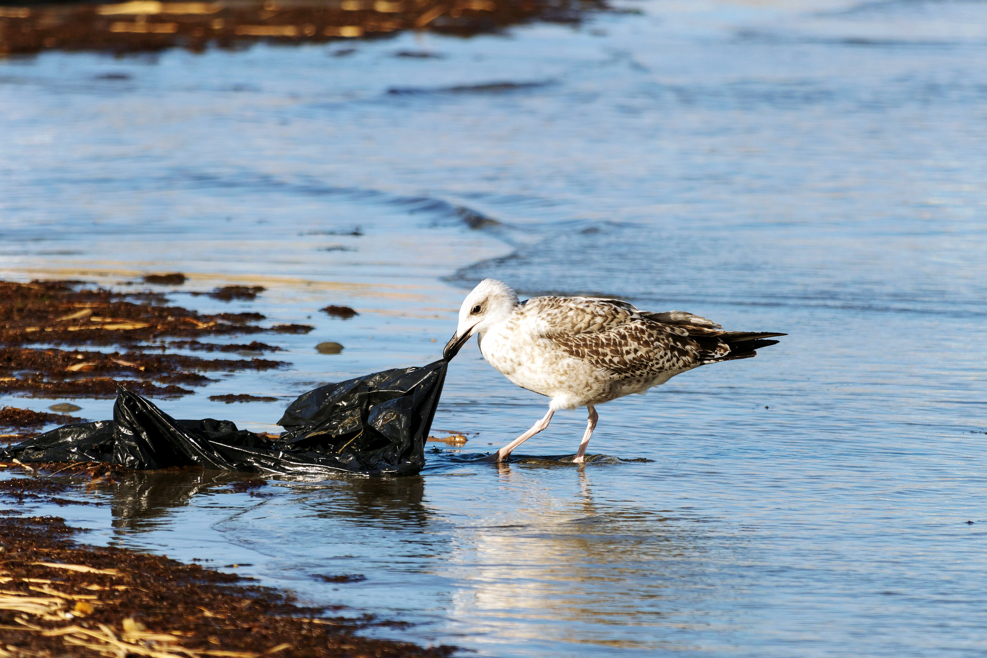
Click the link to read the release on the Colorado State University website (Mark Gokavi):
September 2024
Megan Hill is an assistant professor of chemistry and leader of the Hill Lab in Colorado State University’s College of Natural Sciences. Her research leverages organic chemistry to design advanced polymeric materials for applications in sustainability, catalysis and soft materials. She recently sat down with SOURCE to answer some common questions.
What are microplastics?
Given their name, they are micro-sized bits of plastic. There are even smaller nanoplastics that are below that (.5 mm in diameter) threshold (about the size of a grain of rice). They are pieces of plastic that have broken down but never fully degraded.
How long has synthetic, mass-produced plastic been around?
Let’s say about 100 years. Chemists spent a lot of time and effort optimizing polymerization techniques, eventually making catalysts that enabled extremely fast, cheap and easy production of plastic materials. Once the industry realized how useful these lightweight, durable and cheap materials were, then it just kind of exploded. It’s much more complex than that because there was government assistance in making these types of products more affordable. Within the last 10 to 20 years, people started to realize, “Wow, this stuff is still around, and it doesn’t seem like it’s going away anytime soon.”

Have we had better living through chemistry, i.e. plastics, in the past century?
You absolutely have to take that into account. Plastics make cars and airplanes lighter, reducing the amount of fuel that is needed. Wind turbines are made from epoxy resins, crosslinked polymer networks. Polyethylene is used in hip replacements, and Kevlar is something that saves people’s lives. These are all plastic materials.
What are the unintended consequences?
We’ve never had to deal with materials that have such a long lifetime. Every material that we’ve worked with in the past has been environmentally degradable over at least long periods of time. People didn’t realize how long it would actually take these materials to degrade. But now we are facing the fact that nearly every piece of plastic that has ever been made still exists, except for a small percentage that has been incinerated.
Is it bad that microplastics are found in virtually every part of human bodies?
We still have a lot to learn about how microplastics affect our health. Initially, it was thought that it wouldn’t be that big of an issue because particles have to be really small to pass through your esophagus or digestive tract, so we assumed microplastics would not persist in the body. But as these particles have become smaller and smaller, now they’re accumulating in tissues and throughout our bodies. We are still not sure what this means to our health. Plastics are designed to be inert, so the chemical structures are not likely interacting with anything in our body, but they are foreign objects that your body will likely react to. There’s still a lot unknown about the severity or what might actually happen as these particles accumulate more in animals and then humans as it goes up the food chain.

What’s an example of your lab’s research in polymers?
One area of research our lab focuses on is integrating reversible or degradable bonds into polymer networks and backbones. By making some of the bonds reversible, we can improve the ability for the materials to be broken and reformed, without compromising their material properties — a big problem plastic recycling is currently facing. Another CSU group has pioneered polymer materials that can be chemically recycled, a route that enables polymers to be broken down to their starting materials so they can be remade into the high-quality materials that are needed in industry.
What does it mean for a polymer to be sustainable?
It means finding starting materials that aren’t derived from oil. [ed. emphasis mine] It means using processes that are less energy intensive. It means thinking about the end-of-life of the materials we are making. We still aren’t exactly sure how long it’s OK for something to persist in the environment, and the answer will certainly depend on several different circumstances, but it needs to be addressed. Something I find hopeful and inspiring is how the whole polymer community, and chemistry community, has refocused our attention on these issues. I wouldn’t say that anyone’s doing research now without thinking about the end fate of the materials they are making, which is something that people just didn’t consider before.
What are some positive developments?
Scientists have teamed up and come up with some really promising solutions. They have developed new recycling methods, they have engineered enzymes that are more efficient at breaking down plastics, they have developed catalysts that can convert plastics into useful chemicals, etc. There is also funding for researchers to develop sustainable materials, figure out creative methods to tackle the abundance of plastic waste, and for people to start companies. So I see a very bright future in this. It would help if the government would make plastic a little more expensive or have some sort of incentives to get companies to stop using it. It’s incredibly difficult for individual consumers to avoid all the plastic that is cheap and easy.
What can people do to help?
Every little action helps. Support companies that try to steer away from plastics, vote for politicians who support research, and if you can, spend or give a little extra money to show it’s something you care about.


I’m in Dolores tonight camped near the Dolores river. We’re over here for a little R & R on the eastern edge of the Colorado Plateau.


Click the link to read the article on the Inside Climate News website (Georgina Gustin):
August 26, 2024
High-level policy discussions have built momentum for “food system transformation” that would help farmers address the climate crisis.
As much of the world heads into the fall harvest season and agriculture once again enters international policy conversations, humanitarian groups are calling for fundamental changes to the global food system—not only to feed the world’s hungry but also to enlist more farmers in solving the climate crisis.
At the United Nations annual climate conference, being held this November in Azerbaijan, a working “hub” organized by the UN’s Food and Agriculture Organization (FAO) and conference leaders will focus on agriculture and food systems. Agriculture will also get the spotlight at an upcoming UN conference on desertification and at Climate Week in New York, during the UN General Assembly next month.
This intensified attention on food systems, which generate between one quarter and one-third of global greenhouse gas emissions, adds to momentum building for the past couple of years as advocacy and policy groups have moved agriculture toward the forefront of climate policy discussions. In 2022 and 2023 at the UN’s annual climate conferences, referred to as COPs for conference of the parties, food systems and agriculture got increasingly higher billing.
“Food and agriculture is, indeed, a big part of the agenda again, heading into COP29. I think what we’ve seen in the past few years is a major change in that agriculture and food systems and food security are no longer confined to one small part of the conversation,” said Kaveh Zahedi, director of the office of climate change, biodiversity and environment at FAO. “It took about 20 COPs for food to be even mentioned at a COP. It was invisible.”
The attention, hunger and food advocacy groups say, can’t come soon enough: As agriculture’s role in the climate crisis has become more prominent, so have the inequities in the global food system, prompting more urgent calls for a major agricultural overhaul.
Within 25 years, the world’s farmers will have to produce 50 percent more food than they do now, and already one in 11 people on the planet doesn’t have enough to eat. As climate change continues to fuel more disruptive weather events, from drought to floods, the UN estimates that 1.8 billion more people could be pushed into hunger by mid-century.

For the past three years, the number of hungry people around the world has stayed at frustratingly high levels, foiling aid and humanitarian groups that celebrated a decline in hunger through the previous decade. In its annual flagship report on global hunger published in July, FAO and the other major UN food agencies said that roughly 773 million people on the planet are facing acute hunger.
“We saw a big jump during COVID, but the numbers aren’t going down,” Zahedi said. “There are, of course, regional differences, but the number I find quite shocking—in Africa, one in five people face hunger.” In South America, where countries spend more on social programs, the numbers are heading in a positive direction, with 5 million fewer people going hungry on that continent in 2023 over the previous year, the FAO report found.
Wars, conflict and economic conditions are primary drivers of hunger. In Sudan, an ongoing civil war has pushed millions of people to the brink of starvation, as opposing sides have choked off supplies and weaponized the lack of food against their own people. The ongoing war in the Ukraine, a major wheat grower, has roiled global grain markets, raising prices. The Israel-Hamas war drove nearly 580,000 people into famine, the most severe level of food insecurity and the most severe crisis since the UN assessments began. By the latter part of 2023, the entire 2.2 million population of Gaza was facing crisis-level hunger, the FAO report said.
But climate change is, increasingly, becoming the primary driver in many parts of the world.
“We have 18 countries where 71.9 million people face high-acute food insecurity because of weather extremes,” said Gernot Laganda, who leads climate and disaster risk reduction programs at the UN’s World Food Program (WFP). “So a larger number of countries with a larger number of people.”
Most of these countries were in Africa and Latin America. In 2020, that number was 15.7 million in 15 countries, mostly in Africa, Latin American and South Asia.
The WFP, the world’s largest humanitarian aid organization, has only 50 percent of the funding it needs to reach the world’s hungriest people. It provides the bulk of the food aid distributed by relief agencies but is chronically stretched, bouncing from crisis to crisis. Laganda and others have called for years for the UN food agencies to change the way they respond to hunger by providing financing to potential victims ahead of a crisis.
“We didn’t see the Russian invasion or COVID coming,” Laganda said. But with improved technology for better predictive forecasting, experts can position resources in potential crisis areas before they happen, he explained. “We need to invest in these capabilities for countries that are getting hit the hardest. That’s not happening at the scale and speed that’s required.”
Laganda said that of all the funding in the international aid system, only 2 percent is in place ahead of time. The rest is raised and distributed on the fly.
“We’re not moving from a system that’s waiting for things to happen and then using very costly resources to absorb the shocks—we’re not moving from that age-old model into a model that pre-positions financing and makes that financing available before these shocks happen, which would gives us the time, and the communities [time], to brace for impact,” Laganda said.
The July FAO report not only notes the stubbornly high number of acutely food insecure people across the world, but also emphasizes a need for better global financing to help lower- and middle-income countries adapt to weather extremes driven by climate change. In June, the Rome-based UN food agencies—WFP, FAO and the International Fund for Agricultural Development (IFAD)—met with COP organizers to plan for the Azerbaijan conference and called for an urgent scaling up in climate action and financing to help farmers, especially in politically fragile counties.
“All three Rome-based agencies are working closely with the incoming [COP] presidency to take this forward,” said Juan Carlos Mendoza, who directs climate efforts at IFAD. “There’s going to be an increased focus on financing.”
More of the funding needs to go toward helping farmers make their operations more resilient to climate shocks, by, for example, planting crops better suited for the conditions, taking steps to develop their soils to withstand drought or flood conditions, or growing crops and raising livestock in ways that don’t lead them to cut down trees. Deforestation is the largest source, globally, of greenhouse gas emissions from agriculture.
“By managing landscapes in a more integrated manner and improving farming methods to make farms more regenerative, we can make food systems more resilient,” Laganda said.
While “regenerative agriculture” is a somewhat fuzzy concept, conversations about it will be prominent at Climate Week in New York next month.
“There’s a definition issue with regenerative agriculture, but we really define it in terms of outcomes,” said Roy Steiner, who leads food initiatives at the Rockefeller Foundation and will be a panelist at upcoming events during Climate Week. “Regenerative agriculture moves you toward better soil health, better biodiversity, better water quality and better farmer well-being. Ninety percent of agriculture in the world doesn’t meet that definition.”
The foundation’s research suggests that it will take $400 to 500 million over the next decade to transition more agricultural systems in that direction.
Roughly $600 million a year in government subsidies goes toward agriculture, 80 percent of which flows to larger agricultural operations that grow or produce major commodities and tend to be more greenhouse gas intensive. The World Bank has even called for those subsidies to be redirected toward lower greenhouse gas-emitting farms and food production.
“That 80 percent is not going to regenerative agriculture,” Steiner said.
This type of farming improves soils, making them better able to sequester planet-warming carbon dioxide, and produces livestock in less greenhouse-gas polluting ways. But it has benefits beyond greenhouse gas reductions.
“Globally we depend on just a handful of crops,” Laganda said. “The diversification of food systems is an important part of the conversation. Diversified farms are more resilient.”
Greater resilience, Laganda said, will mean the world’s small-scale farmers can weather climate extremes better and feed their communities when a crisis strikes.
Click the link to read the article on the Land Desk website (Jonathan P. Thompson):
August 23, 2024
🤯 Annals of Inanity 🤡
This week, the state of Utah filed a lawsuit looking to seize control of some 18.5 million acres of federal land in the state, culminating decades of effort by movements such as the Sagebrush Rebellion and Wise Use to wrest America’s public lands from the public’s hands. The suit only targets “unappropriated” lands, meaning those managed by the BLM that are not designated as national monuments, parks or conservation areas or wilderness areas. It’s not clear how this would apply to national monuments the state is looking to shrink or revoke, such as Bears Ears and Grand Staircase-Escalante.
Utah says it launched the legal action to “answer the constitutional question of whether or not the Federal Government can retain unappropriated lands in a state indefinitely.” And on the state’s website — standforourland.utah.gov — created solely to promote the suit, the state justifies the action by saying, “Federal overreach prevents Utah from actively managing public lands, impacting recreation, local economies, and resource development.”
And they’re mad because the feds shut down a handful of trails to motorized travel (while leaving far more open to OHVs and jeeps and other internal-combustion-engine-propelled machines). Oh, yeah, and Gov. Spencer Cox is apparently feeling sensitive about his opponent and state lawmaker Phil Lyman out-wing-nutting him on public lands issues. So instead of his old “disagree better” routine, Cox has gone all in on the MAGA grievance party, in which he whines and cries about having too much public land in his state, even though that public land is easily the state’s most valuable asset and alluring draw. It’s all a vain and vacuous spectacle aimed at riling up the extreme right wing that is increasingly calling the shots in Utah, Wyoming, and Idaho.
And one way to do that is to appeal to a sense of nostalgia for a past that never really existed, for which “Make America Great Again” is exhibit A. Exhibit B? The ad Utah posted on Twitter or X or Elno’s rantroom to build support for its lawsuit (I’ll get to the legal merits in a moment). Let’s take a look:


The ad is overflowing with misinformation, but it tugs at the heartstrings and evokes that faux nostalgia, which is the objective, I guess. It does harken back to the wrong era, though: The Sagebrush Rebels’ glory days ended in 1976, when Congress passed the Federal Land Policy Management Act, and when President Jimmy Carter vowed to end the Western “rape, ruin, and run” ethos. And, besides, I’m pretty sure no RV-appropriate roads are being closed anywhere in Utah. The handful of routes that are going non-motorized are in the backcountry, and are mostly used by OHVs.
Okay, but let’s get to the legalese. First of all, Utah’s claim is baseless, because the 1894 Enabling Act, which paved the way to Utah’s statehood, gave up all right to the public domain (i.e. lands stolen from the Diné, Ute, and Paiute people). It reads:
That the people inhabiting said proposed State do agree and declare that they forever disclaim all right and title to the unappropriated public lands lying within the boundaries thereof.
See that “forever” part? Well, we’re still within that timeline.
Utah’s complaint reads: “Nearly half of that federal land—roughly 18.5 million acres—is ‘unappropriated’ land that the United States is simply holding, without formally reserving it for any designated purpose or using it to execute any of its enumerated powers.” But then, in the very same paragraph, Utah contradicts the no-designated-purpose part by writing that the BLM “earns significant revenue by leasing those lands to private parties for activities such as oil and gas production, grazing, and commercial filmmaking, and by selling timber and other valuable natural resources that the federal government retains for its own exploitation.”
The formal purpose of unappropriated BLM land is just this, what’s called multiple-use in FLPMA. And, by the way, the federal government isn’t exploiting those resources — which belong to the American people. The oil and gas companies, livestock operators, mining companies, and recreationists are. Utah also fails to mention that a lot of that revenue comes back to the state and local communities.
Meanwhile all the taxpayer money the state is throwing away on spurious lawsuits, and on the ads to support them, ain’t coming back.
But what’s most irking is Utah’s victim shtick. They feel like they’re being discriminated against because nearly 70% of the state is public land, while only 1% of Connecticut and New York or managed by the federal government. I guess Utah’s so-called leaders haven’t noticed that East Coasters are coming to Utah in droves, to visit or to live, and are stocking up the state’s coffers in the process. Are they coming for the sodas? The fry sauce? The backwards ass politics?
Nope. They’re coming for all of that public land.
The arrogance of the off-road vehicle lobby — Jonathan P. Thompson, January 2, 2024
In a rather predictable — but still maddening — move, the off-road-vehicle lobby is suing the Bureau of Land Management over the agency’s Labyrinth Canyon and Gemini Bridges travel plan for off-highway vehicle use. Read full story
🏠 Random Real Estate Room 🤑
A new report from CoreLogic finds 2.6 million homes in the West are in wildfire danger zones. That includes 1.26 million in California and more than 321,000 in Colorado. Damn. I reckon a lot of those folks have or will get a grim letter from their insurance company canceling coverage or hiking prices.
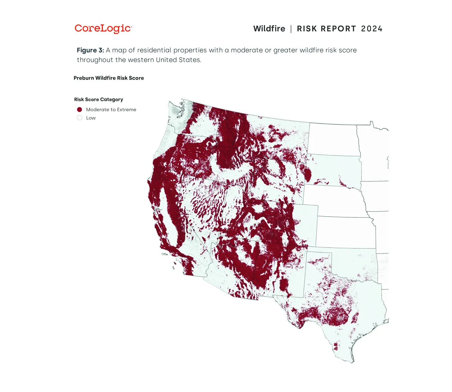
📸 Parting Shot 🎞️


Click the link to read the article on the Big Pivots website (Allen Best):
August 19, 2024
Women will be among the attendees at the Colorado Water Congress annual summer conference this week, and relatively speaking, lots of them.
It wasn’t always so, says Doug Kemper, the executive director for the organization, Colorado’s largest group dedicated to convening discussions about water issues.
Kemper, who is moving on in September after 20 years managing the Water Congress, recalls that when he got involved in Colorado water matters about 40 years ago, water meetings were very different. Young people were expected to sit in the back and listen, to pay their dues.
“It wasn’t 100%, but the feeling was that you sit in the back and go along for the ride.”
Water Congress – and by extension all water matters in Colorado – have become more intergenerational. And more diverse in gender.
“You see a much higher percentage of women, and that just makes for a better (water) community. We are not where we need to be yet. But those are the two big changes in the makeup of the water community in the last 20 to 30 years, and especially in the last 10.”
Also evident, at least in the agenda for Water Congress conferences in the last few years, has been the inclusion of native voices – including native women. This summer’s conference in Colorado Springs is no exception. In addition to sessions devoted to agriculture, the Colorado River and other topics, a half-hour is allotted to comments from representatives of both the Southern Ute and the Ute Mountain Ute tribes. Both speakers will be women.
And yet another change, which can also be seen in the agenda for Water Congress but elsewhere, too, is the proliferation of locally based watershed groups.
Kemper grew up primarily in Atlanta, and got his first college degree in Nashville before making his way to Colorado. Part of his motivation was the Colorado River. In a freshman class he had heard an explanation about the Colorado River Compact that stuck with him.
“We were being told in 1973 – 51 years ago — that out West, they have these seven states that share the Colorado River, and you know what they did? They have allocated more water from the river than there is river.”
Kemper remembers thinking, “What an interesting problem.”

Engineers are attracted to problems, he says. “Not that I thought I had the solution. But I was fascinated by the problem.”
By late 1980, with a degree in environmental and water resources engineering, he was in Colorado. (He later picked up a master’s in civil engineering and water resources from the University of Colorado-Boulder).
At the Colorado Air Pollution Control Division, working on problems that are familiar yet today: ozone and particulates. But his greater interest was in water, and so he then worked for a variety of smaller consulting firms, working on everything from uranium mining to a job in Longmont that led to a deeper understanding of the conversion of water from agriculture to urban uses.
By 1986, he was ready for a new challenge. He got hired by Aurora and eventually became the manager of water resources, a position that he held until 2005, when he left to oversee the Colorado Water Congress.
Even when he started that position, Aurora was getting water from three different river basins in Colorado: The South Platte, the Arkansas and the Colorado.
Aurora, working with Colorado Springs, wanted to expand its diversions from the Colorado River Basin through a project in the Eagle River Basin, near Vail, called Homestake II.
The project, as proposed, was scuttled in the early 1990s, and it remains unclear whether any of that water will ever get diverted.
In 1992, Denver and other Front Range water providers also were sent reeling when the Environmental Protection Agency refused to issue a permit vital for a giant diversion project called Two Forks. It would have enlarged diversions from Summit County – and even from the Vail area.
From his Aurora Water office Kemper saw this and thought, “You know, we have to change our whole approach to water resources, at least in the cities.”
He obtained training, at Harvard and elsewhere, on collaborative problem solving and consent building. The task: learn how to work with people in a high-conflict environment. That, says Kemper, defined the rest of his career — although, he adds, the us vs. them that dominated water thinking 50 to 75 years ago may not be entirely gone. “We may be coming back to that now.”

Aurora, founded in 1891, began as a farming community. The population rapidly expanded from 11,000 in 1950 to 222,000 in 1990, when Kemper was trying to figure out where the water was to come from. (It is now 400,000).
That was the era of big projects. Homestake and Two Forks were big, big projects. Their defeat forced cities to look at transfers from agriculture in Eastern Colorado and in smaller, more incremental ways.
Something else also happened: water conservation. Per capita water use in the 20th century had been rising, in the case of Aurora from 110 gallons daily per capita in the mid-1950s to 180 gallons per capita by the 1980s.
During the last several decades, that per-capita growth flattened and then declined. Aurora’s water use per capita is now at 115 gallons per day.
We have low-water toilets and washing machines, but also new urban landscapes. Cities are also rising vertical. The denser housing reduces the amount of water devoted to front yards and backyards.
Front Range cities have grown considerably but in the last 20 years without necessarily expanding water supplies.
Concurrent with this change has been a revised attitude about water supplies in Colorado. Early in Kemper’s career, it was a mantra that Colorado had at least a half-million acre-feet of water on the Western Slope to develop.
Any lingering thoughts in that regard have largely been shelved by the drought of the 21st century coupled with the aridification caused by a warming climate. Transmountain projects are expensive – and will the water even be there?
Ken Neubecker credits Kemper with being a “pioneer in the changing of the guard.” He points to the attitudes of Denver Water in the 1960s and 1970s. He summarizes the attitude of at least one chief executive of Denver water during that time as being: “We have the water rights, we have more money than you, and we will see you in court.”
Neubecker, a Glenwood Springs-area resident who was a long-term representative for American Rivers, says that Denver retained elements of this attitude even after it lost in the Two Forks battle.
Other water diverters over time had become more willing to have discussions, to take the problems of the Western Slope interest and the environmental community more seriously. He credits in particular the wok of Northern Water.
Denver Water, though, didn’t entirely shift until another Western Slope resident, Jim Lochhead, was hired to oversee the agency.
Neubecker says that Kemper dramatically changed Water Congress. “Not overnight, but he shifted the organization’s thinking into greater inclusivity, the idea that ‘we’re in all in this together,’” he said. “And my position also changed,” he added, from “‘Hell no, not one more drop,’ to ‘We can work together. And the Front Range can still get some of the water. It just depends upon how we do it.’”
As for Kemper’s plans after leaving the Water Congress in September, he says he has deliberately chosen to have none. “I have never taken more than two weeks off literally from the time I was in 10th grade, So, right now, I am trying not to have any commitments. I’ll just let things happen.”


Click the link to read the article on The Los Angeles Times website (Ian James). Here’s an excerpt:
August 7, 2024
In a decision that could end a years-long battle over commercial extraction of water from public lands, the U.S. Forest Service has ordered the company that sells Arrowhead bottled water to shut down a pipeline and other infrastructure it uses to collect and transport water from springs in the San Bernardino Mountains. The Forest Service notified BlueTriton Brands in a letter last month, saying its application for a new permit has been denied. District Ranger Michael Nobles wrote in the July 26 letter that the company “must cease operations” in the San Bernardino National Forest and submit a plan for removing all its pipes and equipment from federal land. The company has challenged the denial in court.
Environmental activists praised the decision.
“It’s a huge victory after 10 years,” said Amanda Frye, an activist who has campaigned against the taking of water from the forest. “I’m hoping that we can restore Strawberry Creek, have its springs flowing again, and get the habitat back.”
She and other opponents say BlueTriton’s operation has dramatically reduced creek flow and is causing significant environmental harm. The Forest Service announced the decision one month after a local environmental group, Save Our Forest Assn., filed a lawsuit that alleged agency was illegally allowing the company to continue operating under a permit that had expired.

Click the link to read the article on the Heated website (Emily Atkin). Here’s an excerpt:
August 1, 2024
I haven’t had time to analyze media coverage of the 2024 Olympic Games. So I’m not sure how many stories about Tuesday’s dangerous heat in Paris mentioned that the high temperatures were fueled by climate change. But just in case you didn’t see, here’s an important stat: Fossil fuels, deforestation, and animal agriculture made outdoor temperatures at Tuesday’s Olympics about 5.2°F degrees hotter than they would have normally been.
The reason we know this is because of incredible recent advancements in attribution science, which uses observational data and statistical methods to figure out how likely and severe an extreme weather event would be today, compared to how it would have played out in a world un-warmed by human activities. Specifically, the 5.2°F number comes from a “super rapid analysis” published Wednesday by World Weather Attribution (WWA), an international group dedicated to conducting and communicating attribution science. It found the heat wave that’s plagued France and other Mediterranean countries this July would have been anywhere from 4.5°F (2.5°C) to 5.9°F (3.3°C) cooler in a pre-climate-changed world. The average of that range is 5.2°F.
And the idea that fossil fuels, deforestation, and animal agriculture caused this 5.2°F increase comes from basic climate science. Approximately 75 percent of current anthropogenic CO2 emissions come from fossil fuels, and anywhere from 13 to 20 percent come from agriculture, forestry and land use (AFOLU), according to the IPCC. In the AFOLU category, 45 percent of emissions come from deforestation, and 41 percent of global deforestation comes from beef production.
I spell all this out because I want to make it clear: If we want the summer Olympics to continue to exist and be safe for athletes, we need to rapidly reduce emissions from these sectors. I’ve said it before, but I’ll say it again: It’s not enough to say that “climate change” is screwing with the things we love. Communicators have to also be clear about why climate change is happening, so it’s equally clear what must be done.
.jpg)