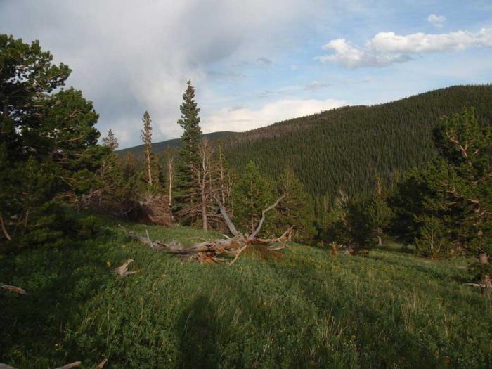
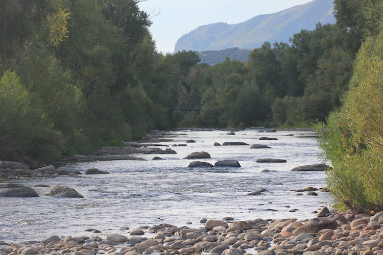
Rafters make their way down Clear Creek in Idaho Springs. Colorado’s rivers are expected to be running high after an epic winter. Photo credit: Sara Hertwig via Metropolitan State University of Denver
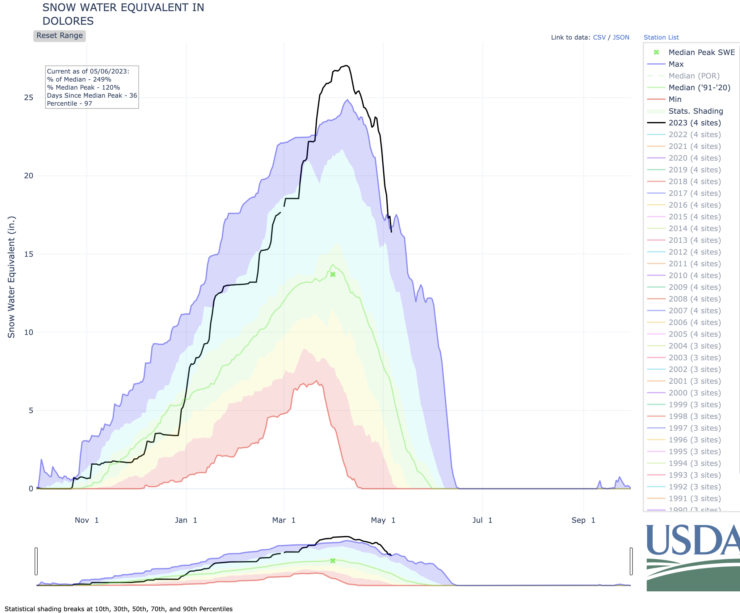
Colorado’s bountiful snowpack is beginning to melt, and stream and river flows are rising. If current predictions for spring runoff stay on track this could be the longest stretch of boatable days seen on Colorado’s rivers in over a decade, including a rare opportunity to float southwestern Colorado’s spectacular 240-mile-long Dolores River.
“We haven’t seen this kind of season since 2011,” said Erin Walter, a hydrologist for the National Weather Service based in Grand Junction. “All the basins are doing well.”
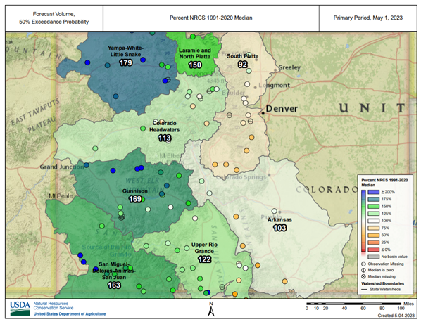
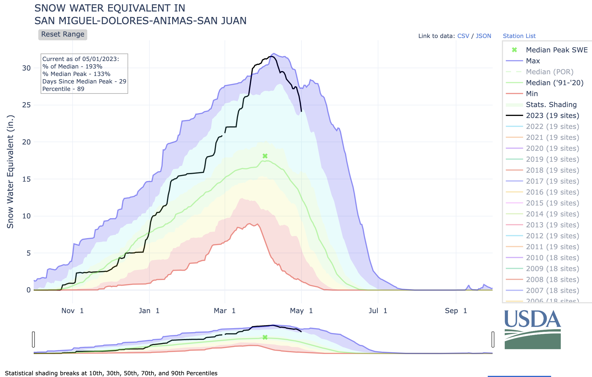
The Dolores Basin, in southwestern Colorado, has the highest snowpack in the state, at 254% of average. The Gunnison River Basin stands at 169%, the upper Yampa Basin is at 152%, while the combined Animas, San Miguel, San Juan and Dolores are collectively at 192%. The lowest snowpack numbers are in the South Platte Basin at 98% and the Arkansas Basin at 78%.
“This is definitely one for the record books,” said Kestrel Kunz, of American Whitewater. “As a boater I’m excited. This healthy snowpack is something that everyone can be excited about, regardless of whether you’re a river runner, rancher or restaurant owner.”
With that healthy snowpack and higher water comes danger, especially for beginning boaters. Rivers are faster and colder, the difficulty of rapids increases and there is more debris — like fallen trees — in the water and low bridges to watch out for. “Since the pandemic more people have gotten into river recreation so a large part of the population hasn’t seen these kinds of flows,” said Kunz. “We have to make sure people are accessing the flows and making good decisions about river safety.”
One of the epicenters of this season’s higher flows is Almont in the Gunnison River Basin where the East, Taylor and Gunnison rivers come together. The peak flow of the combined rivers may reach a 100-year high, according to the National Weather Service.
“High water is a good problem to have,” said Dirk Schumacher, outfitting manager for Three Rivers Rafting in Almont. “The projections we’re looking at right now, the river’s going to be high. High but not un-runnable. At normal flows, these are very straightforward Class 3 rivers. At higher water … everything just happens a lot faster.”
Schumacher was referring to a river flow rating system in which flows are rated from Class 1 to 5, with 5 being the highest intensity.
Despite the lower snowpack numbers in the Arkansas River Basin, Arkansas Headwaters Recreation Area park manager Tom Waters is optimistic. “We’re looking at a really good year,” Waters said. “It’s going to be a promising season for rafting and the fishery. I think we’ll see high water but we don’t anticipate really high water or really extended high water. People are already fishing and floating here.”
Dolores River watershed
But it is the southwestern corner of the state, on the Dolores River, that is generating the most excitement, said Andy Neinas of Echo Canyon Outfitters in Canon City.
“The Dolores is a gem among gems,” Neinas said. “But it’s a river that never runs. There hasn’t been a meaningful boating season on the Dolores in 10 years or longer. This year Americans are going to get to see a wonderful resource that has not been available to them.”
How fast or slow the snowpack melts will determine much about the length or brevity of the upcoming boating season. Unusually warm temperatures could send the snowpack rushing downriver all at once creating dangerous conditions and shortening the boating season. Depending on geography, the runoff can begin in early spring, and will have run its course by late summer.
Erin Walter, of the National Weather Service, said a number of variables come in to play, including rain, dust, wind, warm or cold temperatures and soil moisture content.
Dust carried by high winds in April tinted much of Colorado’s snowpack with a distinctive red coloring. “When it collects on snow, dust, being darker, absorbs the solar radiation rather than reflecting it and increases the rate of snow melt. We’ve also had several years of drought and the soil can suck up a lot of that moisture as well,” she said.
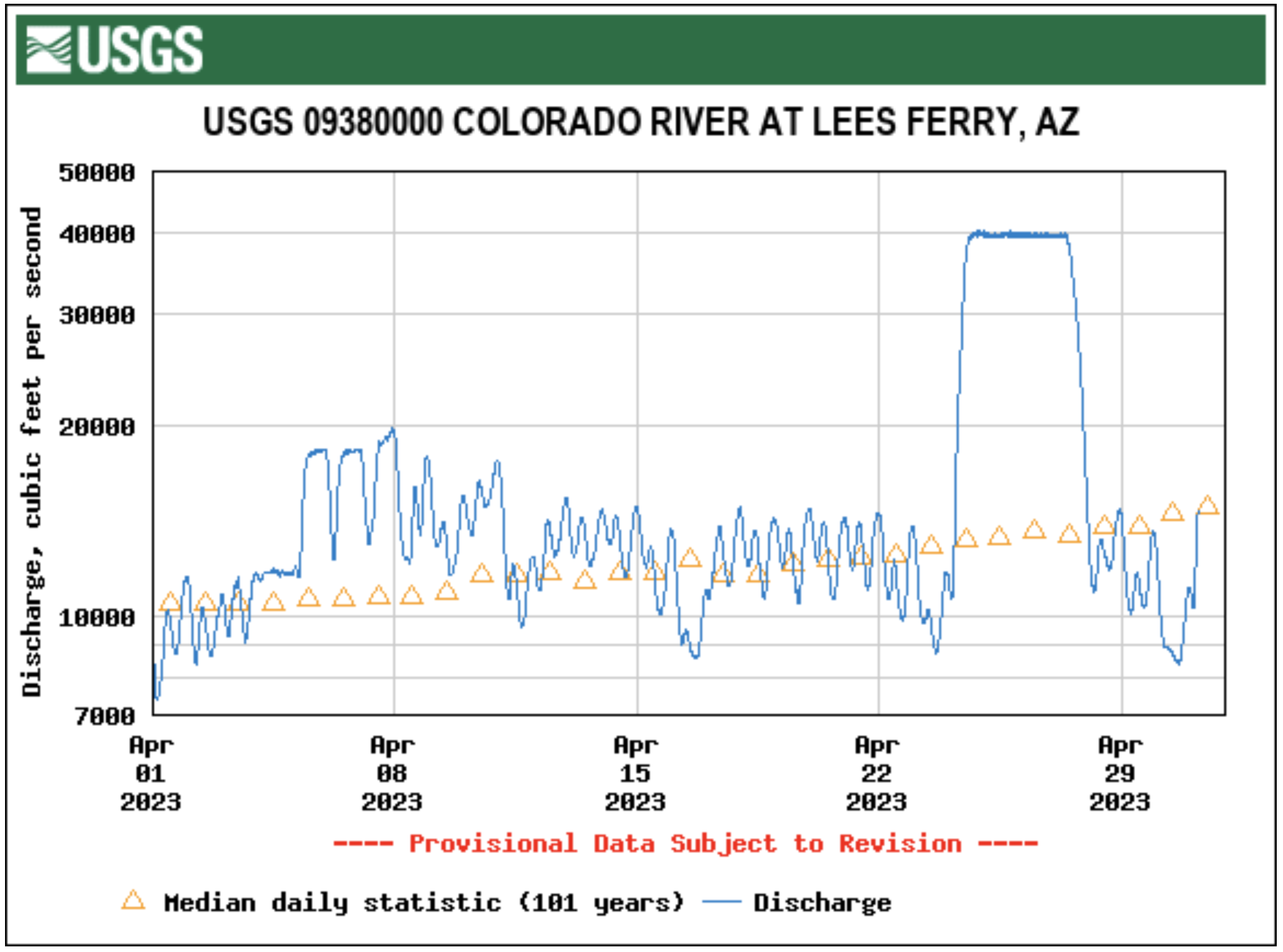
Graham Sexstone, research hydrologist for the U.S. Geological Survey (USGS), says the next 30 days will shape the rest of the rafting season.
“A lot depends on the weather over the next month,” Sexstone said. “Many of the USGS stream monitors are showing high flows already and the snowpack above 11,000 feet hasn’t even started to melt. The real runoff hasn’t begun.”
Dean Krakel is a photographer and writer based in Almont, Colo. He can be reached at dkrakel@gmail.com.
The Dolores River, below Slickrock, and above Bedrock. The Dolores River Canyon is included in a proposed National Conservation Area. Photo: Brent Gardner-Smith/Aspen Journalism.
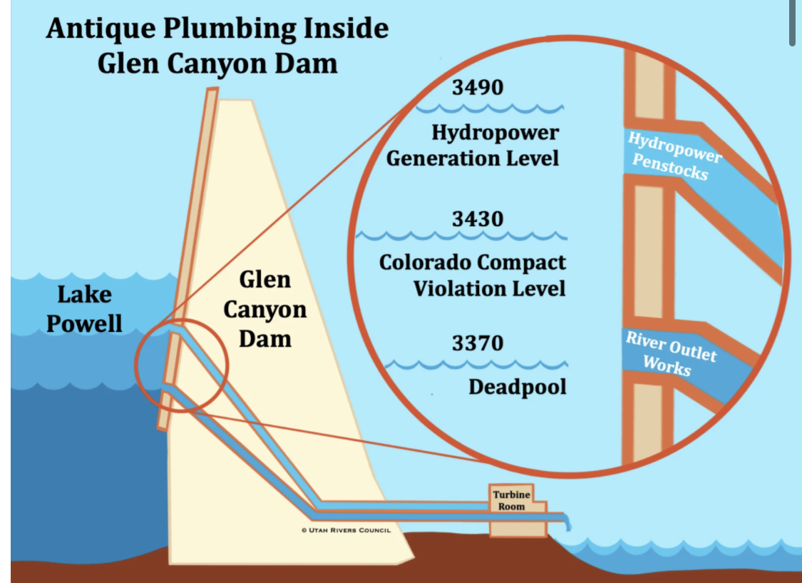
Yes, that diagram again. I was chastised by readers last week for using it – partly for the ‘Antique’ in the diagram’s title, but also for not adequately explaining what the diagram shows. I apologize for the latter. These posts tend to run long and demand a lot more of readers than the 15-second attention span for which Americans are derided. But just to keep them down to a couple thousand words or so, I find myself having to go through some things too quickly in order to get to whatever point I was aiming for. Brevity unfortunately is not the soul of my wit.
But having a sense of the structure and infrastructure of our big dams is critical to understanding what is going on along the Colorado River these days, where it is easy to confuse the river itself (which is experiencing chronic low flows but is not ‘drying up’) with the ‘river management system’ (which really could dry up critical stretches of the river under the current management regime). The ‘river management system’ is the integrated set of physical structures along the river for storing the river’s water and distributing it to users – and the operating systems whereby those structures are managed.
The ‘Supplemental Environmental Impact Study’ the Bureau of Reclamation is doing now is basically an analysis of its own operating systems for the big structures on the Colorado River, and how those systems might be radically changed with an equitable distribution of impacts on humans – systems that could have been changed gradually over the past several decades, the past century even, to reflect undeniable evolving realities, both natural and cultural, but now must be done with radical surgery – the call for an almost-immediate reduction in Lower Basin uses of two million acre-feet.
This might be what life in the Anthropocene will mostly be on many fronts: learning how to live well enough with the world we have imposed on the world we found here. A recreated world where some cultural works were done naively and maybe profligately, under assumptions now needing correction – which one might hope we will learn to begin sooner rather than later – or too late, period.
Graphic via Holly McClelland/High Country News.
So it is fitting to look critically at what we’ve done along the ‘First River of the Anthropocene’ – trying not to fall into hypocritical analysis, gnawing on the hands that feed us. And on that spectrum of critical analysis, I do need to explain, if not defend, using a diagram that calls the ‘plumbing’ of a major element in the management system we’ve imposed on the Colorado River ‘antique.’
I will say first that I do not necessarily think of ‘antique’ as a derogatory term (although that was probably intended by the creators of this diagram). If an automobile is fifty years old and still running, it qualifies for an ‘antique’ license plate; that’s cool, an achievement for those who kept the car functional. I think of the word as more descriptive than judgmental: an antique is an artifact whose time is past but which reflects that time, something old but with an element of class, something that summons memories of a previous time, a time we want to remember but not necessarily carry forward.
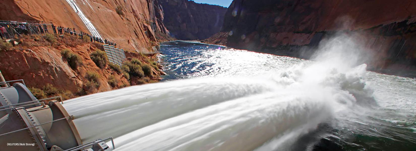
So, being more than 50 years old at this point – is Glen Canyon Dam an antique? We can start with an examination of its ‘plumbing,’ which says something about its life and times. (My doctor uses colonoscopies for a similar analysis.)
1983 – Color photo of Glen Canyon Dam spillway failure from cavitation, via OnTheColorado.com
One piece of plumbing not shown on the diagram is the dam’s spillways – two huge ‘drains’ up at the 3,700-foot elevation, near the dam’s 3,715-foot crest (for context, 583 feet above the original streambed). The purpose of the spillways is to keep the reservoir from filling to the point where it would go over the crest. Glen Canyon’s spillways have only been used once, in 1983, when a very wet May and hot June caught the dam managers unaware, with the reservoir already too full to perform its flood-control function. The spillways proved to be not up to the task of getting the flood waters past the dam; the water pouring down them caused a cavitation problem – a million tiny ‘air-hammers’ beating on the concrete with enough cumulative force to break it up. The managers knew there was a problem when large chunks of concrete, then sandstone, started washing out the bottom of the spillway outlets. That threatened the integrity of the dam itself; it was necessary to close off the spillways, lining the top of them with sheets of plywood four feet high and praying that the water would stop rising before it topped the plywood. It did stop in time, and the dam was saved. The spillways were rebuilt, hopefully resolving the cavitation problem, and have not been used since – and at this point, given the projections about climate change, it is hard to imagine the reservoir ever being that full again. The spillways alone might qualify as ‘antiques,’ built for a river that needed them (once) but may no longer exist. (Oh great river gods, please make me eat my words!)
During the 1983 Colorado River flood, described by some as an example of a “black swan” event, sheets of plywood (visible just above the steel barrier) were installed to prevent Glen Canyon Dam from overflowing. Source: Bureau of Reclamation
For the dam managers, however, to ‘spill’ water at all is a mark of bad management; their ideal is for every gallon of water contained by the dam to be released through openings 210 feet below the spillways, at hydropower generation level, the 3,490-foot elevation (see diagram). Those openings into the dam drop the water through pentstocks a couple hundred vertical feet to turbines in generators the size of small houses; on its way to its designated use downstream, the water generates electricity. The higher the reservoir level, the more pressure the water’s weight exerts in pushing the water through the turbines; with the reservoir at high levels, the Glen Canyon generators can produce annually up to five billion kilowatt-hours of electricity. In 2022, however, with the reservoir level only around 35 feet above the pentstock inlets, it only produced 2.6 kilowatt-hours. (Bureau figures)
The Bureau’s semi-panicky call in 2022 for massive reductions in use basin-wide was based on projections forward of another couple water years like the 2020-22 period; under the current river management regime, the level of the reservoir would have dropped below the level of the pentstock intakes in a couple years, and year-round power generation would have been impossible.
The back of Glen Canyon Dam circa 1964, not long after the reservoir had begun filling up. Here the water level is above dead pool, meaning water can be released via the river outlets, but it is below minimum power pool, so water cannot yet enter the penstocks to generate electricity. Bureau of Reclamation photo.
Even if that were to happen, however, it would still be possible to move water downstream from Powell Reservoir, through river outlet works with intakes 120 feet lower down in the dam, at the 3,370-foot elevation. The river outlets there are four big pipes, each eight feet in diameter, with a total flow capacity of 15,000 cubic feet per second – when there’s a lot of water in the reservoir to push water through them. If the water pressure stayed at that level, and all four tubes worked 24/7/365, it would be possible to move around 10 million acre-feet (maf) through the dam annually and down to Mead Reservoir, roughly the amount the Bureau has been releasing from Mead for Lower Basin and Mexican use – plus the system losses for which no one has wanted to claim responsibility.
That 10 maf leaving the system at the lower end obviously becomes problematic if only 6-8 maf are flowing into the system at the upper end, as has been the recent situation. For one thing, the Bureau is not sure the outlet works can stand that kind of constant use; they are getting old, and may not have been built for constant use anyway. So if the Bureau were able to keep only three tubes running all the time, with one in maintenance mode, the amount of water that could be moved at full pressure would drop to just about the Upper Basin’s Colorado River Compact commitment – 7.5 maf plus the Upper Basin’s share of the Mexican obligation (750,000 af).
But as the water level in the reservoir dropped closer to the outlet works intakes – 6-7 maf inflow minus 8 maf outflow equals a storage decrease of 1-2 maf/year – the water pressure through the tubes would also drop, and below the 3,430-foot elevation, it would no longer be possible to push the full Upper Basin commitment to the Lower Basin and Mexico through the tubes.
Map credit: AGU
Worst case – if the reservoir level dropped below the 3,370-foot elevation, it would no longer be possible to move any water at all past the dam, even though there would still be just under two million acre-feet left in storage – the ‘dead pool.’ At that point, the Lower Basin states would either have to do something completely nonconstructive like sue somebody (Upper Basin states? Interior Department? The Bureau?), or argue about which states should pay how much to Upper Basin water users to let their water (not federally controlled) flow to Powell to try to raise the level back above the 3,370-foot elevation. And most of the Upper Basin water rights junior to the Compact are not a bunch of rugged individualist farmers and ranchers; they are the big transmountain diverters – Colorado’s Front Range cities, the Santa Fe-Albuquerque corridor, the Salt Lake basin, who are already ‘lawyered up.’
The ramshackle ‘Law of the River,’ grounded in appropriation law and followed to the letter of the laws, would have nothing to offer to relieve that situation; it is easier to imagine Paolo Bacigalupi’s ‘Water Knife’ war commencing.
That is an overview of Glen Canyon Dam’s plumbing – pretty standard for a big 20th century dam, designed to operate optimally when the reservoir is more than two-thirds full and able to maintain a full power head in releasing water through the turbines for – oh yeah, not primarily power generation, but the dam’s main job of providing dependable water for agricultural and domestic users downstream. A specific warning in the Colorado River Compact (IV(b)).
Now to the question: is Glen Canyon Dam an ‘antique’? I think, at this point, given the prognostications for the future of the regional water supply, we could truly say that the dam was built for a different era, a different river – some of which river may have existed only in the minds of the dam builders. The ‘Hassayampa romance,’ carried along, like Deacon Holmes’ wonderful one-hoss shay, ‘for a century to the day’ – the day the Bureau finally abandoned its paper surplus calculations and called a shortage.
In addition to working on new river operation protocols, the Bureau now has a team working on ways to possibly modify the dam, undoubtedly at considerable cost, maybe enlarging the outlet works, maybe generating some flow of electricity through openings lower in the dam, and maybe constructing tunnels to bypass the dam entirely, leaving Mead Reservoir as the river’s major storage.
The latter concept could relieve a problem that the dam has created for ‘today’s river’ through the Grand Canyon: the beaches and sandbars that are essential as night stops for the billion-dollar Grand Canyon recreational boating industry are eroding away, with no replacement sand and silt getting past the dam. This is being dealt with now by occasional staged ‘floods’ like the one just recently: pouring 200,000-plus acre feet of water over 2-3 days down through the Grand Canyon to stir up sediment that has slumped from the beaches down into the riverbed, in hopes that it will be redeposited on a beach downstream. Ultimately this mostly just escalates the passage downstream of all the beach material with only irregular and inadequate deposits of new material from side streams. That this ultimate losing effort was done in April 2023, with Powell Reservoir under 30 percent full, but anticipating a runoff that might get it all the way up to half-full or only half-empty, depending on your psychological inclination…. There’s an underlying desperation there that is not goimng to let us look back on this period with any pleasant sense of nostalgia. But we might look back on antiquities like Glen Canyon Dam as a reminder of the consequences of operating on assumptions and standards not fully grounded in demonstrable reality.
A problem with this analysis, however, is that for better or worse, it evaluates Glen Canyon Dam out of context. To really understand why we have Glen Canyon Dam at all, it is necessary to see our river’s physical structures in the larger context of the less visible political and legal infrastructure that led us to pile five million yards of concrete (with internal plumbing) in the river’s path in that particular place. That is another great story in the evolution of this mixed bag we call America. Up next in a couple weeks; stay tuned.
Delph Carpenter’s original map showing a reservoir at Glen Canyon and one at Black Canyon via Greg Hobbs
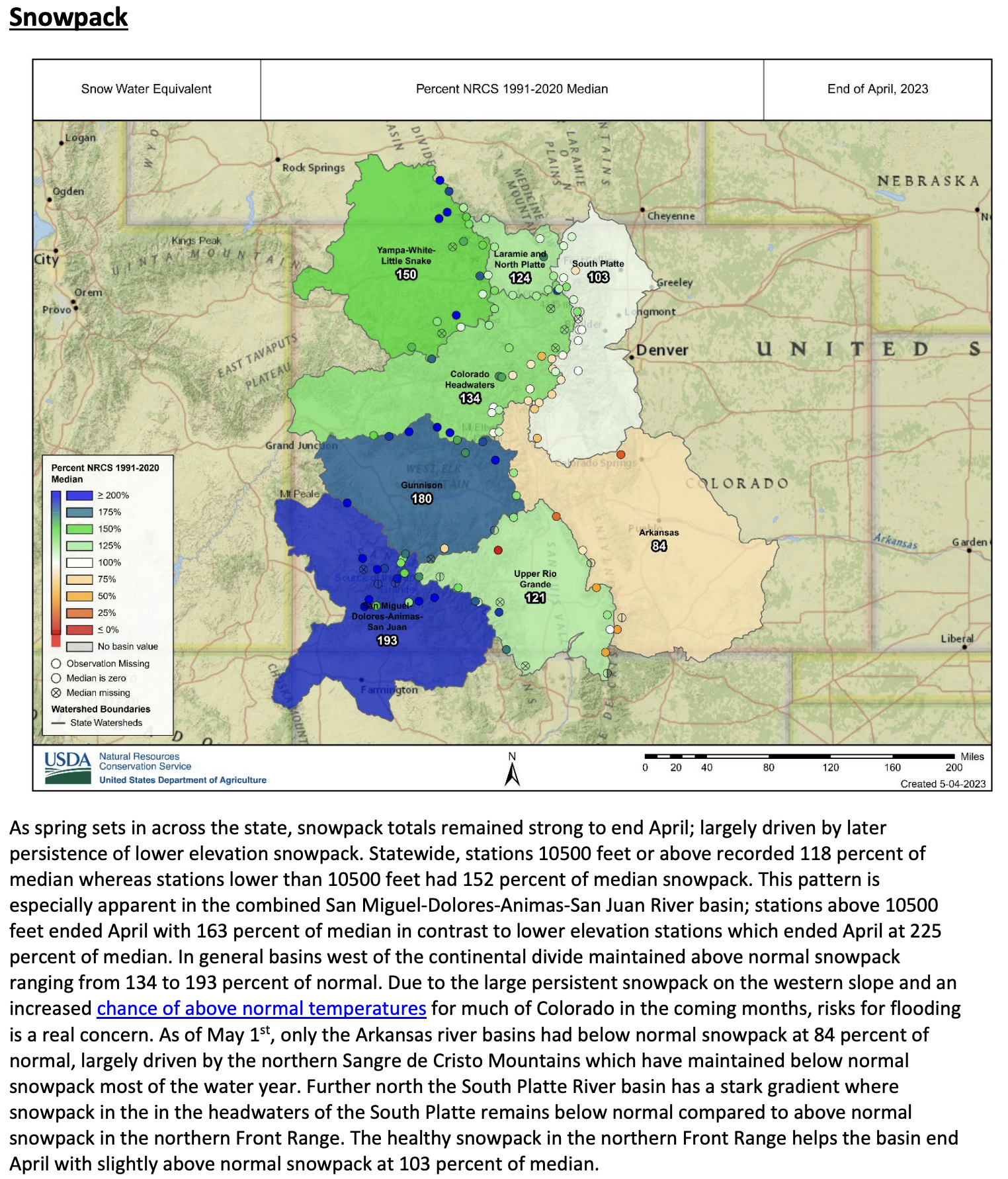
Click the link to read the release on the NRCS website:
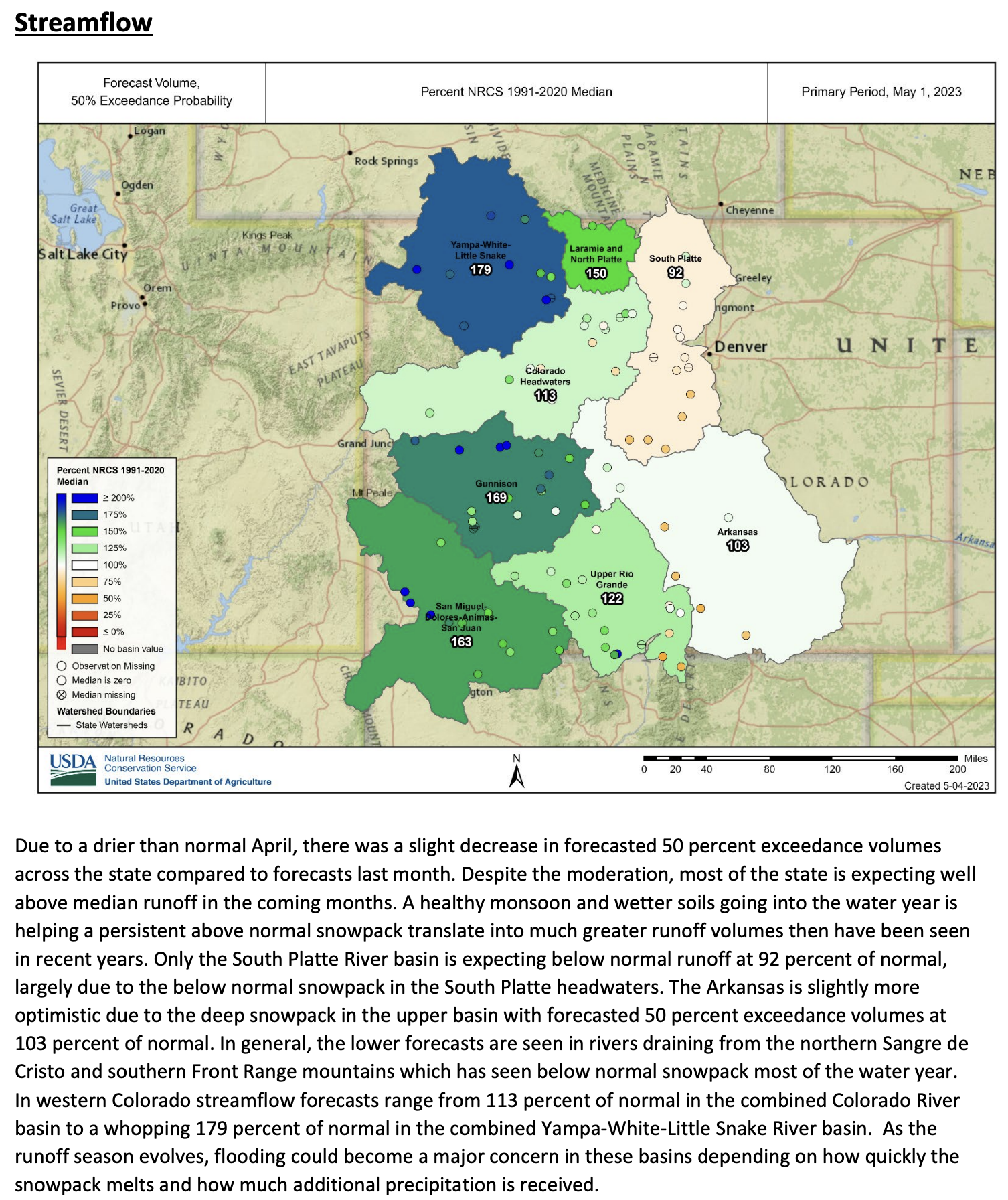
Denver, CO – May 4th, 2023 – In addition to above normal snowpack across much of the state, primarily in Western Colorado, lower elevation snowpack were particularly plentiful leading to substantial early season runoff in some basins. Along with this low elevation snowmelt, significant flooding has already been observed in the Yampa and Dolores basins with still much more snowmelt to come. While much of Western Colorado experienced above normal April streamflow volumes this was not the case across the entire state. NRCS Hydrologist Karl Wetlaufer commented “Peak snowpack and streamflow forecasts for the full April-July runoff period vary widely across the state this year. While much of Western Colorado should expect a continuing trend of above normal streamflow, much of the Arkansas and South Platte basins are forecasted for well below normal seasonal runoff volumes.” Portions of the Colorado River headwaters and portions of the Rio Grande River basins are also anticipated to have below normal streamflow over the coming month.
May 1, 2023 Colorado streamflow forecast. Map credit: NRCS
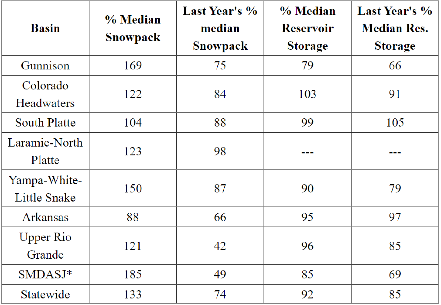
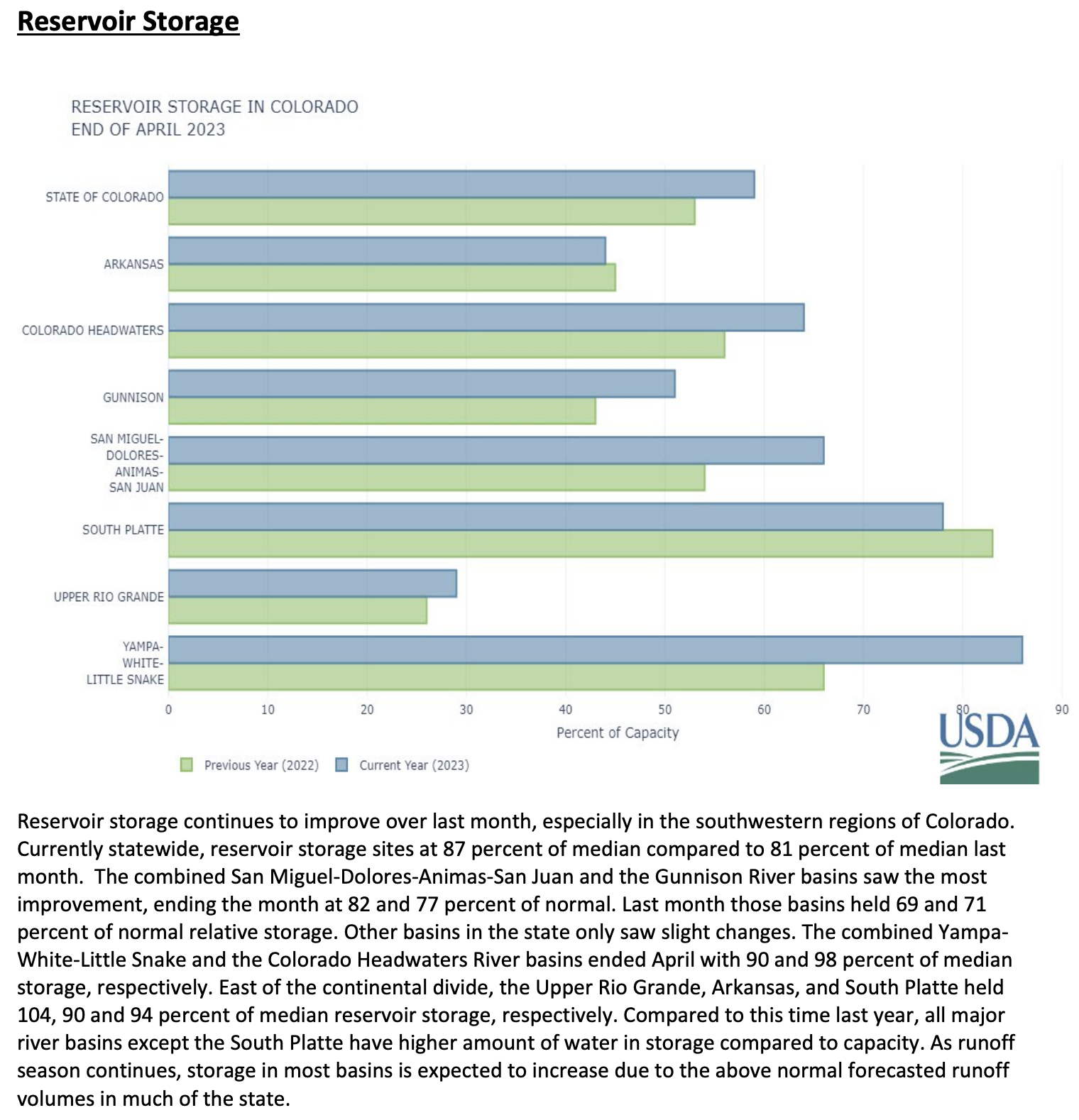
Reservoir storage has begun to improve in the basins with the biggest deficits, namely the Gunnison and the combined San Miguel-Dolores-Animas-San Juan River basins, with most other basins holding near normal storage values. With several months of snowmelt runoff still to come, it is anticipated that reservoir storages will be changing considerably as the season progresses. Given the high degree of variability in streamflow forecasts across the state it is recommended to pay close attention to forecasts and changing conditions in your local area throughout the spring and summer.
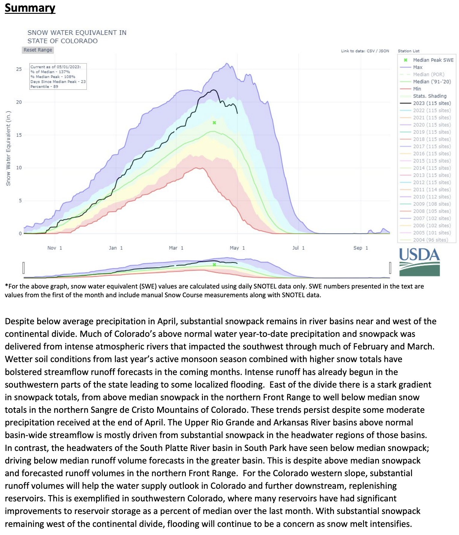
Statewide snowpack, as measured at SNOTEL sites, peaked on April 8th prompting the start of the primary snowmelt runoff season. As days get longer and the sun gets higher in the sky, snowmelt rates have the potential to continue to accelerate. Hydrologist Wetlaufer notes “This is an incredibly important time of year for water resources. Conditions can change quickly and is important to monitor changing conditions closely over the coming months depending on the needs of water resource management in a given basin.” Wetlaufer continued “In a year like this, some areas may need to be planning activities such as reservoir management with flood potential in mind while in areas with lesser streamflow forecasts conservation may need to be the focus.” While plentiful streamflow are certainly good news from a strictly water supply standpoint in the greater Colorado River Basin (above Lake Powell) it is important for everyone in Colorado to be mindful of flood potential and those associated hazards.
May 1, 2023 Colorado reservoir storage. Credit: NRCS
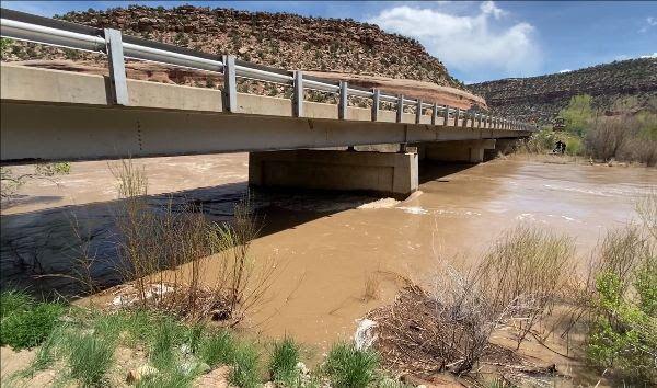
A photo captured on May 3, 2023 shows the Dolores River flowing underneath a CDOT bridge structure located on Colorado Highway 141 at mile point 88.5. River flow rates are nearing 10-year flood event levels. (Courtesy photo/CDOT)
The Colorado Department of Transportation is strongly considering closing Colorado 141 between Naturita and Gateway Friday evening, May 5, due to water levels on the Dolores River and extra caution over the structural integrity of the bridge at Roc Creek.
If the river reaches expected levels, CDOT plans to close the highway at 5 p.m. Friday, with the highway remaining closed until the flood danger has subsided. According to a CDOT news release, the closure is dependent on various factors, including snowmelt and reservoir releases. As flow amounts fluctuate, the bridge over Roc Creek may require additional closures
“River flows in the area have not been observed at these levels in 18 years. With the flood event expected to peak this Friday, we are taking proactive and cautionary measures at this particular bridge. Engineers and maintenance personnel will be assessing the structural integrity throughout this high-flow event,” Regional Transportation Director Julie Constan said in the news release.
For safety, CDOT has determined that the bridge structure at Roc Creek should be closed to traffic while peak water flows are occurring. The structure is located approximately 27.5 miles north of Naturita at mile point 88.5. The northbound closure point is located north of Naturita and the County Road CC junction at mile point 64. The southbound closure point is just south of Gateway, at mile point 110.
CDOT hydraulics engineers are closely watching forecasts, as well as tracking the anticipated releases from McPhee Reservoir in Montezuma County, CDOT spokeswoman Lisa Schwantes said.
“It’s going to be a combination of those things that really have an effect on how high the water flow is,” she said. With respect to whether CDOT in fact closes 141: “We’re leaning toward the side of caution.”
The National Weather Service (NWS) has issued a flood advisory for the Dolores River due to the increased release of water from McPhee Reservoir. The flood advisory also includes the Dolores and San Miguel Rivers due to heavy runoff from snowmelt. The flood advisory is in place until further notice and covers Montrose County, as well as the counties of Montezuma, Dolores and San Miguel.
CDOT is less concerned that water will overflow the top of the bridge — projections have the river hitting about 2 to 4 feet below. Rather, the concern is how the bridge structure might respond to a high flow at a rate not seen in close to 20 years, Schwantes said. There is some concern about the bridge piers, as well as large debris that could wash down and lodge beneath it.
“We’re confident of the integrity of the bridge, but we don’t want anyone driving over it when those high peak flows are occurring,” she said.
The northbound closure point is located north of Naturita and the County Road CC junction at mile point 64. The southbound closure point is just south of Gateway, at mile point 110.
Mcphee dam
The National Weather Service (NWS) has issued a flood advisory for the Dolores River due to the increased release of water from McPhee Reservoir. The flood advisory also includes the Dolores and San Miguel Rivers due to heavy runoff from snowmelt. The flood advisory is in place until further notice and covers Montrose County, as well as the counties of Montezuma, Dolores and San Miguel.
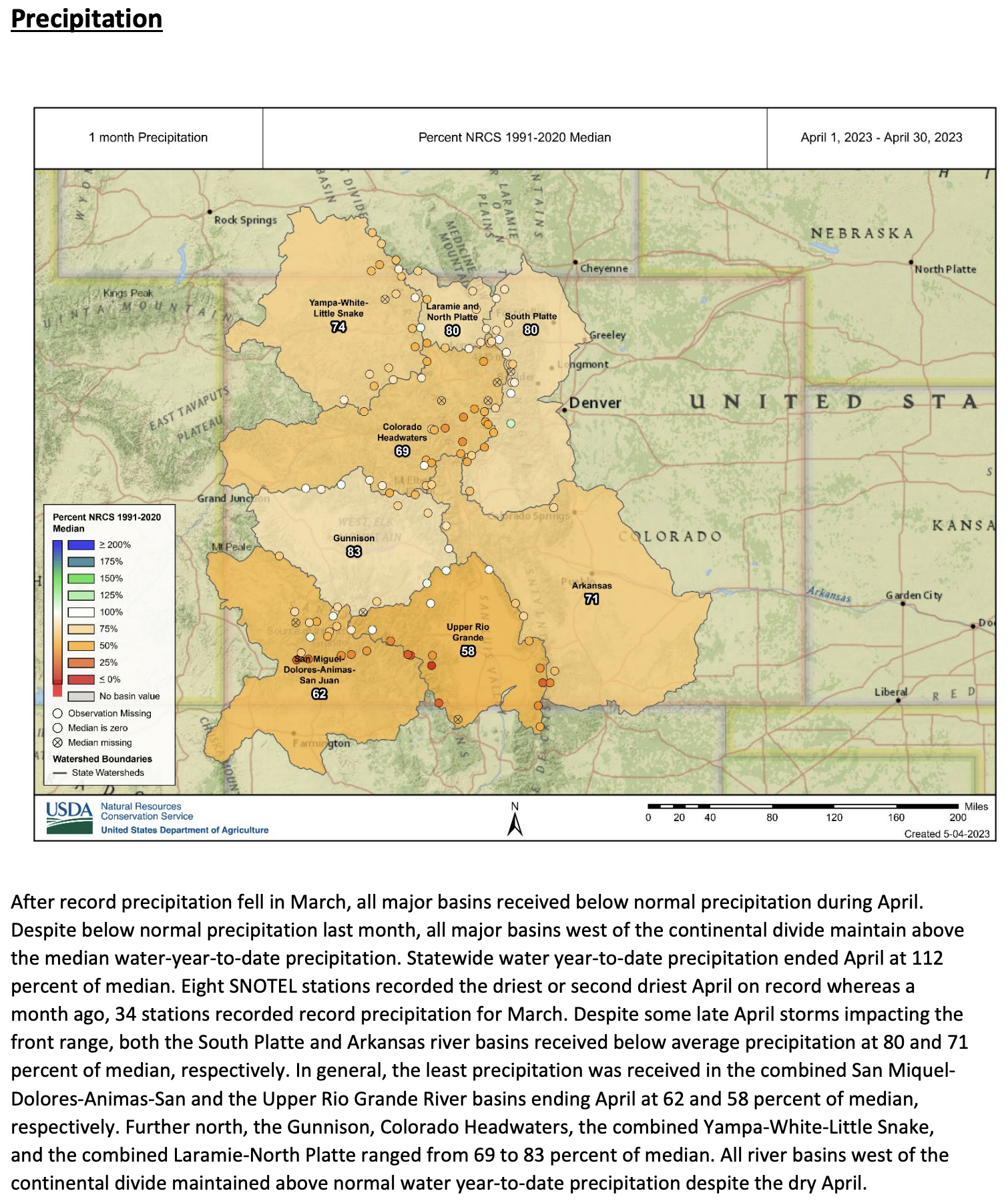
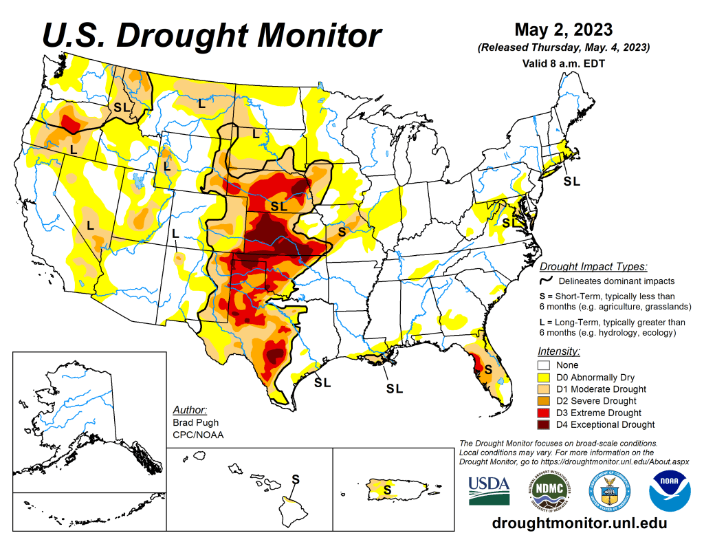
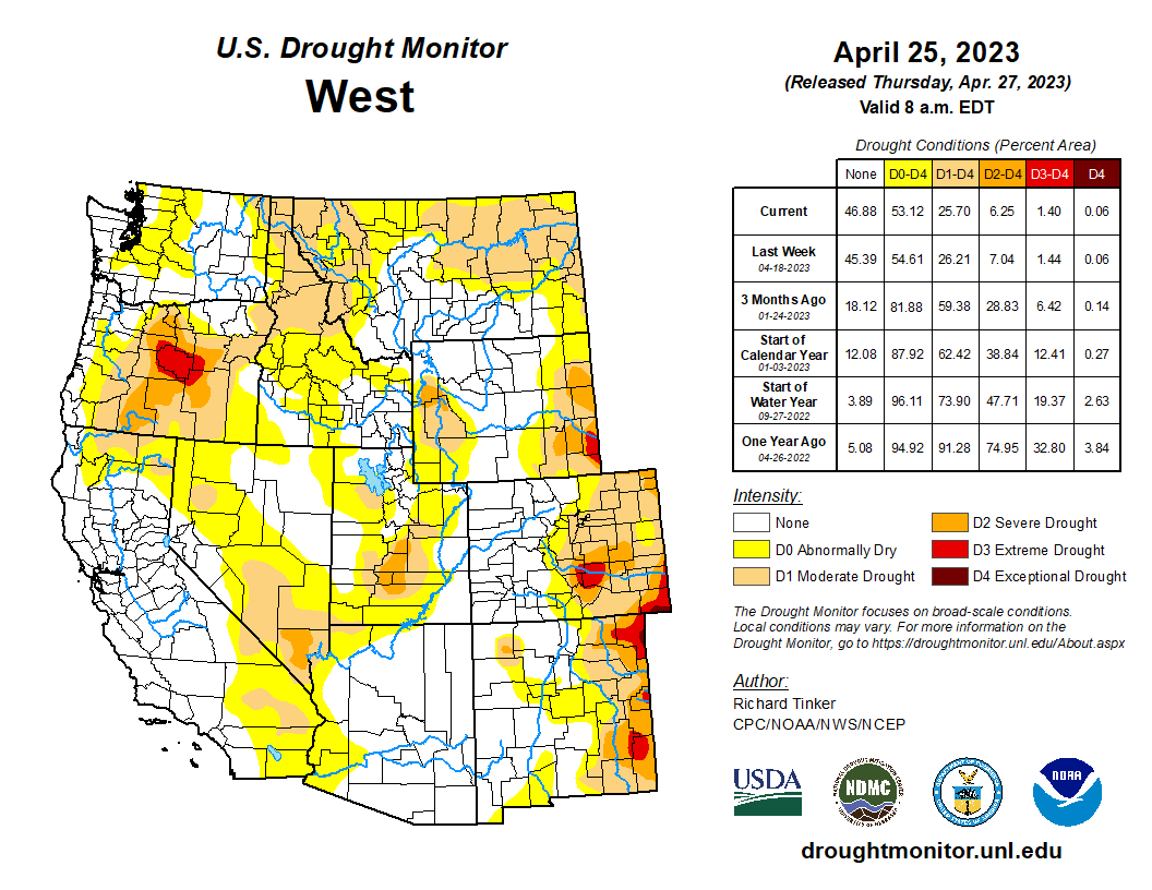
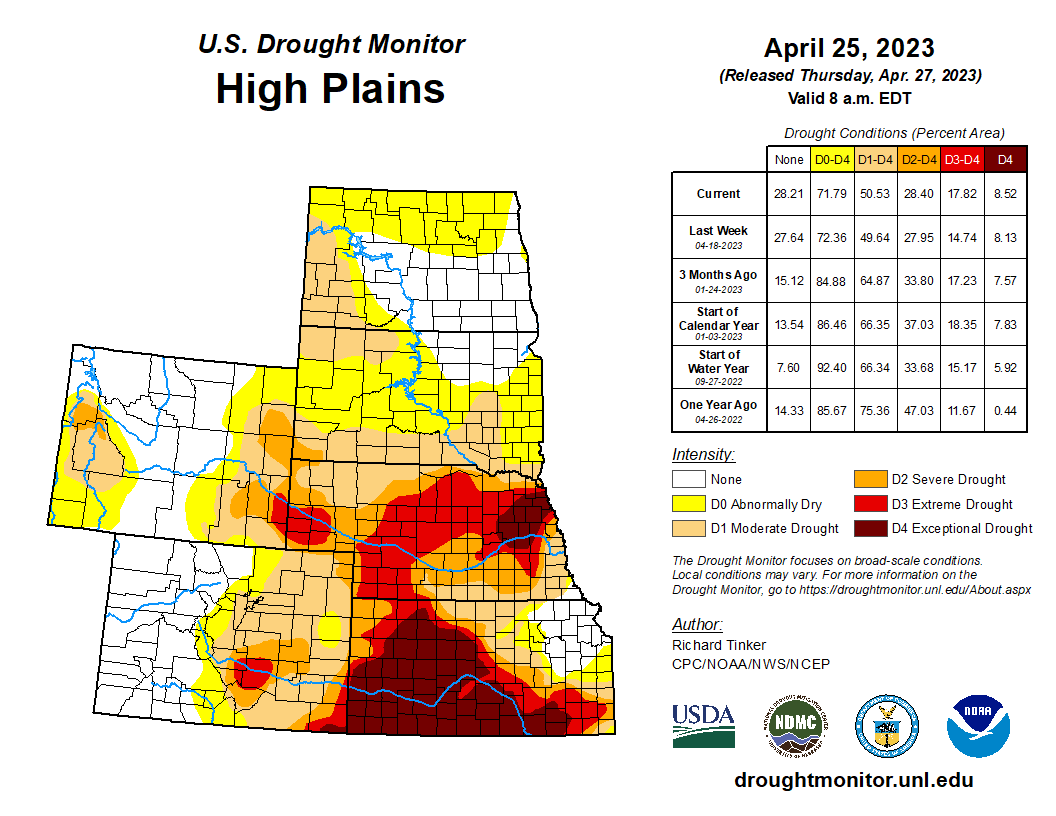
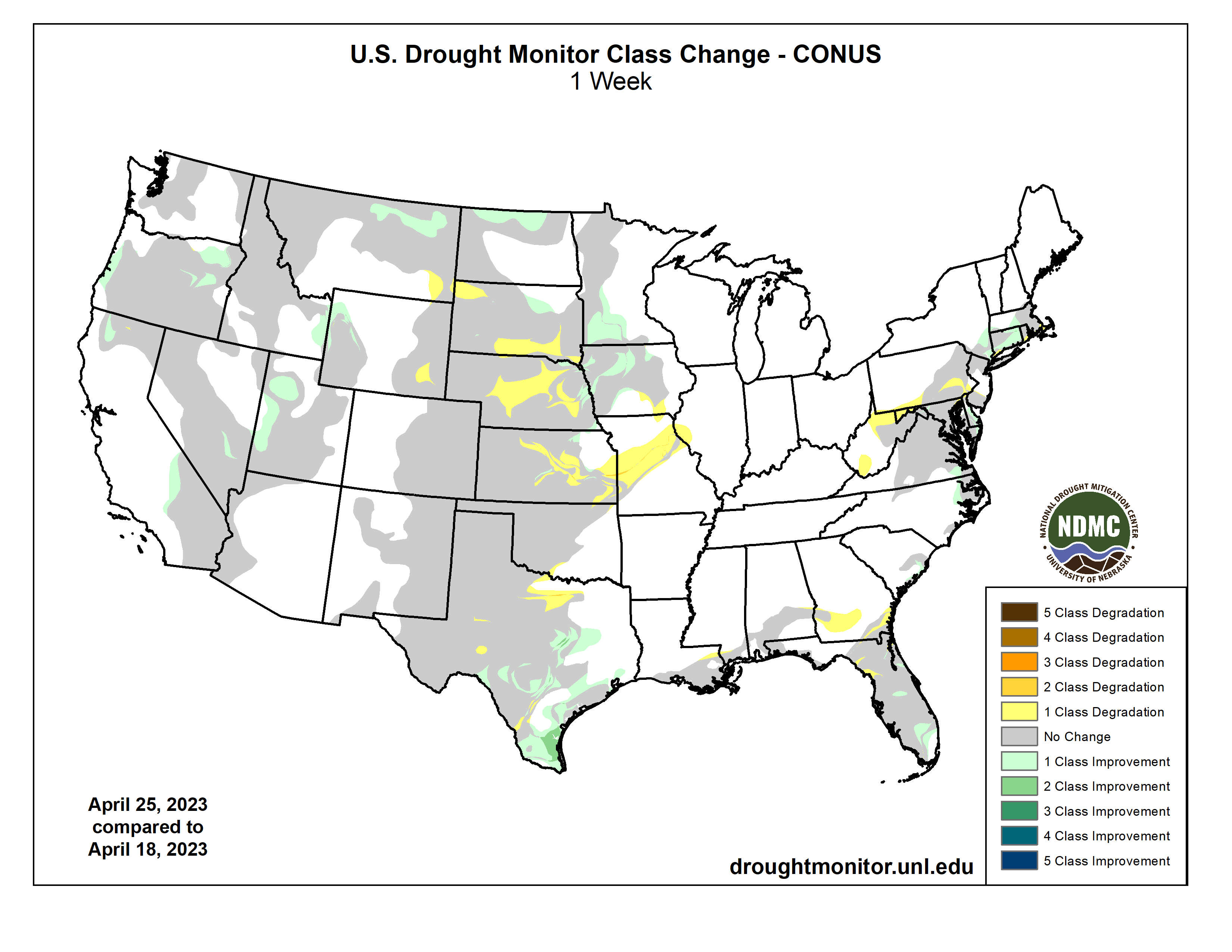
A pair of low pressure systems tracked from the Southeast northward along the East Coast, bringing a swath of widespread precipitation (2 to 4 inches, locally more) to much of the East Coast at the end of April. During the final week of April, the Southern Great Plains along with the Lower Mississippi Valley also received widespread precipitation with amounts exceeding 2 inches across southeastern Colorado, northern and eastern Oklahoma, and northeastern Texas. Late April was mostly dry across the Central to Northern Great Plains and Middle Mississippi Valley. Little to no precipitation was observed throughout the West where a significant warmup at the end of April resulted in rapid snowmelt, runoff, and flooding along streams and rivers. In contrast to these above-normal temperatures, cooler-than-normal temperatures occurred across the Great Plains, Corn Belt, and much of the East from April 25 to May 1…
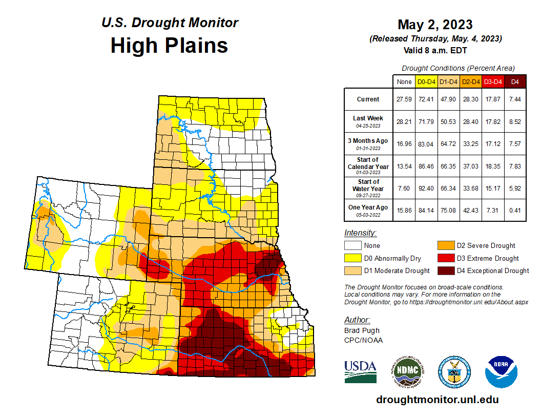
Rainfall of 1.5 to 2 inches, or more, during the past week along with SPI at various time scales and soil moisture supported a 1 to 2-category improvement to southeastern Colorado. For similar reasons, a 1-category improvement was made to southwestern Kansas. However, 12-month SPI still supports D3-D4 across much of western and central KS. Wichita has only received 0.72 inches of precipitation from March 1 to April 30, which made it the 2nd driest March and April on record and the driest since 1936. Based on the NDMC’s short and long-term objective blends and CPC’s leaky bucket soil moisture, D1-D3 expansion was warranted for northern Kansas and south-central Nebraska. D3 was increased westward across west-central Nebraska following a very dry April. North Platte tied the driest April on record. Degradations were also made to southeastern Kansas based on 60 to 120-day SPEI. Abnormal dryness (D0) coverage increased in northeastern Wyoming based on recent dryness and declining soil moisture. A small improvement was made to the southwest corner of South Dakota, based on a local report that was consistent with VegDri and objective drought blends…
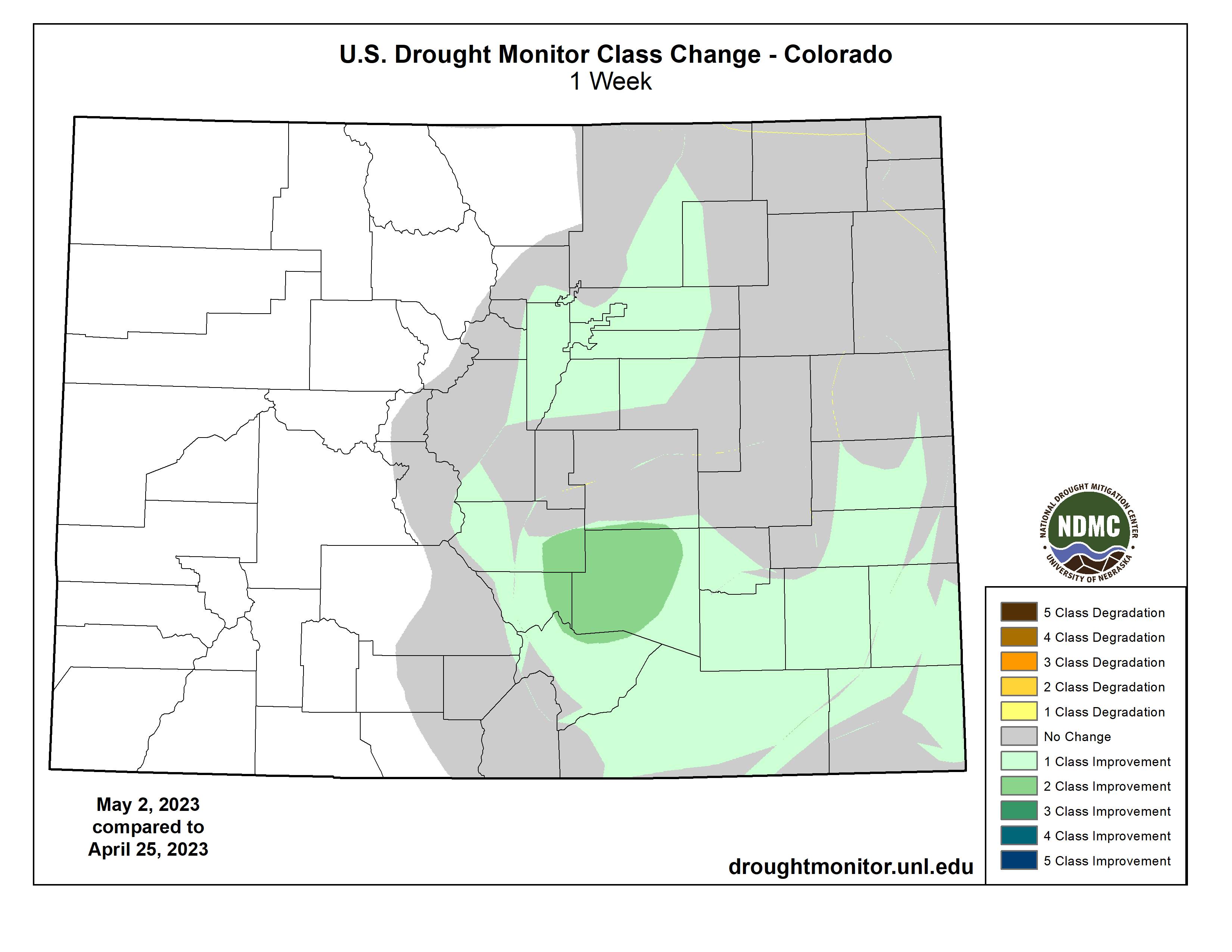
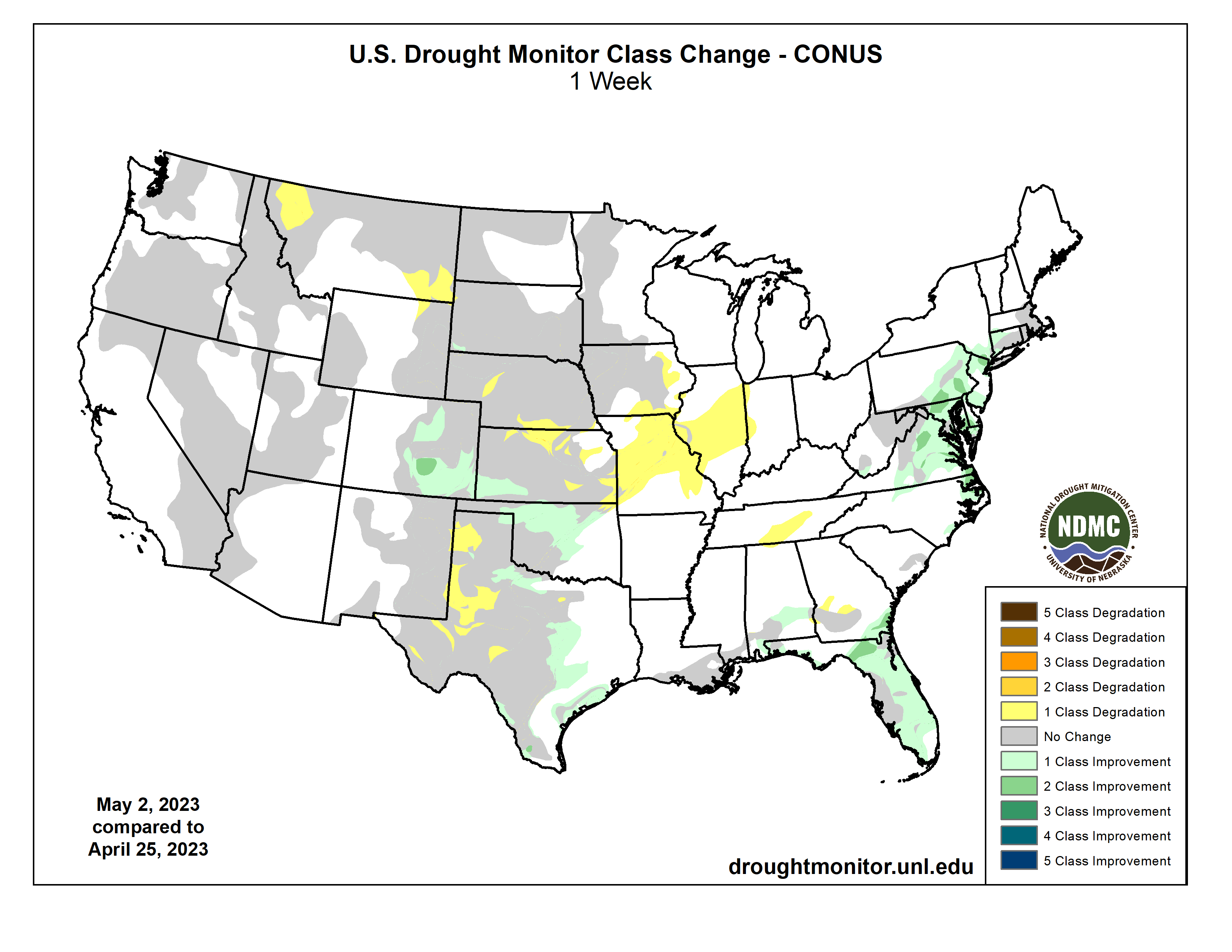
Colorado Drought Monitor one week change map ending May 2, 2023.
30 to 60-day SPI along with soil moisture indicators support an expansion of abnormal dryness (D0) and moderate drought (D1) across southeastern Montana. 30 to 90-day SPIs, recent warmth, and soil moisture led to a 1-category degradation in northwestern Montana. Following major improvements during the past few months across California and the Great Basin, no changes were made this week after little or no precipitation. Drought of varying intensity is designated for parts of Oregon and northern Idaho where precipitation averaged below-normal for the Water Year to Date (October 1, 2022 to May 1, 2023)…`
Balancing longer term SPIs and recent widespread rainfall (1 to 3.5 inches), a 1-category improvement was made to parts of Oklahoma and Texas. Improvements were also made to parts of central Texas along with the Texas Gulf Coast after more than 1.5 inches of rainfall this past week. CPC’s leaky bucket soil moisture and 90 to 120-day SPI supported a slight expansion of moderate (D1) to severe (D2) drought in west-central Texas. Based on soil moisture considerations and impact reports (very dry pastures), extreme (D3) drought was increased in coverage across the Texas Panhandle. The addition of abnormal dryness (D0) in east-central Tennessee was based on increasing 30-day deficits, SPEI, soil moisture, and 28-day average streamflows…
Looking Ahead
During the next five days (May 4 – 8, 2023), moderate to heavy precipitation (0.5-1.5 inches, locally more) is forecast for the Pacific Northwest, Great Basin, Northern Rockies, and higher elevations of California. An active weather pattern is expected from the Great Plains east to the Mississippi Valley with varying 5-day precipitation amounts forecast. Following a very wet end to April along the East Coast, drier weather is forecast to be accompanied by a gradual warming trend across the East.
The Climate Prediction Center’s 6-10 day outlook (valid May 9-13) favors below-normal temperatures across the West, while above-normal temperatures are more likely throughout the central and eastern U.S. Elevated probabilities for above-normal precipitation are forecast for the Pacific Northwest, northern California, Great Plains, Mississippi Valley, and Southeast. Near normal precipitation amounts are favored for much of the Great Lakes and Northeast.
US Drought Monitor one week change map ending May 2, 2023.
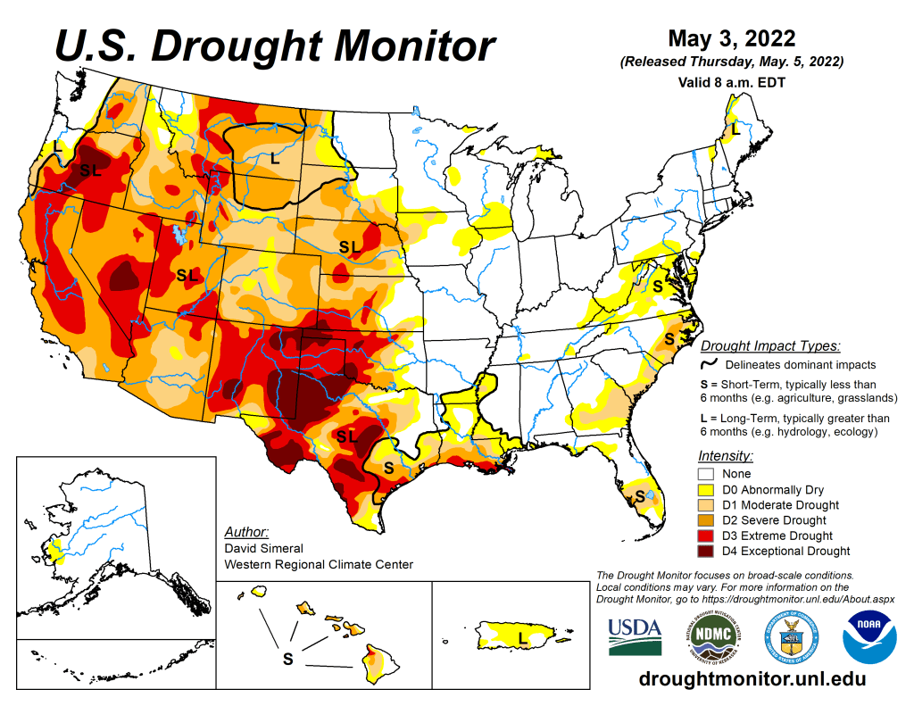
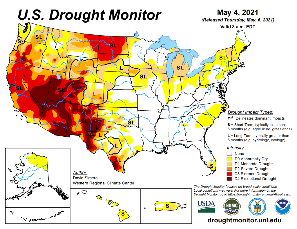
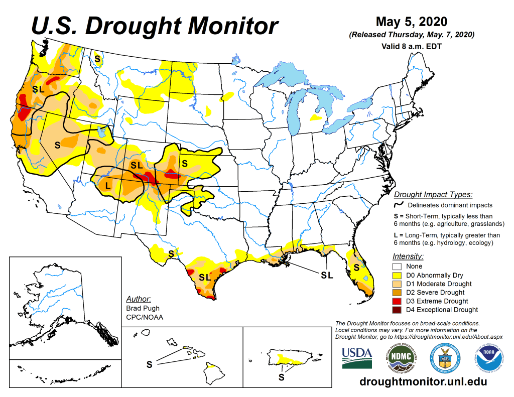
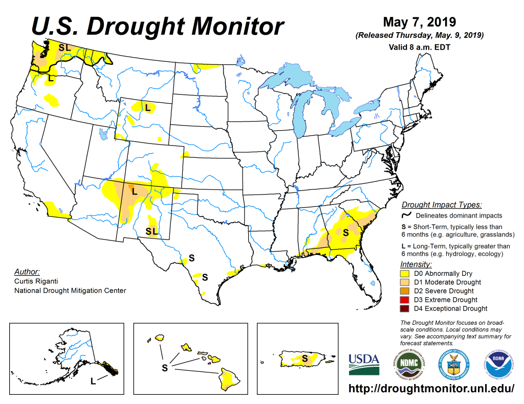
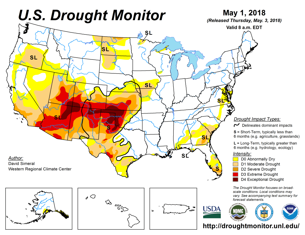
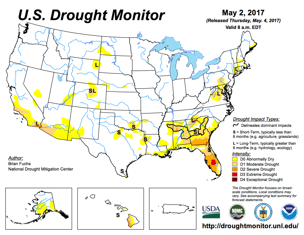
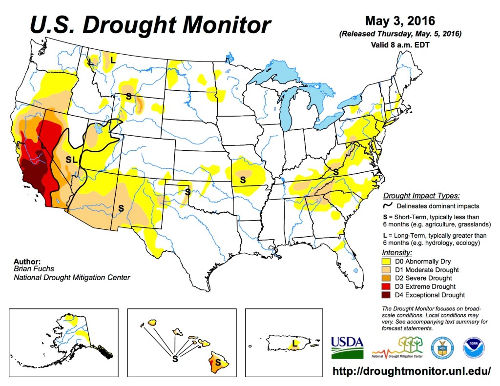
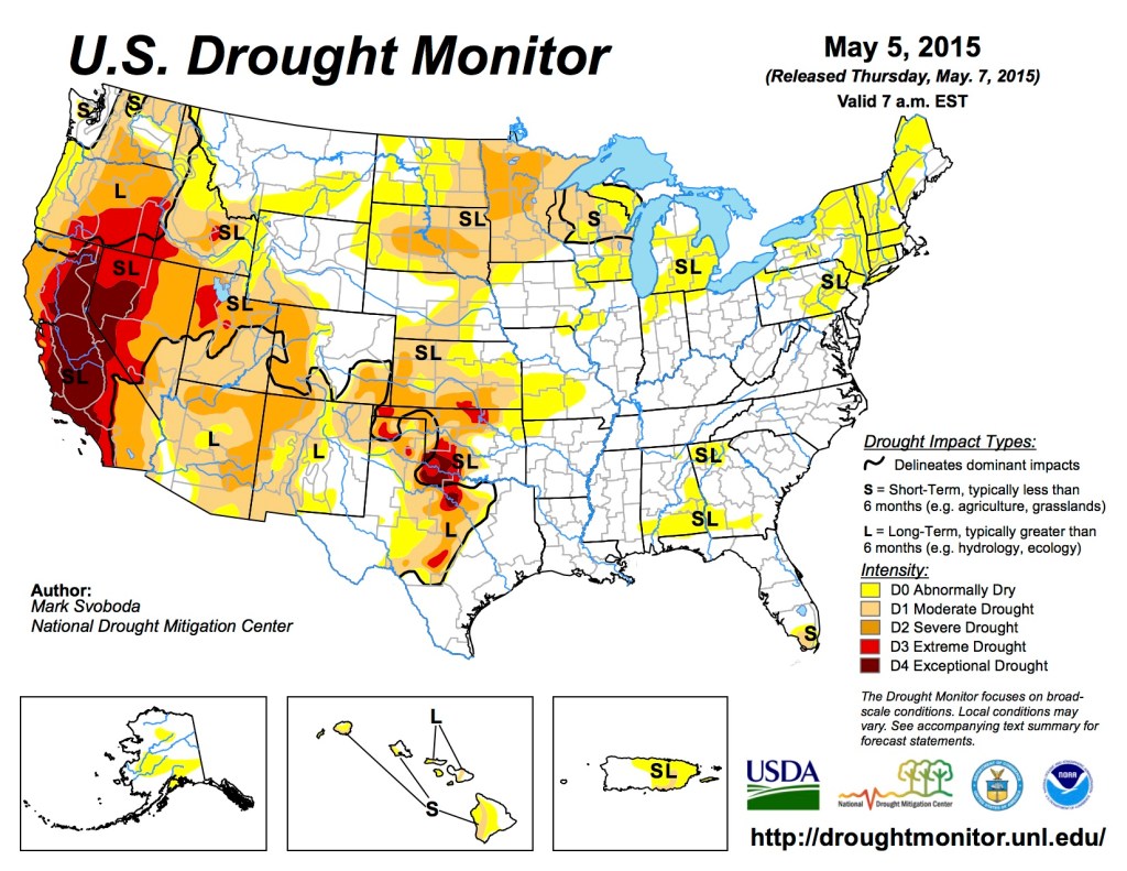
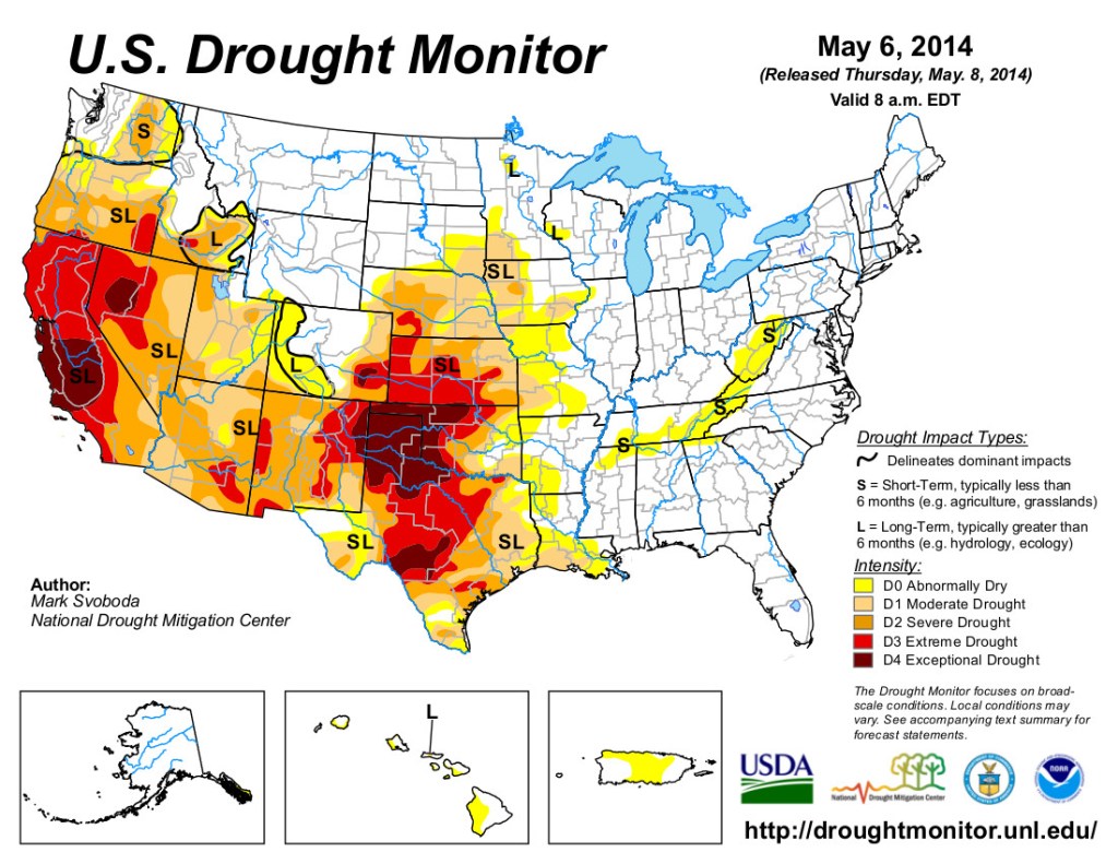
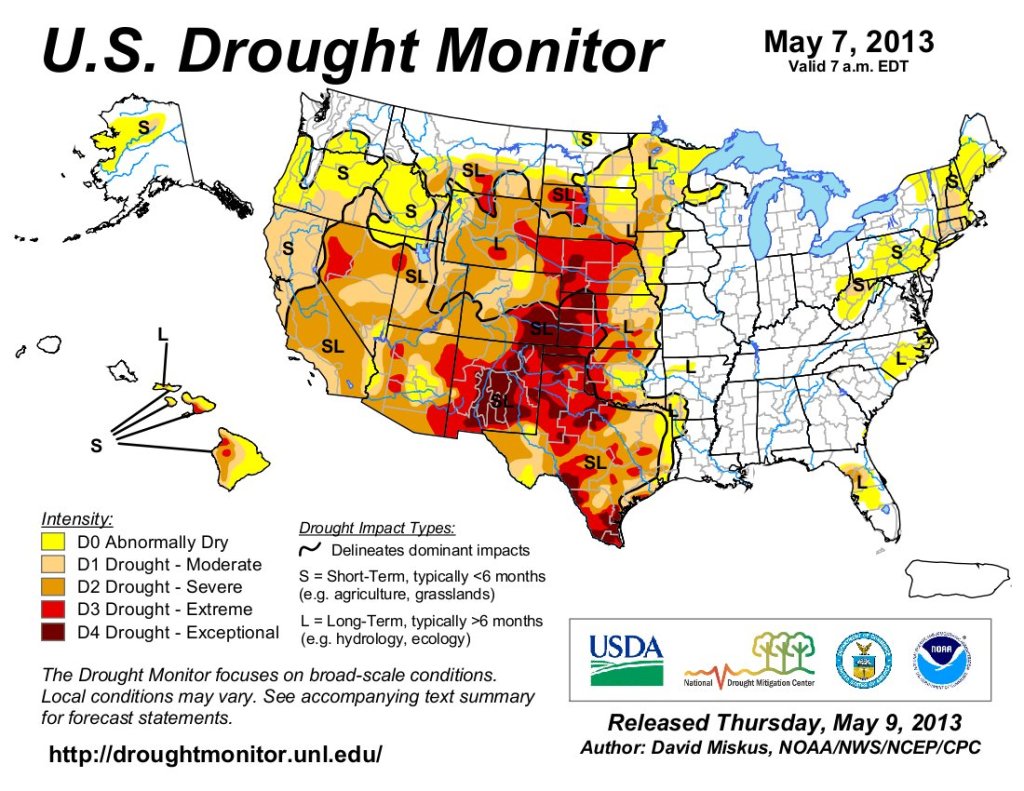
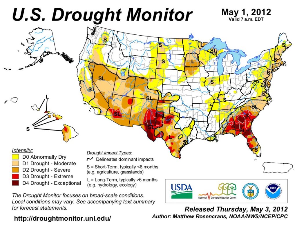
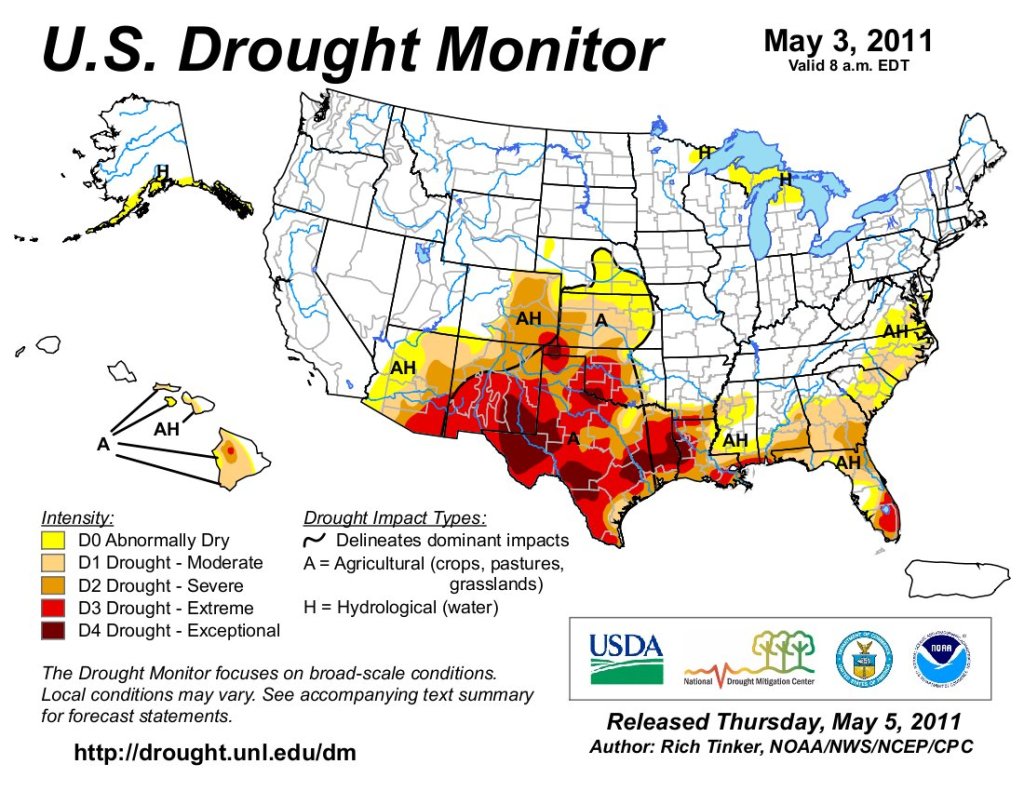
Just for grins here’s a gallery of US Drought Monitor maps for early May for the past few years.
Click the link to read the article on the Grist website (Jake Bittle):
For the first two decades of the 21st century, not even a once-in-a-millennium drought could deter real estate developers from building vast suburban tracts on the wild edges of Western U.S. cities. But in 2021, a reckoning appeared on the horizon. The Colorado River sank to historic lows, winter rains never arrived, and communities from California to Texas found their groundwater wells going dry after decades of overuse.
Western officials had seldom let questions about water availability get in the way of population growth, but suddenly they seemed to have no other choice. Faced with an unprecedented shortage, many local governments tried to pump the brakes on new developments. A small town in Utah halted all new housing permits, fearful that more homes would sap a local river. A suburb of Colorado Springs, Colorado, told developers that it could no longer allow new subdivisions to connect to the city’s water system. Most significantly, the state of Arizona has all but paused new housing in some Phoenix suburbs, citing a shortage of groundwater.
This pivot to conservation was bad news for D.R. Horton, the nation’s largest homebuilding company. Buoyed by pandemic-induced demand for cheap, spacious housing across the West, Horton netted $6 billion constructing more than 80,000 homes last year alone. The company had long been able to assume that if it built a development, someone else would provide water for it — usually a local government eager for tax revenue. All of a sudden, Horton had to find the water itself.
Luckily, there was a third party who could help.
In April of last year, Horton acquired Vidler Water Company, a tiny outfit whose dozen employees worked out of an unassuming faux-Mediterranean office park in Carson City, Nevada. Though Vidler’s annual revenue was less than a tenth of a percent of Horton’s, the real estate titan spent big to snap it up: The price tag on the acquisition was an eye-popping $291 million.
Vidler is an unusual company. It doesn’t actually deliver water to people, nor does it own any facilities for water treatment or desalination. Instead the company functions as a broker for water rights, finding untapped water in rural communities and marketing it to developers and corporations in fast-growing cities and suburbs. For 20 years, the company has bought up remote farmland and drilled wells in bone-dry valleys to amass an enormous private water portfolio, then made tens of millions of dollars by selling that portfolio one piece at a time.
This kind of business inevitably involves some guesswork, and often that guesswork looks like classic real estate speculation: You can make money by bringing water to places where people already want it, but you can make even more money bringing it to places where people will want it in the future. This is exactly what Vidler has tried to do, and it has led the company’s critics to contend that its business model violates the anti-speculation spirit of Western water law.
Indeed, suspicions that Vidler is profiteering off a vulnerable public resource have made the company more than its share of enemies over the years: Top officials have been pilloried in courtrooms and threatened by rural residents, and an early executive once had to jump out a window to escape an angry crowd at a public meeting.
Horton’s purchase of Vidler has no real precedent, but it is a clear indication of where the West is headed. The region has grown twice as fast as the rest of the United States since the 1950s, and national builders like Horton are relying on it to fuel future profits. If these companies want to capitalize on migration to the booming suburbs of Phoenix and Las Vegas, they’ll need to find creative new water supplies that will allow them to keep building even as regulators try to clamp down on unsustainable growth.
In this regard, Vidler is a pioneer. The company was the first in the West to make a business model out of finding and flipping water. In the past few years, a new crop of upstarts has sought to mimic this model, buying up water rights in rural areas and marketing them to developers and suburbs that need them for future growth.These companies include Water Asset Management, which has bought up agricultural land in Colorado to secure water rights, and the investment firm Greenstone, which organized a first-of-its-kind deal to move Colorado River water from farms in western Arizona to a city near Phoenix. Both companies boast former Vidler executives in top leadership positions.
Vidler still stands at the front of the pack, tapping water in hard-to-reach aquifers and pursuing aggressive litigation to push new construction forward. If the company’s tactics become more common, the effects will be far-reaching — not only could rural areas and desert ecosystems see their precious water siphoned off, but thousands of people will buy and occupy homes fed by water sources that may turn out to be unreliable. A major part of Vidler’s strategy has been to pump water from small underground aquifers, squeezing every available drop from finite water banks that may someday run dry, especially as climate change contributes to the long-term aridification of the West.
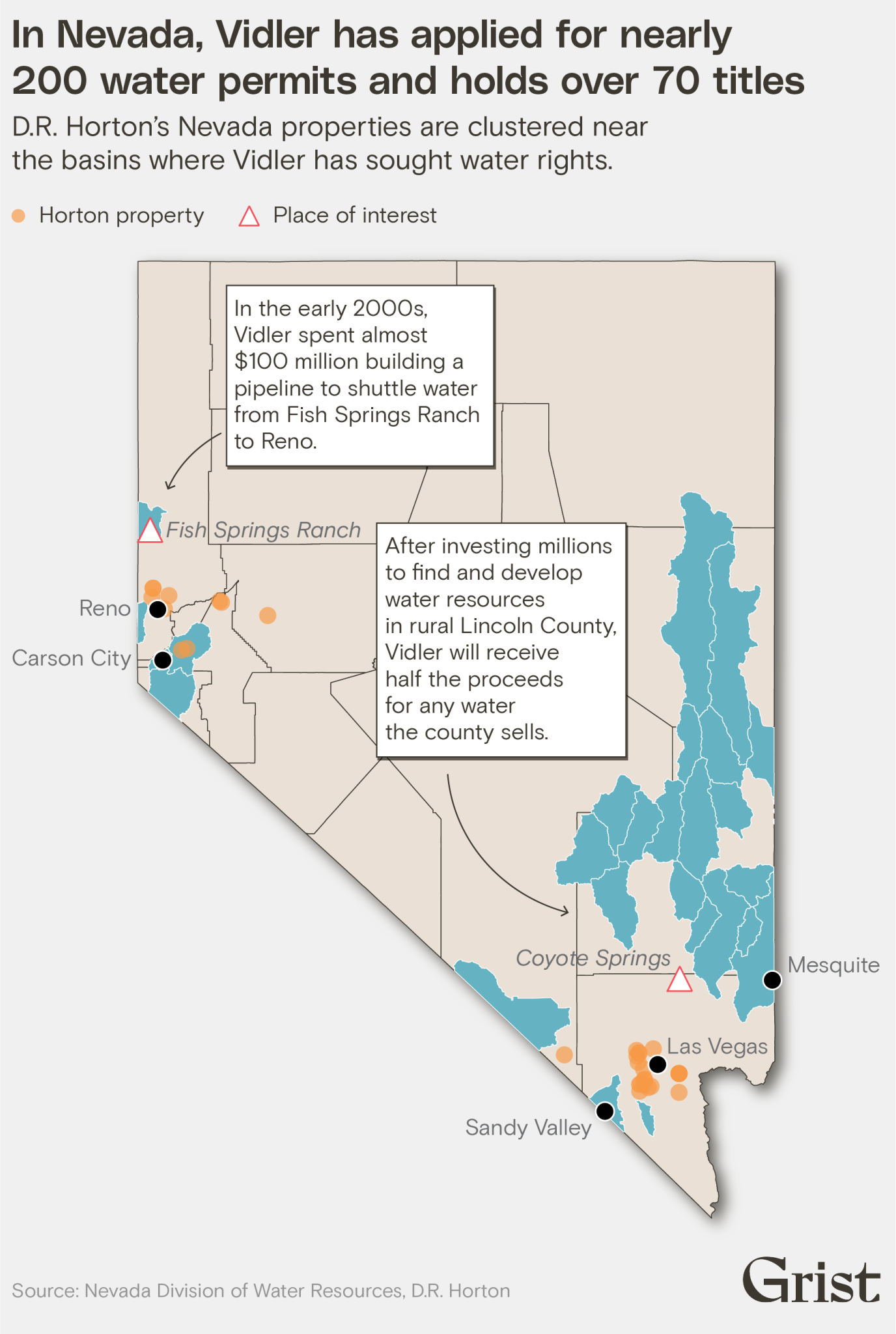
Kevin Brown is the manager of a water utility in the southern Nevada city of Mesquite, where Vidler has been trying for years to build a pipeline that could bring new water to the city. The company has proposed tapping a virgin aquifer and using the water to supply new housing developments on the edge of town, but Brown doubts the pipeline is a good idea. Instead he has focused on reducing water usage across the city and recycling water where he can.
Vacant land in Lincoln County, Nevada, near the city of Mesquite. Vidler owns a large portfolio of water assets in the area that could enable further development. Grist / Mikayla Whitmore
“In the world we live in, and the market we live in, if you put enough money against it, someone will make it happen,” Brown told Grist. “If these developers aren’t building homes, then they’re going out of business. But at some point, somebody needs to say, ‘You know what, we can’t grow anymore. It’s not sustainable.’”
In most Western states, water is public property regardless of whose land it flows through or sits under. Private entities can only own the right to use that water for a specific purpose. Individuals and companies can apply to use any unclaimed water source, but they have to convince the state government that they plan to put the water to a productive use. By the same token, owners can sell or lease their existing water rights to each other as long as the buyers keep using the water for something.
In this arrangement, the new breed of water brokers has found an opportunity to accumulate assets and generate profits. But the law requires them to tread cautiously.
At the turn of the 20th century, a Transcontinental Mining executive named Rees Vidler tried to dig a tunnel through the heart of the Colorado Rockies. It was supposed to link the mineral-rich mountain towns around Breckenridge with the young Denver metro area, but Vidler never completed the project. The shaft sat unused until an engineer bought it in the 1950s and repurposed it to move water rather than ore. He acquired the rights to river water on the Breckinridge side of the tunnel, built a water pipeline through the shaft, and proposed to sell the river water to people in the fast-growing cities around Denver. The engineer didn’t have any confirmed buyers for the water, but he could store it in a reservoir until he made a sale.
In 1979, the Colorado Supreme Court dealt a blow to that scheme. A judge ruled that the engineer’s water purchases were “grounded on no interest beyond a desire to obtain water for sale.” If Colorado allowed such purchases, it would “encourage those with vast monetary resources to monopolize [water] for personal profit rather than beneficial use,” the court wrote. In other words, speculating on water was unacceptable. Judges in other states soon adopted similar rulings, creating a precedent that some legal scholars have called “the Vidler doctrine.”
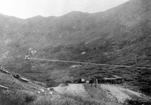
Vidler tunnel entrance and exit, Summit County side of range. Date: [1900-1905]. Summary: An “X” on the image marks the spot of the Vidler tunnel portal in a gulch above timberline, Summit County, Colorado. Men pose near a log cabin in the foreground. Photo credit: Brandes, Juan F via Denver Public Library
About 15 years later, the Vidler tunnel and its water rights fell into the possession of one John Hart, a swashbuckling financier who was beginning a decades-long corporate takeover spree. Hart and his business partner had just taken over the Physicians Insurance Company of Ohio, or PICO. They transformed the moribund Midwestern insurance company into an umbrella corporation for buying and flipping distressed assets, including a Swiss railway operator, an Australian oil company, a million acres of rural land in Nevada, and a canola-seed crushing facility.
The Vidler tunnel’s history gave Hart an idea. He lived near San Diego, which relies in part on the Colorado River, and he could see that water was only going to get more valuable across the region, especially if real estate kept booming. Many farmers who had fallen on hard times were selling their irrigated land to developers, who repurposed irrigation water to supply new homes and golf courses. Hart wanted to profit from this slow transition away from agriculture, and he thought he saw a way to do it: Buy up water rights in the driest states, wait for the rights to rise in value, and sell them later on to developers that needed them for new housing. As long as the population of the West continued to increase, the price of water would increase as well — and with it PICO’s investment profits.
By acting as a broker for water rights, the PICO subsidiary that Hart called Vidler Water Company could get around the anti-speculation doctrine invoked in its very name. The tunnel engineer had sought to hold onto his water rights and make money by selling water to people who needed it. Vidler would just buy and sell the water rights themselves. This amounted to an elegant form of arbitrage: If a water right was worth more to a developer than it was to a farmer, Vidler could profit by flipping the right from the latter to the former.
The only problem was that Hart didn’t know very much about the nitty-gritty details of water law, and he knew even less about the science of hydrology. In order for his plan to work, he had to find someone who could handle both. That someone was Dorothy Timian-Palmer, an engineer who had been Carson City’s municipal utilities director for around a decade before Hart poached her in 1997. Timian-Palmer declined to speak with Grist, but several sources who worked with and against Vidler described her as one of the nation’s foremost water experts.
“She is the most knowledgeable person about water in the country,” insisted Hart in an interview. He recalled how he and Timian-Palmer used to attend investment conferences where skeptical audiences heard the legendary oil tycoon T. Boone Pickens talk in vague and confused terms about his water investments. But when Timian-Palmer took the stage, introduced herself as a water engineer, and started rattling off facts about hydrology and hydraulics, all the attendees perked up and started taking notes.
“She’s very smart, very shrewd, and very tough,” said Paul Hultin, a lawyer who sued Vidler over one of its later projects in New Mexico.
Armed with an infusion of cash from PICO, Timian-Palmer and a small group of Nevada-based lawyers and engineers set about flipping water. They bought agricultural water rights along a river in Colorado and sold them to Denver-area developers. They bought tens of thousands of acres of farm- and ranchland in Arizona, Idaho, Nevada, and New Mexico and either sold the water rights to urban utilities, leased them back to farmers, or sold the land to developers. In one case the company made a fivefold profit after six years.
Credit: Grist / Jessie Blaeser
When developers wanted to use the water they’d just acquired on former farmland, they could fallow the irrigated fields and start pumping water into their subdivisions and power plants, fueling further housing expansion. Marc Reisner, the journalist who wrote that “water flows uphill towards money” in his seminal book Cadillac Desert, also joined Vidler for a few years as a part-time political consultant, believing the company’s projects could enable growth while avoiding the construction of harmful new reservoirs and dams.
In other cases, Vidler chose to sit on the water it acquired until its value went up. In California and Arizona, the company bought and stored water in so-called “underground storage facilities,” artificial aquifers that serve as subterranean reservoirs. The cities and farmers who typically use these kinds of water banks are usually trying to squirrel away water for use during dry years, but Vidler’s goal was to profit on the gradual increase in water prices.
In California’s agriculture-heavy Central Valley, for instance, the company took partial ownership of an artificial aquifer, then flipped its share to real estate developers and water utilities, making $25 million off the transaction in just a few years. In Arizona, meanwhile, the company built its own large storage facility west of Phoenix and filled it with more than 250,000 acre-feet of water from the Colorado River. (An acre-foot is equivalent to around 326,000 gallons, or roughly enough water to supply two homes for a year.) Vidler executives wrote in a 2004 financial statement that “continued growth of the municipalities surrounding Phoenix” and “the low level of Lake Mead,” the largest Colorado River reservoir, were both “likely to increase demand” for the water.
No one has ever accused the company of breaking the law with these transactions, but its strategy clashed with the legal principles established in the 1979 ruling against the original Vidler tunnel scheme. In order for Vidler to secure new water rights, it had to identify a “beneficial use” for each water source it wanted to claim. The company would tell state regulators that it wanted to use each given water right to supply a power plant, or a suburban development, or a farm. In its own financial statements, though, the company made it clear that using water was merely incidental to the company’s mission.
“Vidler seeks to acquire water rights at prices consistent with their current use, with the expectation of an increase in value if the water right can be converted to a higher use,” the company said in a 2001 annual report. “Vidler’s priority is to develop recurring cash flow from these assets.”
Rural housing in Dayton, Nevada, east of Carson City. Vidler owns water rights in the area and has sought to market them to developers. Grist / Mikayla Whitmore
Kyle Roerink, a water-conservation advocate who runs the nonprofit Great Basin Water Network, told Grist that he’s observed Vidler trying to find ways around the “beneficial use” doctrine for almost a decade.
“It’s a model where you’re trying to squeeze blood, profits, and water from stone, and they’ve been pretty successful at it,” he said. “[They’re] pushing the boundaries and testing the limits of what the foundational principles of Western water law are. It’s among the most dangerous elements of capitalism at play here.”
Indeed, Vidler’s loose regard for beneficial-use requirements has sometimes landed the company in hot water. In 1999, Vidler asked Nevada officials for permission to pump around 2,000 acre-feet of groundwater in Sandy Valley, a remote community of trailers and tumbleweeds about an hour southwest of Las Vegas. Vidler claimed to be applying for the water on behalf of a real estate company in Primm, a casino town on the California border. It laid out a far-fetched plan to build a pipeline that would move Sandy Valley’s water down to Primm across 25 miles of mountains, allowing developers to build housing and a theme park. The state government gave Vidler only some of the rights it asked for — but it amounted to almost as much water as the entire town of Sandy Valley used at the time.
When Sandy Valley residents heard about the project, they were furious. The area’s aquifer was already overdrawn thanks to a number of irrigated farms nearby. Residents depended on shallow household wells for their water, and they were terrified that those wells would go dry if the state let Vidler take its share.
“Vidler is a four-letter word here in Sandy Valley,” Al Marquis told me when I visited the town in February. A retired real estate lawyer who sued to stop Vidler on behalf of his town, Marquis is a quintessential Sandy Valley personality: He wears a ten-gallon-hat, flies amateur planes, and writes books of what he calls “cowboy poetry.” He recalled that a Vidler representative who showed up at a public meeting about the application found himself greeted by shouts and death threats from angry residents, who reminded him in no uncertain terms that nearly everyone in the valley owned a firearm.
In 2006, a judge overturned the state government’s decision to grant Vidler’s application, ruling that the company hadn’t proven it could put Sandy Valley’s water to beneficial use. Vidler claimed that the Primm real estate company needed the water to build apartments and a theme park, but the company couldn’t demonstrate that any of that development was really going to happen — the main evidence it had was a one-page wishlist drafted by the real estate company itself. In the absence of a clear beneficial use, the judge wrote, Vidler had no claim to Sandy Valley’s water, and the state had erred in giving the company permission to pump.
“It appears to me that the company was formed for the sole purpose of speculating in and the hoarding of a public resource,” Marquis told Grist. He hypothesized that Vidler never wanted the water for Primm at all, and instead just wanted to flip it to someone else later on. “I gotta give them credit, in that they had foresight.”
Timian-Palmer and her fellow executives saw that the West didn’t have enough water, and they knew that was good news for Vidler: As drought got worse, the company’s assets would only get more valuable.
As the nation’s housing market boomed in the early 2000s, Vidler evolved. Instead of just buying and selling water rights that were already in use, the company began to search for unclaimed groundwater in remote parts of Nevada. It drilled new wells to bring that water to the surface, built new infrastructure to move it toward big cities like Reno and Las Vegas, and marketed it to developers and utilities. If Vidler could sell a new water source for more than it cost to develop and transport the water, the company would turn a profit.
“There seemed to be a void in terms of developing new supplies of water,” said Hart, explaining the opportunity. “Governments don’t really like to spend money for future citizens or future residents, and developers don’t want the upfront risk of having to go out to develop water for projects somewhere down the road.”
Updated Colorado River 4-Panel plot thru Water Year 2022 showing reservoirs, flows, temperatures and precipitation. All trends are in the wrong direction. Since original 2017 plot, conditions have deteriorated significantly. Brad Udall via Twitter: https://twitter.com/bradudall/status/1593316262041436160
At the same time, major water sources like the Colorado River were showing signs of vulnerability as the region entered its current climate-fueled megadrought, lending more urgency to the search for untapped water.It could take years to secure regulatory approval for new groundwater pumping and even longer to build infrastructure to move that water around. Hart and Timian-Palmer were some of the only people in the West with the capital and expertise needed to pursue this kind of project.
The company’s first major experiment was a public-private partnership with a massive rural county about an hour north of Vegas. Lincoln County is one of the most sparsely populated counties in the nation — its population of 4,500 occupies a land area larger than Massachusetts — but it also boasted a hoard of untapped groundwater, most of which no one had ever tried to use.This water sits in some of the state’s shallowest and most remote aquifers, where it has accreted over thousands of years beneath chalk-white valleys.
In the late 1980s, Las Vegas’s powerful water utility filed applications for almost all of Lincoln County’s unused water, more than 100,000 acre-feet in total, and proposed to build a pipeline that could bring it to Sin City. Officials in Lincoln County were still trying to fend off the big city when Vidler showed up and offered to act as a white knight. The company said it would invest millions of dollars to find and pump the county’s groundwater resources while also protecting those resources from Las Vegas. In exchange the company would get half the proceeds from any water the county sold.
Depending on whom you ask, this was either a boon for an impoverished rural county or a corporate takeover of a public resource. Wade Poulsen, the county employee who runs the water partnership, told Grist that Vidler had been “fantastic” and claimed that the county “would be nowhere without them.” But conservationists allege that Vidler was mining Lincoln County’s resources for profit.
“Vidler has turned Lincoln County into a water colony,” said Patrick Donnelly, a conservation biologist with the nonprofit Center for Biological Diversity who has litigated against groundwater usage in Nevada. “They own some serious water up there, and there’s this ideology of, ‘This water exists for us to benefit economically from it.’”
The business thesis for the Lincoln-Vidler partnership was based on the assumption that the growth of Las Vegas would one day extend so far that it crossed the border into Lincoln County, more than 50 miles away from the city’s downtown. In the heady days of the early 2000s housing boom, this seemed like a real possibility; a number of real estate developers had staked out housing projects that could use Lincoln County’s water.
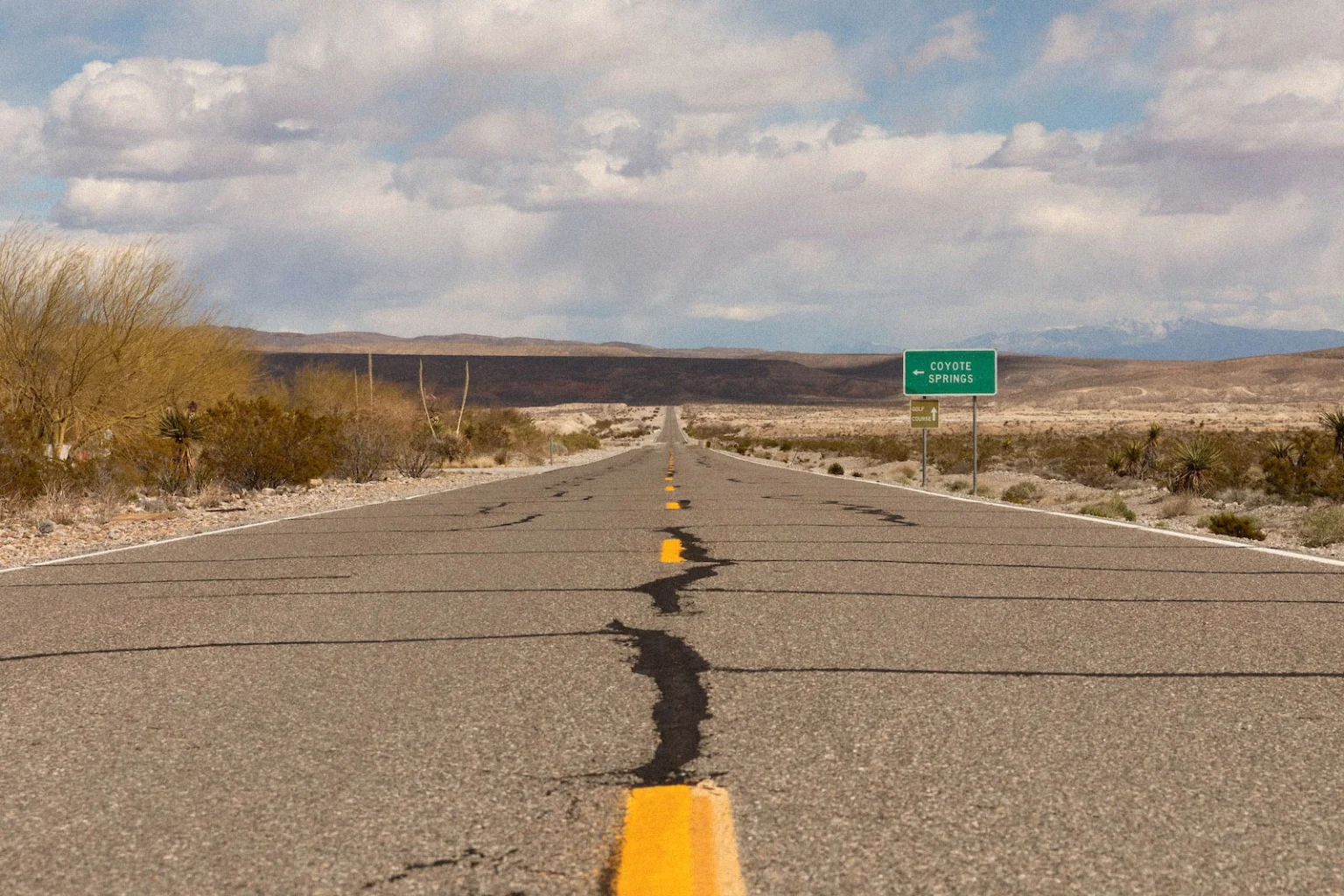
Chief among them was Harvey Whittemore, a friend of the late Senator Harry Reid and powerful casino lobbyist, who agreed to buy 1,000 acre-feet of water rights from Vidler in 2005. Before he went to prison for campaign finance violations in 2014, Whittemore spent more than a decade trying to build a megadevelopment called Coyote Springs in Lincoln County, pitching it as a desert metropolis that would someday contain 160,000 homes.
Highway 93 near Coyote Springs, Nevada, where the casino lobbyist Harvey Whittemore tried to use Vidler’s water to build a massive desert city. Grist / Mikayla Whitmore
He managed to build a golf course on the development site, but a regulatory battle subsequently derailed the project and Whittemore never used Vidler’s water. Whittemore’s green, which was designed by golf legend Jack Nicklaus, still stands by itself on an empty desert highway, flanked by a massive sign announcing the future site of Coyote Springs, which another company is still trying to push forward. A tortoise habitat sits just a few feet away.
“They said at first they were gonna provide water for everybody, but the only people that [the Lincoln County partnership] ever actually tried to develop water for were [real estate developers],” said Louis Benezet, a longtime county resident. He said the water district initially discussed agricultural projects and growth opportunities in the county’s small towns, which were more attractive to county residents, but later focused on exporting water toward Vegas.
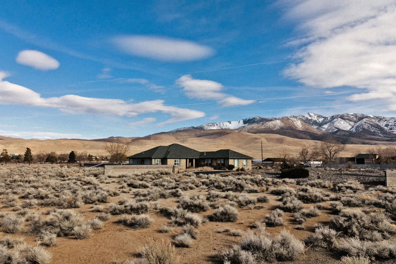
Timian-Palmer also pursued a similar strategy in fast-growing Reno in the early 2000s, targeting a property called Fish Springs Ranch about an hour north of the city. The land under the ranch contained enough groundwater for thousands of homes, and officials in the Reno area had long eyed it as a water source that could reduce the city’s reliance on the Truckee River, which drains out of Lake Tahoe. Instead of asking the local utility to help with the costs, as past entrepreneurs had, Vidler used private capital to push the project forward.The company built a pipeline that snaked through 28 miles of hilly terrain, ending in a cluster of valleys that were primed for future construction.
It was a transaction only Timian-Palmer could have managed, and one that demonstrated Vidler’s clout on water issues: Getting permission to build the project required conducting multiple federal environmental reviews, placating officials in multiple states, negotiating with the nearby Pyramid Lake Paiute Tribe, and passing a bill to ratify the details in Congress. Even after spending almost $100 million to permit and build the project, Vidler still stood to profit by selling the water to developers in Reno’s suburbs — there were almost no alternative water sources in the valleys north of Reno, so Vidler would be able to set the price.
Alas, Hart and Timian-Palmer had terrible timing. Just as the company’s projects in Reno and Vegas seemed to be taking off, the U.S. housing market started to wobble, led by a wave of foreclosures in Nevada and other Western states. When the market collapsed, builders and developers nixed all their suburban development projects, sold off their land, and pulled out of their agreements to buy water from Vidler. The company had moved heaven and earth to secure water for Nevada’s future growth, but that growth seemed to evaporate overnight.
“When Vidler started construction on the pipeline project, essentially, all of the water was spoken for,” said John Enloe, an official at the water utility that serves the Reno area. Enloe worked with Vidler on the pipeline project. “By the time construction was completed, the Great Recession hit, and everyone backed out. There just wasn’t a need for the water.”
Even as the housing market started to rebound from the Great Recession, Vidler spent much of the next decade running up against a very simple problem: The company had spent millions of dollars to develop new water resources across the West, paying to drill test wells and fill out lengthy water-right applications with the state government, but it couldn’t find buyers for all the new water it had developed.
That was in part because regulators had started to question the logic of growth. By the time the Western real estate market surged back to life in the late 2010s, the megadrought that gripped the region was well into its second decade. Major reservoirs in the Sierra Nevada and the Colorado River were bottoming out, and many rural communities were starting to see their wells go dry. This shortage had begun to stoke new concerns about overreliance on groundwater, and Vidler soon found itself facing new opposition from courts and regulators.
In a sign of its commitment to aiding development, Vidler fought back against these restrictions with a vengeance, litigating and lobbying to ensure its projects could move forward.
A case in New Mexico demonstrated how aggressive the company could be in snapping up water. In the early 2000s, as Vidler was looking to expand into the state, Timian-Palmer connected with a rancher named Rob Gately. Gately owned a large chunk of land in the mountains east of Albuquerque and was seeking to build a big suburban development on the empty parcel. The area was far from prime real estate: It boasted a few dozen houses scattered across a stretch of wind-blown desert, but nothing else in the way of commerce. At least one other proposed development had already fallen through. Even so, Vidler offered to help Gately secure water. It applied to the New Mexico state government for permission to pump 700 acre-feet of water from the area aquifer, spending almost $6 million during the application process.
But Vidler’s own models showed that water use from the new development would cause water levels in the aquifer to drop, endangering residential wells. “People are already having problems with water, and that’s well-known here,” said Joanne Hilton, a hydrologist who lives in the area around the proposed development site and relies on a household well.
By 2017, residents had taken Vidler to court in an attempt to stop the project. Several key executives had to take the stand, including Timian-Palmer and her longtime right-hand man, executive vice president Steve Hartman. During a series of testy depositions, it emerged that Vidler seemed to be stretching the truth about the “beneficial use” it planned for the water. The company claimed that Gately was the mastermind behind the development, but the Montana holding company he was using for the project had been dissolved and no one from Vidler seemed sure about where he was based.
During one deposition, the lawyer for the area residents asked Hartman if he could provide specifics about how Vidler wanted to use the water. Just what kind of development was Gately trying to build, and how much water would it need? Hartman struggled to answer.
“So assuming that you get the permit and the case becomes final, then at that point you and Mr. Gately are going to sit down and talk about what’s next, is that right?” the lawyer asked.
“Yes,” Hartman said.
“And at this point you have no idea what that is?” the lawyer asked.
“I do not,” Hartman replied.
Two years later, the court tossed out Vidler’s application, ruling that the project would have risked taking water away from area residents and would conflict with New Mexico’s statewide goals for water conservation.
Faced with obstacles like these, Vidler had to go on offense. The company donated more than $275,000 to Nevada political candidates between 2008 and 2022, increasing its annual contributions in the years that followed the Great Recession. Hartman became a fixture in the Nevada legislature, lobbying on dozens of water bills, many of them concerned with obscure points of water law. During the present legislative session, as the company prepares to defend its water interests in Lincoln County, it has hired Nevada’s premier lobbying firm, whose other clients include Amazon and Uber.
In recent years, Timian-Palmer and Hartman have tried to scrape value from Vidler’s water assets wherever they can. They sold off some of their banked Arizona water to a golf course in a Phoenix suburb, making a more than threefold profit. They returned to Sandy Valley in 2016 to apply for water on a different patch of land, only to run into trouble once again with Marquis, who discovered that the company hadn’t told an area landowner it was going to apply for the water under his land. In litigation over the Coyote Springs development in Lincoln County, they conducted geological testing to prove that they should be able to tap an aquifer the state had deemed too vulnerable, alleging the existence of an underground fault they named “Dorothy’s Fault,” apparently after Timian-Palmer. They even went so far as to demand that Nevada cut off water deliveries to a town near a basin where Vidler had been prevented from pumping water, arguing that the town shouldn’t get to use water, either.
“They’re engaging in these processes for one reason and one reason only, and that’s to one day make money,” said Roerink, the water conservation advocate.
Neither Vidler nor D.R. Horton responded to extensive requests for comment on this story. Dorothy Timian-Palmer initially agreed to an interview in response to a request from Grist, but a Horton spokesperson later said that the company wouldn’t be participating in the story. After Grist visited Vidler’s office in Carson City, a Horton spokesperson offered to respond to a list of questions, but company representatives failed to do so before publication.
Even as Vidler sought buyers for its water rights, PICO went through a shakeup: Shareholders grew dissatisfied with Hart’s high salary and with the slow return on their investments. They ousted Hart and replaced him with a new chairman who soon cut costs, selling off PICO subsidiaries. Vidler’s assets were more difficult to cash out: The company had spent tens of millions of dollars on water projects like the ones near Reno and Albuquerque, and it wasn’t clear when those projects would start making money. The easiest way to make the company’s shareholders whole was for another company to buy Vidler outright.
Timian-Palmer and her fellow executives started trying to find a buyer as early as 2017, when they hired a bank to solicit potential offers, according to a corporate filing. The bank contacted more than 150 different potential buyers, but none of them showed much interest. The main problem was that nobody seemed to be interested in acquiring Vidler wholesale. As the search continued, it became clear that Vidler needed a company that wanted to use its executives’ water expertise, not just sell off the assets Timian-Palmer had acquired — in other words, a company that needed Vidler as much as Vidler needed it.
It took a few more years and a millennium-scale drought, but in the final months of 2021, Vidler found a company that could finally make its development dreams a reality.
D.R. Horton is a tight-lipped company, and it didn’t say much about its purchase of Vidler. In a press release published on the day of the acquisition, the company noted that “Vidler owns a portfolio of premium water rights and other water-related assets … in markets where D.R. Horton operates.” A few weeks later, when a stock analyst asked about the purchase on an earnings call, an executive replied that “we put out pretty much what we’re going to say about Vidler in the press release.”
Even so, the logic of the transaction was apparent: The places where Vidler owned substantial water rights were also places where Horton was building homes. At a shareholder meeting in 2021, Timian-Palmer told investors that Horton was “moving like gangbusters” in the north suburbs of Reno, planning multiple subdivisions that could purchase water from Vidler’s long-dormant Fish Springs Ranch pipeline. The valleys north of Reno are now home to a horde of uniform subdivisions, most of them sandwiched against each other just off the freeway. Many of the largest belong to Horton. If the city’s recent growth spurt continues, Vidler’s pipeline will be the only available water source for future builders.
Horton is also building several developments east of Carson City on a fast-growing industrial corridor near a Tesla factory. In a 2021 financial statement, Vidler noted that “there are currently few existing sustainable water sources to support future growth and development” in that corridor, except for Vidler’s own supplies. Horton also has numerous active projects in central Arizona, where Vidler has banked almost 300,000 acre-feet of water underground. Together, the two companies have everything they need to capitalize on the West’s post-pandemic population boom.
Vidler has always operated more like a fixer than a financial trader, not just flipping assets but developing new water resources in the driest areas. Several sources who spoke to Grist theorized that this was why Horton paid so much to acquire the company.
“If you’re a homebuilder, your best option is to do what Horton has done — go out and find more supply,” said Grady Gammage, a real estate lawyer who has represented Greenstone, another water broker founded by a former Vidler employee, and several homebuilders. “What Horton is likely thinking is that you’re faced either with doing a deal [to get new water], or trying to build that expertise in-house.”
The future of the West depends on whether, and to what extent, these companies can secure these deals and expertise in the face of new regulatory restrictions and supply constraints.
Nowhere is this dynamic clearer than in the western suburbs of Phoenix, where developers and builders have thrown up tens of thousands of homes that rely on groundwater from fragile aquifers. Earlier this year, Arizona’s new governor released a study that showed the area has much less water available than was previously thought. State law requires developers to show that proposed homes have a hundred-year water supply, and officials have now decreed that there isn’t enough groundwater in the area to provide for any more new subdivisions in the southern and western outskirts of the city.
This has left several gigantic development projects stuck in limbo, including ones with which Horton was involved. It has also forced developers and homebuilders to look for alternate sources of water, including from underground storage facilities like Vidler’s. The company’s biggest underground aquifer contains enough water to supply about 2,000 homes for a hundred years each.
“It’s a challenge to find other supplies right now, to say the least,” said Spencer Kamps, vice president of legislative affairs at the Central Arizona Home Builders Association, which advocates for builders and real estate. “A number of investments have been made out in the area under the assumption that there was water available for growth.” But many people in the industry now worry that those assumptions were mistaken.
You wouldn’t know it from visiting the area. Earlier this year, I presented myself as a potential home buyer in the Phoenix suburbs where the state has identified a groundwater shortage, touring several Horton developments. These developments are tight clusters of cookie-cutter homes, surrounded for the most part by empty desert or isolated alfalfa fields. Construction appears to happen rapidly: As I drove through the developments, I found myself slipping back and forth between streets full of finished homes with xeriscaped lawns and streets where construction crews were still hammering at open timber frames.
In speaking with Horton sales representatives on my tours, I asked about water access, saying I’d heard there were issues in the area. The representatives brushed off my concerns, saying they “try to stay out of politics,” or that they “don’t believe they would allow growth out here” if there wasn’t enough water.
That is far from certain. Timian-Palmer and her colleagues have spent decades finding water sources for suburban developments like these. While the homes they helped build will last for many decades, the water that supplies them may not. Without ample rain to replenish them, the small and fragile aquifers that Vidler has tapped could someday empty out, leaving future homeowners high and dry. This has already started to happen in rural parts of the West where agriculture is dominant, and it may ultimately happen to the suburban developments Vidler is now helping to build.
Mike Machado, a former California state senator who served on PICO’s board of directors between 2013 and 2017, said the company’s business model makes him worried for the future of those developments.
“The biggest challenge for Vidler is whether or not the resources they have are renewable,” he told Grist. “It’s great to be able to have these resources, but if all you’re doing is mining them, at some point in time, you’re not going to have them. So that is creating a false sense of security for those that are relying on the resource.”
Horton’s sales representatives in Arizona have no such misgivings. For the moment, at least, the building boom is very much alive.
“If we continue to grow out here, the people living here will have water,” one sales representative told me. “What, are we just not gonna have water when we turn our faucet on?”
Pump jack and noise barrier. Photo credit: Allen Best/Big Pivots
Click the link to read the article on the Big Pivots website (Allen Best):
Colorado 350 has set out to ask Colorado voters in 2024 to phase out new oil and gas leasing before 2031. Why so soon?
350 Colorado and associated groups coalesced as Safe & Health Colorado have launched an effort that members hope will result in a ballot proposal in the 2024 general election.
If successful, this ballot initiative would end new oil and gas permits issued on lands governed by state government before the end of 2030.
Micah Parkin
In an interview with Big Pivots, Micah Parkin, the executive director of 350 Colorado, said her group has been buoyed by polling that shows Coloradans are “very concerned about the impacts of the climate crisis that we see in our state.” Too, she added, “we feel this plan aligns with what scientists around the world are calling for, to phase out fossil fuels and move toward renewable energy.”
In 2021, Colorado was responsible for 3.7% of crude oil extraction in the United States, fifth among states. Texas was first at 42.4% and New Mexico second at 11.1%.
This is from Big Pivots 73 (April 27, 2023). Please consider subscribing—or, just maybe a donation?
Colorado ranked seventh in natural gas production. It is responsible for 4.9% of the nation’s production.
“We really need to be dealing with our contribution to the climate crisis,” she said.
An additional impetus is more localized. Oil and gas drilling has a substantial contribution in creating high ozone levels during summer months.
Organizers have created two, overlapping draft proposals, unsure which one they will eventually seek to put before voters. They will use polling to evaluate which one is most likely to be approved.
One measure would specifically target oil and gas operations that use hydrofracturing technology, i.e. “fracking,” and the other more broadly all oil and gas drilling.
Both proposals have been submitted to the Legislative Council as required by state law. The state agency is required by law to “review and comment” on initiative petitions, basically to ward off confusions and make sure the proposals conform to state law.
In their first draft, the proponents said they wanted to phase out and discontinue the issuance of new oil and gas operation permits by the state’s Colorado Oil and Gas Conservation Commission by Dec. 31, 2030. The Legislative Council asked whether those permits would be effective beyond this deadline or would there be expiration dates?
The reviewers at the Colorado Capitol also suggested using “gases,” the more familiar spelling, instead of “gasses.”
And then the law requires a single title for the bill? What would that title be?
The Legislative Council also recommended addressing the loss of severance taxes on oil and gas extracted, as those severance taxes are used to fund a wide variety of programs in Colorado, half to water projects and other natural resource management programs, and the other half to local governments.
The draft language also calls for a “state program to explore transition strategies for oil and gas workers.”
Legislative council reviewers responded: “Is the new program intended to merely ‘identify’ funding sources for workers and communities to access on their own OR is the program intended to provide funding to assist workers and communities?”
Ballots for the November 2024 election won’t go out until October 2024, still more than 17 months away. Why the effort now?
Parkin points to the necessary legwork, including signatures for petitions for the measure, whatever is finally chosen, to go on the ballot. “It will be more affordable and there will be less competition with other campaigns.”
Why not seek a legislative remedy instead of going directly to voters?
“We actually have been proposing it as legislation, and there was a legislator willing to cover it, but was unable to get leadership approval to move a bill forward. It was a bill just to study the phase-out, what it would be like. And our governor (Jared Polis) really has not shown much interest in reining in the oil and gas industry. The Colorado Oil and Gas Commission has permitted more than 5,000 wells since he has been in office (starting in January 2019), about 1,000 a year. He really has shown no interest. We have talked with different staff members and have gotten no interest, even though (the oil and gas sector) is a massive source of greenhouse gases and runs in opposition to our emission goals and our air quality goals.”
Downsides? “It takes a lot of effort, it’s expensive, and it takes a lot of fundraising. Unfortunately we don’t have the money of the fossil fuel industry.”
Allen Best is a Colorado-based journalist who publishes an e-magazine called Big Pivots. Reach him at allen.best@comcast.net or 720.415.9308.
Click the link to read the article on The Denver Post website (Conrad Swanson). Here’s an excerpt:
Colorado’s legislative leadership promised this year that the state’s water problems would be the “centerpiece” of conservation efforts but their keystone proposal focused on the Colorado River and widespread drought plaguing the West is to study the issue further. At such a late stage in the drying American West, water experts tell The Denver Post that creating another study group amounts to procrastination while time is running out. And, they say, it’s unlikely that evaluating the drought – exacerbated and made permanent by climate change – yet again will yield any new ideas.
Lawmakers introduced the bipartisan bill, SB23-295, late in their session. It is on its way to clearing the Senate and heading to the House of Representatives. Behind the measure are Western Slope Sens. Dylan Roberts, an Avon Democrat, and Perry Will, a New Castle Republican, Speaker of the House Julie McCluskie, and Marc Catlin, a Montrose Republican. The bill would create a 16-member task force, plus an advisory member, consisting of a cross-section of water users including representatives of the Department of Natural Resources, the Colorado Agriculture Commission, members of the Ute Mountain Ute and Southern Ute tribes, water commissions and environmental organizations.
On a day in late May [2022] when wildfire smoke obscured the throat of an ancient volcano called Shiprock in the distance, I visited the Ute Mountain Ute farming and ranching operation in the southwestern corner of Colorado. Photo credit: Allen Best/Big Pivots
Officials in Colorado could be doing far more, though, than convening another task force, Dan Beard, a former U.S. Bureau of Reclamation commissioner, said. He lambasted the proposal.
“It isn’t a flop, it’s a belly flop,” Beard said.
Once formed, the task force would begin meeting by July and by December recommend ways Colorado could counter drought in the Colorado River Basin and related inter-state commitments. The group would have broad leeway for the types of recommendations it could offer…While Colorado isn’t the biggest water user in the Colorado River Basin, it could still contribute meaningful water savings, [Dan] Beard said. For example, lawmakers could work to curb the amount of water piped out of the basin, Beard said. Major urban centers along the Front Range (like Denver) draw water from the river and move it across the Continental Divide to their taps. Farmers and Ranchers east of the divide also rely on Colorado River water. Trans-basin water transfers like those are problematic because all the water taken out of the basin is lost to the Colorado River forever. On the contrary, water used within the basin to irrigate crops will ultimately flow back into the river if it’s not absorbed by the plants.
Colorado transmountain diversions via the State Engineer’s office
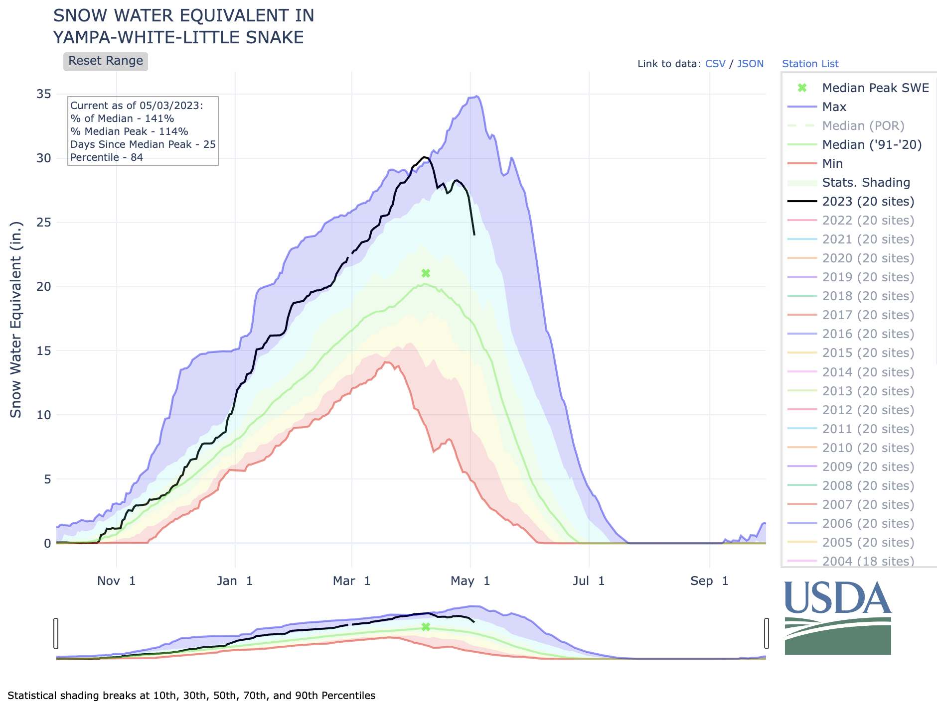
Routt County Emergency Management is warning residents to expect flooding Thursday, May 4, into Friday, May 5, with the Yampa River anticipated to reach its highest level yet this season. Emergency Operations Manager David “Mo” DeMorat told Routt County commissioners on Monday, May 1, that the river had hit 6,500 cubic feet per second, and warm temperatures are expected to continue through the week, which could cause the river to reach 7,000 cfs by Friday. DeMorat said this amount of water for the Yampa River is considered “action level” flooding by the National Weather Service. Action levels generally require municipalities to keep a closer eye on flooding and have potential mitigation plans and flood warnings in place…
To gauge what flooding will look like, the county uses snow-water equivalent gauges that provide estimates for the amount of snowmelt that could occur three to four weeks out. This looks at the amount of snow on the ground, but cannot predict at what rate it will melt. Because of this, no exact estimates can be given, as it is ultimately the weather and the freeze-and-thaw cycle that will determine at what rate the snow melts.
DeMorat explained to commissioners that these gauges show areas north of Steamboat and the Stagecoach Reservoir currently have the highest potential for flooding. Three snow-water equivalent gauges stationed north of Steamboat have helped emergency management identify these regions as problem areas for flooding due to the snowpack that could melt. All three are north of Steamboat with one near Dry Lake, one near Lost Dog Creek and another slightly farther northwest. DeMorat noted these locations range from 165-185% of the average snowpack. He told commissioners that Stagecoach Reservoir is another area of concern with 140% of its average snowpack.
Alongside the problem areas DeMorat named, the National Weather Service issued a flood warning for Elkhead Creek, particularly where the creek meets the Yampa River. This flood warning began on Monday and will end Friday unless communicated otherwise by the National Weather Service.
Street-side swale and adjacent pervious concrete sidewalk in Seattle, US. Stormwater is infiltrated through these features into soil, thereby reducing levels of urban runoff to city storm sewers. By U.S. Environmental Protection Agency – U.S. Environmental Protection Agency, Washington, D.C. “Managing Wet Weather with Green Infrastructure:Municipal Handbook:Green Streets” Document No. EPA-833-F-08-009, Public Domain, https://commons.wikimedia.org/w/index.php?curid=5921077
Click the link to read the article on the NOAA website:
The Mid-Atlantic Regional Integrated Sciences and Assessments (MARISA), a NOAA CAP/RISA team, principal investigators Jordan Fischbach, Debra Knopman, and Klaus Keller published a new tool to mainstream green infrastructure planning in the publication, “Rhodium-SWMM: An open-source tool for green infrastructure placement under deep uncertainty.” Green infrastructure measures are stormwater management practices that mimic natural hydrological processes that are used to mitigate negative impacts of urban development and climate change adaptation. While these practices are increasingly being used, there is a challenge to evaluate their effectiveness due to some deep uncertainties and require navigating tradeoffs between multiple objectives. Advanced decision-making tools and methods such as Robust Decision Making (RDM) and Many-Objective Robust Decision Making (MORDM) have been applied to green infrastructure sparingly, but there has still been a lack of open-source tools to support decision-makers.
The MARISA investigators have developed Rhodium-SWMM that connect two open source tools: the Stormwater Management Model (SWMM) and Rhodium, a Python library for MORDM. This new open-source Python library provides an interface for taking SWMM files and applying them to a wide range of parameters identified as uncertainties or levers. . It helps to efficiently search and sample GI decision alternatives and identify vulnerabilities in the system for better multifunctional solutions to future changes.
Debris and mud covers roads, trails, train tracks in Glenwood Springs https://t.co/ClIkWC56DB
— Summit Daily News (@SummitDailyNews) May 2, 2023
Click the link to read the article on The Summit Daily website (Cassandra Ballard). Here’s an excerpt:
After a quick weather jump from cold to warm over the past week, there have now been multiple areas of mud and debris flow throughout Glenwood Springs and the surrounding area due to the rapidly melting snow on Red Mountain and elsewhere. On Tuesday morning, a major debris flow blocked access to the wastewater treatment facility in West Glenwood, along with covering the Union Pacific Railroad train tracks in West Glenwood, causing a freight train to get stuck…
On Monday, local trails on Red Mountain and at Wulsohn Mountain Park, and on the higher trails of the South Canyon trail system were closed from mud flows, and the city was urging people to stay off the closed trails…
In addition, Garfield County emergency management officials reported late Monday that County Road 127 (3 Mile Road) was covered with water and mud and a private bridge was washed out at the half mile mark due to flooding on Three Mile Creek. Several residences were also being impacted. And, the Colorado Department of Transportation was reporting mudflow activity in Glenwood Canyon near Interstate 70.
Hi all, and thank you for joining Audubon Rockies and conservation photographer Dave Showalter for his multimedia journey through the living Colorado River! In his new book, Living River: The Promise of the Mighty Colorado, Dave shares the beauty of the watershed and a story of resiliency and resolution to continue the work for healthy watersheds. You can watch last week’s virtual book launch event recording here.
The Colorado River existing management guidelines are set to expire in 2026. The states that draw water from it are about to undertake a new round of negotiations over the river’s future. The use of the river will be renegotiated amid climate change, reduced snowpack, and water shortages, presenting an opportunity to ensure universal access to clean water for more than 30 federally-recognized Native tribes and make the allocation of the Colorado equitable as well as sustainable.
This May is a critical time to be a voice for the river, as the United States Bureau of Reclamation seeks public comment on the Draft Supplemental Environmental Impact Statement (SEIS) to the 2007 Interim Guidelines. This SEIS evaluates different scenarios to better balance water supply in the Colorado River watershed, which will impact ecosystem health in the Grand Canyon and other areas.
The stories, art, and lifeways that deepen our relationships to water are what build the collective voice for healthy rivers that benefit wildlife and people. The Mighty Colorado changes everything it touches, including us. Here are a few ways you can join the Living River conversation:
*Audubon members, as a special thank you, get a 20% discount by using the code “LIVINGRIVERLOVE” at checkout from Mountaineers Books.
Attend another book launch event or encourage a friend to attend one. The Living River book tour is traveling the West and has both in-person and virtual events.
Take action by May 30 and urge the Bureau of Reclamation to recognize the important links between human health, stable communities, and the environment and also implement measures that better balance water supply and protect the Grand Canyon ecosystem.
Presently, there is less water in the Colorado River system than at any time in recorded history, threatening the vitality of its ecosystem. But wherever there is water, there is abundant, dynamic life. As Dave Showalter says: “The river is not dying. She flows with the same pure purpose as before we arrived.”
There’s no giving up on the Colorado for riverkeepers engaged in riparian restoration. The hard work ahead requires widespread engagement in our future, which begins with all of us asking: Where does our water come from, and who does it connect us to?
All my best and hope to see you downstream,
Abby
Updated Colorado River 4-Panel plot thru Water Year 2022 showing reservoirs, flows, temperatures and precipitation. All trends are in the wrong direction. Since original 2017 plot, conditions have deteriorated significantly. Brad Udall via Twitter: https://twitter.com/bradudall/status/1593316262041436160
Streamflows in the Roaring Fork basin are down from last week.
Aspen Journalism is now compiling real time streamflow data. At Stillwater, located upstream of Aspen, the Fork ran at 39.7 cfs on April 24 at 1:30 pm. In terms of trends, the Fork ran at 40.1 cfs or 65.7% of average on April 23 after reaching 65.6 cfs on April 19. That’s down from 55.2 cfs and 117.4% of average, on April 16.
You can find all the featured stations from the dashboard with their real-time streamflow on this webpage.
Credit: Laurine Lassalle/Aspen Journalism
The USGS sensor on the Roaring Fork river below Maroon Creek recorded the Fork running at 138 cfs on April 23, or 98.6% of average. That’s down from 164 cfs on April 16.
At Emma, below the confluence with the dam-controlled Fryingpan, the April 23 streamflow of 364 cfs represented about 78.3% of average. That’s down from 412 cfs, and 101.7% of average, on April 16.
The transbasin diversion that sends Roaring Fork basin headwaters to Front Range cities was flowing at 13.7 cfs on April 23, up from 5.9 cfs on April 16.
Meanwhile, the Crystal River above Avalanche Creek, which is not impacted by dams or transbasin diversions, flowed at 195 cfs, or 70.1% of average, on April 23. Last week, the river ran at 244 cfs, or 123.9% of average.
How many people does it take to get the Colorado-Big Thompson Project ready for the peak delivery season? For the Northern Water Operations Division, the answer is … just about everyone.
Crews have been working throughout the winter to maintain the 80-year-old infrastructure and make the necessary repairs. Sometimes just decades of freeze-thaw action will create the need for repairs and replacements.
Why work so hard in the winter? Because water users expect consistent and reliable deliveries throughout the spring, summer and fall, meaning there isn’t room on the schedule to make repairs during warm, long days.
Map of the Colorado-Big Thompson Project via Northern Water
Registration includes access to the Watershed Summit, happy hour, refreshments, and entrance to Denver Botanic Gardens on June 22, 2023.This year, we’re excited to offer add-on optional experiences for those looking for something special before the main event:Guided tour of water-wise gardens by Denver Botanic Gardens horticulturists: $10 (75 spots available)Eat within your watershed: Locally sourced lunch prepared by SAME Café: $20 (25 spots available)The Watershed Summit, or “Shed” as it is affectionately known, has become a Colorado tradition, gathering a range of stakeholders to discuss current and future water challenges and opportunities facing the state. This year’s event will convene diverse voices and creative points of view to explore water efficient landscaping, how youth environmental education is bridging geographical divides, federal involvement in western water issues, and so much more!
Shed ’23 returns to a fully in-person event at Denver Botanic Gardens, concluding with the ever-popular happy hour event sponsored by Stem Ciders and Howdy Beer.
This event is produced through a collaborative partnership between the One World One Water Center (a joint initiative of Metropolitan State University of Denver and Denver Botanic Gardens), Aurora Water, the Colorado Water Conservation Board, Denver Water and Resource Central.
We hope you’ll join us this summer for the return of the Watershed Summit!
CONTEXT: I’ve long been intrigued by Rico, a former mining town of about 300 people in the western San Juan Mountains in southwestern Colorado. On paper, Rico looks a lot like Silverton: It was platted in the 1870s on Ute land as a mining hub and flourished during its early years; it sits at about 9,000 feet in elevation, surrounded by high mountains; and it was serviced by a railroad built by Otto Mears.
Yet Rico, just 20 miles as the crow flies from Silverton, ultimately followed a far different trajectory. The 1893 Silver Panic hit both towns hard initially, but Silverton ultimately recovered and its mining industry continued to support a fairly healthy population until the early 1990s. Rico, not so much — the population in 1890 was about 4,000; by 1900 it had shrunk to 811 and continued to ebb, bottoming out at just 75 in 1980.
Prior to mining, snowmelt and rain seep into natural cracks and fractures, eventually emerging as a freshwater spring (usually). Graphic credit: Jonathan Thompson
Mining in Rico didn’t collapse after the Silver Panic by any means. Throughout the decades, big and little firms gouged and tunneled, drilled and blasted, stoped and mucked, milled and smelted in the Rico Mountains. Sulfide-bearing iron pyrite — the active ingredient in acid mine drainage — is abundant here. So much so that in the 1950s the Rico-Argentine Mining Company and Vanadium Corporation of America began mining pyrite to produce sulphuric acid at a plant at the St. Louis Tunnel. The acid was used mainly for uranium processing at mills in surrounding lowlands. In 1980 Anaconda, a subsidiary of Atlantic Richfield, bought the Rico Argentine Mine site and surrounding lands with an eye toward molybdenum mining, but never actually pulled any ore out of the ground.
All of the mining activity permanently scarred the land, sullied the waters of the Dolores River, which passes through town, and contaminated town soils with lead. But it was never enough to revive the town’s early glory or population. Rico lost the Dolores County seat to the powerful Dove Creek pinto bean and Grange lobby in the 1940s, and the Rio Grande Southern railroad abandoned the community shortly thereafter.
Silverton, meanwhile, held onto its branch of the Denver & Rio Grande Western railroad, helping that town to become the backdrop of many a mid-century western film and a major tourist attraction. And the relatively prosperous mining industry there had left behind infrastructure to support the new economy. Despite its scenic location, mining history, and proximity to public lands, Rico never developed a strong tourist economy — perhaps by design. In 1990 Silverton’s population was about 800; Rico’s was roughly one-eighth of that. But what Rico lacked in economic development it made up for with a rough and rustic sort of charm.
Over the years, various entities have hatched economic development schemes. In the 1980s, the Rico Development Corporation bought most of the Anoconda/Atlantic Richfield land and other property, compiling 1,800 acres of patented mining claims and hundreds of in-town lots (and in so doing took on responsibility for water treatment at the old Rico-Argentine mine site, which didn’t end so well). Real estate developer Rico Renaissance acquired the land in the mid-1990s and worked with Rico officials to come up with a grand plan to revive, spiff-up, and build out the infrastructure needed to substantially grow the old mining town. Meanwhile, economic exiles from Telluride — 26 miles and one mountain pass away — began moving in and opening a few businesses, including a live music venue that attracted folks from around the region.
Rico Renaissance’s plans fell apart in 2007 for various reasons, and they tried to sell the land to Bolero Mining, which wanted to build a molybdenum mine nearby, to the dismay of some and delight of other locals. The effort failed, in part because the global financial crisis diminished demand for minerals, in part because opening a new mine in this day and age ain’t easy. As if to drive home the point, in 2011 the Environmental Protection Agency ordered Atlantic Richfield Company (ARCO) to clean up the Rico-Argentine Mine site just north of town; it had been oozing high concentrations of zinc and other heavy metals into the Dolores River since the mid-1990s. The company has spent at least $63 million on the effort so far, even though it never made any money off of the property.
What was left of Rico Renaissance became Disposition Properties, which continued to toy with developing the properties, but never progressed very far. Meanwhile Rico’s population has continued to grow, albeit slowly, and real estate prices have climbed. There are no homes in Rico listed for sale on Zillow, just a couple of lots priced around $200,000. But a 12-bedroom log-cabin monstrosity a handful of miles downriver from town is priced at $2.95 million. Still, the place isn’t what I’d call gentrified in any pervasive way; it retains its small-town funkiness. I passed through there last Fourth of July and was delighted to see the aftermath of a down-home parade and just dozens of folks milling about the sidewalks eating burgers (as opposed to the thousands that mob Silverton on the Fourth).
Map via The Land Desk.
Last April, Disposition finally threw in the towel and put 181 parcels covering 1,146 acres on the market for $10 million. Telluride Properties, the listing agent, marketed the property — and its potential — aggressively. It touted its geothermal properties (hot springs resort), the space for 300 new homes, potential for a land swap with the Forest Service, a parcel for a riverside lodge, and so on. It even suggested the possibility of building a chairlift, perhaps to access a Silverton Mountain-esque backcountry ski area. It did not mention the Superfund site or lead contamination; lack of infrastructure; floodplains and other geologic hazards; or Rico’s 2004 master plan objective of avoiding a “predominant resort character.”
Many locals were not amused. A resort and hundreds of new homes would certainly bring jobs and money to the area, but it would also completely overwhelm the existing community and smother its scrappy spirit. Rico townsfolk only needed to look around the region to see that amenity-economy-based prosperity has its downsides, ranging from housing crises to the widening abyss between the ultra-wealthy and everyone else.
Rico still may get gentrified, but the threat of it becoming a glitzy destination resort appears to have subsided. On April 5, the Dolores County clerk recorded a real property transfer and a special warranty deed conveying dozens of Disposition Properties’ parcels to Atlantic Richfield. While the property transfer document remains under wraps — it’s labeled a “sensitive document” — the warranty deed includes a list of what appears to be all of Disposition’s remaining properties. The transfer fee is listed as $778.94, indicating that the sale price was about $7.79 million.
We weren’t able to get in touch with anyone at Atlantic Richfield — now the valley’s largest landowner — about the purchase or their intentions. We can rest assured, however, that they aren’t going to be building a Rico Mountain mega-resort. Rico Town Manager Chauncey McCarthy said the mining company likely will hold onto contaminated and mining-impacted claims in order to remediate and reclaim them (which is probably why they bought the property in the first place). They may sell off other parcels and have expressed an interest in working with the town to make use of the in-town properties. The Montezuma Land Conservancy reportedly wanted to buy the property and put conservation easements on some parcels while possibly building affordable housing on others. Those kinds of scenarios seem far more likely now.
Rico, undoubtedly, will continue to grow. But what that growth looks like and how fast it will occur seems now to be far more within the control of the community and its residents.
CONTEXT: The Nevada firm and its many associated companies (Blackstone, Anson, etc) has been staking claims like crazy in the region, as reported by the Land Desk over the last six months or so, and has big plans to extract and mechanically process lithium. Last September, the Moab BLM office approved A1’s proposal to drill two exploratory wells (actually, to reopen abandoned oil and gas wells for exploratory purposes) near the road to Dead Horse Point State Park and Canyonlands National Park’s Island in the Sky unit. Southern Utah Wilderness Alliance appealed the decision.
The Utah BLM’s acting state director Anita Bilbao decided to set aside the permit. Bilboa ordered the Moab Field Office to re-open its analysis to “address SUWA’s concerns regarding a reasonable range of alternatives and to complete additional analysis regarding the cumulative impacts to water quantity.”
A1/Anson also has the Green River Project in the works north of the aforementioned wells. In March, the company announced it had filed a notice of intent with the BLM to drill three exploratory wells there.
Prior to 1921 this section of the Colorado River at Dead Horse Point near Moab, Utah was known as the Grand River. Mike Nielsen – Dead Horse Point State Park
Mauna Loa is WMO Global Atmosphere Watch benchmark station and monitors rising CO2 levels Week of 23 April 2023: 424.40 parts per million Weekly value one year ago: 420.19 ppm Weekly value 10 years ago: 399.32 ppm 📷 http://CO2.Earthhttps://co2.earth/daily-co2. Credit: World Meteorological Organization
The LMDT is west of Hwy. 91 north of Leadville. Forest, wetlands, and a small neighborhood are located nearby. Photo credit: Reclamation
Click the link to read the release on the Reclamation webiste (Anna Perea and Elizabeth Smith ):
LOVELAND, Colo. — The Bureau of Reclamation announces a $56 million investment from the President’s Investing in America agenda for the construction of a replacement Leadville Mine Drainage Tunnel Treatment Plant. Originally built in 1991, the plant removes heavy metals from contaminated water caused by mining operations in the Leadville area. It has since reached its service life, and this investment from the Bipartisan Infrastructure Law will ensure the plant continues to protect water supply
The Department of the Interior recently announced a nearly $585 million investment from the Bipartisan Infrastructure Law for infrastructure repairs on water delivery systems. Funds will support 83 projects across all five Reclamation regions, including the Leadville Mine treatment plant.
Since 1991, the treatment plant has operated to remove lead, zinc, manganese, iron, and other heavy metals from contaminated water that flows from the 2-mile-long Leadville Mine Drainage Tunnel. The plant sends 650 million gallons per year of treated, clean water to the headwaters of the Arkansas River in accordance with Environmental Protection Agency guidelines.
“The replacement of the treatment plant represents one of the key priorities that the Bipartisan Infrastructure Law is intended to accomplish, protecting our water supplies for people and the natural environment,” said Jeff Rieker, Eastern Colorado Area Office Manager. “This funding will allow us to replace aging infrastructure that is critical for continued protection of the water resources of the Arkansas River, benefitting both the river itself, as well as the people who rely on it for a wide range of activities and uses.”
At present, the treatment plant has surpassed its expected service life of roughly 30 years. Over the next several years, Reclamation will construct a new treatment plant that incorporates knowledge gained over the past three decades, focuses on safety and improves the plant’s visual impact.
“The new plant will provide a longer service life and continue Reclamation’s commitment to community safety and producing clean water for the Arkansas River,” said Plant Supervisor, Jenelle Stefanic. “There will also be more maneuverability within the floor plan and additional safety features such as fall protection and noise reduction technology.”
Prior to mining, snowmelt and rain seep into natural cracks and fractures, eventually emerging as a freshwater spring (usually). Graphic credit: Jonathan Thompson
His rich baritone and gift for melodies made him one of the most popular artists of the 1970s with songs like “The Wreck of the Edmund Fitzgerald” and “If You Could Read My Mind.”
Gordon Lightfoot, the Canadian folk singer whose rich, plaintive baritone and gift for melodic songwriting made him one of the most popular recording artists of the 1970s, died on Monday night in Toronto. He was 84…
Mr. Lightfoot, a fast-rising star in Canada in the early 1960s, broke through to international success when his friends and fellow Canadians Ian and Sylvia Tyson recorded two of his songs, “Early Morning Rain” and “For Lovin’ Me.” When Peter, Paul and Mary came out with their own versions, and Marty Robbins reached the top of the country charts with Mr. Lightfoot’s “Ribbon of Darkness,” Mr. Lightfoot’s reputation soared. Overnight, he joined the ranks of songwriters like Bob Dylan, Phil Ochs and Tom Paxton, all of whom influenced his style…When folk music ebbed in popularity, overwhelmed by the British invasion, Mr. Lightfoot began writing ballads aimed at a broader audience. He scored one hit after another, beginning in 1970 with the heartfelt “If You Could Read My Mind,” inspired by the breakup of his first marriage. In quick succession he recorded the hits “Sundown,” “Carefree Highway,”“Rainy Day People” and “The Wreck of the Edmund Fitzgerald,” which he wrote after reading a Newsweek article about the sinking of an iron-ore carrier in Lake Superior in 1975, with the loss of all 29 crew members…
For Canadians, Mr. Lightfoot was a national hero, a homegrown star who stayed home even after achieving spectacular success in the United States and who catered to his Canadian fans with cross-country tours. His ballads on Canadian themes, like “Canadian Railroad Trilogy,” pulsated with a love for the nation’s rivers and forests, which he explored on ambitious canoe trips far into the hinterlands. His personal style, reticent and self-effacing — he avoided interviews and flinched when confronted with praise — also went down well. “Sometimes I wonder why I’m being called an icon, because I really don’t think of myself that way,” Mr. Lightfoot told The Globe and Mail in 2008. “I’m a professional musician, and I work with very professional people. It’s how we get through life.”
[…]
Gordon Meredith Lightfoot Jr. was born on Nov. 17, 1938, in Orillia, Ontario, where his father managed a dry-cleaning plant. As a boy, he sang in a church choir, performed on local radio shows and shined in singing competitions. “Man, I did the whole bit: oratorio work, Kiwanis contests, operettas, barbershop quartets,” he told Time magazine in 1968…Mr. Lightfoot, accompanying himself on an acoustic 12-string guitar, in a voice that often trembled with emotion, gave spare, direct accounts of his material. He sang of loneliness, troubled relationships, the itch to roam and the majesty of the Canadian landscape. He was, as the Canadian writer Jack Batten put it, “journalist, poet, historian, humorist, short-story teller and folksy recollector of bygone days.”
Strong winter snowpack has water managers optimistic
A parade of snowstorms through the American West this winter has water managers across the region cautiously optimistic about the near-term water supply.
According to data from the Natural Resources Conservation Service, the Upper Colorado River watershed is at about 113 percent of its annual average for precipitation. Further downstream in the Colorado River Basin, other tributaries such as the Gunnison River and San Juan River are showing even larger snowpack totals compared to historic averages. For communities throughout the basin, that is great news.
The above-average snowpack in the Upper Colorado River Basin means there is a strong chance that the Colorado-Big Thompson (C-BT) Project reservoirs will fill this summer, too. That’s good news for residents of Northern Colorado who depend on the supplemental water supply that it delivers, but it’s not as good for Windy Gap Project participants. They have an agreement with the U.S. Bureau of Reclamation that allows them to use available capacity in Lake Granby to store Windy Gap water for future delivery, but if Lake Granby is full of C-BT Project water, no storage capacity is available for Windy Gap water.
With the construction of Chimney Hollow Reservoir, Windy Gap Firming Project participants will have the opportunity to capture and store water for multiple-year deliveries with greater frequency and flexibility in years when Lake Granby would otherwise be full of C-BT Project water. The construction of reservoirs helps moderate the ups and downs of annual precipitation and has enabled Colorado’s population and food production systems to grow and prosper for more than a century.
Map of the Colorado-Big Thompson Project via Northern Water
Glen Canyon Dam released higher flows over the past three days, with a peak discharge of over 40k cfs. This experiment aims to rebuild beaches, disrupt invasive fish breeding, and increase invertebrate abundance and diversity.
Updated Colorado River 4-Panel plot thru Water Year 2022 showing reservoirs, flows, temperatures and precipitation. All trends are in the wrong direction. Since original 2017 plot, conditions have deteriorated significantly. Brad Udall via Twitter: https://twitter.com/bradudall/status/1593316262041436160
On April 11, the Bureau of Reclamation released a draft Supplemental Environmental Impact Statement (SEIS). The SEIS is a mechanism to adjust the current operating guidelines for Glen Canyon (Lake Powell) and Hoover Dams (Lake Mead), providing tools for Reclamation to adapt to potentially dry years in the next few water years. Several news outlets, including The Colorado Sun, Politico, Colorado Politics, and AP News, covered the release with commentary from CWCB experts. CWCB Director and Colorado Commissioner Becky Mitchell is seeking public input to inform Colorado’s response to the SEIS. Share your feedback.
High snowpack in the San Juan River Basin this year has led to an above-average inflow forecast into the reservoir. The latest most probable inflow forecast from the Colorado River Basin Forecast Center is for 150% of average inflows from snowmelt runoff.
While most of the releases will be made to recover reservoir storage, Reclamation is planning to conduct a channel maintenance release from Navajo Dam. The release will ramp up slowly, peaking at 5,000 cfs for at least 11 days before ramping back down. This operation is expected to begin the last week of May and last through the third week of June. The exact schedule dates are to be determined as they will be timed to coincide with the peak on the Animas River. A notice with the final start date will be sent out approximately one week prior to beginning this release. Please stay tuned for updates…
For more information, please see the following resources below:
Bureau of Reclamation:
Susan Behery, Hydrologic Engineer, Reclamation Western Colorado Area Office: sbehery@usbr.gov or 970-385-6560
Earlier this month, Colorado Senator Dylan Roberts, House Speaker Julie McCluskie, Senator Perry Will, and Representative Marc Catlin introduced bipartisan legislation — “Senate Bill 23-295, Colorado River Drought Task Force” — to create a task force to make legislative recommendations to address the historic drought conditions on the Colorado River. The task force will be responsible for generating legislative recommendations that:
Proactively address climate-driven drought impacts on the Colorado River and its tributaries;
Avoid disproportionate economic/environmental impacts to any region of the state, ensuring acquisition of agricultural water rights is voluntary, temporary, and compensated;
Provide for collaboration among the Colorado River Water Conservation District, Southwestern Water Conservation District, and the State of Colorado in the design and implementation of drought security programs;
Explore ways new programs can benefit the environment and recreation;
Evaluate sources of revenue for the acquisition of program water; and
Establishes the Tribal Sub-Task Force to ensure there is appropriate space and time for their unique consideration.
A three-decade long drought threatens the Colorado River. Just last week, and previous years before, our allies at American Rivers listed it number one on their top endangered rivers in the United States. Colorado’s water security is decreasing as a result. These diminishing supplies are threatening our drinking water, agriculture, and environmental and recreational opportunities.
More flexible tools, that could be recommended by the task force established in SB23-295, can help Colorado communities respond to threats and impacts of drought exasperated by a warming climate and over allocation. Without clear action in the immediate future, these problems will only get worse.
Reach out to your legislator today to let them know you support action to make Colorado more resilient in the face of drought and climate change.
If you have lived in Denver for a few years or longer, you probably know that the efficient way to water landscapes is to follow Denver Water’s summer watering rules, which begin every year on May 1 and run through Oct. 1.
But what about those thousands of people who have moved to the City and County of Denver in recent years?
As it turns out, they are pretty familiar with Denver Water’s rules too.
Best practices for efficient, healthy outdoor watering are not just a Denver thing. They are the same best practices you’ll find utilities advocating for in California, Texas, Arizona, Illinois and Florida — the states where many of Denver’s newcomers came from.
How did we figure that out? We looked at federal census data (specifically the 72,490 people who moved in between 2012 and 2016) to learn which five states, and which county in each of those states, were the biggest suppliers of our recent round of new neighbors in Denver.
Then we looked at a sampling of the water providers in each of those counties to see what they advise their own customers to do.
Here’s what they all said:
There is no need to water when it’s raining, Mother Nature can handle it. And if it’s windy, it is best to hold off on watering.
When using a hose to wash the car, or water the lawn or trees, always use a shut-off nozzle in order to use only what you need, right when and where you need it.
Allowing water to run off onto sidewalks or the street wastes water.
Watering in the cooler parts of the day, between 6 p.m. and 10 a.m., cuts down on evaporation.
So, when it comes to outdoor watering, there’s no need for a native versus transplant turf battle. Instead, let’s raise a cool glass of safe, clean tap water to everyone who knows the best way to water landscapes efficiently.
And if you need a refresher on the ins and outs of Denver Water’s annual summer watering rules, check out denverwater.org/BestPractices for more information. You’ll find all kinds of efficiency tips there for water use inside and out.
View of Denver and Rio Grande (Silverton Branch) Railroad tracks and the Animas River in San Juan County, Colorado; shows the Needle Mountains. Summer, 1911. Denver Public Library Special Collections
Density concerns, soundscapes and dark skies, wildlife impacts, preservation of the Animas River Corridor, and water and sanitation demands are only half of the issues Animas Valley residents face if a proposed luxury RV park is approved by La Plata County. Residents of the Animas Valley have also questioned the legality of the proposed RV park in terms of zoning. A preliminary sketch plan of the development targeting 876 Trimble Lane (County Road 252) was approved by the La Plata County Planning Commission in January and is now moving through a minor land-use permit process. Arizona-based developer Scott Roberts wants to build a 306-stall luxury RV park, which includes 49 tiny homes the proposal calls “adventure cabins.” But some residents fear the scope of the potential development would impede on the rural lifestyle they enjoy.
The Animas Valley Action Coalition, a community group organized to protect the Animas Valley from developments that pose major impacts to the area, hosted a meeting Saturday at the Durango Public Library to discuss impacts and continue the conversation about Roberts’ RV park. About 58 residents and friends of the Animas Valley gathered to hear two presentations about the history of the valley and an opportunity to protect the Animas River Corridor. Tom Penn said AVAC community members have different expectations of the RV park proposal. Some people don’t want an RV park to be built at all and others would prefer a smaller development.
Spring runoff is just beginning in the Crystal River Valley (April 2023). A group of nearly 140 people gathered in Marble Thursday to voice their values and concerns as part of a stakeholder process aimed at exploring protections for the river. Heather Sackett/Aspen Journalism
Click the link to read the article on the Aspen Journalism website (Heather Sackett):
Keeping the Crystal River free-flowing with no dams and preserving its scenic qualities, ecosystems and water rights for agriculture were values that nearly all the attendees of a Thursday community summit at the Marble Firehouse agreed on. How best to achieve those goals is another matter.
The summit was organized by the Wild & Scenic Feasibility Collaborative, which is made up of representatives from the town of Marble, Gunnison County, Pitkin County, the Colorado River Water Conservation District and American Whitewater, and was facilitated by staffers from Wellstone Collaborative Strategies and P2 Solutions. The meeting drew nearly 140 people — more than double the number expected — and sent organizers scrambling for more chairs.
The summit kicked off a much-anticipated public stakeholder process aimed at evaluating community interest in pursuing protections for the Crystal River, which flows through the towns of Marble and Redstone, as well as Gunnison and Pitkin counties. In small groups, attendees outlined their most important values, long-term aspirations, biggest concerns and criteria for evaluating management options.
A faction of residents and conservationists, including Pitkin County, is pushing for a federal Wild & Scenic designation, which it says would carry the strongest protections for preserving the river in its current state. Pitkin County, through its Healthy Rivers program, has funded a grassroots campaign by Carbondale-based conservation group Wilderness Workshop to drum up support for Wild & Scenic, and has secured a resolution of support for Wild & Scenic from Carbondale Town Council.
But some say that approach is jumping the gun and that the stakeholder process should include other options for protection without the federal government’s oversight.
Representatives from Pitkin County spoke about threats to the Crystal and the need for Wild & Scenic at a Gunnison Board of County Commissioners work session Tuesday.
“One of the concerns we are having is that the only foregone conclusion is that Wild & Scenic is the only tool,” Gunnison County Commissioner Jonathan Houck told them. “It’s going to be tough if people feel like the foregone conclusion is Wild & Scenic.”
Although there may not be imminent, specific threats of dams or diversions on the Crystal, Wild & Scenic proponents say that doesn’t mean there won’t be threats at some point. A hotter, drier future under climate change could push Front Range cities or downstream water users to look to one of the last rivers without a dam or transmountain diversion — a rarity in western Colorado — as a means to quench their thirst.
“Today, there is nobody trying to take water out of the Crystal River basin,” Pitkin County Commissioner Francie Jacober told Gunnison County commissioners at Tuesday’s meeting. “But I don’t have faith the Crystal River or the Roaring Fork or the Gunnison won’t be targeted. I want to do everything we can to protect the Crystal River before the threat is at our doorstep.”
One of the biggest threats of a dam on the Crystal was removed a decade ago when, after a legal battle with Pitkin County, the River District and Rifle-based West Divide Water Conservancy District relinquished water rights tied to a potential reservoir at Placita, just below McClure Pass. In 2012, the River District walked away from rights tied to a second reservoir, Osgood, that would have inundated the town of Redstone.
Pitkin County Healthy Rivers administrator Lisa Tasker, left, and Matt Annabel of Back 40 Stories, write down their most important values about the Crystal River at a community summit in Marble on Thursday. The summit was the kickoff event in a stakeholder process aimed at exploring protections for the river. Heather Sackett/Aspen Journalism
Designation details
The U.S. Forest Service determined in the 1980s that 39 miles of the Crystal River was eligible for designation under the Wild & Scenic River Act, which seeks to preserve rivers with outstandingly remarkable scenic, recreational, geologic, fish and wildlife, historic, and cultural values in a free-flowing condition.
According to the National Wild & Scenic Rivers System Guide for Riverfront Property Owners, one of most important provisions of the act protects rivers “from the harmful effects of project proposals within the river’s bed or banks” and projects that need a federal permit or loan are subject to review under the act.
Any designation would take place upstream of the big agricultural diversions on the lower portion of the river.
There are three categories under a designation: wild, which are sections that are inaccessible except by trail, with shorelines that are primitive; scenic, with shorelines that are largely undeveloped but are accessible by roads in some places; and recreational, which are readily accessible by road or railroad and have development along the shoreline.
The initial Forest Service proposal for the Crystal included all three designations: wild in the upper reaches of the river’s wilderness headwaters; scenic in the middle stretches; and recreational from the town of Marble to the Sweet Jessup canal headgate. Each river with a Wild & Scenic designation has unique legislation written for it that can be customized to address local stakeholders’ values and concerns.
A first attempt at a Wild & Scenic designation around 2012 couldn’t get buy-in from Marble residents or Gunnison County. Suspicions of the federal government still run high for some residents, even as they say they want to see the Crystal protected.
Larry Darien, who owns a ranch on County Road 3, which borders the river, has long been an opponent of Wild & Scenic. But he said he would be in favor of alternate protections. He does not want to see the river dammed or its waters transferred out of the basin and said the summit was a good start at working toward solutions.
“It seems to me like there’s a consensus on what we want and there’s more than one way to get there,” Darien said. “There are other options [besides Wild & Scenic]. I’m not in favor of the federal government helping me with my property.”
Facilitators will bring people together again in September to evaluate what those alternative management options might be. In the meantime, they plan to form a steering committee — on which Darien plans to serve as a representative of private-property owners — to collect input and lead the process.
In addition to county officials and residents, the summit drew people from a wide range of water interests, including influential Boulder water attorney Glenn Porzak; managers from Crystal River Ranch, which has the largest agricultural diversion on the river; representatives of U.S. Sen. John Hickenlooper, a Democrat, and U.S. Rep. Lauren Boebert, a Republican; local business owners; a representative from Colorado Stone Quarries, which operates the Pride of America Mine above Marble; environmentalists; and anglers and kayakers.
Pitkin County Commissioner Kelly McNicholas Kury was pleased with the high turnout.
“[Wild & Scenic] is what we feel like our constituents have wanted for a long time, but we know that we don’t own the solution by ourselves,” she said. “That’s why we have been willing participants in this process to evaluate what’s going to work best for the community. … There feels like a shared love for the river in this room tonight, and I think that is the most important thing to inspire the good conversations ahead.”
Editor’s note: Aspen Journalism is supported in part by a grant from the Pitkin County Healthy Community Fund.
Hydrologists with the Colorado Basin River Forecast Center are predicting the fourth-highest peak runoff of the Elk River in the 53 years of available U.S. Geological Survey stream gauge data.
“There is strong potential for the Elk River to crest above flood stage,” said Brenda Alcorn, senior hydrologist with the forecast center, a federal agency that is part of the National Weather Service.
The only stream gauge on the Elk River is located along County Road 42 west of the Marabou Ranch subdivision and has recorded river flows consistently for 53 years. The water level at the gauge at 11:15 p.m. Thursday showed a peak of 5.5 feet or 2,900 cubic feet per second, or cfs, following significant increases the previous three days. The high water forecast through the next 10 days at the stream gauge is for 6.85 feet or 4,581 cfs on May 4. The river can fluctuate approximately 1,000 cfs from the warmest to the coolest parts of the day, hydrologists say, and the flood level at the gauge is 7.5 feet or 5,916 cfs.
The outflow of the Bousted Tunnel just above Turquoise Reservoir near Leadville. The tunnel moves water from tributaries of the Roaring Fork and Fryingpan rivers under the Continental Divide for use by Front Range cities, and Pitkin County officials have concerns that more water will someday be sent through it.
Major water infrastructure project funded by the Bipartisan Infrastructure Law to provide clean, reliable drinking water to 50,000 Coloradans once completed
PUEBLO, Colo. – The Bureau of Reclamation today broke ground on the Boone Reach trunk line of the Arkansas Valley Conduit (AVC), a major infrastructure project under President Biden’s Investing in America agenda that will bring clean, reliable drinking water to 39 communities in southeastern Colorado.
Deputy Assistant Secretary for Water and Science Gary Gold and Reclamation Commissioner Camille Calimlim Touton joined local and Federal leaders at the groundbreaking ceremony where they highlighted the $60 million investment provided through President Biden’s Bipartisan Infrastructure Law for the project. When completed, the project’s 230 miles of pipeline will deliver as much as 7,500 acre-feet of water annually from Pueblo to Lamar, where water providers in Bent, Crowley, Kiowa, Otero, Prowers and Pueblo counties will serve a projected future population of 50,000.
“The results of the historic investment from the Bipartisan Infrastructure Law are evident here today as we see this project moving forward,” said Deputy Assistant Secretary for Water and Science Gary Gold. “This project will bring a long-term, clean water supply to so many communities in southeastern Colorado.”
“Through the President’s Investing in America agenda, Reclamation is now well positioned to help advance these important water projects that have been paused for decades,” said Bureau of Reclamation Commissioner Camille Calimlim Touton. “Our investment in this project, dedicated by President Kennedy more than 60 years ago, will provide the path forward for safe drinking water to so many residents of this area.”
“This long-awaited project is a vital step forward for the Arkansas Valley and shows what can be accomplished through a strong coalition of federal, state, and local partnerships,” said Jeff Rieker, Eastern Colorado Area Manager.
“Generations of people of the Lower Arkansas Valley have waited for the AVC for more than 60 years, and now with construction starting, we are seeing the realization of that dream,” said Bill Long, President of the Southeastern Colorado Water Conservancy District. “This is the culmination of years of determination on the part of Reclamation, the District and the AVC participants to get this job done.”
“This is a truly monumental achievement and marks the culmination of decades of hard work, dedication, and collaboration by those who have devoted their lives to the business of water,” said Seth Clayton, executive director of Pueblo Water. “Pueblo Water is proud to be an integral participant in this important time in history.”
The Arkansas Valley Conduit was part of the 1962 Fryingpan-Arkansas Project Act, and its construction represents the completion of the project. Once complete the project will replace current groundwater sources contaminated with radionuclides and help communities comply with Environmental Protection Act drinking water regulations. The connection point for AVC is at the east end of Pueblo Water’s system, at 36th Lane and U.S. Highway 50, and follows the Arkansas River corridor from Pueblo to Lamar, with spurs to Eads and Crowley County. Reclamation is building the trunk line, while the Southeastern District will build the spur and delivery lines. Estimated total cost is about $600 million.
The Bipartisan Infrastructure Law allocates $8.3 billion for Bureau of Reclamation water infrastructure projects over five years to advance drought resilience and expand access to clean water for families, farmers, and wildlife. The investment will repair aging water delivery systems, secure dams, and complete rural water projects, and protect aquatic ecosystems. The funding for this project is part of the $1.05 billion in Water Storage, Groundwater Storage and Conveyance Projects provided by the Law.
Michael Bennet, Colorado Senator; Bill Long, Southeastern Colorado Water Conservancy District; Camille Calimlim Touton, Reclamation Commissioner; Rebecca Mitchell, Director Colorado Water Conservation Board stand with pipe for the construction of the Arkansas Valley Conduit. Photo credit: Reclamation
Click the link to read “Arkansas Valley Conduit project breaks ground” on The Pueblo Chieftain website (JamesBartolo/USA Today). Here’s an excerpt:
Advocates of the Arkansas Valley Conduit celebrated the groundbreaking of the conduit’s Boone Reach 1 trunk line, which will connect Pueblo’s water system to Boone, on Friday, April 28, at Martin Marietta Rich Sand & Gravel east of Pueblo. The trunk line is the first 6-mile piece of the conduit’s planned 230mile project stretching from Pueblo to Lamar and Eads. Once completed, the conduit will send up to 7,500 acrefeet of Pueblo Reservoir water to about 50,000 southeastern Colorado residents. WCA Construction LLC., a Towaoc, Colorado-based company owned by the Ute Tribe, was awarded a $42.9 million contract from the U.S. Bureau of Reclamation in September 2022 to complete construction of the Boone Reach 1 trunk line.
Communities benefitting from the conduit include communities in eastern Pueblo, Crowley, Otero, Bent, Kiowa and Prowers counties. Drinking water in many of these communities currently contains contaminants like radionuclides and selenium, according to Bill Long, board president of the Southeastern Colorado Water Conservancy District…
Estimates for the total cost of the project are between $600 and $700 million, Long said. Project leaders hope to receive upward of $500 million more from the federal government. After receiving $60 million from the Bipartisan Infrastructure Package, the Arkansas Valley Conduit continues to be a competitive project in the fight for future federal funding, according to U.S. Bureau of Reclamation Commissioner Camile Touton.
Arkansas Valley Conduit map via the Southeastern Colorado Water Conservancy District (Chris Woodka) June 2021.
Consider me adequately freaked out. Substack now has an AI image generator, about which I’m pretty damned ambivalent, at best. But I wanted to try it out, so I asked for a picture of a cow grazing in the desert in the style of Georgia O’Keefe. This is what it came up with. On the one hand, no one would ever mistake this for an O’Keefe. On the other hand, it’s not terrible or even obviously generated by a machine. Which worries me (and makes me uncomfortable about including it here, even to question the technology behind it). I did ask it to draw me a picture of Glen Canyon Dam after being blown up. It failed. And then I asked for a dam with a crack down the middle. Still didn’t work. That gives me some hope that the art apocalypse isn’t upon us … yet.
When the Interior Department issued a draft of a new Public Lands Rule, designed to “guide the balanced management of public lands” and put conservation on a par with other uses, like oil and gas drilling, grazing, and mining, I thought I had been transported back in time to 1976. That’s when Congress passed the Federal Land Policy and Management Act, or FLPMA, which was supposed to elevate conservation and rid the Bureau of Land Management of the well deserved monicker: Bureau of Livestock and Mining.
FLPMA didn’t always do the job it intended: While the BLM as a whole has progressed, many of the agency’s field offices still behave as if it’s the 1950s, prioritizing drilling and grazing above all other uses, regardless of what policies are handed down from Washington.
Given that history, I wondered whether this proposed rule really amounted to more than merely “rearranging the deck chairs on the Titanic” as the Center for Biological Diversity put it. If it was just reiterating FLPMA policies, how could it make any difference on the ground now? I don’t have the answer, but I did dig into the rule and looked at some of the details in a recent High Country News column.
To sum it up, the rule would elevate conservation by:
Vernal pools form in winter and spring and support many types of animals and plants. Photo credit BLM.
… applying land health standards and guidelines to all BLM-managed public lands and uses; current BLM policy limits their application to grazing authorizations. The problem is that the agency is doing a piss-poor job applying land health standards to rangelands. So how can we expect them to do any better with other lands?
… making conservation leases available to entities that seek to restore public lands or provide mitigation for a particular action. A nonprofit could lease a parcel, pay rent, and post a reclamation bond to do riparian area restoration, for example, or a solar company might lease a parcel to do some land-healing to offset its impacts to other public land.
… amending the existing Area of Critical Environmental Concern (ACEC) regulations to emphasize the areas as the primary designation for protecting important natural, cultural, and scenic resources and contributing to ecosystem resilience by protecting intact landscapes and preserving habitat connectivity. It would also establish a more comprehensive framework for identifying and evaluating these areas.
The biggest change, then, appears to be the conservation leases. But it’s still unclear exactly how they’d work or what could be done with them. In theory, someone could lease out a parcel for conservation, thereby precluding grazing or oil and gas leasing from the parcel during the lease. But what happens when the lease term ends? Josh Osher, Public Policy Director for the Western Watersheds Project, pointed out that an organization could use the leases to, say, do a regenerative grazing project, and cynically use it to lock the land into a grazing lease afterwards. He also noted that even though oil and gas drilling and mining are restricted in ACECs, grazing typically is not.
This only reinforced my skepticism about the rule. But then I started looking at industry’s reactions to the rule and I have to say, I was a little taken aback.
Sen. John Barrasso, the Wyoming Republican, compared the bureaucrats who wrote the “decree” to the tree-spiking eco-warriors of the 1980s, while the ranching industry feels “betrayed” by what it says is a plan to “eradicate” grazing on public lands. Say, what?!
Chris Saeger, an advocate and consultant from Montana, gathered some more responses and sent them my way, including these gems:
“‘[T]he administration is making a policy shift of gigantic proportions with this proposed rule by giving conservation equal footing to all other public land uses.’ – Mallori Miller, vice president of government relations for the Independent Petroleum Association of America
“‘The rule would make conservation one of the uses on equal footing as the uses listed above [grazing, water rights, oil, gas and mining].’ – Rancher Rachel Gabel
“‘[W]hen BLM is analyzing projects and uses because they are mandated as a multiple use public land agency, conservation will now have as much standing as recreation, grazing, mining and other uses as outlined in FLPMA.’ – Blue Ribbon Coalition Action Alert email, titled: Proposed BLM Rule to Devastate Public Land Access
“‘The Biden Administration has proposed significant changes to how federal lands are managed…with the department to issue conservation leases on par with grazing and mineral leases.’ – Rancher Cat Urbigkit“
And then there’s the reaction by Rep. Matt Rosendale, a Montana Republican. In a hearing, Interior Secretary Deb Haaland said the rule would put conservation on equal footing with other uses. Rosendale responded, rather testily: “Well, they’re not supposed to be on equal footing.”
Wow. Just wow. See, here I thought that conservation already was on an equal footing with drilling, mining, and so forth, as mandated by FLPMA. Obviously I was wrong! All of these folks are acknowledging that, in fact, the agency has been kowtowing to the oil and gas, drilling, and livestock industries all along while shirking their duties as stewards of the public’s land.
In that case, this new rule might actually have some real on the ground impacts. That is if the Biden administration implements it quickly enough to insulate it from future efforts to rescind it. And if they can ensure that the new policies are implemented on a field-office level rather than sitting around moldering on some Washington D.C. desk.
Piñon pine (Juniperus_occidentalis). Photo credit: Wikimedia
Piñon-Juniper Watch
Speaking of the BLM, rules, and conservation … Back in 2020, the Trump administration (of course) quietly enacted the “Pinyon-Juniper Categorical Exclusion Rule.” It allowed the BLM to cut, hydro-mow, chain, or otherwise mechanically raze up to 10,000 acres of piñon-juniper forests without environmental review or even notifying the public. The BLM justifies these types of projects by saying they allow sagebrush to establish itself and benefit mule deer or sage grouse. They also can convert forest land into foraging land for cows.
Of course, these brutal and violent projects destroy not only the targeted trees, but also all of the other vegetation and the cryptobiotic soils. And they harm other species that rely on them for habitat, such as the piñon jay.
That’s why Defenders of Wildlife and Southern Utah Wilderness Alliance challenged the rule in court, which in turn led to a court-approved settlement: The BLM has agreed to drop the rule. That won’t stop the projects altogether, but it will require the agency to analyze the environmental impacts before proceeding. It’s an important victory. But, to the Biden administration’s credit, it actually directed the agency to discontinue the use of the categorical exclusion rule in December.
Old growth Ponderosa pine on public land that would be transferred to private ownership in proposed Valle Seco land trade, photo courtesy of Colorado Wild Public Lands
In 2017, the public lost 1,470 acres of wilderness-quality land at the base of Mount Sopris near Aspen, Colorado.
For decades, people had hiked and hunted on the Sopris land, yet the Bureau of Land Management (BLM) handed it over to Leslie Wexner, former CEO of Victoria’s Secret and other corporations, at his request. The so-called “equivalent terrain” he offered in return was no match for access to trails at the base of the 13,000-foot mountain.
This ill-considered trade reveals how land management agencies pander to wealthy interests, do not properly value public land, and restrict opportunities for public involvement. It’s an ongoing scandal in Colorado that receives little attention.
Since 2000, the BLM and the Forest Service have proposed over 150 land exchanges in Colorado. Last year alone, the agencies proposed to trade more than 4,500 acres of public lands, worth over $9 million, in three major Colorado land exchanges.
Land to be traded away includes precious riverfront, lands recommended for Wild and Scenic River designation, and hundreds of acres of prime hunting and recreation territory.
Open meadows and mixed forest are common among the parcels Denver Water is conveying to the U.S. Forest Service. Photo credit: Denver Water.
Public land exchanges can be a useful tool. Federal agencies use them to consolidate land holdings, improve public access, reduce management costs and protect watersheds.
By law, the trades must serve the public interest, and the land exchanged must be of equal value. The agencies are supposed to analyze, disclose and mitigate the impacts of relinquishing public lands in exchanges, and also solicit public input on whether a trade makes sense.
But here in Colorado — and elsewhere around the country — this management tool has been usurped by powerful players who aim to turn valuable public lands into private playgrounds.
Often, the deals proposed sound good in terms of acreage. In the Valle Seco Exchange, for example, the San Juan National Forest in southern Colorado would trade 380 acres for 880 acres of prime game-wintering habitat. But the trade mostly benefits the landowners pushing the exchange.
Public lands for trade in the Valle Seco Exchange include river access, corridors considered for Wild and Scenic River designation, wetlands, sensitive species habitat, and significant cultural sites.
Alarmingly, the Valle Seco exchange also includes more than 175 acres of a Colorado Roadless Area, a designation meant to block development of high-quality land. The exchange would allow a neighboring landowner to consolidate those 380 acres with his 3,000-plus acre ranch, opening the door to development.
The Valle Seco Exchange follows a long-standing pattern. “Exchange facilitators,” people familiar with the land-acquisition wish lists of agencies, help private landowners buy lands the agencies want. The landowners then threaten to manage and develop those lands in ways that undermine their integrity.
The Valle Seco proponents did this by closing formerly open gates and threatening to fence the 880 acres for a domestic elk farm and hunting lodge. This is blackmail on the range.
While catering to these private interests, the agencies suppress public scrutiny by refusing to share land appraisals and other documents with the public until afterthe public process has closed — or too late in the process to make it meaningful.
The proponents and their consultants have ready access to these documents, yet the public, which owns the land, does not. In Valle Seco, appraisals were completed in August 2020, but they weren’t released to the public until December 2021, just a few weeks before the scheduled decision date for the exchange. Advocates managed to pry the appraisals out of the agency only after submitting multiple Freedom of Information Act requests and taking legal action.
In another deal, the Blue Valley Exchange, the BLM also withheld drafts of the management agreements until just before releasing the final decision. This is hardly an open and fair public process.
The federal government presents what are, in effect, done deals. Development plans and appraisals are undisclosed and comment periods hindered. By prioritizing the proponents’ desires over public interests and process, the land management agencies abdicate their responsibilities.
Erica Rosenberg. Photo credit: Writers on the Range
The result is that too many land trades are nothing less than a betrayal of the public trust as the public loses access to its land as well as the land itself.
Erica Rosenberg is a contributor to Writers on the Range, writersontherange.org, an independent nonprofit that works to spur lively conversation about Western issues. She is on the board of Colorado Wild Public Lands, a nonprofit in the town of Basalt that monitors land exchanges around the state.
In what’s become an annual tradition in the Colorado General Assembly, Democrats in the majority are spending the final weeks of the legislative session passing bills aimed at reducing greenhouse gas emissions, while their Republican colleagues persist in outright denial of the scientific consensus on manmade climate change.
Senate Bill 23-16, which would set new targets for greenhouse gas emissions cuts while boosting clean energy and carbon-capture efforts, was given initial approval by the House on Wednesday evening — but not before Colorado GOP lawmakers reiterated their rejection of mainstream climate science.
In a nearly hourlong speech in opposition to the bill, state Rep. Ken DeGraaf, a Colorado Springs Republican, offered a grab-bag of debunked climate-denial talking points and half-truths, rehashing decades-old myths as he described concern over carbon dioxide’s role in global warming as “hysteria around a trace gas.”
“Carbon dioxide, god bless it — great for growing plants, but does really very little in terms of greenhouse gas,” DeGraaf said in his speech on the House floor.
It was the latest in a long series of reminders that GOP lawmakers remain committed to all-out climate misinformation as they battle Colorado Democrats’ clean-energy agenda at the Capitol.
“The crisis that we have is to spend as much money on the green energy cartel before everybody becomes aware that it’s not a real threat,” added DeGraaf.
In 2021, GOP Senate Minority Leader Chris Holbert said of “so-called climate change” during a floor debate on an environmental justice bill that he did “not believe that it is man-made.” State Sen. Barbara Kirkmeyer, who lost narrowly last year to Democratic U.S. Rep. Yadira Caraveo in the race for the new 8th Congressional District, falsely claimed during her campaign that “to what extent any warming is a result of man-caused activity is unknown.”
In fact, climate scientists with the Intergovernmental Panel on Climate Change say that the Earth has warmed at an unprecedented rate since 1850, and the evidence of human influence is “unequivocal.”
“Evidence is overwhelming that the climate has indeed changed since the pre-industrial era and that human activities are the principal cause of that change,” concluded the IPCC’s 2021 report on the physical science of climate change, which was authored by 234 scientists from around the world and compiled the results of thousands of studies conducted over many decades.
SB-16, which had been poised to win final passage in the full House this week, would commit Colorado for the first time to achieving net-zero greenhouse gas emissions by 2050, revising the state’s current target up from a 90% reduction by that date, and setting other interim emissions goals.
“We know we need to get to 100%,” said state Rep. Karen McCormick, a Longmont Democrat, one of the bill’s House sponsors, during Wednesday’s floor debate. “We really need to set these goals out there, so that we’re aiming to get them, and having interim targets makes sure we’re on track.”
Denialist talking points
Telling his fellow lawmakers that he had “been studying this stuff for a long time,” DeGraaf read at length from printed material authored by prominent climate deniers and skeptics, including Judith Curry and Howard Hayden. Curry is a former atmospheric scientist with the Georgia Institute of Technology and Hayden, a Pueblo resident, is a retired physics professor who has self-published a number of books denying the science of climate change, including “Bass Ackwards: How Climate Alarmists Confuse Cause with Effect.”
DeGraaf began his speech with one of the most frequently repeated talking points in climate-denial circles.
“Fifty years ago we were talking about global cooling, and now we’re talking about climate change,” he claimed.
A 2008 paper published by the American Meteorological Society called the past existence of a global-cooling consensus a “pervasive myth.” The hypothesis attracted only scant news coverage in the 1970s and was not at any point embraced by the scientific community at large. One of the most widely circulated claims involving global cooling — a purported Time Magazine cover warning of a “coming Ice Age” — is a hoax.
State Rep. Richard Holtorf, a Akron Republican, joined DeGraaf in denouncing the bill and repeating the global-cooling myth, arguing that “none of these predictions will come true, as they haven’t come true in the last 50 years.”
DeGraaf also argued that variations in solar radiation, rather than greenhouse gas emissions, have been responsible for the global temperature increases recorded over the last two centuries. In fact, the IPCC concluded again in 2021 that there has been “negligible long-term influence from solar activity” since 1900.
And DeGraaf’s repeated claim that global warming is driven by water vapor, rather than carbon dioxide and other greenhouse gases emitted by human activity, is another assertion that has been widely shared among conservatives on social media and consistently debunked by climate scientists.
“Without the water vapor, global warming is a nonstarter,” DeGraaf said. “That’s the actual climate science. It’s water vapor.”
Water vapor makes up about 4% of the Earth’s atmosphere. Because it stores heat, it can be considered a greenhouse gas, and the potential for feedback loops caused by rising temperatures and a wetter atmosphere is an important factor in the climate models used by scientists to make long-term global warming projections.
But climatologists say there is overwhelming evidence that the “radiative forcing” of rising atmospheric concentrations of gases like carbon dioxide and methane is the primary driver of global warming. A researcher told AFP in 2021 that water vapor’s categorization as a greenhouse gas is “a great example of the practice of trying to confuse the public with information that is true but totally irrelevant.”
In February, DeGraaf, a first-term lawmaker who was elected in House District 22 last year, introduced a bill that would have “prohibit(ed) the classification of carbon dioxide as a pollutant” in Colorado. The bill was defeated in the House Energy and Environment Committee, with all three of the committee’s Republicans voting in favor.
Rising global temperatures are the main driver of an ongoing “megadrought” in the Colorado River Basin more severe than any dry spell the region has experienced in at least the last 1,200 years, scientists say. Warmer, drier conditions have increased wildfire risk, and all of the 20 largest wildfires in Colorado history have occurred since 2000.
SB-16 contains provisions aimed at boosting decarbonization efforts across a wide variety of industries, including tax incentives for electric-powered lawn equipment; measures to accelerate the construction of electricity transmission infrastructure and rooftop solar installation; stricter requirements on large insurance companies to assess climate risk; and more authority for state regulators to oversee carbon-capture projects.
“There’s probably something in here for everyone,” McCormick said Wednesday. “If you look, you’re going to find a section that you like.”
If passed by the House, the amended SB-16 would need to return to the Senate for a final vote before heading to Gov. Jared Polis for his signature.
The Global Monitoring Division of NOAA/Earth System Research Laboratory has measured carbon dioxide and other greenhouse gases for several decades at a globally distributed network of air sampling sites. Credit: NOAA Global Monitoring Laboratory
California and Arizona are currently fighting each other over water from the Colorado River. But this isn’t new — it’s actually been going on for over 100 years. At one point, the states literally went to war about it. The problem comes down to some really bad math from 1922.
To some extent, the crisis can be blamed on climate change. The West is in the middle of a once-in-a-millennium drought. As temperatures rise, the snow pack that feeds the river has gotten much thinner, and the river’s main reservoirs have all but dried up.
But that’s only part of the story: The United States has also been overusing the Colorado for more than a century thanks to a byzantine set of flawed laws and lawsuits known as the “Law of the River.” This legal tangle not only has been over-allocating the river, it also has been driving conflict in the region, especially between the two biggest users, California and Arizona, which are both trying to secure as much water as they can. And now, as a massive drought grips the region, the law of the river has reached a breaking point.
The Colorado River begins in the Rocky Mountains and winds its way southwest, twisting through the Grand Canyon and entering the Pacific at Baja California. In the late 19th century, as white settlers arrived in the West, they started diverting water from the mighty river to irrigate their crops, funneling it through dirt canals. For a little while, this worked really well. The canals made an industrial farming mecca out of desert that early colonial settlers viewed as “worthless.”
Even back then, the biggest water users were Arizona and California, which took so much water that they started to drain the river farther upstream, literally drying it out. According to American legal precedent, whoever uses a body of water first usually has the strongest rights to it. But other states soon cried foul: California was growing much faster than they were, and they believed it wasn’t fair that the Golden State should suck up all the water before they got a chance to develop.
September 21, 1923, 9:00 a.m. — Colorado River at Lees Ferry. From right bank on line with Klohr’s house and gage house. Old “Dugway” or inclined gage shows to left of gage house. Gage height 11.05′, discharge 27,000 cfs. Lens 16, time =1/25, camera supported. Photo by G.C. Stevens of the USGS.
Source: 1921-1937 Surface Water Records File, Colorado R. @ Lees Ferry, Laguna Niguel Federal Records Center, Accession No. 57-78-0006, Box 2 of 2 , Location No. MB053635.
In 1922, the states came to a solution — kind of. At the suggestion of a newly appointed cabinet secretary named Herbert Hoover, the states agreed to split the river into two sections, drawing an arbitrary line halfway along its length at a spot called Lee Ferry. The states on the “upper” part of the river — Colorado, Utah, Wyoming, and New Mexico — agreed to send the states on the “lower” end of the river — Arizona, California, and Nevada — what they thought was half the river’s overall flow, 7.5 million acre-feet of water each year. (An acre-foot is enough to cover an acre of land in a foot of water, about enough to supply two homes for a year.)
This agreement was supposed to prevent any one state from drying up the river before the other states could use it. The Upper Basin states got half and the Lower Basin states got half. Simple.
But there were some serious flaws to this plan.
First, the Law of the River overestimated how much water flowed through the river in the first place. The states’ numbers were based on primitive data from stream gauges placed at arbitrary points on the waterway, and they took samples during an unusually wet decade, leading to a very optimistic estimate of the river’s size. The river would only average about 14 million acre-feet annually, but the agreement handed out 15 million to the seven states.
While the states weren’t able to immediately use all this water, it set in motion the underlying problem today: The states have the legal right to use more water than actually exists in the river.
And you’ll notice that the Colorado River doesn’t end in the U.S. — It ends in Mexico. Initially, the Law of the River just straight-up ignored that fact. Decades later, Mexico was squeezed into the agreement and promised 1.5 million acre-feet, further straining the already over-allocated river.
On top of all of this, Indigenous tribes that had depended on the river for centuries were now forced to compete with states for their share of water, leading to these drawn-out lawsuits that took decades to resolve.
But in the short-term, Arizona and California struck it rich — they were promised the largest share of Colorado River water and should have been primed for growth. For Arizona, though, there was a catch: The state couldn’t put their water to use.
The state’s biggest population centers in Phoenix and Tucson were hundreds of miles away from the river itself, and it would take a 300-mile canal to bring the water across the desert — something the state couldn’t afford to build on its own. Larger and wealthier California was able to build all the canals and pumps it needed to divert river water to farms and cities. This allowed it to gulp up both its share and the extra Lower Basin water that Arizona couldn’t access. California’s powerful congressional delegation lobbied to stop Congress from approving Arizona’s canal project, as the state wanted to keep the Colorado River to itself.
Arizona was furious. And so, in 1934, Arizona and California went to war — literally. Arizona tried to block California from building new dams to take more water from the river, using “military” force when necessary.
Arizona sent troops from its National Guard to stop California from building the Parker Dam. It delayed construction, but not for very long because their boat got tangled up in some electrical wire and had to be rescued.
For the next 30 years, Arizona and California fought about whether Arizona should be able to build that canal. They also sued each other before the Supreme Court no fewer than 10 times, including one 1963 case that set the record for the longest oral arguments in the history of the modern court, taking 16 hours over four days and involving 106 witnesses.
That 1963 case also made some pretty big assumptions: Even though the states now knew that the initial estimates were too high, the court-appointed expert said he was “morally certain that neither in my lifetime, nor in your lifetime, nor the lifetime of your children and great-grandchildren will there be an inadequate supply of water” from the river for California’s cities.
A few years after that court case, in 1968, Arizona finally struck a fateful bargain to ensure it could claim its share of the river. California gave up its anti-canal campaign andthe federal government agreed to pay for the construction of the 300-mile project that would bring Colorado River water across the desert to Phoenix. This move helped save Arizona’s cotton-farming industry and enabled Phoenix to eventually grow into the fifth-largest city in the country. It seemed like a success — Arizona was flourishing!
But in exchange for the canal, the state made a fateful concession: If the reservoirs at Lake Powell and Lake Mead were to run low, Arizona, and not California, would be the first state to make cuts. It was a decision the state’s leaders would come to regret.
US Drought Monitor June 25, 2002.
In the early 2000s, as a massive drought gripped the Southwest, water levels in the river’s two key reservoirs dropped. Now that both Arizona and California were fully using their shares of the river, combined with the other states’ usage, there suddenly wasn’t enough melting snow to fill the reservoirs back up. A shrinking Colorado River couldn’t keep up with a century of rising demand.
Today, more than 20 years into the drought, Arizona has had to bear the biggest burden. Thanks to its earlier compromise decades earlier, the state had “junior water rights,” meaning it took the first cuts as part of the drought plan. In 2021, those cuts officially went into effect, drying out cotton and alfalfa fields across the central part of the state until much of the landscape turned brown. Still, those cuts haven’t been enough.
This century, the river is only averaging around 12.4 million acre-feet. The Upper Basin states technically have the rights to 7.5 million acre-feet, but they only use about half of that. In the Lower Basin, meanwhile, Arizona and California are gobbling up around three and four million acre-feet respectively. In total, this overdraft has caused reservoir levels to fall. It’s going to take a lot more than a few rainy seasons to fix this problem.
So, for the first time since the Law of the River was written, the federal government has had to step in, ordering the states to reduce total water usage on the river, this time by nearly a third. That’s a jaw-dropping demand!
These new cuts will extend to Arizona, California, and beyond, drying up thousands more acres of farmland, not to mention cities around Phoenix and Los Angeles that rely on the Colorado River. These new restrictions will also put increased pressure on the many tribes that have used the Colorado River for centuries: Tribes that have water rights will be pressured to sell or lease them to other water users, and tribes without recognized water rights will face increased opposition as they try to secure their share.
And Arizona and California are still fighting over who should bear the biggest burden of these new cuts. California has insisted that the Law of the River requires Arizona to shoulder the pain, and from a legal standpoint they may be right. But Arizona says further cuts would be disastrous for the state’s economy, and the other five river states are taking its side.
Either way, the painful cuts have to come from somewhere, because the Law of the River was built on math that doesn’t add up.
Click the link to read the article on the InkStain website (John Fleck):
After a couple of years of setback, the aquifer underneath the University of New Mexico neighorhood is rising again.
The spring measurement shows that it’s risen three feet since last year around this time.
The annual variability (the graph’s ups and downs) are the result of regional groundwater pumping for our municipal supply – more pumping in summer, less in winter. It’s fun to see how the regional aquifer responds, like a big bathtub filled with gravel and sand.
The long term upward trend, beginning in 2006-08-ish, is the result of a) significant conservation reducing overall municipal demand, and b) a shift to imported surface water via the San Juan-Chama Project.
The dip in 2020-21 is because we had a badass drought that required us to shift a significant amount of our supply off of that imported surface water and increase our groundwater pumping. The aquifer here dropped five feet from 2021 to 2022, for example.
This is a great example of polycentric governance. Absent a top-down (read state government) regulatory framework, our local water utility, the Albuquerque Bernalillo County Water Utility Authority, has taken it upon itself to serve as a sort of de facto manager of this aquifer – not because it’s our legal responsibility (though there are some legal entanglements with the state water rights regime) but because we, as a community, concluded a number of years ago that it was in our best interest to take care of the aquifer. (Disclosure: I serve on the ABCWUA Technical Customer Advisory Committee.)
This is just one measurement point, because one of my intellectual tricks is to pick a gage (usually a river gage, but also this one for groundwater) and pay attention to it. This is tricky, because what if it’s not representative? But there’s been a lot of work by the USGS and others looking at our groundwater network as a whole, and the trend holds in general in the big, deep aquifer beneath Albuquerque. (One of my other favorite wells, City #2, which goes back to the 1950s, is up 6 inches year-over-year. Another favorite is City #3, which is located at the heart of one of the thick geographies I’m writing about for the new book, and is really close to one of the ABCWUA well fields, which tells another fabulous story as a result, but I’ve got a chapter to finish today so I’ll leave that for another day.)
The Uinta Basin Railway project would build around 80 miles of train tracks connecting oil production to America’s rail network. That would allow producers to ship crude oil on trains through Colorado to refineries elsewhere in the country. The U.S. Surface Transportation Board and the United States Department of Agriculture have given the project the go-ahead, prompting a letter from U.S. Sen. Michael Bennet and U.S. Rep. Joe Neguse criticizing the federal review of the project.
“First, it focused solely on the Project’s risks in Utah with no evaluation of its potential harm to Colorado, including the risk of a derailment and oil spill in the headwaters of the River”, the March 28 letter read. “Second, this review also failed to include any analysis of the Project’s effect on greenhouse gas emissions and climate change. We urge you to conduct a supplemental review to fully account for these potential harms.”
[…]
While opponents of the project note the catastrophic consequences of a major spill into the Colorado River, those working to get the rail built say the likelihood of contamination is overstated. That’s because the crude oil is high in paraffin wax content, which means it turns to a solid below about 110 degrees Fahrenheit, according to Keith Heaton, director of the Seven County Infrastructure Coalition in Utah that’s advocating for the rail.
“The only times that the crude is a liquid is when it is heated and loaded into the railcars and when it is reheated back above the 110 degrees pour point, so it can be unloaded and processed,” Heaton said in an email. “In short, Uinta Basin waxy crude is transported as a solid, not a flammable or hazardous liquid. It does not present an environmental concern if there were a derailment.”
Luis Zerpa, associate professor at the Colorado School of Mines Petroleum Engineering Department, says those waxy properties have historically been seen as a barrier to shipping that type of oil.
“So that’s the problem with the waxy oils is they have a lot of these paraffinic molecules or components … that create the petroleum jelly or the candles, that when the temperature decreases it will solidify,” Zerpa said, adding that those properties make it very difficult to move the oil via a pipeline.
However, what makes the crude oil difficult to ship, should make it easy to clean up — at least in the event of a spill. Heaton says the studies done on the rail estimate less than one derailment a year and, if there was an accident, clean-up would be like “picking up a bunch of candles.”
“This is the safest and most ecological way to transport material. And the material, the waxy crude that we have in the basin, is a much sought after and superior product in ways when it comes to environmental concerns and those types of things. I guess you could characterize it as a little bit perplexing from time to time that there’s so much opposition to this,” Heaton said in a phone call with CPR News.
In the first official scorecard of Yampa River system health, the middle section of the Yampa earned an overall score of B. That B means the middle Yampa River from Pump Station boat launch east of Hayden to South Beach about 2 miles south of Craig is a “highly functional river where some stressors are present but in general it remains largely resilient to disturbances and may rely on limited management,” said Jenny Frithsen, environmental program manager with Friends of the Yampa, which is managing the scorecard project. Within the overall score of B as part of the Yampa River Scorecard Project, the middle Yampa earns an A for dissolved oxygen, PH levels and metals in the water, “the only ecological indicators that got an A,” Frithsen reported.
The first results of the long-term scorecard project will be released fully in early May with information available at YampaScorecard.org. Data collection started in the middle Yampa in summer 2022, and the overall project will include five river sections.
During summer 2023, data collection will focus on the stretch starting from Chuck Lewis State Wildlife Area to the Pump Station boat launch.
The river scorecard is derived via approximately 45 different indicators in and around the Yampa River that fall under three main areas: ecological health and function, river uses and management, and people and community benefits.
“By seeing what areas are a C, D or F, we can now focus on action and how to improve these numbers,” said Lindsey Marlow, executive director for Friends of the Yampa. “We now have a template to start conversations with people in this basin about the health of the river and its ecosystem services.”
Marlow said another key finding that stands out is riverscape connectivity, or a measurement of the ease in which a river can move around such as a connected flood plain and river channel.
“There are areas that score so well at 95% and others that need help at 65%, and now we get to embark on the exciting task of figuring out how to improve floodplain connectivity,” Marlow said.
Under a plan approved in 2012, the bureau had been conducting high-flow experiments almost annually until 2018. Since then, a string of dry years and excessive water use have depressed levels of Lake Powell, which today is only 23% full, sitting at 3,525 feet above sea level. That is about to change drastically in the coming weeks as the upper Colorado basin’s snowpacks, which are 157% of normal, melt and flow into Powell and upstream reservoirs. The lake level is projected to climb by more than 50 feet this year, according to Bart Leeflang, the CRAU’s hydrologist…What happened in those months was a big snowpack getting bigger, holding twice as much water in some places as normal for this time of year, coming after back-to-back years of skimpy snow accumulations. According to Bureau projections, the lake level is expected to peak in July at 3,591 feet, 71 feet above its historic low recorded April 13…
At 3,576 feet, Powell would still remain 124 feet below full pool, holding just 39% of its capacity. This year’s bounty doesn’t put an end to the crisis on the Colorado River, which supplies 40 million Westerners and irrigates 5 million acres, but it buys Utah and the six other basin states time to find a lasting solution to the river’s chronic deficits. It may even rescue boating this summer at Lake Powell, among Utah’s top recreation draws, where most of the ramps are high and dry and marinas are unusable…This year, the Bureau plans to increase releases from Glen Canyon Dam to 9.5 acre-feet to bring up the level of Powell’s downstream big sister, Lake Mead. That’s the maximum amount released under the dam’s operating guidelines and 2 million more than what is typically released in a year. The big spike in Lake Powell’s projected “regulated” inflows, expected to total 13.2 million acre-feet, has enabled federal river managers to resume the high-flow experiments.
Construction of an underpass for the High Line Canal trail at US 85 (Santa Fe Drive) is underway! The underpass is a component of a CDOT & Douglas County project to widen US 85 from Highlands Ranch Parkway to C-470. A trail detour will be in place into 2024. Photo credit: Highline Canal Conservancy
From the latest Highline Canal Conservancy Newsletter:
Construction of an underpass for the High Line Canal trail at US 85 (Santa Fe Drive) is underway! The underpass is a component of a CDOT & Douglas County project to widen US 85 from Highlands Ranch Parkway to C-470. A trail detour will be in place into 2024.
As you no doubt already know, if you follow Colorado River news, the Bureau of Reclamation and Department of Interior have issued a ‘Near-term Colorado River Operations: Supplemental Environmental Impact Statement’ (SEIS) analyzing two alternatives for making massive cuts in the consumptive use of the Colorado River’s waters, beginning in 2024. The SEIS analyzes strategies for cutting use by two million-acre feet (maf) next year, with cuts up to four maf in following years if the water supply in storage continues to decline – roughly a third of the total volume of the river as it has run since the turn of the century.
Table of Cuts2025-26 cuts
The alternatives discussed in the SEIS will look familiar to those who have followed the river news for the past couple months; they are similar to the plans for large reductions created by the seven River Basin states: one plan by six of the states, the other by the seventh, California. One of the Bureau’s ‘action alternatives’ divides the big cuts equitably among the three states based on the size of their allotments, like the six states’ plan; the other adheres mostly to priority of water rights in dishing out the cuts, like the California plan.
If there is anything to be learned for the future from the past, it should be noted now that this sudden dramatic need for really major cuts in consumptive use in the lower part of the river basin is the consequence of problems that could have been dealt with gradually – intelligently, one might say, far-sightedly – over at least the past 30 years, if not the whole last century since the discovery that the Colorado River Compact was based on false numbers.
But through the 1940s and 50s, there was a lovely sense of abundant water in the Lower Basin. The four states of the Upper Basin were considerably slower in developing than the three in the Lower Basin, so a lot of the river was still flowing freely to the desert states below the canyons and eventually being ‘wasted’ to the ocean, then regarded as a sad end for freshwater.
Even before Hoover Dam was completed, the Californians, with Bureau permission, decided to borrow some of that water to grow on – with really no firm plan about what to do when the Upper Basin developed its water. They did not really know how much (or how little) water the river really carried, and the spirit of the times decreed that the engineers would figure something out to solve the problems of the future. California’s 1931 ‘Seven Parties Agreement’ divvied up more than 900,000 af of borrowed water – and built their permanent systems large enough to carry that along with their legal allotment.
The structural deficit refers to the consumption by Lower Basin states of more water than enters Lake Mead each year. The deficit, which includes losses from evaporation, is estimated at 1.2 million acre-feet a year. (Image: Central Arizona Project circa 2019)
The Lower Basin states were also, kind of semiconsciously, depending on that ‘surplus’ water to cover all of the substantial ‘system losses’ in the Lower Basin – evaporation and conveyance losses – and also the Lower Basin’s 750,000 af share of the commitment to Mexico: all told, at least 2 maf of water for which the Lower Basin states were accountable, but none of which was deducted from their allotments as set by the Boulder Canyon Project Act. They developed their 7.5 maf Compact allotment to the max, and this ambiguous but very real 2 maf became known as ‘a structural deficit,’ as though it were just inherent in the structure of the system and nothing could be done about it, not unlike an Act of God.
But the Upper Basin states eventually got up to around 4 maf of consumptive use (including Upper Basina system losses) late in the century, with big out-of-basin projects like the Colorado-Big Thompson, San Juan-Chama, Dillion Reservoir, Homestake, and Arizona’s big Central Arizona Project came on line in 1993 – and everyone knew by then how little water the river actually carried, with no big river augmentation projects on the horizon…. Common sense would seem to dictate that, at least by the 1990s, the Californians would have begun a schedule for weaning themselves from the borrowed water, and all three Lower Basin states would have begun figuring out how to deal with the ‘structural deficit.’ But that kind of sense was of course completely contrary to the naive energies of the Early Anthropocene that still prevailed in the Basin, and the Lower Basin states – graciously enabled by the Bureau – continued using consumptively somewhere around 800,000 af of borrowed Upper Basin water in addition to their full 7.5 maf Compact allotments, and ignoring any responsibility for the 2 maf structural deficit.
During the 1983 Colorado River flood, described by some as an example of a “black swan” event, sheets of plywood (visible just above the steel barrier) were installed to prevent Glen Canyon Dam from overflowing. Source: Bureau of Reclamation
The water, by then, was no longer flowing freely through the canyons to the Lower Basin, but was being released by the Bureau from Powell Reservoir, requiring some complex definitions of ‘surplus’ – possibly trying to disguise its decline – and some big water years in the 1980s and 90s allowed them to continue to cover the profligate release of more than 10 maf to cover Lower Basin’s legal allotments, plus borrowings, plus ignored system losses.
Updated Colorado River 4-Panel plot thru Water Year 2022 showing reservoirs, flows, temperatures and precipitation. All trends are in the wrong direction. Since original 2017 plot, conditions have deteriorated significantly. Brad Udall via Twitter: https://twitter.com/bradudall/status/1593316262041436160
But the climate and the river turned against them with the turn of the century. For the five water years 2000-2004, inflows into Powell Reservoir averaged a measly 6 maf, less than two-thirds the 20th-century average inflows. Meanwhile, however, the Bureau continued to release more than 8 maf annually from Powell to Mead, and then the usual Compact allocation plus borrowings from Mead to the desert states with no accounting for the system losses: basically, 6 maf in, and 10+ maf out of the system. Predictably enough, storage took a dive in both reservoirs, and everyone realized that something different needed to be done soon.
The first thing done was in 2003; Interior Secretary Gale Norton, mustered the gumption to tell California that it was time to stop borrowing no-longer-existing surplus water. To the surprise of all the Caliphobics, California complied, and began to work its way back to its 4.4 maf allotment. But nothing was said then about the ‘structural deficit,’ so between their full consumptive use of their 7.5 maf Compact allotment, and the 2 maf of system losses and Mexican obligations for which they continued to decline responsibility, the Lower Basin states were still consuming between nine and ten million acre-feet annually; storage was still declining and something really different still needed to be done.
For two years representatives from the seven states and other stakeholders met with the Bureau, to address that need, and the result was a 2007 agreement called ‘Colorado River Interim Guidelines for Lower Basin Shortages and the Coordinated Operations for Lake Powell and Lake Mead.’ This was essentially an attempt to try out some ideas for more carefully coordinating the use of the two big reservoirs while encouraging Lower Basin users to cut their use and leave some of their water in Mead (‘Intentionally Created Surpluses), making it possible to draw less from Powell. The ‘interim’ for these temporary guidelines was the 20 years to 2026, at which time, according to plan or hope, the Bureau and the seven states would have developed a new longterm management regime that actually incorporated the realities of a desert river.
The Interim Guidelines rely on a ‘balancing’ of the water in the two reservoirs, to keep both reservoir levels high enough so the generation of electric power can continue – an elevation of 3,490 feet (above sea level) for Powell Reservoir and 1,000 feet for Mead Reservoir. And if that proved to be impossible in an extended period of aridification, then the last-ditch effort would be to keep levels above each reservoir’s outlet works – an elevation of 3,370 feet in Powell and 895 feet in Mead. If the reservoirs fell below those outlet levels for either dam, then it would be impossible to convey any water at all beyond the dam. Dead pool.
A complex table of ‘Lake Powell Operational Tiers’ is the heart of the Interim Guidelines, defining the various levels at which releases from Powell should increase or decrease depending on both the level in Powell and how the level in Mead was increasing or (generally) decreasing. And if levels continued to decline (which they have), the grinding gut of the Interim Guidelines is a set of ‘shortage conditions’ – levels at which delivery cuts will be imposed on the Lower Basin states. In 2022, the Bureau finally acknowledged the reality of the situation and declared the first level of cuts, on Arizona and Nevada.
Hoover Dam’s intake towers protrude from the surface of Lake Mead near Las Vegas, where water levels have dropped to record lows amid a 22-year drought. (Source: Bureau of Reclamation)
Why not California too? More history: Back in 1968, when Arizona was lobbying desperately for approval of the legislation that would finally enable the CAP, California had said that it would only support the project if Arizona would accept a junior status for the CAP to all of California’s Colorado River water rights. For Arizona, even in the late 1960s, that seemed like a gamble worth taking; who could imagine water shortages that might shut down Hoover Dam and the vast array of urban-industrial development it watered? So the Arizonans agreed to California’s condition – and half a century later the unimaginable happened.
But California did not entirely employ the Shylock gambit; they reluctantly agreed in a neighborly way to accept some Interim Guideline cuts before Central Arizona was completely dried up; their cuts begin at about the fourth level of escalating cuts for Arizona and Nevada.
Everywhere in the Colorado River region today, it is entirely too easy to get lost in the numbers, all those abstract thousands and millions of acre-feet. Suffice it to say for now that under the Interim Guidelines, by the time the balanced levels of Powell and Mead Reservoirs dropped to within 30-40 feet of the power generation cutoff levels, central Arizona would be giving up 720,000 af, Nevada 30,000 af, and California 350,000 af, for a total of 1.1 maf. Substantial pain – but only about half of the 2 maf structural deficit, the number to keep in mind for this unfolding melodrama. Because there is simply no way, short of constant climate miracles, to avoid an eventual dead-pool situation if the Lower Basin continues ignoring the structural deficit, with inflows to Powell way below the outflows plus system losses from the Lower Basin storage and distribution systems.
What about the Upper Basin states? They get a bye on this round. For one thing, the federal government does not control their water supply, nature does; and they are also way under their 7.5 maf Compact allotment. Also since the beginning of the drought period, the Bureau had already let more than 10 maf of ‘their’ water flow down to Mead above and beyond the Compact requirement. They also have no ‘structural deficit’; their usage includes their system losses – although the half-million acre-feet, plus or minus, evaporated out of Powell should probably be included in the unaccounted-for reservoir system losses since it occurs after the measured inflow. But people in the Upper Basin know their opportunity to participate in the reductions will come.
Even as the first level of shortages was being executed on Arizona and Nevada in 2022 (with the second level promised for this year), Powell was in its third consecutive year of inflows of 6 maf or less with outflows and system losses from Mead still in excess of 9 maf, and the Bureau realized that even the Interim Guidelines reductions might not get them all the way to 2026. Facing that, the Bureau and Interior Secretary issued a somewhat desperate announcement that it would be necessary to quickly implement much heavier cuts – at least two and maybe four million acre-feet. The Bureau Director and Interior Secretary asked the seven states to come up with a plan for how that might happen – and said that if the states did not come up with a plan, they would impose one of their own.
Graphic credit: Colorado Water Wise
They actually said this twice, midsummer in 2022, and midwinter in 2023; the first time I think the states were too stunned to respond, and no plans emerged from either the states or the Bureau. But now, after the second call, there are four alternatives on the table, two from the states and two from the Bureau. Two of these alternatives argue for using the foundational ‘Law of the River,’ the appropriation doctrine, to distribute the necessary cuts; a big faction (mostly those with senior water rights) believes appropriations law can and should resolve every issue involving water in the arid West.
The other two alternatives seem to see the 2 maf structural deficit as a foundational mistake that needs to be corrected outside or below the rules governing the use of the river’s water; the structural deficit is water that isn’t there to use, and therefore shouldn’t be dealt with through the laws for the use of water. It thus makes the most sense to share those ‘structural’ losses out proportionally among the three states rather than trying to apply the use-allocation law to them.
It is clear enough that the resolution will have to involve a middle ground, similar to that arrived at in the Interim Guidelines, when California’s priority was acknowledged but the state conceded to take some cuts before completely drying up the CAP. The Bureau’s second alternative comes closest to seeking that middle ground. If it were implemented, that accommodation to seniority would be carried forward with reduced assessments to California despite their use of more than half the Lower Basin’s water. In getting to the 2.083 maf goal, Arizona would take the hardest hit (1.087 maf), more than a third of their 2.8 maf allotment; and California would lose 927,000 af, only a fifth of their 4.4 maf allotment. Nevada would lose 69,000 af, about a fourth of their 300,000 af allotment.
Ultimately something along those lines has to sound better to California than going to court on principle for the usual decade, and driving the river into a dead-pool status under which they would get no water at all much of the year. Laws that can’t bend or open up to fit changing situations eventually break under the stress.
And then – well, the 20-year interim period for the water mavens to figure out what to do for the next century has shrunk to three years. And the last I heard, they are still trying to figure out who does and doesn’t get to sit at the table to figure it out the future.
Heavy precipitation fell on areas of dryness in the Northeast, the southern and northern Plains, the northern Rockies, northern Intermountain West, and Pacific Northwest, and more-scattered areas in the mid-Atlantic Region and Florida. Enough rain fell on some extant areas of dryness and drought here to improve drought designations, including parts of the D3 and D4 areas in central to southern Texas. In contrast, the D3 to D4 areas in the rest of the Plains and the northwestern Florida Peninsula and recorded little or no precipitation, keeping extreme to exceptional drought in place with a few areas of deterioration, especially in central Nebraska and the northwestern Florida Peninsula…
The general pattern observed during the past few weeks continued. Unusually deep snowpack was melting in the central and northern Dakotas, leading to some improvements there, including the removal of all moderate drought (D1) from northern North Dakota.
In the Great Plains from central and western South Dakota southward through Kansas, the continued lack of substantial rainfall led to intensification over a relatively large part of these areas. In particular, D3 expanded through most of central Nebraska, and lesser expansion of D3 and D4 reported in central Kansas. To the west, conditions remained generally unchanged in eastern parts of Wyoming and Colorado, with deterioration (to D2) limited to a small area in southeastern Wyoming. In the other area of extant dryness and drought in western Wyoming – adjacent to Utah and Idaho – some areas saw improved conditions, as did states to the north and west.
The Department of Agriculture reported 62 percent of Kansas winter wheat in poor or very poor condition, as was 42 percent of Nebraska winter wheat. Only 7 percent of Colorado winter wheat was in very poor condition, but almost one-third of the rest of the state’s crop was in poor condition…
Areas of moderate to heavy precipitation brought some improvement across western Oregon and portions of Montana, while melting of the deep snowpack farther south eased conditions in parts of southeastern Idaho, much of the western half of Utah, northeastern Oregon, and small patches in the southern Great Basin and Southwest. This included the removal of moderate drought (D1) from parts of northern California, continuing the trend of improvement there since heavy precipitation became a frequent occurrence starting in early December 2022. The only area in the West Climate Region that noticeably deteriorated was some D0 expansion in southeastern Montana, where conditions have been similar to those in the central and southern High Plains Climate Region…
Locations from eastern Texas and Oklahoma eastward through Mississippi and Tennessee remained free of any designation on the Drought Monitor, though a number of areas reported that short-term dryness – on the order of a few weeks – was becoming noticeable over northern stretches of this area. Thus dryness and drought were again limited to areas near the Gulf of Mexico and over central and western sections of Texas and Oklahoma.
Heavy rain eased dryness-related impacts over much of central and southern Texas. Several inches of rain in eastern parts of Deep South Texas allowed for 2-category improvements, with much of the area going from D1 last week to no designation this week. Still, large areas of D3 and D4 remained over central and western parts of Texas and Oklahoma, with more limited reductions occurring in these areas. But enough rain fell to pull D4 out of Bexar County, Texas.
To the north and west of central Texas, little or no rain fell this past week to the 8 am EDT April 25 valid period of the Drought Monitor, keeping conditions essentially unchanged in most areas, though some degradation was noted in small sections in west-central and northern Texas. Most of the northern tier of Oklahoma remains entrenched in exceptional (D4) drought, in addition to a few scattered areas farther south. According to the Department of Agriculture, 63 percent of Oklahoma winter wheat was in poor or very poor conditions, as was 55 percent of Texas winter wheat…
Looking Ahead
During the next five days (April 26 – May 1, 2023) moderate to heavy precipitation (over 1.5 inches) is expected along the southern tier of the Nation from Texas and the lower Mississippi Valley through central and northern Florida, and along the Eastern Seaboard from Georgia through New England. Parts of the Upper Peninsula in Michigan are also forecast to receive 1.5 or more inches. Very heavy precipitation (3 to 5 inches) are expected in part of northeastern Texas, the central Gulf Coast Region, and southern Georgia. In contrast, little or nothing is anticipated from the High Plains westward, over the central and northern Great Plains, parts of the middle Mississippi Valley, and the southern Great Lakes Region. Moderate to locally heavy precipitation was observed from the Colorado Rockies through the south-central Great Plains and adjacent areas shortly after the Drought Monitor valid period (8 am EDT Tuesday, April 25) ended, with over 1.5 inches observed in scattered areas of central Arkansas, near the Oklahoma/Kansas border, west-central Kansas, higher elevations in the Rockies, and isolated sites across northern Texas. This precipitation will be considered for the Drought Monitor valid May 2, 2023 (next week). Other areas in dryness or drought should see one-tenth to locally one inch. Below-normal temperatures are expected over the southern Great Plains and most of the eastern half of the contiguous states outside the immediate coast in the South Atlantic Region. Meanwhile, warmer than normal weather is anticipated from most of the Plains through interior sections of the West Coast States. Cooler than normal conditions are expected along most of the immediate Pacific Coastline.
The Climate Prediction Center’s 6-10 day outlook (valid May 2 – 6, 2023) Identifies enhanced chances for above-normal precipitation in most of New England, the lower Mississippi Valley, Texas, the southern half of the High Plains, and from the Rockies to the Pacific Coast (except northwestern Washington). Odds for significantly above-normal precipitation exceed 50 percent in the Great Basin, most of California, and some adjacent areas. In contrast, subnormal totals are favored in the Southeast, the lower mid-Atlantic Region, and from the central and southern Appalachians northwestward through most of the Ohio Valley, Great Lakes Region, northern half of the Mississippi Valley, the northern Plains, and the Upper Midwest. Enhanced chances for cooler than normal weather cover California and adjacent areas in the Southwest and Great Basin, and in most locations from the Mississippi Valley to the East Coast. Meanwhile, unusually warm weather is expected from the northern Rockies and Intermountain West through most of the Rockies and the southern half of the High Plains.
US Drought Monitor one week change map ending April 25, 2023.
Glen Canyon Dam, January 2022. Jonathan P. Thompson photo.
Click the link to read the article on The Denver Post website (Bruce Finley). Here’s an excerpt:
The water gushing out of dam jets this week normally would have flowed gradually over the month of April out of Lake Powell into the river. Eventually, the water will end up in Lake Mead, the key supply for Arizona, California and Nevada. Federal officials based their recent decision to allow the simulated floods on the relatively heavy high mountain snowpack this year along headwaters of the Colorado River, which begins west of Denver near Grand Lake…
Federal hydrologists have estimated 14.7 million acre-feet of water this summer will flow from Colorado, Wyoming and Utah into Lake Powell. Since 2018, federal dam operators have declined to release water for simulated flood surges due to long-term drought and anxieties around record-low reservoir water levels, linked by scientists to climate warming and aridification of the Southwest — transformations that have left Lake Powell and Lake Mead less than a quarter full. Yet the nation’s 1992 Grand Canyon Protection Act requires efforts to ensure ecological health in the canyon, and officials established a program that includes simulated floods…
Denver Water “is supportive of the environmental flow program” in the Grand Canyon, utility manager Jim Lochhead said, lauding the effort by multiple agencies that “come together to shift water releases — not increase overall releases — in order to mimic spring hydrology through the basin, which helps to improve beaches, sandbars and aquatic habitats.”
[…]
In 1963, the construction of the Glen Canyon Dam atop the Grand Canyon disrupted essential natural processes and created Lake Powell. Sand and other sediments that for centuries moved downriver, scouring surfaces and creating beaches, suddenly were backed up on the reservoir side of that dam. And the regularized, steady flows of clear water, devoid of sediment, gradually are transforming the canyon.
Colorado River “Beginnings”. Photo: Brent Gardner-Smith/Aspen Journalism
Click the link to read the article on the Water Education Website (Jerd Smith):
A new, late-session bill creating a statewide task force designed to shore up the state’s Colorado River drought protection efforts will be heard this week by Colorado lawmakers, with the Senate Agriculture and Natural Resources Committee considering the bill today.
The Colorado General Assembly adjourns May 6, giving lawmakers just days to deliberate on the bill.
Senate Bill 23-295 is sponsored by Sen. Dylan Roberts, D-Avon; House Speaker Julie McCluskie, D-Summit County; Sen. Perry Will, R-New Castle; and Rep. Marc Catlin, R-Montrose. It would create a task force that has six months to come up with ways to protect the state from water shortages due to the ongoing megadrought in the Colorado River Basin, and to ensure that efforts to temporarily fallow West Slope farms and ranches to help keep more water in the Colorado River don’t impose undue burdens on West Slope farms and ranches and other water users.
“This legislation … will bring us one step closer to addressing one of the most pressing issues our state has ever faced – the endangered Colorado River – and ensure every Colorado community has access to the water resources they need now and into the future,” Roberts said in a statement.
The Colorado River Basin covers seven states. The Lower Basin is made up of Arizona, California and Nevada, and the Upper Basin comprises Colorado, New Mexico, Utah and Wyoming.
The majority of the river’s supplies are generated here in the Upper Basin, with Colorado being the largest contributor to the system.
And the majority of the river’s water, roughly 80%, is used to grow food. If states can find ways to reduce agricultural water use, it would help rebalance the system. But it is a complicated undertaking, and could harm rural farm economies and food production if not done properly.
Map credit: AGU
Major water districts on Colorado’s West Slope, including the Glenwood Springs-based Colorado River District, as well as the Durango-based Southwestern Water Conservation District, represent many growers who rely on the Colorado River. They have been frustrated by what they say is a failure by the state to include them in decision making about new federal farm fallowing pilot programs, among other things. The proposed task force would be charged with devising a formal structure for including water districts and other interested parties.
Last month these districts were alarmed when the Colorado Water Conservation Board, the state’s lead water policy body, opted not to give them the opportunity to review fallowing proposals submitted to the Upper Colorado River Commission as part of what is known as the System Conservation Pilot Program (SCPP), a short-term initiative that would pay growers to voluntarily fallow their fields, or switch crops, or use other techniques to reduce their use of Colorado River water.
Steve Wolff is general manager of the Southwestern Water Conservation District. He said state water officials need to be more inclusive and transparent about decisions being made about the Colorado River.
Wolff said the CWCB’s decision to exclude the water districts from the SCPP review process is an example of the lack of transparency that is driving concern on the Western Slope.
He said the task force bill is a major undertaking and may not be finished before the session ends.
“It’s moving very fast,” he said.
The CWCB did not immediately respond to a request for comment. But CWCB Director Becky Mitchell has acknowledged previously that the SCPP initiative was rolled out very quickly, and its processes could be improved. Mitchell also represents Colorado on the Upper Colorado River Commission.
This year, due to historically deep mountain snows in Colorado and elsewhere, lakes Powell and Mead, the two largest reservoirs in the Colorado River system, will see more water flowing in than they have in decades. But because both reservoirs have sunk to less than 30% full, the bountiful runoff won’t be enough to restore the system.
In the coming weeks, major decisions loom on how to restore the river and to sustain it as climate change and lingering drought continue to sap its flows.
This week, for instance, the Upper Colorado River Commission, which represents the four Upper Basin states, will likely make decisions about which growers will participate in the $125 million SCPP.
Later this summer, the U.S. Bureau of Reclamation will announce how much Lower Basin states will have to cut their water use and which states will take the largest cuts.
Last summer, U.S. Bureau of Reclamation Commissioner Camille Touton ordered the seven states to cut 2 million to 4 million acre-feet of water this year, but negotiations have failed to produce a consensus.
The Upper Basin states, along with Nevada and Arizona, have agreed to a six-point plan that includes the SCPP, as well as a longer-term plan to create a special protected drought pool in Lake Powell, an initiative known as demand management. At the same time, California has offered its own plan that proposed cuts that are largely opposed by Arizona.
The new Colorado task force, if approved, would include West Slope and Front Range water district members, as well as environmental, agricultural and industrial interests.
Brad Wind is general manager of the Berthoud-based Northern Colorado Water Conservation District. It is one of the largest users of Colorado River water on the Front Range, and serves hundreds of farmers and more than a million urban water users.
He said his board won’t have time to take a formal position on the bill, but he said he’s concerned that it favors West Slope districts over those on the Front Range.
“There will be a lot more work between now and then [the end of the session],” Wind said. “It’s going to be a lively discussion.”
Jerd Smith is editor of Fresh Water News. She can be reached at 720-398-6474, via email at jerd@wateredco.org or @jerd_smith.
Rio Grande overbanking, Albuquerque, April 22, 2023. By John Fleck
Click the link to read the article on the Inkstain website (John Fleck)
In the early 1990s, a group of New Mexico scientists set up experimental plots at the Bosque del Apache National Wildlife Refuge on the Rio Grande south of Albuquerque for in an effort to determine what might happen when water was reintroduced to the flood-starved woods flanking the river. Their description of what happened is a delight:
From time immemorial, this must have been a near-annual event, as the crickets and spiders scurried ahead of rising water each spring as the Rio Grande spread across the valley floor – bad for people trying to live here, great for the flora and fauna. From the same group of authors:
This changed in the early 1930s, dramatically, in an ecological instant as the newly formed Middle Rio Grande Conservancy District dug drainage ditches on either side of the Rio Grande and across the valley floor, throwing up the excavated dirt in spoil bank levees flanking the river’s then-main channel.
We understand what happened next thanks to a University of New Mexico biology student named Marjorie Van Cleave, who for her 1935 masters thesis documented the change. In that historic moment, plants and animals dependent on the wetlands spread across the valley floor disappeared.
Cattails – gone. Sedges, with deeper roots, hung on for a bit longer before fading into the ecological mists. Cocklebur, Russian thistle, lamb’s quarters, sunflowers, and pigweed colonized the old marshlands of the valley floor. We are forever in Van Cleave’s debt.
What we’re seeing this spring on the fringes of the Rio Grande bears so little resemblance to the valley-wide ecosystem that it seems cheap to even compare, but the careful work of Cliff Crawford, Manual Molles, and their colleagues three decades ago trying to address this question – What would happen if we reintroduced just a bit of flooding to the forests on the river’s edges? – nevertheless draws a critical connection between the Rio Grande and the community that surrounds it.
For our forthcoming book Ribbons of Green, Bob Berrens and I are interested in that critical moment in the 1930s when, with levees and drains, the valley floor around Albuquerque was disconnected from the river. The ecology was changed, suddenly, as was the connection between human communities and their river.
Much of our modern understanding of the bosque ecosystem is built on the work of Crawford and Molles, who started taking students down to the river in the 1980s. For much of the time between Van Cleave’s exhaustive work and the return of Crawford, Molles, and their students in the 1980s, little scientific attention seems to have been paid to the riverside ecosystem.
I can’t find the newspaper story I wrote based on a visit to the bosque with Cliff Crawford and his then-grad student and now my good friend Mary Harner. But I did find the obituary I wrote when Cliff died in 2010.
It’s a model in my mind for public-facing science, and I’ve been thinking about it a lot as Bob and I wrestle with how to explain, in our book, Albuquerque’s modern relationship with the Rio Grande.
Mary has done an amazing job with her Witnessing Watersheds project of thinking about and documenting Albuquerque’s historic relationship with the river, and the time I have spent with her – mostly walking in the bosque, some to think of it – has been a huge influence on how I think about and approach this question.
Given flood control flow constraints, it’s hard to to get enough water through town to rise up out of the main channel and get back into the woods these days, to get it to “come alive with hopping crickets and running spiders,” but with 2023’s big snowpack, but there enough low spots providing delightful exceptions, and we’re already starting to see it rising up into those. Lissa and I were on a bosque trail near downtown Saturday when we were stopped by the water you see in the picture at the top of the blog.
There’s a sciency thing going on here – nutrient cycling, clearing out all the dry crud built up on the forest floor that in a more “natural” system would be wetted most years. (It was, in fact, Mary Harner who turned me on to the Molles et al paper I quoted above, with the hopping crickets and running spiders, when I asked for help running down the nutrient cycling piece. It turns out to be super nerdy and I probably won’t put it in the book.)
But it’s the cultural piece that I’m more interested in – the way we as a community have shifted from a desire in the 1930s to fence ourselves off from the river completely, to embracing overbanking with delight.
As often happens with these little mini-essays – sketches, really, for the book – this didn’t end up where I expected. I started with the intention of writing about nutrient cycling – printouts of research papers scattered across my desk, underlined bits, an excessive number of browser tabs.
But I realize that this is, in fact, a story about the relationship between a community and its river.
A cottonwood forest in Bosque del Apache National Wildlife Refuge. Credit: Matthew Schmader/Open Space Division
As the Colorado Legislature this session grapples with headlining issues such as land use, firearm violence reduction and reproductive health care access, a batch of bills is also trying to pump resources into wildfire mitigation and resilience.
Experts agree that the wildfire season is longer and more intense in Colorado and the rest of the West due to the effects of climate change. The three largest wildfires in state history all occurred in 2020, and the most destructive fire — the 2021 Marshall Fire — leveled entire subdivisions in an urban area once thought relatively safe from wildfires.
It’s an issue drawing attention from statewide, regional and national leaders.
“We must continue strengthening our aerial capabilities, supporting our professional and volunteer firefighters, and preparing for a hotter, drier climate,” Gov. Jared Polis, a Democrat, said in his State of the State address to the General Assembly in January. “Getting this right is critical for the health of our communities and the future of our state.”
While there are many more than just five bills this session concerned with wildfire prevention, mitigation and containment, the five detailed below are noteworthy in their scope. Additionally, there is legislation related to buying another firefighting helicopter, exempting some taxes for people rebuilding their home after a wildfire, and adding fire damage as a condition that makes a housing unit uninhabitable, among others.
There are just two more weeks of the legislative session.
HB-1288: Fair Access To Insurance Requirements Plan
Colorado home and business owners who cannot secure adequate property insurance because of wildfire risk could obtain an insurance plan of “last resort” under a bill from Democrats House Speaker Julie McCluskie of Dillon and Rep. Judy Amabile of Boulder.
“The overarching goal is that we don’t have another Marshall Fire experience where people wake up after the fire and realize that they’re dramatically underinsured,” Amabile told reporters last week.
Roughly two-thirds of the homes lost in the Marshall Fire may have been underinsured, according to data collected by Colorado’s Division of Insurance.
The bill would set up a board to run that quasi-state insurance plan for property owners who can prove they are unable to get insurance from a private company. As the threat of wildfires grows in Colorado, the bill sponsors said it has become more challenging for certain property owners to get coverage as private insurers become skittish.
“Even if that hasn’t happened yet, we can see that that is what is on the horizon. This bill helps us get out in front of a looming problem so that we will be ready when we need it,” Amabile said on the House floor last week.
The program would be a safety net, not intended for widespread use instead of private insurance.
The bill passed through the House 48-15 on third reading on April 21. Its Senate sponsor is Sen. Dylan Roberts, an Avon Democrat.
SB-166: Establishment Of A Wildfire Resiliency Code Board
Perhaps one of the most sweeping bills related to wildfires this session aims to create a new board to adopt a statewide building code for wildfire resiliency. The 21-member board would be tasked with defining high-risk areas in the wildland-urban interface — that transition area between wilderness and developed land — and creating a minimum building and landscaping code for local governments to adopt.
“There’s a lot of data that this is one of the very best ways we can prevent fires from devastating our state. A minimum code is hugely impactful,” bill sponsor Sen. Lisa Cutter, a Littleton Democrat, said on the Senate floor earlier this month. A similar effort was abandoned last year towards the end of session.
Bill sponsors point to data that shows $1 spent on hardening homes can prevent between $4 and $8 in damage.
The bill is also sponsored by Democrats Sen. Tony Exum of Colorado Springs, Rep. Meg Froelich of Englewood and Rep. Elizabeth Velasco of Glenwood Springs.
“This is about community resiliency. This is about community safety and making sure we are ready for the next event,” Velasco told reporters last week.
The bill, which has cleared the Senate, passed through the House Appropriations Committee on April 21.
The East Troublesome Fire burns north of Granby on Oct. 22, 2020. (Chase Woodruff/Colorado Newsline)
SB-5: Forestry And Wildfire Mitigation Workforce
A bipartisan bill aims to bolster the state’s workforce as related to wildfire mitigation, specifically when it comes to timber and forest management. It would authorize the expansion and creation of forestry programs at higher education institutions, with some receiving financial support to train students quickly.
“In Colorado, we’re estimated to be 20 to 50 percent understaffed in peak wildfire season, so we must do everything we can to increase educational resources and the recruitment of our frontline firefighters,” bill sponsor Sen. Sonya Jaquez Lewis, a Longmont Democrat, said on the Senate floor earlier this month.
The bill would also include high school outreach and set up internships with the timber industry in partnership with the Colorado State Forest Service.
The bill is also sponsored by Cutter, House Minority Leader Mike Lynch, a Wellington Republican, and Marc Snyder, a Manitou Springs Democrat.
It has already passed the Senate and passed on third reading in the House on Monday.
HB-1273: Creation Of Wildfire Resilient Homes Grant Program
Snyder was Manitou Springs mayor when the Waldo Canyon fire devastated the community in 2012, forcing tens of thousands of people to evacuate and destroying 346 homes. This year, Snyder is running two wildfire-related bills in the Legislature.
HB-1273 would create a grant program to help homeowners make their houses more resilient against wildfires. The grants could pay for best practices and materials for new builds, as well as retrofitting and structural improvements to existing houses.
“A lot of this is common sense — you mitigate 100 feet from your home any vegetation that’s flammable. But there’s a lot of other small changes that you can make,” Snyder told reporters earlier this month. Other improvements could include replacing roofing and siding material or closing open soffit vents to prevent embers from getting inside a house.
It would be housed within the Division of Fire Prevention and Control in the Department of Public Safety.
The grant program would have $2 million to start, but Snyder thinks that getting it up and running will make it easier to effectively use incoming federal dollars.
The bill made it through the House Agriculture, Water and Natural Resources committee on April 13. Democratic Rep. Junie Joseph of Boulder is also sponsoring the bill.
HB-1075: Wildfire Evacuation And Clearance Time Modeling
Another Snyder bill would direct the state’s emergency management office to study the feasibility of an evacuation and clearance time modeling system that would help residents understand various evacuation routes and the time it might take to evacuate during a wildfire.
Snyder said that a public-facing interface with that information could be a helpful pre-evacuation tool for residents in high-risk areas.
“When they ask everyone to leave at once, it can be a real nightmare. We saw what happened in Paradise, California, when a lot of people perished in their vehicles trying to flee,” he said, referring to a 2019 fire that killed 85 people.
The bill is also sponsored by Joseph and Democratic Sen. Tony Exum of Colorado Springs.
It made it through the House on April 11 on a 51-10 vote. It passed through its Senate committee on April 20 and was referred to the Senate Appropriations Committee.
Around 10,000 years ago, the Neolithic revolution saw many human cultures end their nomadic lifestyles of hunting and gathering to settle and begin farming.
This onset of agriculture has seen humans reshape the Earth’s surface – cultivating crops to provide food for people and animals, grazing livestock on pastures and cutting wood to be used as construction material or fuel.
These interventions into natural ecosystems provide the foundation for modern society, but they also come with some unwanted side effects. One of the most dramatic is the tremendous amount of carbon dioxide (CO2) that is released through the way that humans use the land.
As the global community tries to get a grip of its CO2 emissions, understanding where they are coming from is key to stopping them – and to increasing the amount of atmospheric CO2 taken up by the land.
In this article, we show how we can track the ups and downs of CO2 emissions and removals from land-use change in six very different parts of the world – Brazil, China, the Democratic Republic of the Congo (DRC), Europe, Indonesia and the US.
Past, present and future of land-use emissions
Globally, the largest share of humanity’s CO2 emissions stems from burning fossil fuels, which made up about 87% of CO2 emissions over the past 20 years. Land-use emissions are responsible for the remaining 13%.
Historically, land use was even more important, with land-use emissions being larger than fossil emissions until the 1950s. Collectively, one-third of CO2 emissions since 1750 are due to land-use change.
Although the share of land-use emissions has gone down in recent decades, their importance might increase again in the future due to the potential reduction of fossil fuel emissions in line with global climate mitigation policies.
Likewise, reducing CO2 emissions from land use is a key factor for meeting climate targets – for example, the Glasgow Declaration on Forests, agreed at COP26, calls on countries “to halt and reverse forest loss and land degradation by 2030”.
These intended emission reductions can be complemented by taking up and storing additional carbon in biomass and soils – for instance, via forestation and forest management. Sustainable land use can, thus, itself become a key element for climate mitigation.
CO2 emissions to the atmosphere and carbon uptake by vegetation and soils are known as carbon fluxes. The balance between all of these fluxes determines whether the land is a net “source” of carbon or a net “sink”.
Drone photo of deforestation in the Bolivian Amazon for soybeans. Photo by Rhett A. Butler.
To reverse land use from being an overall global source of CO2 to being a sink, it is essential to understand the various drivers of these fluxes.
Furthermore, as mitigation policies are mainly implemented at the national level, estimating land-use CO2 fluxes for individual countries provides important insights into the effectiveness of mitigation efforts.
Estimating CO2 fluxes from land use
Global estimates of land-use CO2 fluxes are often based on computer models that provide a consistent method of quantifying fluxes for all countries.
Of particular importance are “bookkeeping” models. These track changes in the carbon contents of soil and vegetation that occur due to land-use changes (such as deforestation, where forest is converted to agricultural land) or land management (such as wood harvest, where forest remains forest) based on spatially explicit data.
The resulting CO2 fluxes between land and atmosphere are calculated as the changes in carbon contents of soil and vegetation.
Bookkeeping models account for various processes – ranging from the fast emission of CO2 due to fires, to the rather slow decomposition of long-lived wood products, to the gradual regrowth of forest. They are complemented by CO2 emissions from peat drainage and peat fires from existing estimates.
The Global Carbon Budget (GCB) – published each year by the Global Carbon Project – currently uses estimates from three bookkeeping models to provide land-use CO2 fluxes at global level.
These models have been improved in recent years and now include more detailed data for specific countries. As a result, the most recent GCB of 2022 extended its assessment to include land-use CO2 flux estimates at the country-level.
Land-use CO2 fluxes in individual countries
In the chart below, we take a closer look at six countries and regions with distinct land-use flux dynamics. The chart shows annual land-use CO2 fluxes for each region. Lines above the zero line indicate a net source of CO2, while lines below indicate a net sink. In all countries, land-use CO2 fluxes show substantial year-to-year variability.
Time series of net land-use CO2 fluxes for Brazil (blue), Indonesia (red), the DRC (yellow), China (dark blue), US (orange), and the EU27 of Europe (purple) over 1950-2020. Lines denote the average land-use CO2 flux estimates and shaded areas represent the uncertainty of these numbers (minimum-to-maximum range, as estimated by three bookkeeping models). Chart by Tom Pearson for Carbon Brief.
Brazil (blue), Indonesia (red), China (dark blue) and the DRC (yellow) have had the highest land-use CO2 emissions in the last 70 years – representing around 45% of all emissions from net-emitting countries.
Europe (purple) and the US (orange) have had the largest net CO2 removals – representing about 90% of all removals from countries with a net sink. China switched from net land-use emissions to net removals in the 2000s.
Drivers of land-use change
The models we use allow us to estimate the impact of specific drivers of CO2 fluxes for individual countries. The chart below illustrates the variations that this analysis reveals.
The bars for each region show average CO2 fluxes from deforestation (blue), forestation (dark blue), wood-harvest emissions (yellow) and removals due to regrowth (orange), peat fires and drainage (red) and other transitions (purple) for 1950-2020.
These other transitions include the transformation of shrubland to cropland or pasture or conversions between cropland and pasture. Bars above the zero line indicate sources of CO2, while bars below indicate sinks. The grey bars show the overall net fluxes from land use for each region.
Components of land-use CO2 fluxes in Brazil, Indonesia, China, the DRC, the US and Europe (EU27) averaged over 1950-2020. The individual components are deforestation (blue), forestation (dark blue), wood harvest (yellow for emissions and orange for removals), peat drainage & peat fires (red) and other transitions (purple). Net fluxes for each country are shown in grey.
In Brazil, land-use emissions were high, but relatively constant, between the 1960s and the 1980s. In the 1990s, emissions began to rise and reached a peak in the early 2000s, as deforestation rates accelerated. In the following years, deforestation and emissions decreased substantially under the presidency of Luiz Inácio Lula da Silva (Lula), but they have started to increase again in the most recent years due to less-stringent forest protection policies under former president Jair Bolsonaro.
While deforestation clearly dominates CO2 emissions in Brazil, substantial emissions also stem from wood harvest and from other transitions.
For Indonesia, emissions are characterised by a quick increase in the 1980s, which was predominantly due to deforestation for the expansion of palm oil plantations and cropland. This was followed by several large emissions peaks starting in the late 1990s, caused by widespread peat fires used – on top of drainage – to convert peatlands into agricultural land.
In 1997, remarkably high emissions were apparent resulting from the interaction of land-use changes and an extremely dry El Niño year. Strikingly, Indonesia has the largest CO2 uptake due to forestation of all countries displayed. However, regrowth after harvest only partly offsets wood harvest emissions, pointing to unsustainable forestry practices.
The DRC has had low emissions throughout the 20th century, but emissions increased substantially in the late 2000s and remain high to this day.
Emissions from deforestation dominate land-use fluxes in the DRC, but they are largely counterbalanced by removals due to forestation. Farmers in the DRC often apply shifting cultivation, an agricultural practice in which forests are burned down to obtain arable land (causing CO2 emissions), which is in turn abandoned after a few years, allowing forests to regrow and take up CO2 again. This results in high CO2 fluxes from both deforestation and forestation, respectively. Other fluxes are mostly negligible in the DRC.
China saw a sharp increase in emissions due to deforestation in the 1980s. However, large uncertainties exist regarding the timing and extent of the deforestation activities, which is reflected in the large uncertainties of China’s emissions in that period. Economic reforms starting in 1978 led to decreasing deforestation rates and to forest expansion, causing a decline in CO2 emissions from the 1980s onwards.
In the last 20 years, land-use fluxes in China have remained close to net-zero, as emissions due to deforestation and wood harvest have been largely offset by CO2 uptake from forestation and regrowth after wood harvest.
In the US, emissions decreased in the 1950s, and land use has been a relatively small net carbon sink from the 1960s onwards, albeit with substantial uncertainties. Wood harvest causes the highest emissions, although these are counterbalanced by subsequent regrowth.
Rainforest logging Sumatra, Indonesia. Credit: Sumatran Welfare Society
Collectively, Europe (specifically, the 27 countries that now make up the EU) had a constant carbon sink throughout the last 70 years, mainly due to forestation. Europe has a long history of deforestation, going back to Roman times and intensifying until it reached a peak at the onset of the industrial revolution. In the years that followed, forests in Europe started to regrow again, leading to large-scale CO2 removals. The balance of emissions and removals from wood harvest suggests that forestry in Europe is sustainable.
It is worth noting that the uncertainties around the land-use CO2 fluxes shown here are substantial for several countries – particularly in Brazil, China and the US. These large uncertainties are due to various reasons, but mostly stem from differences in land-use change data used by the different bookkeeping models and differences in process implementation – such as in the consideration of fire management in the US. There are also varying assumptions on how much carbon is stored in soils and different types of vegetation, and on how quickly vegetation and soils emit carbon (after deforestation) or take up carbon (after reforestation) following land-use changes.
Importance of national mitigation plans
Emissions from land-use change can be expected to decrease substantially in the coming years – as long as countries put the land-use commitments within their Paris Agreement climate pledges into action.
Detailed knowledge of the changes and drivers of land-use CO2 fluxes in individual countries provides a key element to monitor and assess the country-specific measures to cut emissions and increase removals.
Specifically, splitting up land-use fluxes into their components allows for a separate assessment of emissions and removals. Net CO2 sinks are only possible if CO2 removals from forestation exceed the sum of emissions from deforestation, peat emissions and other emission-causing land-use transitions.
A comprehensive and reliable quantification of land-use fluxes is also essential in light of the increasing importance of carbon dioxide removal (CDR) technologies, since the vast majority of CDR currently stems from conventional management of land, such as reforestation.