
Click the link to read the release from the Colorado Department of Transportation on The Montrose Daily Press website:
The Colorado Department of Transportation is strongly considering closing Colorado 141 between Naturita and Gateway Friday evening, May 5, due to water levels on the Dolores River and extra caution over the structural integrity of the bridge at Roc Creek.
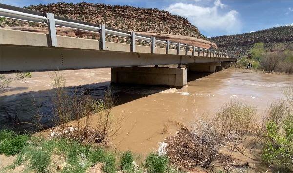
If the river reaches expected levels, CDOT plans to close the highway at 5 p.m. Friday, with the highway remaining closed until the flood danger has subsided. According to a CDOT news release, the closure is dependent on various factors, including snowmelt and reservoir releases. As flow amounts fluctuate, the bridge over Roc Creek may require additional closures
“River flows in the area have not been observed at these levels in 18 years. With the flood event expected to peak this Friday, we are taking proactive and cautionary measures at this particular bridge. Engineers and maintenance personnel will be assessing the structural integrity throughout this high-flow event,” Regional Transportation Director Julie Constan said in the news release.
For safety, CDOT has determined that the bridge structure at Roc Creek should be closed to traffic while peak water flows are occurring. The structure is located approximately 27.5 miles north of Naturita at mile point 88.5. The northbound closure point is located north of Naturita and the County Road CC junction at mile point 64. The southbound closure point is just south of Gateway, at mile point 110.
CDOT hydraulics engineers are closely watching forecasts, as well as tracking the anticipated releases from McPhee Reservoir in Montezuma County, CDOT spokeswoman Lisa Schwantes said.
“It’s going to be a combination of those things that really have an effect on how high the water flow is,” she said. With respect to whether CDOT in fact closes 141: “We’re leaning toward the side of caution.”
The National Weather Service (NWS) has issued a flood advisory for the Dolores River due to the increased release of water from McPhee Reservoir. The flood advisory also includes the Dolores and San Miguel Rivers due to heavy runoff from snowmelt. The flood advisory is in place until further notice and covers Montrose County, as well as the counties of Montezuma, Dolores and San Miguel.
CDOT is less concerned that water will overflow the top of the bridge — projections have the river hitting about 2 to 4 feet below. Rather, the concern is how the bridge structure might respond to a high flow at a rate not seen in close to 20 years, Schwantes said. There is some concern about the bridge piers, as well as large debris that could wash down and lodge beneath it.
“We’re confident of the integrity of the bridge, but we don’t want anyone driving over it when those high peak flows are occurring,” she said.
The northbound closure point is located north of Naturita and the County Road CC junction at mile point 64. The southbound closure point is just south of Gateway, at mile point 110.

The National Weather Service (NWS) has issued a flood advisory for the Dolores River due to the increased release of water from McPhee Reservoir. The flood advisory also includes the Dolores and San Miguel Rivers due to heavy runoff from snowmelt. The flood advisory is in place until further notice and covers Montrose County, as well as the counties of Montezuma, Dolores and San Miguel.