Reclamation awards $4 million for new and innovative #water treatment technologies #PFAS

Salt mine at Sambhar Lake in daytime. Sambhar, Rajasthan, India. Photo credit: Life Brine Mining https://brinemining.eu/en/what-is-life-brine-mining/

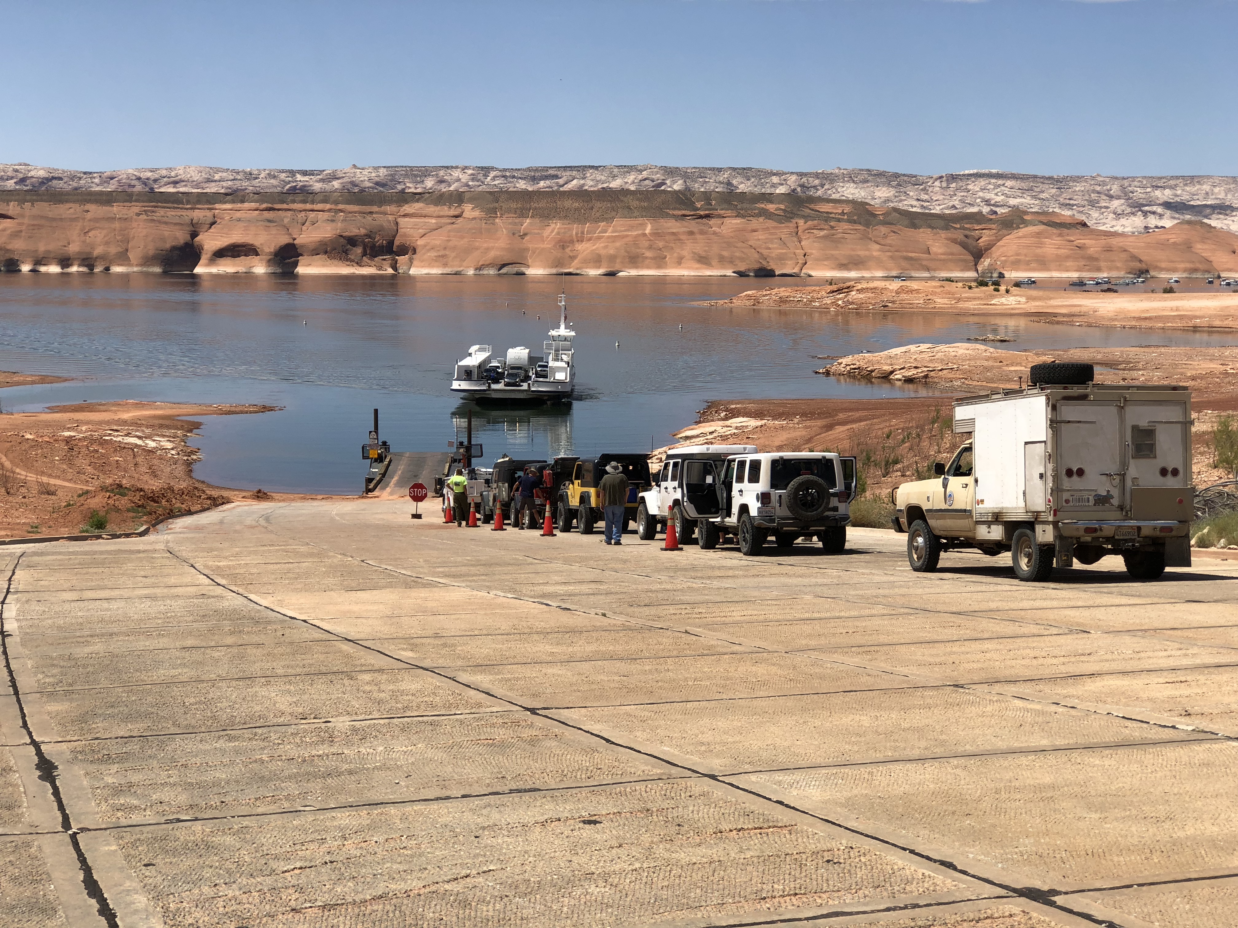
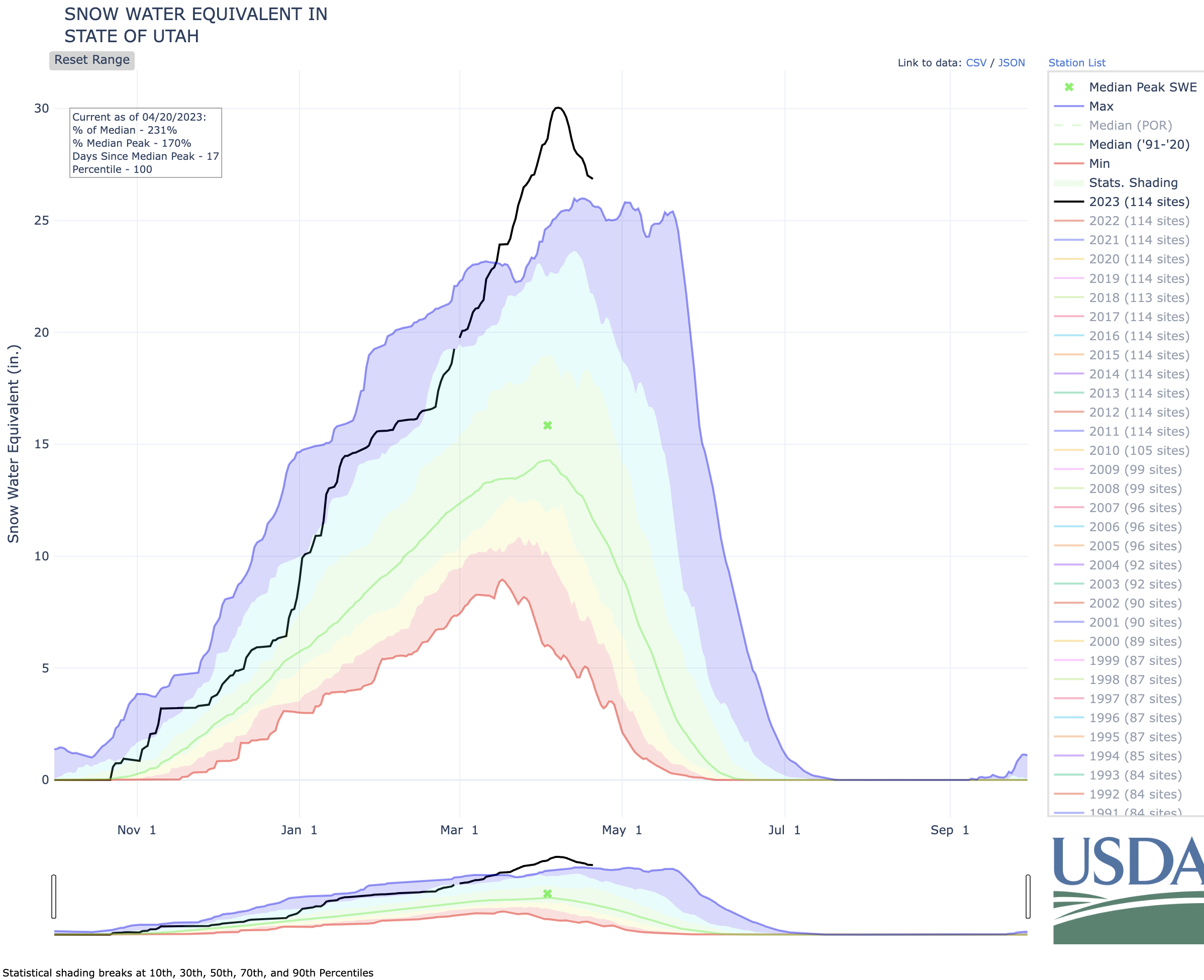
Click the link to read the release on the Reclamation website (Chelsea Kennedy):

The Bureau of Reclamation awarded funding for 15 projects under the Desalination and Water Purification Research program. The research projects are innovative solutions that seek to reduce water treatment costs and improve performance.  

“Developing new technologies that can treat currently unusable water will help communities worldwide,” said Research and Development Program Manager Ken Nowak. “These technologies have the potential to increase water supply flexibility under the risks of climate change and drought.” 

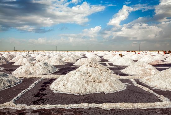
The Desalination and Water Purification Research Program provides financial assistance for advanced water treatment research and development, leading to improved technologies for developing water supply from non-traditional waters, including seawater, brackish groundwater, and municipal wastewater, among others.โ€ฏ 

In addition to the $4 million in federal funding provided for selected projects, recipients have committed an additional $3 million of non-federal cost share to further support these research efforts.  

Alabama 

  • University of Alabama ($249,966 federal funding, $499,932 total project cost) : Engineering Sustainable Solvents for Brine Desalination. This project seeks to improve solvent performance in temperature swing solvent extraction for brine desalination through experimental and computational techniques.  

Californiaโ€ฏ 

  • Pacifica Water Solutions, LLC ($350,000 federal funding, $700,000 total project cost): Field Pilot Testing Electrically Conducting Nanofiltration and Reverse Osmosis Membranes. This project will field test innovative anti-scaling and antifouling electrically conducting desalination membranes against commercial membranes for reverse osmosis concentrate minimization and produced water applications.  
  • University of California, Riverside ($250,000 federal funding, $390,754 total project cost): Development of a Novel Vacuum-ultraviolet Photochemical System for Treatment of Nitrate and Per Fluorinated Substances from Inland Desalination Brine. This project will test a novel laboratory-scale vacuum ultraviolet light-driven photochemical process for treatment of nitrate and perfluoroalkyl substances (PFASs) from inland desalination brine. 

Colorado  

  • University of Colorado ($592,703 federal funding, $756,246 total project cost): Concentrate Minimization: Pilot Testing of Improved Static Mixer Crystallizers. This project will perform pilot scale testing and evaluation of improved in-line, static mixer elements to accelerate the desupersaturation of reverse osmosis desalination brine. 
  • University of Colorado ($250,000 federal funding, $396,501 total project cost): Robust Surface Patterned Membranes for Membrane Distillation of High Salinity Brine with High Efficiency. This project aims to develop and test scalable, robust, surface-patterned microporous membranes that are designed for a membrane distillation process treating highly concentrated brines. 
  • Mickley & Associates LLC ($111,500 federal funding, $234,150 total project cost): Brine Mining. The project will gather, analyze, and synthesize information from the literature, websites, and interviews to bring clarity to many issues involving brine mining, such as potential benefits, feasibility, applicable technologies, recoverable compounds, and more. 

Indiana  

  • Purdue University ($250,000 federal funding, $465,799 total project cost): Batch Counterflow Reverse Osmosis. This project will develop lab-scale demonstration of batch counterflow reverse osmosis to achieve high recovery and efficiency and develop a fundamental understanding of fouling kinetics for the process. 

Massachusetts 

  • Tufts University ($249,994 federal funding, $407,733 total project cost): New Fouling-Resistant, Anti-Microbial Membranes for Pretreatment. This project aims to develop and demonstrate ultrafiltration pretreatment membranes that resist organic fouling and biofouling through dual mechanisms, manufactured through a novel scalable manufacturing process. 

Minnesota 

  • University of Minnesota ($249,853 federal funding, $249,853 total project cost): Crystallization Kinetics: Toward the Useful Separation of Salts in Enhanced Evaporation Systems. This project seeks to leverage the research teamโ€™s detailed understanding of the spatial and temporal temperature variation and brine evaporation behavior in enhanced evaporation systems to intentionally, and selectively, precipitate salt in distinct locations for collection and reuse. 

New Mexico 

  • New Mexico Institute of Mining and Technology ($249,896 federal funding, $499,792 total project cost): Advanced Hybrid Membrane Process for Simultaneous Recovery of Clean Water and Lithium from High Salinity Brines. This project seeks to develop an innovative hybrid membrane process for simultaneous recovery of clean water and lithium from high-salinity brines. 

Pennsylvania  

  • Temple University ($250,000 federal funding, $500,972 total project cost): Synergistic Integration of Electroactive Forward Osmosis and Microbial Desalination Cells for Energy-Neutral Desalination. The goal of this project is to develop an energy-neutral seawater desalination system by integrating electroactive forward osmosis and microbial desalination cells. 

Tennessee  

  • Vanderbilt University ($250,000 federal funding, $518,463 total project cost): Selective Removal and Degradation of PFAS via Cyclic Adsorption-electrooxidation on Conductive Functionalized Cu-MOF-aminated-GO. This project aims to develop a fundamentally new approach to selectively remove PFAS from water using a metal organic framework and degrade it to ensure complete removal. 

Texas  

  • William Marsh Rice University ($250,000 federal funding, $332,842 total project cost): Ion Exchange Membranes with Tunable Monovalent Ion Permselectivity to Maximize Water Recovery in Desalination. This project seeks to improve the performance of electrodialysis technologies by developing ion exchange membranes with tunable ion permeability and permselectivity for desalination applications. 
  • Freese and Nichols, Inc. ($231,710 federal funding, $539,945 total project cost): Strategies for Gaining Pathogen Removal Credit for Reverse Osmosis in Potable Reuse in Texas (and Beyond). This project will facilitate the identification and evaluation of strategies for gaining pathogen removal credit for reverse osmosis in potable reuse applications in Texas and beyond. 

Virginia  

  • George Mason University ($250,000 federal funding, $500,203 total project cost): Engineering Spatial Wood Carbon Scaffolds with Nanocellulose Fillers for Water Deionization. This project seeks to create an innovative and energy-efficient capacitive deionization process with the help of biomass-based advanced porous structures for water desalination and purification. 

For more information on Reclamation’s Desalination and Water Purification Research Program visit www.usbr.gov/research/dwpr

The Topsoil Percent Short to Very Short shows driest conditions in the Central and Southern Plains and increasing dryness in parts of the Eastern US — @DroughtDenise

The Subsoil Percent S/VS map shows conditions drying most along parts of the East Coast. https://agindrought.unl.edu/Other.aspx

The percent of winter wheat in poor to very poor conditions is highest in the Central and South Plains and increased by 2 to 10 percentage points in those states — @DroughtDenise

Nationally, 41% of the winter #wheat is P/VP, up 2% from last week. https://agindrought.unl.edu/Other.aspx

The #PuebloWest Metro District Board narrowly approves new #water, sewer fees in 3-2 vote — The #Pueblo Chieftain

Pueblo West. By Jeffrey Beall – Own work, CC BY 4.0, https://commons.wikimedia.org/w/index.php?curid=61051069

Click the link to read the article on The Pueblo Chieftain website (Tracy Harmon). Here’s an excerpt:

The board voted 3-2 to pass a resolution setting new water rates. Members Joe Mahaney and Nick Madero voted against the resolution. The raise in rates includes a 94-cent monthlyย fee for residential water users and a $3.17 monthly fee for residential sewer customers. The fees are described as โ€œreadiness to serveโ€ fees, which represent the fixed costs the utilities providers experience getting the services to customers, said Jim Blasing, utilities director for the district.ย  The rates will go into effect in May…New residential customers will see an increase in the residential water resource fee and tap fee, totaling a little more than $1,000. Those increases are designed to have new residents help pay for the growth of the system…

Board member Jami Baker Orr said the district has “among the lowest paid district employees” and has been trying to bring those wages up. She also said that the rates are “based on the advice of a water expertโ€ and noted that the district’s facilities are getting older and will need to be upgraded in the near future.

Supreme Court Rejects Big Oil’s Bid to Review Landmark #Climate Case — City of #Boulder #ActOnClimate

Denver, Colorado, USA – January 12, 2013: The Suncor Energy refinery in Denver, Colorado. Based in Calgary, Alberta, Suncor Energy is a Canadian oil and gas company with revenues of over 35 Billion Canadian Dollars. Photo credit: City of Boulder

Click the link to read the bulletin on the City of Boulder website (Christian Herrmann, Emily Sandoval, and Kate Fried):

Boulder County’s case to proceed in local court; stage set for similar cases across US

The United States Supreme Court delivered a critical victory to those suffering the harms of the climate crisis. The Court rejected ExxonMobil and Suncorโ€™s petition for certiorari seeking to force three Colorado communities โ€” who sued the companies for their role in the climate crisis and the local impacts the communities suffer โ€” into federal court. The result of the Supreme Courtโ€™s denial is that the cases brought by Boulder County, San Miguel County, and the City of Boulder will proceed in Colorado state court.

In June 2022, after the U.S. Court of Appeals for the Tenth Circuit decided that the case belonged in state court, the companies sought Supreme Court review on two questions โ€“ whether federal common law actually governed the municipalitiesโ€™ state law tort claims and whether federal courts thus have jurisdiction over the case. With the Supreme Court rejecting their petition, Exxon and Suncor can no longer forestall Colorado state courtsโ€™ consideration of the case. The cases will now proceed in the Colorado court system.

The Supreme Court also rejected petitions in four similar climate cases where the fossil fuel companies pressed the same arguments for federal jurisdiction. More than two dozen similar cases were filed in state courts across the country. Other high-profile climate litigation cases include those in Rhode Island, Baltimore, Hawaiโ€™i, and several California municipalities.

EarthRights General Counsel Marco Simons issued the following statement:

โ€œSince the Colorado communities filed this case in 2018, ExxonMobil and Suncor have consistently sought to delay the litigationโ€”moving the case from court to court and losing each step along the way. Todayโ€™s development brings these communities one step closer to holding fossil fuel companies accountable for their misconduct and obtaining remedies for the serious climate harms Colorado residents face.

โ€œEvery court that has reviewed this case has come to the same conclusionโ€“that it should be heard in a local court, by a local jury. The Supreme Courtโ€™s decision today confirms that. This case is not about changing national climate policy โ€” itโ€™s about accountability for the climate harms in Colorado that companies like Exxon and Suncor are responsible for.โ€

Boulder County Commissioner Ashley Stolzmann issued the following statement:

โ€œBoulder County is thrilled by the U.S. Supreme Courtโ€™s decision not to take up this case. Our lawsuit against Exxon and Suncor should be determined in Colorado state court โ€“ where the actions of these companies are negatively impacting our residents. Communities like ours are exposed to destructive climate change impacts caused by the actions of fossil fuel companies while they reap record profits. These companies need to pay their fair share to deal with the climate chaos theyโ€™ve created and take responsibility for the climate impacts. Local governments cannot shoulder the price tag of climate change alone.โ€

The City of Boulder issued the following statements:

โ€œToday, the court affirmed what we know to be true โ€“ our case deserves its day in local court, where our communities experience the impacts and costs of climate change,” said Boulder Mayor Aaron Brockett. “Oil companies are making record profits while our planet continues to warm. Itโ€™s only fair that the companies that profit from irresponsible actions compensate communities for the harm they cause.โ€

โ€œThereโ€™s no doubt that climate change is very costly for local government. Taxpayer dollars are stretched to support key services, and the costs to prepare for and recover from climate disasters are too much for communities alone to bear,” said Boulder City Manager Nuria Rivera-Vandermyde. “Todayโ€™s decision is a step toward justice. Colorado communities will have the chance to hold oil companies responsible for the hundreds in millions in damages their actions cause.โ€

San Miguel County Commissioner Hilary Cooper issued the following statement:

โ€œThis is excellent news for San Miguel County. Itโ€™s only fair that our lawsuit against Suncor and Exxon be heard not before the U.S. Supreme Court but in Colorado, closer to the communities where the impacts of climate change are most acutely felt. Enough with the delays. Itโ€™s time for fossil fuel companies to help local governments with the costs of addressing climate change in the name of protecting the health and well-being of our residents.โ€

Background:

In 2018, Boulder County, San Miguel County, and the City of Boulderโ€”with legal support from EarthRights International, the Hannon Law Firm, and the Niskanen Centerโ€”filed a lawsuit against Exxon and Suncor for their decades of misinformation and other contributions to the climate crisis. The communities, which are already experiencing significant climate change impacts, demanded that these companies pay their fair share of the costs associated with these impacts so that the costs do not fall disproportionately on taxpayers.

Shortly after the communities filed their case in Colorado state court, defendant fossil fuel companies sought to remove the case to federal court. Both the federal district court and Tenth Circuit Court of Appeals agreed that the case should proceed, as filed, in state court. However, the Tenth Circuit needed to revisit this jurisdictional issue after the Supreme Courtโ€™s 2021 decision in BP v. Baltimore.

In February 2022, the Tenth Circuit ruled that the Colorado climate case should indeed proceed in state, not federal, court. Defendants ExxonMobil and Suncor then filed a petition for a writ of certiorari, asking the Supreme Court to hear the case and answer two narrow questions related to federal removal jurisdiction. The Supreme Courtโ€™s initial reaction was to ask the U.S. Government for its views; in March 2023, the Solicitor General submitted a brief agreeing with the Colorado communities that the Supreme Court should not hear the case and that it should proceed in state court.

Representation of the Colorado communities at the Supreme Court has been led by Kevin Russell of Goldstein, Russell & Woofter LLC.

Celebrate! A spring high flow experiment in #GrandCanyon — @AmericanRivers #COriver

Rafts in the Grand Canyon | Photo Amy S. Martin

Click the link to read the article on the American Rivers website (Sinjin Eberle):

Last week, the Bureau of Reclamation, the federal government agency that oversees and manages operations on the Colorado River, announced the authorization of a spring High Flow Experiment (HFE) in the Grand Canyon. This is a big deal since the last time an HFE was conducted was in the fall of 2018, and the last time a spring HFE was executed was in 2008. And with the COLORADO RIVER IN THE GRAND CANYON NAMED AS AMERICAโ€™S MOST ENDANGERED RIVERยฎ just last week, we are thrilled that this action is happening to benefit the ecosystem in the canyon.

WHAT IS AN HFE?

A High Flow Experiment is in essence a simulated flood being conducted through Glen Canyon dam. In practice, the dam releases a high volume of water, usually through both the hydropower turbines and the bypass tubes, which are lower-elevation tubes through the dam that are usually only used for these short duration floods or in other unique situations (like releasing water during the extreme inflows of 1983) over a limited period of time. HFEโ€™s are extremely important to the management of sand in the canyon and the healthy functioning of the Grand Canyon riparian ecosystem overall.

To set the stage even further, letโ€™s go back to the time before the creation of Glen Canyon Dam. The Colorado River traditionally carried millions and millions of tons of sediment down the river each year. Since Glen Canyon was built, most of that sand has been trapped in the upper reaches of Lake Powell โ€“ as flows slow down as the river becomes the lake, the sediment drops out and settles (up near Hite and Halls Crossing and then the San Juan as it enters the lake as well.) The result is that the water coming through Glen Canyon dam is very clear, lacking the traditional sediment that would be carried by the river and maintaining beaches and sandbars and the natural ecological benefits of that silty, sediment-laden water throughout the canyon. This clear water erodes sand from beaches and sandbars, and for decades in the 1970โ€™s and 1980โ€™s was causing real problems with the canyonโ€™s ecology. In the 1990โ€™s and early 2000โ€™s, some experiments were conducted to begin to learn how these floods might act and how they might contribute to sand and other ecological functions within the canyon. Then, in 2016, the Long Term Experimental and Management Plan (LTEMP) was completed and set the guidelines for how and how frequently future HFEโ€™s could be conducted.

Now, the Paria River, which is about 17 miles downstream from Glen Canyon dam (and about a mile below the put-in at Leeโ€™s Ferry) is the main source of sediment into the Grand Canyon. When the Paria River flashes (most commonly during the summer monsoon season) it can deposit tons of sand โ€“ sometimes more than a million tons of sand โ€“ in a summer. This sand is what can be pushed downstream in an HFE to rebuild beaches and sandbars, and aid in the protection of cultural resources throughout the length of the canyon.

The author preparing to measure the volume of sand at this Grand Canyon beach using geodetic survey techniques | Photo by Katie Chapman

One of the elements within these LTEMP guidelines is how and when these HFEโ€™s may be conducted, and how often the program should try to make them happen. Sadly, they have not happened often enough, and the canyon is really suffering because of it. Since the last HFE in 2018, there have been complications with declining water levels across the basin but felt most acutely in Lake Powell as elevations have declined to record lows. Then in 2021 and 2022, the monsoons delivered abundant sand through the Paria into the Colorado River, but unfortunately also caused a lot of erosion of beaches downstream as these monsoon storms ripped across Grand Canyon and the Colorado Plateau.

Today, we are celebrating the decision by the Bureau of Reclamation to use this opportunity to trigger one of these HFEโ€™s to move the volume of sand currently sitting near the mouth of the Paria to rebuild beaches and sandbars, repair the ecology, and aid the protection of cultural resources downstream.

Glen Canyon Dam | Photo courtesy of National Park Service

Reclamation was able to make this decision based on several factors. First, due to the drought operations conducted over the past two years, there is a good amount of water parked in Lake Powell to protect the hydropower infrastructure at Glen Canyon dam that had to be moved downstream sometime this year. Second, the sand is there and the damage to the beaches in the canyon is glaring. Third, the water sitting in Lake Powell right near the dam (in an area above the dam called the โ€œforebayโ€) is quite cold, which could aid aquatic species downstream. And lastly, there is a window of time where Reclamation and the hydropower providers can shift the timing of some needed maintenance at the dam to free up the opportunity to have all 8 hydropower penstocks and some of the bypass tubes available to actually conduct the high flows through the dam.

This weekโ€™s HFE will be pretty dramatic, both visually and scientifically. The flow will begin early Monday morning (April 24, 2023) and last into Thursday evening (April 27, 2023.) The dam will ramp up releases to 39,500 cubic feet per second (CFS) and hold that for 72 hours straight creating a flood that will flow all the way to Lake Mead over a period of about a week, rebuilding sandbars and beaches along the way (and giving rafters in the canyon an exciting ride!) One additional key point to understand is that HFEโ€™s consume no net loss of water in Lake Powell โ€“ after the HFE occurs, Glen Canyon dam will release slightly less water than normal over a period of weeks, in order to make up that amount of water that is shot downstream, yet another benefit in the design in these critically important High Flow Experiments.

High Flow Experiment Pattern

Again, we applaud the Bureau of Reclamation, the scientists at USGSโ€™ Grand Canyon Monitoring and Research Center, and everyone else who has been working hard to make one of these HFEโ€™s happen for years. We are looking forward to seeing the great results that will come out of this event very soon.

(To learn more about the Grand Canyonโ€™s history and ecosystem, check out our new STORY MAP, CAUGHT IN THE MIDDLE โ€“ we think you will love it!)

Feds start 3-day flood experiment of the #GrandCanyon to improve #ColoradoRiver conditions in the canyon — AZCentral.com #COriver

Glen Canyon Dam during high flow experimental release about a decade ago. These occasional releases are just about the only time the river outlet works (where water is gushing out above) operate. Photo credit: Jonathan P. Thompson/The Land Desk

Click the link to read the article on the AZCentral.com website (Shaun McKinnon). Click through for video and a photo gallery. Here’s an excerpt:

The Bureau of Reclamation opened the bypass tubes at Glen Canyon Dam early Monday and began three days of high water flows from Lake Powell to help improve environmental conditions on the Colorado River through the Grand Canyon. It’s the first such high-flow experiment at the dam since 2018 and the first during spring runoff season. The goal is to move accumulated sediment downstream and begin to rebuild beaches on the river that have eroded in recent years. The engineered flood mimics some of the river’s pre-dam flows, when snowmelt runoff from the mountains far upstream would raise water levels and redistribute sediment. Since Glen Canyon Dam’s completion in 1963, the water flowing into the Grand Canyon has carried less sediment, much of the river’s sand and other materials trapped behind the dam.

Releasing more water from Lake Powell won’t change the total amount of water that flows through the system this year, bureau officials said. The water will arrive at Lake Mead earlier than it would have otherwise and remain there until it’s needed downstream. Dam operators began raising water flows early Monday, first through the power plant turbines and then through bypass tubes on the side of the dam. By mid-morning, water gushed from the tubes into the river at the dam’s base, the start of a journey downstream through the Grand Canyon toward Lake Mead. The amount of water released will fluctuate over the three days, but the bureau said the high flows will peak at about 39,500 cubic feet per second, or as much as quadruple the average output from the dam. The water releases will return to normal operations by Thursday.

Why average #snowpack in #Colorado is something to celebrate this year — CBS Colorado #runoff

Click the link to read the article on the CBS Colorado website (Spencer Wilson). Here’s an excerpt:

Let’s get to the good news: Colorado got snow this year, and it’s going to help fill up our reservoirs, some of them almost to average! Yes, that doesn’t sound great, but considering our last few years, the average is something to celebrate.ย Travis Thompson, Denver Water spokesperson, pointed to the snowpack just starting to melt into the Colorado River Basin, where he said Denver gets about half its water.ย  If these next rounds of storms coming through are able to drop off some moisture, our pack levels will likely hit 100% normal and we’d be in good shape, for this year at least.,,

…in Colorado, it’s more spread out, some parts got hammered, like the San Juan Mountain Range, and some parts of Colorado got what they usually got, or even less in some spots. To look at an overall state average would to be instilling a false sense of confidence, Thompson said.

Elkhead Reservoir expected to top spillway again this year similar to 2011: Streambank erosion expected in lower #ElkheadCreek — Steamboat Pilot & Today #runoff

The Colorado River Water Conservation District predicts Elkhead Reservoir will overtop its spillway in mid-May with water exiting the spillway and outflow at a combined rate of about 2,000 cubic feet per second, or about the same level of peak water as in 2011, shown here on June 14, 2011. Stream bank damage is expected downstream in Elkhead Creek in May. Photo credit: Colorado River Water Conservation District

Click the link to read the article on the Steamboat Pilot & Today website (Suzie Romig). Here’s an excerpt:

Last year, Elkhead Reservoir operators carefully managed the reservoir that straddles the Routt and Moffat countyline due to low water issues, but this year reservoir managers are facing challenges due to high water from abundant snowmelt in the Yampa Valley. Managers predict Elkhead Reservoir will top its spillway in mid-May with water exiting the spillway and outflow at a combined rate of about 2,000 cubic feet per second, or cfs, or about the same level of peak water as in wet 2011, said Don Meyer, senior water resources engineer with the Colorado River Water Conservation District based in Glenwood Springs.

โ€œThe current outflow is about 550 cfs with valves 100% open,โ€ Meyer said. โ€œWhen (the reservoir is) full, the release will be 590 cfs. When spilling, we will likely keep the outlet discharge at 590 cfs, and the rest will go over the spillway.โ€

Meyer, who has managed Elkhead Reservoir releases since 2007, said high water flows in 2011 recorded 1,800 cfs on May 8 and more than 2,000 cfs on May 16, May 24 and June 4. He expects 2023 spillage will follow a similar path…

The watershed upstream of Elkhead Reservoir drains a 205-square-mile basin, according to the river district that owns or controls water supplies that are available for contract to agricultural, municipal, industrial and other water users.

Yampa River Basin via Wikimedia.

Southern and northern lights sweep planet in stunning display of auroras — The Washington Post #aurora

Click the link to read the article on The Washington Post website (Matthew Cappucciย andย Kasha Patel). Click through for the video, photos, and Twitter stream. Here’s an excerpt:

A โ€˜severeโ€™ solar storm triggered the outburst of auroras. Even California, Arizona, Arkansas and Virginia reported sightings.

Skywatchers in Europe, Asia and North America were treated Sunday night to perhaps one of the most widespread displays of the northern lights since the autumn solar storms of 2003. Equally impressive shows of the aurora australis, or southern lights, were spotted in Australia and New Zealand.

The northern and southern lights, collectively known as the aurora, are most common in the high Arctic and Antarctic regions around the poles, but they can venture to the middle latitudes on rare occasions during potent geomagnetic storms. The storms are caused by magnetic energy and electrons that are hurled into space by the sun. The stronger the solar storm, the greater the effect โ€” particularly if the resulting outburst is directed toward Earth. Forecasters at the Space Weather Prediction Center in Boulder, Colo., issued warnings for a Level 4 out of 5 โ€œsevereโ€ geomagnetic storm, which happens on average only 60 times every 11 years. The episode may have been even more intense at times, sparking auroral displays as far south as California, Arizona, Arkansas and Virginia…

On Friday afternoon, NASAโ€™s Solar Dynamics Observatory satellite recorded an explosion on the surface of the sun. The flare, rated an M2 on an ascending scale that climbs A, B, C, M to X, caused a radio burst on Earth eight minutes later. That clued NOAA forecasters into the fact that the energy was directed toward Earth…The flare was followed by a coronal mass ejection (CME) โ€” a mass of solar plasma, charged particles and magnetism โ€” that headed directly toward Earth at speeds of roughly 1.5 million miles per hour. That interplanetary shock wave collided with Earthโ€™s magnetic field on Sunday afternoon Eastern time, which was after dark in Europe and in the early hours of Monday in China. Brilliant apparitions of the northern lights quickly appeared. The CME brought โ€œsevereโ€ geomagnetic storming, stronger than what the Space Weather Prediction Center forecast when the CME left the sun Friday…

The colors of an aurora correspond to the type and altitude of the element that is excited in Earthโ€™s atmosphere, Murtagh explained. Excited oxygen atoms glow red above 120 miles and glow green between 60 and 120 miles. Excited nitrogen atoms below 120 miles can glow pink or purple. Murtagh said a more intense aurora is typically higher, so lower latitudes will see more red.

โ€œThe bigger storms can light up the higher altitudes, which is largely going to [excite] the oxygen causing that red,โ€ he said. โ€œThe further you are away, down south that is, youโ€™re going to not see the green and yellow in the lower altitudes.โ€

How do you tackle microplastics? Start with your washing machine: Simple filters could help remove microfiber pollution from your laundry. But experts say a broader portfolio of solutions is needed to address the problem — Grist

Credit: EPA

Click the link to read the article on the Grist website (Saqib Rahim):

As environmental challenges go, microfiber pollution has come from practically out of nowhere. It was only a decade or so ago that scientists first suspected our clothing, increasingly made of synthetic materials like polyester and nylon, might be major contributors to the global plastic problem.

Today a growing body of science suggests the tiny strands that slough off clothes are everywhere and in everything. By one estimate, they account for as much as one-third of all microplastics released to the ocean. Theyโ€™ve been found on Mount Everest and in the Mariana Trench, along with tap water, plankton, shrimp guts, and our poo.

Research has yet to establish just what this means for human and planetary health. But the emerging science has left some governments, particularly in the Global North, scrambling to respond. Their first target: the humble washing machine, which environmentalists say represents a major way microfiber pollution reaches the environment.

Late last month a California State Assembly committee held a hearing on Assembly Bill 1628, which would require new washing machines to include devices that trap particles down to 100 micrometers โ€” roughly the width of human hair โ€” by 2029. The Golden State isnโ€™t alone here, or even first. France already approved such a requirement, effective 2025. Lawmakers in Oregon and Ontario, Canada have considered similar bills. The European Commission says itโ€™ll do the same in 2025.

Environmental groups, earth scientists and some outdoor apparel companies cheer the policies as an important first response to a massive problem. But quietly, some sustainability experts feel perplexed by all the focus on washers. They doubt filters will achieve much, and say whatโ€™s really needed is a comprehensive shift in how we makeclean and dispose of clothes.

The wash is โ€œonly one shedding point in the lifecycle of the garment. To focus on that tiny, tiny moment of laundry is completely nuts,โ€ said Richard Blackburn, a professor of sustainable materials at the University of Leeds. โ€œIt would be much better to focus on the whole life cycle of the garment, of which the manufacturing stage is much more significant in terms of loss than laundering, but all points should be considered.โ€

Today, some 60 percent of all textiles incorporate synthetic material. Anyone whoโ€™s worn yoga pants, workout gear or stretchy jeans knows the benefits: These materials add softness, wicking and flexibility. Under a microscope, though, they look a lot like plain old plastic. From the moment theyโ€™re made, synthetic clothes โ€” like all clothes โ€” release tiny shreds of themselves. Once liberated these fibers are no easier to retrieve than glitter tossed into the wind. But their size, shape, and tendency to absorb chemicals leaves scientists concerned about their impacts on habitats and the food chain.

Anja Brandon is an associate director for U.S. plastics policy at the Ocean Conservancy who has supported the California and Oregon bills. She concedes that filters wonโ€™t fix the problem, but believes they offer a way to get started. She also supports clothing innovations but said they could be years away. โ€œI for one donโ€™t want to wait until itโ€™s a five-alarm fire,โ€ she said.

Studies suggest a typical load of laundry can release thousands or even millions of fibers. Commercially available filters, like the PlanetCare, Lint LUV-R and Filtrol, strain the gray water through ultra-fine mesh before flushing it into the world. Itโ€™s the ownerโ€™s job, of course, to periodically empty that filter โ€” ideally into a trash bag, which Brandon said will secure microfibers better than the status quo of letting them loose into nature.

Washing machine manufacturers in the U.S. and Europe have pushed back, saying the devices pose technical risks, like flooding and increased energy consumption, that must be addressed  first. University experiments with these filters, including an oft-cited 2019 study by the University of Toronto and the Ocean Conservancy, havenโ€™t found these issues, but itโ€™s not a closed case yet: Last year a federal report on microfibers, led by the Environmental Protection Agency and National Oceanic and Atmospheric Administration, called for more research in this vein.

Manufacturers also argue that microfibers originate in a lot of places, but washers are a relatively modest one. As self-serving as that sounds, people who study the issue agree thereโ€™s a huge hole in the available science: While we know clothes shed microfibers throughout their lives, we know surprisingly little about when most of it happens.

Some evidence suggests that the friction of simply wearing clothes might release about as many microfibers as washing them. Then there are dryers, which some suspect are a major source of microfiber litter but have been barely studied, according to the federal report. There is also limited knowledge about how much microfiber pollution comes from the developing world, where most people wash by hand. (A recent study led by Hangzhou Dianzi University in Hangzhou, China pointed to this knowledge gap โ€“ and found that hand-washing two synthetic fabrics released on average 80 to 90 percent fewer microfiber pollution than machine-washing.)

To Blackburn, itโ€™s obvious that most releases occur in textile mills, where itโ€™s been known for centuries that spinning, weaving, dyeing and finishing fabric spritzes lots of fiber. โ€œWhere do you think it goes when we get it out of the factory?โ€ he said. โ€œIt goes into the open air.โ€

He calls filter policies โ€œtotally reactionary,โ€ arguing that they would at best shave a few percentage points off the total microfiber problem. But there is one area where Blackburn is in broad agreement with environmentalists: In the long run, tackling the issue will take a lot of new technology. No silver-bullet solution has appeared yet, but a slew of recent announcements reveals a vibrant scene of research and development attacking the problem from many angles.

Some best practices already are known within the industry. For example, more tightly woven clothes, and clothes made of long fibers rather than short ones, fray less. But for years, popular brands like Patagonia and REI have said what they really need is a way to experiment with many different materials and compare their shedding head to head. This has been tricky: Microfibers are, well, micro, and thereโ€™s no industry standard on how to measure them.

That might be changing. In separate announcements in February, Hohenstein, a company that develops international standards for textiles, and activewear brand Under Armour revealed new methods in this vein. Under Armour is targeting 75 percent โ€œlow-shedโ€ fabrics in its products by 2030.

These approaches would at best reduce microfiber emissions, not eliminate them. So another field of research is what Blackburn calls โ€œbiocompatibilityโ€: making microfibers less harmful to nature. California-based companyIntrinsic Advanced Materials sells a pre-treatment, added to fabrics during manufacturing, that it claims helps polyester and nylon biodegrade in seawater within years rather than decades. Blackburnโ€™s own startup, Keracol, develops natural dyes, pulled from things like fruit waste, that break down more easily in nature than synthetic ones.

New ideas to dispose of clothes are also emerging, though some will cause arched eyebrows among environmentalists. This year U.S. chemical giant Eastman will start building a facility in Normandy, France that it claims โ€œunzipsโ€ hard-to-recycle plastics, like polyester clothes, into molecular precursors that can be fashioned into new products like clothes and insulation. Critics charge that such โ€œchemical recyclingโ€ techniques are not only of dubious benefit to the environment, theyโ€™re really just a smokescreen for fossil-fuel corporations trying to keep their product in demand.

Lest anyone forget about washing machines, thereโ€™s R&D going after them, too. In January Patagonia and appliance giant Samsung announced a model that they claim cuts micro plastic emissions up to 54%. Itโ€™s already rolled out in Europe and Korea. At around the same time, University of Toronto researchers published research on a coating that, they claim, makes nylon fabric more slippery in the wash, reducing friction and thus microfiber emissions by 90 percent after nine washes. In a press release the researchers tut-tutted governments for their focus on washing-machine filters, which they called a โ€œBand-Aidโ€ for the issue.

One continuous thread through all these efforts, of course, is that everyone is working with imperfect information. The emerging science on microfibers โ€“ and microplastics in general โ€“ suggests theyโ€™re a gritty fact of modern life, but doesnโ€™t yet show the magnitude of their harm to humans and other species. For the moment environmentalists, policymakers and manufacturers arenโ€™t just debating whether to put filters on washing machines, but whether we know enough to act. In 20 years, when scientists know a lot more, itโ€™ll be easier to judge whether todayโ€™s policies represented proactive leadership on an emerging environmental problem โ€” or a soggy Band-Aid.

Using solar farms to generate fresh desert soil crust: Arizona State University researchers discover new way to replace biocrusts damaged by human activities

Biological soil crust in Natural Bridges National Monument near Sipapu Bridge. By Nihonjoe – Own work, CC BY-SA 3.0, https://commons.wikimedia.org/w/index.php?curid=14671018

Click the link to read the release on the Arizona State University website (Richard Harth):

In the arid regions of the American Southwest, an unseen world lies beneath our feet. Biocrusts, or biological soil crusts, are communities of living organisms. These industrious microbes include cyanobacteria, green algae, fungi, lichens and mosses, forming a thin layer on the surface of soils in arid and semiarid ecosystems.

Biocrusts play a crucial role in maintaining soil health and ecosystem sustainability, but they are currently under assault. Human activities including agriculture, urbanization and off-road vehicle use can lead to the degradation of biocrusts, having long-term consequences for these fragile environments. Climate change is also placing stress on biocrusts, which struggle to adapt to sunlight and searing heat in arid landscapes like the Sonoran Desert.

In a proof-of-concept study, ASU researchers adapted a suburban solar farm in the lower Sonoran Desert as an experimental breeding ground for biocrust. During the three-year study, photovoltaic panels promoted biocrust formation, doubling biocrust biomass and tripling biocrust cover compared with open areas with similar soil characteristics. Graphic by Shireen Dooling

To help with this issue, Arizona State University researcher Ferran Garcia-Pichel and his students have proposed an innovative approach to restoring healthy biocrusts. The idea is to use new and existing solar energy farms as nurseries for generating fresh biocrust.

Safely shielded from the sun beneath arrays of solar panels, like beachgoers under an umbrella, the biocrusts are sheltered from excessive heat and can flourish and develop. Ultimately, the newly generated biocrusts can then be used to replenish arid lands where such soils have been damaged or destroyed.

Help for desert soil

In a proof-of-concept study, ASU researchers adapted a suburban solar farm in the lower Sonoran Desert as an experimental breeding ground for biocrust. During the three-year study, photovoltaic panels promoted biocrust formation, doubling biocrust biomass and tripling biocrust cover compared with open areas with similar soil characteristics.

When biocrusts were harvested, natural recovery was moderate, taking around six to eight years to fully recuperate without intervention. However, when harvested areas were reinoculated, the recovery was much faster, with biocrust cover reaching near-original levels within one year.

The researchers emphasize that the use of similar, but larger, solar farms could provide a low-cost, low-impact and high-capacity method to regenerate biocrusts and expand soil restoration approaches to regional scales. They have dubbed their pioneering approach โ€œcrustivoltaics.โ€

The study estimates that use of the three largest solar farms in Maricopa County, Arizona, as biocrust nurseries could empower a small-scale enterprise to rejuvenate all idle agricultural lands within the county, spanning more than 70,000 hectares, in under five years. Among many environmental benefits, this restoration effort has the potential to significantly decrease airborne dust presently impacting the Phoenix metropolitan region.

โ€œThis technology can be a game changer for arid soil restoration,โ€ Garcia-Pichel said. โ€œFor the first time, reaching regional scales at our fingertips, and we could not be more excited. To boot, crustivoltaics represents a win-win approach for conservation of arid lands and for the energy industry alike.โ€

Garcia-Pichel is a Regents Professor in the School of Life Science and the founding director of the Biodesign Center for Fundamental and Applied Microbiomics. The center amalgamates researchers that study assemblages of microbes, or microbiomes, acting in unison in various settings, from humans to animals and plants, to oceans and deserts. Garcia-Pichelโ€™s lab has specialized in the study and applications of desert soil microbiomes. 

The groupโ€™s findings appear in the current issue of the journalย Nature Sustainability, in a publication co-lead by graduate student Ana โ€œMechesโ€ Heredia-Velรกsquez, and former graduate student Ana Giraldo-Silva, now a professor at the Public University of Navarre in Spain. A separate briefing of this contribution appears concurrently in Nature.

Living matrix

Biocrusts are complex ecosystems researchers have only recently begun to explore. Among their many functions, they act to stabilize soil by binding soil particles together, minimizing the loss of topsoil caused by wind and water. They contribute to nutrient cycling by fixing atmospheric nitrogen, a process where nitrogen gas is converted into ammonia, making it available to plants. Cyanobacteria, which are present in biocrusts, are the primary organisms responsible for this process.

Photosynthetic activities within biocrusts play a role in carbon storage by fixing atmospheric carbon dioxide. This process can help mitigate some of the effects of climate change by removing CO2 from the atmosphere. Biocrusts also increase the soil’s water-retaining capacity, allowing more water to infiltrate the soil and reducing runoff. This helps to improve water availability for plants and other organisms in arid ecosystems.

Finally, biocrusts support a diverse community of microorganisms that contribute to overall ecosystem biodiversity and resilience.

Drylands, which make up approximately 41% of the Earth’s continental area, are experiencing severe degradation due to human activities and climate change. The communities of microorganisms on soil surfaces are vital to protect and fertilize these soils and are essential for dryland sustainability. However, current biocrust restoration methods involve high effort and low capacity, limiting their application to small areas. Existing methods have struggled to replenish more than a few hundred square meters of land.

Solar solutions

The research suggests that solar farms serve as biocrust hotspots, as the elevated photovoltaic panels create a greenhouse-like microclimate promoting biocrust development. Although crustivoltaics is a slower and weather-dependent method compared to greenhouse-sized biocrust nurseries, it has many advantages. The technique requires fewer resources, minimal management and no upfront investment. Indeed, the use of crustivoltaics is 10,000 times more cost effective than current methods, according to the research findings.

The next steps will involve implementing crustivoltaics at regional scales through the cooperation of scientists, collaborative agencies, land users and managers. Use of the technique can provide incentives to solar farm operators, including reduced dust formation on solar panels and increased revenue from carbon credits.

The crustivoltaic approach has the potential to offer a dual-use solution for both solar power generation and biocrust restoration on a large scale while also providing socioeconomic benefits. This method could play a significant role in the restoration and sustainability of dryland ecosystems.

Learn more about the The #ColoradoRiver Cooperative Agreement — #Colorado #Water #Wise #COriver #aridification

Denver Water is one of 18 partners who signed the Colorado River Cooperative Agreement in 2013, ushering in a new era of cooperation between the utility and West Slope stakeholders, all with the vested interest in protecting watersheds in the Colorado River Basin. As part of that agreement, a process called โ€œLearning by Doingโ€ was created, which has helped the utility stay better connected on river conditions in Grand County. The partnership is a collection of East and West Slope water stakeholders who help identify and find solutions to water issues in Grand County. โ€œDenver Water has been part of Grand County for over 100 years, and we understand the impact our diversions have on the rivers and streams,โ€ said Rachel Badger, environmental planning manager at Denver Water. โ€œOur goal is to manage our water resources as efficiently as possible and be good stewards of the water โ€” and Learning By Doing helps us do that.โ€

The 2023 Secretarial #Drought Designations include 523 primary counties and 277 contiguous counties through April 12 — @DroughtDenise

For more details on the Emergency Disaster Designation and Declaration Process, please visit https://fsa.usda.gov/Assets/USDA-FSA-Public/usdafiles/FactSheets/emergency_disaster_designation_declaration_process-factsheet.pdfโ€ฆ

Upper #ColoradoRiver states add muscle as decisions loom on the shrinking riverโ€™s future — Water Education Foundation #COriver #aridification @WaterEdFdn

Flows in the White River (pictured above) and other Upper Basin tributaries have declined dramatically over the last 20 years, a trend experts warn will worsen as the West becomes hotter and drier. (Source: The Water Desk)

Click the link to read the article on the Water Education Foundation website (Nick Cahill):

Western Water Notebook: Upper Basin States Seek added Leverage to protect their river shares amid difficult talks with California and the Lower Basin

The states of the Lower Colorado River Basin have traditionally played an oversized role in tapping the lifeline that supplies 40 million people in the West. California, Nevada and Arizona were quicker to build major canals and dams and negotiated a landmark deal that requires the Upper Basin to send predictable flows through the Grand Canyon, even during dry years.

But with the federal government threatening unprecedented water cuts amid decades of drought and declining reservoirs, the Upper Basin states of Wyoming, Utah, Colorado and New Mexico are muscling up to protect their shares of an overallocated river whose average flows in the Upper Basin have already dropped 20 percent over the last century.

They have formed new agencies to better monitor their interests, moved influential Colorado River veterans into top negotiating posts and improved their relationships with Native American tribes that also hold substantial claims to the river.

While the Upper Basin has had a joint-bargaining arm in the Upper Colorado River Commission since 1948, the individual states are organizing outside the commission and doing more to look out for their own interests.

Pat Mulroy, who helped shape Colorado River water policy for nearly 30 years as former general manager of the Southern Nevada Water Authority, said the moves signal a political shift in the Upper Basin to become a tougher negotiator and force California, Nevada and Arizona to live with less.

โ€œI see [the Upper Basin states] absolutely gearing up and being ready for a full-blown confrontation with the Lower Basin,โ€ Mulroy said.

Unprecedented Federal Action Looms

The 1922 Colorado River Compact divided the river into Upper and Lower Basins and entitled each with 7.5 million acre-feet of water per year. While the Upper Basin routinely uses far less than its yearly apportionment, the Lower Basin commonly uses its full share even during dry years. The discrepancy in usage as drought depletes key reservoirs on the river remains a chief source of discontent between the two Basins, a century after the Compactโ€™s signing.

Currently, the seven Basin states and tribes are negotiating immediate water-use reductions. They must reach a deal in the coming months to fend off the federal government, which is threatening to intervene if the Basinโ€™s water users donโ€™t come up with an acceptable plan to address chronic water shortages.

Long-term drought, rising demand and the changing climate have severely diminished the riverโ€™s main reservoirs,ย Lake Powellย behind Glen Canyon Dam on the Arizona-Utah border andย Lake Meadย behindย Hoover Damย near Las Vegas.

A key negotiating priority for the Upper Basin is forcing the Lower Basin to shoulder evaporative losses at Lake Mead (pictured above) and elsewhere downstream of Lee Ferry, the dividing point between the basins. (Source: The Water Desk/Lighthawk)

With both reservoirs falling to record-low levels, the Department of the Interior gave the Basin states and tribes an ultimatum: Agree to buoy the reservoirs and keep the giant dams producing hydropower, or weโ€™ll unilaterally decide who takes cuts. Interiorโ€™s Bureau of Reclamation directed the parties to trim their combined usage by 2 million to 4 million acre-feet, or 16 percent to 33 percent, of the riverโ€™s average annual flow dating back to 2000.

Earlier this month, Interior officials presented three options it may take absent a seven-state consensus. One would cut supply to senior water-rights holders, including Californiaโ€™s Imperial Irrigation District, the biggest single user of Colorado River water. Officials said they will make a final decision this summer and that the revised rules will go into effect next year if the states canโ€™t make a deal.

Mulroy, aย senior fellowย for climate adaptation and environmental policy at the University of Nevada, Las Vegas, called the plans โ€œambitiousโ€ and said they would likely spark a lawsuit from California if senior rights are targeted. She said the federal governmentโ€™s probable goal is to push the states into further negotiations.ย 

JB Hamby, chair of the Colorado River Board of California, pushed back on the federal proposals and argued that they wrongly shield the Upper Basin.

โ€œThe pain is moved around between the three Lower Basin states without even modeling or considering participation from our partners in Mexico or the Upper Basin states,โ€ Hamby said.

In addition to a short-term drought fix, the Basin states and 30 tribes are also scrambling to replace the riverโ€™s operating rules, which expire in 2026. The states have a golden opportunity to craft a framework that addresses climate change and the riverโ€™s changing hydrology, said Eric Kuhn, a former Colorado water manager and co-author of a book on the 1922 Compact.

โ€œThereโ€™s a structural deficit that needs to be solved and we have to go beyond the structural deficit because we allowed reservoirs to get as low as they are without taking action,โ€ he said.

Muscling Up to California and the Lower Basin

California, the largest user of Colorado River water with a 4.4 million acre-feet annual entitlement, has been a dominating presence in the Basin dating back to the 1870s when Palo Verde farmers and miners filed the first claim to the riverโ€™s water. ย 

The Colorado River Compact divided the basin into an upper and lower half, with each having the right to develop and use 7.5 million acre-feet of river water annually. (Source: U.S. Geological Survey via The Water Education Foundation)

California lawmakers played a pivotal role in convincing Congress in 1928 to help fund construction of the All-American Canal and Hoover Dam. Nine years later, in 1937, the state created the Colorado River Board of California to protect its water rights.

In the current negotiations over a dwindling river, the Upper Basin states are seeking to maximize their leverage by taking a page from Californiaโ€™s playbook.  

In 2021, the Utah Legislature approved the Colorado River Authority of Utah, a seven-member board created to manage the stateโ€™s river interests. Founded during an extended period of population growth, the authority was tasked with improving Utahโ€™s bargaining position on the river. Utah is entitled to 23 percent of the Upper Basinโ€™s river share and uses around 1 million acre-feet per year.

The creation of the authority has given Utah for the first time a united approach to handling Colorado River issues, said Gene Shawcroft, who chairs the authority. He added that the 2021 law removed some red tape and gave the authority more flexibility than the state engineer, who previously led Utahโ€™s river management.

โ€œThe state engineer was woefully underequipped to deal with the issues on the river,โ€ said Mulroy, the former Nevada water official. โ€œThe [authority] will hopefully provide some level of forum for unified decision-making.โ€ย 

Utah diversified the authority in 2022, adding a board seat designated for a tribal member. The inaugural seat is held by Paul Tsosie, an attorney who is a member of the Navajo Nation and previously served as Interiorโ€™s Indian Affairs chief of staff.

Pat Mulroy, former general manager, Southern Nevada Water Authority, has helped make water policy on the river for decades. (Source: Water Education Foundation)

โ€œMy service does not replace official Native American tribal consultation, but I will serve as a voice to ensure that Indian Country is included in decisions made by the Colorado River Authority,โ€ Tsosie said in a statement.

As the largest user of river water in the Upper Basin, Colorado is also attempting to increase its political clout.

Colorado Gov. Jared Polis has asked the Legislature to expand the Colorado River Water Conservation Board and create an executive position within the Colorado Department of Natural Resources that would focus directly on river issues. If lawmakers approve the budget item, Rebecca Mitchell would move from director of the conservation board into the new executive position this summer.

Meanwhile, a bipartisan group of Colorado lawmakers want to create 15-member task force that would study Colorado River issues. The panel would include the stateโ€™s top water officials and managers and representatives from tribal, farming and environmental groups.  

โ€œI see it as the Upper Division states and the Upper Colorado River Commission scaling up to respond to the importance of these negotiations,โ€ said Mitchell, the stateโ€™s main river negotiator and representative on the Upper Colorado River Commission.

The riverโ€™s main reservoirs are expected to get a boost in the coming months from the Basinโ€™s largest snowpack since 1997, but Mitchell said keeping the pressure on the Lower Basin to rein in its usage is one of Coloradoโ€™s top priorities.

โ€œWe need to head-on address the overuse in the Lower Basin and provide for a complete accounting of depletions and evaporation,โ€ she said.

Currently, Upper Basin states are charged for evaporation losses but the Lower Basin is not. Federal officials estimate as much as 10 percent of the riverโ€™s flow evaporates annually, including more than 1 million acre-feet from the Lower Basin.

Arizona and Nevada have said in the past year that they are open to new rules that would account for water lost to evaporation, seepage and other system leaks in the Lower Basin, but California remains the lone holdout.ย 

Hamby, Californiaโ€™s new top negotiator, cast the push to pin evaporative losses on California as an oversimplified argument that punishes the state for developing its rights to the river faster than others. He said projects that were developed well after Californiaโ€™s, such as the Central Arizona Project, which serves more than 80 percent of Arizonaโ€™s population, have added to the imbalance between what Mother Nature provides and what the Lower Basin states, tribes and Mexico use.   

While he agrees that fixing the structural deficit in the Lower Basin will be a key piece of the ongoing negotiations, Hamby hinted that progress is drying up on an evaporation deal. โ€œThe [existing evaporation proposals] would hit California, Mexico and Lower Basin tribes disproportionately hard. Is that an equitable approach?โ€

Crafting a path for tribes to be included in water policy decisions has been a high priority recently for Colorado as well as Utah.

In March, Lorelei Cloud of the Southern Ute Indian Tribe in southwest Colorado becameย the first tribalย member appointed to the Colorado Water Conservation Board. Cloud was also among the tribal participants in aย historic forumย last August hosted by the Upper Colorado River Commission that focused on tribal water issues.

โ€œItโ€™s essential that the seven Basin states include and consult with the Colorado River Basin tribes in the post-2026 reservoir operations negotiations,โ€ Mitchell said.

New Mexico & Wyoming

Wyoming (14 percent) and New Mexico (11 percent) receive the smallest portions of the Upper Basinโ€™s annual apportionment but are nonetheless looking to play big roles in the discussions.   

To bolster its stake in the river, New Mexico last year reappointed Estevan Lopez, a former Reclamation commissioner, to handle its river negotiations. Lopez, who as Reclamation commissioner helped negotiate theย Lower Basin Drought Contingency Planย that was eventually signed in 2019, said New Mexico wants to see evaporative losses in the Lower Basin settled.ย 

Estevan Lopez, New Mexico’s top river negotiator and former head of the Bureau of Reclamation. (Source: Water Education Foundation)

Securing federal resources to improve tribal water development, particularly a drinking water pipeline for the Navajo Nation, is another top priority for New Mexico. Lopez said the state is doing more now than ever to involve tribes that hold rights to the Colorado River โ€“ Navajo Nation and Jicarilla Apache Nation โ€“ in water policy conversations. 

โ€œI think we have as much transparency with the tribes as weโ€™ve ever had and weโ€™re trying to build on it,โ€ Lopez said.

Meanwhile, Wyoming Gov. Mark Gordon last month approved an advisory committee that will aid the State Engineerโ€™s Office in river issues. The 11-member committee includes farmers, environmentalists, municipal water managers and elected officials. Gordon also approved legislation that funds studies for new water developments and creates a full-time position that will focus partly on Colorado River issues.

The Upper Basin states are digging in, solidifying their bargaining capabilities and pushing for new rules that reflect the Westโ€™s changing climate and hydrology. They hope the added focus will result in a new approach that avoids litigation and causes everyone on the river to tighten their belts, regardless of priority rights. 

โ€œEveryone recognizes that weโ€™re going to have to learn to live on less, I think thatโ€™s a given,โ€ said Shawcroft, Utahโ€™s top water official. โ€œWeโ€™ll get there on a deal thereโ€™s no doubt about it, but everyone will have a little less water.โ€


Reach Writer Nick Cahill at ncahill@watereducation.org.

Know someone else who wants to stay connected with water in the West? Encourage them to sign up for Western Water, and follow us on Facebook Twitter,  LinkedIn and Instagram.

Flooding in the county from rapid snowmelt primarily poses a flood threat on the #ColoradoRiver and the #GunnisonRiver — The #GrandJunction Daily Sentinel #COriver #aridification #snowpack #runoff (April 23, 2023)

Click the link to read the article on The Grand Junction Daily Sentinel website (Dennis Webb). Here’s an excerpt:

The county Department of Public Works says in a news release that the threat of flooding in the county from rapid snowmelt primarily poses a flood threat on the Colorado and Gunnison rivers, but several creeks and washes also can be at significant risk of flooding.

Coloradoโ€™s snowpack on Friday was at 133% of median for that date, according to the Natural Resources Conservation Service. Snowpack is at 143% of normal in the Yampa/White river basins, 123% in the upper Colorado River Basin in Colorado, 159% in the Gunnison River Basin and 184% in the combined San Juan/Dolores/San Miguel/Animas basins…Snowpack at three measurement sites on Grand Mesa ranges from 137% to 238% of normal. The Columbine Pass site on the Uncompahgre Plateau is holding four times the normal amount of snow for this time in April.

Flooding already has occurred in places such as Dolores, Montrose County and Hayden in Routt County. Delta County and the city of Delta have been making preparations for high waters on waterways including the Gunnison and Uncompahgre rivers, through measures ranging from checking and cleaning culverts and storm drains…Gudorf said anywhere from Palisade to Fruita along the Colorado River has potential for flooding in lower-lying areas…Among other areas she is concerned about are Plateau Creek, and the Dolores River in Gateway. She said drainages in the Redlands area also may be susceptible to high waters from snow melting at higher elevations…

Gudorf said that when temperatures started warming up quickly a while back she got nervous about rapidly increasing runoff, but the cooldown that followed gave her some hope for a slow but steady runoff season. But she said a lot of snowmelt needs to come off Grand Mesa. Another concerning factor is a recent windstorm that deposited dust on a lot of Coloradoโ€™s mountains, which can accelerate snowmelt as the dark dust absorbs heat from the sun.

Glaciers melting and rising sea levels, which hit a record high in 2022, are expected to persist for thousands of years. This is the #StateOfClimate — World Meteorological Association #ActOnClimate #KeepItInTheGround

Epic snow from all those atmospheric rivers in the West is starting to melt, and the flood danger isย rising

Tulare Lake is reemerging as flood water spreads across miles of California farmland. Luis Sinco / Los Angeles Times via Getty Images

Chad Hecht, University of California, San Diego

To get a sense of the enormous amount of water atmospheric rivers dumped on the Western U.S. this year and the magnitude of the flood risk ahead, take a look at Californiaโ€™s Central Valley, where about a quarter of the nationโ€™s food is grown.

This region was once home to the largest freshwater lake west of the Rockies. But the rivers that fed Tulare Lake were dammed and diverted long ago, leaving it nearly dry by 1920. Farmers have been growing food on the fertile lake bed for decades.

This year, however, Tulare Lake is remerging. Runoff and snowmelt from the Sierra Nevada have overwhelmed waterways and flooded farms and orchards. After similar storms in 1983, the lake covered more than 100 square miles, and scientists say this yearโ€™s precipitation is looking a lot like 1983. Communities there and across the West are preparing for flooding and mudslide disasters as record snow begins to melt.

Satellite images show farmland with only a few small lakes in early March, then a larger lake covering that farmland by early April.
Tulare Lake, long dry, begins to reemerge in March 2023 as flood water spreads across farm fields. NASA Earth Observatory

We asked Chad Hecht, a meteorologist with the Center for Western Weather and Water Extremes at the University of California San Diegoโ€™s Scripps Institution of Oceanography, how 2023โ€™s storms compare to past extremes and what to expect in the future.

How extreme were this yearโ€™s atmospheric rivers?

California averages about 44 atmospheric rivers a year, but typically, only about six of them are strong storms that contribute most of the annual precipitation total and cause the kind of flooding weโ€™ve seen this year.

This year, in a three-week window from about Dec. 27, 2022, to Jan. 17, 2023, we saw nine atmospheric rivers make landfall, five of them categorized as strong or greater magnitude. Thatโ€™s how active itโ€™s been, and that was only the beginning.

Map of where atmospheric rivers arrived through the end of March 2023
Where atmospheric rivers hit during the first half of the 2023 water year, which started Oct. 1. The arrows show where the storms were strongest, but their impact reached far wider. Center For Western Weather and Water Extremes, Scripps Institution of Oceanography

In all, the state experienced 31 atmospheric rivers through the end of March: one extreme, six strong, 13 moderate and 11 weak. And other storms in between gave the Southern Sierra one of its wettest Marches on record.

These storms donโ€™t just affect California. Their precipitation has pushed the snow-water equivalent levels well above average across much of the West, including in Oregon, Nevada, Utah, Idaho and the mountains of western Colorado, Arizona and New Mexico.

Snow water equivalent is a measure of the water in snowpack. Many basins across the West were well over 200% of average in 2023. NRCS/USDA

In terms of records, the big numbers this year were in Californiaโ€™s Southern Sierra Nevada. The region has had 11 moderate atmospheric rivers โ€“ double the average of 5.5 โ€“ and an additional four strong ones.

Overall, California has about double its normal snowpack, and some locations have experienced more than double the number of strong atmospheric rivers it typically sees. The result is that Northern Sierra snow water content is 197% of normal. The central region is 238% of normal, and the Southern Sierra is 296% of normal.

What risks does all that snow in the mountains create?

There is a lot of snow in the Sierra Nevada, and it is going to come off the mountains at some point. Itโ€™s possible we are going to be looking at snowmelt into late June or July in California, and thatโ€™s far into summer for here.

Flooding is certainly a possibility. The closest year for comparison in terms of the amount of snow would be 1983, when the average statewide snow water content was 60.3 inches in May. That was a rough year, with flooding and mudslides in several parts of the West and extensive crop damage.

It’s happening: County sees first round of flooding from heavy #snowpack as runoff roars down — The #Montrose Daily Press

Click the link to read the article on the Montrose Daily Press website (Katharhynn Heidelberg). Here’s an excerpt:

When Luz Marquez returned to her Heritage Estates home off Marine Road Wednesday morning, she was prepared for an ordinary day. What she found was water โ€” lots of it, pooling in her backyard, flowing under a raised shed, and carving small trenches through her parking area to dump the gravel there into the street…

Montrose County had been anticipating flooding this year, based on high snowpack and the potential for a quick melt and runoff. The county was getting sand and sandbags ready for distribution, cleaning ditches and had a contractor lined up for the work. But the water came even sooner than expected.

โ€œIt came a little quicker than we thought,โ€ Montrose County Road and Bridge Superintendent Brandon Wallace said, as he and other county staff worked at Heritage Estates. โ€œWe watched all night and it decided it really wanted to release. We were trying to get a game plan to clear out some of these drainage ditches cleaned out to alleviate some of this water.โ€

Montrose County was on alert for weeks, in light of intense snowpack, which just weeks ago stood at record highs in parts of the Gunnison River Basin…The water came roaring about a week sooner than was expected, upending the countyโ€™s plans to clear out drainage ditches when things are a bit drier. โ€œThe water just beat us to it. We really thought we had a little bit bigger window to get it cleaned when it was dry,โ€ Hawkins said.

Snowmass topped 400 inches of snowfall before closing — The #Aspen Daily News #snowpack

Click the link to read the article on the Aspen Daily News website (Scott Condon). Here’s an excerpt:

Snowmass ski area reaped another 36 inches of snow before it closed last weekend, boosting its 2022-23 season total to 409 inches, according to Aspen Skiing Co. Snowmass was at 143% of its season average for October through March, based on records back to the 1994-95 season…The season started with a bang and never let up. There were 35 inches of snow in October, or 137% of the average of 28 inches. The 53 inches in November were 121% of the average of 44 inches…December brought 66 inches of snowfall to Snowmass, or 136% of the average of 49 inches. Another 72 inches of snow fell in January, or 141% of the average of 51 inches. In February there was 60 inches, or 110% of the average of 54 inches. March was the big winner with 87 inches of snowfall, or 151% of the average of 57.5 inches, according to data shared by SkiCo. For those five months, Snowmass collected 372 inches of snow compared to the average of 260.5 inches.

Meanwhile, the snow keeps falling. Aspen Mountain was prepped for closing weekend with 9 inches of fresh snow on Wednesday and Wednesday night. More snow is forecast for the closing weekend.

Big snow means big water, and local outfitters are happy to see it — The #Montrose Daily Press

Click the link to read the article on The Montrose Daily Press website (Kylea Henseler). Here’s an excerpt:

A way-above-average snowpack has already begun melting, meaning rivers on the Western Slope will likely be rushing this year โ€” and some nearby adventure outfitters will be happy to see it.ย  The increased flows will likely have both positive and negative impacts on the services, but owners and managers agreed: southwestern Colorado needs water, and nobodyโ€™s complaining about it…

As of March 21, the Daily Press reported SnoTel sites above nearby waterways and their reservoirs show big-time snowpack, with the gauge at Columbine Pass sitting at 262% of normal and more than 41 inches of snow water equivalent on the Uncompahgre Plateau. Itโ€™s already melting, as evidenced by the flooding seen earlier this week at the Heritage Estates neighborhood off Marine Road.

San Juan Mountains #snowpack yields healthier stream flows on #Rio #Grande and #ConejosRiver — @AlamosaCitizen

Click the link to read the article on the Alamosa Citizen website (Chris Lopez):

COLORADO is estimating 750,000 acre-feet on the Rio Grande and 405,000 acre-feet on the Conejos River, both dramatically up from a year ago thanks to healthy snowpack in the San Juan Mountains, State Engineer Kevin Rein told the Rio Grande Compact Commission on Friday.

โ€œForecasted river flows are much better this year, especially for the rivers starting in the San Juan Mountains,โ€ Rein said. โ€œStreamflows from the San Juan Mountains are estimated to be 130 to 250 percent of the last 30-year average.โ€

The Sangre de Cristo Mountains are at near average snowpack conditions, but still better than recent years, Rein said. 

Streamflows on the Trinchera, Culebra, and Crestone creeks are forecasted at 90 to 120 percent of the last 30-year average, he said.

In 2022, the Rio Grande had 442,000 acre-feet and the Conejos 266,000 acre-feet for a third straight year of below average stream flows.

Reinโ€™s presentation to the Rio Grande Compact Commission, which manages water on the Rio Grande for the states of Colorado, New Mexico and Texas, included a report on the San Luis Valleyโ€™s subdistrict system and Coloradoโ€™s groundwater pumping rules that Valley irrigators have to follow.

Subdistrict 1, which is the biggest land subdivision in the San Luis Valley with 3,000 water wells and where farmers hold contracts with entities like Coors, Walmart and Safeway, has submitted a fourth plan of water management to Rein and the Colorado Division of Water Resources in its effort to meet the sustainability requirements for Upper Rio Grandeโ€™s unconfined aquifer.

โ€œIt is struggling with meeting its sustainability requirements in the unconfined aquifer,โ€ Rein told the Rio Grande Compact Commission.ย 

The proposed fourth plan of water management by Subdistrict 1 would require irrigators to cover groundwater withdrawals with natural surface water or through the purchase of surface water credits. The plan calls for a 1-to-1 augmentation, meaning for every acre-foot of water used, an acre-foot has to be returned to the unconfined aquifer through recharging ponds.

In the San Luis Valley, well owners must replace their injurious river depletions by participating in a subdistrict or by getting a court-approved augmentation plan. The subdistricts, governed by the Rio Grande Water Conservation District, must get state approval for annual replacement plans that show how farmers and ranchers are covering their water depletions.

There are three upcoming state water court cases involving irrigators in Subdistrict 1 who filed their own augmentation plans in an effort to stay out of the subdistrict. 

The largest of the three cases involves the Sustainable Water Augmentation Group (SWAG), which consists of 17,000 irrigated acres in Subdistrict 1. That case is set for a five-week trial in July and will be closely watched to see how a proposed augmentation plan this large is reviewed by state water court.

JOIN US

Alamosa Citizen members get the Monday Briefing sent directly to their In boxes โ€“ plus a weekly newsletter on Thursdays that summarizes the top stories in the Valley. Member support keeps The Citizen free for all to read.

BECOME A MEMBER

2023 #COleg: #Drought task force to consider #conservation programs: 15 water leaders to provide recommendations on legislation — @AspenJournalism

The Colorado River from Navajo Bridge below Leeโ€™s Ferry and Glen Canyon Dam. The proposed Marble Canyon Dam would have been just downstream from here. Jonathan P. Thompson photo.

Click the link to read the article on the Aspen Journalism website (Heather Sackett):

Colorado legislators on Thursday [April 20, 2023] introduced a bill that would create a drought task force with the aim of providing recommendations about how to implement water-conservation programs and avoid a compact call.

A draft of Senate Bill 295 says the purpose of the task force is to provide recommendations for state legislation to develop programs that address drought โ€œand interstate commitments related to the Colorado River and its tributaries through the implementation of demand reduction projects and the voluntary and compensated conservation of the waters of the Colorado River and its tributaries.โ€

District 8 State Sen. Dylan Roberts, a Democrat, is a sponsor of the bill, along with other Western Slope legislators: District 5 Sen. Perry Will, who is a Republican; District 13 Rep. Julie McCluskie, the Democrat speaker of the house; and District 58 Rep. Marc Catlin, a Republican.

The bill resurrects a yearslong, ongoing and controversial conversation about a potential โ€œdemand managementโ€ program, which would pay water users to cut back on a temporary and voluntary basis.

โ€œWe absolutely want them to consider what a demand-management program would look like,โ€ Roberts said. โ€œIf we can create a voluntary and temporary program that is well compensated, I think it will be much more successful and less damaging to Western Slope agriculture interests and Western Slope economies.โ€

The task force would have 15 representatives from a wide swath of the Colorado water world, including the Department of Natural Resources, the state engineerโ€™s office, the Ute Mountain Ute Tribe, the Southern Ute Indian Tribe, the Colorado River Water Conservation District, the Southwestern Water Conservation District, Front Range water providers, environmental groups, agricultural producers and industrial water users.

The task force would begin meeting no later than July 31 and may hold up to 12 meetings throughout the rest of the year. Members must submit a written report that includes recommendations and a summary of their work to the Water Resources and Agriculture Review Committee no later than Dec. 15. Roberts said the task force meetings will be open to the public.

Bruce, Ron, Billy, and vehicles with ferry at the Bullfrog Basin Marina. By The Greater Southwestern Exploration Company from Claremont, California, United States – 201812_0106, CC BY 2.0, https://commons.wikimedia.org/w/index.php?curid=78352599

Demand-management redux

The option for demand management was laid out in the 2019 Drought Contingency Plan and established a special 500,000-acre-foot pool in Lake Powell, where the upper basin states could store water to protect against a compact call. If the upper basin states (Colorado, Utah, New Mexico and Wyoming) were not able to deliver the 75 million acre-feet of water over 10 years to the lower basin states (Nevada, Arizona and California), as required by the 1922 Colorado River Compact, it could trigger involuntary cutbacks in water use.

With climate-change-fueled hotter temperatures robbing the upper basin of streamflows, the possibility of a compact call becomes more of a looming threat each year.

The state of Colorado spent over two years investigating the feasibility of a demand-management program, forming eight work groups that considered various aspects and challenges of a potential program. But the Colorado Water Conservation Board shelved the investigation last year in favor of exploring a drought resiliency toolkit.

Demand management has many skeptics, especially in western Colorado where some worry that temporarily compensating irrigators to use less could be a slippery slope toward โ€œbuy and dry,โ€ stripping communities of their water.

In response to the federal governmentโ€™s announcement in June that basin states needed to cut 2 to 4 million acre-feet of water use, the Upper Colorado River Commission unveiled its 5-Point Plan. One leg of that plan is implementing a program that is conceptually the same as demand management (paying water users to cut back), but with one important difference: it does not have a specially designated pool in Powell to store the water. Any water conserved under the System Conservation Program, which is being funded with $125 million from the Inflation Reduction Act, just stays in the stream and can be picked up by the next water user.

Head of the CWCB and Coloradoโ€™s Commissioner to the UCRC Becky Mitchell had promised the Colorado River Water Conservation District and the Southwestern Water Conservation District they could have a say in approving projects within their boundaries. But with an announcement in March that applications would be considered solely on criteria developed by the UCRC, Mitchell walked back her commitment, effectively cutting the conservation districts out of the process. The UCRC is in the process of finalizing contracts with selected project applicants.

Senate bill 295 explicitly instructs the task force to include the CWCB and districts in its process, saying itย must specify their respective rolesย and obligations in the development, implementation and operation of any conservation programs.

The Colorado River Water Conservation District, based in Glenwood Springs, has not taken a formal position on supporting or opposing the creation of a demand-management program, but the organization has been a leader on the topic, producing reports and studies, such as one on the secondary economic impacts of a program on communities. River District leaders have said that if a demand-management program comes to pass, it must be done with careful guidelines that prevent harm to water users and to ensure that conservation doesnโ€™t happen disproportionately in one geographic area.

River District board members Wednesday voted unanimously to support the Senate bill 295.

Zane Kessler, River District director of government relations, said the bill codifies a collaborative path forward.

โ€œThis is a broad-based and bipartisan effort with support from Speaker McCluskie and Representative Catlin, senators Roberts and Will. Thatโ€™s about as balanced as it gets,โ€ Kessler said in an email. โ€œWe believe it provides an important seat at the table for agricultural producers, West Slope communities, and the conservation districts charged with protecting the Colorado Riverโ€™s water resources, and for engaging and working with other interests across the state to navigate a complex and rapidly evolving water future.โ€

The Colorado Farm Bureau supports the bill. Environmental groups are also supporting the bill, including Conservation Colorado and Western Resource Advocates. Environmental groups want to ensure that any water saved through conservation programs could also benefit the environment by boosting streams at certain times of year.

โ€œWe are very encouraged that a task force is being set up to address one of the most challenging issues we are facing as a state,โ€ said Bart Miller, director of Healthy Rivers at WRA. โ€œWe are looking forward to being part of that discussion and to make sure as thatโ€™s happening we are keeping rivers, recreation, local economies and all the things that depend on flowing streams in mind.โ€

The nationโ€™s two largest reservoirs, Lake Powell and Lake Mead, both on the Colorado River, have plummeted to record-low levels, threatening the ability to make hydropower. In order to keep the system from crashing, the federal government has issued warnings to the seven basin states to cut their water use. Throughout the basin, there is a growing recognition that those cuts will come from agriculture, by far the largest water-use sector.

Roberts said the current crisis on the river, coupled with an unprecedented amount of federal funding, brings new urgency to conservation discussions.

โ€œWe are now in a situation where the Bureau of Reclamation and the federal government are looking at the Colorado River and forcing the states to try to figure this out like weโ€™ve never seen before,โ€ he said. โ€œThere is significant federal funding available, and we want the task force to come up with recommendations on how we can maximize Coloradoโ€™s benefit from that federal funding to make a demand-management program incredibly well compensated and successful.โ€

Aspen Journalism is a nonprofit, investigative news organization that covers water, the environment and social justice. To support this work or learn more, go to aspenjournalism.org.

A hayfield near Grand Junction irrigated with water from the Colorado River. State officials are now exploring a demand management program that would pay willing irrigators to fallow hay fields and send the water otherwise use to Lake Powell. Photo: Brent Gardner-Smith/Aspen Journalism

#Colorado adopts new measures to increase availability of zero-emission trucks that offer lower operating and fuel costs — Colorado Department of Health & Environment #ActOnClimate

Trucks are loaded up. During the day, four semi-trucks will make the trips to the saw mill on the Valley floor, each hauling eight loads a day. Photo credit: Ryan Michelle Scavo

Click the link to read the release on the CDPHE website:

State health department proposed the rules to protect air quality and address climate change

REMOTE (April 21, 2023): Coloradoโ€™s Air Quality Control Commission today adopted new rules to promote access to zero-emissions trucks. The state health departmentโ€™s Air Pollution Control Division developed the rules and proposed them to the commission following extensive public engagement. These new measures will:

  • Give Colorado businesses and consumers more options when buying zero-emission trucks.
  • Reduce maintenance, operating, and fuel costs for zero-emission truck owners.
  • Dramatically reduce greenhouse gas emissions, like carbon dioxide, that cause climate change.
  • Reduce air pollution emissions, like nitrogen oxides and particulate matter, that lead to the formation of harmful ground-level ozone pollution

The air quality benefits are particularly important for further protecting Coloradans living in communities disproportionately impacted by pollution. Many of these communities are located along heavy traffic corridors.

โ€œWeโ€™re always looking for new ways to address environmental and health inequities that still impact many Colorado communities today. By encouraging more zero-emitting trucks on the road, we take another step towards realizing clean air for all Coloradans no matter where they live,โ€ said Michael Ogletree, director of the Air Pollution Control Division. โ€œWeโ€™re proud of our part in developing these policies that will benefit Coloradoโ€™s air quality for years to come and save Coloradans money in the long run.โ€

The independent commission unanimously approved three rules after a robust, multi-day hearing. The hearing included opportunities for public comment and consideration of alternate proposals from other organizations. Ultimately, the commission voted to adopt the two most impactful rules as the division proposed them, which include the Advanced Clean Trucks rule and the Low NOx Truck rule.

The Advanced Clean Trucks rule sets a sales standard for manufacturers to make more zero-emission trucks available in Colorado. It takes effect for trucks starting with model year 2027, and the sales standard percentage grows incrementally through model year 2035. This rule will only apply to manufacturers of medium- and heavy-duty trucks. It does not impact farming equipment or off-road construction equipment. The sales standard does not require Colorado businesses or consumers to purchase a zero-emission truck.

The Low NOx Truck rule sets more stringent air pollution emissions standards for heavy duty vehicles, improves testing requirements for engines, and extends warranties. It takes effect for trucks starting with model year 2027. NOx refers to nitrogen oxides, which form ground-level ozone pollution when they react with other pollutants in heat and sunlight. Most trucks run on diesel, which generates even more nitrogen oxide emissions than vehicles that run on gas. The rule will lower the nitrogen oxide emissions standard for new vehicles by 90% compared to the current standard.

The commission made some changes to the divisionโ€™s proposal for the last rule, the Large Entity Reporting rule. It will still only apply to operators with a fleet of 20 or more trucks. As the Public Service Company of Colorado suggested, the division will collect this information twice, instead of once. The first reporting deadline is November 30, 2024. The second reporting deadline is December 31, 2027. As the Environmental Justice Coalition suggested, the division will also make all of this data publicly available. 

The division proposed the clean trucking rules to help meet goals in the Colorado Greenhouse Gas Pollution Reduction Roadmap. The roadmap directed the division to develop a holistic Clean Truck Strategy and to consider proposing these rules as part of that effort. 

Zero-emission vehicles can lead to savings on maintenance and fuel costs for owners. Cleaner vehicles also offer savings through avoided health impacts and avoided climate impacts. The air division completed a Final Economic Impact Analysis that shows total savings could be more than $15.6 billion through 2050.

To help cover up-front costs, the division recently opened two grant programs for applications to fund clean vehicles. The federal Inflation Reduction Act created significant incentives for zero-emission trucks. These include up to $40,000 off the purchase price of clean trucks through a new federal tax credit. Colorado is also positioned to access significant federal funding to assist in deployment and reduce up-front costs for zero-emission trucks.

Colorado adopts โ€˜Advanced Clean Trucksโ€™ rule to speed transition to heavy-duty EVs — #Colorado Newsline #ActOnClimate #Electrification

Part of the Amazon fleet at a warehouse along I-70. Photo credit: Allen Best/The Mountain Town News

Click the link to read the article on the Colorado Newsline website (Chase Woodruff):

Air quality panel unanimously approves California-style standards after yearlong delay

Colorado air quality regulators on Friday approved a pair of rules aimed at reducing pollution from truck engines and speeding up adoption of medium- and heavy-duty electric vehicles โ€” albeit a year or two later than many environmentalists hoped.

In a unanimous vote after a three-day hearing, members of the Air Quality Control Commission adopted the Advanced Clean Trucks and Low-Nitrogen Oxides rules largely as proposed by state staff, with only minor tweaks to certain data-collection provisions in the proposal requested by environmental groups.

The move makes Colorado the eighth state to follow Californiaโ€™s lead in adopting the Advanced Clean Trucks rule, which requires manufacturers of medium- and heavy-duty vehicles to sell an increasing percentage of zero-emission models in the coming years. The ruleโ€™s mandate for clean trucks, buses and vans is similar to the approach Colorado and many other states have already taken towards passenger cars with their Zero Emission Vehicles rules.

While the transition to fully electric truck fleets could take decades, the Low-NOx rules, also pioneered by California, establish new standards for gas- and diesel-powered truck engines, lowering emissions of a hazardous air pollutant that contributes to ground-level ozone formation.

The rules, AQCC commissioners said Friday, will be key tools for the state in its efforts to reduce both ozone pollution and emissions of climate-warming greenhouse gases.

โ€œWe know that transportation sources are huge for both of these,โ€ said commissioner Patrick Cummins, a senior policy advisor at Colorado State Universityโ€™s Center for the New Energy Economy. โ€œTransitioning to a clean transportation system, weโ€™re really at the very beginning of that. Itโ€™s going to take time, and we need to get going.โ€

There are about 480,000 trucks, vans and buses registered in Colorado, according to state data, and together they emitted more than 5.3 million tons of CO2-equivalent greenhouse gases in 2019. Thatโ€™s far less than the 17 million tons emitted by the stateโ€™s millions of light-duty vehicles, but cuts will need to be made in all areas of the transportation sector if Colorado hopes to achieve its statutory goals of a 50% reduction in statewide emissions by 2030, and a 90% cut by 2050.

In addition to broad climate effects, environmental-justice advocates and experts say the trucking sector has a disproportionate impact on low-income communities and people of color who live near the highways, depots and industrial facilities where heavy-emitting trucks largely operate.

Will Toor, director of the Colorado Energy Office and the stateโ€™s top climate official, highlighted new grant programs to incentivize the purchase of clean trucks and buses and other policies that will help manufacturers and fleet operators meet the targets set by the ACT rule.

โ€œColorado has established a strong foundation for a successful transition,โ€ Toor said. โ€œWeโ€™re very much taking a whole-of-government approach, with interagency coordination and planning to support ZEV adoption, multiple pieces of legislation that have created dedicated revenue streams both for charging infrastructure and vehicle purchase incentives, and โ€ฆ significant utility engagement and investment to support transportation electrification.โ€

โ€˜Shocked, in a good wayโ€™

Environmental groups had urged Colorado policymakers to move forward with the ACT rule as early as 2021, and were dismayed by state officialsโ€™ decision last year to push back the rulemaking to 2023. Officials said at the time that the delay would allow for a more โ€œrobust stakeholder process.โ€

In the end, however, there was little controversy over the ruleโ€™s adoption this week. The Colorado Motor Carriers Association, a group representing the stateโ€™s trucking industry, asked commissioners to consider an alternative plan that would have included longer phase-in periods and more exemptions, and joined representatives of Weld County in requesting that cleaner-burning natural gas vehicles count towards the ruleโ€™s requirements. Neither alternative proposal was adopted.

But vehicle manufacturers themselves offered no testimony in opposition to the rule, a fact that Garry Kaufman, a deputy director of the stateโ€™s Air Pollution Control Division, said showed that the market stands ready to comply with its targets.

โ€œIf we canโ€™t meet them, why isnโ€™t Dodge, and Ford, and some of these other companies that produce heavy vehicles โ€” why arenโ€™t they in here screaming bloody murder that thereโ€™s no way we can achieve this?โ€ Kaufman said. โ€œI think the answer is because they can.โ€

โ€œThe fact that not one vehicle manufacturer or engine maker showed up here to voice any concern or opposition to these standards โ€” honestly, Iโ€™m shocked, in a good way,โ€ Cummins agreed.

Coloradoโ€™s clean-energy industry hailed the new electric truck standards, which will go into effect in 2026, as a watershed moment in the transition to a zero-emission transportation system.

โ€œColoradoโ€™s adoption of ACT is a windfall for Coloradans who want to see the state meet its climate goals, avoid shouldering increasing costs from climate-related disasters, and live in an overall healthier environment,โ€ Susan Nedell, an advocate with the industry group Environmental Entrepreneurs, said in a statement. โ€œThis rule gives businesses the tools they need to work with the state to drive its transition to clean transportation and widen the path for fruitful innovation and investment in the nascent clean transportation industry already in Colorado.โ€

A coalition of environmental and social-justice groups, including Conservation Colorado, the Colorado Sierra Club, GreenLatinos and the Rocky Mountain NAACP, applauded the adoption of the rules while noting the โ€œwork still to come.โ€

โ€œThis is by no means the end of our fight to make Coloradoโ€™s air safer to breathe and to reduce the toxic pollution accelerating the worst effects of climate change, but it is a step in the right direction,โ€ the coalition said in a press release. โ€œTo meet the stateโ€™s emissions reduction targets, we need those in positions of power to hold polluters accountable to the rules that already exist; our economy and future generations of Coloradans depend on it.โ€

Denver’s Brown Cloud via the Denver Regional Council of Governments.

Biden-Harris Administration Announces Over $140 Million for #Water #Conservation and Efficiency Projects in the West

Photo credit: Reclamation

Click the link to read the release on the Department of Interior website:

84 projects in 15 western states expected to conserve over 230,000 acre-feet annually once completedย 

WASHINGTONโ€”The Department of the Interior today announced a $140 million investment for water conservation and efficiency projects as part of the Presidentโ€™s Investing in America agenda to enhance the resilience of the West to drought and climate change. Funding for 84 projects in 15 western states, provided through the Bipartisan Infrastructure Law and annual appropriations, will go to irrigation and water districts, states, Tribes and other entities and are expected to conserve over 230,000 acre-feet of water when completed. This is equivalent to 77 billion gallons of water, enough water for more than 940,000 people.

โ€œAs we work to address record drought and changing climate conditions throughout the West, we are bringing every resource to bear to conserve local water supplies and support the long-term stability and sustainability of the Colorado River System,โ€ said Deputy Secretary Tommy Beaudreau. โ€œThe projects we are funding today are locally led and will support increased water conservation through innovative efficiency measures.โ€

โ€œDelivering water more efficiently is key to helping Western communities become more resilient to drought,โ€ said Bureau of Reclamation Commissioner Camille Calimlim Touton. “For more than 120 years, Reclamation and its partners have developed sustainable water and power solutions for the West. With increased funding from the Bipartisan Infrastructure Law and Inflation Reduction Act, weโ€™re able to expand that work, extending collaboration and expanding conservation.โ€

The leaders returned last week from visits across the West as part of the Administrationโ€™s Investing in America tour to highlight the opportunities that the Bipartisan Infrastructure Law and Inflation Reduction Act are creating.

The Bipartisan Infrastructure Law includes $8.3 billion for Reclamation water infrastructure projects over five years to advance drought resilience and expand access to clean water for families, farmers and wildlife. The investment will revitalize water delivery systems, advance water purification and reuse techniques, expand water storage capacities and complete rural water projects. The Inflation Reduction Act is investing another $4.6 billion to address Western drought. Combined, these laws represent the largest investments inโ€ฏclimate resilience in the nationโ€™s history and provide unprecedented resources to support the Administrationโ€™s comprehensive, government-wide approach to make Western communities more resilient to drought and climate change.

In the Colorado River Basin, 12 projects will receive more than $20 million in federal funding from todayโ€™s announcement, resulting in more than $44.7 million in infrastructure investments. Once completed, the projects will result in a combined annual water savings of more than 29,000 acre-feet in the Colorado River System. Another 32 projects selected in California will receive $46.7 million in federal funding. The projects will result in more than $164.3 million in infrastructure investments in the state and a combined annual savings of more than 65,000 acre-feet once completed.

Todayโ€™s announcement is part of the efforts underway by the Administration to increase water conservation, improve water efficiency, and prevent the Colorado River Systemโ€™s reservoirs from falling to critically low elevations that would threaten water deliveries and power production. The ongoing implementation and effectiveness of these essential efforts through new investments, as well as any voluntary system conservation agreements between Basin states, will help determine the degree to which revised operations will be implemented.

Selected projects include updating canal lining and piping to reduce seepage losses, installing advanced metering, automated gates and control systems, and programs in urban areas to install residential water meters and other water conservation activities.

One-third of the selected projects advance the Administrationโ€™s Justice40 initiative, which aims to deliver 40 percent of the overall benefits of climate, clean energy and related investments to disadvantaged communities that are marginalized, overburdened and underserved.

This funding is part of Reclamationโ€™s WaterSMART Program, which focuses on collaborative efforts to plan and implement actions to increase water supply sustainability, including investments to modernize infrastructure. More information is available onโ€ฏReclamation’sย WaterSMART program webpage.

Map credit: AGU

Running and cycling to raise awareness of global #water issues — The Los Angeles Times #ActOnClimate

Click the link to read the article on The Los Angeles Times website

Dustin Garrick, an associate professor of water and development policy at the University of Waterloo in Ontario, Canada, has started an initiative calledย Water Cycles Expeditionsย and recently led a group on a five-day cycling trip in Southern California and Arizona. The journey took riders from Joshua Tree to the Coachella Valley, and beside the Salton Sea, which is fed by water draining off farmlands. The cyclists also rode next to the U.S.-Mexico border, stopping to see the area where the last of the Colorado Riverย dries up in the desert, becoming a sandy riverbed fringed with vegetation.

โ€œIt was really a profound experience,โ€ Garrick said.

Bicycles allow people โ€œto get on the ground and get close to the issues,โ€ he said. He values that perspective as a water researcher, and believes it also helps those who are interested in learning about water sources and challenges.

โ€œThe bike brings what I call the bikeโ€™s eye view,โ€ he said.

Isabel Jorgensen, a doctoral researcher at the University of Waterloo who grew up in Southern California, said pedaling by the Salton Sea โ€œoffered a slower pace to really examine the landscape, both natural and human.โ€

Jorgensen studies saline lakes, among them the Salton Sea. She said being on a bike helped her notice the shift in desert vegetation as they descended toward the Salton Sea and also gave her a closeup view of Slab City, where people have erected makeshift homes near the lake.

She said cycling provided a different perspective than by car, in part because the group rode into strong winds and dust.

โ€œThe sheer force of the wind on the high wind days was knocking our bikes back and even out from under us,โ€ Jorgensen said. โ€œIt blew dust everywhere.โ€

Arapahoe County Divides on Gas & Oil — The Buzz #ActOnClimate #KeepItInTheGround

Click the link to read the post on The Buzz website (Floyd Ciruli):

A surprising 3 to 2 vote against a moratorium on gas and oil drilling in Arapahoe County highlighted a board of commissioners with many new members and seldom seen in Arapahoe Countyโ€™s history – a Democratic majority. The commissioners voted against the moratorium that would have stopped a potential drilling application for 174 wells east of Aurora and the Aurora Reservoir.

Bill Holen, a moderate Democrat, and Jeff Baker, the only Republican, joined with new commissioner Carrie Warren-Gully to defeat the moratorium. Leslie Summey, who represents the most Democratic district, voted in favor with Jessica Campbell-Swanson, who won Republican Nancy Sharpeโ€™s Greenwood Village seat very handily last fall.

Arapahoe County continues to drift to the political left but has unpredictable variations.

Holen is term limited in 2024 and Baker will likely have a competitive reelection (won by about 200 votes in 2020, had a recount).

Navajo Dam operations update: Bumping releases to 500 cfs April 21, 2023

Navajo Dam spillway via Reclamation.

From email from Reclamation Susan Novak Behery:

The Bureau of Reclamation has scheduled an increase in the release from Navajo Dam from 300 cubic feet per second (cfs) to 500 cfs for Friday, April 21st, at 4:00 AM.

#Snowpack peaks, shifting view toward #runoff — The #Aspen Times

Click the link to read the article on The Aspen Times website (Josie Taris). Here’s an excerpt:

This season, snowpackย peakedย on April 7 with 23.2 inches of snow-water equivalent, about five inches above average, according to the USDA. Consistent snowfall throughout the season contributed to the 35% above-average count โ€“ the highest snowpack for the second week of April since 2019. Experts said it is still too soon to tell exactly what the snowmelt pattern will look like. Factors like temperature, wind, and dust will play into that rate…

If temperatures continue to rise and wind storms blow away top layers of snow or carry in dirt โ€” the most detrimental to snowpack โ€” rivers could swell and lead to strong flow or even flooding. Or if cold weather like Friday continues, the snowmelt could come at a more even pace all the way into July. Normal peak runoff season in the Roaring Fork watershed is mid-May through mid-June.ย  [Erin] Walter said elevation also plays a huge role in the rate of snowmelt. The highest elevations hold out the longest.ย Another factor in extending the runoff season is better soil moisture at the beginning of winter than in seasons past.ย 

โ€œThis winter, weโ€™re heading in with better soil moisture. And so the hope is that then that water finds its way into the river rather than into the ground,โ€ said Roaring Fork Conservancy water quality technician Matthew Anderson.ย 

U.S. senators Bennet and Hickenlooper on potential revisions to #ColoradoRiver operations: Wet year no excuse to ignore a drier future — The #Vail Daily #COriver #aridification

Water levels at Lake Powell have plummeted to lows not seen since the days when the reservoir was filling for the first time. Credit: Alexander Heilner, The Water Desk with aerial support from LightHawk, CC BY-NC-ND 4.0

Click the link to read the article on the Vail Daily website (John LaConte). Here’s an excerpt:

The Bureau of Reclamation on Tuesday [April 11, 2023] issued a set of potential options to revise the current operation of the Colorado River system, catching the attention of many residents and stakeholders within the system…The options were laid out in a draft Supplemental Environmental Impact Statement, which determined that some action would be required to protect the Glen Canyon and Hoover Dam operations, system integrity, and public health and safety in the years to come…

Sen. Michael Bennet, following Tuesdayโ€™s announcement, issued a statement saying as much.

โ€œThis yearโ€™s good snowpack canโ€™t be an excuse to kick the can down the road,โ€ Bennet said. โ€œThis SEIS is a constructive step toward sustaining the Colorado River system for the long term, and I continue to urge all seven Basin states to come to an agreement. We have no time to lose.โ€

The Supplemental Environmental Impact Statement contemplates an โ€œabsence of consensus among all entities affected by changed operations,โ€ saying sound and prudent operation of the reservoirs on the system โ€œwill almost certainly lead to objection by specific entities to the impacts of one or more aspects of water management decisions.โ€

Sen. John Hickenlooper called the statement โ€œan important step in planning for a drier West, saying states โ€œmust work towards a collaborative, seven-state solution for managing water scarcity that honors our communities, the sovereignty of Tribes, and the concerns of agricultural producers.โ€

Hickenlooper also mentioned the lure of the no-action alternative in the shadow of the historic winter of 2022-23.

โ€œNo matter how promising this yearโ€™s snowpack is, we must prepare for less water in the river on which we rely,โ€ he said.

Reclamation releases April 2023 24-month study projections #ColoradoRiver #COriver #aridification

Click the link to read the release on the Reclamation website:

The 24-Month Study projects future Colorado River system conditions using single-trace hydrologic scenarios simulated with the Colorado River Mid-term Modeling System (CRMMS) in 24-Month Study Mode. Three Studies, the Most, Minimum, and Maximum Probable 24-Month Studies, are released monthly, typically by the 15th day of the month.

  • Initial Conditions: The 24-Month Study is initialized with previous end-of-month reservoir elevations.
  • Hydrology: In the Upper Basin, the first year of the Most Probable inflow trace is based on the 50th percentile of Colorado Basin River Forecast Center (CBRFC) forecasts and the second year is based on the 50th percentile of historical flows. To represent dry and wet future conditions, the Minimum Probable and Maximum Probable traces use the 10th and 90th forecast percentiles in the first year and the 25th and 75th percentiles of historical flows in the second year, respectively. The Lower Basin inflows are based only on historical intervening flows that align with the Upper Basin percentiles.
  • Water Demand: Upper Basin demands are estimated and incorporated in the unregulated inflow forecasts provided by the CBRFC; Lower Basin demands are developed in coordination with the Lower Basin States and Mexico.
  • Policy: Reservoir operations are input manually in the 24-Month Study by reservoir operators and align with Colorado River policies.
  • Drought Response Actions:ย CRMMS projections contain actions undertaken with theย 2022 Drought Response Operations Plan,ย 2022 Glen Canyon Dam operational adjustment, and the 2023 operations described in the 24-Month Study.
    • The 2022 Drought Response Operations Plan includes an additional release of 500 kaf from Flaming Gorge from May 2022 through April 2023.
    • The reduction of releases from Lake Powell from 7.48 maf to 7.00 maf in water year 2022 will result in a reduced release volume of 0.480 maf that normally would have been released from Glen Canyon Dam to Lake Mead as part of the 7.48 maf annual release volume, consistent with routine operations under the 2007 Interim Guidelines. The reduction of releases from Glen Canyon Dam in water year 2022 (resulting in increased storage in Lake Powell) will not affect future operating determinations and will be accounted for โ€œas ifโ€ this volume of water had been delivered to Lake Mead. The August 2022 24-Month Study modeled 2023 and 2024 operations at Lakes Powell and Mead as if the 0.480 maf had been delivered to Lake Mead for operating tier/condition determination purposes for the Lower Basin States and for Mexico.
    • Because the 2022 operations were designed to protect critical elevations at Lake Powell, Reclamation will implement Lower Elevation Balancing Tier operations in a way that continues to protect these critical elevations, or preserves the benefits of the 2022 operations to protect Lake Powell, in water year 2023. Specifically, Reclamation modeled operations in WY 2023 as follows in the 24-Month Studies:
      • The Glen Canyon Dam annual release has initially been set to 7.00 maf, and in April 2023 Reclamation will evaluate hydrologic conditions to determine if balancing releases may be appropriate under the conditions established in the 2007 Interim Guidelines;
      • Balancing releases will be limited (with a minimum of 7.00 maf) to protect Lake Powell from declining below elevation 3,525 feet at the end of December 2023;
      • Balancing releases will take into account operational neutrality of the 0.480 maf that was retained in Lake Powell under the May 2022 action. Any Lake Powell balancing release volume will be calculated as if the 0.480 maf had been delivered to Lake Mead in WY 2022; and
      • The modeling approach for WY 2023 will apply to 2024.

Consistent with the provisions of the 2007 Interim Guidelines, and to preserve the benefits to Glen Canyon Dam facilities from 2022 Operations into 2023 and 2024, Reclamation will consult with the Basin States on monthly and annual operations. Reclamation will also ensure all appropriate consultation with Basin Tribes, the Republic of Mexico, other federal agencies, water users and non-governmental organizations with respect to implementation of these monthly and annual operations.

Reclamation will continue to carefully monitor hydrologic and operational conditions and assess the need for additional responsive actions and/or changes to operations. Reclamation will continue to consult with the Basin States, Basin Tribes, the Republic of Mexico and other partners on Colorado River operations to consider and determine whether additional measures should be taken to further enhance the preservation of these benefits, as well as recovery protocols, including those of future protective measures for both Lakes Powell and Mead.

For more detailed information about the approach to the 24-Month Study modeling, see the CRMMS 24-Month Study Mode page. All modeling assumptions and projections are subject to varying degrees of uncertainty. Please refer to this discussion of uncertainty for more information.

Projections

The latest 24-Month Study reports for each study can be found at the links below:

Archived 24-Month Studyย results are also available. Descriptions of the 24-Month Study hydrologic scenarios are also documented inย Monthly Summary Reports.ย Lake Powellย andย Lake Meadย end-of-month elevation charts are shown below.

Projected Lake Powell end-of-month physical elevations from the latest 24-Month Study inflow scenarios.
Projected Lake Mead end-of-month physical elevations from the latest 24-Month Study inflow scenarios.

For additional information or questions, please contact us via email at: ColoradoRiverModeling@usbr.gov.

Last updated: 2022-08-16

Reclamation: Above-average #snowpack and projected #runoff will send more #water from #LakePowell to #LakeMead #ColoradoRiver #COriver #aridification

Colorado River Allocations: Credit: The Congressional Research Service

Click the link to read the release on the Reclamation website:

WASHINGTON โ€“ The Bureau of Reclamation today released its April 24-Month Study, which includes an increase to downstream flows from Lake Powell to Lake Mead of up to 9.5 million acre-feet (maf) this water year (Oct. 1, 2022 through Sept. 30, 2023).

Glen Canyon Damโ€™s annual release volume for water year 2023 was initially set at 7.0 maf, based on the August 2022 24-Month Study, and is now projected to increase to up to 9.5 maf because of high snowpack this winter and projected runoff in the Colorado River Basin this spring. The actual annual release volume from Glen Canyon Dam is adjusted each month throughout the water year and is determined based on the observed inflow to Lake Powell and the storage contents of Lake Powell and Lake Mead.

While this water yearโ€™s projections are above average, the Colorado River Basin is experiencing severe drought conditions and system reservoirs remain at historically low levels. In response to this historic drought, Reclamation recently released a draft Supplemental Environmental Impact Statement to potentially revise the current interim operating guidelines for the near-term operation of Glen Canyon and Hoover Dams.

โ€œThis winterโ€™s snowpack is promising and provides us the opportunity to help replenish Lakes Mead and Powell in the near-term โ€” but the reality is that drought conditions in the Colorado River Basin have been more than two decades in the making,โ€ said Commissioner Camille Calimlim Touton. โ€œDespite this yearโ€™s welcomed snow, the Colorado River system remains at risk from the ongoing impacts of the climate crisis. We will continue to pursue a collaborative, consensus-based approach to conserve water, increase the efficiency of water use, and protect the systemโ€™s reservoirs from falling to critically low elevations that would threaten water deliveries and power production.โ€ 

Lake Powell is currently operating in the Lower Elevation Balancing Tier, and Reclamation is required to โ€œbalance the contentsโ€ of Lake Mead and Lake Powell, as outlined in Section 6.D.1 of the Colorado River Interim Guidelines for Lower Basin Shortages and Coordinated Operations for Lake Powell and Lake Mead (2007 Interim Guidelines).  

Reclamation utilized the Colorado Basin River Forecast Centerโ€™s (CBRFC) April forecasts and other relevant factors such as Colorado River system storage and reservoir elevations to make balancing adjustments to Lake Powell operations.

The CBRFCโ€™s April through July unregulated inflow forecast for Lake Powell is 11.3 maf (177% of average) โ€” an increase of 3.3 maf from March, which was 125% of average. Reclamationโ€™s April 24- Month Study projects Lake Powellโ€™s elevation at 3,576.50 feet at the end of the water year (Sept. 30, 2023). This is approximately 40 feet higher and 2.74 maf of additional storage than projected in the August 2022 Most Probable 24-Month Study, which was used to set the annual operations for Lake Powell and Lake Mead.

For the past several years, Reclamation has had to take drought response operations, including modifying monthly releases from Glen Canyon Dam, to keep water in Lake Powell and help prevent it from dropping to critically low elevations. ย 

The higher annual release volume for the remainder of this water year is inclusive of water previously kept in Lake Powell:

  • 480,000 acre-feet of water kept in Lake Powell by reducing the annual release volume in water year 2022 from 7.48 maf to 7.0 maf
  • 523,000 acre-feet of water held back this winter to increase Lake Powell elevations during the lowest point in the water year until post-runoff months of May through September

Reclamation has already increased the monthly release volume for April from Glen Canyon Dam from 552,000 acre-feet to 910,000 acre-feet to be better positioned to release up to 9.5 maf by the end of the water year (Sept. 30, 2023). Monthly releases for May through September will also be adjusted as needed.

Reclamation will take advantage of Aprilโ€™s higher water releases and will conduct a 72-hour high-flow release from Glen Canyon Dam later this month. This will involve a release of water from Glen Canyon Dam that is more rapid than normal โ€” up to 39,500 cfs during its peak โ€” to move sediment stored in the river channel and redeposit it onto beaches, which will benefit conditions at Grand Canyon National Park and aid in management of invasive species in the Colorado River. The release will not change the annual release volume of up to 9.5 maf from the dam.

“The steps announced by the Bureau of Reclamation today respond adaptively to the unusual conditions this year with an action grounded in the sound science of the Grand Canyon Monitoring and Research Center scientists,โ€ said National Park Serviceโ€™s Grand Canyon National Park Superintendent Ed Keable. โ€œThis release is critical to rebuild the sandbars and protect the archeological resources and restore the camping beaches in the canyon in compliance with the 1992 Grand Canyon Protection Act.โ€

Based on the April 24-Month Study, Lake Meadโ€™s elevation is also projected to improve in calendar year 2023, with a projected end of calendar year elevation of 1,068.05 feet โ€” approximately 33 feet higher than the March 24-Month Study. With this improvement in Lake Meadโ€™s elevation, a mid-year review of Lake Mead operations is not expected in 2023.

While improved hydrology and projected forecasts have provided an opportunity to recover upstream reservoir storage and use the higher runoff to take positive action in the Grand Canyon, the Colorado River system remains at risk, with Lake Powell and Lake Mead at a combined storage capacity of just 26%.

Reclamation is committed to protecting and sustaining the system and is undertaking an expedited, supplemental process to revise the current interim operating guidelines for the Glen Canyon and Hoover Dams. This process will provide the alternatives and tools needed to address the likelihood of continued low-runoff conditions and reduced water availability across the basin over the next two years. This draft SEIS is available for public review and comment until May 30, 2023. The document can be found on the project website, www.usbr.gov/ColoradoRiverBasin/SEIS.html, as well as information on how to submit written comments and when virtual public meetings will be held.

Additional information about the planned high-flow release will be posted and updated online at: https://www.usbr.gov/uc/progact/amp/ltemp.html.

Flooding reaches some #Utah cities, but #water managers welcome huge #snowpack: Managing what water goes where will be key going forward — The Deseret News #runoff (April 21, 2023)

Click the link to read the article on The Deseret News website (Amy Joi Oโ€™Donoghue). Here’s an excerpt:

March, which is typically Utahโ€™s best month for precipitation, outdid itself this year. By the time it was over, precipitation was 250% of normal, more than twice what the month generally delivers.

โ€œI donโ€™t know what we did to deserve March, but it was something. I donโ€™t know what to say about March. I know our forecast staff was extremely tired. It was just phenomenal,โ€ said Glen Merrill, senior hydrologist with the National Weather Service in Salt Lake City, adding not only was the wet weather outstanding, but the cool temperatures as well…

The warmer temperatures last week kick-started the melt from lower and mid-elevations of a snowpack that exceeded that of the early โ€™80s and even, cautiously speaking, the big snow year of 1952, although at that time measurements were not taken as often and measure sites were not as plentiful…That snow coming off the mountains means extraordinarily high stream runoff forecasts in some areas and flooding that is already happening at Emigration Creek, resulting in the closure of some recreational trails near waterways and wary eyes cast on the Weber and Ogden rivers…

All that water needs to go somewhere and reservoirs are already in an operational mode of controlled releases to make room for the coming melt. The precipitation has also delivered enough water to lift the ailing Great Salt Lake by 3.5 feet and forecasters predict Lake Powell will receive 11 million acre-feet of water due to inflows. Neither of those amounts are enough to get the Great Salt Lake or Lake Powell Reservoir out of trouble, but it will help. And as the berm dividing the north arm of the Great Salt Lake from the south arm is expected to be eclipsed by the precipitation, water experts said some of that additional water will make it into the north arm โ€” a good thing.

#Drought drastically reduced in #Utah, much of the West after winter storms: Regional experts say Utah in particular has stellar snowpack, high runoff forecast this spring — The Deseret News

Utah Drought Monitor map April 18, 2023.

Click the link to read the article on The Deseret News website (Amy Joi Oโ€™Donoghue). Here’s an excerpt:

As of Oct. 1 last year, 73% of land in the Southwest was in some sort of drought. Flash forward to April and only 27% of that same region was impacted by drought. That is according to a Tuesday briefing coordinated by the National Integrated Drought Information System and in conjunction with other entities that include the Colorado River Basin Forecast Center and the National Weather Service.

Utah sat at 100% of its land in some sort of drought, while only a few troublesome spots remain according to the U.S. Drought Monitor. Utah now sits at 35% of its land in some sort of drought, but none in the exceptional or extreme categories โ€” the worst of the worst.

Dave Simeral, associate research climatologist with the Western Regional Climate Center/Desert Research Institute based in Reno, Nevada, pointed to the whopping 253% average of precipitation the Great Basin Region received since the new water year began in October. The basin stretches from the Sierras on the West to the Wasatch Range in Utah.

Rural Renewables & Agrivoltaics Get a Leg Up in North Fork Valley — #Colorado Farm & Food Alliance

NREL researcher Jordan Macknick and Michael Lehan discuss solar panel orientation and spacing. The project is seeking to improve the environmental compatibility and mutual benefits of solar development with agriculture and native landscapes. Photo by Dennis Schroeder, NREL

Here’s the release from the Colorado Farm & Food Alliance:

PAONIA, CO. (April 20, 2023) – Today the Colorado Farm & Food Alliance was named by the National Community Solar Partnership (NCSP) as a recipient of a Community Power Accelerator Phase 1 prize to study and advance community-owned farm-based renewable projects in the North Fork Valley.

The Community Power Accelerator Prize is a U.S. Department of Energy led initiative to spur development of community-owned solar and renewable projects. The North Fork award is for a collaboration that involves the CO Farm & Food Alliance and other organizations, community leaders and businesses. In March this group submitted a proposal to help plan a small solar project that will benefit area farms and farm-related businesses and to use that project as a springboard for additional renewable energy to benefit rural communities. Phase 1 prize recipients can compete for additional awards.

โ€œOur goal is to promote rural climate leadership and to show that the clean energy transition can support agriculture, boost local enterprise, and work toward greater energy equity,โ€ said Pete Kolbenschlag, director of the Colorado Farm & Food Alliance. โ€œWe are extremely excited to move our project forward, and we see it as a model for rural climate action that puts land health, people and local community first.โ€

The North Fork team first coalesced around a small agrivoltaic project being scoped near Hotchkiss, and saw this as an opportunity to consider how the area might advance more community-owned renewables that integrate with agriculture and serve local residents. 

โ€œWe see agrivoltaics as part of our effort to pursue sustainability, adding renewable energy to our efforts to improve the health of our land and soil and to better feed our local community,โ€  said Mark Waltermire, owner of Thistle Whistle Farm in Hotchkiss, Colorado. โ€œThis project will give a handful of farms like this one, and a few food-related businesses that use our produce, a way of accessessing cleaner power, while benefiting our farm by giving us more gentle growing conditions under the panels to grow some of our crops. Our whole farm community benefits. And, we can set the stage for similar projects in areas around the valley that can help other producers,โ€ he added.

Agrivoltaics is an emerging field of solar development that is paired with agriculture. In the U.S. Southwest, as we head into a warmer and drier future, interest in agrivoltaics, as a means to adapt farming to a changing climate while co-locating clean energy production, is high. Some studies show that growing certain crops under solar panels can provide shade benefits, help regulate soil-moisture, and can also help to cool the panels, which increases their efficiency.ย 

Rogers Mesa

The projects being considered by the North Fork team will involve working agriculture, grid energy production, and scientific research conducted in partnership with the Colorado State University Western Colorado Research Center at Rogers Mesa, to gather more data on how renewable energy and agriculture can co-exist and can even benefit each other. 

โ€œInnovative solar projects involving agrivoltaics and community ownership models promise significant benefits for rural agricultural communities and there isnโ€™t a better place than the Western Slope to demonstrate that potential and to provide a model that can be replicated,โ€ said team-member Alex Jahp, who works at Paonia-based Solar Energy International. โ€œReceiving the Community Power Accelerator Prize demonstrates that we aren’t alone in our thinking.โ€ 

The North Fork Valley is named after a major stem of the Gunnison River, which is the second largest tributary to the imperiled Colorado River system. The region is at the epicenter of the global climate emergency, as a critical headwaters area and due to its heating at a more rapid rate than many places in the nation. The North Fork Valley is home to both the stateโ€™s largest operating coal-mine and its highest concentration of organic farms. Many in the region still see both agriculture and energy as key parts of a diverse economic future, but also see the critical need to act to address climate change. 

โ€œWith Delta County warming double the national and global average, the impacts of local warming are upon us. Building community resilience–through community-driven projects like the ones being considered here, at the nexus of agriculture, water, and energyโ€“is critical if we are to survive and thriveโ€ said Natasha Lรฉger, Executive Director, Citizens for a Healthy Community. She added that โ€œfarms play a critical role in transitioning away from oil and gas as energy sources for running farm operations, and will be leadership models for new approaches to land use.โ€ 

Citizens for a Healthy Community has recently completed a Climate Action Plan for Delta County, hoping to help local governments act more boldly to address the climate crisis. In its recent report, Gunnison Basin: Ground Zero in the Climate Emergency, the Colorado Farm & Food Alliance also made a pitch for the potency of rural-based climate action โ€“ including the expansion of farm-based renewables. The North Fork Valley agrivoltaic team is not waiting to act.

โ€œThe Community Power Accelerator Prize is a key award that will allow us to take the great work already being done by local community groups and turn it into tangible results,โ€ said Kolbenschlag on behalf of the Colorado Farm & Food Alliance which accepted the prize for the community collaboration. โ€œWe have an exceptional team and an exceptional project. We think this can be a model for rural climate action and community resilience. We thank the Department of Energy and Solar Partnership for this opportunity to prove it.โ€ย 

Gunnison River Basin. By Shannon1 – Own work, CC BY-SA 4.0, https://commons.wikimedia.org/w/index.php?curid=69257550

2023 #COleg: #Colorado lawmakers consider pilot projects that combine #solar energy with #water conservation — @WaterEdCO

Grays and Torreys, Dillon Reservoir May 2017. Photo credit Greg Hobbs.

Click the link to read the article on the Water Education Colorado website (Allen Best):

Colorado lawmakers on Thursday, April 13, will hear why Colorado should study the nexus of solar energy and water. Aquavoltaics, as this still-emerging practice is known, positions solar panels above canals and other water bodies.

The marriage, proponents say, can save water by reducing evaporative losses while boosting the amount of electricity solar panels generate.

The proposal is part of a bill, SB23-092, that will be heard by the Senate Transportation and Energy Committee.

That same bill also proposes to nudge development of agrivoltaics, where solar production occurs simultaneously with agricultural production. A similar agrivoltaics bill was introduced last year, but was not passed. Aquavoltaics is new to this yearโ€™s bill.

State Sen. Chris Hansen, D-Denver, a principle sponsor of both bills, said his study of water conservation efforts around the world found that aquavoltaics was one of the most advantageous ways to reduce evaporation from canals and reservoirs. Doing so with solar panels, he says, produces a โ€œhuge number of compounded value streams.โ€

Covering the water can reduce evaporation by 5% to 10%, he says, while the cooler water can cause solar panels to produce electricity more efficiently, with a gain of 5% to 10%. Electricity can in turn be used to defray costs of pumping water.

Solar panels in cooler climates produce electricity more efficiently, which is why solar developers have looked eagerly at the potential of Coloradoโ€™s San Luis Valley. At more than 7,000 feet in elevation, the valley is high enough to be far cooler than the Arizona deserts but with almost as much sunshine.

Colorado already has limited deployment of aquavoltaics. Walden in 2018 became the stateโ€™s first community to deploy solar panels above a small pond used in conjunction with water treatment. The 208 panels provide roughly half the electricity needed to operate the plant. The town of 600 people, which is located at an elevation of 8,100 feet in North Park, paid for half of the $400,000 cost, with a state grant covering the rest.

Other water and sewage treatment plants, including Fort Collins, Boulder and Steamboat Springs, also employ renewable generation, but not necessarily on top of water, as is done with aquavoltaics.

As introduced, the bill would authorize the Colorado Water Conservation Board to โ€œfinance a project to study the feasibility of using aquavoltaics.โ€

Hansen said he believes Colorado has significant potential for deploying floating solar panels on reservoirs or panels above irrigation canals. โ€œThere is significant opportunity in just the Denver Water reservoirs,โ€ he said. โ€œPlus you add some of the canals in the state, and there are hundreds of megawatts of opportunity here,โ€ he said.

Other Western states are also eying the technology.

Arizonaโ€™s Gila River Indian Community announced last year that it is building a canal-covering pilot project south of Phoenix with the aid of the U.S. Amy Corp of Engineers. โ€œThis project will provide an example of new technology that can help the Southwest address the worst drought in over 1,200 years,โ€ said Stephen Roe Lewis, governor of the tribe.

When completed, the canal-covering solar project will be the first in the United States.

But both the Gila and a $20 million pilot project launched this year by Californiaโ€™s Turlock Irrigation District are preceded by examples in India.

Officials with the Central Arizona Project (CAP), a major user of Colorado River water and the largest consumer of electricity in Arizona, will be closely following the pilot projects in Arizona and California, according to a report in the Arizona Republic. In the past, both CAP and the Salt River Project, two of the largest water providers in Arizona, have cited engineering challenges of aquavoltaics.

The new Colorado bill also would authorize the Colorado Agricultural Drought and Climate Resilience Office to award grants for new or ongoing demonstration or research projects that demonstrate or study the use of agrivoltaics. This is to be overseen by a stakeholder group.

Mike Kruger, chief executive of the Colorado Solar and Storage Association, says his members want to see the most expansive definition of eligible projects possible. โ€œI donโ€™t think it will ever be โ€˜amber waves of grainโ€™ under panels. It will more likely be cattle and sheep grazing,โ€ he says.

That is indeed what will be happening near Delta. There, a solar project was proposed near an electrical substation with the intent of serving the Delta-Montrose Electric Association. Neighbors objected, and the county commissioners rejected it in a 2-to-1 vote. The project developer returned with a revised project, one that calls for sheep grazing to occur amid the solar panels. This revised proposal passed in a 3-to-0 vote.

Hansen says this is exactly the model he expects to see play out in the contest between devoting land for agriculture and for renewable power generation.

โ€œWhat is clear is that county commissions do not want the fight between solar and agriculture if they can help it,โ€ says Hansen. He cites the Delta County case as a prime example.

โ€œIf you combine it with grazing, we are going to say yes, and thatโ€™s exactly what the Delta County commissioners did. That is why I see this as one of the ways to address the fight between solar and agriculture.โ€

Allen Best is a frequent contributor to Fresh Water News. He also publishes Big Pivots, an e-journal that chronicles the energy and water transitions in Colorado and beyond.

Reclamation releases #ClimateChange Adaptation Strategy

Ringside seats to the decline of Lake Mead. Credit: InkStain

Click the link to read the release on the Reclamation website (Peter Soeth):

WASHINGTON โ€“ The Bureau of Reclamation has released its Climate Change Adaptation Strategy that outlines how Reclamation will combat climate change. The strategy also affirms Reclamation will use leading science and engineering to adapt to human-caused climate change.

“Climate change is impacting our communities, economies and the environment throughout the West,” said Reclamation Commissioner Camille Calimlim Touton. “Through this strategy, Reclamation will work collaboratively with our federal and non-federal partners and incorporate climate change into our water and power management decisions to minimize climate change’s impacts on western water into the future.”

The strategy focuses on four goals:

  1. Increase water management flexibility โ€“ including improvements to reservoir operations and hydropower generation efficiency, development of water treatment and water conservation technologies to relieve water scarcity and advancing applications in watershed monitoring and forecasting to provide better decision-support.
  2. Enhance climate adaptation planning โ€“ including engagement with water and power stakeholders to build climate resilience and provide financial assistance through WaterSMART programs, and development of guidance to better account for climate change in planning and related environmental reviews, tailored for situations in long-term resource management, new infrastructure, asset management, operations and maintenance, dam safety, aquatic restoration and more.
  3. Improve infrastructure resilience โ€“ Reclamation will embark on strategic activities in hydropower, dam safety, infrastructure investments and innovation, ensuring its infrastructure continues to provide benefits well into the future.
  4. Expand information sharing โ€“ including working with partners to develop quality-assured climate change information and then making that information publicly available for different resource management situations.  

The strategy supports the implementation of President Biden’s Executive Order on Protecting Public Health and the Environment and Restoring Science to Tackle the Climate Crisis and Executive Order on Tackling the Climate Crisis at Home and Abroad. It also aligns with Secretarial Order on Department-wide Approach to the Climate Crisis and Restoring Transparency and Integrity to the Decision-Making Process. Finally, it is consistent with the Department of the Interior’s Climate Adaptation and Resilience Plan.

Reclamation’s 2021 West-wide Climate and Hydrology Assessment identified the human-induced climate change impacts expected to impact the West through the rest of this century. It identifies changes in temperature, precipitation, snowpack and streamflow across the West.

You can read the entire Climate Change Adaptation Strategy at www.usbr.gov/climate.

Climate Change Website

Local officials prepare for spring runoff (April 19, 2023) — The #Gunnison Country Times #GunnisonRiver #ColoradoRiver #COriver

Click the link to read the article on The Gunnison Country Times website (Bella Biondini). Here’s an excerpt:

On Monday, April 17, Gunnison County Emergency Services hosted a multi-jurisdictional meeting to discuss spring runoff and the possibility of flooding in the Gunnison Valley as temperatures rise. Although the upcoming weather forecast is favorable and no cause for alarm, local officials and law enforcement made sure plans are in place and sandbags are available in the case of rapid snowmelt. Snowpack for the Gunnison Basin sat at approximately 160% of normal on April 9 with more snow on the way. After an exceptionally wet winter, rapid warming has the potential to overfill streams and rivers โ€” putting low-lying areas at risk as the snow finally starts to melt away.ย 

Temperatures above freezing overnight at higher elevations for several days can lead to expedited snowmelt, National Weather Service (NWS) Hydrologist Erin Walter said during a weather briefing at the start of the meeting. But transitioning into the middle of the week, she said the basin will see the influence of a low pressure system carrying snow and cooler temperatures. 

โ€œThis downward turn in temperatures is what we want to see for snowmelt,โ€ Walter said. โ€œIf we saw a ridge of high pressure over us and all of these temperatures climbing for a prolonged period of time, thatโ€™s when we need to be on high alert.โ€

Federal officials lay out options for #ColoradoRiver cuts if no consensus is reached — The #Nevada Independent #COriver #aridification

A boat is shown on the Colorado River near Willow Beach Saturday, April 15, 2023. Willow Beach is located approximately 20 miles south of the Hoover Dam. Photo by Ronda Churchill/The Nevada Independent

Click the link to read the article on Nevada’s only statewide nonprofit newsroom The Nevada Independent website (Daniel Rothberg):

Earlier this week [April 11, 2023], federal water officials released theย draftย of a much-awaited document outlining potential major short-term cuts to stabilize a Colorado River shrinking due to overuse and drought โ€”ย unless the seven states that rely on the watershed come up with an alternative.ย 

The last part is key. 

Officials made it clear that they still wanted the states to reach a consensus on what painful cuts might look like as any action that is taken by the federal government faces a risk of litigation.

Speaking in front of Lake Mead, with its prominent bathtub ring โ€” one of the most apparent illustrations of the Colorado River shortage โ€” Tommy Beaudreau, deputy secretary of the Department of Interior, said the choices federal water officials laid out โ€œprovide room for additional work and solutions.โ€

The document, he said, โ€œis intended to drive those conversations and negotiations forward.โ€

The announcement served as a step in an ongoing environmental impact study, led by the U.S. Bureau of Reclamation, to analyze the cuts needed to stabilize the Colorado Riverโ€™s reservoirs, which serve about 40 million people across the West and have hit record lows in recent years. 

The Colorado River and its tributaries form a watershed that spans a massive geography, which includes seven U.S. states, 30 Native American tribes and Mexico. The river supports millions of acres of agricultural land, countless ecosystems, aquatic species, recreation and many of the Westโ€™s largest cities, including Las Vegas, Los Angeles, Phoenix, Salt Lake City and Denver. 

Southern Nevada receives about 90 percent of its water directly from the Colorado River. All of the states below Lake Mead โ€” Arizona, California and Nevada โ€” comprise the Lower Colorado River Basin and face the possibility of major cuts. In recent years, the Southern Nevada Water Authority has taken proactive steps to offset future cuts with aggressive conservation measures, including the removal of decorative water-guzzling turf and limiting the size of residential pools. 

The water authority is still conducting a detailed analysis of the nearly 500-page draft document, authority spokesman Bronson Mack said. But conversations among the states continue. 

On Friday, John Entsminger, the head of the water authority, met with counterparts in Arizona and California. In a statement, he called the draft โ€œthe next step in the process to find workable solutions to protect water supplies for 40 million Americans and more than a trillion dollars in economic activity.โ€

The document released Tuesday is a draft of what is known as a Supplemental Environmental Impact Statement, or an SEIS. It amends the current set of guidelines that govern shortages on the river.

As the Western U.S. experienced its worst drought in 1,200 years, it became clear that the existing shortage guidelines, finalized in 2007, were not sufficient to keep the riverโ€™s largest reservoir, Lake Mead, from crashing so low it would threaten water deliveries across the West.

Federal water officials launched the SEIS process last year after the seven states tried but failed to reach a consensus over how the painful cuts to the Colorado River should be allocated within a framework of law, known as the Law of the River, that gives California a priority to its Colorado River share over Arizonaโ€™s major diversion, a 336-mile canal called the Central Arizona Project.

Eventually, by January, six of the seven states had reached a consensus framework, but without California, the largest user of the river and a meaningful player in making any sizable cutbacks.

The draft SEIS outlines three approaches that the federal government could take:

  1. The do-nothing approach: Federal operations would implement the existing operating agreements for the Colorado River reservoirs, which would risk the possibility of one or both major reservoirs โ€” Lake Mead and Lake Powell โ€” declining so low they would effectively become inoperable in future years if dry conditions continue.
  2. Rely on the water rights system: Follow what is known as the priority system outlined in the Law of the River, a compilation of the many compacts, settlements, decrees and treaty documents pertaining to the Colorado River. In general, this system often gives  priority to those who have the oldest or โ€œseniorโ€ rights, including agricultural districts and tribal nations. This more closely aligned the proposal that California had advocated for.
  3. Apportion additional cuts evenly: The other action alternative outlined by federal water managers calls for building on existing agreements, which reflect priority, and applying cuts on a proportional basis by assigning an across-the-board cut of up to 15.6 percent. The cuts in this scenario would more closely align to the cuts outlined in the six-state plan and backed by Arizona, putting a larger burden of cuts on California.

But federal officials were clear: This draft document is not the last word. Notably, federal officials did not endorse a preferred option, instead framing the actions as โ€œtoolsโ€ they could implement.

โ€œIt was interesting that they did not do what they said they were going to do and offer a federal [preferred] option,โ€ said John Fleck, a University of New Mexico professor who focuses on the Colorado River and water governance. โ€œThey simply offered a federal-lite version of the six-state proposal and the California proposal, and a positive โ€˜power of collaborationโ€™ argument.โ€

At a press conference Tuesday, negotiators for California and Arizona signaled willingness to reach a consensus deal and avoid either option, both of which come with risks for each state.

People recreate on Colorado River-fed Lake Mojave near Katherine Landing Saturday, April 15, 2023. Katherine Landing is located just north of Laughlin, Nevada. Photo by Ronda Churchill/The Nevada Independent

Between two bookend scenarios, a possible deal?

J.B. Hamby, the chair of the Colorado River Board of California and on the board of the Imperial Irrigation District, which holds the single largest entitlement to the Colorado River, said โ€œit is our hope and our fervent desire that the tools laid out in the [document] never have to be used.โ€ 

The best way to get there, he said, โ€œis through ongoing work with collaborative processes.โ€ He said that the ideal situation would be to develop a seven-state consensus in the coming months, if not weeks. 

During the press conference Tuesday, Tom Buschatzke, who directs the Arizona Department of Water Resources, also echoed the continued need for states to come up with a negotiated deal, noting that officials from Arizona, California and Nevada have been discussing paths forward.

Buschatzke said the goal is to avoid litigation. 

โ€œSo we have to avoid that outcome,โ€ Buschatzke said, arguing that it could take decades to settle any lawsuit, time that negotiators do not have to reach major agreements on cutbacks. โ€œOnce litigation occurs, if it does, it’s going to be very difficult to negotiate something moving forward.โ€

Setting up  bookend alternatives could give the states more boundaries by which to negotiate a path forward that balances the priority system and equity, water experts said.

โ€œWhat they are trying to do is set up the worst-case scenario for Californiaโ€ by showing what could be done if officials deviate from a strict application of priority, said Elizabeth Koebele, a UNR professor who focuses on water policy and has followed the negotiations over the cuts.

Each state has internal dynamics to sort through

Much of the rhetoric around the Colorado River negotiations has focused on the long-held and ongoing tensions between California and Arizonaโ€™s share of water on the river.ย 

While California has priority rights over water that flows through the Central Arizona Project โ€” water that is delivered to cities, tribal nations, agricultural districts and industrial users โ€” each state has internal dynamics that will influence what happens next.

What priority looks like within โ€” and between โ€” the three states is extremely complicated. 

For instance, although California is often seen as the senior user on the river, the Metropolitan Water District โ€” the major municipal water purveyor for Southern California โ€” has rights that have less priority relative to other water users and could be cut off in either of the alternatives. 

In a statement, the water agencyโ€™s general manager said neither alternative is ideal.

โ€œBoth include significant supply cuts that would hurt Metropolitan and our partners across the Basin,โ€ General Manager Adel Hagekhalil said. โ€œThere is a better way to manage the river.โ€

Arizona also faces complicated internal dynamics when it comes to what curtailment by priority would actually look like. Although Arizona supported an equitable approach and is often seen as  junior to California, several Arizona water users have high-priority water rights to the Colorado River. During the Tuesday press conference, Buschatzke said that the several water users in Arizona, including Colorado River Indian Tribes and farmers in the Yuma area, wrote letters urging officials to respect the priority system.

Last week, federal water officials began a 45-day comment period on the SEIS as talks continue. A final version of the document will be released after the comment period ends.

โ€œOptimistically, the next 45 days look like meeting some middle ground between the priority approach and the equity-based approach,โ€ said Rhett Larson, law professor at Arizona State University. “It’s going to require a fair amount of give and take, including intrastate negotiations.โ€

People recreate on Colorado River-fed Lake Mojave at Telephone Cove Saturday, April 15, 2023. The cove is located just north of Laughlin, Nevada. Photo by Ronda Churchill/The Nevada Independent

Still searching for a long-term agreement

The two options weighed by federal officials are part of a larger dialogue over the long-term management of the river. The cuts are meant to stabilize Colorado River reservoirs until 2026. 

The 2007 guidelines for operating the river are set to expire in 2026, and officials must renegotiate a new set of rules in the coming years.

Since last year, drought conditions in the Colorado River Basin have improved with large storms increasing the snowpack โ€” the primary source of the Colorado River โ€” to well-above average. 

As the snow melts this summer, reservoirs could start recovering from record lows. But one year of low runoff after 2023 could quickly put the river back into a dire situation, especially given the existing deficit. In addition, many water experts believe significant cuts are still needed to ensure the basin is able to rebuild storage in the reservoirs, rather than continuing to overuse water.

โ€œThe hydrology this year has been nothing short of amazing and I think itโ€™s up to us to ensure that we donโ€™t squander it,โ€ said Estevan Lรณpez, the Colorado River negotiator for New Mexico. โ€œWe have an opportunity here to rebuild supplies that were kind of loaned to the system, if you will, under the emergency drought actions that were taken over the course of the last year.โ€

Even with one good year of snowpack, the Colorado River faces significant challenges โ€” with more rights to water than there is water to go around. On top of these structural problems and continued overuse, a changing climate and warmer temperatures are making the region more arid, contributing to less runoff in recent decades and more uncertainty about water supply. 

As negotiators focus on long-term river management and renegotiating the 2007 rules, they must also address inequities embedded in the riverโ€™s foundational documents, which excluded tribal governments and gave little consideration to the riverโ€™s ecosystems, which have been damaged by overuse.

At the press conference Tuesday, Rosa Long, vice chair of the Cocopah Indian Tribe and chair of theย Ten Tribes Partnership, urged all states to focus on conservation measures.

โ€œIn closing, let us commit to continuing our collaboration and to work together in the spirit of mutual respect and understanding,โ€ Long said in her remarks Tuesday. โ€œBy doing so we can ensure that the Colorado River remains a vital and thriving resource for generations to come.โ€

The latest seasonal outlooks through July 31, 2023 are hot off the presses from the #Climate Prediction Center

#Drought news April 20, 2022: Some areas of deterioration were also noted across D0 to D2 areas in central and eastern #Colorado, but most of the state was unchanged from last week, as was #Wyoming.

Click on a thumbnail graphic to view a gallery of drought data from the US Drought Monitor website.

Click the link to go to the US Drought Monitor website. Here’s an excerpt:

This Week’s Drought Summary

While most of the country received light precipitation at best last week, large totals fell on a few areas. Over 1.5 inches fell on the south half of Mississippi and the central Gulf Coast Region from Louisiana through the Florida Panhandle, with totals of 4 to 6 inches dousing parts of southeast Mississippi, southern Alabama, and coastal Louisiana. Totals also exceeded 1.5 inches in parts of the central and southern Florida Peninsula, with amounts reaching 6 inches in parts of the southern Peninsula and along the eastern coastline. A few swaths in the Upper Midwest recorded 1.5 to 3.0 inches, specifically from central to northeastern Minnesota, across much of Wisconsin and the western Upper Peninsula of Michigan, and from northeast Kansas and southeast Nebraska into southwest Iowa. Beneficial moderate to heavy precipitation also fell on parts of the Northern Rockies, northern Intermountain West, and Pacific Northwest. Most of the Nation west of the Appalachians, however, saw light precipitation at best. Precipitation was a little more widespread over the Appalachians and along the Eastern Seaboard, but most areas received subnormal amounts with only isolated patches reporting moderate to heavy precipitation.

On the whole, some areas of dryness and drought in the Southeast, the Upper Midwest, the northern Rockies, and the Pacific Northwest felt improvement over the course of the week. In addition, rapid snowmelt quickly recharged soil moisture and boosted streamflows from the Dakotas to the western Great Lakes Region, prompting improvement in some areas. But most locations experiencing abnormal dryness or drought saw conditions persist or intensify, with deterioration to D3 or D4 (Extreme to Exceptional Drought) noted in some areas across the western Florida Peninsula and the southern half of the Great Plains…

High Plains

A majority of Kansas and portions of Nebraska remained entrenched in D3 to D4 (extreme to exceptional drought). Some D3 and D4 expansion took place there, but a few small areas saw limited improvement from localized rainfall. Some areas of deterioration were also noted across D0 to D2 areas in central and eastern Colorado, but most of the state was unchanged from last week, as was Wyoming.

Farther north, precipitation was unremarkable and generally below normal in the Dakotas, but rapid melting of the unusually deep snowpack has been recharging soil moisture and boosting streamflows, with river flooding reported in some areas. As a result, dryness and drought generally eased this past week, reducing D0 and D1 coverage, and removing last weekโ€™s D2 from southeastern South Dakota.

The Weekly Weather and Crop Bulletin reported poor or very poor conditions for 60 percent of Kansas winter wheat, 40 percent of Nebraska winter wheat, and 38 percent of Colorado winter wheat…

Drought Monitor one week change map ending April 18, 2023.

West

Areas of moderate to heavy precipitation brought continued improvement to many of the dryness and drought areas in Washington, Oregon, and Montana. Improvement was also noted across parts of Utah as the unusually deep snowpack continued to slowly melt, recharging soil moisture and boosting streamflows.

From May 5 to August 9, 2022, anywhere from 25 to 39 percent of the West Climate Region was entrenched in D3 or D4 drought. As of April 18, only about 1.5 percent of the region was in D3, restricted to interior northeastern Oregon.

According to the California Department of Water Resources, mid-April statewide reservoir contents were about 19.5 million acre-feet in 2021, and less than 18 million acre-feet in 2022. But after abundant December-March precipitation in most of the state, mid-April reservoir storage has rebounded to around 27.5 million acre-feet this year, slightly above the long-term average of around 26 million acre-feet at this time of year…

South

Heavy rainfall also eased dryness and drought from southern Louisiana eastward into the Florida Panhandle. Moderate drought there is now restricted to southeastern Louisiana, where substantial multi-month precipitation shortfalls remained despite a wet week. Elsewhere, Tennessee and the Lower Mississippi Valley remained free of dryness and drought, as did eastern Texas and southeastern Oklahoma.

A tight gradient exists from near normal conditions in the aforementioned areas to extreme or exceptional drought (D3-D4) over portions of central and western Texas and Oklahoma. Beneficial rains fell on Deep South Texas and southeastern Texas, bringing limited improvement, but a dry week for most of the central and western sections of Texas and Oklahoma meant conditions persisted or deteriorated there. Most locations across central and northern Oklahoma have 3-month SPEI below the 5 percentile threshold, with 90-day precipitation 3 to 5 inches below normal.

As of April 16, the Weekly Weather and Crop Bulletin reports 53 percent of Oklahoma winter wheat and 52 percent of Texas winter wheat crops in poor or very poor condition [ed. empahisis mine]…

Looking Ahead

During the next five days (April 19-24, 2023) moderate to heavy precipitation (over an inch) is expected in the Pacific Northwest, higher elevations in the central and northern Rockies, much of the eastern Great Plains, most of the Mississippi Valley and Great Lakes Region, the Appalachians, the Carolinas, the Middle Atlantic Region, and the Northeast. Totals of 1.5 to 3.0 inches is forecast for a broad area from the Mississippi/Ohio Riversโ€™ Confluence Region southward across the west side of the lower Mississippi Valley and the eastern half of Texas. In contrast, most areas from the west side of the Great Plains to the Pacific Coast (outside the higher elevations and areas west of the Cascades) are expecting light precipitation at best. Light amounts of precipitation (less than one-quarter inch) are also expected in Florida, Georgia, and some adjacent locales.

The Climate Prediction Centerโ€™s 6-10 day outlook (valid April 25-29) shows above-normal precipitation favored over the vast majority of the central and eastern contiguous states and Alaska. Odds are only marginally enhanced in most areas, but odds exceed 50 percent that amounts will be in the wettest one-third of the historical distribution in part of the South Atlantic States and in southeastern Alaska. Subnormal precipitation is more favored in most areas from the Rockies to the Pacific Ocean, with much of the northern Great Basin having at least a 50 percent chance for precipitation totals in the lowest one-third of the historical distribution. Enhanced chances for subnormal temperatures cover a large area from the Plains to the Middle Atlantic Region, especially across the northern Plains, upper Midwest, and upper Mississippi Valley. Colder than normal temperatures are also expected across most of Alaska outside southeastern areas. Warmer than normal weather is forecast for the southern Rockies, the Intermountain West, and West Coast, as well as across northern New England and locations across and near the Florida Peninsula.

US Drought Monitor one week change map ending April 18, 2023.

Fire danger in the high mountains is intensifying: Thatโ€™s bad news for humans, treacherous for theย environment

Fires are increasing in high mountain areas that rarely burned in the past. John McColgan, Bureau of Land Management, Alaska Fire Service

Mohammad Reza Alizadeh, Massachusetts Institute of Technology (MIT) and Mojtaba Sadegh, Boise State University

As wildfire risk rises in the West, wildland firefighters and officials are keeping a closer eye on the high mountains โ€“ regions once considered too wet to burn.

The growing fire risk in these areas became startling clear in 2020, when Coloradoโ€™s East Troublesome Fire burned up and over the Continental Divide to become the stateโ€™s second-largest fire on record. The following year, Californiaโ€™s Dixie Fire became the first on record to burn across the Sierra Nevadaโ€™s crest and start down the other side.

We study wildfire behavior as climate scientists and engineers. In a new study, we show that fire risk has intensified in every region across the West over the past four decades, but the sharpest upward trends are in the high elevations.

Fire burns in the mountains above a building and ranch fence.
In 2020, Coloradoโ€™s East Troublesome fire jumped the Continental Divide. AP Photo/David Zalubowski

High mountain fires can create a cascade of risks for local ecosystems and for millions of people living farther down the mountains.

Since cooler, wetter high mountain landscapes rarely burn, vegetation and dead wood can build up, so highland fires tend to be intense and uncontrollable. They can affect everything from water quality and the timing of meltwater that communities and farmers rely on, to erosion that can bring debris and mud flows. Ultimately, they can change the hydrology, ecology and geomorphology of the highlands, with complex feedback loops that can transform mountain landscapes and endanger human safety.

Four decades of rising fire risk

Historically, higher moisture levels and cooler temperatures created a flammability barrier in the highlands. This enabled fire managers to leave fires that move away from human settlements and up mountains to run their course without interference. Fire would hit the flammability barrier and burn out.

However, our findings show thatโ€™s no longer reliable as the climate warms.

We analyzed fire danger trends in different elevation bands of the Western U.S. mountains from 1979 to 2020. Fire danger describes conditions that reflect the potential for a fire to ignite and spread.

Over that 42-year period, rising temperatures and drying trends increased the number of critical fire danger days in every region in the U.S. West. But in the highlands, certain environmental processes, such as earlier snowmelt that allowed the earth to heat up and become drier, intensified the fire danger faster than anywhere else. It was particularly stark in high-elevation forests from about 8,200 to 9,800 feet (2,500-3,000 meters) in elevation, just above the elevation of Aspen, Colorado.

Chart showing changing wildfire risks in the high mountains
Mohammad Reza Alizadeh, CC BY

We found that the high-elevation band had gained on average 63 critical fire danger days a year by 2020 compared with 1979. That included 22 days outside the traditional warm season of May to September. In previous research, we found that high-elevation fires had been advancing upslope in the West at about 25 feet (7.6 meters) per year.

Cascading risks for humans downstream

Mountains are water towers of the world, providing 70% of the runoff that cities across the West rely on. They support millions of people who live downstream.

High-elevation fires can have a significant impact on snow accumulation and meltwater, even long after they have burned out.

For example, fires remove vegetation cover and tree canopies, which can shorten the amount of time the snowpack stays frozen before melting. Soot from fires also darkens the snow surface, increasing its ability to absorb the Sunโ€™s energy, which facilitates melting. Similarly, darkened land surface increases the absorption of solar radiation and heightens soil temperature after fires.

The result of these changes can be spring flooding, and less water later in the summer when communities downstream are counting on it.

Fire-driven tree loss also removes anchor points for the snowpack, increasing the frequency and severity of avalanches.

A burned area on a mountain ridge with a large reservoir far below.
Wildfire burn scars can have many effects on the water quality and quantity reaching communities below. George Rose/Getty Images

Frequent fires in high-elevation areas can also have a significant impact on the sediment dynamics of mountain streams. The loss of tree canopy means rainfall hits the ground at a higher velocity, increasing the potential for erosion. This can trigger mudslides and increase the amount of sediment sent downstream, which in turn can affect water quality and aquatic habitats.

Erosion linked to runoff after fire damage can also deepen streams to the point that excess water from storms canโ€™t spread in high-elevation meadows and recharge the groundwater; instead, they route the water quickly downstream and cause flooding.

Hazards for climate-stressed species and ecosystems

The highlands generally have long fire return intervals, burning once every several decades if not centuries. Since they donโ€™t burn often, their ecosystems arenโ€™t as fire-adapted as lower-elevation forests, so they may not recover as efficiently or survive repeated fires.

Studies show that more frequent fires could change the type of trees that grow in the highlands or even convert them to shrubs or grasses.

A team of pack mules carries supplies up a high mountain in Glacier National Park. Some of the trees have burned, even at this high elevation.
High-elevation tree species like whitebark pines face an increasing risk of blister rust infections and mountain pine beetle infestations that can kill trees, creating more fuel for fires. Chip Somodevilla/Getty Images

Wet mountain areas, with their cooler temperatures and higher precipitation, are often peppered with hot spots of biodiversity and provide refuges to various species from the warming climate. If these areas lose their tree canopies, species with small ranges that depend on cold-water mountain streams can face existential risks as more energy from the Sun heats up stream water in the absence of tree shading.

While the risk is rising fastest in the high mountains, most of the West is now at increasing risk of fires. With continuing greenhouse gas emissions fueling global warming, this trend of worsening fire danger is expected to intensify further, straining firefighting resources as crews battle more blazes.

Mohammad Reza Alizadeh, Postdoctoral Researcher in Environmental Engineering, Massachusetts Institute of Technology (MIT) and Mojtaba Sadegh, Assistant Professor of Civil Engineering, Boise State University

This article is republished from The Conversation under a Creative Commons license. Read the original article.

The St. Vrain and Left Hand Water Conservancy District taps millions in new cash to transform mountain watersheds, farms, streams — @WaterEdCO #SouthPlatteRiver

A colorful signpost welcomes visitors to Jamestown. Jamestown residents have joined forces with multiple agencies in a project funded in part by the St. Vrain and Left Hand Water Conservancy District to restore the forest and the James Creek watershed. Credit: Jerd Smith

Click the link to read the article on the Water Education Colorado website (Jerd Smith):

On the hillsides that rise above James Creek in Jamestown, Colorado, west of Boulder, the yards of mountain homes and the forests that surround them are dotted with trees decorated with pink and blue ribbons.

Itโ€™s festive, but not in the usual sense.

Jamestown lies in the headwaters of Left Hand Creek, a tributary of the St. Vrain River. The pink trees will be kept, while those flagged in blue will be cut down in a careful thinning project designed to protect a watershed farther downstream that serves farmers and thousands of people in communities such as Lyons and Longmont.

The watershed is a critical part of the St. Vrain and Left Hand Water Conservancy District, an agency charged with overseeing and managing the St. Vrain River, a major system in the larger South Platte River Basin on Coloradoโ€™s Front Range.

The people of Jamestown have been working for years to find funding to protect their community from wildfire and to protect James Creek. Tree cutting is expensive, sometimes costing $1,000 just to remove one tree.

Trees marked for forest health initiative above James Creek in Jamestown, Colorado. Credit: Jerd Smith

But thanks to a property tax increase the districtโ€™s voters approved in 2020, as well as an influx of COVID relief money to the state, and new federal funds for infrastructure and jobs, the people of Jamestown and the St. Vrain district now have access to the money they need to reshape and improve their water systems in ways that benefit supply, recreation, the environment and agriculture.

If state and federal funding proposals come through, and some already have, the district will have more than $240 million to work with. For perspective, that is 60 to 80 times the size of the districtโ€™s annual $3 million to $4 million operating budget.

Similar big federal funding opportunities exist for other water districts, and policy makers across the state are looking to the St. Vrain district to lead by example.

Alex Funk, senior counsel and director of water resources at the Theodore Roosevelt Conservation partnership is tracking the streams of new cash. He says the opportunities to modernize water systems and improve the stateโ€™s farms and rivers now are huge.

โ€œItโ€™s unprecedented in its scope and scale,โ€ Funk said. โ€œThere has never been this amount of federal money available all at once. In that sense, we are in uncharted territory.โ€

Thatโ€™s not lost on Sean Cronin, executive director of the St. Vrain and Left Hand Water Conservancy District.

Plume of subtropical moisture streaming into Colorado September 2013 via Weather5280

After the floods of 2013, the district saw its streams and water systems devastated. Desperate to rebuild, small communities, ditch companies and watershed groups, as well as the St. Vrain district, began banding together to apply for federal and state emergency assistance.

โ€œThe flood introduced us to new friends,โ€ Cronin said.

From that grew a ballot initiative in 2020 that has raised millions of dollars in property taxes.

Though statewide water tax proposals have had little success among Colorado voters, St. Vrainโ€™s was one of two local districts that year that succeeded. The Glenwood Springs-based Colorado River Water Conservation District also won approval to raise taxes to protect and improve the regions water sources.

โ€œThe fact that we had a plan that looked at all things regarding water and wasnโ€™t specifically for a single water outcome is part of why we succeeded,โ€ Cronin said. โ€œPeople embrace looking at things holistically.โ€

Credit: St. Vrain and Left Hand Water Conservancy District

Energized by the win, the district launched into planning and design on a range of modest projects.

And then the federal funding deluge began. Now the district is in the running for $240 million to improve infrastructure and restore streams, and improve agricultural irrigation systems, among other projects.

Todd Boldt oversees the federal  Emergency Watershed Protection program in Colorado at the Natural Resources Conservation Service as well as other major grant-making programs that are now flush with cash.

He said one of his agencyโ€™s priorities is to get the word out about federal funding opportunities and to ensure even small water districts have the resources to do the planning, engineering and design work needed to begin the grant process.

He credits the St. Vrain district with being well-planned and well-organized at the starting line.

โ€œThis is complicated stuff,โ€ Boldt said. โ€œWeโ€™re at a critical juncture in time.โ€

If the St. Vrain and Left Hand team succeeds, its ditches, streams, wetlands, reservoirs and farm fields could look significantly different in seven to 10 years.

High in the mountains, for instance, a historic diversion system will be brought into the 21st century. More than 130 years old, the structure is difficult to access and maintain. Soon it will be rehabilitated so that it can be monitored and operated remotely to make sure water is accurately counted and properly diverted.

โ€œWeโ€™re trying to squeeze every last drop out of our system,โ€ Cronin said.

In fact, there are dozens of diversion structures in this sprawling district that includes prized recreational streams, thousands of acres of farms, rich wetlands, and cities.

Sean Cronin and John McClow at the 2014 CFWE President’s Award Reception

Cronin and his team are reaching out to everyone, funneling the cash theyโ€™ve raised into matching grants and offering assistance to partners.

Another part of the districtโ€™s strategy is to grow water supplies where possible, and to do so in a way that doesnโ€™t require the purchase of farm-tied water rights and the subsequent dry up of farm fields.

This year, for instance, the district began its own cloud-seeding program, which is forecast to increase water derived from annual snow storms by 5% to 10%.

Funk said the work in the St. Vrain and Left Hand district is encouraging.

โ€œWe need to see more of that. We want people to think creatively about these [federal] funds,โ€ he said.

Back up in Jamestown, St. Vrainโ€™s Jenny McCarty, a water resources specialist, has been monitoring the forest restoration work. She believes the initiative could serve as a template for other community-based, multi-property-owner watershed health projects.

In the mountains, while itโ€™s helpful for one property owner to thin trees and remove slash, the impact is limited, McCarty said.

โ€œThese property owners like their privacy. Their contribution to the project has been to allow all those trees to be cut down,โ€ she said. โ€œItโ€™s the collective effort that makes a difference.โ€

Jerd Smith is editor of Fresh Water News. She can be reached at 720-398-6474, via email at jerd@wateredco.org or @jerd_smith.

Healthy #snowpack provides water for long-delayed Grand Canyon environmental flood — AZCentral.com

Glen Canyon High Flow Experiment November 2013 via Jonathan Thompson

Click the link to read the article on the AZCentral.com website (Brandon Loomis). Here’s an excerpt:

Grand Canyon advocates are celebrating a decision by federal water managers to unleash a three-day pulse of high water from Glen Canyon Dam to rebuild beaches and improve environmental conditions on the Colorado River. The high-flow experience is scheduled to start Monday. Environmentalists, river runners and others had sought such a flood release, outlined under the damโ€™s adaptive management program, for years. Healthy monsoon rains had pushed tons of sand into the river, but had also gouged the beaches and sandbars that create natural backwaters and campsites for river trips. Opening the damโ€™s floodgates before the fresh sediment gradually washed downstream could push the sand up to form new beaches. Their efforts previously ran into the reality of declining water behind the dam in Lake Powell, where the U.S. Bureau of Reclamation was trying to hold back enough water to keep generating hydropower. In response under the Grand Canyon Protection Act of 1992, the agency can release floodwaters when the Paria River dumps sufficient sand below the dam, butย had not done so since 2018.ย This winter, the Rocky Mountains piled up more snow than at any time since 2011, with enough water content to raise the reservoir by dozens of feet.

Before and after photos of results of the high flow experiment in 2008 via USGS

Reclamation’s Upper Colorado Region confirmed the plan on Tuesday. On Friday, the agency sent interested parties a memo explaining its decision to go ahead with a 72-hour release of extra water beginning Monday. Dam operators will open bypass tubes to roughly quadruple the riverโ€™s flow to 39,500 cubic feet per second.

The government has conducted several such high-flow experiments in the past, but this will be the first to occur in spring, the natural time for flooding before Glen Canyon Damโ€™s completion in 1963.

โ€œA springtime (flood) is an opportunity to see all the natural processes that are kicked in by a high flow and see how they respond,โ€ said Kelly Burke, who directs Wild Arizonaโ€™s Grand Canyon Wildlands Council.

Carbon โ€˜bankโ€™ at risk of failure: Scientists trying to determine what will happen to massive carbon stores as rainforests dry out — #Colorado State University #ActOnClimate

View of one of the rainforests studied by CSU researcher Daniela Cusack, as seen from a motorboat on the Panama Canal. Researchers had to access the forests in the study by boat.

Click the link to read the article on the Colorado State University website (Jayme DeLoss):

Tropical rainforests store 25%-40% of global soil carbon, though they occupy only 7% of Earthโ€™s land area. By functioning as a carbon sink, tropical forests prevent more severe effects from climate change.

A research team led by a Colorado State University scientist found that climate change will impact tropical forestsโ€™ ability to store carbon. Their study reveals that persistent drying in tropical forests, an anticipated result of climate change, leads to carbon loss from the most fertile soils โ€“ and that soil nutrients play an important role in how much carbon is released and when. 

โ€œTropical forests can be really sensitive to reductions in rainfall,โ€ said Daniela Cusack, lead author and an associate professor in the Department of Ecosystem Science and Sustainability, โ€œand they have some of the largest stores of carbon on Earth. As climate is drying, that carbon is vulnerable.โ€ 

Climate change is reducing rainfall in some places and causing more year-to-year variation. Some tropical forests already have been documented as drying.  

โ€œAll of that carbon thatโ€™s stored in rainforests right now is like a bank,โ€ Cusack said. โ€œWeโ€™re banking all that carbon and anything that releases that carbon is going to exacerbate climate change and impact everybody.โ€ย 

Unexpected results

Daniela Cusack, an associate professor in Ecosystem Science and Sustainability, led the PARCHED study, which revealed surprising results about how tropical forests will react to climate change.

Cusack and her team assessed the effects of natural seasonal drying and chronic reduced rainfall on carbon fluxes in tropical forests. They found that natural seasonal drying suppressed the release of carbon dioxide. 

โ€œThere was some resilience at first, which makes sense because these are seasonal forests, so theyโ€™re used to a dry season,โ€ Cusack said. โ€œBut it seems like after that initial resilience, weโ€™re hitting a threshold where things are shifting more rapidly in some tropical forests.โ€ 

The ecosystem model they used in the study predicted that persistent drying would increase the release of carbon dioxide from more fertile and wetter tropical forests but decrease CO2 fluxes from drier tropical forests. 

โ€œWe had predicted that the wettest site would be most sensitive to drying,โ€ Cusack said. โ€œItโ€™s the least adapted to drier conditions.โ€ 

The expectation was that as the wetter sites dried down a little, they would become more favorable for microbes, which decompose carbon in soil, turning it back into carbon dioxide. 

โ€œWhat we saw was the opposite of whatโ€™s been hypothesized for these tropical forests,โ€ Cusack said. The site they expected to have the biggest carbon loss actually lost the least carbon. 

Perhaps the microbes canโ€™t thrive in infertile soil, Cusack said, or maybe microbial activity is just slower to ramp up in the wettest soils because they take longer to dry out. Cusack said more research is needed to determine why the results disagreed with the model. 

Carbon loss via respiration did increase significantly with persistent drying in the more fertile soils, suggesting nutrients play an important role in CO2 fluxes.  

Withholding rain from the rainforest

The study, called PARCHED for PAnama Rainforest CHanges with Experimental Drying, measured the effects of natural seasonal drying and experimental chronic drying on soil carbon storage in four distinct tropical forests in Panama.ย ย 

The forests encompassed a broad range in natural rainfall and soil fertility. This allowed the researchers to compare how different kinds of tropical forests would respond to drying. 

With initial investment from the National Science Foundation, they took two years of baseline measurements, starting in 2015. Then the team started monitoring carbon fluxes under conditions imposed by experimental drying over plots of rainforest in 2018, thanks to funding from the Department of Energy. 

To induce artificial drying, the team built partial greenhouse roofing over plots measuring 10 meters by 10 meters in each of the four forests. The roofing, which was below the forest canopy, diverted about half of the rainfall from the soil at each site. Trenches lined with plastic kept moisture from seeping into the study plots.ย ย 

PARCHED study field team, from left: Amanda Cordeiro (CSU grad student), Jackie Reu (intern), Edwin Garcia (Panama technician), Daniela Cusack and Lee Dietterich (CSU postdoc and co-author).

The study, published in Global Biogeochemical Cycles, showed that different tropical forests will respond to climate change differently and on different time frames, and that fertile soils may be the first to react with big carbon losses across the tropics. 

Researchers were surprised that soil nutrients seem to have as big an effect as soil moisture, which necessitates updates to predictive models. 

โ€œIf there arenโ€™t enough nutrients, the microbes donโ€™t seem to respond as much to changes in moisture,โ€ Cusack said. 

Scientists have not observed changes in plant growth or conversion of CO2 to oxygen via photosynthesis yet, which makes sense, Cusack said, because plants are bigger organisms that take longer to grow. 

โ€œMicrobes are small creatures, and they tend to respond much more quickly to climate change and other kinds of disturbance,โ€ she said. 

With continued experimental drying, the other plots also are trending toward carbon loss, Cusack said โ€“ one more reason to address emissions problems and increase carbon sequestration initiatives. 

โ€œEveryone thinks about temperature change, but I think precipitation change can be more confusing,โ€ Cusack said. โ€œItโ€™s more variable, and itโ€™s changing differently in different places. But drying in the tropics is a real concern as far as these carbon stores.โ€ย 

The PARCHED study team built infrastructure to divert about 50% of rainfall from plots measuring 10 meters by 10 meters in four forests in Panama. The forests varied greatly in mean annual precipitation and soil properties.

Improved prediction

Cusack and her teamโ€™s results have contributed to improved modeling of rainforest carbon cycling.  

Ecosystem-scale soil carbon models were developed for temperate forests, which is why they donโ€™t simulate saturated, infertile tropical soils very well. The researchers updated the carbon model they worked with to better match their observations. 

Soil fertility is not fully represented in many ecosystem carbon models, especially for the nutrients scarcest in tropical forests, like phosphorus. In many existing soil carbon models, carbon loss predictions are based primarily on soil moisture. Cusack said representing nutrients better in ecological models is an important next step in this research.ย 

Authors of the study, โ€œSoil Respiration Responses to Throughfall Exclusion are Decoupled from Changes in Soil Moisture for Four Tropical Forests, Suggesting Processes for Ecosystem Models,โ€ are Cusack, Lee H. Dietterich, with CSUโ€™s Department of Ecosystem Science and Sustainability, and Benjamin N. Sulman, with Oak Ridge National Laboratory. The Department of Ecosystem Science and Sustainability is part of the Warner College of Natural Resources.ย 

Navajo Dam operations update April 19, 2023 #SanJuanRiver #ColoradoRiver #COriver

The San Juan Riverโ€™s Navajo Dam and reservoir. Photo credit: U.S. Bureau of Reclamation

From email from Reclamation (Susan Novak Behery):

At 9:00 AM on April 20thย (Thursday), the release at Navajo Dam will be transferred to the 4×4 Auxiliaryย outlet for a period of 2 hours to allow for SCADA testing.ย ย During this time, the release volume will not change.ย The release will be transferred back to the power plant after the 2-hour test has concluded. You may expect some silt and discoloration downstream in the river during this time due to the location of the 4×4.

Taming the forest fires of the future โ€• today: @DenverWater and partners are making landscape-scale changes that may ease the threat of wildfires and protect precious #water supplies

Click the link to read the article on the Denver Water website (Todd Hartman):

In the race to protect homes and communities โ€• and water supplies โ€• from the intensifying threat of wildfire, Front Range organizations spent urgent years hustling to thin dense and overgrown forests in scattered patches.

Cutting trees and clearing brush ideally would ease the risk of catastrophic fire by reducing what could burn and slowing a fireโ€™s spread in a less crowded forest.

In September 2019, firefighters quickly contained the Payne Gulch fire in Pike National Forest. Work done in 2017 to reduce the density of the trees in the area, from 256 to 44 trees per acre, helped make it more difficult for the 2019 fire to spread rapidly. Photo credit: U.S. Forest Service.

And that was true. But the approach, while well-meaning and understandable, also was disorganized and scattershot.

โ€œOrganizations were frantically out there working on their own,โ€ explained Madelene McDonald, a watershed scientist at Denver Water focused on protecting water supplies from wildfire. โ€œThese were shotgun treatments, or what is sometimes called โ€˜random acts of restoration.โ€™ It was 500 acres here, then 300 acres there.โ€

Things are changing โ€• for the better. And Denver Water is at the forefront.


Denver Water scientist earns rare slot on Congressional wildfire commission.


With greater coordination, more resources and a more strategic approach, agencies and communities are beginning to create larger, more connected swaths of thinned-out forests. 

Experts believe these larger swaths can better prevent the kind of massive damage to waterways, reservoirs โ€” and the forests themselves โ€” that have marked the last quarter-century of epic wildfire in Colorado.

โ€œWe are recognizing that we canโ€™t be working independently. We need to be collaborating and doing strategic cross-boundary planning. We can get far more done together,โ€ McDonald said. โ€œThe risk is still there, but we are moving the needle.โ€

Focus on the Pike National Forest

One of the clearest examples of this strategic shift can be found in the South Platte Ranger District, in a region near Bailey located south and west of Denver.

Here, partnerships involving the U.S. Forest Service, Denver Water, the Colorado State Forest Service and other state and local organizations are driving landscape-scale work that will provide greater protection for forests and for Denver Waterโ€™s supplies in an era of a warming climate and hotter, larger, more damaging forest fires.

A view of the trees, now stacked as logs, that were thinned as part of the Jerome Miller/Miller Gulch Project to reduce wildfire risk and protect the North Fork of the South Platte River, a key supply for Denver Water. Photo credit: Denver Water.

Much of the work is occurring under the banner of the Jerome Miller/Miller Gulch Project, an effort focused on an area of the Pike National Forest that lies between the North Fork and the South Platte rivers and upstream from where the two waterways merge near Strontia Springs Reservoir, a temporary pool for 80% of Denver Waterโ€™s supply.

The project is expanding a series of forest treatments in the region that collectively are designed to limit future fires ability to spread quickly and grow in intensity. That, in turn, should lessen wildfire impacts to the North Fork of the South Platte, a stretch that conveys critical supplies of water flowing from Dillon Reservoir to the metro area.

Parts of this general region in the South Platte River watershed were the epicenter of two major fires in 1996 and 2002 that together burned more than 150,000 acres, devastated landscapes and left reservoirs clogged with thousands of tons of sediment that poured from the scorched, treeless landscape left by the fires. 

Those two fires, named the Buffalo Creek and Hayman, set Denver Water and other land management agencies on the course they are on today โ€• to collaborate on the ground to ease the risk of future catastrophic fires.

Examples of success 

Already, the partnershipโ€™s work has resulted in tangible success stories.

In 2019, a fire broke out in an area called Payne Gulch in the Pike National Forest. As part of a series of forest management projects in the region, this area had been thinned in 2017.

โ€œThe fire could have blown up to be a pretty catastrophic fire, but wildland firefighters were able to access and suppress the fire effectively because of the thinning,โ€ McDonald said. โ€œThatโ€™s a shining example of where weโ€™ve seen this work pay off. The connectivity between treated areas is increasing and attracting more and more work in that area.โ€

This photo shows the result of work to reduce forest density in the Jerome Miller/Miller Gulch Project on U.S. Forest Service land. Photo credit: Denver Water.

In perhaps the highest profile example, the partnershipโ€™s work to develop fuel breaks protected about 1,400 homes and as much as $1 billion in value in Silverthorne during the Buffalo Fire in Summit County in 2018. The work has also protected Denver Waterโ€™s Dillon Reservoir, Denver Waterโ€™s largest water storage facility.

Success has many fathers (as the saying goes), but thereโ€™s little question that Denver Waterโ€™s From Forests to Faucets partnership with the U.S. Forest Service, Natural Resources Conservation Service, Colorado State Forest Service and Colorado Forest Restoration Institute is a key part of the story driving greater investment and partnerships to get ahead of big fires in Colorado.


In 2020, the Williams Fork fire hit one source of Denver Water supply.


All told, partners have committed more than $96 million to the From Forests to Faucets partnership, from its inception in 2010 through work planned into 2027.

In total, Denver Water and partners have treated more than 120,000 acres of forested land since 2010, with nearly two-thirds of that within the South Platte Basin. Local organizations involved in the South Platte Basin work include Jefferson County Open Space, Jefferson Conservation District, Aurora Water and the Coalition for the Upper South Platte. 

Feds point to Colorado

Federal officials gathered Feb. 9 for a news conference in Broomfield to highlight new congressional funding for forest work and called such partnerships in Colorado โ€œa template for the nation.โ€

At that event, Homer Wilkes, the U.S. Department of Agriculture Undersecretary of Natural Resources and Environment, announced $37 million in federal money for priority landscapes along the Front Range in 2023, including areas in the South Platte watershed.

Last year, the region attracted $18 million in federal dollars. All of that money comes on top of recent funding at the state level of more than $80 million.ย 

โ€œInvesting proactively in protecting forests and watersheds is a smart business decision. You can see our partners increasingly understand that as state and federal resources pour in to help reduce the impacts of, and potential for, big fires,โ€ said Christina Burri, who has for years developed and strengthened Denver Waterโ€™s interagency collaboration.

Burri noted that with the new flow of state and federal money, Denver Water is seeing up to a tenfold return on the utilityโ€™s investment into From Forests to Faucets.

โ€œIt is amazing to see,โ€ she said.

Outgoing Denver Water CEO/Manager Jim Lochhead said the big rise in funding to protect water supplies and communities is a tribute to Denver Waterโ€™s years of focus on the issue.

โ€œIt is just one more example of how a utility can achieve results by leaning into collaboration and partnerships, and by leading in innovation,โ€ Lochhead said.ย 

In August of 2022, Denver Water commissioners joined the utilityโ€™s watershed scientists to visit the area being treated as part of the Jerome Miller/Miller Gulch Project. Left to right: Alison Witheridge, Christina Burri, Commissioner Craig Jones, Commissioner Dominique Gรณmez, Madelene McDonald, Commissioner Tyrone Gant. Photo credit: Denver Water.

This Week’s Topsoil Moisture % Short/Very Short (S/VS) by @usda_oce

The Lower 48 saw a 3% rise in S/VS, w/ big jumps in the Mid-Atlantic and Northeast. The Central/Southern Plains continue to have high levels of S/VS. Most of the West and Southeast (except FL) have low levels.