Helms Ditch Headgate. Photo credit: Colorado Water Trust
Here’s the release from the Colorado Water Trust (Dana Hatlelid):
April 17, 2023: Since 2001, Colorado Water Trust has restored over 20 billion gallons of water to 600 miles of Colorado’s rivers and streams. Upon our founding, water transactions for environmental benefit were controversial and there were many skeptics of their viability. It took over a decade of tireless outreach and negotiations to prove it was possible and start implementing projects that restored water to rivers.
We stand at the beginning of a new era. Coloradans see clearly the impact climate change and population growth has had on our rivers. We read and hear about compact compliance and federal regulations and know we are in a time of grave concern for the west’s water future. In Colorado, water transactions for environmental benefit are gaining quickly in importance and regularity. Five years ago, an offer of water at Colorado Water Trust was rare. Today, our staff are fielding inquiries with increasing frequency. Colorado is changing, and Colorado Water Trust aims to help turn the tide.
We are scaling up our impact, implementing visionary solutions for low-flowing rivers, instituting new programs, bringing more people together, and spreading out our team across the state. As we enter this new stage of growth, our Board and Staff decided it was time to modernize our brand. We revamped our mission statement, created a new vision and values statements, designed a bright and colorful logo and brand, and constructed a brand-new website. After nearly a year of effort and thoughtful consideration, we present to you a renewed Colorado Water Trust.
We invite you to join us in celebrating our hard work which we couldn’t have done without the support of our community.
Consider doing your part for Colorado’s rivers and returning the amount of water you use in your household annually to Colorado’s rivers and streams with myRiver Balance: ColoradoWaterTrust.org/myRiverBalance.
Click the link to read the article on the NOAA website (Theo Stein):
Levels of carbon dioxide (CO2), methane and nitrous oxide, the three greenhouse gases emitted by human activity that are the most significant contributors to climate change, continued their historically high rates of growth in the atmosphere during 2022, according to NOAA scientists.
The global surface average for CO2 rose by 2.13 parts per million (ppm) to 417.06 ppm, roughly the same rate observed during the last decade. Atmospheric CO2 is now 50% higher than pre-industrial levels. 2022 was the 11th consecutive year CO2 increased by more than 2 ppm, the highest sustained rate of CO2 increases in the 65 years since monitoring began. Prior to 2013, three consecutive years of CO2 growth of 2 ppm or more had never been recorded.
The Global Monitoring Division of NOAA/Earth System Research Laboratory has measured carbon dioxide and other greenhouse gases for several decades at a globally distributed network of air sampling sites. Credit: NOAA Global Monitoring Laboratory
Atmospheric methane, which is far less abundant but much more potent than CO2 at trapping heat in the atmosphere, increased to an average of 1,911.9 parts per billion (ppb). The 2022 methane increase was 14.0 ppb, the fourth-largest annual increase recorded since NOAA’s systematic measurements began in 1983, and follows record growth in 2020 and 2021. Methane levels in the atmosphere are now more than two and a half times their pre-industrial level.
This graph shows the globally-averaged, monthly mean atmospheric methane abundance determined from marine surface sites since the inception of NOAA measurements starting in 1983. (Image credit: NOAA Global Monitoring Laboratory)
In 2022, levels of the third-most significant anthropogenic greenhouse gas, nitrous oxide, rose by 1.24 ppb to 335.7 ppb, which is tied with 2014 as the third-largest jump since 2000 and a 24% increase over its pre-industrial level of 270 ppb. The two years of highest growth occurred in 2020 and 2021. Increases in atmospheric nitrous oxide during recent decades are mainly from use of nitrogen fertilizer and manure from the expansion and intensification of agriculture.
This graph shows the globally-averaged, monthly mean atmospheric nitrous oxide abundance determined from marine surface sites since 2001. (Image credit: NOAA Global Monitoring Laboratory)
“The observations collected by NOAA scientists in 2022 show that greenhouse gas emissions continue to rise at an alarming pace and will persist in the atmosphere for thousands of years,” said Rick Spinrad, Ph.D., NOAA administrator. “The time is now to address greenhouse gas pollution and to lower human-caused emissions as we continue to build toward a Climate-Ready Nation.”
NOAA’s measurements vital for understanding emissions trends
NOAA’s Global Monitoring Laboratory collected more than 14,000 air samples from monitoring stations around the world in 2022 and analyzed them in its state-of-the-art laboratory in Boulder, Colorado. Every spring, NOAA calculates and releases the preliminary global average levels of the three primary long-lived greenhouse gases — CO2, methane and nitrous oxide — observed during the previous year.
Measurements are obtained from air samples collected from sites in NOAA’s Global Greenhouse Gas Reference Network, which includes more than 50 cooperative sampling sites around the world.
“Our latest measurements confirm that the most important greenhouse gases continue to increase rapidly in the atmosphere,” said Stephen Montzka, NOAA’s Global Monitoring Laboratory senior scientist. “It’s a clear sign that much more effort will be required if we hope to stabilize levels of these gases in the next few decades.”
Carbon dioxide emissions remain the biggest problem
CO2 is by far the most important contributor to climate change. The main driver of increasing atmospheric CO2 is the burning of fossil fuels, with emissions increasing from 10.9 billion tons per year in the 1960s — which is when the measurements at the Mauna Loa Observatory in Hawaii began — to about 36.6 billion tons per year in 2022, according to the Global Carbon Projectoffsite link, which uses NOAA’s greenhouse gas measurements in its estimates.
The amount of CO2 in the atmosphere today is comparable to where it was around 4.3 million years ago during the mid-Pliocene epoch, when sea level was about 75 feet higher than today, the average temperature was 7 degrees Fahrenheit higher than in pre-industrial times and studies indicate offsite linklarge forests occupied areas of the Arctic that are now tundra.
About a quarter of the CO2 emissions from fossil fuels to date have been absorbed by the world ocean, contributing to ocean acidification, which may threaten some fisheries and aquaculture around the world.
Cause of methane increases not fully known
NOAA’s long-term measurements show that atmospheric methane increased rapidly during the 1980s, nearly stabilized in the mid-1990s and early 2000s, then resumed a rapid rise in 2007.
A 2022 study by NOAA and NASA scientistsoffsite link suggests that as much as 85% of the increase from 2006 to 2016 was due to increased microbial emissions generated by livestock, agriculture, human and agricultural waste, wetlands and other aquatic sources. The rest of the increase was attributed to increased fossil fuel emissions.
The exact causes of the recent increase in methane are not yet fully known, said GML carbon cycle scientist Lindsay Lan, a CIRESoffsite link scientist working at the Global Monitoring Laboratory. One possibility, she said, is the influence of a persistent three-year La Nina, which, on average, results in enhanced precipitation over tropical wetland regions, which may increase the activity of microbes that generate methane emissions as a result. NOAA scientists are investigating the possibility that climate change is causing wetlands to give off increasing methane emissions in a feedback loop.
Click the link to read the guest column on the New York Times website (Chukwumerije Okereke). Here’s an excerpt:
Several environmentalists last year presented Africa’s leading climate negotiators with a bold idea: A technology called solar geoengineering could protect their countries from the worst effects of climate change, they said. While insisting they were impartial, representatives from the Carnegie Climate Governance Initiative said that these technologies, which claim to be able to re-engineer the climate itself, either by dimming the sun’s rays or reflecting sunlight away from the earth, could quickly and cheaply turn the tide of dangerously rising temperatures — and that poor countries might have the most to gain.
It wasn’t the first time Westerners have tried to persuade Africans that solar engineering projects may be in our best interest. And it won’t be the last. In May, another international nonprofit, the Climate Overshoot Commission, headquartered in Paris, is hosting an event in Nairobi to help drum up support for research on solar geoengineering and other related technologies it says could be helpful in reducing risks when the world exceeds its global warming targets.
As a climate expert, I consider these environmental manipulation techniques extremely risky. And as an African climate expert, I strongly object to the idea that Africa should be turned into a testing ground for their use. Even if solar geoengineering can help deflect heat and improve weather conditions on the ground — a prospect that is unproven on any relevant scale — it’s not a long-term solution to climate change. It sends a message to the world that we can carry on over-consuming and polluting because we will be able to engineer our way out of the problem.
The solar engineering technology attracting the most attention would use balloons or aircraft to spray large quantities of aerosols — tiny particles of, for example, sulfur dioxide or engineered nanoparticles — into the stratosphere to dim the sunlight. It’s called solar radiation management and it’s highly speculative.Without using the whole earth as a laboratory, it’s impossible to know whether it would dim anything, let alone how it would affect ecosystems, people and the global climate.
These technologies would also theoretically need to be deployed essentially forever to keep warming at bay. Stopping would unleash the suppressed warming of the carbon dioxide still accumulating in the atmosphere in a temperature spike known as “termination shock.” One study found that the temperature change after ending solar radiation management could be up to four times as large as what’s being caused by climate change itself.
The other risk is that geoengineering will divert attention and investments from building renewable energy and other climate solutions in Africa. The continent has received only 2 percent of global investments in renewable energy in the last two decades, and the lack of access to capital is perhaps the biggest obstacle for countries that would like to cut down on fossil fuels.
THREAT: CLIMATE CHANGE AND OUTDATED WATER MANAGEMENT
The Colorado River’s Grand Canyon is one of our nation’s, and the world’s, greatest natural treasures. A sacred place of deep cultural significance, it is also a beloved recreation and travel destination, and home to endangered plants and animals. But rising temperatures and severe drought driven by climate change, combined with outdated river management and overallocation of limited water supplies, put this iconic river at serious risk. As it makes critical decisions about water management along the Colorado River, the Bureau of Reclamation must consider the environment a key component of public health and safety and prioritize the ecological health of the Grand Canyon.
The Ohio River unifies 30 million people across 15 states, from New York to Mississippi. Protecting this precious resource is essential to ensuring the endurance of cultural identity, historical significance, biodiversity, vibrant river communities, and safe drinking water. But the upper river is threatened by industrialization and pollution, recently exemplified by the East Palestine train derailment. This ongoing chemical disaster underscores the vulnerability of the Ohio River and need for increased safeguards and durable funding for additional and continuous monitoring. To protect the Ohio River, Congress must designate the river as a federally protected water system and commit to significantly fund both the Ohio River Restoration Plan and Ohio River Valley Water Sanitation Commission’s technical upgrades.
The Pearl River is one of the most biodiverse rivers in the U.S. and the primary drinking water source for Jackson, Mississippi. But this natural treasure is threatened by a devastating private real estate development scheme masquerading as a flood control project. This “One Lake” project would dredge and dam the Pearl River to create new waterfront property, destroying vital fish and wildlife habitat, worsening Jackson’s flooding and drinking water crisis, increasing toxic contamination, and reducing freshwater flows critical to the region’s important seafood and tourism economies. The Biden administration must stop this project and invest in environmentally-sustainable flood relief for the predominantly Black community of Jackson while protecting the Pearl River and all the communities and economies that rely on it.
Ansel Adams The Tetons and the Snake River (1942) Grand Teton National Park, Wyoming. National Archives and Records Administration, Records of the National Park Service. (79-AAG-1). By Ansel Adams – This tag does not indicate the copyright status of the attached work. A normal copyright tag is still required. See Commons:Licensing., Public Domain, https://commons.wikimedia.org/w/index.php?curid=118192
Salmon in the Columbia-Snake River basin are on the brink of extinction in large part due to four dams on the lower Snake in eastern Washington. Restoring salmon runs and honoring treaties and responsibilities with Tribal Nations across the region requires removal of these four dams. Momentum and support for this river restoration effort is growing, but it is critical that the hydropower, transportation, and irrigation services of the dams are replaced before dam removal can begin. The region’s congressional delegation and the Biden administration must act with urgency to invest in infrastructure so that the dams can be removed, setting the Northwest on a course to climate resilience, economic strength, abundant salmon, and cultural revitalization.
The Clark Fork is a regional boating and angling destination and supplies some of the richest habitat in the lower 48. Throughout European settlement and industrial development, the Clark Fork was the backbone of large-scale enterprises that left a legacy of pollution and ecological damage. Community members, advocates, Tribes, and government officials are among many who have been helping to heal the river, however, the shuttered Smurfit-Stone pulp mill threatens to reverse the gains made. Sitting along four miles of the Clark Fork downstream of Missoula, Montana, Smurfit-Stone is poisoning the groundwater and river with dioxins and heavy metals. These pollutants threaten fish and wildlife and put the health of Tribal subsistence fishers at risk. Through federal Superfund law, the polluters are responsible for cleaning up the site.
The Eel River once teemed with abundant native fish and other wildlife, supporting the Wiyot, Sinkyone, Lassik, Nongatl, Yuki and Wailaki peoples, who have lived along the river since time immemorial. Today the river’s Chinook salmon, steelhead, and Pacific lamprey are all headed toward extinction in large part because of two obsolete dams that make up Pacific Gas and Electric’s Potter Valley Hydroelectric Project. Together the dams completely block salmon migration and harm river habitat. The license for the dams recently expired and PG&E no longer wants to operate the facilities. It’s up to federal regulators to require PG&E to remove the dams as part of the decommissioning plan, expected during the fall of 2023.
The Lehigh River near Jim Thorpe, Pennsylvania, 24 June 2002. By The original uploader was Malepheasant at English Wikipedia. – Transferred from en.wikipedia to Commons by Matthiasb using CommonsHelper., CC BY-SA 2.0, https://commons.wikimedia.org/w/index.php?curid=4495692
The Lehigh River, flowing out of the Appalachian Mountains and through the densely populated Lehigh Valley region, is the “backyard river” for half a million people, and the keystone to Northeastern Pennsylvania’s outdoor recreation industry. The areas that surround the river offer outdoor gathering spaces and accessible recreation opportunities for folks throughout the watershed, but especially in the cities of Allentown, Easton, and Bethlehem. But as the region becomes the logistics hub of the eastern seaboard, with over four square miles of warehouses and distribution centers built to date, the river’s health is at risk. Unless federal, state and local decision makers act to improve protections for local waterways, the area’s clean water and wildlife habitat could suffer irreversible harm.
But the Palmer Project, a proposed copper and zinc mine, is about to move to the next stage of development, which could release hundreds of thousands of gallons of toxic wastewater per day into nearby creeks that feed directly into the Klehini and Chilkat rivers, potentially crippling the entire ecosystem of the Chilkat Valley. This is in addition to the already concerning impacts of climate change, such as rapid glacier melting and a historic increase in rainfall. Congress and the Environmental Protection Agency (EPA) must act now to ensure the fundamental protections guaranteed by the federal Clean Water Act are not abandoned and a grave environmental injustice is not allowed.
Fishing on the Gallinas River near Las Vegas, New Mexico, Date: 1886 – 1888?
J.R. Riddle Collection,
Palace of the Governors Photo Archives, New Mexico History Museum, Santa Fe, New Mexico.
THREAT: CLIMATE CHANGE AND OUTDATED FOREST AND WATERSHED MANAGEMENT
New Mexico’s waterways are among the most vulnerable in the United States. The Rio Gallinas is the poster child for the adverse impacts—both ecological and cultural — of climate change on Southwestern watersheds. The river provides water for Las Vegas, New Mexico, and for the traditional acequia irrigation system. Drinking water, farming, and overall watershed functionality are all threatened by climate change and outdated forest management practices. Furthermore, without a good connection to its floodplain and a loss of wetlands, the Rio Gallinas is less able to naturally store the water needed to maintain flows during periods of drought.
The Okefenokee Swamp — a unique wetland nearly half a million acres in size — is threatened by a proposed titanium mine, which government agencies predict would result in permanent and unacceptable damage to this special place. In 2022, the U.S. Army Corps of Engineers abdicated its responsibility for oversight of the proposed mine. The Corps’ decision leaves permitting to the Georgia Environmental Protection Division, which must deny the permit applications for this ill-advised project. The Corps should make it clear that a federal Clean Water Act permit is required for the proposed mine. Perhaps no clearer case exists for why meaningful wetland protections at the federal level under the Clean Water Act are so important.
The Colorado River flowing just above its confluence with the Roaring Fork River in Glenwood Springs on Friday. Spring runoff season has begun. Heather Sackett/Aspen Journalism
Fueled by a deep snowpack that hit record highs in some areas, spring streamflow is forecasted to be well above average across the Western Slope.
According to the April Water Supply Outlook Report from the National Resources Conservation Service, streamflows are forecast to be 184% of median in the Yampa/White/Little Snake River basin; 173% of normal in the Gunnison River basin; 171% of median in the San Miguel/Dolores/Animas/San Juan basin. The mainstem of the Colorado River headwaters lagged behind other areas of the West Slope with a predicted 118% of normal streamflow.
Map: Laurine Lassalle – Aspen Journalism Source: National Resources Conservation Service Created with Datawrapper
The Roaring Fork River basin is forecast to hit 136% of median streamflow; the Eagle River basin is at 105% of average and the Blue River is at 94% of median. At the confluence of the Roaring Fork and Colorado rivers in Glenwood Springs, streamflow is forecast to be about 140% of normal.
“I think the biggest takeaway is that really substantial March precipitation across the state, particularly in western Colorado, really boosted the streamflow forecast,” said Karl Wetlaufer, a hydrologist and assistant supervisor with the NRCS Colorado Snow Survey. “A pretty substantial proportion of western Colorado SNOTEL sites had record-high or second-highest snowpack accumulations for the month of March and that was going on top of a snowpack that was already quite substantial.”
SNOTEL, or snow telemetry, sites are remote sensing stations throughout the West’s mountainous watersheds that collect weather and snowpack data. Most sites have been collecting data for about the last 30 or 40 years. According to the report, up to 30% of the SNOTEL sites in the state reached a record or near-record snow depth and snow-water equivalent. Snow-water equivalent (SWE) is a measure of how much water is contained in the snowpack.
The southwest corner of the state was the big winner for March precipitation, with the combined San Miguel/Dolores/Animas/San Juan river basins receiving 326% of median snowfall. The Sharkstooth SNOTEL site in the Dolores basin ended March with a whopping 532% of median precipitation.
With warmer temperatures this week, it’s likely that much of the Western Slope has already turned the corner, hitting peak snowpack and beginning to melt out. In the Roaring Fork basin, most SNOTEL sites started seeing a decrease in snowpack around April 9 or 10.
“It’s definitely looking like this may have been peak snowpack statewide in the last week or so,” Wetlaufer said. “You can always get another pulse that can top it, but I think it would take a significant input of snow to achieve a new peak beyond what we have seen.”
As that snow turns to water it will begin to fill Colorado’s depleted reservoirs. For many of the reservoirs, Wetlaufer said, inflow is forecast to be more than the reservoir’s total capacity.
“It’s encouraging that this year will most certainly help to fill most if not all reservoirs,” he said.
After two years of drought, in March 2022, Ruedi Reservoir on the Fryingpan River above Basalt hit its lowest level in two decades. This year, Ruedi is on track to fill, with a forecasted 107% of average inflow. The reservoir is currently at about 61% full.
“We should have the best opportunity to reach a full fill since 2019,” said Tim Miller, a hydrologist with the U.S. Bureau of Reclamation, which operates Ruedi Reservoir.
As spring progresses, water managers will get a clearer picture of what this year will bring. Scientists are gaining a better understanding that what happens in the weeks following peak snowpack can have an outsize influence on the year’s water supply and that the April numbers may no longer be a reliable benchmark.
In particular, timing of the melt out can be hard to predict. High temperatures, lots of sun and dust on snow, which increases the melt rate, could all combine to cause flooding in some areas.
“I think the timing of this runoff is something I would advise people to watch closely, both for reservoir management and for the flood potential,” Wetlaufer said. “With this much water stored in the snowpack across western Colorado, if it does come down all at once, the rivers are most certainly going to be flowing fast and furious.”
Dave Kanzer, director of science and interstate matters with the Colorado River Water Conservation District, said the good news is that there should be enough water for nearly all users in western Colorado this season and that most reservoirs, including Paonia, Ridgway, Granby and others, should fill and spill. But regionally, even this winter’s record-breaking snowstorms won’t be enough to replenish the nation’s two largest reservoirs Lake Powell and Lake Mead, which are 23% and 28% full, respectively.
The March forecasts from the Bureau of Reclamation, which manages Powell and Mead, predicted that the most probable estimate of inflow into Lake Powell this year would be 10.9 million acre-feet, which is 113% of average. According to Reclamation’s estimates from March, 10.9 million acre-feet of inflow would result in raising Lake Powell’s elevation to 3,552 feet, or about 33% full, as of Dec. 31, 2023.
Five inches of snow falling ahead of closing day made 2023 the second snowiest season ever recorded at Steamboat Resort. Flakes fell throughout Friday, April 14, and continued into early Saturday, April 15, bringing the mid-mountain snow total on Steamboat’s snow report to 448 inches. There are some discrepancies on the resort’s snow report at Steamboat.com/the-mountain/mountain-report, as the sum of monthly totals is 459 inches. Nevertheless, 448 was all that was needed to become the second snowiest season at the resort, according to data collected by the resort since 1980. In order to become the second snowiest season on record, this year’s snowfall had to surpass the 447.75 inches that collected at mid-mountain in the 1996-97 season. The record of 489 inches set in 2007-08 will continue to stand at least for another year, as the resort will close on Sunday, April 16, and stop documenting snowfall…
While the melt was slowed by Friday’s snow and cold temperatures, the fluffy stuff is diminishing quickly. The snowpack or snow water equivalent in the Yampa, White, Little Snake Basin seems to have peaked on April 7, according to data from the United States Department of Agriculture…The presumed peak, which came 24 hours before the median peak based on 30-year averages, was 30.1 inches. The past two years peaked at 18 inches, or just below. The last year to have a similar peak was 1997. Between April 1 and 8, the area had record snow water equivalent as the measurement surpassed 29 inches and reached 30. With the melt, the 2023 snowpack is back below the record trajectory, which was set in 2011.
Yampa River flow hit 817 cubic feet per second on Thursday evening, April 13, which is four times greater than the flow of 204 cfs on the same day the year before, according to U.S. Geological Survey data. The Elk River hit a high flow of 1,700 cfs on Friday, April 14, more than six times the flow on the same day in 2022.
Last month, Sir David Attenborough called on United Kingdom residents to “go wild once per week”. By this, he meant taking actions which help rather than harm the natural world, such as planting wildflowers for bees and eating more plant-based foods.
Australia should follow suit. We love our natural environment. But we have almost 10 times more species threatened with extinction than the UK. How we act can accelerate these declines – or help stop them.
If you go for a bushwalk, you might wonder what the problem is. Gums, wattles, cockatoos, honeyeaters, possums – everything is normal, right? Alas, we don’t notice what’s no longer there. Many areas have only a few of the native species once present in large numbers.
We are losing nature, nation-wide. Our threatened birds are declining very rapidly. On average, there are now less than half (48%) as many of each threatened bird species than in 1985. Threatened plants have fared even worse, with average declines of over three quarters (77%).
Biodiversity loss will have far-reaching consequences and is one of the greatest risks to human societies, according to the OECD.
The small choices we all make accumulate to either help or harm nature.
Seeing common birds like rainbow lorikeets can make us think everything is fine in the natural world. John Morton/Flickr, CC BY
Our top ten actions to help biodiversity
1. Choose ASC and MSC certified seafood products
These labels tell you the seafood is a sustainable choice. Image: MSC/ASC, Author provided
Why? Why? Overfishing is devastating for fish species. By-catch means even non-food species can die in the process. Good wild fishery and aquaculture practices minimise impacts to biodiversity.
2. Keep your dog on a leash in natural areas – including beaches
Why? Off-leash dogs scare and can attack native wildlife. When animals and birds have to spend time and energy fleeing, they miss out on time to eat, rest and feed their young.
Where to start: Look for local off-leash areas and keep your dog leashed everywhere else.
Walk your dog on a leash in natural areas so it can’t chase and scare native wildlife. Jaana Dielenberg
3. Cut back on beef and lamb
Why? Producing beef and lamb often involves destroying or overgrazing natural habitat, as well as culling native predators like dingoes.
Where to start: Eat red meat less often and eat smaller portions when you do. Switch to poultry, sustainable seafood and more plant-based foods like beans and nuts. Suggest a meatless Monday campaign in your friend and family group chat to help wildlife – and your own health.
What a delicious looking veggie burger! Reducing beef and lamb consumption is a relatively easy way to reduce your impact on nature, given the wide range of vegetable, poultry and sustainable fish alternatives. Theo Crazzolara/Flickr
4. Donate to land protection organisations.
Why? These organisations protect land in perpetuity. Donations help them expand and do important on-ground biodiversity management.
You can help threatened species like this critically endangered mala by donating to private land conservations organisations that do on-ground biodiversity management. Wayne Lawler/Australian Wildlife Conservancy.
5. Make your investments biodiversity-friendly
Why? Many funds include companies whose business model relies on exploiting the natural environment. Your money could be contributing. Looking for biodiversity-positive investments can nudge funds and companies to do better.
Where to start: Look at the approach your superannuation fund takes to sustainability and consider switching if you aren’t impressed. You could also explore the growing range of biodiversity-friendly investment funds.
6. Donate to threatened species and ecosystem advocacy organisations
Why? These groups rely on donations to fund biodiversity advocacy, helping to create better planning and policy outcomes for our species.
7. Plant and maintain a wildlife garden wherever you have space
Why? Our cities aren’t just concrete jungles – they’re important habitat for many threatened species. Gardening with wildlife in mind increases habitat and connections between green space in suburbs.
Where to start: Your council or native nursery is often a great source of resources and advice. Find out if you have a threatened local species such as a butterfly or possum you could help by growing plants, but remember that non-threatened species also need help.
Gardens can provide valuable habitat for native animals in urban areas and help them to move between larger habitat patches. Jaana Dielenberg
8. Vote for political candidates with strong environmental policies
Why? Electing pro-environment candidates changes the game. Once inside the tent, environmental candidates can shape public investment, planning, policy and programs.
Where to start:Look into local candidate and party policies at every election. Consider talking to your current MP about environmental issues.
9. Desex your cat and keep it inside or in a cat run
Why?Research shows every pet cat kept inside saves the lives of 110 native animals every year, on average. Desexing cats avoids unexpected litters and helps to keep the feral cat population down.
Where to start: Keep your cat inside, or set up a secure cat run to protect wildlife from your cute but lethal pet. It’s entirely possible to have happy and healthy indoor cats. Indoor cats also live longer and healthier lives.
Cats are excellent pets – and excellent killers of wildlife if let loose. Shutterstock
10. Push for better control of pest animals
Why? Pest species like feral horses, pigs, cats, foxes and rabbits are hugely destructive. Even native species can become destructive, such as when wallaby populations balloon when dingoes are killed off.
Where to start: Look into the damage these species do and tell your friends. Public support for better control is essential, as these issues often fly under the radar.
Making a difference
Conservation efforts may seem far away. In fact, our daily choices and actions have a considerable effect.
Talking openly about issues and actions can help these behaviours and habits spread. If we all do a small part of the work and support others to do the same, we will see an enormous effect.
An aerial view from the Airborne Snow Observatories’ survey aircraft during mapping of the Roaring Fork Watershed last week. The extensive dust-on-snow coverage is strikingly evident. Photo by Dan Berisford/Airborne Snow Observatories
Click the link to read the article on the Aspen Daily News website (Austin Corona). Here’s an excerpt:
Last week, geospatial technology company Airborne Snow Observatories completed its first survey of the Roaring Fork River Basin. Flying at 25,000 feet, a Beechcraft King Air B200 roved over the headwaters of the Roaring Fork River and its tributaries like a high-altitude lawn mower for a total of six hours. Meanwhile, an onboard LiDar system scanned the mountains below, capturing a three-dimensional image of the landscape, and spectrometers measured light reflecting off the snow’s surface. The data from this survey will provide western Colorado water managers with unprecedented information about spring snowmelt and runoff in the watershed. ASO operated these flights through contracts with eight public entities, including the Colorado River District, the city of Aspen and Pitkin County. After flying the watershed, ASO compared the data they collected with data taken last summer, when the mountains were snow-free. The difference in the two scans represents how much snow is lying on the landscape and provides insight into how much runoff will flow into the Roaring Fork River and its tributaries this spring and summer.
In total, ASO found that there are a little less than 600,000 acre feet of water stored in snowpack within their measurement area. For perspective, that’s three times the amount of Colorado River water used by the state of Nevada last year, according to data from the Bureau of Reclamation. And it doesn’t even include snowpack above the Crystal River, which adds significantly to the Roaring Fork’s total flow. While some of that water will be absorbed into the soil, much of it will ultimately become river water, sustaining riparian habitats and human communities in the valley and beyond. Using data on snow “albedo,” or the light that reflects off the snow’s surface, ASO also examined the impact that dust deposited by high winds have on snowmelt in the basin…
Colorado water managers say ASO’s technology is a major step forward from existing snowpack measurement tools in the Roaring Fork Watershed. First developed as a project under NASA, ASO says the technology is superior to both ground and satellite-based snow measurement methods. Dave Kanzer, Director of Science and Interstate Matters at the Colorado River Water Conservation District, said it wouldn’t be inappropriate to call the tech “revolutionary” for Colorado snowpack measurement.
Wyoming Game and Fish Department comments cast doubt on irrigators’ claims that a 264-foot-high dam proposed in Carbon County will benefit fisheries, riparian zones and wetland-wildlife habitats.
The dam proposed for the West Fork of Battle Creek above the Little Snake River on the Medicine Bow National Forest would provide 6,000 acre-feet of late-season irrigation to ranches near Baggs, Dixon and Savery and in Colorado. The 700-foot-long concrete dam and associated 130-acre reservoir would also provide a “minimum bypass flow” to improve fisheries in downstream creeks and rivers, according to the proposal.
The reservoir itself could be a “brood facility” and refuge for native Colorado River cutthroat trout, a species of conservation concern, the Wyoming Water Development Commission and others say.
As dam backers’ plans were opened to formal public review and comment earlier this year, however, critics challenged the rosy ecological picture and accounting of public benefits claimed by water developers.
Among these critics is Wyoming’s own Game and Fish Department, which says construction and operation of the dam would cause “substantial negative impacts on the aquatic and fisheries resources in the West Fork Battle Creek, Battle Creek and Little Snake River drainages.”
Even though mitigation efforts are “likely” to offset such impacts and may conserve and enhance fish and wildlife habitat, the wildlife agency expressed reservations about the project.
“Given the complexity of ecological systems and inherent uncertainties about project operation and impacts and future climate and hydrology,” Game and Fish wrote in nine pages of comments, “it is not known if the proposed project will benefit fisheries, riparian, and wetland wildlife habitats, as suggested by the proponents.”
In-stream flow vs. bypass
Wyoming’s wildlife agency made its comments along with 935 other individuals and organizations as the Natural Resources Conservation Service, a federal agency tasked with aiding agriculture on private lands, analyzes the project through an environmental impact statement. Eight hundred ninety-nine commenters opposed dam construction and an associated land swap with the Medicine Bow National Forest that would enable it.
Game and Fish offered six pages of recommendations for how to potentially alleviate some of the dam’s impacts. Those include a program to wipe out non-native trout from a network of creeks that extends about six miles upstream of the dam site. Colorado River cutthroat trout would then be planted in an artificial “brood facility” in the reservoir and upstream.
The valley in which the West Fork dam and reservoir would be constructed. (Angus M. Thuermer, Jr./WyoFile)
In launching the plan to dam the West Fork of Battle Creek, dam backers declared benefits would accrue to “fisheries, riparian and wetland wildlife habitats, and water-associated recreation,” according to a legal notice published in the Federal Register.
“Ecological objectives … include improvements to aquatic ecosystems and riparian habitats by supplementing stream flows during low-flow periods, and … to terrestrial habitat associated with irrigation-induced wetlands,” the notice posted by the NRCS states. “Benefits are expected to accrue to these attributes [downstream] to the confluence with the Yampa River including improvements to both cold water and warm water sensitive species.”
Fisheries below the dam could benefit from 1,500 acre-feet earmarked for bypass flow, a 483-page Wyoming study says. Bypass water that would be released from the dam would maintain a minimum flow for about 4 miles downstream.
Nothing in the plan as currently written, however, would prevent any irrigator from taking water out of the creek below that point and using it for irrigation.
“Without an in-stream flow water right, once released from the bypass flow account in West Fork Reservoir, the water could be used or diverted for other purposes,” Jason Mead, interim director of the Wyoming Water Development Office wrote in an email. Nevertheless, “[m]ost of the water released solely for habitat flow purposes, according to hydrologic models, occurs during the non-irrigation season months,” Mead wrote. “[T]here are no irrigation diversions below the [proposed] West Fork Reservoir on the West Fork of Battle Creek or Battle Creek until it runs on to private land.”
‘Habitat units’
The 4.8-mile reach of Battle Creek that runs across private land would benefit from approximately 1,414 new fishery “habitat units” if the dam were built, according to Wyoming’s study. A “habitat unit” supports about one pound of trout per acre. Together, the new aquatic productivity “could facilitate additional private enterprise investment which could generate direct private fishing benefits of $144,228 annually,” the Wyoming Water Development Office says in the 2017 study.
That money would increase through an economic theory known as an “indirect benefit multiplier,” producing $379,320 in private benefits annually and $8.2 million over 50 years, Wyoming’s plan states.
Little Snake River agricultural lands along the Colorado-Wyoming border. Angus M. Thuermer, Jr./WyoFile)
That, plus other “instream flow benefits,” are estimated to generate $35 million in public benefits in the dam’s half-century life, the WWDO study states. All told, the state forecasts $73 million in public benefits. That sum justifies the state paying for most of the 2017-estimated $80 million project price tag.
“Given the unique location of the West Fork Reservoir project, its most valuable recreation attribute may be its isolated location which provides a sense of solitude that some recreationalists seek and consider priceless,” the state study reads.
In a comment letter, downstream ranch owners Sharon and Pat O’Toole said the proposed dam “offers multiple benefits,” and would offset the city of Cheyenne’s water diversions from the Little Snake River Basin.
“An environmental benefit would include creating and enhancing wetlands and riparian habitats upstream from the West Fork Reservoir, and improving stream habitat to sequester copper and other metals” from an abandoned mine, the O’Tooles wrote. “The created wetlands and improved stream channel could also provide wetland and stream channel mitigation for the project.
“Our family owns all the private land on Battle Creek,” the couple wrote, adding that “in the lower reaches we have Colorado Cutthroat Trout,” along with other species.
“Haggerty Creek [above the site of the proposed reservoir] used to provide habitat for this species of interest, and could again, with the benefit provided by the dam. The proposed dam would offer value to the recreating public. It would provide a fishery on Haggerty Creek and downstream that does not presently exist.”
John Cobb, chairman of the Little Snake River Conservation District, an irrigation group, wrote that there are “many self-mitigating aspects of this [dam-building] alternative with the potential to drastically offset any potential negative impacts.” Dam construction could “result in a net benefit to the native ecosystems and human economies that thrive within the proposed service area of this project,” his comment reads.
The project would also contribute to the goals of the Colorado-based Yampa, White, Green Roundtable, a consortium of river users, according Jonathan Bowler, watermaster for the Savery-Little Snake River Water Conservancy District that applied to build the dam. Among those is a goal to develop a system to reduce water shortages and meet environmental and recreation needs, he said in a presentation to the group.
Professional, expert critique
In addition to Game and Fish comments on the plan, reaction includes reviews and criticism from angling and conservation groups.
Wyoming proposes to swap state property for federal land to enable construction, and budgets $594,000 of the estimated $80 million project cost for wetland and stream mitigation, public documents state.
Without endorsing construction, Wyoming Trout Unlimited recommended that any plan include funding for non-native brook trout removal and other conservation measures, Kathy Buchner, Wyoming TU Council chair and two other TU officers wrote. Other groups were more critical.
Little Snake River watershed S. of Rawlins, Wyoming via the Wyoming Water Development Office.
“Five years of construction will destroy the present aquatic habitat for all populations of vertebrate and invertebrate species and terrestrial wildlife habitat,” wrote Brian Smith, a former Wyoming water development technician who operated the nearby High Savery Dam and Reservoir where Game and Fish established a similar Colorado River cutthroat trout reserve. “Spawning migrations that have occurred [in and above Battle Creek] presumebly (sic) since the last ice age by CRCT will be terminated. The Little Snake River Drainage is one of only 3 in the State of Wyoming, where the CRCT exist.”
The nonprofit American Rivers also criticized the state plan saying the proposed project could threaten year-round water in the Belvidere Ditch upstream of the proposed reservoir. That ditch is “a WGFD stocking source of cutthroat trout,” and disruption there could harm “these valuable populations.”
Matt Rice, the group’s Colorado River Basin program director, said threats to the ditch could damage “one of the only remaining healthy populations of cutthroat trout [and] could perhaps push the species sufficiently to the brink to merit a federally endangered listing.” The dam would further reduce flows downstream, including in the Yampa River “with additional consequences for protection and recovery of pikeminnow and other sensitive species,” Rice wrote.
A promise of ecological benefits downstream is unsubstantiated, wrote Ben Beall, Friends of the Yampa president. He said that was “a questionable claim given the project’s stated primary purpose is to supply late season irrigation water and the limitation of capacity of the bypass account in the reservoir.”
Forest staffer worried
Worries about the dam’s impacts and a lack of critical review emerged well before the NRCS opened the issue for comments. When the Medicine Bow began preparing for a potential land swap two years ago, a staff hydrologist became alarmed that the dam’s effects wouldn’t be thoroughly analyzed.
The Medicine Bow distributed a briefing paper to its staff that included language “taken from the water development justifications/benefit promotional material and adopted by FS management/lands staff w/o consultation of fisheries professionals,” Medicine Bow hydrologist Dave Gloss wrote to colleagues.
The Medicine-Bow distributed the briefing paper after dam backers had held several meetings with national forest officials and put the bureaucratic wheels in motion for the land exchange, according to an email chain obtained by WyoFile through a Freedom of Information Act request.
“There is much more to the aquatics story,” Gloss wrote, “including the upstream reaches above the reservoir not supporting fish populations due to metals contamination and dewatering from an irrigation ditch, the in-reservoir and downstream trade-offs from altered flow, etc.
“If I could achieve one thing related to this project, it would be an honest and critical look at the social and environmental effects …” Gloss wrote.
He held out little hope for that “honest and critical” look. “There are a lot of factors in play making that approach very unlikely at the moment …” his email read.
A Medicine-Bow spokesman earlier this year wrote that Gloss’s worries are now unfounded. In briefing papers like the one Gloss complained about, “external opinions are encouraged to be included in the full range of information, as they help give situational awareness,” spokesman Aaron Voos wrote in an email. Information in the briefing paper was appropriately cited to make clear it came from project proponents, he wrote.
Further the Medicine Bow will consider the social and environmental effects of the dam and a wide range of public input and values for the public lands, water and resources involved, Voos wrote. “That will be accomplished with the EIS. We are a cooperating agency in that process and will be involved.”
The Medicine Bow, however, has no plans to peer-review Wyoming’s study of public benefits that justifies state funding of the dam, Voos wrote. The NRCS also said it will not peer-review the 483-page Wyoming Little Snake River final report of 2017.
“At this time we cannot say whether or not the Little Snake River Supplemental Storage Level II Phase II Study Report will be used in the land exchange feasibility analysis,” Voos wrote. “[H]owever, it could be used as a reference document during the feasibility analysis or at other points in the land exchange and NEPA processes.”
The San Juan River peaked at 1,700 cubic feet per second (cfs) at midnight and 12:45 a.m. on April 12 — above the medians for those times that are near 400 cfs.
Mountain of the Holy Cross
Creator: Jackson, William Henry, 1843-1942. View of Mount of the Holy Cross in the Sawatch Range, Eagle County, Colorado. Shows snow on a mountain peak, rocky ridges and talus. Date: 1892? Credit: Denver Public Library Digital Collections
Click the link to read the article on the Big Pivots website (Allen Best):
Glenwood Springs-based cooperative says it can leap from 50% emission-free energy to 92% by next year—despite owning a coal plant. Exactly how do this work? Is it a model for others?
Let’s start with the obvious. The sun doesn’t always shine and, except for springtime in Colorado, the wind doesn’t always blow.
So how can Holy Cross Energy, which serves the Vail, Aspen, and Rifle areas, achieve 92% emission-free energy in 2024? Last year it was 50%.
And if Holy Cross can do it, what is possible for utilities serving Crested Butte and Steamboat Springs, Holyoke and Crestone, Sterling and Pueblo?
By the way, Holy Cross still owns 8% of Colorado’s newest coal plant, Comanche 3.
Directors of Holy Cross several years ago adopted what seemed like the audacious goal of achieving 100% emissions-free power by 2030. Municipal utilities serving Aspen and Glenwood springs already have 100% renewables, but do not own their own generation.
I expected small steps. Wind and solar have become far less expensive than coal or gas. But what windless, sunless days?
Resource adequacy has become a major question in this energy transition. Coal plants, if sometimes down, are far more reliable than wind and sunshine. Now we’re hurriedly closing those high-priced and polluting plants. Natural gas can respond quickly to demand. However, those plants are costly and pollute, too.
Do we need more natural gas plants?
Colorado’s two largest electrical providers, Xcel Energy and Tri-State Generation and Transmission, both say they can reduce carbon emissions 80% carbon by 2030 as compared to 2005 levels. But both have refrained from embracing higher, short-term goals.
Tri-State, which delivers power to 17 of the state’s 22 electrical cooperatives, warns of ambitions outpacing realities. Duane Highley, the chief executive, likens resource adequacy to a “big bad wolf.” The Western Energy Coordinating Council in December warned that Western states risked having insufficient resources by 2025 to meet electric demand on the grid they share.
Storage will be crucial. Lithium-ion batteries, if increasingly more affordable, can store electricity for just a few hours. We need technologies that can store energy for days if not weeks. Xcel Energy will be testing one such long-term technology, called iron-air, at Pueblo. Colorado wants to be part of the elusive answer to hydrogen, perhaps using existing electricity infrastructure at Brush or Craig. And transmission and other new infrastructure, such that could allow Colorado to exploit the winds of Kansas or the sunshine of Arizona, can help—but remains unbuilt.
Holy Cross actually has the second lowest electrical rates among Colorado’s 22 electrical cooperatives. And its rates are 5% less than those of Xcel. This is not Gucci electricity, a Tesla Model X Plaid. The Aspen Skiing Co. and Vail Resorts make snow with some of Colorado’s lowest electricity rates.
Holy Cross Energy owned 8% of Comanche 3 when the coal-burning unit at Pueblo began operations in 2010, when this photo was taken, and it still does. It has assigned output of the power to Guzman Energy. Photo/Allen Best
Bryan Hannegan, the chief executive and head wizard at Holy Cross, laid out his utility’s broad strategy in recent presentations to both state legislators and the Avon Town Council. Holy Cross, he explained, will add new wind from eastern Colorado and several new solar-plus-storage projects within its service territory.
The cooperative also intends to integrate new storage in homes and businesses. It incentivizes home batteries that can be tapped as needed to meet demand from neighborhoods. Holy Cross also wants to integrate vehicle batteries, such as from electric school buses, in its efforts to match demands with supplies. Time-of-use rates will be crucial. This market mechanism aims to shift demands to when renewable electricity is most readily available — and cheapest.
Importantly, Holy Cross expects to achieve this high mark without need of new natural gas capacity. Many environmentalists loathe the idea of new and rarely used – but always expensive – natural gas plants. Most utilities see even more gas generation as necessary.
Speaking to the Avon council, Hannegan expressed confidence Holy Cross can meet growing demand from electric vehicles, heat pumps, and other uses. He called it “smart electrification.”
Holy Cross’s journey from 92% to 100%, though, will “be a bit of a doozie,” he said. He likened it to the climb from Camp 4 on Everest to the peak.
“We have to think about how we balance (supply and demand) at every location on our grid at every moment of every day,” he said. That “fine-grained balancing” will be “quite an engineering challenge. There is reason we have given ourselves six years” to figure this out.
What about that coal plant that Holy Cross still owns? Does that muck up the math? Can Holy Cross truly claim 92% ? And what prevents other utilities from following in its footsteps? These are questions I will ask Holy Cross and others in coming weeks.
Instead of taking the lead, [the Interior Deparment] urged the seven states — Arizona, California, Colorado, Nevada, New Mexico, Utah and Wyoming — to figure out how to make the cuts themselves. Since then the states have engaged in futile discussions about how much water each must forgo. Tensions have been most acute among Arizona, California and Nevada, the three states that get their water primarily from large reservoirs instead of stream flow and therefore are the only ones who can be ordered to make reductions. Arizona and California, whose allotments are much larger than Nevada’s, should make the biggest cuts, but they have been sharply divided over how to carry them out.
This week, Interior Secretary Deb Haaland at last entered the negotiations over how the cuts — revised down to two million acre-feet — should be allocated. Her agency released a draft with three options, but it clearly favors one in which the water delivered to Arizona, California and Nevada is reduced by the same percentage for each state…
Coming to agreement will not be easy. To date, California has offered insufficient reductions in its water use, claiming that a federal law enacted more than 50 years ago — before climate change reared its head — places much of the burden of cutting back on Arizona. Arizona has responded that California’s proposal would effectively shut down water deliveries to Phoenix, Tucson and other cities, devastating Arizona’s economy…
Interior has some firepower to pressure the parties toward agreement. All water users, cities and farmers alike, that take water from Lake Mead must have a contract with the department detailing the terms and conditions on which water is delivered from the reservoir. A regulation known as Section 417 empowers the department to periodically review those contracts to assure that water is being delivered and used with maximum efficiency; contracts can be adjusted to reduce water use that is not absolutely necessary.
Last month, Sir David Attenborough called on United Kingdom residents to “go wild once per week”. By this, he meant taking actions which help rather than harm the natural world, such as planting wildflowers for bees and eating more plant-based foods.
Australia should follow suit. We love our natural environment. But we have almost 10 times more species threatened with extinction than the UK. How we act can accelerate these declines – or help stop them.
If you go for a bushwalk, you might wonder what the problem is. Gums, wattles, cockatoos, honeyeaters, possums – everything is normal, right? Alas, we don’t notice what’s no longer there. Many areas have only a few of the native species once present in large numbers.
We are losing nature, nation-wide. Our threatened birds are declining very rapidly. On average, there are now less than half (48%) as many of each threatened bird species than in 1985. Threatened plants have fared even worse, with average declines of over three quarters (77%).
Biodiversity loss will have far-reaching consequences and is one of the greatest risks to human societies, according to the OECD.
The small choices we all make accumulate to either help or harm nature.
Seeing common birds like rainbow lorikeets can make us think everything is fine in the natural world. John Morton/Flickr, CC BY
Our top ten actions to help biodiversity
1. Choose ASC and MSC certified seafood products
These labels tell you the seafood is a sustainable choice. Image: MSC/ASC, Author provided
Why? Why? Overfishing is devastating for fish species. By-catch means even non-food species can die in the process. Good wild fishery and aquaculture practices minimise impacts to biodiversity.
2. Keep your dog on a leash in natural areas – including beaches
Why? Off-leash dogs scare and can attack native wildlife. When animals and birds have to spend time and energy fleeing, they miss out on time to eat, rest and feed their young.
Where to start: Look for local off-leash areas and keep your dog leashed everywhere else.
Walk your dog on a leash in natural areas so it can’t chase and scare native wildlife. Jaana Dielenberg
3. Cut back on beef and lamb
Why? Producing beef and lamb often involves destroying or overgrazing natural habitat, as well as culling native predators like dingoes.
Where to start: Eat red meat less often and eat smaller portions when you do. Switch to poultry, sustainable seafood and more plant-based foods like beans and nuts. Suggest a meatless Monday campaign in your friend and family group chat to help wildlife – and your own health.
What a delicious looking veggie burger! Reducing beef and lamb consumption is a relatively easy way to reduce your impact on nature, given the wide range of vegetable, poultry and sustainable fish alternatives. Theo Crazzolara/Flickr
4. Donate to land protection organisations.
Why? These organisations protect land in perpetuity. Donations help them expand and do important on-ground biodiversity management.
You can help threatened species like this critically endangered mala by donating to private land conservations organisations that do on-ground biodiversity management. Wayne Lawler/Australian Wildlife Conservancy.
5. Make your investments biodiversity-friendly
Why? Many funds include companies whose business model relies on exploiting the natural environment. Your money could be contributing. Looking for biodiversity-positive investments can nudge funds and companies to do better.
Where to start: Look at the approach your superannuation fund takes to sustainability and consider switching if you aren’t impressed. You could also explore the growing range of biodiversity-friendly investment funds.
6. Donate to threatened species and ecosystem advocacy organisations
Why? These groups rely on donations to fund biodiversity advocacy, helping to create better planning and policy outcomes for our species.
7. Plant and maintain a wildlife garden wherever you have space
Why? Our cities aren’t just concrete jungles – they’re important habitat for many threatened species. Gardening with wildlife in mind increases habitat and connections between green space in suburbs.
Where to start: Your council or native nursery is often a great source of resources and advice. Find out if you have a threatened local species such as a butterfly or possum you could help by growing plants, but remember that non-threatened species also need help.
Gardens can provide valuable habitat for native animals in urban areas and help them to move between larger habitat patches. Jaana Dielenberg
8. Vote for political candidates with strong environmental policies
Why? Electing pro-environment candidates changes the game. Once inside the tent, environmental candidates can shape public investment, planning, policy and programs.
Where to start:Look into local candidate and party policies at every election. Consider talking to your current MP about environmental issues.
9. Desex your cat and keep it inside or in a cat run
Why?Research shows every pet cat kept inside saves the lives of 110 native animals every year, on average. Desexing cats avoids unexpected litters and helps to keep the feral cat population down.
Where to start: Keep your cat inside, or set up a secure cat run to protect wildlife from your cute but lethal pet. It’s entirely possible to have happy and healthy indoor cats. Indoor cats also live longer and healthier lives.
Cats are excellent pets – and excellent killers of wildlife if let loose. Shutterstock
10. Push for better control of pest animals
Why? Pest species like feral horses, pigs, cats, foxes and rabbits are hugely destructive. Even native species can become destructive, such as when wallaby populations balloon when dingoes are killed off.
Where to start: Look into the damage these species do and tell your friends. Public support for better control is essential, as these issues often fly under the radar.
Making a difference
Conservation efforts may seem far away. In fact, our daily choices and actions have a considerable effect.
Talking openly about issues and actions can help these behaviours and habits spread. If we all do a small part of the work and support others to do the same, we will see an enormous effect.
The autumn darter is endangered in Japan. Photo: coniferconifer, (CC BY 2.0
Click the link to read the article on The Revelator website (Tara Lohan):
Maybe you’ve noticed summer night skies dimmed by the loss of fireflies, or a lack of bug splatter on your windshield. Or perhaps you’ve been urged to plant milkweed to help monarch butterflies recover. Those are just small glimpses at the insect declines happening globally.
In the United States research has documented American bumblebees down 90% since 2000. Moth populations have fallen 33% since 1968; the western population of migratory monarch butterflies has plummeted by 90% in the past 50 years. In Germany researchers measured a 76% reduction in the biomass of flying insects, and research in East Asia showed the summertime number of predator insects had fallen by 20%.
A look at the bigger picture isn’t much better: A 2019 study concluded that we could lose 40% of the world’s insect species to extinction in the next few decades.
This mounting body of scientific evidence prompted a 2018 New York Times story, “The Insect Apocalypse Is Here,” which caused a storm of media attention.
New research since then only adds to the concern. It also hones in on the additional pressure of climate change, which amplifies other threats already facing many insect species.
“We have enough data to know we are in a critical moment because many of the insects we know are declining, and Earth is experiencing transformations that will make it even more inhospitable to insects as we know them,” says Mariana Abarca, an assistant professor of biological sciences at Smith College. She’s the coauthor of a paper published in November in Ecological Monographs called, “Scientists’ Warning on Climate Change and Insects,” which summarizes the effects of gradual global surface temperature increases on insects, as well as the effects of increased extreme events.
“We warn that, if no action is taken to better understand and reduce the action of climate change on insects, we will drastically reduce our ability to build a sustainable future based on healthy, functional ecosystems,” the authors of the study concluded.
That’s bad news not just for insects but for all wildlife — and for us.
Life as we know it relies on insects doing what they do: pollinating plants, including three-quarters of the crops we eat and 80% of wild plants; controlling pests; breaking down organic matter and recycling the nutrients; and being eaten. Insects make up the base of the aquatic and terrestrial food webs. Salmon, birds, people — and countless other animals — would all go hungry without them.
How Bad Is It?
Are concerns of an “apocalypse” justified? The answer may be somewhere between “not sure” and “not yet.”
To be certain, we’d need more information.
“In order to know what proportion of insect populations are declining and how geographically widespread these declines are, we would need long-term monitoring data from multiple locations in the globe,” says Abarca. “Only a subset of insects in a restricted geographic range have been properly monitored, so of those, we know many are experiencing serious declines and that is concerning.”
But signs are strong that we’re headed into dangerous territory.
A butterfly on a butterfly bush. Photo: Michele Dorsey Walfred (CC BY 2.0)
“If we don’t change what we’re doing, the areas and groups that are declining will spread,” says Carol Boggs, a professor of biological sciences at the University of South Carolina, and another coauthor of the study.
The Threats
Climate change will hurry that process along.
Some of the biggest threats to insects are habitat loss and fragmentation, pollution, invasive species and land-use changes like deforestation, urbanization and industrial agriculture. Climate change adds another compounding layer.
Warming temperatures will force some species to migrate, but that’s a prospect that gets harder as we convert natural areas — and potential climate refugia — into roads, housing developments and chemical-intensive farms.
Most insects are ectothermic, making them unable to control their own body heat and therefore vulnerable to changing temperatures or moisture levels.
When temperatures get too high insects can suffer a range of injuries, including development failures and negative effects on longevity, dispersal and fecundity. “All of which can reduce their resilience in the face of climate change and in the worst-case scenarios lead to population crashes,” the researchers wrote.
Many insects also rely on temperature signals to initiate stages of life, including diapause, a necessary period when development is suspended in winter. More summer heatwaves or warmer winter spells could trigger mistimed biological cues, resulting in “trophic mismatch” where a lack of synchronous resource availability affects organisms’ survival.
“I’ve collaborated with Dr. David Inouye to show that early snowmelt in montane regions can lead to flowering plants starting to grow earlier; those plants’ flower buds can then get aborted due to late spring freezes,” says Boggs. “A lack of flowers leads to reduced egg laying by the Mormon fritillary butterfly, which leads to decreases in population. This phenomenon likely applies to other butterflies as well.”
Extreme Weather
It’s not just long-term warming trends. More climatic extremes can be dangerous for insects, too.
Climatic extremes pose “a short-term threat to insects, with long-term consequences for ecosystems,” the researchers write.
Heat waves can impair reproduction and fertility. Extreme rainfall and floods can dislodge insects from plants, change soil properties, and force those who live underground to come to the surface, increasing the risk of predation.
Drought also threatens insects and the plants they rely on. For example, the study found “a recent mega-drought in western North America had negative and long-lasting effects on montane butterfly communities that were comparable in magnitude to the combined effects of decades of habitat loss and degradation at lower elevations.”
One exception may be wildfires, the aftereffects of which are a boon for wood-boring beetles (and the birds who eat them). Emergent vegetation after a fire can boost the understory and bugs attracted to that new growth — though even for these species, researchers warn, big changes to fire regimes can still be problematic.
But smoke from wildfires can also negatively affect some insects, a recent study found, including blocking antennal receptors in bees and decreasing flying abilities of painted lady butterflies.
Winners and Losers
That’s an important reminder that climate change won’t affect all species the same way — insects included.
Tropical insect species have been found to be at a greater risk than those in temperate areas, who are more adapted to a greater range in temperature. But insects in the coldest places, like areas in front of receding glaciers, also face habitat change.
Some insects could benefit — in some cases the ones we least want to see proliferate. Warming winter temperatures are leading to more forest and crop pests that were previously held in check by cold weather. In Hawai‘i native birds like the ‘akikiki, a kind of honeycreeper, are endangered by the avian malaria spread by invasive mosquitoes that are now increasing their range to higher elevations with warming temperatures.
“Winners tended to be generalist/invasive species, good dispersers, generally colonizing from downstream or downslope, such as grasshoppers,” they write. “Conversely, the losers are often specialist species, adapted to cold habitats, among which some were restricted to isolated glacier-influenced ecosystems.”
Taking Action
Despite a lot of concerning findings, there’s also some good news if we act quickly. “Most insects have short generations and lay hundreds of eggs, so they have a better chance of bouncing back than other imperiled animals, such as rhinos or tigers,” says Abarca. “I’m optimistic about the success of insect conservation programs — we just have to start them.”
Some of that can be small, like “microclimatic refugia.” This includes flower strips, hedgerows, woodlots, and diverse agricultural areas and cover cropping.
Wheat fields bordered with flowers to attract pollinating insects. Photo: Paul van de Velde (CC BY 2.0)
Insect needs also vary at different times of the year.
“Overwintering insects need the protection that leaf litter and organic debris provide,” she says. “It’s important to not only provide native flowers for pollen and nectar during the growing season, but also to let caterpillars and other larvae to eat the foliage of trees and to leave the leaves where they fall in autumn, so they host pupae until the following spring.”
People can help this process in their own yards by using a diverse mix of native plants, forgoing pesticides, sowing native wildflowers, limiting mowing and leaving plant debris on the ground.
“I would like to change the image of a neat, tidy yard as something desirable and replace it with the image of a rich, messy, biodiverse yard,” says Abarca.
We also need actions on a much larger scale.
“It’s vitally important that factors such as habitat loss and fragmentation, invasive species, intensive agricultural practices, various forms of pollution, and other stresses are fully integrated into conservation management approaches,” the researchers write. “Only in this way will declines in insects be stabilized or reversed.”
Curbing climate change will be needed to help insects, too. The study highlights a range of actions along those lines, including reducing and eliminating the use of fossil fuels, curbing short-lived pollutants like methane, restoring and permanently protecting ecosystems to safeguard biodiversity and store carbon, embracing a circular economy and growth within ecological limits, and stabilizing human population levels.
“Scientific progress alone is unlikely to result in desirable outcomes and needs to be paired with enabling policies, broad awareness-raising, and stakeholder education,” it reads. “The evidence is clear and the onus is on governing bodies to act now. With species and habitats being lost every day, a refusal or delay to act is not a wise choice.”
There’s also one more way we can all help: Tell stories about insects. “Insects are so different from mammals that we don’t typically connect with them,” says Abarca. “But once people learn more about their ways of life and their ecological importance, they change their minds.”
The Colorado River flows from its headwaters region, near Parshall, Colo. Credit: Mitch Tobin, The Water Desk, CC BY-NC-ND 4.0
Click the link to read the article on the EOS website (Jane Palmer). Here’s an excerpt:
As Colorado River Basin states prove unable to reach a consensus in reducing their water consumption, the U.S. Department of the Interior is investigating an option that defies the Law of the River...
Consequently, as the states have been unable to reach a consensus, on 11 April the Bureau of Reclamation stepped in with a draft analysis weighing options for water use reduction. One option, which is aligned with the current Law of the River, considers making reductions based on the seniority of water rights. This strategy means that some users in Arizona would face drastic reductions, and the water allocations to the cities of Tucson and Phoenix could be slashed. California, however, would not have to make cuts.
“This business-as-usual approach means the lowest-priority users take the biggest cut, and that is surely not going to work,” said Jack Schmidt, director of the Center for Colorado River Studies at Utah State University.
An alternative, unprecedented approach outlined in the analysis would be to divvy the cuts up evenly among the lower basin states, reducing the water allocated to California, Arizona, and Nevada. Everybody taking the same proportional cuts might be okay in the near term, but sustainability in the long term requires more targeted and thoughtful analysis, Schmidt said. “But if it’s an incremental step towards people saying that we have to move beyond the limits of the Law of the River, then it’s a first step,” Schmidt said. “And we have to start somewhere.”
Schmidt pointed out that the Law of the River has always progressively changed in increments, and the current situation, exacerbated by a warming climate, would call for further changes. “That said, it is important for the federal government to exert its leadership because the states have recently not been able to reach an agreement,” Schmidt said…
“It is time for a fundamental restructuring of how we think about water allocation in the Colorado River system,” Schmidt said.
Water levels at Lake Powell have plummeted to lows not seen since the days when the reservoir was filling for the first time. Credit: Alexander Heilner, The Water Desk with aerial support from LightHawk, CC BY-NC-ND 4.0
The graphs this week from the U.S. Department of Agriculture show that the Gunnison Basin is at 161% of its normal snow-water-equivalent (S.W.E.). Interestingly, the Upper Colorado Headwaters zone is at 132% of its normal S.W.E. These “normals” are based on just the previous thirty years, twenty of which have been drought years here in the western U.S. But there is some elation in seeing the moisture now residing in the soils within our valleys, though it is said to be too wet to plant onions just yet. Of course, the soils in the backyards of towns such as Crested Butte are still hidden from sight, beneath five feet of settled snow still on the level…
How much of this melting snowpack can we capture and store this year? As reported by Katharhynn Heidelberg in Tuesday’s Montrose Press, the U.S. Bureau of Reclamation states that Blue Mesa Reservoir’s actual live storage capacity is projected to be at just 71% by the end of the water year in September. That beats last year, anyway.
THE federal government’s Closed Basin Project reared its head at Thursday’s special meeting of the Rio Grande Water Conservation District board.
In question was whether Closed Basin water could be included in annual replacement plans as a potential resource for subdistricts to help offset winter depletions to the Rio Grande and Conejos River basins.
The majority of the board answered in the affirmative, with some dissent, and approved resolutions to that effect and then separately approved the respective annual replacement plans of the six subdistricts. Those now get filed with the state Division of Water Resources for review and sign-off and are key plans to show the state how Valley irrigators are replacing the water they pump out in efforts to bring sustainability to the Upper Rio Grande aquifers.
The meeting drew a crowd of water users along the Rio Grande and Conejos River basins, who had heard the subdistrict annual replacement plans were in jeopardy of not being approved because the plans included potential use of Closed Basin water. Without a board-approved annual replacement plan in place, irrigators wouldn’t be able to begin groundwater pumping, hence the turnout and pleas to the board to vote for the plans.
No annual replacement plan, no groundwater pumping, no Valley ag economy was the message the Rio Grande Water Conservation District board members heard.
The U.S. Bureau of Reclamation-managed Closed Basin Project, positioned in the northern end of the Valley, pools surface water and groundwater and pumps the water into a canal to meet Rio Grande Compact and Treaty of Mexico requirements.
In rulings from the Colorado Supreme Court, the water also can be prioritized for private use if there’s water left after meeting annual downstream obligations to New Mexico, Texas and Mexico, and delivering water to the Valley’s wetlands and wildlife refuges.
But rarely is that the case.
With the persistent drought conditions, the Closed Basin Project has reduced its pumping to about 12,500 acre-feet of water a year, said Amber Pacheco, acting general manager of the Rio Grande Water Conservation District. Of that, about 4,000 acre-feet is used to protect the wetlands areas and the rest of the water, or around 8,000 acre-feet, heads downstream.
The Closed Basin has an absolute water right of 42,000 acre-feet annually if conditions allow for it, and pumping is constantly monitored because under federal statute the Closed Basin Project cannot withdraw water to a level two feet below the area being pumped.
“They can’t pump it dry,” Pacheco said. “The Closed Basin Project can’t operate that way.”
Pacheco said the Rio Grande Water Conservation District cannot use Closed Basin water for anything other than wintertime depletions. “We pay all our irrigation-season depletions by other means. We don’t use the Closed Basin for that.”
And despite there being plenty of water users who would like to see the Closed Basin Project shut down and the water kept in the San Luis Valley, including some members of Rio Grande Water Conservation District board, a vote to shut it down isn’t within the boards power.
“This board can’t shut down the Closed Basin. It’s a federal project. They can ask and make comments, but they can’t vote to shut it down.”
But the Rio Grande Water Conservation District can approve an annual replacement plan for a subdistrict that includes the option of using Closed Basin water to offset winter depletions. The meeting at least made that clear.
SLV WATER
Find more coverage of the RWR plan and other Valley water issues HERE
The headwaters of the Rio Grande River in Colorado. Photo: Brent Gardner-Smith/Aspen Journalism
For non-Albuquerque readers, the Jemez flows through the Jemez Mountains northwest of Albuquerque. Its confluence with the Rio Grande is ~25 miles (~40km) river miles upstream from Albuquerque.
Measurements here are in cubic feet per second (cfs).
Flood stage measurements in feet are important for assessing flood impact, while cfs measurements are useful for water volume analysis, which is what I’m most interested in.
The highest flow since a specific date depends on the measurement used – flood stage in feet versus cfs – as the channel changes. So flood stage “highest since” will differ from cfs flow “highest since”
The red line on the chart represents daily flow in cfs. Yesterday’s the highest April 13 volume of water since the gage was installed in the 1930s.
Huge caveat: There are significant gaps in the dataset from spring 1941 to spring 1953. 1942? We’ll never know. So really the best way to characterize this is “a dataset that goes back to the 1950s”.
Yesterday’s average daily flow was 1,130 cfs, the highest daily flow since 1987, when the flow peaked at 1,440 cfs on April 19 and 20.
The all-time peak flow on record occurred on April 21, 1958, at 3,160 cfs. Yowza.
Click the link to read the article on the NOAA website (Emily Becker):
Well, that was quick! Just two months ago I was writing about La Niña for what seemed like the 97th month in a row, and then by March La Niña had departed. Today we’re hoisting an El Niño Watch, meaning that conditions are favorable for the development of El Niño conditions within the next 6 months. In fact, there’s a 62% chance of El Niño conditions for the May–July period. Read on for the reasoning behind the outlook, thoughts about the potential strength of El Niño, and implications for global weather and climate.
Let’s run some numbers
The March average sea surface temperature in the Niño-3.4 region, our primary monitoring region for ENSO (El Niño/Southern Oscillation, the whole El Niño-La Niña system), was 0.2° Celsius (~0.4˚Fahrenheit) below the long-term average, according to ERSSTv5. This is solidly in the ENSO-neutral range, that is, between -0.5 and 0.5 °C difference from average.
Three-year history of sea surface temperatures in the Niño-3.4 region of the tropical Pacific for the 8 existing multi-year La Niña events (gray lines) and the current event (purple line). Of all the previous 7 events, 2 went on to La Niña in their third year (below the blue dashed line), 2 went on to be at or near El Niño levels (above the red dashed line) and three were neutral. Graph by Emily Becker based on monthly Niño-3.4 index data from CPC using ERSSTv5.
The atmosphere is also looking quite neutral, overall. In March, both the Southern Oscillation Index and the Equatorial Southern Oscillation Index were close to zero. Both of these indexes measure the strength of the atmospheric component of ENSO, via the relative surface pressures in the western and central-eastern Pacific. Negative index values indicate the Walker circulation is weaker than average, an El Niño response, while positive values tells us the west-east pressure difference is greater than average, indicating a strengthened Walker circulation—a La Niña response. Near-zero, like the current values, tells us that the atmospheric patterns are near average over the tropical Pacific Ocean.
Onward!
That’s where we are… but where are we going?? There’s a 62% chance that El Niño will develop during the May–July period, and more than 80% chance of El Niño by the fall.
NOAA Climate Prediction Center forecast for each of the three possible ENSO categories for the next 8 overlapping 3-month seasons. Blue bars show the chances of La Niña, gray bars the chances for neutral, and red bars the chances for El Niño. Graph by Michelle L’Heureux.
We spend a lot of time and effort monitoring and predicting ENSO because it can give us an idea about upcoming potential weather and climate conditions (and because it is a fascinating natural system!). When El Niño or La Niña are holding court in the tropical Pacific, they can affect global temperature and rain/snow patterns in specific ways, with the strongest impacts during the winter. Since ENSO can be predicted months in advance, we can start playing the odds on what sort of climate patterns can be expected. There is a lot of variety, and no prediction is ever perfect! But it’s currently the best tool we have to anticipate upcoming seasonal conditions.
I’ll get back to the potential impacts of El Niño in a minute—first, let’s discuss this confident forecast. Forecasts made during the spring are often less accurate than those made other times of the year. ENSO tends to change phase during the spring, and the tropical Pacific ocean-atmosphere system can be more susceptible to smaller pushes like short-term weather variations, contributing to the “spring predictability barrier.” So it seems the forecasters are really feeling their oats this month, to be giving El Niño such relatively high odds. What’s behind this?
First, the latest runs from our computer climate models are providing very high probabilities that El Niño will develop this year. When there is a lot of agreement among the models, we tend to give more credence to their predictions. For some examples, here’re Niño-3.4 forecasts from the European multi-model ensemble, Australia’s ACCESS-S2, and the North American Multi-Model Ensemble.
But it’s not just model advice supporting the forecast. We always keep an eye on the temperature of the water under the surface of the tropical Pacific. After many months cooler than average, the amount of warmer subsurface water has increased over the past month as a downwelling Kelvin wave—an area of warmer water that sloshes from the west to the east beneath the surface—traverses the tropical Pacific.
Water temperatures in the top 300 meters (1,000 feet) of the tropical Pacific Ocean compared to the 1991–2020 average in February–April 2023. NOAA Climate.gov animation, based on data from NOAA’s Climate Prediction Center.
This warm subsurface will provide a source of warmer water to the surface over the next couple of months and helps provide confidence in the forecast.
Further bolstering the chance for El Niño is a short-term forecast for the Madden-Julian Oscillation (MJO). The MJO is an area of storminess that travels west-to-east along the equator. It’s flanked by wind anomalies, as surface level winds rush toward the area of storminess. The MJO is predicted to be in a phase that will weaken the trade winds (the consistent east-to-west winds near the equator) over the next couple of weeks. Weaker trade winds allow the surface to warm and can contribute to the growth or propagation of downwelling Kelvin waves.
One more observation supporting the potential development of El Niño is the currently very warm far-eastern Pacific. The Niño-1+2 index, which measures the sea surface temperature off the coast of Peru, was near-record warm in March. A coastal El Niño like this can precede a larger El Niño event, although not always.
To summarize, there are several signs pointing to the development of El Niño, including model predictions and the current state of the ocean and atmosphere. It’s still possible that a developing El Niño will sputter out, and the forecast includes around a 1-in-8 chance of neutral conditions in the late fall. However, from our current vantage point, there is enough evidence to support a confident forecast for El Niño.
How strong of an El Niño are we talking?
That’s a lot of support for El Niño developing, but how strong it will get if it forms is a different question. Some of the models are predicting pretty extraordinary Niño-3.4 values, but we put a lot less trust in those predictions—models tend to overestimate, especially in the spring. The ENSO team has a method of predicting the strength of an El Niño or La Niña event that combines human forecasts and model predictions. This method has shown promise so far, although we’ve only been using it for a couple of years. (Lots more detail in Tom’s post on the topic.) By that method, the current chance for a strong El Niño (Niño-3.4 greater than 1.5 °C) is about 4 in 10; a clearer picture of the potential strength of El Niño will develop as we emerge from the spring barrier.
What would an El Niño mean for global climate?
Right, I promised to get back to impacts! El Niño influences the Atlantic and Pacific hurricane seasons, usually leading to fewer tropical storms and hurricanes in the Atlantic and more than average in the Pacific. In the case of the Atlantic, El Niño increases vertical wind shear—the change in wind direction and strength from the surface to higher in the atmosphere—which can impede a hurricane’s growth. NOAA’s hurricane outlook comes out next month, so keep your eyes peeled for that.
You can check out some of the El Niño-related expected temperature and precipitation patterns during June–August and December–February here. We’ll get into more detail about these potential patterns in coming months.
One last comment! ENSO has a strong relationship with the global average temperature: in general, the warmest year of any decade will be an El Niño year, and the coolest a La Niña one. Global warming means that we can’t just say “El Niño years are warmer than La Niña,” since recent La Niña years (we’re looking at you, past 3 years!) have featured much higher global averages than El Niño years from the 1990s and earlier. 2022 was the 6th warmest year since records began in 1880, and that was with a non-stop La Niña. If El Niño develops this year, it increases the odds of record-warm global temperature.
Map showing the March 2023 sea surface temperature difference from the long-term average. Figure by climate.gov from NOAA Coral Reef Watch data.
Water from the Colorado-Big Thompson Project is delivered to water users north of Horsetooth Reservoir in this photo from summer 2018. Photo credit: Northern Water
Here’s the release from Northern Water (Jeff Stahla):
The Northern Water Board of Directors voted Thursday to increase its 2023 quota allocation for the Colorado-Big Thompson Project to 70 percent. Members voted 8-4 to increase the allocation from the 40 percent initial quota set in October.
Board members discussed the combination of this year’s above-average snowpack and streamflow projections contrasted against the lowest East Slope non-C-BT reservoir levels since 2013 and below-average soil moisture readings throughout much of the district.
Luke Shawcross, manager of the Water Resources Department at Northern Water, outlined water modeling showing the predicted storage levels in the project through the end of 2023 and into 2024, and he also discussed the available water supplies in regional reservoirs. Water Resources Specialist Emily Carbone and Water Scheduling Department Assistant Manager Sarah Smith also provided Board members with current water supply and availability data.
Public input was also considered in the Board’s decision.
While current soil moisture conditions on Northeastern Colorado farmland prompted several Board members to ask for consideration of a higher quota, others cited the uncertainty of future hydrology to support their approach this year.
The Board has been setting C-BT quota since 1957 and 70 percent is the most common quota declared. It was also the quota set for the 2021 water delivery season. In 2022, the final quota was 80 percent. Quotas are expressed as a percentage of 310,000 acre-feet, the amount of water the C-BT Project was initially envisioned to deliver to project allottees each year. A 70 percent quota means that the Board is making 0.70 acre-feet of water available for each C-BT Project unit, or collectively, 217,000 acre-feet.
The quota increases available C-BT Project water supplies by 93,000 acre-feet from the initial 40 percent quota made available in November 2022. Water from the C-BT Project supplements other sources for 33 cities and towns, 120 agricultural irrigation companies, various industries and other water users within Northern Water’s 1.6 million-acre service area. According to recent census figures, more than 1 million residents now live inside Northern Water’s boundary. To learn more about Northern Water and the C-BT quota, visit www.northernwater.org.
Screenshot of the Colorado-Big Thompson Project boundaries via Northern Water’s interactive mapping tool , June 5, 2019.
Click the link to read the article on the Steamboat Pilot & Today website (Dylan Anderson, Tom Skulski and John F. Russell). Here’s an excerpt:
Hayden’s Dry Creek certainly didn’t live up to its name Thursday, as flash flooding from melting snow crested its banks around midnight. The floodwaters closed streets, Hayden Valley Schools, the town’s parks and a 38-mile stretch of U.S. Highway 40 to start the day…Many Hayden residents — whether they are new to town or have spent decades in the Yampa Valley — said they had never seen flooding like this before. While for part of the morning there was a true sense of panic in town, many residents were quick to pump water out of their houses, and their neighbors were ready to help…
While Thursday’s flooding was significant, officials expect flooding to continue as snow keeps melting. Water in Dry Creek was starting to rise again Thursday evening…Hayden officials closed several streets on Thursday as well, with Third, Fourth and Poplar streets all seeing significant flooding. The water submerged roads, flooded garages and made its way into some people’s homes…U.S. 40 was closed to through traffic between Steamboat and Craig until after 1 p.m. Thursday, though the road was largely free of the flooding. Rather, CDOT officials were concerned about a key bridge just west of Hayden, and waited for an engineer to inspect it before reopening the highway. The bridge may eventually close the highway again if floodwaters rise overnight after a day of melting, DeMorat wrote in his update.
Click the link to read the article on The Denver Post website (Bruce Finley). Here’s an excerpt:
Mountain snow-melting intensified this week with an unusually abrupt “flick of the switch” from cold to hot, leading to flooding that on Thursday cut off northwestern Colorado’s main transportation route and forced a shutdown of schools. The statewide heat that brought Denver temperatures to 85 degrees, breaking two records, combined with mountain snowpack more than a third above the norm, also has boosted the potential for early replenishment of water supply reservoirs, including those along the Colorado River…
But rapid melting here and around the Southwest this week has brought higher-than-expected flows in rivers, such as the Mancos River in southwestern Colorado, along U.S. 160, and in the Yampa River in northwestern Colorado, along U.S. 40…Water in the Yampa and tributaries on Thursday gushed over banks and submerged a bridge near Hayden, forcing state transportation officials to close U.S. 40, the main transportation route in northwestern Colorado, between Steamboat Springs and Craig…
As the Mancos River swelled near Cortez, Montezuma County officials who had anticipated possible flooding in May or June suddenly faced those perils a month early.
Synopsis: ENSO-neutral conditions are expected to continue through the Northern Hemisphere spring, followed by a 62% chance of El Niño developing during May-July 2023.
During the last month, above-average sea surface temperatures (SSTs) became more prominent in the western and far eastern equatorial Pacific Ocean. The latest weekly Niño-3.4 index value was 0.0ºC, but the Niño1+2 index value was +2.7ºC, indicating significant warming along the South American coast. Area-averaged subsurface temperatures also increased over the past month, reflecting the dominance of above-average subsurface temperatures across the equatorial Pacific Ocean. For the monthly average, upper-level and low-level winds were near normal across most of the equatorial Pacific Ocean. However, low-level westerly wind anomalies were evident in the first half of March associated with subseasonal activity. Suppressed convection was evident over the central tropical Pacific and over parts of Indonesia. While the warming near coastal South America was striking, the basin-wide coupled ocean-atmosphere system was consistent with ENSO-neutral.
The most recent IRI plume favors a transition to El Niño, beginning June-August 2023 and persisting into the winter. While the lower accuracy of forecasts during the spring can result in surprises, the recent oceanic Kelvin wave plus recurring westerly wind anomalies are anticipated to further warm the tropical Pacific Ocean. The coastal warming in the eastern Pacific may foreshadow changes across the Pacific basin. Therefore, an El Niño Watch has been issued, and the range of possibilities toward the end of the year includes a strong El Niño (4 in 10 chance of Niño-3.4 1.5C) to no El Niño (1 in 10 chance). In summary, ENSO-neutral conditions are expected to continue through the Northern Hemisphere spring, followed by a 62% chance of El Niño developing during May-July 2023.
This U.S. Drought Monitor (USDM) week saw continued improvements on the map across areas of the West including California, Nevada, Idaho, Montana, and Utah. In the Plains states, drought-related conditions degraded in the southern Plains in Kansas and Oklahoma. In Kansas, the past 9-month period (July 2022-March 2023) has been the 4th driest on record, according to the NOAA National Centers for Environmental Information (NCEI). In the northern Plains, the conditions on the map improved in response to recent significant winter storm events that helped to boost snowpack conditions in North Dakota where numerous weather stations broke all-time snow depth records for April, according to the North Dakota State Climate Office. In the South, a mix of improvements and degradation characterized the region’s drought status this week. Significant improvements were observed in South Texas, parts of the Hill Country, and the Gulf Coast regions where locally heavy rainfall accumulations (2 to 8+ inches) were logged. Conversely, areas of western Texas and the Panhandle saw continued degradations in response to short and longer-term precipitation shortfalls. In the Southeast, above-normal temperatures (4 to 8 deg. F) and generally dry conditions persisted across drought-affected areas of Florida. Further to the north in the Carolinas and areas of southern Virginia, improvements were made related to widespread shower activity, including some locally heavy accumulations (2 to 5+ inches), observed this past week. In the Mid-Atlantic and Northeast, short-term dry conditions and widespread low streamflow activity led to areas of degradation in Virginia, Maryland, New Jersey, New York, Connecticut, and Rhode Island. Looking at the latest climatological data released by NOAA NCEI, March precipitation across the contiguous U.S. ranked in the wettest third of the historical record (129 years) with well above-normal precipitation (falling in the top 10th percentile) observed regionally across much of the western U.S. including in California (7th wettest), Nevada (6th wettest), and Utah (3rd wettest). Meanwhile, drier-than-normal conditions for March were observed across much of the Eastern Seaboard including in Virginia, which saw its 8th driest on record. In terms of average temperatures, temperatures were above normal for March across all of the Eastern Seaboard as well as across the southern Gulf Coast states where Florida observed its 8th warmest on record. In the northern Plains and across the West, cooler-than-normal temperatures prevailed with notable anomalies observed in California (5th coldest), Nevada (5th coldest), Oregon (3rd coldest), and Utah (7th coldest). Looking at snowpack conditions across the West, record-breaking snowpack conditions were observed in the Sierra Nevada, Great Basin, ranges of the Colorado Plateau in Utah and northern Arizona, and in the central and southern Rockies of western Colorado, northern Utah, and southeastern Idaho…
West Drought Monitor basin-filled map April 12, 2023 via the NRCS.
On this week’s map, deterioration occurred in the southern extent of the region in Kansas where both short and long-term precipitation deficits exist (ranging from 4 to 16 inches during the past 12-month period). Moreover, other drought-related indicators, such as surface and root zone soil moisture, are showing very low moisture levels (ranging from the 2nd to the 20th percentile) across Kansas as well as much of Nebraska, according to NASA Short-term Prediction Research and Transition Center (NASA SPoRT). In the Dakotas, deep snowpack conditions were observed this month as well as recent rapid melting which has boosted soil moisture levels significantly (leading to improvement on the map) as well as concerns over major flooding. Flood warnings have been issued for numerous rivers across the Dakotas as temperatures are expected to soar into the low 90s today (April 12) in southeastern South Dakota. According to NOAA NCEI, North Dakota logged its 32nd wettest March on record while Nebraska observed its 28th driest and Kansas its 14th driest. In terms of average temperatures, North Dakota observed its 5th coldest March and South Dakota its 16th coldest on record, For the 12-month period (April 2022-March 2023), Nebraska experienced its 11th driest on record while Kansas its 17th driest…
Colorado Drought Monitor one week change map ending April 11, 2023.
On the map, another round of improvements was made in drought-affected areas of California, Nevada, Idaho, Montana, and Utah this week. Looking at the October through March period, NOAA NCEI’s latest climatological rankings are showing above-normal precipitation in the West Climate Region (California, Nevada) as well as in the Southwest Climate Region (Four Corners states) coming in at 9th wettest (+6.31-inch anomaly) and 18th wettest (+1.83-inch anomaly), respectively. At a statewide level for the contemporaneous period, California ranked 10th wettest (+8.6 inch-anomaly), Nevada 5th wettest (+3.03-inch anomaly), and Utah 4th wettest (+3.71-inch anomaly). Looking at the latest region-level (2-digit HUC) snowpack data across the West, the NRCS SNOTEL network (April 11) was reporting the following median snow water equivalent (SWE) levels: Pacific Northwest 126%, Missouri 114%, Souris-Red-Rainy 84%, California 258%, Great Basin 246%, Upper Colorado 157%, Arkansas-White-Red 98%, Lower Colorado 417%, and Rio Grande 143%. In the Colorado River Basin, Lake Powell was at 23% of capacity and Lake Mead at 28% of capacity on April 11, according to the U.S. Bureau of Reclamation. In Arizona, the Salt and Verde River system reservoirs were 98% full as compared to 72% full a year ago, according to the Salt River Project. In California, the state’s two largest reservoirs, Shasta Lake and Lake Oroville, are 110% and 117% of their historic averages for the date, respectively. Overall, drought coverage (D1-D4 categories) in California on the map dropped to 8.79% this week as compared to 99.77% at the beginning of the Water Year (October 1, 2022). Likewise, drought coverage on the map in Utah went from 100% (October 1) to 35% this week, and in Nevada from 100% (October 1) to 23%…
In the South, drought-related conditions improved in areas of southern Texas in association with some locally heavy rainfall accumulations (up to 8 inches) during the past week. In other areas of the region, drought-related conditions deteriorated in isolated areas of western Oklahoma and Texas in response to precipitation shortfalls at various time scales, low streamflows (<10th percentile), poor groundwater conditions, and impacts within the agricultural sector. For the week, average temperatures across the region were below normal across Louisiana, Oklahoma, and Texas (2 to 10+ degrees F) while Arkansas, Mississippi, and Tennessee were 1 to 5 degrees F above normal. According to NOAA NCEI, the past 12-month period (April 2022-March 2023) was the 5th warmest and 33rd driest on record in the South Climate Region. For March 2023, the region saw its 35th warmest on record with a +3.0-degree F anomaly and its 51st driest on record…
Looking Ahead
The NWS WPC 7-Day Quantitative Precipitation Forecast (QPF) calls for moderate-to-heavy liquid (liquid = rain + SWE) precipitation accumulations ranging from 2 to 5+ inches across western portions of Oregon and Washington while lighter accumulations (< 1 inch) are forecasted for areas of the northern and central Rockies. The remainder of the West is expected to be generally dry during the next 7-day period. In areas of the Upper Midwest and Northeast, light accumulations (< 1 inch) are expected, while light to moderate accumulations (1 to 4+ inches) are forecasted for areas of the Gulf Coast states with the heaviest accumulations expected in southern portions of Louisiana and Mississippi. The CPC 6-10-day Outlooks calls for a moderate-to-high probability of above-normal temperatures across the southern and central Plains, South, Southeast, and the Northeast, while below-normal temperatures are expected across areas west of the Rockies and across areas of the northern Plains and Upper Midwest. In terms of precipitation, below-normal precipitation is expected across the far eastern extent of the Midwest and the southwestern portion of the Northeast region, while above-normal precipitation is forecasted for Plains states, Texas, and the northern two-thirds of the western U.S.
US Drought Monitor one week change map ending April 11, 2023.
Click the link to read the article on the InkStain website (John Fleck):
I’ll need a few more days to digest all 476 pages of the Department of Interior’s Colorado River Draft Supplemental Environmental Environmental Impact Statement, but the top line numbers are worth sharing right away. The DEIS includes a couple of action alternatives, which I’ll briefly describe below, but what’s immediately striking to me is that Interior’s cuts are significantly less ambitious than the states’. Here’s a quick update of the table I built back in January comparing the proposal submitted by Arizona/Nevada/Utah/Colorado/New Mexico/Wyoming, and the California plan.
As you can see, the states were far more willing to cut more quickly, and more deeply, than the federal alternatives. The numbers are cuts, in thousands of acre feet, from the old pre-chaos baselines of 4.4 maf for California, 2.8 maf for Arizona, 300kaf for Nevada.
Tier
Elevation
6-state
California
DEIS 2024
DEIS 2025-26
Tier 0
1090
1,784
1,241
400
400
Tier 1
1075
2,156
1,613
1,066
1,066
Tier 2a
1,050
2,918
1,721
1,234
1,234
Tier 2b
1045
2,918
2,013
1,734
1,734
Tier 2c
1040
2,918
2,071
2,083
2,083
Tier 2d
1035
2,918
2,129
2,083
2,250
Tier 2e
1030
3,168
2,188
2,083
2,500
Tier 3a
1025
3,168
2,525
2,083
3,000
Tier 3b
1020
3,368
2,675
2,083
3,333
Tier 3c
1015
3,368
2,875
2,083
3,333
1,010
3,368
3,125
2,083
3,333
1,005
3,368
3,325
2,083
3,333
In addition to the, “whatever, let’s just crash the system”, the DEIS includes two alternatives….
PRIORITY ADMINISTRATION
Alternative one would allow the cuts in my “DEIS” column based on the priority system. This plan is similar to California’s, in that the brunt of deep cuts falls on others. At current reservoir levels, Arizona would be required to cut 1.2 million acre feet, while California cuts nothing.
SHARING THE IMPACTS OF CLIMATE CHANGE
Alternative two would spread additional needed cuts based on a pro-rata share of 2021 water use among all the users. At current levels, Arizona would cut 1.025 million acre feet, California would cut 1.067.
HOW IT PLAYS OUT
Contrary to that crazy New York Times headline (click soon, it’ll certainly change!) Interior isn’t picking a preferred alternative. These are really just starting points for a push toward a seven-state negotiation between now and summer.
Colorado River “Beginnings”. Of the states that rely on the Colorado River, California receives the largest share of water. Photo: Brent Gardner-Smith/Aspen Journalism
Click the link to read “Federal government considers major water cuts to protect Colorado River” on The Los Angeles Times website (Ian James). Here’s an excerpt:
The stakes in the decision are high for California, which receives the largest share of water from the Colorado River, as well as for Arizona and Nevada. Imposing an equal across-the-board cut would hit California harder, particularly in agricultural regions, while strict adherence to the water-rights priority system would bring larger reductions for cities like Phoenix and Las Vegas. The U.S. Bureau of Reclamation presented its alternatives as an initial step in a review aimed at revising the rules for dealing with shortages through 2026. Federal officials said that the proposals still could change and that a solution somewhere between the two options could emerge as representatives of states, water agencies and tribes continue negotiations on how to address the chronic water shortages.
“The prolonged drought afflicting the American West is one of the most significant challenges facing our country today,” Deputy Interior Secretary Tommy Beaudreau said. “We’re in the third decade of a historic drought that has caused conditions that the people who built this system would not have imagined.”
[…]
The Bureau of Reclamation said it released its initial review of alternatives, called a draft supplemental environmental impact statement, to “address the continued potential for low run-off conditions and unprecedented water shortages” in the Colorado River Basin. Officials said they need plans in place to protect critical levels at Lake Mead and Lake Powell and prevent them from dropping so low that the dams would stop generating power and water deliveries would be at risk…
The agency is revising the 2007 guidelines for its operations of Glen Canyon Dam and Hoover Dam, which include measures for dealing with shortages through 2026 — but which federal officials say would no longer be sufficient if reservoirs continue to decline. The Biden administration released its options more than two months after officials from California and six other states presented two conflicting proposals for water reductions. Closed-door talks among state officials and managers of water agencies are set to continue while the federal government receives input on the proposals. And representatives of California, Arizona and other states pledged to continue working toward a seven-state consensus…
The Salton Sea (pictured above ) straddles the Imperial and Coachella valleys and has long been a sticking point in Colorado River deals. The Imperial Irrigation District holds the single largest water right on the Colorado River. (Source: Water Education Foundation)
Under one of the options, the federal government would consider making water reductions based predominantly on the existing priority system for water rights. That would mean smaller cuts or no cuts for agencies and entities that hold older senior rights, including agricultural suppliers such as California’s Imperial Irrigation District, which uses the single largest share of Colorado River water to supply about 500,000 acres of farmland in the Imperial Valley. Strict adherence to the water-rights priority system would also mean large cuts for junior water rights holders that started taking water from the river later, such as the Central Arizona Project, which supplies Phoenix, Tucson and other cities.
Under a second alternative, the Bureau of Reclamation would analyze the effects of reductions “distributed in the same percentage” for all water users in the three Lower Basin states of California, Arizona and Nevada. This approach would mean across-the-board cuts for all water users in the region, including senior water rights holders, amounting to a reduction of about 13% on top of cuts that were already agreed to under a 2019 deal. Agricultural irrigation districts, cities and tribes would all need to participate based on a schedule of reductions tied to the levels of Lake Mead. Beaudreau said this second alternative reflects the Interior secretary’s authority to “provide for human health and safety” and manage supplies under emergency conditions. If reservoir levels drop further and additional cuts are triggered, this approach would shore up the allocations of agencies with more junior water rights, such as cities in Arizona, Nevada and Southern California.
Both of these alternatives call for progressively larger reductions as the level of Lake Mead declines. The total amount of potential cuts in 2024, including reductions under existing agreements, could reach slightly more than 2 million acre-feet — a major reduction from the three states’ total apportionment of 7.5 million acre-feet.
Updated Colorado River 4-Panel plot thru Water Year 2022 showing reservoirs, flows, temperatures and precipitation. All trends are in the wrong direction. Since original 2017 plot, conditions have deteriorated significantly. Brad Udall via Twitter: https://twitter.com/bradudall/status/1593316262041436160
After months of fruitless negotiations between the states that depend on the shrinking Colorado River, the Biden administration on Tuesday proposed to put aside legal precedent and save what’s left of the river by evenly cutting water allotments, reducing the water delivered to California, Arizona and Nevada by as much as one-quarter. The size of those reductions and the prospect of the federal government unilaterally imposing them on states have never occurred in American history…
The Biden administration is desperately trying to prevent that situation, known as deadpool. But it faces a political and ethical dilemma: How to divvy up the cuts required.
The Interior Department, which manages the river, released a draft analysis Tuesday that considered three options. The first alternative was taking no action — a path that would risk deadpool. The other two options are making reductions based on the most senior water rights, or evenly distributing them across Arizona, California and Nevada, by reducing water deliveries by as much as 13 percent beyond what each state has already agreed to…
Aerial photo – Central Arizona Project. The Central Arizona Project is a massive infrastructural project that conveys water from the Colorado River to central and southern Arizona, and is central to many of the innovative partnerships and exchanges that the Gila River Indian Community has set up. Public Domain, https://commons.wikimedia.org/w/index.php?curid=326265
If changes were based on seniority of water rights, California, which among the seven states is the largest and oldest user of Colorado River water, would mostly be spared. But that would greatly harm Nevada and force disastrous reductions on Arizona: the aqueduct that carries drinking water to Phoenix and Tucson would be reduced almost to zero.
“Those are consequences that we would not allow to happen,” Tommy Beaudreau, the deputy secretary for the Interior Department, said in an interview on Monday…
From the 2018 Tribal Water Study, this graphic shows the location of the 29 federally-recognized tribes in the Colorado River Basin. Map credit: USBR
Another challenge with letting the cuts fall disproportionately on Arizona: Doing so would hurt the Native American tribes that rely on that water, and whose rights to it are guaranteed by treaty. Governor Stephen Roe Lewis of the Gila River Indian Community, which is entitled to a significant share of Colorado River water, said the goal should be “a consensual approach that we can all live with.” Spreading the reductions evenly would reduce the impact on tribes in Arizona, and also help protect the state’s fast-growing cities. But it would hurt Southern California’s agriculture industry, which helps feed the nation, as well as invite lawsuits. The longstanding legal precedent, often called the law of the river, has been to allocate water based on seniority of water rights…
The draft analysis did not formally endorse any option; a final analysis is expected this summer, and it could include still other approaches. But Mr. Beaudreau said he was “pretty comfortable” that allocating cuts evenly would let the department meet its goals — preventing water levels in Lake Mead and Lake Powell from falling below critical levels, protecting health and safety, and not exceeding the department’s legal authority. He defended the government’s willingness to depart from longstanding seniority rules about water rights, arguing that the shocks of climate change couldn’t have been predicted when those rights were agreed to decades ago. The proposal marks a new and painful phase in America’s efforts to adapt to the decades-long drought in the West. Until now, the federal government has responded to drought primarily by paying farmers, cities and Native tribes to voluntarily use less water.
The Colorado River from Navajo Bridge below Lee’s Ferry and Glen Canyon Dam. The proposed Marble Canyon Dam would have been just downstream from here. Jonathan P. Thompson photo.
Click the link to read “Colorado River cities and farms face dire trade-offs with new federal review” on The Washington Post website (Joshua Partlow). Here’s an excerpt:
Interior officials also defended Secretary Deb Haaland’s right to make cuts in a proportional way in times of emergency even if that goes against water rights held by farming communities from more than a century ago…
the Lower Basin “structural deficit”, reified. Photo credit: John Fleck
Through the windows behind [Deb Haaland], the bleached “bathtub ring” on the hillside above Lake Mead was clearly visible — a reminder of how far the reservoir, now about a quarter full, has fallen over the past two decades of drought.
“Some may believe that this winter’s snow and rain has saved the river, but that is not the case,” said Tom Buschatzke, director of the Arizona Department of Water Resources. “We have a lot of hard work and difficult decisions ahead of us in this basin.”
State officials expressed the desire for all seven Colorado River basin states to reach an agreement over the next few months and avoid the need for the federal government to impose cuts unilaterally. Federal officials described the two alternatives they laid out — strictly following water rights, or making cuts of the same percentage across California, Arizona and Nevada — as “bookends” on a spectrum, giving state officials direction to seek compromise in between…
“It gives us the framework … on which we can build and perhaps find something that is partway between those two bookends,” said Estevan Lopez, New Mexico’s representative on the Upper Colorado River Commission. “I think that’s our challenge right now.”
The goal of the document is to assess potential rule changes for how water is released from Lake Powell and Lake Mead to protect these reservoirs from falling below what is known as “minimum power pool.” That’s the point at which the Glen Canyon and Hoover dams can no longer produce hydropower because there is not enough water to flow through the turbines safely. These reservoir elevations — about 3,500 feet above sea level at Lake Powell and 950 feet at Lake Mead — will be the thresholds that the federal government is working to avoid. Lake Powell stands just 20 feet above that level and is less than a quarter full…
In January, six of the states — Arizona, Nevada, New Mexico, Colorado, Utah and Wyoming — agreed on an approach that would make major cuts in a proportional way among states. That would hit California farmers in places such as the Imperial Valley — who suck up a lot of the river and have rights to it that predate some cities — particularly hard. California, the largest user of Colorado River water, rejected that approach, and called for cuts that adhered to water rights priority. The plan would be devastating to Arizona, state officials there say…
But Tuesday’s environmental review also establishes a different way to justify the reductions. The six-state plan rationalized departing from a strict adherence to water rights by attributing some 1.5 million acre-feet of cuts to evaporation and other losses as water travels down the canals from the major reservoirs. But the federal government’s second alternative — the one for proportional cuts — is based not on evaporation but on Haaland’s legal authority to protect the river.
“In our mind, the appropriate presentation is grounded in the secretary’s authorities to provide for human health and safety, manage the system under emergency conditions, and provide for beneficial use,” Beaudreau said. “It is the secretary’s responsibility, and she has the authority, to protect the system.”
Hoover Dam’s intake towers protrude from the surface of Lake Mead near Las Vegas, where water levels have dropped to record lows amid a 22-year drought. (Source: Bureau of Reclamation)
Click the link to read “Without agreement among states, federal officials say Colorado River cuts are coming” on the KUNC website (Luke Runyon). Here’s an excerpt:
Federal officials made clear they hope not to have to use the plan at all, whether that’s because the region experiences a string of wet winters or the states come up with commitments to reduce their reliance on the river without federal intervention.
“We’re looking to develop a true seven-state consensus in the coming months, ideally in this next 45-day period, if possible,” said J.B. Hamby, California’s top Colorado River negotiator.
If the federal government moves ahead and turns its draft plan into a final form, it could increase the likelihood of interstate lawsuits over state water rights.
“We do see that litigation could be possible,” said Tom Buschatzke, Arizona’s top water official. “We are committed to avoiding that litigation outcome as best we can by coming up with a collaborative solution.”
Public comment is open on the draft plan until the end of May, with a final plan expected this summer.
Lake Powell boat ramp at Page, Arizona, December 17, 2021. Photo credit: Allen Best/Big Pivots
Click the link to read “Federal officials propose reducing Colorado River water to lower-basin states in “shot across the bow” on The Denver Post website (Conrad Swanson). Here’s an excerpt:
The move strengthens the federal agency’s resolve to conserve water from the Colorado River as the seven states within its basin repeatedly fail to find common ground, said Rhett Larson, a water law professor at Arizona State University.
“I am reading this as a shot across the bow,” Larson said. “The federal government is saying, ‘Brace yourselves, because if you don’t come up with something, we will.’”
West snowpack April 11, 2023 via the NRCS.
The cuts are needed because, despite a massive snowpack in the Rocky Mountains this winter, water levels at lakes Powell and Mead — the country’s two largest reservoirs — are still projected to diminish as they face historically dry conditions exacerbated by climate change.
“We’re thankful for this winter’s snow and rain,” Deputy Interior Secretary Tommy Beaudreau said at a news conference Tuesday. But, he added, “One good year will not save us from more than two decades of drought.”
[…]
While federal officials consider their options, each of the seven states in the Colorado River Basin will continue to negotiate water use for the long term. At risk is the water supply for cities, towns, farms and industries across the West. And if any of the states or Native American tribes in the basin sour on the plan they could sue, which would plunge the entire scheme into an expensive and time-consuming legal tangle…
“So we can do nothing, do what California wants or do what everybody else wants and have cuts across the board,” [Rhett] Larson said.
Doing nothing isn’t an option, Larson said. Doing what California wants could devastate several major cities and cutting water use equally could be illegal and result in major lawsuits.
Larson said he feels as though federal officials, particularly President Joe Biden, might ultimately lean further toward cutting water use across the board.
“Realistically, there isn’t a solution to this that doesn’t require California to take some cuts,” Larson said…
Lake Powell key elevations. Credit: Reclamation
Still, the idea, Beaudreau said, would be to keep water at Powell and Mead high enough so that their dams could still generate electricity and pass water downstream. As of Monday, Lake Powell sat at 22% full while Lake Mead was 29% full.
Lake Mead key elevations. Credit: USBR
That 2 million acre-feet also is the minimum amount of water federal officials set out to save when they announced impending action last summer. Some water experts have wondered whether the basin must actually save three times that much.
Click the link to go to the conference website to register and for all the inside skinny:
Crisis on the Colorado River: From Short-Term Solutions to Long-Term Sustainability
The Colorado River is in crisis. Rapid declines in reservoir storage now threaten many longstanding agreements and operational norms, triggering curtailments in water deliveries and prompting emergency interstate and federal/interstate negotiations.
The challenge is two-fold: adopting rules to equitably “share the pain” in the short-term, while transitioning to a management framework to support long-term sustainability in what will likely be an increasingly arid future. It is both a water and a “people” problem, requiring innovations for stretching limited supplies through processes emphasizing equity and inclusion across all values, stakeholders, and sovereigns, including the United States, Mexico, Tribes, and the seven basin states.
Updated Colorado River 4-Panel plot thru Water Year 2022 showing reservoirs, flows, temperatures and precipitation. All trends are in the wrong direction. Since original 2017 plot, conditions have deteriorated significantly. Brad Udall via Twitter: https://twitter.com/bradudall/status/1593316262041436160
Colorado River “Beginnings”. Photo: Brent Gardner-Smith/Aspen Journalism
Here’s the release from the Bureau of Reclamation:
Outlines alternatives and tools needed to manage drought in the Basin and strengthen water security in the West
BOULDER CITY, Nev. — To address the continued potential for low run-off conditions and unprecedented water shortages in the Colorado River Basin, the Department of the Interior’s Bureau of Reclamation (Reclamation) today released a draft Supplemental Environmental Impact Statement (SEIS) to potentially revise the current interim operating guidelines for the near-term operation of Glen Canyon and Hoover Dams. Today’s release comes on the heels of historic investments the Biden-Harris administration announced last week as part of an all-of-government effort to make the Colorado River Basin and all the communities that rely on it more resilient to climate change and the ongoing drought in the West.
The draft SEIS released today analyzes alternatives and measures to address potential shortages in the event that such measures are required to protect Glen Canyon and Hoover Dam operations, system integrity, and public health and safety in 2024 through 2026, after which the current operating guidelines expire. It also ensures Reclamation has the tools to protect continued water deliveries and hydropower production for the 40 million Americans who rely on the Colorado River.
“The Colorado River Basin provides water for more than 40 million Americans. It fuels hydropower resources in eight states, supports agriculture and agricultural communities across the West, and is a crucial resource for 30 Tribal Nations. Failure is not an option,” said Deputy Secretary Tommy Beaudreau. “Recognizing the severity of the worsening drought, the Biden-Harris administration is bringing every tool and every resource to bear through the President’s Investing in America agenda to protect the stability and sustainability of the Colorado River System now and into the future.”
“Drought conditions in the Colorado River Basin have been two decades in the making. To meet this moment, we must continue to work together, through a commitment to protecting the river, leading with science and a shared understanding that unprecedented conditions require new solutions,” said Bureau of Reclamation Commissioner Camille Calimlim Touton. “The draft released today is the product of ongoing engagement with the Basin states and water commissioners, the 30 Basin Tribes, water managers, farmers and irrigators, municipalities and other stakeholders. We look forward to continued work with our partners in this critical moment.”
The SEIS process was initiated in October 2022. The release of the draft follows months of intensive discussions and collaborative work with the Basin states and water commissioners, the 30 Basin Tribes, water managers, farmers and irrigators, municipalities, and other stakeholders. The draft alternatives in the SEIS incorporate concepts from many models and proposals received during the scoping period, including from all seven Basin states.
The alternatives presented in the draft SEIS analyze measures that may be taken under Secretary of the Interior Deb Haaland’s authorities to protect system operations in the face of unprecedented hydrologic conditions, while providing equitable water allocations to Lower Basin communities that rely on the Colorado River System.
The draft SEIS includes proposed alternatives to revise the December 2007 Record of Decision associated with the Colorado River Interim Guidelines. The 2007 Interim Guidelines provide operating criteria for Lake Powell and Lake Mead. These include provisions designed to provide a greater degree of certainty to water users about timing and volumes of potential water delivery reductions for the Lower Basin States, as well as additional operating flexibility to conserve and store water in the system.
The draft SEIS will be available for public comment for 45 calendar days and the final SEIS is anticipated to be available with a Record of Decision in Summer 2023. This document will inform the August 2023 decisions that will affect 2024 operations for Glen Canyon and Hoover Dams.
This proposal to address immediate water supply challenges complements Reclamation’s ongoing process to develop new guidelines for Colorado River Operations when the current interim guidelines expire at the end of 2026.
Draft SEIS Alternatives
The draft SEIS analyzes three alternatives, which reflect input from the Basin states, cooperating agencies, Tribes and other interested parties, including comments submitted during the SEIS public scoping period, including two written proposals from the Basin states that informed the following alternatives considered in this draft SEIS:
No Action Alternative: The No Action Alternative describes the consequences of continued implementation of existing agreements that control operations of Glen Canyon Dam and Hoover Dam, including under further deteriorating hydrologic conditions and reservoir elevations.
Action Alternative 1: Action Alternative 1 models potential operational changes to both Glen Canyon Dam and Hoover Dam. Action Alternative 1 includes modeling for reduced releases from Glen Canyon Dam, as well as an analysis of the effects of additional Lower Colorado River Basin shortages based predominately on the priority of water rights. Action Alternative 1 models progressively larger additional shortages as Lake Mead’s elevation declines, and larger additional shortages in 2025 and 2026, as compared with 2024. The total shortage contributions in 2024, including those under existing agreements, are limited to 2.083 million-acre-feet because this is the maximum volume analyzed in the 2007 Interim Guidelines final environmental impact statement.
Action Alternative 2: Action Alternative 2 is similar to Action Alternative 1 in how it models potential operational changes to both Glen Canyon Dam and Hoover Dam. Action Alternative 2 includes modeling for reduced releases from Glen Canyon Dam, as well as an analysis of the effects of additional Lower Colorado River Basin reductions that are distributed in the same percentage across all Lower Basin water users under shortage conditions. While both the 2007 Interim Guidelines and the 2019 Drought Contingency Plan encompass shortages and contributions that reflect the priority system, the incremental, additional shortages identified in Action Alternative 2 for the remainder of the interim period would be distributed in the same percentage across all Lower Basin water users. Action Alternative 2 models progressively larger additional shortages as Lake Mead’s elevation declines and models larger Lower Basin shortages in 2025 and 2026 as compared with 2024. The total shortage contributions in 2024, including those under existing agreements, are limited to 2.083 million-are-feet because this is the maximum volume analyzed in the 2007 Interim Guidelines FEIS.
Members of the public interested in providing input on the SEIS can do so through May 30, 2023, per instructions in the Federal Register that will be published on April 14, 2023. Additional information about virtual public meetings can be found at Reclamation’s website.
Historic Investments to Address the Drought Crisis
President Biden’s Investing in America agenda represents the largest investment in climate resilience in the nation’s history and is providing much-needed resources to enhance the resilience of the West to drought and climate change, including to protect the short- and long-term sustainability of the Colorado River System. Through the Bipartisan Infrastructure Law, Reclamation is investing $8.3 billion over five years for water infrastructure projects, including water purification and reuse, water storage and conveyance, desalination and dam safety. The Inflation Reduction Act is investing an additional $4.6 billion to address the historic drought.
To date, the Interior Department has announced the following investments for Colorado River Basin states, which will yield hundreds of thousands of acre-feet of water savings each year once these projects are complete:
$281 million for 21 water recycling projects that are expected to increase annual water capacity by 127,000 acre-feet annually
Over $73 million for infrastructure repairs on water delivery systems, $19.3 million in fiscal year 2022 and another $54 million announced last week.
$71 million for 32 drought resiliency projects to expand access to water through groundwater storage, rainwater harvesting, aquifer recharge and water treatment
In the absence of consensus among all entities affected by changed operations, the Department must consider the overall conditions in the Basin in order to make the most prudent operational decisions. The overall sound and prudent operation of the major reservoirs on the Colorado River system during a period of declining inflows and historically low reservoirs will almost certainly lead to objection by specific entities to the impacts of one or more aspects of water management decisions. The Department will follow applicable federal law and prudent reservoir operations with respect to any modified operating guidelines, recognizing that with current reservoir elevations at historic lows, even one additional low-runoff winter season could have unprecedented adverse consequences across the Basin. In short, every potential option involves difficult water management impacts and unprecedented reductions for entities in the Basin.
Record snowfall continued across many portions of the region during March. Record-high April 1st snow-water equivalent values were observed in Utah and western Colorado and the 2023 Utah statewide average surpassed the previous record set in 1983. Streamflow volume forecasts are above to much-above average for the Upper Colorado River and Great Basins and the inflow forecast for Lake Powell is 177% of average, providing much-needed water after record-low water levels. Regional drought conditions improved during March, especially in Utah, and 45% of the region is currently in drought. There is an increased probability of below average regional temperatures during April which would contribute to flooding risk in portions of the region with very large snowpacks.
March precipitation was much-above normal in Utah and western Colorado, above normal in western Wyoming, and generally below normal in eastern Colorado and eastern Wyoming. In Utah and western Colorado, precipitation was 150-400% of normal during March; half of Utah observed 200-400% of normal March precipitation. March precipitation was 25-75% of normal for most of Colorado and Wyoming east of the Continental Divide, except for the Bighorn Mountains in northern Wyoming where March precipitation was near-normal.
Regional temperatures were below normal during March. The coldest conditions were observed in western Wyoming where temperatures were 9-15 degrees below normal; temperatures in parts of southwestern Wyoming were the coldest on record. In Utah and northwestern Colorado, March temperatures were generally 6-12 degrees below normal and March temperatures were among the 12 coldest on record. Southeastern Colorado was the regional hot spot where temperatures were 3-6 degrees below normal.
Regional snowpack is above average for the entire region except for the South Platte and Arkansas River Basins where April 1 snow-water equivalent (SWE) is near-average. For much of Utah and western Colorado, record-high SWE conditions exist. On April 1st, statewide average SWE in Utah was 197% of normal and average SWE was 28.4”, shattering the previous statewide SWE record of 26” set in 1983. In Colorado, April 1st statewide SWE was 140% of average. Snowpack in Colorado was generally near-normal east of the Continental Divide and much-above normal west of the Divide, including the Dolores River Basin which is at a record-high 165% of average. Wyoming snowpack is above normal statewide (117% average) with near-normal April 1st SWE in the Bighorn, Upper Green, Shone [ed. Shoshone?], and Yellowstone River Basins and above average SWE conditions across the remainder of Wyoming.
West snowpack basin-filled map April 9, 2023 via the NRCS.
Seasonal streamflow volume forecasts are above average to much-above average for most regional river basins. Streamflow forecasts are highest for the Great Basin where forecasted volumes are 115-450% of average. Below normal (60-90%) to near-normal (90-110%) seasonal streamflow volumes are forecasted for the Arkansas, South Platte, Shoshone, Tongue, and Yellowstone Rivers. Above normal seasonal streamflow (110-130%) is forecasted for the Bighorn, Laramie, Powder, and Wind Rivers. Much-above normal seasonal streamflow (>130%) is forecasted for the remaining regional river basins, with streamflow forecasts above 300% for the Lower Green, Provo/Utah Lake, Sevier, Six Creeks, Virgin, and Weber Rivers. Seasonal streamflow forecasts for most large Upper Colorado River Basin reservoirs are much-above normal with only near-to-above normal forecasts for Green Mountain, Fontenelle, and Flaming Gorge Reservoirs. The inflow forecast for Lake Powell is 177% of normal.
Regional drought conditions improved during March due to above to much-above average precipitation and cool temperatures. At the end of March drought covered 45% of the Intermountain West, down from 55% at the end of February. The most significant improvement in drought conditions occurred in Utah where drought conditions were entirely removed from the eastern, northern, and western portions of the state. Moderate and severe drought conditions remain present in the central portion of Utah. Drought conditions in Colorado and Wyoming changed little during March with drought conditions in the eastern portions of both states and wetter conditions in western Colorado and central Wyoming.
West Drought Monitor map April 4, 2023.
Eastern Pacific Ocean temperatures were slightly below to slightly above average during March leading to neutral ENSO conditions. There is a 60-70% probability of El Niño conditions developing during late summer and persisting through the end of the forecast period in early winter. NOAA seasonal forecasts for April suggest an increased probability of below average temperatures for most of the region and an increased probability of above average precipitation for northwestern Utah. The April-June NOAA seasonal forecast predicts an increased probability for below average precipitation in southern Colorado and southern Utah, an increased probability of below average temperatures for northern Utah, and above average temperatures for southeastern Colorado.
Significant March weather event: Record Utah snowpack. As a scientist, skier, and general lover of snow, I’ve simply run out of superlatives to describe the 2023 winter in Utah. Snowfall and SWE records around Utah are falling, especially in northern Utah. As of April 5th, statewide average SWE is 29.5” and at 209% of normal. The early 1980s, particularly 1983, were the winters of record in Utah, and 2023 has eclipsed nearly all snowfall and SWE records from those years. As of April 4th, of SNOTEL sites with at least 20 years of data, 36 sites were reporting record-high daily SWE totals, and 17 sites reported second-highest daily SWE totals. Twenty SNOTEL sites were reporting all-time record high SWE including Ben Lomond Peak, a site in northern Utah with an astounding 81.8” of SWE and a snow depth of 186”. While I don’t typically report snowfall from ski areas, the snowfall totals in the Wasatch Mountains, particularly the Cottonwood Canyons, are absurdly high. Ski areas in northern Utah have relatively long snowfall records, as long or longer than the SNOTEL network and all have broken all-time snowfall records; current (4/5/23) 2023 record snowfall totals in the Cottonwood Canyons include 874” at Alta, 850” at Brighton, 805” at Snowbird, and 779” at Solitude. Maximum snow depths in the Wasatch Mountains range from 150-250”. Many high elevation sites in Utah have likely not yet reached peak SWE and high elevation snowpack may continue to build. The 2023 winter has also been remarkable due to cold temperatures and very deep snowpacks at low elevations, which the SNOTEL network does not effectively capture. In Salt Lake City, winter 2022-2023 was the 6th snowiest on record (through 4/4) and the snowiest since 1993 with 87” of snowfall since October 1, 2022.
Brighton Village mobile home park next to a river. Multiple trailers are intersperses with bare deciduous trees on a riverbank. Photo credit: Aqua Talk
State legislators have introduced a bill that would create a water-testing program at mobile home parks, addressing residents’ long-standing concerns about water quality.
House Bill 1257, which is sponsored by District 57 Rep. Elizabeth Velasco, D-Garfield County, would require the Colorado Department of Public Health and Environment to create a water-testing program that covers all mobile home parks in the state by 2028. If the testing finds a water-quality issue, the park owner must come up with a remediation plan and not pass the cost of fixing the problem on to the residents.
The testing results would be made available to park residents and the public in English, Spanish and other languages. The bill would also require park owners to identify the water source and establish a grant program to help park owners pay for remediation options such as infrastructure upgrades.
The bill was introduced March 26, and its other sponsors are Rep. Andrew Boesenecker, D- Larimer County, and Sen. Lisa Cutter, D-Jefferson County.
Velasco, who said she lived in mobile home parks growing up, said she has heard complaints from residents about discolored water that stains clothes, smells and tastes bad, causes skin rashes, and breaks appliances. But often, those complaints go unaddressed because the water may still meet the standards of the Environmental Protection Agency’s Safe Drinking Water Act.
“The odor, the taste, the color, those are secondary traits of the water, according to these regulations,” Velasco said. “These issues are in low-income communities, majority people of color. These issues are not happening to wealthy families.”
Environmental justice issue
Water quality in mobile home parks is an environmental-justice issue for the Latino community. According to the Colorado Latino Climate Justice Policy Handbook, nearly 20% of Latino households live in mobile homes. And according to survey results in the 2022 Colorado Latino Policy Agenda, 41% of mobile home residents said they do not trust or drink the water in their homes. Eighty percent of survey respondents said they support new regulations requiring that mobile home parks provide their residents with clean drinking water.
Beatriz Soto is executive director of Protegete, a Latino-led environmental initiative of Conservation Colorado that developed the climate justice handbook. Conservation Colorado supports the bill. Soto, who also lived in mobile home parks in the Roaring Fork valley, said for years she has heard the same complaints Velasco did about water quality, so she knew it was a top priority for the Latino community. The survey results confirmed the anecdotes.
“This is not just little things we are hearing here and there in the community; this is a bigger issue,” Soto said. “When you work two jobs and you have to drive two hours to work and you come home and have to go to a laundromat because you can’t wash your clothes at your residence, there’s a real cumulative impact of living under those conditions.”
The Aspen-to-Parachute region has 55 parks, which combined have about 3,000 homes and 15,000 to 20,000 residents. Mobile home parks are some of the last neighborhoods of nonsubsidized affordable housing left in the state and provide crucial worker housing, especially in rural and resort areas.
Residents have complained about the water quality in some parks for years, but agencies have lacked the regulatory authority to enforce improvements. Recently, residents in parks near Durango and in Summit County have lacked running water for weeks at a time.
Voces Unidas de las Montanas, a Latino-led advocacy nonprofit that is based in Colorado’s central mountains and works in the Roaring Fork Valley, is one of the organizations leading Clean Water for All Colorado, a committee that helped to craft the legislation.
“Many of us who grew up in mobile home parks, myself included, have always known and normalized buying bottled water from the store, and it’s because we don’t trust our water,” said Alex Sanchez, president and CEO of Voces Unidas. “Many residents have been complaining and calling for action for decades, and no one has answered their call.”
Sanchez said the bill is his organization’s No. 1 legislative priority this session.
Rocky Mountain Home Association and Colorado Manufactured Housing Coalition oppose the bill. Tawny Peyton, executive director of the Rocky Mountain Home Association, said the mobile home park industry has been bombarded with sweeping law changes in recent years, causing confusion and additional operation and legal costs. Laws enacted in 2019, 2020 and 2022 granted extra protections to mobile home park residents.
“The Rocky Mountain Home Association is concerned with the entire bill,” Peyton said in an email. “Why is the mobile home park industry being singly targeted with this legislation? Industry was not made aware that mobile home park water quality was such an issue that a 23-page bill was warranted.”
Bill proponents acknowledge that the issue may take years to get resolved and that new regulations would be just the first step toward gathering data and assessing the problem.
“This is just a first stab at trying to resolve this issue,” Soto said. “This is establishing a framework to start testing and get all the information and documenting all the water sources for mobile home parks to determine what is the problem.”
House Bill 1257 is scheduled for a hearing by the Transportation, Housing and Local Government Committee on Wednesday [April 12, 2023].
Just another day on the job in 1890 – Measuring the velocity of streams in a cable-suspended, stream-gaging car on the Arkansas River in Colorado. Photo credit: USGS
Here’s the releasee from the Arkansas River Basin Water Forum (Joe Stone):
The premier water event in Colorado’s largest river basin happens Tuesday and Wednesday, April 25-26, in Colorado Springs. The 27th Arkansas River Basin Water Forum will feature discussions and presentations on “Facing the Future Together” delivered by top water experts in Colorado and the Ark Basin.
Tuesday’s keynote speaker will be Kelly Romero-Heaney, assistant director of water policy for Colorado’s Department of Natural Resources. Kelly has over 20 years of diverse experience in natural resource issues, having worked as a consultant, hydrologist, environmental specialist and wildland firefighter. In her current position she advises top executives at DNR, the Division of Water Resources and the Colorado Water Conservation Board about water policy issues and legislation.
Rachel Zancanella will deliver Wednesday’s keynote address. Rachel was promoted to Division 2 (Arkansas River Basin) engineer in December 2022 following Bill Tyner’s retirement. She has held multiple positions with DWR, ranging from deputy water commissioner to water resources engineer and lead assistant division engineer. Prior to joining DWR, Rachel worked as a water resources engineer in the private sector.
Mornings at the Water Forum will feature presentations on topics like projects in El Paso County to meet future demand for water, technological advances in snow measurement, transforming landscapes to conserve water, and PFAS mitigation in drinking water supplies.
After lunch, attendees can choose from several tours and field trips. Tuesday afternoon will feature:
A field trip to explore aquifer recharge and water reuse in El Paso County.
A tour of the Mesa Garden, a demonstration garden for water-wise landscapes.
A tour of Fountain Creek that will highlight the importance of Plains fish conservation and visit streamgages managed by DWR and the U.S. Geological Survey.
Wednesday afternoon opportunities include:
A tour highlighting pioneering work in PFAS mitigation using strong base anion ion exchange resin.
A filed trip to Colorado Springs Utilities to see how non-potable water is being reused.
An Art and Ale tour that will feature murals created through the Storm Drain Art Project followed by a visit to a Fountain Creek Watershed District Brewshed Alliance brewery.
Since 1995, the Ark River Basin Water Forum has served the basin by encouraging education and dialogue about water, the state’s most valuable resource, and this year’s Forum will take place at the Doubletree by Hilton.
The Forum remains a very good value:
Two-day full registration, including lunches – $300.
One-day registration, either Tuesday or Wednesday, including lunch – $150.
Percolation and Runoff networking dinner – $20 (all proceeds support the ARBWF Scholarship Fund).
The real fun begins at 5 p.m. Tuesday with Percolation and Runoff, a casual networking event that raises money for the Forum’s college scholarship fund. The $20 cost includes dinner, drinks and entertaining conversation.
To register for the Forum, go to arbwf.org. For more information, contact Jean Van Pelt, Forum manager, at arbwf1994@gmail.com.
Reservoir manager Ken Beck says wryly that he has lots of water coming his way, “and I need a hole to put it in.”
In southern Colorado, Beck is the superintendent of Pine River Irrigation District and Vallecito Reservoir, which catches water from the 13,000 and 14,000-foot-high peaks of the Weminuche Wilderness. It’s a place so wild and beautiful that Teddy Roosevelt protected it in 1905 by creating the 1.8-million-acre San Juan National Forest.
Vallecito Lake via Vallecito Chamber
The name Vallecito means “little valley” in Spanish, and the reservoir stores water for the town of Bayfield, population 2,838, as well as providing supplemental irrigation for 65,000 acres of Tribal and non-tribal land to the south.
This winter, Beck has been faced with a near-record snowpack, now expected to turn into some 320,000 acre-feet of water. His 82-year-old reservoir, however, can only hold 125,000 acre-feet. What’s more, snow was still falling in early April.
In late March, Beck saw moisture going up dramatically. Any reservoir manager has to deal with uncertainty, but Beck’s job, which he has held for seven years, has an Achilles heel.
“I was told by the Bureau (of Reclamation) to manage my reservoir so I don’t use my spillway,” he says. “We’re restricted because of the needed repairs.”
Spillways are critical elements of any dam. When oncoming water overwhelms the intakes for hydroelectric and outlet works, excess water flows into the river below. Beck has few options without the safety valve of a dependable spillway, yet he may be forced to use it.
Lawn Lake Flood
Beck is well aware that dams can fail. Six major dams have failed in Colorado since 1950, with the biggest disaster occurring in Larimer County, in 1981. When its Lawn Lake Dam failed, three people died and property damage amounted to $31 million.
Beck says Vallecito’s management challenges came to the fore after “the big wakeup call of 2017, when Lake Oroville fell apart in California.” California’s tallest dam, Oroville, resembles Vallecito in being earthen built. It nearly failed when its spillways began eroding during high runoff.
Soon after, Vallecito’s dam was closely inspected, revealing leaks and erosion in its spillway. The Bureau of Reclamation, which built the dam, patched up the spillway but also put the dam “under review.”
By the end of March, Beck had released 15 times more water daily than during the previous month. By late April, Beck estimates, the formerly half-empty Vallecito Reservoir be just 20% full, better prepared for what could be an epic snowmelt.
In the arid West, this makes Beck a reservoir apostate. Spring is when reservoir managers follow a creed that’s been honed during periodic drought: Store as much water as possible as early as possible.
For Beck, that’s not wise. “But don’t mistake my being meek as weak,” he says. “I’ve got an Abe Lincoln style: Wrap good people around you and encourage them to say things you might not want to hear.”
Beck has surrounded himself with a team of straight shooters, though he relies most on Susan Behery, a Bureau of Reclamation hydrologic engineer, based in Durango. With Behery’s advice, Beck decided that Vallecito’s reservoir needed to be dramatically drawn down.
Evidence for doing that was obvious this winter as roofs sagged, driveways became mini-canyons, and snow at the nearby Purgatory ski area outside Durango reached 20 feet high in places. USDA SNOTEL sites above Vallecito Reservoir measured snowpacks at 170% and 180% of normal.
With so much big water ready to head their way, a reservoir manager might have decided to operate quietly and hope for the best. Instead, Behery says, Beck has been transparent with the public and collaborative. She admires Beck for it.
“I’m an engineer and nobody gets into engineering because they’re super good with people. I don’t do the fluffy stuff.”
Beck makes a lot of information available. He holds open meetings and emails a weekly newsletter to anyone interested. “A lot of people are asking why we’re turning out more water,” he says, “but I just met with farmers that say I haven’t brought it down enough.”
What does Beck predict will happen to his reservoir as snowmelt barrels toward Vallecito Reservoir?
“If spring rains come it will add to the pucker factor. But the spillway will hold.” Meanwhile, he’s a little bit on edge.
Dave Marston is the publisher of Writers on the Range, writersontherange.org, an independent nonprofit dedicated to spurring lively conversation about the West. He lives in Durango, Colorado.
The Navajo Dam on the San Juan River.Photo credit Mike Robinson via the University of Washington.
From email from Reclamation (Susan Novak Behery):
BUREAU OF RECLAMATION NAVAJO UNIT COORDINATION MEETING
Sent via Email on April 10th, 2023
The next coordination meeting for the operation of the Navajo Unit is scheduled for Tuesday, April 18th, 2023, at 1:00 pm. This meeting is open to the public and will be held in an in-person/virtual hybrid format.
*Please note that due to the rapid increase in snowpack this spring, Reclamation projects it is likely that sufficient water will be available to conduct a spring release to 5,000 cfs. The current forecast and plans will be discussed at this meeting. Updates will be sent to this email list as the plan evolves. *
The following attendance options are available:
• In-Person: The physical location of the meeting will be at the Farmington Civic Center, 200 W. Arrington, Farmington, New Mexico.
• Virtual Video attendance: Microsoft Teams video option at this link. This link should open in any smartphone, tablet, or computer browser, and does not require a Microsoft account. You will be able to view and hear the presentation as it is presented, ask questions and have your comments heard by the group.
• Phone line: Alternatively, you can call-in from any phone using the following information: (202) 640-1187, Phone Conference ID 125 691 028#. You will not be able to see the presentation with this option. A copy of the presentation will be distributed to this email list and posted to our website prior to the meeting for those who wish to listen by phone. You will be able to ask questions and have your comments heard by the group.
We hope the options provided make it possible for all interested parties to participate as they are able and comfortable. Please try to log on at least 10 minutes before the meeting start time to address any technical issues. Feel free to call or email me with any questions regarding attendance, or to test your connection prior to the meeting (contact information below).
A copy of the presentation and meeting summary will be distributed to this email list and posted to our website following the meeting. If you are unable to connect to the meeting, feel free to contact me following the meeting for any comments or questions.
The meeting agenda will include a review of operations and hydrology since January, current soil and snowpack conditions, a discussion of hydrologic forecasts and planned operations for remainder of this water year, updates on maintenance activities, drought operations, and the Recovery Program on the San Juan River.
If you have any suggestions for the agenda or have questions about the meeting, please call Susan Behery at 970-385-6560, or email sbehery@usbr.gov. Visit the Navajo Dam website at https://www.usbr.gov/uc/water/crsp/cs/nvd.html for operational updates.
The Colorado Drought Summit will be a 2-day event on May 31 & June 1, 2023. Space is limited – Register here(External link). The full draft agenda can be accessed in the sidebar to the right and a snapshot of the draft agenda is below.
The Colorado Water Conservation Board (CWCB) is hosting the Drought Summit to evaluate lessons-learned and adaptive solutions for addressing drought concerns. In January 2023, Governor Polis directed the CWCB to hold this event. The two-day summit will make good on that directive and demonstrate CWCB’s commitment to advancing the conversation around drought resilience in the 2023 Colorado Water Plan.
CWCB is grateful to Brown & Caldwell for being the lead sponsor and for helping to plan and staff the event.
Mammatus clouds, associated with strong convection, grace a sunset over Fort Collins, Colorado, home of the NOAA Cooperative Institute for Research in the Atmosphere at Colorado State University. Photo credit: Steve Miller/CIRA
In a 6-1 vote Tuesday [April 4, 2023] night, Fort Collins City Council approved the addition of new oil and gas regulations to the city’s land use code that effectively ban new oil facilities from being built in city limits. The code changes came as part of a state bill that allows municipalities to have stricter requirements than the state with regard to where oil and gas facilities can go. If a municipality doesn’t have its own restrictions, applicants for facilities follow the Colorado Oil and Gas Conservation Commission rules.
The approved changes to the land use code include:
Adding zone restrictions to oil and gas facilities.
Adding development plan review procedures.
Requiring a 2,000-foot setback from occupiable building, and an additional 1,000-foot buffer from Natural habitat features.
Adding a list of prohibited facilities to development standards, including injection wells.
Not allowing a modification of the setback standards.
Adding basic development review procedures for plugging and abandoning.
[…]
When discussing the decision, council members felt it was better to adopt the proposed changes and add operational standards at a later date so that at least in the meantime there were some tighter regulations in place than the state’s. Operational standards would provide local enforcement and compliance criteria in addition to what the state has in place, which many have said is not sufficient or is poorly enforced. Previously, city staff told the Coloradoan they expected the creation of operational standards to take a couple of city employees working on that for an estimated six months, along with an additional council work session on the topic.
A global map using data from the National Oceanic and Atmospheric Administration showing areas in orange and red where temperatures have been above the long-term average. Credi: University Of Maine
Click the link to read the article on The Guardian website (Graham Readfearn). Here’s an excerpt:
“The current trajectory looks like it’s headed off the charts, smashing previous records,” said Prof Matthew England, a climate scientist at the University of New South Wales…
According to the Noaa data, the second-hottest globally averaged ocean temperatures coincided with El Niño that ran from 2014 to 2016.
Credit: NOAA
The data is driven mostly by satellite observations but also verified with measurements from ships and buoys. The data does not include the polar regions. More than 90% of the extra heat caused by adding greenhouse gases to the atmosphere from burning fossil fuels and deforestation has been taken up by the ocean. A study last year said the amount of heat accumulating in the ocean was accelerating and penetrating deeper, providing fuel for extreme weather.
England, a co-author of that study, said: “What we are seeing now [with the record sea surface temperatures] is the emergence of a warming signal that more clearly reveals the footprint of our increased interference with the climate system.”
Four months ago, the outlook for the Colorado River was so dire that federal projections showed imminent risks of reservoirs dropping to dangerously low levels. But after this winter’s major storms, the river’s depleted reservoirs are set to rise substantially with runoff from the largest snowpack in the watershed since 1997. The heavy snow blanketing the Rocky Mountains offers some limited relief as water managers representing seven states and the federal government continue to weigh options for cutting water use…
“It’s a great snowpack,” said Bill Hasencamp, manager of Colorado River resources for the Metropolitan Water District of Southern California. “It gives us breathing room. It gives us a little bit of space to negotiate.”
Hasencamp said the runoff should eventually raise Lake Mead’s level by 20 to 30 feet, which might return it toward an “equilibrium level,” though both major reservoirs are still expected to remain well below half-full…The historic snow and rain in California this winter has also allowed the district to “back off on the Colorado River supplies,” which will in turn help boost water levels at Lake Mead, Hasencamp said.
Pond on the Garcia Ranch via Rio Grande Headwaters Land Trust
Click the link to read the article on The Denver Post website (Bruce Finley). Here’s an excerpt:
A state-backed coalition of conservation groups is launching an unprecedented push that would pay private landowners to save 3.3 million acres of natural terrain from development. That’s a small portion of Colorado’s total 66 million acres, which include nearly 40 million acres of private property. Robust real estate activity and new construction, bringing high-end houses and commercial buildings to once-pristine mountain valleys, has added urgency to the effort…
Saving 3.3 million acres of private land within ten years — the goal Keep It Colorado announced Wednesday at the Denver Botanic Gardens — would match the amount of private land protected against development since 1965, according to data in a “Conserving Colorado” strategy unveiled after a $300,000, 18-month planning effort. Colorado Parks and Wildlife, the Colorado Water Conservation Board and Great Outdoors Colorado provided funding. Private land conservation increasingly is seen as essential for enduring multiple threats: cascading impacts of climate warming, including droughts, heat waves, wildfires, erosion, extreme storms; degradation of ecologically sensitive areas; water scarcity; and economic challenges that threaten to drive ranchers and farmers out of agriculture.
A Nature Conservancy analysis recently identified 16 million acres of “climate-resilient” private property in Colorado that is critical for wildlife survival under harsher climate conditions. Keep It Colorado members planned to prioritize land in river valleys that benefits existing human communities as well as wildlife.
Protecting natural terrain depends on landowners who prioritize the ecological health of their property and agree to conservation easements — agreements that block future development. Ownership stays private. Landowners receive compensation for the value of development rights they give up through state-level property tax breaks, which Keep It Colorado leaders propose to increase, along with creating new federal tax incentives and future payments to landowners for “ecosystem services.”
Historically, production from the Uinta Basin was capped by the capacity of nearby refineries who refined the yellow and black waxy crude oil that comes out of the ground there. That meant production couldn’t exceed around 85,000 barrels per day (bpd). However, with the ability to now load that crude onto Union Pacific Railway trains headed to the Gulf Coast, production has surged as high as 135,000 bpd. Because of the unique geography of the area, all that oil is currently moved out by tanker trucks.
Enter the Uinta Basin Railway project, a proposed, brand new, 85-mile rail line that would connect the Uinta Basin’s oil fields to the Union Pacific system. According to the project’s proponents, it isn’t designed to take tanker trucks off local roads. Instead, the project is all about future growth. Proponents—a coalition of seven Utah counties—envision unlocking 130,000-350,000 bpd of new crude production.
That’s a shocking amount of growth for an oil field that produces a highly unusual form of crude oil—a hard, waxy crude that solidifies at temperatures below 110 degrees. Because of its unique chemistry, it cannot be transported via pipeline. Rather, it must be shipped either by truck or rail inside specially heated tanks, all of which has meant that Unita crude has been economically marginal for most of its history.
But access to a larger market could change all of that. And what makes it truly shocking is its cumulative greenhouse gas emissions, which could surpass the globally controversial Willow Project. That’s because at Willow’s peak, daily production is estimated at 180,000 bpd, while the Uinta Basin Railway proponents see their fields adding up to 350,000 bpd of new production.
According to the Surface Transportation Board’s Environmental Impact Statement (EIS) for the project, the high-end production scenario unlocked by this rail line could lead to more than 53 million metric tons of annual greenhouse gas emissions from the combustion of this oil. Given the International Energy Agency’s admonition that no new crude oil supply projects should be brought online to keep global temperature rise in check, the Uinta Basin Railway provides a textbook example of a project with no future in a climate-constrained world. Any federal decisions that could lead to the project’s construction–be they permits or financial assurances–are equivalent to the green lighting of a significant, long-term increase in unneeded and risky oil production.
A Threat to Precious Western Water Supplies
If you read the EIS for the Uinta Basin Railway project, you’d be deceived into believing it’s just about moving crude oil 85 miles closer to the Salt Lake City area and that its impacts are limited in scope. However, nothing could be further from the truth. The surge in growth this project would unlock is all about connecting the Uinta Basin to Gulf Coast refineries, which have bought increasing volumes of this oil in recent years and have the specialized refining equipment necessary to turn this oil into usable products.
What that means on the ground is that this project is about tying into the rail systems that can be used to get the oil all the way to the Gulf Coast. That means primarily using Union Pacific’s rail line, which runs through the Rocky Mountains alongside the headwaters of the Colorado River.
Union Pacific’s rail lines (left) hug the Glenwood Canyon walls beside the muddy Colorado River. Credit: djvass, Flickr
According to the project’s EIS, the extraordinary increase in crude-by-rail traffic facilitated by the project could lead to a derailment every year. Should that derailment be significant, there is a high probability that ruptured tank cars would leak oil into nearby waterways. In a letter from Colorado’s U.S. Senators Bennet and Hickenlooper, joined by Colorado Representative Neguse, this risk is called out specifically given how difficult a major response effort would be in the route’s rugged and remote terrain.
Equally concerning are the properties of the oil itself and what might happen should a spill take place in rapidly moving water without a near-immediate response effort. Though project proponents claim that the Uinta’s waxy crudes are “clean up friendly,” their unique qualities should raise serious concerns. For crude oils that quickly solidify when spilled into water, long term contamination is always a serious risk should the oil adhere to the river bottom as it biodegrades. The extraordinary lack of scientific basis for concluding minimal spill risks within the EIS should raise alarm bells for anyone looking at this project. Given that this oil would move alongside one of the West’s most critical water bodies, robust consideration of spill risks and response limitations should have been paramount to the environmental analysis that was conducted.
Instead, the Surface Transportation Board has accepted the Uinta Railway Project’s voluntary commitment to prepare an emergency response plan applicable only to the 85 miles of new rail line encompassing this project. The increased risks and emergency response capacities beyond that short distance are simply ignored, as if the thousands of miles left for the oil to travel simply do not exist.
A Project with Ballooning Costs Requests Taxpayer Support
Project proponents now hope to access 15% of that remaining pot, even though DOT’s bonds to date have supported highway and rail transit projects.
Indeed, the Uinta Basin Railway is a decidedly poor fit for these financial supports. Its sole purpose is moving crude oil out of the Uinta Basin. Few other commodities come from the area and project proponents have made no attempt to play up the rail line’s potential for diversifying markets for local commodities. Instead, they’ve doubled down on the assertion that the rail line will be about oil, oil, oil. Given the congressional desire that private activity bonds “increase private sector investment in U.S. transportation infrastructure,” using these bonds for a project with almost no meaningful utility aside from expanding oil production represents a gross misuse of limited federal funds.
A Project with Unacceptable Risks to the Climate and Fresh Water
In the aftermath of the Willow Project’s approval, the federal government must take greater care in its management of projects designed to lock in massive quantities of future greenhouse gas emissions. The Uinta Basin Railway project is one of these. Its approval and financial support would represent an extraordinary misuse of federal funds at a time when so much federal investment and effort is going to decarbonizing the U.S. economy. Instead, the federal government should be partnering with state and local governments to diversify the economy of this region instead of locking it into another century of dependence on oil.
Colorado River Basin in Colorado via the Colorado Geological Survey
Denver, CO – April 7th, 2023 – The basins of Western Colorado continued to benefit from a series of storms throughout the month of March. During this time 34 SNOTEL sites in the state received the highest or second highest March snowpack accumulation amounts on record. NRCS Hydrologist Karl Wetlaufer notes “The record high monthly snowpack accumulation fell on top of an already plentiful snowpack at many sites. This brought about 25 percent of SNOTEL sites in the state to their record or second highest values for April 1st.” The spatial pattern of snowpack accumulation and streamflow forecasts this winter has been a shift from the previous three years where Western Colorado has experienced well below normal snowmelt runoff volumes and basins that flow east observed more plentiful runoff. “This year should provide a welcome reprieve for water supply and depleted reservoir storage across Western Colorado after several years of low streamflow” Wetlaufer continued. While forecasts are for the most plentiful volumes in the western half of the state the average of forecasts in the Arkansas and South Platte are for near normal volumes, albeit with a lot of variability point to point.
Reservoir storage across most major basins is near to slightly below normal except for the Gunnison and the combined San Miguel-Dolores-Animas-San Juan River basins of Southwest Colorado which are currently at 71 and 69 percent of normal, respectively. While several years of low streamflow have contributed to these deficits, current streamflow forecasts indicate that those values will likely be rapidly rising over the coming months. Given the plentiful snowpack and streamflow forecasts, in many areas reservoir management plans will also likely be taking flood prevention into consideration over the coming months as well.
After three years of below normal streamflow runoff across the state, 2023 is bringing a welcome change from a water supply standpoint to most major basins of Colorado, and arguably to some that needed it most. Hydrologist Wetlaufer notes “Overall, the water supply outlook for Colorado is looking quite positive for the upcoming runoff season.” While plentiful water is certainly good news in many respects, and it is worth keeping in mind that it can also come with an increased flood risk and a friendly reminder that one wet year doesn’t immediately cancel out several dry years.” Wetlaufer summarizes “With forecasts far above normal streamflow in much of the state residents should also be mindful of increased flood risk during peak flow. Additionally, it is important to bear in mind that in some basins, with the Colorado River being the prime example, one year of plentiful streamflow will not be enough to solve bigger picture water supply challenges in the long run.”
Following a visit to the Gila River Indian Community, Deputy Secretary of the Interior Tommy Beaudreau, Senior Advisor to the President and White House Infrastructure Implementation Coordinator Mitch Landrieu, and Deputy Bureau of Reclamation Commissioner David Palumbo announced up to $233 million in historic funding and conservation agreements to help the Gila River Indian Community and water users across the Colorado River Basin protect the stability and sustainability of the Colorado River System. They were joined by federal, state, local and Tribal leaders.
The visit is part of the Biden-Harris administration’s Investing in America tour to highlight the opportunities that the Bipartisan Infrastructure Law and Inflation Reduction Act are creating. Combined, these laws represent the largest investments in climate resilience in the nation’s history and provide unprecedented resources to support the Administration’s comprehensive, government-wide approach to make Western communities more resilient to drought and climate change.
“Through the Bipartisan Infrastructure Law and Inflation Reduction Act, we have historic, once-in-a-generation investments to expand access to clean drinking water for families, farmers and Tribes,” said Deputy Secretary Beaudreau. “In the wake of record drought throughout the West, safeguarding Tribal access to water resources could not be more critical. These types of agreements will support Tribal communities through essential water infrastructure projects and support water conservation in the Colorado River System.”
“Water is a sacred resource and crucial to ensuring the health, safety and empowerment of Tribal communities,” said Deputy Commissioner Palumbo. “The Bureau of Reclamation is hard at work to support projects that have long awaited this kind of funding — projects that are integral to protecting the Colorado River System and the communities that rely on it. By working together, we can ensure the longevity of the basin.”
The Gila River Indian Community will receive $50 million in funding from the Inflation Reduction Act via the Lower Colorado River Basin System Conservation and Efficiency Program, which will help finance a system conservation agreement to protect Colorado River reservoir storage volumes amid persistent climate change-driven drought conditions. This conservation initiative will result in nearly 2 feet of elevation in Lake Mead for the benefit of the Colorado River System. The agreement also includes the creation of up to 125,000 acre-feet of system conservation water in both 2024 and 2025, with an investment of an additional $50 million for each additional year. This is among the first allocations for a system conservation agreement from the Lower Colorado River Basin System Conservation and Efficiency Program.
In October 2022, the Department announced the creation of the Lower Colorado River Basin System Conservation and Efficiency Program to help increase water conservation, improve water efficiency, and prevent the System’s reservoirs from falling to critically low elevations that would threaten water deliveries and power production.
In addition, the Department announced $83 million for the Gila River Indian Community’s Reclaimed Water Pipeline Project to expand water reuse and increase Colorado River water conservation. The project will provide a physical connection of reclaimed water to Pima-Maricopa Irrigation Project facilities. When completed, the project will provide up to 20,000 acre-feet annually for system conservation with a minimum of 78,000 acre-feet committed to remain Lake Mead. Funding for the pipeline project comes from the Bipartisan Infrastructure Law and annual appropriations.
The Bipartisan Infrastructure Law including $8.3 billion for Reclamation water infrastructure projects over five years to advance drought resilience and expand access to clean water for families, farmers and wildlife. The investment will repair aging water delivery systems, secure dams, complete rural water projects, and protect aquatic ecosystems. The Inflation Reduction Act is investing another $4.6 billion to address Western drought.
More information on the Administration’s all-of-government effort to support the Colorado River Basin is available via a White House fact sheet.
Gila River. Photo credit: Dennis O’Keefe via American Rivers
Click the link to read “Arizona tribe will receive millions in federal payouts for water conservation” on the KUNC website (Alex Hager). Here’s an excerpt:
The Gila River Indian Community will conserve 125,000 acre-feet of water and receive $50 million from the Inflation Reduction Act in exchange. The tribe has the option to do so again in 2024 and 2025, receiving another $50 million in each additional year. That water will stay in Lake Mead, the nation’s largest reservoir, where historically-low water levels threaten hydropower production within the Hoover Dam, and have raised concerns about the reservoir’s long-term ability to provide water to millions of people in cities such as Phoenix, Las Vegas and Los Angeles. Those payments would break down to $400 per acre-foot of water…
The tribe will also receive $83 million from the Bipartisan Infrastructure Law to expand water reuse efforts. It will fund a reclaimed water pipeline that, when completed, will add up to 20,000 acre-feet annually for system conservation with a minimum of 78,000 acre-feet committed to remain Lake Mead…Sarah Porter, director of the Kyl Center for Water Policy at Arizona State University, cautioned that funding sent to the Gila River Indian Community is not necessarily indicative that the federal water conservation program is working at a broader level.
“It doesn’t say as much as we might hope,” Porter said, “Because this program is competing with current commodity prices. I have asked a few growers who have the opportunity to participate if they will, and it’s clear that the high price of different agricultural commodities is getting in the way. The Gila River Indian community is in a unique position to participate.”
[…]
Current guidelines for the Colorado River are set to expire in 2026, and states are expected to negotiate a new set of rules for how it’s shared. As climate change shrinks supplies, state and federal governments have assembled a patchwork of short-term conservation agreements to chip away at demand and prevent catastrophe before then.
Click the link to read the release on the Department of Interior website:
Today during a visit to the Imperial Dam, Deputy Secretary of the Interior Tommy Beaudreau, Senior Advisor to the President and White House Infrastructure Implementation Coordinator Mitch Landrieu, and Bureau of Reclamation Commissioner Camille Calimlim Touton announced a nearly $585 million investment from President Biden’s Bipartisan Infrastructure Law for infrastructure repairs on water delivery systems throughout the West. Funding will go to 83 projects in 11 states to improve water conveyance and storage, increase safety, improve hydro power generation and provide water treatment.
The visit to the Colorado River Basin’s Imperial Dam – which is receiving $8.24 million in fiscal year 2023 – is part of the Biden-Harris administration’s Investing in America tour to highlight the opportunities that the Bipartisan Infrastructure Law and Inflation Reduction Act are creating.
“President Biden’s Bipartisan Infrastructure Law is making a historic investment to provide clean, reliable water to families, farmers and Tribes,” said Deputy Secretary Beaudreau. “As we work to address record drought and changing climate conditions throughout the West, these investments in our aging water infrastructure will conserve community water supplies and revitalize water delivery systems.”
“President Biden is investing in America, and today’s announcement delivering much needed repairs to aging dams and other water infrastructure is part of our whole-of-government approach to making communities more resilient to drought,” said Senior Advisor Landrieu.
“These projects have been identified through a rigorous process and is a testament to the Bureau of Reclamation’s commitment to deliver water to future generations,” said Commissioner Touton. “As we manage through changing climate, we must look to the safety of our projects to ensure that we can continue to provide clean, reliable water to communities, irrigators, and ecosystems across the west.”
The projects selected for funding today are found in all the major river basins and regions where Reclamation operates. Among the 83 projects selected for funding are efforts to increase canal capacity, provide water treatment for Tribes, replace equipment for hydropower production and provide necessary maintenance to aging project buildings. Projects will be funded in Arizona, California, Colorado, Idaho, Montana, Nevada, New Mexico, North Dakota, Oregon, South Dakota and Washington.
President Biden’s Investing in America agenda is delivering historic resources to communities to help advance drought resilience and strengthen local economies. The Bipartisan Infrastructure Law includes $8.3 billion for Reclamation water infrastructure projects over five years to advance drought resilience and expand access to clean water for families, farmers and wildlife. The investment will repair aging water delivery systems, secure dams, complete rural water projects, and protect aquatic ecosystems. The Inflation Reduction Act is investing another $4.6 billion to address the worsening crisis. Combined these two initiatives represent the largest investments in climate resilience in the nation’s history and provide a once-in-a-generation opportunity for the work of the Interior Department.
Today’s announcement builds on $240 million allocated through the Law in fiscal year 2022. The next application period for extraordinary maintenance funds is expected in October 2023.
Detailed information on Reclamation programs and funding provided in the Bipartisan Infrastructure Law is available on Reclamation’s website.
The Southwestern Water Conservation District held its 39th annual seminar Friday [March 31, 2023] in Ignacio to address the topic of “seeking common ground in crisis.”
About 300 people were in attendance, including both chairmen of the Southern Ute and Ute Mountain Ute Indian tribes, ranchers, farmers and officials from agencies involved in water conservation at the federal level all the way down to local districts. U.S. Rep. Lauren Boebert was a surprise guest…The event’s schedule included panels on reusing treated wastewater, seeking common ground in the distribution of the river’s resources, and the connection been food and water for agricultural producers on the Western Slope, Front Range, and the upper and lower Colorado River Basin…From the Front Range farmers, like panelist Robert Sakata, the owner of a 2,400-acre farm nestled in the expanding urban boundaries of Brighton, to lower basin users such as panelist Bart Fisher, a farmer and former chairman of the Colorado River Board of California, the impacts of the historic drought are top of mind. The need to reduce water use has affected what they grow as well as the quantity…
“Buy-and-dry” programs have become a tense topic of conversation among farmers. The concept is to reduce water consumption by paying farmers annually for water to which they have a right but do not use. Although this can be done in any number of ways, the program’s epithet refers to the common method of fallowing – or intentionally not cultivating – land. Despite protections that ensure unused water rights will not be forfeited, as is historically the case, farmers are skeptical. From a financial perspective, the incentive is small. The upper basin program offers only $150 to farmers per acre-foot of water saved (an acre-foot is the amount needed to submerge an acre of land in 1 foot of water), while farmers can typically harness far more in profits from that water if they use it for irrigation.
“When you diminish agriculture significantly by fallowing, you diminish the economic engine of the community that supports agriculture,” Fisher said…
Simon Martinez, the general manager of Ute Mountain Ute Farm and Ranch, said he is more interested in testing out water-efficient crops…Like many farmers looking to save water, the Ute Mountain Ute Farm and Ranch is experimenting with Kernza. The wheatgrass variant can significantly reduce water consumption compared to a crop such as alfalfa…Martinez hopes to test the new grain as potential cattle feed and intends on sowing 46 acres with the seed, likely this spring. Although the concept is experimental – Martinez said the crop has not been grown in the region and its exact efficacy as a cattle feed is unclear – success could mean a significant water savings for the farm. In addition to reducing the amount of water needed to irrigate, which Martinez estimated could near 50% compared to alfalfa, grazing the farm’s herd on Kernza would increase profits by enabling the farm to sell more of the alfalfa that it does produce. The perennial grain has grown in popularity as its viability as an alternative crop becomes increasingly intriguing to farmers. The outdoor brand Patagonia adopted it into the company’s line of sustainable foods and now produces pasta and beer with the grain. Martinez said he is unsure of how the experiment will go. But to test out the grain on 46 acres of the 7,700-acre farm is a small sacrifice…
West snowpack basin-filled map April 6, 2023 via the NRCS.
With future weather predictions becoming increasingly unpredictable, farmers are endorsing an array of solutions. Although this year’s ample snowfall does little to reverse the long-term impacts of the historic drought, water aficionados in the Four Corners are nonetheless grateful for the supply.
Wahweap Marina on Lake Powell at low water. Lake Powell will recover some storage thanks to the spectacular runoff predicted for this year. Jonathan P. Thompson photo
Calling this year’s forecasted Colorado River streamflows a “a once-in-a-century” event, water officials are warning decision makers not to squander the river’s surprising 2023 bounty.
The drought-strapped Lake Powell could see new supplies of more than 10 million acre-feet this year, 2 million more than had been forecast just one month ago, according to the Colorado River Basin Forecast Center.
Due to drought, and climate-driven reductions in mountain snows, Lake Powell hasn’t been full in 20 years and plummeted to just 23% full last year. It holds roughly 26 million acre-feet when it reaches maximum storage capacity. One acre-foot equals 326,000 gallons.
“It’s a tremendous gift. Our challenge is to not squander it,” said Chuck Cullom, director of the Upper Colorado River Commission, which represents the four Upper Colorado River Basin states of Colorado, New Mexico, Utah and Wyoming. Arizona, California and Nevada comprise the Lower Basin.
Cullom’s comments came March 31 at a seminar by Colorado’s Southwestern Water Conservation District in Ignacio, Colorado.
Screenshot of the Colorado Basin River Forecast Center streamflow forecast April 7, 2023.
With the new streamflow forecasts, reservoirs are expected to recover dramatically. Upper Colorado River water officials say the water needs to be held in the Upper Basin to improve the health of the system and to help cope with future drought years and reduced mountain snowpacks.
Even with the unexpected surge in new water supplies, Powell is only expected to recover slightly this year. Another bad year could throw the river back into crisis, officials said.
The seven-state Colorado River basin has been mired in a drought for more than 22 years, a dry spell widely believed to be the worst in more than 1,200 years. Lake Powell and Lake Mead, the largest reservoirs in the nation, have dropped to record lows, threatening water supplies to millions of people and jeopardizing the U.S. Bureau of Reclamation’s ability to generate low-cost, renewable hydropower for thousands of electric utilities across the West.
In 2019, in response to the ongoing drought and an alarming drop in storage levels at Powell and Mead, all seven states agreed to an historic set of drought contingency plans, which include cutbacks in use in the Lower Basin, as well as emergency releases from Utah’s Flaming Gorge Reservoir and Colorado’s Blue Mesa in the Upper Basin, to bolster Powell.
Those emergency plans were activated in the summer of 2021. Since then roughly 600,000 acre-feet of water has been released from Flaming Gorge and Blue Mesa, with the majority coming from Flaming Gorge.
Just a few weeks ago it wasn’t clear that any of the actions taken would be enough to keep Powell and Mead from dropping into crisis territory, where power generation would stop and deliveries out of Lake Mead to Lower Basin states would not be enough to satisfy demand.
But now, because of the surprising depth of mountain snows, suddenly there will be water and Reclamation has pledged to hold as much of it as it can in the Upper Basin to restore levels in Flaming Gorge and elsewhere, Cullom said.
In the coming weeks, the seven states have critical decisions to make about how the system will operate for the rest of this year, including how much water will be released from Powell and from Mead.
Andy Mueller, general manager of the Colorado River District, which oversees the river across a 15 county region in western Colorado, said he is grateful for the watery surge, but he said the Upper Basin states will push hard to limit releases from Powell and Mead this year and in years to come.
Climate stripes through 2022. Credit: Ed Hawkins
“We have to recognize that the water supply has changed underneath our feet. Yes, this year is a good year, and we appreciate that. What we have to remember is that one good year means the weather was good. It doesn’t mean the climate is going to go back to what we experienced in the 1970s or before,” Mueller said.
“The current guidelines have been focused on crisis management … We can’t continue to do that if we are going to get out of this problem,” he said, referring to the drought contingency plans and current guidelines for reservoir operations.
Manuel Heart is chairman of the Ute Mountain Ute Tribe in southwestern Colorado. The tribe is a major agricultural producer in the region. In 2021, the tribe received just 10% of its Colorado River water allocation due to the drought. Fields went dry and workers were laid off.
Now, along with other Colorado River farmers and ranchers, the tribe is looking for ways to adapt to a drier climate.
But this year, Heart said he is enjoying this remarkable wet season.
“Our prayers got answered this year,” he said. “It’s good to see the mountains the way they are supposed to look. I like to see the rivers flow and our lands green.”
Jerd Smith is editor of Fresh Water News. She can be reached at 720-398-6474, via email at jerd@wateredco.org or @jerd_smith.
Navajo Mountain March 2023. Jonathan P. Thompson photo.

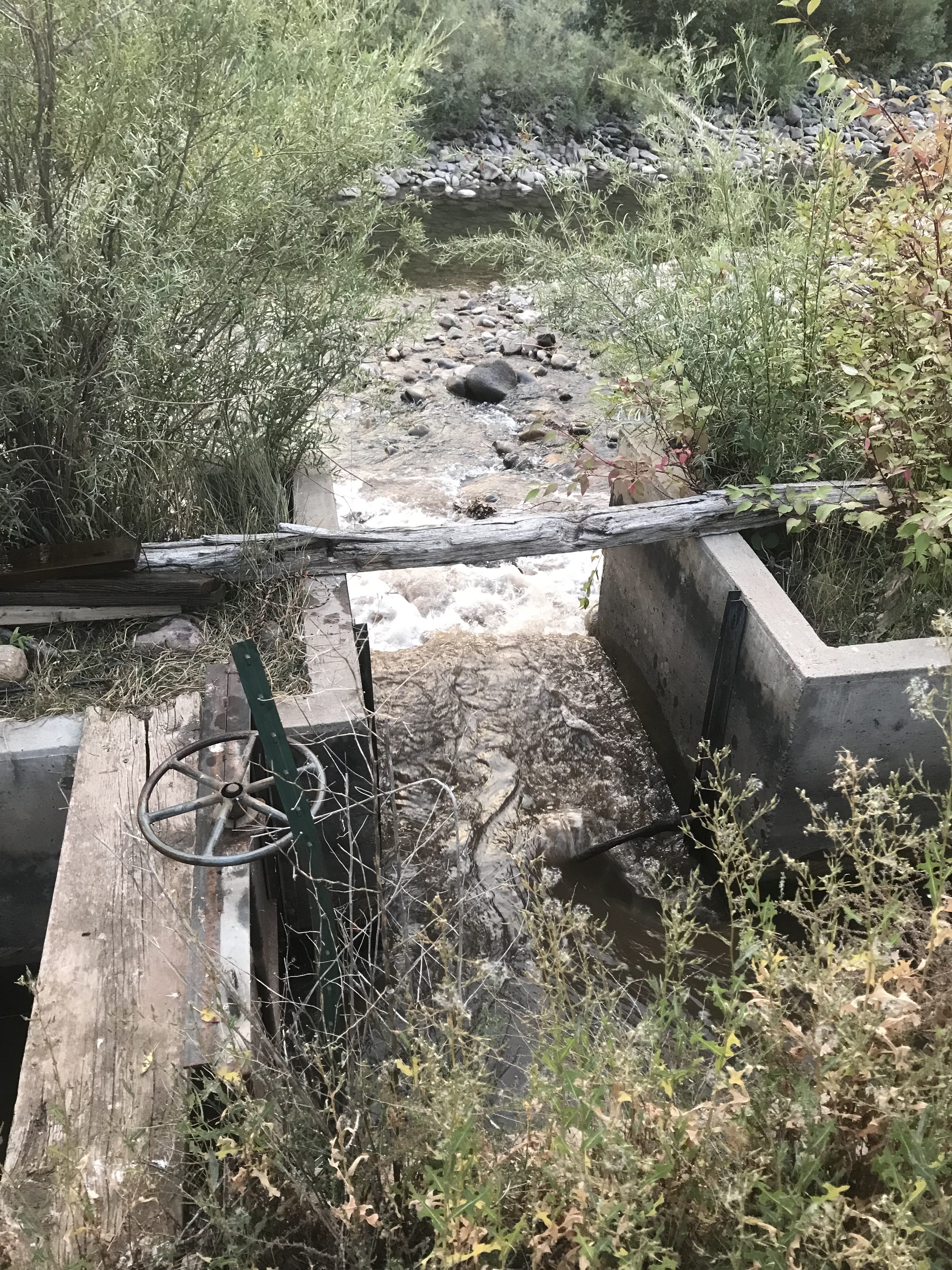
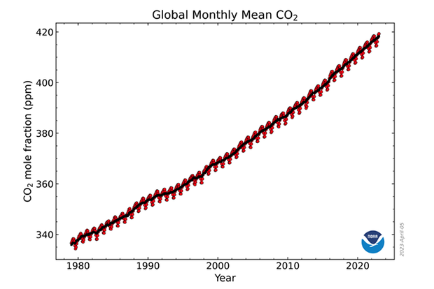

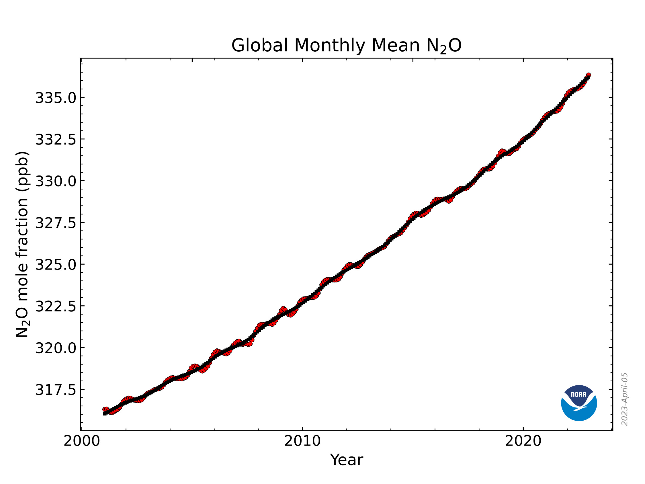
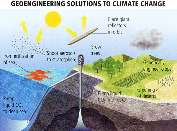
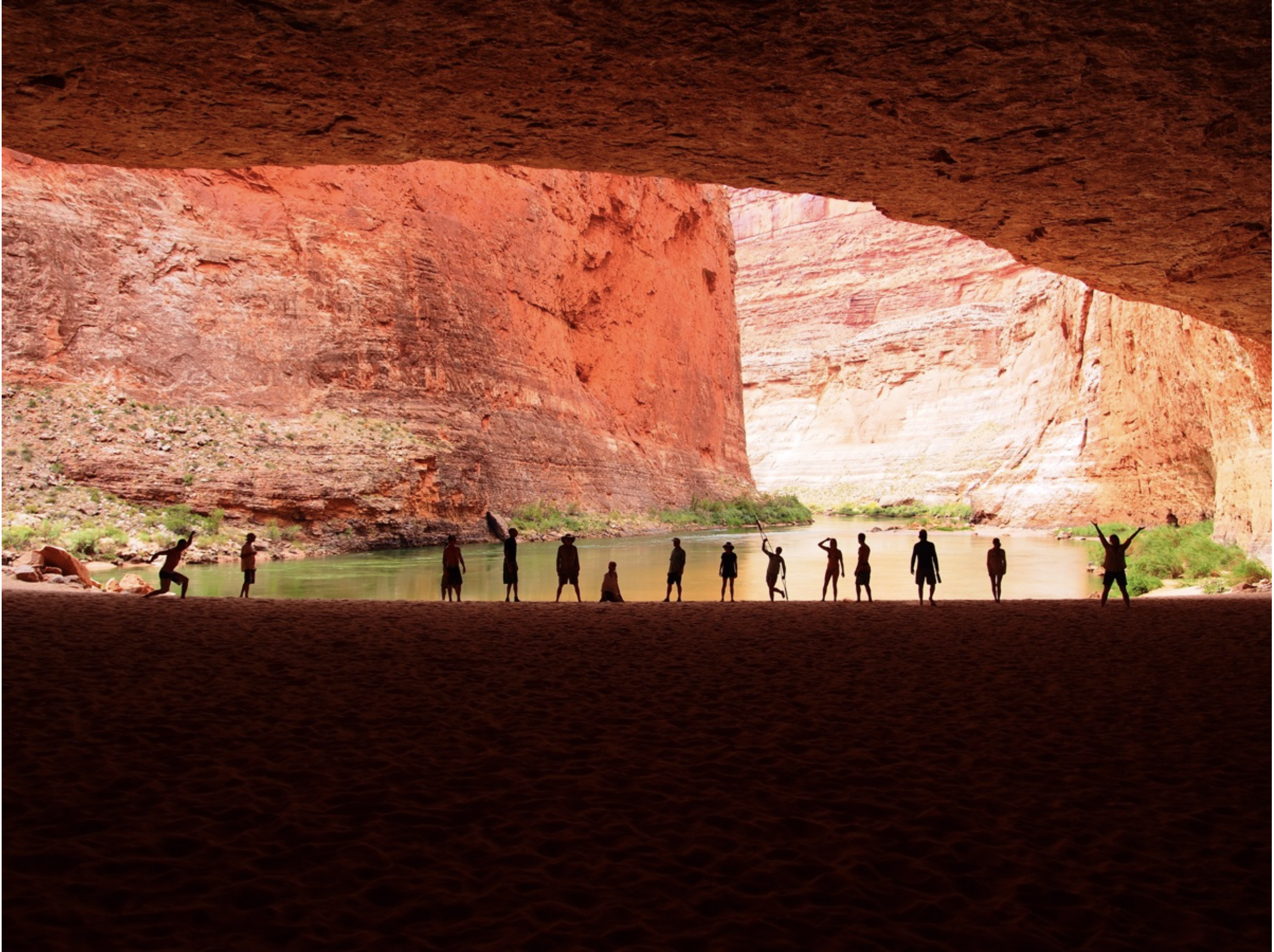

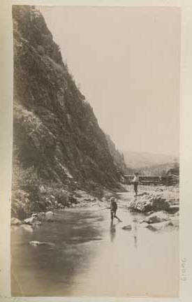
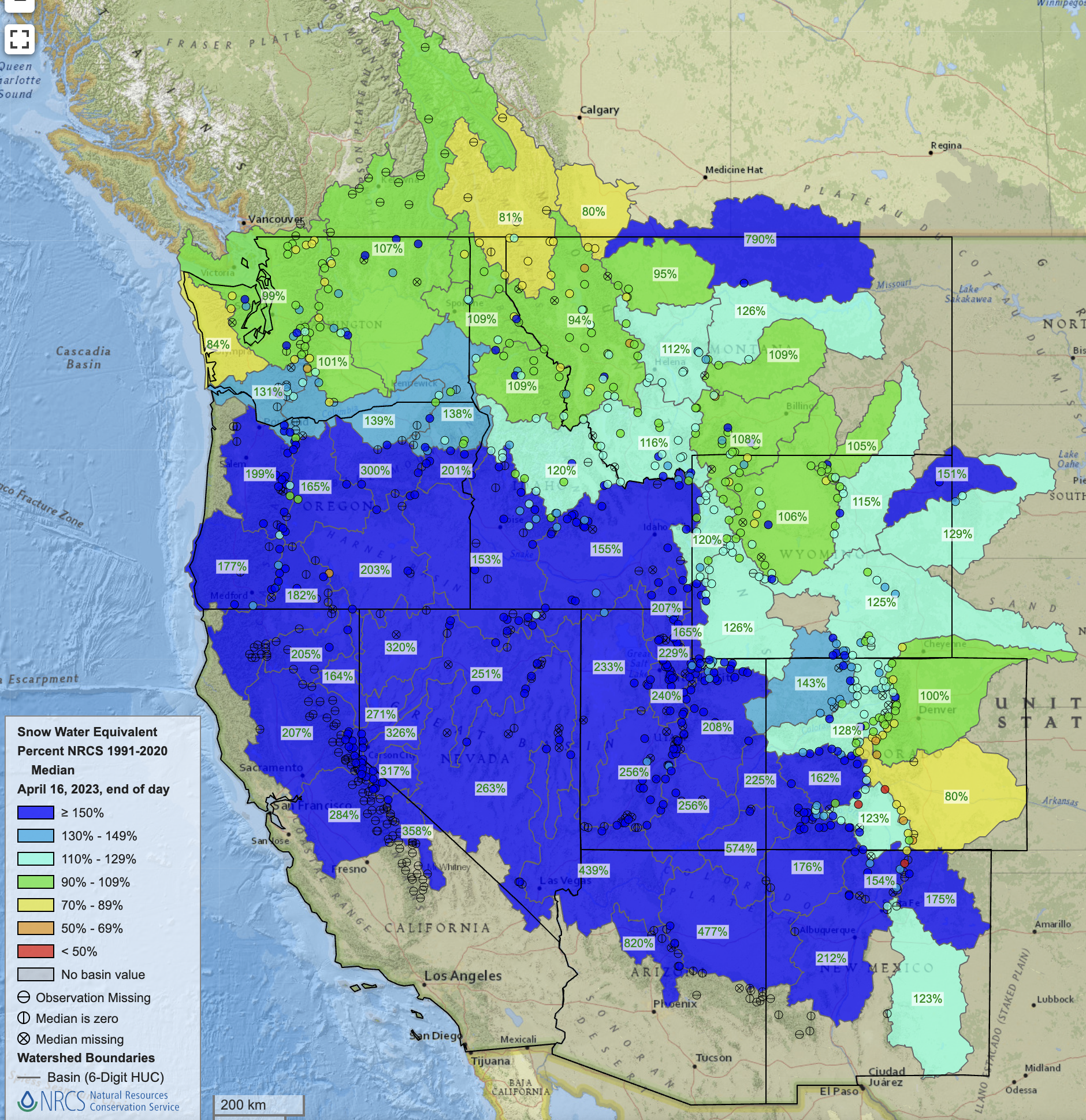

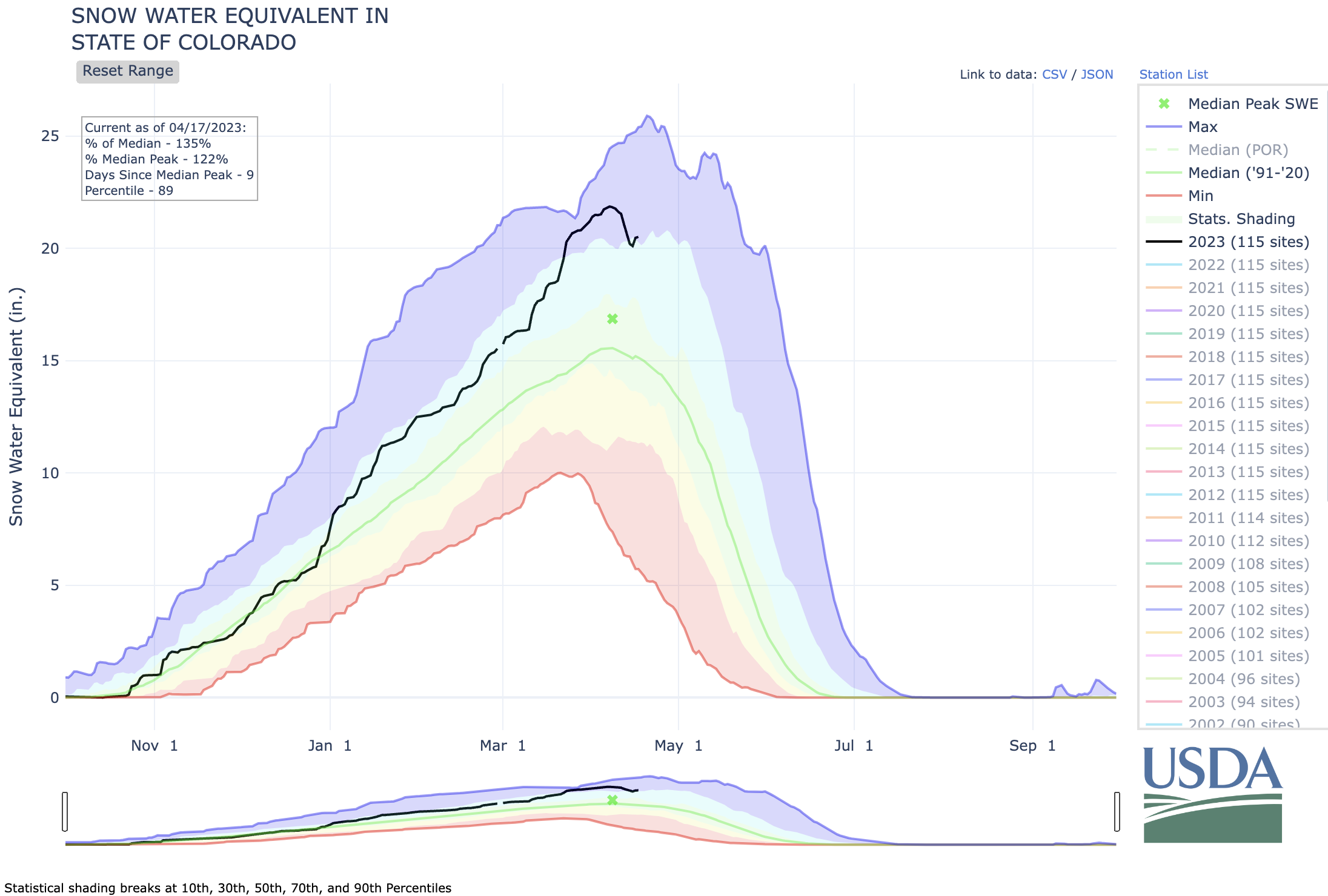
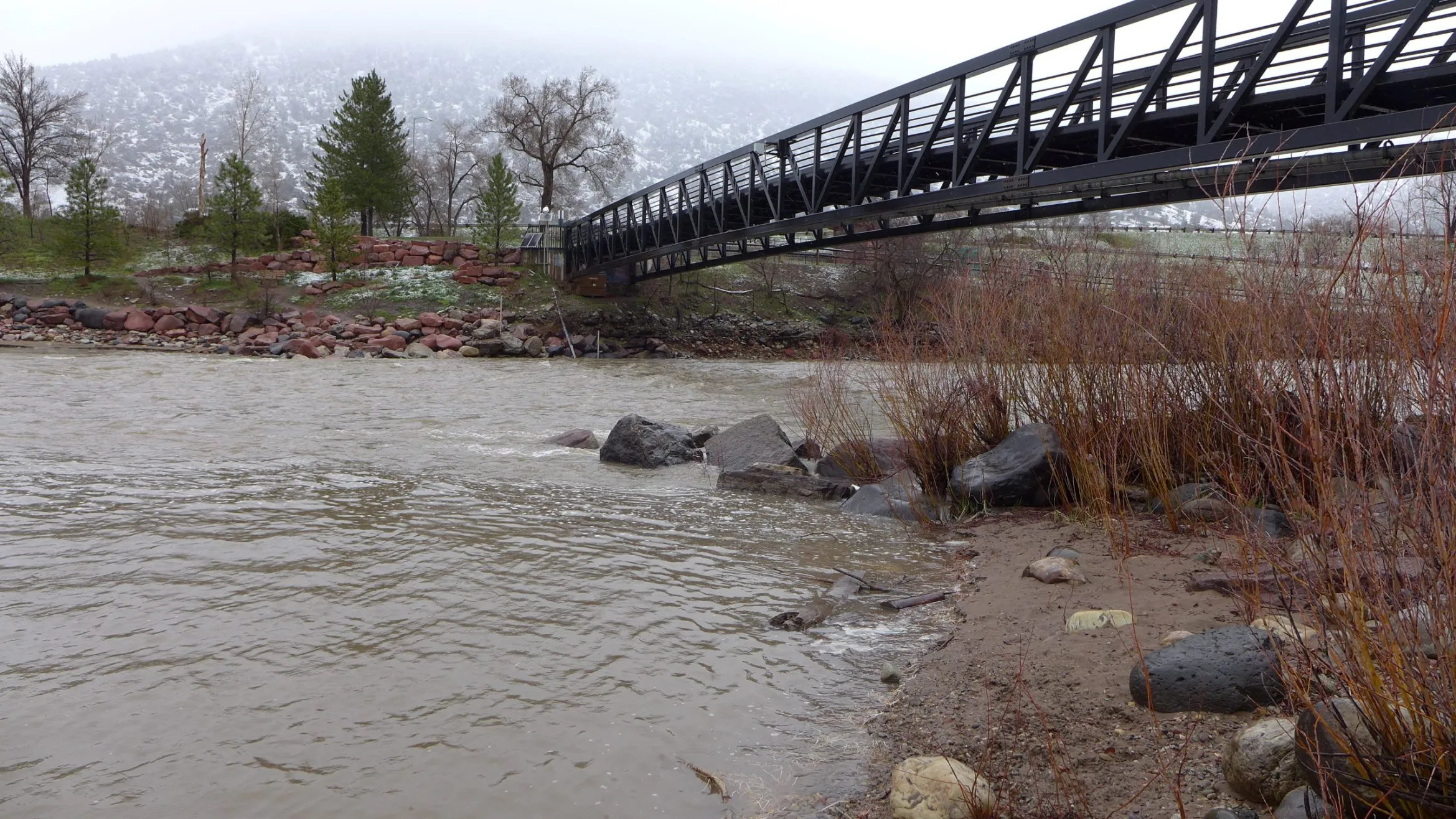


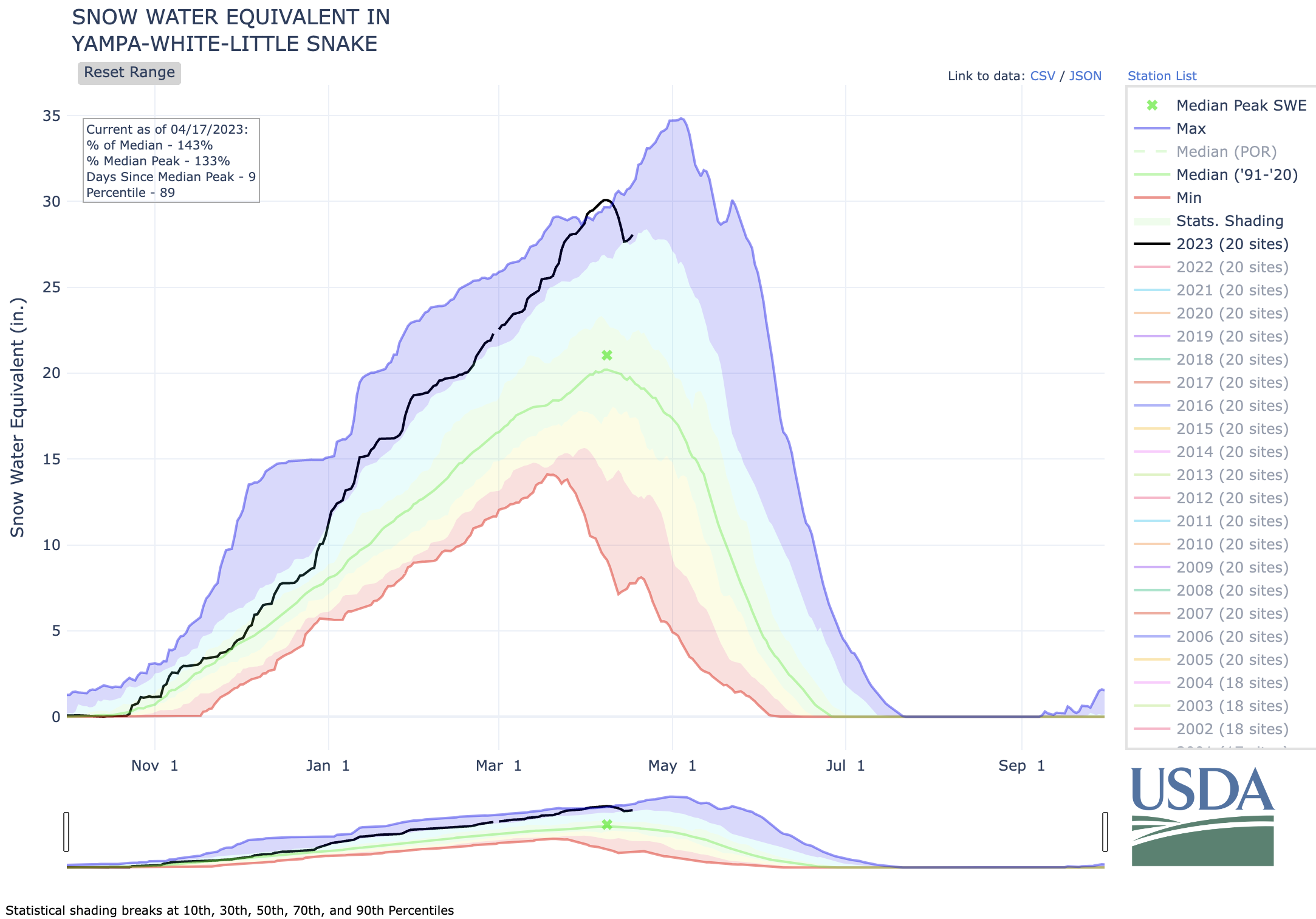
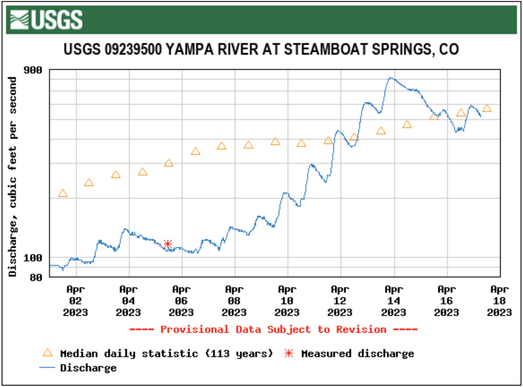


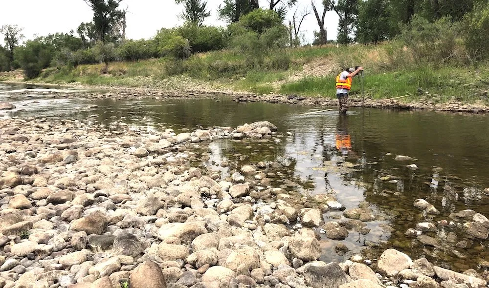

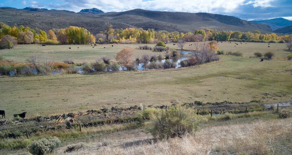
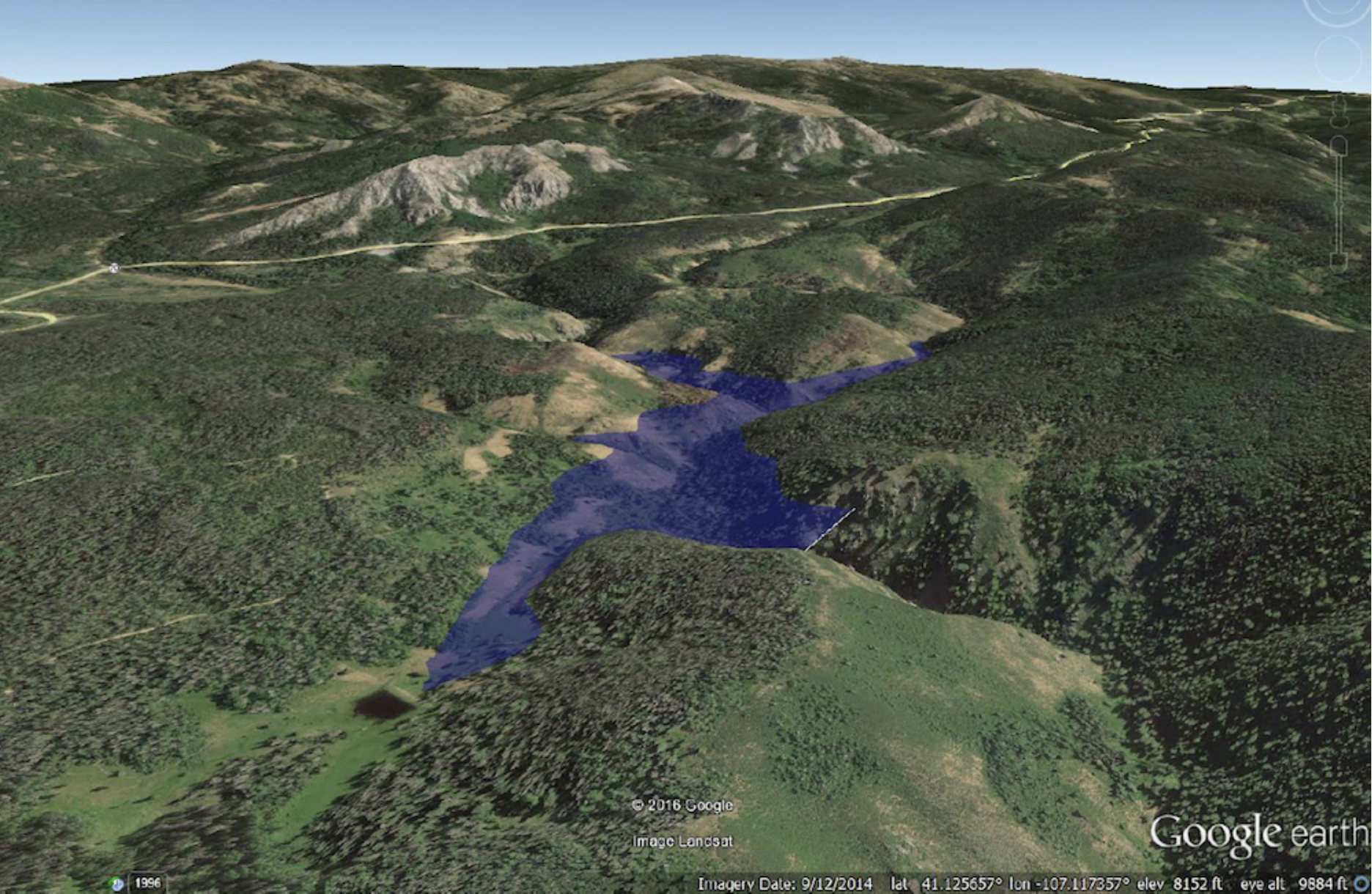

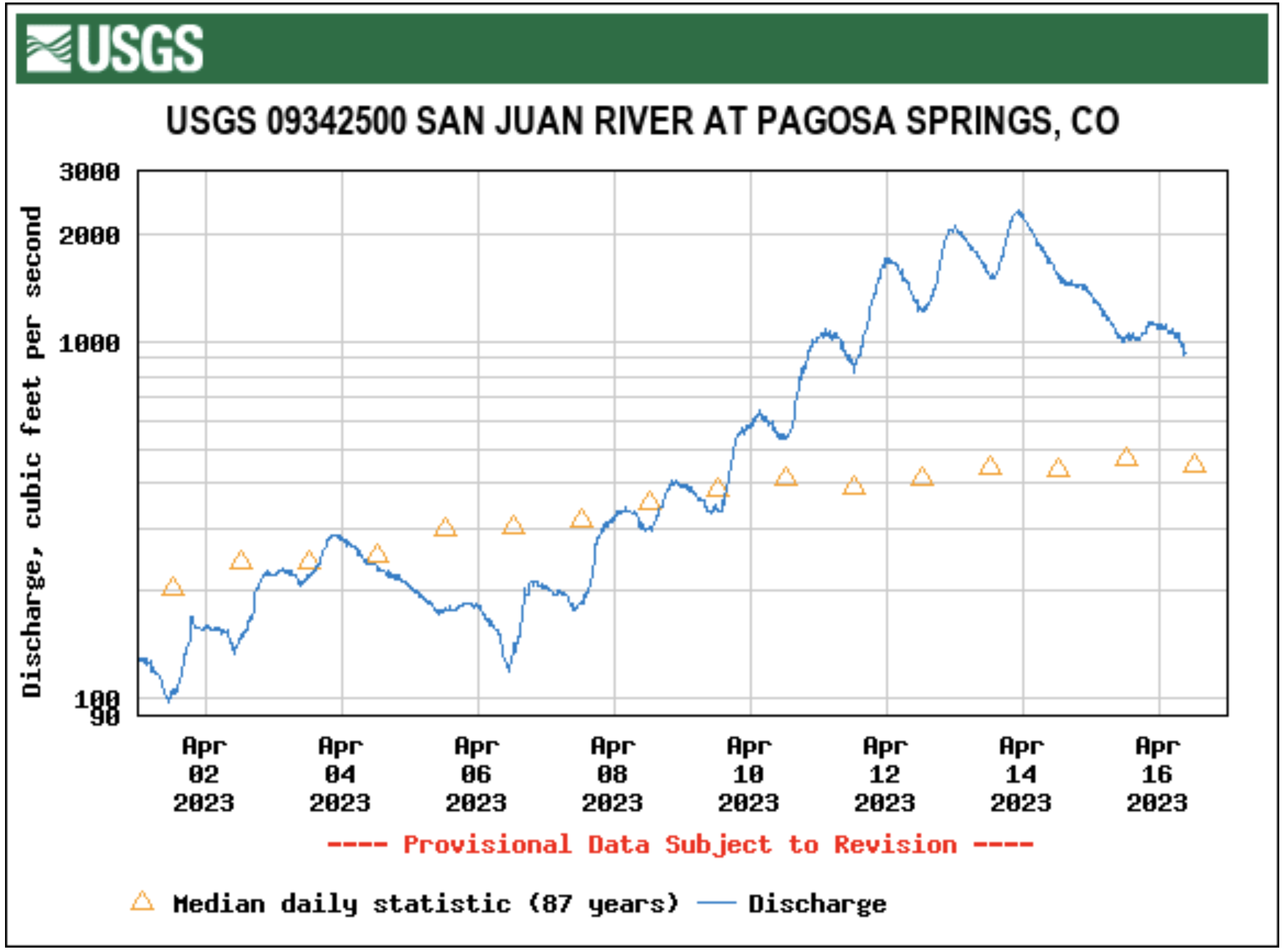
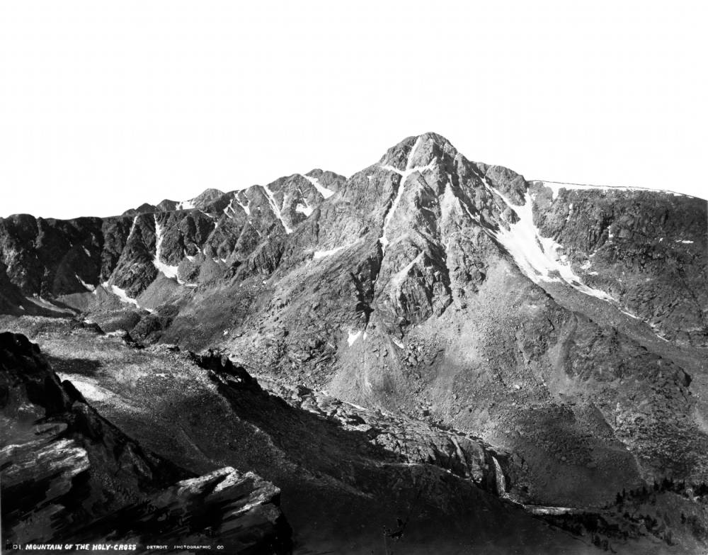
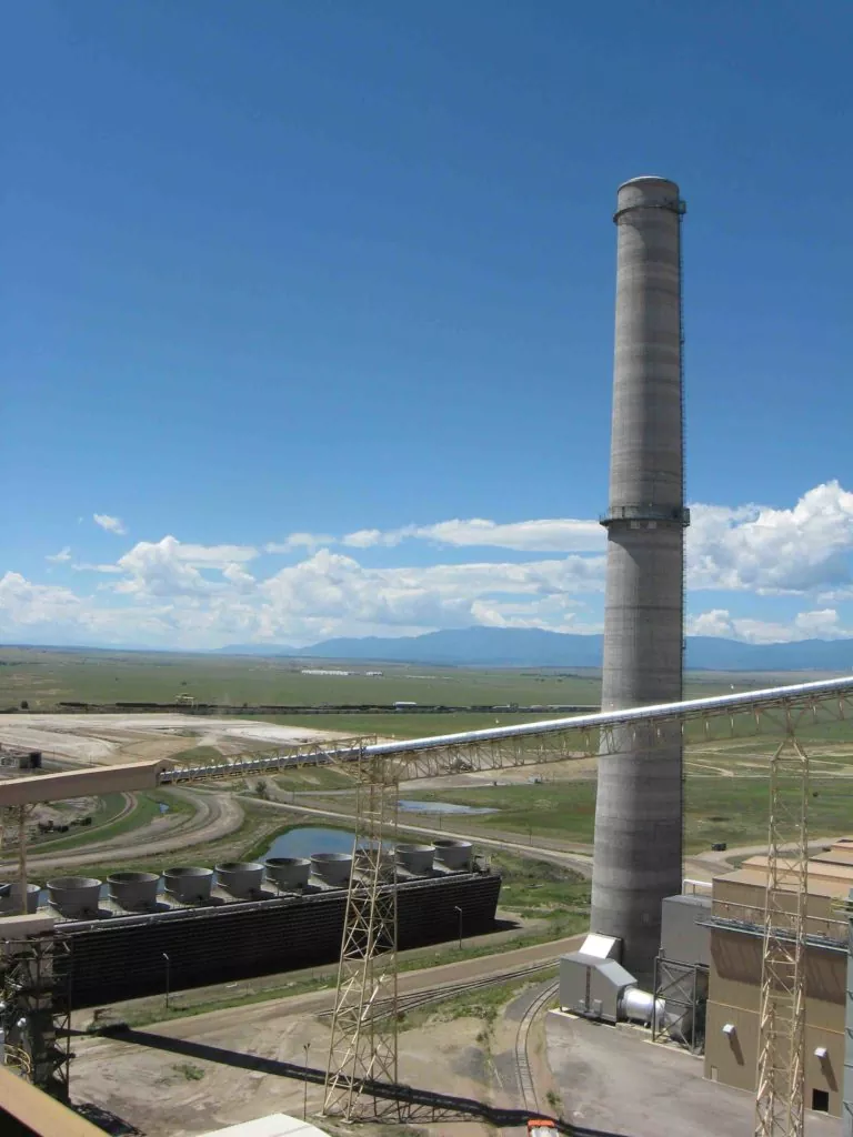


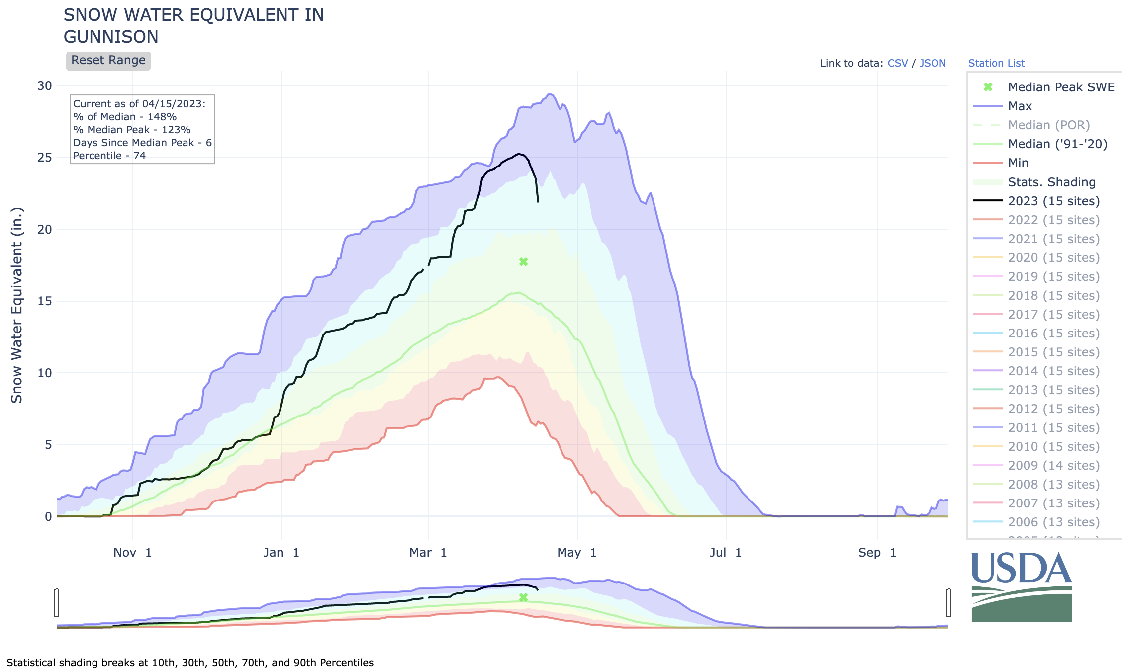


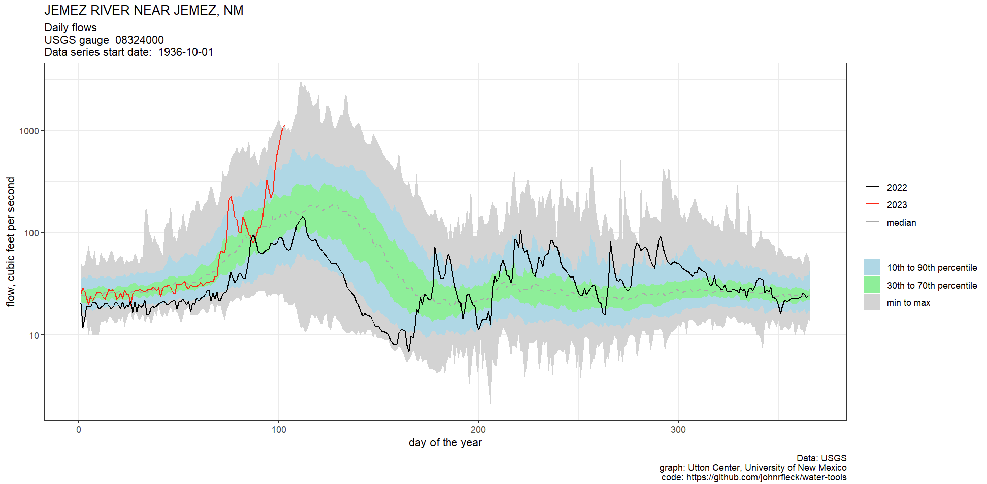

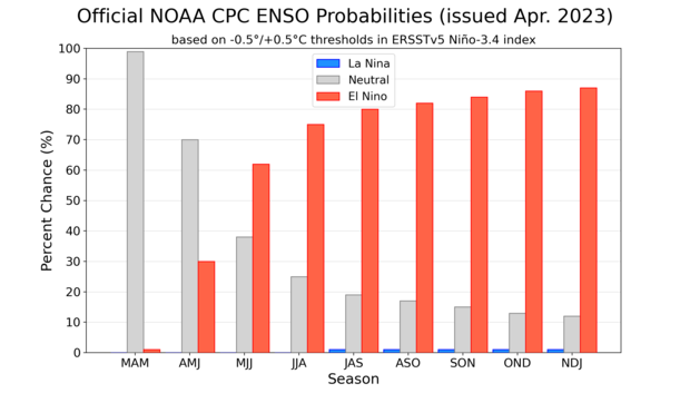
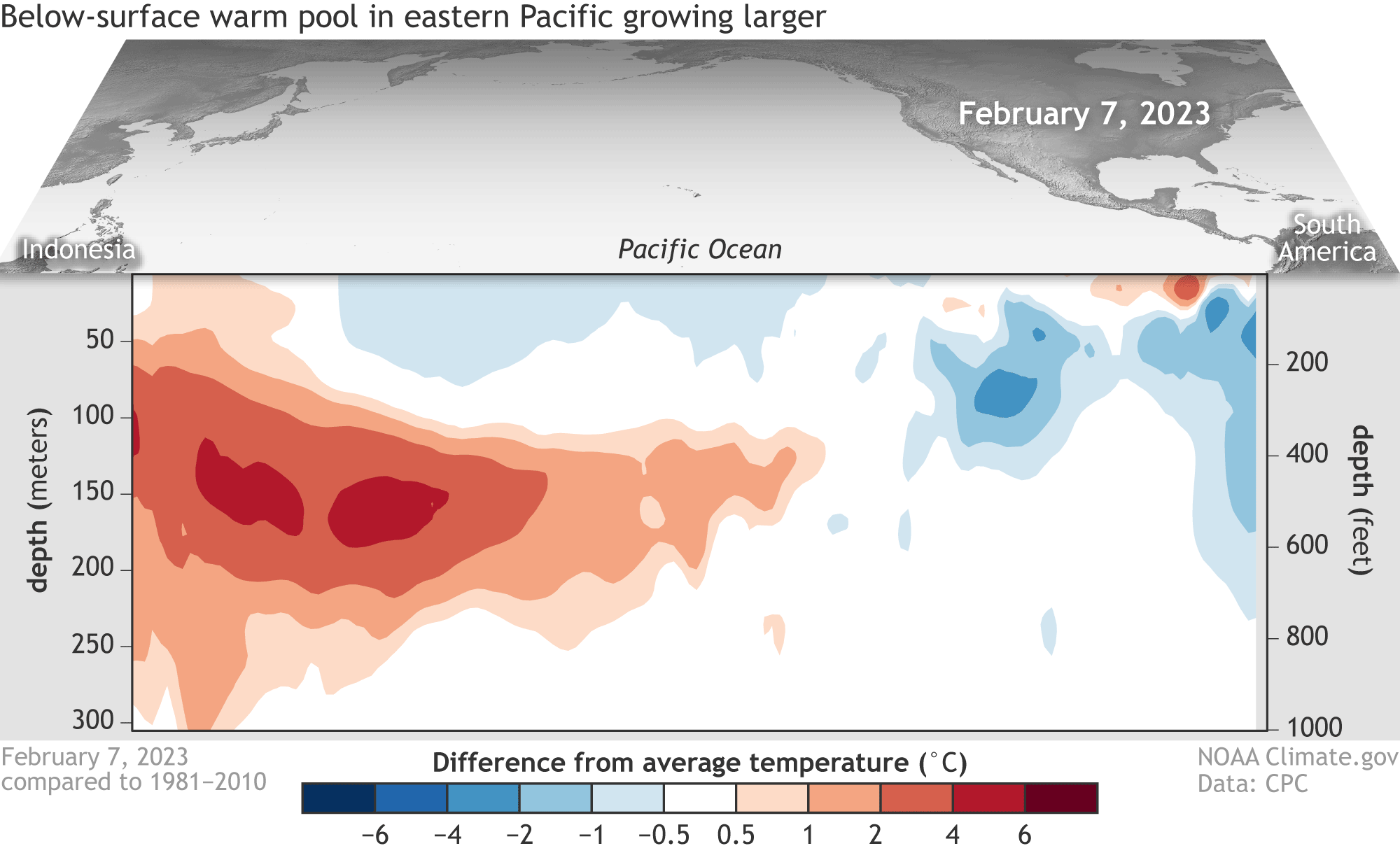
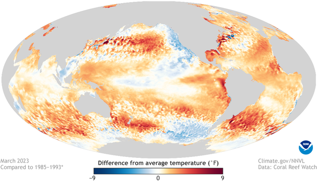
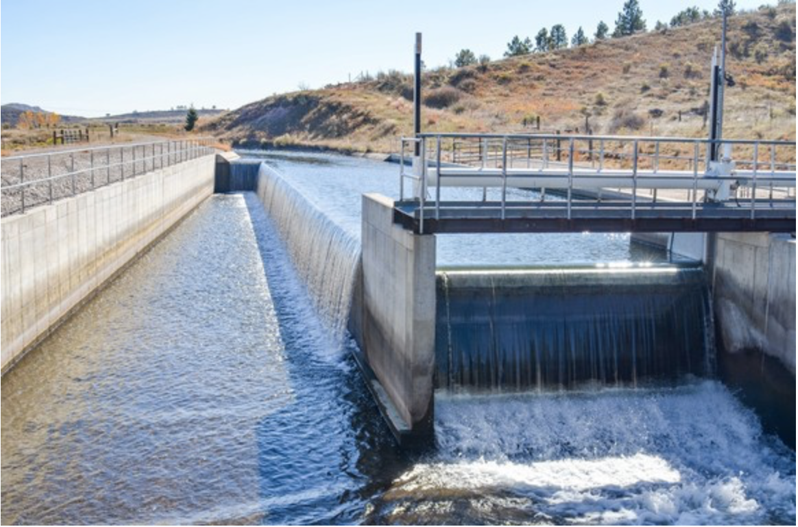
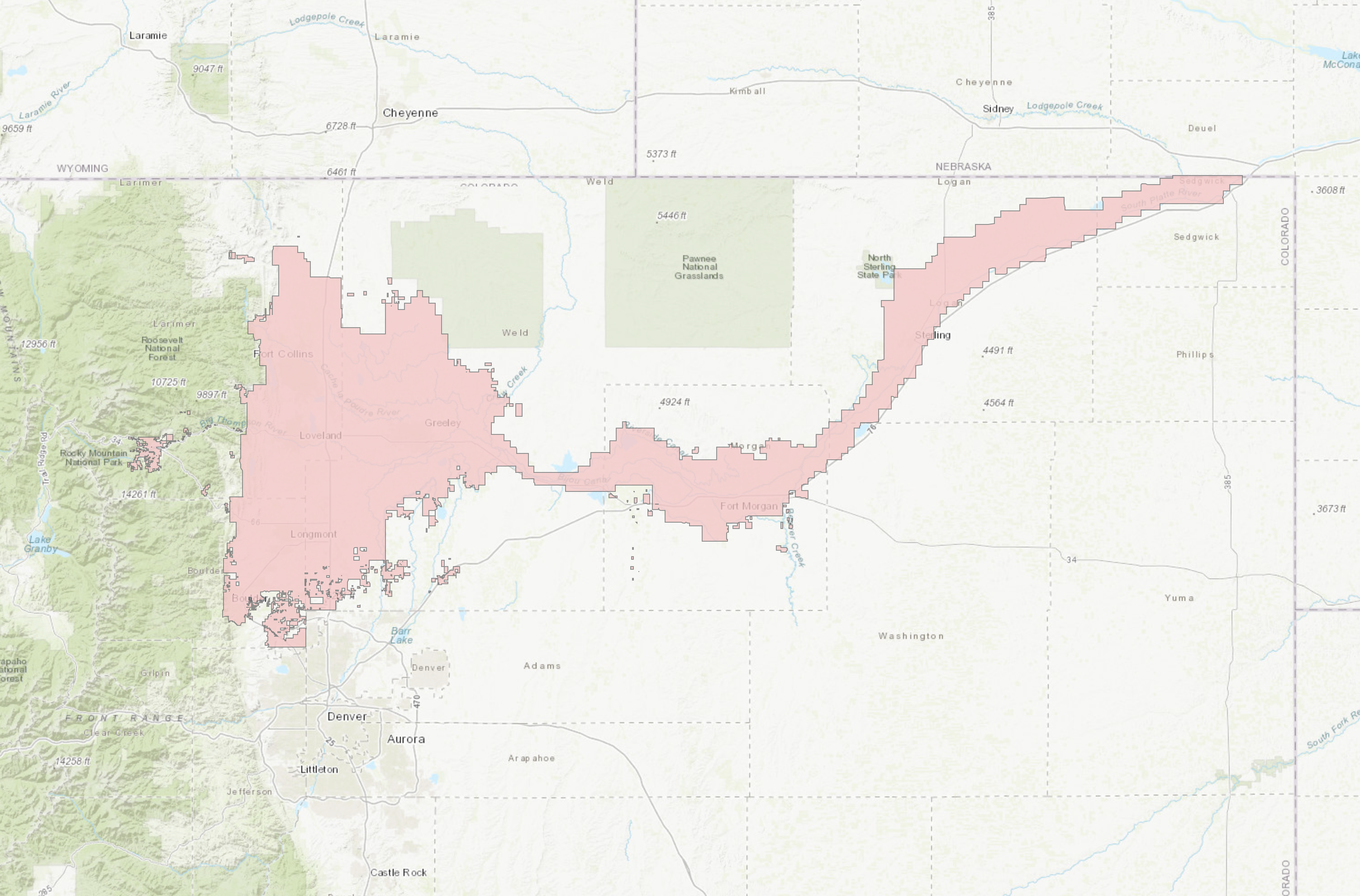
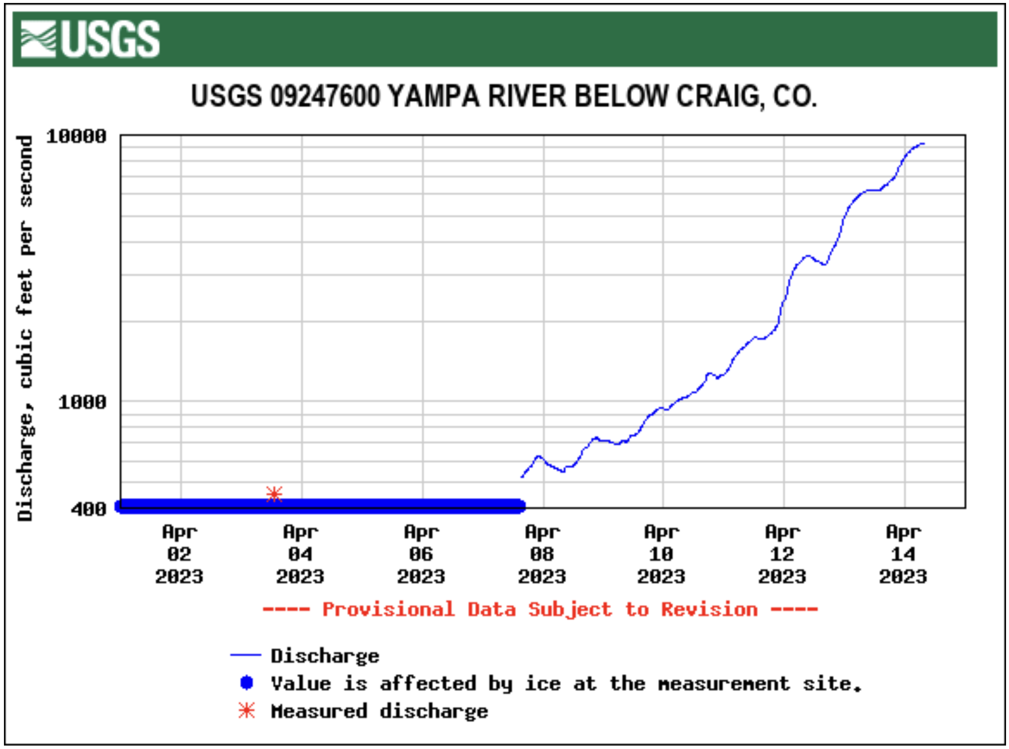

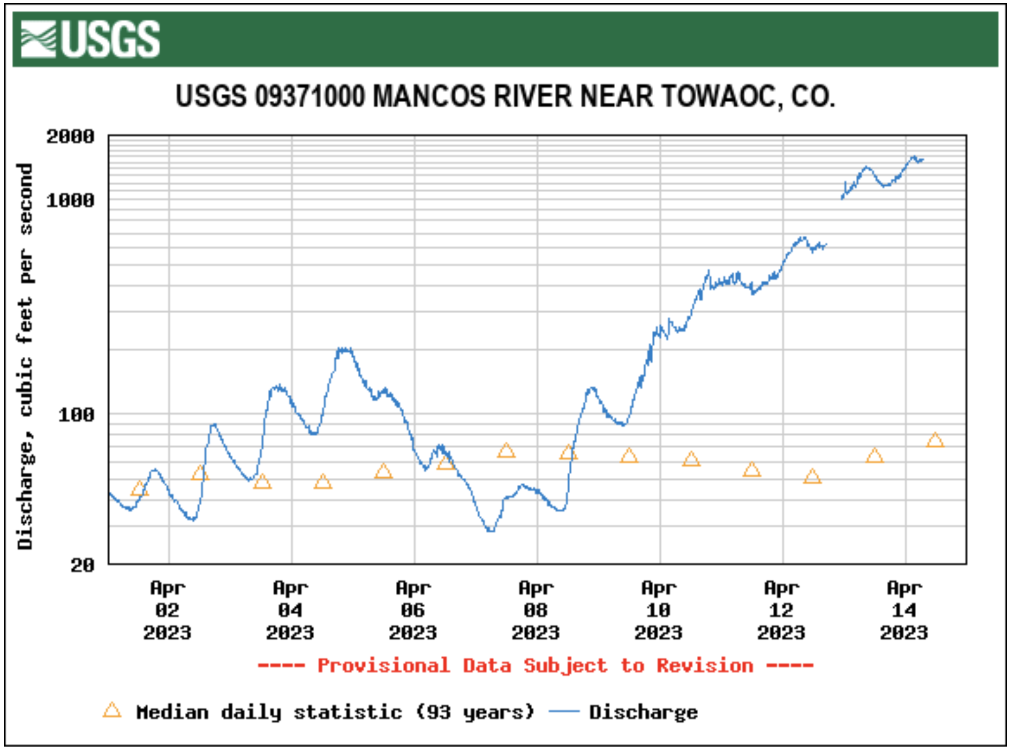

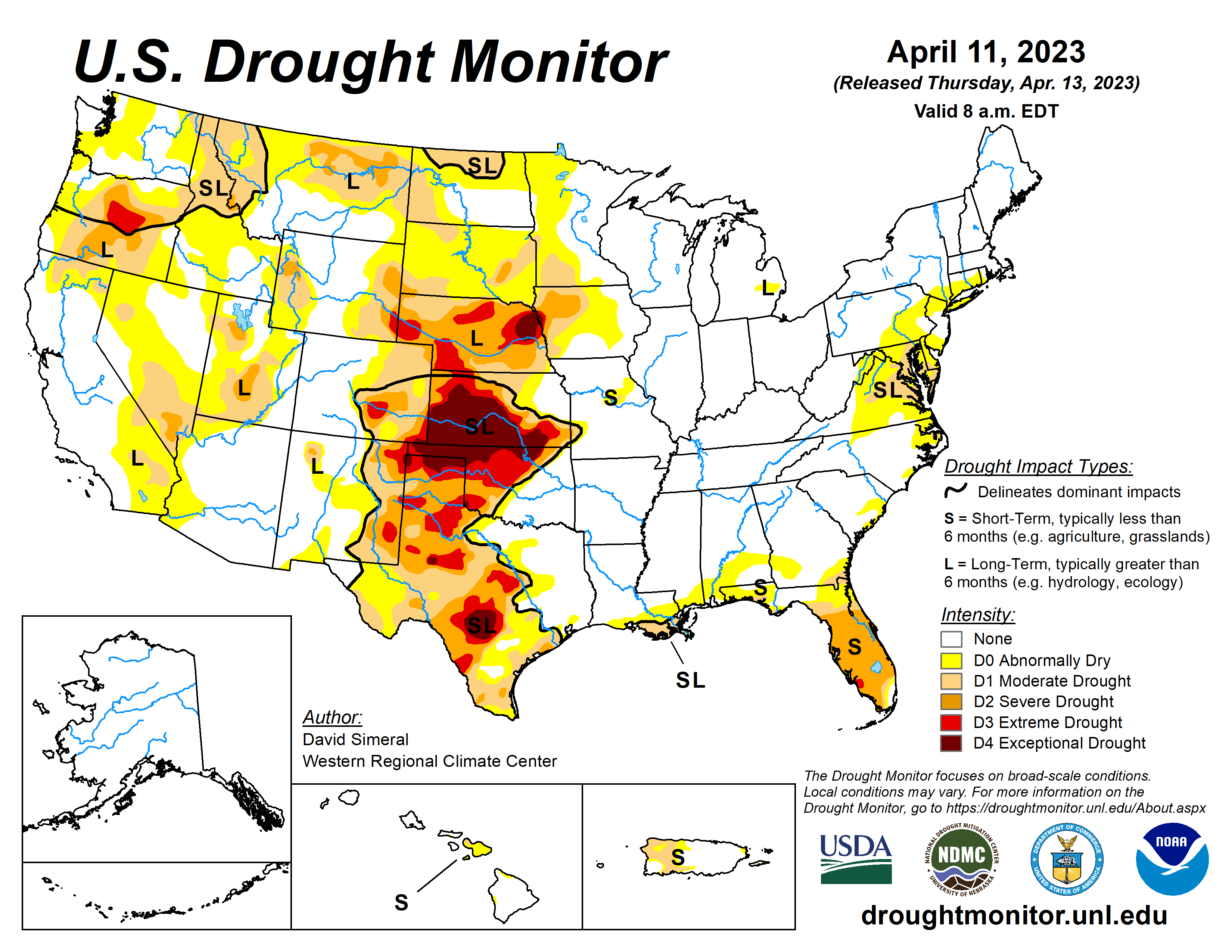
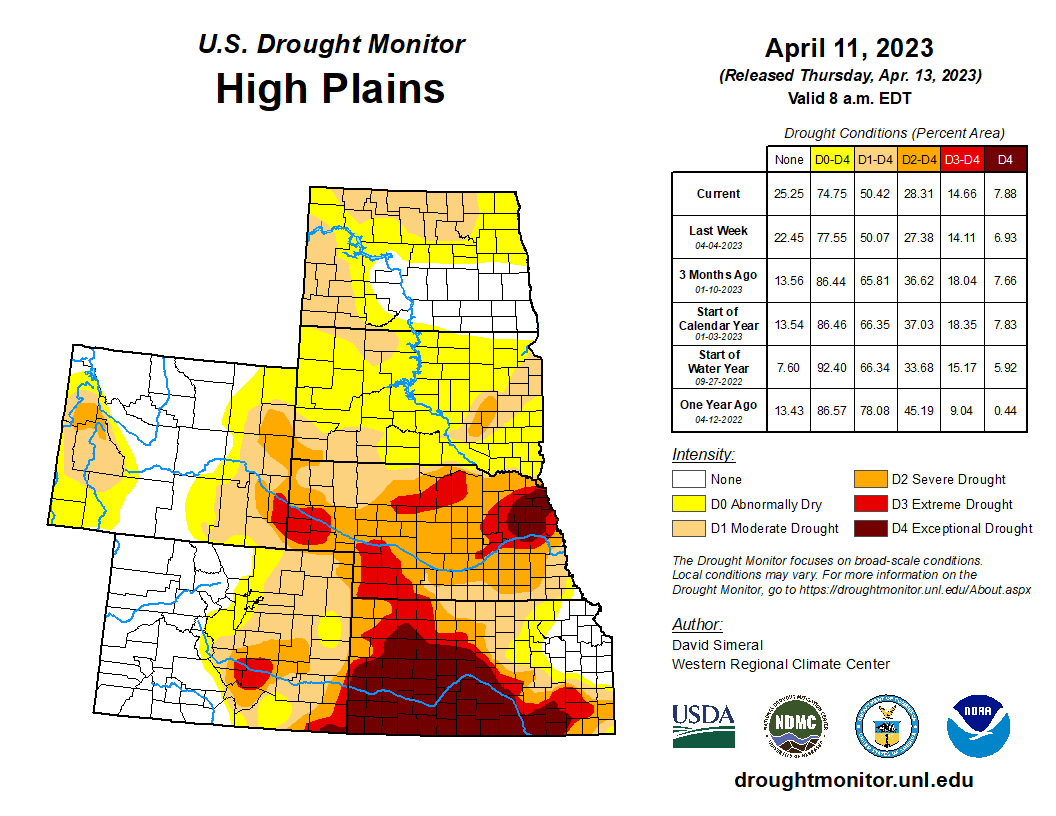


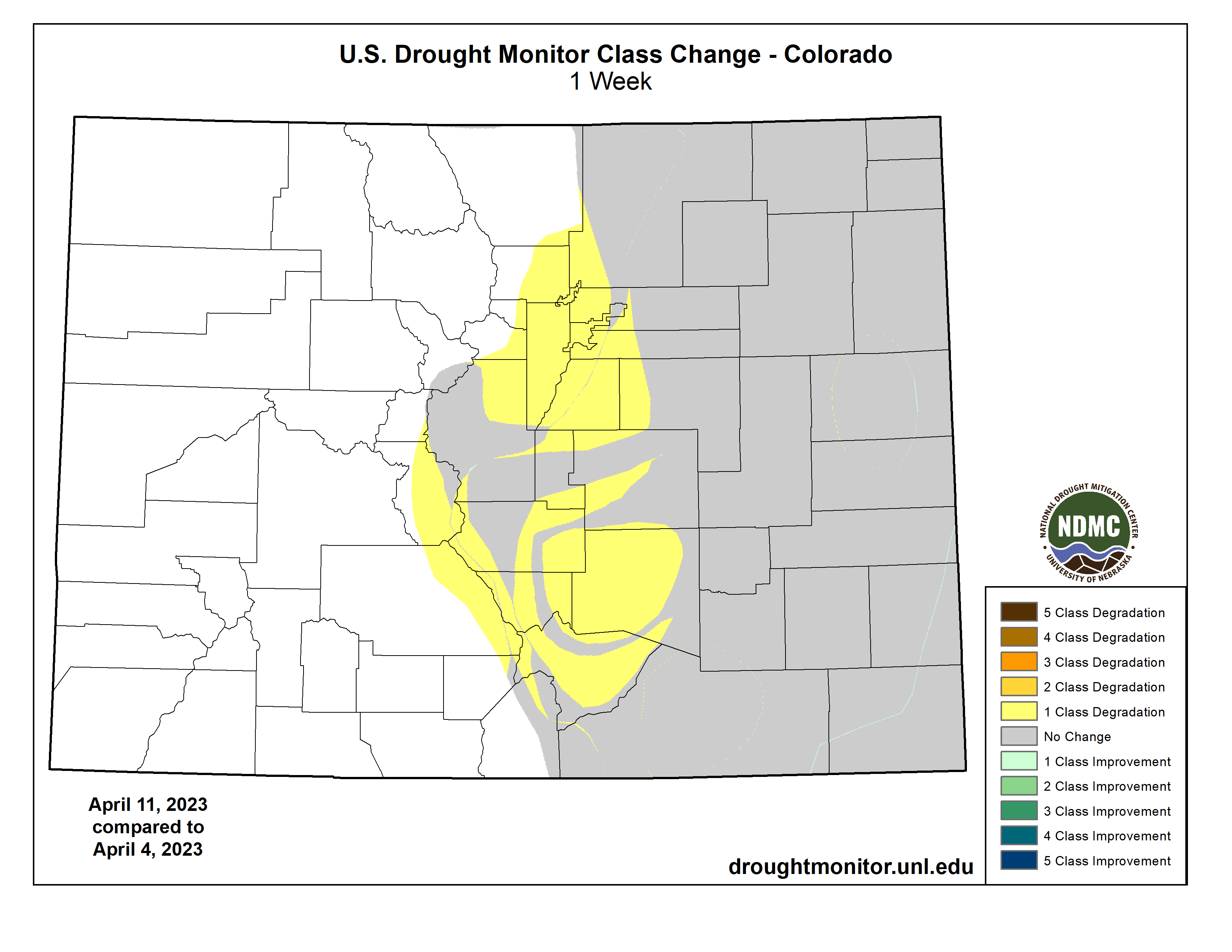
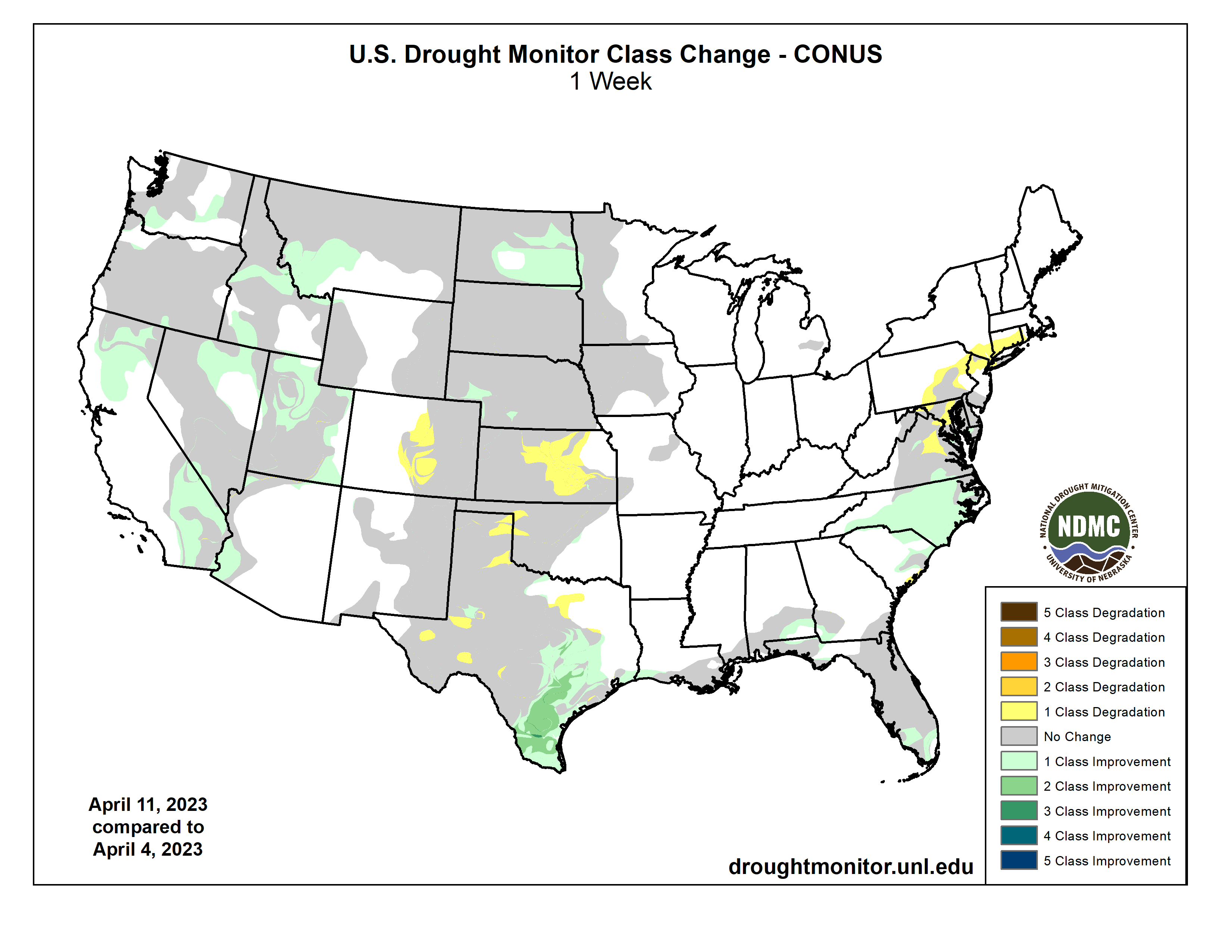
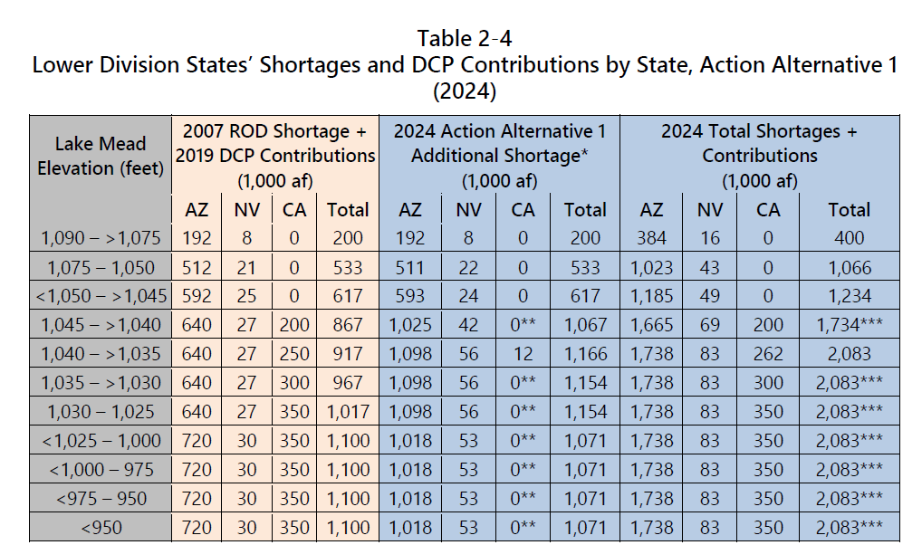
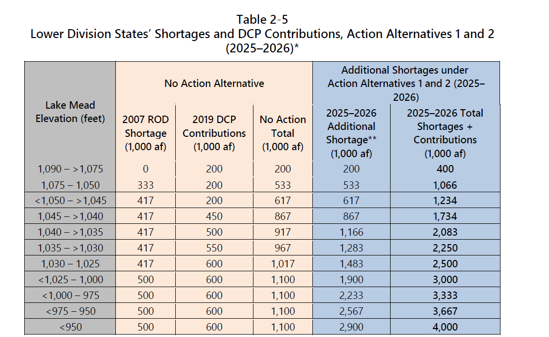


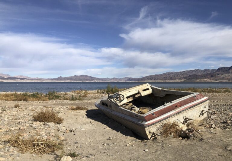


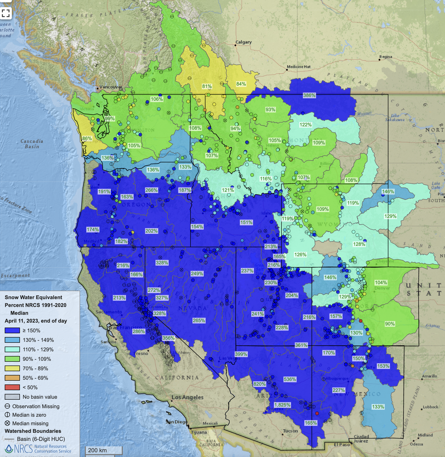

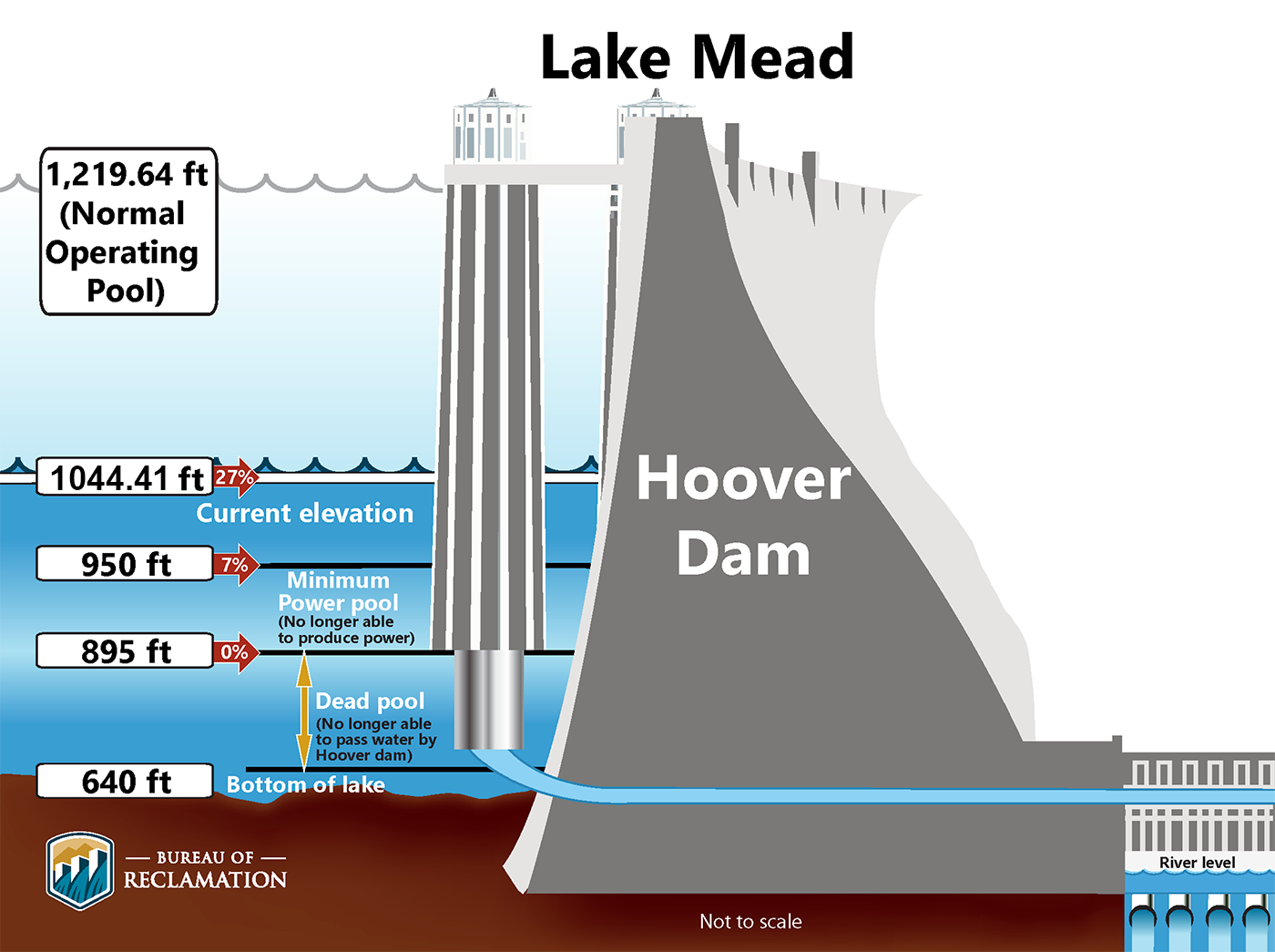
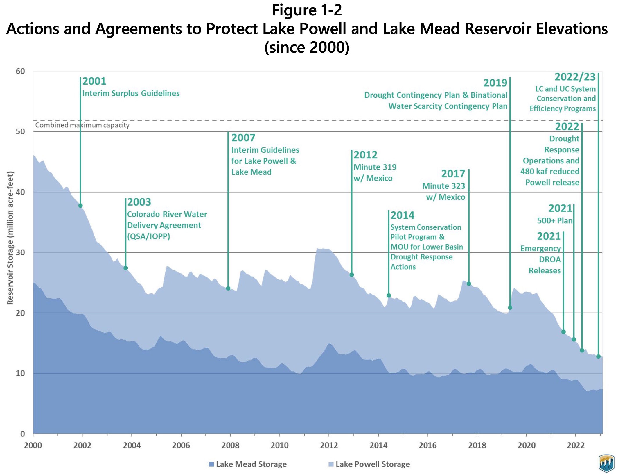
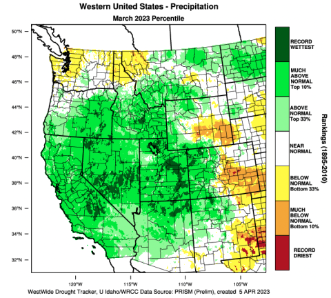
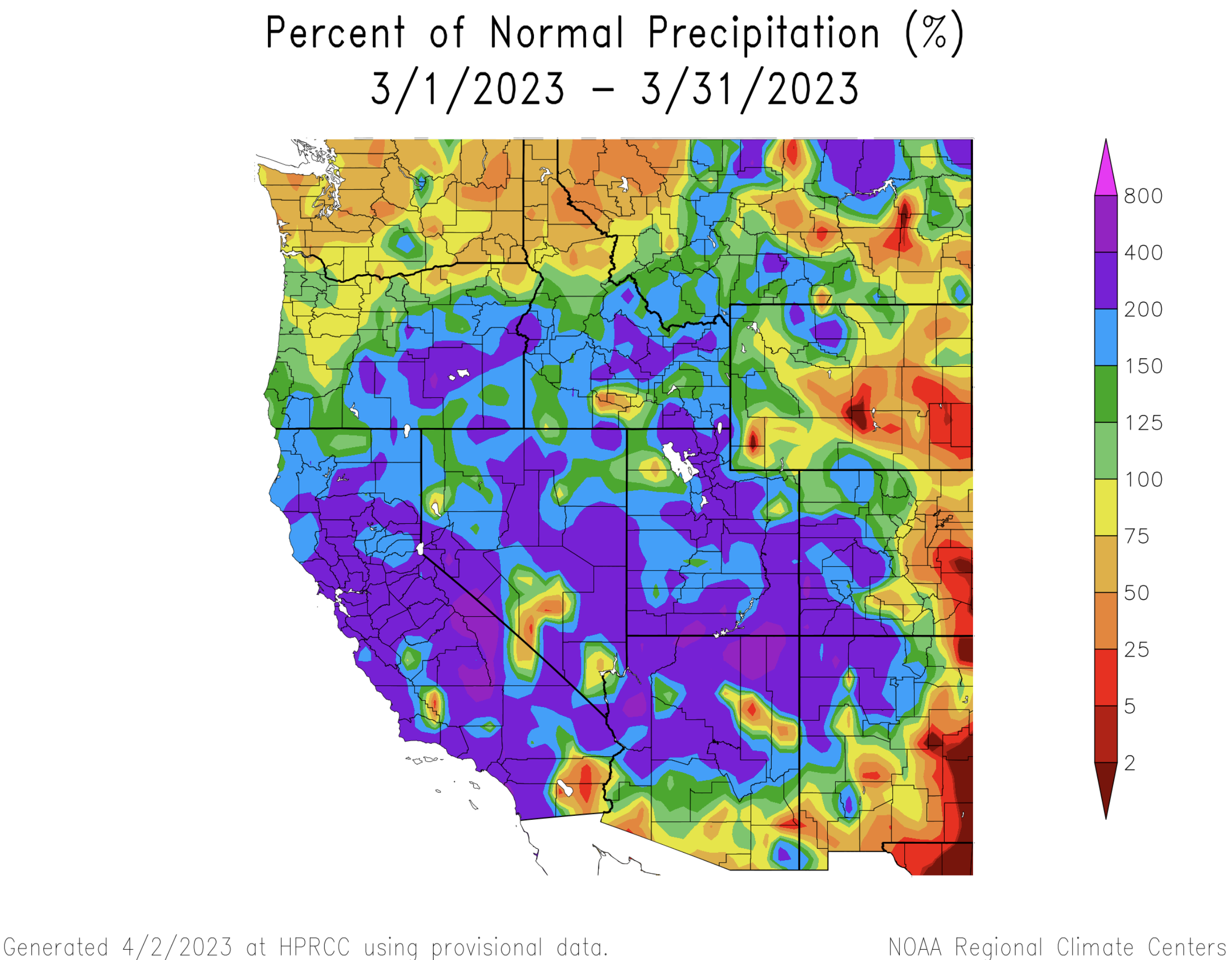
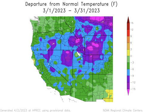
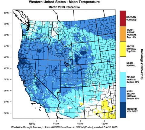
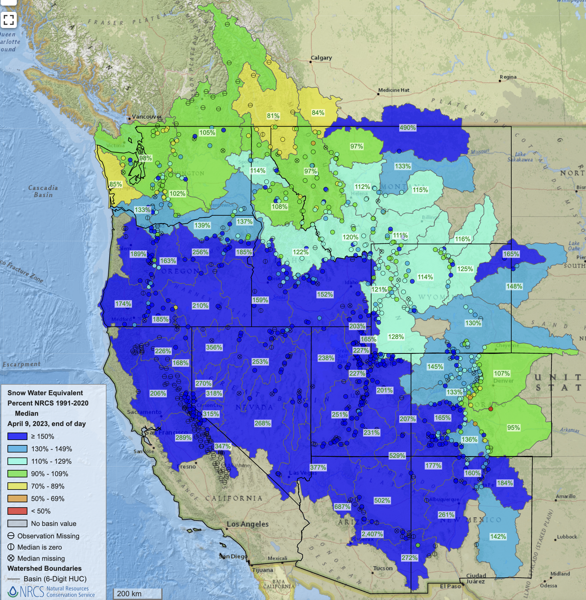

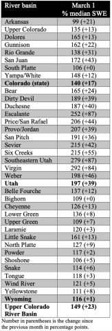
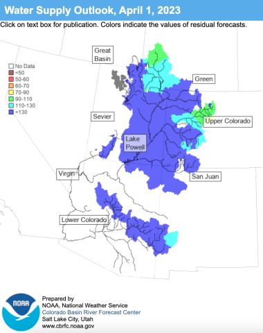
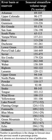
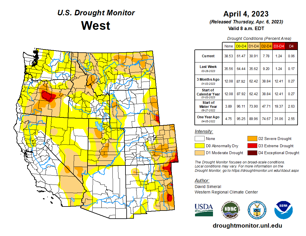
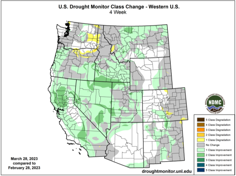
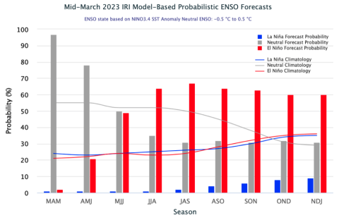
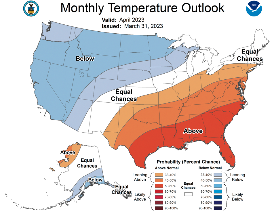
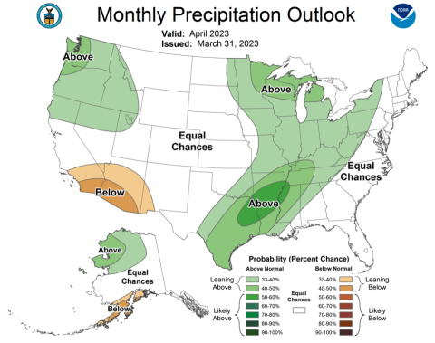
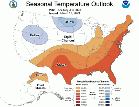
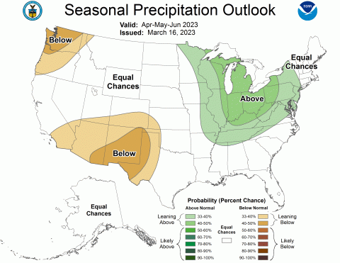
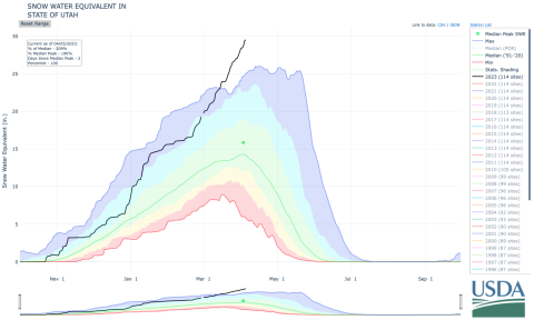


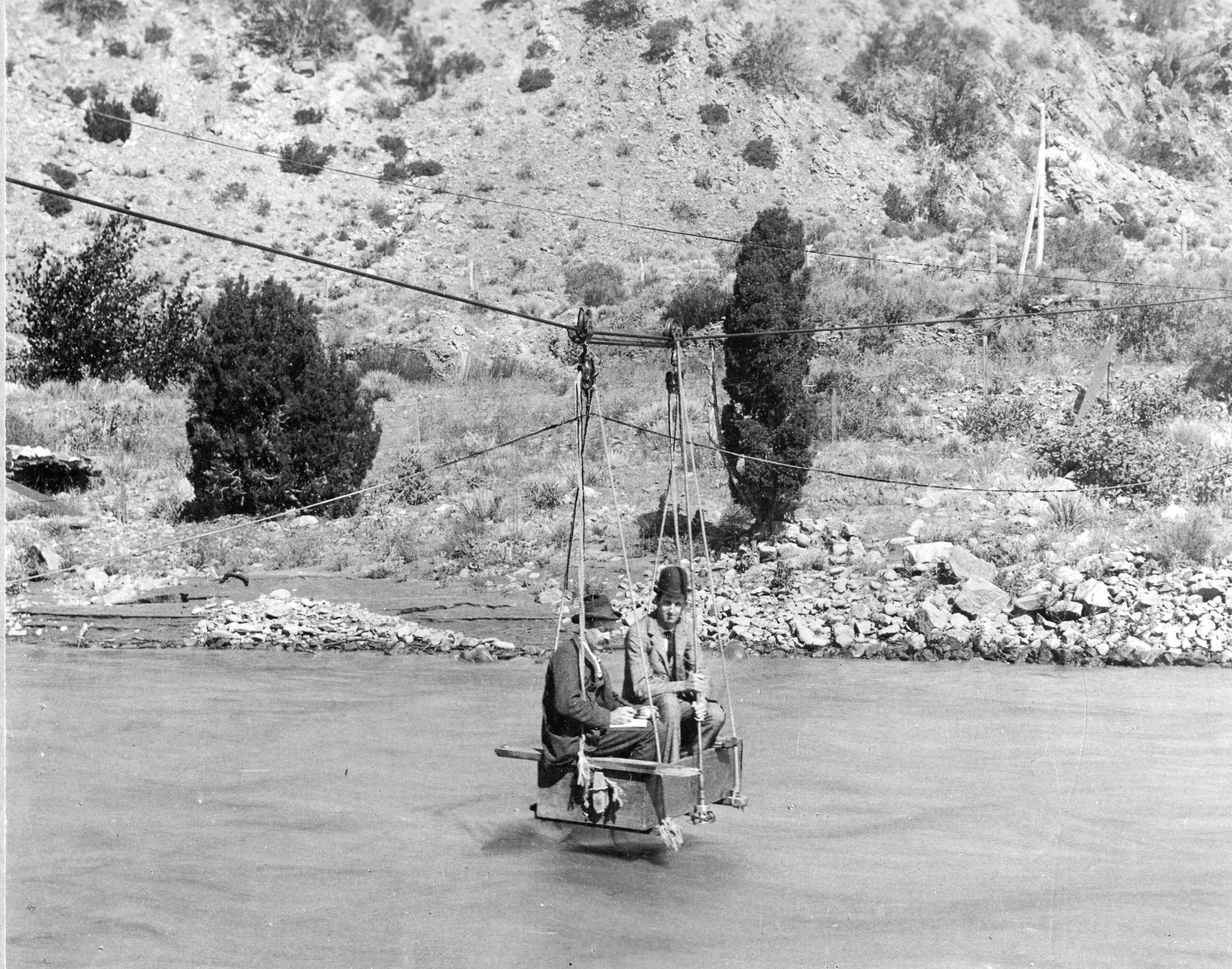


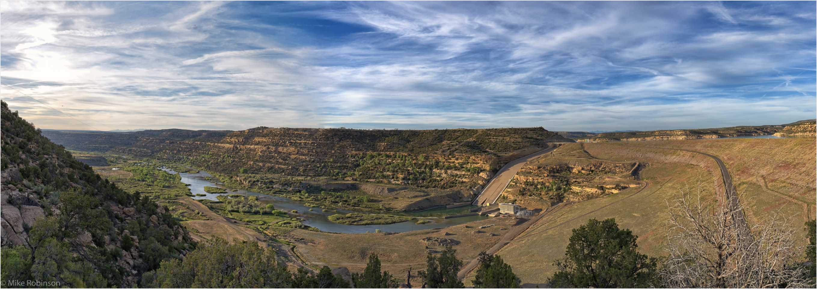


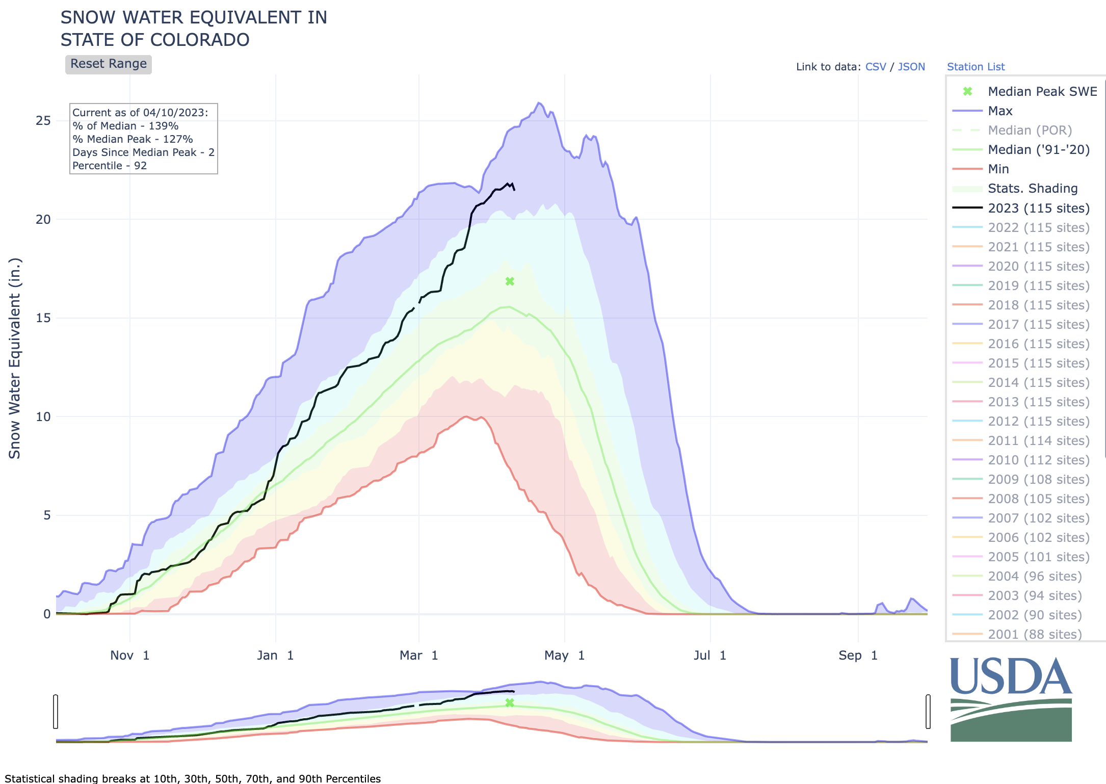
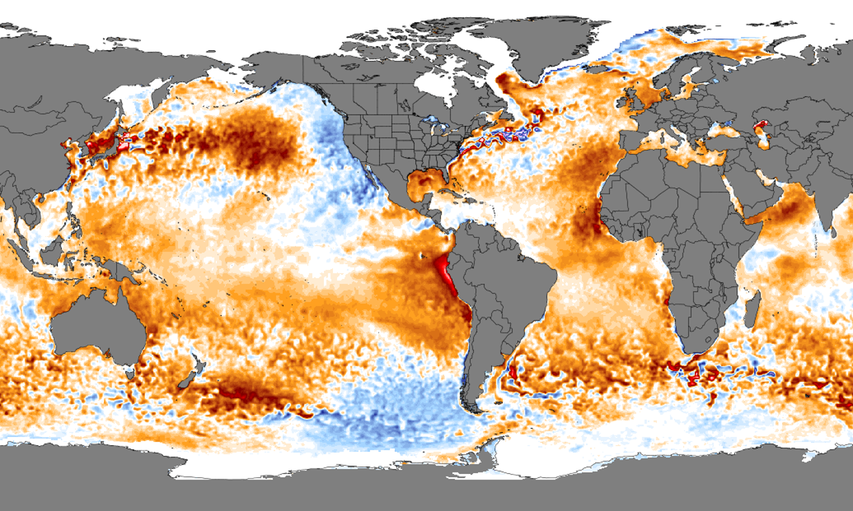
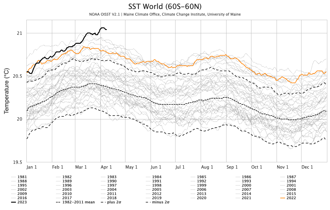
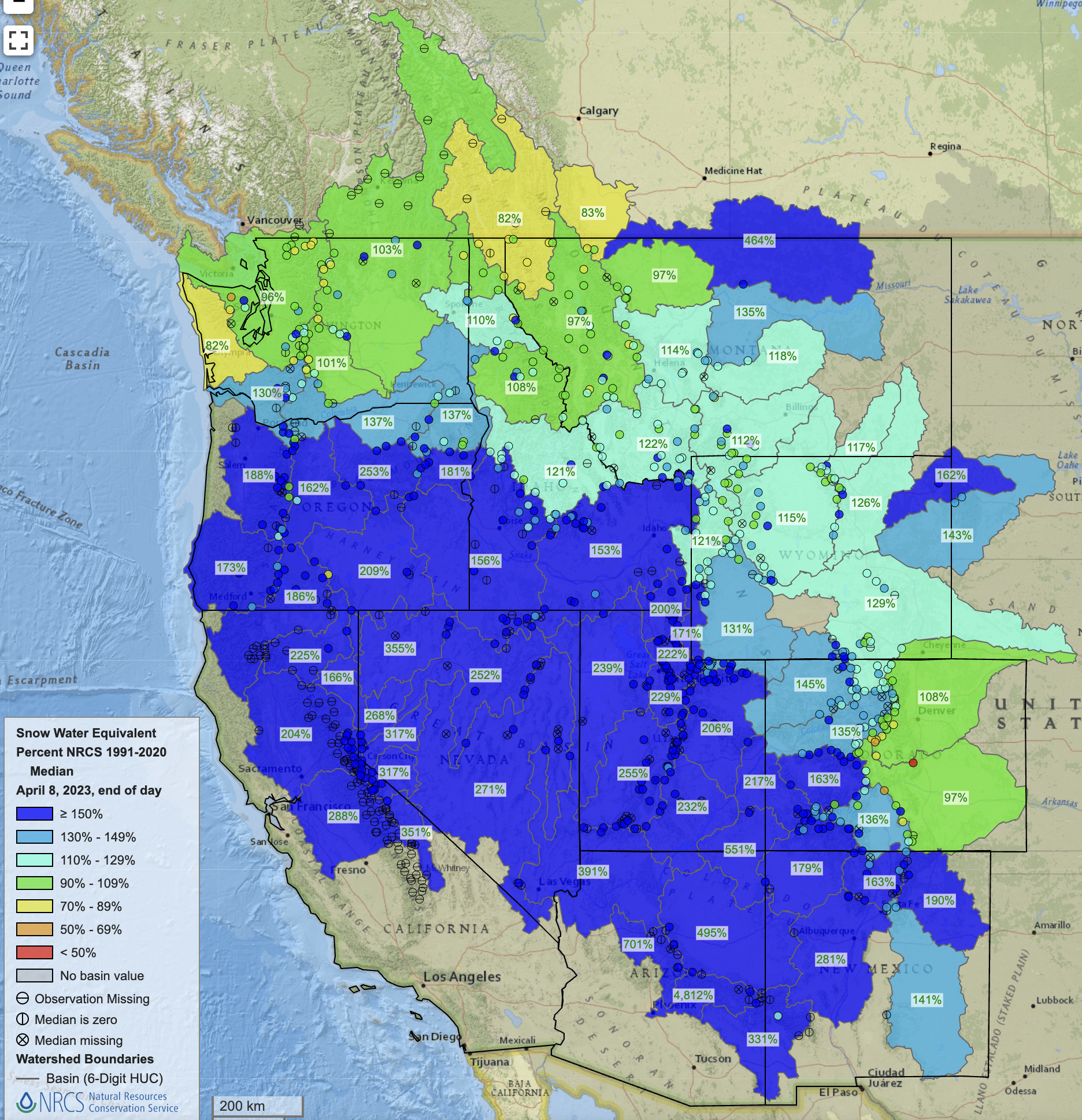
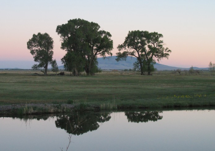
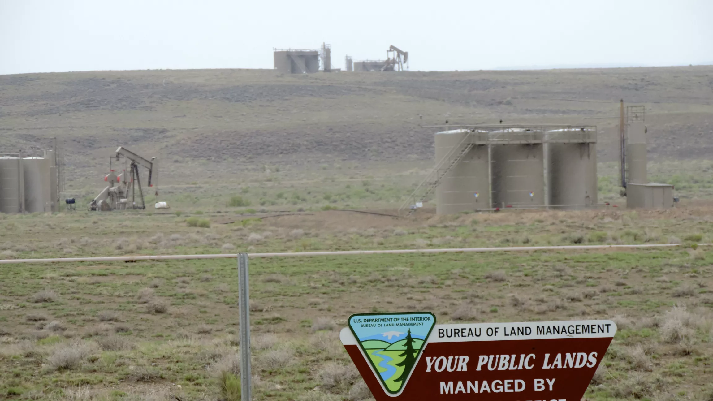
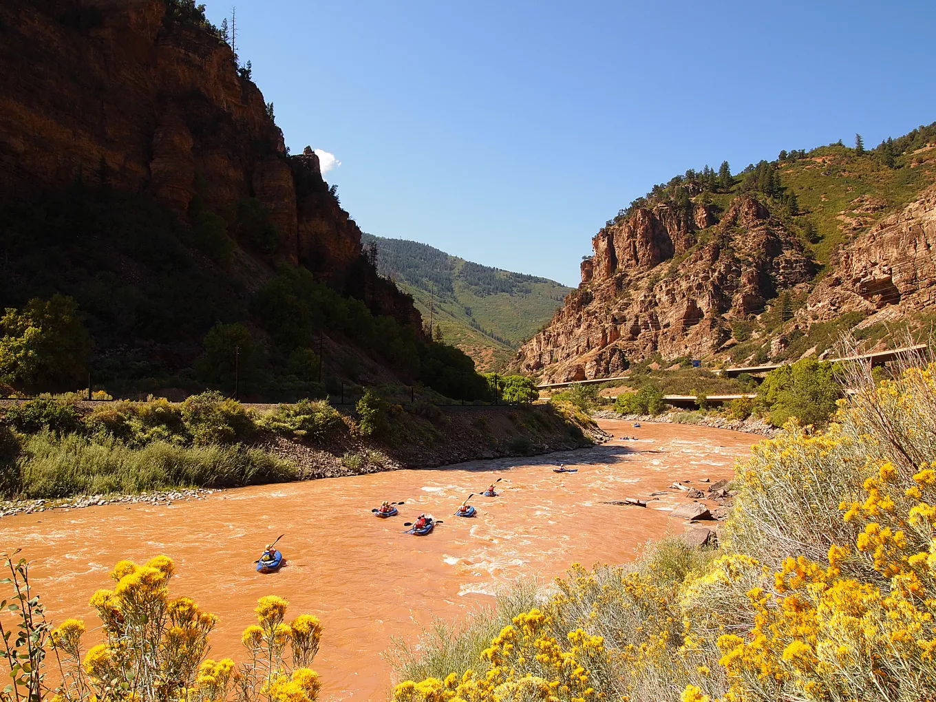

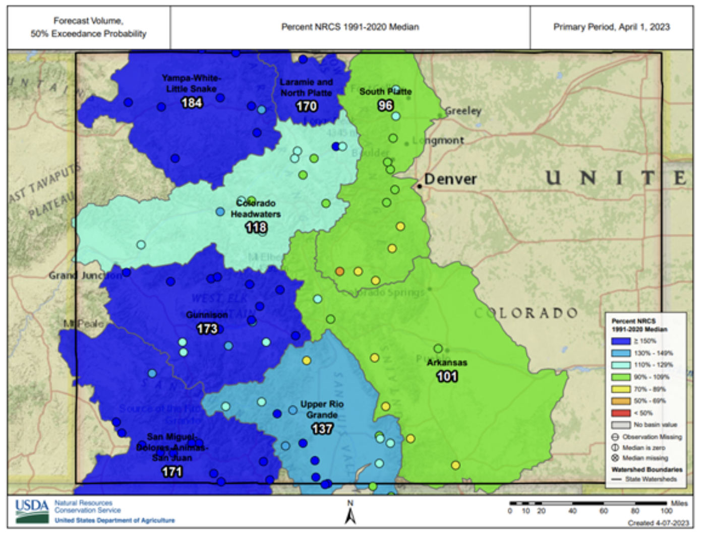

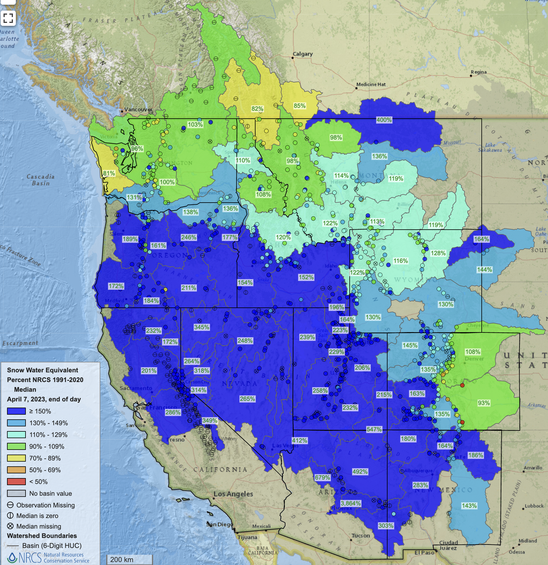
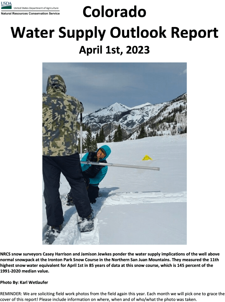
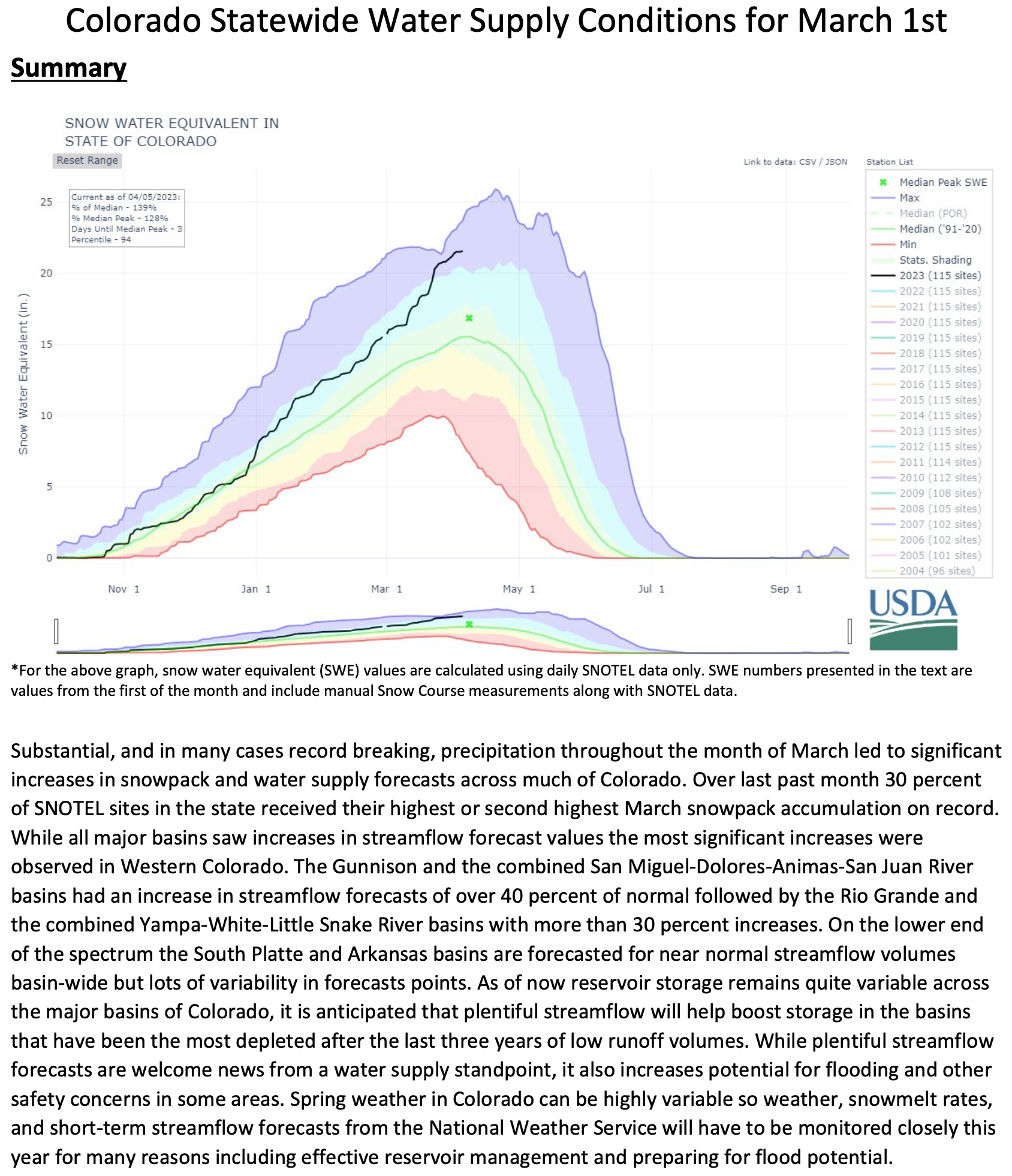
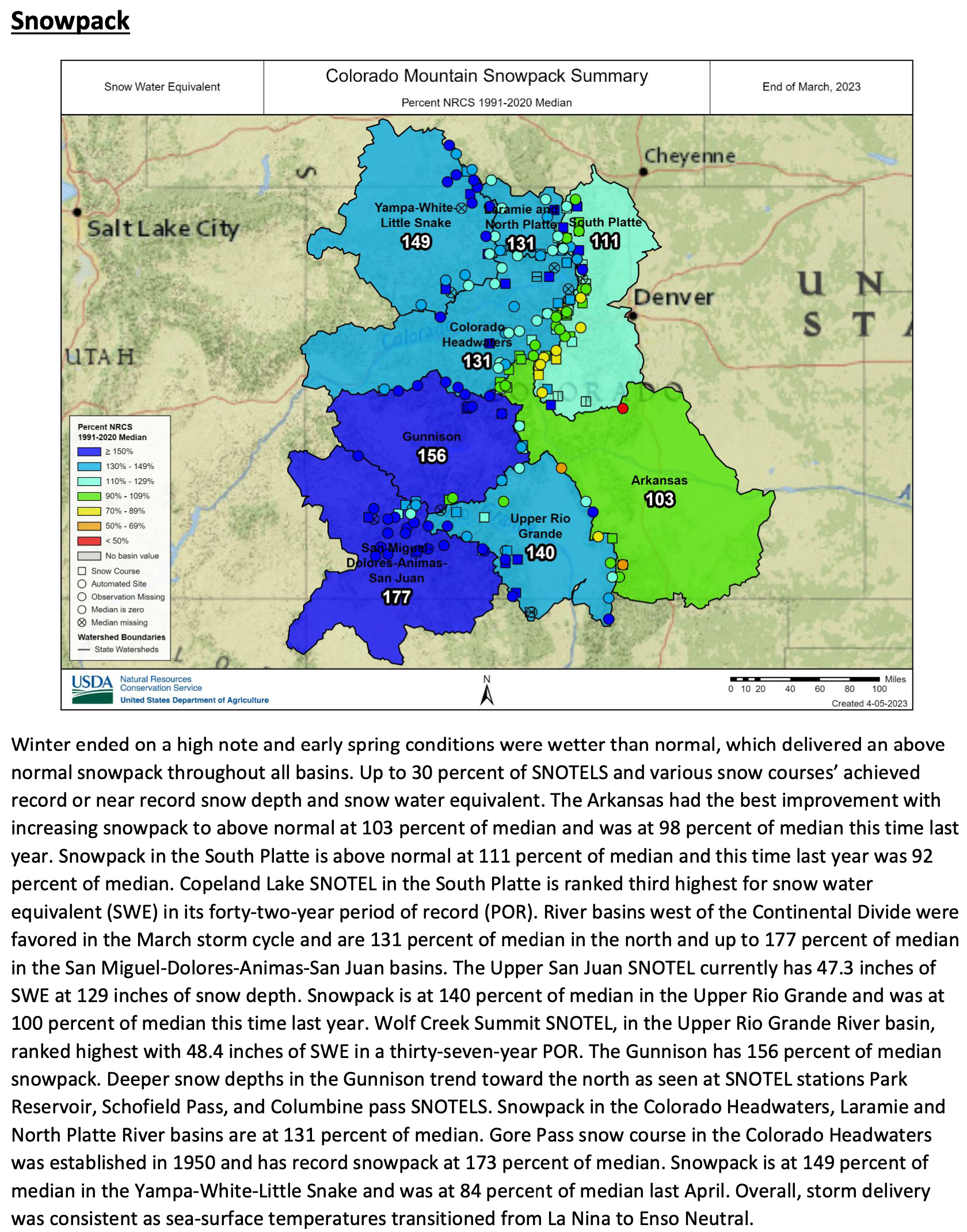
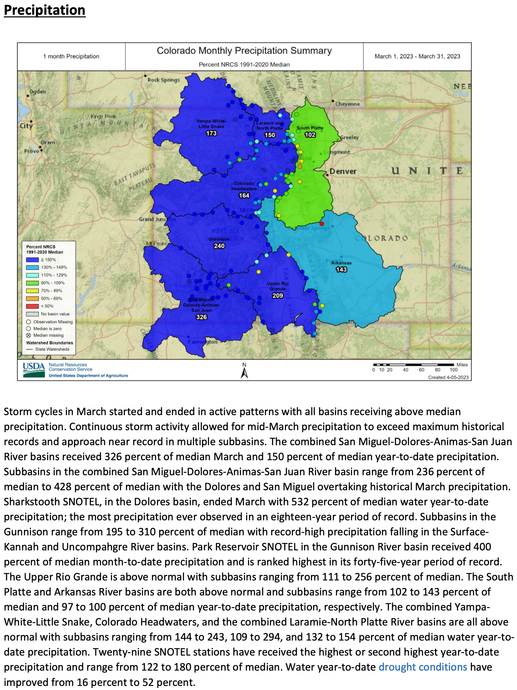
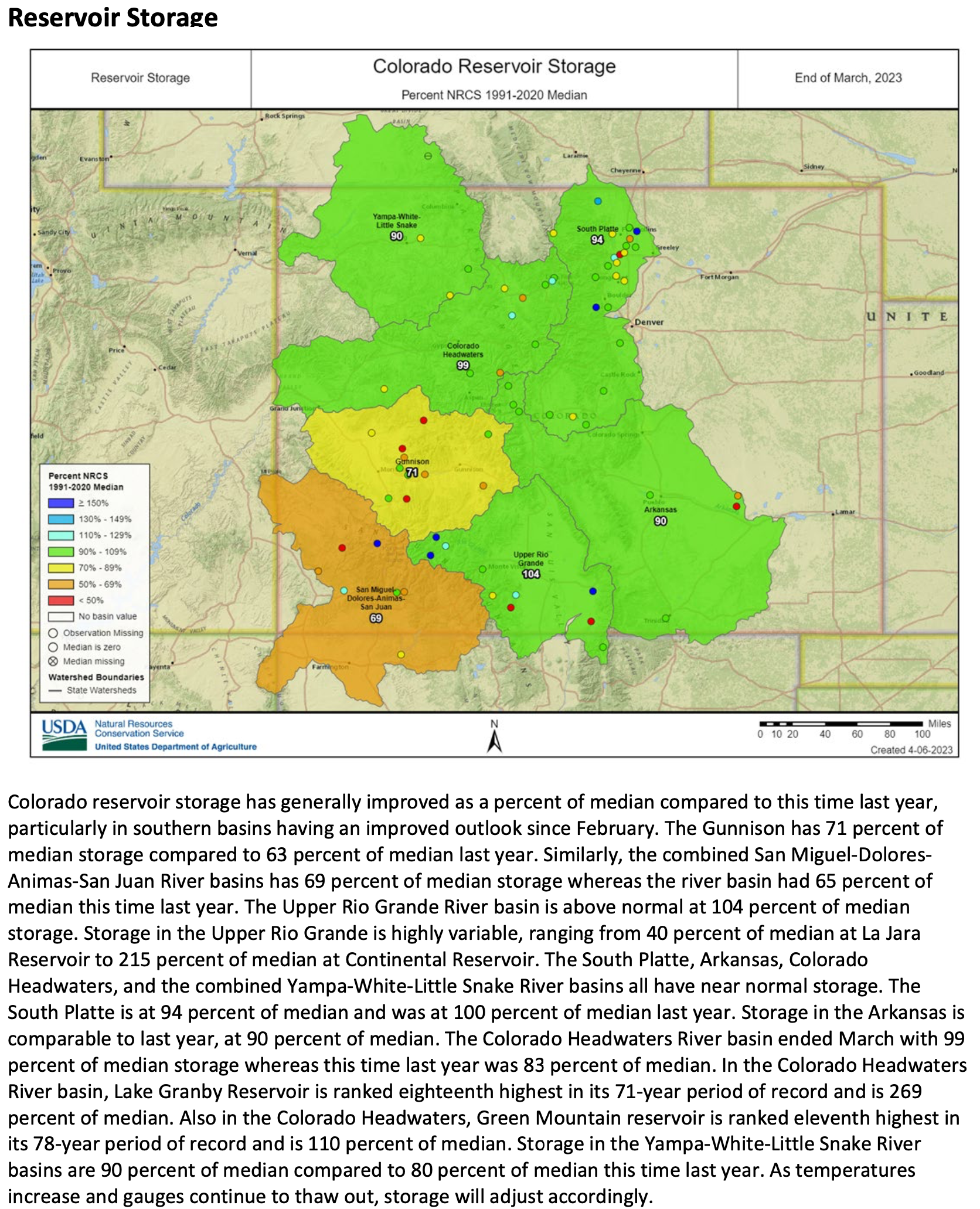
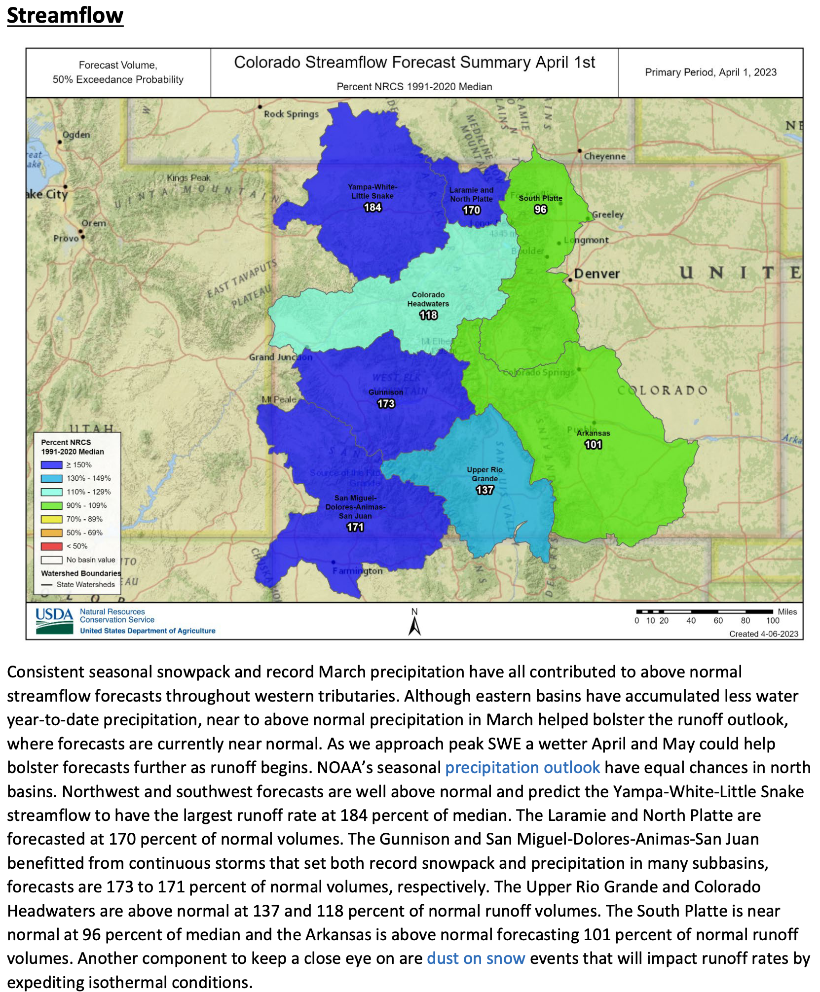


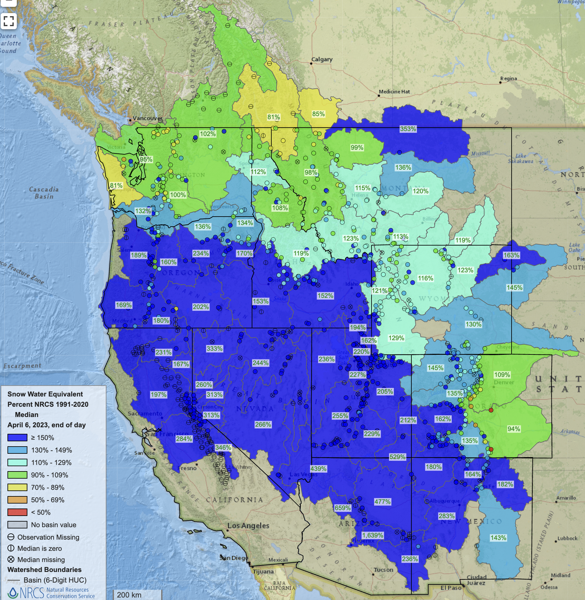

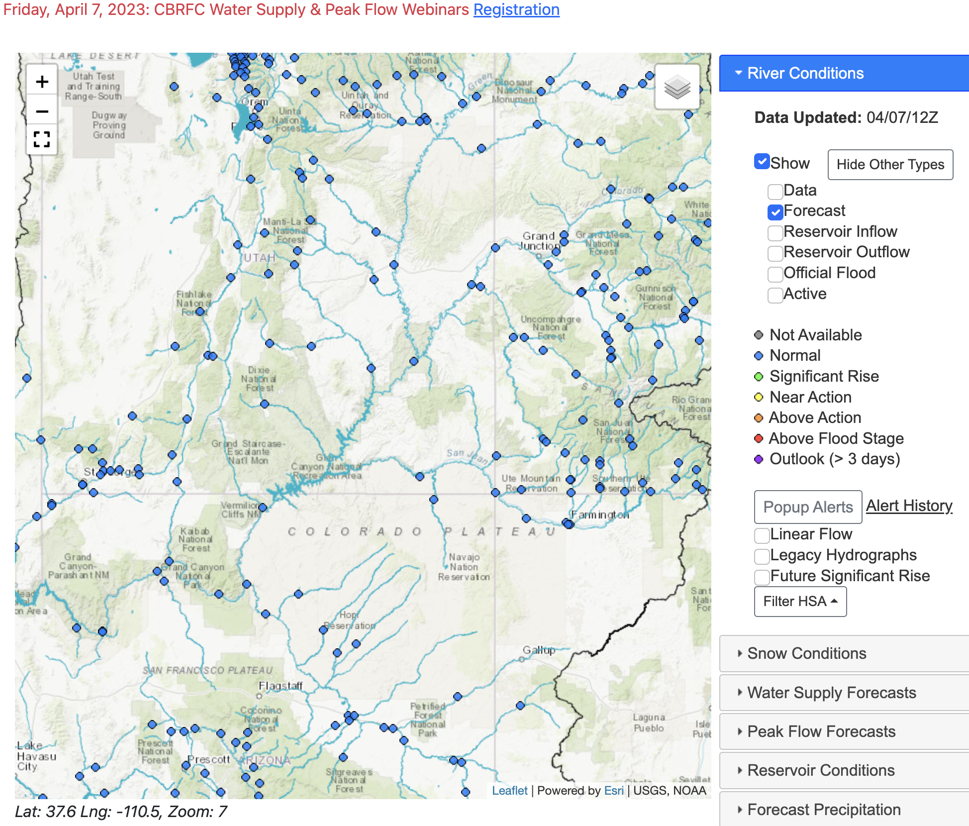
