
Chad Hecht, University of California, San Diego
To get a sense of the enormous amount of water atmospheric rivers dumped on the Western U.S. this year and the magnitude of the flood risk ahead, take a look at California’s Central Valley, where about a quarter of the nation’s food is grown.
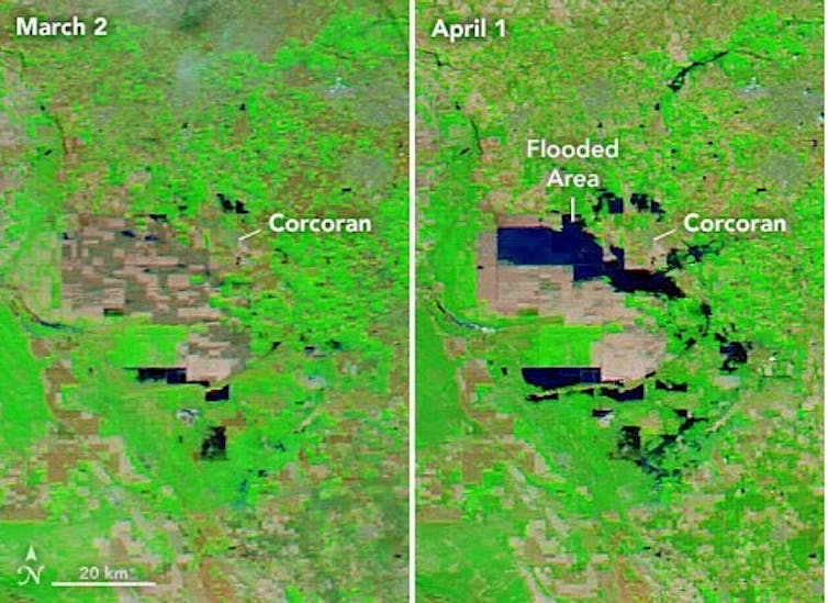
This region was once home to the largest freshwater lake west of the Rockies. But the rivers that fed Tulare Lake were dammed and diverted long ago, leaving it nearly dry by 1920. Farmers have been growing food on the fertile lake bed for decades.
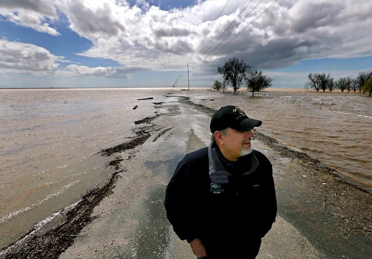
This year, however, Tulare Lake is remerging. Runoff and snowmelt from the Sierra Nevada have overwhelmed waterways and flooded farms and orchards. After similar storms in 1983, the lake covered more than 100 square miles, and scientists say this year’s precipitation is looking a lot like 1983. Communities there and across the West are preparing for flooding and mudslide disasters as record snow begins to melt.
We asked Chad Hecht, a meteorologist with the Center for Western Weather and Water Extremes at the University of California San Diego’s Scripps Institution of Oceanography, how 2023’s storms compare to past extremes and what to expect in the future.
How extreme were this year’s atmospheric rivers?
California averages about 44 atmospheric rivers a year, but typically, only about six of them are strong storms that contribute most of the annual precipitation total and cause the kind of flooding we’ve seen this year.
This year, in a three-week window from about Dec. 27, 2022, to Jan. 17, 2023, we saw nine atmospheric rivers make landfall, five of them categorized as strong or greater magnitude. That’s how active it’s been, and that was only the beginning.
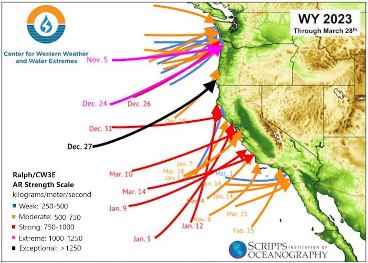
In all, the state experienced 31 atmospheric rivers through the end of March: one extreme, six strong, 13 moderate and 11 weak. And other storms in between gave the Southern Sierra one of its wettest Marches on record.
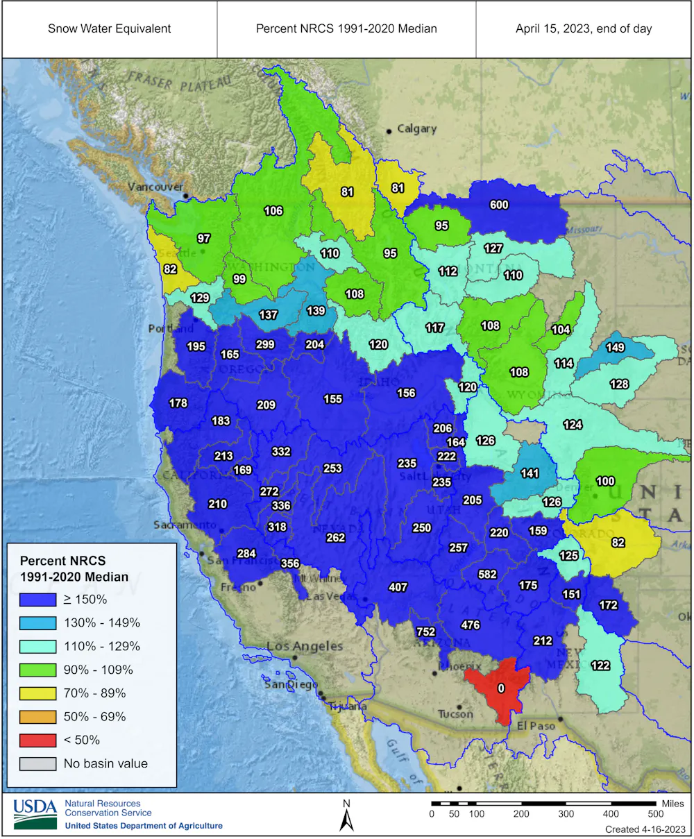
These storms don’t just affect California. Their precipitation has pushed the snow-water equivalent levels well above average across much of the West, including in Oregon, Nevada, Utah, Idaho and the mountains of western Colorado, Arizona and New Mexico.
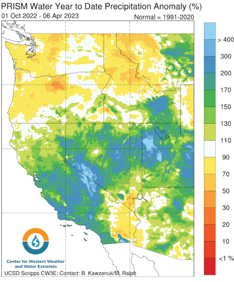
In terms of records, the big numbers this year were in California’s Southern Sierra Nevada. The region has had 11 moderate atmospheric rivers – double the average of 5.5 – and an additional four strong ones.
Overall, California has about double its normal snowpack, and some locations have experienced more than double the number of strong atmospheric rivers it typically sees. The result is that Northern Sierra snow water content is 197% of normal. The central region is 238% of normal, and the Southern Sierra is 296% of normal.
What risks does all that snow in the mountains create?
There is a lot of snow in the Sierra Nevada, and it is going to come off the mountains at some point. It’s possible we are going to be looking at snowmelt into late June or July in California, and that’s far into summer for here.
Flooding is certainly a possibility. The closest year for comparison in terms of the amount of snow would be 1983, when the average statewide snow water content was 60.3 inches in May. That was a rough year, with flooding and mudslides in several parts of the West and extensive crop damage.
This year, portions of the Southern Sierra Nevada have passed 1983’s levels, and Tulare Lake is filling up again for the first time in decades. Tulare Lake is an indication of just how extreme this year has been, and the risk is rising as the snow melts.
The transition from extreme drought in 2022 to record snow was fast. Is that normal?
California and some other parts of the West are known for weather whiplash. We frequently go from too dry to too wet.
2019 was another above-average year in terms of precipitation in California, but after that we saw three straight years of drought. We went from 13 strong or greater magnitude atmospheric rivers in 2017 to just three in 2020 and 2021, combined.
California relies on these storms for about half its water supply, but if the West gets too many atmospheric rivers back to back, that starts to have harmful impacts, like the heavy snowpack that collapsed roofs in the mountains this year, and flash flooding and landslides. These successive storms are typically referred to as atmospheric river families and can result in exacerbated hydrologic impacts by quickly saturating soils and not allowing rivers and streams to recede back to base flow between storms.
Are atmospheric rivers becoming more intense with a warming climate?
There’s been a lot of research on the impact of temperature because of how reliant California is on these storms for its water supply.
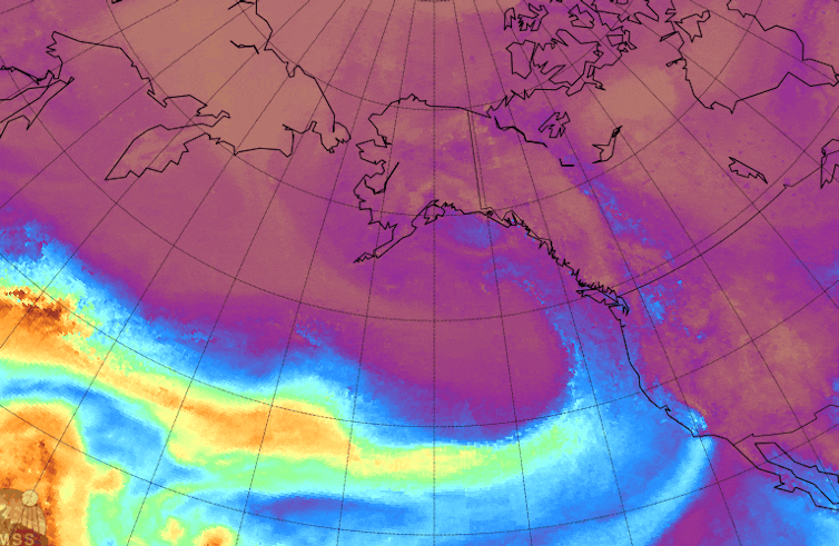
Atmospheric rivers are long, narrow corridors of water vapor in the sky that typically start in the tropics as water evaporates and is pulled poleward by atmospheric circulations. They carry a lot of moisture – on average, their water vapor transport is more than twice the flow of the Amazon River. When they reach land, mountains force the air to rise, which wrings out some of that moisture.
In a warming climate, the warmer air can hold more moisture. That can increase the capacity of atmospheric rivers, with more water vapor resulting in stronger storms.
Research by some of my colleagues at Scripps Institution of Oceanography also suggests that California will see fewer storms that aren’t atmospheric rivers. But the state will likely see more intense atmospheric rivers as temperatures rise. California will be even more reliant on these atmospheric rivers for its snow, which will result in drier dries and wetter wets.
So, we’re likely to see this whiplash continue, but to a more extreme level, with longer periods of dry weather when we’re not getting these storms. But when we do get these storms, they have the potential to be more extreme and then result in more flooding.
In the more immediate future, we’re likely headed into an El Niño this year, with warm tropical Pacific waters that shift weather patterns around the world. Typically, El Niño conditions are associated with more atmospheric river activity, especially in Central and Southern California.
So, we may see another wet year like this again in 2024.
Chad Hecht, Research and Operations Meteorologist, Center for Western Weather and Water Extremes, University of California, San Diego
This article is republished from The Conversation under a Creative Commons license. Read the original article.