Happy Arbor Day

Click the link to read the article on the Grist website (Jake Bittle & Daniel Penner):
California and Arizona are currently fighting each other over water from the Colorado River. But this isn’t new — it’s actually been going on for over 100 years. At one point, the states literally went to war about it. The problem comes down to some really bad math from 1922.
To some extent, the crisis can be blamed on climate change. The West is in the middle of a once-in-a-millennium drought. As temperatures rise, the snow pack that feeds the river has gotten much thinner, and the river’s main reservoirs have all but dried up.
But that’s only part of the story: The United States has also been overusing the Colorado for more than a century thanks to a byzantine set of flawed laws and lawsuits known as the “Law of the River.” This legal tangle not only has been over-allocating the river, it also has been driving conflict in the region, especially between the two biggest users, California and Arizona, which are both trying to secure as much water as they can. And now, as a massive drought grips the region, the law of the river has reached a breaking point.
The Colorado River begins in the Rocky Mountains and winds its way southwest, twisting through the Grand Canyon and entering the Pacific at Baja California. In the late 19th century, as white settlers arrived in the West, they started diverting water from the mighty river to irrigate their crops, funneling it through dirt canals. For a little while, this worked really well. The canals made an industrial farming mecca out of desert that early colonial settlers viewed as “worthless.”
Even back then, the biggest water users were Arizona and California, which took so much water that they started to drain the river farther upstream, literally drying it out. According to American legal precedent, whoever uses a body of water first usually has the strongest rights to it. But other states soon cried foul: California was growing much faster than they were, and they believed it wasn’t fair that the Golden State should suck up all the water before they got a chance to develop.

In 1922, the states came to a solution — kind of. At the suggestion of a newly appointed cabinet secretary named Herbert Hoover, the states agreed to split the river into two sections, drawing an arbitrary line halfway along its length at a spot called Lee Ferry. The states on the “upper” part of the river — Colorado, Utah, Wyoming, and New Mexico — agreed to send the states on the “lower” end of the river — Arizona, California, and Nevada — what they thought was half the river’s overall flow, 7.5 million acre-feet of water each year. (An acre-foot is enough to cover an acre of land in a foot of water, about enough to supply two homes for a year.)
This agreement was supposed to prevent any one state from drying up the river before the other states could use it. The Upper Basin states got half and the Lower Basin states got half. Simple.
But there were some serious flaws to this plan.
First, the Law of the River overestimated how much water flowed through the river in the first place. The states’ numbers were based on primitive data from stream gauges placed at arbitrary points on the waterway, and they took samples during an unusually wet decade, leading to a very optimistic estimate of the river’s size. The river would only average about 14 million acre-feet annually, but the agreement handed out 15 million to the seven states.
While the states weren’t able to immediately use all this water, it set in motion the underlying problem today: The states have the legal right to use more water than actually exists in the river.
And you’ll notice that the Colorado River doesn’t end in the U.S. — It ends in Mexico. Initially, the Law of the River just straight-up ignored that fact. Decades later, Mexico was squeezed into the agreement and promised 1.5 million acre-feet, further straining the already over-allocated river.
On top of all of this, Indigenous tribes that had depended on the river for centuries were now forced to compete with states for their share of water, leading to these drawn-out lawsuits that took decades to resolve.
But in the short-term, Arizona and California struck it rich — they were promised the largest share of Colorado River water and should have been primed for growth. For Arizona, though, there was a catch: The state couldn’t put their water to use.
The state’s biggest population centers in Phoenix and Tucson were hundreds of miles away from the river itself, and it would take a 300-mile canal to bring the water across the desert — something the state couldn’t afford to build on its own. Larger and wealthier California was able to build all the canals and pumps it needed to divert river water to farms and cities. This allowed it to gulp up both its share and the extra Lower Basin water that Arizona couldn’t access. California’s powerful congressional delegation lobbied to stop Congress from approving Arizona’s canal project, as the state wanted to keep the Colorado River to itself.
Arizona was furious. And so, in 1934, Arizona and California went to war — literally. Arizona tried to block California from building new dams to take more water from the river, using “military” force when necessary.
Arizona sent troops from its National Guard to stop California from building the Parker Dam. It delayed construction, but not for very long because their boat got tangled up in some electrical wire and had to be rescued.
For the next 30 years, Arizona and California fought about whether Arizona should be able to build that canal. They also sued each other before the Supreme Court no fewer than 10 times, including one 1963 case that set the record for the longest oral arguments in the history of the modern court, taking 16 hours over four days and involving 106 witnesses.
That 1963 case also made some pretty big assumptions: Even though the states now knew that the initial estimates were too high, the court-appointed expert said he was “morally certain that neither in my lifetime, nor in your lifetime, nor the lifetime of your children and great-grandchildren will there be an inadequate supply of water” from the river for California’s cities.
A few years after that court case, in 1968, Arizona finally struck a fateful bargain to ensure it could claim its share of the river. California gave up its anti-canal campaign and the federal government agreed to pay for the construction of the 300-mile project that would bring Colorado River water across the desert to Phoenix. This move helped save Arizona’s cotton-farming industry and enabled Phoenix to eventually grow into the fifth-largest city in the country. It seemed like a success — Arizona was flourishing!
But in exchange for the canal, the state made a fateful concession: If the reservoirs at Lake Powell and Lake Mead were to run low, Arizona, and not California, would be the first state to make cuts. It was a decision the state’s leaders would come to regret.
In the early 2000s, as a massive drought gripped the Southwest, water levels in the river’s two key reservoirs dropped. Now that both Arizona and California were fully using their shares of the river, combined with the other states’ usage, there suddenly wasn’t enough melting snow to fill the reservoirs back up. A shrinking Colorado River couldn’t keep up with a century of rising demand.
Today, more than 20 years into the drought, Arizona has had to bear the biggest burden. Thanks to its earlier compromise decades earlier, the state had “junior water rights,” meaning it took the first cuts as part of the drought plan. In 2021, those cuts officially went into effect, drying out cotton and alfalfa fields across the central part of the state until much of the landscape turned brown. Still, those cuts haven’t been enough.
This century, the river is only averaging around 12.4 million acre-feet. The Upper Basin states technically have the rights to 7.5 million acre-feet, but they only use about half of that. In the Lower Basin, meanwhile, Arizona and California are gobbling up around three and four million acre-feet respectively. In total, this overdraft has caused reservoir levels to fall. It’s going to take a lot more than a few rainy seasons to fix this problem.
So, for the first time since the Law of the River was written, the federal government has had to step in, ordering the states to reduce total water usage on the river, this time by nearly a third. That’s a jaw-dropping demand!
These new cuts will extend to Arizona, California, and beyond, drying up thousands more acres of farmland, not to mention cities around Phoenix and Los Angeles that rely on the Colorado River. These new restrictions will also put increased pressure on the many tribes that have used the Colorado River for centuries: Tribes that have water rights will be pressured to sell or lease them to other water users, and tribes without recognized water rights will face increased opposition as they try to secure their share.
And Arizona and California are still fighting over who should bear the biggest burden of these new cuts. California has insisted that the Law of the River requires Arizona to shoulder the pain, and from a legal standpoint they may be right. But Arizona says further cuts would be disastrous for the state’s economy, and the other five river states are taking its side.
Either way, the painful cuts have to come from somewhere, because the Law of the River was built on math that doesn’t add up.
Click the link to read the article on the InkStain website (John Fleck):
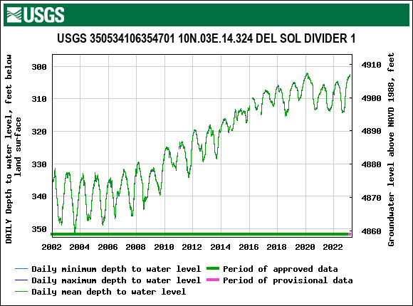
After a couple of years of setback, the aquifer underneath the University of New Mexico neighorhood is rising again.
The spring measurement shows that it’s risen three feet since last year around this time.
The annual variability (the graph’s ups and downs) are the result of regional groundwater pumping for our municipal supply – more pumping in summer, less in winter. It’s fun to see how the regional aquifer responds, like a big bathtub filled with gravel and sand.
The long term upward trend, beginning in 2006-08-ish, is the result of a) significant conservation reducing overall municipal demand, and b) a shift to imported surface water via the San Juan-Chama Project.
The dip in 2020-21 is because we had a badass drought that required us to shift a significant amount of our supply off of that imported surface water and increase our groundwater pumping. The aquifer here dropped five feet from 2021 to 2022, for example.
This is a great example of polycentric governance. Absent a top-down (read state government) regulatory framework, our local water utility, the Albuquerque Bernalillo County Water Utility Authority, has taken it upon itself to serve as a sort of de facto manager of this aquifer – not because it’s our legal responsibility (though there are some legal entanglements with the state water rights regime) but because we, as a community, concluded a number of years ago that it was in our best interest to take care of the aquifer. (Disclosure: I serve on the ABCWUA Technical Customer Advisory Committee.)
This is just one measurement point, because one of my intellectual tricks is to pick a gage (usually a river gage, but also this one for groundwater) and pay attention to it. This is tricky, because what if it’s not representative? But there’s been a lot of work by the USGS and others looking at our groundwater network as a whole, and the trend holds in general in the big, deep aquifer beneath Albuquerque. (One of my other favorite wells, City #2, which goes back to the 1950s, is up 6 inches year-over-year. Another favorite is City #3, which is located at the heart of one of the thick geographies I’m writing about for the new book, and is really close to one of the ABCWUA well fields, which tells another fabulous story as a result, but I’ve got a chapter to finish today so I’ll leave that for another day.)
Click the link to read the article on the Colorado Public Radio website (Tom Hesse). Here’s an excerpt:
The Uinta Basin Railway project would build around 80 miles of train tracks connecting oil production to America’s rail network. That would allow producers to ship crude oil on trains through Colorado to refineries elsewhere in the country. The U.S. Surface Transportation Board and the United States Department of Agriculture have given the project the go-ahead, prompting a letter from U.S. Sen. Michael Bennet and U.S. Rep. Joe Neguse criticizing the federal review of the project.
“First, it focused solely on the Project’s risks in Utah with no evaluation of its potential harm to Colorado, including the risk of a derailment and oil spill in the headwaters of the River”, the March 28 letter read. “Second, this review also failed to include any analysis of the Project’s effect on greenhouse gas emissions and climate change. We urge you to conduct a supplemental review to fully account for these potential harms.”
[…]
While opponents of the project note the catastrophic consequences of a major spill into the Colorado River, those working to get the rail built say the likelihood of contamination is overstated. That’s because the crude oil is high in paraffin wax content, which means it turns to a solid below about 110 degrees Fahrenheit, according to Keith Heaton, director of the Seven County Infrastructure Coalition in Utah that’s advocating for the rail.
“The only times that the crude is a liquid is when it is heated and loaded into the railcars and when it is reheated back above the 110 degrees pour point, so it can be unloaded and processed,” Heaton said in an email. “In short, Uinta Basin waxy crude is transported as a solid, not a flammable or hazardous liquid. It does not present an environmental concern if there were a derailment.”
Luis Zerpa, associate professor at the Colorado School of Mines Petroleum Engineering Department, says those waxy properties have historically been seen as a barrier to shipping that type of oil.
“So that’s the problem with the waxy oils is they have a lot of these paraffinic molecules or components … that create the petroleum jelly or the candles, that when the temperature decreases it will solidify,” Zerpa said, adding that those properties make it very difficult to move the oil via a pipeline.
However, what makes the crude oil difficult to ship, should make it easy to clean up — at least in the event of a spill. Heaton says the studies done on the rail estimate less than one derailment a year and, if there was an accident, clean-up would be like “picking up a bunch of candles.”
“This is the safest and most ecological way to transport material. And the material, the waxy crude that we have in the basin, is a much sought after and superior product in ways when it comes to environmental concerns and those types of things. I guess you could characterize it as a little bit perplexing from time to time that there’s so much opposition to this,” Heaton said in a phone call with CPR News.
Click the link to read the article on the Steamboat Pilot & Today website (Suzie Romig). Here’s an excerpt:
In the first official scorecard of Yampa River system health, the middle section of the Yampa earned an overall score of B. That B means the middle Yampa River from Pump Station boat launch east of Hayden to South Beach about 2 miles south of Craig is a “highly functional river where some stressors are present but in general it remains largely resilient to disturbances and may rely on limited management,” said Jenny Frithsen, environmental program manager with Friends of the Yampa, which is managing the scorecard project. Within the overall score of B as part of the Yampa River Scorecard Project, the middle Yampa earns an A for dissolved oxygen, PH levels and metals in the water, “the only ecological indicators that got an A,” Frithsen reported.
The first results of the long-term scorecard project will be released fully in early May with information available at YampaScorecard.org. Data collection started in the middle Yampa in summer 2022, and the overall project will include five river sections.
During summer 2023, data collection will focus on the stretch starting from Chuck Lewis State Wildlife Area to the Pump Station boat launch.
The river scorecard is derived via approximately 45 different indicators in and around the Yampa River that fall under three main areas: ecological health and function, river uses and management, and people and community benefits.
“By seeing what areas are a C, D or F, we can now focus on action and how to improve these numbers,” said Lindsey Marlow, executive director for Friends of the Yampa. “We now have a template to start conversations with people in this basin about the health of the river and its ecosystem services.”
Marlow said another key finding that stands out is riverscape connectivity, or a measurement of the ease in which a river can move around such as a connected flood plain and river channel.
“There are areas that score so well at 95% and others that need help at 65%, and now we get to embark on the exciting task of figuring out how to improve floodplain connectivity,” Marlow said.
Click the link to read the article on The Salt Lake Tribune website (Brian Maffly). Here’s an excerpt:
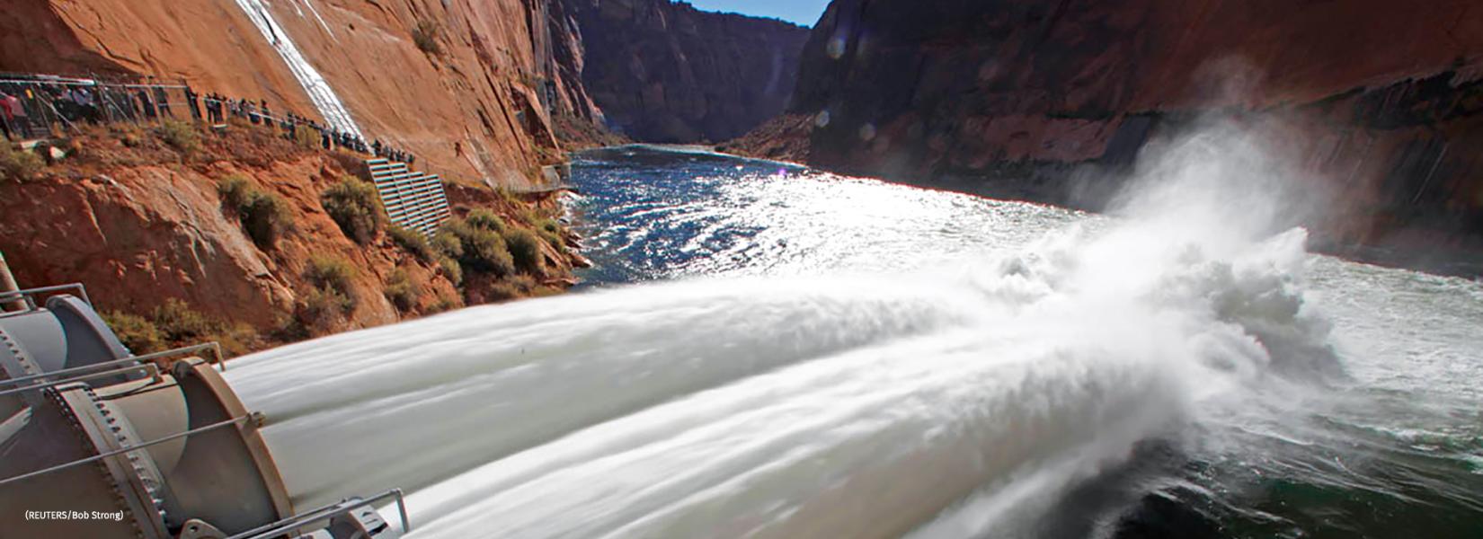
Under a plan approved in 2012, the bureau had been conducting high-flow experiments almost annually until 2018. Since then, a string of dry years and excessive water use have depressed levels of Lake Powell, which today is only 23% full, sitting at 3,525 feet above sea level. That is about to change drastically in the coming weeks as the upper Colorado basin’s snowpacks, which are 157% of normal, melt and flow into Powell and upstream reservoirs. The lake level is projected to climb by more than 50 feet this year, according to Bart Leeflang, the CRAU’s hydrologist…What happened in those months was a big snowpack getting bigger, holding twice as much water in some places as normal for this time of year, coming after back-to-back years of skimpy snow accumulations. According to Bureau projections, the lake level is expected to peak in July at 3,591 feet, 71 feet above its historic low recorded April 13…
At 3,576 feet, Powell would still remain 124 feet below full pool, holding just 39% of its capacity. This year’s bounty doesn’t put an end to the crisis on the Colorado River, which supplies 40 million Westerners and irrigates 5 million acres, but it buys Utah and the six other basin states time to find a lasting solution to the river’s chronic deficits. It may even rescue boating this summer at Lake Powell, among Utah’s top recreation draws, where most of the ramps are high and dry and marinas are unusable…This year, the Bureau plans to increase releases from Glen Canyon Dam to 9.5 acre-feet to bring up the level of Powell’s downstream big sister, Lake Mead. That’s the maximum amount released under the dam’s operating guidelines and 2 million more than what is typically released in a year. The big spike in Lake Powell’s projected “regulated” inflows, expected to total 13.2 million acre-feet, has enabled federal river managers to resume the high-flow experiments.
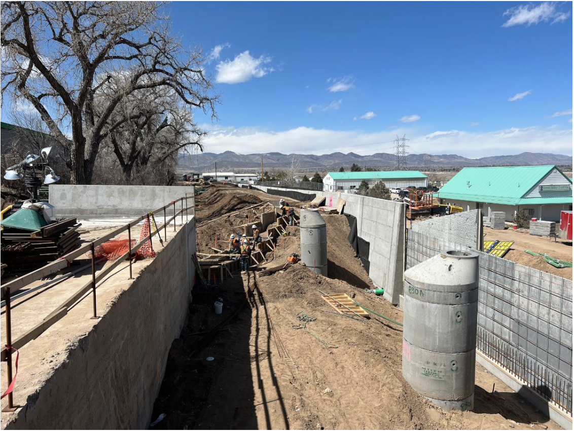
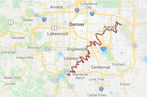
From the latest Highline Canal Conservancy Newsletter:
Construction of an underpass for the High Line Canal trail at US 85 (Santa Fe Drive) is underway! The underpass is a component of a CDOT & Douglas County project to widen US 85 from Highlands Ranch Parkway to C-470. A trail detour will be in place into 2024.
Click the link to go to the Douglas County Project webpage.