

Click on a thumbnail graphic to view a gallery of drought data from the US Drought Monitor website.

Click the link to go to the US Drought Monitor website. Here’s an excerpt:
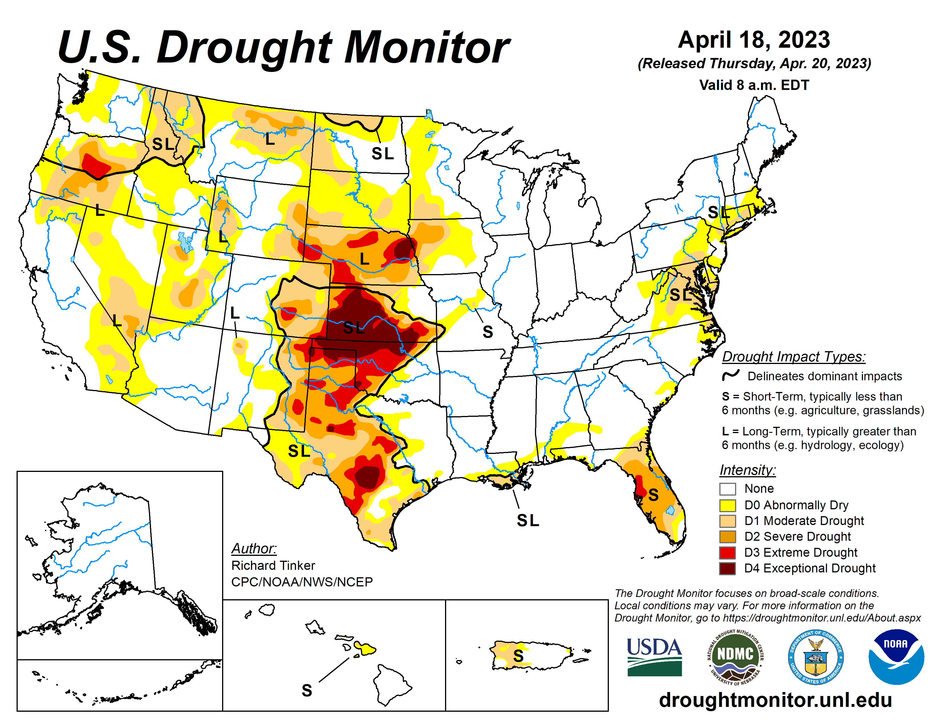
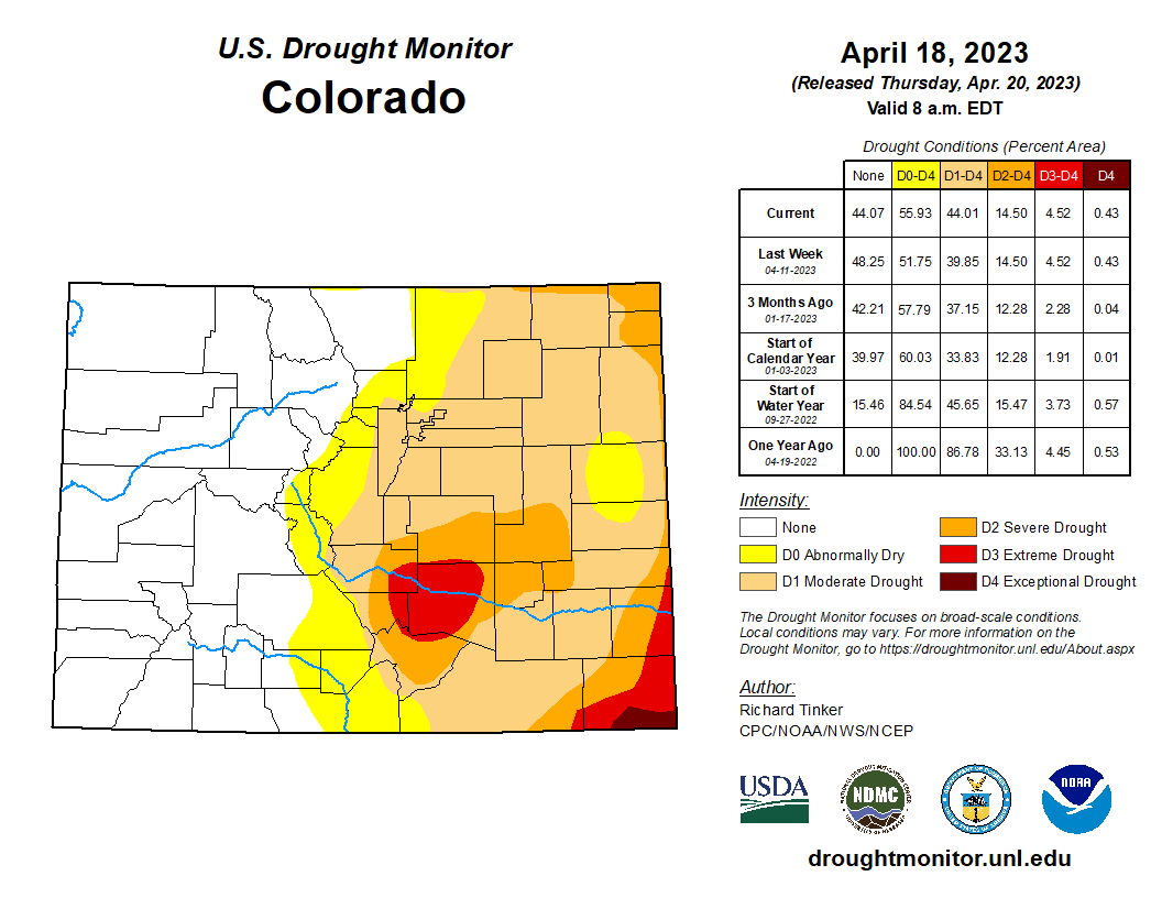
This Week’s Drought Summary
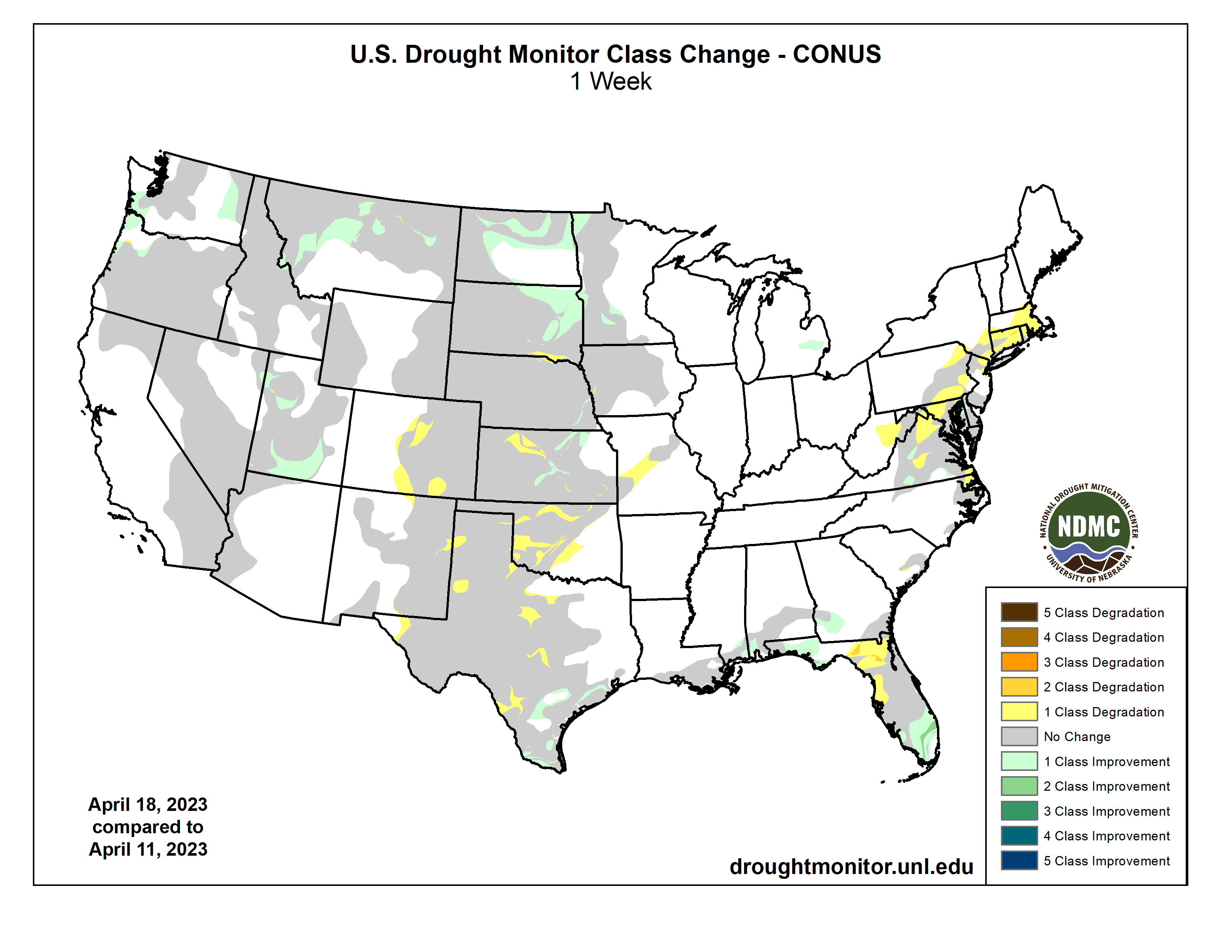
While most of the country received light precipitation at best last week, large totals fell on a few areas. Over 1.5 inches fell on the south half of Mississippi and the central Gulf Coast Region from Louisiana through the Florida Panhandle, with totals of 4 to 6 inches dousing parts of southeast Mississippi, southern Alabama, and coastal Louisiana. Totals also exceeded 1.5 inches in parts of the central and southern Florida Peninsula, with amounts reaching 6 inches in parts of the southern Peninsula and along the eastern coastline. A few swaths in the Upper Midwest recorded 1.5 to 3.0 inches, specifically from central to northeastern Minnesota, across much of Wisconsin and the western Upper Peninsula of Michigan, and from northeast Kansas and southeast Nebraska into southwest Iowa. Beneficial moderate to heavy precipitation also fell on parts of the Northern Rockies, northern Intermountain West, and Pacific Northwest. Most of the Nation west of the Appalachians, however, saw light precipitation at best. Precipitation was a little more widespread over the Appalachians and along the Eastern Seaboard, but most areas received subnormal amounts with only isolated patches reporting moderate to heavy precipitation.
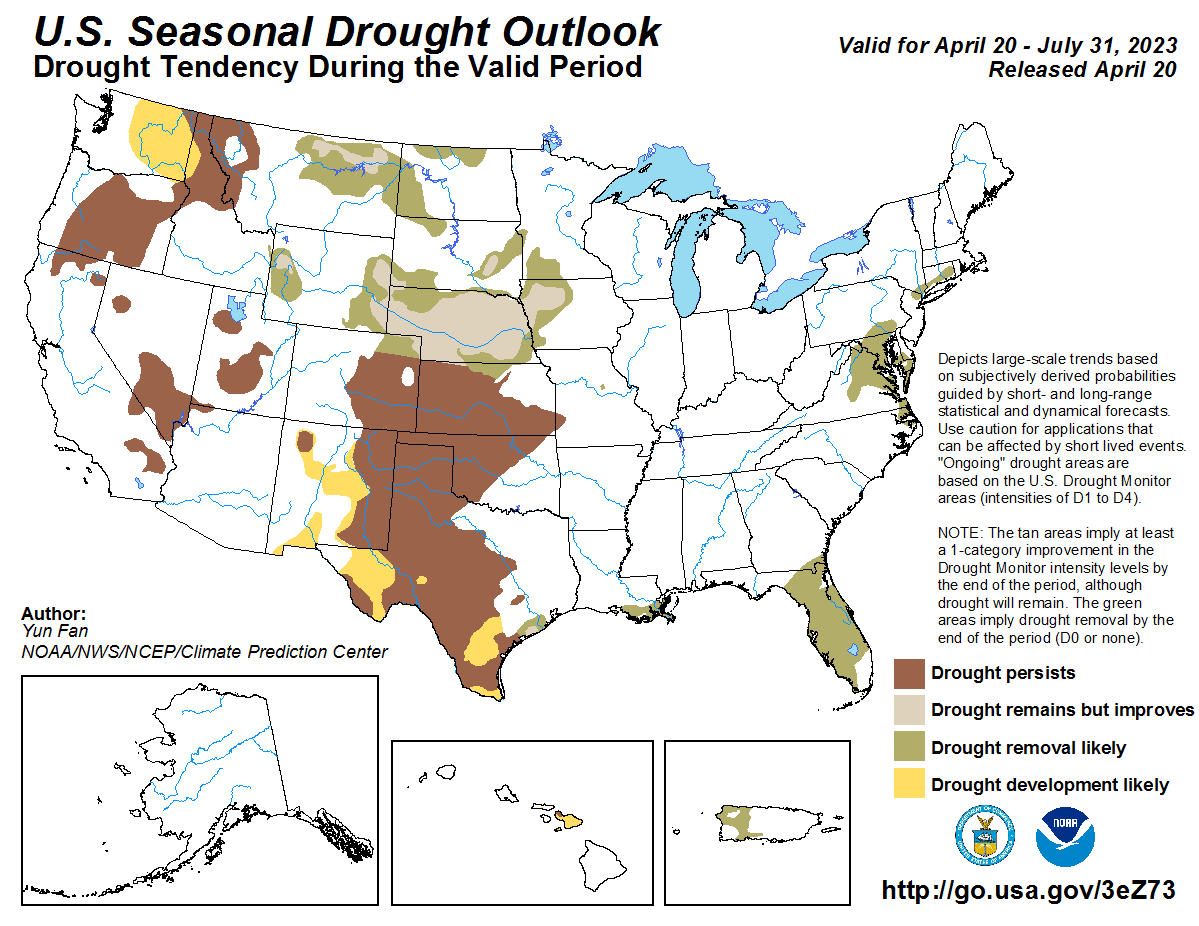
On the whole, some areas of dryness and drought in the Southeast, the Upper Midwest, the northern Rockies, and the Pacific Northwest felt improvement over the course of the week. In addition, rapid snowmelt quickly recharged soil moisture and boosted streamflows from the Dakotas to the western Great Lakes Region, prompting improvement in some areas. But most locations experiencing abnormal dryness or drought saw conditions persist or intensify, with deterioration to D3 or D4 (Extreme to Exceptional Drought) noted in some areas across the western Florida Peninsula and the southern half of the Great Plains…
High Plains
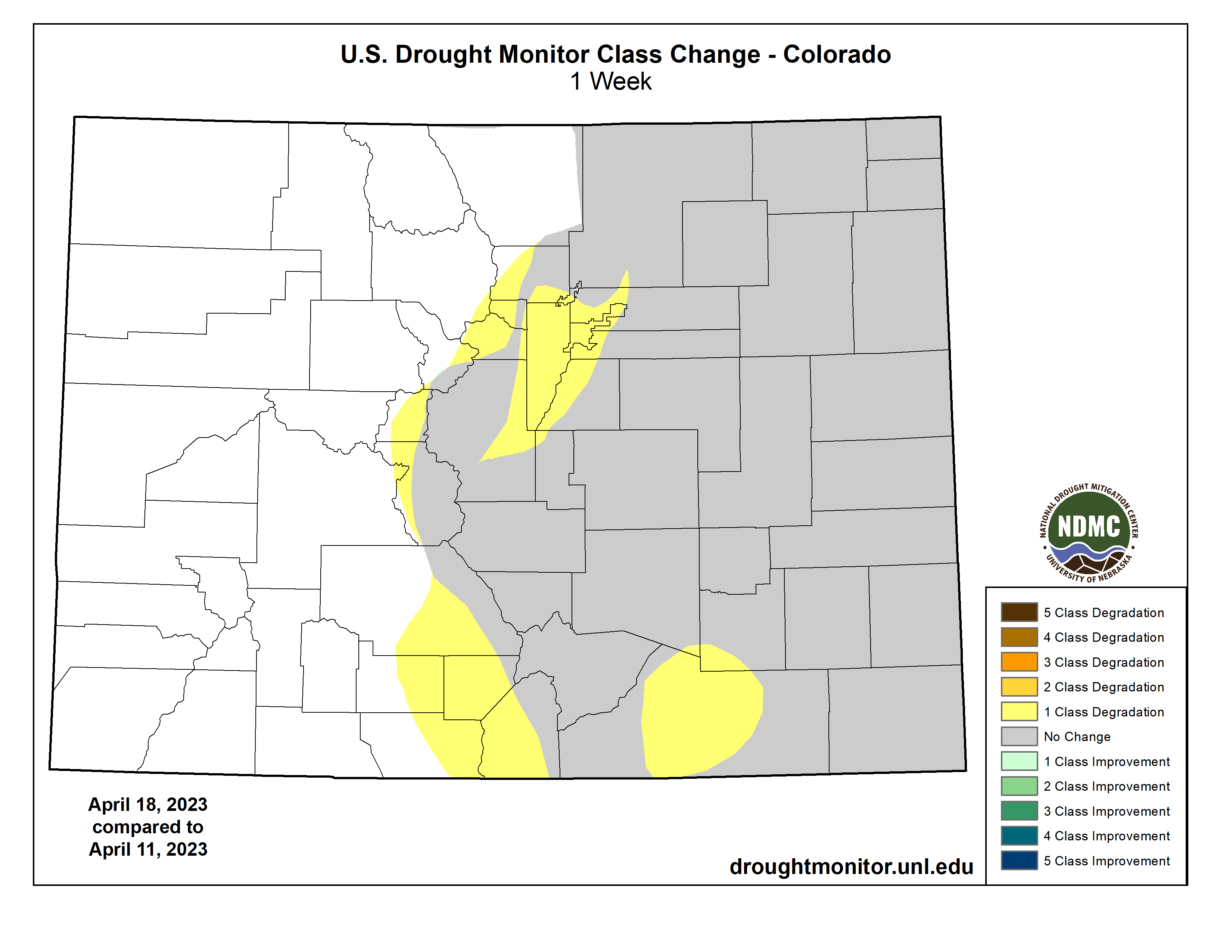
A majority of Kansas and portions of Nebraska remained entrenched in D3 to D4 (extreme to exceptional drought). Some D3 and D4 expansion took place there, but a few small areas saw limited improvement from localized rainfall. Some areas of deterioration were also noted across D0 to D2 areas in central and eastern Colorado, but most of the state was unchanged from last week, as was Wyoming.
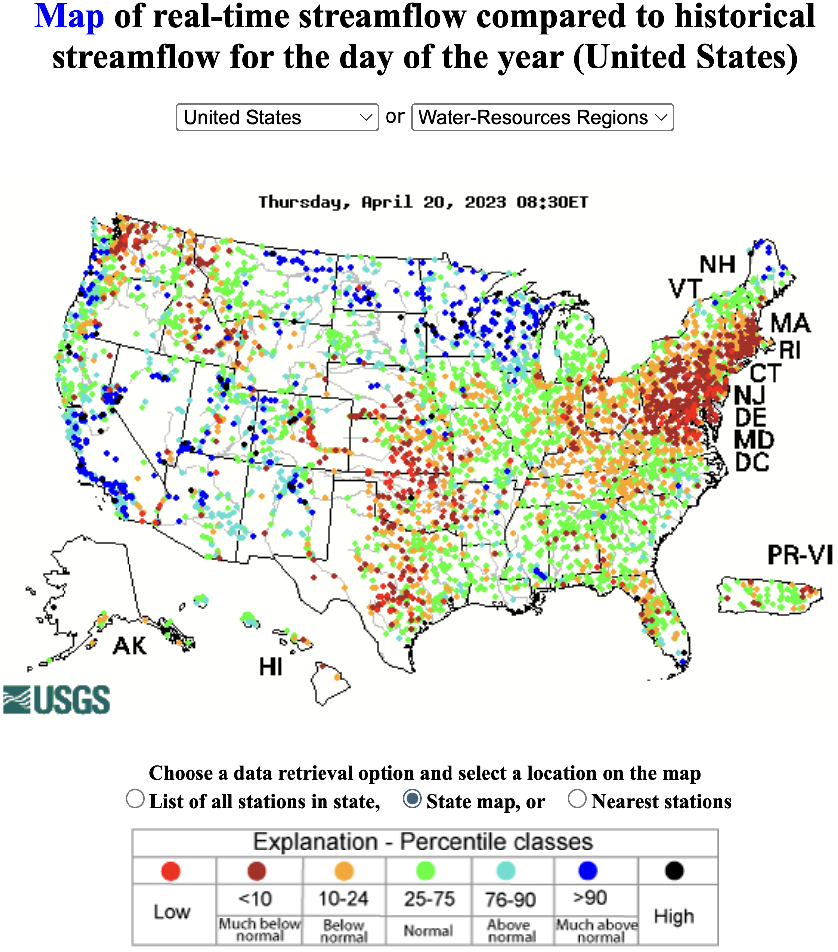
Farther north, precipitation was unremarkable and generally below normal in the Dakotas, but rapid melting of the unusually deep snowpack has been recharging soil moisture and boosting streamflows, with river flooding reported in some areas. As a result, dryness and drought generally eased this past week, reducing D0 and D1 coverage, and removing last week’s D2 from southeastern South Dakota.
The Weekly Weather and Crop Bulletin reported poor or very poor conditions for 60 percent of Kansas winter wheat, 40 percent of Nebraska winter wheat, and 38 percent of Colorado winter wheat…
West
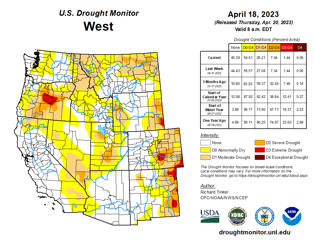
Areas of moderate to heavy precipitation brought continued improvement to many of the dryness and drought areas in Washington, Oregon, and Montana. Improvement was also noted across parts of Utah as the unusually deep snowpack continued to slowly melt, recharging soil moisture and boosting streamflows.
From May 5 to August 9, 2022, anywhere from 25 to 39 percent of the West Climate Region was entrenched in D3 or D4 drought. As of April 18, only about 1.5 percent of the region was in D3, restricted to interior northeastern Oregon.
According to the California Department of Water Resources, mid-April statewide reservoir contents were about 19.5 million acre-feet in 2021, and less than 18 million acre-feet in 2022. But after abundant December-March precipitation in most of the state, mid-April reservoir storage has rebounded to around 27.5 million acre-feet this year, slightly above the long-term average of around 26 million acre-feet at this time of year…
South
Heavy rainfall also eased dryness and drought from southern Louisiana eastward into the Florida Panhandle. Moderate drought there is now restricted to southeastern Louisiana, where substantial multi-month precipitation shortfalls remained despite a wet week. Elsewhere, Tennessee and the Lower Mississippi Valley remained free of dryness and drought, as did eastern Texas and southeastern Oklahoma.
A tight gradient exists from near normal conditions in the aforementioned areas to extreme or exceptional drought (D3-D4) over portions of central and western Texas and Oklahoma. Beneficial rains fell on Deep South Texas and southeastern Texas, bringing limited improvement, but a dry week for most of the central and western sections of Texas and Oklahoma meant conditions persisted or deteriorated there. Most locations across central and northern Oklahoma have 3-month SPEI below the 5 percentile threshold, with 90-day precipitation 3 to 5 inches below normal.
As of April 16, the Weekly Weather and Crop Bulletin reports 53 percent of Oklahoma winter wheat and 52 percent of Texas winter wheat crops in poor or very poor condition [ed. empahisis mine]…
Looking Ahead
During the next five days (April 19-24, 2023) moderate to heavy precipitation (over an inch) is expected in the Pacific Northwest, higher elevations in the central and northern Rockies, much of the eastern Great Plains, most of the Mississippi Valley and Great Lakes Region, the Appalachians, the Carolinas, the Middle Atlantic Region, and the Northeast. Totals of 1.5 to 3.0 inches is forecast for a broad area from the Mississippi/Ohio Rivers’ Confluence Region southward across the west side of the lower Mississippi Valley and the eastern half of Texas. In contrast, most areas from the west side of the Great Plains to the Pacific Coast (outside the higher elevations and areas west of the Cascades) are expecting light precipitation at best. Light amounts of precipitation (less than one-quarter inch) are also expected in Florida, Georgia, and some adjacent locales.
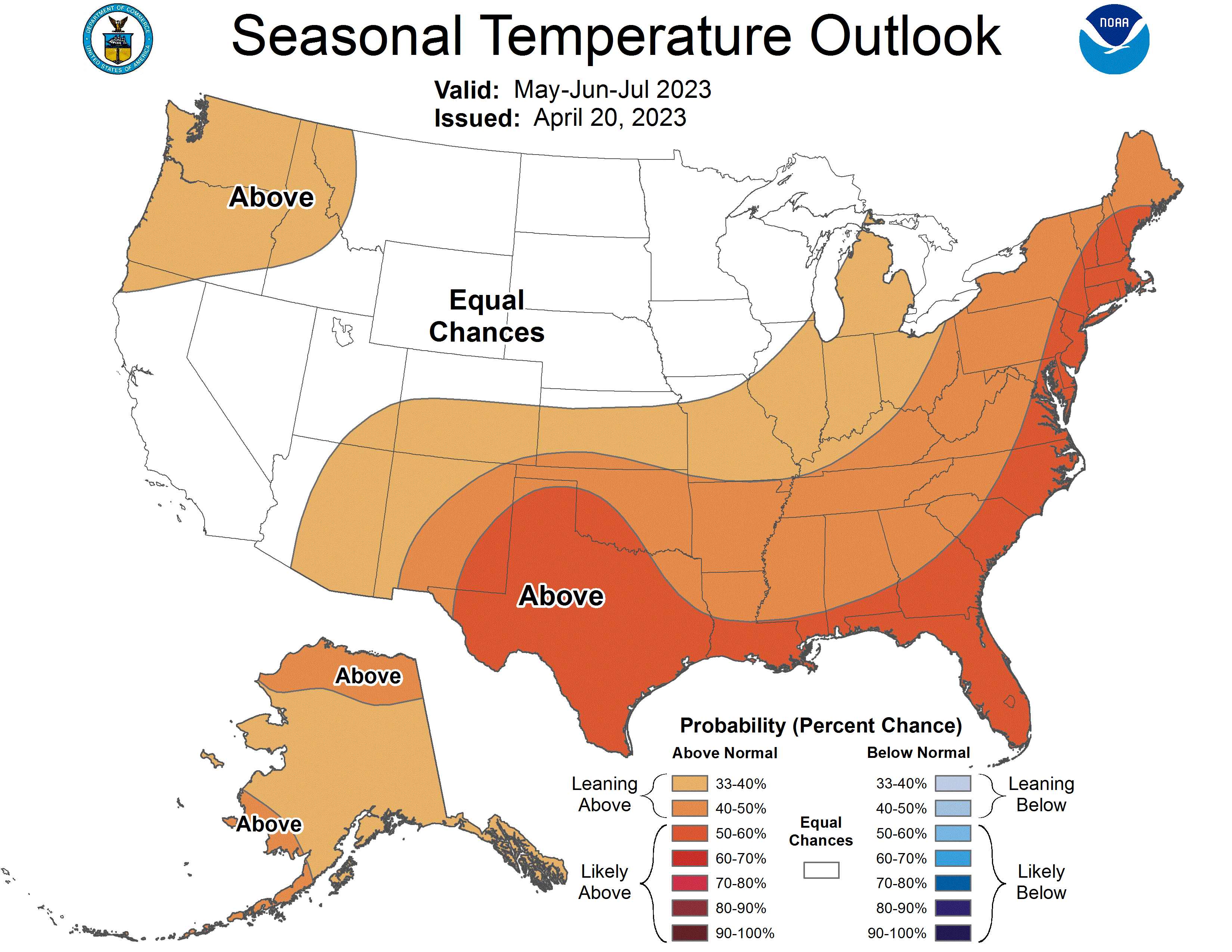
The Climate Prediction Center’s 6-10 day outlook (valid April 25-29) shows above-normal precipitation favored over the vast majority of the central and eastern contiguous states and Alaska. Odds are only marginally enhanced in most areas, but odds exceed 50 percent that amounts will be in the wettest one-third of the historical distribution in part of the South Atlantic States and in southeastern Alaska. Subnormal precipitation is more favored in most areas from the Rockies to the Pacific Ocean, with much of the northern Great Basin having at least a 50 percent chance for precipitation totals in the lowest one-third of the historical distribution. Enhanced chances for subnormal temperatures cover a large area from the Plains to the Middle Atlantic Region, especially across the northern Plains, upper Midwest, and upper Mississippi Valley. Colder than normal temperatures are also expected across most of Alaska outside southeastern areas. Warmer than normal weather is forecast for the southern Rockies, the Intermountain West, and West Coast, as well as across northern New England and locations across and near the Florida Peninsula.
Mohammad Reza Alizadeh, Massachusetts Institute of Technology (MIT) and Mojtaba Sadegh, Boise State University
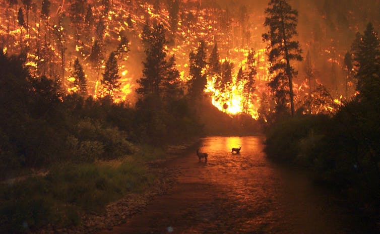
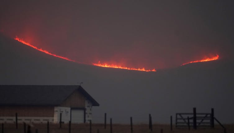
As wildfire risk rises in the West, wildland firefighters and officials are keeping a closer eye on the high mountains – regions once considered too wet to burn.
The growing fire risk in these areas became startling clear in 2020, when Colorado’s East Troublesome Fire burned up and over the Continental Divide to become the state’s second-largest fire on record. The following year, California’s Dixie Fire became the first on record to burn across the Sierra Nevada’s crest and start down the other side.
We study wildfire behavior as climate scientists and engineers. In a new study, we show that fire risk has intensified in every region across the West over the past four decades, but the sharpest upward trends are in the high elevations.
High mountain fires can create a cascade of risks for local ecosystems and for millions of people living farther down the mountains.
Since cooler, wetter high mountain landscapes rarely burn, vegetation and dead wood can build up, so highland fires tend to be intense and uncontrollable. They can affect everything from water quality and the timing of meltwater that communities and farmers rely on, to erosion that can bring debris and mud flows. Ultimately, they can change the hydrology, ecology and geomorphology of the highlands, with complex feedback loops that can transform mountain landscapes and endanger human safety.
Historically, higher moisture levels and cooler temperatures created a flammability barrier in the highlands. This enabled fire managers to leave fires that move away from human settlements and up mountains to run their course without interference. Fire would hit the flammability barrier and burn out.
However, our findings show that’s no longer reliable as the climate warms.
We analyzed fire danger trends in different elevation bands of the Western U.S. mountains from 1979 to 2020. Fire danger describes conditions that reflect the potential for a fire to ignite and spread.
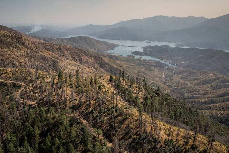
Over that 42-year period, rising temperatures and drying trends increased the number of critical fire danger days in every region in the U.S. West. But in the highlands, certain environmental processes, such as earlier snowmelt that allowed the earth to heat up and become drier, intensified the fire danger faster than anywhere else. It was particularly stark in high-elevation forests from about 8,200 to 9,800 feet (2,500-3,000 meters) in elevation, just above the elevation of Aspen, Colorado.

We found that the high-elevation band had gained on average 63 critical fire danger days a year by 2020 compared with 1979. That included 22 days outside the traditional warm season of May to September. In previous research, we found that high-elevation fires had been advancing upslope in the West at about 25 feet (7.6 meters) per year.
Mountains are water towers of the world, providing 70% of the runoff that cities across the West rely on. They support millions of people who live downstream.
High-elevation fires can have a significant impact on snow accumulation and meltwater, even long after they have burned out.
For example, fires remove vegetation cover and tree canopies, which can shorten the amount of time the snowpack stays frozen before melting. Soot from fires also darkens the snow surface, increasing its ability to absorb the Sun’s energy, which facilitates melting. Similarly, darkened land surface increases the absorption of solar radiation and heightens soil temperature after fires.
The result of these changes can be spring flooding, and less water later in the summer when communities downstream are counting on it.
Fire-driven tree loss also removes anchor points for the snowpack, increasing the frequency and severity of avalanches.
Frequent fires in high-elevation areas can also have a significant impact on the sediment dynamics of mountain streams. The loss of tree canopy means rainfall hits the ground at a higher velocity, increasing the potential for erosion. This can trigger mudslides and increase the amount of sediment sent downstream, which in turn can affect water quality and aquatic habitats.
Erosion linked to runoff after fire damage can also deepen streams to the point that excess water from storms can’t spread in high-elevation meadows and recharge the groundwater; instead, they route the water quickly downstream and cause flooding.
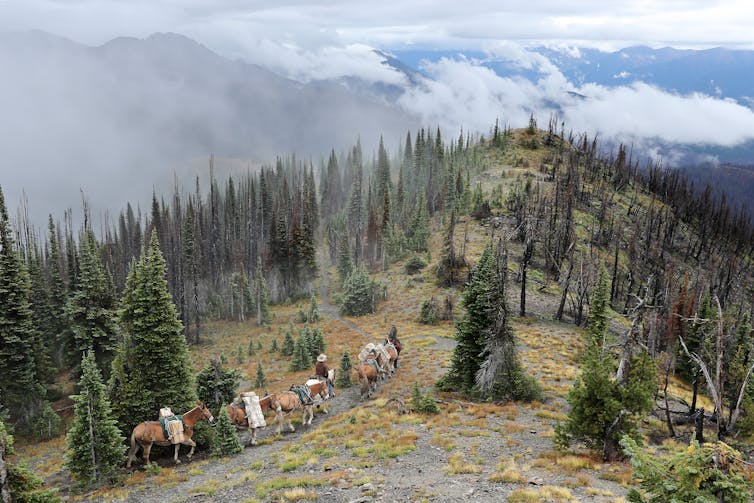
The highlands generally have long fire return intervals, burning once every several decades if not centuries. Since they don’t burn often, their ecosystems aren’t as fire-adapted as lower-elevation forests, so they may not recover as efficiently or survive repeated fires.
Studies show that more frequent fires could change the type of trees that grow in the highlands or even convert them to shrubs or grasses.
Wet mountain areas, with their cooler temperatures and higher precipitation, are often peppered with hot spots of biodiversity and provide refuges to various species from the warming climate. If these areas lose their tree canopies, species with small ranges that depend on cold-water mountain streams can face existential risks as more energy from the Sun heats up stream water in the absence of tree shading.
While the risk is rising fastest in the high mountains, most of the West is now at increasing risk of fires. With continuing greenhouse gas emissions fueling global warming, this trend of worsening fire danger is expected to intensify further, straining firefighting resources as crews battle more blazes.
Mohammad Reza Alizadeh, Postdoctoral Researcher in Environmental Engineering, Massachusetts Institute of Technology (MIT) and Mojtaba Sadegh, Assistant Professor of Civil Engineering, Boise State University
This article is republished from The Conversation under a Creative Commons license. Read the original article.

Click the link to read the article on the Water Education Colorado website (Jerd Smith):
On the hillsides that rise above James Creek in Jamestown, Colorado, west of Boulder, the yards of mountain homes and the forests that surround them are dotted with trees decorated with pink and blue ribbons.
It’s festive, but not in the usual sense.
Jamestown lies in the headwaters of Left Hand Creek, a tributary of the St. Vrain River. The pink trees will be kept, while those flagged in blue will be cut down in a careful thinning project designed to protect a watershed farther downstream that serves farmers and thousands of people in communities such as Lyons and Longmont.
The watershed is a critical part of the St. Vrain and Left Hand Water Conservancy District, an agency charged with overseeing and managing the St. Vrain River, a major system in the larger South Platte River Basin on Colorado’s Front Range.
The people of Jamestown have been working for years to find funding to protect their community from wildfire and to protect James Creek. Tree cutting is expensive, sometimes costing $1,000 just to remove one tree.

But thanks to a property tax increase the district’s voters approved in 2020, as well as an influx of COVID relief money to the state, and new federal funds for infrastructure and jobs, the people of Jamestown and the St. Vrain district now have access to the money they need to reshape and improve their water systems in ways that benefit supply, recreation, the environment and agriculture.
If state and federal funding proposals come through, and some already have, the district will have more than $240 million to work with. For perspective, that is 60 to 80 times the size of the district’s annual $3 million to $4 million operating budget.
Similar big federal funding opportunities exist for other water districts, and policy makers across the state are looking to the St. Vrain district to lead by example.
Alex Funk, senior counsel and director of water resources at the Theodore Roosevelt Conservation partnership is tracking the streams of new cash. He says the opportunities to modernize water systems and improve the state’s farms and rivers now are huge.
“It’s unprecedented in its scope and scale,” Funk said. “There has never been this amount of federal money available all at once. In that sense, we are in uncharted territory.”
That’s not lost on Sean Cronin, executive director of the St. Vrain and Left Hand Water Conservancy District.

After the floods of 2013, the district saw its streams and water systems devastated. Desperate to rebuild, small communities, ditch companies and watershed groups, as well as the St. Vrain district, began banding together to apply for federal and state emergency assistance.
“The flood introduced us to new friends,” Cronin said.
From that grew a ballot initiative in 2020 that has raised millions of dollars in property taxes.
Though statewide water tax proposals have had little success among Colorado voters, St. Vrain’s was one of two local districts that year that succeeded. The Glenwood Springs-based Colorado River Water Conservation District also won approval to raise taxes to protect and improve the regions water sources.
“The fact that we had a plan that looked at all things regarding water and wasn’t specifically for a single water outcome is part of why we succeeded,” Cronin said. “People embrace looking at things holistically.”

Energized by the win, the district launched into planning and design on a range of modest projects.
And then the federal funding deluge began. Now the district is in the running for $240 million to improve infrastructure and restore streams, and improve agricultural irrigation systems, among other projects.
Todd Boldt oversees the federal Emergency Watershed Protection program in Colorado at the Natural Resources Conservation Service as well as other major grant-making programs that are now flush with cash.
He said one of his agency’s priorities is to get the word out about federal funding opportunities and to ensure even small water districts have the resources to do the planning, engineering and design work needed to begin the grant process.
He credits the St. Vrain district with being well-planned and well-organized at the starting line.
“This is complicated stuff,” Boldt said. “We’re at a critical juncture in time.”
If the St. Vrain and Left Hand team succeeds, its ditches, streams, wetlands, reservoirs and farm fields could look significantly different in seven to 10 years.
High in the mountains, for instance, a historic diversion system will be brought into the 21st century. More than 130 years old, the structure is difficult to access and maintain. Soon it will be rehabilitated so that it can be monitored and operated remotely to make sure water is accurately counted and properly diverted.
“We’re trying to squeeze every last drop out of our system,” Cronin said.
In fact, there are dozens of diversion structures in this sprawling district that includes prized recreational streams, thousands of acres of farms, rich wetlands, and cities.

Cronin and his team are reaching out to everyone, funneling the cash they’ve raised into matching grants and offering assistance to partners.
Another part of the district’s strategy is to grow water supplies where possible, and to do so in a way that doesn’t require the purchase of farm-tied water rights and the subsequent dry up of farm fields.
This year, for instance, the district began its own cloud-seeding program, which is forecast to increase water derived from annual snow storms by 5% to 10%.
Funk said the work in the St. Vrain and Left Hand district is encouraging.
“We need to see more of that. We want people to think creatively about these [federal] funds,” he said.
Back up in Jamestown, St. Vrain’s Jenny McCarty, a water resources specialist, has been monitoring the forest restoration work. She believes the initiative could serve as a template for other community-based, multi-property-owner watershed health projects.
In the mountains, while it’s helpful for one property owner to thin trees and remove slash, the impact is limited, McCarty said.
“These property owners like their privacy. Their contribution to the project has been to allow all those trees to be cut down,” she said. “It’s the collective effort that makes a difference.”
Jerd Smith is editor of Fresh Water News. She can be reached at 720-398-6474, via email at jerd@wateredco.org or @jerd_smith.

Click the link to read the article on the AZCentral.com website (Brandon Loomis). Here’s an excerpt:
Grand Canyon advocates are celebrating a decision by federal water managers to unleash a three-day pulse of high water from Glen Canyon Dam to rebuild beaches and improve environmental conditions on the Colorado River. The high-flow experience is scheduled to start Monday. Environmentalists, river runners and others had sought such a flood release, outlined under the dam’s adaptive management program, for years. Healthy monsoon rains had pushed tons of sand into the river, but had also gouged the beaches and sandbars that create natural backwaters and campsites for river trips. Opening the dam’s floodgates before the fresh sediment gradually washed downstream could push the sand up to form new beaches. Their efforts previously ran into the reality of declining water behind the dam in Lake Powell, where the U.S. Bureau of Reclamation was trying to hold back enough water to keep generating hydropower. In response under the Grand Canyon Protection Act of 1992, the agency can release floodwaters when the Paria River dumps sufficient sand below the dam, but had not done so since 2018. This winter, the Rocky Mountains piled up more snow than at any time since 2011, with enough water content to raise the reservoir by dozens of feet.

Reclamation’s Upper Colorado Region confirmed the plan on Tuesday. On Friday, the agency sent interested parties a memo explaining its decision to go ahead with a 72-hour release of extra water beginning Monday. Dam operators will open bypass tubes to roughly quadruple the river’s flow to 39,500 cubic feet per second.
The government has conducted several such high-flow experiments in the past, but this will be the first to occur in spring, the natural time for flooding before Glen Canyon Dam’s completion in 1963.
“A springtime (flood) is an opportunity to see all the natural processes that are kicked in by a high flow and see how they respond,” said Kelly Burke, who directs Wild Arizona’s Grand Canyon Wildlands Council.