

Click the link to read the article on the Aspen Journalism website (Heather Sackett):
Fueled by a deep snowpack that hit record highs in some areas, spring streamflow is forecasted to be well above average across the Western Slope.
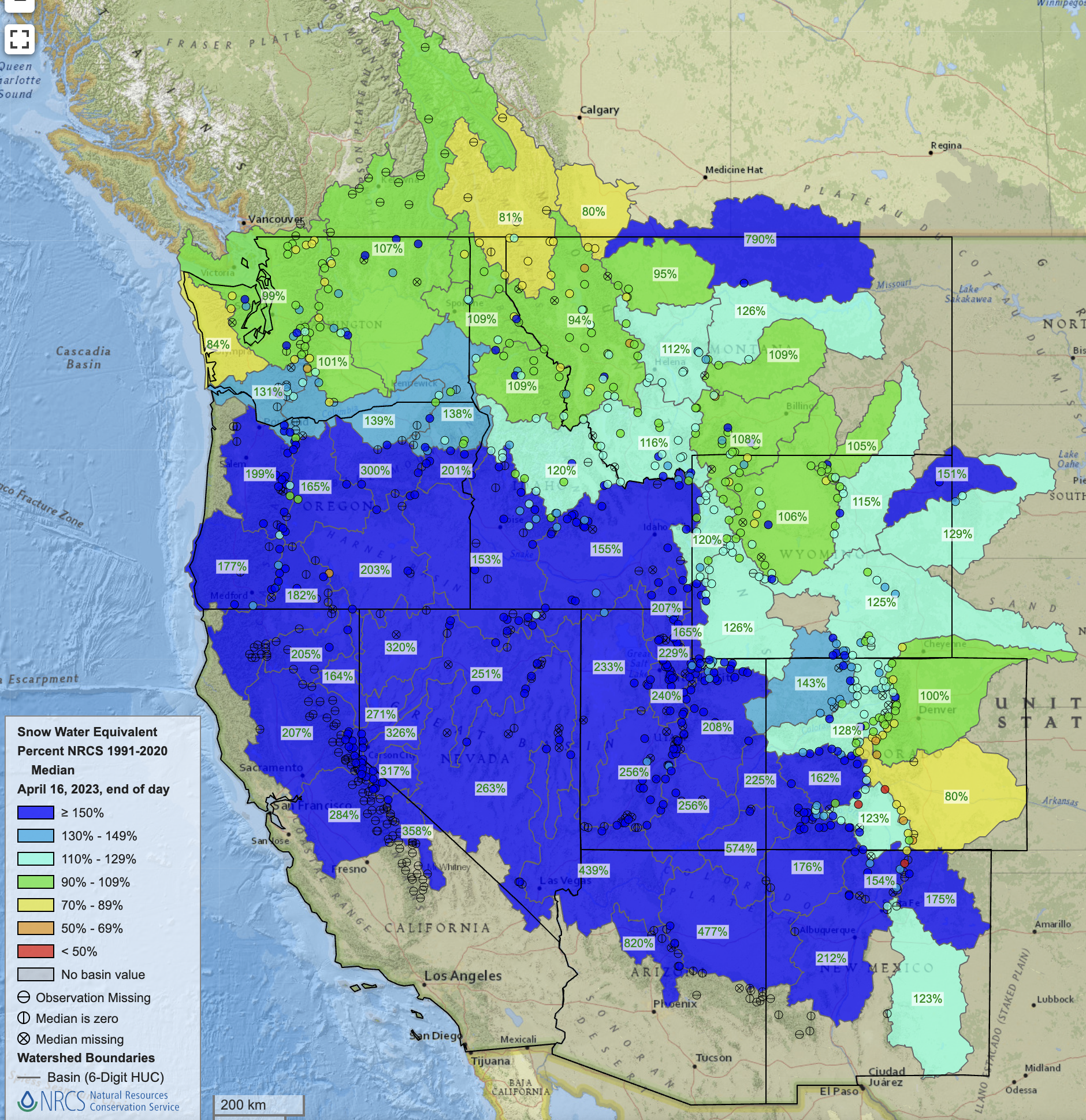
According to the April Water Supply Outlook Report from the National Resources Conservation Service, streamflows are forecast to be 184% of median in the Yampa/White/Little Snake River basin; 173% of normal in the Gunnison River basin; 171% of median in the San Miguel/Dolores/Animas/San Juan basin. The mainstem of the Colorado River headwaters lagged behind other areas of the West Slope with a predicted 118% of normal streamflow.

The Roaring Fork River basin is forecast to hit 136% of median streamflow; the Eagle River basin is at 105% of average and the Blue River is at 94% of median. At the confluence of the Roaring Fork and Colorado rivers in Glenwood Springs, streamflow is forecast to be about 140% of normal.
“I think the biggest takeaway is that really substantial March precipitation across the state, particularly in western Colorado, really boosted the streamflow forecast,” said Karl Wetlaufer, a hydrologist and assistant supervisor with the NRCS Colorado Snow Survey. “A pretty substantial proportion of western Colorado SNOTEL sites had record-high or second-highest snowpack accumulations for the month of March and that was going on top of a snowpack that was already quite substantial.”
SNOTEL, or snow telemetry, sites are remote sensing stations throughout the West’s mountainous watersheds that collect weather and snowpack data. Most sites have been collecting data for about the last 30 or 40 years. According to the report, up to 30% of the SNOTEL sites in the state reached a record or near-record snow depth and snow-water equivalent. Snow-water equivalent (SWE) is a measure of how much water is contained in the snowpack.

The southwest corner of the state was the big winner for March precipitation, with the combined San Miguel/Dolores/Animas/San Juan river basins receiving 326% of median snowfall. The Sharkstooth SNOTEL site in the Dolores basin ended March with a whopping 532% of median precipitation.
With warmer temperatures this week, it’s likely that much of the Western Slope has already turned the corner, hitting peak snowpack and beginning to melt out. In the Roaring Fork basin, most SNOTEL sites started seeing a decrease in snowpack around April 9 or 10.
“It’s definitely looking like this may have been peak snowpack statewide in the last week or so,” Wetlaufer said. “You can always get another pulse that can top it, but I think it would take a significant input of snow to achieve a new peak beyond what we have seen.”
As that snow turns to water it will begin to fill Colorado’s depleted reservoirs. For many of the reservoirs, Wetlaufer said, inflow is forecast to be more than the reservoir’s total capacity.
“It’s encouraging that this year will most certainly help to fill most if not all reservoirs,” he said.
After two years of drought, in March 2022, Ruedi Reservoir on the Fryingpan River above Basalt hit its lowest level in two decades. This year, Ruedi is on track to fill, with a forecasted 107% of average inflow. The reservoir is currently at about 61% full.
“We should have the best opportunity to reach a full fill since 2019,” said Tim Miller, a hydrologist with the U.S. Bureau of Reclamation, which operates Ruedi Reservoir.
As spring progresses, water managers will get a clearer picture of what this year will bring. Scientists are gaining a better understanding that what happens in the weeks following peak snowpack can have an outsize influence on the year’s water supply and that the April numbers may no longer be a reliable benchmark.
In particular, timing of the melt out can be hard to predict. High temperatures, lots of sun and dust on snow, which increases the melt rate, could all combine to cause flooding in some areas.
“I think the timing of this runoff is something I would advise people to watch closely, both for reservoir management and for the flood potential,” Wetlaufer said. “With this much water stored in the snowpack across western Colorado, if it does come down all at once, the rivers are most certainly going to be flowing fast and furious.”
Dave Kanzer, director of science and interstate matters with the Colorado River Water Conservation District, said the good news is that there should be enough water for nearly all users in western Colorado this season and that most reservoirs, including Paonia, Ridgway, Granby and others, should fill and spill. But regionally, even this winter’s record-breaking snowstorms won’t be enough to replenish the nation’s two largest reservoirs Lake Powell and Lake Mead, which are 23% and 28% full, respectively.
The March forecasts from the Bureau of Reclamation, which manages Powell and Mead, predicted that the most probable estimate of inflow into Lake Powell this year would be 10.9 million acre-feet, which is 113% of average. According to Reclamation’s estimates from March, 10.9 million acre-feet of inflow would result in raising Lake Powell’s elevation to 3,552 feet, or about 33% full, as of Dec. 31, 2023.
“One year does not bust a drought,” Kanzer said.

Click the link to read the article on the Steamboat Pilot & Today website (Shelby Reardon). Here’s an excerpt:
Five inches of snow falling ahead of closing day made 2023 the second snowiest season ever recorded at Steamboat Resort. Flakes fell throughout Friday, April 14, and continued into early Saturday, April 15, bringing the mid-mountain snow total on Steamboat’s snow report to 448 inches. There are some discrepancies on the resort’s snow report at Steamboat.com/the-mountain/mountain-report, as the sum of monthly totals is 459 inches. Nevertheless, 448 was all that was needed to become the second snowiest season at the resort, according to data collected by the resort since 1980. In order to become the second snowiest season on record, this year’s snowfall had to surpass the 447.75 inches that collected at mid-mountain in the 1996-97 season. The record of 489 inches set in 2007-08 will continue to stand at least for another year, as the resort will close on Sunday, April 16, and stop documenting snowfall…
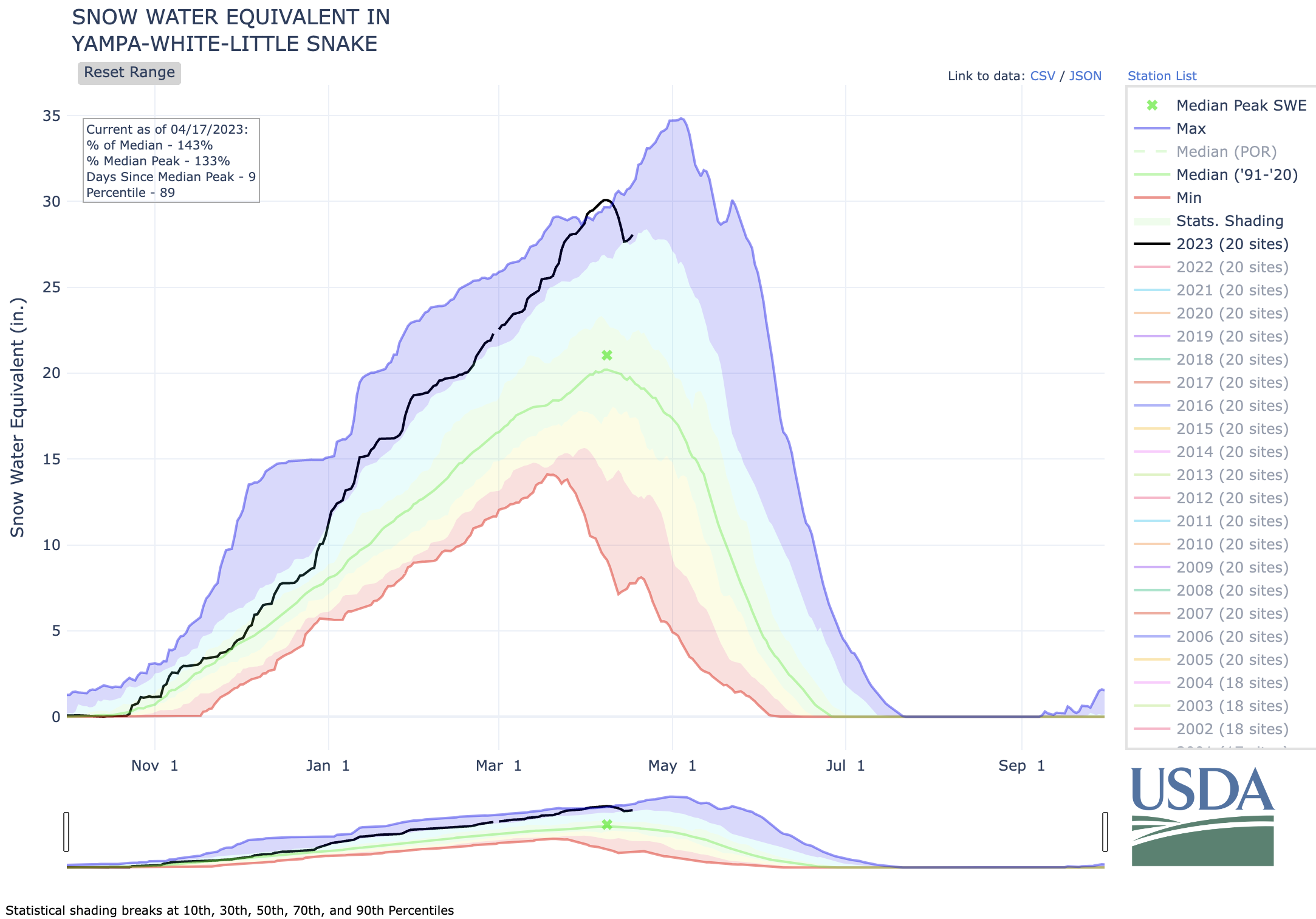
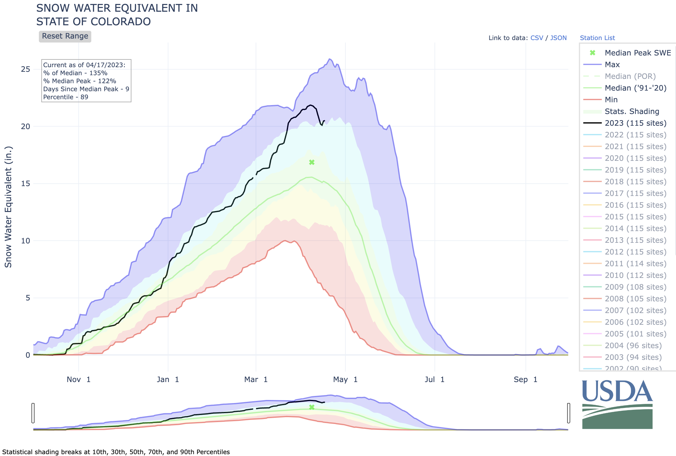
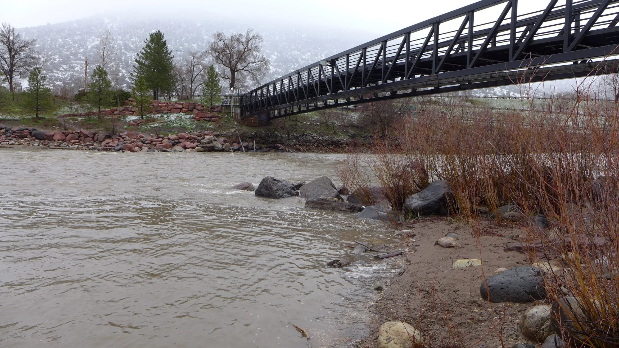
While the melt was slowed by Friday’s snow and cold temperatures, the fluffy stuff is diminishing quickly. The snowpack or snow water equivalent in the Yampa, White, Little Snake Basin seems to have peaked on April 7, according to data from the United States Department of Agriculture…The presumed peak, which came 24 hours before the median peak based on 30-year averages, was 30.1 inches. The past two years peaked at 18 inches, or just below. The last year to have a similar peak was 1997. Between April 1 and 8, the area had record snow water equivalent as the measurement surpassed 29 inches and reached 30. With the melt, the 2023 snowpack is back below the record trajectory, which was set in 2011.
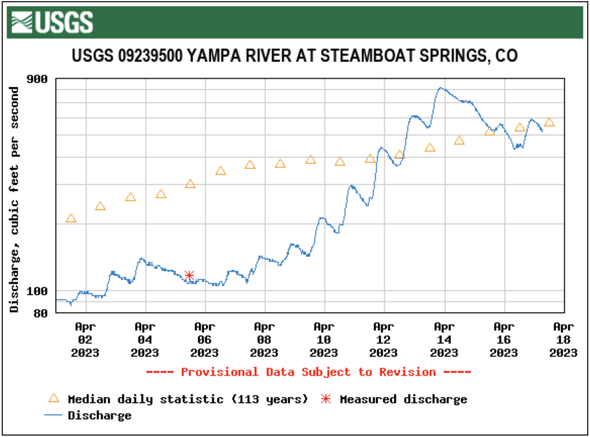
Yampa River flow hit 817 cubic feet per second on Thursday evening, April 13, which is four times greater than the flow of 204 cfs on the same day the year before, according to U.S. Geological Survey data. The Elk River hit a high flow of 1,700 cfs on Friday, April 14, more than six times the flow on the same day in 2022.
Matthew Selinske, RMIT University; Georgia Garrard, The University of Melbourne; Jaana Dielenberg, Charles Darwin University, and Sarah Bekessy, RMIT University
Last month, Sir David Attenborough called on United Kingdom residents to “go wild once per week”. By this, he meant taking actions which help rather than harm the natural world, such as planting wildflowers for bees and eating more plant-based foods.
Australia should follow suit. We love our natural environment. But we have almost 10 times more species threatened with extinction than the UK. How we act can accelerate these declines – or help stop them.
We worked with 22 conservation experts to identify 10 actions which actually do help nature.
If you go for a bushwalk, you might wonder what the problem is. Gums, wattles, cockatoos, honeyeaters, possums – everything is normal, right? Alas, we don’t notice what’s no longer there. Many areas have only a few of the native species once present in large numbers.
We are losing nature, nation-wide. Our threatened birds are declining very rapidly. On average, there are now less than half (48%) as many of each threatened bird species than in 1985. Threatened plants have fared even worse, with average declines of over three quarters (77%).
Biodiversity loss will have far-reaching consequences and is one of the greatest risks to human societies, according to the OECD.
The small choices we all make accumulate to either help or harm nature.
1. Choose ASC and MSC certified seafood products
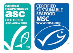
Why? Why? Overfishing is devastating for fish species. By-catch means even non-food species can die in the process. Good wild fishery and aquaculture practices minimise impacts to biodiversity.
Where to start: Look for certification labels from the Marine Stewardship Council (MSC) or the Aquaculture Stewardship Council (ASC) on seafood products where you shop. Certified products are caught or farmed sustainably.
2. Keep your dog on a leash in natural areas – including beaches
Why? Off-leash dogs scare and can attack native wildlife. When animals and birds have to spend time and energy fleeing, they miss out on time to eat, rest and feed their young.
Where to start: Look for local off-leash areas and keep your dog leashed everywhere else.

3. Cut back on beef and lamb
Why? Producing beef and lamb often involves destroying or overgrazing natural habitat, as well as culling native predators like dingoes.
Where to start: Eat red meat less often and eat smaller portions when you do. Switch to poultry, sustainable seafood and more plant-based foods like beans and nuts. Suggest a meatless Monday campaign in your friend and family group chat to help wildlife – and your own health.

4. Donate to land protection organisations.
Why? These organisations protect land in perpetuity. Donations help them expand and do important on-ground biodiversity management.
Where to start: Check out organisations such as the Australian Wildlife Conservancy, Bush Heritage Australia, Trust for Nature, and Tasmanian Land Conservancy.
5. Make your investments biodiversity-friendly
Why? Many funds include companies whose business model relies on exploiting the natural environment. Your money could be contributing. Looking for biodiversity-positive investments can nudge funds and companies to do better.
Where to start: Look at the approach your superannuation fund takes to sustainability and consider switching if you aren’t impressed. You could also explore the growing range of biodiversity-friendly investment funds.
6. Donate to threatened species and ecosystem advocacy organisations
Why? These groups rely on donations to fund biodiversity advocacy, helping to create better planning and policy outcomes for our species.
Where to start: Look into advocacy groups like WWF Australia, Birdlife Australia, Biodiversity Council, Environment Centre NT, and the Environmental Defenders Office.
7. Plant and maintain a wildlife garden wherever you have space
Why? Our cities aren’t just concrete jungles – they’re important habitat for many threatened species. Gardening with wildlife in mind increases habitat and connections between green space in suburbs.
Where to start: Your council or native nursery is often a great source of resources and advice. Find out if you have a threatened local species such as a butterfly or possum you could help by growing plants, but remember that non-threatened species also need help.
8. Vote for political candidates with strong environmental policies
Why? Electing pro-environment candidates changes the game. Once inside the tent, environmental candidates can shape public investment, planning, policy and programs.
Where to start: Look into local candidate and party policies at every election. Consider talking to your current MP about environmental issues.
9. Desex your cat and keep it inside or in a cat run
Why? Research shows every pet cat kept inside saves the lives of 110 native animals every year, on average. Desexing cats avoids unexpected litters and helps to keep the feral cat population down.
Where to start: Keep your cat inside, or set up a secure cat run to protect wildlife from your cute but lethal pet. It’s entirely possible to have happy and healthy indoor cats. Indoor cats also live longer and healthier lives.

10. Push for better control of pest animals
Why? Pest species like feral horses, pigs, cats, foxes and rabbits are hugely destructive. Even native species can become destructive, such as when wallaby populations balloon when dingoes are killed off.
Where to start: Look into the damage these species do and tell your friends. Public support for better control is essential, as these issues often fly under the radar.
Conservation efforts may seem far away. In fact, our daily choices and actions have a considerable effect.
Talking openly about issues and actions can help these behaviours and habits spread. If we all do a small part of the work and support others to do the same, we will see an enormous effect.
Matthew Selinske, Senior Research Fellow, RMIT University; Georgia Garrard, Senior Lecturer, School of Ecosystem and Forest Sciences, The University of Melbourne; Jaana Dielenberg, University Fellow, Charles Darwin University, and Sarah Bekessy, Professor in Sustainability and Urban Planning, Leader, Interdisciplinary Conservation Science Research Group (ICON Science), RMIT University
This article is republished from The Conversation under a Creative Commons license. Read the original article.

Click the link to read the article on the Aspen Daily News website (Austin Corona). Here’s an excerpt:
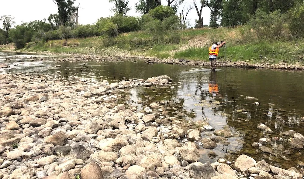
Last week, geospatial technology company Airborne Snow Observatories completed its first survey of the Roaring Fork River Basin. Flying at 25,000 feet, a Beechcraft King Air B200 roved over the headwaters of the Roaring Fork River and its tributaries like a high-altitude lawn mower for a total of six hours. Meanwhile, an onboard LiDar system scanned the mountains below, capturing a three-dimensional image of the landscape, and spectrometers measured light reflecting off the snow’s surface. The data from this survey will provide western Colorado water managers with unprecedented information about spring snowmelt and runoff in the watershed. ASO operated these flights through contracts with eight public entities, including the Colorado River District, the city of Aspen and Pitkin County. After flying the watershed, ASO compared the data they collected with data taken last summer, when the mountains were snow-free. The difference in the two scans represents how much snow is lying on the landscape and provides insight into how much runoff will flow into the Roaring Fork River and its tributaries this spring and summer.
In total, ASO found that there are a little less than 600,000 acre feet of water stored in snowpack within their measurement area. For perspective, that’s three times the amount of Colorado River water used by the state of Nevada last year, according to data from the Bureau of Reclamation. And it doesn’t even include snowpack above the Crystal River, which adds significantly to the Roaring Fork’s total flow. While some of that water will be absorbed into the soil, much of it will ultimately become river water, sustaining riparian habitats and human communities in the valley and beyond. Using data on snow “albedo,” or the light that reflects off the snow’s surface, ASO also examined the impact that dust deposited by high winds have on snowmelt in the basin…
Colorado water managers say ASO’s technology is a major step forward from existing snowpack measurement tools in the Roaring Fork Watershed. First developed as a project under NASA, ASO says the technology is superior to both ground and satellite-based snow measurement methods. Dave Kanzer, Director of Science and Interstate Matters at the Colorado River Water Conservation District, said it wouldn’t be inappropriate to call the tech “revolutionary” for Colorado snowpack measurement.
“It is a game changer,” he said.

Click the link to read the article on the WyoFile website (Angus M. Thuermer Jr.):
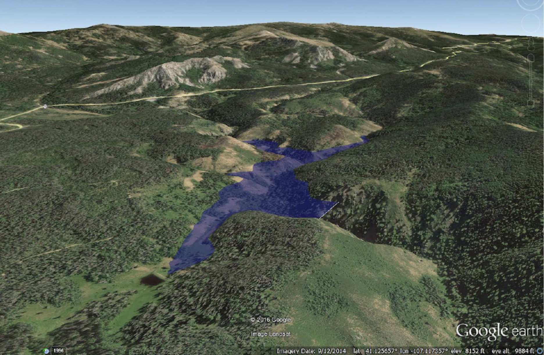
Wyoming Game and Fish Department comments cast doubt on irrigators’ claims that a 264-foot-high dam proposed in Carbon County will benefit fisheries, riparian zones and wetland-wildlife habitats.
The dam proposed for the West Fork of Battle Creek above the Little Snake River on the Medicine Bow National Forest would provide 6,000 acre-feet of late-season irrigation to ranches near Baggs, Dixon and Savery and in Colorado. The 700-foot-long concrete dam and associated 130-acre reservoir would also provide a “minimum bypass flow” to improve fisheries in downstream creeks and rivers, according to the proposal.
The reservoir itself could be a “brood facility” and refuge for native Colorado River cutthroat trout, a species of conservation concern, the Wyoming Water Development Commission and others say.
As dam backers’ plans were opened to formal public review and comment earlier this year, however, critics challenged the rosy ecological picture and accounting of public benefits claimed by water developers.
Among these critics is Wyoming’s own Game and Fish Department, which says construction and operation of the dam would cause “substantial negative impacts on the aquatic and fisheries resources in the West Fork Battle Creek, Battle Creek and Little Snake River drainages.”
Even though mitigation efforts are “likely” to offset such impacts and may conserve and enhance fish and wildlife habitat, the wildlife agency expressed reservations about the project.
“Given the complexity of ecological systems and inherent uncertainties about project operation and impacts and future climate and hydrology,” Game and Fish wrote in nine pages of comments, “it is not known if the proposed project will benefit fisheries, riparian, and wetland wildlife habitats, as suggested by the proponents.”
In-stream flow vs. bypass
Wyoming’s wildlife agency made its comments along with 935 other individuals and organizations as the Natural Resources Conservation Service, a federal agency tasked with aiding agriculture on private lands, analyzes the project through an environmental impact statement. Eight hundred ninety-nine commenters opposed dam construction and an associated land swap with the Medicine Bow National Forest that would enable it.
Game and Fish offered six pages of recommendations for how to potentially alleviate some of the dam’s impacts. Those include a program to wipe out non-native trout from a network of creeks that extends about six miles upstream of the dam site. Colorado River cutthroat trout would then be planted in an artificial “brood facility” in the reservoir and upstream.

In launching the plan to dam the West Fork of Battle Creek, dam backers declared benefits would accrue to “fisheries, riparian and wetland wildlife habitats, and water-associated recreation,” according to a legal notice published in the Federal Register.
“Ecological objectives … include improvements to aquatic ecosystems and riparian habitats by supplementing stream flows during low-flow periods, and … to terrestrial habitat associated with irrigation-induced wetlands,” the notice posted by the NRCS states. “Benefits are expected to accrue to these attributes [downstream] to the confluence with the Yampa River including improvements to both cold water and warm water sensitive species.”
Fisheries below the dam could benefit from 1,500 acre-feet earmarked for bypass flow, a 483-page Wyoming study says. Bypass water that would be released from the dam would maintain a minimum flow for about 4 miles downstream.
Nothing in the plan as currently written, however, would prevent any irrigator from taking water out of the creek below that point and using it for irrigation.
“Without an in-stream flow water right, once released from the bypass flow account in West Fork Reservoir, the water could be used or diverted for other purposes,” Jason Mead, interim director of the Wyoming Water Development Office wrote in an email. Nevertheless, “[m]ost of the water released solely for habitat flow purposes, according to hydrologic models, occurs during the non-irrigation season months,” Mead wrote. “[T]here are no irrigation diversions below the [proposed] West Fork Reservoir on the West Fork of Battle Creek or Battle Creek until it runs on to private land.”
‘Habitat units’
The 4.8-mile reach of Battle Creek that runs across private land would benefit from approximately 1,414 new fishery “habitat units” if the dam were built, according to Wyoming’s study. A “habitat unit” supports about one pound of trout per acre. Together, the new aquatic productivity “could facilitate additional private enterprise investment which could generate direct private fishing benefits of $144,228 annually,” the Wyoming Water Development Office says in the 2017 study.
That money would increase through an economic theory known as an “indirect benefit multiplier,” producing $379,320 in private benefits annually and $8.2 million over 50 years, Wyoming’s plan states.
That, plus other “instream flow benefits,” are estimated to generate $35 million in public benefits in the dam’s half-century life, the WWDO study states. All told, the state forecasts $73 million in public benefits. That sum justifies the state paying for most of the 2017-estimated $80 million project price tag.
“Given the unique location of the West Fork Reservoir project, its most valuable recreation attribute may be its isolated location which provides a sense of solitude that some recreationalists seek and consider priceless,” the state study reads.
In a comment letter, downstream ranch owners Sharon and Pat O’Toole said the proposed dam “offers multiple benefits,” and would offset the city of Cheyenne’s water diversions from the Little Snake River Basin.
“An environmental benefit would include creating and enhancing wetlands and riparian habitats upstream from the West Fork Reservoir, and improving stream habitat to sequester copper and other metals” from an abandoned mine, the O’Tooles wrote. “The created wetlands and improved stream channel could also provide wetland and stream channel mitigation for the project.
“Our family owns all the private land on Battle Creek,” the couple wrote, adding that “in the lower reaches we have Colorado Cutthroat Trout,” along with other species.
“Haggerty Creek [above the site of the proposed reservoir] used to provide habitat for this species of interest, and could again, with the benefit provided by the dam. The proposed dam would offer value to the recreating public. It would provide a fishery on Haggerty Creek and downstream that does not presently exist.”
John Cobb, chairman of the Little Snake River Conservation District, an irrigation group, wrote that there are “many self-mitigating aspects of this [dam-building] alternative with the potential to drastically offset any potential negative impacts.” Dam construction could “result in a net benefit to the native ecosystems and human economies that thrive within the proposed service area of this project,” his comment reads.
The project would also contribute to the goals of the Colorado-based Yampa, White, Green Roundtable, a consortium of river users, according Jonathan Bowler, watermaster for the Savery-Little Snake River Water Conservancy District that applied to build the dam. Among those is a goal to develop a system to reduce water shortages and meet environmental and recreation needs, he said in a presentation to the group.
Professional, expert critique
In addition to Game and Fish comments on the plan, reaction includes reviews and criticism from angling and conservation groups.
Wyoming proposes to swap state property for federal land to enable construction, and budgets $594,000 of the estimated $80 million project cost for wetland and stream mitigation, public documents state.
Without endorsing construction, Wyoming Trout Unlimited recommended that any plan include funding for non-native brook trout removal and other conservation measures, Kathy Buchner, Wyoming TU Council chair and two other TU officers wrote. Other groups were more critical.
“Five years of construction will destroy the present aquatic habitat for all populations of vertebrate and invertebrate species and terrestrial wildlife habitat,” wrote Brian Smith, a former Wyoming water development technician who operated the nearby High Savery Dam and Reservoir where Game and Fish established a similar Colorado River cutthroat trout reserve. “Spawning migrations that have occurred [in and above Battle Creek] presumebly (sic) since the last ice age by CRCT will be terminated. The Little Snake River Drainage is one of only 3 in the State of Wyoming, where the CRCT exist.”
The nonprofit American Rivers also criticized the state plan saying the proposed project could threaten year-round water in the Belvidere Ditch upstream of the proposed reservoir. That ditch is “a WGFD stocking source of cutthroat trout,” and disruption there could harm “these valuable populations.”
Matt Rice, the group’s Colorado River Basin program director, said threats to the ditch could damage “one of the only remaining healthy populations of cutthroat trout [and] could perhaps push the species sufficiently to the brink to merit a federally endangered listing.” The dam would further reduce flows downstream, including in the Yampa River “with additional consequences for protection and recovery of pikeminnow and other sensitive species,” Rice wrote.
A promise of ecological benefits downstream is unsubstantiated, wrote Ben Beall, Friends of the Yampa president. He said that was “a questionable claim given the project’s stated primary purpose is to supply late season irrigation water and the limitation of capacity of the bypass account in the reservoir.”
Forest staffer worried
Worries about the dam’s impacts and a lack of critical review emerged well before the NRCS opened the issue for comments. When the Medicine Bow began preparing for a potential land swap two years ago, a staff hydrologist became alarmed that the dam’s effects wouldn’t be thoroughly analyzed.
The Medicine Bow distributed a briefing paper to its staff that included language “taken from the water development justifications/benefit promotional material and adopted by FS management/lands staff w/o consultation of fisheries professionals,” Medicine Bow hydrologist Dave Gloss wrote to colleagues.
The Medicine-Bow distributed the briefing paper after dam backers had held several meetings with national forest officials and put the bureaucratic wheels in motion for the land exchange, according to an email chain obtained by WyoFile through a Freedom of Information Act request.
“There is much more to the aquatics story,” Gloss wrote, “including the upstream reaches above the reservoir not supporting fish populations due to metals contamination and dewatering from an irrigation ditch, the in-reservoir and downstream trade-offs from altered flow, etc.
“If I could achieve one thing related to this project, it would be an honest and critical look at the social and environmental effects …” Gloss wrote.
He held out little hope for that “honest and critical” look. “There are a lot of factors in play making that approach very unlikely at the moment …” his email read.
A Medicine-Bow spokesman earlier this year wrote that Gloss’s worries are now unfounded. In briefing papers like the one Gloss complained about, “external opinions are encouraged to be included in the full range of information, as they help give situational awareness,” spokesman Aaron Voos wrote in an email. Information in the briefing paper was appropriately cited to make clear it came from project proponents, he wrote.
Further the Medicine Bow will consider the social and environmental effects of the dam and a wide range of public input and values for the public lands, water and resources involved, Voos wrote. “That will be accomplished with the EIS. We are a cooperating agency in that process and will be involved.”
The Medicine Bow, however, has no plans to peer-review Wyoming’s study of public benefits that justifies state funding of the dam, Voos wrote. The NRCS also said it will not peer-review the 483-page Wyoming Little Snake River final report of 2017.
“At this time we cannot say whether or not the Little Snake River Supplemental Storage Level II Phase II Study Report will be used in the land exchange feasibility analysis,” Voos wrote. “[H]owever, it could be used as a reference document during the feasibility analysis or at other points in the land exchange and NEPA processes.”
