Romancing the River: Beginning to Face Reality — Sibley’s Rivers #ColoradoRiver #COriver #aridification

Graphic credit: Sibley’s Rivers

Click the link to read the article on the Sibley’s Rivers website (George Sibley):

As you no doubt already know, if you follow Colorado River news, the Bureau of Reclamation and Department of Interior have issued a ‘Near-term Colorado River Operations: Supplemental Environmental Impact Statement’ (SEIS) analyzing two alternatives for making massive cuts in the consumptive use of the Colorado River’s waters, beginning in 2024. The SEIS analyzes strategies for cutting use by two million-acre feet (maf) next year, with cuts up to four maf in following years if the water supply in storage continues to decline – roughly a third of the total volume of the river as it has run since the turn of the century.

Table of Cuts
2025-26 cuts

​The alternatives discussed in the SEIS will look familiar to those who have followed the river news for the past couple months; they are similar to the plans for large reductions created by the seven River Basin states: one plan by six of the states, the other by the seventh, California. One of the Bureau’s ‘action alternatives’ divides the big cuts equitably among the three states based on the size of their allotments, like the six states’ plan; the other adheres mostly to priority of water rights in dishing out the cuts, like the California plan.

If there is anything to be learned for the future from the past, it should be noted now that this sudden dramatic need for really major cuts in consumptive use in the lower part of the river basin is the consequence of problems that could have been dealt with gradually – intelligently, one might say, far-sightedly – over at least the past 30 years, if not the whole last century since the discovery that the Colorado River Compact was based on false numbers.

​But through the 1940s and 50s, there was a lovely sense of abundant water in the Lower Basin. The four states of the Upper Basin were considerably slower in developing than the three in the Lower Basin, so a lot of the river was still flowing freely to the desert states below the canyons and eventually being ‘wasted’ to the ocean, then regarded as a sad end for freshwater.

​Even before Hoover Dam was completed, the Californians, with Bureau permission, decided to borrow some of that water to grow on – with really no firm plan about what to do when the Upper Basin developed its water. They did not really know how much (or how little) water the river really carried, and the spirit of the times decreed that the engineers would figure something out to solve the problems of the future. California’s 1931 ‘Seven Parties Agreement’ divvied up more than 900,000 af  of borrowed water – and built their permanent systems large enough to carry that along with their legal allotment.

The structural deficit refers to the consumption by Lower Basin states of more water than enters Lake Mead each year. The deficit, which includes losses from evaporation, is estimated at 1.2 million acre-feet a year. (Image: Central Arizona Project circa 2019)

The Lower Basin states were also, kind of semiconsciously, depending on that ‘surplus’ water to cover all of the substantial ‘system losses’ in the Lower Basin – evaporation and conveyance losses – and also the Lower Basin’s 750,000 af share of the commitment to Mexico: all told, at least 2 maf of water for which the Lower Basin states were accountable, but none of which was deducted from their allotments as set by the Boulder Canyon Project Act. They developed their 7.5 maf Compact allotment to the max, and this ambiguous but very real 2 maf became known as ‘a structural deficit,’ as though it were just inherent in the structure of the system and nothing could be done about it, not unlike an Act of God.

​But the Upper Basin states eventually got up to around 4 maf of consumptive use (including Upper Basina system losses) late in the century, with big out-of-basin projects like the Colorado-Big Thompson, San Juan-Chama, Dillion Reservoir, Homestake, and Arizona’s big Central Arizona Project came on line in 1993 – and everyone knew by then how little water the river actually carried, with no big river augmentation projects on the horizon…. Common sense would seem to dictate that, at least by the 1990s, the Californians would have begun a schedule for weaning themselves from the borrowed water, and all three Lower Basin states would have begun figuring out how to deal with the ‘structural deficit.’ But that kind of sense was of course completely contrary to the naive energies of the Early Anthropocene that still prevailed in the Basin, and the Lower Basin states – graciously enabled by the Bureau – continued using consumptively somewhere around 800,000 af of borrowed Upper Basin water in addition to their full 7.5 maf Compact allotments, and ignoring any responsibility for the 2 maf structural deficit.

During the 1983 Colorado River flood, described by some as an example of a “black swan” event, sheets of plywood (visible just above the steel barrier) were installed to prevent Glen Canyon Dam from overflowing. Source: Bureau of Reclamation

​The water, by then, was no longer flowing freely through the canyons to the Lower Basin, but was being released by the Bureau from Powell Reservoir, requiring some complex definitions of ‘surplus’ – possibly trying to disguise its decline – and some big water years in the 1980s and 90s allowed them to continue to cover the profligate release of more than 10 maf to cover Lower Basin’s legal allotments, plus borrowings, plus ignored system losses.

Updated Colorado River 4-Panel plot thru Water Year 2022 showing reservoirs, flows, temperatures and precipitation. All trends are in the wrong direction. Since original 2017 plot, conditions have deteriorated significantly. Brad Udall via Twitter: https://twitter.com/bradudall/status/1593316262041436160

But the climate and the river turned against them with the turn of the century. For the five water years 2000-2004, inflows into Powell Reservoir averaged a measly 6 maf, less than two-thirds the 20th-century average inflows. Meanwhile, however, the Bureau continued to release more than 8 maf annually from Powell to Mead, and then the usual Compact allocation plus borrowings from Mead to the desert states with no accounting for the system losses: basically, 6 maf in, and 10+ maf out of the system. Predictably enough, storage took a dive in both reservoirs, and everyone realized that something different needed to be done soon.

​The first thing done was in 2003; Interior Secretary Gale Norton, mustered the gumption to tell California that it was time to stop borrowing no-longer-existing surplus water. To the surprise of all the Caliphobics, California complied, and began to work its way back to its 4.4 maf allotment. But nothing was said then about the ‘structural deficit,’ so between their full consumptive use of their 7.5 maf Compact allotment, and the 2 maf of system losses and Mexican obligations for which they continued to decline responsibility, the Lower Basin states were still consuming between nine and ten million acre-feet annually; storage was still declining and something really different still needed to be done.

For two years representatives from the seven states and other stakeholders met with the Bureau, to address that need, and the result was a 2007 agreement called ‘Colorado River Interim Guidelines for Lower Basin Shortages and the Coordinated Operations for Lake Powell and Lake Mead.’ This was essentially an attempt to try out some ideas for more carefully coordinating the use of the two big reservoirs while encouraging Lower Basin users to cut their use and leave some of their water in Mead (‘Intentionally Created Surpluses), making it possible to draw less from Powell. The ‘interim’ for these temporary guidelines was the 20 years to 2026, at which time, according to plan or hope, the Bureau and the seven states would have developed a new longterm management regime that actually incorporated the realities of a desert river.

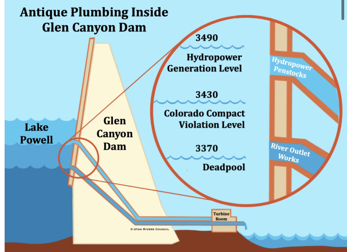
​The Interim Guidelines rely on a ‘balancing’ of the water in the two reservoirs, to keep both reservoir levels high enough so the generation of electric power can continue – an elevation of 3,490 feet (above sea level) for Powell Reservoir and 1,000 feet for Mead Reservoir. And if that proved to be impossible in an extended period of aridification, then the last-ditch effort would be to keep levels above each reservoir’s outlet works – an elevation of 3,370 feet in Powell and 895 feet in Mead. If the reservoirs fell below those outlet levels for either dam, then it would be impossible to convey any water at all beyond the dam. Dead pool.

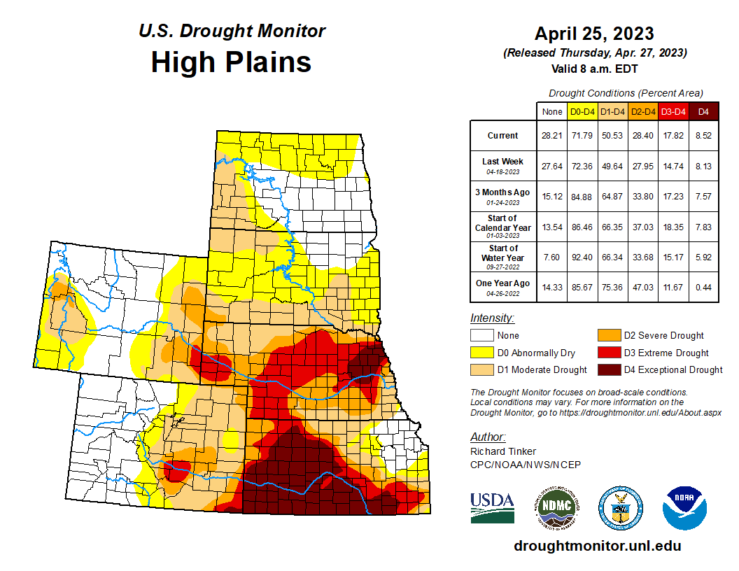
A complex table of ‘Lake Powell Operational Tiers’ is the heart of the Interim Guidelines, defining the various levels at which releases from Powell should increase or decrease depending on both the level in Powell and how the level in Mead was increasing or (generally) decreasing. And if levels continued to decline (which they have), the grinding gut of the Interim Guidelines is a set of ‘shortage conditions’ – levels at which delivery cuts will be imposed on the Lower Basin states. In 2022, the Bureau finally acknowledged the reality of the situation and declared the first level of cuts, on Arizona and Nevada.

Hoover Dam’s intake towers protrude from the surface of Lake Mead near Las Vegas, where water levels have dropped to record lows amid a 22-year drought. (Source: Bureau of Reclamation)

​Why not California too? More history: Back in 1968, when Arizona was lobbying desperately for approval of the legislation that would finally enable the CAP, California had said that it would only support the project if Arizona would accept a junior status for the CAP to all of California’s Colorado River water rights. For Arizona, even in the late 1960s, that seemed like a gamble worth taking; who could imagine water shortages that might shut down Hoover Dam and the vast array of urban-industrial development it watered? So the Arizonans agreed to California’s condition – and half a century later the unimaginable happened.

But California did not entirely employ the Shylock gambit; they reluctantly agreed in a neighborly way to accept some Interim Guideline cuts before Central Arizona was completely dried up; their cuts begin at about the fourth level of escalating cuts for Arizona and Nevada.

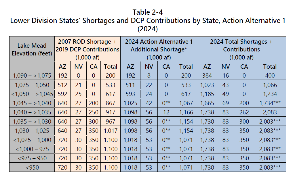
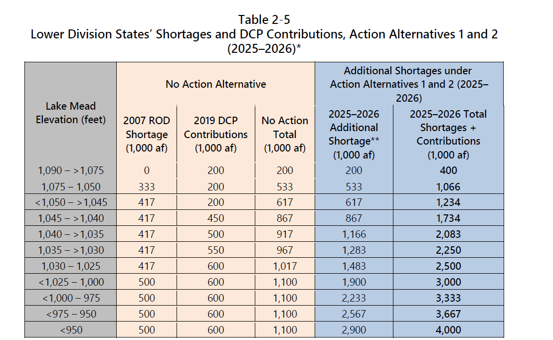
​Everywhere in the Colorado River region today, it is entirely too easy to get lost in the numbers, all those abstract thousands and millions of acre-feet. Suffice it to say for now that under the Interim Guidelines, by the time the balanced levels of Powell and Mead Reservoirs dropped to within 30-40 feet of the power generation cutoff levels, central Arizona would be giving up 720,000 af, Nevada 30,000 af, and California 350,000 af, for a total of 1.1 maf. Substantial pain – but only about half of the 2 maf structural deficit, the number to keep in mind for this unfolding melodrama. Because there is simply no way, short of constant climate miracles, to avoid an eventual dead-pool situation if the Lower Basin continues ignoring the structural deficit, with inflows to Powell way below the outflows plus system losses from the Lower Basin storage and distribution systems.

What about the Upper Basin states? They get a bye on this round. For one thing, the federal government does not control their water supply, nature does; and they are also way under their 7.5 maf Compact allotment. Also since the beginning of the drought period, the Bureau had already let more than 10 maf of ‘their’ water flow down to Mead above and beyond the Compact requirement. They also have no ‘structural deficit’; their usage includes their system losses – although the half-million acre-feet, plus or minus, evaporated out of Powell should probably be included in the unaccounted-for reservoir system losses since it occurs after the measured inflow. But people in the Upper Basin know their opportunity to participate in the reductions will come.

Even as the first level of shortages was being executed on Arizona and Nevada in 2022 (with the second level promised for this year), Powell was in its third consecutive year of inflows of 6 maf or less with outflows and system losses from Mead still in excess of 9 maf, and the Bureau realized that even the Interim Guidelines reductions might not get them all the way to 2026. Facing that, the Bureau and Interior Secretary issued a somewhat desperate announcement that it would be necessary to quickly implement much heavier cuts – at least two and maybe four million acre-feet. The Bureau Director and Interior Secretary asked the seven states to come up with a plan for how that might happen – and said that if the states did not come up with a plan, they would impose one of their own.

Graphic credit: Colorado Water Wise

​They actually said this twice, midsummer in 2022, and midwinter in 2023; the first time I think the states were too stunned to respond, and no plans emerged from either the states or the Bureau. But now, after the second call, there are four alternatives on the table, two from the states and two from the Bureau. Two of these alternatives argue for using the foundational ‘Law of the River,’ the appropriation doctrine, to distribute the necessary cuts; a big faction (mostly those with senior water rights) believes appropriations law can and should resolve every issue involving water in the arid West.

The other two alternatives seem to see the 2 maf structural deficit as a foundational mistake that needs to be corrected outside or below the rules governing the use of the river’s water; the structural deficit is water that isn’t there to use, and therefore shouldn’t be dealt with through the laws for the use of water. It thus makes the most sense to share those ‘structural’ losses out proportionally among the three states rather than trying to apply the use-allocation law to them.

​It is clear enough that the resolution will have to involve a middle ground, similar to that arrived at in the Interim Guidelines, when California’s priority was acknowledged but the state conceded to take some cuts before completely drying up the CAP. The Bureau’s second alternative comes closest to seeking that middle ground. If it were implemented, that accommodation to seniority would be carried forward with reduced assessments to California despite their use of more than half the Lower Basin’s water. In getting to the 2.083 maf goal, Arizona would take the hardest hit (1.087 maf), more than a third of their 2.8 maf allotment; and California would lose 927,000 af, only a fifth of their 4.4 maf allotment. Nevada would lose 69,000 af, about a fourth of their 300,000 af allotment.

Ultimately something along those lines has to sound better to California than going to court on principle for the usual decade, and driving the river into a dead-pool status under which they would get no water at all much of the year. Laws that can’t bend or open up to fit changing situations eventually break under the stress.

​And then – well, the 20-year interim period for the water mavens to figure out what to do for the next century has shrunk to three years. And the last I heard, they are still trying to figure out who does and doesn’t get to sit at the table to figure it out the future.

​The Bureau encourages comments on the SEIS, by May 30: Crinterimops@usbr.gov.

Map credit: AGU

#Drought news April 27, 2023: No change in depiction for #Colorado

Click on a thumbnail graphic to view a gallery of drought data from the US Drought Monitor website.

Click the link to go to the US Drought Monitor website. Here’s an excerpt:

This Week’s Drought Summary

Heavy precipitation fell on areas of dryness in the Northeast, the southern and northern Plains, the northern Rockies, northern Intermountain West, and Pacific Northwest, and more-scattered areas in the mid-Atlantic Region and Florida. Enough rain fell on some extant areas of dryness and drought here to improve drought designations, including parts of the D3 and D4 areas in central to southern Texas. In contrast, the D3 to D4 areas in the rest of the Plains and the northwestern Florida Peninsula and recorded little or no precipitation, keeping extreme to exceptional drought in place with a few areas of deterioration, especially in central Nebraska and the northwestern Florida Peninsula…

High Plains

The general pattern observed during the past few weeks continued. Unusually deep snowpack was melting in the central and northern Dakotas, leading to some improvements there, including the removal of all moderate drought (D1) from northern North Dakota.

In the Great Plains from central and western South Dakota southward through Kansas, the continued lack of substantial rainfall led to intensification over a relatively large part of these areas. In particular, D3 expanded through most of central Nebraska, and lesser expansion of D3 and D4 reported in central Kansas. To the west, conditions remained generally unchanged in eastern parts of Wyoming and Colorado, with deterioration (to D2) limited to a small area in southeastern Wyoming. In the other area of extant dryness and drought in western Wyoming – adjacent to Utah and Idaho – some areas saw improved conditions, as did states to the north and west.

The Department of Agriculture reported 62 percent of Kansas winter wheat in poor or very poor condition, as was 42 percent of Nebraska winter wheat. Only 7 percent of Colorado winter wheat was in very poor condition, but almost one-third of the rest of the state’s crop was in poor condition…

West

Areas of moderate to heavy precipitation brought some improvement across western Oregon and portions of Montana, while melting of the deep snowpack farther south eased conditions in parts of southeastern Idaho, much of the western half of Utah, northeastern Oregon, and small patches in the southern Great Basin and Southwest. This included the removal of moderate drought (D1) from parts of northern California, continuing the trend of improvement there since heavy precipitation became a frequent occurrence starting in early December 2022. The only area in the West Climate Region that noticeably deteriorated was some D0 expansion in southeastern Montana, where conditions have been similar to those in the central and southern High Plains Climate Region…

South

Locations from eastern Texas and Oklahoma eastward through Mississippi and Tennessee remained free of any designation on the Drought Monitor, though a number of areas reported that short-term dryness – on the order of a few weeks – was becoming noticeable over northern stretches of this area. Thus dryness and drought were again limited to areas near the Gulf of Mexico and over central and western sections of Texas and Oklahoma.

Heavy rain eased dryness-related impacts over much of central and southern Texas. Several inches of rain in eastern parts of Deep South Texas allowed for 2-category improvements, with much of the area going from D1 last week to no designation this week. Still, large areas of D3 and D4 remained over central and western parts of Texas and Oklahoma, with more limited reductions occurring in these areas. But enough rain fell to pull D4 out of Bexar County, Texas.

To the north and west of central Texas, little or no rain fell this past week to the 8 am EDT April 25 valid period of the Drought Monitor, keeping conditions essentially unchanged in most areas, though some degradation was noted in small sections in west-central and northern Texas. Most of the northern tier of Oklahoma remains entrenched in exceptional (D4) drought, in addition to a few scattered areas farther south. According to the Department of Agriculture, 63 percent of Oklahoma winter wheat was in poor or very poor conditions, as was 55 percent of Texas winter wheat…

Looking Ahead

During the next five days (April 26 – May 1, 2023) moderate to heavy precipitation (over 1.5 inches) is expected along the southern tier of the Nation from Texas and the lower Mississippi Valley through central and northern Florida, and along the Eastern Seaboard from Georgia through New England. Parts of the Upper Peninsula in Michigan are also forecast to receive 1.5 or more inches. Very heavy precipitation (3 to 5 inches) are expected in part of northeastern Texas, the central Gulf Coast Region, and southern Georgia. In contrast, little or nothing is anticipated from the High Plains westward, over the central and northern Great Plains, parts of the middle Mississippi Valley, and the southern Great Lakes Region. Moderate to locally heavy precipitation was observed from the Colorado Rockies through the south-central Great Plains and adjacent areas shortly after the Drought Monitor valid period (8 am EDT Tuesday, April 25) ended, with over 1.5 inches observed in scattered areas of central Arkansas, near the Oklahoma/Kansas border, west-central Kansas, higher elevations in the Rockies, and isolated sites across northern Texas. This precipitation will be considered for the Drought Monitor valid May 2, 2023 (next week). Other areas in dryness or drought should see one-tenth to locally one inch. Below-normal temperatures are expected over the southern Great Plains and most of the eastern half of the contiguous states outside the immediate coast in the South Atlantic Region. Meanwhile, warmer than normal weather is anticipated from most of the Plains through interior sections of the West Coast States. Cooler than normal conditions are expected along most of the immediate Pacific Coastline.

The Climate Prediction Center’s 6-10 day outlook (valid May 2 – 6, 2023) Identifies enhanced chances for above-normal precipitation in most of New England, the lower Mississippi Valley, Texas, the southern half of the High Plains, and from the Rockies to the Pacific Coast (except northwestern Washington). Odds for significantly above-normal precipitation exceed 50 percent in the Great Basin, most of California, and some adjacent areas. In contrast, subnormal totals are favored in the Southeast, the lower mid-Atlantic Region, and from the central and southern Appalachians northwestward through most of the Ohio Valley, Great Lakes Region, northern half of the Mississippi Valley, the northern Plains, and the Upper Midwest. Enhanced chances for cooler than normal weather cover California and adjacent areas in the Southwest and Great Basin, and in most locations from the Mississippi Valley to the East Coast. Meanwhile, unusually warm weather is expected from the northern Rockies and Intermountain West through most of the Rockies and the southern half of the High Plains.

US Drought Monitor one week change map ending April 25, 2023.

#Colorado’s big #snowpack powers massive “pulse” of #water being shot through #GrandCanyon — The #Denver Post #ColoradoRiver #COriver #aridification

Glen Canyon Dam, January 2022. Jonathan P. Thompson photo.

Click the link to read the article on The Denver Post website (Bruce Finley). Here’s an excerpt:

The water gushing out of dam jets this week normally would have flowed gradually over the month of April out of Lake Powell into the river. Eventually, the water will end up in Lake Mead, the key supply for Arizona, California and Nevada. Federal officials based their recent decision to allow the simulated floods on the relatively heavy high mountain snowpack this year along headwaters of the Colorado River, which begins west of Denver near Grand Lake…

Federal hydrologists have estimated 14.7 million acre-feet of water this summer will flow from Colorado, Wyoming and Utah into Lake Powell. Since 2018, federal dam operators have declined to release water for simulated flood surges due to long-term drought and anxieties around record-low reservoir water levels, linked by scientists to climate warming and aridification of the Southwest — transformations that have left Lake Powell and Lake Mead less than a quarter full. Yet the nation’s 1992 Grand Canyon Protection Act requires efforts to ensure ecological health in the canyon, and officials established a program that includes simulated floods…

Denver Water “is supportive of the environmental flow program” in the Grand Canyon, utility manager Jim Lochhead said, lauding the effort by multiple agencies that “come together to shift water releases — not increase overall releases — in order to mimic spring hydrology through the basin, which helps to improve beaches, sandbars and aquatic habitats.”

[…]

In 1963, the construction of the Glen Canyon Dam atop the Grand Canyon disrupted essential natural processes and created Lake Powell. Sand and other sediments that for centuries moved downriver, scouring surfaces and creating beaches, suddenly were backed up on the reservoir side of that dam. And the regularized, steady flows of clear water, devoid of sediment, gradually are transforming the canyon.

2023 #COleg: Lawmakers propose #ColoradoRiver #Drought task force as session nears an end — Water Education #Colorado @WaterEdCO #COriver #aridification

Colorado River “Beginnings”. Photo: Brent Gardner-Smith/Aspen Journalism

Click the link to read the article on the Water Education Website (Jerd Smith):

A new, late-session bill creating a statewide task force designed to shore up the state’s Colorado River drought protection efforts will be heard this week by Colorado lawmakers, with the Senate Agriculture and Natural Resources Committee considering the bill today.

The Colorado General Assembly adjourns May 6, giving lawmakers just days to deliberate on the bill.

Senate Bill 23-295 is sponsored by Sen. Dylan Roberts, D-Avon; House Speaker Julie McCluskie, D-Summit County; Sen. Perry Will, R-New Castle; and Rep. Marc Catlin, R-Montrose. It would create a task force that has six months to come up with ways to protect the state from water shortages due to the ongoing megadrought in the Colorado River Basin, and to ensure that efforts to temporarily fallow West Slope farms and ranches to help keep more water in the Colorado River don’t impose undue burdens on West Slope farms and ranches and other water users.

“This legislation … will bring us one step closer to addressing one of the most pressing issues our state has ever faced – the endangered Colorado River – and ensure every Colorado community has access to the water resources they need now and into the future,” Roberts said in a statement.

The Colorado River Basin covers seven states. The Lower Basin is made up of Arizona, California and Nevada, and the Upper Basin comprises Colorado, New Mexico, Utah and Wyoming.

The majority of the river’s supplies are generated here in the Upper Basin, with Colorado being the largest contributor to the system.

And the majority of the river’s water, roughly 80%, is used to grow food. If states can find ways to reduce agricultural water use, it would help rebalance the system. But it is a complicated undertaking, and could harm rural farm economies and food production if not done properly.

Map credit: AGU

Major water districts on Colorado’s West Slope, including the Glenwood Springs-based Colorado River District, as well as the Durango-based Southwestern Water Conservation District, represent many growers who rely on the Colorado River. They have been frustrated by what they say is a failure by the state to include them in decision making about new federal farm fallowing pilot programs, among other things. The proposed task force would be charged with devising a formal structure for including water districts and other interested parties.

Last month these districts were alarmed when the Colorado Water Conservation Board, the state’s lead water policy body, opted not to give them the opportunity to review fallowing proposals submitted to the Upper Colorado River Commission as part of what is known as the System Conservation Pilot Program (SCPP), a short-term initiative that would pay growers to voluntarily fallow their fields, or switch crops, or use other techniques to reduce their use of Colorado River water.

Steve Wolff is general manager of the Southwestern Water Conservation District. He said state water officials need to be more inclusive and transparent about decisions being made about the Colorado River.

Wolff said the CWCB’s decision to exclude the water districts from the SCPP review process is an example of the lack of transparency that is driving concern on the Western Slope.

He said the task force bill is a major undertaking and may not be finished before the session ends.

“It’s moving very fast,” he said.

The CWCB did not immediately respond to a request for comment. But CWCB Director Becky Mitchell has acknowledged previously that the SCPP initiative was rolled out very quickly, and its processes could be improved. Mitchell also represents Colorado on the Upper Colorado River Commission.

This year, due to historically deep mountain snows in Colorado and elsewhere, lakes Powell and Mead, the two largest reservoirs in the Colorado River system, will see more water flowing in than they have in decades. But because both reservoirs have sunk to less than 30% full, the bountiful runoff won’t be enough to restore the system.

In the coming weeks, major decisions loom on how to restore the river and to sustain it as climate change and lingering drought continue to sap its flows.

This week, for instance, the Upper Colorado River Commission, which represents the four Upper Basin states, will likely make decisions about which growers will participate in the $125 million SCPP.

Later this summer, the U.S. Bureau of Reclamation will announce how much Lower Basin states will have to cut their water use and which states will take the largest cuts.

Last summer, U.S. Bureau of Reclamation Commissioner Camille Touton ordered the seven states to cut 2 million to 4 million acre-feet of water this year, but negotiations have failed to produce a consensus.

The Upper Basin states, along with Nevada and Arizona, have agreed to a six-point plan that includes the SCPP, as well as a longer-term plan to create a special protected drought pool in Lake Powell, an initiative known as demand management. At the same time, California has offered its own plan that proposed cuts that are largely opposed by Arizona.

The new Colorado task force, if approved, would include West Slope and Front Range water district members, as well as environmental, agricultural and industrial interests.

Brad Wind is general manager of the Berthoud-based Northern Colorado Water Conservation District. It is one of the largest users of Colorado River water on the Front Range, and serves hundreds of farmers and more than a million urban water users.

He said his board won’t have time to take a formal position on the bill, but he said he’s concerned that it favors West Slope districts over those on the Front Range.

“There will be a lot more work between now and then [the end of the session],” Wind said. “It’s going to be a lively discussion.”

Jerd Smith is editor of Fresh Water News. She can be reached at 720-398-6474, via email at jerd@wateredco.org or @jerd_smith.