Celebrate! A spring high flow experiment in #GrandCanyon — @AmericanRivers #COriver

Rafts in the Grand Canyon | Photo Amy S. Martin

Click the link to read the article on the American Rivers website (Sinjin Eberle):

Last week, the Bureau of Reclamation, the federal government agency that oversees and manages operations on the Colorado River, announced the authorization of a spring High Flow Experiment (HFE) in the Grand Canyon. This is a big deal since the last time an HFE was conducted was in the fall of 2018, and the last time a spring HFE was executed was in 2008. And with the COLORADO RIVER IN THE GRAND CANYON NAMED AS AMERICA’S MOST ENDANGERED RIVER® just last week, we are thrilled that this action is happening to benefit the ecosystem in the canyon.

WHAT IS AN HFE?

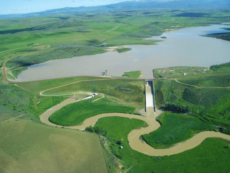
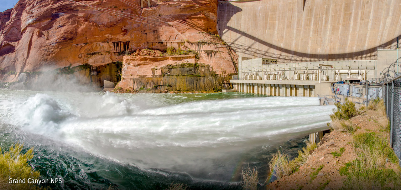
A High Flow Experiment is in essence a simulated flood being conducted through Glen Canyon dam. In practice, the dam releases a high volume of water, usually through both the hydropower turbines and the bypass tubes, which are lower-elevation tubes through the dam that are usually only used for these short duration floods or in other unique situations (like releasing water during the extreme inflows of 1983) over a limited period of time. HFE’s are extremely important to the management of sand in the canyon and the healthy functioning of the Grand Canyon riparian ecosystem overall.

To set the stage even further, let’s go back to the time before the creation of Glen Canyon Dam. The Colorado River traditionally carried millions and millions of tons of sediment down the river each year. Since Glen Canyon was built, most of that sand has been trapped in the upper reaches of Lake Powell – as flows slow down as the river becomes the lake, the sediment drops out and settles (up near Hite and Halls Crossing and then the San Juan as it enters the lake as well.) The result is that the water coming through Glen Canyon dam is very clear, lacking the traditional sediment that would be carried by the river and maintaining beaches and sandbars and the natural ecological benefits of that silty, sediment-laden water throughout the canyon. This clear water erodes sand from beaches and sandbars, and for decades in the 1970’s and 1980’s was causing real problems with the canyon’s ecology. In the 1990’s and early 2000’s, some experiments were conducted to begin to learn how these floods might act and how they might contribute to sand and other ecological functions within the canyon. Then, in 2016, the Long Term Experimental and Management Plan (LTEMP) was completed and set the guidelines for how and how frequently future HFE’s could be conducted.

Now, the Paria River, which is about 17 miles downstream from Glen Canyon dam (and about a mile below the put-in at Lee’s Ferry) is the main source of sediment into the Grand Canyon. When the Paria River flashes (most commonly during the summer monsoon season) it can deposit tons of sand – sometimes more than a million tons of sand – in a summer. This sand is what can be pushed downstream in an HFE to rebuild beaches and sandbars, and aid in the protection of cultural resources throughout the length of the canyon.

The author preparing to measure the volume of sand at this Grand Canyon beach using geodetic survey techniques | Photo by Katie Chapman

One of the elements within these LTEMP guidelines is how and when these HFE’s may be conducted, and how often the program should try to make them happen. Sadly, they have not happened often enough, and the canyon is really suffering because of it. Since the last HFE in 2018, there have been complications with declining water levels across the basin but felt most acutely in Lake Powell as elevations have declined to record lows. Then in 2021 and 2022, the monsoons delivered abundant sand through the Paria into the Colorado River, but unfortunately also caused a lot of erosion of beaches downstream as these monsoon storms ripped across Grand Canyon and the Colorado Plateau.

Today, we are celebrating the decision by the Bureau of Reclamation to use this opportunity to trigger one of these HFE’s to move the volume of sand currently sitting near the mouth of the Paria to rebuild beaches and sandbars, repair the ecology, and aid the protection of cultural resources downstream.

Glen Canyon Dam | Photo courtesy of National Park Service

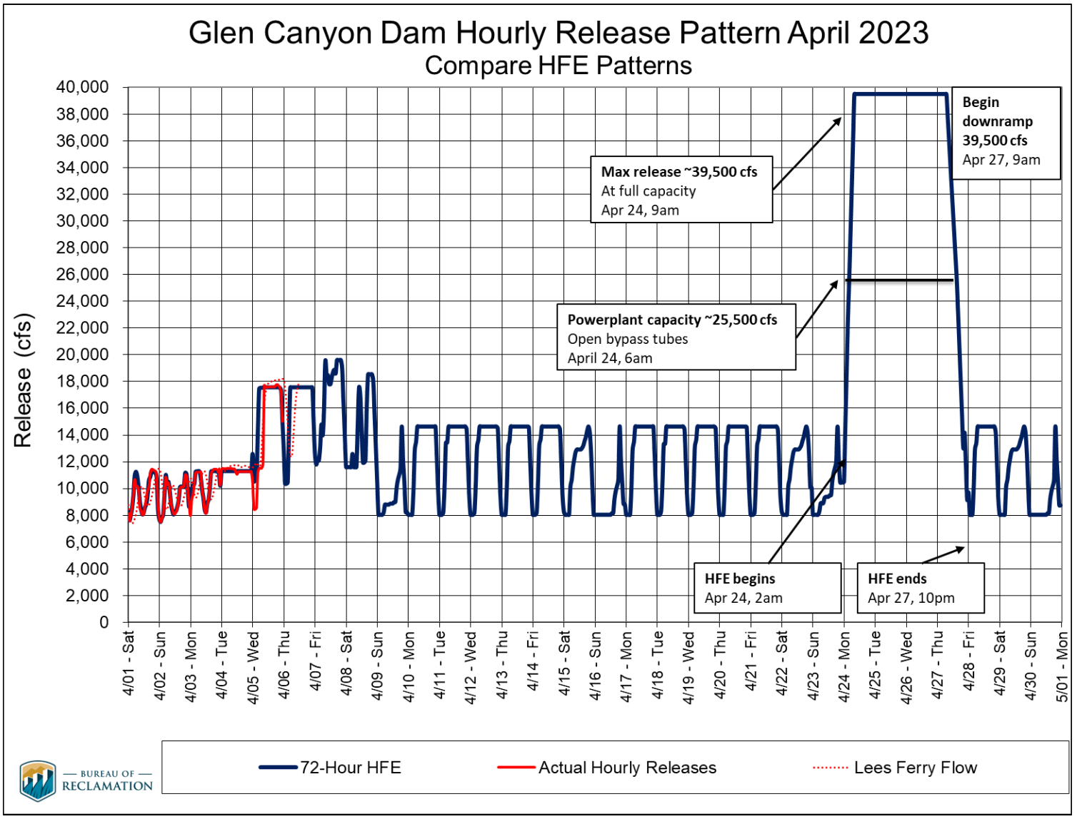
Reclamation was able to make this decision based on several factors. First, due to the drought operations conducted over the past two years, there is a good amount of water parked in Lake Powell to protect the hydropower infrastructure at Glen Canyon dam that had to be moved downstream sometime this year. Second, the sand is there and the damage to the beaches in the canyon is glaring. Third, the water sitting in Lake Powell right near the dam (in an area above the dam called the “forebay”) is quite cold, which could aid aquatic species downstream. And lastly, there is a window of time where Reclamation and the hydropower providers can shift the timing of some needed maintenance at the dam to free up the opportunity to have all 8 hydropower penstocks and some of the bypass tubes available to actually conduct the high flows through the dam.

This week’s HFE will be pretty dramatic, both visually and scientifically. The flow will begin early Monday morning (April 24, 2023) and last into Thursday evening (April 27, 2023.) The dam will ramp up releases to 39,500 cubic feet per second (CFS) and hold that for 72 hours straight creating a flood that will flow all the way to Lake Mead over a period of about a week, rebuilding sandbars and beaches along the way (and giving rafters in the canyon an exciting ride!) One additional key point to understand is that HFE’s consume no net loss of water in Lake Powell – after the HFE occurs, Glen Canyon dam will release slightly less water than normal over a period of weeks, in order to make up that amount of water that is shot downstream, yet another benefit in the design in these critically important High Flow Experiments.

High Flow Experiment Pattern

Again, we applaud the Bureau of Reclamation, the scientists at USGS’ Grand Canyon Monitoring and Research Center, and everyone else who has been working hard to make one of these HFE’s happen for years. We are looking forward to seeing the great results that will come out of this event very soon.

(To learn more about the Grand Canyon’s history and ecosystem, check out our new STORY MAP, CAUGHT IN THE MIDDLE – we think you will love it!)

Feds start 3-day flood experiment of the #GrandCanyon to improve #ColoradoRiver conditions in the canyon — AZCentral.com #COriver

Glen Canyon Dam during high flow experimental release about a decade ago. These occasional releases are just about the only time the river outlet works (where water is gushing out above) operate. Photo credit: Jonathan P. Thompson/The Land Desk

Click the link to read the article on the AZCentral.com website (Shaun McKinnon). Click through for video and a photo gallery. Here’s an excerpt:

The Bureau of Reclamation opened the bypass tubes at Glen Canyon Dam early Monday and began three days of high water flows from Lake Powell to help improve environmental conditions on the Colorado River through the Grand Canyon. It’s the first such high-flow experiment at the dam since 2018 and the first during spring runoff season. The goal is to move accumulated sediment downstream and begin to rebuild beaches on the river that have eroded in recent years. The engineered flood mimics some of the river’s pre-dam flows, when snowmelt runoff from the mountains far upstream would raise water levels and redistribute sediment. Since Glen Canyon Dam’s completion in 1963, the water flowing into the Grand Canyon has carried less sediment, much of the river’s sand and other materials trapped behind the dam.

Releasing more water from Lake Powell won’t change the total amount of water that flows through the system this year, bureau officials said. The water will arrive at Lake Mead earlier than it would have otherwise and remain there until it’s needed downstream. Dam operators began raising water flows early Monday, first through the power plant turbines and then through bypass tubes on the side of the dam. By mid-morning, water gushed from the tubes into the river at the dam’s base, the start of a journey downstream through the Grand Canyon toward Lake Mead. The amount of water released will fluctuate over the three days, but the bureau said the high flows will peak at about 39,500 cubic feet per second, or as much as quadruple the average output from the dam. The water releases will return to normal operations by Thursday.

Why average #snowpack in #Colorado is something to celebrate this year — CBS Colorado #runoff

Click the link to read the article on the CBS Colorado website (Spencer Wilson). Here’s an excerpt:

Let’s get to the good news: Colorado got snow this year, and it’s going to help fill up our reservoirs, some of them almost to average! Yes, that doesn’t sound great, but considering our last few years, the average is something to celebrate. Travis Thompson, Denver Water spokesperson, pointed to the snowpack just starting to melt into the Colorado River Basin, where he said Denver gets about half its water.  If these next rounds of storms coming through are able to drop off some moisture, our pack levels will likely hit 100% normal and we’d be in good shape, for this year at least.,,

…in Colorado, it’s more spread out, some parts got hammered, like the San Juan Mountain Range, and some parts of Colorado got what they usually got, or even less in some spots. To look at an overall state average would to be instilling a false sense of confidence, Thompson said.

Elkhead Reservoir expected to top spillway again this year similar to 2011: Streambank erosion expected in lower #ElkheadCreek — Steamboat Pilot & Today #runoff

The Colorado River Water Conservation District predicts Elkhead Reservoir will overtop its spillway in mid-May with water exiting the spillway and outflow at a combined rate of about 2,000 cubic feet per second, or about the same level of peak water as in 2011, shown here on June 14, 2011. Stream bank damage is expected downstream in Elkhead Creek in May. Photo credit: Colorado River Water Conservation District

Click the link to read the article on the Steamboat Pilot & Today website (Suzie Romig). Here’s an excerpt:

Last year, Elkhead Reservoir operators carefully managed the reservoir that straddles the Routt and Moffat countyline due to low water issues, but this year reservoir managers are facing challenges due to high water from abundant snowmelt in the Yampa Valley. Managers predict Elkhead Reservoir will top its spillway in mid-May with water exiting the spillway and outflow at a combined rate of about 2,000 cubic feet per second, or cfs, or about the same level of peak water as in wet 2011, said Don Meyer, senior water resources engineer with the Colorado River Water Conservation District based in Glenwood Springs.

“The current outflow is about 550 cfs with valves 100% open,” Meyer said. “When (the reservoir is) full, the release will be 590 cfs. When spilling, we will likely keep the outlet discharge at 590 cfs, and the rest will go over the spillway.”

Meyer, who has managed Elkhead Reservoir releases since 2007, said high water flows in 2011 recorded 1,800 cfs on May 8 and more than 2,000 cfs on May 16, May 24 and June 4. He expects 2023 spillage will follow a similar path…

The watershed upstream of Elkhead Reservoir drains a 205-square-mile basin, according to the river district that owns or controls water supplies that are available for contract to agricultural, municipal, industrial and other water users.

Yampa River Basin via Wikimedia.

Southern and northern lights sweep planet in stunning display of auroras — The Washington Post #aurora

Click the link to read the article on The Washington Post website (Matthew Cappucci and Kasha Patel). Click through for the video, photos, and Twitter stream. Here’s an excerpt:

A ‘severe’ solar storm triggered the outburst of auroras. Even California, Arizona, Arkansas and Virginia reported sightings.

Skywatchers in Europe, Asia and North America were treated Sunday night to perhaps one of the most widespread displays of the northern lights since the autumn solar storms of 2003. Equally impressive shows of the aurora australis, or southern lights, were spotted in Australia and New Zealand.

The northern and southern lights, collectively known as the aurora, are most common in the high Arctic and Antarctic regions around the poles, but they can venture to the middle latitudes on rare occasions during potent geomagnetic storms. The storms are caused by magnetic energy and electrons that are hurled into space by the sun. The stronger the solar storm, the greater the effect — particularly if the resulting outburst is directed toward Earth. Forecasters at the Space Weather Prediction Center in Boulder, Colo., issued warnings for a Level 4 out of 5 “severe” geomagnetic storm, which happens on average only 60 times every 11 years. The episode may have been even more intense at times, sparking auroral displays as far south as California, Arizona, Arkansas and Virginia…

On Friday afternoon, NASA’s Solar Dynamics Observatory satellite recorded an explosion on the surface of the sun. The flare, rated an M2 on an ascending scale that climbs A, B, C, M to X, caused a radio burst on Earth eight minutes later. That clued NOAA forecasters into the fact that the energy was directed toward Earth…The flare was followed by a coronal mass ejection (CME) — a mass of solar plasma, charged particles and magnetism — that headed directly toward Earth at speeds of roughly 1.5 million miles per hour. That interplanetary shock wave collided with Earth’s magnetic field on Sunday afternoon Eastern time, which was after dark in Europe and in the early hours of Monday in China. Brilliant apparitions of the northern lights quickly appeared. The CME brought “severe” geomagnetic storming, stronger than what the Space Weather Prediction Center forecast when the CME left the sun Friday…

The colors of an aurora correspond to the type and altitude of the element that is excited in Earth’s atmosphere, Murtagh explained. Excited oxygen atoms glow red above 120 miles and glow green between 60 and 120 miles. Excited nitrogen atoms below 120 miles can glow pink or purple. Murtagh said a more intense aurora is typically higher, so lower latitudes will see more red.

“The bigger storms can light up the higher altitudes, which is largely going to [excite] the oxygen causing that red,” he said. “The further you are away, down south that is, you’re going to not see the green and yellow in the lower altitudes.”