Synopsis: ENSO-neutral conditions are expected to continue through the Northern Hemisphere spring, followed by a 62% chance of El Niño developing during May-July 2023.
During the last month, above-average sea surface temperatures (SSTs) became more prominent in the western and far eastern equatorial Pacific Ocean. The latest weekly Niño-3.4 index value was 0.0ºC, but the Niño1+2 index value was +2.7ºC, indicating significant warming along the South American coast. Area-averaged subsurface temperatures also increased over the past month, reflecting the dominance of above-average subsurface temperatures across the equatorial Pacific Ocean. For the monthly average, upper-level and low-level winds were near normal across most of the equatorial Pacific Ocean. However, low-level westerly wind anomalies were evident in the first half of March associated with subseasonal activity. Suppressed convection was evident over the central tropical Pacific and over parts of Indonesia. While the warming near coastal South America was striking, the basin-wide coupled ocean-atmosphere system was consistent with ENSO-neutral.
The most recent IRI plume favors a transition to El Niño, beginning June-August 2023 and persisting into the winter. While the lower accuracy of forecasts during the spring can result in surprises, the recent oceanic Kelvin wave plus recurring westerly wind anomalies are anticipated to further warm the tropical Pacific Ocean. The coastal warming in the eastern Pacific may foreshadow changes across the Pacific basin. Therefore, an El Niño Watch has been issued, and the range of possibilities toward the end of the year includes a strong El Niño (4 in 10 chance of Niño-3.4 1.5C) to no El Niño (1 in 10 chance). In summary, ENSO-neutral conditions are expected to continue through the Northern Hemisphere spring, followed by a 62% chance of El Niño developing during May-July 2023.
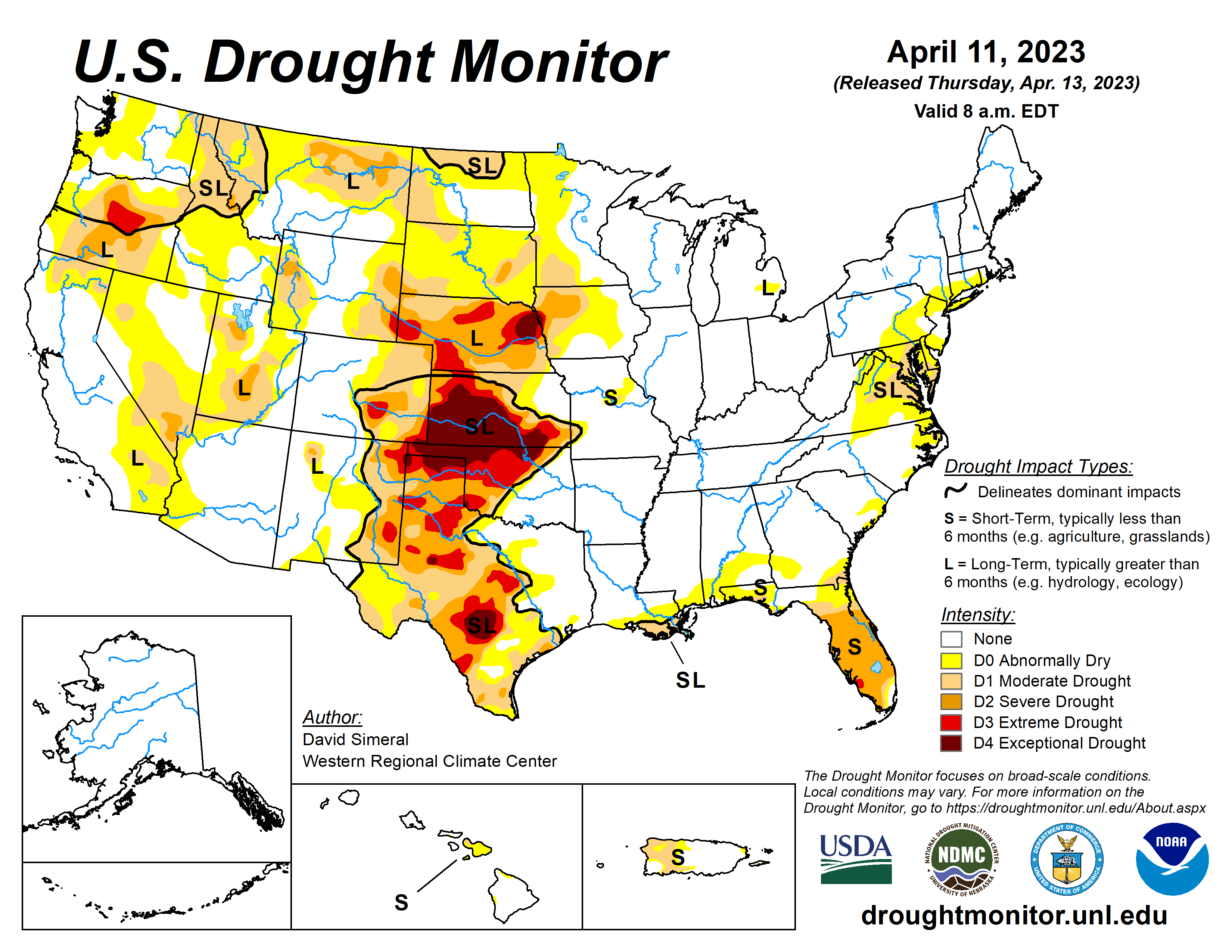
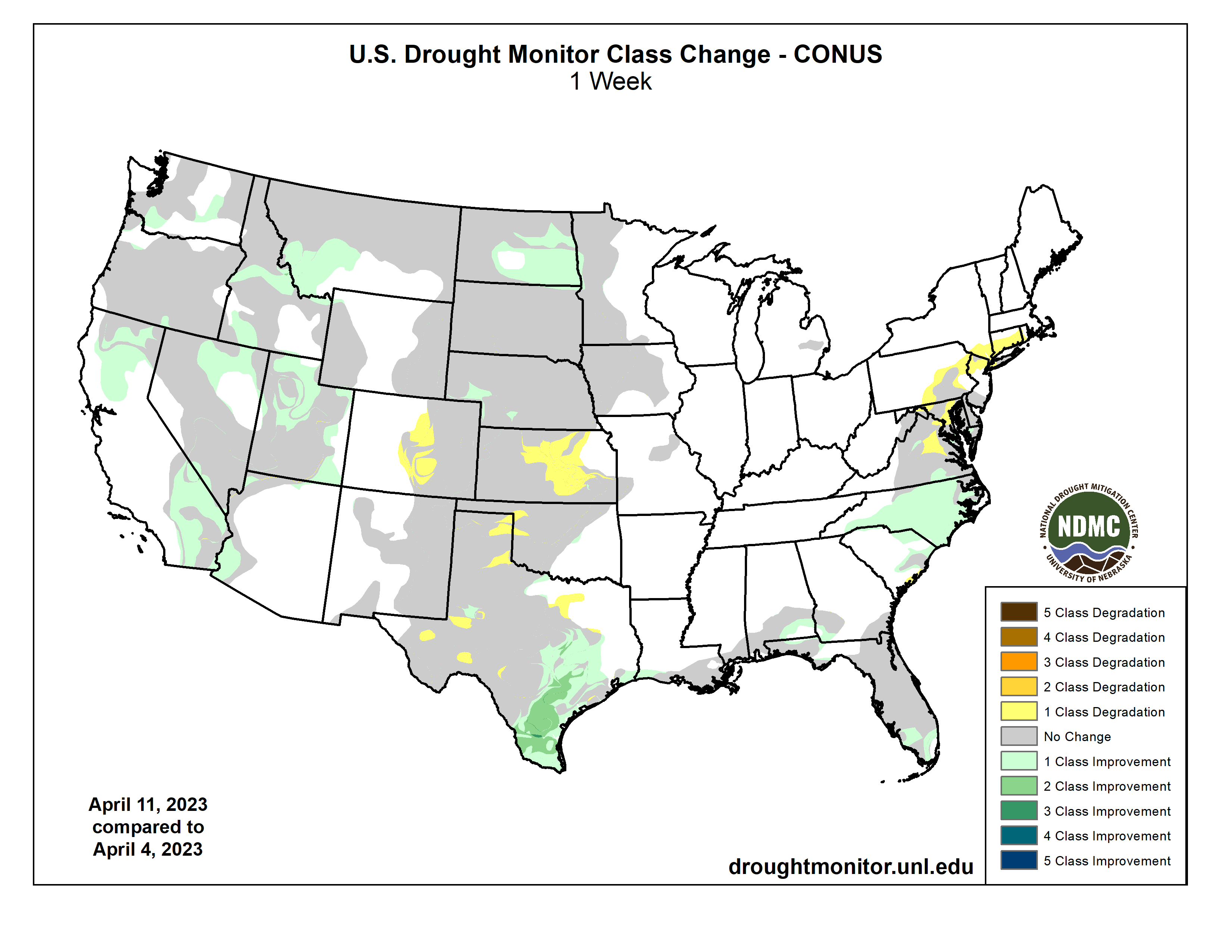
This U.S. Drought Monitor (USDM) week saw continued improvements on the map across areas of the West including California, Nevada, Idaho, Montana, and Utah. In the Plains states, drought-related conditions degraded in the southern Plains in Kansas and Oklahoma. In Kansas, the past 9-month period (July 2022-March 2023) has been the 4th driest on record, according to the NOAA National Centers for Environmental Information (NCEI). In the northern Plains, the conditions on the map improved in response to recent significant winter storm events that helped to boost snowpack conditions in North Dakota where numerous weather stations broke all-time snow depth records for April, according to the North Dakota State Climate Office. In the South, a mix of improvements and degradation characterized the region’s drought status this week. Significant improvements were observed in South Texas, parts of the Hill Country, and the Gulf Coast regions where locally heavy rainfall accumulations (2 to 8+ inches) were logged. Conversely, areas of western Texas and the Panhandle saw continued degradations in response to short and longer-term precipitation shortfalls. In the Southeast, above-normal temperatures (4 to 8 deg. F) and generally dry conditions persisted across drought-affected areas of Florida. Further to the north in the Carolinas and areas of southern Virginia, improvements were made related to widespread shower activity, including some locally heavy accumulations (2 to 5+ inches), observed this past week. In the Mid-Atlantic and Northeast, short-term dry conditions and widespread low streamflow activity led to areas of degradation in Virginia, Maryland, New Jersey, New York, Connecticut, and Rhode Island. Looking at the latest climatological data released by NOAA NCEI, March precipitation across the contiguous U.S. ranked in the wettest third of the historical record (129 years) with well above-normal precipitation (falling in the top 10th percentile) observed regionally across much of the western U.S. including in California (7th wettest), Nevada (6th wettest), and Utah (3rd wettest). Meanwhile, drier-than-normal conditions for March were observed across much of the Eastern Seaboard including in Virginia, which saw its 8th driest on record. In terms of average temperatures, temperatures were above normal for March across all of the Eastern Seaboard as well as across the southern Gulf Coast states where Florida observed its 8th warmest on record. In the northern Plains and across the West, cooler-than-normal temperatures prevailed with notable anomalies observed in California (5th coldest), Nevada (5th coldest), Oregon (3rd coldest), and Utah (7th coldest). Looking at snowpack conditions across the West, record-breaking snowpack conditions were observed in the Sierra Nevada, Great Basin, ranges of the Colorado Plateau in Utah and northern Arizona, and in the central and southern Rockies of western Colorado, northern Utah, and southeastern Idaho…
West Drought Monitor basin-filled map April 12, 2023 via the NRCS.
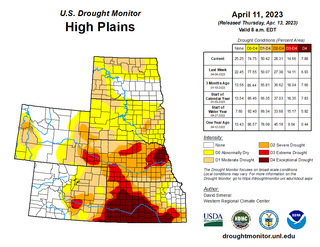
On this week’s map, deterioration occurred in the southern extent of the region in Kansas where both short and long-term precipitation deficits exist (ranging from 4 to 16 inches during the past 12-month period). Moreover, other drought-related indicators, such as surface and root zone soil moisture, are showing very low moisture levels (ranging from the 2nd to the 20th percentile) across Kansas as well as much of Nebraska, according to NASA Short-term Prediction Research and Transition Center (NASA SPoRT). In the Dakotas, deep snowpack conditions were observed this month as well as recent rapid melting which has boosted soil moisture levels significantly (leading to improvement on the map) as well as concerns over major flooding. Flood warnings have been issued for numerous rivers across the Dakotas as temperatures are expected to soar into the low 90s today (April 12) in southeastern South Dakota. According to NOAA NCEI, North Dakota logged its 32nd wettest March on record while Nebraska observed its 28th driest and Kansas its 14th driest. In terms of average temperatures, North Dakota observed its 5th coldest March and South Dakota its 16th coldest on record, For the 12-month period (April 2022-March 2023), Nebraska experienced its 11th driest on record while Kansas its 17th driest…
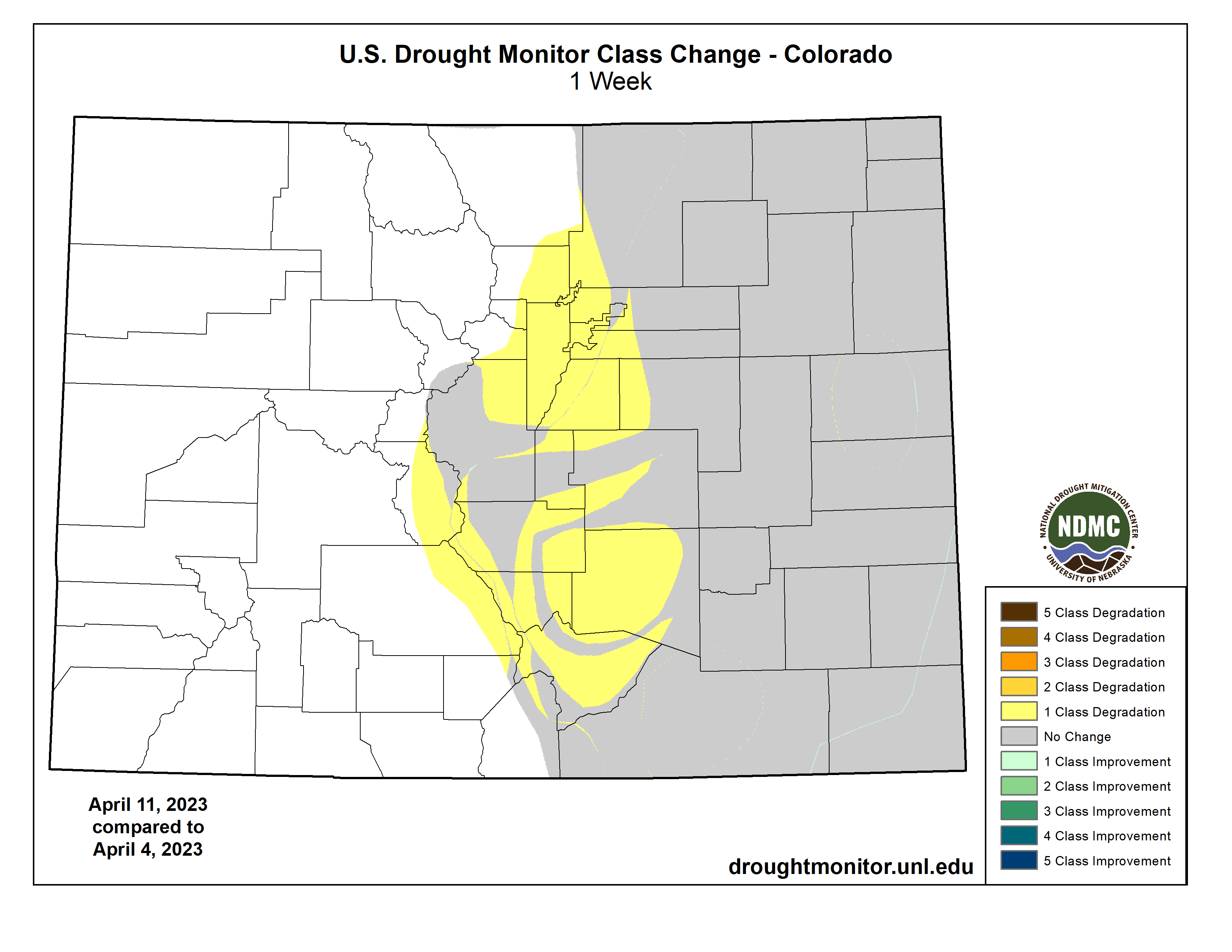
Colorado Drought Monitor one week change map ending April 11, 2023.
On the map, another round of improvements was made in drought-affected areas of California, Nevada, Idaho, Montana, and Utah this week. Looking at the October through March period, NOAA NCEI’s latest climatological rankings are showing above-normal precipitation in the West Climate Region (California, Nevada) as well as in the Southwest Climate Region (Four Corners states) coming in at 9th wettest (+6.31-inch anomaly) and 18th wettest (+1.83-inch anomaly), respectively. At a statewide level for the contemporaneous period, California ranked 10th wettest (+8.6 inch-anomaly), Nevada 5th wettest (+3.03-inch anomaly), and Utah 4th wettest (+3.71-inch anomaly). Looking at the latest region-level (2-digit HUC) snowpack data across the West, the NRCS SNOTEL network (April 11) was reporting the following median snow water equivalent (SWE) levels: Pacific Northwest 126%, Missouri 114%, Souris-Red-Rainy 84%, California 258%, Great Basin 246%, Upper Colorado 157%, Arkansas-White-Red 98%, Lower Colorado 417%, and Rio Grande 143%. In the Colorado River Basin, Lake Powell was at 23% of capacity and Lake Mead at 28% of capacity on April 11, according to the U.S. Bureau of Reclamation. In Arizona, the Salt and Verde River system reservoirs were 98% full as compared to 72% full a year ago, according to the Salt River Project. In California, the state’s two largest reservoirs, Shasta Lake and Lake Oroville, are 110% and 117% of their historic averages for the date, respectively. Overall, drought coverage (D1-D4 categories) in California on the map dropped to 8.79% this week as compared to 99.77% at the beginning of the Water Year (October 1, 2022). Likewise, drought coverage on the map in Utah went from 100% (October 1) to 35% this week, and in Nevada from 100% (October 1) to 23%…
In the South, drought-related conditions improved in areas of southern Texas in association with some locally heavy rainfall accumulations (up to 8 inches) during the past week. In other areas of the region, drought-related conditions deteriorated in isolated areas of western Oklahoma and Texas in response to precipitation shortfalls at various time scales, low streamflows (<10th percentile), poor groundwater conditions, and impacts within the agricultural sector. For the week, average temperatures across the region were below normal across Louisiana, Oklahoma, and Texas (2 to 10+ degrees F) while Arkansas, Mississippi, and Tennessee were 1 to 5 degrees F above normal. According to NOAA NCEI, the past 12-month period (April 2022-March 2023) was the 5th warmest and 33rd driest on record in the South Climate Region. For March 2023, the region saw its 35th warmest on record with a +3.0-degree F anomaly and its 51st driest on record…
Looking Ahead
The NWS WPC 7-Day Quantitative Precipitation Forecast (QPF) calls for moderate-to-heavy liquid (liquid = rain + SWE) precipitation accumulations ranging from 2 to 5+ inches across western portions of Oregon and Washington while lighter accumulations (< 1 inch) are forecasted for areas of the northern and central Rockies. The remainder of the West is expected to be generally dry during the next 7-day period. In areas of the Upper Midwest and Northeast, light accumulations (< 1 inch) are expected, while light to moderate accumulations (1 to 4+ inches) are forecasted for areas of the Gulf Coast states with the heaviest accumulations expected in southern portions of Louisiana and Mississippi. The CPC 6-10-day Outlooks calls for a moderate-to-high probability of above-normal temperatures across the southern and central Plains, South, Southeast, and the Northeast, while below-normal temperatures are expected across areas west of the Rockies and across areas of the northern Plains and Upper Midwest. In terms of precipitation, below-normal precipitation is expected across the far eastern extent of the Midwest and the southwestern portion of the Northeast region, while above-normal precipitation is forecasted for Plains states, Texas, and the northern two-thirds of the western U.S.
US Drought Monitor one week change map ending April 11, 2023.
Click the link to read the article on the InkStain website (John Fleck):
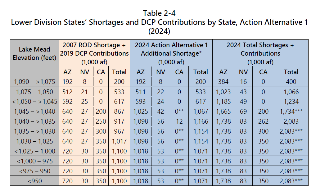
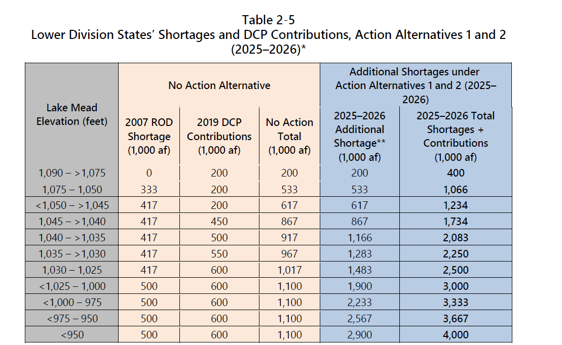
I’ll need a few more days to digest all 476 pages of the Department of Interior’s Colorado River Draft Supplemental Environmental Environmental Impact Statement, but the top line numbers are worth sharing right away. The DEIS includes a couple of action alternatives, which I’ll briefly describe below, but what’s immediately striking to me is that Interior’s cuts are significantly less ambitious than the states’. Here’s a quick update of the table I built back in January comparing the proposal submitted by Arizona/Nevada/Utah/Colorado/New Mexico/Wyoming, and the California plan.
As you can see, the states were far more willing to cut more quickly, and more deeply, than the federal alternatives. The numbers are cuts, in thousands of acre feet, from the old pre-chaos baselines of 4.4 maf for California, 2.8 maf for Arizona, 300kaf for Nevada.
Tier
Elevation
6-state
California
DEIS 2024
DEIS 2025-26
Tier 0
1090
1,784
1,241
400
400
Tier 1
1075
2,156
1,613
1,066
1,066
Tier 2a
1,050
2,918
1,721
1,234
1,234
Tier 2b
1045
2,918
2,013
1,734
1,734
Tier 2c
1040
2,918
2,071
2,083
2,083
Tier 2d
1035
2,918
2,129
2,083
2,250
Tier 2e
1030
3,168
2,188
2,083
2,500
Tier 3a
1025
3,168
2,525
2,083
3,000
Tier 3b
1020
3,368
2,675
2,083
3,333
Tier 3c
1015
3,368
2,875
2,083
3,333
1,010
3,368
3,125
2,083
3,333
1,005
3,368
3,325
2,083
3,333
In addition to the, “whatever, let’s just crash the system”, the DEIS includes two alternatives….
PRIORITY ADMINISTRATION
Alternative one would allow the cuts in my “DEIS” column based on the priority system. This plan is similar to California’s, in that the brunt of deep cuts falls on others. At current reservoir levels, Arizona would be required to cut 1.2 million acre feet, while California cuts nothing.
SHARING THE IMPACTS OF CLIMATE CHANGE
Alternative two would spread additional needed cuts based on a pro-rata share of 2021 water use among all the users. At current levels, Arizona would cut 1.025 million acre feet, California would cut 1.067.
HOW IT PLAYS OUT
Contrary to that crazy New York Times headline (click soon, it’ll certainly change!) Interior isn’t picking a preferred alternative. These are really just starting points for a push toward a seven-state negotiation between now and summer.