Roundup of news about the #ColoradoRiver SEIS from Interior #COriver #aridification

Colorado River “Beginnings”. Of the states that rely on the Colorado River, California receives the largest share of water. Photo: Brent Gardner-Smith/Aspen Journalism

Click the link to read “Federal government considers major water cuts to protect Colorado River” on The Los Angeles Times website (Ian James). Here’s an excerpt:

The stakes in the decision are high for California, which receives the largest share of water from the Colorado River, as well as for Arizona and Nevada. Imposing an equal across-the-board cut would hit California harder, particularly in agricultural regions, while strict adherence to the water-rights priority system would bring larger reductions for cities like Phoenix and Las Vegas. The U.S. Bureau of Reclamation presented its alternatives as an initial step in a review aimed at revising the rules for dealing with shortages through 2026. Federal officials said that the proposals still could change and that a solution somewhere between the two options could emerge as representatives of states, water agencies and tribes continue negotiations on how to address the chronic water shortages.

“The prolonged drought afflicting the American West is one of the most significant challenges facing our country today,” Deputy Interior Secretary Tommy Beaudreau said. “We’re in the third decade of a historic drought that has caused conditions that the people who built this system would not have imagined.”

[…]

The Bureau of Reclamation said it released its initial review of alternatives, called a draft supplemental environmental impact statement, to “address the continued potential for low run-off conditions and unprecedented water shortages” in the Colorado River Basin. Officials said they need plans in place to protect critical levels at Lake Mead and Lake Powell and prevent them from dropping so low that the dams would stop generating power and water deliveries would be at risk…

The agency is revising the 2007 guidelines for its operations of Glen Canyon Dam and Hoover Dam, which include measures for dealing with shortages through 2026 — but which federal officials say would no longer be sufficient if reservoirs continue to decline. The Biden administration released its options more than two months after officials from California and six other states presented two conflicting proposals for water reductions. Closed-door talks among state officials and managers of water agencies are set to continue while the federal government receives input on the proposals. And representatives of California, Arizona and other states pledged to continue working toward a seven-state consensus…

The Salton Sea (pictured above ) straddles the Imperial and Coachella valleys and has long been a sticking point in Colorado River deals. The Imperial Irrigation District holds the single largest water right on the Colorado River. (Source: Water Education Foundation)

Under one of the options, the federal government would consider making water reductions based predominantly on the existing priority system for water rights. That would mean smaller cuts or no cuts for agencies and entities that hold older senior rights, including agricultural suppliers such as California’s Imperial Irrigation District, which uses the single largest share of Colorado River water to supply about 500,000 acres of farmland in the Imperial Valley. Strict adherence to the water-rights priority system would also mean large cuts for junior water rights holders that started taking water from the river later, such as the Central Arizona Project, which supplies Phoenix, Tucson and other cities.

Under a second alternative, the Bureau of Reclamation would analyze the effects of reductions “distributed in the same percentage” for all water users in the three Lower Basin states of California, Arizona and Nevada. This approach would mean across-the-board cuts for all water users in the region, including senior water rights holders, amounting to a reduction of about 13% on top of cuts that were already agreed to under a 2019 deal. Agricultural irrigation districts, cities and tribes would all need to participate based on a schedule of reductions tied to the levels of Lake Mead. Beaudreau said this second alternative reflects the Interior secretary’s authority to “provide for human health and safety” and manage supplies under emergency conditions. If reservoir levels drop further and additional cuts are triggered, this approach would shore up the allocations of agencies with more junior water rights, such as cities in Arizona, Nevada and Southern California.

Both of these alternatives call for progressively larger reductions as the level of Lake Mead declines. The total amount of potential cuts in 2024, including reductions under existing agreements, could reach slightly more than 2 million acre-feet — a major reduction from the three states’ total apportionment of 7.5 million acre-feet.

Updated Colorado River 4-Panel plot thru Water Year 2022 showing reservoirs, flows, temperatures and precipitation. All trends are in the wrong direction. Since original 2017 plot, conditions have deteriorated significantly. Brad Udall via Twitter: https://twitter.com/bradudall/status/1593316262041436160

Click the link to read “Biden Administration Proposes Evenly Cutting Water Allotments From Colorado River” on The New York Times website (Christopher Flavelle). Here’s an excerpt:

After months of fruitless negotiations between the states that depend on the shrinking Colorado River, the Biden administration on Tuesday proposed to put aside legal precedent and save what’s left of the river by evenly cutting water allotments, reducing the water delivered to California, Arizona and Nevada by as much as one-quarter. The size of those reductions and the prospect of the federal government unilaterally imposing them on states have never occurred in American history…

The Biden administration is desperately trying to prevent that situation, known as deadpool. But it faces a political and ethical dilemma: How to divvy up the cuts required.

The Interior Department, which manages the river, released a draft analysis Tuesday that considered three options. The first alternative was taking no action — a path that would risk deadpool. The other two options are making reductions based on the most senior water rights, or evenly distributing them across Arizona, California and Nevada, by reducing water deliveries by as much as 13 percent beyond what each state has already agreed to…

Aerial photo – Central Arizona Project. The Central Arizona Project is a massive infrastructural project that conveys water from the Colorado River to central and southern Arizona, and is central to many of the innovative partnerships and exchanges that the Gila River Indian Community has set up. Public Domain, https://commons.wikimedia.org/w/index.php?curid=326265

If changes were based on seniority of water rights, California, which among the seven states is the largest and oldest user of Colorado River water, would mostly be spared. But that would greatly harm Nevada and force disastrous reductions on Arizona: the aqueduct that carries drinking water to Phoenix and Tucson would be reduced almost to zero.

“Those are consequences that we would not allow to happen,” Tommy Beaudreau, the deputy secretary for the Interior Department, said in an interview on Monday…

From the 2018 Tribal Water Study, this graphic shows the location of the 29 federally-recognized tribes in the Colorado River Basin. Map credit: USBR

Another challenge with letting the cuts fall disproportionately on Arizona: Doing so would hurt the Native American tribes that rely on that water, and whose rights to it are guaranteed by treaty. Governor Stephen Roe Lewis of the Gila River Indian Community, which is entitled to a significant share of Colorado River water, said the goal should be “a consensual approach that we can all live with.” Spreading the reductions evenly would reduce the impact on tribes in Arizona, and also help protect the state’s fast-growing cities. But it would hurt Southern California’s agriculture industry, which helps feed the nation, as well as invite lawsuits. The longstanding legal precedent, often called the law of the river, has been to allocate water based on seniority of water rights…

The draft analysis did not formally endorse any option; a final analysis is expected this summer, and it could include still other approaches. But Mr. Beaudreau said he was “pretty comfortable” that allocating cuts evenly would let the department meet its goals — preventing water levels in Lake Mead and Lake Powell from falling below critical levels, protecting health and safety, and not exceeding the department’s legal authority. He defended the government’s willingness to depart from longstanding seniority rules about water rights, arguing that the shocks of climate change couldn’t have been predicted when those rights were agreed to decades ago. The proposal marks a new and painful phase in America’s efforts to adapt to the decades-long drought in the West. Until now, the federal government has responded to drought primarily by paying farmers, cities and Native tribes to voluntarily use less water.

The Colorado River from Navajo Bridge below Lee’s Ferry and Glen Canyon Dam. The proposed Marble Canyon Dam would have been just downstream from here. Jonathan P. Thompson photo.

Click the link to read “Colorado River cities and farms face dire trade-offs with new federal review” on The Washington Post website (Joshua Partlow). Here’s an excerpt:

Interior officials also defended Secretary Deb Haaland’s right to make cuts in a proportional way in times of emergency even if that goes against water rights held by farming communities from more than a century ago…

the Lower Basin “structural deficit”, reified. Photo credit: John Fleck

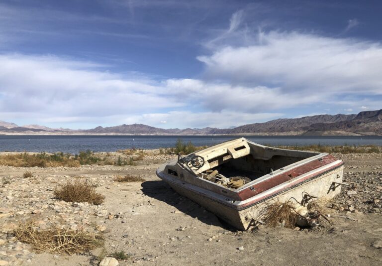
Through the windows behind [Deb Haaland], the bleached “bathtub ring” on the hillside above Lake Mead was clearly visible — a reminder of how far the reservoir, now about a quarter full, has fallen over the past two decades of drought.

“Some may believe that this winter’s snow and rain has saved the river, but that is not the case,” said Tom Buschatzke, director of the Arizona Department of Water Resources. “We have a lot of hard work and difficult decisions ahead of us in this basin.”

State officials expressed the desire for all seven Colorado River basin states to reach an agreement over the next few months and avoid the need for the federal government to impose cuts unilaterally. Federal officials described the two alternatives they laid out — strictly following water rights, or making cuts of the same percentage across California, Arizona and Nevada — as “bookends” on a spectrum, giving state officials direction to seek compromise in between…

“It gives us the framework … on which we can build and perhaps find something that is partway between those two bookends,” said Estevan Lopez, New Mexico’s representative on the Upper Colorado River Commission. “I think that’s our challenge right now.”

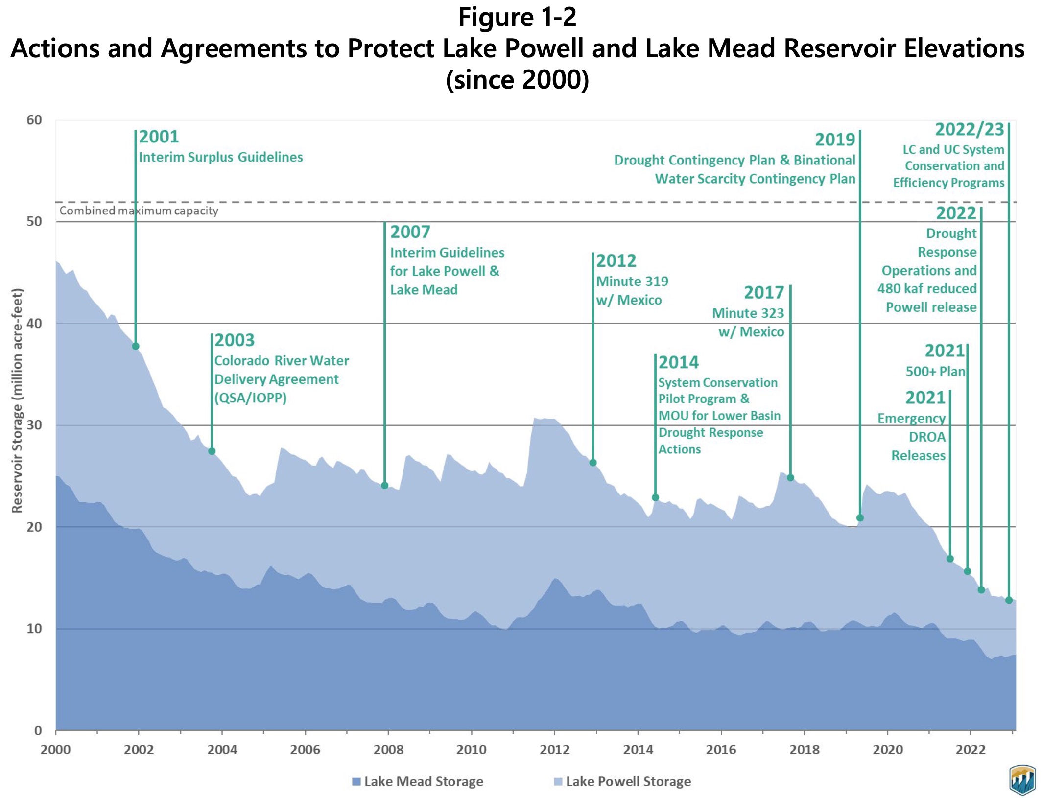
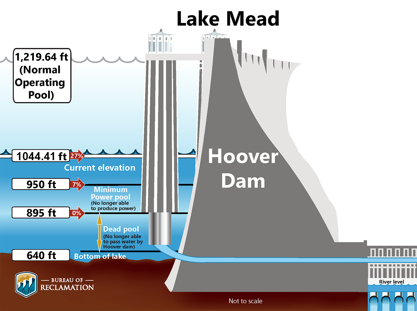
The goal of the document is to assess potential rule changes for how water is released from Lake Powell and Lake Mead to protect these reservoirs from falling below what is known as “minimum power pool.” That’s the point at which the Glen Canyon and Hoover dams can no longer produce hydropower because there is not enough water to flow through the turbines safely. These reservoir elevations — about 3,500 feet above sea level at Lake Powell and 950 feet at Lake Mead — will be the thresholds that the federal government is working to avoid. Lake Powell stands just 20 feet above that level and is less than a quarter full…

In January, six of the states — Arizona, Nevada, New Mexico, Colorado, Utah and Wyoming — agreed on an approach that would make major cuts in a proportional way among states. That would hit California farmers in places such as the Imperial Valley — who suck up a lot of the river and have rights to it that predate some cities — particularly hard. California, the largest user of Colorado River water, rejected that approach, and called for cuts that adhered to water rights priority. The plan would be devastating to Arizona, state officials there say…

But Tuesday’s environmental review also establishes a different way to justify the reductions. The six-state plan rationalized departing from a strict adherence to water rights by attributing some 1.5 million acre-feet of cuts to evaporation and other losses as water travels down the canals from the major reservoirs. But the federal government’s second alternative — the one for proportional cuts — is based not on evaporation but on Haaland’s legal authority to protect the river.

“In our mind, the appropriate presentation is grounded in the secretary’s authorities to provide for human health and safety, manage the system under emergency conditions, and provide for beneficial use,” Beaudreau said. “It is the secretary’s responsibility, and she has the authority, to protect the system.”

Hoover Dam’s intake towers protrude from the surface of Lake Mead near Las Vegas, where water levels have dropped to record lows amid a 22-year drought. (Source: Bureau of Reclamation)

Click the link to read “Without agreement among states, federal officials say Colorado River cuts are coming” on the KUNC website (Luke Runyon). Here’s an excerpt:

Federal officials made clear they hope not to have to use the plan at all, whether that’s because the region experiences a string of wet winters or the states come up with commitments to reduce their reliance on the river without federal intervention.

“We’re looking to develop a true seven-state consensus in the coming months, ideally in this next 45-day period, if possible,” said J.B. Hamby, California’s top Colorado River negotiator.

If the federal government moves ahead and turns its draft plan into a final form, it could increase the likelihood of interstate lawsuits over state water rights.

“We do see that litigation could be possible,” said Tom Buschatzke, Arizona’s top water official. “We are committed to avoiding that litigation outcome as best we can by coming up with a collaborative solution.”

Public comment is open on the draft plan until the end of May, with a final plan expected this summer.

Lake Powell boat ramp at Page, Arizona, December 17, 2021. Photo credit: Allen Best/Big Pivots

Click the link to read “Federal officials propose reducing Colorado River water to lower-basin states in “shot across the bow” on The Denver Post website (Conrad Swanson). Here’s an excerpt:

The move strengthens the federal agency’s resolve to conserve water from the Colorado River as the seven states within its basin repeatedly fail to find common ground, said Rhett Larson, a water law professor at Arizona State University.

“I am reading this as a shot across the bow,” Larson said. “The federal government is saying, ‘Brace yourselves, because if you don’t come up with something, we will.’”

West snowpack April 11, 2023 via the NRCS.

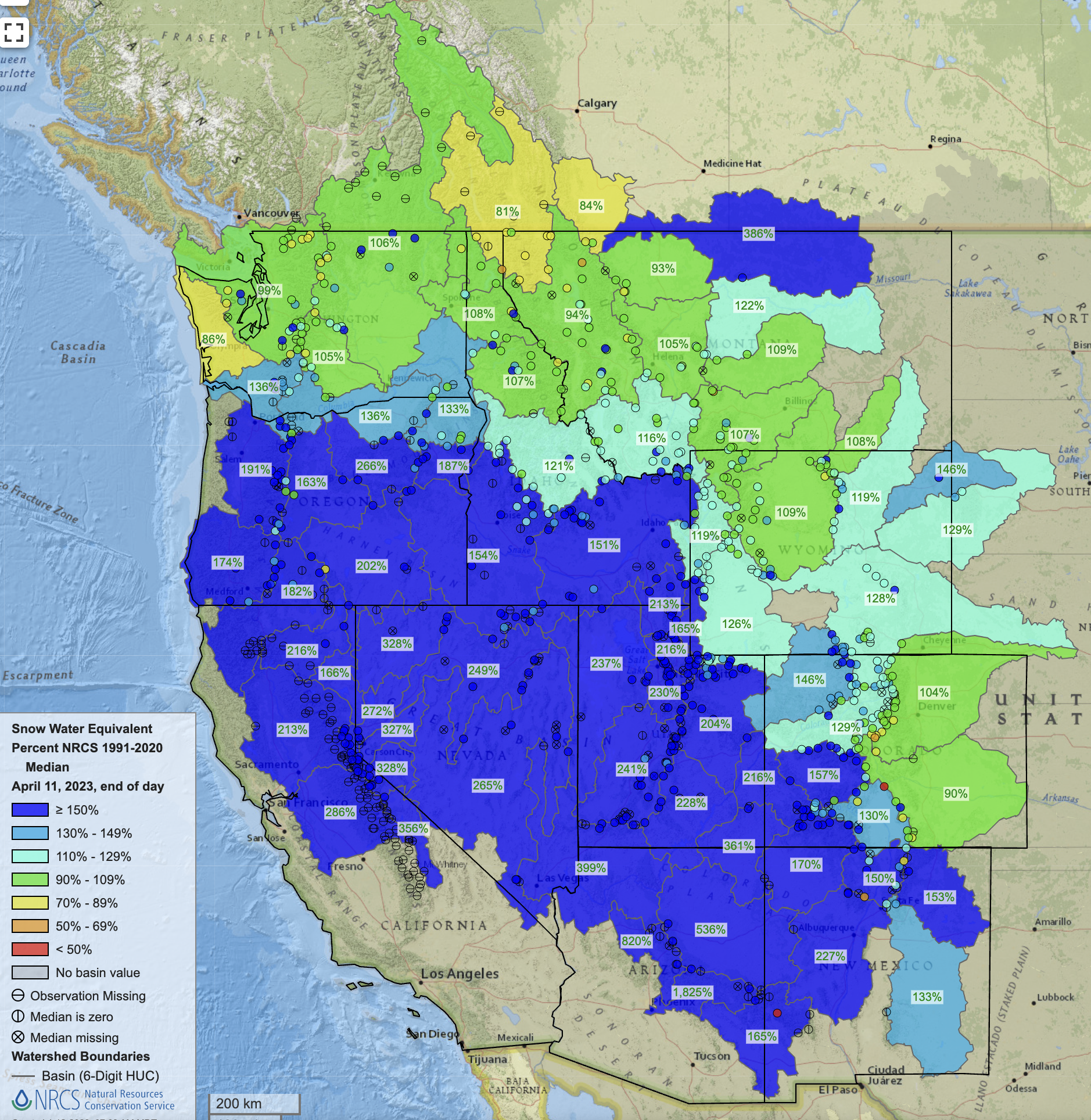
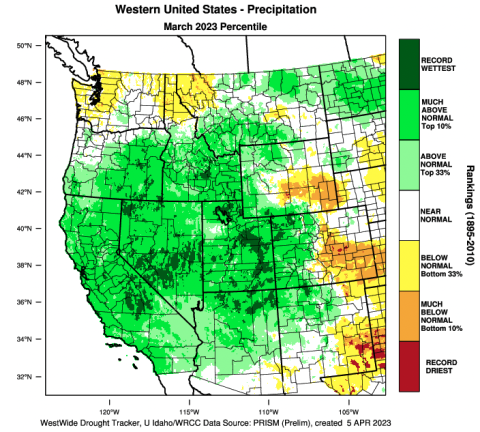
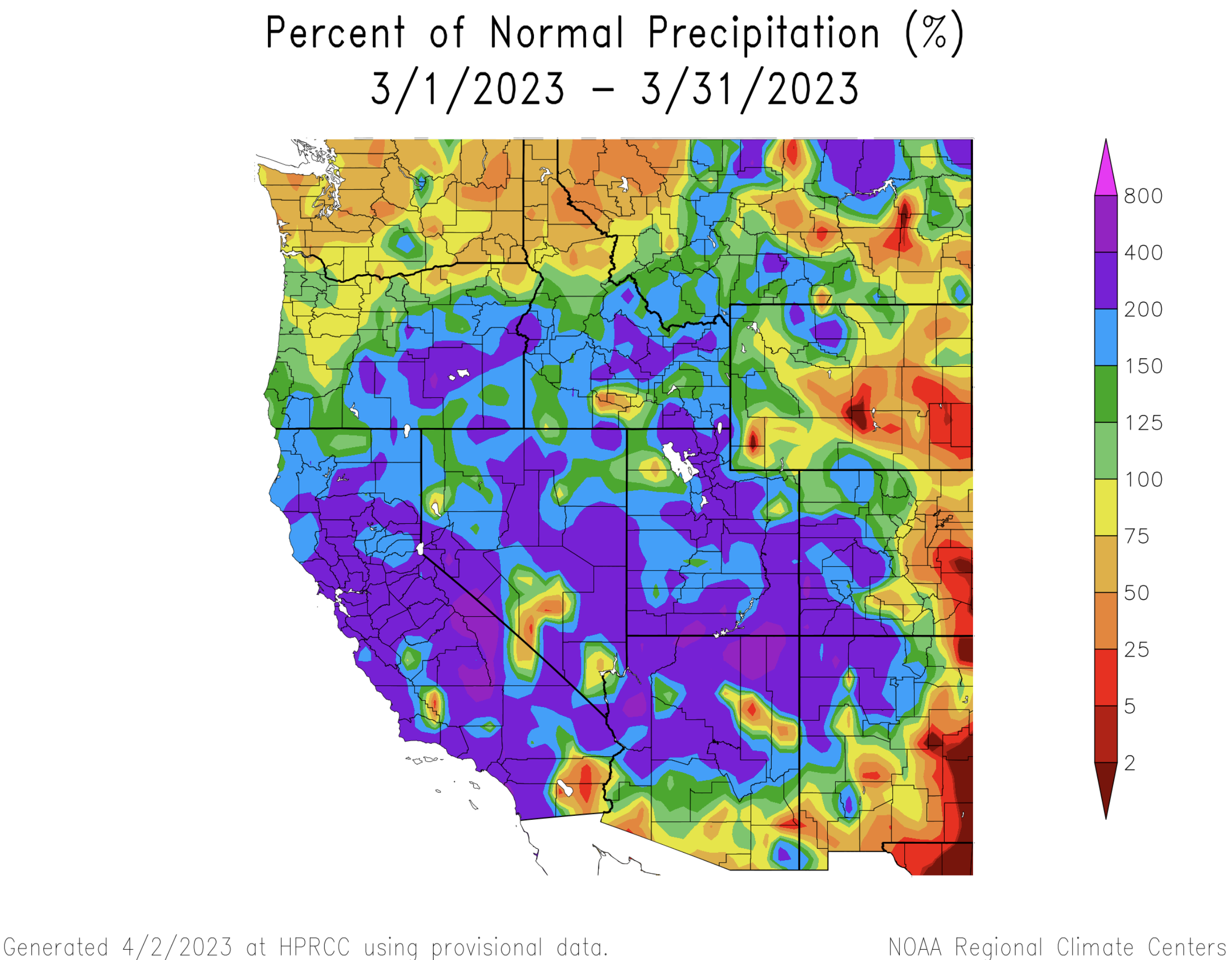
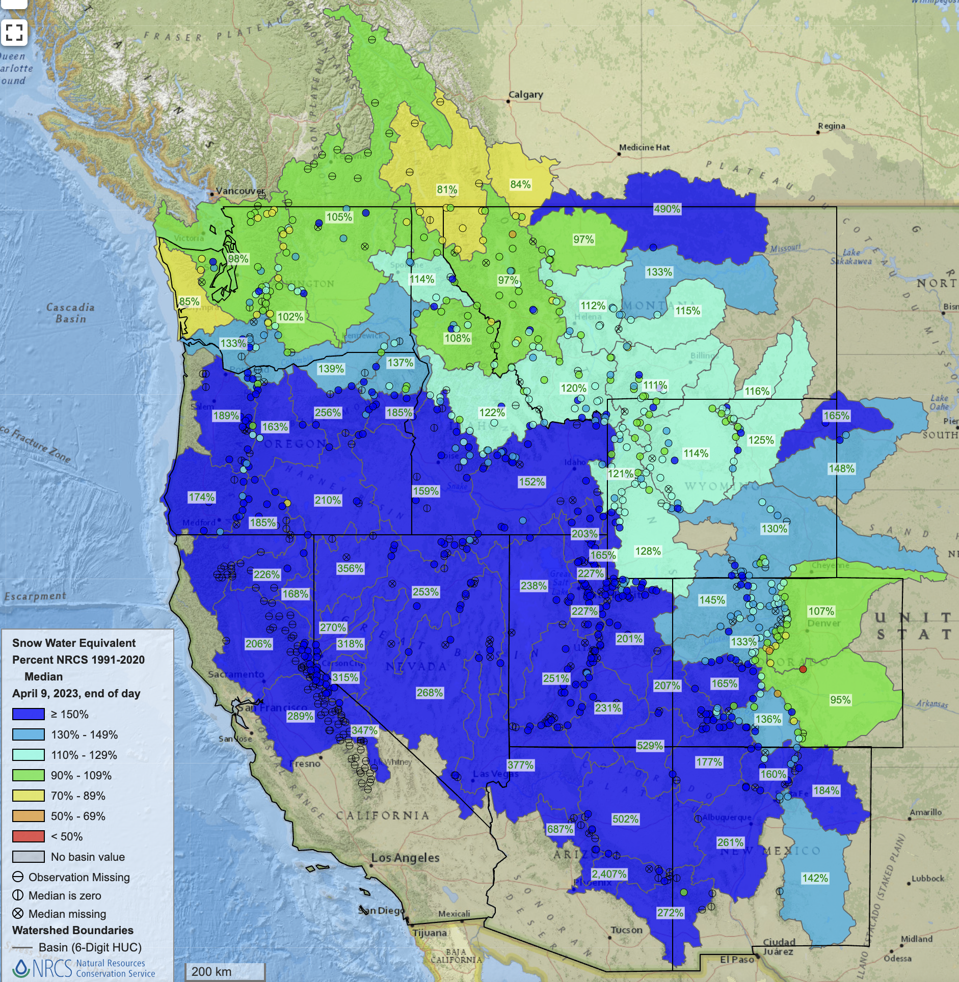
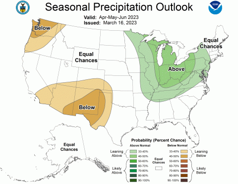
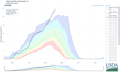
The cuts are needed because, despite a massive snowpack in the Rocky Mountains this winter, water levels at lakes Powell and Mead — the country’s two largest reservoirs — are still projected to diminish as they face historically dry conditions exacerbated by climate change.

“We’re thankful for this winter’s snow and rain,” Deputy Interior Secretary Tommy Beaudreau said at a news conference Tuesday. But, he added, “One good year will not save us from more than two decades of drought.”

[…]

While federal officials consider their options, each of the seven states in the Colorado River Basin will continue to negotiate water use for the long term. At risk is the water supply for cities, towns, farms and industries across the West. And if any of the states or Native American tribes in the basin sour on the plan they could sue, which would plunge the entire scheme into an expensive and time-consuming legal tangle…

“So we can do nothing, do what California wants or do what everybody else wants and have cuts across the board,” [Rhett] Larson said.

Doing nothing isn’t an option, Larson said. Doing what California wants could devastate several major cities and cutting water use equally could be illegal and result in major lawsuits.

Larson said he feels as though federal officials, particularly President Joe Biden, might ultimately lean further toward cutting water use across the board.

“Realistically, there isn’t a solution to this that doesn’t require California to take some cuts,” Larson said…

Lake Powell key elevations. Credit: Reclamation

Still, the idea, Beaudreau said, would be to keep water at Powell and Mead high enough so that their dams could still generate electricity and pass water downstream. As of Monday, Lake Powell sat at 22% full while Lake Mead was 29% full.

Lake Mead key elevations. Credit: USBR

That 2 million acre-feet also is the minimum amount of water federal officials set out to save when they announced impending action last summer. Some water experts have wondered whether the basin must actually save three times that much.

Map credit: AGU

Getches-Wilkinson Center 43rd Annual #Colorado Law Conference on Natural Resources June 8-9, 2023

Click the link to go to the conference website to register and for all the inside skinny:

Crisis on the Colorado River: From Short-Term Solutions to Long-Term Sustainability

The Colorado River is in crisis. Rapid declines in reservoir storage now threaten many longstanding agreements and operational norms, triggering curtailments in water deliveries and prompting emergency interstate and federal/interstate negotiations. 

The challenge is two-fold: adopting rules to equitably “share the pain” in the short-term, while transitioning to a management framework to support long-term sustainability in what will likely be an increasingly arid future. It is both a water and a “people” problem, requiring innovations for stretching limited supplies through processes emphasizing equity and inclusion across all values, stakeholders, and sovereigns, including the United States, Mexico, Tribes, and the seven basin states.

Updated Colorado River 4-Panel plot thru Water Year 2022 showing reservoirs, flows, temperatures and precipitation. All trends are in the wrong direction. Since original 2017 plot, conditions have deteriorated significantly. Brad Udall via Twitter: https://twitter.com/bradudall/status/1593316262041436160

Interior Department Announces Next Steps to Protect the Stability and Sustainability of #ColoradoRiver Basin #COriver #aridification

Colorado River “Beginnings”. Photo: Brent Gardner-Smith/Aspen Journalism

Here’s the release from the Bureau of Reclamation:

Outlines alternatives and tools needed to manage drought in the Basin and strengthen water security in the West 

BOULDER CITY, Nev. — To address the continued potential for low run-off conditions and unprecedented water shortages in the Colorado River Basin, the Department of the Interior’s Bureau of Reclamation (Reclamation) today released a draft Supplemental Environmental Impact Statement (SEIS) to potentially revise the current interim operating guidelines for the near-term operation of Glen Canyon and Hoover Dams. Today’s release comes on the heels of historic investments the Biden-Harris administration announced last week as part of an all-of-government effort to make the Colorado River Basin and all the communities that rely on it more resilient to climate change and the ongoing drought in the West.

The draft SEIS released today analyzes alternatives and measures to address potential shortages in the event that such measures are required to protect Glen Canyon and Hoover Dam operations, system integrity, and public health and safety in 2024 through 2026, after which the current operating guidelines expire. It also ensures Reclamation has the tools to protect continued water deliveries and hydropower production for the 40 million Americans who rely on the Colorado River.

“The Colorado River Basin provides water for more than 40 million Americans. It fuels hydropower resources in eight states, supports agriculture and agricultural communities across the West, and is a crucial resource for 30 Tribal Nations. Failure is not an option,” said Deputy Secretary Tommy Beaudreau. “Recognizing the severity of the worsening drought, the Biden-Harris administration is bringing every tool and every resource to bear through the President’s Investing in America agenda to protect the stability and sustainability of the Colorado River System now and into the future.”

“Drought conditions in the Colorado River Basin have been two decades in the making. To meet this moment, we must continue to work together, through a commitment to protecting the river, leading with science and a shared understanding that unprecedented conditions require new solutions,” said Bureau of Reclamation Commissioner Camille Calimlim Touton. “The draft released today is the product of ongoing engagement with the Basin states and water commissioners, the 30 Basin Tribes, water managers, farmers and irrigators, municipalities and other stakeholders. We look forward to continued work with our partners in this critical moment.”

The SEIS process was initiated in October 2022. The release of the draft follows months of intensive discussions and collaborative work with the Basin states and water commissioners, the 30 Basin Tribes, water managers, farmers and irrigators, municipalities, and other stakeholders. The draft alternatives in the SEIS incorporate concepts from many models and proposals received during the scoping period, including from all seven Basin states.

The alternatives presented in the draft SEIS analyze measures that may be taken under Secretary of the Interior Deb Haaland’s authorities to protect system operations in the face of unprecedented hydrologic conditions, while providing equitable water allocations to Lower Basin communities that rely on the Colorado River System.

The draft SEIS includes proposed alternatives to revise the December 2007 Record of Decision associated with the Colorado River Interim Guidelines. The 2007 Interim Guidelines provide operating criteria for Lake Powell and Lake Mead. These include provisions designed to provide a greater degree of certainty to water users about timing and volumes of potential water delivery reductions for the Lower Basin States, as well as additional operating flexibility to conserve and store water in the system.

The draft SEIS will be available for public comment for 45 calendar days and the final SEIS is anticipated to be available with a Record of Decision in Summer 2023. This document will inform the August 2023 decisions that will affect 2024 operations for Glen Canyon and Hoover Dams.

This proposal to address immediate water supply challenges complements Reclamation’s ongoing process to develop new guidelines for Colorado River Operations when the current interim guidelines expire at the end of 2026.

Draft SEIS Alternatives

The draft SEIS analyzes three alternatives, which reflect input from the Basin states, cooperating agencies, Tribes and other interested parties, including comments submitted during the SEIS public scoping period, including two written proposals from the Basin states that informed the following alternatives considered in this draft SEIS:

  • No Action Alternative: The No Action Alternative describes the consequences of continued implementation of existing agreements that control operations of Glen Canyon Dam and Hoover Dam, including under further deteriorating hydrologic conditions and reservoir elevations.
  • Action Alternative 1: Action Alternative 1 models potential operational changes to both Glen Canyon Dam and Hoover Dam. Action Alternative 1 includes modeling for reduced releases from Glen Canyon Dam, as well as an analysis of the effects of additional Lower Colorado River Basin shortages based predominately on the priority of water rights. Action Alternative 1 models progressively larger additional shortages as Lake Mead’s elevation declines, and larger additional shortages in 2025 and 2026, as compared with 2024. The total shortage contributions in 2024, including those under existing agreements, are limited to 2.083 million-acre-feet because this is the maximum volume analyzed in the 2007 Interim Guidelines final environmental impact statement.
  • Action Alternative 2: Action Alternative 2 is similar to Action Alternative 1 in how it models potential operational changes to both Glen Canyon Dam and Hoover Dam. Action Alternative 2 includes modeling for reduced releases from Glen Canyon Dam, as well as an analysis of the effects of additional Lower Colorado River Basin reductions that are distributed in the same percentage across all Lower Basin water users under shortage conditions. While both the 2007 Interim Guidelines and the 2019 Drought Contingency Plan encompass shortages and contributions that reflect the priority system, the incremental, additional shortages identified in Action Alternative 2 for the remainder of the interim period would be distributed in the same percentage across all Lower Basin water users. Action Alternative 2 models progressively larger additional shortages as Lake Mead’s elevation declines and models larger Lower Basin shortages in 2025 and 2026 as compared with 2024. The total shortage contributions in 2024, including those under existing agreements, are limited to 2.083 million-are-feet because this is the maximum volume analyzed in the 2007 Interim Guidelines FEIS.

Members of the public interested in providing input on the SEIS can do so through May 30, 2023, per instructions in the Federal Register that will be published on April 14, 2023. Additional information about virtual public meetings can be found at Reclamation’s website.

Historic Investments to Address the Drought Crisis

President Biden’s Investing in America agenda represents the largest investment in climate resilience in the nation’s history and is providing much-needed resources to enhance the resilience of the West to drought and climate change, including to protect the short- and long-term sustainability of the Colorado River System. Through the Bipartisan Infrastructure Law, Reclamation is investing $8.3 billion over five years for water infrastructure projects, including water purification and reuse, water storage and conveyance, desalination and dam safety. The Inflation Reduction Act is investing an additional $4.6 billion to address the historic drought.

To date, the Interior Department has announced the following investments for Colorado River Basin states, which will yield hundreds of thousands of acre-feet of water savings each year once these projects are complete:

Graphic credit: Reclamation

From the Supplemental EIS:

In the absence of consensus among all entities affected by changed operations, the Department must consider the overall conditions in the Basin in order to make the most prudent operational decisions. The overall sound and prudent operation of the major reservoirs on the Colorado River system during a period of declining inflows and historically low reservoirs will almost certainly lead to objection by specific entities to the impacts of one or more aspects of water management decisions. The Department will follow applicable federal law and prudent reservoir operations with respect to any modified operating guidelines, recognizing that with current reservoir elevations at historic lows, even one additional low-runoff winter season could have unprecedented adverse consequences across the Basin. In short, every potential option involves difficult water management impacts and unprecedented reductions for entities in the Basin.

The latest briefing (April 7, 2023) is hot off the presses from Western #Water Assessment

Click the link to read the briefing on the Western Water Assessment website (scroll down):

April 7, 2023 – CO, UT, WY

Record snowfall continued across many portions of the region during March. Record-high April 1st snow-water equivalent values were observed in Utah and western Colorado and the 2023 Utah statewide average surpassed the previous record set in 1983. Streamflow volume forecasts are above to much-above average for the Upper Colorado River and Great Basins and the inflow forecast for Lake Powell is 177% of average, providing much-needed water after record-low water levels. Regional drought conditions improved during March, especially in Utah, and 45% of the region is currently in drought. There is an increased probability of below average regional temperatures during April which would contribute to flooding risk in portions of the region with very large snowpacks. 

March precipitation was much-above normal in Utah and western Colorado, above normal in western Wyoming, and generally below normal in eastern Colorado and eastern Wyoming. In Utah and western Colorado, precipitation was 150-400% of normal during March; half of Utah observed 200-400% of normal March precipitation. March precipitation was 25-75% of normal for most of Colorado and Wyoming east of the Continental Divide, except for the Bighorn Mountains in northern Wyoming where March precipitation was near-normal.

Regional temperatures were below normal during March. The coldest conditions were observed in western Wyoming where temperatures were 9-15 degrees below normal; temperatures in parts of southwestern Wyoming were the coldest on record. In Utah and northwestern Colorado, March temperatures were generally 6-12 degrees below normal and March temperatures were among the 12 coldest on record. Southeastern Colorado was the regional hot spot where temperatures were 3-6 degrees below normal.

Regional snowpack is above average for the entire region except for the South Platte and Arkansas River Basins where April 1 snow-water equivalent (SWE) is near-average. For much of Utah and western Colorado, record-high SWE conditions exist. On April 1st, statewide average SWE in Utah was 197% of normal and average SWE was 28.4”, shattering the previous statewide SWE record of 26” set in 1983. In Colorado, April 1st statewide SWE was 140% of average. Snowpack in Colorado was generally near-normal east of the Continental Divide and much-above normal west of the Divide, including the Dolores River Basin which is at a record-high 165% of average. Wyoming snowpack is above normal statewide (117% average) with near-normal April 1st SWE in the Bighorn, Upper Green, Shone [ed. Shoshone?], and Yellowstone River Basins and above average SWE conditions across the remainder of Wyoming.

West snowpack basin-filled map April 9, 2023 via the NRCS.

Seasonal streamflow volume forecasts are above average to much-above average for most regional river basins. Streamflow forecasts are highest for the Great Basin where forecasted volumes are 115-450% of average. Below normal (60-90%) to near-normal (90-110%) seasonal streamflow volumes are forecasted for the Arkansas, South Platte, Shoshone, Tongue, and Yellowstone Rivers. Above normal seasonal streamflow (110-130%) is forecasted for the Bighorn, Laramie, Powder, and Wind Rivers. Much-above normal seasonal streamflow (>130%) is forecasted for the remaining regional river basins, with streamflow forecasts above 300% for the Lower Green, Provo/Utah Lake, Sevier, Six Creeks, Virgin, and Weber Rivers. Seasonal streamflow forecasts for most large Upper Colorado River Basin reservoirs are much-above normal with only near-to-above normal forecasts for Green Mountain, Fontenelle, and Flaming Gorge Reservoirs. The inflow forecast for Lake Powell is 177% of normal.

Regional drought conditions improved during March due to above to much-above average precipitation and cool temperatures. At the end of March drought covered 45% of the Intermountain West, down from 55% at the end of February. The most significant improvement in drought conditions occurred in Utah where drought conditions were entirely removed from the eastern, northern, and western portions of the state. Moderate and severe drought conditions remain present in the central portion of Utah. Drought conditions in Colorado and Wyoming changed little during March with drought conditions in the eastern portions of both states and wetter conditions in western Colorado and central Wyoming.

West Drought Monitor map April 4, 2023.

Eastern Pacific Ocean temperatures were slightly below to slightly above average during March leading to neutral ENSO conditions. There is a 60-70% probability of El Niño conditions developing during late summer and persisting through the end of the forecast period in early winter. NOAA seasonal forecasts for April suggest an increased probability of below average temperatures for most of the region and an increased probability of above average precipitation for northwestern Utah. The April-June NOAA seasonal forecast predicts an increased probability for below average precipitation in southern Colorado and southern Utah, an increased probability of below average temperatures for northern Utah, and above average temperatures for southeastern Colorado.

Significant March weather event: Record Utah snowpack. As a scientist, skier, and general lover of snow, I’ve simply run out of superlatives to describe the 2023 winter in Utah. Snowfall and SWE records around Utah are falling, especially in northern Utah. As of April 5th, statewide average SWE is 29.5” and at 209% of normal. The early 1980s, particularly 1983, were the winters of record in Utah, and 2023 has eclipsed nearly all snowfall and SWE records from those years. As of April 4th, of SNOTEL sites with at least 20 years of data, 36 sites were reporting record-high daily SWE totals, and 17 sites reported second-highest daily SWE totals. Twenty SNOTEL sites were reporting all-time record high SWE including Ben Lomond Peak, a site in northern Utah with an astounding 81.8” of SWE and a snow depth of 186”. While I don’t typically report snowfall from ski areas, the snowfall totals in the Wasatch Mountains, particularly the Cottonwood Canyons, are absurdly high. Ski areas in northern Utah have relatively long snowfall records, as long or longer than the SNOTEL network and all have broken all-time snowfall records; current (4/5/23) 2023 record snowfall totals in the Cottonwood Canyons include 874” at Alta, 850” at Brighton, 805” at Snowbird, and 779” at Solitude. Maximum snow depths in the Wasatch Mountains range from 150-250”. Many high elevation sites in Utah have likely not yet reached peak SWE and high elevation snowpack may continue to build. The 2023 winter has also been remarkable due to cold temperatures and very deep snowpacks at low elevations, which the SNOTEL network does not effectively capture. In Salt Lake City, winter 2022-2023 was the 6th snowiest on record (through 4/4) and the snowiest since 1993 with 87” of snowfall since October 1, 2022.