Hot Sulphur Springs: Water rehab project to start turning dirt March 15

A picture named fountainpavementdrawing.jpg

From the Sky-Hi Daily News:

The Town of Hot Sulphur Springs is scheduled to begin construction on the town water project on Monday, March 15, with some exploratory excavation work near the water tank site, to be followed by more extensive digging at that site. The $3.3 million project is being funded by the American Recovery and Reinvestment Act…

Beginning April 5, construction will also begin near the water plant. Both construction sites will be excavated using “Best Management Practices” (BMPs) for erosion and sediment control, Southway said, including the use of rice-straw wattles and pine-beetle-killed log berms to control sediment from moving off site. Construction will generally take place Monday through Friday between 6:30 a.m. and 5 p.m.

More infrastructure coverage here.

Energy policy — coalbed methane: Pioneer Natural Resources files augmentation plan for coalbed methane produced water

A picture named derrick.jpg

From The Pueblo Chieftain (Chris Woodka):

Pioneer Natural Resources filed its application last month under new state rules brought on by a Supreme Court decision and legislation last year. The company operates nearly 3,000 wells in Las Animas County, mostly above Trinidad Lake in the Purgatoire River Basin.

Jeris Danielson, manager of the Purgatoire Water Conservancy District, said the district is close to reaching a stipulation on how many of those wells are tributary to the watershed. He has not seen the filing for the augmentation plan and could not comment.

In January, Pioneer filed a plan with the state Division of Water Resources claiming that about 1,800 of its wells are tributary. It also says that 1,170 of its wells produce nontributary water. Another 108 wells not yet drilled are also covered in the court filing. The filing describes how replacement water, or augmentation flows, would be discharged at numerous points throughout the watershed, accounting for both flowing and perennial streams. The application asks for storage rights at various points to use produced water from nontributary wells to augment flows. The application specifically avoids claiming salvaged water from tributary flows, based on previous court decisions.

More coalbed methane coverage here and here.

Water short years show strong correlation between west and east slopes

A picture named coloradotransmountaindiversions.jpg

From The Pueblo Chieftain (Chris Woodka):

Western Water is studying future water projections for the Colorado Water Conservation Board. “It has always been thought that if you are bringing in water from both sides of the Continental Divide, you have protection. That is not the case,” said Jeff Lukas, of Western Water. “While they vary from year to year, the dry years and wet years in both basins show a strong correlation.” The two driest years on record in both basins were 1977 and 2002, and the record of imports into the Arkansas River basin bears out Lukas’ depiction of drought protection — or the lack of it. Other than 1987, when little water was brought over in the Fryingpan-Arkansas Project simply because there was no place to put it, 1977 and 2002 produced the least imported water for the Arkansas Valley. In other words, there wasn’t much water available on the other side of the mountains either.

In 1977, the Fry-Ark Project was just getting ramped up, and Lake Pueblo was still filling. Imports, however, dropped to just 11,400 acre-feet, or less than one-third of the typical year at the time because 1977 was the driest on record for the Western Slope.

In 2002, Fry-Ark flows through Boustead Tunnel totalled just 13,200 acre-feet, or about one-fourth of the long-term average. Basinwide, in 2002, imports totalled just half of the long-term average at 67,224 acre-feet, with projects like Twin Lakes, Homestake and Board of Water Works diversions pulling in every drop available. The year 2002 was the driest on record for the Arkansas River basin, and second-driest on the Colorado River.

In the past 500 years, the period of record for tree rings in both basins, there have been about eight annual droughts as severe as 1977 and 2002. All show both basins were equally affected. “They’re showing the same extreme low-flow years,” Lukas said. More ominous are long-term drought periods in Colorado, some lasting up to 60 years.

In the Arkansas River basin, the longest period of prolonged drought in recorded years was from the 1950s through the ’70s. While there were wet years and even drier years in the 1930s, the average was far below normal. By comparison, the 1980s and ’90s were the wettest years since the 1910s and ’20s, and the past decade has been relatively average. The Colorado River basin as a whole — it stretches over seven states — saw its lowest recorded flow period in a century in the first decade of this century. However, its performance in Colorado has essentially mirrored the Arkansas River basin. While there is much more water available every year in the Colorado River basin, its wet and dry years come at the same time as the Arkansas River basin.

More Colorado water coverage here.

Arkansas Valley: Tamarisk control workshop March 30

A picture named tamarisk.jpg

From The Pueblo Chieftain:

The Southeastern Colorado Water Conservancy District, Colorado State Forest Service, and the Natural Resource Conservation Service are sponsoring a technical workshop on tamarisk control and restoration methodology. The workshop will be 8 a.m. to 4:30 p.m. March 30 at the Southeastern district office, 31717 United Ave…

There is no cost to attend the workshop and lunch will be provided. Contact Jean Van Pelt, jean@secwcd.com or 719-948-2023.

More tamarisk control coverage here and here.

The town of Wiggins is still shopping for water rights

A picture named coloradodesignatedgroundwaterbasins.jpg

From The Fort Morgan Times (Dan Barker):

At the end of the Wiggins Town Council meeting Wednesday night, after a closed-door executive session, Town Administrator Bill Rogers was instructed to meet with an undisclosed person to discuss the sale of water rights. Although Wiggins has begun building its new water pipeline and may soon have U.S. Department of Agriculture approval for a loan to finance it, the town still only has about half of the new water supply it needs to replace its failing wells.

Water levels in the town wells have fallen for years now, and mineral levels have risen. The same has been true in the rest of the Bijou-Kiowa water basin. Wiggins bought 10 shares of Weldon Valley Ditch Co. water, but that will only provide about half of what it will need, Rogers has said in the past. At its height of use, Wiggins was consuming about 240 acre-feet of water each year, although the town only used 193 acre-feet last year, partly because of water restrictions, he said.

More Wiggins coverage here and here.

Logan County Water Water Conservancy District: Pawnee Creek Flood Control Project

A picture named pawneecreek.jpg

From the Sterling Journal Advocate (Judy Debus):

The Logan County Water Conservancy District (LCWCD) has initiated planning work for its Pawnee Creek Flood Control Project according to a press release from Shane Miller, director. The district has retained W.W. Wheeler and Associates, Inc. to provide professional engineering services for the project. The first phase of work involves development of a comprehensive hydrology model of the Pawnee Creek watershed, data collection and review, facilitation of stakeholder meetings, and preparation of a Phase I report according to Miller. The Phase 1 report should be available by the end of the year, Miller said.

Pawnee Creek is a large, uncontrolled watershed that drains more than 645 square miles from Pawnee Buttes to its confluence with the South Platte River near Atwood. Pawnee Creek is generally dry and its channel is more than a mile wide in many places, but the creek narrows near Atwood to a more confined channel that is susceptible to major flooding. The Pawnee Creek watershed has produced extreme floods about every 30 years and the last major flood occurred in 1997.

More stormwater coverage here and here.

SB 10-052 (Alter Designated Groundwater Basin Area) is on its way to Governor Ritter’s desk

A picture named groundwater.jpg

From the Sterling Journal Advocate (Marianne Goodland):

This was a bill that little more than a month ago passed quietly and uneventfully through the Senate with no drama and no strong debate. The bill’s sponsor, Sen. Greg Brophy, R-Wray, joked during its final Senate vote that there were very few water lawyers in the room when the bill was reviewed by the Senate Agriculture and Natural Resources Committee. That prompted Sen. Shawn Mitchell, R-Broomfield, a lawyer, to joke he couldn’t vote for it because not enough lawyers were involved. But even at that time, at the end of January, storm clouds were gathering.

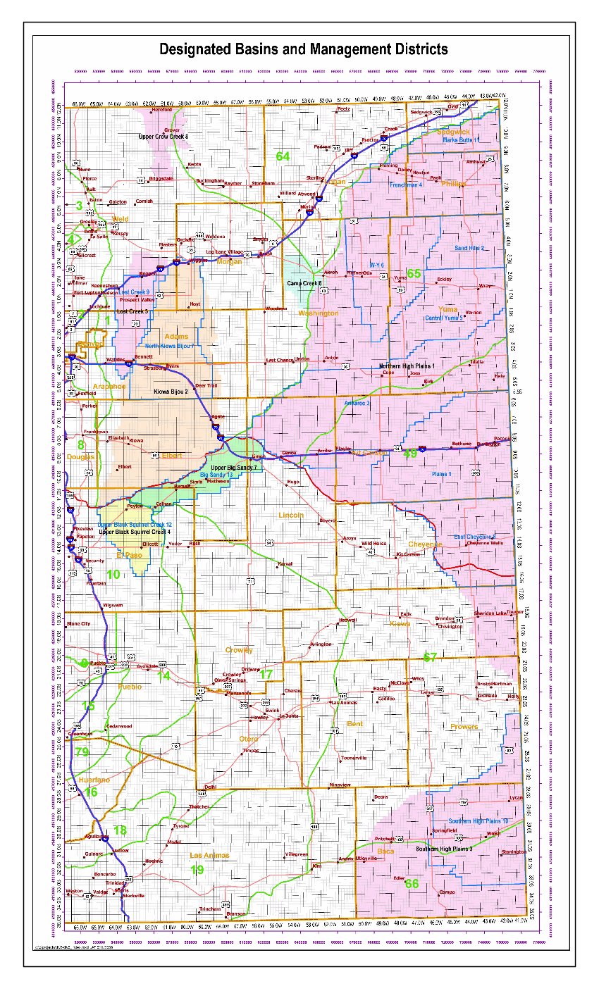
[SB 10-052] (pdf) would make it clear that a final permit for ground water wells in a designated basin is final. Ground water permit holders need to have certainty, said Rep. Jerry Sonnenberg, R-Sterling, who told House members during second reading debate on March 9 that the certainty was lost in 2006. That’s when the Colorado Supreme Court ruled in Gallegos v. Colorado Ground Water Commission that a surface water rights holder who has senior water rights can challenge the permit of a ground water well in a designated ground water basin if the senior water rights holder can prove their surface water rights are being affected. Under SB 52, the Ground Water Commission, which manages the eight designated basins along the Eastern Plains and the Front Range, could revise a basin’s boundaries to remove previously-included areas only if the area does not include wells that have had final permits issued. The bill includes an exception for current legal cases winding through the courts, so the Gallegos case, which is still not resolved, would not be affected.

The only person to testify against it in the Senate committee, Mark Lengel of Burlington, said he planned to marshal forces to oppose SB52 when it got to the House. Lengel was true to his word, and in the past two weeks, the bill has had a rocky ride…

Leading off [opposition in the house ag committee] was water lawyer Ray Petros, who represents three ranchers who have senior surface water rights on the south fork of the Republican River that date back to the late 1800s. He told the Ag Committee that “this will take away one of the most important water rights, the ability to curtail junior users who affect the [stream].” Petros also pointed out that the state constitution establishes the “first in time, first in line” doctrine of prior appropriation, and while ground water users have relied on permits since 1965, he said, the surface users have relied on their surface decrees for more than 100 years. The legislation insulates designated wells from surface water rights calls, he said; and it also removes the remedy for surface users, because it would say that the wells don’t impact surface water flow.

Petros’ clients also testified on the bill: Lengel, Dan Patten of the Hutton Trust of Hale, and Mike Bohnen of Bethune. Bohnen said new wells being drilled near the Republican River are affecting stream flow. “My private property rights are being legislated away from me,” he said. “A senior surface right is a vested property right.”[…]

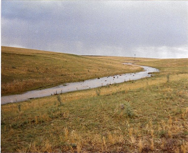
Robin Wiley of Idalia, chair of the Yuma County Water Authority and a fourth-generation farmer on the south fork of the Republican River, recounted how the water authority was created to purchase surface water rights. Several years ago, surface water owners petitioned the Ground Water Commission to redraw the boundaries of the basin, which would have stopped pumping from more than 1,300 wells that serve farmers and municipalities such as Yuma and Wray. Voters approved that purchase, halting pending litigation. SB 52 is needed to ensure that the threat of litigation doesn’t come back, he said.

Mark Kokes of Fort Morgan, general manager of Fort Morgan Quality Water, said that in 1970, farmers started seeking a higher quality source of water. They found it in the Lost Creek Basin and formed the water district, buying the wells and infrastructure. “It changed the economy of Morgan County,” Kokes said, bringing in businesses, new residents and housing. Today, 60 percent of the county water comes from Lost Creek. If the wells were redesignated, it would cost $15 million just to purchase augmentation water and that would create an economic crisis in Morgan County.

The bill even got competing petitions: one supporting SB 52 with more than 300 signatures from Washington and Yuma County residents, and one opposed to SB 52 with about 30 signatures from people in the Burlington area. SB 52 had an even tougher time when it reached the floor of the House for debate on March 9.

Opposition to the bill was led by Rep. Marsha Looper, R-Calhan, who raised concerns during the committee hearing and in the House debate that surface water users with senior water rights would have no remedy if the bill passed. There have been impacts to surface users, she said, pointing to the 2002 and 2003 drought. Rep. Sal Pace, D-Pueblo, submitted an amendment to ensure the bill wouldn’t injure senior water rights owners and take apart the doctrine of prior appropriations. Curry objected, stating such an amendment would gut the bill and the amendment failed. Sonnenberg also said that ground water basins have very little surface water, pointing to the Republican River, which he said has seven tributaries. Only three run water above ground part of the time, he said, and none run water above ground all of the time. There have been thousands of wells drilled in the basins since 1965, he said — and not one has been challenged.

More 2010 Colorado legislation coverage here.

Montezuma County: Southwest Colorado Watershed Workshop recap

A picture named farviewreservoir.jpg

From the Cortez Journal (Kimberly Benedict):

The workshop, sponsored by Colorado State University Extension and BUGS Consulting, was a gathering of all the major players in watershed activities in Southwest Colorado…

Representatives were on hand from a number of local, regional and state entities, including the Colorado Water Quality Control Commission, Mancos Water Conservancy District, Dolores River Restoration Partnership, Dolores River Dialogue, Colorado Watershed Assembly, Colorado Water Conservation Board, San Juan Citizens Alliance, Dolores Water Conservancy District, Montezuma Valley Irrigation Co., U.S. Bureau of Land Management, New Mexico Environment Department, Rocky Mountain Watershed Network, Pagosa Area Water and Sanitation District, Natural Resources Conservation Service and the U.S. Bureau of Reclamation…

Peter Butler, vice chair of the Colorado Water Quality Control Commission, discussed the history of the Animas River Stakeholders Group. The San Miguel Watershed Coalition was introduced by Peter Mueller, a volunteer with the organization and The Nature Conservancy’s North San Juans project director. Chester Anderson, owner of BUGS consulting, addressed work being done by the Dolores River Dialogue, which includes the Lower Dolores Management Plan Working Group. Felicity Broennan detailed efforts of the Mancos River Watershed Project, an undertaking of the Mancos Conservation District…

Jeff Crane, executive director of the Colorado Watershed Assembly, explained to participants that there is no such thing as an ideal model for a watershed organization. The assembly is a coalition of more than 70 watershed groups in Colorado. “You have been hearing about the groups in the Southwest, and they are really diverse,” Crane said. “And really, they are diverse throughout the state. It is all over the place how they are structured, and how they are organized is also all over the place. It is a lot of thinking outside the box.”

Afternoon sessions at the workshop dealt with the benefits of local watershed groups, group dynamics and best management practices…

On the Net: Animas River Stakeholders Group, http://sanjuanrcd.org/watermanagement.php#ARSG; Mancos River Watershed Project, http://www.sustainablemancos.com/watershed_project; San Miguel Watershed Coalition, http://www.sanmiguelwatershed.org; Dolores River Dialogue, http://ocs.fortlewis.edu/drd/default.asp.

More Dolores River watershed coverage here, San Juan Basin coverage here, Mancos River watershed coverage here, Animas River watershed coverage here and San Miguel watershed coverage here.

Aurora: Summer watering restrictions update

A picture named watersprinkler.jpg

From the Aurora Sentinel (Sara Castellanos):

The Aurora City Council voted unanimously to keep this year’s watering restriction the same as last year, with residents being able to pick which days they can water their lawns as long as they don’t water more than three days per week. Greg Baker, Aurora Water Department spokesman, said the vote means that water conservation techniques have been embraced by residents and have been effective in the past. “For the second year, council has expressed that the conservation ethic has been woven into the social fabric of the community,” Baker said in a statement. “Residents know that watering your lawn more than three days-a-week is not only unnecessary, but wasteful. We have the latitude to provide a little more flexibility to everyone’s busy day by letting them choose the days they want.”

More conservation coverage here.

Flaming Gorge pipeline: Metro and Arkansas Basin roundtables are funding study of the project

A picture named flaminggorgepipelinemillion.jpg

From The Pueblo Chieftain (Chris Woodka):

the project has faced contention from major water users in the state. At one point, the state’s largest water users sought to block a Bureau of Reclamation contract proposal, and an alternative group led by Parker Water and Sanitation is trying to form its own coalition to develop the project. One of the reservoir sites, on the Norris Ranch in El Paso County, also lies on the same spot in Upper Williams Creek where Colorado Springs Utilities wants to build a reservoir that is part of the Southern Delivery System.

To wade through all of the potential issues the project could face, the El Paso County Water Authority has suggested a task force, similar to the one that broke political logjams on Fountain Creek and led to the formation of a special district, said Gary Barber, agent for the El Paso County group. “This grant is for an assessment only, not to form the task force,” Barber explained to the Arkansas Basin Roundtable this week. Barber also chairs the roundtable and was instrumental in forming the Fountain Creek district. He is now the interim director of the Fountain Creek district as well. The roundtable agreed to apply for a $40,000 state appropriation through the Water Supply Reserve Account. The Metro Basin Roundtable approved the grant request last month. The El Paso County group would kick in another $5,000. The Keystone Center would be hired to bring together those who would be affected by the pipeline to determine if a task force should be convened. If the decision to move ahead is made, a task force would be formed to study the project and alternatives…

Million’s plan, now under environmental review by the U.S. Army Corps of Engineers, includes conservation measures that would directly benefit the environment and agriculture. It also brings the pipeline into the Arkansas River basin. The Parker-led coalition is still in its nascent stages and has not looked at the Arkansas River basin one way or the other.

More Flaming Gorge pipeline coverage here and here.

Snowpack news: Blanket of snow over the southern mountains

A picture named snowpackcolorado03132010

From The Pueblo Chieftain (Chris Woodka):

Snowfall of up to a foot in the state’s southern mountains overnight Wednesday kept snowfall totals above average. Farther north, however, the state remains dry…

“Water users should be prepared for significantly less water than in the previous two years,” said Allen Green, state conservationist with the NRCS. Northern Colorado snowpack totals are at about 80 percent of average, while Southern Colorado is close to 100 percent of average in most places. The picture shifts a little when looking at the areas where most Arkansas River basin users — Colorado Springs, Pueblo and cities along the river and Fountain Creek — get their water. The Roaring Fork basin on the western side of the Continental Divide was at 90 percent of average Thursday, slightly better than the rest of the Colorado River basin. The Upper Arkansas River basin was at 93 percent, slightly lower than the overall average for the entire basin. At the highest elevations, there is about 5 feet of snow on the ground, with moisture content of about a foot of water.

Alexandra Davis appointed director of the Colorado Interbasin Compact Committee

A picture named ibccroundtable.jpg

From The Pueblo Chieftain (Chris Woodka):

She will head a group that was formed in 2005 to sort out state water issues by encouraging dialogue on water issues at the grass-roots level and broadening the scope of participants in the discussion. In January, Ritter put renewed importance on the IBCC during a speech to the Colorado Water Congress, saying the board needs to meet more often to help shape state water policy. “Alex’s long experience as a water litigator and her dedication to resolving difficult water policy challenges make her an invaluable asset for all who are concerned about Colorado’s future,” said James B. Martin, executive director of DNR, in a press release. “I look forward to Alex’s leadership in this most critical natural resource arena.” Davis interacts with other agencies within DNR, such as State Parks, the Division of Wildlife and the Colorado Water Conservation Board.

“The IBCC has gained real momentum in tackling statewide water supply issues,” Davis said. “I am honored to be able to continue working with the IBCC members to create a positive vision for Colorado water supply solutions.”

More IBCC — Basin roundtables coverage here.

CWCB is coordinating work on water project decision support system for the Arkansas Valley

A picture named arkansasriverbasin.jpg

From The Pueblo Chieftain (Chris Woodka):

Brown and Caldwell engineers, consultants for the project, are conducting interviews and using surveys to determine the feasibility of developing a support system for the Arkansas River Basin. The project is coordinated by the Colorado Water Conservation Board.

The Rio Grande and Colorado River basins already have these models in place, and they have been used to help shape state and federal water policy. A decision support system is being completed for the South Platte River Basin as well. Although the process of developing the models began more than 20 years ago, the Arkansas River project was delayed because of the ongoing Kansas v. Colorado case in the U.S. Supreme Court. The case was settled last year. The model would provide a common baseline for historic water use that could be applied to future proposals, explained Lindsay Griffith, project manager for Brown and Caldwell.

More Arkansas River Basin coverage here.

State Engineer approves Rueter-Hess fill

A picture named rueter-hessplans.jpg

From the Parker Chronicle:

On Feb. 24, the State Engineers Office of Dam Safety approved a request by Parker Water and Sanitation District to allow the first water to be stored in Rueter-Hess. Before the approval, water within Newlin Gulch was pumped around the construction site. With the approval, the water will be stored behind the dam. The approval allows for water to be stored to a depth of 43 feet, which will allow up to 5,000 acre-feet of water. While construction of the dam is not slated to be complete until February 2012, storing water now will save the district money and allow for future use of that water to district customers. Over the next two years while construction is completed, an additional $34 million will be spent by PWSD on the project employing about 100 workers. Jim Nikkel, assistant district manager for Parker Water and project manager for the Rueter-Hess project, said the approval will allow the district to save about $10,000 a month in pumping costs.

More Parker coverage here and here.

Climate Change and the ski industry

A picture named meltwaterlake.jpg

From The Durango Telegraph:

The ski industry is getting more sobering news from the science community. A new report from the National Wildlife Federation says global warming is part of the reason for the unusual winter weather in the West. Climate scientist and report author Amanda Staudt says powder enthusiasts should be especially concerned. “Aspen Mountain could see a 2,400-foot rise in the snow line, which is as far as the snowpack extends down the mountain,” she said. “And if that happens, many of the base areas at that mountain won’t even have any snow.” A recent report in the journal Science explained that water vapor in the atmosphere plays a role in global warming. It may intensify, or sometimes moderate, the heating effects of carbon pollution. Staudt concluded that the analysis of weather trends underscores the importance of cutting carbon pollution that has been connected to warmer global temperatures. She added that despite the severe winter, 2009 was the second warmest year on record for the world, according to NASA.

More climate change coverage here and here.

Archuleta County: Board of Commissioners ask the Pagosa Area Water and Sanitation District to produce and annual report complete with the details about the proposed Dry Gulch Reservoir

A picture named sanjuan.jpg

Here’s Part I of Bill Hudson’s series PAWSD Gets Called on the Carpet running in (Pagosa Daily Post) report from last week’s meeting. From the article:

As a few of us discovered for the first time yesterday — sitting in the audience in the Commissioners meeting room at 10am — the County Commissioners have the power to request an “annual report” from any special district located all or partly within their county.

And that is what the Board of County Commissioners want from PAWSD, according to the letter (pdf) approved yesterday. Give us an annual report, the BoCC asked, that will clarify your financial condition and your long range plans. Especially, give us some justification for the planned 35,000 acre-foot Dry Gulch Reservoir, and the related impact fees.

Here’s Part II of Bill Hudson’s series PAWSD Gets Called on the Carpet running in the Pagosa Daily Post. From the article:

The Pagosa Area Water and Sanitation District has found itself in the position of such a forward-thinking parent in the past few years — assuring us, the residents of Archuleta County, that if we would just pony up and swallow their $360 million, 35,000 acre-foot reservoir and water treatment project at Dry Gulch, our great grandchildren will someday have plenty of water.

At Tuesday’s PAWSD board meeting, board member Bob Huff referred to Dry Gulch critics as folks who “want to kick the can down the road” — meaning, they want to put off the hard decisions, and the immediate costs of a well-considered plan for the future. “We, as a board, have decided, we’re not kicking the can down the road. We’re going to start planning; we’re going to start moving on that plan. And that’s what the Dry Gulch [property purchase] is all about. We’re moving forward in a step-by-step way…

The most vocal of PAWSD’s critics include, of course, the Pagosa Area Association of Realtors and many of our local developers and builders who see the water district’s Water Resource Fee impact fees and Capital Investment Fees and Inclusion Fees — running $30,000 or more for a large, new home in Pagosa Springs — as part of the reason behind the slow demise of the Archuleta County construction industry, beginning in about 2006 when those new fees were established by PAWSD.

Here’s Part III where Hudson steps through the commissioner’s letter.

More Pagosa Springs coverage here and here.

Pagosa Springs Sanitation General Improvement District chasing USDA dough to build a new wastewater treatment plant

A picture named wastewatertreatmentwtext.jpg

From the Pagosa Sun (Jim McQuiggin):

The board previously rejected the idea of pursuing USDA funding when it was brought to the table last summer. At that time, the USDA had set forth two requirements that the board found insurmountable: designing the plant to be outside a 500-year floodplain and conducting an environmental assessment that would have driven initial costs for the USDA application up (with no guarantee of securing USDA funding). However, according to [Pagosa Springs Sanitation General Improvement District supervisor, Phil Starks], the USDA has changed its requirements and appears to be more flexible in working with the PSSGID toward offering up funding. Seemingly entrenched with criteria stipulating a 500-year floodplain last year, the USDA now appears to offer an out, allowing the plant to be built within a 500-year floodplain “if no reasonable alternative exists.” Furthermore, Starks said, costs for preliminary environmental assessments have dropped significantly, from cost estimates between $70,000 and $100,000 last year, to between $30,000 and $60,000 for current estimates…

According to Starks, the PSSGID would likely receive a $3.3 million loan and a $2.7 million grant to go toward a $6 million plant — about $700,000 more than estimates for a previously rejected project. Starks added that the plant would be a facility that would last at least 20 years and, when time expired on the plant, would merely require an upgrade as opposed to construction of an entirely new plant. Previous wastewater treatment plants in Pagosa Springs have been, in Starks’ words, “stopgap measures” that required entirely new construction once the plants became obsolete.

More coverage from the Pagosa Daily Post (Bill Hudson):

Lately, we have been polluting the river. Just a little. That normally happens in the winter months, due to the Town’s aging lagoon-style sewer treatment plant; in cold weather, the bacteria that live in the lagoon and do the heavy work of breaking the raw sewage down into non-toxic materials, simply aren’t active enough to keep the sewer effluent from violating Colorado state standards. So we dump a little too much ammonia or solid waste into our local river — and we risk fines from the Colorado Department of Public Health and Environment, CDPHE.

More Pagosa Springs coverage here.

Say hello to the San Juan River Workgroup

A picture named sanjuan.jpg

From the Pagosa Sun (Chuck McGuire):

The San Juan River Workgroup (SJRW) became reality last Thursday evening, as approximately 50 individuals attended an organizational meeting at the Ross Aragon Community Center in Pagosa Springs. A few participants reportedly came from as far away as Denver and Silverton. According to program coordinators, interest ran high among a diverse crowd of ranchers and property owners, water service providers, photographers, anglers, whitewater enthusiasts, oil land gas developers, and conservationists concerned with protecting a wide array of intrinsic river values. To address their concerns on a local level, attendees agreed to form the SJRW and meet monthly through December…

Once the SJRW became official at Thursday’s meeting, the group discussed a three-phase process it will undergo, and how its program relates to the above-referenced forest management plan. Basically, anyone interested in the river will have a seat at the table and will be considered a stakeholder throughout the process. While respecting all opinions expressed, even when different than their own, group members will consider future actions that meet the interests and/or needs of a diversity of stakeholders and water users. All will receive factual information and tools necessary to lead productive talks resulting in creative problem-solving. Group discussions will be open and transparent, and everyone will be heard.

More San Juan Basin coverage here.

BLM proposes that the CWCB file for instream water rights on two Dominguez-Escalante Conservation Area creeks

A picture named sosidepikespeak.jpg

From The Grand Junction Daily Sentinel editorial staff:

The BLM has proposed an unusal plan for resolving the issue, under which the state may file for instream water rights for the two streams that run through a wilderness area in the [Dominguez-Escalante National Conservation Area]. The concept is one the Colorado Water Conservation Board should accept when it takes up the question in May. At the heart of the proposed solution is an agreement written into the federal legislation that created the NCA: If the state files for adequate instream water rights for the two wilderness creeks, the Interior Department won’t assert a federal water right…

The BLM has asked the state to seek a variable instream water right that recognizes streamflow can change dramatically. That’s not how Colorado instream flow rights have traditionally been appropriated in the past. A set minimum amount has been the typical filing. But a variable rights have been filed for a handful of other streams in the state.

Private water rights are also an issue. Even though the headwaters of both Big and Little Dominguez Creeks are both high up on the Uncompahgre Plateau in the Uncompahgre National Forest, there is private land within the national forest that depends on water from the two creeks. The BLM proposal recognizes that, and acknowledges rights will be senior to the state’s instream flow filings, and there will be some modest amount of water for additional future development of those rights.

More CWCB coverage here.

Snowpack news: Upper Colorado River Basin looks iffy

A picture named sosidepikespeak.jpg

From the Sky-Hi Daily News (Matt Barnes):

As a result of decent storm activity during the third weekend of February, snowpacks in the Upper Colorado River Basin improved slightly from 72 percent of average last month to 79 percent of average on March 1. This is the second lowest March 1 snowpack percentage the basin has seen going all the way back to 1992. Only March 1, 2002, with 68 percent of average snowpacks, was lower.

Using projections based on historical SNOTEL data, there is only a 10 percent chance that the basin will reach its average peak snowpack. Most of the sub-basin snowpacks are below average to well below average.

The lowest snowpack percentages can be found in the Willow Creek and Muddy Creek watersheds at 59 percent and 69 percent of average, respectively (these are lower than 2002). The Roaring Fork and Plateau Creek drainages boasted the best snowpacks at 90 and 95 percent of average. February precipitation at the higher elevations was 95 percent of average.

Fort Morgan: Water Resources Director briefs council about elevated levels of total suspended solids at wastewater treatment plant

A picture named sosidepikespeak.jpg

From The Fort Morgan Times (John Brennan):

The surges have been happening periodically over the last couple of months, usually at night, he said. City officials are trying to determine what is in the wastewater stream and where it’s coming from. [Water Resources Director Gary Dreessen] said he has contacted the city’s wastewater consultant and state officials, and both believe that “we’re being hit by something,” he said — meaning that someone is putting a large amount of an unknown substance into the sewer system.

More wastewater coverage here.

Colorado Springs Utilities will start building access trails for the south slope of Pikes Peak this year

A picture named sosidepikespeak.jpg

From The Colorado Springs Gazette (R. Scott Rappold):

Bowing to public pressure, Utilities officials have sped up their time line for opening the long-closed watershed, a remote and scenic area that contains several reservoirs. Original plans, announced in January, called for trail-building in 2011 at the earliest. While a date has not been set, the area could be opened to public recreation this summer. “It’s not any secret the public has felt like we can move faster on this. Now that we’re at a place where we can move faster, let’s do it,” said Utilities spokeswoman Patrice Quintero Tuesday.

Utilities officials will make a presentation to the city council members, sitting as the Colorado Springs Utilities Board, at a public meeting March 17. A public open house will be held April 27…

A trail along Ute Pass will be extended through Utilities property, an important goal for trail advocates behind the Ring the Peak Trail. In the South Slope watershed, a 5.6-mile trail along the west side of Mason Reservoir will be opened to bicycle use, instead of just foot and horse traffic. The other proposed trail, the Lake Moraine Trail, would connect with an existing trail that runs to the Cog Railway. Another proposed change would allow limited hunting in the area. Despite pleas from Ring the Peak advocates and the Trails and Open Space Coalition, Utilities does not plan a route to connect the two new trails, because the terrain is rugged and there is concern about impacts to a bighorn sheep herd in the area.

Energy policy — nuclear: HB 10-1348 (Increase Oversight Radioactive Materials) update

A picture named conventionaluraniummill.jpg

From the Telluride Daily Planet (Reilly Capps):

A new piece of legislation seeks to tighten up the application process and ensure that old mills are cleaned up before new ones are opened, and the Telluride Town Council came out in support of it yesterday. The Uranium Processing Accountability Act [HB 10-1348] (pdf) would apply most directly to the Cotter-owned mill near Cañon City, which first opened in 1958. It is still in the process of cleaning up contamination. The company applied to reopen the mill in 2001. If this bill passes, the Cotter Corp. couldn’t re-open the mill until all the clean-up has been completed…

The bill would also apply to the bonds that companies put up to pay for cleanup. When a mill starts operation, the company has to post a public bond that will pay for the cleanup. The proposed bill seeks to make sure that the public has a say in the size of the bond.

But Dianna Orf, a lobbyist for the Colorado Mining Association, said the legislation doesn’t make sense. “The implication I see is that if you can’t accept new material for processing, you can’t produce the revenue stream you need” to clean up the old site, Orf said. The Colorado Mining Association is not necessarily opposed to the legislation, said director Stuart Sanderson. But he said the state, and the country, would do well to support uranium production in general.

Here’s the fact sheet from the Colorado Environmental Coalition and an excerpt:

Uranium milling has a radioactive and toxic legacy in Colorado. Operations have polluted our air and water, devastated communities and public health, killed wildlife, and ruined our lands. In March 2009, Cotter announced plans to reopen its Canon City mill, even though it’s still an E.P.A. superfund site and has other outstanding violations. The first new uranium mill in the U.S. in 25 years is being considered in the Paradox Valley of Western Colorado to mill ore pulled from the public lands in Colorado’s red rock canyon country surrounding the Dolores River. We must learn from our past mistakes and update state law to match modern standards. The Uranium Processing Accountability Act would require any uranium processing facility to clean up its toxic mess before applying for new or expanding operations. This ensures scarce state resources will be allocated for the clean-up of existing problems.

More 2010 Colorado legislation coverage here. More nuclear coverage here.

SB 10-027 (Fine Illegal Surface Water Diversions) passes State House Agriculture, Livestock and Natural Resources Committee now awaits vote of full house

A picture named submersiblepump1

From The Durango Herald (Joe Hanel):

[State Representative Ellen Roberts], is carrying Senate Bill 27 on behalf of Attorney General John Suthers. The bill puts a $500 per day fine on people who illegally divert surface water. It matches the fine that is already in place for people illegally using groundwater. “The basic point is to get compliance so senior water rights are not injured,” Roberts said.

The $500 fine would be the maximum. In most cases, the attorney general resolves the case in less than a month for fines that are much less than $500, said Assistant Attorney General Chad Wallace.

More 2010 Colorado legislation coverage here.

CWCB: Proposed 2011 Instream Flow Appropriations

A picture named sanmiguelriver1109

From email from the Colorado Water Conservation Board (Rob Viehl):

Pursuant to ISF Rule 5c of the Rules Concerning the Colorado Instream Flow and Natural Lake Level Program, this notice identifies the streams to be considered for instream flow appropriations in 2011. At the January 2011 meeting of the Colorado Water Conservation Board (CWCB), staff may request that the Board form its intent to appropriate instream flow water rights for the streams listed on the attached Instream Flow Appropriation List. The attached list contains a description of the Instream Flow (ISF) Recommendations including stream name, watershed, county, upper terminus, lower terminus, length, and USGS quad sheet name(s).

Copies of the Instream Flow Recommendations and Appendices of data submitted into the Official CWCB Record are available for review by the public during regular business hours (8:00 a.m. – 5:00 p.m.) at the Colorado Water Conservation Board’s Office, located at 1313 Sherman Street, Room 723, Denver, Colorado, 80203. In addition to the CWCB office, copies of the Instream Flow and Natural Lake Level Recommendations are available on the CWCB website.

HB 10-1188: Rafting bill faces uncertain future in the State Senate

A picture named coloradocapitolfront.jpg

From The Durango Herald (Joe Hanel):

“It’s in trouble,” said Sen. Mary Hodge, D-Brighton, the sponsor of House Bill 1188. The bill coasted through the House on a 40-25 vote, but it faces a tough first hearing in the Senate on Monday. A confluence of three very different opponents does not like the bill.

The first and most powerful force is an alliance of farmers, ranchers and developers who want to protect their property rights.

Second, water experts are worried about the bill’s reliance on English Common Law to grant the right to raft on Colorado streams.

Finally, private boaters think the bill is too narrow, because it extends the rights of only professional rafting companies and leaves everyone else high and dry…

“It’s kind of unfortunate, because it [HB 10-1188] has driven a wedge between what we enjoy now, which are informal agreements between rafters and landowners,” said Sen. Bruce Whitehead, D-Hesperus. Whitehead said he has been bombarded by e-mails from both sides, including some from Southwest Colorado landowners who are rethinking their decisions to allow rafting through their land. Whitehead said he can see both sides of the argument, but he does not support the bill in its current form. He’s especially worried about the bill’s use of English Common Law to confer a “right of navigation” on commercial rafting companies.

The Colorado Water Congress opposes HB 1188 for the same reason, said Doug Kemper, executive director of the lobbying group. By introducing the Common Law concept of “navigable” rivers, Colorado could open itself to many consequences unrelated to rafting, such as impacts on federal water-quality standards, Kemper said. “That term ‘navigable’ is really an Eastern term,” Kemper said…

“We’re not trying to upset the balance here. We’re trying to maintain the balance,” said Greg Felt of the Colorado River Outfitters Association.

The bill is limited to registered commercial rafting companies, and that upsets people like Mark Squillace, a University of Colorado law professor who is arguing for the rights of private boaters, anglers and tubers. “What this bill would do is give a preference for individuals who are willing and able to pay a rafting company to go out on the river,” Squillace said…

The test for HB 1188 will come next week in the Senate Judiciary Committee. Hodge thinks that if she can get the bill through the committee, she will have enough support to get it through the full Senate…

…Squillace is hoping legislators will take the question straight to the state Supreme Court. It’s a seldom-used maneuver, but the law allows the Legislature to ask the court legal questions on a pending bill.

More 2010 Colorado legislation coverage here.

SB 10-052 (Alter Designated Groundwater Basin Area) passes State House

A picture named coloradodesignatedgroundwaterbasins.jpg

From The Pueblo Chieftain (Patrick Malone):

Sponsored in the House by Rep. Kathleen Curry, U-Gunnison, SB52 passed by a margin of 38-26. Opponents, including Rep. Sal Pace, D-Pueblo, said the bill undermines the standing of senior surface-water rights holders, while its supporters said it protects those with properly permitted wells. The bill’s specific aim is to honor already permitted wells in the event that the Colorado Ground Water Commission redraws boundaries of the state’s eight existing designated groundwater basins…

Having passed the Senate unanimously, the bill now will be presented to the governor for final approval to become law.

More 2010 Colorado legislation coverage here.

Denver: Contractors, health officials and landowners are invited to participate in the development of new sewage disposal rules

A picture named septagedisposal.jpg

From The Fort Morgan Times:

An individual sewage disposal system stakeholders’ meeting is scheduled for Thursday from 1 to 4 p.m. at the Colorado Department of Public Health and Environment at 4300 Cherry Creek Drive South, Building A, in Denver…Many of the people at a recent stakeholders’ meeting in Fort Morgan expressed opposition to a statewide system of regulations, pointing to a likelihood of increased costs and saying that rural areas should not be subject to the same restrictions as more densely populated areas.

More wastewater coverage here.

CWCB: Don’t forget the streams at tax time

A picture named ohbejoyfulslatecreek.jpg

From email from the Colorado Water Conservation Board:

SUPPORT the COLORADO HEALTHY RIVERS FUND on your COLORADO STATE INCOME TAX RETURN

Donations support:

Cleaner Water
Healthier Wildlife & Restored Habitat
Improved Recreation & Accessibility

Since 2003, 86,342 citizens donated over $631,840 from their tax returns to fund 50 local water enhancement projects in Colorado.

In the CheckOff Colorado section of your state income tax form – LINE 34 – please contribute a portion of your refund to help protect and conserve our most fragile and important resource – OUR WATER.

For more information go to www.coloradowater.org and click on the Colorado Healthy Rivers Fund logo.

Colorado State University: March/April issue of Colorado is hot off the presses

A picture named marchapril2010coloradowater.jpg

From email from the Colorado State University Water Center and the Colorado Water Institute (Zachary Hittle):

The CSU Water Center and the Colorado Water Institute are pleased to announce the March / April 2010 issue of our Colorado Water newsletter

In their 2008 paper in the journal Science, Milly and his colleagues proclaimed, “Stationarity Is Dead” and went on to ponder, “Whither Water Management?” Their thesis was that climate change undermines a basic assumption that historically has facilitated management of water supplies, demands, and risks.

Most statistical forecasting methods are based on the assumption that a series can be rendered approximately stationary through the use of mathematical transformations. A stationarized series is relatively easy to forecast: you simply predict that statistical properties will be the same in the future as they have been in the past.

HB 10-1188: Opponents mount advertising campaign

A picture named taylorriver.jpg

From the Colorado Independent (David O. Williams):

Friends of Colorado’s Rivers is listed on the “paid for” line in the ads, which advocate for the property rights of landowners along Colorado rivers. The ad reaches out to landowners who may want to keep commercial rafting outfits from pulling out on their property in order to portage rough sections of water or deal with emergency situations.

The group caused some confusion for proponents of the legislation, who argue Colorado rivers should be kept open to the state’s $142-million-a-year rafting industry – even along private stretches. The problem was that Friends of Colorado’s Rivers isn’t listed with the Colorado Secretary of State as a political committee. It is, however, registered as a nonprofit corporation under the SOS business section.

More 2010 Colorado legislation coverage here.

Moffat Collection System Project: Denver Water’s Travis Bray tells forum in Summit County, ‘In dry years, we take smidge’

A picture named grossdam.jpg

From the Summit County Citizens Voice (Bob Berwyn):

In addition to increasing diversions from the Fraser River, in Grand County, Denver Water would also take between 4,000 and 5,000 acre feet of additional water from Dillon Reservoir each year, equal to about 2 percent of the Blue’s annual flow at its confluence with the Colorado River near Kremmling. Denver Water project manager Travis Bray said that, without the project, Denver Water would have to take even more water from Dillon Reservoir in the future as demand for water grows on the Front Range. Currently, Denver Water’s collection system is unbalanced, with 90 percent going through the southern branches of the system (including Dillon Reservoir, the Roberts Tunnel and the South Platte), and only 10 percent in the northern collection system (including the Moffat Tunnel).

The Blue River Watershed Group hosted a public forum on the project Tuesday evening that turned into a classic trans-divide showdown. County and town officials advocated for more Front Range conservation, while Denver Water staffers gave a detailed explanation of their plan to export more West Slope water across the Continental Divide, and also outlined their conservation efforts. Bray said increased diversions from the Blue River Basin would mainly happen in wet years during peak spring flows, shaving some water off the top of the hydrograph when it’s least noticeable. “In dry years, we take smidge,” he said. “It puts water in storage to use during a drought.”[…]

Summit County Commissioner Karn Stiegelmeier said the draft study has some serious flaws…

“What happens in May to September is the main concern. That’s our primary recreation season,” she said, adding that the draft study failed to address potential climate change impacts and also didn’t take into account any of the possible outcomes of a wild and scenic river planning process currently under way…

Similar concerns were repeated by Erica Stock, an outreach coordinator with Colorado Trout Unlimited.
The fisheries conservation group has specific ecological concerns related to lower flows, including warmer water that harms fish and higher concentrations of toxic metals. All those issues need to be addressed in the environmental study, she said. “We need minimum flows, flushing flows, adaptive management and monitoring. If we see the river is starting to collapse, we need to stop doing what we’re doing,” she concluded.

More Moffat Collection System Project coverage here.

Hammon Oklahoma tornado

A picture named hammonoklahomatornado.jpg

One of my colleagues at Examiner.com has posted video of Monday’s tornado in Hammon Oklahoma. These weather events always fascinate me.

Snowpack news: Snow-water equivalent up slightly in South Platte River Basin

A picture named coloradosnowpack03102010

From the Estes Park Trail (Mike Oatley):

With about six weeks left in the snow accumulation season, the snowpack statewide, and especially across the northern half of the state, is lagging well behind both 2009 levels and long-term averages. The silver lining in the outlook for 2010 is the strong snowpacks of the past couple of years. A National Resources Conservation Service report states that “(a)bout the only good news for water supplies is the near average reservoir storage across most of the state.”[…]

The Big Thompson Basin was running about 77 percent of last year`s level and 75 percent of the long-term average at this point in the season. The Cache la Poudre Basin is holding about 80 percent of its average snowpack. The St. Vrain Basin, hampered in particular by a lack of snow in Wild Basin, is sitting at 69 percent of last season`s level and just 59 percent of its average…

Watersheds in the southern part of the state are faring better in general, though only two watersheds are at or above their averages. Most of the northern half of the state is at less than 80 percent of average. Only portions of the Arkansas, Rio Grande and San Juan basins are expected to reach average or above snowpacks.

Farther south, some southern New Mexico river basins have a water content in the snowpack greater than 200 percent of average…

Water managers are forecasting the lowest streamflows since the height of the drought eight years ago. The NRCS gives the snowpack a 10 percent chance of reaching average and forecast “well below average runoff” in the Colorado, Yampa, White, and North and South Platte basins.

SB 10-052 (Alter Designated Groundwater Basin Area) is moving through the State House

A picture named groundwater.jpg

From The Pueblo Chieftain (Patrick Malone):

Sponsored in the House by Rep. Kathleen Curry, U-Gunnison, [SB 10-052] (pdf) seeks to honor already permitted wells in the event that the Colorado Ground Water Commission redraws boundaries of the state’s eight existing designated groundwater basins.

Designated groundwater basins generally are considered nontributary, or at least not adjacent to major streams and rivers. They may include municipal, industrial and agricultural uses. At odds in the bill are the rights of senior surface water rights and the interests of permitted well users relying on groundwater…

Arguing in favor of the bill, Sonnenberg said the Legislature recognized in the 1960s that managing groundwater basins required a different set of rules than the set steering surface rights and therefore established the Colorado Ground Water Commission. Surface rights holders who have claims of injury would not be left without recourse because they could bring their challenges to the commission, he said…

Initially, the House rejected the bill by head count, called a division vote, Tuesday. But supporters called for a recorded vote of the full House, and it was revived by a margin of 33-30, with two representatives excused…

Having already been passed by the Senate with little saber-rattling, the bill next faces a final vote of the House.

More 2010 Colorado legislation coverage here.

Flaming Gorge pipeline: Million Resources Group in Casper pitching the project to Wyoming officials

A picture named flaminggorgepipelinemillion.jpg

From the Casper Star-Tribune (Pete Nickeas):

The Casper City Council heard from two of Million’s representatives at Monday night’s work session, after hearing from the group of municipal investors in February. At that meeting, the council agreed to set aside $20,000 to help the municipal group study the pipeline’s feasibility.
Though the city’s water supply is considered safe and reliable, the council is looking 50 to 100 years out at projected water needs. Owning a piece of the water supply from the Green River Basin, which would be dumped into the North Platte River via Million or the other group’s pipeline, would allow the city to account for future growth…

Under Million’s plan, Casper and other water districts would own the right to the water, and Million’s pipeline would ship it from point A to point B. Water districts would be charged based on how far the water has to be pumped, said Jeff Fassett, former state engineer who is now working for Million. “He’s the highway. Our model is that the individual end users, including Casper, Cheyenne, Lake Hattie … we believe you need to apply and obtain and secure and maintain your own water rights,” Fassett said. “There’s no reason for Mr. Million or anybody else to have control over the city’s water supply.”[…]

Council Vice President Paul Bertoglio and others repeatedly asked for a cost estimate, a request [Million’s attorney, Steve Freudenthal] danced around without providing specifics. Bertoglio, an engineer by trade, said the costs of pumping water hundreds of miles through a pipe over a mountain could make the entire project cost prohibitive. “In terms of what we’re looking at — the precision is so far off that I hesitate to go into that,” Freudenthal said. “But the basic preposition at the far end is what potential users — what’s their second cheapest alternative? And our numbers come in well below those.”[…]

None of the council members have questioned the need to plan long-term for the city’s water supply, and the city hasn’t committed to either party yet. For now, the city seems content “riding both horses” and seeing which group can piece together the best proposal.

More Flaming Gorge Pipeline coverage here and here.

Summit County commissioners okay Old Dillon Reservoir enlargement

A picture named olddillonreservoir.jpg

From the Summit County Voice (Bob Berwyn):

County commissioners Tuesday gave their go-ahead for the enlargement of Old Dillon Reservoir, a $7 million project that will give local water users some new options, with storage high in the Blue River Basin. The 62-acre-foot reservoir was built in 1936 and stored water for Dillon until the town was relocated when Dillon Reservoir was created by Denver Water. Under the proposed enlargement, formally approved by the U.S. Forest Service last week, Old Dillon Reservoir’s capacity would be upped to 286 acre feet…

County officials have estimated the construction and preliminary soft costs like planning and design will total about $7 million, but they’re hopeful that the economic climate will result in some favorable bids that would lower the total cost. The county will pay for about 53 percent of the project, with Silverthorne kicking in about 8 percent and Dillon paying for the rest. Dillon stands to benefit significantly from the project. The town currently depends on surface water from Straight Creek, which is vulnerable to pollution from I-70. During the 2002 drought, Straight Creek flows dropped to a point that had Dillon thinking about direct diversions from Dillon Reservoir. The water in Old Dillon Reservoir could also be used to enhance stream flows in the Snake and Lower blue under other scenarios.

A picture named dilloncolorado.jpg

More coverage from the Summit Daily News (Julie Sutor):

The proposed expansion would enlarge Old Dillon Reservoir’s capacity from 62 acre-feet to 286 acre-feet by raising its north and south dams. The $7 million project would create new water-storage and water-supply capacity for the town of Dillon, the town of Silverthorne and unincorporated Summit County. All three entities project that demand for municipal water in their respective service areas will increase in coming years. Old Dillon Reservoir was originally constructed in 1936 as a water-supply source for Dillon. The 14-acre reservoir is fed by water diverted from Salt Lick Gulch, just to its north. Salt Lick Gulch is a tributary of the lower Blue River.

In 1963, Denver Water constructed the new Dillon Reservoir to supply drinking water to Denver, requiring the town of Dillon to relocate from its original location to its current one. Since the move, Dillon has been unable to use the water in Old Dillon Reservoir, but the town has maintained the reservoir and the water rights to it. In the spring of 2008, a culvert carrying water from Old Dillon Reservoir failed under Interstate-70’s westbound lanes, causing a portion of the highway to collapse. The culvert was replaced, but the Colorado Division of Water Resources ordered the Town of Dillon to drain the reservoir over concern for safety of its north dam. The reservoir is to remain drained until either the proposed expansion is conducted or the Town of Dillon reconstructs the north dam.

More Old Dillon Reservoir coverage here and more Old Dillon Reservoir coverage here.

Salida: Construction begins to improve town’s whitewater park

A picture named kayaker.jpg

From the Salida Citizen:

Construction on expansion of the Whitewater Park has begun as two new play features are being installed before a March 31st regulatory deadline. Planned improvements include two new whitewater playspots and a trail extension through Riverside Park. Additions will also include a built-in year-round rock climbing structure appropriate for children and beginner to advanced adult climbers. Much needed bathrooms and changing rooms at the Salida downtown boat ramp will also be complete in time for the summer rush. The City of Salida, in partnership with the Arkansas River Trust was awarded a grant to expand the Salida Whitewater Park and improve Riverside Park. The majority of the funding has come from a GOCO grant and a cash match by the City of Salida. Citizens have been very generous with their support however, the Arkansas River Trust is seeking additional funding from the community to supplement the grant.

The Arkansas River Trust is raising funds by selling Bricks that will be placed in Riverside Park. Your brick purchase will help support this effort and create a lasting memorial to your family and/or business. The engraved bricks will be inset, in the new trail extension in Riverside Park near the Rotary Amphitheater. For more information please e-mail arkrivertrust@gmail.com.

More whitewater coverage here.

Water found in rocks retrieved from the Moon by Apollo missions

A picture named moonrocks.jpg

From the National Geographic (John Roach):

Tiny amounts of water have been found in some of the famous moon rocks brought back to Earth by the Apollo astronauts, scientists announced last Wednesday. The water levels detected in Apollo moon rocks and volcanic glasses are in the thousands of parts per million, at most—which explains why analyses of the samples in the late 1960s and early 1970s concluded that the moon was absolutely arid. “Only in the last decade have instruments become sensitive enough to even analyze water at those kinds of concentrations,” said Gary Lofgren, the lunar curator at NASA’s Johnson Space Center in Houston, Texas…

In part by bombarding the mineral with a particle beam from an electron microprobe, the researchers were able to calculate the amounts of the gases fluorine and chlorine within the sample. Given known formulas for apatite, the amounts of fluorine and chlorine present suggest there’s another compound needed to complete the mineral’s crystal structure. The missing molecule, the team concluded, must be hydroxide—a common component of apatite and a byproduct of the breakup of water. The finding is “one of the first to detect water in a lunar magmatic mineral” and adds to evidence that moon magma, in general, contains trace amounts of water, according to geoscientist Francis McCubbin, who participated in the research. But, though discoveries of moon water continue to mount, they’re really just drops in the bucket, said McCubbin, of the Carnegie Institution for Science in Washington, D.C. “While there is a lot more water in the moon than we previously thought,” he said, “it is still orders of magnitude drier than the Earth and Mars and therefore completely consistent with the last 40 years of lunar sample observation.”

Greeley: ‘Fix a leak week’ March 15-21

A picture named waterfromtap.jpg

From The Greeley Tribune:

The event is sponsored by the U.S. Environmental Protection Agency’s WaterSense program. Residents are asked to check household plumbing fixtures and irrigation systems for leaks. According to a prepared release, minor water leaks can amount to more than 10,000 gallons in a home and accounts for more than 1 trillion gallons of water wasted per year in U.S. homes. Greeley is hosting workshops to help residents find and repair leaks at 12:15 p.m., 5:15 p.m. and 6 p.m. on Monday at the Greeley Recreation Center, 651 10th Ave. Each workshop is scheduled to last half an hour.

More infrastructure coverage here.

Wellington Lake re-opening under consideration

A picture named wellingtonlake.jpg

From The Fairplay Flume:

The future of Wellington Lake continues to remain uncertain because of the incompletion of an investigation into the impacts that recreational use has on the water and the property. John Akolt, the attorney for the Wellington Reservoir Co., said the board is conducting an investigation with the help of a private contractor, and a decision could be made soon. “I would assume in the next couple of months, certainly before summer,” he said…

Wellington Lake, which is in Jefferson County east of Bailey on Stoney Pass Road, the continuation of Park County Road 68 in Jefferson County, closed last October to recreational use, and the employees there were fired…

Akolt said the concern of the board was that the lake’s popularity had grown to the point where the health of the land and the water could be damaged. He said the board of directors voted to close recreational use.

More South Platte River Basin coverage here.

Lake Pueblo storage update

A picture named puebloreservoir.jpg

Update: From KKTV.com (Jason Aubrey):

According to Vaughan, there are several reasons for the vast amount of water. One reason is the plentiful amount of precipitation that’s been falling for the last five years. The last time the reservoir was this full, a drought devastated its supply. It was down to a quarter of its capacity, or just over 21 billion gallons in October 2003. Another reason is because water has been moved downstream from several lakes to make space for Spring run-off from the western slope. With snowpack this year currently near the “average” range, the bureau hopes to capture 14 to 16 billion gallons of water. The third reason for the high water level is the Winter Water Storage program. Before the conservation program, farmers would simply flood their fields in the winter. Most of this water would eventually evaporate or move downstream and become useless before it could be used. Presently, the winter water storage system allows groups to store water in the reservoirs Flood Control space from November 15 through March 15.

From The Pueblo Chieftain (Chris Woodka):

As of Monday, the lake’s level was at 4,881.52 feet in elevation, meaning more than 261,200 acre-feet of water is behind Pueblo Dam — with more coming in daily. Lake Pueblo has not been that full since March 2000, according to Bureau of Reclamation records…

Federal rules on operation of the dam require storage to be capped at 256,949 acre-feet after April 15 to ensure the dam has the capacity to contain a flood. “Some of the canal companies plan to start taking out carry-over water by April 1,” said Roy Vaughan, manager of the Fryingpan-Arkansas Project. Farmers are storing about 15,000 acre-feet of winter water and project water in Lake Pueblo in accounts that must be cleared by May 1. About half of that is expected to be released by April 15. That still would leave about 5,000 acre-feet too much in storage, and the water could be spilled.

Part of the reason Lake Pueblo is full is that Reclamation has moved water from Twin Lakes and Turquoise Lake to make room for imports through the Boustead Tunnel later this year. Right now, snowpack in the Roaring Fork basin is about 89 percent of average, and 98 percent in the Arkansas River basin. Under similar conditions, imports of the year have totalled 45,000-50,000 acre-feet, Vaughan said.

More Fryingpan-Arkansas Project coverage here.

Energy policy — nuclear: Powertech releases revised estimate of recoverable uranium at Centennial Project

A picture named uraniuminsituleaching.jpg

From the Fort Collins Coloradoan (Bobby Magill):

The British Columbia-based company now estimates it will be able to recover more than 12.6 million pounds of uranium, up from the 11.5 million pounds it reported last summer, according to a technical report filed in February with the Canadian government. The higher uranium resources estimate comes after the company purchased more than 3,500 acres from two local landowners last summer, said Powertech President Richard Clement. “Anytime you have an increase in size of your resource, you increase the economic value of your prop-erty,” Clement said Monday. “It becomes that much more viable and capable of being developed.”

More nuclear coverage here.

Boulder Reservoir below limits on certain contaminants

A picture named boulderreservoir.jpg

From the Boulder Daily Camera (Heath Urie):

There is no evidence that motorized boats are leaving behind potentially deadly contaminants in Boulder Reservoir, according to a new study. Since last year, the city has been sampling water from the reservoir amid concerns from some residents that motor boats were contaminating it with byproducts from gasoline or oil. A city report shows that throughout 2009, tests consistently found “non-detectable” levels of harmful boating byproducts. The tests looked for increased levels of so-called “volatile organics” — benzene, a carcinogen; ethylbenzene, which can cause kidney and liver damage; toluene, which can damage kidneys, livers and the human nervous system; and xylene, which can affect the nervous system. “We never detected anything,” said Michelle Wind, Boulder’s drinking water program manager.

More water pollution coverage here.

Arkansas River projects to improve recreation on river

A picture named placingrocks.jpg

From The Pueblo Chieftain (Tracy Harmon):

Work is nearing completion on the Whitewater Kayak and Recreation Park-Canon City, which runs in the river channel along Centennial and Depot parks. A short distance downstream, between Ninth Street and Raynolds Bridge, a Trout Unlimited fish-habitat improvement project has been capped off with new informational signs detailing the benefits of “Trout Home Improvement.” In Salida, the fourth phase of the Salida Whitewater Park, featuring a new play hole and kayak features got under way this month and will be complete by the end of March. While the projects are aimed at providing thrills for two very different, sometimes conflicting user groups — kayakers and fishermen — they really are harmoniously helping make both Salida and Canon City Arkansas River corridors prime outdoor destinations.

“The whitewater park should help improve fish habitat because it will be pumping a lot of oxygen into the river, which will improve the bug habitat — that is insect life the fish need for food,” [Pueblo-based Southern Colorado Greenback Chapter of Trout Unlimited member Ted Sillox] said. “It really is a beautiful area.” Three Trout Unlimited chapters and the Colorado Division of Wildlife headed the Trout Home Improvement project which provided strategically placed boulders where brown trout can rest from the strong current, feed and reproduce on their own to maintain the population naturally. Bushes and vegetation planted along the banks are vital for shade for the fish and also support insect life. Sillox said Trout Unlimited members will be back this spring to conduct more plantings where some of the willows died. The members also helped with the informational signs that explain the benefits of the project…

Contractor Ted Seipel Construction’s Colorado Riverworks is on schedule to complete the $375,000 whitewater park by the end of March. The park, designed and engineered by Jason Carey of RiverRestoration.org, will provide exciting whitewater play holes for kayakers interested in executing spectacular stunts and surfing maneuvers…

A grand opening is planned when the park is complete, plus it will get a proper indoctrination during the June 25-26 Whitewater Festival, which will feature some surfing competitions for kayakers. The park will provide a whitewater thrill during high water summer months, but, in addition, the movement of water from upstream reservoirs to Pueblo Reservoir during the winter months will bring, “some very surfable waves all winter long,” Colon said.

More whitewater coverage here.

Glenwood Springs: Bids for new wastewater plant lower than expected

A picture named wastewatertreatmentwtext.jpg

From the Glenwood Springs Post Independent (John Gardner):

The city received five competitive bids from prequalified contractors for the project. The low bid, from Salida-based Moltz Construction, came in at $22.3 million. That is nearly $1.2 million less than the first-round low bidder Arizona-based Archer-Western Construction, at $23.5 million. Archer-Western was the lone contractor that did not resubmit a bid for the project. The other remaining bids came in close the original bids with three slightly increasing, and two, including Moltz’s bid, which came in at $1.5 million lower than its original bid. The lower bids were a welcomed surprise for City Manager Jeff Hecksel considering that previous estimates including Davis-Bacon wage requirements could increase the price of the project by as much as $1.5 million. “We were surprised that the bids came in lower,” said City Manager Jeff Hecksel. “I think we expected them to come back the same or a bit more. I think we were very surprised to have them come back as low as they did.”

More wastewater coverage here.

Crow Canyon Archaeological Center to present ‘Before Lake Powell: Memories of Glen Canyon Archaeology’ March 12

A picture named glencanyonconst.jpg

From The Farmington Daily Times (Alysa Landry):

Before Lake Powell: Memories of Glen Canyon Archaeology’ March 12 will be at the Crow Canyon Archaeological Center, in Cortez, Colo. It is part of the center’s distinguished lecturers series and is organized by the Friends of Crow Canyon. The organization hosts five lecturers per year, said Audrey Coleman, senior development officer for the Crow Canyon Archaeological Center. “They tend to be high-profile presenters, people who are highly regarded in their particular fields,” she said. “The proceeds stay locally to benefit students, including some from Farmington, who come to Crow Canyon.”

The evening begins with wine and appetizers at 7 p.m., followed by the lecture at 7:30 p.m. The archeological center is located at 23390 Road K, in Cortez, Colo. Tickets for the lecture are $30. For information, call Amy at (970) 564-4341.

More Colorado River Basin coverage here.

Buena Vista: Board of Trustees approves Nestlé’s offer to share the company’s Arkansas River pipeline crossing

A picture named nestlehaffeepipelinec.jpg

From The Chaffee County Times (Kathy Davis):

Town engineer Rachel Friedman will work with Nestlé during the construction. After the water pipeline is completed, Nestlé will convey the pipeline to the town. The agreement with Chaffee County grants an easement on its property on the Arkansas River. Also approved was an agreement with Paul and Rohnda Moltz for an easement on their property underneath the river. As of this meeting, the town had not heard from the U.S. Army Corps of Engineers regarding an application for a permit for the construction of a pipeline under the river.

According to Friedman, the town’s water master plan documents the need for additional water for future annexations anticipated within the town’s three-mile planning area, including Johnson Village.

More Nestlé Waters North America Chaffee County Project coverage here and here.

HB 10-1188: Rafting bill faces uncertain outcome in State Senate

A picture named raftingarkriver.jpg

From The Denver Post (Jessica Fender):

Opponents of the bill have upped their lobbying firepower, started a full-court press on committee members scheduled to hear the legislation later this month and made the vote much tougher for some lawmakers who once favored the legislation. The turning tide has bill-backers threatening to put the question directly to voters with a 2010 ballot initiative if they fail in the legislature.

Sen. Evie Hudak, D-Westminster, said the bill has so stirred tensions among river users and property owners that she doubts a long-standing and sometimes uneasy truce — where local companies and residents work out private agreements — will ever return. “This reopens a wound that we had a couple of Band-Aids on. Now we’re scratching the heck out of it,” she said. “People are angry on both sides. There’s the threat of lawsuits and ballot initiatives.” Viewed by some as the swing vote on the Senate Judiciary Committee, slated to hear the bill March 17, Hudak has faced more pressure than many of her colleagues, including a robo-call to her constituents from bill supporters…

Meanwhile, scores of private rafters, kayakers and anglers have clamored to be covered by the bill. That outcry should give lawmakers pause, said Jim Idema, head of the Creekside Coalition formed in 1994 to fight off a ballot initiative to open private land to river users. “To bestow a navigation right on a single class of citizens is not going to sit well with the rest. They will be coming up behind and saying what about us?” Idema said. “Time has allowed the senators to say, ‘Now wait a minute. The implications here are very, very broad.’ ” Idema’s group opposes the bill, but he’s not counting on its slowed progress as a sign of sure defeat.

The legislation’s first blow in the Senate came with its committee appointment, said sponsor Sen. Mary Hodge, D-Brighton. HB 1188 landed in the judiciary committee, which focuses on the legal aspects of bills, instead of the business affairs committee, which may have been more sympathetic to arguments that the bill would save business owners and protect tourism…

The sudden turbulence surprised Bob Hamel, who heads a rafting industry group and saw a sportsman governor and a Democrat-controlled legislature as his industry’s chance to settle a long-standing dispute in their favor. He’s nonetheless confident of public support, though opponents argue Coloradans are just as eager to prevent the government from taking private property. “We didn’t think it would be an easy fight, and if we lose, there are huge potential risks,” Hamel said. “But if this goes to the open public, these people have no idea what’s coming their way.”

From The Pulse – Of Colorado Farm Bureau (Garin Vorthmann):

The controversial right-to-float bill has been scheduled to be heard in the Senate Judiciary Committee for March 17. Watch for more information. Keep up the good work and contact your Senators asking for a NO vote.

More 2010 Colorado legislation coverage here.

Colorado to release 303d list on Tuesday

A picture named mercuryincoloradodp.jpg

From The Grand Junction Daily Sentinel (Emily Anderson):

The Colorado Department of Public Health and Environment on Tuesday will adopt a lengthy list (pdf) of Colorado waters it has deemed impaired.

Despite the city of Grand Junction’s attempts to reverse the decision, the list likely will include Juniata Reservoir on Grand Mesa, which provides a majority of Grand Junction’s drinking water. The city temporarily closed the reservoir to visitors and fishermen before opening it again in late February, when the Health Department told the city the closure would not get the reservoir off the impaired-waters list…

Steve Gunderson, director of the state Health Department’s water-quality division, said most items on the list have water-contamination problems, but some areas get listed just for having active fish-consumption advisories, such as the one Juniata has…

City Attorney John Shaver said the city likely will offer suggestions to the Health Department staff about changing the methodology for listing bodies of water on the impaired list so the list would reflect water, and not fish, contamination.

More mercury pollution coverage here and here.