Colorado-Big Thompson Project update

A picture named vibratingwirepiezometer

Here’s a release from Reclamation (Kara Lamb):

The Bureau of Reclamation has scheduled a routine drill program for Granby Dike #3 near Grand Lake, Colo. Work will begin June 16 and continue through August.

The road around Lake Granby will remain open during the work. Traffic will be temporarily reduced to one lane to accommodate the drill crew. Initial work will occur off of County Road 6 and will not restrict or impede traffic. Lane reduction will begin after the Fourth of July Holiday weekend on July 7 or 8. One-lane restrictions will be in place day and night for the duration of work taking place on top of the dike.

Work is being conducted as part of Reclamation’s Safety of Dams Program. Safety of Dams provides an ongoing assessment of Reclamation’s facilities in the 17 Western states. Drilling programs collect information from dams and dikes for evaluation and also provide a means for installation of new monitoring equipment.

Reclamation owns Lake Granby, Granby Dam, and all four dikes. The Northern Colorado Water Conservancy District provides operations and maintenance of the facilities.

For additional information, please contact Kara Lamb at Reclamation’s Eastern Colorado Area Office, (970) 962-4326, or e-mail, klamb@ usbr.gov.

More Colorado-Big Thompson Project coverage here.

Runoff news: South Platte River levels still on the high side near Kersey

A picture named soplatteapril09

The Denver Metro area sends a lot of stormwater to Kersey and points north at times. Click on the thumbnail graphic to the right for a shot of the South Platte River near Kersey in April ’09. Here’s the link to the Kersey station. At 6:30 p.m. 12,100 cfs was rushing by.

From The Greeley Tribune:

Residents along the South Platte River from Greeley to east of Kersey moved their families and animals to higher ground as the river continued to rise from all the recent rain…

The Poudre and South Platte river converge just west of Kersey, and both rivers were high today, causing some residents to leave their homes. Janelle Gill, whose family lives along Weld County Road 388 north of Kersey, temporarily moved across the road to a house offered by a neighbor. They were up most of the night Sunday as floodwaters rose. “We moved the chickens, turkeys and goats into horse trailers because the barn and chicken houses were flooding,” Gill said. “The water in the barn is three feet deep.”

From CBS4Denver.com (Dominic Garcia):

The National Weather Service says a flood warning is in effect until Monday afternoon but the river is expected to fall below floodstage by the evening.

Aspen: City Council toughens stormwater regulations

A picture named stormwateroutlet

From the Aspen Daily News (Curtis Wackerle):

The “Urban Runoff Management Plan” lays out minimum standards and recommended practices for development and redevelopment projects. The manual is part of the city’s program to remove sediments and pollutants from stormwater runoff before the runoff reaches local rivers. Sediments and pollutants are often added to runoff as it crosses pavement, rooftops and other hard surfaces…

City policy outlined in the manual operates on a sliding scale: The more impervious — impenetrable by water — surface area on a site, the more water that has to be detained on site in a vault, settling pond, rain garden or by some other method. On-site detention allows sediments and pollutants in runoff to settle before the water flows into the city’s stormwater collection system. Green space on a site — either grass, vegetation of green roofs, all of which reduce actual runoff — offsets the amount of water that has to be detained, under the new guidelines. The manual also recommends pervious or modular paving, which employs large blocks with gaps in between that allow water to infiltrate the ground.

Previous city stormwater guidelines were focused on large rain events, Barker said. The new manual shifts the focus to smaller rain events, which make up the majority of rain in Aspen, and are most troublesome from a runoff perspective since the first bit of rain collects the most pollutants. The project also loosens rules for projects that result in less than 1,000 square feet of new impervious area. Before, any project with more than 200 square feet of disturbance had to hire a professional engineer to do a grading study. That requirement has now been eliminated for projects with less than 1,000 square feet of disturbance.

More stormwater coverage here and here.

Colorado Foundation for Water Education is hosting a tour of Fountain Creek on June 22

A picture named fountaincreek

Here’s the release from CFWE (Kristin Maharg):

Fountain Creek drains an urban watershed serving 1/2 million people from north of Colorado Springs down to Pueblo. Changes in the watershed have increased flooding and erosion, accelerated farmland and habitat loss, and destroyed the foundations of roads and homes. However, there is an exciting, collaborative initiative to restore the ecosystem’s health, integrity and sustainability.

Attend this fun all-day watershed tour on Tuesday, June 22 to learn how municipal districts, non-profits and state government are working together to create a vital amenity for the communities through which Fountain Creek flows. Participants will also be provided with hands-on education tools in related content areas. Secondary teachers receive 1/2 credit hour from Colorado School of Mines for attending the tour.

More Fountain Creek coverage here and here.

Flaming Gorge pipeline: Poudre School District is considering a water rights buy from Aaron Million’s pipeline

A picture named flaminggorgepipelinemillion

From the Fort Collins Coloradoan (Bobby Magill):

PSD irrigates many of its lawns with water from nearby irrigation canals or ditches. The district currently “rents” or leases much of that raw, or untreated, water from the city of Fort Collins and Colorado State University, said Jim Sarchet, PSD assistant superintendent of business services…

When the district rents irrigation water, it means PSD has the right to use that water for a year. City officials want to replace an existing water rental contract with the district requiring it to pay $6,500 per acre-foot for the water, according to PSD Board of Education documents.

District officials decided to reconsider when an opportunity arose recently to buy hard-to-get and less expensive water rights from Million Agricultural Investments Ltd., owned by Fort Collins entrepreneur Aaron Million…

PSD would pay Million about $5,200 per acre-foot for permanent rights to irrigation water from Pleasant Valley and Lake Canal Co. The PSD board approved the measure at its June 8 meeting, but Million said Friday no contract for the water has been signed yet. “Water rights continue to be a premium,” Sarchet said. “The cost of water per acre-foot has done nothing but go up. This is an investment not just in next year, but the future in the district.”

More Flaming Gorge pipeline coverage here and here.

Fryingpan-Arkansas Project update

A picture named fryingpanarkansasproject

From email from Reclamation (Kara Lamb):

Early this morning, we cut back releases from Ruedi Dam to the lower Fryingpan by 50 cfs. We will curtail releases an additional 50 cfs around 5 p.m. Currently, the release from the dam is about 630 cfs. With the Rocky Fork running just under 40 cfs, the gage below Ruedi Dam is reading 670 cfs. After the change later this afternoon, Ruedi will be releasing aout 580 cfs. With the Rocky Fork added, after 5 p.m., the gage at Ruedi Dam should read about 626 cfs.

More Fryingpan-Arkansas Project coverage here.

Runoff news: Pourdre River area flooding

A picture named 3dayrainfallurbandrainage06142010

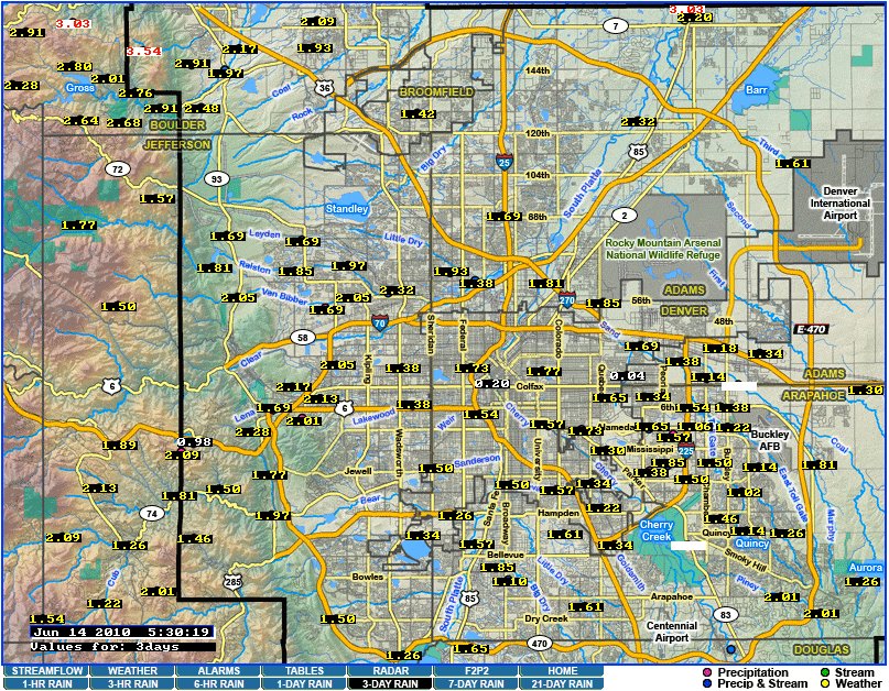
Click on the thumbnail graphic to the right for the 3 Day Rainfall map for the Denver Metro area from the Urban Drainage and Flood Control District. The station just west of Gulch Manor shows 2.32″ since Friday.

From The Greeley Tribune:

Weld County Road 53 north of Kersey was closed early Sunday morning because of flooding, said Weld County Undersheriff Margie Martinez. It’s not known exactly when the road will be safe to open. Northern sections of 71st, 83rd and 95th avenues in Greeley also remain closed, said Jerry Pickett, streets superintendent for the city of Greeley. He said these should be open sometime today. Unless the rain picks up again, Pickett said water should start receding. The cooler weather has slowed runoff from the mountains, actually helping to lower some rivers, Pickett said.

Here’s a report from the Fort Collins Coloradoan:

More than 2 inches of rain fell in the three days of precipitation that started Friday, according to rain gauges throughout the city. Through 12:41 p.m. Sunday, downtown LaPorte reported 2.2 inches of rain. Gauges at City Park and Avery Park detention pond recorded more than 2 inches as well with the rest of Fort Collins, receiving anywhere between 1.4 and 1.89 inches of rain. Weld County roads 13 and 17 in Windsor were closed to traffic in the vicinity of the Poudre River, and Larimer County Road 5 near roads 36 and 38 near Timnath were closed early Sunday. A combination of high runoff flows and local thunderstorms forced the Poudre River out of its banks in those and other low-lying areas. The only north-south arterial that remains open south out of Windsor is Colorado Highway 257, and the water level is rising in that area, too. Colorado Highway 392, an east-west arterial, remains open above the Poudre River, although the water level there is very high…

Windsor Public Works Director Terry Walker said his main focus now is Colo. 257 and the railroad trestle that runs parallel to the highway. “There is debris catching under the trestle,” Walker said. “We’ve contacted the railroad, and they are aware of it. It’s a big concern.”

From The Denver Post (Joey Bunch):

Many of the state’s monitored rivers are flowing at two to three times their normal rate for this time of year, according to the U.S. Geological Survey. Some that had posed concern last week, including the Roaring Fork River at Glenwood Springs and the Arkansas River west of Pueblo, had returned to near normal Sunday. Clear Creek at Golden, the site of warnings about the dangerous currents Tuesday and Saturday when the flow reached 1,400 cubic feet per second, was flowing at 966 cfs Sunday, compared with the 35-year average of 763 cfs. Cherry Creek in Denver, however, was flowing at 108 cfs Sunday, compared with its 55-year mean for the date of 37 cfs, according to the USGS’s gauges…

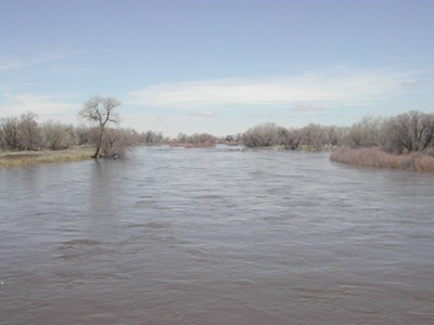
Flooding also was reported Sunday along the South Platte River near Kersey as the river exceeded its 10-foot flood stage, according to the National Weather Service.

From the Colorado Daily (Amy Bounds):

Boulder County sheriff’s Sgt. Lori Cox said the threat of flooding receded Sunday, though the risk for South St. Vrain and Boulder creeks remained moderate to high.

Boulder Creek’s water flow dropped about 200 cubic feet per second — to about 400 cubic feet per second — on Sunday, down from about 600 cubic feet per second on Friday. The average for Boulder Creek is between 100 to 300 cubic feet per second.