Colorado Water 2012: Fix Those Leaks!

coloradowater2012

Here’s a new post from Your Water Colorado Blog highlighting Fix a Leak Week. From the post:

The EPA has declared Fix a Leak Week, March 12 through 18, 2012 because leaks waste a tremendous amount of water. Fix a Leak Week is an annual reminder to check household plumbing fixtures for leaks, this week and all year long. Several cities in Colorado are sponsoring activities to celebrate Fix a Leak Week.

More conservation coverage here.

March 12 – 18 is National Groundwater Awareness Week

groundwatermovementusgs.jpg

Here’s the webpage from the National Ground Water Association:

Now well into its second decade, Groundwater Awareness Week spotlights one of the world’s most important resources — groundwater.

Who should be “aware” of groundwater? Quite simply, everyone.

Groundwater is essential to the health and well-being of humanity and the environment. Whether you’re on a public water system or a private well, whether you are a health care official, policymaker, regulator, an environmentalist or a groundwater professional, you can get involved in protecting this vital resource.

You can find more information on groundwater and water well stewardship by going to NGWA’s Web site for well owners, www.wellowner.org.

Here’s the link to the USGS Groundwater webpage. Here’s a link to the USGS publication What is Groundwater?.

The BLM has scheduled open houses in Saguache and Alamosa for comments on potential geothermal leases

riogranderift.jpg

Here’s the link to the announcement from the U.S. Bureau of Land Management.

Geothermal Energy Leasing Environmental Assessment

The Bureau of Land Management welcomes your comment on an environmental assessment (EA) to amend the 1991 BLM San Luis Resource Management Plan (RMP) for geothermal energy leasing on BLM-managed lands. The Colorado Geological Survey recognizes the potential for geothermal energy in the San Luis Valley. Currently, there are no geothermal energy leases on BLM lands in the Valley.

Public comment on this EA opens March 12, 2012 and closes April 10, 2012. BLM is also hosting two open house meetings: Tuesday, March 20th from 4 – 7 p.m at the Saguache County Road and Bridge Building and Wednesday, March 21st from 4 – 7 p.m. at Adams State College (McDaniel Hall)

Thanks to the the Associated Press via The Denver Post for heads up.

More geothermal coverage here and here.

Snowpack news: Storage may obviate the effects of the expected below average streamflow forecast

basinplotstate12

Click on the thumbnail graphic for an ogive of the statewide snowpack (from the Natural Resources Conservation Service), which has flat-lined over the past few days.

From 9News.com (Tara Meyer):

The Natural Resources Conservation Service reports that Colorado’s snowpack is 81 percent of average, as of March 1. At the beginning of February, the snowpack was only 72 percent of average. Although February snowfall helped increase the snowpack significantly, the state is well behind last year’s totals. The March 1 measurement is 71 percent of last year’s snowpack on the same date.

From The Mountain Mail (Mike Campbell):

The Arkansas, Upper Rio Grande and Colorado river basins improved with 86, 83, and 75 percent of average, respectively [for March 1]. Colorado snowpack increased to 81 percent of average – up 9 percent…

The Yampa and White river basins snowpack is up 14 percent for 47 percent of average. The North Platte basin was at 80 percent. The basins of San Juan, Animas, Dolores and San Miguel rivers were 86 percent of average…

For most water users, reservoirs throughout the state are above or near average, she said, which should help with late-summer shortages.

Loveland: Sales to water haulers for hydraulic fracturing is on the increase

lovelandcoloradoandsoutherndepot.jpg

From the Loveland Reporter-Herald (Tom Hacker):

Green-thinking cities including Loveland that own the Platte River Power Authority electric utility are pressing for conversion of its generating plants from dirty coal to clean-burning natural gas. PRPA policy represents but a tiny portion of the forces driving production of natural gas, a $9 billion Colorado industry that has been pushed ahead by improvements in a technology called hydraulic fracturing, or “fracking.” The technology, more akin to mining than drilling, requires water — and lots of it.

As gas producers expand their operations into the western fringe of the Wattenberg field in Larimer and Boulder counties, their demands for water reach into municipalities up and down the Front Range, Loveland among them. “We’re not selling as much as other providers, because we’re further away from most of the activity,” said Loveland water resources engineer Greg Dewey. “But it has become a significant source of income for us.”[…]

…the dominant supplier of water to the industry, Fort Lupton-based A&W Water Service Inc., sends its tanker trucks to Loveland on a regular basis to load water at designated city hydrants to take to drilling sites. On Friday, two truck crews were tapping a metered hydrant just north of the roundabout at Sculptor Drive and First Street, each drawing 6,200 gallons of treated water into their tanks. The water was destined for a drilling site just north of U.S. 34, a quarter-mile east of the Larimer-Weld county line for Petroleum Development Corp…

Loveland water manager Dewey said A&W and other suppliers draw about 2 million gallons monthly, a tiny fraction of what other municipalities in the region provide. They pay at the rate of $1 for 300 gallons, more than twice what Loveland homeowners pay for their usage. And, the industry’s purchases from Loveland make scarcely a dent in the city’s supply. “We want to make sure we have adequate supplies for our residents first,” Dewey said. “We see this alternative as a way to maintain service to our customers at reasonable rates.”

More oil and gas coverage here and here.

The Colorado River Roundtable has funding available for projects that will address environmental and recreational water needs involving the Colorado River and its tributaries

coloradoriverbasincgs.jpg

From the Glenwood Springs Post Independent:

The Colorado Basin Roundtable (CBRT) is looking to help fund projects that will address environmental and recreational water needs involving the Colorado River and its tributaries. Funding for these projects would be from the roundtable’s Water Supply Reserve Account, which is administered by the Colorado Water Conservation Board.

As much as $2 million may be available for competitive grants statewide. Although there is no limitation to grant requests, typical grants are about $200,000. CBRT hopes to identify up to five projects for near-term funding and implementation, and other projects may be considered for long-term prioritization.

The CBRT is sponsoring an informal workshop to help potential project applicants with the funding process. It takes place from 10 a.m. to 12:30 p.m. on March 15, in the Blue River Room of the North Branch Library in Silverthorne. Interested parties should prepare a short project summary based on criteria that can be found on the Colorado River District website at www.ColoradoRiverDistrict.org or by calling Jacob Bornstein, CWCB (303-866-3441) or Lane Wyatt, CBRT (970-468-0295, ext. 116).

More IBCC — basin roundtables coverage here.

Colorado Water 2012 — Justice Hobbs to discuss his book ‘Living the Four Corners: Colorado Centennial State of the Headwaters’ Wednesday in Pueblo

coloradowater2012

From The Pueblo Chieftain (Gayle Perez):

Hobbs is scheduled to speak from 3 to 4:20 p.m. in the Library and Academic Resource Center, Room 109. Hobbs’ presentation is part of the ongoing Colorado Water 2012 series of speakers being hosted by CSU-Pueblo. The series is free and open to the public.

Here’s the link to the book store page from the Continuing Legal Education Inc. page.

More Colorado Water 2012 coverage here.

Governor Hickenlooper’s oil and gas task force starts work

derrick.jpg

From The Denver Post (Bruce Finley):

A 12-person team tasked with sorting out how local governments might be involved with regulating the oil and gas industry in Colorado began their work Friday with clear direction from Attorney General John Suthers. “The inspection authority can be shared and delegated, but the enforcement authority cannot,” Suthers said.

That may limit local efforts to impose new protective measures and issue citations but appears to leave room to craft new cooperative arrangements in the face of the Colorado Oil and Gas Conservation Commission’s existing authority to promote and oversee oil and gas operations.

More oil and gas coverage here and here.

Northern Water: Regional Pool Water available, bids due March 16

coloradobigthompsonprojecteastslopesystemncwcd.jpg

From email from the Northern Colorado Water Conservancy District:

Today the Northern Water Board of Directors made 25,000 acre feet of water available for lease through the Regional Pool Program, a C-BT Project water leasing/renting mechanism, with bids due March 16. The board’s decision was based on the status of C-BT Project storage reserves, which were replenished in the previous two water years, and current crop irrigation demands.

Bid prices per acre foot must be greater than or equal to $9.50, a floor price the board selected based on the 2012 agricultural assessment.

Here’s the link to the website.

More Colorado-Big Thompson Project coverage here.

State Engineer Dick Wolf tells San Luis Valley sub-district one irrigators that they need to deliver 5,000 acre-feet of replacement water this year

slvdischargerecharge.jpg

From the Valley Courier (Ruth Heide):

A few days ago the Valley reached another milestone in its sub-district journey with Wolfe’s expectation letter telling the sub-district and its sponsoring district the Rio Grande Water Conservation District how much replacement water must be delivered this year — 5,000 acre feet.

Rio Grande Water Users Engineer Jim Slattery clarified the 5,000 acre feet is the amount of depletions a groundwater model determined must be replaced this year, but it does not begin to replenish the Valley’s greatly reduced aquifer.

Wolfe said the first sub-district must submit a plan to the state by April 15 that includes the specified water replacement amount, and the state will hold a public hearing in April before acting on the plan. The sub-district’s plan must be updated and approved annually…

The groundwater model Slattery and other engineers and scientists have spent countless hours developing is designed to help sub-districts determine how much water they need to replace, and until recently the model was not calibrated to a point where that number could be specified.

Wolfe said now that the groundwater model is refined enough to provide specific data about the kind of water replacements required in the Rio Grande Basin, the first sub-district and several other sub-districts in various stages of formation can move forward more rapidly.

In addition, Wolfe and a large advisory group can begin moving forward again on groundwater rules and regulations for the Rio Grande Basin. The well rules advisory group has not met since last August but will resume its meetings soon, Wolfe said.

His goal is to submit well regulations to the water court before the end of the year. How long between his promulgation of the rules to their implementation will depend on how many objections there are to the rules and whether or not a trial becomes necessary, he said. Wolfe said in similar regulation promulgations in other basins in the state, the time frame was about a year between the time the rules were submitted to the court and implemented.

More San Luis Valley groundwater coverage here and here.

State of the Rockies Project: Will and Zak release a new video — ‘A Paddler’s Perspective on the Colorado River Delta’

willorzakcoloradoriverdelta2012stateoftherockies.jpg

Here’s the link to the video. Will and Zak paddled from the headwaters of the Green River to the Colorado River Delta as researchers for Colorado College’s State of the Rockies Project.

More Colorado River Basin coverage here.

Governor Hickenlooper plans a pow wow with Gov. Brownback (Kansas) and Gov. Dave Heineman (Nebraska), with a little Whooping Crane watching

whoopingcranes.jpg

Here’s the release from Governor Hickenlooper’s office (Eric Brown/Megan Castle):

Gov. John Hickenlooper will meet with Nebraska Gov. Dave Heineman and Kansas Gov. Sam Brownback on Friday, March 23, to discuss common efforts and issues related to eco-tourism and economic development. The three governors will meet in Wood River, Neb.

“The economies of Colorado and surrounding states are linked in many ways,” Hickenlooper said. “This meeting will be great opportunity to share ideas and find ways we can work together to boost tourism and economic development in our region.”

According to statistics gathered by the Colorado Tourism Office in 2010, Colorado attracted 51.6 million visitors made up by overnight leisure travelers and day trips. Visitors to Colorado spent $14.6 billion in 2010, an 8.4 percent increase over 2009. The tourism industry supports nearly 137,000 jobs and generates $750 million in local and state tax revenues, saving every Colorado household $395 in taxes they would have otherwise paid to maintain the same services.

In addition to discussing tourism efforts, the governors will view the world-renowned migration of the sandhill cranes, a significant eco-tourism attraction in Nebraska.

From mid-February to mid-April each year, visitors to the Platte River valley in south-central Nebraska can enjoy the migration of 90 percent of the world’s sandhill cranes. Approximately 500,000 sandhill cranes gather each year en route to their summer breeding grounds in Canada, Alaska and Siberia.

Water Research Foundation: Joint Front Range Climate Change Variability Study available on Scribd

clearcreek1106

Here’s the link to the report. Thanks to Bob Berwyn’s Twitter feed (@bberwyn) for the heads up.

Colorado Water 2012: Lee Hancock — ‘Farming and ranching is the second-largest contributor to our state’s economy’

coloradowater2012

Here’s the latest in The Pueblo Chieftain’s Water 2012 series. Here’s an excerpt:

Farming and ranching is the second-largest contributor to our state’s economy. Most people just don’t realize that our rural communities are directly dependent on agriculture. At the turn of the century, our towns sprung up to support the emerging agricultural industry. As the agricultural industry grew, so did its supporting communities. Before long, the interdependency between local agriculture and its local community became so strong that if either failed, both would fail. This has proven especially true in Southeastern Colorado.

Agriculture is mostly made up of ranching, dry-land farming and irrigated land. It is the irrigated agriculture and the perennial supply of irrigation water that allows farmers in the Lower Arkansas Valley to grow the crops for our food supply. The sale of these commodities such as corn, sorghum, wheat, alfalfa, onions, cantaloupes, watermelons, tomatoes, chiles and a slew of other crops bring millions of dollars into our rural communities annually. Water, especially irrigation water, has created wealth in private land and water rights ownership. Irrigated farmland is valued considerably higher because of the water and its production potential.

More Colorado Water 2012 coverage here.

Trinidad: Work is ongoing on $120,000 restoration project along the Purgatoire River through town

purgatoireriver.jpg

From The Pueblo Chieftain (Chris Woodka):

“This used to be a great repository for old tires and beer cans. There were also a lot of illegal ATVs tearing things up,” Lackey said last week, while looking from a city park at the restoration work in the river bed. “We hope this will be part of a new direction Trinidad takes.” Work is being done on a $120,000 project that will improve the fish habitat by adding groups of rocks that will help pool water in low flows and provide shelter in the higher water. The project also includes a trail, handicapped fishing features and removal of invasive species like tamarisks and Russian olives.

Contributors to the project include the city of Trinidad, Pioneer Natural Resources, Trout Unlimited, the Arkansas Basin Roundtable and Purgatoire River Conservancy District, among many others. “We’re looking at this as a demonstration project,” said Jim Muzzulin, president of the local Trout Unlimited chapter. “It’s a real investment that will allow tourists and kids to go fishing in town. Every year they have the Santa Fe Trail Festival in this park, so Trout Unlimited can set up a booth and take them right down to the river to cast a line.”

The flows in the river are almost entirely controlled by releases from Trinidad Lake, about three miles upstream. During the winter months, water is stored. As snow melts, rains come or when farmers call for water out of storage, the flows pick up. The river bed is basically flat, and the higher flows scour it. Contractors have been hired to add small boulders at strategic points, reinforce banks and develop a more complex system for fish.

More Arkansas River basin coverage here.

EPA WaterSense: ‘Fix a leak week’ starts tomorrow, runs through next Sunday

leakingcopperpipe.jpg

Here’s the announcement from the U.S. Environmental Protection Agency:

Did you know that an American home can waste, on average, more than 10,000 gallons of water every year due to running toilets, dripping faucets, and other household leaks?

Nationwide, more than 1 trillion gallons of water leak from U.S. homes each year. That’s why WaterSense reminds Americans to check their plumbing fixtures and irrigation systems each year during Fix a Leak Week.

WaterSense is teaming up with our partners to promote the fourth annual Fix a Leak Week, March 12-18, 2012.

From New Mexico’s search for bad flappers to leak detection efforts in Texas, West Virginia and across the nation, there are plenty of opportunities to get involved in this year’s Fix A Leak Week. Explore our list of some of this year’s many events to find out more.

More Environmental Protection Agency coverage here.

Snowpack news: Statewide snowpack approximately 81% of average, below average streamflow forecasted

snowpackcolorado03092012

From The Denver Post (Scott Willoughby):

Following a winter last year that refused to yield its grip on much of the state until the calendar said it was officially summer, the winter of 2011-12 never really got rolling in the Rocky Mountains until mid-February. And the snowpack that local rivers and reservoirs depend upon for water currently reflects that. February’s wintery weather created optimism that the state might rebound from its sluggish start. But statistics on the board offer a grim outlook for salvaging even an average water year on the majority of the Western Slope, the wet side of Colorado.

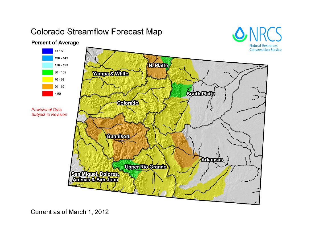
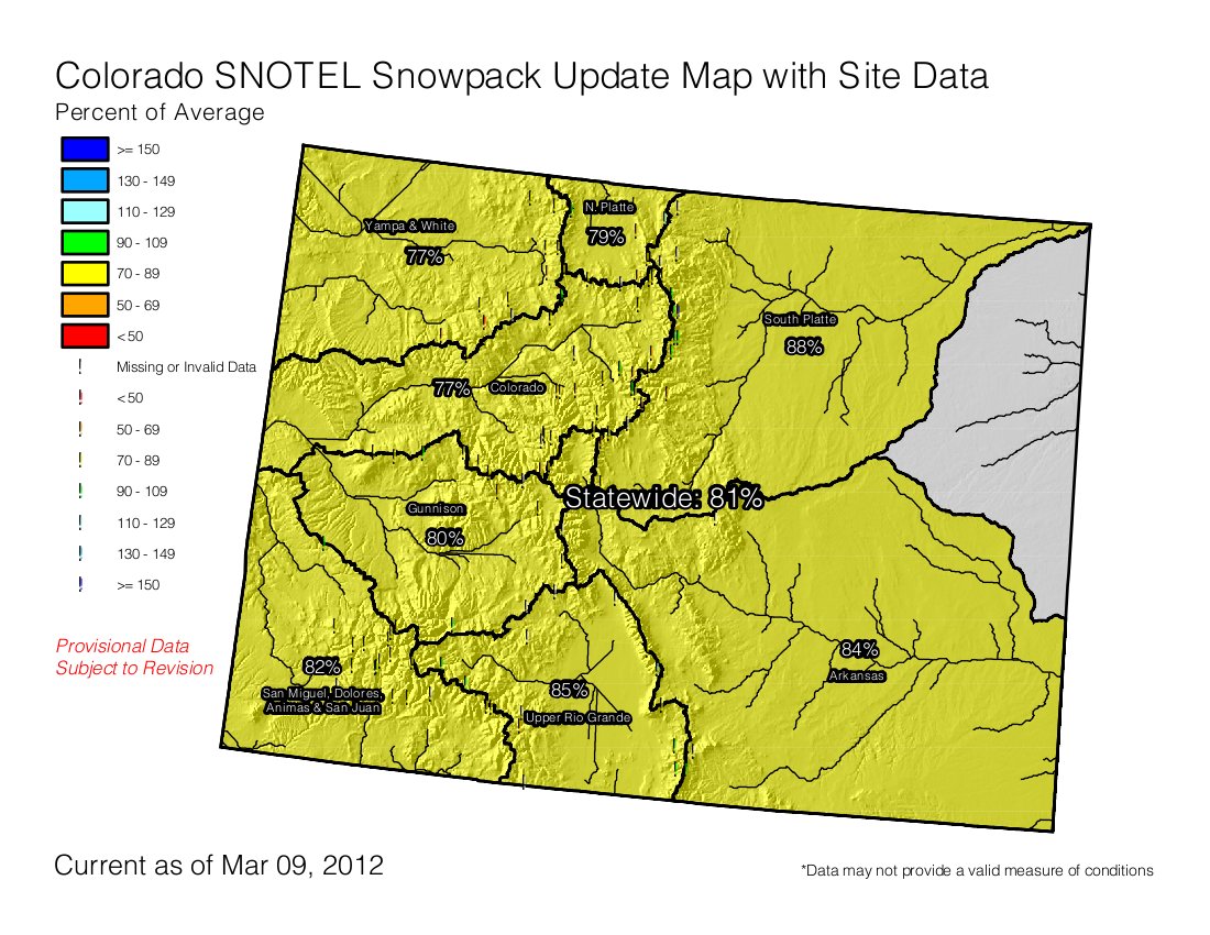
The National Water and Climate Center currently places year-to-date precipitation below average in seven of Colorado’s eight major river basins, establishing a comparably subpar snowpack. And even as the Upper Rio Grande basin registers 101 percent of precipitation average, the snow water equivalent there remains down 15 percent at just 85 percent of average.

Elsewhere in the state, the numbers are generally worse. With 92 percent of its average precipitation so far, the South Platte River basin is clinging to 85 percent of its snow water equivalent, and the Arkansas River basin is pulling 84 percent of the water from 87 percent of its average snowfall. Salvaging a solid runoff and healthy fishing flows is not out of reach in those areas, given a shift in weather patterns through April, generally the second- snowiest month in the mountains.

But the Upper Colorado River basin — fed at its headwaters by the mountains of Grand County and downstream by the Blue and Eagle rivers of Summit and Eagle counties — will face increased urgency to mount a comeback from a snowpack of only 77 percent. A similar scenario holds true for the Yampa and White river basins to the north, while the Gunnison River basin to the west is faring slightly better at 80 percent snowpack and 78 percent snow water equivalent, according to the Natural Resources Conservation Service.

From The Telluride Daily Planet (Katie Klingsporn):

According to the Natural Resources Conservation Service, February’s series of storms helped boost the state’s overall snowpack by 9 percent. As of this week, the snowpack for the San Miguel, Dolores, Animas and San Juan Basin was up to 82 percent of average, which put it 1 percent ahead of the statewide average. It’s still slightly behind the basin’s average for this time of year, but considering that it sat at just 61 percent of average on Jan. 15, it’s come a long way. The NRSC’s Snotel censor measured the snow depth at Lizard Head Pass on Friday at 47 inches.

According to weather data compiled by local resident Thom Carnevale, the town of Telluride received 37.8 inches of snow in February, up significantly from the monthly average of 26.8 inches. That translated into 2.21 inches of precipitation, up from the average of 1.72 inches. (The record snowfall for the month, according to Carnevale’s records, is an astonishing 97.9 inches, which fell in 1936)

January, meanwhile, saw 27.8 inches, according to Carnevale’s reports, up slightly from the average of 26.9 inches. Of the total inches, Carnevale said, 20 fell between Jan. 21 and 27…

Technically, the La Niña pattern hasn’t gone anywhere, and Colton said the region might be feeling more of its downsides as March unfolds. “We’re expecting conditions to warm up and dry out for the next 30 days,” [Jeff Colton, a meteorologist with the National Weather Service’s Grand Junction station] said this week…

As of March 1, reservoir storage statewide was 107 percent of average, and the reservoir storage in the San Miguel, Dolores, Animas and San Juan Basin was 104 percent of average.

From Steamboat Today (Tom Ross):

The combined Yampa and White river basins stood at 80 percent of average moisture stored in the snow on Monday, according to the Natural Resources Conservation Service. “Things have improved for Colorado since Feb. 1, that’s for sure,” NRCS assistant snow survey supervisor Mage Skordahl said. “But overall the chances are pretty unlikely we’ll get back to average by April. We don’t get a lot of moisture in April, but if we get a wet spring there can still be a large accumulation then as well.” Skordahl was putting the finishing touches on a statewide water forecast Monday and said Colorado had picked up 9 percentage points in February to reach 81 percent of average snowpack. She said in a typical year, Colorado gets 20 percent of its seasonal snow moisture in March.

Close to Steamboat Springs, at 9,400 feet, the Rabbit Ears Snotel site showed 15.2 inches of water in the snowpack compared to the typical 22.3 inches for the date. That translates to 68 percent of average. But there’s more ground to be made up…

The Tower Snotel site at the 10,500-foot summit of Buffalo Pass on the Continental Divide northeast of Steamboat typically peaks on May 6 with 52.4 inches of water, according to the NRCS. On Monday, the water content in the snow there stood at 28.7 inches. That’s 74 percent of average for the date, but 55 percent of the average peak.

The area around Crosho Lake on the edge of the Flat Tops Wilderness Area between Phippsburg and Yampa has a good shot at reaching average snowpack — water content there on Monday was 9.8 inches, or 92 percent of the average for the date of 10.7 inches. The Crosho Snotel site needs to get to 12 inches to hit the April 5 average peak snowpack.

From the Sky-Hi Daily News (Tonya Bina):

The overall snowpack for Middle Park is at 81 percent, with 100 percent being “average.” “We’re doing a little bit better. Hopefully March will still be snowy,” said Mark Volt of the USDA Natural Resources Conservation Service, Kremmling Field Office. At the beginning of February, snowpack was at 75 percent of the 30-year average snowpack.

Field Office snow surveyors Volt, Vance Fulton, and Joe Messina took the March 1 snow survey measurements during the last days of February.

Snowpack in the mountains above Middle Park now ranges from 55 percent to 111 percent of the 30-year average. Last year at this time, the area was at 128 percent of average. Two areas of Middle Park measured better than other areas. Areas around Gore Pass met the 30-year average in moisture content of snowpack at 104 percent of average, with 43 inches of snow depth, and a Granby snow course near the old Granby Landfill and C Lazy U Ranch measured at 106 percent of average with 40 inches. Snow density is averaging 22 percent, which means that for one foot of snow there is about 2.6 inches of water. “This is pretty low snow density for this time of year,” said Volt. “Snow density for March 1st usually runs in the high 20s.”

From the Associated Press via the Loveland Reporter-Herald:

The U.S. Department of Agriculture reported Tuesday that statewide snowpack increased to 81 percent of average, up 9 percentage points from the 72 percent of average recorded on Feb. 1. Forecasters say despite these gains, this year’s snowpack continues to lag well behind last year’s totals. As of March 1, all major basins in Colorado are expected to have below average runoff conditions this spring and summer.

Climate change wildcard: It’s hard to forecast how much carbon arctic soils may give up to the atmosphere with warming

soilcrosssectionuniversityatalbany.jpg

From the North Forty News (Gary Raham):

In a recent Science News article (“Soil’s Hidden Secrets,” Jan. 28, 2012) Charles Petit said, “If the bank of carbon held in the world’s soils were to drop by just 0.3 percent, the release would equal a year’s worth of fossil fuel emissions.”

Soil hoards about three times the amount of carbon contained in the air and all above-ground vegetation combined, but it doesn’t just hold carbon like a laundry basket holds dirty socks. Soils form complex and varied ecosystems like the prairies, rain forests and coral reefs humans can more readily recognize. Soil scientists create color-coded soil type maps of the world that look like someone spilled a handful of confetti on an atlas. The problem is that these scientists sometimes have a hard time knowing just how and when different soils may play their carbon trump cards in a warming world.

In eastern Colorado, we walk on prairie soils. Such soils contain a layered mix of living and non-living components. Finely ground rocks, clay, sand and wind-blown debris (loess) form the bottom layer. The middle layers house a community of worms, mites, insects and microorganisms swimming in a sea of partially decayed organic matter invaded by networks of feathery roots and spider-web filaments of fungi. The remains of Ice Age mammoths and tigers mingle with those of the cattle and corn stalks of more recent grasslands. Billions of bacterial and fungal cells constantly work at breaking down a backlog of complex carbon molecules into climate-warming gases such as carbon dioxide…

“Biochar,” a clever term for charcoal created during fires in forests and grasslands, represents another wildcard in soil chemistry. Under certain conditions, biochar can sequester carbon in the soil for decades or centuries, but sometimes it can degrade within years and cycle the carbon into the atmosphere. Soil scientists, like Prof. M. Francesca Cotrufo at Colorado State University, work on ways to produce biochar for different purposes.

“Depending on the feedstock, temperature, and other conditions of pyrolysis (burning),” Cotrufo said, “we can make a biochar which is relatively easy to decompose and works best for soil fertility but not for carbon sequestration, as well as build a very recalcitrant biochar.”

The latter type keeps carbon compounds out of the air longer…

The soil that may hold the fate of the world’s climate in its black, carbon-rich depths lies in the Arctic. Scientists estimate that once permanently frozen Arctic soils contain 1.5 billion tons of carbon — about half of all the carbon contained in soils worldwide. As these soils warm and microbes fire up their engines, a torrent of greenhouse gases could tip the planet from the relatively icehouse conditions of today to the hothouse conditions of eons past.

More climate change coverage here and here.

Aspen: The city plans to install three additional tap water stations in town by summer, they serve up filtered tap water

smugglermineaspen.jpg

From the Aspen Daily News (Dorothy Atkins):

The specifically designed filling stations are strategically placed around town and provide filtered tap water to the public. They have a traditional water fountain and a spicket to fill bottles, and each has a gauge that determines how much water is used. They currently do not operate during the winter months.

The city kicked off its “Aspen Tap” campaign last year by installing three stations — one near the restrooms at Wagner Park, another at Conner Park, next to City Hall, and the third at the skate park next to the Rio Grande Trail.

Between July and September of last year, people consumed over 700 gallons of water from the station at Conner Park and over 1,000 gallons from the skate park tap.

Good idea.

More infrastructure coverage here.

Dolores: McPhee Reservoir and Dolores Project operations meeting March 21

dolorescolorado.jpg

From the U.S. Bureau of Reclamation via the Cortez Journal:

The Bureau of Reclamation will host a McPhee Reservoir and Dolores Project operation meeting on March 21 at the Dolores Community Center at 7 p.m. Topics of discussion will focus on anticipated water releases to the lower Dolores River and an overview of the Dolores Project.

More Dolores River watershed coverage here and here.

2012 Colorado November election: Farmers are eyeing initiatives 3 and 45 warily

justianifirstdodifierofriparianrights.jpg

From The Fence Post (Eric Brown):

Initiatives 3 and 45 — proposed citizen-sponsored legislation pieced together and filed by Richard Hamilton of Fairplay and his attorney, Phil Doe — seek to apply the public trust doctrine to Colorado water rights through a constitutional change.

[Gene Kammerzell], a Weld County produce grower who owns Arborland Nursery and is a member of the Colorado Farm Bureau Water Committee, has joined a number of other farmers, ranchers and agricultural organizations — as well as the Colorado Water Congress — in fighting the initiatives because they could cause chaos with state water rights, according to the opponents. Both sides agree in that the initiatives would override the state’s current prior-appropriation system — which states that those who own older water rights have a higher priority in using them — and 136 years of case law that have also helped define how water may be used in Colorado.

In addition to invalidating water rights, the proposed measures, if voted into law, would allow anyone to use the state’s water and then leave it up to the public to determine if the water is being used for the common good, Hamilton explained in a phone interview Wednesday. If members of the public were to determine the water isn’t being used for the common good, they could file a lawsuit in effort to curtail or prevent further water use in that capacity.

Hamilton, an aquatic microbiologist who has been a lobbyist in the environmental and natural resources industries for nearly 40 years, said the purpose behind his initiatives — in addition to placing control of the state’s water into the general public’s hands — is to prevent further contamination of water, often seen in return flows to the rivers following industrial use, and prevent the further depletion of the state’s rivers, caused by increased municipal, industrial and agricultural use. “Water is a public right,” Hamilton said, “and if you want it, don’t overuse the resource … and don’t send it back to the public filled with crap.”

More 2012 Colorado November election coverage here.

Windsor: Sales of water for hydraulic fracturing operations is a growing source of revenue

marcellushydraulicfracturing.jpg

From the Fort Collins Coloradoan (Bobby Magill):

After years of selling small amounts of municipal water to construction firms, oil and gas well servicing companies started lining up in November at the [Windsor’s] fire hydrants, earning the community nearly $17,000 in millions of gallons of water sales as of March. 1…

Fracking is a thirsty process, with each Niobrara frack job using an average of 4.3 million gallons of water, or about 13 acre-feet, according to the Colorado Oil and Gas Association. Where that water comes from and where it goes is critical because many environmentalists are sounding alarms about the amount of water being used for drilling along the Front Range because they say it poses serious future water supply problems as the energy industry continues to boom here.

But the state begs to differ. Colorado energy regulators project that roughly 16,000 acre feet of water will be used this year for fracking statewide, most of which will stay far underground without being returned to a local stream or river. Compare that to the 13.9 million acre-feet of water used for farming in Colorado each year. Or the 1.2 million acre-feet of water all the state’s cities use each year. Those figures show that fracking represents only a fraction of the state’s overall water demand, said Thom Kerr, acting director of the Colorado Oil and Gas Conservation Commission…

The Coloradoan asked 32 municipalities in Larimer and Weld counties to report how much bulk municipal water they sold or rented to the energy industry in 2011, including oil and gas companies and their water haulers. Of the 26 that responded, seven were able to report selling water specifically to oil and gas companies and water haulers. The rest either did not sell water to the energy industry last year or do not track what kind of companies buy their water…

Greeley, in the heart of Northern Colorado’s oil and gas patch, is another big benefactor of the industry’s thirst for water. The city made $1.6 million in 1,507 acre-feet of bulk water sales in 2011, up from $951,000 in 2010, mostly to the oil and gas industry, said Jon Monson, director of Greeley Water and Sewer…

Also reaping big benefits from selling water to the energy industry is the city of Fort Lupton in southern Weld County, where officials are using the windfall of cash to pay down $20 million in debt the city racked up from replacing its water treatment plants in the 1990s, Fort Lupton city administrator Claud Hanes said…

“They don’t understand what the cumulative impact is going to be if we put in another 100,000 wells,” said environmentalist Phillip Doe of Littleton, a former environmental compliance officer for the U.S. Bureau of Reclamation. If all the wells that exist today were fracked multiple times, “it’s not hard to come up with calculations that come up with Denver’s annual water use. This stuff goes underground and never comes back.”

More oil and gas coverage here and here.

Pueblo: The city’s raw water supplies are sufficient to cover anticipated growth

pueblo.jpg

From The Pueblo Chieftain (Chris Woodka):

Pueblo’s advantage is that it has not grown into its existing supply, unlike many other Front Range communities. While storage is the key to ongoing statewide strategies, few new projects have been built since the completion of Lake Pueblo in the 1970s. The Preferred Storage Options Plan, which would look at enlarging Lake Pueblo, is 14 years old and “still at Step 1,” [Executive Director Alan Hamel] said. The water board bought 28 percent Bessemer Ditch in 2009 as a way to reduce dependence on Colorado River water, but half of Pueblo’s supply still comes from the Western Slope. It will be at least 10 years before the Bessemer shares are converted to municipal use in water court, Hamel said. At the same time, Pueblo water customers have voluntarily cut their use 17 percent and the water board is looking at other strategies for conservation…

The water board is pricing water service rates to new large users at the true cost of providing water — $16,200 per acre-foot. As it has developed the policy, staff members have worked behind the scenes with city staff and met with the Pueblo Economic Development Corp. to make sure the rates don’t scare off companies that could bring jobs to Pueblo, Hamel said.

More Pueblo Board of Water Works coverage here.

Snowpack news: Crested Butte Mountain Resort cancels the Freeskiing World Tour’s annual stop due to low snowpack in the extreme terrain on the mountain

snowpackcolorado03092012

Click on the thumbnail graphic to the right for the current Colorado snowpack map from the Natural Resources Conservation Service.

From The Crested Butte News (Alissa Johnson):

Crested Butte Mountain Resort made a difficult decision last week to cancel the Freeskiing World Tour’s annual stop in Mt. Crested Butte, originally scheduled for March 7-11. Ski patrol and event organizers made the call due to low snowpack in the extreme terrain.

“Due to an unfortunate weather pattern this year, we cannot provide the venue that truly showcases the athletes and what they have come to expect here in Crested Butte,” said Crested Butte snow safety director Frank Coffey in the official announcement.

Public relations and communications manager Erica Reiter said the decision also came down to safety. She also said CBMR opted not to relocate the event to a run like the Headwall because it would not provide the type of terrain expected by freeskiing athletes. It would displace other skiers on the mountain, and given how late the Headwall opened, that wasn’t a viable choice.

From the Summit Daily News (Janice Kurbjun):

The Colorado River Basin is at 75 percent of average snowpack and 59 percent of last year’s snowpack. That’s improved from Feb. 1’s 69 percent of average snowpack. Water storage in the Colorado basin, though, is at 116 percent of average, indicating good planning on behalf of water managers in a high runoff year last year…

Statewide, snowpack is at 81 percent of average, up from 72 percent recorded on Feb. 1. Water storage statewide is at 107 percent of average…

Meanwhile, February’s snowfall pounded the Yampa, White and North Platte basins as well as the combined San Juan, Animas, Dolores and San Miguel basins, putting those areas in a much better position than in previous months.

The March 1, 2012 Colorado Basin Outlook Report is hot off the press: Below average streamflow forecast, above average storage will help over the summer

borco312streamflow.jpg

This is the time of year that the Natural Resources Conservation Service’s Basin Outlook Reports are the talk of the town. Here’s the link to the March 1, 2012 Colorado Basin Outlook Report. Click on the thumbnail graphic to the right for the streamflow forecast map from the report. Here’s the introduction to the report:

Summary

The month of February brought improvements to snowpack percentages in all major basins in Colorado. Unfortunately the snowy month was not enough to boost the snowpack to average conditions; as of March 1 the state snowpack was at just 81 percent of average. With only four to six weeks remaining in the typical accumulation season the odds of the snowpack obtaining average conditions are diminishing. Runoff forecasts remain below average across the state, with slight improvements over last month in the northern and southwest portions of the state. A majority of basins have considerably dry soils beneath the snowpack which can reduce surface water supply. Thanks in part to a good water supply year in 2011 reservoir storage volumes for the state are currently at 107 percent of average.

Snowpack

Despite above average snow accumulation during the month of February the statewide snowpack remains below average. The good news is that last month’s snowfall was very beneficial to the Yampa, White and North Platte basins. These basin’s snowpacks have been well below average for the entire season and previously reported just 65 percent of average conditions on February 1. As of March 1 the basins snowpack percentages had improved to 78 percent of average. The combined San Juan, Animas, Dolores, and San Miguel basins also benefited from above average snowfall in February. These basins saw a snowpack increase from 73 percent of average on February 1 to 86 percent of average measured on March 1. Across the rest of the state snowpack improvements were more nominal. The South Platte basins’ snowpack increased 8 percentage points over the last month from 81 percent on February 1 to 89 percent of average on March 1. In the Gunnison, Colorado, Arkansas and Upper Rio Grande basins only slight increases in snowpack percentages were measured compared to last month’s readings. For the state overall, the March 1 snowpack was reported at 81 percent of average, this is only 71 percent of last year’s readings at this same time. Comparisons to last year show indicate that the current snowpack is well below last year’s readings for all basins except for the Rio Grande and the combined basins in the southwest.
Precipitation

Mountain precipitation measured at SNOTEL sites across Colorado during the month of February was near to well above average. Statewide monthly totals were at 111 percent of average, marking a welcome turn in conditions after three consecutive months with below average precipitation measured. The Arkansas and Colorado basins were the only basins in the state to post below average monthly precipitation totals; still each basin reported a respectable 92 percent of average for the month. While February brought above average precipitation, water year totals are still below average for most basins. Year to date precipitation totals now range from just 80 percent of average in the Colorado basin to 103 percent of average in the Upper Rio Grande basin. The Upper Rio Grande and the combined San Miguel, Dolores, Animas, and San Juan basins are the only basins in the state with above average water year precipitation totals. Statewide year to date precipitation was at 90 percent of average at the close of February. Without the wet month of October and the return to above average conditions this past month, water year totals would be quite dismal.

Reservoir Storage

End of February storage data from the state’s major reservoirs indicates that volumes increased slightly during the past month. Statewide, storage is at 107 percent of average and there are a total of 3,588,000 acre feet of water available in the state’s reservoirs. Only two basins, the Upper Rio Grande and the Arkansas have below average storage volumes as of March 1. The lowest percentage in the state, at 69 percent of average, was reported in the Upper Rio Grande, this basin has had well below average storage volumes since the beginning of the water year. The highest storage amounts, as a percent of average, were reported in the Yampa basin which was 124 percent of average on March 1. Strictly looking at total volumes, the Colorado basin is storing the largest volumes above the average for this time of year with 117,000 acre feet greater than average stored as of March 1. Statewide storage on March 1 was 102 percent of last year’s storage amounts on this same date. This equates to an additional 56,000 acre feet of water compared to last year’s levels. Once again, the good storage volumes across most of the state will most certainly aid those water users who face potential surface water shortages this summer.

Streamflow

Below average streamflow runoff is expected this spring and summer across the state of Colorado. Outlooks for the northwest and southwest portions of the state have improved in the past month thanks to above average snowfall. Elsewhere forecasts remained consistent with those issued on February 1. Currently, the lowest forecasts in the state occur in the headwater tributaries to the Gunnison and South Platte rivers. Most of these forecasts range from 60 to 75 percent of average. March 1 forecasts for most of the rest of the state generally range from 75 to 85 percent of average. Volumes in this range are expected to prevail throughout the Yampa, White, Colorado, and combined San Juan, Animas, Dolores and San Miguel basins. The lower portion of the South Platte and the northeastern portion of the Rio Grande are in slightly better shape with forecasts ranging from 80 to 95 percent of average at most locations.

Rio Grande Watershed Conservation District quarterly meeting recap: The NRCS is looking for ideas for the 2013 budget

smithreservoir.jpg

From the Valley Courier (Lauren Krizansky):

A crowd comprised of Valley conservationists was pleased to welcome special guest Natural Resources Conservation Services Colorado State Conservationist Phyllis Philipps to the meeting and to hear about upcoming agency plans. Philipps said the agency is looking for ideas from local conservation districts to shape the 2013 NRCS budget. “We are asking you what you want to do,” Philipps said. “We want to rally around what you are passionate about.”

She explained that the state recognizes that each of the 76 conservations districts in the Valley have unique needs and operate at different levels. She encouraged the conservation districts to strive to identify projects that have a true impact…

The conservationists recommended that the districts focus on growing green manures – cover crops – to help reduce water use in Rio Grande Sub-district 1 without fallowing land. The sub-district is calling for 40,000 acres to be removed from production. “I’m not seeing a lot of emphasis on soil health and erosion,” [RGWCD President Brian Nuefeld] said. “They go hand in hand.”

More Rio Grande River basin coverage here.

Colorado Water 2012: Water law and Chaffee County water history from The Mountain Mail

coloradowater2012

Here’s the first article in their year-long series examining water issues in the Upper Arkansas Valley from Joe Stone writing for The Mountain Mail. From the article:

Along the western edge of the valley, the peaks of the Sawatch Range reach heights exceeding 14,000 feet above sea level and receive far more precipitation than the valley floor. As a result, approximately 80 percent of regional water comes from mountain snowpack that accumulates during winter and flows downstream as warmer temperature melts the snow. These characteristics of geography and climate created challenges for early settlers and fostered development of a water management system unique in the United States…

Early settlers found good farmland in the Lower Arkansas Valley and diverted water from the Arkansas River into the Rocky Ford High Line Canal. The canal has an 1861 water right senior to Upper Arkansas Valley water rights and, therefore, continues to affect Upper Ark water rights…

The oldest ditch in Chaffee County is the Trout Creek Ditch with an 1864 appropriation date. Other early ditches included the 1864 Thompson Ditch on Cottonwood Creek and the 1870 Hayden Ditch near Coaldale.

More Colorado Water 2012 coverage here.

Delta County Oil and Gas forum provided information on leasing and production potential in the region

rogersmesawinterorchardsviewrivendaleretreat.jpg

Here’s a release from Delta County via the Delta County Indpendent. Here’s an excerpt:

It shows real commitment of those interested about potential oil and gas development in the North Fork Valley, to spend an entire Saturday in educational sessions. But a large number of people did just that by attending the Oil and Gas Public Information Meeting sponsored by the Delta County Commissioners.

The meetings started at 9 a.m. and went until 4:30 p.m. and some longer than that. People continued to talk with various experts in the hallways at Paonia Junior and Senior High Schools before, during and after the sessions.

Delta County put together a list of speakers who have many years experience on the regulations, the initial nomination of parcels, the public’s roles throughout and what the agencies can and cannot do. In the afternoon break out sessions, citizens had the opportunity to ask questions that have been nagging them and were not settled during the morning presentations.

Olen Lund, chair of the Board of County Commissioners, moderated and introduced each speaker.

Dr. David Noe, senior geologist with the Colorado Geological Survey, began on the very important subject of the geology of the North Fork Valley where oil and gas exploration is being proposed. Dr. Noe has been mapping the geology from Montrose up to Rogers Mesa, and has not completed his work on the rest of the North Fork Valley.

After his presentation, he made clear that just mapping the geology of the area will not answer the question everyone is seeking — How viable is oil and gas production in the valley?

“It’s hard to evaluate that,” he said. “Just as I showed with the maps this morning, the way to understand the geology is to look at it systematically. You just take that general idea and you go into great depth with it,” Dr. Noe said. “The level of detail that we have with the geology mapped out right now doesn’t answer those questions at that general level. You have to dig in a little bit and look into the old oil and gas records. It’s hard to say. I can’t answer that question for you. The proof is really in doing it.”

Meanwhile, the BLM has released their preliminary environmental assessment on oil and gas exploration in the North Fork area, according to this release from the Bureau of Land Management via the Delta County Indpendent. From the release:

The EA analyzes whether or not the parcels are offered for competitive oil and gas leasing to allow private individuals or companies to explore and develop federal oil and gas resources in compliance with the National Environmental Policy Act. There are three alternatives offered within the EA including offering all of the nominated parcels for sale, offering a subset of the parcels for sale or not offering any parcels at this time

“The BLM has implemented a thorough and public review of oil and gas leasing, and we appreciate the input and information the public provided during this process,” said Barbara Sharrow, BLM Uncompahgre Field Manager. “Now, we encourage the public to review the preliminary environmental assessment and provide us with your comments on the proposed action.”

More oil and gas coverage here and here.

Aaron Million: ‘This project would divert less than 5 percent annually out of the massive Flaming Gorge Reservoir’

Conceptual route for the Flaming Gorge Pipeline — Graphic via Earth Justice

Here’s a guest column about the Flaming Gorge pipeline written by Aaron Million running in the Northern Colorado Business Report. Here’s an excerpt:

The argument that no further Upper Basin water projects be developed, which is a position some have taken, by default and in the simplest terms means California, Nevada and Arizona all benefit to the detriment of this region. Colorado faces a massive water supply shortfall, projected to be between 500,000 to 700,000 acre-feet over the next 20 years. New water and new storage, one of Gov. Hickenlooper’s keystone policy objectives and a long-standing objective for Colorado, can basically be accomplished with a pipe connection. This project would divert less than 5 percent annually out of the massive Flaming Gorge Reservoir, which is 25 times larger than Horsetooth Reservoir…

…the Flaming Gorge Project has several advantages for a new water supply. The Green River system itself, starting just south of Jackson Hole, has a different snowpack regime, which mitigates risk compared to relying on water from a single source or watershed. Also, global warming models predict the Green’s more northerly region to be wetter than average, while the Colorado River main-stem drainage, the historical focus of Front Range water needs, is predicted to be dryer than average. And the Green River is as large as the Colorado River main-stem, with comparatively little consumptive use and very few diversions.

Without question, the river has major environmental and recreational benefits that require protection…

So why does that matter for this region? It matters because an overall systems analysis on the Green River following implementation of the ROD indicates substantial surplus flows after meeting all the environmental needs of the river. Those surpluses, estimated at several hundred-thousand acre feet in a river system that flows over 1.5 million acre-feet annually, could be used to bring in a new water supply for the South Platte and Arkansas basins, generate new alternative energy, produce hundreds of millions of dollars in economic benefits, and provide re-use of waters for agriculture to keep the region strong and vibrant.

So the real question is this: If a large river system can be fully protected, and at the same time some of the potential surpluses from that same system alleviate major supply issues elsewhere, isn’t that an environmentally sound and reasonable water supply approach? The question remains unanswered until a rigorous and thorough environmental impact evaluation is completed…

I believe this we need to take this project through its paces. If it is environmentally sound, it should be permitted and built. If not, then stick a fork in it. The truth of a full scientific and environmental evaluation may be hard for some in the environmental community to swallow, but the consequences of not allowing that evaluation to occur remain: A continued bulls-eye on the Poudre, reverse-osmosis plants on the South Platte because of poor water quality, more future dry-up of the agricultural base in this state, and continued pressure on the western high country of our nearby mountain peaks.

The Flaming Gorge pipeline will be the topic of discussion March 14 at the Collegiate Peaks Anglers Chapter of Trout Unlimited. Here’s the release via The Chaffee County Times:

More Flaming Gorge pipeline coverage here and here.

Glenwood Springs: Former oil patch water handler calls for the EPA to classify produced water from oil and gas wells as a ‘toxic substance’

bigrignexttocontainmentpitbluetechblog.jpg

From the Glenwood Springs Post Independent (John Colson):

Aaron Milton, 36, has started an online petition to pressure the U.S. Environmental Protection Agency (EPA) to reclassify produced water from gas wells as toxic waste. The petition, titled “Classify production and reclaimed frack water toxic,” can be found at www.change.org/petitions.

Milton also is involved in making a documentary film about the industry with filmmakers Hamilton Pevec of Carbondale and Austin Lottimer, formerly of Carbondale but now living in Denver. The film, Milton said, will be titled, “The Water Handler.” “It will be my story, and there’s a lot of other whistleblowers that are going to be in there, too,” Milton said.

Milton, who said he’d rather be called a concerned citizen than a whistleblower, told the Post Independent he recently worked for a Garfield County gas exploration company. He declined to name the companies he worked for and with, and said he worked there for less than a year…

Milton questions the safety of a regular industry practice of using injection wells to dispose of produced water that cannot be used again for hydraulic fracturing, or fracking. “The problem is, that is not classified as anything but water by the EPA,” Milton noted. “But that is not just water.”

David Ludlam, director of the Western Colorado Oil and Gas Association trade group, responded that the disposal of produced water is done in more than one way, depending on a variety of factors. “If Mr. Milton has concerns about the protocol for handling produced water, our industry is anxious to hear more.” Ludlam wrote in an email to the Post Independent. “I’ll be giving Mr. Milton a call next week to see if he is interested in meeting with our member companies so we can learn from his experiences and collaborate on how to address his grievances.”

More oil and gas coverage here and here.

Report: Oil Shale 2050 — Data, Definitions, & Everything You Need to Know About Oil Shale in the West

oilshaledepositscowyutblmostseis.jpg

Oil shale has been the next big thing here in Colorado for over a 100 years now. Here’s the release from Western Resource Advocates (Jason Bane):

Today Western Resource Advocates (WRA) introduced a comprehensive new report about oil shale development titled: “Oil Shale 2050: Data, Definitions & What You Need to Know About Oil Shale in the West.” This timely new analysis of oil shale in the Western United States comes just one week ahead of public meetings planned by the Bureau of Land Management (BLM) to discuss a new federal policy on oil shale development.*

“We looked at this issue inside and out, and based on extensive research, we can’t find a good reason why commercial oil shale development should be pursued in the West,” said David Abelson, Oil Shale Policy Advisor at WRA and the lead author of Oil Shale 2050. “Frankly, I sometimes wonder why this is even a discussion. Oil shale would foul our air and water, soak up enormous amounts of water, and disrupt local economies. And nobody has been able to come up with a viable commercial process to produce it anyway.”

Oil Shale 2050 is the first report to link water demands and regulatory frameworks with potential oil shale development, examining the history of oil shale and key data points all under one cover. The release of Oil Shale 2050 is particularly timely; the BLM is holding public meetings in Colorado, Utah and Wyoming next week to discuss proposed federal guidelines for oil shale research and development, and this report is the ideal guidebook for those discussions.

The report also comes on the heels of a late February announcement by Chevron, in which the company decided to stop working on oil shale research in order to redeploy resources towards fuel sources for which extraction technologies already exist.

“Chevron’s announcement is another in a long line of examples proving that nobody knows how to develop oil shale on a commercial scale,” said Rob Dubuc, Staff Attorney and Oil Shale Expert in WRA’s Utah office. “Oil and gas companies are abandoning oil shale research independently, yet the State of Utah is still preparing to turn over public resources for speculative development. That’s like building a factory before you know how to make the widget. It doesn’t make sense.”

Oil Shale 2050 addresses these issues and more, including:

• What is oil shale and how might it be turned into a fuel source?
• Will oil shale production ever be commercially viable?
• How would oil shale development impact the environment compared to the production of more traditional sources of fuel?
• What are the impacts of diverting large amounts of water for oil shale development? How would that impact present and future demand for water?
• How is oil shale different from shale gas and shale oil?

“Even if we could develop oil shale, we would need a larger conversation about whether we should,” said Mike Chiropolos, Chief Counsel to the Lands Program at WRA. “Annual commercial oil shale production could require one-and-a-half times the water needs of all 1.3 million Denver Water customers. Where would that water come from?”

This year may well be the most important year in the history of oil shale speculation, as upcoming decisions by the Department of the Interior and Congress will fundamentally direct the course of oil shale policy for decades. Oil Shale 2050 will be an invaluable tool for decision-makers as they plot the future allocations of Western lands and energy sources.

To download the complete report or fact sheets, go to www.WesternResources.org/oilshale2050.

*The BLM is holding public meetings on oil shale in Colorado, Utah and Wyoming during the week of March 12. For a list of scheduled meetings, go to: http://ostseis.anl.gov/involve/pubschedule/index.cfm

More coverage from the Colorado Independent (Troy Hooper):

“Water is the defining resource in the West,” Mike Chiropolos, chief counsel for Western Resource Advocates, told reporters on a conference call this week. “There is an enormous uncertainty of what the impacts are of utilizing large quantities of that supply.”

The report, “Oil Shale 2050, comes in advance of the Bureau of Land Management’s meetings in Colorado and Utah next week that ask for public feedback to the Department of Interior’s plan to dramatically scale back the acreage of lands available for oil shale and tar sands development. Federal officials are proposing to cut the Bush-era oil leasing inventory from 1.9 million acres to 462,000 for oil shale and from 431,000 acres to 91,000 for tar sands.

U.S. Rep. Doug Lamborn, R-Colorado, however, is sponsoring H.R. 3408, the “Pioneers Act,” which would revive the Bush-era plan to open vast amounts of public lands in Utah, Wyoming and western Colorado to oil shale and tar sands production. His bill made it out of the House Committee on Natural Resources last month, and House Speaker John Boehner has said oil shale revenues will partly pay for national transportation projects in the next five years.

Oil shale production, however, has yet to be proven commercially viable.

More coverage from KSL.com (Amy Joi O’Donoghue). From the article:

“Oil Shale 2050,” released by Boulder-based Western Resource Advocates, details critical links between the resource development and its use of water in the thirsty West, as well as what the group says is an unproven technology that should be abandoned in pursuit of clean energy alternatives. “The finite research and development dollars available should be invested in clean energy solutions,” said Mike Chiropolos, the group’s chief counsel of its lands programs.

Chriopolos and two other representatives from the organization spoke to the report’s findings in a Wednesday teleconference, noting that after 100 years of trying to pull deposits from the ground, the industry is no closer to success. The trio pointed to the late February decision by Chevron to give up its experimental lease for oil shale in Colorado, instead opting to direct its three staffers on that project to work in other areas. They said they hope that sends a signal to other would-be developers.

More oil shale coverage here and here.

Colorado Water 2012: San Luis Valley groundwater sub-districts are designed to protect senior surface rights holders and take some irrigated cropland out of production

coloradowater2012

From the Valley Courier (Steve Vandiver):

In 2004, the Rio Grande Water Conservation District (RGWCD) supported legislation (SB04-222) that granted the State Engineer wide discretion to permit the continued use of underground water consistent with preventing material injury to senior surface water rights and ensuring sustainability of the unique aquifer systems in the San Luis Valley.

The district, as well as other water interests and well owners in the San Luis Valley, undertook this effort to try and reduce the severe negative economic impacts that have come about in other basins as the result of strict priority administration of groundwater by the state. The bill was signed into law in 2004, and codified as section 37-92-501. It prevents the State Engineer from curtailing groundwater withdrawals so long as those withdrawals are included in a groundwater management subdistrict and the withdrawals are made pursuant to the subdistricts’ properly adopted and approved groundwater management plan.

The district supports the development of subdistricts in the Valley as a flexible and innovative alternative to a strict priority administration by the state, as they can ensure protection to senior surface water rights, the viability of the aquifer systems and ensure the protection of the local economy that is dependent upon sophisticated agricultural practices. Water users developing subdistricts determined that subdistricts could be formed in communities of interest with relatively uniform hydrologic conditions that would reflect a local system, all the while protecting senior vested rights and sustaining the aquifer.

More Colorado Water 2012 coverage here.

U.S. Representative Scott Tipton’s small hydropower on federal facilities bill gets the go ahead in the House

microhydroelectricplant.jpg

From The Pueblo Chieftain (Peter Roper):

The measure was approved on a vote of 265-154. Tipton said the legislation streamlines the regulatory process to allow small hydropower projects on existing Bureau of Reclamation canals and pipelines. Those waterways and pipes have already gone through environmental review. “This bill makes significant strides in encouraging the development of clean, renewable hydropower and getting people back to work in some of America’s hardest-hit rural communities,” Tipton said in a statement after the vote.

Officials from the federal bureau opposed the legislation, which would exempt small hydropower projects of less than 1.5 megawatts from federal environmental review regulations.

More coverage from Kelcie Pegher writing for the Cortez Journal. From the article:

The bill was sponsored U.S. Rep. Scott Tipton, a Republican from Cortez, in order to streamline regulations for small hydropower projects that have been approved by the Bureau of Reclamation. The Bureau of Reclamation Small Conduit Hydropower Development and Rural Jobs Act passed with unanimous Republican support and 28 votes from Democrats. Almost the entire Colorado delegation voted for the bill, with the exception of U.S. Rep. Diana DeGette, a Democrat.

U.S. Rep. Grace Napolitano, D-Calif., unsuccessfully tried to amend the bill to remove language that exempted the projects from review under the National Environmental Policy Act. “While I support the goal of increasing hydropower, this bill goes a step too far by granting a blanket exemption from critical environmental laws,” Napolitano said in a statement.

Tipton disagreed, saying small water projects such as canals have already passed regulation within the Bureau of Reclamation. “This is just bringing common sense to policy. We aren’t eliminating anything in terms of being able to protect the environment because it was already studied,” he said in an interview…

Several organizations endorsed the bill, including the Family Farm Alliance, the National Water Resources Association and the Association of California Water Agencies.

The bill will next go to the Senate, where it is likely to have a tougher time.

More hydroelectric coverage here and here.

Reclamation to use aerial photography for Arkansas Valley Conduit

arkansasvalleyconduitproposed.jpg

From The Pueblo Chieftain (Chris Woodka):

The Bureau of Reclamation announced Monday that planes will be taking aerial photographs along the proposed route of the conduit from Pueblo Dam to Lamar and Eads as part of its Environmental Impact Statement for the project. The EIS also is looking at a long-term master storage project requested by the Southeastern Colorado Water Conservancy District. The draft EIS is expected to be completed late this year. Reclamation has identified five possible pipeline routes from Pueblo to Lamar that will be surveyed.

From Thursday until March 17, survey crews will place white panels shaped like giant plus signs in conjunction with aerial photography to map the potential routes, said Kara Lamb, spokeswoman for Reclamation.

The 11-foot panels are constructed flat on the ground and the locations are calculated using global positioning equipment. Once placed, they will remain on the ground for up to three weeks. The panels are used with aerial photography from an airplane flying at 5,000 feet to obtain topographic information.

More Arkansas Valley Conduit coverage here and here.

Coyote Gulch outage: I’m celebrating the anniversary of my twenty first birthday today, I’ll see you tomorrow

coyotegulchmidnightclassic07162011

I’m celebrating the anniversary of my twenty first birthday today with a little biking around Denver. I won’t tell you how many anniversaries I’ve racked up — let’s just say it’s a multi-decadal celebration.

I’ll see you tomorrow.

Reclamation Releases Final Aspinall Unit Operations Environmental Impact Statement

aspinallunitdescription.jpg

Here’s the release from the U.S. Bureau of Reclamation (Steve McCall/Justyn Hock):

Reclamation’s Western Colorado Area Office announced today the release of the final Aspinall Unit Operations Environmental Impact Statement. The purpose of the EIS is to outline Aspinall Unit operations to avoid jeopardy to downstream endangered fish species while continuing to meet the congressionally authorized unit purposes. In general, new operations will provide higher spring flows and protect base flows in the Gunnison River. Reclamation will not make a decision on the proposed action until at least 30 days after release of the FEIS. After the 30-day public review period, Reclamation will complete a record of decision which will state the action to be implemented and discuss all factors leading to that decision.

If you have questions or need additional copies of the final EIS, please contact Steve McCall at 970-248-0638 or Terry Stroh at 970-248-0608. The final EIS is also available on Reclamation’s web site.

More Aspinall Unit coverage here.

USGS: How Does a U.S. Geological Survey Streamgage Work?

typicalstreamgageinstallationusgs.jpg

Click here for the publication from the United States Geological Survey. Here’s an excerpt:

The most common method used by the USGS for mea- suring velocity is with a current meter. However, a variety of advanced equipment can also be used to sense stage and measure streamflow. In the simplest method, a current meter turns with the flow of the river or stream. The current meter is used to measure water velocity at predetermined points (sub- sections) along a marked line, suspended cableway, or bridge across a river or stream. The depth of the water is also measured at each point. These velocity and depth measurements are used to compute the total volume of water flowing past the line dur- ing a specific interval of time. Usually a river or stream will be measured at 25 to 30 regularly spaced locations across the river or stream.

Here’s the link to the USGS Water Watch website.

More USGS coverage here.

Western Colorado Congress meeting recap: Planning for future shortages in supply

suburbs.jpg

From NBC11News.com (Andie Adams):

“We’re facing a future that could very possibly be drier than we’ve gotten used to, and the demands on the water that we have is almost certainly going to be higher,” said Hannah Holm, coordinator for the Water Center at Colorado Mesa University.

Holm was the guest speaker at a Western Colorado Congress of Mesa County meeting on Sunday.

She discussed the many factors that could lead to a strain on our water, including a growing number of users. “There are a number of population projections that project that Colorado’s population will double by 2050,” Holm said…

Holm said that [avoiding] a crisis depends on planning, even if issues can be daunting. “Even though the challenges are kind of global in nature and kind of overwhelming,” said Holm. “I think we’ll find the solutions in a lot of really small local initiatives that are a little easier to get your hands around.” Those initiatives, she said, are to be created by citizens who educate themselves about the issues.

“The more we all know about water the better off we’re going to be the more we’re going to be able to act collectively in our own best interests,” [Tom Phillips, a citizen representative for the Water Center Advisory Council] said. “We can do more conservation, but that doesn’t completely solve the problem either.”

More infrastructure coverage here.

CWCB: Joint Water Availability & Flood Task Force Meeting – March 22

cherrycreekflood08031933castlewooddamfailure.jpg

From email from the Colorado Water Conservation Board (Ben Wade):

A Joint Water Availability & Flood Task Force meeting has been scheduled for Thursday, March 22 from 9:30a-12:00p at the Colorado Parks & Wildlife Headquarters, 6060 Broadway Denver, CO, in the Bighorn Room.

More CWCB coverage here.

Colorado Water 2012 book review: ‘House of Rain: Tracking a Vanished Civilization Across the American Southwest’ by Craig Childs

houseofraincraigchilds.jpg

Justice Greg Hobbs has posted a review of Craig Childs’ book House of Rain: Tracking a Vanished Civilization Across the American Southwest on Your Water Colorado Blog. Here’s an excerpt:

Follow the T-shaped doorway, the signature architectural marker of their [Ancestral Puebloans] abode and passage. It’s the perfect sign and symbol of the inverted mountain, where a sacred spring breaks forth from some deep subterranean place into what the Navajos continue to call this “glittering world,” a place to drink and farm and live in water pockets of community with your clan and domesticated turkeys.

You’ll find them not really disappeared. They’ve left their hands imprinted all over the face of sandstone cliffs, along with mountain sheep and the spiraling swirl of their creation story carved into petroglyphs on the front of kiva cornerstones. You’ll find the water frogs they carved, inlaid with turquoise eyes, at the back of alcove dwellings, continuing to offer blessings for a trickle. Shards of their drinking mugs and shriveled corncobs litter the landscape of your inquiry.

More Colorado Water 2012 coverage here.

Fort Collins: Evapotranspiration Workshop March 21

evapotranspirationbalancenasa.jpg

From email from the Colorado Division of Water Resources (Thomas W. Ley):

[Register here for] the 2012 Evapotranspiration Workshop to be held in Ft Collins, CO on March 21, 2012. This workshop is a follow-up to the highly successful Evapotranspiration Workshop held in Ft Collins in March 2010. Speakers at this year’s workshop will provide up to date information on evapotranspiration research and operational support during the morning session. The afternoon session is designed to meet many of the needs expressed by participants of the 2010 Workshop: specifically, how to tie all the information presented together in an example case study.

Aurora offers $502,500 in incentives to Niagara Bottling in move to help create jobs

futurehomeofniagaradrinkingwater.jpg

Aurora is a friend to the bottled water industry. Readers may remember the city leasing augmentation water to Nestlé Waters North America up in Chaffee County. The city has offered incentives to California-based Niagara Water to locate a bottling plant in the city anticipating the creation of 36 jobs. Here’s a report from Sara Castellanos writing for the Aurora Sentinel. From the article:

Aurora City Council members at their council meeting Monday approved the incentive package on a vote of 9 to 1 with Councilwoman Renie Peterson opposing the deal. The proposed 10-year agreement would provide California-based Niagara Bottling with waivers and rebates of city taxes up to $502,500. The agreement also contains a provision for the company to repay a portion of the incentive if the number of jobs is not maintained throughout the agreement, according to the documents. The company is set to construct a 177,000 square foot facility at Prologis Park 70 near E-470 and I-70 and create 36 full-time jobs while investing about $10 million for land and building improvements and $20 million in capital equipment.

Peterson said before the formal vote that all of Aurora’s water should be kept for its residents, not sold to a private company. “I would not be for having a water bottling company come into Aurora even if it was not incentivized,” she said. “To allow it to come with an incentive is really against what my people that I represent would expect of me.” She also reprimanded her fellow council members for their unwillingness to share information about the incentive deal with the public or the media until it came to council for a formal vote…

Niagara is set to use about 300,000 gallons of Aurora’s water per day, six days per week, which totals to about 290 acre-feet of water per year, according to Aurora Water spokesman Greg Baker. Aurora produces about 77,000 acre-feet of water on average annually, he said. That means the company will use less than one percent of Aurora’s total water production. Councilman Bob Roth said it’s important to be cognizant of that fact. “It sounds like a lot, but I want to keep in mind that it’s three-tenths of one percent of our average normal yield,” he said.

Niagara would pay market rate for the water, said Mayor Steve Hogan. “Aurora cannot continue to have residential customers bear the full weight of paying water bills,” Hogan said in an email. “We must have a balanced package of residential users, tap fees payers, industrial users, and other users. If we don’t, residential users will be totally abused by rate increases. This company will fall nicely into the category of industrial users.”

More coverage from Melanie Asmar writing for Westword. From the article:

Aurora’s city council has agreed to offer waivers and rebates of city taxes up to $502,500 to the California-based Niagara Bottling, according to the Aurora Sentinel. The company hopes to construct a plant at ProLogis Park that would create up to 36 jobs, the Sentinel reports. Niagara would use about 300,000 gallons of water a day, which city officials say is less than one percent of Aurora’s total water production.

More Aurora coverage here and here.

Monday is the deadline for the USFS to respond to the Ski Area Association’s lawsuit over permit requirements for water rights

powderhornskiarea.jpg

From The Wall Street Journal (Ann Zimmerman):

Federal officials have until Monday to respond to a lawsuit by a trade group for the owners and operators of ski destinations, challenging a new directive that requires resorts operating on Forest Service lands to transfer water rights to the federal government.

The group’s suit, filed in U.S. district court in Colorado in January, alleges the change is an “uncompensated taking of private property” by the federal government. Ski-area owners contend it will diminish the value of the water rights they obtained “at great expense,” according to the suit, and prevents them from selling those rights to anyone but another ski operation. The Forest Service says the new directive will guarantee the water will always remain with the mountain…

The ski-resort operators argue the regulation covers water rights they have purchased from both federal and private lands. But the Forest Service insists it only pertains to water rights obtained from federal lands, and the agency said it plans to change the directive’s language to make that clear. Even so, the ski operators say they still wouldn’t be satisfied…

The ski association and its members are concerned that they wouldn’t get fair market value for the water rights if there was only one type of buyer, rather than allowing numerous bidders. “We had no choice but to defend ourselves and our property by filing suit,” said Geraldine Link, the group’s director of public policy.

Officials with the Forest Service, part of the Department of Agriculture, said the aim of the revamped clause is to make clear that resorts cannot sell the water rights and leave towns and mountains high and dry…

Last fall, after news of the impending permit clause became public, the ski association and several congressmen asked the Forest Service to study the issue further and get public comment. The agency declined and began enforcing the directive in November.

Ski groups noted that under the new clause, the federal government would be permitted to sell off the same water it is worried the resorts will auction to the highest bidder. The Forest Service’s Mr. Peña said his department plans to strengthen the language to make clear it doesn’t intend to sell the rights or repurpose them for any use but skiing.

More water law coverage here.

Cotter plans to route Ralston Creek through a temporary pipeline around the Schwartzwalder Mine

schwartzwalderminelocationmap.jpg

From The Denver Post (Bruce Finley):

Nobody wants Cotter Corp.’s re-routing of Ralston Creek to be permanent. Federal biologists say the pine-studded creek corridor through a picturesque canyon is habitat for the endangered Preble’s Jumping Mouse

Cotter work crews on Monday were completing a 21-foot-deep concrete-and-steel structure designed to channel all surface and shallow groundwater through an 18-inch-diameter black plastic pipeline running 4,000 feet around the Schwartzwalder Mine, once the nation’s largest underground uranium mine. As a condition of its 10-year federal permit, Cotter must irrigate the creek corridor to ensure that trees and wildlife survive. “This is a temporary bypass that will allow us to do the permanent fix,” Cotter vice president John Hamrick said. “We really are trying to do the right thing here.”[…]

Cotter also has agreed to use excavators and seven sump pumps to remove uranium from contaminated groundwater near the mine’s 2,000-foot-deep shaft, where uranium levels top 24,000 ppb. The sump pumping and subsequent treatment of contaminated groundwater over the past 18 months has removed about 1 ton of uranium that otherwise could have flowed into metro drinking water. That uranium sits in a guarded facility here until it can be trucked to a radioactive-waste dump…

State mining inspectors say uranium-laced water inside the mine shaft “is finding other ways out of the mine pool” and into groundwater and the creek beyond the mine. “The only way to fix that,” [Loretta Pineda, director of Colorado’s Division of Reclamation, Mining and Safety] said, “is to draw down the mine pool and treat it.”

Cotter favors a different approach. While Hamrick acknowledged there may be some underground pathways between the mine shaft and Ralston Creek, he and Cotter health physicist Randy Whicker on Monday said pumping toxic water out of the mine makes no sense.
Such a project would require construction of a large plastic-lined waste pond, with the cost likely to exceed $10 million, and perpetual pumping of groundwater that would continue to fill up the mine shaft and turn toxic through contact with exposed minerals.

Better, Cotter contends, would be to keep the super-toxic water inside the mine shaft and treat it in there. Mixing molasses and alcohol into uranium-laced water would cause bacteria already present inside the mine shaft to multiply, Hamrick and Whicker said. These bacteria would bond with uranium particles, separating uranium from water so that it could settle deep underground.

More nuclear coverage here. More Schwartzwalder Mine coverage here.

The March NRCS Colorado Snow Survey and Water Supply News Release is hot off the press, statewide storage = 107% of average

nrcssnowpackstoragetablemarch2012

Click on the thumbnail graphic to the right for the table from the press release.

Here’s the release from the Natural Resources Conservation Service (Mage Skordahl):

February’s weather brought welcome increases to snowpack percentages across Colorado, according to March 1 snowpack surveys conducted by the USDA, Natural Resources Conservation Service (NRCS). The statewide snowpack increased to 81 percent of average, up 9 percentage points from the 72 percent of average recorded on February 1. Despite these gains this year’s snowpack continues to lag well behind last year’s, with the March 1 readings only 71 percent of last year’s totals on this same date, according to Phyllis Ann Philipps, State Conservationist with the NRCS.

This year’s La Nina pattern has been dramatically different than the previous La Nina pattern. At this time last year many basins in Colorado had broken records that had been in place since the 1930’s; this year, average would be a welcome benchmark. February’s snowfall seemed to be a turning point for the Yampa, White, and North Platte and combined San Juan, Animas, Dolores and San Miguel basins. The combined Yampa and White basins snowpack’s increased 14 percentage points reporting at 74 percent of average on March 1. The North Platte basin was at 80 percent of average on March 1 compared to just 69 percent of average on February 1. In the southwest corner of the state, the combined San Juan, Animas, Dolores and San Miguel basins snowpack’s were at 86 percent of average on March 1, a 13 point improvement over last month. The Arkansas, Upper Rio Grande and Colorado basins benefited the least from the February storm systems but their snowpack percentages still improved. Across the state all major river basins received near or above average snowfall for the month of February.

As of March 1, the state’s water supply forecasts closely mirrored the state’s snowpack percentages. All major basins in Colorado are expected to have below average runoff conditions this spring and summer. The South Platte basin has the highest snowpack percentage in the state and boasts some of the highest streamflow forecasts.

Fortunately for most water users, reservoir storage is above or near average across most of the state. This available stored water should help alleviate any late-summer shortages.

More coverage from the Associated Press via The Aspen Times:

The U.S. Department of Agriculture reported Tuesday that [March 1] statewide snowpack increased to 81 percent of average, up 9 percentage points from the 72 percent of average recorded on Feb. 1.

Forecasters say despite these gains, this year’s snowpack continues to lag well behind last year’s totals.

The South Platte basin is in the best shape with a snowpack that’s 89 percent of average. The Yampa/White basin is the lowest at 74 percent.

Snowpack news: Statewide snowpack approximately 83% of average, Upper Colorado — 80%

usdroughtmonitor02282012

snowpackcolorado03052012

Click on the thumbnail graphics to the right for the latest snowpack map from the Natural Resources Conservation Service and the current drought map from the U.S. Drought Monitor.

Geologic primer for western Colorado

northtosouthcrosssectioncoloradorivervalleyatparachutecgs.jpg

Here’s a report from the Glenwood Springs Post Independent (John Colson). Click through and read the whole article. Here’s an excerpt:

Peter Barkmann, and environmental geologist and hydro-geologist for the Colorado Geological Survey, offered a primer on the deep geologic history of western Colorado in a presentation last week to the Northwest Colorado Oil and Gas Forum, which meets quarterly in Rifle. Barkmann described the formation of the Mesaverde and other energy-rich rock layers formed from coastal plains sediments deposited 75 million years ago…

The organic deposits of the seaway, laid down over eons, were covered by accumulating layers of rock and sediment. Buried deep underground, subjected to extreme pressure and heat, the organic materials gradually decomposed and permeated the surrounding rock, forming deposits of coal, oil, gas and oil shale.

More Colorado River basin coverage here.

Colorado Water 2012: CSU Pueblo Water Resources Series Wednesdays through April 18

coloradowater2012

From The Pueblo Chieftain (Gayle Perez):

The series is scheduled each Wednesday through April 18 from 3 to 4:20 p.m. in Room 109 of the Library and Academic Resource Center. All sessions are free and open to the public…

Wednesday: Tom Cech, director of the One World, One Water Center at Metro State-Denver. Cech is author of “Colorado Water Law for Non-Lawyers.”

March 14: Colorado Supreme Court Justice Gregory Hobbs to discuss his latest book, “Living the Four Corners.”

March 21: Scott Lorenz, general manager of the Arkansas Groundwater Users Association, to speak about the interplay between groundwater and surface water management.

March 28: No lecture, spring break.

April 4: Larry Small, general manager of the Fountain Creek Watershed, Flood Control and Greenway District, to give a presentation on restoration principles.

April 11: Reed Dils, co-founder of the Arkansas River Headwaters Recreation Area, to discuss the voluntary flow program for rafting and fishing the Upper Arkansas River.

April 18: Peter Binney, director of Sustainable Planning for Black and Veatch and namesake of the state-of-the-art Peter D. Binney water purification facility, will discuss sustainability of Western water resources.

For more information about the series, call 549-2045.

More Colorado Water 2012 coverage here.

Pueblo: Western Landscape Symposium March 17

xeriscapelandscape.jpg

From The Pueblo Chieftain (Mary Porter):

…Scott Calhoun, an author and a xeric-garden designer and enthusiast from Tucson, Ariz., will talk about the beauty and the economy of low-water landscapes when he gives the keynote address at the sixth annual Western Landscape Symposium. The event is scheduled for 9 a.m. to 3:30 p.m. March 17 in the Fortino Ballroom at Pueblo Community College, 900 W. Orman Ave…

Calhoun’s topic will be “Lessons from the Southwest: Strategies for Designing Water-thrifty Gardens,” and while it might be preaching to the choir in this Four Corners state, he said, there still are many people who haven’t heard or heeded the message. And for residents of drought-stricken Texas where he recently spoke, for example, the less-water message means a whole new way of doing things. “To me, it’s really exciting to be alive in this time,” Calhoun said. “Climate change is scary, but it also is getting people to convert to landscapes that are low-maintenance and can have stunning beauty. There are so many exciting things to do, interesting things that other people in other (wetter) places can’t; bold, exciting things.”

More conservation coverage here.

Assessing Riparian Condition Workshops — Info for 2012 Workshops in Colorado

saguachecreek.jpg

From email from the U.S. Bureau of Land Management (Jay Thompson):

[Click here for] information about two workshops focusing on Assessing the Condition of Riparian Areas that will be held in Colorado this summer. These workshops are intended to introduce private landowners, state or federal employees and others involved with riparian management about the Proper Functioning Condition Assessment process for determining the health of riparian areas. Please see the attached brochure for information about the assessment method, the Colorado Riparian Team, target audience, as well as locations, dates, registration instructions for our 2012 workshops. Many of you who are receiving this message have recently attended one of these workshops – we are not asking you to attend again, but instead are hoping that you will forward this message to others in your agency or organization who might be interested in attending. Thanks for your help in getting the word out about these workshops.

The Colorado Riparian Training Team has been holding these workshops since 1996, typically conducting two or three workshops each year. Class sizes are limited (to about 30 participants), and unfortunately we usually end up turning some folks away for lack of room. If you have attended one of these workshops in the past five years, you can sign up to attend as a “refresher”, but your name will be placed on a waiting list, since preference is given to folks who have not attended a previous workshop. If there is space available, you will be moved from the wait list to the attend list.

Thanks to Loretta Lohman (NPDES Colorado) for the link.

More restoration/reclamation coverage here.