2012 CWCB Statewide Drought Conference recap: More storage, more conservation and more collaboration

2012cwcbstatewidedroughtconference.jpg

From The Greeley Tribune (Eric Brown):

Hickenlooper further noted during his speech Wednesday that Colorado must have cooperation between Republicans and Democrats going forward in water decisions. The governor said he’s optimistic such cooperation can take place in the state. As an example of recent bipartisan cooperation, Hickenlooper referred to a state budget that passed in May with support from 86 percent of Colorado’s lawmakers. “That doesn’t happen in a purple state,” Hickenlooper said. “Maybe it’s the high altitude. Maybe it’s all the medical marijuana. Who knows?”[…]

Klaus Wolter with the National Oceanic Atmosphere Association said he believes the recent wildfires in the mountains are influencing the weather in the eastern part of the state, and added that wildfire impacts on climate should be more closely researched.

More coverage from Kirk Siegler writing for KUNC. From the article:

Thursday morning, Colorado water managers, policy experts and decision makers got some advice from a nearby state that was in our position last year – Texas. Mike Bewley of that state’s Division of Emergency Management headed response efforts to one of the worst droughts to hit the Lonestar State since the 1950s that led to water rationing, ranchers being forced to sell off their cattle herds, wildfires. Sound familiar?

“Everyone knows we built the West during a 25 year wet period.”

“This is a problem for the western United States,” Bewley said. “Everyone knows we built the West during a 25 year wet period, I heard someone say the other day ‘we haven’t had normal rainfall in Texas in 15 years,’ and I’m like, well maybe that’s not normal anymore.”

More CWCB coverage here.

The Northern Colorado Water Conservancy celebrates its 75th anniversary

coloradobigthompsonmap.jpg

From the Loveland Reporter-Herald (Pamela Dickman):

The Northern Water Conservancy District formed on Sept. 20, 1937, specifically to build the Colorado-Big Thompson water project to bring water from the Colorado River to what is now the growing, vibrant Front Range.

A small group shared that idea during the country’s greatest financial crisis and during a time of unparalleled drought.

Residents were out of work, families starving during The Great Depression.

Walls of dust were swirling enough to cause pneumonia, to kill cattle to smother crops, to cause havoc during what is now known as the Dust Bowl.

Yet residents had a vision and pushed through opposition, through financial roadblocks to create a then unprecedented contract with the U.S. Bureau of Reclamation, to build the $164 million tunnel, reservoir and canal system, and to turn what seemed like an impossible feat of the imagination into the foundation of our region.

“They gave this region the future, a priceless gift that many of us take for granted,” Eric Wilkinson, general manager of the water district, told hundreds at a celebration Thursday — 75 years to the day that the district, now known at Northern Water, was formed.

Just less than 10 years after the district formed in 1937, crafted an agreement with the Bureau of Reclamation and convinced voters to support the project by a 17-1 margin, the first drops of water flowed through the Adams Tunnel over the continental divide and into the Big Thompson River.

That foundation of the project still exists with water stored in reservoirs on the west side and throughout Larimer County, including Carter Lake, Horsetooth, Flatiron and Pinewood Reservoirs.

From the Northern Colorado Business Report:

Former U.S. Rep. Hank Brown, historian Dan Tyler and U.S. Bureau of Reclamation Regional Director Mike Ryan were all taking part in the event.

From The Greeley Tribune (Eric Brown):

Northern Water was established in 1937 as the first water conservancy district in the state and was tasked to work with the federal government to contract for and then build and operate the C-BT Project.

That project is made up of 11 reservoirs that collectively divert about 260,000 acre-feet of water annually from the Colorado River headwaters on the Western Slope to the Big Thompson River, which is a South Platte River tributary on the Eastern Slope, for distribution to lands and communities in eight northern Colorado counties, including Weld.

When constructed in 1937, the C-BT project — the brainchild of a group of Greeley residents — was then the largest transmountain water-supply project in the state. Its 13.1-mile tunnel at the time was the longest in the world dug from two headings, and in the 75 years of its existence, it’s responsible for much of the economic and population growth in northern Colorado, according to those who spoke Thursday…

Today the C-BT Project — completed in 1957, and spreading over 250 square miles — supplies about 850,000 residents and about 640,000 irrigated farm acres. C-BT water was collectively worth about $500,000 at the time the project was built. Today, it’s worth about $3.1 billion.

More Northern Colorado Water Conservancy District coverage here.

Two Rivers Water Company signs supply deal with Monument

huerfanoriver1.jpg

From the Huerfano World Journal:

The intent of Two Rivers’ activities becomes clearer with the passage of time.

Two Rivers has made proposals to the Town of Monument and Cherokee Metro District in El Paso County. According to an article in the Sept. 1 issue of Our Community News, the Monument town newspaper, Two Rivers is proposing that Monument “purchase rights to renewable water assets.” The company is proposing the delivery of water from Two Rivers through a storage contract in Pueblo Reservoir with the Bureau of Reclamation and then a delivery contract with Colorado Springs Utilities for use of space in the Southern Delivery System from Pueblo Reservoir to the Colorado Springs area. A new pipeline would be needed to reach Monument.

Gary Barber, President of Two Rivers, proposed the Town of Monument “purchase shares of Two Rivers’ water supply system portfolio” and noted that “Two Rivers can provide financing through Wedbush Securities, Inc. … .” He said this would provide the town with the independent water ownership needed to participate in Colorado Springs Utilities’ (CSU) Southern Delivery System (SDS)…

If these proposals are accepted, Two Rivers will be able to use any preliminary commitments from Monument, Cherokee, or other towns to justify its requests in Water Court for the change of water rights and plans for augmentation. It gives the company the prospect of an end user of the water rights – so the complaint that its water plan is speculative (the court rejects cases if they are speculative in nature) would no longer be valid. In short, if the proposals are accepted, the land Two Rivers has been farming for alfalfa in Huerfano County could be fallowed (not planted) and Huerfano County’s water could be leased to metropolitan users signing up for the agreement.

From The Pueblo Chieftain (Chris Woodka):

A company seeking to revive farmland in Pueblo and Huerfano counties wants to partner with a northern El Paso County town to provide water through rotational fallowing. Two Rivers Water Co., which owns ditch and reservoir systems southeast of Pueblo, announced a memorandum of understanding Thursday with Monument.

“We are very pleased to embark on a collaborative relationship with Monument to identify viable renewable water supply strategies. We are committed to an integrated rotating farm fallowing model as the method for developing reliable municipal sources of supply,” said Gary Barber, president of Two Rivers Water Co.

More Arkansas River Basin coverage here and here.

Ensuring Public Safety by Investing in Our Nation’s Critical Dams and Levees — Center for American Progress

damsreport092012centerforamericanprogress.jpg

From the Center for American Progress (Keith Miller/Kristina Costa/Donna Cooper):

Seven years ago, Hurricane Katrina pushed ashore in Louisiana, devastating the city of New Orleans and crippling an entire region. Massive storm surges overtook the city’s levees and washed away entire neighborhoods, leaving more than 1,800 dead and displacing more than 1 million more. The sum of property damages alone was more than $200 billion, with the overall damage to the regional economy totaling billions more. Making Katrina all the more tragic was the disaster’s preventability—if only those responsible for the region’s storm defenses and levees had taken action in the decades leading up to August 29, 2005.

The costs of this failure to act continue to mount. Since Katrina, repairing and upgrading the levee and flood-protection systems around New Orleans has cost the federal government $14 billion, and expenditures by the Federal Emergency Management Agency for displaced residents have run upwards of $30 billion.

But for those familiar with the condition of America’s water infrastructure, Hurricane Katrina was just the most devastating example of the kinds of failures that are now neither rare nor unexpected. Every year flooding alone kills an average of 94 people and causes roughly $7.2 billion in damages nationwide, and these figures exclude the devastation inflicted by storm surges similar to those that overtook New Orleans in 2005. Over the past century we have increasingly relied on manmade structures such as dams and levees to protect us from natural disasters, and since the early 1900s we have built these structures by the thousands in almost every state.

There are currently more than 84,000 dams and approximately 100,000 total miles of levees in the United States. In addition to helping prevent floods and enabling the movement of freight up and down inland waterways, these structures are also relied upon to provide water for drinking and irrigation, to generate electricity, to help combat forest fires, and to provide recreational opportunities. They are critical components of our national economy and improve our quality of life in underappreciated ways every day.

But despite their tremendous importance to thousands of communities across our country, a frightening number of dams and levees have been allowed to fall into disrepair. A combination of aging and government neglect means many of these structures struggle to remain operational or even structurally sound. More alarming still is that changing settlement patterns have resulted in hundreds of dams and levees never designed to protect human life now being expected to safeguard the thousands who have moved into nearby flood zones.

Meanwhile, federal, state, and local efforts to monitor and repair levees and dams are piecemeal and drastically underfunded, characterized by a lack of clear leadership and a dearth of critical information. Hundreds of dams across the country whose failure would put lives in danger are years overdue for inspection, while we have almost no information at all on the condition of the vast majority of American levees.

Additionally, advances in scientific research and in our understanding of aquatic habitats and hydrological processes shed light on the negative environmental consequences of building and maintaining some kinds of dams. On hundreds of rivers throughout the United States, thousands of aging dams—many of which are no longer serving the purpose for which they were built—contribute to water quality degradation, biodiversity damage, and fisheries harm. While some efforts are being made to assess these damages and remove dams when environmentally and economically appropriate, the pace of dam removal in these instances remains slow.

Despite these risks, funding authorization for the National Dam Safety Program, which helps states formulate plans for inspecting and repairing dams under their jurisdiction, expired a year ago, and Congress has been slow and miserly in its efforts to reauthorize the program. The Senate proposes to maintain the current inadequate level of funding for the program—in fiscal year 2011, the National Dam Safety Program received just $11 million—while the House has proposed a funding cut. Neither proposal has moved forward since being introduced earlier this year.

In this report we will detail the following:

– The conditions of our nation’s dam and levee infrastructure and exactly how we have arrived at this point

– The relative responsibilities of local, state, and federal agencies for maintaining dam and levee safety

– The steps needed to bring these structures into a state of good repair or, where appropriate, to breach them

– Policy recommendations, including immediately reauthorizing the National Dam Safety Program, creating a National Levee

– Safety Program, and increasing federal spending on both infrastructure types by at least a combined $1 billion annually

If we do not make changes soon to the way we monitor and maintain our nation’s dams and levees, catastrophes such as Hurricane Katrina striking an ill-prepared New Orleans or the failure of the Kaloko Reservoir Dam in Hawaii that killed seven people in 2006, will continue to occur—likely with greater frequency. The combination of extreme weather and flooding resulting from global warming and our aging dam and levee infrastructure means that without action, thousands of lives and communities are at risk and avoidable public costs will rise. It is time that policymakers stop simply hoping that the worst will not occur and finally devote the resources and political will required to ensure the safety and prosperity of the American public.

Thanks to Chris Woodka (The Pueblo Chieftain) for the heads up. From the article:

Colorado ranks third in the number of high-hazard dams in need of repair, according to a report released Thursday by the Center for American Progress. Colorado officials are aware of dam safety problems and have taken steps to either restrict storage in substandard dams or improve the dams. The report lists Colorado behind Georgia and Pennsylvania in terms of high-hazard dams in need of repair.

More infrastructure coverage here and here.

2012 CWCB Statewide Drought Conference: It was a real Twitter fest yesterday and today

hickenlooperstulpsalazarcoloradowaterbraintrust2012.jpg

I’m pretty sure there has never been as complete coverage of an event as there was for the 2012 CWCB Statewide Drought Conference. The past two days resulted in a Twitter thread or Trend of more than 400 Tweets. I created a .pdf of the whole trend and you can download a copy here.

It’s a little hard to read but scroll down near the bottom and read upward. (Twitter is presented in reverse chronological order). Concentrate on the black fonts for the content.

People tweeting about the conference included: @CoyoteGulch (of course), @bobbymagill, @beckylong, @KirkSiegler, @90by20, @ProtectFlows, @bberwyn, @CoEnviroCo, @highcountrynews, @jfleck, @denverpost, @KUNC, @DenverWater, @pmaloneco, @LauraPaskus, @COConnorDP, @joe_vacc, @paolobacigalupi and @OldNumberSix.

More CWCB coverage here.

‘We’ve got to put more focus on innovation in dealing with drought’ — Governor Hickenlooper

historycoloradomuseumfrankodoms.jpg

The first day of the statewide drought conference had many highlights and anytime that Governor Hickenlooper shows up the energy level in the room goes up. He gave a short speech, emphasized “aligning self-interests” and listed some of the challenges that Colorado faces. The Guv even commented on the possible need to determine the “carrying capacity” of Colorado in terms of people and stress on the water supply.

I live-Tweeted the day at hashtag #CODrought. I was a bit mortified when I determined that I had also live-Tweeted some of the day, including most of the Hickenlooper speech at #CODrougnt. I blame cut and paste for repeating my typo over and over.

Here’s a report from Bobby Magill writing for the Fort Collins Coloradoan. Mr. Magill also live-Tweeted at #CODrought. Here’s an excerpt from the article:

In Colorado, [Climate Change] means business models will have to adjust to a time in which water is scarce, electricity is expensive and skiing is threatened. That was water rights investor Bill Brennan’s welcome message to the 2012 Colorado Statewide Drought Conference on Wednesday, where Gov. John Hickenlooper called for more places to store drinking water as Colorado’s weather becomes increasingly volatile…

A threatened ski industry will be one of Colorado’s largest climate change issues, while the state’s forests will be Colorado’s “single most threatened natural resource as foreign and native pests and diseases will thrive under a warmer climate,” he said…

Colorado should plan for another decade of generally dry conditions because of the current status of the weather-driving warm-cool cycles of the Atlantic and Pacific oceans, said Klaus Wolter, researcher for the National Oceanic and Atmospheric Administration in Boulder…

Of members of the tourism and recreation industry in Colorado, only snow- and water-related businesses seem to be connecting the dots between drought, climate change and their bottom lines, said Deborah Thomas, associate geography and environmental science professor at the University of Colorado…

“I’m not out there to stir up the water around climate change,” Hickenlooper said, but everyone seems to agree that Colorado’s weather will become more volatile and unpredictable. To compensate, he called for more water storage in the state and better land-use planning tooled for better water conservation.

More coverage from Bruce Finley writing for The Denver Post. From the article:

…Hickenlooper told participants at a conference Wednesday that an analysis of “carrying capacity” must be done. “What is too many people? Eight million? Ten million? Twenty million?” Hickenlooper said in an interview after he made remarks at the conference. “You probably can have a lot more people if you have density.”

The analysis would determine: “Is there an ultimate capacity issue?” he said.

Colorado’s population of about 5.2 million is expected to reach 8.7 million to 10.3 million by 2050. State planners project a water supply gap of 200,000 acre-feet to 600,000 acre-feet at that time. For years, Hickenlooper has urged conservation as a solution to avert shortages, but this summer sent a letter to President Obama and federal engineers warning that Colorado faces a significant water supply gap and seeking swifter permitting decisions on proposed water projects to sustain urban growth…

Thursday, Obama Administration Agriculture Secretary Tom Vilsack is expected to attend and announce that federal help will be made available to farmers in Colorado’s San Luis Valley, where overpumping of water from aquifers may force 80,000 irrigated acres out of production. State officials have pressed center-pivot farmers to take land out of production so that pumping can be reduced by about 30,000 acre-feet a year…

“As we go through a drought like this, there is no idea that is not worth listening to,” Hickenlooper said. “How do we rethink our legal system so we don’t end up putting communities in the position of drying up their water systems forever?

More coverage from Kurt Siegler writing for KUNC. From the article:

Governor Hickenlooper warned the audience of local and state water managers that climate change will likely bring more severe droughts in the years to come. He said this illustrates how vulnerable industries like farming and tourism are to a state with scarcer water, and a booming population…

With the state’s population approaching six million people, Hickenlooper added that droughts like this one illustrate the need for the construction of more water storage projects and better conservation. He also said he hoped it would lead to smarter decisions about where future home and other developments should occur.

More CWCB coverage here.

Colorado Water Quality Control Commission: Three Dolores River Watershed creeks get ‘outstanding water’ designation

doloresriverwatershed.jpg

I believe cutthroats were seen doing backflips celebrating the news. Here’s a report from Caleb Soptelean writing for the Cortez Journal. From the article:

The Little Taylor, Rio Lado and Spring Creek drainages were selected for protection because they contain Colorado River cutthroat trout. The decision was made on Tuesday, Sept. 11 by the Colorado Water Quality Control Commission.

The Dolores River Anglers were the “movers and shakers” behind the effort…

The Dolores River Anglers notified Parks and Wildlife of the existence of the trout between Dolores and Rico north of Highway 145, said Burkett, who worked with Chuck Wanner on the application. The state agency is taking fry from the creeks and using them for brood stock since they are such a pure strain, [Chris Burkett] said…

The state has given 15 creeks and their tributaries the “outstanding water” designation since 2006, according to Anthony. The largest of these are Hermosa and Rapid creeks. These do not include wilderness areas or national parks.

More Dolores River Watershed coverage here and here.

CWCB: Statewide Drought Conference kicks off today

usdroughtmonitorcolorado09112012.jpg

Here’s the link to the CWCB webpage for the conference.

From the Associated Press via The Denver Post:

Water regulators are asking farmers, ranchers and other water users to share their ideas for dealing with the current drought. The Colorado Water Conservation Board is holding a conference Wednesday in Denver to share new approaches to drought preparedness. They also want information on what drought may look like under future climate change conditions.

Nearly all of Colorado has been declared a crop disaster area, and the entire state has been in either a severe, extreme or exceptional drought this summer.

I’ll be at the conference today Tweeting at hashtag #CODrought.

‘We’re still looking for no-regret or low-regret planning [for new supplies]’ — John Stulp

transmountaindiversionscoloradostateengineer2011.jpg

From The Pueblo Chieftain (Chris Woodka):

While some are becoming impatient with scenario planning for future state water needs, it’s still the best way to head off troubles down the road, the governor’s water adviser said this week.

“We’re still looking for no-regret or low-regret planning, so that regardless of what the future holds we’re doing what we should be doing today,” said John Stulp, who advises Gov. John Hickenlooper on water issues. Stulp also chairs the Interbasin Compact Committee, formed with basin roundtables in 2005 to resolve statewide water conflicts.

At last week’s meeting of the Arkansas Basin Roundtable, the representatives to the IBCC reported there had not been much progress made on the scenario front. Basically, the five scenarios range from a hot and crowded future to a slow-growth model in which weather follows historic patterns.

More IBCC — basin roundtables coverage here.

Drought news: Rio Grande River Basin — Record drawdown of San Luis valley aquifer

riograndebasin.jpg

From The Pueblo Chieftain (Matt Hildner):

The irrigation season in the San Luis Valley is limping to a close with low stream flows and a record drop in the area’s most heavily used groundwater aquifer. Craig Cotten, the state’s division engineer for the valley, said Tuesday that stream flows on the two biggest rivers in the area have dropped to near 2002 levels. That was tempered by the fact that rivers ran much higher this spring. “We had significantly more stream runoff this year than we did in 2002,” Cotten told the Rio Grande Basin Roundtable.

Colorado Water Conservation Board drought tournament recap

usdroughtmonitorcolorado09112012.jpg

What a cool time today at the CWCB’s drought tournament.

Teams were tasked with working through a three year drought across a river basin with cities, storage, sub-basins, whitewater sports, flat water boating, agriculture, past mining activity, endangered/threatened species, groundwater pumping, federal reserved water rights, transbasin diversions, prior appropriation, recreation in-channel water rights, instream flow rights, state parks, oil and gas, a ski resort and a compact senior to all other water rights.

AMEC organized the event and developed the materials, including the drought news, which became grimmer as time went on.

On the bike ride back to Gulch Manor from the Colorado History Center I determined that the real takeaway, for me, was the complexity of planning on that level.

The mix of players from recreation, energy, water and environment present was a real eye-opener as well. The conversation was as varied as the experience around each table.

Congratulations to the winning team whose frugal use of funds tipped the scales after the competition ended in a tie.

More CWCB coverage here.

Sterling Ranch developers appeal ruling

denverbasinwellsandpumping.jpg

From the Denver Business Journal (Dennis Huspeni):

Attorneys for the planned Sterling Ranch subdivision in northwest Douglas County last week filed a motion asking for a judge to reconsider his ruling or at least send it back to the Douglas County Board of County Commissioners. The motion states District Court Judge Paul King erred when he ruled in late August that the commission had improperly approved a zoning changed and approved a development permit. The judge said the developers had failed to show the water supply was adequate for the Sterling Ranch project.

King’s ruling came in the civil lawsuit filed last year by the Chatfield Community Association against the Douglas County commission, challenging its approval of Sterling Ranch LLC’s plan for development.

Drought news: Ranchers in the U.S. far far west [Hawaii] are battling drought

usdroughtmonito09112012.jpg

From the Associated Press (Jennifer Sinco Kelleher) via The Durango Herald:

While large swaths of the mainland United States are in the middle of the worst drought in decades, the far-away Hawaiian islands in the middle of the Pacific are familiar with occasional drought. The wide-ranging weather of the islands can bring rainfall on one side of an island but be very dry just a few miles away.

Ponoholo Ranch, one of the three biggest on the Big Island of Hawaii, is heading into its eighth year of drought conditions.

“It’s our biggest challenge now,” said Sabrina White, a manager at the ranch in North Kohala. “It’s too dry. We don’t have the grass we need to feed the cows.” They’ve had to reduce their herd by about 2,000.

Ranchers in other parts of the state, where there are pockets of extreme drought conditions, are reporting the same to the National Weather Service in Honolulu. There have been reports of dried-out pastures on the southern point of the Big Island, with ranchers having to haul thousands of gallons of water. Dry conditions on Molokai have caused an increase in crop damage by axis deer. Maui County continues to call for a voluntary reduction in water usage in some areas, the weather service said.

According to the U.S. Drought Monitor, 54 percent of Hawaii is in a drought now, compared with about 21 percent a year ago. Nearly 9 percent – mainly leeward parts of the Big Island, Maui and Molokai – are suffering from extreme drought.

Colorado-Big Thompson Project update: The Carter Lake pump is off for the season

carterlake.jpg

From email from Reclamation (Kara Lamb):

Just a quick note to let you know that as of today, September 17, the pump up to Carter Lake has gone off for the season.

More Colorado-Big Thompson Project coverage here.

Northern Colorado Water Conservancy District 75th Anniversary bash September 20

firstwaterfromadamstunnel1947.jpg

Here’s the link to the 75th Anniversary webpage from Northern Water:

The public is invited to come celebrate Northern Water’s 75th anniversary at its Berthoud headquarters on Sept. 20.

The celebration kicks off at 1 p.m. with an open house and tours of Northern Water’s award-winning Conservation Gardens and an interpretive model of the Colorado-Big Thompson Project – the reason for Northern Water’s creation on Sept. 20, 1937.

The Sept. 20 celebratory remarks will begin at 2 p.m. Speakers include former Congressman Hank Brown, historian Dan Tyler and Mike Ryan, regional director for the U.S. Bureau of Reclamation.

After the program, Conservation Gardens tours will continue, along with the opportunity to walk through the Berthoud campus, 200 Water Ave., and learn more about Northern Water’s operations and activities from employees firsthand. Refreshments will be provided.

More Northern Colorado Water Conservancy District coverage here.

Climate Change and Amphibian Declines: Putting the puzzle pieces together

borealtoad.jpg

Here’s a blog post from the EPA weblog It All Starts with Science (Jason Rohr/Thomas Raffel):

We had similar interested as kids: a love for amphibians and exploring wetlands, and a passion for puzzles and mystery and detective movies. So, it should be no surprise that we both turned out to be scientist studying the mystery of global amphibian declines. Working to figure out how all the “puzzle pieces” of climate change, environment, and other factors contribute to the mysterious global decline of amphibians is like living in our own mystery movie: a pair of scientist Sherlock Holmes-like detectives serving as interpreters for the frogs who cannot reveal clues or communicate directly.

Upon examining the literature, we noticed that declines of Latin American frogs were occurring under three scenarios: declines were occurring in (1) warm years, in (2) cool seasons, and at (3) high elevations. What caused this peculiar pattern? The key was to find the common link among all three.

What we discovered, with research supported by EPA funds, was that the common link was temperature variability.

Frogs exposed to (1) warm years, (2) cool seasons, or (3) high elevations all experienced more variability in temperature—at both daily and monthly time scales—than those not (that is, frogs exposed to cool years, warm seasons, and low elevations).

Another clue: chytrid fungus. We found that both daily and monthly temperature variability served as positive predictors of amphibian declines thought to be caused by the fungus. Hence, the missing link seemed to be temperature variability.

We suspected that we were on to something. We hypothesized that pathogens such as chytrid fungus might benefit from temperature shifts and extremes because they are smaller and have faster metabolisms than their ectothermic (also known as “cold blooded”) hosts, and thus might acclimate faster than their hosts after an abrupt shift to a new temperature.

We conducted a series of experiments to test our hypothesis and to see if it offered a causal (“cause-and-effect”) explanation for the patterns we saw for frogs living in the field.

We discovered that frogs exposed to temperature shifts at daily and monthly time scales not only had more chytrid fungus, but were also more likely to die from these infections than frogs living in areas with more constant temperatures. Given that temperature variability and extremes are increasing in many regions, this work suggests that climate change might be a culprit in amphibian declines.

We now are trying to serve as detectives and interpreters for other declining animals by testing whether temperature shifts spark increases in their disease risk, and whether such temperature shifts benefit pathogens in general. That is, we are trying to determine if the story of the frogs is just one piece of a larger puzzle.

About the authors:

Jason Rohr, Ph.D., is an EPA-funded Associate Professor in the Integrative Biology Department of the University of South Florida. He studies interactions among climate change, pollution, and disease.

Thomas Raffel, Ph.D., is an EPA-funded Assistant Professor in the Department of Biological Sciences at Oakland University. He uses a combination of field studies, experiments, and modeling to study the ecology of parasitism in aquatic systems.

Drought news: Snow in Summit County

Nothing like the first snow of the upcoming winter to get me dancing around like I’ve got ants in my pants. Snow in the Blue River Basin, some of which may find its way to my tap in North Denver. Click on the link in Bob Berwyn’s Tweet below:

Does the U.S. need a water policy and top-down planning for supplies?

coffinvslefthandditchcasedocumentlefthandditchheadgate.jpg

From InsideClimateNews.org (Robert Krier):

“The nation lacks a coherent approach to dealing with water,” said Gerald Galloway, a civil engineer, hydrology expert and former president of the American Water Resources Association. “Everyone is just hoping it will get better. Hope is not a method.” The nation’s hydrologic future has become increasingly uncertain because of climate change, he believes, and that uncertainty is making planning and decision making difficult at a time when both are desperately needed.

What the nation has had for many years, Galloway says, is an ad hoc, piecemeal and dysfunctional system for dealing with water issues.

There is no overarching authority, or policy, to look at the broad picture and go beyond the problem de jour, deal with the mounting water conflicts, keep track of resources and scientific data, and address the needs of a crumbling infrastructure.

Instead, there’s a disjointed mishmash of dozens of federal agencies, state, tribal and private interests, often with overlapping authority and veto power, that results in inertia.

The odds that politicians will tackle the issue, despite polls showing the public is very concerned about water supply and quality, appear slim.

More infrastructure coverage here and here.

You’re right if you feel like it’s been hot this summer — Colorado comes in ninth in the top ten hottest states

2012recordbreakingheat.jpg

From Climate Central:

The summer of 2012 has been one for the record books in the lower 48 states. On the heels of the country’s warmest-ever spring, several record-breaking June and July heat waves kept the Southwest, Midwest and Atlantic Coast sweltering. July went on to become the all-time warmest month on record for the country. In fact, 2012 to-date has been the hottest year for the U.S. since instrument records began in 1895, and the summer was the third warmest summer on record.

The record-breaking heat has affected nearly every part of the country at some point this year, and so far there have been more than 28,000 daily high-temperature records broken or tied. This begs the question: which state was the biggest record-breaker in 2012? Or put another way: Which state had the most extreme heat?

Answering this question is not as simple as counting the number of records broken or tied in each state. If that were the case, the states with the most thermometers would almost always be the top record-breakers. When quantifying record-breaking heat by state, there are more factors to consider: How often do these stations set records? How long have records been kept for at each station? (It’s harder to break a record at a station with 100 years of data compared to one with 40.) How does this year compare to average? How many record-high temperatures compared to record lows were set in the state this year? To put it simply, finding the biggest record-breakers depends on how you look at the data.

Drought news: Denver’s Sloans Lake closing to boating today

sloanslake.jpg

From The Denver Post (Ryan Parker):

A record-breaking heat wave this summer, and irrigation for dry Denver Parks, have left water level at a point necessitating closure, officials said. As of Thursday, Denver has received only 6.4 inches of precipitation in 2012, which is below the normal level of 12.5 inches, according to the National Weather Service.

From Reuters (Carey Gillam):

At least “moderate” levels of drought have now enveloped more than 64 percent of the contiguous United States, up from 63.39 percent the week before, according to the Drought Monitor, a weekly compilation of data gathered by federal and academic scientists.

“This is the greatest extent of drought we’ve seen all summer,” said Brian Fuchs, a climatologist at the National Drought Mitigation Center at the University of Nebraska-Lincoln. “The drought is easing in the east, but we’re seeing more of it expand in the Central Plains, Rockies and Dakotas.”

The Drought Monitor’s measurement of the worst level of drought, “exceptional”, expanded to 6.23 percent of the land area in the contiguous U.S. for the week ended September 11, up from 6.14 percent in the prior week…

This year’s persistent high heat and lack of soil moisture have decimated the U.S. corn crop, and threaten the same to the soybean crop. Dry soils are also worrying wheat farmers who now must seed a new winter wheat crop. The U.S. Agriculture Department on Wednesday estimated that the U.S. corn crop will be the lowest in six years and soybeans the lowest in nine years due to drought losses.

Wiggins: New water treatment plant to undergo testing this week

wiggins.jpg

From The Fort Morgan Times (Dan Barker):

The reverse osmosis filters will be installed Tuesday, and plant testing starts Wednesday, [Public Works Director Jon Richardson] said.

Unfortunately, town officials still do not know how they are supposed to complete a final section of water pipeline that would take the pipe through the town flood levee and allow water to start flowing.

Town Clerk Craig Trautwein said he spoke to a U.S. Army Corps of Engineers representative Tuesday, and he was expecting an e mail about which plan the corps would accept — if it accepts any of the proposed plans. The representative would not disclose the results until then, he said.

One piece of good news is that Industrial Facilities Engineering has agreed to eliminate some of the exclusions it had on a plan to blend the town’s existing well water with its new water until Wiggins has enough new water for all its needs.

More Wiggins coverage here and here.

Mancos and Dolores projects update — July end of month status

mcpheereservoiroverlook.jpg

jacksongulchreservoir.jpg

From Reclamation via the Cortez Journal:

Jackson Gulch reservoir live content stood at 3,914 acrefeet with a 9,948 acre-feet maximum capacity and a 7,322 acre-feet average (1981-2010) end-of-month content. At Jackson Gulch, a daily maximum/minimum of 52/31 cubic-feet-per second was released into the Mancos River, and 69 acre-feet were released for municipal purposes.

McPhee Reservoir live content stood at 260,582 acre-feet, with a 381,051 acre-feet maximum capacity and a 315,968average (1981-2010) end-of-month content. At McPhee, 4,301 acre-feet were released into the Dolores River, and 42,398 acre-feet were released for trans-basin purposes. At McPhee, a daily maximum/minimum of 71/69 cubic-feet-per-second was released into the Dolores River.

More McPhee Reservoir coverage here. More Jackson Gulch Reservoir coverage here.

Pine beetles are running out of food — U.S. forest mortality numbers show decline

mountainpinebeetles.jpg

From the Summit County Citizens Voice (Bob Berwyn):

Tree mortality was reported across 6.4 million acres in 2011, down by nearly half from the 12-million acre peak in 2009, but still significantly higher than during the 1990s, when tree mortality stayed under 1 million acres per year between 1990 and 2001. Acres of forests with dead trees due to the mountain pine beetle declined from 6.8 million acres in 2010 to 3.8 million acres in 2011 in western states, according to a report released by the U.S. Forest Service last week. Mountain pine beetles accounted for about 59 percent of the total damage, the agency said.

This marks the second straight year with reduced mortality rates after steady increases between 2006 and 2009. Although Forest Service surveyors attribute some of the reductions to fewer available lodgepole pines, ponderosa pine and high-elevation white bark pine are still at risk. “Native insects and diseases run in cycles, and right now we are grateful the trend is downward,” said U.S. Forest Service Chief Tom Tidwell. “While the news is good, we are certain to continue to face challenges, such as the effects of climate change and the introduction of invasive species.”

Despite the decline, pine beetles still resulted in more than 3.8 million acres of mortality in 2011, with the biggest affected areas in Colorado, Montana, Idaho and Wyoming.

The most widespread pine beetles damage was in Montana, at nearly 1 million acres, with Colorado, Idaho and Wyoming all reporting between 700,000 and 800,ooo acres of pine beetle mortality in 2011.

In Colorado, mountain pine beetles continued to cause damage, with most of the mortality now reported east of the Continental Divide, including ornamental plantings in downtown Denver. The Forest Service said the insects are spreading readily into lower elevation ponderosa pine forests in Bouler and Larimer counties. West of the Continental Divide, mortality continues to spread around Aspen and Vail. The bugs area also starting to attack limber pines and Rocky Mountain bristlecone pines.

Forest experts said drought-induced stress and wind-downed trees helped fuel the surge in spruce beetles in the region. Spruce beetle outbreaks in Colorado include the Grand Mesa, the Wet Mountains and especially the eastern San Juans, where the bugs have marched into the headwaters of the Rio Grande and continued into the southern portions of the Gunnison National Forest.

Drought news: ‘Only 6 yrs since 1872 have been drier’ — NWS

Donation of nearly 77,000-Acre Easement by Louis Bacon establishes Sangre de Cristo Conservation Area

trincheraranchforbessangredecristoconservationarea.jpg

Here’s the release from the U.S. Department of Interior (Blake Androff/Leith Edgar):

Secretary of Interior Ken Salazar today announced the formal establishment of the Sangre de Cristo Conservation Area as the nation’s 558th unit of the National Wildlife Refuge System, thanks to the donation of a nearly 77,000-acre conservation easement in the Sangre de Cristo Mountains bordering the San Luis Valley by noted conservationist Louis Bacon.

“Following in the footsteps of our greatest conservationists, Louis Bacon’s generosity and passion for the great outdoors is helping us to establish an extraordinary conservation area in one of our nation’s most beautiful places,” Secretary Salazar said. “This newest treasure in our National Wildlife Refuge System links together a diverse mosaic of public and private lands, protects working landscapes and water quality, and creates a landscape corridor for fish and wildlife unlike any place in the world.”

Bacon, a longtime advocate and proponent of landscape and wildlife conservation, is donating a conservation easement on nearly 77,000 acres of his 81,400-acre Trinchera Ranch. Today’s action builds on his previously announced intention also to donate a perpetual conservation easement on the 90,000 acre Blanca Ranch, bringing the total amount of permanently protected land to nearly 170,000 acres. When completed, the two easements will represent the largest donation ever to the U.S. Fish and Wildlife Service (Service). The Blanca Ranch easement donation is expected to be finalized later this year.

“We are too quickly losing important landscapes in this country to development– and I worry that if we do not act to protect them now, future generations will grow up in a profoundly different world,” said Bacon. “This motivates me and is why I am proud to place Trinchera Ranch, Blanca’s adjoining ranch, into a conservation easement forever protecting it with the US Fish and Wildlife Service. I am also honored to help Secretary Salazar and the US Fish and Wildlife Service create the Sangre de Cristo Conservation Area in Colorado’s San Luis Valley. It is an area widely known for its cultural, geographic, wildlife and habitat resources, and this conservation area provides another opportunity to conserve it in perpetuity.”

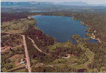
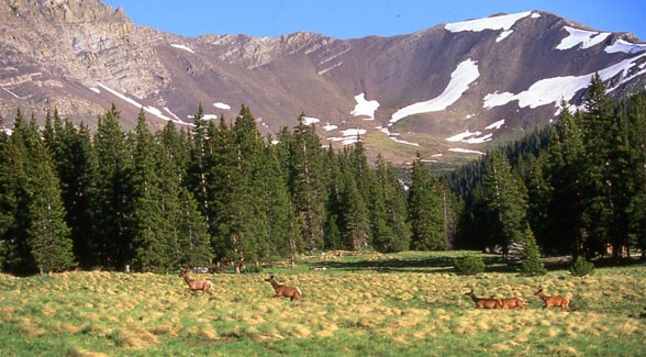
Trinchera Blanca Ranch is the largest contiguous, privately owned ranch in Colorado and features breathtaking vistas of high desert shrubs and mountain grasslands, combined with alpine forest and alpine tundra. The area stretches up to the top of one of the highest peaks in Colorado, Blanca Peak at 14,345 feet above sea level. It falls in the center of the Sangre de Cristo mountain range, the longest mountain chain in the United States, and borders the Sangre de Cristo Wilderness near Great Sand Dunes National Park and Preserve.

Joined by Service Director Dan Ashe and Dan Pike of Colorado Open Lands, Salazar and Bacon signed the conservation easement on the Trinchera Ranch to formally establish the new refuge. They also signed a memorandum of agreement to complement an existing Colorado Open Lands easement agreement already in place on the property.

Colorado Open Lands will jointly monitor and support the conservation efforts with the Service. The agreement marks one of the first cooperative arrangements of its kind among the federal government, a private land trust and a private landowner.

“Trinchera is such a spectacular property and the creation of the Sangre de Cristo Conservation Area allows us to protect this landscape, something that is truly special,” said Colorado Open Lands Executive Director Pike. “It has been an honor to hold the conservation easement on Trinchera for nearly a decade. We look forward to being able to share best practices with the US Fish and Wildlife Service and are extremely excited about this innovative collaboration in land conservation.”

“We’re excited to see the results of this collaborative conservation effort come to fruition, thanks to the generosity of Louis Bacon and the strategic and inclusive planning efforts that serve the conservation needs of fish, wildlife and plants across the San Luis Valley landscape,” said Director Ashe. “The Service has been working with landowners in the San Luis Valley on a locally-led voluntary cooperative partnership effort to conserve wildlife habitat and keep working lands working.”

Costilla County Commissioner Crestina Martinez, noted photographer and author John Fielder, and Executive Director of Colorado Coalition of Land Trusts John Swartout also joined today’s signing ceremony.

“Mr. Bacon’s donation of this incredible conservation easement is welcome news for Coloradans who treasure this area and can now rest assured that it will be protected for generations to come. I want to commend him for the example he is setting for other landowners in Costilla County and across the state interested in protecting the wildlife and natural resources that sustain our local economies and way of life,” Udall said. “This announcement reflects a first-of its kind partnership in this part of Colorado, where a private landowner and a federal agency, the Fish and Wildlife Service, have made a shared commitment to conservation of one of the most pristine private landholdings in the southern Rockies. It has been said that we don’t inherit the earth from our parents — we borrow them from our children. The establishment of the Sangre de Cristo Conservation Area ensures that this scenic gem will be here for future Coloradans to enjoy.”

Under President Obama’s America’s Great Outdoors initiative to establish a 21st century conservation and outdoor recreation agenda, the Interior Department has spearheaded a series of voluntary partnerships with landowners to conserve rural landscapes while ensuring ranching, farming and other traditional ways of life remain strong. Conservation easements are only acquired from willing landowners.

These initiatives include new units of the National Wildlife Refuge System, such as the Flint Hills Legacy Conservation Area in Kansas, the Dakota Grassland Conservation Area of South Dakota and North Dakota, and the Rocky Mountain Front Conservation Area in Montana.

For more information about the Service’s partnership work in the San Luis Valley or the Sangre de Cristo Conservation Area, please visit the U.S. Fish and Wildlife Mountain-Prairie’s homepage at: http://www.fws.gov/mountain-prairie/.

More coverage from the Associated Press (Thomas Peipert) via The Denver Post. From the article:

Bacon, a hedge fund manager, is adding a conservation easement to protect nearly 77,000 acres of his 81,400-acre Trinchera Ranch from development. He announced plans in June to add a perpetual conservation easement on his 90,000-acre Blanca Ranch if the federal government moved ahead with plans to create a new 5 million-acre conservation corridor in Colorado and New Mexico…

It creates “a contiguous mosaic of privately held and publicly protected lands that will stay in perpetuity in creating one of the longest migratory wildlife corridors in America,” stretching from the Great Sand Dunes National Park and Preserve to New Mexico, Bacon said. He added that he hopes his decision to put the land under a conservation easement will inspire other landowners to do the same.

Bacon’s land, which Salazar’s office said is the largest contiguous, privately owned ranch in Colorado, includes three 14,000-foot peaks—Mount Lindsey, Blanca and Little Bear peaks—in the Sangre de Cristos. The mountain range is one of relatively few in the United States that that still allows unobstructed migration by wildlife.

More Rio Grande River Basin coverage here and here.

Conservation easements: ‘The laws were meant to help ranchers and farmers keep their land’ — Alice Madden

standleylakesunset.jpg

Here’s an in-depth look at the origins of the conservation easement monkey business from a few years ago. The Denver Post reporter David Migoya also reports on the current investor lawsuits over the deals. Click through and read the whole article. Here’s an excerpt:

Easements were usually very simple: Donate the land, and earn a tax deduction or credit equal to the drop in land value up to a certain amount. The maximum credit was the same no matter the size of the property.
But [Denver lawyer Rodney Atherton] had a new idea — he testified he was not alone in devising it — to maximize the tax benefits of an easement. He’d do it by slicing the donation into pieces, then sell the parts to investors.

Then, with drawings indicating the subdivided property was destined for a housing development, each owner would donate the land into a conservation easement. The rub: Appraisers would value each lot as if development were a done deal, increasing the tax benefit by millions of dollars.

The idea would be the basis for nearly every easement Atherton created thereafter — even property in the most remote parts of eastern Colorado where housing starts were miles away. It was the root of about $37 million in tax credits diverted from the Colorado treasury, most since disallowed.

More conservation easement coverage here and here.

The Colorado Springs Gazette is sifting through receipts from Colorado Springs Utilities’ water tours

oteropumpstation.jpg

From The Colorado Springs Gazette (Daniel Chacón):

Other purchases included:

• $140 for 100 zippered pencil cases

• $47 for prizes for a water tour quiz

• $286 to rent two fans to keep participants cool during a lunchtime barbeque at what Utilities calls an SDS warehouse

Utilities defended the trip, saying the water tour gave participants an up-close look at the city’s water system that couldn’t be replicated with charts and graphs or in one day.

“Colorado Springs is not like cities such as Denver or Pueblo, which have local, in-town major waterways. Our community’s vast, complex water system includes 25 reservoirs and dams, more than 200 miles of pipes, four major pump stations, and facilities and infrastructure in 11 counties,” Utilities spokeswoman Patrice Lehermeier said in an email.

“The water tour gives leaders and officials first-hand knowledge of the massive work, equipment, facilities and people it takes to deliver water to Colorado Springs, as well as the ongoing construction of the Southern Delivery System,” she said. “It would be difficult to give people this level of information and insight in such an important investment using another forum. And despite all the talk of pipes and wires, a business, even in utilities, is about building relationships.”

The water tour started about 25 years ago, Lehermeier said.

The most recent tour cost $20,200, not $25,000 as originally reported by Utilities.

More Colorado Springs Utilities coverage here.

The Arkansas Basin Roundtable is hoping to assemble a coordinated model of the river

arkansasriverbasin.jpg

From The Pueblo Chieftain (Chris Woodka):

A stream of studies is feeding into what could become a coordinated water database for the Arkansas River in Colorado. But the process is slow, expensive and filled with sometimes conflicting information about how the river performs.

The Arkansas Basin Roundtable last week reviewed ongoing studies that have grown from discussions by the roundtable since 2005. The studies look at technical, legal and policy questions surrounding agricultural water transfers, and include pilot projects on the Super Ditch and conservation easements. “The next step is to look at imported flows versus native flows and see how they interact,” Barber said. “There are several models, but they don’t talk to each other.”

More from the meeting, from Chris Woodka writing for The Pueblo Chieftain:

There’s nothing like a drought year to stir up questions about whether water is being managed properly. A routine discussion about the voluntary flow program for the Upper Arkansas River erupted into a debate about water storage policy at the Arkansas Basin Roundtable meeting Wednesday.

“We lost an opportunity to store water upstream because we were waiting for this magical date,” said Reed Dils, talking about the flow program he helped start more than 20 years ago. Flows could have been altered because of drought forecasts earlier this year, said Dils, Chaffee County’s director on the Southeastern Colorado Water Conservancy District, which helps set storage policy.

More coverage from Chris Woodka writing for The Pueblo Chieftain. From the article:

The Arkansas Basin Roundtable this week looked at moving ahead with an agriculture values study being coordinated by James Pritchett, an economics professor at CSU-Fort Collins.

Past studies have tied farm revenue to acreage or looked at hypothetical irrigation patterns if more water were available. The new study will look at real-world conditions and possibilities for the Arkansas River basin in particular, said Gary Barber, chairman of the roundtable.

The first part of the study will look at identifying the current market and hydrological conditions associated with irrigated agriculture, explained Perry Cabot, of the Colorado Water Institute, a research arm of CSU-Fort Collins. It then will move into looking at the broader value of water in agriculture and develop a baseline. Finally, the project will estimate the larger value of water to the regional economy.

More IBCC — basin roundtables coverage here.

NIDIS Weekly Climate, Water and Drought Assessment Summary of the Upper Colorado River Basin

wyutcoprecipitationsevendaysep3thru92012.jpg

Click on the thumbnail graphic for the precipitation summary. Click here to snag a copy of all the summaries from the Colorado Climate Center.

Drought news: All of Colorado is still classified in one stage of drought or another

usdroughtmonitorcolorado09112012.jpg

Click on the thumbnail graphic for the current Colorado drought map from the folks at the U.S. Drought Monitor.

Brush: City Council approves stormwater rate hike

brush.jpg

From the Brush News-Tribune (Katie Collins) via The Fort Morgan Times:

Stormwater rates will experience a three-cent hike as of Oct. 1, meaning that owners or occupants of property in Brush will see an increase to their city bill near the end of October.

The rate hike follows on the heels of the city’s Stormwater Activity Enterprise, established by a previous ordinance that assigned that enterprise the fiscal responsibility for both street cleaning and stormwater system maintenance and operation.

With Brush looking to tackle not only drainage issues downtown, but in four other areas of the municipality, the increase will aid in providing funding for such projects.

Although the City of Brush did not raise stormwater rates in 2011, the three-cents per lineal foot hike has generally been an annual increase and this move will set rates from the previous $.16 per month per lineal foot of a property’s frontage to $.19.

Colorado Water 2012: ‘There are over 200,000 acres of wetlands across the Valley’ — Rio De La Vista

blancawetlands.jpg

Here’s the latest installment of the Valley Courier’s Colorado Water 2012 series, a discussion of the importance of the San Luis Valley wetlands to the area. Here’s an excerpt:

Wetlands are a valuable component of our semi-arid landscape for many reasons. They are an important aspect of the hydrology, storing water through the drier parts of the year, minimizing flood impacts, and supporting vegetation essential to both wildlife and livestock. In Colorado, only 2 to 3 percent of the landscape is either wetlands or river zones, called riparian areas. But over 75 percent of all wildlife depend upon those zones at some point in their life, including species that are either endangered or at risk. Wetlands also have a crucial role in sustaining agricultural production and they can also provide additional economic benefits and opportunities, such as recreational fishing, bird watching, duck hunting, and many more.

There is a vital water/wetlands connection wherever water is scarce. The Rio Grande and Conejos Rivers and the many smaller streams flowing into the SLV have helped to shape and influence the types of wetlands that exist here. Floodplain wetlands along the larger rivers feature backwater sloughs, oxbow lakes, and wet meadows. The vegetation communities in these areas range from tall emergent species such as softstem bulrush and cattail in semi-permanent to permanent wetlands to short emergent species such as sedges and rushes in wet meadows or seasonally flooded wetlands. Galleries of narrowleaf cottonwoods and willows also exist along rivers and creeks, ideally with understories of currant and wild rose…

The San Luis Valley Wetland Focus Area Committee (a collaborative group of organizations and agencies working on behalf of wetlands) held a workshop in mid-June to provide landowners and land managers a wide range of information about managing wetlands. This article draws upon the information from that program, and a handbook is being compiled from the many presentations. This free publication will be available to the public both in print and electronically. The booklet will address optimal management practices and recommendations on grazing, haying and mowing, burning, and water and weed management, as well as providing information on wildlife, land and water conservation options, and the many economic benefits of wetlands. It will also include a directory of resource organizations and agencies.

To learn more and obtain a copy of the handbook, please contact Ruth Lewis at the Natural Resources Conservation Service at 589-5661 extension 134 or the Rio Grande Headwaters Land Trust at 657-0800. The completed handbook will also be posted on line at http://www.riograndelandtrust.org.

More Colorado Water 2012 coverage here.

Custer County: The Round Mountain board approves water and sewer tap fees

wetmountainvalley.jpg

From the Wet Mountain Tribune (Nora Drenner):

During their regular monthly meeting on Sept. 6, the board of directors unanimously approved raising the fee from $9,000 to $10,500, which equates to $6,000 for a water tap and $4,500 for a sewer tap. The fee increase takes effect April 2013 to give property owners adequate time to purchase the taps at the current price even if they choose not install them until a later date.

More infrastructure coverage here and here.

Orchard City is making progress on water loss in their system

fountainpavementdrawing.jpg

From the Delta County Independent (Hank Lohmeyer):

Repair of a major leak in the transmission line along Highway 65 is being credited with cutting the amount of water lost from the town system. Mayor Don Suppes had told the DCI that the rupture in a fairly new steel line had occurred on the bottom of the conduit and so it was not readily visible to workers. The water leaking out had created an underground channel running into Surface Creek. The amount lost could well have been into the tens of thousands of gallons per day, Suppes had explained…

At the beginning of August, well upwards of 30 percent of the town’s treated water was going missing. Following repair of the big leak, losses were cut to “the 15 percent range,” Suppes said. The Highway 65 repair “had to account for the bulk (of the losses),” he said. “But we still have some leaks out there.”

Suppes explained later in the meeting that “over the last eight months we have found a lot of town water lines that are borderline failure. They are going to be a major budget hit to us.”

More infrastructure coverage here and here.

Restoration: Colorado Parks and Wildlife stocks Hermosa Creek with Colorado River cutthroat #coriver

cutthroattrouthistoricranges.jpg

Here’s a look at restoration efforts on Hermosa Creek, from Dale Rodebaugh writing for The Durango Herald. Click through for the Herald video taken on Wednesday at the headwaters. Here’s an excerpt:

Colorado Parks and Wildlife biologists and volunteers, including Trout Unlimited, planted 11,000 fingerlings about 3 inches long and 200 10-inchers in the main stem of Hermosa Creek upstream from Hotel Draw. Fish were carried in bags from trucks and emptied into Hermosa Creek at various points. If the fish had to be carried any distance, they were transported in super-oxygenated water to ensure they arrived in good condition.

Michael Martinez, a fish culturist at the Parks and Wildlife hatchery in Durango, brought the fingerlings Tuesday from the Rifle Falls hatchery in Garfield County…

Native cutthroat trout don’t compete well with other species, so efforts to increase their population – they occupy only 14 percent of their historic habitat – focus on giving them exclusive use of certain waters…

In pre-Columbian times, the Colorado River variety was found in all cool-water habitat above present-day Glen Canyon…

More restoration coverage here and here.

Silverthorne and Basalt finish first and second in taste test

waterfromtap.jpg

From the Aspen Business Journal (Bob Berwyn):

“Like a party in my mouth,” one of the judges wrote next to sample identified only as “G.”

The testing went through three rounds, with the top two samples from each round making it to the finals. In the end, Silverthorne prevailed, while Basalt took second place and Aurora Water came in third after winning the competition last year.

“We have the benefit of using the water before anyone else does,” said Silverthorne public works director Bill Linfield, giving Mother Nature most of the credit for the victory.

From the Summit Daily News (Paige Blankenbuehler):

Silverthorne’s water comes from six different wells called the Blue River Alluvium, which sits at a lower elevated valley near Silverthorne, according to Kevin Batchelder, Silverthorne town manager. “We’re at the top of the food chain for clean, safe water,” Batchelder said. “We’re very lucky to have natural filtration and pristine, snow melt water.”[…]

Ranking behind Silverthorne, in its first-ever entry into the competition, Basalt took second place with Aurora Water coming in third…

As the winner, Silverthorne will represent Colorado in a national water-tasting contest later this year.

More water treatment coverage here and here.

Colorado River District’s annual conference recap

coloradoriverbasincgs.jpg

From KREXTV.com (Courtney Griffin):

The Colorado River District celebrated its 75th birthday Thursday by holding an annual conference at the Two Rivers Convention Center…

With the small amount of snow and rainfall Grand Junction has had this past year, officials say without more precipitation this winter, it could mean stricter water conservation methods. “It’s a mindset more than anything else and it’s an appreciation for the ethics of water, the values of water and conservation is kind of a natural consequence,” said Chris Treese, external affairs manager for the Colorado River District.

Officials are also discussing how to preserve fish populations, how to keep dependent agriculture businesses thriving and how to deal with decreased water supply.

More Colorado River Basin coverage here and here.

Douglas County: Sun Resources (Phil Anschutz) plans to mine 15,000 acre-feet a year from the Denver Basin aquifer system

denveraquifer.jpg

From The Denver Post (Bruce Finley):

Rights to the water were acquired by billionaire Phil Anschutz last year, and one of his companies, Sun Resources, is building wells that could pump as much as 15,000 acre-feet of water per year from Denver Basin aquifers. That’s enough water to sustain 30,000 houses, though Sun Resources chief executive Gary Pierson characterized the drilling as exploratory.

“We have not made any arrangements for the water at this point,” Pierson said…

Two production wells — 1,450 and 1,800 feet deep — were nearing completion this week. A 2009 document obtained by The Denver Post proposed 35 production wells and shows water being moved to cities and communities through pipelines, including one leading to Sterling Ranch, a planned $4.3 billion, 12,050-house development south of Chatfield State Park…

State water authorities this year issued permits allowing Sun Resources to drill two production wells under the Greenland open space. A 1995 water-court decision established rights to 1.5 million acre-feet of water under the 7,640-acre Greenland Ranch. Anschutz acquired those rights last year in a purchase of assets from the Gaylord family of Oklahoma…

South-metro water providers relying on finite underground sources have declared a mission of shifting to renewable water from snowmelt and rivers, said Eric Hecox, director of the South Metro Water Supply Authority. “That doesn’t mean they have to be 100 percent off the Denver Basin aquifer water,” Hecox said. “What we would like to do is use the Denver Basin in a different way, as a drought supply.

More Denver Basin Aquifer system coverage here and here.

The Water Center at CMU is hosting a water law seminar and a tour of the Uncompahgre Valley

gunnisontunnelnps.jpg

From Colorado Mesa University (Hannah Holm) via the Grand Junction Free Press:

The Water Center at Colorado Mesa University is pleased to announce two exciting opportunities to learn about water in our region: An eight-hour “Water Law in a Nutshell” class Sept. 21, and a water tour of the Uncompahgre Valley Sept. 25. Both events are open to the general public.

• “Water Law in a Nutshell” – Friday, Sept. 21, 8 a.m.-5 p.m.

Do you have some understanding that senior water rights have priority over junior water rights in Colorado, but get a bit confused when people start talking about augmentation plans and conditional water rights? Are you a little fuzzy on the difference between a ditch share and a water right? And would you like to understand all of this a whole lot better? If so, then this course is for you.

The Water Center at CMU will host “Water Law in a Nutshell,” presented by Aaron Clay, attorney at law and former 26-year Water Referee for the Colorado Water Court, Division 4. This seminar will cover all aspects of the law related to water rights and ditch rights as applied in Colorado. Subject matter includes the appropriation, perfection, use, limitations, attributes, abandonment and enforcement of various types of water rights. Additional subject matter will include special rules for groundwater, public rights in appropriated water, federal and interstate compacts and more.

This seminar is open to all interested persons. Fee is $89; $113 for .5 graduate in-service credit. The course has also been pre-approved for eight hours of Continuing Legal Education credit. For more information or to register, see http://www.coloradomesa.edu/eso/WaterLaw.html or call the Water Center at 970-248-1968.

• Uncompahgre Valley Water Tour – Tuesday, Sept. 25, 7:30 a.m.-5 p.m.

Over 100 years ago, a tunnel was drilled from the Black Canyon of the Gunnison to carry water from the Gunnison River to the Uncompahgre Valley. The water flowed, and a rich diversity of farms flourished.

In an all-day tour Sept. 25, you can learn about this fascinating history and see how the valley is responding to newer challenges: The opportunity to develop hydropower from canals, the need to control the levels of salt and selenium leaching from farmland into the Uncompahgre and Gunnison rivers, and the need to get more precise with irrigation when water supplies dwindle.

The tour will start and finish at the Bill Heddles Recreation Center at Confluence Park in Delta, and is being co-hosted by the Uncompahgre Valley Water Users Association, the Delta-Montrose Electric Association, and the Water Center at CMU.

The tour will begin with a presentation on the history of water development in the Uncompahgre Valley by Steve Fletcher, manager of the Uncompahgre Valley Water Users Association. Stops will include the South Canal hydropower project, which is currently under construction; the Ironstone diversion on the Uncompahgre River; a ditch lining project on the EC lateral; Randy Meeker’s farm; and David Harold’s farm. Meeker employs sprinkler irrigation, and Harold uses a drip system.

The tour is open to anyone who is interested. The $40 fee includes transportation, breakfast and a picnic lunch at the Mountain View Winery near Olathe. For more information or to register, see http://www.coloradomesa.edu/watercenter/UncompahgreTour.html or call the Water Center at 970-248-1968.

More education coverage here.

Colorado-Big Thompson Project update: 61 cfs in the river below Olympus Dam

olympusdam.jpg

From email from Reclamation (Kara Lamb):

[September 13] Late tonight/early tomorrow morning, we will be cutting back releases from Olympus Dam to the Big Thompson River. Currently, flows are around 215 cfs. By early tomorrow morning, September 14, they should be under 100 cfs.

Starting last weekend, we began bumping up releases from the dam to the river in order to deliver Colorado-Big Thompson Project water to water users while a section of the Charles Hansen Feeder Canal was down for inspections. Now that the work is wrapping up, we can begin moving C-BT water back through its system again, reducing the amount of water down through the canyon.

This time of year, releases from Olympus Dam typically reflect inflows to Lake Estes. Whatever the Big T brings into Lake Estes, we pass through Olympus Dam down the canyon. Inflows to Lake Estes are currently about 61 cfs.Unless we have a significant rain event, it is likely releases from Olympus Dam will be around 61 cfs by tomorrow.

More Colorado-Big Thompson Project coverage here.

Fryingpan-Arkansas Project update: Reclamation is bypassing Ruedi Reservoir inflows to the Grand Valley

fryingpan.jpg

From email from Reclamation (Kara Lamb):

We have a couple of adjustments coming to our release from Ruedi Dam to the Fryingpan River. Today, 9-13, at 5 p.m., releases will increase to 241 cfs. Tomorrow, around noon, they will increase to 266 cfs. The total increase in releases is 50 cfs.

Today’s change is due to the senior water right call down on the Colorado River near Grand Junction. That call requires us to pass the inflow to Ruedi on downstream. Inflows went up with the recent rains, so to meet this water right, we increased 25 cfs today, 9-13.

Tomorrow’s change is per the U.S. Fish & Wildlife Service on behalf of the endangered fish and their critical habitat in the Colorado River. The Colorado, like the rest of the state, saw a very hot and dry August.

More Fryingpan-Arkansas Project coverage here.

Fountain Creek: Uncontrolled Colorado Springs stormwater funneled to Pueblo

fountaincreekflood1999apviachieftain.jpg

From The Pueblo Chieftain (Chris Woodka):

New rule of thumb: An inch of rain in Colorado Springs equals a foot rise for Fountain Creek in Pueblo. And corresponding demands for stormwater control.

“It’s one big funnel,” said Jay Winner, manager of the Lower Arkansas Valley Water Conservancy District. “Because Colorado Springs is unable to control its stormwater, it all flows very quickly into that narrow area we call Fountain Creek. Geographically, it’s a tight funnel that fills up very fast.”

Sites throughout Colorado Springs received anywhere from 0.7 to 1.4 inches of rain that fell throughout the city, heaviest over the Waldo Canyon burn scar, which increases the amount of mud. About 12 hours later, Fountain Creek changed from a meandering stream to a full-blown dirty river in Pueblo, with the level increasing by one foot.

More Fountain Creek coverage here and here.

Drought news: After the monsoon season the drought over much of the mountains has improved to D1

usdroughtmonito09112012.jpg

Click on the thumbnail graphic for this week’s updated map from the US Drought Monitor.

From the Brush News-Tribune (Jenni Grubbs):

Most of the Colorado High Plains was classified as in an extreme drought as of Aug. 21, and that area had grown to cover all of eastern Colorado by Sept. 4, according to the U.S. Drought Monitor. Some parts of southeastern Colorado even showed exceptional drought throughout that same time period. And about 21 percent of Colorado’s corn crop was rated good or excellent as of Aug. 26, according to the CCGA. The current crop also is starting to be harvested a little sooner than usual, according to CCGA…

Across the U.S. from 2011 to 2012, corn producers saw the average corn yield fall an average of 23.8 percent, according to the U.S. Department of Agriculture…

The Pagosa Area Water and Sanitation District tables Dry Gulch Reservoir Project for another day, another board

sanjuan.jpg

From the Pagosa Sun (Lindsey Bright):

During Tuesday’s Pagosa Area Water and Sanitation board of director’s meeting, with both directors Mike Church and Roy Vega excused, the board unanimously passed a motion to send a letter, “requesting substantial completion” to the Colorado Water Conservation Board regarding their $11. 2 million loan, of which only $9.2 million has been drawn and used.

The letter will be sent to Kirk Russell, CWCB’s finance section chief, who had recently told PAWSD that he needed a letter of intent and direction by Sept. 18 to present to the CWCB board.

PAWSD Business Manager Shellie Peterson will write the letter to inform the CWCB board that PAWSD does not, with the current board, intend on building Dry Gulch Reservoir and they will not be drawing the remainder of the loan out. The PAWSD board used $9.2 million of the CWCB loan, along with the San Juan Water Conservancy District’s $1 million CWCB grant, to purchase the Running Iron Ranch in 2007 as a reservoir site. Prior to this letter, there had been discussion by previous PAWSD boards considering use of the rest of the funds to buy a small portion of the adjacent Laverty property in order to have enough land to build the reservoir.

More Pagosa Springs coverage here and here.

Colorado River Cooperative Agreement implementation at hand

Here’s a short report from the Associated Press via The Columbus Republic:

Colorado’s largest water utility and more than 30 western slope providers are expected to begin implementing an agreement balancing the Denver-area’s demand for water with the needs of mountain communities as early as next month. According to the Grand Junction Daily Sentinel a project spokesman said Tuesday a few more signatures are needed.

More Colorado River Cooperative Agreement coverage here.

Drought news: ‘This is one of those nice, light rains, nothing real big or intense’ — Jennifer Stark (NWS)

cocorahs09122012.jpg

From The Pueblo Chieftain (Gayle Perez):

Rain returned to Pueblo on Wednesday bringing with it much needed moisture and cooler temperatures. “This is one of those nice, light rains, nothing real big or intense,” said Jennifer Stark, a meteorologist with the National Weather Service in Pueblo. “This is more of a typical fall-type system but I think we’re all very happy for the beneficial rain.”

Cooler air moved into Pueblo early Wednesday bringing light rain early on with intermittent showers falling throughout the day. By 8 p.m., one-half of an inch of rain was reported at the Pueblo Airport with additional accumulations expected to continue through this morning.

From the Associated Press via The Pueblo Chieftain:

[Yesterday’s] storm [was] expected to bring up to 10 inches to some of Colorado’s central and southern mountains. The National Weather Service says snow could be heavy in the eastern Sawatch mountains and western Mosquito Range above 11,000 feet on Wednesday. In other parts of the state, the precipitation has been falling as rain and temperatures were expected to be about 20 degrees cooler than in recent days.

From The Durango Herald (Dale Rodebaugh):

Officials have 99 years of flow records for the Animas River, Rege Leach, the Colorado Division of Water Resources engineer in Durango, said Friday. There are 95 years of records for the La Plata River and 101 years for the Dolores River. “They all show the same trend,” Leach said. “The year 2002 was the driest, followed by 1934, 1977 and 2012.”

The Animas River at Durango on Sunday was flowing at 164 cubic feet per second, lower than the 172 cfs registered at the end of June 2002, the month that the Missionary Ridge Fire was burning 72,000 acres in the San Juan Mountains…

The La Plata River, with half of its flow at Hesperus required to be delivered to New Mexico, is hurting, Leach said. Barely 1 cubic foot a second of flow is reaching the state line from the Long Hollow area, also just north of the state line, he said. Except for holders of senior water rights, ditches off the Florida River have been closed…

Bruce Whitehead, executive director of the Southwestern Water Conservation District and the Animas-La Plata Water Conservancy District, said the flow of water into Lake Powell mirrors the woes of Southwest Colorado. Lake Powell is set this year to get 48 percent of its normal flow, the third lowest ever, he said. But, go figure, Whitehead said. Last year, Lake Powell received 142 percent of normal flow.

From the Summit Daily News (Chris Campton):

In mid-April 2012, it looked as if we were headed down another dry riverbed season, and another “2002,” where commercial boating user days were down 40 percent from the previous year. We will not know until January, when all the final numbers are in and compiled, what the toll of this year’s drought took on commercial boating and in turn the economic impact on the state. However, initial thoughts are that it will not be as grim as it was in 2002. What may have hurt the industry the most in 2012 was not necessarily the drought itself, rather the perception of water levels throughout the state.

Commercial boating is the largest tourism-related economic draw for Colorado in the summer months and just last year 508,644 guests enjoyed the rivers of Colorado, and it created an economic impact of $155,157,888. Add in the private boaters that enjoy the rivers of Colorado, and that impact to our state grows to even greater numbers…

On a brighter note, water levels and warm temperatures in 2012 saw many families choose to raft that had decided not to brave the higher flows of 2011. This year, water levels on many rivers provided them with more viable options and great beginner trips such as the ones commercial outfitters run on the Colorado River. The Colorado is a river that typically runs well in a drought year and boasts steady flows throughout the summer months. And it prevailed to do so once again in 2012. Due to reservoir storage, senior water rights and calls from downstream users, the water on the Colorado traveled west and as a benefit of being close to the headwaters, the commercial and private boaters were able to float on “average” flows this summer. The good boating opportunities stretched all the way from Kremmling to the Colorado State Line, and beyond.

From the Boulder Daily Camera (John Agular):

Across the city’s 23 parks, Lafayette has suspended irrigation a month early to prepare for the possibility that 2013 will be as dry as this year has been. Only high traffic sports fields at City Park, Whitetail Park and Lamont Does Park will continue to be watered.

“What we’re doing is making sure we’re proactively planning in case the drought continues into next year,” city spokeswoman Debbie Wilmot said. “We’re pushing dormancy up by a month.”[…]

in spite of the water conservation measures implemented by the city, residential water use in Lafayette in 2012 jumped 38 percent — or by 551 acre feet — through August over the same period in the previous year. Wilmot said the spike in water use likely is due to the extremely hot weather Colorado has endured this year, starting in the early spring.

Snake River: USGS — Warmer Temperatures Likely Driving Increase of Metal Concentrations in Rocky Mountain Watershed

pennsylvaniamineperucreekcotu.jpg

Here’s the release the United States Geological Survey (Heidi Koontz/Jim Scott):

Warmer air temperatures since the 1980s may explain significant increases in zinc and other metal concentrations of ecological concern in a Rocky Mountain watershed, according to a new study published in the journal Environmental Science and Technology, led by the U.S. Geological Survey and the University of Colorado, Boulder.
Rising concentrations of zinc and other metals in the upper Snake River just west of the Continental Divide near Keystone, Colo., may be the result of falling water tables, melting permafrost, and accelerating mineral weathering rates, all driven by warmer air temperatures in the watershed. Researchers observed a fourfold increase in dissolved zinc over the last 30 years during the month of September.

“This study provides another fascinating, and troubling, example of a cascading impact from climate warming as the rate of temperature-dependent chemical reactions accelerate in the environment, leaching metals into streams,” said USGS Director Marcia McNutt. “The same concentration of metals in the mountains that drew prospectors to the Rockies more than a century ago are now the source of toxic trace elements that are harming the environment as the planet warms.”

Increases in metals were seen in other months as well, with lesser increases seen during the high-flow snowmelt period. During the study period, local mean annual and mean summer air temperatures increased at a rate of 0.2-1.2 degrees Celsius per decade.

Generally, high concentrations of dissolved metals in the upper Snake River watershed are the result of acid rock drainage, or ARD, formed by natural weathering of pyrite and other metal-rich sulfide minerals in the bedrock. Weathering of pyrite forms sulfuric acid through a series of chemical reactions, and mobilizes metals like zinc from minerals in the rock and carries these metals into streams.

Increased sulfate and calcium concentrations observed over the study period lend weight to the hypothesis that the increased zinc concentrations are due to acceleration of pyrite weathering. The potential for comparable increases in metals in similar Western watersheds is a concern because of impacts on water resources, fisheries and stream ecosystems. Trout populations in the lower Snake River, for example, appear to be limited by the metal concentrations in the water, said USGS scientist Andrew Todd, lead researcher on the project.

“Acid rock drainage is a significant water quality problem facing much of the Western United States,” Todd said. “It is now clear that we need to better understand the relationship between climate and ARD as we consider the management of these watersheds moving forward.”

In cases where ARD is linked directly with past and present mining activities it is called acid mine drainage, or AMD. Another Snake River tributary, Peru Creek, is largely devoid of life due to AMD generated from the abandoned Pennsylvania Mine and smaller mines upstream, and has become a target for potential remediation efforts.

The Colorado Division of Reclamation Mining and Safety, in conjunction with other local, state and federal partners, is conducting underground exploration work at the mine to investigate the sources of heavy metals-laden water draining from the adit. The study conducted by Todd and colleagues has implications in such efforts because it suggests that establishing attainable clean-up objectives could be difficult if natural background metal concentrations are a “moving target.”

Collaborators include USGS, CU Boulder and the Institute of Arctic and Alpine Research (INSTAAR). The data analyzed for the study came from INSTAAR, the USGS and the U.S. Environmental Protection Agency.

From the Summit Daily News (Paige Blankenbuehler):

Rising concentrations of zinc and other metals in the upper Snake River west of the Continental Divide near Keystone may be the result of falling water tables, melting permafrost and accelerating mineral- weathering rates — all driven by warmer air temperatures in the watershed…

High concentrations of dissolved metals in the upper Snake River watershed are the result of acid rock drainage, according to the research. The drainage is a result from past and present mining activities.

More water pollution coverage here.

NWS: South Platte River’s response to today’s rain event

Colorado Foundation for Water Education ‘Water Fluency Webinar’ Thursday September 13

waterfromwikipediaseptember2012.jpg

From email from the Colorado Foundation for Water Education:

Water Fluency Webinar. Thanks to the Colorado Municipal League, join CFWE’s Kristin Maharg; the Colorado Climate Center’s Wendy Ryan; and the Governor’s Water Advisor, John Stulp, via webinar on Thursday 9/13 at noon. Hear about drought, water supply, and resources you can use to learn more and to celebrate water across the state. Free to all Municipal Members, but registration is required. Register online and learn more about the event.

Speaking of CML, check out the article about CFWE in the latest edition of Colorado Municipalities Magazine.

More Colorado Foundation for Water Education coverage here and here.

6,000 people participate in 90 by 20 conference call

coloradoriverbasinusgs.jpg

From Westword (Patricia Calhoun):

More than 6,000 people called in to the teleconference. “The response we had on the call was tremendous,” [Former Governor Bill Ritter] said. “Clearly Coloradans understand the singular nature of the 800,000 jobs and 35,000,000 drinking water consumers that the Colorado River supports. To sustain and restore the river, we need to adopt 90 By 20 and like measures.”

According to the campaign, if every community along the Colorado River basin were to adopt the 90 By 20 benchmark, the water savings in one year would be enough to service the entire city of Denver for three years.

More Colorado River basin coverage here.