Reuse: The WISE Partnership gets approval from the Denver Water Board

prairiewaterstreatment.jpg

From the Denver Business Journal:

Denver Water last week approved the WISE partnership agreement that clears the way for the utility to delivery treated water to the area’s southern suburbs.

Approval of WISE, which stands for Water Infrastructure and Supply Efficiency, formalizes the regional cooperative water project. The agreement calls for the permanent delivery of 72,250 acre-feet of treated water from Denver and Aurora to members of the South Metro Water Supply Authority (SMWSA).

SMWSA was formed in 2004 from the banding together of smaller water utilities in south Denver.
With the agreement now in place, some of the water that currently flows down the South Platte River and out of the state would be recaptured by Aurora’s 34-mile Prairie Waters Pipeline and pumped back to the Peter D. Binney Water Purification Facility near the Aurora Reservoir. There, the water would be treated and piped to the southern suburbs.

The water delivery will begin in 2016. Members of the SMWSA must have infrastructure in place to move the water from the purification facility. The cost of the water and infrastructure for its delivery is estimated at $250 million over the next 10 years. Each member will independently determine how to finance their share of the project.

The participating members of SMWSA are the town of Castle Rock, Dominion Water & Sanitation District, Stonegate Village Metropolitan District, Cottonwood Water & Sanitation District, Pinery Water and Wastewater District, Centennial Water & Sanitation District, Rangeview Metropolitan District, Parker Water & Sanitation District, Meridian Metropolitan District and Inverness Water & Sanitation District.

More WISE Partnership coverage here.

Fountain Creek: ‘At some point, this board is going to lose its patience’ — Buffie McFadyen

fountaincreekerosionpueblocountychieftain.jpg

From The Pueblo Chieftain (Chris Woodka):

Pueblo County commissioners are more than happy to throw some money into the hat to keep a Fountain Creek district afloat. At the same time, patience is wearing thin for El Paso County to come to grips with stormwater funding. “At some point, this board is going to lose its patience with the largest city in the state without a stormwater fee,” said Commissioner Liane “Buffie” McFadyen. “I feel like we’re standing knee-deep in water and not going anywhere.”

Larry Small, executive director of the Fountain Creek Watershed Flood Control and Greenway District, asked commissioners Monday to consider the district’s plan to patch funding until 2016. The district is nearly out of funds, and is asking county and city governments to come up with $50,000 to meet administrative needs in 2014. Pueblo County’s share would be $10,000.

If Southern Delivery System comes online in 2016, as projected, the district would begin receiving payments from Colorado Springs toward the $50 million negotiated in the Pueblo County 1041 process. That money is earmarked for Fountain Creek flood control projects that protect Pueblo. Interest from the $50 million could be used as soon as next year to begin planning flood-control projects that could benefit Pueblo. But commissioners still are sore that Colorado Springs City Council eliminated its stormwater enterprise in 2009 and has not replaced it.

Colorado Springs City Council is seek­ing a regional solution to meet $900 million in identified projects in El Paso County. Nearly 80 percent of those are in Colorado Springs. Mayor Steve Bach is pursuing a separate course to prioritize projects. While that discussion continues, the Fountain Creek district has put its own plans for a mill levy election — the district can assess up to 5 mills of property tax — on hold just in case there is an El Paso County stormwater fee election in 2014. “The longer (the Fountain Creek district) goes without passing a mill levy, it limits the time you’re able to do projects,” said Commissioner Sal Pace.

Small pointed to a U.S. Geological Survey study that showed 10 retention ponds south of Fountain would provide protection for Pueblo by cutting 46 percent of the peak flow off a 100-year flood. The SDS money would all go toward those types of projects, or a large dam, an option that is unlikely. But commissioners want results sooner. “If we put the district in mothballs for too long, we defeat the statutory mandate,” said Chairman Terry Hart.

More Fountain Creek watershed coverage here and here.

The Weld County Commissioners put the North Colorado secession question on the fall ballot

Here’s Ms. Hood’s writeup of the vote and meeting on KUNC. Here’s an excerpt:

Weld County Commissioners voted Monday to approve ballot measure language that will appear in front of county voters this November. It will be up to Weld voters to decide if the county should further pursue the formation of a 51st state separate from Colorado.

Three other counties–Cheyenne, Sedgwick, and Yuma–have also decided to put similar measures in front of voters. Counties still deciding whether to put the issue on the ballot include Logan, Phillips, Washington and Kit Carson.

Morgan County Commissioners have decided to leave it up to citizens to get the issue on the ballot. Residents there have until August 26 to gather signatures from 15 percent of active voters.

Westword (Patricia Calhoun) gives the secessionists all the serious attention the proposal deserves:

If at first you don’t secede, try, try again. Ten counties in northeastern Colorado are still considering seceding from the state. Cheyenne County (population 1876, appropriately enough) has already gotten the proposal on the November ballot; Weld County could do the same soon. In this week’s Westword, we offer some alternative slogans, symbols and names for this proposed 51st state, including Uncolorado, Near Nebraska, Southern Wyoming and Coloraduh. But why should northeast Colorado have all the fun?

Here are nine other possible spinoffs:

Potopia : Perfect should Denver and Boulder, as well as that handful of other spots around the state that are respecting the will of the voters on Amendment 64, decide to secede as other local governments ban recreational marijuana sales. (Pairs nicely with Methopotamia, a potential title for the 51st state.)

Crackpotopia: Early contender for the name of the new 51st state, but also available to other crackpot quarters.

Crankerado : Adams County as well as any other county that has more than three curmudgeons show up at county commissioner meetings — not counting the commissioners themselves.

Little Texas: Vail

Little L.A.: Aspen

Coolerado: The Capitol Hill, RiNo, Baker and LoHi neighborhoods of Denver; a slice of Boulder; La Veta, Salida and Crested Butte (the original town, not the resort).

Western Kansas (or Might as Well Be Kansas): An alternative for all those eastern counties that don’t want to be part of Near Nebraska.

Almost Oklahoma: An alternative for all those southeastern counties that don’t want to be part of Might As Well Be Kansas.

New New Mexico: Following the green chile trail from the southern border up to the San Luis Valley, with a few strongholds in Pueblo and metro Denver.

More North Colorado Secession coverage here.

Denver Water: Antero Dam rehabilitation project

anteroreservoirdwd.jpg

Here’s the release from Denver Water (Stacy Chesney/Travis Thompson):

A project to bring Antero Dam in line with current engineering standards will begin Monday, Aug. 19. The $14 million undertaking will ensure the safety and functionality of the dam for another 100 years.

Denver Water, in coordination with Colorado Parks and Wildlife and the Office of the State Engineer, lowered Antero Reservoir by 2 feet in May 2011 as a safety precaution to reduce water pressure and seepage within the dam. The reservoir has been operating at a height of 16–17 feet since that time. Antero Dam was built in 1909 by Canfield and Shields of Greeley, and purchased by Denver Water in 1924. The dam has experienced substantial seepage since it was built and as a result, has been operating under reservoir storage restrictions by the state since the early 1900s to ensure public safety.

The rehabilitation project will be done in phases. The first phase, which begins Aug. 19, is scheduled for completion by late November 2013. During this phase, Denver Water’s contractor, Geo-Solutions, Inc., will build a sand trench to filter the normal seepage from the dam to help ensure the safety of the foundation.

Denver Water will keep the popular reservoir open to recreation, and Colorado Parks and Wildlife will continue to manage the fishery during the project. The construction will take place on the east side of the dam, which will not be accessible to the public. There will be an increase in truck traffic along Highway 9 and Highway 24 at various times during phase one as sand is brought in to complete the filter trench. Trucks will enter the site through an access road on the south side of the dam.

The subsequent phases of the project are embankment grading from May 2014 through November 2014, and spillway and valve improvements May 2015 through November 2015.

When all three phases are complete, the water levels at Antero will return to and be maintained at a level of 18 feet, which is expected to occur after spring runoff in April 2016.

Wildlife questions regarding fishing at Antero can be directed to Colorado Parks and Wildlife at 303-291-7227.

More Denver Water coverage here and here.

Lincoln Park/Cotter Mill: Cleanup awaiting state go ahead

cottergroundwatercontaminationlocation.jpg

From The Pueblo Chieftain (Tracy Harmon):

State health officials have preliminarily ordered Cotter Corp. Mill officials not to do any cleanup work pending future decommissioning and reclamation guidelines. Cotter Corp. Uranium Mill Manager John Hamrick had requested permission to excavate the ore pad area after uranium ore was removed and shipped to the White Mesa Mill in Blanding, Utah.

The state health department’s Jennifer Opila, unit leader, said although an earlier work pause has been lifted, Cotter will not be authorized to proceed with, “New decommissioning or reclamation activities.” She said the decision to deny the request was made after health officials and the Community Advisory Group discussed the issue. The public is invited to comment on the state’s preliminary decision.

Comment will be accepted Monday through Sept. 20. The public also can comment during the same time frame on completion reports for Lincoln Park water wells.

More Lincoln Park/Cotter Mill coverage here and here.

Arkansas Valley Conduit update: $15 million needed for engineering

arkansasvalleyconduitproposed.jpg

From The Pueblo Chieftain (Chris Woodka):

The exact route and cost of the Arkansas Valley Conduit won’t be known until engineering is complete, but the water line to serve 40 communities in Eastern Colorado is becoming a reality. “There are a whole lot of people who thought we’d never get to this point,” Jim Broderick, executive director of the Southeastern Colorado Water Conservancy District told the board Thursday. “The work we’ve done so far is preliminary. We still have to get this done.”

The Bureau of Reclamation’s environmental impact statement on the project was released Aug. 9. A record of decision is expected to be issued after a 30-day comment period, meaning work on the actual project can begin. It took just two years for the EIS to be completed, which is less time than a typical project would take. However, the conduit was approved by Congress in the 1962 Fryingpan-Arkansas Project Act.

District officials and members of Congress are working on strategies to get the estimated $15 million needed for engineering in the 2015 fiscal year, and possibly to shift some Reclamation funding sooner than that. Construction of the conduit could begin as soon as 2016, largely depending on funding. The EIS also covers Southeastern’s master storage contract that will serve 37 communities and a federal project to interconnect the north and south outlet works.

Negotiations still are ongoing to build the first leg of the conduit, which would go from the south outlet works to Pueblo Boulevard. From there, the pipeline would head to the Pueblo Board of Water Works Whitlock Treatment Plant, where it would be filtered and moved south through City Park, along Pueblo Boulevard and then south of Pueblo and the Comanche Power Plant. It would run east from there to the St. Charles Mesa treatment plant, then head north of the Arkansas River where it would begin its route eastward with spurs to serve communities along the way.

In all, there would be 227 miles of pipeline tapering from 48 inches in diameter to 6 inches.

More Arkansas Valley Conduit coverage here and here.

AWRA Colorado Section summer field trip recap: What happens when you dig a 40 foot hole in the ground?


Coffee and bagels at Denver Water just before heading to Pueblo Dam

Every now and again you sign up for the right water tour. The American Water Resources Colorado Section tour of the Southern Delivery System — which is slated to move Fryingpan-Arkansas Project water to serve several Arkansas Valley communities — turned out great.

First off, we visited the valve house for the project at the base of Pueblo Dam.

Valve house north outlet works Pueblo Dam, August 2013

Folks from Colorado Springs Utilities and USBR detailed much of the design and proposed operational facts about the outlet works. The release to the Arkansas River was engineered for 1120 CFS. One of our hosts smiled as he said, “You can feel a vibration when it’s open.”

Valve test north outlet works Pueblo Dam via MWH Global

We also visited the site where CSU is building a new treatment plant out by the Colorado Springs airport. That’s where the MWH Global project manager explained that they had spent most of the week pumping stormwater out of the 40 foot hole that they dug in the wind blown sand soil at the site. It seems that one of those monsoon storms dumped an inch or so of precipitation in 30 minutes. They had accomplished pouring one section of the slab base for the plant that day.

New CSU water treatment plant site, August 2013

Converstion on the bus between stops ranged from the cultural differences between white europeans and the native american tribes to the announcement earlier in the day from Reclamation of a 24 month operating plan for Lake Powell that would reduce deliveries downriver to Lake Mead.

We heard about Castle Rock’s plans to move to 75% renewable supplies from their director, Mark Marlowe.  They’re hoping to eventually only use their wells  to get through a drought.

We also heard some roadside geology from one of the folks at the Colorado Geological Survey. He explained a bit about the Denver Basin Aquifer System and hydraulic fracturing in the Niobrara.

More Southern Delivery System Coverage here and here.

Grand Junction: The Colorado River District’s Annual Seminar will take place September 13 #ColoradoRiver

coloradoriverbasincgs.jpg

Click here to read the latest newsletter from the Colorado River District (Jim Pokrandt). Here’s an excerpt:

What: The Colorado River District’s Annual Water Seminar — “Shrinking in Supply, Growing in Demand” — where in one day, you can learn about the latest news and programs related to the Colorado River and its challenges to meet the needs of man and nature in the arid West.

When: 9 a.m. to 3:30 p.m., Friday, Sept. 13, 2013;  check-in starts at 8:30 a.m. Greg Pederson, the lead author of the U.S. Geological Survey study that confirms snow- pack is falling victim to warmer spring temperatures.

Where: The Two Rivers Convention Center in Grand Junction, Colo.

Cost: $30 for adults with advance registration by Friday, Sept. 6, 2013; $10 for students. Includes lunch. $40 after Sept. 6.

Who are some of the speakers?

  • James Eklund, the new director of the Colo- rado Water Conservation Board who will dis-
    cuss the two-year deadline to create a Colorado Water Plan and what that means
  • Klaus Wolter, the Climate Diagnostics Center researcher for NOAA who is the go-to expert for predicting seasonal weather
  • A panel discussion on how the Roundtables will inform the Colorado Water Plan with their findings and plans to meet their water supply shortages
  • Beorn Courtney, an engineer for the Headwa- ters Corp. who will discuss how the Sterling Ranch development in the South Denver Metro Area will employ water conservation through house design, landscaping, clustering and water capture
  • A discussion on what the low levels at Lake Powell portend reduced water releases to Lake Mead and the Lower Basin states and a decla- ration of a shortage ….. and more
  • Information and questions: 970-945-8522 or edinfo@crwcd.org.

    More education coverage here.

    Denver: 28th Annual Watereuse Symposium will take place September 15 – 18

    waterreuse.jpg

    Here’s the pitch:

    There is still time to register for the 28th Annual WateReuse Symposium!

    Join us September 15-18 at the Denver Marriott City Center in Denver, CO for 111 technical presentations, seven panel and roundtable discussions, networking events, and a popular Exhibit Hall.

    Click here to register.

    Filling the East Slope Municipal Water Supply Gap: A Joint Statement of the [eastern slope] Roundtables #ColoradoRiver

    ibccroundtable.jpg

    Click here to read the draft. Here’s an excerpt:

    Purpose of the Statement

  • The cities, towns, and rural neighborhoods on the eastern slope of Colorado are projected to be
    between XXX, XXX, and XXX,XXX acre-feet short of water supply by 2050. This is 70 [check] percent
    of the projected statewide municipal supply gap.
  • The eastern slope has 80 percent of the state’s population and provides 80 percent of the state’s economy and tax base and a large portion of the agricultural, recreational, and tourism sectors of the state’s economy. Eighty percent of the state’s population and job growth will be on the eastern slope. With the regional interdependence of the state’s economy, it is critical to Colorado’s prosperity that the supply gap be filled throughout the state.
  • Cities along the Front Range are national leaders in water conservation and reuse and will continue to make the most efficient use of their supplies.
  • These cities are struggling to obtain permits for small expansions to their water systems despite the environmental mitigation and enhancements these projects offer.
  • Colorado lacks a plan for meeting east slope municipal water needs. Beyond conservation, reuse, and the small expansion projects mentioned above, the default plan for our state is the dry-up of hundreds of thousands of acres of agricultural land on the east slope, some of Colorado’s most productive land. We reject this default plan…
  • Here’s a report from the recent Arkansas Basin Roundtable meeting, from Chris Woodka writing for The Pueblo Chieftain:

    Placing more value on agriculture, tying water to land use and ensuring that growth pays for itself should be ingredients in the state’s long-term recipe for water use. “I guess we’re just not hungry enough yet to see that we ought to be pledging a limit for water to stay in agriculture,” Beulah rancher Reeves Brown told the Arkansas Basin Roundtable last week.

    The roundtable was reacting to a statement drafted last month at a joint meeting of the Arkansas, South Platte and Metro roundtables. “Filling the East Slope Municipal Water Supply Gap” rejects the “default plan” of drying up agriculture to fill city needs.

    As alternatives, the statement lists conservation, reuse, current projects, ag-urban water sharing, more storage, protection of Colorado River imports and new projects using Colorado River water when needed.

    The elements within the statement received 70-80 percent approval of roundtable members at the July meeting.

    But some lingering doubts surfaced last week at the Arkansas Basin Roundtable, particularly because the Arkansas Basin is the most vulnerable to future ag dryups, permanent or temporary, in order to quench the thirst of cities. “We’re depreciating our interest in future water use,” Brown said. “The paper solidifies the fact that in 2016, there will be water disappearing from the Arkansas Valley for the benefit of upstate use. I don’t think we’re going to get the point made that ag water is valuable.”

    Several roundtable members supported Brown, pointing out that efforts to make agriculture sustainable, preserving land to grow food in the future and the quality of food are all important considerations.

    The roundtable is sponsoring activities that promote looking at the value of ag water — a Colorado State University-Fort Collins study and a conference for policy makers in October. But those efforts are taking longer to reach a conclusion than is called for in Gov. John Hickenlooper’s push to get a state water plan by December 2015.

    Click here to read the joint meeting summary.

    Land use planning and policy is at the heart of the water problem. Here’s a report from Chris Woodka writing for The Pueblo Chieftain:

    Agriculture isn’t the only issue Arkansas Basin Roundtable members have with a joint statement adopted last month by Front Range water interests. The statement fails to ask the state to confront land use planning head-on, some say. Much of the state’s land use regulation is at the city or county level. Water supply is sometimes disconnected from the process, even though decisions in one part of the state can affect others.

    “Land use regulations and water supply plans have to go hand-in-hand,” said SeEtta Moss of Canon City, who represents environmental interests on the roundtable. “The message should be, ‘You can’t do everything you want because you might be hurting the rest of the state.’ ”

    Dave Taussig, a Lincoln County attorney, advocated a stronger statement about the need for new growth to pay its own way, rather than sticking current Colorado residents with the bill.

    Mannie Colon, a Canon City farmer, said the statement is short-sighted in limiting future water supply to the Colorado River basin, given the dependency of so many people on the basin already. The Missouri River could be more promising for a major project, he said. “We’re being asked to think outside the box,” Colon said.

    More IBCC — basin roundtables coverage here and here.

    Video: ‘It fully explains the Fed’s water accounting procedures’ — Greg Heiden #ColoradoRiver

    Click here to watch Ma and Pa Kettle do the math.

    Thanks to Coyote Gulch reader, Greg Heiden, who sent this link along in email.

    Bureau of Reclamation Forecasts Lower Water Release from Lake Powell to Lake Mead for 2014 #ColoradoRiver

    lakepowellbradudall.jpg

    Here’s the release from the US Bureau of Reclamation (Lisa Iams/Rose Davis):

    As part of its ongoing management of Colorado River reservoirs, the Bureau of Reclamation has determined that, based on the best available data projections of Lake Powell and Lake Mead reservoir elevations, under the 2007 Colorado River Interim Guidelines for Lower Basin Shortages and Coordinated Operations for Lake Powell and Lake Mead (2007 Interim Guidelines) a release of 7.48 million acre-feet (maf) from Lake Powell is required in water year 2014 (Oct. 1, 2013 – Sept. 30, 2014).

    An annual release of 7.48 maf is the lowest release since the filling of Lake Powell in the 1960s. Lake Mead is projected to decline an additional eight feet during 2014 as a result of the lower Lake Powell annual release; however, Lake Mead will operate under normal conditions in calendar year 2014, with water users in the Lower Colorado River Basin and Mexico receiving their full water orders in accordance with the 2007 Interim Guidelines and the 1944 Treaty with Mexico.

    The 2007 Interim Guidelines Record of Decision was signed by the Secretary of the Interior after extensive consultation with the seven Colorado River Basin states, Native American tribes, federal agencies, environmental organizations, and other stakeholders and interested parties. The guidelines were adopted to coordinate reservoir management strategies and address annual operations of Lake Powell and Lake Mead, particularly under low reservoir conditions.

    “This is the worst 14-year drought period in the last hundred years,” said Upper Colorado Regional Director Larry Walkoviak. “Reclamation’s collaboration with the seven Colorado River Basin states on the 2007 Interim Guidelines is proving to be invaluable in coordinating the operations of the reservoirs and helping protect future availability of Colorado River water supplies,” added Walkoviak.

    Reclamation’s Lower Colorado Regional Director Terry Fulp also pointed to the variability in the system. “With a good winter snowpack next year, the outlook could change significantly as it did in 2011, but we also need to be prepared for continuing drought. Currently the longer-term projections from Reclamation’s hydrologic models show a very small chance of lower basin delivery shortages in 2015, with the first significant chance of reduced water deliveries in the lower basin in 2016. These projections will be updated monthly and will reflect changes in weather and the resulting hydrology,” said Fulp.

    Updated monthly, Reclamation’s 24-Month Study is an operational report that provides projected reservoir operations for all major system reservoirs in the Colorado River Basin for the next two years. The August 24-Month Study is available on the Reclamation websites for the Upper and Lower Colorado regions:

    Upper Colorado Region: http://www.usbr.gov/uc/water/crsp/studies/index.html
    Lower Colorado Region: http://www.usbr.gov/lc/region/g4000/24mo/index.html

    By planning ahead for varying reservoir levels, the 2007 Interim Guidelines provide Colorado River users, especially those in the lower basin states of Arizona, Nevada and California, with a greater degree of certainty about annual water deliveries. The 2007 Interim Guidelines also define the reservoir levels that would trigger delivery shortages and specify those reduced delivery amounts in the lower Colorado River Basin once Lake Mead reaches certain elevations. Information about the 2007 Interim Guidelines is available at http://www.usbr.gov/lc/region/programs/strategies.html.

    Click here to go to an article from Sally Deneen writing for the National Geographic. They’re running an interactive graphic comprised of aerial photos with a slider so the reader can see the effects of the drought on Lake Powell from 1999 to 2013. Here’s an excerpt:

    For days and weeks, water officials fretted that the federal Bureau of Reclamation’s anticipated 24-month study would deliver bad news, and it did. The agency—a division of the Department of Interior that provides water and power in the West—announced today it would cut water released from Lake Powell’s Glen Canyon Dam by 750,000 acre-feet next year. That’s about enough water to serve 1.5 million homes.

    “Unprecedented,” said Scott Huntley, spokesperson for the Las Vegas-based Southern Nevada Water Authority, whose chief, Pat Mulroy, has mentioned the idea of seeking federal aid…

    Las Vegas effectively has two straws into Lake Mead, which is roughly 300 miles (480 kilometers) downstream of Lake Powell, to get its water. One of those straws could stop working once the lake drops too far—somewhere between 1,050 feet (320 meters) and 1,075 feet (328 meters) above sea level, it’s thought. Perhaps as early as autumn 2014, Lake Mead is expected to drop to 1,075 feet (down 25 feet from the current level).

    Anticipating trouble earlier, the city’s water authority has been busy installing a third straw to reach a deeper part of Lake Mead. “It’s essentially a race for us,” Huntley said, as the lake “is going to drop more precipitously than seen in the past.”

    From the Northern Colorado Business Report:

    The Colorado River supplies roughly half the water used by residents of the Front Range. The river, which begins in the Never Summer Mountains high in Rocky Mountain National Park, serves millions of people from Denver to Las Vegas and Los Angeles.

    The decision by the U.S. Bureau of Reclamation, which manages the two giant storage reservoirs, is an effort to equalize storage in the two lakes and to stave off the need to curtail use farther up the river in states such as Colorado, said Eric Wilkinson, manager of the Berthoud-based Northern Colorado Water Conservancy District. The district diverts hundreds of thousands of acre feet of water from the river for use in Northern Colorado. The river serves seven states: Colorado, Utah, New Mexico, Wyoming, Nevada, Arizona and California.

    “Powell and Mead are as low as they have been in a number of years,” have been in a number of years,” Wilkinson said Friday.

    Under the Colorado River Compact of 1922, if lower basin states don’t receive their legal share of the river, they can force states such as Colorado, to cut back their use. But Wilkinson said there is no immediate threat of a forced cutback or curtailment because water deliveries are calculated on a running 10-year-average. “Our 10-year running total (delivery) is at 85 million acre feet right now,” he said. “By law we’re only required to deliver 75 maf. So we still have some cushion.”[…]

    Jim Lochhead, manager of Denver Water, said the decision is a reflection of the ongoing pressures on the western water supplies. Denver Water derives roughly half of its supplies from the Colorado River…

    U.S. Sen. Mark Udall, who recently led a Senate hearing on the future of the Colorado River basin, urged Coloradans to conserve water following the Bureau of Reclamation’s announcement.

    “The Colorado River made our state what it is today: It irrigates our crops, sustains a robust recreation industry and supports cities throughout Colorado,” Udall said in a statement. “The Bureau of Reclamation’s announcement today is a reminder that every Coloradan has a role to play in keeping the Colorado River strong.”

    From The Albuquerque Journal (John Fleck):

    “What we’re facing here is a truly historic drought,” said Assistant Secretary of the Interior Anne Castle, speaking at a meeting of Colorado River managers at which the shortage declaration was a major topic of discussion.

    The last 14 years are the driest in a century of record keeping, Castle said, and among the driest such periods in more than a thousand years of tree ring records.

    Castle said natural drought, made worse by climate change, requires “new thinking” to deal with the region’s water problems.

    New Mexico uses Colorado Basin water for farming and cities in the San Juan Basin in the northwest corner of the state. In addition, Albuquerque, Santa Fe and other New Mexico communities use Colorado water imported via the San Juan-Chama project.

    Friday’s announcement is the result of a historic deal among the seven Colorado River Basin states signed in 2007 that allowed the federal government to hold back water if Lake Powell drops too low.

    That has the practical effect of protecting New Mexico’s supplies for the foreseeable future, because Lake Powell acts as a sort of savings bank for states in the Colorado’s Upper Basin, said Estevan López, head of the state’s Interstate Stream Commission.

    Under the 2007 deal, the Upper Basin states agreed to share extra water with the downstream states of Arizona, Nevada and California during wet years in exchange for an agreement to hold water back in Lake Powell during dry years like this one.

    “It’s playing out just the way it was supposed to,” López said.

    From The Deseret News (Amy Joi O’Donoghue):

    The action by the U.S. Bureau of Reclamation led Pat Mulroy, head of the water district that serves the Las Vegas metropolitan area, to call for federal disaster relief, arguing the potential for damage is comparable to East Coast hurricanes…

    Mulroy’s Southern Nevada Water Authority is in a race against Mother Nature, rushing to put in a third intake in a deeper part of the reservoir from which to withdraw water. The fear is the reservoir could drop to levels low enough that the other intakes would not work…

    Gary Wockner, campaign coordinator for Save the Colorado, said the federal action should be a signal that the Colorado River cannot support any more diversions.

    “There’s no more extra water in the system. If you take water out upstream, then someone downstream is going dry,” Wockner said. “So we can’t divert any more water out of the Colorado River or build any new water supply projects.”[…]

    Shortages of water deliveries to Nevada, in particular, may further stoke the Southern Nevada Water Authority’s pursuit of a groundwater pumping project in the eastern basins of Nevada…

    If the drying trends continue, groups worry that a nightmarish scenario could play out for the West. Those possibilities include:

  • Lower water levels could cut off power production at Glen Canyon Dam as soon as the winter of 2015, affecting power supply and pricing in six states.
  • Less water coming into Lake Mead may bring the level below an intake pipe that delivers water to Las Vegas by the spring of 2015.
  • By the winter of 2015, Lake Mead may also dip to a level that will result in a major decline in power generation at Hoover Dam, affecting supply and cost of power for consumers in three states, including California.
  • The bureau’s Lower Colorado Regional Director Terry Fulp did point to the unpredictability and variability in the Colorado River system. “With a good winter snowpack next year, the outlook could change significantly as it did in 2011, but we also need to be prepared for continuing drought,” he said.

    From the Summit County Citizens Voice (Bob Berwyn):

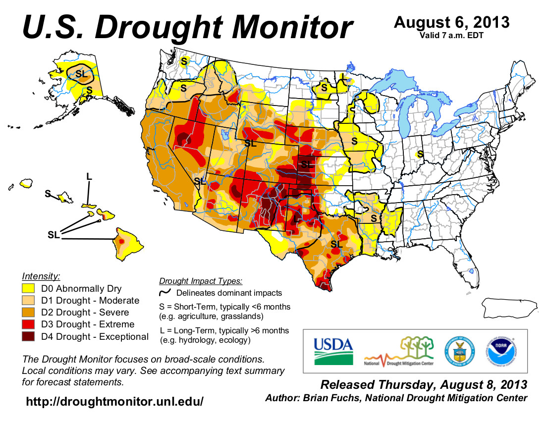
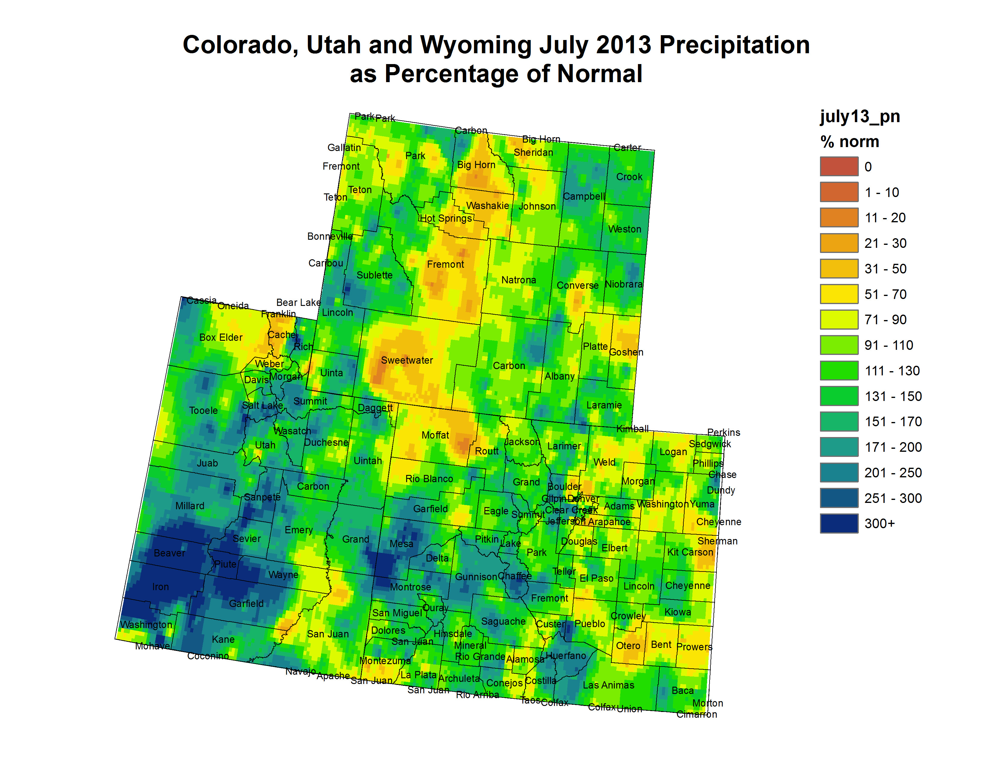
    July inflow into Lake Powell was just 13 percent of average, following a spring runoff season during whic the river delivered only about a third of the average amount of water.

    The cutback comes as no surprise, and won’t have an immediate impact on water users in California, Arizona and Nevada. In 2007, states that depend on the river agreed to a set of guidelines for reduced flows to the Lower Basin states when Lake Powell dips to a certain level. The giant reservoir holds about 24.3 million acre feet but is currently only about half full, nearing a level that triggers the agreed-upon cuts.

    From the Arizona Central (Dennis Wagner):

    A Bureau of Reclamation study released Friday says the Colorado River’s worst drought in a century will force reduced water releases from Lake Powell that could affect agriculture, downstream business and hydroelectric power production.

    Groups urging conservation warned of drastic cutbacks and severe economic implications while state officials and the Central Arizona Project sought to downplay the alarm…

    CAP officials emphasized that water delivery to towns and cities will not be affected. However, based on the bureau projections, they said shortages could trigger a 20 percent decrease in Arizona deliveries to agriculture…

    CAP stressed that, if the drought triggers a shortage and cutbacks in two years, it will not have an impact on municipalities, residential water users or Native American tribes.

    From The Christian Science Monitor (Pete Spotts):

    The bureau formally announced the cut Friday. The amount of water that the bureau will release from the lake starting Oct. 1 will be some 10 percent less than the amount released in the prior 12 months – some 7.48 million acre-feet of water during the 2014 water year, compared with 8.23 million acre-feet during the current water year, which ends Sept. 30…

    “We’re in an unparalleled – at least in recorded history – period of droughts on the Colorado River system,” says Michael Cohen, a senior research associate who specializes in Colorado River water issues at the Pacific Institute in Oakland, Calif.

    “It seems that this is the new normal,” he says, noting that climate scientists studying the potential effects of global warming have been predicting these conditions in the region for more than a decade…

    The bureau’s move “is truly historic,” adds Taylor Hawes, director of the Nature Conservancy’s Colorado River Program. “The bureau has never released less than 7.5 million acre-feet” of water since the Glen Canyon Dam, which formed Lake Powell, was built.

    The bureau took the action under an interim allocation agreement hammered out in 2007 between states in the upper Colorado River Basin and the lower basin. The upper-basin states include Wyoming, Colorado, Utah, New Mexico. The lower-basin states include Arizona, Nevada, and California…

    Flows for the past two months give a sense of the magnitude of the problem. Data from the National Oceanic and Atmospheric Administration’s Colorado Basin River Forecast Center in Salt Lake City show that flows in June were 35 percent below average, while July’s flows were 13 percent of normal. August looks a bit better, with stream flows projected at 32 percent below normal.

    Under the 2007 allocation agreement, the bureau tries to strike a balance in water levels between Lake Mead and Lake Powell, Dr. Fulp explains.

    “We try to get a better balance during high-flow years between the two basins,” he says. “We’re trying to balance the pain of low-flow years between the two basins.”

    Although Lake Mead is drawing the short straw this time around, it received about 800,000 additional acre-feet of water from Lake Powell last year, Mr. Cohen adds. This was preceded by a bigger release from Powell to Mead in 2008, he adds. “So in some ways, it’s a wash,” he says.

    Even so, the cost of Friday’s announcement to Lake Mead is a waterline eight feet lower than it is today – a falling level that Las Vegas is desperately trying to beat as it installs a new intake system at the lake to provide water for the city…

    The supply-demand study that the bureau released in December was a call to action for more-aggressive efforts to improve water-use efficiency and for other approaches to adapting to a future where climate and populations continue to put the squeeze on water resources, Ms. Hawes says. But looking at the bureau’s historic reduction in water to be released from Lake Powell, she adds, “Nobody expected it to happen so quickly.”

    From The Salt Lake Tribune (Brian Maffly):

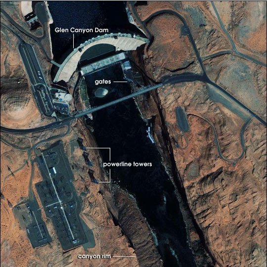
    Reclamation operates Glen Canyon in tandem with its downstream partner Hoover Dam, which impounds Lake Mead, a key water source for Las Vegas and other lower Colorado River Basin users. The two reservoirs, which sit on each side of the Grand Canyon, are both less than half full, putting their ability to generate hydropower at risk.

    From The Wall Street Journal (Jim Carlton):

    More than a decade into a drought that has plagued the Southwest, federal officials for the first time plan a sharp cut in the amount of Colorado River water that flows 360 miles from Lake Powell into Lake Mead. In the year starting Oct. 1, officials at the U.S. Bureau of Reclamation said Friday, that supply will drop by nearly 10%—roughly equivalent to the annual water usage of about 700,000 families.

    The cut will translate into a reduction in hydroelectric power generation in some areas served by the reservoir—Nevada, Arizona and California—and brings the reservoir level close to a federal declaration of a water shortage. Such a declaration would mean that Nevada and Arizona would face having their water allocations cut…

    The effect on Lake Mead will be a drop in water level of eight feet, which will come on top of receding water levels that already have totaled about 100 feet since the drought took hold in 2000. Water levels at Lake Mead now stand at an elevation of 1105 feet. The new cutback will bring the level perilously close to a federal trigger point of 1075 feet—the measure at which the Interior Department would declare a water shortage. Mr. Fulp said in an interview that there is a 50% chance such a shortage would be declared in 2016; a probability he added has been increased this year as the drought has intensified. The reduction will result in an 8% decrease in electricity production at Glen Canyon Dam, requiring a federal power agency to spend about $10 million to buy electricity on the open market to meet customer demands, said Lisa Iams, a Bureau of Reclamation spokeswoman in Salt Lake City…

    In Arizona, a reduction of 320,000 acre-feet, or one fifth its supply, would prompt the Central Arizona Project to cut supplies for farming and other lower-priority uses such as banking water underground to guard against a future emergency, said Chuck Cullom, Colorado River programs manager for the big water agency.

    Here’s a release from US Senator Mark Udall’s office (Mike Saccone):

    Following the U.S. Bureau of Reclamation’s decision today to release a historically low amount of water from Lake Powell, Mark Udall urged Coloradans to do their part by responsibly using water and making every drop count. Udall, who recently led a U.S. Senate hearing on the future of the Colorado River Basin, said every Coloradan has an obligation to conserve water. He also urged the groups involved in the Colorado River Supply and Demand Study to keep moving forward to implement the strategies identified in the study, which include reducing demand through innovation, conservation and better management of supply.

    “The Colorado River made our state what it is today: It irrigates our crops, sustains a robust recreation industry, and supports cities throughout Colorado,” Udall said. “The Bureau of Reclamation’s announcement today is a reminder that every Coloradan has a role to play in keeping the Colorado River strong. Make every drop count: Only use what you need and make water conservation a priority.”

    Udall has been an unwavering advocate for the Colorado River and the interstate and international compacts that keep it strong. He heralded a recent agreement between the United States and Mexico, in cooperation with the seven Colorado River Basin states, to better manage the Colorado River. He also has been a strong proponent of finding innovative ways to better manage water to meet the rising demand throughout the West.

    Udall also has fought to protect Colorado’s waterways and reservoirs from threats like wildfire. He welcomed a federal, state and local partnership the U.S. Department of Agriculture and U.S. Department of the Interior formed in July to reduce the threat wildfires pose to Colorado’s drinking-water supplies. Udall also led the recent fight to secure recovery funds for Colorado’s watersheds damaged by 2012’s High Park and Waldo Canyon wildfires.

    From the Associated Press (Ken Ritter and Paul Foy) via The Sacramento Bee:

    The bureau that controls the levers at the Glen Canyon and Hoover dams said cities, states, farmers and Indian tribes will get their full Colorado River water deliveries next year — and probably in 2015. [Terry] Fulp said a 2 percent chance of the Lake Mead level dropping in 2015 to the trigger point for a shortage declaration increases to 50 percent in 2016…

    Utah Division of Water Resources chief Dennis Strong said his state doesn’t currently draw its full 1.4-million acre-foot allotment of river water. He said his concern was for states in the Colorado River’s lower basin. “We’ve spent 14 years in a drought situation — with only three above-average years — and Lake Powell and Lake Mead are below half full,” Strong said. “It’s hard not to worry about the future when you’re below 50 percent.”

    From inkstain (John Fleck):

    The shortfall out of Lake Powell in 2014 is not all that large compared to the recent over-deliveries. Or maybe this really makes the case that the Lower Basin is not living within its means, where “its means” are defined as 8.23 maf per year.

    From The Grand Junction Daily Sentinel (Gary Harmon):

    More water will be stored in Lake Powell in 2014 as the U.S. Bureau of Reclamation anticipates the likelihood of continued drought.

    “This is the worst 14-year drought period in the last hundred years,” Upper Colorado Regional Director Larry Walkoviak said, noting that low water levels will require increased coordination in the operations of reservoirs upstream from Lake Powell.

    Storing more water in Lake Powell will protect the ability of the bureau to generate electricity at Glen Canyon Dam.

    “Should Powell fall below powerhead (the level at which water can spin the turbines) there’s a whole revenue stream that’s at stake,” Colorado River Water Conservation District spokesman Jim Pokrandt said.

    That revenue stream includes funding from Powell’s power revenues for selenium- and salinity-control programs, Pokrandt said.

    Additional storage in Powell can insulate the upper-basin states of Colorado, Utah, New Mexico and Wyoming from an immediate demand by downstream states for water guaranteed them under a 1922 agreement, but that possibility is not immediate, said Terry Fulp, the Bureau of Reclamation’s Lower Colorado Region director.

    “With a good winter snowpack next year, the outlook could change significantly, as it did in 2011, but we also need to be prepared for continuing drought,” Fulp said.

    Longer-term projections in the bureau’s longer-term models show a “very small chance of lower-basin delivery shortages in 2015,” Fulp said.

    The first significant chance of reduced water deliveries to the lower basin is in 2016, Fulp said, noting that projections will be updated monthly to reflect changes in weather and hydrology.

    Bureau officials and environmentalists have been raising alarms in recent months about demand outstripping supply on the river serving some 40 million people in seven states and cities including Los Angeles, Phoenix, Denver and Las Vegas.

    “The problem isn’t drought, and a big rain storm or a heavy winter snow season won’t fix this,” said Bob Irvin, president of American Rivers in Washington. D.C. The advocacy group in April labeled the Colorado River the most endangered waterway in the U.S.

    “What we need are fundamental changes in how we manage water in the Colorado basin,” Irvin said. “This is the loudest wake-up call so far.”

    Fulp pointed to a federal report issued in December that concluded that the river may not meet the needs of a growing regional population by 2060.

    “The study showed very clearly that demand and supply curves are crossing and demand is exceeding supply,” he said.

    Fulp compares managing the two largest reservoirs on the Colorado River to pouring tea from one cup to another. He said the usual annual delivery of 8.23 million acre-feet of water from Lake Powell to Lake Mead will be cut next year about 9 percent, to 7.48 million acre-feet. Officials say one acre-foot is enough to serve two Nevada families for a year.

    Lake Powell, near the Utah-Arizona state line, would decrease from 45 percent this year to 42 percent next year.

    Lake Mead, on the Nevada-Arizona state line, is currently at 47 percent capacity and could drop to 39 percent capacity next year.

    Lake Mead on Friday was at 1,106 feet. The low level next year would be about 10 feet above a 1,075-foot elevation trigger point agreed upon in 2007 by the seven U.S. states that share river water under a 1928 allocation agreement. Native American tribes and Mexico also get shares of Colorado River water.

    A shortage declaration would mean Arizona would get 11.4 percent less than its 2.8 million acre-foot allocation. Nevada would get 4.3 percent less than its 300,000 acre-foot allotment — a loss equivalent of the amount serving 26,000 homes.

    Southern Nevada Water Authority chief Pat Mulroy last week floated the idea of a federal disaster declaration due to drought in the Southwest. Meanwhile, local officials stress conservation, and note that iconic dancing fountains on the Las Vegas Strip use recycled water.

    From the Las Vegas Review Journal (Henry Brean):

    Lake Mead will receive its smallest water delivery ever in the coming year, thanks to a sudden dip in Lake Powell fueled by the second- driest year since drought hit the Colorado River in 2000. The U.S. Bureau of Reclamation made it official Friday with the release of its August forecast that sets the annual water delivery from Lake Powell and predicts reservoir levels along the river through July 2015. The document calls for Lake Powell to release 7.48 million acre-feet of water in the coming year, 750,000 acre-feet less than in any year since the reservoir on the Arizona-Utah border was created.

    The move will speed the decline of Lake Mead, which is expected to drop almost 25 feet to a record low by November 2014. By April 2015, the surface of Lake Mead could sink to 1,075 feet above sea level, triggering the first federal shortage declaration on the river and prompting water supply cuts for Nevada and Arizona.

    Should the lake keep dropping from there, it eventually will shut down one of the two intakes the Southern Nevada Water Authority uses to draw about 90 percent of the Las Vegas Valley’s water supply. According to the federal projections released Friday, that could happen sometime in late summer 2015…

    “Conditions on the Colorado River continue to deteriorate,” she said. “Weathering this storm will require an exceptional level of cooperation among all of us who rely upon the Colorado River, whether for municipal water supplies or agricultural irrigation.”

    Conservation groups are expressing alarm. One group called what is happening to the river “The Great Depletion.” “This is like the ‘check engine’ light coming on in your car,” said Bart Miller of the Boulder, Colo.-based Western Resource Advocates. “It’s a message from the Colorado River telling us that something is wrong, and we need to fix it soon.”

    Back in Southern Nevada, critics of the water authority argue the agency isn’t behaving as though there is a crisis. No major new water restrictions have been adopted or even proposed since 2009, and no real effort has been made to curb indoor water use or set limits on future residential and commercial development. If this is such an emergency, why aren’t Mulroy and company screaming for the community to cut its water use as much as possible?

    For one thing, said authority spokesman J.C. Davis, this is not a problem that can be solved by people in Southern Nevada using less water. Nevada gets 300,000 acre-feet, or about 2 percent, of the 16.5 million acre-feet of Colorado River water that is parceled out each year among seven western states and Mexico. If the Las Vegas Valley went one year without using any water from Lake Mead, the impact on the reservoir would be a rise of about 3 feet…

    The agency still hasn’t figured out how to pay for what figures to be one of the most expensive public works projects in Nevada history: a network of wells, pipelines and pumps stretching several hundred miles to bring groundwater to Las Vegas from across rural Clark, Lincoln and White Pine counties. By the authority’s own estimates, the in-state water project could wind up costing as much as $15 billion, including financing costs.

    Authority board members have yet to cast a final vote authorizing the design and construction of the controversial pipeline, but a decision could come by the end of next year.

    Under rules adopted by the authority in 2009, the vote will be taken as soon as Lake Mead drops to the 1,075-foot level.

    It seems the only thing that can stop that now is a Rocky Mountain winter choked with heavy snow.

    More Colorado River Basin coverage here and here.

    ‘We’re in hydro uncertainty’ — Eric Kuhn

    ‘We’ve seen…the worst consecutive years of inflow in the last 100 years’ — Terry Fulp #ColoradoRiver

    glencanyondamnasaearthobservatory.jpg

    From the Associated Press via the Albuquerque Journal:

    After back-to-back driest years in a century on the Colorado River, federal water managers are giving Arizona and Nevada a 50-50 chance of having their water deliveries cut in 2016, unless the Rocky Mountains get more winter snow than in recent years. A U.S. Bureau of Reclamation operations plan being made public Friday will for the first time ever slow the flow of water from the Lake Powell reservoir upstream of the Grand Canyon to the huge Lake Mead reservoir that provides almost all of Las Vegas’ water.

    But a bureau official said Lake Mead won’t reach a low point next year that would trigger cuts to Sin City’s main drinking water supply.

    “What we’ve seen in the last two years are the worst consecutive years of inflow in the last 100 years,” bureau Lower Colorado Regional Director Terry Fulp said in an interview in advance of the report.

    “We’re going to slow Powell’s decline. That will hasten Mead’s decline,” he said. “But next year, we can adjust again.”

    The bureau that controls the levers at the Glen Canyon and Hoover dams said cities, states, farmers and Indian tribes will get their full Colorado River water deliveries next year — and probably in 2015.

    Fulp said a 2 percent chance of the Lake Mead level dropping in 2015 to the trigger point for a shortage declaration increases to 50 percent in 2016…

    Fulp compares managing the two largest reservoirs on the Colorado River to pouring tea from one cup to another. He said the usual annual delivery of 8.23 million acre-feet of water from Lake Powell to Lake Mead will be cut next year to 7.48 million acre-feet. Officials say one acre-foot is enough to serve two Nevada families for a year.

    Lake Powell, near the Utah-Arizona state line, would decrease from 45 percent this year to 42 percent next year.

    Lake Mead, on the Nevada-Arizona state line, is currently at 47 percent capacity and could drop to 39 percent capacity next year.

    Lake Mead on Thursday was at nearly 1,106 feet. The low level next year would be about 10 feet above a 1,075-foot elevation trigger point agreed upon in 2007 by the seven U.S. states that share river water under a 1928 allocation agreement. Native American tribes and Mexico also get shares of Colorado River water…

    California, Colorado, Utah, New Mexico and Wyoming wouldn’t see direct cuts in their share of river water in 2016 depending on the Lake Mead water level. But officials acknowledged there would be ripple effects.

    “Denver Water has a direct interest in these issues because half our supply comes from the Colorado River,” said Jim Lochhead, chief executive of the water agency serving Denver and its suburbs. “Issues like compact curtailment or political or legal confrontation along the river will affect that supply.”[…]

    Utah Division of Water Resources chief Dennis Strong said his state doesn’t currently draw its full 1.4-million acre-foot allotment of river water. He said his concern was for states in the Colorado River’s lower basin.

    “We’ve spent 14 years in a drought situation — with only three above-average years — and Lake Powell and Lake Mead are below half full,” Strong said. “It’s hard not to worry about the future when you’re below 50 percent.”

    More Colorado River Basin coverage here and here.

    Governor Hickenlooper announces appointees to the Arkansas River Compact Administration

    arkansasriverbasinmapviaeoearthorg.jpg

    From The Pueblo Chieftain (Chris Woodka):

    Colin Thompson of Holly and Scott Brazil of Pueblo have been appointed to the Arkansas River Compact Administration, along with James Eklund, the executive director of the Colorado Water Conservation Board. Appointments are made by Gov. John Hickenlooper.

    Thompson, who farms on the Amity Canal, was first appointed to ARCA in 2005. His term expires in 2015.

    Brazil, who farms in the Vineland area, will begin his first term on the board. He replaces Matt Heimerich of Crowley County. His term will expire in 2017.

    Eklund began his CWCB post in June and replaces Jennifer Gimbel.

    ARCA administers the Arkansas River Compact, which was ratified by Kansas and Colorado in 1949 to determine how the waters of the river are shared.

    In recent years, ARCA has been preoccupied by issues raised by Kansas related to storage and groundwater use in Colorado. A U.S. Supreme Court case filed in 1985 was resolved in 2009.

    ARCA meets annually in December.

    Meanwhile, here’s a report about administering the Arkansas River this summer, from Chris Woodka writing for The Pueblo Chieftain:

    Sporadic, often heavy, rains have created a “roller coaster” world of water in the Arkansas River basin this summer. “It’s been a real roller coaster the last couple of weeks,” Water Division 2 Engineer Steve Witte said Thursday.

    Witte, who began issuing split calls of water rights on the Arkansas River during last year’s drought, created the first five-way call on the river this year to keep up with changed weather patterns that are dumping copious amounts of water, but only in some corners of the watershed. “The number of different calls are intended to take advantage of water where it is available,” Witte said. “It’s difficult for people to understand that with erratic conditions, there is an inconsistent supply.”

    On Thursday, for instance, flows through Pueblo were at a minimum, about 100 cubic feet per second. Up around Salida, they were being maintained for rafting at about 700 cfs, thanks to releases by the Bureau of Reclamation for the voluntary flow program.

    Fountain Creek was adding 345 cfs at the confluence with the Arkansas River because of rains Wednesday in Pueblo and Colorado Springs. The Purgatoire River near Las Animas was flowing at 1,400 cfs, and has reached 6,000 cfs in the past two weeks, even though it’s normally nearly dry at this time of year.

    Storage also is problematic. Levels are at about 80 percent of average for August in Turquoise, Twin Lakes and Pueblo reservoirs, and extremely low at John Martin Reservoir, although some water is being stored — a rare event during the past three years. But Two Buttes Reservoir south of Lamar, under restriction since the 1965 flood, is brimming with water for the first time in decades. The state has had meetings with local residents in the past week on the best way to manage the situation.

    “It’s been wild,” Witte said. “In years gone by, with conditions like this we would set a call and everyone would accept it. Now, we’re having erratic weather, coupled with increased scrutiny of the river.”

    More Arkansas River Basin coverage here and here.

    Greeley’s latest water conservation e-newsletter is hot off the presses #COdrought

    ‘There’s no reason to run around like your hair’s on fire’ — John Fleck #ColoradoRiver

    coloradoriverbasin2012doiviatheaspentimes.jpg

    From inkstain (John Fleck):

    The Bureau of Reclamation is going to tell us Friday that there’s not very much water in Lake Powell, and that as a result releases from Powell will be curtailed in the coming year, which sets off a cascading set of effects downstream. I took a crack at explaining this here, but Brett Walton has really done the journalistic heavy lifting to explain what it all means. I don’t have much to add to Brett’s analysis, which is rich and detailed, except for this simple takeaway message: You’ll hear from and see a lot of people in coming days running around like their hair is on fire about this. Chill. As Brett’s piece explains, this is an orderly process.

    Here’s the post that Mr. Fleck cites above from Circle of Blue (Brett Walton). Click through and read the whole thing. Here’s an excerpt:

    Every month, officials at the federal Bureau of Reclamation, the dam-master for the river, run some hydrological assumptions and observations through a computer, peer into the crystal screen, and see a rough outline of the system’s health for the following two years. The 24-month study, as it is called, has taken on greater significance since 2007, when the seven U.S. states that share the Colorado River signed an agreement that declared the study as the guidepost for how to operate the Basin’s two big reservoirs, Mead and Powell, in times of water surplus and water deficit. (The 2007 shortage-sharing agreement, known formally as the Colorado River Interim Guidelines for Lower Basin Shortages, did not include Mexico, which is guaranteed water from the river under a 1944 treaty. Mexico’s obligations during a shortage were worked out in an amendment called Minute 319, signed last November.)

    Every year since the shortage-sharing agreement was signed, the August study — the 2013 version of which will be released this Friday — has been the standard-setter. Its projections determine how much water the Bureau will send downstream in the next year. If the results from last month hold, as is likely, the amount of water released from Lake Powell in 2014 will be the lowest since the reservoir was being filled during the 1960s. The resulting 9 percent cut would set the table for the first-ever shortage declaration on the Lower Colorado River, either in 2015 or 2016. By then, the water level in Lake Mead, downstream from Powell, is projected to drop below a trigger point that sets off a round of restrictions on water withdrawals for Arizona, California, Nevada, and now Mexico…

    Yet, if Lake Mead were to fall below 327.7 meters (1,075 feet) in elevation, thus breaching the first of three shortage levels named in the 24-month study, the short-term effects would not be devastating: there would be a belt-tightening by a small group of users in Arizona and Nevada, a price increase for a larger group in Arizona, and a firm cap on withdrawals in California. In practice, water use would likely remain constant, because groundwater pumping — itself an unsustainable safety net — would rise to offset the restriction on surface diversions…

    The first number to watch for is 1,089.7 meters (3,575 feet). If Friday’s study projects that Lake Powell’s elevation will fall below the 3,575-feet barrier in January of 2014 — as the July study showed — then a shortage for the Lower Basin is all the more likely by 2016, because of the smaller slug of water that the Bureau would release from Powell. Shortages, however, are declared based on Lake Mead’s elevation and would affect only Arizona, California, and Nevada.

    Bruce Williams, who works for the Bureau’s river operations group, says that dry soils and below-average rainfall for 2013 point to a similar forecast for this month’s study as was predicted last month.

    “Based on everything going on in the Basin, the odds are that July is close to what we’ll see in August,” Williams told Circle of Blue.

    If that happens, then attention turns to Lake Mead. The 2007 shortage-sharing agreement sets three reservoir elevations under which water restrictions are imposed on the Lower Basin: 1,075 feet, 1,050 feet, and 1,025 feet. Under the first shortage level, total water use is cut by 4.4 percent in the three Lower Basin states: Arizona would take an 11 percent cut and Nevada 4 percent, while California’s allocation would not be reduced. Mexico’s deliveries would be take a 3.3 percent hit.

    From The Imperial Valley Press (Antoine Abou-Diwan):

    Under standard conditions, the BOR releases 8.23 million acre-feet of water from Lake Powell to Lake Mead to keep the two reservoirs operating in harmony. However, this year’s annual release volume could be less than standard. Fourteen consecutive years of drought, reduced inflows to the Colorado River and urban population growth have squeezed water supplies. Diversions from the Colorado River deliver water to California, six other western states and parts of Mexico. “If on Friday the 24-month study puts us in operational mid-release tier, it could mean that this year’s annual release volume could be less than standard. It would be 7.48 million acre-feet,” said Lisa Iams, Upper Colorado Region public affairs officer.

    Lake Powell and Lake Mead are BOR’s two storage reservoirs on the Colorado River. The BOR tries to maintain a balance in the water level between the two reservoirs, and reduced inflows to Lake Powell generally mean lower releases to Lake Mead, which lies downstream of Lake Powell. While a lower release does not necessarily correspond with a declaration of a water shortage, the likelihood of such an occurrence will increase if conditions on the river remain the same.

    The water level on Lake Mead will drop four to eight feet more than it would under standard releases, bringing the lake within 31 feet of its shortage trigger, said Tina Shields, Imperial Irrigation District assistant water manager. “It’s not a shortage until Lake Mead reaches an elevation of 1,075 (feet),” Shields said.

    A shortage declaration on the lower Colorado River Basin would not directly impact California, Shields said. Arizona, Nevada and Mexico would be first to feel the pinch. However, California’s inadvertent overrun policy would be suspended, putting a hard cap on California’s allocation. Under the Colorado River Compact, California has an entitlement of 4.4 million acre-feet of water per year.

    From the Oakland Press (Brian Maffly):

    July’s actual flow into the reservoir separating the Colorado River’s upper and lower basin turned out be about 100,000 acre feet less than forecast, or 13 percent of July’s normal inflows, according to Michelle Stokes of the National Oceanic and Atmospheric Administration. “That was the huge shocker. The month before was 35 percent of normal,” said Stokes, the hydrologist in charge of NOAA’s Colorado Basin River Forecast Center. And the outlook for the next several months is not much better.

    It is widely expected that this new data will prompt the U.S. Bureau of Reclamation to reduce Glen Canyon releases next year by 750,000 acre feet, enough water to supply 1.5 million homes. “We had very low years the past two years, almost record lows for the upper basin,” Stokes said. “We are starting with relatively dry soils and low flows. Our forecast is for below normal, 80 percent. We are thinking 33 percent in August and 44 percent in September, 60 to 70 in October.”

    From Colorado River Setting the Course:

    Water policy experts convening at the annual Clyde Martz Summer Water Conference in Boulder, Colo. (Aug. 15-16), are abuzz about an unprecedented alarm in the Colorado River Basin. Amidst the driest 14 years on record in the Southwest, for the first time in history the Bureau of Reclamation (BOR) will likely reduce the amount of water that Lake Powell releases to Lake Mead – an alarm that could be the first indication of serious water shortages ahead.

    Western Resource Advocates (WRA) and Environmental Defense Fund (EDF) have prepared a fact sheet to help explain the significance of the Lake Powell release reduction. [Download the Fact Sheet here (PDF)]

    “This is like the ‘check engine’ light coming on in your car—it’s a message from the Colorado River telling us that something is wrong and we need to fix it soon,” said Bart Miller, Water Program Director at Western Resource Advocates. “If we don’t take action to fix this ‘Great Depletion,’ we will face serious consequences within a matter of just a few years.”

    More Colorado River Basin coverage here.

    Drought news: Parts of the Arkansas Valley show improved conditions #COdrought

    usdroughtmonitor08062013.jpg

    From The Pueblo Chieftain (Chris Woodka):

    Rains have pushed the level of Lake Minnequa up by about 1.5 feet, but it’s probably too soon to break out the sailboats. The level still is about 1.5 feet short of the point where it can be measured, said Alan Ward, water resources manager for the Pueblo Board of Water Works. And, it’s still 4.5 feet short of the outlet that delivers water from Lake Minnequa to the Arkansas River. “We have not been able to measure it exactly, but there’s no question that the lake’s been filling up with the recent storms,” Ward said.

    The level of the lake has dropped steadily for the past three years, creating problems with fish kill and odor. Over the winter, the city deepened the lake by dredging on the north shore. A city-financed $1 million, 3.7-mile pipeline from the St. Charles reservoirs at Stem Beach south of Pueblo has been completed, and is ready for use to deliver freshening flows to the lake. But it probably won’t be used until the lake fully refills. Under an agreement, the Lower Arkansas Valley Water Conservancy District would flow water it is moving through the Minnequa Canal into Lake Minnequa. But that won’t happen until the water level reaches the outlet. More of the area around the lake has been mowed this year to reduce the chances of fires around the lake, such as the one that burned there last fall.

    Meanwhile, the Pueblo water board continues to make up evaporation losses from new wetlands that were created to improve the park surrounding the lake. Releases are made from Pueblo Dam directly into the Arkansas River to replace long-term depletions, Ward said.

    Weekly Climate, Water and Drought Assessment of the Upper Colorado River Basin #COdrought #ColoradoRiver

    wycoutprecipitationaugust2013mtdccc.jpg

    Click on the thumbnail graphic to see the August month to date precipitation map for the Upper Colorado River Basin from the Colorado Climate Center. Click here to read the current assessment. Click here to go to the webpage.

    More Colorado River Basin coverage here.

    The Water and Agriculture Tax Reform Act of 2013: Senator Bennet introduces legislation to help ditch companies

    smithsditchwashingtonparkdenver.jpg

    Here’s the release from Senator Bennet’s office:

    A bipartisan group of lawmakers has introduced legislation that would ensure farmers and ranchers have access to modern and safe water infrastructure.

    Senators Michael Bennet (D-CO) and Mike Crapo (R-ID) introduced The Water and Agriculture Tax Reform Act of 2013 on Thursday. Congressman Cory Gardner (R-CO) is leading companion legislation in the House.

    The bill would reform outdated tax provisions that hinder ditch and irrigation companies’ ability to raise capital to invest in infrastructure. Current law dictates that mutual ditch and irrigation companies must receive 85 percent of their income from shareholder investment to maintain its non-profit designation. The bill allows these companies to receive other sources of income for operations and maintenance and still maintain its non-profit status. The legislation requires that the extra revenue be used exclusively for operations and maintenance of the ditch and irrigation company.

    Currently, when ditch and irrigation companies incur a large capital expense, such as replacing a dam in disrepair, they are severely limited in how they can collect revenue. This legislation eases restrictions while still ensuring that the revenue is used solely for operations and maintenance expenses.

    “Water is a precious resource in Colorado, and nobody knows that better than our farmers and ranchers,” Bennet said. “Producers throughout the state face challenges when it comes to distributing water across their land to keep it productive for its agricultural uses. This bill will help give irrigation companies in Colorado greater flexibility to keep this infrastructure in good working condition.”

    “Current law is outdated and does not serve the needs of the people of Colorado,” said Gardner. “It’s critical that farmers and ranchers have access to water. This legislation will help prevent the buy and dry-up of farm land and protect agriculture jobs in Colorado.”

    “The high cost of maintaining reservoirs, ditches and other irrigation structures comes at great cost to Idaho farmers and ranchers,” said Crapo. “Many in the agriculture community form mutual ditch and irrigation companies to develop and maintain water storage and delivery systems for their land, but due to an outdated provision in our tax code our farmers and ranchers end up being penalized for this very investment. In order to maintain a thriving agriculture sector, we must fix this provision by passing the WATER Act.”

    From The Greeley Tribune (Eric Brown):

    Water providers for farmers and ranchers could have more dollars and flexibility to upgrade their aging delivery systems if a pair of Colorado lawmakers push through their respective bills in Washington.

    Many in Weld County — the 8th-most agriculturally productive county in the United States, lined with hundreds of miles of irrigation canals, spillways, inlets and diversion structures — are eager for passage, since routine upgrades and repairs to these water-delivery systems can add up into the millions of dollars.

    Current law says that mutual ditch and irrigation companies must receive 85 percent of their income from shareholder investments to maintain nonprofit designation. In recent years, though, a number of ditch companies have seen an influx in revenue, mostly from an upswing in oil and gas activity in the region, and that increase in dollars has put some companies past the 85 percent threshold, leaving them to be taxed on the additional revenue.

    With aging water infrastructure being a concern in rural Colorado, Sen. Michael Bennet, D-Colo., recently introduced a bill that would reform tax provisions and allow irrigation and ditch companies to receive additional sources of income and still maintain nonprofit status. The legislation requires that the extra revenue be used exclusively for operations and maintenance of the ditch and irrigation company. Bennet, along with Sen. Mike Crapo, R-Idaho, introduced their Water and Agriculture Tax Reform Act of 2013 on Thursday.

    Rep. Cory Gardner, R-Colo., introduced companion legislation in the House last fall.

    Several farmers and ditch company representatives in Weld met with Gardner last year to help the congressman piece together his legislation.

    The U.S. Joint Committee on Taxation estimated last year that Gardner’s bill would take away about $31 million in tax revenue from the federal government between 2012 and 2021 — “definitely worth it,” Gardner said, stressing how important irrigated agriculture is to the economy and to the nation’s food security.

    With the effort now receiving bipartisan support, many in Weld County — like Dale Trowbridge, general manager at the New Cache La Poudre Irrigating Co. in Lucerne — are hopeful, adding that the additional dollars and flexibility from such legislation would “certainly be welcome.” Trowbridge and his company alone oversee about 80 miles of ditches and canals for about 350 shareholders — and the system is 134 years old. “When you’re working with something that big and that old, there’s always upgrades or repairs needed,” he said.

    However, replacing the nearly 200 head gates along his system can cost $10,000-$15,000 each, Trowbridge noted. Replacing or doing major work on a diversion structure can add up into the hundreds of thousands of dollars. Building new facilities to store more water or repairing reservoirs can cost $10 million-plus. Trowbridge didn’t even want to take a crack at estimating the costs of further water-efficiency measures — such as lining irrigation ditches with concrete, to prevent water lost to ground seepage. “Across the board, we see this as a good thing … if we want to make the most of our water,” Trowbridge said.

    Here’s a release from US Representative Cory Gardner’s office:

    A bipartisan group of lawmakers has introduced legislation that would ensure farmers and ranchers have access to modern and safe water infrastructure.

    Senators Michael Bennet (D-CO) and Mike Crapo (R-ID) introduced The Water and Agriculture Tax Reform Act of 2013 on Thursday. Congressman Cory Gardner (R-CO) is leading companion legislation in the House.

    The bill would reform outdated tax provisions that hinder ditch and irrigation companies’ ability to raise capital to invest in infrastructure. Current law dictates that mutual ditch and irrigation companies must receive 85 percent of their income from shareholder investment to maintain its non-profit designation. The bill allows these companies to receive other sources of income for operations and maintenance and still maintain its non-profit status. The legislation requires that the extra revenue be used exclusively for operations and maintenance of the ditch and irrigation company.

    Currently, when ditch and irrigation companies incur a large capital expense, such as replacing a dam in disrepair, they are severely limited in how they can collect revenue. This legislation eases restrictions while still ensuring that the revenue is used solely for operations and maintenance expenses.

    “Current law is outdated and does not serve the needs of the people of Colorado,” said Gardner. “It’s critical that farmers and ranchers have access to water. This legislation will help prevent the buy and dry-up of farm land and protect agriculture jobs in Colorado.”

    “Water is a precious resource in Colorado, and nobody knows that better than our farmers and ranchers,” Bennet said. “Producers throughout the state face challenges when it comes to distributing water across their land to keep it productive for its agricultural uses. This bill will help give irrigation companies in Colorado greater flexibility to keep this infrastructure in good working condition.”

    “The high cost of maintaining reservoirs, ditches and other irrigation structures comes at great cost to Idaho farmers and ranchers,” said Crapo. “Many in the agriculture community form mutual ditch and irrigation companies to develop and maintain water storage and delivery systems for their land, but due to an outdated provision in our tax code our farmers and ranchers end up being penalized for this very investment. In order to maintain a thriving agriculture sector, we must fix this provision by passing the WATER Act.”

    The latest Middle Colorado Watershed Council newsletter is hot off the presses #ColoradoRiver

    coloradorivereaglecounty.jpg

    Click here to read the newsletter. Here’s an excerpt:

    On August 20st and 22nd, the BLM and Colorado Riparian Association are coming to Carbondale to conduct a free Riparian Assessment Workshop. This gathering is intended for any interested parties included but not limited to land managers, land owners, riverfront property owners, and watershed stakeholders. Check out the flier for more information. As of printing, there were two spaces still available. Contact Jay Thompson, Fish and Riparian Program Lead, BLM Colorado State Office, 303-239-3724, or at jmthomps@blm.gov.

    More Colorado River Basin coverage here and here.

    CWCB report: Public Opinions, Attitudes and Awareness Regarding Water in Colorado

    greeleyirrigationditchnumber3constructioncirca1870.jpg

    Click here to read the report.

    Drought news: Governor Hickenlooper is on tour assessing the impacts of Colorado’s drought #COdrought

    hickenlooperstulpsalazarcoloradowaterbraintrust2012.jpg

    From The Pueblo Chieftain (Chris Woodka):

    It was billed as a drought tour, stretching from Sterling to Springfield with six stops along the way. But Gov. John Hickenlooper spent a portion of the time defending some of his fights this year that he conceded might be unpopular in rural areas: gun laws, temporary clemency for a death-row killer and support for a state law setting a renewable energy standard. He also listened to community concerns. “I want to get out to as many people as I can,” Hickenlooper said. “Each meeting there is some problem pointed out that we can do something about.”

    In his opening remarks, Hickenlooper said the small fee for a background check for anyone purchasing a gun is worth it. He claimed more than 3,000 people who had been convicted of crimes, had outstanding warrants or restraining orders were identified in background checks in Colorado last year. “And we only checked half of them,” Hickenlooper said.

    He fielded a series of questions quickly, promising to look into easing state regulations on farmers and ranchers who have been hit hard by drought. “There are ways to do what’s fair,” he said.

    Hickenlooper also pledged to look into improving the climate for agri-tourism, particularly in the area of landowner liability issues.

    The meeting wasn’t all about problems.

    Otero County Commissioner Keith Goodwin thanked the governor for state support of cantaloupe growers after a scare hurt sales last year. Hickenlooper praised Agriculture Commissioner John Salazar for taking decisive action and growers for acting proactively.

    Bent County Commissioner Bill Long thanked Hickenlooper for signing a bill that repurposed Fort Lyon as a center for helping the homeless after it was closed as a prison. Again, the governor deflected the praise: “Bill Long did more work on that issue than I’ve ever seen a citizen do.”

    The tour continues today with stops in Trinidad, Alamosa, Salida, Del Norte and Pagosa Springs. It follows a look at drought areas in the Arkansas Valley Monday by a separate group of state officials.

    From the Glenwood Springs Post Independent (Hannah Holm):

    According to Western Water Assessment at CU-Boulder, the answer is that “short-term drought conditions have eased considerably over the region after a wet July, with lesser improvements in long-term drought conditions.”

    Over the past month, it rained more than usual across most of Colorado, Utah and the rest of the Southwest. But it was so dry in June and over the winter that precipitation totals for the 2013 water year, which started in October of 2012, are still well below average for most of the same region. The Colorado River headwaters area is one of the few exceptions.

    The longer-term picture is reflected in reservoir storage levels. The Natural Resource Conservation Service (NRCS) reports that end-of-July reservoir levels in Colorado averaged 47% of capacity, which is 70% of average — down from 73% of average at the same time in 2012. Blue Mesa Reservoir, the largest in Colorado, was at 46% of capacity on Aug. 11.

    Downstream, Lake Powell is under half full, and the Bureau of Reclamation reports that unregulated inflows to the lake are predicted to be just 41% of average for the 2013 water year. The bureau also reported a slightly more than 50% chance that Lake Powell will fall enough to trigger a reduction in releases to Lake Mead in 2014, under an agreement negotiated between the states that share the Colorado River.

    So while this summer’s monsoon rains are bringing much-needed relief for thirsty plants, streams and people, they don’t spell an end to the long-term management challenges faced by our state and the Colorado River Basin as a whole, both of which are looking at a future where projected water demands exceed projected supplies.

    From the Cañon City Daily Record (Brandon Hopper):

    Fremont County is on pace for a good month of rain totals. So far this month, the area has received 1.47 inches of moisture according to National Weather Service meteorologist Randy Gray. That’s compared to the 2.23 inches of rain that the area averages in August, according to the Weather Channel. The storm that came through on Saturday evening produced enough quick rain to cause a mudslide on Parkdale Hill, which shut down U.S. 50. The Canon City area received between .05 and .15 inches of rain during the storm. Canon City has received just less than three-quarters of an inch of rain in a six-day span last week…

    The latest measurement has the vast majority of Fremont County in a severe drought, listed as D2.

    Fort Collins: Open house for proposed Poudre River project, September 5

    coyditchdampoudreriver.jpg

    From the Fort Collins Coloradoan:

    The city of Fort Collins will hold a public open house to discuss planned improvements along the Poudre River from 6-8 p.m. Sept. 5.

    The drop-in open house will be held at the Lincoln Center Columbine Room, 417 W. Magnolia St. A variety of projects are planned along the Poudre River between where it crosses Shields and Mulberry streets, addressing issues of flood protection, recreation and habitat.

    A presentation regarding kayaking opportunities will precede the meeting, at 5-6 p.m. in the Lincoln Center Founders Room, a release states.

    Information: http://www.fcgov.com/riverprojects.

    More Cache la Poudre River watershed coverage here and here.

    The High Country News profiles The Pueblo Chieftain owner Bob Rawlins (and Chris Woodka)

    bobrawlinsviahighcountrynews.jpg

    Matt Jenkins is a terrific writer who understands water issues in the West very well. Here’s his profile of Bob Rawlins the owner of The Pueblo Chieftain: Here’s an excerpt:

    The Chieftain is printed out of a squat building on western 6th Street in Pueblo near the railyard, where downtown’s brick buildings give way to the lazy meander of the Arkansas River. Rawlings runs the newspaper from a suite with several well-stuffed chairs and a lighted globe. The most high-tech thing inside is an IBM Selectric II typewriter.

    For a man with such a fierce print voice, Rawlings is surprisingly amiable. He is nearly deaf — a result of his time aboard a submarine chaser during World War II — so he follows conversations with unusual attentiveness. In person, he rarely utters phrases more blasphemous than “I’ll be doggone.”

    One wall of his office is home to what he calls “the Rogues Gallery”: a collection of photographs of himself glad-handing practically every politician who’s passed through Pueblo. But a far less ostentatious memento hints at Rawlings’ true passion. On the coffee table lies a small, gold-painted skillet engraved with the words:

    GOLDEN FUTURE
    FRYING PAN
    MORE WATER FOR
    THE ARKANSAS VALLEY

    It’s an emblem of the role that the newspaper and its publisher’s family have played in securing and defending water for the valley, an enterprise that stretches almost as far back as Rawlings’ own life.

    chriwoodkaviathehighcountrynews.jpg

    HCN and Mr. Jenkins are also runnign a short article about my friend and mentor, Chris Woodka. Here’s an excerpt:

    …Woodka, 57, is Colorado’s sole remaining full-time water reporter. He has worked hard to separate himself from the Chieftain’s editorial slant, and has built a reputation for his fair coverage of an extremely complicated and contentious subject. “You kind of make your own luck,” Woodka says. “Your sources have to be good, and you don’t burn them.”

    Steve Henson, the Chieftain’s current managing editor, serves as a deliberate editorial firewall between Woodka and the publisher’s suite. “I kind of make my own assignments,” Woodka says. “Steve will let me know the publisher’s concern, and what the publisher would like to see in the story.”

    “But,” he adds, “that’s not always the story that he gets.”

    More Arkansas River Basin coverage here and here.

    Drought news: Monsoon moisture helps but southeastern Colorado is still behind for the water year #COdrought

    wateryear2013precipitationwyutcooctobertojune.jpg

    Click on the thumbnail graphic for the water year precipitation map for the Upper Colorado River region from the Colorado Climate Center.

    From The Pueblo Chieftain (Chris Woodka):

    Rainfall in the past week has doubled the year’s precipitation total for Pueblo, but even with all that moisture, the official count is just 78 percent of average. That has the potential to change again, as storms are expected to move through the area today and Wednesday, with lingering showers the rest of the week. “I think we’re making a dent in the short-term precipitation deficit, but it’s going to take several months of above-average rain to get out of the drought,” said Eric Petersen, meteorologist with the National Weather Service in Pueblo.

    The U.S. Drought Monitor shows Southeastern Colorado is moving out of the most extreme stage of drought, although the corridor along the Arkansas River remains exceptionally dry.

    The rains, 3 inches since Aug. 1, have been coming right on schedule, because the first two weeks of August are historically the wettest in summer. They also are coming later in the day, since the storms usually lose their punch by sundown. Much of the recent rainfall in Pueblo has developed at dusk and hung around until midnight, Petersen said. The rains continue to be local, with some areas getting pounded and others just receiving a mist. Maps for the last week from the Community Collaborative Rain, Hail and Snow Network, a group of volunteer weather spotters, show that storms have been far from uniform.

    That explains why heavy rains in Manitou Springs west of Colorado Springs aren’t making much of an impact on Fountain Creek by the time it gets to Pueblo. The greatest surge came early Saturday, causing a 1-foot increase at the confluence of Fountain Creek with the Arkansas River. The flow of water briefly hit 1,000 cubic feet per second and then quickly dropped as the wave passed through.

    During the rains, many Puebloans have turned off their sprinkler systems and left watering the lawn to Mother Nature.

    From email from Governor Hickenlooper’s office (Eric Brown):

    Gov. John Hickenlooper declared a disaster emergency related to flooding in recent days in El Paso County. The declaration will make resources available to remove flooding debris and provide flood emergency protective measures.

    El Paso County and the City of Manitou Springs on Aug. 10 requested the state assistance. The governor gave verbal approval on the same day.

    The governor authorized $400,000 be transferred into the Disaster Emergency Fund from the General Fund appropriation in Fiscal Year 2013-14 to the Controlled Maintenance Trust Fund. The director of the Colorado Office of Emergency Management will direct and allocate the funding to the appropriate government agencies to address the disaster.

    The governor also activated the State Emergency Operations Plan to address the flooding. The activation requires all state departments and agencies to take whatever actions may be required and requested by the director of the Colorado Office of Emergency Management, including provision of appropriate staff and equipment as necessary.

    The governor further authorized the Colorado National Guard to assist with search and rescue missions in the area, if necessary, as more rain continues to fall.

    Arkansas Valley Conduit Final EIS Available

    arkansasvalleyconduitproposed.jpg

    Here’s the release from the US Bureau of Reclamation (Kara Lamb/Buck Feist):

    The Bureau of Reclamation announces the release of the Final Environmental Impact Statement on the proposed Arkansas Valley Conduit and Long-Term Excess Capacity Master Contract. To access the document, its Executive Summary, and supporting appendices please visit http://www.usbr.gov/avceis. A list of local libraries housing hard copies of the Final EIS is also included on the website.
    In the Final EIS, Comanche North is identified as the agency-preferred alternative. It minimizes cost and urban construction disturbance, avoids the U.S. Highway 50 expansion corridor, and maximizes source water quality and yield. It is a hybrid alternative developed in response to comments on the Draft EIS by using components of other alternatives analyzed in that document. Of the AVC alternatives, Comanche North would be least costly and provide the most benefits.

    “After extensive public involvement and consideration of comments, scientific data and regional water needs, Reclamation is pleased to release this Final Environmental Impact Statement and announce Comanche North as the agency-preferred alternative,” said Mike Ryan, Regional Director for Reclamation’s Great Plains Region, which includes eastern Colorado.

    Reclamation completed the Final EIS in compliance with the National Environmental Policy Act. In it, the agency proposed and analyzed three federal actions pertaining to AVC and the Master Contract:

  • Construct and operate the AVC and enter into a repayment contract with Southeastern Colorado Water Conservancy District;
  • Enter into a conveyance contract with various water providers for use of a pipeline interconnection between Pueblo Dam’s south and north outlet works; and,
  • Enter into an excess capacity master contract with Southeastern Colorado Water Conservancy District to store water in Pueblo Reservoir.
  • When completed, the pipeline for the AVC could be up to 227 miles long.

    From The Pueblo Chieftain (Chris Woodka):

    Colorado’s congressional delegation wants more funding for the Arkansas Valley Conduit, and sent a joint letter last week to the Department of Interior arguing for more funds in 2015. The letter came at the same time as the final environmental impact statement by the Bureau of Reclamation for the Arkansas Valley Conduit, which recommends construction of a 227-mile pipeline from Pueblo Dam to Lamar and Eads, serving 40 water districts and a population of 50,000 that is expected to grow to 75,000 by 2070. The conduit route would move water through the Pueblo water board’s Whitlock Treatment Plant for filtration, swing south of the Comanche Power Plant, then run primarily north of the Arkansas River east of Pueblo. In the letter, U.S. Sens. Michael Bennet and Mark Udall, both Democrats, and U.S. Reps. Scott Tipton and Cory Gardner, both Republicans, asked Anne Castle, Interior undersecretary for science and water, for increased funding in the 2015 budget, when construction of the conduit could start.

    The EIS also recommends an interconnection at Pueblo Dam between the North Outlet Works construction by Colorado Springs for the Southern Delivery System and the South Outlet Works, which will primarily serve the Arkansas Valley Conduit. The south connection also serves Pueblo West, the Fountain Valley Conduit and the Pueblo Board of Water Works. The EIS also recommends 40-year Lake Pueblo storage contracts for 25 conduit participants and 12 other water providers. The contracts would total almost 30,000 acre-feet annually. The total cost for all three projects is estimated at $400 million in the EIS, and some of that would be repaid by storage contract revenues under 2009 federal legislation.

    While the conduit itself benefits 50,000 people, the interconnect benefits more than 665,000, by providing redundancy for SDS and Pueblo. About 178,000 people would be served by the master contract, including some El Paso County communities outside of Colorado Springs and several Upper Arkansas water users.

    But the push for funding in austere federal times continues. The Southeastern Colorado Water Conservancy District, which sponsors the projects, sought $15 million in funds for the 2014 fiscal year, but received just $1 million. With the record of decision for the projects expected in 30 days, Colorado’s congressional representatives asked Castle to consider more “robust” funding for the conduit.

    Here’s the full text of their letter from the Boulder iJournal:

    Dear Assistant Secretary Castle and Commissioner Connor:

    As the Department of Interior begins consideration of its FY 2015 budget, we write to express our strong support for robust funding of water conservation and delivery studies, projects and activities. In particular, we want to highlight the Arkansas Valley Conduit project in southeastern Colorado. Adequate funding is essential in order to meet federally mandated water quality standards in the region.

    The Arkansas Valley conduit is a planned 130-mile water delivery system from the Pueblo Dam to communities throughout the Arkansas River Valley in Colorado. The conduit is the final phase of the Fryingpan-Arkansas Project, which Congress authorized in 1962. When completed, it will help bring clean drinking water to up to 42 municipalities, towns, and water providers in the lower Arkansas valley.

    Many of the wells in these areas have been contaminated with radon or uranium. As a result, many of the water providers in the region are out of compliance with federal water quality standards. More importantly, however, because of the lack of funding for water projects like this, the populations of these regions have been denied clean high quality water. Providing clean and safe water to all Americans should be at the forefront of the Department’s mission, and these water quality issues underscore the urgent need for progress on the conduit.

    The federal government has already funded planning and feasibility studies for four years in order to make the conduit a reality, and President Obama signed legislation in 2009 committing to fund a substantial share of the project costs. Unfortunately, the Administration’s budget proposal for FY 2014 did not fund the project adequately. While planners in the Arkansas valley expect costs to exceed $15 million in FY 2014, the Bureau of Reclamation’s budget justification requested just $1 million for the project. Adequate funding to compensate for this shortfall in 2015 will be essential to complete the project on schedule.

    As you know, the final Environmental Impact Statement will be released this month. Following a 30-day comment period, a Record of Decision (“ROD”) will be announced. The issuance of an ROD stating a preferred alternative removes any regulatory barrier to moving forward with the project, and signals the start of the design and engineering phase. The Office of Management and Budget indicated that the lack of the ROD was the reason for reducing the funding to only $1 million for FY 2014. With the ROD due to be announced soon, adequate project funding is essential for moving this vital infrastructure and water quality project forward in a timely manner.

    Thank you for your consideration of this request.

    More Arkansas Valley Conduit coverage here and here.

    CWCB will consider recommendations for instream flow protection for 6 Garfield County streams

    eastforkparachutecreekwaterfall.jpg

    From The Grand Junction Daily Sentinel (Dennis Webb):

    Six Garfield County streams, including three along the Mesa County line, are being proposed for instream flow protections. The Colorado Water Conservation Board will consider recommendations for stretches of the Dry Fork of Roan Creek west of De Beque, Beaver Creek south of Rifle, and East Divide Creek south of New Castle. The East Divide Creek stretch being targeted actually crosses into Mesa County, and the other two creeks are just north of the Mesa County line. Also up for consideration are the Left Fork of Carr Creek east of Douglas Pass, the East Fork of Parachute Creek on the Roan Plateau north of Parachute, and Meadow Creek north of New Castle.

    State law allows the board to hold instream flow rights for purposes such as protecting recreation and fisheries, subject to limitations including that the rights don’t injure other water rights.

    The Bureau of Land Management recommended the Left Fork of Carr Creek, East Fork of Parachute Creek and the Dry Fork of Roan Creek for the protections. “All three streams support native fish and riparian communities,” BLM official Roy Smith told Garfield County commissioners earlier this summer. They’re also all in western Garfield County, in areas of increasing oil and gas development.

    The BLM has been investing in improvements on the Dry Fork of Roan Creek, which Smith said has leopard frogs, fish and a “pretty amazing aquatic insect community” to support those fish.

    The other two creeks proposed by the BLM are in pristine condition, and Smith called the East Fork of Parachute Creek “one of the most beautiful places in Garfield County.” The creek sits in a canyon and includes a 200-foot waterfall. That creek is proposed for the highest instream flow rate of the three targeted by the BLM, at 5 cubic feet per second from April through June.

    Smith said the overwhelming majority of BLM creeks with fisheries in Garfield County have instream flow designations.

    Colorado Parks and Wildlife recommended the other three creeks for protections. Beaver Creek is a principal water source for the city of Rifle and also is home to brown trout and Colorado River cutthroat trout. East Divide Creek also contains Colorado River cutthroat trout, along with rainbow trout and speckled dace.

    More CWCB coverage here.

    U.S. Forest Service Launches New Wildland Fire Website

    Secretary Jewell Lauds Enactment of Bipartisan Energy Legislation to Encourage Development of Small Hydropower, Support Rural Jobs

    microhydroelectricplant.jpg

    Here’s the release from the US Department of the Interior:

    Secretary of the Interior Sally Jewell issued the following statement following President Obama’s signature of two bills that are expected to create rural jobs and encourage the development of small hydropower projects, including within existing Bureau of Reclamation conduits, waterways and canals. The Hydropower Regulatory Efficiency Act and the Hydropower and Rural Jobs Act were signed into law today.

    “I applaud the bipartisan efforts that will support the President’s Climate Action Plan and our all-of-the-above energy strategy to boost domestic energy production, reduce our dependence on foreign oil and begin to slow the effects of climate change,” Secretary Jewell said. “By streamlining the permitting of small hydropower on existing Bureau of Reclamation facilities, these laws will help expedite the development of renewable and affordable energy in the West and support the creation of rural jobs. There is more work to be done, but these efforts will help the Department of the Interior as we work to permit enough renewables on public lands to power more than 6 million homes.”

    The Hydropower and Rural Jobs Act provides greater certainty for the generation of clean, renewable hydroelectric power at those Reclamation sites through the regulatory process and administrative streamlining.

    “The enactment of this legislation underscores our efforts to develop renewable energy on canal and conduit sites managed by Reclamation across the west,” said Bureau of Reclamation Commissioner Michael L. Connor. “This unlocks the door to developing new sources of energy at hundreds of our facilities across the West while creating new jobs at the same time.”

    More hydroelectric coverage here and here.

    The Bulletin of the American Meteorological Society ‘State of the Climate – 2012’ is hot off the presses

    bulletinoftheamericanmeteorlogicalsocietysstateoftheenvironment2012.jpg

    Click here to read a copy. Here’s an excerpt:

    Overall, the 2012 average temperature across global land and ocean surfaces ranked among the 10 warmest years on record. The global land surface temperature alone was also among the 10 warmest on record. In the upper atmosphere, the average stratospheric temperature was record or near-record cold, depending on the dataset.

    Monsoonal rain inflows to Two Buttes Dam have raised levels above the safe level

    twobuttesreservoiralmostemptyprowersjournal.jpg

    From The Prowers Journal:

    After a major rain event on Wednesday initiated a dramatic rise in water levels, Colorado Parks and Wildlife is releasing water from the Two Buttes Reservoir.

    Many years ago, the State Engineer’s Office, now the Division of Water Resources, Office of the State Engineer, Dam Safety Branch placed a restriction on the Two Buttes Dam, which is classified as a High Hazard Dam. At that time, a 20-foot storage restriction was put in place by the State Engineer’s office due to safety concerns downstream based on the spillway adequacy to pass the required Inflow Design Flood. This restriction provides storage space in the reservoir to help prevent the dam from overtopping and failing in an extreme flood event, which would help alleviate potential dangers to the residents living downstream of the dam, including the town of Holly.

    At 2 a.m. Thursday morning, parks and wildlife staff noticed a sudden rise in inflows as the water level jumped from 19.2 feet to about 21.5 feet, an estimated rise rate of one foot per hour. Over the last two weeks, Two Buttes Creek flooded on numerous occasions, ultimately causing reservoir levels to rise to more than 24 feet. Due to the storage restriction, the agency is legally obligated to release any water above 20 feet as soon as possible.

    The agency intends to maintain reservoir levels as high as possible within the restriction. The lake will not be drained. In addition, Colorado Parks and Wildlife is currently attempting to gather the funds to continue repairs to the outlet structure and rehabilitation of the dam so that Two Buttes Reservoir can be returned to the originally intended 46-foot depth.

    More Arkansas River Basin coverage here and here.

    Weekly Climate, Water and Drought Assessment of the Upper Colorado River Basin #ColoradoRiver

    wyutcoprecipitationjuly2013percentofnormal.jpg

    Click on the thumbnail graphic for the July 2013 precipitation as a percent of normal map for the Upper Colorado River Basin. Click here to go to the current webpage from the Colorado Climate Center.

    More Colorado River Basin coverage here and here.

    Sepia-tinted pictures from Timothy O’Sullivan show the western landscape as it was charted for the very first time

    lodorecanyon2872timothyosullivan.jpg

    Click here to view a gallery of Timothy O’Sullivan’s photographs from the Wheeler Survey and a few side trips of his own.

    Loveland: ‘Fueling the Future’ summit recap

    lakeloveland.jpg

    From The Greeley Tribune (David Persons):

    Colorado’s snowy peaks produce an abundance of water that is among the most managed, scrutinized and carefully used water in the United States. No drop goes unaccounted for. That’s good news for the state’s agricultural industry, regional oil and gas companies, industrial users, municipalities and even out-of-state entities with water rights. Everyone can count on Colorado for its fair share of water.

    But a day of reckoning is coming — and it’s not too far off, said members of a panel of water and energy officials who took part recently in an energy summit at The Ranch in Loveland sponsored by the Northern Colorado Business Report. And, that’s an issue that needs to be dealt with now. “Water is a big deal right now,” said Jerd Smith, NCBR editor. Smith moderated the panel during the “Fueling the Future” energy summit on July 16. “It’s a big deal because Colorado is a headwater state,” Smith added. “We have eight river basins. That’s a lot of water … but that water doesn’t belong to us. It belongs to various states, farmers, oil and gas companies and other various entities.”

    Smith said ownership is going to cause some serious water problems very shortly as will other related issues. She pointed out the state’s population, which will jump from 5 million to 7 million in the next 15 years or so, will create a water shortage in Colorado by 2030. Experts say the shortage will be about 400,000 acre-feet. An acre-foot of water can supply three homes with water for a year.

    Smith said the state’s oil and gas operations and their need for water will increase, too, and that will impact the price of water, which has already increased dramatically in the past four years. That, in turn, will induce farmers to sell their water rights and shift to dryland farming — a very unreliable way to grow crops given Colorado’s unpredictable weather and propensity for droughts.

    Tom Cech, the director for the One World One Water Center at Metro State University in Denver, believes 133,000 to 226,000 acres of irrigated farmland will dry up by 2030. That’s problematic, he says, for the state and the country.

    Weld County is the eighth most productive agricultural county in the U.S. “It’s a lush, garden area,” Cech said. But, he pointed out, without fresh water for agriculture, the amount of crops (corn, alfalfa, sugar beets, cabbage, tomatoes, lettuce, etc.) will drop significantly at a time when demand will be growing.

    So, what can be done to conserve water and/or lessen the upcoming shortage?

    Two panelists, David Stewart and Doug White, believe recycling and reusing water produced by oil and gas drilling operations, could lighten the load on the amount of fresh water needed for hydraulic fracturing — the technology used today to drill into deep, difficult formations. Recycling and reuse will, in turn, will leave more fresh water for use, they say. “The amount of water used in Colorado for fracking and energy production is about 0.14 percent of the water available (less than one-tenth of 1 percent),” said Stewart, the president of Stewart Environmental Consultants. “That’s not much. But, it’s important. “We get about 20 percent of the water back with each frack and it’s difficult to treat (for reuse). But, it’s significant when you’re in a drought.”

    Stewart said more oil and gas companies need to consider recycling produced water so that the process becomes the “standard operating procedure of the future.”

    White, the vice president of High Sierra Water Services, said his company treats produced water primarily for Noble Energy. He said his company has about seven treatment facilities that service 10 wells in Weld County. White said his company is recycling about 33 million barrels of water each year. He said some water is recycled for reuse in drilling operations and some is cleaned to the point that it can be put back in the water system. White praised Noble Energy for being “a big, big driver for recycled water.” He said other companies need to follow Noble’s lead. “(Oil companies) need to understand that 50 cents a barrel for fresh water isn’t going to last long,” White said.

    More oil and gas coverage here and here.

    Fryingpan-Arkansas Project operations update: 47,000 acre-feet across the Great Divide this season #ColoradoRiver

    fryingpanarkansasproject.jpg

    From The Aspen Times (Scott Condon):

    An estimated 47,000 acre-feet of water will be diverted from the upper Fryingpan River basin this year to municipalities and farmers on the Front Range, according to the U.S. Bureau of Reclamation.

    The diversion is significantly above the paltry 14,000 acre-feet that could be diverted last year but still 13 percent below the average annual diversion of 54,000 acre-feet, according to bureau records.

    The diversion season from the upper Fryingpan is just about finished, according to Kara Lamb, a spokeswoman for the agency, which manages Ruedi Reservoir’s water…

    The snowpack melted quickly, so the diversion season is coming to an end. Sailers and anglers might be disappointed to know the water level in Ruedi Reservoir peaked earlier this week. Even though diversions are easing, less water is flowing into Ruedi Reservoir than must be released, according to Lamb. Her email said the bureau increased the release of water by 60 cfs recently to satisfy owners of superior water rights on the Colorado River near Cameo. An additional 50 cfs was released as part of the Upper Colorado River Endangered Fish Recovery Plan. Ruedi Reservoir is under contract to supply more than 10,000 acre-feet of water for that federal program.

    The total release from the reservoir combined with Rocky Fork Creek is producing a flow of about 268 cfs in the lower Fryingpan River below the dam, a level that generally pleases trout fishermen.

    Ruedi Reservoir peaked around 95,500 acre-feet, or 93 percent of capacity, according to the Bureau of Reclamation. The water level started dropping this week because the inflow fell off so drastically. About 120 cfs was flowing into the reservoir Wednesday.

    More Fryingpan-Arkansas Project coverage here and here.

    Eagle River Watershed Council — 2013 Colorado Riverfest: Discover your Rivers, August 17 #ColoradoRiver

    coloradoriverbasincgs.jpg

    Click here for the details.

    More Colorado River Basin coverage here.

    Farming news: Tour of trial underground drip irrigation project tomorrow in Hooper

    typicaldripirrigationsystemlayouttoro.jpg

    From the Valley Courier (Laura Krizansky):

    See what happens when potatoes are watered from underground.

    On Monday, Beiriger and Christensen Farms welcome the public for a Drip Irrigation Field Day starting at Coors Farm, Saguache County Roads 50 and E, at 9 a.m.

    The tour bus will stop at both farms participating in the Colorado Potato Administrative Committee (CPAC) sub-surface drip irrigation trial that could lend to the way crops are irrigated in the future. In March, the Rio Grande Roundtable unanimously approved $40,000 from local basin funds to support the $146,395 endeavor based on successful Colorado State University area drip irrigation experiments.

    The trial is located within the Subdistrict No. 1 boundary, covers 40 plus acres and utilizes two different system layouts. Similar to a home-based lawn system, each zone is pressured up and watered in sequence for a few hours before moving on to the next section. In a 24-hour period, the whole farm is watered and the system starts over again.

    Roger Christensen installed both permanent and temporary drip lines on 15 acres, half of which is in permanent drip, buried 13 inches underground, and the other temporary, buried two to three inches under the soil. He is growing five acres of Norkotah potatoes, five acres of Yukon Gold, four acres of CO99 100s and one acre of Classics. The Norkotah and Yukon Gold varieties are preforming the best; and he has salvaged 20 percent of his water, applied only one fungicidal treatment versus three or four and applied only 105 units of nitrogen versus upwards of 200.

    What is most interesting, Christensen said in an interview on Thursday, is the way the water moves through his clay heavy soil.

    “It’s funny,” he said about the permanent drip lines that he is finding to outperform the temporary system. “It just rises up.”

    The trial has encountered a few problems, he said, but none that have hindered the potato crop.

    “It’s growing very well,” Christensen said. “I will do it again next year.”

    For five years, Dennis Beiriger and his brothers dreamed of turning their fourth-generation family farm in Hooper into such a demonstration project to prove the benefits of a drip system over a pivot system in a drought-stricken environment. The system is deliberately over-sized at their location to send the water across the road to the center-pivot sprinkler system to compare the amount of water the drip tape uses versus what the center pivot uses to water the crop. He is growing 35 acres divided between the Norkotah Selection 3 and Tabena varieties, and favors the temporary drip line in his sandy soil.

    “It has been a learning experience,” said Beiriger, who is looking to use the system for barley next year. “It’s a better deal. You aren’t going to hurt the aquifer.”

    The trial also includes moisture monitoring, plant nutrition monitoring and pest monitoring with help from Agro Engineering.

    In addition to the tour, attendees will have the opportunity to ask the growers questions about the trial. Diversity D. Inc. drip irrigation specialist Ross Roberts, Maya Ter-Kuile-Miller, Cactus Hill Ag Consulting, Jason Lorenz, Agro Engineering, and Danny Sosebee, Netafim USA agronomist, will also join the panel.

    Coors Farm will provide lunch at 1 p.m. when the tour concludes. RSVP to Judy Jolly at 852-2402 ASAP for lunch.

    More Rio Grande River Basin coverage here and here.

    Raton: Partnership nourishes Rio Grande cutthroat habitat

    riograndecutthroatnmgameandfish.jpg

    Here’s the release from the New Mexico Department of Game and Fish (Rachel Shockley):

    Thanks to a collaboration between the Department of Game and Fish, Colorado Division of Parks and Wildlife, Vermejo Park Ranch and the U.S. Fish and Wildlife Service, the Rio Grande cutthroat trout will have protected habitat long into the future.

    A Candidate Conservation Agreement with Assurances (CCAA) for Vermejo Park Ranch, recently approved by the U.S. Fish and Wildlife Service, will help conserve and restore the New Mexico State Fish and other native fish in the Costilla watershed.

    The Department works closely with private landowners, states and federal agencies to recover sensitive species and their habitat. By proactively agreeing to conservation activities within a project area, a CCAA can protect existing uses such as agriculture, recreation or commercial activities if a covered species becomes federally protected.

    “We have been working together for 10 years to make sure we can address the needs of the Rio Grande cutthroat trout and other native fish living in the watershed, while ensuring private landowners continue to be able to manage their own lands. This agreement does that,” said Department Fisheries Chief Mike Sloane.

    The Rio Grande cutthroat is easy to recognize with its red throat slashes, rosy belly and spotted sides. Anglers have long enjoyed the colorful fish and have contributed millions of dollars to conservation and habitat restoration for the species through the purchase of fishing licenses and fishing equipment. At Vermejo Park Ranch, non-native trout were removed and Rio Grande cutthroat were stocked. Non-native trout will continue to be removed from the waterways until the restoration is complete. Because of the CCAA, the Costilla basin is set to provide important habitat for New Mexico’s native trout for many years to come.

    “The CCAA is a no brainer for us,” said Carter Kruse, aquatic resource coordinator for Turner Enterprises. “If the Rio Grande cutthroat trout is listed under the Endangered Species Act, it provides us the protection and flexibility to design the activities on the ranch, and as private landowners, to manage the property to the best of our abilities for conservation and for economic sustainability. We hope we can be an example for other private landowners that you can still do your ranching activities and participate in conservation. We’ve done it, it works, here’s how.”

    Although not listed as endangered, the Rio Grande cutthroat trout is a candidate species for federal protection under the Endangered Species Act. The Department is working hard to keep the fish off the endangered species list by increasing the subspecies’ range and the number of populations through habitat restoration and stocking. Currently, Rio Grande cutthroats are found in about 10 percent of the species’ historic habitat, which encompassed the Rio Grande, Pecos River and Canadian River basins in New Mexico and Colorado. The species faces many challenges, including non-native fish, fragmented populations, drought and poor habitat.

    From the Associated Press via The Denver Post:

    Wildlife officials in New Mexico and Colorado have teamed up with the Vermejo Park Ranch near Raton to protect habitat for the Rio Grande cutthroat trout. The New Mexico Department of Game and Fish says federal officials have approved a conservation agreement for the northern New Mexico ranch that is aimed at conserving and restoring the trout along with other native fish in the Costilla watershed. The agreement gives the ranch flexibility in managing its private lands while working to meet the needs of the fish if it’s ever listed under the Endangered Species Act.

    The trout are found in about 10 percent of their historic habitat, which encompassed the Rio Grande, Pecos River and Canadian River basins in New Mexico and Colorado. Threats facing the species include non-native fish, fragmented populations, drought and poor habitat.

    More endangered/threatened species coverage here and here.

    Arkansas River Basin: ‘If Jay Winner cared about agriculture, he would be asking us about that story’ — John McKowen

    arkbasinditchsystem.jpg

    From The Pueblo Chieftain (Chris Woodka):

    Two Rivers Water & Farming Co. not only plans to continue farming, but wants to expand its operations on the Bessemer Ditch. But the company is facing challenges from the Lower Arkansas Valley Water Conservancy District that it violated a conservation easement by not irrigating a property it owns. “We’re here because we want to grow vegetables,” John McKowen, Two Rivers CEO, shot back Wednesday as he surveyed newly planted rows of sorghum on the 15-acre property. “This is a great place to farm and the only people trying to move water out of this valley are the Lower Ark district and (its manager) Jay Winner.” The Lower Ark board last month notified Two Rivers of a potential violation of the easement. Two Rivers answered the complaint, saying it is in compliance with the easement. McKowen has bumped heads with Winner in the past over his plan to build reservoirs on the Excelsior Ditch.

    “So far, he’s taken two potshots at us and neither one is true,” McKowen said. “We’re walking our talk. He’s not.” He produced documents filed with the federal Farm Service Agency showing wheat, corn and hay were planted on the ground last year, while there was a failed crop of onions earlier this year.

    In fact, the land is getting more water from its 36 shares of the Bessemer Ditch under Two Rivers than it would as a freestanding farm, said Russ Dionisio, who manages Two Rivers’ farms. “The way we combine our water (from Bessemer shares and augmented wells), we’re able to irrigate 15 acres,” Dionisio said. “If all somebody had was this farm, this year it would be about 5 acres.”

    Two Rivers, which also has farms in other parts of Pueblo and Huerfano counties, has plans that include lease-fallowing possibilities similar to the Lower Ark district’s Super Ditch in the future. But for now, the company is focused on farming. It’s planning to double vegetable production next year and create opportunities for neighboring farmers in the process. “We’re a private enterprise that wants to improve the value of farming, not a government agency,” McKowen said. “If Jay Winner cared about agriculture, he would be asking us about that story.”

    Winner defended the Lower Ark district’s action, saying nothing appeared to be growing on it. If crops are now planted on it, that’s all that the district had asked for, he said.

    “We represent the people of the Arkansas Valley, not a Wall Street farmer who lives in Denver,” Winner said. “People receive a huge amount of money for conservation easements, and as a land trust, it’s our duty to see the ones we hold are enforced.”

    On the water question, Winner reiterated his past statement: “We have not moved a drop of water out of the valley.”

    More about Two Rivers from Chris Woodka writing for The Pueblo Chieftain:

    Box upon box of cabbages the size of volleyballs line a refrigerated warehouse at Dionisio Farms near Avondale. “This is our cooling facility,” Two Rivers Water and Farming Co. CEO John McKowen shouted over the hum of a refrigeration unit. “We’re planning on expanding it, doubling the size, next year.”

    The cabbages grown in nearby fields have to be cooled to 38-40 degrees before shipment to processing plants in Colorado Springs, Kansas, Oklahoma and Texas. Most of the cabbage will wind up as cole slaw for restaurant chains.

    The purchase of Dionisio Farms by Two Rivers last year has allowed nearly full planting of the acres dedicated to vegetables this year, while grain crops have been cut back due to drought, said Russ Dionisio, who oversees all Two Rivers farming operations. “Two Rivers has benefitted us, because we’ve been able to farm 60 percent of our ground this year, while only about 40 percent of the ground is planted on the rest of the ditch,” Dionisio said. Two Rivers made water available from a five-year lease with the Pueblo Board of Water Works this year to its own and other farms in the Arkansas Groundwater Users Association. While many other farmers have had to cut back production, Dionisio will ship more than 10 million pounds of cabbage this season.

    In addition, another 100 acres of pumpkins will be harvested, and some corn is being grown for the first time in decades on Two Rivers land in Huerfano County. McKowen said the vegetables are important crops. “The corn will bring about $800 an acre, but the cabbage will be many multiples of that,” McKowen said.

    From The Pueblo Chieftain (Chris Woodka):

    Two Rivers Water & Farming Co. is refuting the Lower Arkansas Valley Water Conservancy District’s claim that the terms of a conservation easement on the Bessemer Ditch were violated. “Water from the 36 Bessemer Ditch shares has been and continues to be used solely on the property to aid in the production of agricultural crops,” Two Rivers attorney John Keilbach of Pueblo wrote last week. His letter was in response to a July 17 letter from the Lower Ark district claiming the property was not in agricultural production, which is a condition of a conservation easement placed on the property by a former owner.

    Dionisio Farms, owned by Two Rivers, grew corn on the land last year, planted onions which froze this spring and is now growing 15 acres of sorghum on the farm, according to the letter. “In comparing the general agricultural purposes of the easement, the specifically authorized crops and the fact these crops are commonly found in the community surrounding the property . . . we do not understand your conclusion that no irrigated agriculture is being practiced on the property,” Keilbach’s letter stated. “Nothing that Dionisio Farms or Two Rivers has done would indicate or even imply any interruption of agriculture or any intent to move water rights off the property.”

    The letter also says the inspection was made without informing Two Rivers, although the easement has a notice requirement.

    More Arkansas River Basin coverage here and here.

    Tipton’s Hydropower and Jobs Act Signed into Law

    microhydroelectricplant.jpg

    From US Representative Scott Tipton’s office:

    Rep. Scott Tipton’s (CO-03) effort to increase the production of clean, renewable hydropower and create jobs is now public law. The President signed Tipton’s Hydropower and Rural Jobs Act (H.R. 678) into law today, which will create rural jobs by expanding the production of clean renewable hydropower, including jobs in Colorado. The bill passed the House with overwhelming bipartisan support earlier this year and the Senate this month with unanimous consent.

    “This new law provides a tremendous opportunity for clean, renewable energy production in Colorado and across the nation. It will create jobs right here at home, and provide a supply of reliable and affordable power, lowering energy costs,” said Tipton. “I’m honored that I was able to lead the charge for this commonsense effort that received broad and bipartisan support at the local, state and national levels. Hydropower is the cheapest and cleanest source of electricity available through modern technology, and a key component of the all-of-the-above energy platform that I continue to strongly support. With the signing of the Hydropower and Rural Jobs Act into law, we have made headway in the effort to establish American energy independence and put people back to work.”

    By eliminating duplicative environmental analysis on existing manmade Bureau of Reclamation conduits (pipes, ditches, and canals) that have received a full review under the National Environmental Policy Act (NEPA), the law streamlines the regulatory process and reduces administrative costs for the installation of small hydropower development projects within those conduits. In doing so, the law encourages increased small hydropower development, which will create new rural jobs in Colorado, add clean, affordable electricity to the grid to power homes and communities, modernize infrastructure, and supply the federal government with additional revenues.

    The Hydropower and Rural Jobs Act was endorsed by the Family Farm Alliance, the National Water Resources Association, the Colorado River District, and the American Public Power Association, among others.

    The Congressional Budget Office (CBO) has reported that H.R. 678 has no cost to taxpayers, and returns revenues to the treasury. The Interior Department has identified at least 28 Bureau of Reclamation canal sites in Colorado, and 373 nationwide, that could be developed for hydropower purposes.

    Sens. John Barrasso (WY), Jim Risch (ID), Mike Enzi (WY), and Mike Crapo (ID), carried the companion bill in the Senate.

    From KJCT8.com (Gina Esposito):

    These two bills will aid companies across Colorado who are looking to get involved with the renewable energy.

    Spokesperson for Senator Mark Udall, Mike Saccone said, “The benefit of both of these bills is it will make it easier for hydropower projects in Colorado and throughout the country, move forward.”

    Representative Scott Tipton said, “This is going to put the power in our local water district. To be able to make that determination and make it now cost effective for them to be able to take advantage of hydro electric power.”

    David Priske, Engineer for the Ute Water Conservancy District said, “The district is considering a 180-kilowatt hydropower generator at our existing water treatment plant to help offset our electrical demands.”

    Priske said since hydropower could produce more energy than the district needs, excess would be sold to Xcel Energy. “So if we can come to some agreement with Xcel, we are ready to move forward with the project,” said.

    From The Denver Post (Allison Sherry):

    President Barack Obama signed into law Friday two hydropower bills supported by Republican Rep. Scott Tipton and Democratic Rep. Diana DeGette that streamlines the regulatory process and makes it easier to develop the clean energy…

    DeGette’s legislation is broader and directs the Federal Energy Regulatory Commission to study streamlining the permitting process for all small hydropower and conduit projects.

    More hydroelectric coverage here and here.

    Registration is now open for the “Valuing Colorado’s Agriculture: A Workshop for Water Policy Makers”

    younfarmerssfgate.jpg

    Here’s the pitch from the Colorado Ag Water Alliance:

    On Monday, October 7, the Colorado Ag Water Alliance and Arkansas Basin Roundtable will be hosting the “Valuing Colorado’s Agriculture: A Workshop for Water Policy Makers” at the Cheyenne Mountain Resort in Colorado Springs, CO.

    This workshop is aimed at decision-makers who participate in the development of water management policies throughout the state of Colorado. Conference organizers are inviting prominent economists of national renown to share expertise on methods and approaches to the valuation of water as it is managed for agriculture.

    The 1-day workshop will examine both the direct and indirect benefits derived from the use of water to support an agricultural economy. The program will feature moderated interviews with esteemed speakers, who will then participate in afternoon breakout sessions to further expound on the morning’s topics.

    Please share your opinions regarding agricultural water policy by participating in our pre-workshop survey.

    We look forward to seeing you in October!

    The latest CPC ENSO Discussion is hot off the presses, ENSO-neutral forecast for fall #COdrought

    elninolanina.jpg

    Click here to read the discussion and to peruse the graphics. Here’s the synopsis:

    Synopsis: ENSO-neutral is favored into the Northern Hemisphere fall 2013. ENSO-neutral conditions persisted during July 2013, as reflected by near-average sea surface temperatures (SSTs) across the central and east-central equatorial Pacific and below-average SSTs in the eastern Pacific. Consistent with this pattern, weekly Niño-4 and Niño-3.4 values were between -0.5° and 0°C, while Niño-3 and Niño-1+2 indices remained cooler than -0.5°C. The oceanic heat content (average temperature in the upper 300m of the ocean) anomalies continued to be slightly above average during July, due to the persistence of above-average sub-surface temperatures in most of the eastern half of the Pacific. The low-level winds remained near average across the equatorial Pacific, while weak upper-level westerly anomalies persisted in the western Pacific. Convection continued to be enhanced over Indonesia and suppressed in the central part of the basin. Collectively, these atmospheric and oceanic conditions reflect ENSO-neutral.

    Most model forecasts continue to predict ENSO-neutral (Niño-3.4 index between -0.5°C and 0.5°C) into the Northern Hemisphere spring 2014. The statistical model forecasts remain cooler in the Niño-3.4 region relative to the dynamical model forecasts. Similar to last month, the forecast consensus favors ENSO-neutral (60% chance or greater) through October – December 2013 (see CPC/IRI consensus forecast).

    Restoration: The Willow Creek Project is a testimony to the grit and determination of a group of citizens

    willowcreekusgs.jpg

    Here’s an in-depth look at the Willow Creek Project from Gwen Nelson writing for the Valley Courier. Click through and read the whole article. Here’s an excerpt:

    The Willow Creek Reclamation Committee’s mission is to improve water quality and habitat, reduce flood risks, reclaim areas impacted by mining, and preserve historic structures in the Willow Creek watershed in ways that are practical, cost effective, and beneficial to the economic sustainability of the Creede community.

    The group follows the set of core goals developed by the Willow Creek Reclamation Committee. These goals are:

    * Protect the Rio Grande from future fish kills associated with nonpoint source releases during unusual hydrologic events

    * Improve the visual and aesthetic aspects of the Willow Creek watershed and its historical mining district

    * Implement appropriate and cost-effective flood control and stabilization measures for nonpoint sources

    * Protect and preserve historic structures

    * Reclaim the Willow Creek floodplain below Creede to improve the physical, chemical, biological, and aesthetic qualities of the creek as an integral part of the local community

    * Continue to improve water quality and physical habitat quality in the Willow Creek watershed, as part of a long-term watershed management program.

    One way that these goals get accomplished is through five gallon buckets and a few hardy volunteers. That is what has worked for the Willow Creek Reclamation Committee to improve water quality in Willow Creek for the last 15 years. The large buckets that are controlled by excavators or carried by dump trucks are effective in completing large projects. But the continuous and sometimes tedious tasks carried out by this watershed group require small buckets and volunteers.

    The Willow Creek Project is a testimony to the grit and determination of a group of citizens who wanted to retain the independence and self-determination to decide how to clean up a small mountain stream that flows through their town. Their spirit and resolve have drawn a wealth of outside resources to their cause, and have allowed them to succeed beyond their wildest imagination.

    More restoration/reclamation coverage here.

    State Sen. Gail Schwartz hopes to build support for an agricultural efficiency bill #COleg

    dripirrigation.jpg

    From the Aspen Daily News (Nelson Harvey):

    At the center of the discussion, held by a group called the Roaring Fork Watershed Collaborative, was an agricultural efficiency measure proposed by State Sen. Gail Schwartz of Snowmass Village. Schwartz has been criss-crossing Colorado this summer building support for the legislative bill, which would allow irrigators who adopt more efficient irrigation practices to leave unused water in the stream for environmental purposes. Critically, the bill would give those who conserve the legal authority to protect their saved water from other users to the edge of their property line. That would skirt Colorado’s “use it or lose it” water doctrine, which makes unused water immediately available to the holders of more junior water rights.

    The lower Crystal is one of several “pinch points” in the Roaring Fork watershed where late-season flows have dropped low enough in recent years to threaten the health of fish and other species. In 2012, flows near the Crystal River fish hatchery south of Carbondale bottomed out at a trickling 1 cfs. Those low flows are largely the result of agricultural diversions in the Crystal River Valley. Despite the fact that the Colorado River Conservation Board, a state agency, holds a “minimum streamflow” right of 100 cfs on the lower Crystal River to help preserve stream health, the river seldom flows that high in the late summer and fall…

    The irrigation measure that Schwartz is pushing is not new — it was dropped from a piece of water conservation legislation that she passed in 2012, due to strong opposition from cities and farmers on the Front Range. Those interests, represented by a group called the Colorado Water Congress, worried that Schwartz’s bill could be used to lock up water that would otherwise be available for diversion from the Western Slope to the eastern part of the state. They also showed a general resistance to any change in Colorado water management, according to Roger Wilson, a former Colorado representative from House District 61 who chaired Thursday’s water meeting…

    The average water in Colorado is used five or six times on its way to the state line, according to Nichols, so any change to state water law is bound to be contentious. Still, Schwartz is hoping that the atmosphere during this year’s legislative session will be different. “I think we’ve changed the tone of the conversation [since last year],” she said. “The ag community is more engaged now than they were … we all know our economies rely on the flows in our rivers…

    Schwartz is meeting with Front Range agricultural and municipal interests in Denver on Sept. 26-27, in an attempt to win their support for her irrigation efficiency bill.

    More 2014 Colorado legislation coverage here.