
From The Greeley Tribune (Eric Brown):
Water supplies in the South Platte River Basin are heading into 2014 at normal levels.
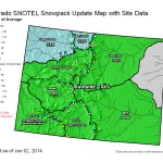
A recent snowpack survey from the Natural Resources Conservation Service — the first comprehensive report for the year — showed that snowpack in the basin was 99 percent of historic average, and collective reservoir storage levels were slightly above normal, at 105 percent of average.
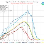
The Colorado River Basin — from which the South Platte basin diverts much of its water supplies, through transmountain tunnels that cross the Continental Divide — had similar numbers. Snowpack for the Colorado basin was 102 percent of average, while reservoir levels were 98 percent of average.
Thanks to significant early season snowfall across Colorado, the state as a whole is enjoying the best start to a winter season since 2011, according to the NRCS report.
From The Denver Post (Kieran Nicholson):
Early winter weather in the Colorado mountains this season has set up the high country’s snowpack to be above average in most basins.
“We had a really good start to the season, with above average snow in October and November,” said Mage Hultstrand, an assistant snow survey supervisor with the U.S. Department of Agriculture Natural Resource Conservation Service.
This time last year, mountain snowpack statewide was at about 70 percent of average. This year, it’s running about 103 percent of average.
“We are pretty much right at normal conditions for this time of year right now,” Hultstrand said.
Following some drought years, and below-normal snowpack percentages, this year’s numbers are much welcomed, Hultstrand said. “Overall, things are looking pretty good.”
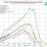
River basins running above average include: Big Thompson, 106 percent; Laramie River, 117 percent; Yampa River, 112 percent; and the North Platte River, 107 percent.
Snow basins below average include: Boulder Creek, 85 percent; and Saint Vrain, 76 percent.
The long-term weather forecast is neutral when it comes to how much snow the Colorado high country can expect through the winter and into the spring, said Jim Kalina, a meteorologist with the National Weather Service.
Long-term forecast models are split on whether the state will get more- or less-than typical snowfall.
“This year, it’s iffy,” Kalina said. “It could go either way.”
Denver Water, which serves about 1.3 million people in the city and surrounding suburbs, depends on mountain snowpack in the Colorado and South Platte river basins.
“We are right on track for this time of year,” utility spokeswoman Stacey Chesney said.
The Colorado River basin is at 105 percent, Chesney said, and the South Platte River basin at 103 percent. Last year at the basins were at 55 and 48 percent respectively.
“It’s too early to predict what it means for 2014,” Chesney said. “We have the full winter in front of us.”
From The Grand Junction Daily Sentinel (Dennis Webb):
Colorado’s best early-season snowpack totals in years have water-watchers grateful, but they’re also anxious about whether a recent drying trend will continue. The state’s snowpack was slightly above average at the beginning of the month in what is the best start to a winter season since 2011, the Natural Resources Conservation Service says. The state was at 103 percent of median snowpack levels as of Jan. 1.
“This is a great start to the 2014 water year. As we saw in 2012 and 2013, early-season deficits are difficult to make up later in the season, so being right where we should be this time of year gives us a head start compared to the past couple of years,” Phyllis Ann Philipps, state conservationist with the NRCS, said in a news release.
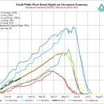
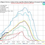
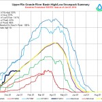
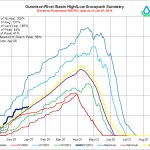
Snow accumulation was above normal from October through early December. Conditions became drier in the second half of December, especially in the southern and southwestern parts of the state. Still, snowpack levels are similar among major river basins, ranging from 111 percent of median in the Yampa, White and North Platte basins to 99 percent in the Rio Grande and South Platte basins. The Colorado is at 102 percent, and the Gunnison at 107 percent.
“It certainly is a great start, the best start we’ve had for quite a number of years,” said Molina farmer and rancher Carlyle Currier.
He said the sizable fall rain helped matters even more by moistening soil before the snow started falling. But while things are looking pretty good for now, he’s a bit worried about the relative lack of snowfall since early December.
“It’s been about a month since any major amounts so we need to keep that (early snowfall) trend going and get some more in,” he said.
Aldis Strautins, a National Weather Service hydrologist in Grand Junction, said the next week holds some promise thanks to a series of disturbances moving through and possibly bringing snow. Snow initially may focus on the central and northern parts of the state, but a system later in the week may dip farther south, which would be good news for a region that particularly has struggled with snowpack levels in recent years.
Late-season snow in 2013 helped save what started out as a bleak snow year for Colorado. But while southwestern Colorado bounced back somewhat, its snow totals still weren’t that great, Strautins said.
“They’re kind of behind the eight-ball this year also,” Strautins said, while emphasizing that it’s still early in the snowpack season.
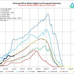
The southern region’s problems are exemplified in its current reservoir storage levels, which are at 64 percent of average for Jan. 1 for the Rio Grande basin; 69 percent for the San Miguel, Dolores, Animas and San Juan; and 67 percent for the Arkansas. The NRCS said heavy precipitation this fall boosted reservoir storage, which is now at 87 percent of average statewide. Storage is at 98 percent of average in the Colorado basin, 80 percent for the Gunnison basin and 118 percent for the Yampa, White and North Platte basins.
At this point, forecasters are predicting spring and summer streamflows of between 90 and 100 percent of normal for the Colorado, South Platte, Yampa, White, and Arkansas River basins. Flows in the Rio Grande, Gunnison and San Juan basins are expected to be anywhere from 80 to 100 percent of average.
So far, this winter is shaping up in line with what Strautins’ Grand Junction colleague, NWS meteorologist Joe Ramey, predicted back in October, with a wet start to the season followed by drying by January if not sooner. That’s based on what’s been common during other winters when neither an El Niño nor a La Niña weather pattern has established itself. Those patterns are linked to equatorial eastern Pacific Ocean water temperatures.
Strautins said that so far, he hasn’t heard of any developments that run counter to Ramey’s early expectations of what the winter might bring. Ramey also speculated that the season could end with a wet March and April.
Currier’s interest in snowpack goes beyond how he makes his own living. He also is involved with water politics and policymaking as a representative on the Colorado Basin Roundtable and the state’s Interbasin Compact Committee. He’s among those keeping a close eye on regional water supply concerns such as the fact that for the first time ever, less water than normal will be released from Lake Powell due to the drought. The reservoir has been dropping fairly consistently over the last decade, Currier said.
“We need to get some replacement” water into Powell, he said.
“We just keep hoping for more snow,” said Currier, adding that while it’s needed from a water standpoint, he’s sure ski areas and recreationists would like more too.
At the same time, Strautins said he knows some people aren’t enjoying all the cold temperatures in the valleys.
“But we’re still getting some snow in the mountains and that’s a good thing,” he said.
From Steamboat Today (Michael Schrantz):
Steamboat meteorologist Mike Weissbluth wrote on Tuesday that four waves should move through the area this week, “with snow in the forecast through next Monday.”
“The first push of energy and moisture moved through on Tuesday night with about 1- 2 inches accumulating at most northern mountains,” Joel Gratz, of http://www.opensnow.com, wrote in Wednesday’s Colorado snow report.
Gratz’s website predicts 2 to 4 inches of snow will fall Wednesday night, 4 to 7 inches Thursday night and 4 to 8 inches on Sunday.
Weissbluth wrote that he expects between 6 to 12 inches of new snow when the Sunday and Monday reports are added…
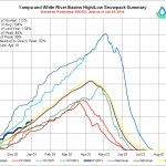
The accumulation this week will help boost the Yampa River Basin snowpack, which has been hovering just above average so far this year. As of Jan. 2, the snowpack for the Yampa/White river basins was 104 percent of average and 133 percent of last year to date…
Across the state, [Mage] Hultstrand said, conditions are near normal levels. And while some southern areas have dried up a little since early December, she said, the northern basins are still looking good. The Yampa/White river basins in particular received some good storms in late December, she said. Hultstrand said she’s cautiously optimistic for the rest of the year.
“It’s still early to make strong predictions,” she said. “Hopefully, these weather patterns keep up.”