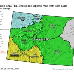
Statewide snowpack map January 8, 2014 via the NRCS
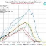
Yampa/White Basin High/Low graph January 8, 2014 via the NRCS
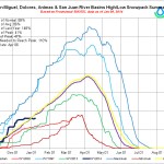
San Miguel/Dolores/Animas/San Juan Basin Hi/Low graph via the NRCS
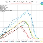
Upper Colorado River Basin High/Low graph January 8, 2014 via the NRCS
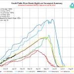
South Platte Basin High/Low graph January 8, 2014 via the NRCS
Arkansas Basin Hi/Low graph January 8, 2014 via the NRCS
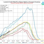
Laramie and North Platte Basin High/Low graph via the NRCS
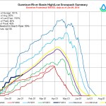
Gunnison Basin High/Low graph January 8, 2014 via the NRCS
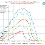
Upper Rio Grande Basin High/Low graph January 8, 2014 via the NRCS
Mage at the NRCS has been really busy today. Click on the thumbnails to view a gallery of snowpack images for January 8, 2014.