
Click here to go to the US Drought Monitor website. Here’s an excerpt:
Summary
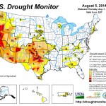
A vigorous monsoon circulation led to heavy rain (locally 2 inches or more) in parts of Arizona and the central and southern Rockies. The rain provided some drought relief, benefited rangeland and pastures, and eased irrigation demands. At times, showers spread as far west as California, resulting in some rare, locally heavy summer rainfall but having little overall impact on the state’s 3-year drought. Moisture also spilled across portions of the central and southern Plains, where interaction with a cold front led to copious rainfall (2 to 6 inches) in Oklahoma and environs. Rainfall totals were much lighter, however, across the majority of Texas. Farther north, however, only isolated showers interrupted an otherwise dry pattern from the Pacific Coast to the northern Plains and western Corn Belt. Despite a July drying trend, many Midwestern crops continued to thrive due to moderate temperatures and adequate subsoil moisture reserves. On August 3, USDA rated nearly three-quarters of the U.S. corn (73%) and soybeans (71%) in good to excellent condition—the highest such ratings this late in the season since 2004. In stark contrast, the return of extremely hot weather to the interior Northwest maintained stress on rangeland, pastures, and rain-fed crops. Elsewhere, locally heavy showers peppered the East, although amounts were highly variable. Some of the heaviest rain fell in the southern Mid-Atlantic States, helping to ease the effects of short-term dryness…California
A strange thing happened on the path to California’s historic drought: it rained. Although the rain’s overall effect on the drought were inconsequential, there were some short-term benefits such as reduced irrigation demands and evaporation rates; lower temperatures in the wake of record-setting heat; and temporary relief for drought-stressed rangeland and pastures. Reasons that California’s rain did not provide substantial drought relief included: 1) a lack of widespread coverage of the heaviest showers, 2) the fact that heavy showers mostly fell outside California’s key watershed areas in the Colorado River basin and the Sierra Nevada, and 3) the fact that the high runoff rate of the heaviest rain did not allow for significant percolation into drought-parched soils. Nevertheless, intense rainfall on August 3 led to memorable flooding on the slopes of Mt. Baldy in southern California. Selected daily-record rainfall totals in California on August 3 included 0.49 inch in Needles and 0.07 inch in Long Beach. Scattered showers were reported in other parts of California on various days. Despite the cooler weather and showers, California’s rangeland condition remained steady (70% very poor to poor on August 3). Similarly, topsoil moisture (80% very short to short) and subsoil moisture (85% very short to short) were unchanged from the previous week. Across the northern tier of California, several wildfires—including the 30,000- to 40,000-acre Eiler and Bald fires—remained active in early August…Northern Plains and Midwest
Spotty showers accompanied below-normal temperatures across the northern Plains and Midwest. Due to persistently cool weather and a lack of heat stress, impacts from short-term dryness have been slow to emerge. Nevertheless, there was some minor expansion of abnormal dryness (D0) and moderate drought (D1) in the southwestern Corn Belt, while a new region of D0 was introduced in northeastern Wisconsin and northwestern Michigan. From June 1 – August 5, rainfall in Traverse City, Michigan, totaled 4.77 inches (71% of normal). Similarly, Green Bay, Wisconsin, netted a June 1 – August 5 total of just 5.29 inches (67% of normal). In Wisconsin, USDA reports indicated that “dry soil conditions and a lack of heat units were keeping corn development behind normal, especially for late-planted fields.” Reports from Michigan echoed those comments: “cool, dry weather in most regions has been a challenge [with respect] to crop development.” In Nebraska, “another week of only scattered rainfall stressed dryland crops and pastures, [while] irrigation continued non-stop in many areas.” North Platte, Nebraska, completed its driest July on record, with rainfall totaling just 0.14 inch (5% of normal) [ed. emphasis mine]. Previously, North Platte’s driest July had occurred in 1901, when 0.34 inch fell. By August 3, topsoil moisture was rated at least one-third very short to short in Missouri (52%), Montana (52%), Nebraska (49%), South Dakota (36%), and Wisconsin (33%). On the same date, nearly one-fifth of the rangeland and pastures were rated very poor to poor in Montana and Nebraska—both at 18%…Northwest
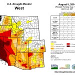
Record-setting heat returned to the interior Northwest, leading to some further increases in drought coverage—mainly in Washington and Oregon. In Washington, Omak posted consecutive daily-record highs (105 and 104°F, respectively) on July 29-30, followed by another record setting high of 100°F on August 2. Wenatchee, WA, also notched a pair of daily-record highs (105 and 103°F, respectively) on July 29-30. Other triple-digit, daily-record highs on July 29 included 105°F in Yakima, WA, and 104°F in Pendleton, OR. Effects of heat and drought were apparent on rangeland, pastures, and rain-fed summer crops. For example, 35% of Washington’s spring wheat crop was rated in very poor to poor condition on August 3, according to USDA. On the same date, 39% of Oregon’s rangeland and pastures were rated very poor to poor. And, topsoil moisture was rated more than half very short to short in Washington (65%), Oregon (62%), and Idaho (56%)…Southern Plains
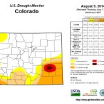
Heavy rain swept across Oklahoma and environs on July 30-31, resulting in modest reductions in drought intensity and coverage. A stripe of 2- to 6-inch rainfall totals stretched across southeastern Colorado, southwestern Kansas, central and eastern Oklahoma, and northeastern Texas, with official, 2-day totals reaching 5.18 inches in McAlester, Oklahoma; 4.02 inches in Paris, Texas; and 2.18 inches in Medicine Lodge, Kansas. Oklahoma’s topsoil moisture was rated 36% very short to short on August 3, an improvement from 47% the previous week. However, the effects of a multi-year drought were still apparent in the fact that, on August 3, subsoil moisture was rated 59% very short to short in Oklahoma, along with 52% in both Colorado and Kansas.Aside from some heavy showers in northern and eastern Texas, significant rainfall largely bypassed the Lone Star State in late July and early August. As a result, both topsoil and subsoil moisture was rated 67% very short to short on August 3, according to USDA. Several degradations in the drought depiction were introduced in Texas, while USDA reported that rangeland and pasture “conditions began to deteriorate in areas of Edwards Plateau due to dry weather.” In addition, some producers in southern Texas “began to provide supplemental feed.”[…]
Southwest
Locally heavy showers associated with the monsoon circulation continued to pepper the Great Basin, Intermountain West, and Southwest, resulting in further improvements to the drought depiction where significant rain fell. Many of the improvements were concentrated across New Mexico, as well as portions of west-central and southeastern Arizona. On August 3, rangeland and pastures were rated 56% very poor to poor in New Mexico and 50% very poor to poor in Arizona. However, those numbers represented improvements from 65 and 56%, respectively, from the previous week. Shower activity continued to bypass many areas in Utah, which topped the Southwestern States on August 3 with 61% of its topsoil moisture rated very short to short. In northeastern Arizona, rain also continued to skirt much of the Navajo Nation and the Hopi Indian Reservation, leading to an increase in the coverage of severe drought (D2)…Looking Ahead
From August 7 – 11, showery weather will gradually shift from the north-central U.S. into the Southeast. Five-day rainfall totals could reach 2 to 4 inches from the southwestern Corn Belt to the Carolinas. Meanwhile, mostly dry weather will prevail across the Great Lakes region and the southern Plains, although generally cool weather in the Midwest will contrast with hot conditions in the south-central U.S. Farther west, monsoon showers will be mostly confined to the northern Intermountain region, although a new surge of moisture may reach the Southwest during the next few days. In Hawaii, the remnants of Hurricane Iselle will pass over or very close to the Big Island during the night of August 7-8. Iselle, expected to be a tropical storm upon reaching the Big Island, could result in torrential rainfall and gusty winds. Effects from Iselle may also reach some of the other Hawaiian Islands, mainly on August 8.The NWS 6- to 10-day outlook for August 12 – 16 calls for the likelihood of below-normal temperatures from the central Plains into the Midwest and Northeast, while hotter-than-normal conditions can be expected across the northern High Plains, Deep South, and much of the West. Meanwhile, near- to above-normal rainfall across the majority of the U.S. will contrast with the likelihood of drier-than-normal weather in southern Texas and from the Pacific Northwest to the northern High Plains.