High Flows Through Grand Canyon National Park Met With Mixed Reactions — National Parks Traveler #ColoradoRiver

Before and after photos of results of the high flow experiment in 2008 via USGS

From National Parks Traveler:

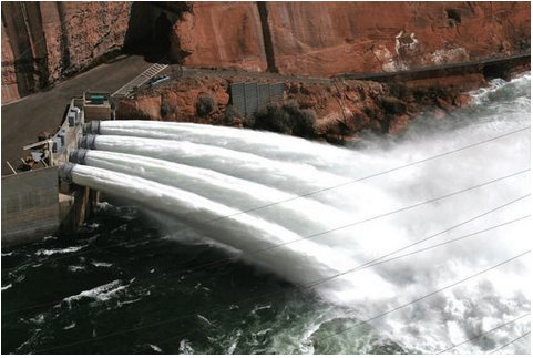
Having peaked on Thursday, high flows of the Colorado River through Grand Canyon National Park will taper back down to normal by Saturday, leaving behind replenished shores, improved fish habitat, and more space for campers. But the benefits will be lingering, according to the Glen Canyon Institute.

While the high-flow experiment, the third in six years, is being applauded by both the Institute and the National Parks Conservation Association, a news release put out by the Institute indicates the experiments are essentially useless in terms of the long-term health of the river as it flows through the national park.

”Once those sediments are redistributed from the channel to the banks, they are immediately attacked by a return to hydropower-driven, fluctuating flows,” said Dave Wegner, a former U.S. Bureau of Reclamation engineer quoted by the Institute. “The result is that instead of protecting and stabilizing the new beaches, the return to normal hydropower-defined operating patterns from the dam act like putting a hot knife into a stick of butter – the sand sloughs off quickly and right back into the river.”

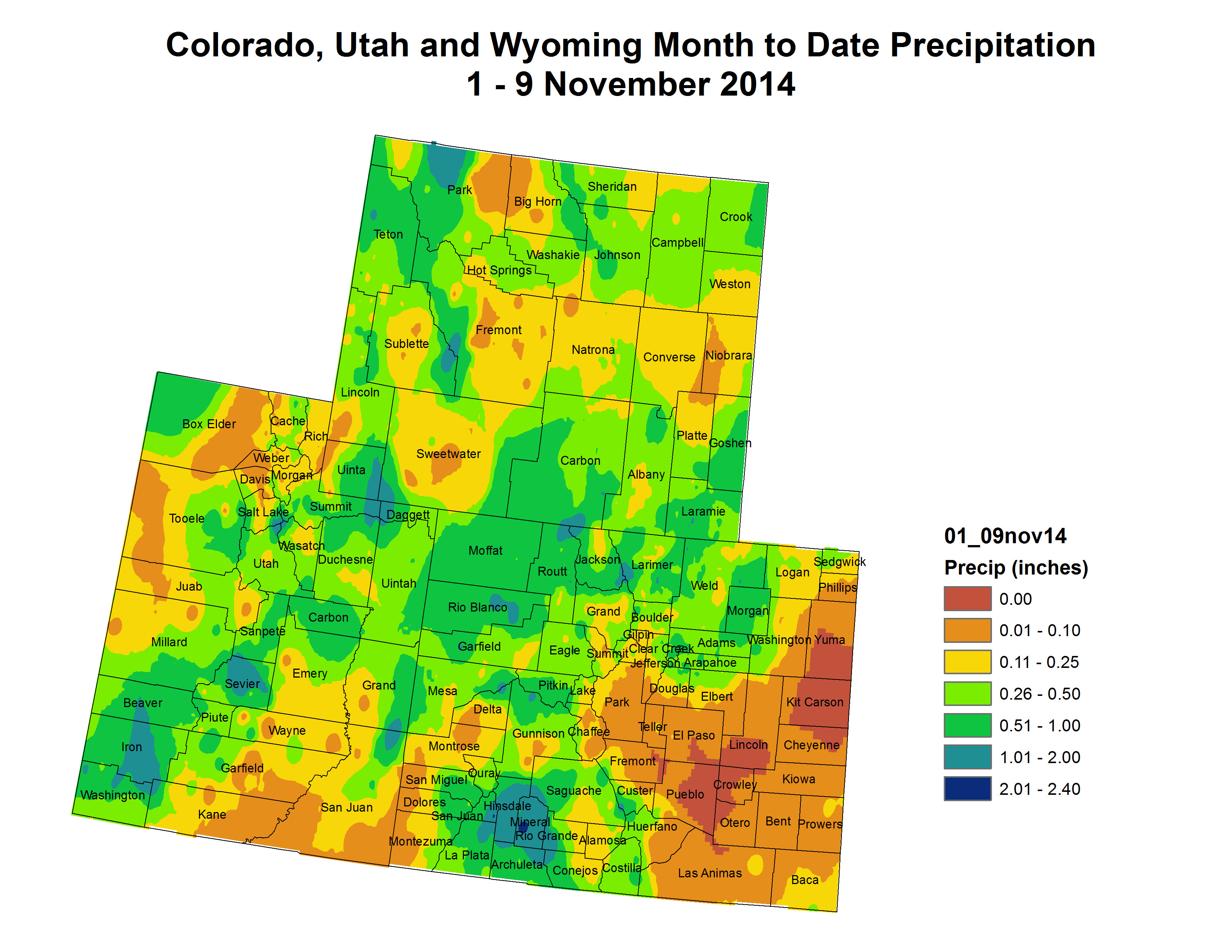
The high-flow releases were to reach a peak volume of 37,500 cubic feet per second on Thursday, and taper back down to normal release rates of between 6,500 CFS and 9,000 CFS by Saturday afternoon. This is the third such experimental release since 2008. The United States Geological Survey estimates that the Colorado River below Glen Canyon Dam only has 6 percent of the sediment that it received before the Glen Canyon Dam was built in the 1960s. This sediment is vital to the health of the Grand Canyon ecosystem. While experimental high-releases provide some relief, the beaches – and consequently the ecosystem – of the Grand Canyon will continue to suffer until there is a systematic change in water management on the Colorado River that significantly increases the sediment flow in the canyon, according to the Institute.

In addition to the detrimental effect of normal releases from Glen Canyon Dam, as much as 95 percent of Colorado River sediment flows are trapped behind the Glen Canyon Dam, the Institute said. After 50 years of sediment trapping, the reality is that the beaches of the Grand Canyon are in a downward decline, it added.

”You can’t cut off 95 percent of the sediment source and expect a sustainable supply for the beaches,” said Eric Balken, program director of Glen Canyon Institute. “These high-flow releases give the public the impression that the Grand Canyon is doing OK. Make no mistake: the Grand Canyon is dying — it is starved of life-giving sediment.”

At NPCA, officials said the high-flow experiment serves as an important measure to support endangered fish and help other natural and cultural resources in Grand Canyon National Park.

“This specially timed ‘high flow’ mimics pre-dam floods and will bring in sediment to build up sandbars along the river’s bank,” said David Nimkin, Southwest regional director for NPCA. “It will provide spawning habitat for fish and other wildlife species, better recreational opportunities for Grand Canyon boaters and other visitors, and keep sacred Native American cultural sites protected from the elements.”

The Department of Interior, which operates Glen Canyon Dam upstream from the Grand Canyon, is releasing the water as part of an experimental protocol resulting from a 2012 environmental assessment. An NPCA release said the goal of the protocol is to continue to fulfill the mandate of the 1992 Grand Canyon Protection Act, which stipulates that Glen Canyon Dam operations adapt with strong scientific research, to better protect the natural, cultural, and recreational qualities of the river within Grand Canyon National Park.

“Grand Canyon National Park is a beloved national treasure, visited by nearly 5 million visitors last year, generating $467 million in economic benefit,” said Mr. Nimkin. “Managing the Colorado River to protect natural conditions in the Grand Canyon makes good ecological and good economic sense.”

Since it was built in 1963, Glen Canyon Dam has regulated the amount of water that flows in the Colorado for its 277-mile stretch through the Grand Canyon. The dam was built to provide an inexpensive source of power for Southwest cities and industry, provide flood control, and store water for farms and communities in the region. Prior to the 71-story dam being erected, the river’s seasonal peak floods averaged over 93,000 cubic feet per second. Since then, the flow of water through the dam’s generating turbines has typically fluctuated between 8,000-25,000 cfs, according to power demand.

Several decades of such highly restricted water flow dramatically altered the conditions of the Colorado River and the canyon itself, prompting Congress to act to protect Grand Canyon National Park.

According to NPCA, Interior Department staff will incorporate data from these experiments, as well as other recent research, in an upcoming management plan that aims to balance the municipal, industrial, agricultural, cultural, recreational, and environmental interests at stake in the Colorado River and the Grand Canyon in years ahead. A draft plan is anticipated to be released for public comment in early 2015.

From the Deseret News (Alex Cabrero):

When construction of the Glen Canyon Dam began in 1956 to store water and generate electricity, it affected the natural flow of the Colorado River through the area and into the Grand Canyon.

This “experimental high-flow release” — the third of its kind in the past three years — is meant to kick up sand and sediment on the bottom of the river and move them downstream.

Scientists with the United States Geological Survey and other agencies say the force from the water will rebuild sandbars, beaches, recreation areas and animal habitat that would have been part of the normal environment if Glen Canyon Dam were never built.

“I wouldn’t judge whether that’s responsible or not, but that it is that you have changed something,” Tucker said. “Experiments like this are ways to find a meaningful way to restore or preserve that ecosystem downstream.”

Fifteen-thousand cubic feet of water per second is flowing out of the dam into the Colorado River.

To put that in perspective, a basketball is about one cubic foot. That means roughly 15,000 basketballs are being released out of the dam every single second.

“It’s something that is very visually striking to see,” Tucker said.

Releasing so much water doesn’t impact drought conditions, he said.

“The same amount of water is going to be released from Glen Canyon Dam throughout the year, so since this is a higher-flow period, obviously with the experiment that is here, that will be compensated for in other months where there will be less water that will go through the dam,” Tucker said.

This is the third in a five-year plan to conduct experimental high-flow releases.

More Colorado River Basin coverage here.

Pitkin County: The Colorado River District, et al., to appeal recent water court decree for Busk-Ivanhoe Ditch

From The Aspen Times (Brent Gardner-Smith):

Pitkin County, the Colorado River District and the Grand Valley Water Users Association have each filed an appeal with the Colorado Supreme Court over a recent Water Court decree setting the size of a diversion from the headwaters of the Fryingpan River. The decree gives Busk-Ivanhoe Inc., an entity owned by the city of Aurora, the right to divert an average of 2,416 acre-feet of water a year from four high-mountain creeks for use within Aurora’s water-service area east of Denver.

But the appellants want the high court to review how Water Court Judge Larry C. Schwartz calculated the historical use of the 1928 water right and then used the answer to define the size and scope of Aurora’s new right. At issue is whether the period from 1987 to 2009, when Aurora was admittedly using water from the Busk-Ivanhoe system for municipal purposes without a decree to do so, should be included in a representative study period of use.

The original 1928 decree for the Busk-Ivanhoe water right only allowed the water to be used for irrigation in the lower Arkansas River Valley.

Pitkin County Attorney John Ely said if the 22 years of undecreed use at issue is factored in, Aurora’s new right might be half the size of the one approved by the judge.

The state engineer and three division engineers, who enforce water-right decrees, also have appealed the judge’s decision.

“The engineers believe that ‘undecreed’ use is equivalent to no decreed use, and that a calculation of average annual historical use must include the 22-year period during which there was no decreed use,” the appeal from the state engineer states.

But the judge sees it differently.

“In the circumstances of this case, including the years after 1986 in the study period but attributing zero diversions to all such years is not necessary to protect junior water rights from injury,” Schwartz wrote.

Aurora, which began buying Busk-Ivanhoe irrigation water in 1987, filed documents with the Water Court in 2009 to change the use of its water from irrigation to municipal uses.

In July 2013, a five-day trial was held in Pueblo. Schwartz issued a substantial ruling on May 27. On Aug. 15, he issued a decree defining the water right.

In early October, the four appeals were filed with the Supreme Court, which directly hears appeals from Water Court. Opening legal briefs are expected by mid-February.

High-mountain water

Busk-Ivanhoe Inc. owns half of the roughly 5,000 acre-feet diverted by the Busk-Ivanhoe system each year. The other half is owned by the Pueblo Board of Water Works and is not at issue in the case.

Busk-Ivanhoe has the right to divert 100 cubic feet per second of water from Hidden Lake Creek, 50 cfs from both Pan Creek and Lyle creeks and 35 cfs from Ivanhoe Creek. A 21-foot-tall dam on Ivanhoe Creek forms Ivanhoe Reservoir, and a 30-inch pipe carries water for 1.3 miles under the Continental Divide near Hagerman Pass. Water exits the pipe, runs down Busk Creek to Turquoise and Twin Lakes reservoirs and then is moved to Aurora.

The new decree would allow Aurora to divert as much as 144,960 acre-feet of water over a 60-year period, at an annual average of 2,416 acre-feet.

Joining the Colorado River District in its appeal is the Basalt Water Conservancy District and Eagle County, and joining the Grand Valley Water Users Association is the Orchard Mesa Irrigation District and the Ute Water Conservancy District.

Those entities also question the judge’s decisions regarding the storage of Busk-Ivanhoe water on the Front Range, which has been done for decades without a decreed right.

Schwartz said even though the original decree was silent on the subject of storage, it was always the “intent” of the water developer to store the water on the Front Range.

He also found that storing the Busk-Ivanhoe water without a decreed right after it had been moved under the Continental Divide “did not cause an injurious expansion or alteration of stream conditions” in the Colorado River Basin.

The appellants disagree.

“We feel the Water Court’s rulings were erroneous and would set a dangerous precedent of holding transmountain diverted water rights to different requirements as in-basin rights when it comes to decree and decree-change calculations,” said Eagle County Attorney Bryan Treu. “There should not be separate rules for transmountain diversions.”

Greg Baker, manager of public relations for Aurora Water, said Aurora officials couldn’t discuss the litigation.

Aspen Journalism is an independent, nonprofit news organization collaborating with The Aspen Times on coverage of rivers and water. More at http://www.aspenjournalism.org.

More water law coverage here.

Colorado’s Water Plan: Hickenlooper to receive draft after re-election…and a reminder of why the plan matters to us

It’s interesting the the Colorado Water Plan conversation is dominated by transmountain diversions. Those basins that don’t have any more water to develop believe that there is available water in the Colorado River Basin. People in the basin not so much.

Snowpack news: Some improvement but most basins tracking near minimum/2002

Numbers are up except Laramie and North Platte with a slight decline. All the graphs are near the 2002/minimum for that day. It’s early, thankfully.

Snowpack news: Where’s Ullr? Laramie/North Platte best in state = 53% of normal

Snow dances are in order.

Water Lines: Resilience in the face of Colorado’s water stress #ColoradoRiver

Colorado River Basin including out of basin demands -- Graphic/USBR
Colorado River Basin including out of basin demands — Graphic/USBR

From the Grand Junction Free Press (Hannah Holm):

On Nov. 5-6, water experts from around the West gathered at Colorado Mesa University for the fourth annual Upper Colorado River Basin Water Forum. The theme was “Seeking a resilient future,” and the speakers offered rich food for thought on that topic.

The complexity and scale of the water challenges facing the Colorado River Basin is daunting. We face an uncertain climate future, almost certainly hotter and possibly drier. Demands in the basin have already exceeded supplies, leading to headline-making bathtub rings on Lakes Powell and Mead.

From Wyoming to Mexico and Colorado to California, ranchers, river rats and city slickers are bound together by mutual dependence on the Colorado River and its tributaries. At the same time, we are separated by diverging interests and separate sets of laws and jurisdictions.

How then could it be possible to make the collective decisions needed to manage water in ways that enable the environment and the communities across the basin to endure? It is far from a given that this will happen, but the speakers at the forum did offer some grounds for hope. The keys? Embrace uncertainty, learn by doing, and harness the complexity of the system to implement creative solutions. And play well with others.

Laurna Kaatz, the climate science, policy and adaptation program manager for the Planning Division at Denver Water, talked about embracing uncertainty. She spoke about the need for water utilities to identify their vulnerabilities and work to enhance the flexibility and adaptive capacity of their systems.

Kaatz also spoke of the need to keep up to date with climate science and the human factors driving water use, themes echoed by officials describing the state water planning efforts in Colorado, Wyoming, Utah and New Mexico. All of these states recognize the need to regularly update their plans to reflect new science, new hydrology and new patterns of use.

“Learning by doing” was a major theme of a panel on efforts to restore streams damaged by transmountain diversions in Grand County, Colo. This means that water and engineering will be applied according to what current science indicates will benefit the streams, but that all parties agree to monitor actual progress and change strategies as needed. It’s another way of embracing uncertainty, and committing to work together over the long haul to adapt as conditions change.

Colorado River management is certainly complex, with two national governments, seven U.S. states, two Mexican states, and multitudes of water management districts, associations and authorities directly involved, as well as many advocacy groups weighing in on what should be done.

The spring 2014 release of water to reconnect the Colorado River to the Sea of Cortez in Mexico demonstrated the tangible results of harnessing that complexity to bring ecological benefits even during a drought. The release was actually only one part of a very complex international agreement (known as Minute 319) to share surpluses and shortages across the border. It was possible because of both the determination of environmental advocates and the opportunity for win-win deal making on a system with multiple reservoirs, delivery systems and users with diverse needs for the timing and scale of water storage and use.

In the vast, interconnected Colorado River system, the ability of scientists, water managers and citizens to learn from each other and negotiate in good faith will be key to the resilience of the whole region.

If you’d like to learn more about the topics discussed at the forum, check out the Water Center at CMU’s website: http://www.coloradomesa.edu/WaterCenter. The full program is posted there, and presentations will be posted shortly.

Pueblo County green lights hydroelectric project at Pueblo Dam

The new north outlet works at Pueblo Dam -- Photo/MWH Global
The new north outlet works at Pueblo Dam — Photo/MWH Global

From The Pueblo Chieftain (Chris Woodka):

A project to add hydropower to the north outlet at Pueblo Dam has gotten an initial OK from Pueblo County. The county planning department recommended a finding of no significant impact for the project under its 1041 permit process. The FONSI is issued if a project is not expected to have significant social, economic or environmental impact to the county.

Pueblo County commissioners heard the report Monday.

The permit is named for the 1974 HB1041 that allows cities and counties to regulate projects with statewide impact.

The Southeastern Colorado Water Conservancy District, Colorado Springs Utilities and Pueblo Board of Water Works are partners in the project.

The hydropower plant would generate 7 megawatts of electric power and cost about $20 million. A loan will be sought in 2015 through the Colorado Water Conservation Board to finance the project.

In September, the Southeastern board heard an update on the project, and learned it would be at least 2018 before power is produced.

The outlet was modified during construction of the hook-up for the Southern Delivery System, the $841 million pipeline being built by Colorado Springs.

It also provides the primary flow to the Arkansas River and can be modified in the future to cross-connect with the south outlet, which serves Pueblo, Pueblo West, the Fountain Valley Conduit and the future Arkansas Valley Conduit.

The project partners are negotiating about who would purchase power generated at the dam.

More Southern Delivery System coverage here.

Get the facts on the U.S. & China’s new commitments to reduce carbon pollution

Weekly Climate, Water and Drought Assessment of the Upper #ColoradoRiver Basin

Upper Colorado River Basin November month to date precipitation November 9, 2014

Click here to read the current assessment. Click here to go to the NIDIS website hosted by the Colorado Climate Center.

Southwest Roundtable to hold 4 meetings about their basin implementation plan #COWaterPlan

Basin roundtable boundaries

From The Durango Herald:

Four meetings on the Southwest Basin Implementation Plan, part of a statewide effort to resolve water shortages, to be unveiled next month, start next week.

Members of the public can learn about draft plans and offer opinions to water authorities.

The Southwest basin contains nine subbasins from the San Juan River to the Dolores and San Miguel rivers.

The meetings are scheduled from 6 to 8 p.m. on Nov. 17 at the Ross Aragon Community Center, 451 Hot Springs Blvd., in Pagosa Springs; Nov. 19 at the Pine River Senior Center, 111 West South St., in Bayfield; Dec. 1 at the Mancos Community Center, 117 N. Main St., in Mancos; and Dec. 9 at the Placerville School House, 400 Front St., in Placerville.

Further information is available from Ann Oliver at 903-9361 or Carrie Lile at 259-5322.

WRA: A New Paradigm for Water Management – Managing a Cycle of Water, Energy and Resources

From Western Resource Advocates (Amelia Nuding):

1. Get rid of the term “end user.” “End user” is a term commonly used by water managers to describe the people and businesses who use water for drinking, washing, industrial operations etc. “End use” implies that delivering water to people is the “end goal.” However, a quick look at a diagram of the urban water cycle (below) clearly shows delivering water to people is not at the end. This stage is right in the middle of a cycle that repeats several times. Now, I’m not just being nit-picky, or demonstrating my mastery at reading a flow chart: the problem with the term is that it’s the wrong way to think about water. It places the emphasis on delivering water to people, and, while that’s clearly very important, urban water management should focus on more than delivering water.

Urban Water Cycle graphic via Western Resource Advocates

2. Capitalize on the fact that water management is energy management. Energy generation should be co-equal goal in water management. Water has energy whenever it its flowing downward (kinetic and potential energy), whenever it contains heat (thermal energy), and whenever it becomes sewer water (chemical energy). Capturing that energy means that water can play a bigger part in our energy generation mix – not just hydroelectric dams at huge reservoirs, but in the pipes and conduits where water is regularly flowing. For example, when water pressure is too high, often a pressure regulator is used to reduce it. In many cases a small hydro turbine can do the same job as the pressure regulator and generate electricity at the same time. The heat from hot water, such as when your shower water flows down your drain, can actually be captured and put back into your water heater, reducing your energy usage and bill.

Water utilities – and especially wastewater utilities – need to see themselves as players in energy. A handful of wastewater treatment plants in the U.S. are leading the way in this, striving to achieve net-zero energy – meaning they produce as much energy on-site as they generate annually. East Bay Municipal Utility District in California actually produces more energy than they use in a year! They capture the energy in the water with hydro turbines, and they also capture energy from the biosolids (yes that’s what you think it is) extracted from wastewater. Those biosolids – along with used food scraps collected from restaurants – decompose in a controlled environment. This process creates gases that are used to spin a turbine, which then creates electricity. So not only is energy generated, but food scraps (a significant part of municipal solid waste streams) are used beneficially, rather than just decomposing in a landfill.

3. Eliminate the term “wastewater.” This term is even more offensive because “wastewater” contains approximately 10x the amount of energy that is used to treat it to drinking water standards (says WERF). WOW. The energy in the water is part thermal, part kinetic, and part chemical – and enough of it can be captured to partially or entirely offset the energy demands of the wastewater treatment plant. So let’s start calling water at this stage of the cycle “resource water.” Got a better name? Email me. It needs to be something that communicates its value, and that the water at this stage is not something to be wasted.

So what this all boils down to is that water management shouldn’t be just water management – it can be about a cycle that address multiple resources. We’ve already got the technology to do it, what’s needed now is an expanded way of thinking about all the resources that water provides, and the roles that water managers can play. It’s about managing water, energy and resource systems in the water cycle to support a community’s higher quality of life.

Results from Wyoming’s cloud-seeding efforts expected next month #ColoradoRiver

Cloud-seeding graphic via Science Matters

From the Casper Journal (Greg Fladager):

Wyoming’s $13 million cloud seeding experiment may be about to pay off, or at least further knowledge in the science of rainmaking.

In a talk to the Wyoming Water Association last month, Wyoming Water Development Commission Director Harry LaBonde, Jr., said the results of over eight years of study would finally be released this December.

“All I will tell you about the results is that it appears that it is positive,” LaBonde told the group in Casper. “Of course what we want to know is, what can you anticipate with winter orographic seeding? Is that a 2 percent increase in precipitation? Is that a 10 percent increase in precipitation, or what can you expect?”

Broad interest

LaBonde said Wyoming’s experiment has drawn regional as well as international attention.

“Everybody wants an answer to the question that we have been asking, and so you are going to see a lot of interest. It will then hopefully be considered and utilized in other states across the West, as well as other operations across the world,” LaBonde said.

The cloud seeding program was conducted in the Medicine Bow/Sierra Madre Mountain Range in southern Wyoming. The study was based on eight snow generators placed in two closely related areas, and in double blind experiments data gatherers were not told which valley had been seeded for a given seeding event.

“The last data collection was last spring. It ended in April, representing about eight years of data collection,” LaBonde said. “We went through some drought years which limited seed-able events. But last year was a very good year. We had about 30 seeding events last year. We ended up with a total of about 160 events over the period of time. That was determined to be a suitable amount of events that … we can make a good scientific conclusion of does weather modification work? Is there an increase in precipitation when you are seeding these mountains with silver iodide, which is the product that we have been using.”

“So, with that data complete, the scientists have been poring over that — we certainly have issues with data quality and some of that, they’ve been looking at all of those issues — but what we hope to have, and what is on the schedule now, is their final report by December of this year,” LaBonde added. “It is our hope that in fact that schedule will be kept, and that document will become public information.”

Wyoming Range and Wind River seeding projects

In the meantime, Wyoming has two other cloud seeding experiments and operations.

“Another weather mod item in Wyoming is that we funded, last year, a Level II weather modification study in the Wyoming Range,” LaBonde said. “I think a lot of you know that Idaho Power runs a very active weather modification (program) out of the Star Valley, and some (of those) seeding effects do roll over into the Wyoming Range. But we wanted to take a more thorough look at what we might be able to do if we are going to set up an operational program in the Wyoming Range. Where might you site those generators? What kind of benefits would accrue to the Colorado River drainage on the East slope of those mountains, as well as the Snake River on the backside (and) the West side of those mountain ranges? So that study is underway. We expect to have the results of that next summer. That was the continuation of what was in essence a Level I study that was started in 2008, completed and then put on the shelf pending the outcome of our scientific programs.”

Moving from study to operations

LaBonde also announced that the WWDC was successful in its effort to get funding to continue cloud seeding in the Wind River Range, and changing (operations) from a scientific study to an operational program.

“The proposal that Water Development put forth to the legislature last year was that we wanted to keep those 10 generators in operation. We wanted to shift from scientific to an operational mode,” LaBonde explained. “However, we did not feel that all of the costs should be borne by the state of Wyoming. The Green River has not appropriated water. Those waters flow out-of-state, and ultimately benefit the lower basin states. So the proposal that was put forth is that Wyoming would pay for 25 percent of the cost of the operation of those generators, but we were required to go forward and seek funding partners from other states to pay for 75 percent of the program.”

Funding buckets

“I’m happy to report today that, in fact, we have achieved the outside funding sources that were required as part of that bill, as a result we will have an operational seeding program run in the Wind Rivers this year,” LaBonde said.

“The funding partners that we’ve put together are: the Arizona Department of Water Resources; Central Arizona Water Conservation District: the Six Agency Committee, which is a group of agencies in California; Southern Nevada Water Authority; Utah Division of Water Resources — of course the Green River flows into Utah, and I think that was a little bit of a surprise that they came forward and wanted to help with the funding; the Bureau of Reclamation has stepped up and it is funding, in essence, the forecasting part of our programs. They’ve got a direct contract with NCAR (National Center for Atmospheric Research), and that outside funding source is $684,000. The respective Wyoming share is $28,000. There will be seeding in the Wind Rivers again, subject to appropriate storms coming across. We’ll start in November, and run into the April season, LaBonde said.”

Augmenting water

LaBonde further noted that he viewed the Wind River Range project as a first step in ‘water augmentation’ in the Colorado River Basin.

“With the ongoing drought in the Colorado River Basin — we have dropping lake levels in Powell and Mead — we thought that maybe, even though we did not have the results of the scientific study, it was appropriate to look at continuing those generators, but moving from a scientific to an operational program.”

“Colorado has a weather modification program. So does Utah. But how do we bring the lower basin states into that program?” LaBonde continued. “I know there are some committees that have been formed, they are talking about that. But with 10 generators in place last year, it was too good an opportunity to go forward — at least for a one-year program — and we, again my hope is, it is going to morph into a more basin wide program.”

LaBonde concluded he was optimistic about cloud seeding expanding to other mountain ranges in the state.

“All in all, I think it’s good news,” LaBonde said. “Finally, there’s some pieces that are going to fall into place with our scientific study coming out. Then hopefully we will see some more operational programs going forward in the future.”

More cloud-seeding coverage here and here.

Sterling water treatment system wins award — Sterling Journal Advocate

Reverse Osmosis Water Plant

From the Sterling Journal Advocate (Sara Waite):

Last week, the American Council of Engineering Companies of Colorado announced the project was one of four to receive a 2015 Engineering Excellence Award for “outstanding engineering accomplishments.”

The water treatment system came online about a year ago, five years after city received an enforcement order due to levels of uranium and trihalomethanes above the drinking water standard allowed by the Environmental Protection Agency. To address that issue, as well as high levels of sulfate and total dissolved solids, the city opted to construct a new reverse osmosis water treatment plant. The plan featured a challenge because of the uranium — the result of runoff over naturally occuring uranium deposits upstream — that would end up in the treatment brine.

Engineers with Hatch Mott MacDonald came up with a solution: coupling the reverse osmosis system with EPA Class 1 deep injection wells to dispose of the waste water.

“The result enabled the city to meet its water quality goals to provide 14,000 residents with safe, clean and aesthetically pleasing drinking water — and building a 9.6 million gallon per day water treatment plant without incurring the costs and risks associated with the disposal of uranium contaminated waste,” the award announcement states.

The 7,000-plus foot wells pump the contaminant deeper than water that is used for drinking water.

The project was funded with a voter-approved $29 million loan from the Drinking Water Revolving Fund through the Colorado Resources and Power Development Authority.

City Manager Don Saling called the award “quite an honor for the engineers.” He added that the well drilling company has asked to use the wells for a case study.

He said the water treatment system was an example of a “great plan” using “great technology.”[…]

According to the ACEC-CO release, the winning projects are ranked by a panel of judges representing a cross section of industry, academia and media, assemble to rank the submissions on engineering excellence. Projects in the competition are rated on the basis of uniqueness and innovative applications; future value to the engineering profession; perception by the public; social, economic, and sustainable development considerations; complexity; and successful fulfillment of client/owner’s needs, including schedule and budget. The other projects receiving top honors were the Denver Union Station Redevelopment, new Transit Center, and Pecos Street over I-70 Bridge Replacement.

2015 Engineering Excellence award-winning projects will advance to ACEC’s national competition in Washington D.C., which will be held in April next year.

For more information, visit http://acec-co.org.

More water treatment coverage here.

Whither El Paso County’s stormwater efforts now?

From the Colorado Springs Independent (J. Adrian Stanley):

Last week, voters turned down the Pikes Peak Regional Drainage Authority, to be funded by nearly $40 million a year in fees, despite a series of devastating floods in the area and concerns that a lack of stormwater maintenance could put Colorado Springs Utilities’ $841 million Southern Delivery System pipeline project in jeopardy.

“I wasn’t surprised,” Small says of the 53-percent-to-47-percent defeat. The public is resistant to taxes in general, he says, but there’s also the feeling that stormwater really shouldn’t be its problem, because developers should have installed adequate systems in the first place. And for most of the city, stormwater isn’t a problem. Floods tend to concentrate in certain neighborhoods.

“It’s all localized issues,” Small says, “and unless you experience those issues, you don’t relate to the need to manage that stormwater.”

The leading candidates in the April city mayoral election agree that stormwater will need to be addressed with new taxes or fees, and that the key will be communicating better with voters.

El Paso County Commissioner and mayoral candidate Amy Lathen says she sees no reason to throw away two years of work that went into the Authority proposal, including public input, engineering studies and project lists. Lathen was a key player in putting the Authority forward, and she stands by the proposal. But she says the ballot question was only approved a month before the election, leaving little time for a campaign, and misinformation was widespread.

Lathen wants to keep the task force that created the Authority proposal, but explain that proposal more clearly and tweak it to make it more palatable. She also says the task force needs to better explain that while stormwater may not flood your backyard, it can threaten the bridges you drive over daily, or even put access to clean water at risk.

Former mayor and current candidate Mary Lou Makepeace feels similarly. One difference: While Lathen says the plan and money must be regional, Makepeace is willing to consider setting aside city funds for stormwater, though she calls that option undesirable because it could mean cutting back on other city services. Like Lathen, she’d also like to try again for a regional solution, this time with better communication…

Outgoing Colorado Attorney General and mayoral candidate John Suthers, who also prefers a regional solution, says he feels a measure could pass if leaders explain to voters that stormwater infrastructure affects the economy. As attorney general, he says, he was contacted by representatives of major companies “that everyone would recognize” who said they had long considered expanding into the Springs but were dissuaded by political turmoil and poor infrastructure. He says Mayor Steve Bach should have been involved in the Authority early on, and then used his position to champion it. Not doing so, he says, echoing the other candidates, was a “failure of leadership.”

Bach, who has not yet said whether he will run again, has his own plans for stormwater. He hopes to pass a funding mechanism, perhaps a sales tax, that would pay for city infrastructure, including stormwater improvements.

Whether a stormwater program in the Springs is a requirement to operate the Southern Delivery System in early 2016 is debatable. John Fredell, SDS program director, says the permits for the projects only refer to containing additional water, which he says should be fully controlled by new drainage requirements the city set. He notes that Colorado Springs Utilities is committed to spending more than $100 million to repair and protect utility infrastructure from stormwater damage and flooding, and is on track to do so.

But Terry Hart, Pueblo County commissioner and the Pueblo County representative on the Fountain Creek District board, says stormwater work is a requirement of the permits. Pueblo County was meeting with lawyers on Monday, Hart says, to decide what legal action to pursue. That action could include suing to prevent the operation of SDS until a stormwater system is in place.

In a statement to the Independent, influential Pueblo Chieftain publisher Bob Rawlings said, “Colorado Springs and its voters have not been supportive of finding and funding solutions for flood control on Fountain Creek throughout the discussions about Southern Delivery System. It should not have been built and should not be turned on until those questions are answered.”

More stormwater coverage here.

#COWaterPlan moving along #ColoradoRiver


from The Durango Herald (Dale Rodebaugh):

As it stands, Colorado no longer has enough water to satisfy unlimited wants of growing Front Range urban areas, farmers and ranchers and environmental and recreational interests – not to mention states with legal rights to Colorado water, they said.

There is still time to reach compromises, which is the reason the Colorado Water Plan is vital, said Bart Miller, water program director with Western Resource Advocates, Amelia Whiting, the Colorado Water Project counsel with Trout Unlimited, and Katie Greenberg, the Western contact for the Young Farmers Coalition.

Whiting is a member of the Southwest Basin task force, which has scheduled four public meetings in Southwest Colorado during the next two months to educate residents on the issues.

The first draft of the plan – the result of an executive order by Gov. John Hickenlooper last year – is expected to be unveiled in December. Each of seven major basins in the state is defining goals.

“As the plan rolls out, it’s conceptual at this time,” Miller said.

Certain issues are flash points.

Nothing raises hackles on the Western Slope as quickly as talk of transmountain diversions, a fancy way of describing the emptying of Western Slope water sources to support the Front Range, where most urban growth is occurring.

Miller said Front Range basins have not committed to specific targets.

The three stakeholders said urban water conservation, advanced agricultural practices, recycling, storage projects and soil stewardship can play a role assuring everyone of water.

If enough moderate measures are taken, large transmountain diversions won’t be necessary, Miller said.

Miller said major changes may well require legislative action.

Pueblo Board of Water Works raw water lease revenue = $9 million

Pueblo photo via Sangres.com

From The Pueblo Chieftain (Chris Woodka):

Pueblo Water’s role as a water broker has kept customers’ rates the lowest among major Front Range cities.

In next year’s $35.9 million budget, about $8.9 million of $33.1 million in operating revenue will be generated from raw water leases, according to projections studied this week at a workshop with the Pueblo Board of Water Works.

“It’s becoming a greater percentage of the budget,” said Seth Clayton, director of administrative services.

That, along with deeper spending of reserves, is keeping Pueblo water rates the lowest among major Colorado cities.

Water rates are on course to increase 3.25 percent next year, and the decision will be finalized after a public hearing at 2 p.m. Nov. 18. The increase will amount to about $1 per month in the typical bill.

Even with that, Pueblo’s rates will remain less than half of Colorado Springs or Aurora, and lower than Denver, the only large city that comes close to the level.

At the same time, Pueblo customers have reduced average household consumption to an average 114,400 gallons per year in 2014, about 20 percent less than in 2005. Part of the decrease was due to a rainy summer, but Clayton noted there is a declining trend to water usage that has continued since the drought of 2002.

Next year’s budget assumes a slight increase in usage, with an average of 117,000 gallons per household. A total of about 8.12 billion gallons is expected to be consumed.

The board also reviewed a projected decline in operating capital from $17.9 million in 2014 to $9.6 million in 2012. Clayton explained the decrease is expected in order to service debt, which will cost about $5.22 million next year. Much of the debt was assumed with the purchase of Bessemer Ditch shares in 2009.

At the same time, Pueblo Water will begin to increase its water development fund with contributions from some of the lease revenues. Contributions to the fund were halted for several years in order to repay debt. Next year, the fund is expected to grow by $1.02 million.

Major expenditures include $3.26 million for utilities (mostly electricity), $1.73 million for outside services, $1.65 million for repairs or maintenance, $807,000 for water rights maintenance, $764,000 for chemicals and $220,000 for gas and oil.

Employee salaries and benefits will increase 2.5 percent.

More Pueblo Board of Water Works coverage here.

Experimental High-Flows from Glen Canyon Dam Benefits Important Phys. and Bio. Resources #ColoradoRiver

November 2012 High Flow Experiment via Protect the Flows

Here’s the release from the US Bureau of Reclamation (Matthew Allen):

The Department of the Interior initiated its third high-flow release from Glen Canyon Dam today under an innovative science-based experimental protocol. The goal of the releases is to help restore the environment by creating flood-like conditions below Glen Canyon Dam, which rebuild sandbars that are important habitat and recreational resources.

During the 2014 high-flow experiment, or HFE, high volumes of water will be released through Glen Canyon Dam’s powerplant and four outlet tubes. The duration of the peak release of approximately 37,500 cubic-feet-per-second will be 96 hours. The annual release volume from Lake Powell will not change as a result of the 2014 HFE, no additional water will be released.

“Dams have impacts, but as we have learned over the last 50 years, we can operate Glen Canyon Dam in ways that both meet our demands for water and hydropower, but also achieve our goals for natural resources and recreation,” said Deputy Commissioner for Operations Lowell Pimley.

Similar experimental releases have been conducted over the years. The releases include continued scientific research, monitoring, and data collecting along the Colorado River between Glen Canyon Dam and Lake Mead, while continuing to meet water delivery and hydropower needs. These successful experiments were the result of extensive collaboration among various agencies of the Department of the Interior, including the U.S. Geological Survey’s Grand Canyon Monitoring and Research Center, Bureau of Reclamation, National Park Service, U.S. Fish and Wildlife Service and the Bureau of Indian Affairs, as well as the Colorado River Basin States.

The HFE protocol is part of the Department’s efforts to improve conservation of limited sediment resources in the Colorado River below Glen Canyon Dam. It is intended to improve understanding of how to better distribute sediment to conserve downstream environmental resources by allowing for multiple high-flow tests through 2020, while still meeting needs for water delivery and hydropower generation.

More Colorado River Basin coverage here.

Snowpack news: “It’s across the board pretty bare…And it’s more than just western Wyoming” — Bob Comey

Upper Colorado River Basin October 2014 precipitation as a percent of normal via the Colorado Climate Center

From WyoFile (Kelsey Dayton):

On Nov. 6, Bob Comey, director of the Bridger-Teton Avalanche Center, checked the center’s forecasting cameras and monitors making sure they were ready to go, while scouting the snow in the area.

The ground was clear on aspects below 9,000 feet and on sunny landscapes above 9,000 feet. Only a couple of inches of snow has accumulated on north faces at the high elevations.

“It’s across the board pretty bare,” he said. “And it’s more than just western Wyoming.”

Comey noted that few forecasters across the region were reporting much snow as of the first week of November.

The center starts its daily forecasts once there’s enough snow to warrant worry about avalanches, although it does provide weekly snowpack summaries. In the last 14 years, the latest it’s ever started forecasting was Nov. 17 — that was in 2008. It’s begun regular forecasts as early as Oct. 25 in 2010. As of Nov. 6, Comey wasn’t sure when the center would need to start forecasting this year, but thought it could be a while. There wasn’t much snow predicted for northern Wyoming in the next 10 days.

“But that can always change quickly,” he said. “A week of steady snowfall could change the whole story.”

Parts of Wyoming did experience early season storms that were then followed by warm spells melting most of the snow other than that on the very high north-facing mountainsides, Comey said…

“Everyone should want snow,” [Jim] Woodmencey said. “More snow means more water for the rest of the year.”

Volunteers work on South Arkansas riparian corridor — The Mountain Mail #ArkansasRiver

Graphic via the Upper Arkansas Water Conservancy District

From The Mountain Mail (J.D. Thomas):

The South Arkansas River riparian corridor in Poncha Springs received a facelift from 25 volunteers during a volunteer workday Friday.

Volunteers, along with students from Salida Middle School and Longfellow Elementary School, dug holes and planted willow, alder and chokecherry close to the river, while further away juniper and pines were planted as part of a riparian buffer.

“In a year or so, this will all look a lot different,” Andrew Mackie, executive director of Land Trust of the Upper Arkansas, said.

Along with removing brush, volunteers removed old car bodies from the banks of the river. Mackie said in the 1960s and 1970s putting car bodies on riverbanks was a practice used to prevent erosion.
Mackie said a steel deck also was removed on the 1,100-foot stretch of riverbank, all of which lies on private property.

Part of the rehabilitation involved creating eddies, which help trout catch food in pockets on non-rapid water, he said.

“The trout can sit in the eddy,” Mackie said. “The food flows into the eddy, which allows the trout to get the food without using a lot of energy.”

One of the property owners is Fred Klein, who said he comes from a family where fishing and the river are important. His father was a fish biologist, Klein said.

Klein said he got involved in the Murray Ditch, which he said brought water access to people without damaging the habitat. “It got me going in habitat rehabilitation,” he said.

“Logs which were used on the banks were locally sourced from property owners along the river,” Klein said.

The section of the river volunteers were working on was near the intersection of Chipeta Avenue and Shavano Street.

The estimated cost of the project when completed will be around $20,000, said Mackie.

The project is being conducted in conjunction with Land Trust of the Upper Arkansas, Collegiate Peaks Anglers Chapter of Trout Unlimited, Trout Unlimited, Colorado State Forest Service and other volunteers. Butala Sand & Gravel donated 142 tons of rock for the project.

Mackie said people who want to donate can send checks to SWAC, c/o LTUA, P.O. Box 942, Salida, CO 81201, or call 539-7700.

More Arkansas River Basin coverage here.

Carpe Diem West: An interview with [Denver Water’s] Laurna Kaatz

Hockey Stick based on Mann & Jones 2003

From Carpe Diem West:

Looking Forward into the Climate & Water Future

An Interview with Laurna Kaatz

Laurna Kaatz is the climate scientist and adaptation coordinator for the Planning Division at Denver Water, where she coordinates climate investigations and implements the findings into Denver Water’s planning process.

Why is it important for utilities to address the climate issues now as they reach out to their rate payers and different constituencies?

For Denver Water, we really want our customers to know that we are actively engaged and reviewing scenarios on this topic. This is not about scare tactics, but rather reasonable and forwarding-looking approaches to address a future changing climate. We are active and we are engaged, and we are a leader on climate adaptation. Being able to get that type of message out takes a lot of background and it takes a lot of time. It’s not just something that you throw up on a billboard and say, “Yeah, we’re prepared for climate change, check; move on.” It’s going to take a proactive and strategic approach and a lot of dialogue with our customers to really develop the type of understanding of what does climate change even mean; what are the changes we’ll see; and why does it matter if your utility is on top of it.

Were Denver Water communications plans developed internally or with a consultant?

Most of it was done internally, though we did work with a consultant on a message mapping tool. A lot of this work can be done internally. I’ve found the message mapping tool to be really easy to use. It just helps you systematically think through how to talk about this issue. [Message mapping tool is available in the WRF report].

Are billing statements are a good communications vehicle for this kind of messaging?

Denver Water has focused on the message that climate change is an issue we’re addressing in our long-term planning and something that we’re thinking about as a future challenge. We weave it into all of our communication materials, including bill inserts and mailers. In this day and age, it’s important to include information that’s important to your customers in every type of communications channel – from bill inserts to social media messages and everything in between. People get their information from a variety of channels and we need to make sure we are using all options available to us.

Are you thinking about what audiences you want to prioritize reaching with these messages, and what methods you’re going to use to reach them?

Our priority first and foremost is to work on bringing climate adaptation to the decision-making process within our organization and get people on board with it here. The term for this is “mainstreaming.” It’s important to do this at all levels of the organization — from our board and executive team to all of our managers, all the way to every employee. Everyone in the organization needs to have an understanding of what it is we’re talking about and why we’re talking about it.

We’re still working through our external communications plan. We’re looking at who we’re going to focus on, who we’re going to partner with, what businesses we should work with, and how we will communicate it. There are a lot of options to consider, from messaging on our website to ads to videos to e-newsletters and more.

Our first priority is to work on our internal efforts, and then we’ll take the step of communicating climate change to our customers.

As you do the internal work to get everyone on the same page, mainstreaming, what does that look like?

We’re going to be talking to a lot of people! We are talking about focusing first on the areas within the organization that are most impacted by the natural system, like Operations & Maintenance and Engineering. We then would work through the other areas of the organization because climate change impacts everything – from financial decisions to planning and much more.

Is regional mainstreaming practical? Might that be an effective approach for the smaller utilities, or does the mainstreaming need to be totally internal?

Because mainstreaming means bringing climate adaptation to the decision-making process, becoming an informed regional community could be a form of mainstreaming as well.

One example of regional mainstreaming is the Joint Front Range Climate Change Vulnerability Study that Denver Water led a few years ago. This was a regional collaboration, which allowed us to develop the tools we needed to analyze climate change. This was helpful because in the West, we don’t have all these tools already developed for our region. This project also allowed utilities that couldn’t talk about climate change or move forward with climate adaptation planning or any analysis on their own to work under the umbrella of a regional collaboration. They were able to participate, provide resources to staff and financial resources, and stay in-the-know about what’s going on with climate information.

That study was completed a few years ago, but we still meet on a quarterly basis to talk about all the issues related to climate change that the different organizations are dealing with.

I think there are a lot of opportunities and good examples out there of mainstreaming. The Water Utility Climate Alliance is a national example of mainstreaming this conversation across utilities in the United States.

Digging into the data a little bit, we now know what incredibly powerful messengers utilities are. How do we leverage that? Who else is important to bring along? What do the choir’s expected messengers look like?

I’m not a communications expert, but from my thinking, we have a very good opportunity to talk about this issue both internally and externally.

In Colorado, we have a truly unique situation where we have one of the highest densities of climate scientists in the world, so there are a lot of really good resources here. We also have some really good folks to work with on the communication side. A big part of what we’ve already been talking about is drought — how to be prepared for that and what our customers need to do. In that sense, we have a lot of themes lined up that I think are going to be really helpful in bringing in climate change messaging. We’re fortunate that the research shows customers trust their utilities, so it’s important to find the right ways in which to talk to them about climate change.

CMU Upper #ColoradoRiver Basin Water Forum recap #COWaterPlan

Colorado River Basin including out of basin demands -- Graphic/USBR
Colorado River Basin including out of basin demands — Graphic/USBR

From The Grand Junction Daily Sentinel (Dennis Webb):

Colorado’s anticipated completion of a water plan in 2015 might be viewed as a starting point rather than an end point for its state water planning process.

That’s one takeaway lesson that might be learned from similar efforts in nearby states, judging from presentations Wednesday at this week’s Upper Colorado River Basin Water Forum, hosted at Colorado Mesa University by CMU’s Water Center.

Representatives from New Mexico, Wyoming and Utah all described how existing plans in those states have been updated over time — in Wyoming’s case, every 10 years, to incorporate new data.

“It’s sort of an evolutionary process and never stays the same,” said Jodie Pavlica, an engineer with the Wyoming Water Development Office.

In Wyoming, basins currently are revising their plans in preparation for revision of the statewide framework.

“We’re always adding things to our plans. We don’t want them to become stagnant,” Pavlica said.

Colorado is one of the last states in the West to develop a state water plan, something designed to project future needs and how they can be addressed. New Mexico first completed a state plan in 2003, following completion of regional plans within the state, said Amy Haas, acting director of the New Mexico Interstate Stream Commission. The impetus for the plans was New Mexico’s battle with El Paso, Texas, over attempts to export New Mexico water, and a Supreme Court determination in a Nebraska case that exports can’t be banned outright but some restraints are appropriate if the state that’s home to the water shows a need for it.

Last year a comprehensive review found that New Mexico’s state plan and regional ones needed full-scale revisions, something now being undertaken.

“They are in dire need of updates,” Haas said.

Todd Adams, deputy director of the Utah Division of Water Resources, said the first Utah state plan he can find was published in 1990, but the state has been doing such planning since the 1960s. Its most recent plan was completed in 2001, and is being updated now, including to address issues such as climate change and tar sands and oil shale development.

James Eklund, director of the Colorado Water Conservation Board, said in an interview that New Mexico’s experience shows that Colorado will want to keep its plan from becoming stale and revise it regularly enough to avoid the need for massive overhauls.

“If the hydrology changes vastly or your population estimate changes up or down vastly then you have to recalculate the whole thing, figure out if you can get there from here” in terms of fulfilling anticipated water demand, he said.

From The Grand Junction Daily Sentinel (Gary Harmon):

Colorado River basin residents must prepare for the worst of events combining population growth, climate change and increasing demands, the former head of the Southern Nevada Water Authority said Wednesday in Grand Junction.

“Take nothing off the table,” Patricia Mulroy told more than 50 people at the 2014 Upper Colorado River Basin Water Forum at Colorado Mesa University. “All options have to be on the table.”

The year 2014 has so far been a wet one and there will be wet years in the future, but water managers — and individual residents — can ill afford to depend on nature to rescue them during dry years, Mulroy said.

Surviving in dry years will demand ingenuity and foresight, Mulroy said.

“The solutions won’t be found in nature,” she said. “They’ll be found in ourselves.”

The only option that’s unavailable is limiting growth, she said, adding that the key to making the most of the Colorado River is in how it’s used.

The overarching issue, however, is preparation for the most arid of times.

“We do not know how bad, “bad” is,” she said.

Mulroy, now the senior fellow for climate adaptation and environmental policy for Brookings Mountain West at the University of Nevada Las Vegas, said water managers will have to think several steps ahead to prepare for the inevitability of drought years and she urged states and water agencies to develop strategic partnerships.

Colorado River Basin issues have long been exacerbated by differences between the upper and lower basins on the river, not least of them the desire by many in the lower basin to see more water in Lake Mead, the main source of water for many in Arizona, California and Nevada.

The lower basin, however, has to bear that responsibility, Mulroy said.

At the same time, it’s up to the upper basin states, including Colorado, to make sure they meet their obligations, Mulroy said.

How the upper basin can do that is up to it, Mulroy said.

More Colorado Water Plan coverage here.

Association of Metropolitan Water Agencies: Election Results and Impacts on the Water Sector

George Washington addresses the Continental Congress via Son of the South

Here’s the release from the AMWA:

[The November 4] midterm elections will remake the look of Congress next year, as the Republican party will control both the House and Senate for the first time since 2006. While votes are still being counted in many parts of the country and many decisions are yet to be made about the new majority’s priorities for the 114th Congress, this memo will provide an early look at where things stand and what AMWA should prepare for heading into 2015.

The Makeup of Congress

Republicans picked up seven U.S. Senate seats outright last night, and appear likely to pick up two more by the time all the votes are counted. The GOP won open seat races in West Virginia, South Dakota, Montana, and Iowa, defeated Democratic incumbents in Arkansas, North Carolina, and Colorado, and successfully defended all GOP-held seats up for election (most notably Kentucky, Georgia, and Kansas).

This gives Republicans 52 Senate seats as of this morning, but the total will grow to 54 if Republican Dan Sullivan holds onto his slim lead over incumbent Democrat Mark Begich in Alaska, and Republican Bill Cassidy defeats Democratic incumbent Mary Landrieu in a December 6 Louisiana runoff election. Meanwhile, Virginia Democratic incumbent Mark Warner holds a slim 12,000-vote lead over Republican challenger Ed Gillespie in a race that appears headed to a recount.

In the House Republicans have gained a net of 14 seats so far, though 15 more remain too-close-to-call or headed to a runoff as of this morning. Analysts say the party appears on track to hold at least 246 House seats next year – which would mark the party’s largest majority since the 1940s.

Notable Winners and Losers

Democratic Rep. Tim Bishop of New York – Ranking Member of the House Water Resources and Environment Subcommittee and a strong proponent of investing in water infrastructure (particularly the Clean Water SRF) – was defeated in New York’s First Congressional District. Also losing was House Transportation and Infrastructure Committee Ranking Member Nick Rahall of West Virginia and Colorado Senator Mark Udall, who served on the Senate Energy and Natural Resources Committee.

On the Republican side, Nebraska Rep. Lee Terry is trailing Democratic challenger Brad Ashford by about 4,000 votes in a still too-close-to-call race. Rep. Terry serves on the Energy and Commerce Committee and is the lead sponsor of H.Res. 112, a resolution marking the importance of tax-exempt municipal bonds. And defeated outright was Florida Republican Steve Southerland, who has been a harsh critic of EPA and its “Waters of the U.S.” proposal.

Pulling out a win was Oregon Democratic Senator Jeff Merkley, who earlier in the year found himself in a competitive race but ultimately defeated his Republican challenger by a comfortable 17-point margin. Sen. Merkley serves on the Environment and Public Works Committee and was an early advocate for the new “Water Infrastructure Finance and Innovation Act” (WIFIA) pilot program.

Committee Ramifications

The election results will lead to some shuffling on the House Transportation and Infrastructure Committee, where Rep. Peter DeFazio (D-Ore.) is expected to take Rep. Rahall’s place as Ranking Democrat and Rep. Donna Edwards (D-Md.) appears in line to take Rep. Bishop’s spot as lead Democrat on the Water Resources and Environment Subcommittee. T&I Chairman Bill Shuster (R-Penn.) and Water Resources and Environment Chairman Bob Gibbs (R-Ohio) each won reelection and are expected to maintain their gavels.

Michigan Republican Fred Upton will return as Chairman of the House Energy and Commerce Committee, and New Jersey’s Frank Pallone is expected to succeed the retiring Henry Waxman as Ranking Democrat. Leadership of the Environment and Economy Subcommittee – which has direct oversight of SDWA – appears likely to remain unchanged with Chairman John Shimkus (R-Ill.) and Ranking Democrat Paul Tonko (D-N.Y.) each winning reelection.

Wholesale changes are in store for Senate committees, as the Republican takeover of the chamber will allow GOPers to replace their Democratic counterparts as chairmen. Most notably for the water sector Oklahoma Republican James Inhofe will be the new Chairman of the Environment and Public Works Committee, bumping Barbara Boxer (D-Calif.) to Ranking Member, while Arkansas’ John Boozman is likely to replace Maryland’s Ben Cardin as Chairman of the Water and Wildlife Subcommittee.

The Policy Landscape of the 114th Congress

While Republicans will be able to drive policy discussions on Capitol Hill for the next two years, their majorities in both chambers will fall well-below veto-proof margins – thereby requiring some degree of cooperation with Democrats and President Obama. Senate Republicans will also have to deal with possible filibusters from members of the new Democratic minority – many of whom will be eager to pay back the GOP for what they saw as an excessive use of the filibuster in recent years.

Looking ahead, lawmakers will return to Washington next week for what could be a brief lame duck session, where a budget measure to keep the government operating beyond December 11 is expected to pass easily. But once newly-elected members are sworn in to begin the 114th Congress the water sector will be affected in a number of ways:

  • If Republicans and Democrats aim for compromise early next year, a comprehensive tax reform bill could be on the agenda. Earlier tax reform proposals have included plans to raise revenues by reducing the tax benefits of municipal bonds – a policy that would have the side effect of increasing infrastructure borrowing costs for local communities. AMWA should be prepared to take part in a major effort to defend municipal bond tax benefits and educate lawmakers on its role for financing infrastructure. This effort will be complicated by the possible loss of Rep. Lee Terry, who sponsored the resolution in support of municipal bonds that served as a rallying point on the issue.
  • The newly-Republican Senate and the more-conservative House will probably take a fiscally conservative approach to writing FY16 appropriations legislation – especially when it comes to agencies like EPA. This could translate to less funding availability for the SRF programs and the new WIFIA pilot, so AMWA will need to brief lawmakers on the economic and job-creating value of water infrastructure investments.
  • Appropriations legislation could also serve as a vehicle for Republicans to attach riders undoing controversial policies, such as EPA’s “Waters of the U.S.” proposal and the agency’s greenhouse gas regulations. Appropriations riders could also be used to attack possible administration efforts to impose “inherently safer technology” (IST) reviews or mandates on water and chemical facilities through Section 112(r) of the Clean Air Act. However, these and other riders would probably draw veto threats from President Obama, thereby forcing Republicans to decide if fights on these issues are worth risking a potential government shutdown.
  • The Republican majority will virtually ensure Congress takes no action on divisive issues such as stand-alone legislation to impose “IST” mandates on water treatment facilities and measures to regulate greenhouse gas emissions or otherwise address climate change. Democratic-backed legislation to reauthorize the Drinking Water SRF also faces an uncertain future, even though a similar version of the bill unanimously passed the House in 2010 before dying in the Senate.
  • Looking to 2016 and Beyond

    Because it is never too early to look ahead to the next election, there is already talk in Washington that the GOP’s new Senate majority could be short-lived. When voters head to the polls in 2016 Republicans will have to defend a slew of competitive seats in states that generally trend blue in presidential election years (including New Hampshire, Pennsylvania, Ohio, Illinois, Wisconsin and Florida). Running the table in these races could tip the Senate’s balance of power back in favor of Democrats – something that might motivate GOP senators from these states to spend the next two years searching for issues on which to reach across the aisle in the spirit of bipartisanship.

    No such competitive environment appears on the horizon in the House, where partisan redistricting has created an environment where most Republicans represent overwhelmingly conservative districts, and most Democrats hail from strongly liberal ones. Most political observers expect the House of Representatives to remain firmly in Republican hands at least through 2020, when the results of the next census will give state lawmakers a chance to once again redraw House district lines.

    More 2014 Colorado November election coverage here.

    Taos to host 2014 Congreso de las Acequias

    Taos Pueblo via Burch Street Casitas
    Taos Pueblo via Burch Street Casitas

    From The Taos News:

    The New Mexico Acequia Association (NMAA) will have its 15th annual membership meeting, Congreso de las Acequias, Saturday, Nov. 15, at the Sagebrush Inn in Taos.

    The theme of this year’s statewide gathering of acequia leaders is “Poco a poco se anda lejos: Honoring Centuries of Acequia History & Celebrating 25 Years of Acequia Advocacy.”

    The meeting is an opportunity to pass resolutions to guide the association, and to elect members to the 11-person Concilio.

    The association says it hopes to continue building the movement throughout the state, protecting our land and water resources for future generations of acequia farmers and ranchers.

    Acequias serve families and so they are inherently intergenerational. This year’s event will feature youth activity areas that will accommodate children, from toddlers to teenagers. Kids are encouraged to attend so they can be exposed to acequia issues at an early age. Registration is free for children 12 years and under.

    For more information or to register for the event visit lasacequias.org. You can also call Paula Garcia with the New Mexico Acequia Association at (505) 231-7752.

    The event is co-hosted by the Taos Valley Acequia Association and the Taos Soil and Water Conservation District. Event sponsors include USDA Farm Service Agency and Natural Resource Services, Taos Soil and Water Conservation District, Trader Joe’s, American Friends Service Committee, Rancho de Chimayo, Los Alamos National Bank, Santa Cruz Farm, and La Asociacion de las Acequia del Valle de Mora.

    The initial incarnation of NMAA took place as early as 1989, followed by the organization formally establishing itself in 1990. This effort was made by various acequia leaders concerned primarily about the transfer of water rights out of acequias and changing the use of those water rights away from agriculture to other purposes such as subdivisions, resorts, and industrial uses. Working as volunteers the original group of NMAA leaders formed vital communications networks to resist the growing trend toward the commodification of water in the 1990s.

    More Rio Grande River Basin coverage here.

    Reclamation plans environmental high flow release from Glen Canyon Dam #ColoradoRiver

    November 2012 High Flow Experiment via Protect the Flows
    November 2012 High Flow Experiment via Protect the Flows

    From Arizona Public Media (Zachary Ziegler):

    Staring Monday, the U.S. Bureau of Reclamation will increase the amount of Colorado River water Northern Arizona’s Glen Canyon Dam releases.

    On a normal November day, the dam lets out no more than 9,000-cubic feet of Colorado River water each second.

    But by Monday night, 37,500-cubic feet per second of Colorado River water will work its way downstream and through the Grand Canyon.

    The release will last until Friday as part of an experiment to see whether high water flows could rebuild sandbars downstream, said Glen Knowles, who is with the Bureau of Reclamation.

    This is the third year in a row a high flow release from the Glen Canyon happens and it appears to be working.

    Knowles said bureau scientists are seeing an increase in fresh sediment showing up on sandbars and along the banks of the Colorado River downstream from Glen Canyon Dam.

    More endangered/threatened species coverage here.

    Reclamation Announces Public Meeting on Lake Durango Water Pipeline

    Lake Nighthorse via The Durango Herald
    Lake Nighthorse via The Durango Herald

    Here’s the release from the US Bureau of Reclamation (Phillip Rieger/Justyn Hock):

    Reclamation announced today that the public is invited to attend a meeting about La Plata West Water Authority’s proposal to construct a 4.6-mile raw water pipeline from Lake Nighthorse to Lake Durango. The meeting is on Tuesday, November 18 at 6 p.m., in the Eolus Room at the Durango Community Recreation Center.
    The purpose of the public meeting is to provide information about the pipeline project. Under the National Environmental Policy Act, Reclamation is required to disclose the environmental impacts of the proposal and is in the process of developing an environmental assessment. Reclamation is seeking input from the public regarding issues or concerns that should be considered in the environmental assessment.

    LPWWA is proposing the water pipeline to meet the current and future needs for domestic water supply in western La Plata County. The proposed right-of-way project crosses lands administered by Reclamation as well as private property.

    Reclamation will consider all comments received prior to preparing a final environmental assessment. Written comments can be submitted to Phillip Rieger Bureau of Reclamation, 185 Suttle St. Ste. 2, Durango, CO 81301.

    More Animas-La Plata project coverage here.

    NISP EIS delayed until spring


    From the Fort Collins Coloradoan (Ryan Maye Handy):

    …the modern struggle over Glade Reservoir — which would divert Poudre water into a lake larger than Horsetooth Reservoir — might not inspire a musket-bearing militia, it could cost hundreds of millions of dollars, and has already sparked two complex environmental studies and angered Poudre River advocates.

    Glade Reservoir may be just a plan on paper, but some say it is key to keeping Northern Colorado from drying up in the next few decades. Others contend that the highly controversial reservoir will damage the Poudre, not to mention swallow up acres of land, displace a federal highway and transfigure northern Larimer County’s landscape.

    But release of a long-awaited environmental study that could pave the way for construction of two new Northern Colorado reservoirs — including Glade — has been postponed until next spring. The delay is the latest stall in an already yearslong battle over expanding Colorado’s water storage.

    “We need this project and we need it soon,” said Carl Brouwer, who has been spear-heading the reservoir project, known as the Northern Integrated Supply Project, for the Northern Colorado Water Conservancy District. “We need this project today.”..

    Now, the study won’t be released until possibly spring 2015, said Northern Water spokesman Brian Werner. That means the plan that would add millions of gallons to Northern Colorado’s reservoirs to stave off inevitable water loss remains years from realization. Meanwhile, Front Range cities are forced to lease water rights from agriculture in order to make up for water shortages, which continue to grow each year.

    The U.S. Army Corps of Engineers has been studying the environmental impacts of the Northern Integrated Supply Project, or NISP, for more than a decade and, in 2008, began a second study into the project after public outcry demanded it. The supplemental study has now taken more time to complete than the first draft released in 2008.

    But the future of NISP is not entirely dependent on the results of that study — the project is tied to the fates of several other proposed reservoirs in Northern Colorado, all of which are snarled in years of environmental study.

    The Army Corps would not confirm that it had officially changed the deadline for the next environmental impact statement but said it is “continuing to work through a deliberative process on the NISP schedule,” said spokeswoman Maggie Oldham.

    But those in the Colorado water community believe the study won’t be released in December or January, as the Corps initially planned. The delay is likely due to the overlap of multiple projects along the Poudre River and their different deadlines…

    Regardless, the way forward for NISP will not be simple, as the project’s success depends on the approval of two other potential reservoirs, Halligan and Seaman, both still years away from realization, said Reagan Waskom, director of the Colorado Water Institute.

    Northern Water has also yet to acquire all the land necessary to build Glade Reservoir, which would also require the relocation of 7 miles of U.S. Highway 287 north of Fort Collins. But all other elements needed to pull NISP together still await approval from the U.S. Army Corps of Engineers.

    Waskom thinks delays on the NISP study can be explained by the complex overlapping of the two water storage projects and a series of staggered deadlines for each.

    “You can see why they are having trouble,” he said Tuesday. But while the Corps grapples with balancing decisions on NISP and another reservoir project, the gap between Colorado’s water availability and water use continues to grow, said Waskom.

    Decades of challenges

    While Brouwer believes he can see the light at the end of the proverbial tunnel for Glade, there are myriad obstacles that stand between the project and completion. In addition to years of environmental studies and public comment, Wockner has vowed to prevent the construction of Glade at any cost by invoking the public right to challenge Army Corps decisions in court.

    All these things have kept Glade and NISP wrapped up in years of controversy, to the point that proponents of the project have joked they will never see it completed in their lifetime.

    But Colorado might not have a lifetime to wait for more water, according to draft versions of the Colorado Water Plan completed this summer.

    The state is on track to be short 500,000 acre-feet of water by 2050 — enough to cover half a million football fields in one foot of water. The Fort Collins-Loveland Water Conservation District has already passed its water shortage date: By 2005, the district was short 1,100 acre-feet of water, an amount that could grow to 7,500 acre-feet by 2050, according to the Army Corps of Engineers.

    The NISP project is projected to bring an extra 40,000 acre feet of water to Northern Colorado, to satisfy shortages in cities from Fort Collins to Fort Morgan.

    The Northern Integrated Supply Project, of which Glade is a part, is just one of a few solutions offered by the in drafts of the state water plan for the South Platte River Basin, the most populous in the state. While Northern Water can’t begin work until the Army Corps finishes the supplemental study the project remains in limbo.

    “We have our good days and our bad days, in terms of ‘is this ever going to end,’ ” said Werner.

    The supplemental environmental study will not be an end to the NISP process, but instead just another step in many years’ worth of approvals and studies, not to mention potential court challenges from groups such as Wockner’s. Thanks to a 1980s purchase, Northern Water owns roughly 75 percent of the land needed to build Glade, but the district has yet to acquire land from Colorado State University, the U.S. Forest Service and the Bureau of Land Management, said Werner.

    The cost of that land acquisition is unknown, Werner said. But the entire project has been given an estimated price tag of $490 million.

    Glade Reservoir would begin just north of Ted’s Place, a Country Store gas station at the junction of U.S. Highway 14 and Highway 287. The reservoir, larger than Horsetooth, would fill 7 miles of highway with Poudre River water, and swallow land north of Ted’s Place and south of Owl Canyon. Only a handful of private property owners will be displaced Werner thinks, but the new reservoir would likely transform a few adjacent properties into lakeside real estate…

    Meanwhile, the inevitability of greater water shortages looms. An executive order from Gov. John Hickenlooper required that the state start preparing a state water plan to reconcile water conflicts between the Western Slope and the Front Range, as well as plan for the next several decades. But that plan, the first draft of which is due to the governor by Dec. 10, will also be subject to a year of public comment.

    In Fort Collins, which has been experiencing water shortages for almost 10 years, the gap between water needs and availability will grow steadily every year unless something is done.

    “The gap only grows if the projects don’t get built,” said Waskom.

    From the Associated Press via The Denver Post:

    Plans for two new reservoirs in northern Colorado are facing more delays as a key federal review is not expected until next spring. The delay is the most recent turn in a long battle over expanding Colorado water resources.

    The release of a long-awaited environmental study that could pave the way for construction of the two new reservoirs could be postponed until next spring, according to advocates and opponents.

    The plan by the Northern Colorado Conservancy District to build Glade and Galeton reservoirs in northern Colorado was supposed to take a step forward this winter with the release of a second environmental impact statement. The statement has been postponed twice.

    The reservoirs are part of North Colorado Water’s Northern Integrated Supply Project to create 40,000 acre-feet of new supplies.

    The Army Corps of Engineers has been studying the environmental impacts of the NISP for more than a decade.

    In addition to the two reservoirs, the project calls for two pump plants, pipelines and improvements to an existing canal, according to a Northern Water summary.

    Northern Water distributes water to portions of eight counties in northern Colorado and a population of 860,000 people.

    In 2008, the corps began the second study into the project after public outcry demanded it. The supplemental study has now taken more time to complete than the first draft, released in 2008.

    The Corps of Engineers said it is reviewing the schedule for the new report, but no official date has been set.

    The study will not end the process, but instead is just another step in the approvals, studies and potential court challenges.

    More Northern Integrated Supply Project coverage here.

    “What good is a [#COWaterPlan] that does not build a consensus on the most difficult issues?” — Eric Kuhn

    Colorado transmountain diversions via the State Engineer's office
    Colorado transmountain diversions via the State Engineer’s office

    From The Denver Post (Bruce Finley):

    Colorado is looking for 163 billion gallons of water, and a long-awaited state plan for finding it calls for increased conservation, reusing treated wastewater and diverting more water from the Western Slope. The plan, ordered by Gov. John Hickenlooper to deal with a massive projected water shortfall, is about to be unveiled. Rising demand from population growth and industry, if continued through 2050, threatens to leave 2.5 million people parched.

    But water suppliers east and west of the Continental Divide are clashing over details that the draft plan does not specify.

    Those on the water-poor east side, where Colorado’s 5.3 million population is concentrated, prioritize diverting more western water under the mountains to sustain Front Range growth. Those on the west side oppose new diversions — and want this reflected in the plan.

    “The state plan is silent on the issues the West Slope has raised,” said Colorado River District manager Eric Kuhn, a longtime advocate for western communities. “What good is a plan that does not build a consensus on the most difficult issues? What good is a plan if it does not encourage discussion and resolution of the most difficult issues?”

    The core problem, Kuhn said, is that “all the water within 50 miles of the Continental Divide is already spoken for.”

    If there’s nothing more to divert, said Eric Wilkinson, manager of the Northern Colorado Water Conservancy District, one of the major Front Range suppliers, then irrigated agriculture will suffer.

    Considering the importance of agriculture and food production, surely there’s more water to be found, Wilkinson said — water that could be removed from the Colorado River Basin before it flows to California, Nevada and Arizona.

    “It is smart to use the available resources that we have,” Wilkinson said. “If you don’t pursue all the alternatives, whatever you don’t procure from conservation … is going to come out of agriculture dry-up.”

    For 18 months, state planners have been trying to meld visions from eight river basins into the state plan.

    The draft plan that the Colorado Water Conservation Board is expected to unveil by Dec. 10 does not specify where Western Slope water would be found. Instead, it focuses on building consensus among people in different river basins and offsetting environmental harm.

    “There’s going to have to be some quantum of water that comes from other basins,” said CWCB director James Eklund. “Our history has been clashing over the Divide. The reality is the Western Slope is seeing available water in wet years for the Front Range to bring over. They are OK with that as long as there is mitigation or compensatory storage.

    “To say there’s no problem over water would be pretty myopic. But I definitely think this plan boiled down is about collaboration and balance. Most people I talk with, even in the intense water community, view themselves as Coloradans first and members of river basins second.”

    Every other state in the water-scarce West has produced a state water plan.

    Colorado also stands out because it is the starting point for rivers, which carry 16 million acre-feet of water a year — two-thirds of it designated under court-enforced agreements to leave the state. (An acre-foot of water is generally believed to be enough for two families of four for a year.)

    When Hickenlooper ordered creation of the state plan to deal with the projected shortfall, he called further dry-up of irrigated farmland unacceptable.

    State water planners project a shortfall by 2050 of 163 billion gallons (about 500,000 acre-feet), which is enough to fill two Dillon Reservoirs, or double the amount used by the 1.3 million residents served by Denver Water.

    State planners also estimate that, if population growth and industrial development continue at today’s pace, the South Platte River Basin that contains metro Denver will lose up to 424,000 acres of irrigated farmland — 40 percent of the current agricultural base.

    Colorado’s challenge has been dealing with a difficult imbalance: 80 percent of water resources are concentrated on the west side of the Continental Divide where fewer than 20 percent of the people reside. Front Range water suppliers have relied on massive engineering projects using 24 pipelines and ditches that move 500,000 acre-feet of water a year — the size of the whole projected shortfall — west to east under the mountains.

    Whether to try to divert more water looms as the most difficult issue.

    Denver Water has been working to move additional water it owns in the upper Colorado River Basin to an expanded reservoir west of Boulder. Beyond that project, utility officials “are not in the near future looking at any new trans-mountain diversion projects,” said Denver Water manager Jim Lochhead, who previously served as director of natural resources for the state.

    Lochhead views Colorado’s projected shortfall in the context of climate-change impact on water around the West and legal obligations to deliver water to other states. An interstate agreement [Colorado River Compact splits 15 million acre-feet of water presumed to be in the Colorado River between upper basin and lower basin states of Arizona, California and Nevada.

    “Our ability to develop additional water projects from the Colorado River is dependent on the security of that supply,” he said. “The problem is that we have an obligation to deliver to the lower basin a certain amount of water. So we get leftovers. And with climate change, the upper basin has to bear the hydrological risk of what is left over. We need a way to quantify that and work with the lower basin to provide security on how we are going to be sure we have that amount of water before we can move forward with any kind of big new project.”

    State officials held public hearings as required by lawmakers on the draft plan. They say they will hold more before finalizing the plan by December 2015.

    “Our need to do this is now. We’ve seen sustained and systemic drought and record flooding,” Eklund said. “We need to make sure we are as agile and forward-thinking as a state as we can be.”

    Silt Water Conservancy District sucessfully de-Bruces to fund infrastructure projects

    Silt Creek
    Silt Creek

    From the Rifle Citizen Telegram (Heidi Rice):

    The Silt Water Conservancy Distict was successfully de-Bruced with unofficial election results reporting 1,943 in favor (58.5 percent) over 1,381 against (41.4 percent). The approval will mean the district will now be able to collect money for repair and replacement of irrigation equipment for Rifle Gap Reservoir and Harvey Gap Reservoir. The measure also will allow for improvements to irrigation ditches for farmers north of the Colorado River in the Rifle and Silt areas.

    “We just want to thank all the voters. A lot of people worked hard to get this passed,” said Kelly Lyon, president of the Silt Water Conservancy District. “This should really help our district. Now we need to go to work and get these things done.”

    The district had stressed that de-Brucing the district would not increase property or sales tax, but would give them access to government grant money to help pay for repairs. The district has been run under the Taxpayer’s Bill of Rights, or “TABOR,” which forces Colorado governments from the state to school districts to face restrictions in raising their budgets.

    More 2014 Colorado November election coverage here.

    Arkansas Headwaters Recreation Area: GOCO dough greased the skids

    arkansasheadwatersrecreationarea

    From The Mountain Mail (Arlene Shovald):

    While many of those involved in forming the partnership between Colorado State Parks and the Bureau of Land Management to create Arkansas Headwaters Recreation Area 25 years ago are now retired or left the area, The Mountain Mail caught up with some of them for comment.

    Jerry Mallett, Salida, was director of Western Riverguides Association in about 1986 when the idea was little more than imagination. Bill Dvorak was vice president.

    “We were doing a series of congressional VIP trips at that time and educating officials on rivers,” Mallett said. “The Arkansas River was managed by the Bureau of Land Management, and the BLM was not a recreation agency and not prepared to manage rivers, so we met with then state BLM Director Canon Richards about working with the BLM to develop a management plan for the Arkansas River.”

    The group included Mallett, Dvorak, Reed Dils and Rick Medrick. All had permits to raft on the river. That first meeting didn’t go so well.

    “Richards said the water belonged to the state, and he would never give us an equity in a public resource,” Mallett said. “I told him we would give it to State Parks, but he wasn’t interested in that either.”

    Next Mallett called Ron Holliday, then Colorado State Parks director, and met with him, Ralph Shell and Tim King about moving the Arkansas River over to State Parks management.

    “They were excited because this was one of the No. 1 resources in rivers and was nationally recognized,” Mallett said.

    “There was a 1½-year process with State Parks holding meetings on the drainage from Leadville to Cañon City to seek public input,” Mallett said. “In the end, the BLM came in for joint management, and that is where we’re at today.”

    He credited then Sen. Tim Wirth for his help. Wirth and Dvorak worked to get $1.2 million from Congress to clean up California Gulch near Leadville.

    When Wirth was meeting outfitters who talked about not enough money for river management, he went to Congress, and fees that outfitters paid to the federal government were redirected to the state.

    Dvorak also got funds from Coors to build a boat chute over the lowhead dam by the fish hatchery. At that time boaters either had to go over the dam or walk around it, and at least one fatal accident had occurred.

    Ken Salazar was state director of natural resources, and he got a volunteer flow program going, which, if enough water is available, augments the river flow to maintain the flow at 700 cubic feet per second from July until Aug. 15.

    John Brejcha, now in Denver, was mayor of Salida when AHRA opened 25 years ago.

    “At that time having State Parks and BLM working together was a very innovative solution, but it has solved a lot of ongoing problems and conflicts with users of the river,” Brejcha said. “It brought better management and helped resolve some of the conflicts.”

    Brejcha cited Holliday, as director of State Parks, as one who worked tirelessly on the project.

    “Another big plus about AHRA was having the headquarters in downtown Salida, on the river,” Breicha said.

    Dave Taliaferro, Salida, now retired, was the BLM river manager in 1994.

    “I was the planner at the BLM office, and we dreamed of making this happen,” he said. “We (worked with) Steve Reese and pulled all four agencies, Bureau of Land Management, Division of Wildlife, Colorado State Parks and U.S. Forest Service, together.

    “I was kind of the peacemaker and I loved it. I had been a planner for 30 years with BLM, and this was a challenge and perfect for me.”

    At that time there were 67 boating permits on the river.

    “Everyone got on board, and we had 80 members with everyone focused on meeting each other’s needs,” Taliaferro said. “We brought people together and built a partnership. It was the opportunity of a lifetime, to work with commissioners from Lake, Chaffee, Fremont and Custer counties.

    “Another thing we came up with was GARNA (Greater Arkansas River Nature Association). Kathryn Wadsworth, one of the river rangers, headed that. I’ve never been so challenged in my life as I was those first 4 or 5 years.”

    AHRA starts at the headwaters in Leadville and ends where the Pueblo Reservoir starts and focuses on everything in that watershed.

    Steve Reese, now in Alaska, was the first Colorado State Parks manager for AHRA.

    “I was in the right place at the right time,” he said. “It was pretty amazing. I’m proud to have been a part of making it happen. So many were determined to make it happen, it was chaotic and crazy at times, but everyone wanted it.”

    Holliday, now retired and living in Eastland, Texas, said, “I was a huge advocate of AHRA. It made a lot of sense. BLM had several properties in strategic locations along the river and no recreation budget or mandate out of Congress. They were pretty hamstrung.

    “Colorado State Parks wasn’t rolling in money, but the lottery was pretty new and providing a steady amount of money. River use was just burgeoning then, and so we answered a plea from the outfitters, more than anyone else, when they knew they needed to be regulated. Private boaters came along as well, and it’s been a raging success.”

    He said he would love to have been in Salida for the 25th anniversary and sends everyone his best.

    “I love the Arkansas and Colorado,” Holliday said.

    More Arkansas River Basin coverage here.

    Republican River Basin: 2015 operations plan okayed, compliance pipeline will be online again

    South Fork of the Republican River
    South Fork of the Republican River

    From The Yuma Pioneer (Tony Rayl):

    Kansas has reached agreements with Colorado and Nebraska to allow for 100-percent credit for augmentation efforts to bring the latter two into compliance with the Republican River Compact.

    The three states met as the Republican River Compact Administration in Denver on October 22, when the agreements were signed.

    The agreement between Colorado and Kansas ensures that Colorado can operate its compact compliance pipeline again in 2015, and receive 100-percent credit for the water pumped into the North Fork of the Republican River near the Colorado-Nebraska border in extreme eastern Yuma County. The pipeline is operated by the Republican River Water Conservation District, and is being paid for by assessment fees on all groundwater users in Colorado’s Republican River Basin, with irrigation farmers carrying the bulk of the cost.

    “The Republican River Water Conservation District appreciates the efforts of State Engineer Dick Wolfe and his staff in reaching this agreement with Kansas and Nebraska,” RRWCD General Manager Deb Daniel said. “We encourage the states to continue negotiations and permanently grant us 100 percent credit for the water delivered by the pipeline so that Colorado will continue to comply with the compact.”

    The agreement signed last month is another one-year resolution, mirroring the one Colorado and Kansas are operating under this year. Colorado delivered 4,000 acre-feet to the North Fork from January to March 2014, and will finish delivering the water necessary to be in compliance for 2014, beginning Monday, November 10, and finishing by December 31.

    Daniel said the plan is to pump an additional 2,500 to 3,000 acre-feet, although final calculations have not been compiled yet.

    “We will deliver most of the water in November and early December,” Daniel said, “and slow the pipeline down as we get near the end of the year so that we only deliver as much water as is necessary to be in compliance with the pipeline.”

    Under the next one-year agreement, Colorado will continue operating the pipeline in the first months of 2015, delivering 4,000 acre-feet by March 31 to begin meeting compliance for next year.

    Calculations will be made throughout the growing season, and Colorado will deliver in November and December whatever amount is necessary to be in compliance for 2015.

    Colorado has agreed to pump a minimum of 4,000 acre-feet each year to help alleviate some of the concerns Kansas has voiced during prolonged negotiations over the augmentation plan’s permanent approval.

    The approximately 7,000 acre-feet to be pumped by the end of 2014 is just a little more than half of the approximately 13,000 acre-feet allowed, based on the historical consumptive use of the wells in operation. (Daniel said there are seven more wells that will be connected to the pipeline in the future, when it becomes necessary to deliver more water. The annual maximum capacity at that time will increase to 25,000 acre-feet, though the state still will deliver only what is necessary to meet compliance, besides the annual minimum 4,000 acre-feet.)

    By comparison, Nebraska has pumped 63,500 acre-feet of water from two augmentation projects. Nebraska’s engineers have calculated the state needed somewhere around 40,000 acre feet this year to stay in compliance. It pumped more than needed because the projects at first were not receiving 100-percent credit. In fact, Nebraska would have received credit for only 37,000 acre-feet if the agreement had not been reached with Kansas.

    More Republican River Basin coverage here.

    Rejection of stormwater plan could mean lawsuit for Colorado Springs — Colorado Springs Gazette

    From The Colorado Springs Gazette (Monica Mendoza):

    A failed stormwater proposal could trigger legal action from Pueblo County and is expected to become a campaign issue in the race for Colorado Springs mayor. Voters rejected a proposal Tuesday to create a regional stormwater authority that would have collected annual fees from property owners to pay for flood control projects in Colorado Springs, Manitou Springs, Green Mountain Falls, Fountain and parts of El Paso County.

    Now, the lack of a stormwater funding program has one Pueblo County commissioner wondering how promised flood control projects that affect his county will be paid for.

    “It’s not an option not to address flooding and stormwater issues,” said Pueblo County Commissioner Sal Pace, who was re-elected to a four-year term Tuesday. “Colorado Springs owes us legally. I expect Colorado Springs to find the money somewhere else.”

    Voters rejected a proposal that would have generated about $40 million a year for 20 years to pay for 114 flood control projects. Proponents ran a $200,000 campaign with billboard, television and radio advertisements. But it wasn’t enough to sway opponents, who said the proposal lacked a guarantee that the new money, collected in fees, would be in addition to what each city and the county already spend on stormwater projects, a provision called “maintenance of effort.”

    “You give government more money to solve the problem and they spend the money on something else and the problem gets worse,” said Steve Durham, who runs the group Citizens for Cost Effective Government, which spent about $25,000 on radio advertisements opposing the measure. “There is a lack of confidence created by city of Colorado Springs when they ceased their maintenance of effort.”

    Pace said by his estimation controlling the water flow in Fountain Creek was part of the deal Colorado Springs Utilities agreed to in 2009 when Pueblo signed off on permits needed for a projected $1 billion Southern Delivery System project to bring Arkansas River water stored in Pueblo Reservoir to Colorado Springs.

    When the permits for SDS were inked, Colorado Springs had a stormwater fee in place and a list of projects designed to head off floodwaters going south, Pace said. But the fee ended in 2011 and left Pueblo officials wondering if the promised flood control projects would be built. He had hoped voters would approve the regional stormwater fee proposal.

    Pace said he will consult the county’s attorney and look into legal action to ensure the agreements in the permits are followed.

    “If Pueblo County believes that Colorado Springs has not lived up to its end of the bargain on the permit, we can take action to revoke the permit,” Pace said. [ed. emphasis mine]

    Utilities officials said they are living up to the negotiated terms with Pueblo. They say the stormwater proposal that voters rejected this week was aimed at the backlog of flood control projects while the negotiated permits with Pueblo address future growth in the city.

    City Councilman Merv Bennett, who chairs the Utilities Board, said Utilities has committed to spending $131 million to mitigate flooding and make improvements along Fountain Creek.

    “We will continue to work closely with Pueblo County commissioners,” Bennett said. “I will call the commissioners and hear their concerns so we can work to address those.”

    However, Bennett, who will be up for re-election in April in an at-large City Council seat, said he was disappointed the stormwater fee proposal failed. He hopes stormwater will be a 2015 campaign issue.

    “It’s such a critical issue for our city and for our neighbors,” he said.

    It may be too soon to start proposing alternative solutions, said Attorney General John Suthers, who announced in September that he intends to run for mayor of Colorado Springs.

    “I think we have to be totally open-minded,” he said. “We need to come back. This has to be dealt with but we need to go back through the process of consensus building.”

    Mayor Steve Bach issued a proclamation before the election detailing his opposition to the stormwater ballot proposal. Among his concerns were the number of Colorado Springs representatives on the stormwater authority board; whether Colorado Springs would get to spend the money its residents contributed; and whether the authority could make changes to projects and spending without public input. Bach did not return a phone call Wednesday seeking comment.

    Suthers agreed that stormwater will become an election issue and expects it to be discussed.

    He believes the stormwater proposal was rejected because there was “a failure of collaborative leadership.”

    “You had a group of incredibly hard-working citizens that went to work on this for two years, and they had a lot of public hearings and they fashioned a proposal that took into account what they heard,” he said. “Then along comes the mayor, who had every opportunity to participate in this process, and he did not participate in a meaningful fashion.”

    Suthers declined to comment on how the lack of a stormwater program affects Pueblo and the permits related to the SDS project.

    “This might involve potential litigation that Colorado Springs might be involved in,” he said.

    El Paso County Commissioner Amy Lathen, who was on the stormwater task force that brought the issue to the ballot, said the group will talk with voters about what they did not like in the proposal.

    “Forty-six percent of the voters believed in our plan,” she said. “That’s a great place to start.”

    Lathen was the first to announce her intention to run for Colorado Springs mayor, and said she expects stormwater to be a campaign issue.

    “Now, we go back to the drawing board and figure out what is going to be successful,” she said.

    “This is too important to let go.”

    More stormwater coverage here.

    Northern Water fall meeting recap: Water, water everywhere, Granby spill in 2015? #ColoradoRiver

    Colorado-Big Thompson Project Map via Northern Water
    Colorado-Big Thompson Project Map via Northern Water

    From The Greeley Tribune (Kayla Young):

    The message about northern Colorado’s water resources was decidedly positive Wednesday at Northern Water’s annual year-in-review meeting at the Hilton in Fort Collins. Wet weather from spring and summer continued momentum started by 2013’s floods and replenished reservoirs to some of their highest levels on record, the conservancy district reported.

    “We are in one of the best positions we’ve been in a long time,” said Andy Pineda, water resources department manager for Northern Water.

    The Colorado-Big Thompson project has the highest storage levels on record, said Brian Werner, Northern Water’s communications director.

    As of Nov. 1, Granby, Carter and Horsetooth reservoirs held over 700,000 acre feet. At the same time in 2012, a notable drought year for Colorado, the same three reservoirs hovered around half of current levels.

    “We’ve known for quite a while that this is one of the best water years we’ve ever had. Anytime you’re at those kinds of numbers, you’re feeling pretty good about next year,” Werner said.

    Pineda said storage levels began to climb with Colorado’s massive floods in 2013. Since then, snowpack has remained high and rainfall has stayed consistent.

    “Because the year was so good and the rivers produced well, there was less pressure on our water in storage. So, we have the ability to carry that over to the future. We start off the year without having to worry about filling those reservoirs,” Pineda said.

    “Even if it is dry, it’s going to have to be one of those extraordinary dry years, which I don’t see right now, in order for us to not get through that year. From what we’ve got in the system right now, we have a comfortable two-year supply.”

    Division 1 engineer Dave Nettles explained that water abundance has also relieved pressure on the South Platte.

    “We are under a free river in basically the whole basin right now. If you want water in the South Platte Basin right now, you can take it. We have plenty of water,” he said, in sharp contrast to the messaging in 2012.

    Lower pressure on the river should provide farmers the opportunity to ease off of groundwater resources.

    “Generally wells and pumps are supplemental. With abundant surface supplies, there is probably going to be less reliance on that. It will also give those farmers using those wells the opportunity to do some recharge,” Pineda said.

    Going into winter, Pineda forecast some El Niño weather that could bring more moisture to Colorado and possibly to drought-stricken California.

    More Northern Colorado Water Conservancy District coverage here.

    Drought news: Drought conditions in Colorado showed little signs of change during the past week

    Click here to go to the US Drought Monitor website: Here’s an excerpt:

    Summary

    Early in the period, a cold front moved from the Appalachians to the East Coast. During the latter portions of last week, the pattern amplified, with an intense low pressure system developing over the Great Lakes and another moving into the Pacific Northwest. The storm in the east pushed record cold temperatures as far south as the Everglades and snowfall from the southern Appalachians to New England, while the western storm brought much needed rain to many portions of the West. The western storm system then moved eastward and tapped into moisture from the Gulf of Mexico, spreading rains from Texas to the Great Lakes…

    Pacific Northwest and California

    Moderate to heavy rains fell across the area from northern California to western Washington. Weekly rainfall totals for northern California top out at 2.3 inches, while rains further north, across the Olympic Peninsula and Cascades, exceed 9 inches. Feedback from California included some reports detailing improvements to stream flows while other reports only greening of small plants and grasses, not indicating deeper soil moisture recharge. The rains had an abrupt cutoff across Mendocino County. Northern Mendocino County reported near normal precipitation for October, but Southern Mendocino County was drier (below normal). Local lawns are greening up from the weekend rain which saturated the upper soils. During the past 2 months precipitation amounts for Del Norte, Siskiyou, Humboldt, Trinity and Northern Shasta Counties have been 150-250% of normal. On the north coast Gasquet is at 200% of Sept/October normal (8″ over normal). Trinity Reservoir is currently at 106 percent of normal inflow for October. Finally saw some river rises from the weekend storms, after the rises the rivers returned to new elevated baseflow levels. Drought reductions were depicted for areas with rains in excess of 1.5 inches and 30-day PnP greater than 200 percent of normal across Northern California.

    AHPS is showing heavy rains across Wheeler County Oregon, but ground reports do not corroborate those estimates. No change was made to the depiction in eastern Oregon.

    Across Washington and Northern Idaho, reductions in drought conditions were made. Almost a 1-category improvement was made across the Cascades. Orographically enhanced precipitation fell across portions of Central Idaho, so D1 was removed from near Clearwater County and also around the Boise area. Boise is reporting above-average precipitation for the year, despite below-average snowfall totals. Precipitation missed many portions of northern Idaho, where D0 and D1 were expanded to account for the ongoing dryness, mainly evident in AHPS data out to 60 days and NLDAS Soil Moisture models…

    Southern and Central Plains

    Widespread rains (1.0 – 2.1 inches) fell across the area from northwestern Texas to Missouri, prompting some improvements across those areas. The rains were ongoing at the data cutoff time of 12Z on Tuesday, November 4. Some reductions in drought intensity and coverage were made over the Texas Panhandle, partly due to recent rains and partly due to a reassessment of conditions in conjunction with the Texas State Climatologist. Improvements were also made to southwest Missouri, where recent rains have ameliorated any lingering dryness.

    Across central and eastern Oklahoma, recent rains (0.5 – 2.6 inches) prompted some small areas of 1-category reduction in drought. No changes were made across southeast Oklahoma. In contrast, dryness continued across Arkansas and northwest Louisiana, so D0 was expanded to cover the areas showing less than 50 percent of normal precipitation at the 30 through 90 day time intervals.

    Some reduction in drought coverage was made across eastern New Mexico, as 30-, 60-, and 90-day precipitation totals were well above average. Drought conditions in Colorado showed little signs of change during the past week. The areas around Las Animas and Conejos Counties have competing signals (dry long-term, wetter short-term). If the trend toward wetter conditions continues, the drought conditions will need to be reassessed…

    Southwest and Great Basin

    No changes were made to the drought depiction across Nevada, Utah, or Arizona. The Nevada State Climatologist requested no changes, pending evaluation of impacts of recent light rains (less than 1.0 inch)…

    Looking Ahead
    During November 6-10, wet weather is forecast for the eastern third of the Nation, Pacific Northwest, and parts of the southern Great Plains. Rainfall totals are likely to exceed 4.0 inches across Texas as the moisture is likely to have a tropical source. Lake enhanced precipitation is also likely near the Great Lakes as a low-pressure system is forecast to move from the Great Lakes to the Canadian Maritime Provinces during the next 3 days. During the early to middle portions of next week, a cold front is forecast to traverse the contiguous 48 states, ushering in drier and cooler conditions.

    For the ensuing 5-day period, November 11-15, odds favor below normal temperatures east of the Rockies, with above normal temperatures west of the Continental Divide. Below median precipitation is favored for much of the contiguous 48 states, except near the Great Lakes, New England, and South Texas. Above median rains are favored for most of Alaska, except the interior basin, north of the Alaska range.

    Reclamation (@usbr): Climate change impacts to western basins

    Albuquerque launches New Mexico’s first operational aquifer storage and recovery project — Albuquerque Journal #RioGrande

    The latest ENSO diagnostic discussion is hot off the presses (El Niño watch)

    Mid-October 2014 plume of model predictions via the Climate Prediction Center
    Mid-October 2014 plume of model predictions via the Climate Prediction Center

    From the Climate Prediction Center:

    Synopsis: There is a 58% chance of El Niño during the Northern Hemisphere winter, which is
    favored to last into the Northern Hemisphere spring 2015.

    During October 2014, above-average sea surface temperatures (SST) increased slightly across the eastern half of the equatorial Pacific. The weekly Niño indices were between +0.6°C (Niño-3.4 and Niño-1+2) and +0.9°C (Niño-3) at the end of the month. Subsurface heat content anomalies (averaged between 180o-100oW) were largely unchanged even as a new downwelling Kelvin wave increased temperatures at depth in the central Pacific. The monthly equatorial low-level winds were near average, although anomalous westerlies continued to emerge on occasion. Upper-level winds were also mostly average across the Pacific. The Southern Oscillation Index continued to be negative, accompanied by mostly average rainfall near the Date Line and suppressed rainfall over Indonesia. Overall, several features across the tropical Pacific are characteristic of borderline El Niño conditions, but collectively, the combined atmosphere and oceanic state remains ENSO-neutral.

    Similar to last month, most models predict El Niño to develop during October-December 2014 and to continue into early 2015. However, the ongoing lack of clear atmosphere-ocean coupling and the latest NCEP CFSv2 model forecast have reduced confidence that El Niño will fully materialize (at least five overlapping consecutive 3-month values of the Niño-3.4 index at or greater than 0.5°C). If El Niño does emerge, the forecaster consensus favors a weak event. In summary, there is a 58% chance of El Niño during the Northern Hemisphere winter, which is favored to last into the Northern Hemisphere spring 2015.

    USGS: National Water-Use at Lowest Levels since before 1970

    Total US water withdrawals since 1950 via the USGS
    Total US water withdrawals since 1950 via the USGS

    Here’s the release from the United States Geological Survey (Ethan Alpern):

    Water use across the country reached its lowest recorded level in nearly 45 years. According to a new USGS report, about 355 billion gallons of water per day (Bgal/d) were withdrawn for use in the entire United States during 2010. This represents a 13 percent reduction of water use from 2005 when about 410 Bgal/d were withdrawn and the lowest level since before 1970.

    “Reaching this 45-year low shows the positive trends in conservation that stem from improvements in water-use technologies and management,” said Mike Connor, deputy secretary of the Interior. “Even as the U.S. population continues to grow, people are learning to be more water conscious and do their part to help sustain the limited freshwater resources in the country.”

    In 2010, more than 50 percent of the total withdrawals in the United States were accounted for by 12 states in order of withdrawal amounts: California, Texas, Idaho, Florida, Illinois, North Carolina, Arkansas, Colorado, Michigan, New York, Alabama and Ohio.

    California accounted for 11 percent of the total withdrawals for all categories and 10 percent of total freshwater withdrawals for all categories nationwide. Texas accounted for about 7 percent of total withdrawals for all categories, predominantly for thermoelectric power, irrigation and public supply.

    Florida had the largest saline withdrawals, accounting for 18 percent of the total in the country, mostly saline surface-water withdrawals for thermoelectric power. Oklahoma and Texas accounted for about 70 percent of the total saline groundwater withdrawals in the United States, mostly for mining.

    “Since 1950, the USGS has tracked the national water-use statistics,” said Suzette Kimball, acting USGS director. “By providing data down to the county level, we are able to ensure that water resource managers across the nation have the information necessary to make strong water-use and conservation decisions.”

    Water withdrawn for thermoelectric power was the largest use nationally, with the other leading uses being irrigation, public supply and self-supplied industrial water, respectively. Withdrawals declined in each of these categories. Collectively, all of these uses represented 94 percent of total withdrawals from 2005-2010.

  • Thermoelectric power declined 20 percent, the largest percent decline.
  • Irrigation withdrawals (all freshwater) declined 9 percent.
  • Public-supply withdrawals declined 5 percent.
  • Self-supplied industrial withdrawals declined 12 percent.
  • A number of factors can be attributed to the 20 percent decline in thermoelectric-power withdrawals, including an increase in the number of power plants built or converted since the 1970’s that use more efficient cooling-system technologies, declines in withdrawals to protect aquatic habitat and environments, power plant closures and a decline in the use of coal to fuel power plants.

    “Irrigation withdrawals in the United States continued to decline since 2005, and more croplands were reported as using higher-efficiency irrigation systems in 2010,” said Molly Maupin, USGS hydrologist. “Shifts toward more sprinkler and micro-irrigation systems nationally and declining withdrawals in the West have contributed to a drop in the national average application rate from 2.32 acre-feet per acre in 2005 to 2.07 acre-feet per acre in 2010.”

    For the first time, withdrawals for public water supply declined between 2005 and 2010, despite a 4 percent increase in the nation’s total population. The number of people served by public-supply systems continued to increase and the public-supply per capita use declined to 89 gallons per day in 2010 from 100 gallons per day in 2005.

    Declines in industrial withdrawals can be attributed to factors such as greater efficiencies in industrial processes, more emphasis on water reuse and recycling, and the 2008 U.S. recession, resulting in lower industrial production in major water-using industries.

    In a separate report, USGS estimated thermoelectric-power withdrawals and consumptive use for 2010, based on linked heat- and water-budget models that integrated power plant characteristics, cooling system types and data on heat flows into and out of 1,290 power plants in the United States. These data include the first national estimates of consumptive use for thermoelectric power since 1995, and the models offer a new approach for nationally consistent estimates.

    In August, USGS released the 2010 water-use estimates for California in advance of the national report. The estimates showed that in 2010, Californians withdrew an estimated total of 38 Bgal/day, compared with 46 Bgal/day in 2005. Surface water withdrawals in the state were down whereas groundwater withdrawals and freshwater withdrawals were up. Most freshwater withdrawals in California are for irrigation.

    The USGS is the world’s largest provider of water data and the premier water research agency in the federal government.

    More USGS coverage here.

    Saguache Creek: 140 years of ranching tradition and 13,000 acres under conservation easements #RioGrande

    Saguache Creek
    Saguache Creek

    From The Pueblo Chieftain (Matt Hildner):

    The creek that drops out of La Garita Mountains and snakes its way toward the north end of the San Luis Valley floor has sustained ranching for 140 years. The ranchers who live in the narrow drainage and the Colorado Cattlemen’s Agricultural Land Trust want to ensure that doesn’t change.

    “They really believe in that lifestyle and the importance of that lifestyle to the rest of us that live in urban areas,” Erik Glenn, the land trust’s deputy director, said.

    Last month, the land trust finalized a conservation easement on the Werner Ranch east of town, pushing the amount of voluntarily protected acreage along the Saguache Creek to 13,000 acres.

    The push to protect the drainage started nearly two decades ago when the Nature Conservancy began reaching out to landowners about protecting their land. But that initial push, which encompassed much of the north end of the San Luis Valley, was slow to take.

    “At that time, conservation easements and the Nature Conservancy in the traditional ag community were probably viewed with some hesitation,” Glenn said.

    The Nature Conservancy’s efforts coincided roughly with the formation in 1995 of the cattlemen’s land trust, which was put together by the membership of the Colorado Cattlemen’s Association. The link to the association, which has been protecting and promoting the interests of the industry since 1867, helped ease some of the locals’ apprehensions, Glenn said. By the late 1990s, a few ranchers in the area led by the Coleman family went ahead with easements. That example made a difference with their neighbors.

    “The landowners down there are very connected to each other,” he said. “It’s a lot of the same families that have been there for years and years.”

    Some of the families along the creek have had their ranches as far back as the 1870s.

    Today, there are 26 easements on parts or all of 21 ranches. The conservation easements share some common traits, Glenn said. They include keeping water rights tied to the property in perpetuity. The easements also restrict the right landowners would otherwise have to subdivide the property and often limit the construction of outbuildings or a new home to small sections of the property. The landowners retain ownership of the land and, in turn, can gain access to federal tax deductions, state tax credits and estate and local property tax benefits, among other potential incentives.

    Glenn said the land trust has gotten financial help from Natural Resources Conservation Service programs in the farm bill that aim to preserve irrigated agriculture. Great Outdoors Colorado also has made grants toward the group’s work. The land trust, which also has done extensive work along Tomichi Creek near Gunnison and the Elk River near Steamboat Springs, will keep working along Saguache Creek.

    Glenn said he hopes the recent conservation of the Werner Ranch will influence others at the eastern end of the drainage.

    “We think that one will probably catalyze additional efforts along the creek east of town,” he said.

    More conservation easement coverage here.

    Fountain Creek: “They’re selfish and the vote shows they don’t care about their neighbors downstream” — Jay Winner

    From The Pueblo Chieftain (Chris Woodka):

    Pueblo County officials are considering legal options after a two-year effort to form an El Paso County drainage authority for Fountain Creek went down the drain Tuesday. Particularly irritating for them was the decision by voters to approve keeping $2 million in tax money for parks while rejecting a plan to fund more than $700 million in flood control backlog.

    “They may develop some nice parks, and hopefully they’ll have water to put on those parks,” said Jay Winner, general manager of the Lower Arkansas Valley Water Conservancy District. “They’re selfish and the vote shows they don’t care about their neighbors downstream. The vote on Tuesday was very divisive to Southern Colorado.”

    “I’m angry and disappointed,” added Pueblo County Commission Chairman Terry Hart. “They’ve put the question to voters twice and stormwater has failed twice. With these votes, it’s clear the people in El Paso County value entertainment more than honoring their commitments.”

    The vote could have repercussions for the Southern Delivery System, an $841 million water pipeline from Pueblo Dam to Colorado Springs.

    “Colorado Springs and its voters have not been supportive of finding and funding solutions for flood control on Fountain Creek throughout the discussions about Southern Delivery System,” said Pueblo Chieftain Publisher and Editor Bob Rawlings. “It should not have been built and should not be turned on until those questions are answered.”

    The Lower Ark District voted last year to sue the Bureau of Reclamation over its approval of the SDS contract despite the lack of a steady stream of funding for stormwater, which Colorado Springs had indicated was in place during a study. The district asked for a supplemental study monitoring SDS impacts without stormwater funding in place. The lawsuit was put on hold until after the election.

    “We did not want to be blamed for the failure of the stormwater vote,” Winner said. “To me, this is not unexpected. I just don’t think they care.”

    The Lower Ark board will consider its legal options at its Nov. 19 meeting.

    Pueblo County also will huddle with lawyers on potential violations of its 1041 permit for SDS, which includes stormwater controls. Hart said the county also is concerned about the Reclamation permit for use of Lake Pueblo and a state water quality permit in light of Tuesday’s vote.

    “Every conversation we’ve had with our friends to the north has been ‘be patient.’ We told them we would sit back and watch,” Hart said. “Our patience is at an end. In fact it may be gone.”

    The other commissioners had similar views.

    “They’re obligated legally and morally to control stormwater,” said Commissioner Sal Pace. “If they have to dry up some parks or not pave some streets, they need to figure it out.”

    “I would share my dismay with Colorado Springs Council President Keith King (who was quoted on the radio Tuesday night),” said Commissioner Liane “Buffie” McFadyen. “They need to regroup and secure funding for flood control on Fountain Creek. I would add that it’s up to their leadership to inform the voters.”

    From The Pueblo Chieftain (Chris Woodka):

    A two-year effort to get El Paso County rowing in one direction on Fountain Creek flood control fell apart like a sandy bank falling into the stream Tuesday. But Colorado Springs officials have not given up on finding a way to fund flood control.

    “I think that it’s unfortunate that the stormwater initiative didn’t pass here in El Paso County, particularly considering the storms, floods and issues we’ve had in the last couple of years,” said Larry Small, a former Colorado Springs council member who now manages the Fountain Creek Watershed Flood Control and Greenway District. “Hopefully the people will become more aware and reconsider the issue at some future point.”

    A task force started by Colorado Springs council members and El Paso County commissioners in 2012 became a private organization promoting the Pikes Peak Drainage Authority in this year’s election. But its efforts to promote were counteracted by signs in Colorado Springs front yards that read: “No rain tax.”

    Council voted 7-2 and commissioners 5-0 to put the measure on the ballot last summer.

    But Colorado Springs Mayor Steve Bach in August issued a proclamation claiming the fee was too high and tied up money for 20 years. He has promoted other ways to fund stormwater control, bundling it with other capital needs. On the day after the election, Bach announced stormwater would be added to the topics at a series of community meetings that will begin next week. In any case, the soonest another election would be held is next April.

    “Everything from Mayor Bach to date has grossly underfunded stormwater,” said Pueblo County Commissioner Terry Hart, who added that the county is looking at legal action as a result of the failed vote. “I need to see something concrete.”

    Colorado Springs Utilities continues to take the position that the 1041 permit applies to future development, not the historic needs that were listed in the stormwater initiative, said Gary Bostrom, chief of water services. However, Utilities wants to see stormwater control succeed.

    “We will remain focused on doing our part to support a longterm solution to fund stormwater infrastructure needs,” Bostrom said. “In addition to our many efforts underway to improve Fountain Creek, Colorado Springs Utilities will continue to work with community leaders to develop a stormwater solution that our residents can support.”

    From KRCC:

    In El Paso County, voters strongly supported issue 1A for a revenue retention to help fund county parks. Voters rejected a proposal to create a regional drainage authority to fund storm water repairs. In Manitou Springs, issue 2G, which would have prohibited marijuana sales, was soundly defeated.

    More Fountain Creek coverage here and here.

    Snowpack news: Upper #RioGrande = 78% of normal, Upper #ColoradoRiver = 51%, #SouthPlatte = 39%

    Click on a thumbnail graphic for a gallery of snowpack data from the Natural Resources Conservation Service.

    Weekly Climate, Water and Drought Assessment of the Upper #ColoradoRiver Basin

    Upper Colorado River Basin October 2014 precipitation as a percent of normal via the Colorado Climate Center
    Upper Colorado River Basin October 2014 precipitation as a percent of normal via the Colorado Climate Center

    Click here to read the current assessment. Click here to go to the NIDIS website hosted by the Colorado Climate Center.

    More Colorado River Basin coverage here.

    One big loser in this election? Climate policy.

    Science Senator. It's called science.
    Science Senator. It’s called science.

    From Vox (Brad Plumer):

    In the lead-up to the 2014 midterms, a lot of green groups were hoping that this might finally be the election in which climate change became a defining issue.

    You had billionaire Tom Steyer spending $57 million trying to convince voters to care about global warming. You had the League of Conservation Voters pouring in another $25 million, more than in the previous two elections combined. All the while, it at least seemed possible that recent natural disasters — from Hurricane Sandy two years ago to the ongoing drought in the West — might push climate issues to the fore.

    Ultimately, none of it mattered much. The outlook for climate policy looks just as dismal after these midterms as it did before — at least in Washington, DC.

    True, there were small shifts in attitude here and there. Some Republicans are now acting like it’s no longer viable to deny the basic facts of global warming. Instead, they dodge and say “I’m not a scientist.” And, as Rebecca Leber reports in The New Republic, green candidates are getting better at playing offense. In Michigan, Democrat Gary Peters won his Senate race handily after making climate a top issue.

    But there are few signs that the broader landscape is changing significantly. Global warming remains a low-priority issue in American politics — in a Pew poll, it ranked a lowly 8th (out of 11) on the list of issues voters care about. The newest, more Republican Congress will, if anything, be even more hostile to climate policy than the last one. And those things will matter a lot.

    Congress’ indifference is a big problem for climate policy

    In the short term, the election’s impact might seem negligible. After all, the action in Washington over the next few years will center on the Environmental Protection Agency, which is crafting rules to cut carbon-dioxide emissions from US power plants. These regs don’t need congressional approval (they’re being done under the existing Clean Air Act), and President Obama is expected to veto any attempts by Republicans to block them.

    But congressional indifference is a huge problem for future climate policy. The most recent report from the Intergovernmental Panel on Climate Change warned that global greenhouse-gas emissions would need to fall 42 to 71 percent below 2010 levels by mid-century if we wanted to fend off the worst impacts of global warming and prevent average temperatures rising more than 2°C (or 3.6°F). That’s an astoundingly difficult task. But it gets harder and more expensive the longer that countries delay.

    Obviously the United States can’t solve climate change on its own. China, India, Europe, and a whole bunch of other nations would also need to get on board. But as one of the world’s biggest emitters, the US would have to make sweeping cuts of its own to help meet that goal. That would mean tripling or quadrupling the amount of clean energy we use and getting radically more efficient in the way we use energy by 2050.

    The EPA simply can’t make all that happen on its own. It just doesn’t have that much power. In theory, Congress could help get there — through policies like carbon pricing or incentives for cleaner energy. But lawmakers would need to act soon: Even though US greenhouse-gas emissions fell between 2005 and 2012, they’re starting to rise again. And the window to stay below 2°C — or even 3°C — keeps getting smaller with each passing day.

    Without a major global shift on climate policy — and soon — the IPCC was clear on what would happen. At current emission rates, the world is on pace to warm between 3.7°C and 4.8°C by the end of the century, compared with pre-industrial levels. (That’s 6.6°F and 8.6°F.) That greatly raise the risk of drastic sea-level rises, crop failures, the flooding of major cities, mass extinctions. Some scientists now worry that a world that hot may not be “able to support society as we currently know it.”

    The report’s bottom line was that countries need to get moving today if they want to stop the planet from heating up drastically. Not tomorrow. Not the day after. And definitely not 10 years from now. But the bottom line of this election is that Congress isn’t going to give much thought to climate change these next two years. Maybe not the two years after that. And it doesn’t seem to be in the power of either committed billionaires or Mother Nature to get them to do so.

    Which means that if anything’s going to change, it may have to happen outside Congress. Maybe new technologies will come along to shake things up (cheaper solar, say?). Or states or cities may need to gin up their own novel ideas for curtailing emissions and adapting to a warmer world. But the 2014 election made clear that Washington, at least, isn’t going to be much help on climate policy anytime soon.

    The latest “The Current” newsletter is hot off the presses from the Eagle River Watershed Council

    Eagle River Basin
    Eagle River Basin

    Click here to read the newsletter. Here’s an excerpt:

    Collaboration is Key for Water Solutions
    by Kate Burchenal

    Increasingly, water in Colorado (and around the West, for that matter) is becoming a fierce battleground with distinct lines drawn in the sand. We see environmentalists and recreationists squaring off against water suppliers; farmers duking it out with so-called “water grabbers”; and, unfortunately, the Front Range pitted against the Western Slope.

    And it’s no wonder we see tension mounting with each passing year. We have a very finite amount of water at our disposal and seemingly innumerable ways in which we, as Coloradans, want to use that water. Drinking water, landscaping, agriculture, recreation, dust suppression, fire protection, industrial uses, snowmaking, power generation, environmental in-stream flows, and the list goes on. Each and every use is important in its own right, but finding the balance between these uses has proven to be extremely difficult.

    Watersheds Conference

    So one would think that when water professionals with various backgrounds get together in a room it would be all-out war, right? Wrong, actually. The Eagle River Watershed Council staff recently attended the Sustaining Colorado Watersheds Conference, an assemblage of water professionals from around the state, where that notion is shattered every year.

    This was the ninth annual conference hosted by three nonprofit organizations: the Colorado Foundation for Water Education, the Colorado Riparian Association and the Colorado Watershed Assembly. Each of these organizations has a mission to better, in some way, the responsible use of water resources in the state of Colorado.

    With nearly 55 speakers covering as many topics, there was no shortage of interesting subject matter to capture the attention of the 300 water professionals attending the conference. During the course of three days, we learned about groundwater, flood recovery, wildfires, resiliency, water quality, stream assessments and much more.

    Collaborative Management

    The session that most caught my attention was the one entitled “Collaborative Water Management.” Representatives from a municipality, a water utility and a nonprofit came together to speak about their experiences working with other entities to use water in non-traditional ways. One example was from the Front Range, others from the Western Slope, but the unifying factor was that these collaborations relied upon the strengths of various groups to use water in ways that benefited more than just the individual organizations.

    Collaboration between entities, organizations and individuals on both sides of the Continental Divide is the answer to Colorado’s complex water issues. The conference highlighted this, perhaps unintentionally. People from around the state came together to learn from one another’s successes and failures, to network and to create partnerships that will help us to solve our problems, both locally and statewide.

    Cooperative Agreement

    There is always talk about the battle in the water world, but innovation and collaboration are abundant here, too, and it isn’t hard to find examples. Just look at the Colorado River Cooperative Agreement, which brought Denver Water together with 42 Western Slope groups to draft a historic agreement that benefits water quality, the environment, recreation and water supplies on the Front Range and the Western Slope.

    Or, for example, the Minute 319 agreement in which the U.S. and Mexico came together in an effort to reconnect the Colorado River with the Gulf of California, where river waters hadn’t flowed since the 1990s. This experiment also paid for infrastructure maintenance and ecosystem restoration in the mighty delta of the Colorado River; a great example of wide-ranging benefits stemming from one bilateral agreement.

    As the same folks that attended the conference continue to draft a state water plan that protects their own water interests, it is important to reflect on these past successes in collaboration. Solutions most often lie in collective effort rather than in disparate fighting.

    More Eagle River watershed coverage here.

    Circle of blue: Not a single pollution-free place left on earth

    Here’s a report from Rachel Nuwer writing for BBC.com (Click through for the photos:

    bootprintearth

    Humans appear to have done a thorough job of contaminating the Earth’s rivers, oceans and atmosphere, says Rachel Nuwer. Is there anywhere pristine left on the planet?

    Somewhere between 1.8 million and 12,000 years ago, our ancestors mastered the craft of fire building. Anthropologists often cite this event as the spark that truly allowed us to become human, giving us the means to cook, keep warm and forge tools. But fire also marked another important first for us: the invention of man-made pollution.

    Pollution, by definition, is something introduced into the environment that harmfully disrupts it. While nature sometimes produces its own damaging contaminants – wildfires send up billows of smoke and ash, volcanoes belch noxious gases – humans are responsibile for the lion’s share of the pollution plaguing the planet today.

    Wherever we go, we seem to have a knack for leaving our rubbish and waste behind. Visit even the most remote outpost on the planet and you will witness this first hand. Shredded tyres and plastic bottles punctuate the vast expanse of the Gobi desert; plastic bags ride the currents in the middle of the Pacific; and spent oxygen canisters and raw sewage mar the snows of Mount Everest.

    Still, the world is a big place. Might there be some last holdouts free from the taint of our pollution? Answering that question works best if we break down the environment into four realms – the sky, land, freshwater and ocean.

    Sky and land

    Coal fired plant
    Coal fired plant

    Air pollution comes in many forms. Smog is mostly composed of particulate matter and ozone – a greenhouse gas that forms when nitrogen oxides and volatile organic compounds produced by cars and industrial plants react together in the presence of sunlight. And its impact on human health and the environment can be severe. In India alone, ozone pollution causes crop losses equivalent to $1.2 billion per year. In terms of human health, outdoor air pollution costs an estimated one million lives per year, while air pollution produced in homes – usually a by-product of cooking fires – kills around two million people annually.

    When carbon monoxide, nitrogen dioxide and other primary pollutants (those that are injected directly into the atmosphere) find their way high into the atmosphere, they often get transformed through chemical reactions into what scientists refer to as secondary pollutants. Some of these pollutants can linger for months. Others, like methane, are less reactive and may circulate the globe for years until they are eventually broken down or find their way to the ground via snow or rain. As Helen ApSimon, a professor of air pollution studies at Imperial College London, points out, this means “you don’t necessarily get away from air pollution by being further from the sources”.

    Pollution expelled into the air gets transported vast distances by winds and atmospheric currents. “One thing we see very often is that pollution starts off in one place but ends up somewhere very far afield,” says David Edwards, director at the National Center for Atmospheric Research Earth System Laboratory in Boulder, Colorado.

    For instance, Malaysia has recently been clearing large tracts of forest with fire to create new palm oil plantations – and Singapore now contends with significant haze problems due to its neighbour’s slash-and-burn tendencies. Smoke pollution can travel even further than that, however: fires used for farming in South America and southern Africa are a major source of air pollution for the entire southern hemisphere. On occasions, says Edwards, “pollution emitted from one source region can find its way around the globe more than once.”

    So based on what we know about atmospheric currents and pollution distribution, it’s safe to say that there are no places on the planet guaranteed to be fully free from air pollution. And therefore that goes for the land surface too.

    That said, however, there are places where the air is cleaner. In general, the Southern Hemisphere’s air is better than the Northern Hemisphere’s, just by virtue of the fact that fewer people live there. While pollution does move around the world, there is less mixing between the hemispheres due to barrier-like wind patterns. The South Pole, therefore, probably contains the cleanest air on Earth given its remoteness.

    But as ApSimon points out, there’s still a massive pollution-caused hole in the ozone layer hovering over Antarctica, and deposits of black carbon can be readily spotted on that continent’s snow. So even if the air there is likely the cleanest, it’s by no means pristine.

    Deep caves, too, could contain relatively pollution-free air, so long as they didn’t have much circulation with the outside world. “I can imagine there could be deep caves where there’s been very little air exchange for a long time,” ApSimon says. “Mind you, you don’t know what else is in that deep cave – I’m thinking there could be lots of guano.” Bat poo, in other words.

    Water

    effluent

    Air pollution, unfortunately, also affects water, and therefore cancels out hope that perfectly clean freshwater bodies exist. “If one looks at pollution broadly, then it’s unlikely that there is a pristine catchment anywhere that hasn’t been polluted, because anthropogenic influences like air pollution have really gone all over the world,” says Thomas Chiramba, chief of the freshwater ecosystem unit at the United Nations Environment Program, based in Nairobi, Kenya.

    But while pollution from the air does settle in water, it’s actually pollution from land that acts as the primary contaminant for freshwater resources. Chemicals, fertilisers and waste seep into groundwater and wash into lakes, streams and rivers, often winding up in the ocean. The result is dead zones – swathes of fresh or saltwater devoid of life. Dead zones occur when nutrient loads from land cause massive microbial blooms, which in turn deplete the water of oxygen. These tubs of death are found all over the world, but the Gulf of Mexico’s Mississippi River Delta is perhaps the most infamous example.

    Raw sewage and industrial waste are primary culprits wreaking havoc on freshwater. In many countries, “sanitation” refers only to removing waste from homes – not treating it before returning it to the environment. By some estimates, 80% of wastewater generated in developing countries is discharged directly into local waterways. That figure can be worse on a case-to-case basis: New Delhi dumps 99% of its wastewater into the Yamuna River, for example, while Mexico City pumps all of its liquid refuse into the Mezquital Valley. “That is the main source of pollution all over the world,” says Asit Biswas, founder of the Third World Centre for Water Management in Mexico, and a distinguished visiting professor at the Lee Kuan Yew School of Public Policy in Singapore. “As a result, the rivers become polluted, and people living downstream are forced to drink that water.”

    According to Biswas’s research, none of South Asia’s 1.65 billion people have access to clean, safe tap water; more than half of China’s rivers and lakes are too polluted to drink; and 72% of samples collected from Pakistan’s water supply system were found to be unfit for human consumption. What’s bad for humans is also bad for the environment. According to a report recently issued by the WWF, animal populations living in freshwater have declined by 75% over the last 40 years, thanks largely to pollution.

    As with the air, freshwater bodies furthest from humans are probably also the cleanest. Canada’s far northern lakes and rivers, along with the Arctic and Antarctic’s freshwater are likely candidates for least-polluted bodies of water. Glacial layers that formed prior to the Industrial Revolution as well as sub-glacier lakes trapped far below the surface could in fact be pristine. Antarctica’s Lake Vostok, for instance, is buried under ice that is 400,000 years old. But these water bodies are clean because humans cannot physically get to them – other than by using drills. When it comes to more accessible areas, remote corners of the Congo Basin and the Amazon rainforest could be close contenders for second place. “Where you have the smallest human populations, you’ll also find increasingly pristine freshwater resources,” Chiramba says.

    Ocean

    genderbendingpollution

    Even the oceans, which remain largely unexplored and occupy a whopping 70% of the Earth’s surface, has not escaped our pollution’s reaches. Today, an estimated 60-80% of marine pollution originates from land, reaching the water through harbours, dirty beaches and polluted waterways that drain into the sea. Of that pollution, plastic is the most pervasive. That’s because most plastic takes centuries – perhaps even longer – to completely disappear. Paper, on the other hand, disintegrates quickly, and glass isn’t nearly as common as it used to be.

    Surprisingly, some of the remotest places in the ocean are also some of the most polluted, thanks to the patterns of the currents. Midway Atoll, a speck of land in the middle of the North Pacific, for example, is uninhabited save for scientists who visit for a few weeks at a time. But it’s covered in washed up debris, which often fatally finds its way into the digestive system of seabirds living there.

    Likewise, the deep sea was once thought to be largely cut off from the human world, but the more we explore, the more we are coming to terms with the fact that that is not the case. “I’ve done a lot of work on the bottom of the ocean with submarines and ROVs [remote operated vehicles], and there’s human debris everywhere,” says Lisa Levin, a biological oceanographer at Scripps Institution of Oceanography in San Diego, California. “It brings home the fact that human beings are an integral part of marine ecosystems now.”

    On the deep-sea floor, the most readily identifiable pollution tends to be cans and bottles, though discarded fishing gear, ropes, metal objects, military ammunition and even old shoes regularly turn up, too. The diversity of garbage represents the fact that, historically, “people used the ocean as a dumping ground”, Levin says. In addition to the things we can see, much more is likely buried under the sediment, she adds, while other forms of pollution cannot be spotted by the human eye, such as microplastic – former bottles and bags that have broken down into ever smaller particles. Those tiny plastic pieces fill the ocean and “are probably impossible to ever clean up”, says Jenni Brandon, a graduate student in biological oceanography at the Scripps Institution, who specialises in the Great Pacific Garbage Patch. “A lot of people think those particles can really be around forever.”

    Plastic pollution is not the only man-made waste contaminating the ocean, however. Oil spills regularly occur all over the world, even if the majority of them escape the notice of Western media. Persistent chemicals such as polychlorinated biphenyls (PCBs) also leach into the water from land, and then travel up the marine food chain.

    And not all marine pollution is physical. Noise pollution caused by things like ship engine noise and sonar is becoming an increasing problem that has been implicated in whale, dolphin and squid deaths. “There are some places that don’t have physical debris – or at least where we haven’t found physical debris,” Brandon says. “But it would be hard to find anywhere that hasn’t had any human impacts.”

    Some human impacts on the marine realm can also be completely unexpected. In 2007, for example, several amphipod crustaceans scooped up from water 11km (6.8 miles) below the surface of the Pacific Ocean turned out to have cow DNA within their guts. “How do you get cow to the bottom of the Kermadec Trench?” Levin says. “I’m sure it was just a ship dumping its leftovers.”

    While a burger for lunch may or may not harm those trench-dwelling creatures, it does demonstrate just how deeply our influence on the planet reaches. Whether our contaminants take the form of a discarded lunch, human excrement or billions of metric tonnes of airborne pollutants, we’re left with an unfortunate but clear answer: there probably is no place on Earth without pollution. In other words, as Biswas says, “We human beings have done a wonderful job of contaminating the environment around us.”

    Snowpack news: Some improvement from the weekend storm #COwx

    Click on the thumbnail graphic for a gallery of snowpack data from the Natural Resources Conservation Service.