
From The Mountain Mail (Samantha Gillespie):
Salidans experienced a year of above-average precipitation in 2015, reaching 15.86 inches at year-end, and, because of continuing El Niño conditions, investing in snow tires was a good idea.
Weather experts predict “a strong likelihood” of another 3 to 4 months of above-normal precipitation, Tony Anderson with the National Weather Service in Pueblo said Wednesday.
But 2015 weather was good for Chaffee County, bringing excellent skiing conditions in time for the holidays, and Jim Aragon, Colorado Parks and Wildlife area wildlife manager, said despite making hunting more challenging, those weather conditions have been good for wildlife.
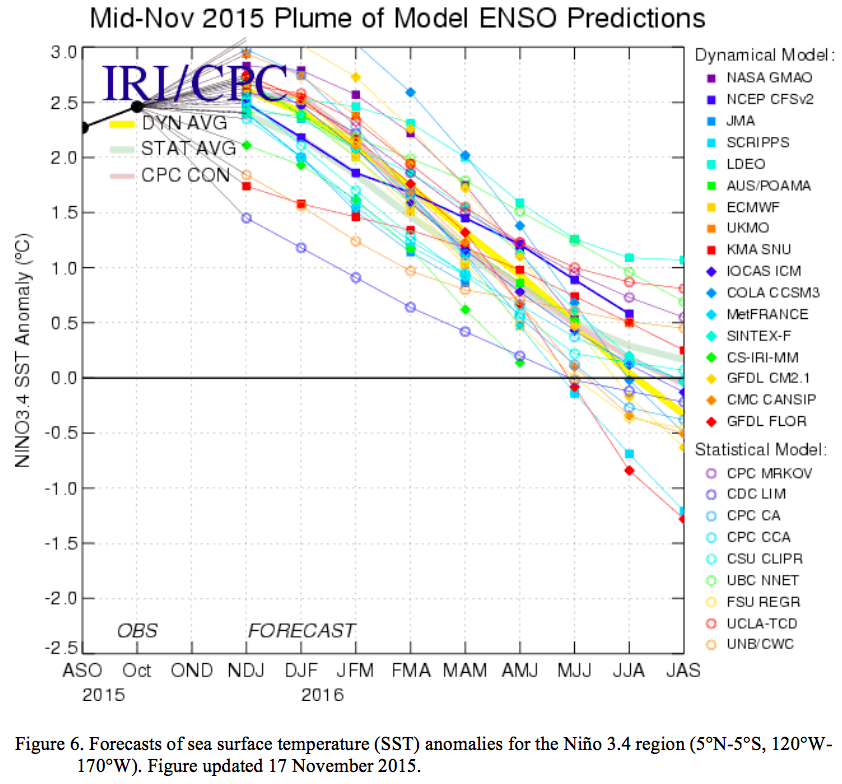
“We are currently in a very strong El Niño that should be reaching maximum intensity right about now,” Anderson said. He added conditions are expected to weaken to neutral by late spring or early summer.
Despite variations in precipitation across the state, overall Colorado saw considerably more precipitation in 2015 than in 2014…
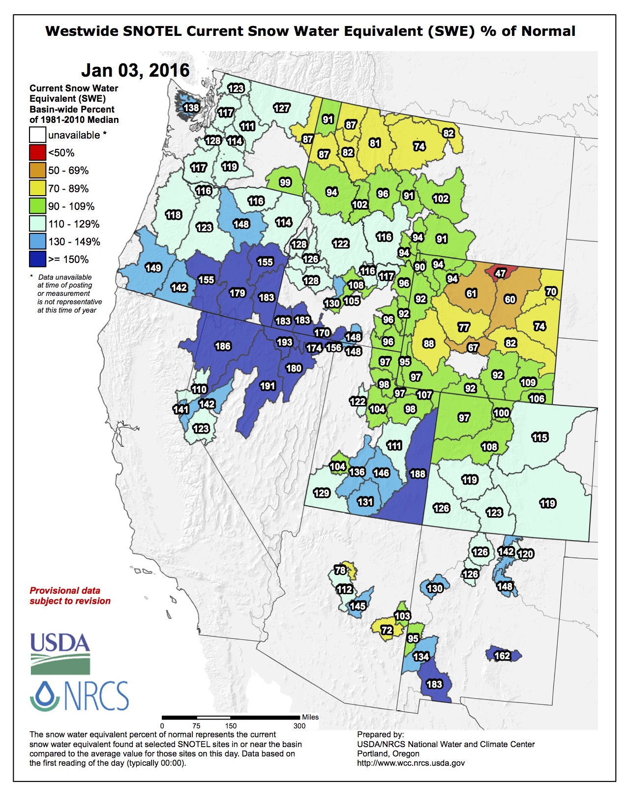
The Natural Resource Conservation Service estimates that current snowpack is above historical averages throughout the south central and southeastern regions of Colorado.
“The current snowpack and weather patterns look promising, but we are still a long way from spring,” Anderson said.
“It is snowing in all the right places,” Aragon said, which is good for wildlife but was difficult for hunters.
From the Glenwood Springs Post Independent (Ryan Summerlin):
While El Niño has lived up to its reputation and brought plenty of storms leading into winter, meteorologists expect January and February to be drier for the Western Slope…
So far this El Niño hasn’t behaved exactly as expected, he said. Whereas El Niño storms typically blow straight west to east, coming off the deserts of the American West, the storm systems this year have come more from the northwest, blowing in from the Alaskan gulf.
Normally the storms coming from the northwest would create some good precipitation for northwestern Colorado, but they’ve largely split into two portions: one tracking into the northeastern plains and the other into southwestern Colorado.
Coming into January, Ramey said the systems seem to be straightening out into the more typical west-to-east pattern.
From the fall and into this winter, the El Niño season has been one of the strongest on record, said Ramey. And now it’s reaching its peak.
In western Colorado, El Niño seasons tend to bring a wet fall and drier winter starting in January. Heavier precipitation tends to come back around in spring.
Forecasting models are showing that weather systems are following that trend, said Ramey.
Also, El Niño seasons bring more precipitation for the southern parts of western Colorado, leaving the northwest part of the state drier.
From Steamboat Today (Christine Shook):
With as much as 75 percent of the water supply being derived from snowmelt, successful water planning and management of the state’s water resources begins with a comprehensive knowledge of current snowpack conditions and the ability to make informed decisions for the upcoming water year.
Since the 1930s, the Natural Resource Conservation Service has been using scientific measurements of mountain snowpack to quantify and forecast annual water supply in 12 western states. Snow surveyors from NRCS and other cooperating agencies manually collect data, such as the snow water equivalent (SWE) and snow depth, from over 1,600 snow courses several times each winter.
The SWE is the amount of water within the snowpack and can be thought of as the depth of water that would theoretically result if the snowpack melted instantaneously.
The NRCS also operates and maintains an extensive automated system that collects snowpack and climate data in real-time, called SNOTEL (SNOpack TELemetry). A variety of information collected from the two methods are available online to the public in several user-friendly interfaces, including interactive maps and report generators. The data is also translated into water supply forecasts that the NRCS State Office issues monthly from January to June in cooperation with the National Weather Service.
So, if you are wondering exactly how this year’s snowpack is measuring up, there are nine SNOTEL sites and two manual snow courses located at high elevations within the Yampa River Basin that conveniently provide us with this valuable data.
As of Dec. 29, the Yampa and White River Basins were reporting that the snowpack is 111 percent of median conditions for SWE and 93 percent of average precipitation for water year to date. The water year-to-date precipitation represents the total precipitation since Oct. 1, usually expressed in inches.
When running a comparison report, data reveals conditions are slightly behind 2014 statistics to this day. This local data can forecast annual streamflow of the Yampa River at specific points, help us operate our local reservoirs, provide input to fisheries management, manage domestic water use and flood control and much more.
Thanks to the United States Department of Agriculture NRCS systematic snowpack inventory and monitoring program, water supplies in the high country are quantifiable, and managers are able to be alerted early in the water year on whether to expect normal flows, water shortages or floods and can make plans while there is still time to take effective action.
So, whether you are planning your irrigation schedule for the upcoming season or monitoring current powder conditions on Buff Pass, real time situational data is available at your fingertips. For more information, contact your local Conservation District or NRCS field office at 970-879-3225×3 or visit http://www.wcc.nrcs.usda.gov/.
Christine Shook is a soil conservationist with the Natural Resources Conservation Service field office in Steamboat Springs.


