Click here to read the newsletter. Here’s an excerpt:
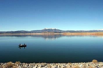
A large refill: Antero Reservoir filling as dam rehab project makes progress
Last year, we emptied Antero Reservoir to clear the way for significant repairs to the 100-year-old dam.
Despite harsh weather conditions and unpredictable construction challenges, we expect to complete the project earlier than originally expected.
Crews recently finished installing a barrier wall inside the dam, and this summer they’re focusing on building the new spillway. With this timeline in place, we can expect to finish construction by the end of 2017.
This spring we started refilling the reservoir, which — depending on snowpack and other conditions — will be fully operational by 2018.
From NASA’s Jet Propulsion Laboratory (Bob Silberg):
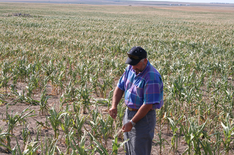
Corn plants with no corn
Why does a half degree of temperature increase make such a difference to some of the crops that were studied? For one thing, a half degree averaged out over the whole world can mean much more of an increase in some locations and at certain times.
“Most of that temperature change may occur during a small fraction of the year, when it actually represents conditions that could be 5 or 10 degrees warmer than pre-industrial temperatures instead of just 1.5 or 2 degrees warmer,” said Dave Schimel, who supervises JPL’s Carbon Cycle and Ecosystems group.
“There are places in the world where, for these important breadbasket crops, they are already close to a thermal limit for that crop species,” Schimel said. Adding to the burden, he said, “this analysis (the EGU study) does not take into account the fact that pests and pathogens may spread more rapidly at higher temperatures.”
And Schimel pointed out that heat can imperil agriculture even when crops don’t die. “If you get really high temperatures or very dry conditions during critical parts of the development of the crop, it produces essentially no grain. For example, above certain temperature thresholds, corn doesn’t die but it doesn’t grow seed. It doesn’t grow a corncob. And other crops are similar to that, where the development of the actual food part of the crop is dramatically inhibited above critical temperatures.”
But what about that fertilization effect from carbon dioxide? “It does help a bit, but it doesn’t make the underlying problem go away,” he said. “And by the way, if the plant was growing really fast when it died, it still died.”
Can we avoid the extra half-percent temperature increase? Schimel agrees that we should try hard to do so, but cautions that we don’t know how to fine-tune global warming with that much precision. “If we aim for 2 degrees, we might hit 3 degrees,” he said. “If we aim for 1.5 degrees, we might still hit 2 degrees.”
FromThe Guardian (Ed Pilkington and Mona Chalabi):
Of the 1,385 who responded to the call-out – from all 50 states – one in five expressed discontent at the relative silence from candidates around a subject that they believed to be of supreme and epochal importance. They noted that much of the Republican debate has either focused on blatant denial that climate change even exists or on how to unpick Barack Obama’s attempts to fight global warming, while on the Democratic side both Hillary Clinton and Bernie Sanders have raised the issue but have rarely pushed it to the top of the political agenda.
Many of the respondents vented despair at a political system that in their view allowed a matter of such overwhelming significance to be so overlooked. “The fact that no one is really talking about climate change, to me, is indicative of just how lost we are,” said Linda Hayden, 51, from Oregon. “Our house is on fire and we are arguing about who is more angry!”
Vivid words and phrases were used to articulate the scale of the pending disaster that readers accused the presidential hopefuls of ignoring, such as “cataclysmic”, “running out of time”, “threat to human life”, “path towards destruction”, or in one particularly memorable remark: “slow-motion apocalypse”.
A reader from Alaska, a state acutely feeling the impact of climate change, used the word “Doomed!”, while an 18-year-old woman from Tennessee who asked to remain anonymous simply said: “Freaking global climate change.” Jennie Ratcliffe, 66, from North Carolina quibbled with the Guardian’s wording of the question, saying “this is far more than an ‘issue’ – it’s a crisis”.
“I’m a climate scientist, and almost no one in the general public knows just how serious and urgent this really is,” said Peter Kalmus, 41, from Altadena, California. “Not only is it real – it’s terrifying.”
The concerns of voters came to light as part of the Guardian’s Voices of America series which aims to highlight the way key issues have been ignored or under-played during a primary season when trivial personal attacks seemed to take precedence over substantial debate of issues that matter…
The co-founder of the climate campaign 350.org, Bill McKibben, who Sanders has appointed to the platform committee at the upcoming Democratic national convention, struck a positive note by pointing out that in the 2012 presidential race between Barack Obama and Mitt Romney, climate change was not raised at all until just days before the election as a result of Hurricane Sandy. “This time around, whoever the Democrat is will be hammering Trump and the rest of the GOP for their blindness to climate science – it’s now a losing proposition for them. So, scientists and movements have done their job in that way.”
But he went on to warn that “merely believing in climate change at this point is way too low a bar. We need leaders who understand it’s the issue of our century, and will work with the focus it requires.”
Not much happened around the Silverton Caldera in southwestern Colorado between 26 million years ago — when hydrothermal alteration of the caldera’s fractured granitic rocks left behind extensive veins of metal-rich ores — and 1871, when those deposits were discovered by prospectors. That’s when Silverton really started to boom. From 1871 to 1991 — when the Sunnyside Mine on the east side of Bonita Peak, the largest of dozens in the area, closed — an estimated $530 million worth of gold, silver, copper, lead and zinc were extracted from the Silverton Caldera. Most of the prospectors and mining companies that extracted that wealth are long gone, but a legacy of widespread environmental impacts remains…
A map of the results of the water and sediment sampling published by the Arizona Geological Survey indicates that only a handful of samples, mostly in the upper reaches of the watershed in the early days of the spill, had pollutant levels that exceeded maximums established for drinking water standards. While the Animas and San Juan rivers remained closed to use for irrigation, drinking water and recreation for about 10 days, the impact to agriculture along the banks of the river was minimal although future crop yields could suffer from the shutdown of irrigation, according to the University of Arizona researchers, led by Karletta Chief, a hydrologist and tribal extension specialist in the Department of Soil, Water and Environmental Science.
The report also put the 3-million-gallon spill into perspective. Each year, Silverton mines collectively discharge more than 330 million gallons of acid mine drainage into the Animas River watershed — more than 100 times the volume of the Gold King spill. In other words, the Animas River is experiencing a Gold King-sized spill, albeit less concentrated, roughly every three days.
After more than a century of largely unmitigated mining in the West, Gold King is just the latest example of the slow-motion environmental problem that has been unfolding in hundreds of mines and along thousands of kilometers of waterways. The EPA’s involvement in this particular spill, however, is an unusual twist that has brought controversy and attention, but at least, researchers say, it is shining a light on the larger problem of abandoned mine lands and the complexities surrounding their regulation and remediation.
In recent decades, the movement to remediate abandoned mine lands has gained momentum, and geoscientists from many different fields, from environmental scientists and hydrologists to geologists and mining engineers, are bringing their expertise to bear in characterizing abandoned mine sites, monitoring their environmental impacts, and assessing and prioritizing them for reclamation. But regulatory, legislative and funding issues remain — and a looming geoscience workforce crisis may leave future cleanup projects in the lurch.
The Impacts of Abandoned Mine Lands
Today, the U.S. has an estimated 400,000 to 500,000 abandoned mine sites mostly concentrated in eastern coal mining regions, like Pennsylvania and West Virginia, and western hardrock and coal mining regions like Colorado and Wyoming.
“Abandoned mines” are those abandoned before 1977 by owners who pulled up stakes when the veins tapped out or market economics changed, making the mine no longer profitable to work. Prior to 1977, when the Surface Mining Control and Reclamation Act (SMCRA) established the national Abandoned Mine Land Reclamation Program, few regulations held former mine owners accountable for the environmental consequences of abandoning a mine. SMCRA assesses fees on active coal mining operations to pay for remediation of abandoned coal mine sites. There is, however, no similar program for hardrock abandoned mines.
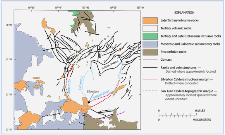
Geologic map of the Silverton Caldera showing the Animas River, Cement Creek and Mineral Creek, which outline the ring-shaped caldera. Much of the mineralization occurs in radial and graben faults. Credit: USGS/Church, von Guerard and Finger, 2007 (modified from Casadevall and Ohmoto, 1977).
Abandoned mines can range from small prospect pits that merely pock the surface, to deep underground mines with kilometer upon kilometer of adits, shafts, drifts, stopes and tunnels. Such underground cavities often intersected the water table — the surface, or top, of water stored underground — requiring drainage tunnels or pumping during active mining. When mines were abandoned, however, the pumping often stopped, and drainage tunnels — which were graded to allow water, as well as loaded ore cars, to passively flow downslope — continued to drain.
Seeping groundwater can then pool in the mine and possibly escape into the surrounding environment, potentially leading to the most prominent and far-reaching of the many health, safety and environmental dangers posed by abandoned mines: the degradation of water resources by acid mine drainage.
Acid rock drainage can occur naturally, without mining, when rocks containing gold, silver, copper and other valuable metals — which also usually contain pyrite, an iron sulfide that, when exposed to air and water, creates sulfuric acid that further leaches metals from the rock — are exposed via weathering and erosion, fractures or exhumation. But mining accelerates and scales up this natural weathering, exposing vast amounts of fresh rock surfaces both inside and outside the mine to oxygen and water.
Until the 1930s, it was common practice to dump mine tailings directly into streams. When acid mine drainage flows into creeks or streams, it can impact reaches of a watershed far downstream, often leaving trails of iron-hydroxide deposits — “yellow boy” in mining terminology — that stain rocks and riverbanks red, yellow and orange. Today, tens of thousands of kilometers of U.S. rivers and streams are still affected by acid mine drainage.
In addition to water-quality impacts, other hazards that also require mitigation include spoils and tailings piles, open portals and shafts, underground fires, ground subsidence, explosive gases and rusting equipment, just to name a few.
In addition to Gold King, Colorado alone has more than 23,000 other abandoned mines posing varying degrees of threats. More than 6,000 have been remediated by the Colorado Division of Reclamation, Mining and Safety in cooperation with the Colorado Department of Public Health and Environment — but $66 million worth of unfunded projects remain listed on the national database of abandoned mine lands. Other states have similar backlogs.
In Pennsylvania, the state most impacted by acid mine drainage and with a long history of remediating it, abandoned mines discharge 300 million gallons of acid mine drainage per day, affecting more than 8,800 kilometers of streams, says Eric Cavazza, director of the state’s Bureau of Abandoned Mine Reclamation and past president of the National Association of Abandoned Mine Land Programs.
The Watershed Approach
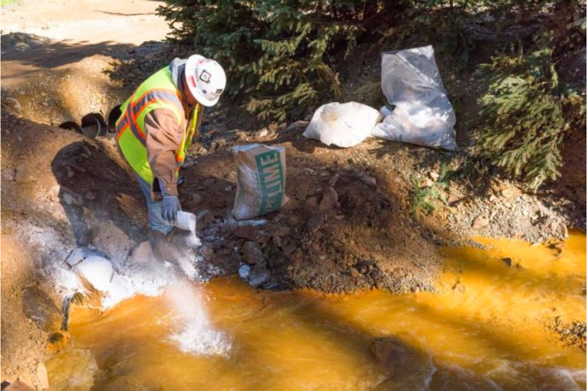
The problem may seem vast and intractable, but the science of acid mine drainage is well understood. And, over the last few decades, a well-stocked toolbox of mitigation techniques has been developed, including treating acid mine drainage waters with lime (calcium carbonate) to buffer the water’s pH to normal levels and channeling mine discharges through settling ponds to allow metals to precipitate.
Gold King mine treatment pond via Eric Vance/EPA and the Colorado Independent
The bigger challenge is determining where and how to allocate limited resources, says Geoffrey Plumlee, a geochemist with USGS in Denver who testified before Congress in November 2015 on the role geoscientists can play in assessing and prioritizing remediation of abandoned mines.
In his testimony, Plumlee emphasized the importance of involving geoscience expertise at every stage: identifying and assessing sites, determining remediation options, and prioritizing projects based on the potential return. The task is figuring out which sites pose the greatest hazard and possess the greatest potential for improvement, he says.
Plumlee cites the example of Colorado’s Summitville Mine, a hardrock gold mine about 100 kilometers southeast of Silverton, where mining had occurred on and off since the late 1800s. In the 1980s, open-pit mining began using a new cyanide-leaching technique to dissolve gold from lower-grade ores. Almost from the beginning, heavy-metal discharges, pH levels lower than 3, and cyanide leakage plagued the operation.
In 1992, the mining company declared bankruptcy and was unable to meet its remediation responsibilities. In 1994, to prevent a major spill into the Alamosa River, the state of Colorado asked the EPA to designate it a Superfund site and take over cleanup, the cost of which has since exceeded $100 million.
The ore geology at Summitville — massive sulfide-rich volcanic deposits, with no underlying carbonates to help buffer and neutralize acidity — “was basically a geologic recipe for extreme acid rock drainage,” Plumlee says. Meanwhile, the ore geology at other mines can result in discharges near drinking-water quality. Although not all mine drainage is acidic, it can still carry substantial amounts of toxic elements.
“Not all mine drainage is created equal,” Plumlee says. “This is why understanding the geology of the deposits is so important to helping predict mine drainage chemistry.” That is just one way geoscientists can help prioritize different sites for cleanup. Another example of how geoscience may be brought to bear is the interdisciplinary “watershed approach,” exemplified in a 10-year pilot study of the effects of more than a century of historical mining in two watersheds: Boulder Creek in Montana and the Animas River in Colorado, which includes Gold King. In the comprehensive study, which ran from 1997 to 2007, researchers examined “the geology and geochemistry of rock and sediment, the hydrology and water chemistry of streams and groundwater, and the diversity and health of aquatic and terrestrial organisms” in each watershed.
Diverting mine drainage into settling ponds allows iron oxides, heavy metals and other suspended particles to precipitate. Credit: EPA.
In the study, undertaken when the USGS implemented a new program in cooperation with federal land-management agencies called the Abandoned Mine Lands Initiative, researchers inventoried mine sites, analyzed an array of water, rock and mine waste samples, and characterized the geologic conditions controlling acidity and the release of toxic metals.
The results of the study, published in a 2007 report edited by USGS scientists Stanley E. Church, Paul von Guerard and Susan E. Finger, demonstrated the full potential of a comprehensive geotechnical assessment of watersheds impacted by mining, Plumlee says. Eight years later, that report became a vital resource for the teams investigating the Gold King Mine spill, helping to establish both pre-spill and pre-mining conditions.
Determining the natural conditions that existed in an environment prior to mining is important, Plumlee says, because it provides a baseline for the conditions that are technically feasible to achieve with remediation. This, in turn, can help planners set realistic goals for reclamation plans.
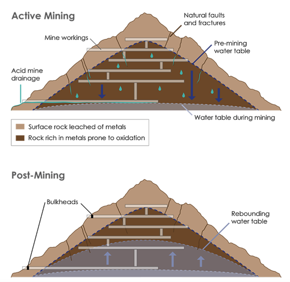
During mining (top), the water table is often lowered to access ore, exposing the rock to oxygen and creating acid mine drainage. Sealing off a mine can return the water table to pre-mining levels (bottom), creating anoxic conditions inside the mine and preventing further acidification. Credit: K. Cantner, AGI.
In establishing those conditions, it is important to remember that nature is not always pristine when left to its own devices. In Colorado, for example, the first European settlers gave streams names like Iron Creek, Alum Creek and Bitter Creek: names that alluded to natural acid rock drainage. In 1875, prior to intensive mining, the topographer of the Hayden Expedition noted the “iron-sulfate” waters of Cement Creek and Mineral Creek were not fit for drinking.
In 2011, the Colorado Geological Survey released a study identifying a number of streams whose headwaters, lying at elevations high above where mining impacts are felt, were acidic with high metals concentrations due to the hydrothermally altered metal-sulfide rocks in the surrounding geology. “Natural acid rock drainage has been active in Colorado for thousands, possibly millions of years,” the authors wrote.
In addition to understanding surface geology, knowing a site’s underground history is also crucial for remediation decision-making. Pairing historic documents with modern geoscientific technologies can help uncover that history.
Tools & Technologies
If the Gold King spill did nothing else, it raised awareness that a better understanding of a mine’s underground structure and hydrologic conduits and connections, both man-made and natural, is needed to make effective remediation decisions.
Gold King was part of a complex of mines including the large Sunnyside Mine. During the decommissioning of the Sunnyside Mine in the 1990s, 12 bulkheads — bunker-like structures made of steel and concrete — were installed to seal off the mine. Like plugging a bathtub drain, the bulkheading prevented acid mine drainage from flowing out at the lowest levels of the mine. After bulkheading, the local water table rose 300 meters, flooding the mine.
Bulkheads, like this one at the Red and Bonita Mine, help stop mine water discharges and allow engineers to monitor the mine pool. Credit: EPA.
Although it might seem like flooding a mine would exacerbate the aquatic chemical reactions that result in acid mine drainage, sometimes water is part of the solution.“The idea behind the bulkheads is to raise the groundwater table back to pre-mining levels and remove oxygen from the acid mine drainage equation,” says Kirstin Brown, a geologist with the Colorado Division of Reclamation, Mining and Safety.
Soon after Sunnyside was bulkheaded and the water table rose, however, acid mine drainage at nearby mines — including the Red and Bonita, Mogul, and Gold King, each of which had previously been dry or discharging minimally — began flowing again. The renewed flows of acid mine drainage into Upper Cement Creek and the Animas River were at first actively treated to raise the pH. However, in 2003 and 2004, treatment ceased when disputes among the mine companies over who was responsible for its cost led to litigation, and streamwater quality again declined.
In 2010, in an effort to better understand the flow of mine drainage into Upper Cement Creek, the Bureau of Land Management, the Animas River Stakeholders Group and the Colorado Department of Public Health and Environment contacted the Colorado Division of Reclamation, Mining and Safety about creating a three-dimensional model of how the mine workings might be intersecting the water table.
The task fell to Brown, who worked with the U.S. Office of Surface Mining Reclamation and Enforcement, to learn and use EarthVision software to create the model, which drew on data from historic mine maps, some of which the researchers had to track down and “dig out of people’s basements in Silverton,” she says.
After scanning and georeferencing the old maps, groundwater data was then overlaid on the workings. Researchers can’t see the groundwater surface underground, but they can see where it flows out on the surface. If a mine portal, spring or stream is flowing at the ground surface, it shows researchers a fixed point on the surface of the groundwater table. Researchers also can check groundwater head pressures on some bulkhead gauges to see the current pressure and depth of the water table.
The result was a model that can be manipulated in three dimensions that gives officials the ability to “better visualize and understand the groundwater in the mountain and to help communicate the problem [of acid mine drainage] to the public,” Brown says. The model could also “help make predictions for the best practices for remediation.”
Understanding the hydrology at work in a mine can also allow for the most potent remediation technique: controlling the water at its source to prevent contamination in the first place. Sealing off mine entries with bulkheads can help prevent water from entering mine workings, and the flow of water inside the mountain can be manipulated to direct acid water away from clean water sources, Brown says.
Remediation teams employ other tools and technologies to investigate what’s going on belowground. Salt and dye tracer solutions can be introduced into mine waters to follow the hydrological connections among the workings. Drilling boreholes to send cameras, sensors or other instruments down into a mine is another common technique, often used to check the pressure and depth of a mine pool prior to beginning work.
“We do a lot of mine pool evaluations and mine pool monitoring, which is what didn’t happen at Gold King that resulted in uncontrolled releases of mine water,” Cavazza says. “Before we open up an abandoned underground mine, we almost always drill and put in monitoring wells so we have a good understanding of exactly how large [the mine pool] is, what the volume is, and how to contain and control it if we decide to open it.”
Another way to figure out what’s going on is to go underground with an engineering team, says Brown, adding that this is only done after ground conditions have been assessed, stabilized and deemed safe. Once underground, teams can map faults and fractures, collect information about water quality and water sources underground, and assess how to control those sources, for example, by determining where to place bulkheads.
But, it turns out, it is getting harder and harder these days to find engineers trained to work in mines.
Mining Engineers: A Depleted Resource
Since 1982, the number of accredited mining engineering schools has shrunk from 25 to 14 and for the last decade they have produced fewer than 200 graduates a year.
“Here in Pennsylvania, we have had a very difficult time recruiting new mining engineers to replace our mining engineers who are reaching retirement age,” Cavazza says. “There are fewer mining engineers being trained nationally, and there is probably going to be a continued need for them into the future.”
Last fall, in response to the Gold King spill, three bills were introduced in the U.S. House of Representatives Subcommittee on Energy and Mineral Resources chaired by Rep. Doug Lamborn (R-Colo.), who noted in his opening remarks the importance of having mining engineers on staff at agencies tasked with acid mine drainage cleanup.
“In the Committee’s investigation of the Gold King Mine spill, we discovered that, out of 15,326 employees, [the EPA] has no mining engineers and only 68 geologists, two of [whom] are assigned to [EPA] Region 8 where the spill occurred,” Lamborn said.
One bill, H.R. 3734, the Mining Schools Enhancement Act, would require the Office of Surface Mining Reclamation and Enforcement to direct 70 percent of its research funding to mining schools to help train the next generation of mining engineers.
In addition to mining engineers working on abandoned mine lands cleanup, it is “crucial to have economic and structural geologists who can help the mining engineers interpret and address the complexities of the geology, and hydrologists who can develop the detailed hydrologic models for groundwater flow,” Plumlee adds.
Legislative Will
The other two bills introduced last fall, H.R. 3843 and H.R. 3844, propose to assess a maintenance fee on mineral claims for the next seven years, establish a federal “Good Samaritan” law, and establish a foundation that would oversee private gifts and bequests to fund abandoned mine lands remediation projects.
The bills are not the sweeping legislation that has been called for to replace the current law governing hardrock mining — the General Mining Act of 1872. Signed into law by Ulysses S. Grant to promote the settling of the West, it was enacted a century before the environmental movement took hold and made no provision for funding or regulation of remediation. “It’s never been updated, which is a very long time for an environmental law to be on the books,” Cavazza says. But, he says, “some people don’t want it updated.”
The most recent legislation proposing to update the 1872 mining act, H.R. 963, the Hardrock Mining Reform and Reclamation Act of 2015, was referred to subcommittee, where it remains. It would have, among other things, assessed reclamation fees to establish a fund for future cleanups and established a federal Good Samaritan law to waive some liability for private citizens, groups or companies who want to become involved in mine cleanup projects. Opponents contend that while domestic coal producers can pass the additional cost of reclamation fees onto consumers, U.S. mineral producers competing in a global market would suffer a competitive disadvantage if additional fees were imposed.
“There’s really never been the legislative will in Congress to enact a hardrock abandoned mine lands program,” Cavazza says.
Thus, hardrock abandoned mine lands are instead overseen by an alphabet soup of local, state and federal agencies, each with its own rules and guidelines. And funding to remediate a particular site may come from a hodge-podge of sources, including federal, state, and private partners who, in turn, get funding from a variety of sources, including SMCRA, Superfund, and the Clean Water Act Grant Program.
“Currently, no single source of funding, whether it be federal, state, tribal or private, is adequate on its own to address the magnitude of the problem that exists,” the Bureau of Land Management (BLM) and the U.S. Forest Service (USFS) reported in 2007. As of 2011, according to a General Accounting Office report, BLM, USFS, the Environmental Protection Agency and the U.S. Office of Surface Mining Reclamation and Enforcement had spent at least $2.6 billion to reclaim abandoned hardrock mines on federal, state, tribal and private lands.
Good Samaritans
Some of the private funding comes from corporations or groups — like Trout Unlimited, a nonprofit organization dedicated to conserving trout fisheries — that have a vested interest in cleaning up their local waterways. However, under certain laws anyone involved with mine cleanup in any way over the years can potentially be held responsible for environmental damage, even that which preceded their involvement with cleanup, and be liable for legal damages and cleanup costs.
Thus, Good Samaritan laws offer permits to waive or reduce the liability of private parties that want to participate in environmental cleanup projects. For example, if a group helped remediate a polluted stream that was previously unable to support aquatic life to the point that fish could survive in it, but not necessarily to the point that the water met the standards of the Clean Water Act, Good Samaritan laws might exempt the company from the more stringent requirement.
South Dakota and Pennsylvania are currently the only states with “Good Sam” laws. In Pennsylvania, Cavazza says, the 1999 law increased the number of private parties participating in acid mine drainage cleanup projects. But, he says, he suspects that many potential corporate partners are still dissuaded by legal teams who do not want to risk federal liability.
“I don’t know why you would want to discourage anybody from going in to try to clean something up that they had nothing to do with creating, that they are not in any way liable for, and for which they are providing their own resources,” says Cavazza, who last fall testified in his capacity as past president of the National Association of Abandoned Mine Land Programs (not in his role as a state official) to the benefits of Good Sam laws before the House subcommittee.
The Legacy of Gold King
Whether the Gold King spill will provide the impetus to create a national program for hardrock abandoned mine lands remains to be seen. The case of Gold King is currently mired in litigation and hearings. At the site, the EPA has set up a temporary water treatment plant in the nearby ghost town of Gladstone to treat Gold King discharge before it reaches Cement Creek. Downstream, state and federal public health agencies and other researchers continue to monitor the Animas watershed, especially during spring runoff and high-water events that may mobilize sediments laden with heavy metals.
“Although there appear to be no short-term effects to health or the environment following the Gold King Mine spill,” the University of Arizona researchers wrote last November, “we will not understand the long-term impacts of this highly concentrated release of metals into our environment for quite some time.”
In April, in response to a request from Colorado Governor John Hickenlooper and towns, counties and tribes in the Animas and San Juan watersheds, the EPA proposed listing 48 historic mine sites in the Silverton Caldera as a Superfund site. Some residents of Silverton had long resisted the designation, despite the fact that it would bring additional federal resources for remediation, because it was thought that associating the town’s name with Superfund, often synonymous with hazardous waste, could threaten tourism. But after seeing the Animas run orange, many changed their minds.
If approved, the Superfund site will be called the Bonita Peak Mining District.
On April 7, 2016, the Environmental Protection Agency proposed adding the “Bonita Peak Mining District” to the National Priorities List, making it eligible for Superfund. Forty-eight mine portals and tailings piles are “under consideration” to be included. The Gold King Mine will almost certainly be on the final list, as will the nearby American Tunnel. The Mayflower Mill #4 tailings repository, just outside Silverton, is another likely candidate, given that it appears to be leaching large quantities of metals into the Animas River. What Superfund will entail for the area beyond that, and when the actual cleanup will begin, remains unclear. Eric Baker
This is the first in a continuing series about how Colorado’s Water Plan will be put into action.
New sources of water are unlikely, so the Arkansas River basin’s focus should be on which crops or landscapes are irrigated, because irrigation is the largest use of water.
Pueblo Water plans to increase storage in key locations above, in and below Lake Pueblo.
Although we won’t find the water supply we want, wise use and efficient water management can stretch the supply we have.
That’s the outlook from Alan Ward, water resources manager for Pueblo Water.
Ward has been involved with filling municipal water needs during the severe drought of 2002 and the more prolonged drought of 2011-13.
He oversees a complex water leasing program that allows Pueblo to make the fullest use possible of its water portfolio.
Ward was part of Pueblo Water’s team that purchased more than one-quarter of the Bessemer Ditch water rights to secure future supply, and as a result is now a member of the canal company’s board of directors.
Colorado’s Water Plan was unveiled last year as an evolving way to meet water needs for the state for decades to come.
The process to develop the document was exhaustive, with hundreds of meetings, thousands of comments and 10 years of effort. It will take even more work to implement the plan and to focus activities that are in line with the plan’s objectives.
To gain a better understanding of how policymakers view the plan, The Pueblo Chieftain and Arkansas Basin Roundtable is asking key individuals three basic questions: How the gap will be filled, what projects are anticipated and what actions can be taken to prevent the gap from getting bigger.
Here are Ward’s answers:
How do we fill the gap in the Arkansas River basin within Colorado’s Water Plan and the Basin Implementation Plan?
“Since the water of the Arkansas River basin is already completely appropriated, the ‘gap’ is really the difference between the water supply we have and the water supply we’d like to have.
I am not optimistic about the prospects of increasing supply. There is no currently unused supply to develop locally within the Arkansas River basin, so an increased supply would have to be imported from elsewhere.
“I think that the expense along with the political and environmental hurdles make importation of new water supply into the Arkansas River basin very complicated and climate change may lead to even less supply on both the Eastern and Western slopes.
“As an alternative, I believe the focus in the Arkansas River basin should be on adapting to having less water than we would like. Storage is key to making the most efficient use of the available water supply.
Storage allows for some control of the timing and location of the limited water supply so that it can be used when and where it is most needed.
Storage also provides the flexibility to move water in ways that can enhance recreational opportunities and minimize environmental impacts.
“Irrigation, whether for crops and livestock grazing or lawns and urban landscapes, is the primary consumptive use of water in the Arkansas Basin (and most of the western United States). I believe that there just isn’t the water capacity to increase the amount of irrigated land, so there needs to be some difficult discussions about what gets irrigated. If urban irrigation increases, then agricultural irrigation will have to decrease or vice versa. It is important to note that urban irrigation has been on a downward trend so there is probably room for some urban growth without an overall increase in the amount of urban irrigation.
“Determining where water should be used for irrigation is a complex problem.
Because water rights are a private property right that can be transferred to new uses, there can be tensions about what role government should play in shaping the free-market movement of water rights and what involvement local communities should have in the transfer of water rights. Finding the right balance between the rights of individuals to use their property as they wish and achieving the desired outcomes of the broader public will be difficult.
“Other water uses such as domestic (including indoor urban), environmental, recreational and industrial are extremely important, but they are so small relative to irrigation use that changes in these water uses will only have minor impacts on the ‘gap’ at a basinwide scale.”
What projects do you plan to fill the gap?
“Pueblo Water is looking to add storage capacity at three key locations for its operations.
“Clear Creek Reservoir can be enlarged to provide additional storage in the Upper Arkansas River basin, which may facilitate better management and optimization of Pueblo’s water imported from the Western Slope.
“Pueblo Reservoir is ideally located in that it is low enough in the basin that a significant amount of water flows into it from upstream.
Many of the largest water users can take delivery of water from the reservoir either by pipeline or by release down the Arkansas River. Enlargement of Lake Pueblo could provide flexibility and water management efficiencies to Pueblo Water and many other urban, rural and agricultural water users.
“Storage located a short distance downstream of the city of Pueblo would allow for more efficient reuse of Pueblo Water’s fully consumable water supplies while at the same time optimizing the timing of flow on the Arkansas River through Pueblo for recreational and environmental benefits.
“Pueblo Water has committed to partner with Colorado Springs, Aurora, Fountain, Pueblo West and the Southeastern Colorado Water Conservancy District in developing this type of storage in order to recapture water that the parties could have captured at Lake Pueblo if not for the Pueblo Flow Management Program (recovery of yield storage).”
How do we keep the gaps for agriculture and municipalities from becoming bigger?
“Keep expectations for water supply in line with actual water supply, plus encourage wise use and efficient water management, including expansion of storage.”
Here’s the release from the University of Montana:
Gravel-bed river floodplains are some of the most ecologically important habitats in North America, according to a new study by scientists from the U.S. and Canada. Their research shows how broad valleys coming out of glaciated mountains provide highly productive and important habitat for a large diversity of aquatic, avian and terrestrial species.
This is the first interdisciplinary research at the regional scale to demonstrate the importance of gravel-bed rivers to the entire ecosystem.
University of Montana Professor Ric Hauer, director of the Center for Integrated Research on the Environment, leads a group of authors who looked at the full continuum of species and processes supported by gravel-bed rivers, from microbes to bull trout and from elk to grizzly bears.
Gravel-bed rivers are found throughout the world in mountainous regions, but the complexity of how they benefit species has not been extensively studied before now.
The team of scientists on the study includes Hauer; Harvey Locke, co-founder of the Yellowstone to Yukon Conservation Initiative; UM professors Vicky Dreitz, Mark Hebblewhite, Winsor Lowe and Cara Nelson; Clint Muhlfeld, research aquatic ecologist from the U.S. Geological Survey; Professor Stewart Rood from University of Lethbridge; and biologist Michael Proctor of Birchdale Ecological.
For the entire Yellowstone to Yukon region, which stretches from Yellowstone National Park north into Canada’s northern Yukon Territory, gravel-bed river floodplains support more than half the region’s plant life. More than 70 percent of the region’s bird species use the river plains while deer, elk, caribou, wolves and grizzly bears use the floodplains for food, habitat and important migration corridors.
“If we think about the Flathead River for example, flowing from British Columbia into the U.S. and along the western edge of Glacier National Park,” Hauer said, “we might wrongly imagine that the river is only water flowing in the channel. But, these gravel-bed systems are so much more than that. The river flows over and through the entire floodplain system, from valley wall to valley wall, and supports an extraordinary diversity of life. The river is so much bigger than it appears to be at first glance.”
Gravel-bed river systems provide complex habitats for species because of the system’s ever-changing features: gravel and cobbles that move with flooding, scoured and changing river channels, and a constant flow of water into and out from the gravels of the river. This water extends across the U-shaped valley bottom often hundreds of meters or more from the river channel, and supports a complex food web that includes aquatic species as well as a vast diversity of avian and terrestrial species. These processes are driven by the river’s changes in volume throughout the year.
The gravel-bed rivers also provide essential connectivity across the landscape for both terrestrial and aquatic organisms, which is critical in a time of climate change.
These floodplains also are some of the most endangered landforms worldwide. Human settlement, agriculture, industry and transportation often occur in flat, productive river valleys. While there are many protected areas in the northern Rocky Mountains of the United States and Canada such as Yellowstone and Banff national parks, humans have altered the structure and function of the gravel-bed river floodplains outside, as well as inside, these protected areas.
“The increasing pressures of climate change mean that species need continued access to intact gravel-bed river ecosystems in order to survive,” Hauer said. “These systems must be protected and those that are already degraded must be restored.”
For more information on the study, call Hauer at 406-250-9900 or email ric.hauer@umontana.edu or Locke at 403-431-6777 or email harvey@y2y.net.
The winter and spring snowpack that normally sits above this former mining town in the southeastern San Juan Mountains can be both a blessing and a curse.
It’s a blessing when there’s a lot of it — more runoff in the Conejos River basin in spring and summer is almost always a good thing.
But it can be a curse, especially for water managers trying to balance deliveries to local irrigators with the obligations of the Rio Grande Compact, because it’s difficult to measure, which, in turn, makes streamflows harder to forecast.
The Conejos Water Conservancy District, with the help of a host of federal and state agencies, has spent the last two years trying to change that.
The district is in the second year of a pilot project that’s prompted the installation of six new snow monitoring sites that can also measure soil moisture, humidity and temperature.
Another project component includes five new stream gauges in the upper reaches of the Conejos basin.
The project has also made use of a federal mobile radar and flights deploying a laser technology that precisely measured the watershed’s surface to get a better handle on the snowpack.
All of these steps result in data that are fed to scientists at the National Center for Atmospheric Research whom are refining a new forecasting model.
Nathan Coombs, manager of the Conejos district, knows a more accurate forecast model requires years of refinement but he’s encouraged by the project so far.
“We know we’re collecting better, usable data,” he said.
That’s a big improvement given that prior to the last two years, the 92-mile long Conejos had no snow gauges above its main stem and lacked stream flow gauges on many of its tributaries.
The lack of information can make it difficult for Colorado to predict its annual obligation under the Rio Grande Compact…
The Colorado Office of the State Engineer has traditionally used forecasts from the U.S. Natural Resources Conservation to project how big or small stream flows will be.
And the engineer’s office imposes curtailments on water users along both the Rio Grande and the Conejos to ensure delivery obligations are met.
Curtailments on the Conejos can often reach 30 percent and the timing of the restrictions can be exacerbated by an inaccurate forecast. “It’s headgates that are closed,” Coombs said. “It’s real, wet water that’s no longer available.”
Money for the project came from a wide range of funders.
The Colorado Water Conservation Board approved a $383,000 grant.
The U.S. Bureau of Reclamation and the National Oceanic and Atmospheric Administration also pitched in.
The Conejos district contributed $25,000, more than 10 percent of its annual budget.
But there are still some steps Coombs hopes to see happen that could further improve data collection for forecasting.
Right now the district’s highest snow gauge is at 10,500 feet in elevation, which excludes large swaths of the snowpack that run off in June.
“All of our late snow that throws our forecast completely out the window is above that,” Coombs said.
One solution to measuring that snowpack was a mobile radar unit stationed in Alamosa during the project’s first year that helped measure the intensity of late spring storms.
Coombs expects that unit to be back next year.
But a longer term solution may emerge from work with the U.S. Forest Service.
The district hopes to install snow gauges in the 161,000-acre South San Juan Wilderness, a move that would require forest service approval.
The wilderness area sits above the district’s gauges and is a monitoring blind spot.
It’s also home to a slew of important Conejos tributaries such as Elk Creek, and the South, Middle and Adams’ forks.
The end game of all the data collection and the work by federal scientists on the forecast model will give water managers a fuller picture of what’s coming downstream.
“Whether you have a compact or not, the priorities turn on and off because of what’s available,” Coombs said. “And if you know the why of what’s available, now you can start making management decisions.”
Dorothy Hargrove, Englewood’s director of library, parks and recreation, told officials at the June 29 tri-cities meeting that the project called River Run includes a trailhead and amenities including a wave generator so visitors can surf the South Platte River.
She said it has been a project involving a number of agencies including Englewood, Sheridan and Arapahoe County — plus the agreement from the Army Corps of Engineers — for all the work on the river channel.
“The project includes a pavilion, restrooms and easy ADA accessible from the parking lot to the river,” she said. “River Run is just one part of the effort to revitalize the South Platte River through Littleton, Englewood and Sheridan.”
The effort is being spearheaded by the South Platte River Working Group. The group is made up of representatives of Englewood Sheridan, Littleton, Arapahoe County, South Suburban Parks and Recreation District, the Colorado Water Conservation Board, Urban Drainage and Flood Control District and the Army Corps of Engineers.
Grants from Arapahoe County Open Space funds as well as money Englewood received from the open space fund and from lottery funds provided the roughly $800,000 needed to construct the trailhead.
Another trailhead amenity was funded when Greater Outdoors Colorado approved Sheridan’s grant request for $350,000 to construct and equip the playground adjacent to the river.
Plans are for the money to be used to build a nature-themed playground, seating overlooking the river, pedestrian paths and to install landscaping around the playground.
Other river amenity projects are planned or under construction. For example, South Suburban Parks and Recreation District applied for a Great Outdoors Colorado grant to construct a walking and running trail along the east bank of the river from Union to Oxford avenues. The estimated cost of the east-side trail is about $3.3 million.
Hargrove and members of the South Platte Working Group talked about some of the other efforts, including the work at Reynolds Landing and Carson Nature Center in Littleton. There are plans for bank enhancements along much of the seven-mile stretch as well as creation of a whitewater tubing and boating channel between West Union and West Oxford avenues. Smaller trailheads are planned at Union and Belleview avenues.
Sunrise at Ruedi Reservoir October 20, 2015. Photo via USBR.
From email from Reclamation (Peter Soeth):
Releases from Ruedi Reservoir are anticipated to remain at 125 cfs throughout the weekend. It is expected to fill next week. If the basin gets any significant rainfall, the reservoir may fill sooner and releases may have to be increased.
Map of the Northern Integrated Supply Project via Northern Water
From the Fort Collins Coloradoan (Jacy Marmaduke):
Citing low flows in the winter and insufficient flushing flows in the spring, river experts give the health of the Cache la Poudre River moderate marks. Ken Kehmeier, senior fishery biologist at Colorado Parks and Wildlife, gives it a “C-plus.” Ellen Wohl, a Colorado State University geosciences professor, prefers “needs improvement.”
“It’s not going to catch on fire like the Cuyahoga River did in the ‘60s, but it’s a very different river than it was in say, 1858,” she said. “I’d never give up on the Poudre. It’s ailing in health, but it can recover, and it’s not anywhere near being done.”
What does the future hold for the Poudre? That interpretation depends a lot on who you ask. It also will depend on how Northern Colorado leaders respond to potential obstacles raised by climate change, urban development and the Northern Integrated Supply Project.
Climate change
Colorado’s in a weird spot when it comes to climate predictions.
While it’s clear temperatures will increase — they already have — there’s no consensus on whether climate change will bring more, less or the same precipitation to Colorado.
Regardless, warmer temperatures are an issue for the Poudre and its aquatic life and water users. The Poudre is fed primarily by mountain snowmelt, and as Colorado’s average temperatures rise, the spring pulse — the onset of higher spring flows fed by snowmelt — will come earlier than usual.
John Stokes, Fort Collins Natural Areas director, said he already sees it happening on the Poudre.
“Our snowmelt is getting earlier and earlier. It’s probably about two weeks earlier now than it used to be,” Stokes said. “As that accelerates, what does that do to our storage in the mountains, which is snow and ice? We rely on the timing of that storage.”
Not everybody agrees with Stokes. Poudre River Commissioner Mark Simpson said flows have varied so much during the last 50 years that he doesn’t see a shift in the peak, which generally occurs around the first week of June.
[Ellen Wohl] said she hasn’t necessarily noticed that trend on the Poudre — the system is so meticulously managed that it can be hard to tell when high flows are the work of Mother Nature or water engineers, she added…
Development
The biggest protection — literally — is a development buffer zone of 300 feet on either side of the river through most of Fort Collins. That’s nearly the length of a football field. The buffer zone, which is enhanced by city ownership of most of the land along the river, quells any fears that the Poudre will one day turn into a built-out river walk. It also mitigates flood risk.
“Maybe In a perfect world we would have had quarter- or half-mile setbacks from the river,” Stokes said. “This river used to go all over the place. It would change its course frequently. But now, it’s pretty much locked into its location because of the way we’ve developed around it.”
[…]
NISP
Proponents say Northern Colorado needed NISP yesterday. Opponents argue that the project will irreversibly damage the river that has long been a lifeblood for the region.
Reservoirs are “exhibit A” for the future of Western water, said Brian Werner, spokesman for NISP initiator Northern Water.
“We’re going to need reservoirs for the next 200 years,” he said. “We’ve got to figure out where to store that water in the wet times so you can use it in the dry times.”
It’s easy to reduce NISP to a lengthy timeline and a lot of bureaucratic jargon, but it’s more than that. The project has become symbolic of a major question about the future of water use: How do we meet the water needs of staggering population growth without harming our rivers?
NISP would divert from the Poudre during peak springtime flows. That causes concern for many because the river needs flushing flows to thrive.
“As the water moves, it has the power to carry things,” Kehmeier said. “When you take that power away from it, then all those sediment pieces drop out and deposit on the (river bed).”
Sediment buildup can make the river dirtier, smellier and fill it with algae and non-native, potentially invasive, species.
Wohl is skeptical of NISP, partially because of the flushing flows issue and partially because the river already lacks a natural flow regime.
Downstream, “the volume of the water isn’t really natural,” Wohl said. “That has a cascade of effects. If you change the amount of water in a river, you change the energy available for processes like picking up and moving sediment, you change the shape and size of the river, you change the habitat available for organisms.”
But it’s possible for NISP to coexist with a healthy river if Northern Water plans accordingly, Kehmeier said.
“With these flushing flows, you’re looking for a recurrence interval,” he said. “Every one-and-a-half to two years, you should have a flow that’s considered bank-full.”
NISP could also boost historically low winter flows on the Poudre by releasing reservoir water into the river during dry times, Kehmeier said.
“From a fisheries standpoint, the Poudre is as limited by low flows, probably more so, than it is by flushing flows,” he said. “Fish don’t survive very well without water.”
Wintertime releases are a component of Northern Water’s recently unveiled conveyance refinement proposal, which is basically a plan to run 14,000 acre feet of the diverted water through most of the Poudre’s stretch in Fort Collins. The move was partially intended to address some of the city of Fort Collins’ issues with NISP, but the city, which is not a NISP member, has yet to respond to the new plan…
What’s next for NISP:
The Army Corps of Engineers says it will release a final environmental impact statement for the project sometime in 2017. After that must come a 401 permit and a record of decision, which NISP opposition group Save the Poudre Executive Director Gary Wockner anticipates will come in 2019. If the record of decision approves the project, Save the Poudre is prepared to challenge it in court, setting off a legal battle which could take years.
Green Mountain Reservoir is planned to reach maximum fill on July 5. On June 29, Green Mountain Reservoir had 1.4 ft of remaining capacity. Releases to the Blue River are forecasted to stay between 800 and 900 cfs. The current weather forecast has extensive precipitation in the region. If Green Mountain Reservoir was to fill early due to the precipitation, releases from Green Mountain could change rapidly. Once full Green Mountain Reservoir will need to pass all inflow to maintain a safe water surface elevation.
Flooding is part of our city’s history back to its beginning. A flash flood on the Cache la Poudre in 1864 wiped out an Army post in Laporte. The camp was moved east to a higher point along the river and it was named Fort Collins.
The city has seen several floods since then. In 1997, after about 14 inches of rain fell on the west side of town, little Spring Creek flash flooded. The flood killed five people and caused an estimated $200 million in damage.
Fort Collins Utilities was recently recognized by the Federal Emergency Management Agency, FEMA, for its work in stormwater. The city received a Class 2 rating under the Community Rating System, or CRS.
The program is intended to be an incentive for communities to pursue floodplain management efforts that exceed minimum requirements of the National Floodplain Insurance Program.
The city was one of only five communities in the nation to receive a Class 2 rating or higher. It was the only community recognized in FEMA’s Region VIII.
The designation means residents and businesses may receive up a 40 percent discount on flood insurance premiums for properties in floodplains mapped by FEMA.
CRS recognizes management efforts such as planning, public outreach, floodplain mapping, high regulatory standards, drainage system maintenance, flood warning and response, and so on, according to FEMA.
So the recognition is a big deal for the city and its professional stormwater enthusiasts. Their work was apparent during the fall 2013 flood that devastated parts of Northern Colorado but caused minimal damage in Fort Collins.
So it’s a good thing somebody cares about stormwater, right?
From the Fort Collins Coloradoan (Jacy Marmaduke):
Poudre River Commissioner Mark Simpson knows that better than anybody. It’s his job to keep track of water rights for the various groups who’ve sometimes paid roughly the price of a new car for each share of water to irrigate their crops, power their businesses and provide to their residents.
Technically, the people of Colorado own the water flowing in Northern Colorado’s Cache la Poudre River. If you want to put the water, to use, though, you have to buy a water right. That can sometimes be as simple as going to the state’s water court, paying a fee and filling out some paperwork…
If you want to use water during a dry year, you need an old water right — some date back to the 1860s and 1870s. People sell older, senior water rights for astronomical prices.
For Simpson, the last several years have been a relief because the Poudre’s flow has been higher than average. The amount of water that runs through the Poudre varies wildly annually, from 100,000 acre feet during dry years to 700,000 acre feet during historically wet years.
The average is about 300,000 acre feet, almost enough to fill Horsetooth Reservoir twice.
During dry years, when everybody wants water but few can get it, Simpson works months without a day off.
“You’ve really got to be paying attention,” he said. “You don’t want a dry-up in town because you shorted somebody. I make it a big point for myself to always be watching the river when it’s on its way down.”
Simpson estimated about 85 percent of the Poudre’s water is diverted for agriculture — mostly corn and hay — and about 15 percent is used for municipal water supplies and industry.
Some of the biggest industry users of Poudre water include breweries, microprocessor factories and other industrial manufacturers. Municipal users of the Poudre include Fort Collins and Greeley. Recreational users have an important place at the table, although their use is classified as “non-consumptive” and is free.
Click through to read the whole article. Ms. Marmaduke talks to users of the river’s water.
For years, the railroad has offered to haul boaters and their gear up to one of the four “put-ins” at Silverton, Needleton, Tacoma Power Plant and Rockwood Gorge.
Aside from embarking on a grueling hike – carrying rafts, kayaks, food and, of course, the celebratory beer, the train is about the only way to access the roaring rapids of the Upper Animas.
Then, after taking in the dramatic scenery of the train’s slow ride into the San Juan Mountains, rafters are faced with up to 30 miles of Class IV/V continuous rapids, known for their bitterly cold water, punishing flows and rocky river bottom.
Hundreds of visitors from all over the world each year pay for the experience. Over the years, commercial rafting companies have fine-tuned how they offer trips, slowly edging toward a more cautious approach.
As Mountain Waters founder Casey Lynch explained a few years ago, the Upper Animas is the only two-day, Class V run in the Southwestern United States, with the highest commercial launch in the U.S. at 9,000 feet, which requires travel in an 1880s steam train along the edge of the largest wilderness in Colorado.
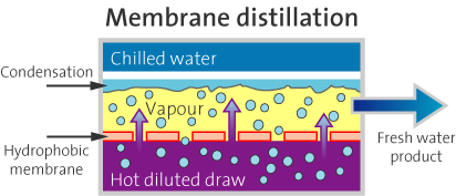
In membrane distillation water is transferred though a hydrophobic membrane by difference in vapor pressure. The driving force of this process is temperature difference. The difference in vapour pressure allows water in gas form to pass the membrane pores while water molecules are rejected by the hydrophobic membranes. Graphic via BlueTec.
From email from Reclamation (Peter Soeth):
Bureau of Reclamation Commissioner Estevan López today announced $2.93 million in funding for water treatment technologies research. This funding is being provided through the Desalination and Water Purification Research Program for the development of new water treatment technologies and Title XVI Water Reclamation and Reuse Program for research into the deployment of new technologies that supports the expansion of water technologies in new locations.
“In a number of Western river basins, Reclamation and its partners are seeing demands for water exceed traditional supplies,” Commissioner López said. “Funding research into new water treatment technologies will expand the number of water supply resource options.”
The Desalination and Water Purification Research Program will provide $1.78 million for nine lab-scale and three pilot-scale projects. This program supports the development of new advanced water treatment technologies. Up to $150,000 will be provided for research and laboratory studies that must be completed within a year and up to $200,000 per year for pilot-scale projects that must be completed within two years.
For example, the Colorado School of Mines in Golden, Colorado, will receive $143,869 to study approaches to increase technical feasibility of using membrane distillation for desalinating high-concentration brines, brackish waters, produced waters and seawater. [ed. emphasis mine]
The Title XVI Water Reclamation and Reuse Research Program will provide $1.15 million to help fund nine projects in the Western United States. This program helps communities address water supply challenges by providing much-needed funding for research to establish or expand water reuse markets, improve or expand existing water reuse facilities, and streamline the implementation of clean water technology at new facilities.
For example, the City of San Angelo, Texas, will use $300,000 of federal funding and $1,094,849 of non-federal funding to perform pilot-scale testing to assess existing water treatment technologies for a direct potable reuse project. The proposed research will evaluate approaches to maximize water recovery, verify the performance of advanced water treatment processes, and assess the viability of reverse osmosis concentrate disposal using deep injection wells at an inland location.
The Colorado Springs Utilities Board voted Wednesday to maintain the status quo of governance by hanging onto their jobs overseeing the billion-dollar enterprise.
The vote was 8-1, with City Council President Merv Bennett opposing the move. Bennett chairs Council, while Councilor Andy Pico chairs the Utilities Board.
Says Bennett in an interview: “I was disappointed on the vote. I’ve been really clear that we need to change the governance because of how much time it’s taking. It’s so technical. I spend 55 to 60 hours a week [on city business]. Utilities is so important to us that having a board whose total focus on that is important. City Council needs to focus on the city. My desire was to have an appointed board. But I will accept the decision of the group and move on. It’s possible a group might decide to petition something onto the ballot, and that’s OK.”
That “group” is the Colorado Springs Forward nonprofit, formed a couple of years ago with the mission to direct policy and politics in local affairs.
The letter, signed by many major American groups, pushes back against climate denial and calls for policy solutions to cut greenhouse gas emissions.
Thirty-one major American scientific organizations sent a letter to Congress on Tuesday emphasizing the overwhelming consensus on climate change science and the urgent need for climate action. The letter served as a scientific counterpoint to recent actions by Congress designed to question that consensus.
Reminding members of Congress that “rigorous scientific research concludes that the greenhouse gases emitted by human activities are the primary driver” of global warming, they cited nearly universal support for the scientific consensus as expressed by the U.S. National Academies, the U.S. Global Change Research Program and the U.N.’s Intergovernmental Panel on Climate Change.
“To reduce the risk of the most severe impacts of climate change, greenhouse gas emissions must be substantially reduced,” said the letter, which was endorsed by institutions such as the American Association for the Advancement of Science, the American Geophysical Union and the University Corporation for Atmospheric Research, a nonprofit consortium that includes more than 100 North American universities.
“In addition, adaptation is necessary to address unavoidable consequences for human health and safety, food security, water availability, and national security, among others,” the letter continued.
Under Republican leadership, Congress has persistently worked to block President Obama’s climate agenda. A report released this spring found that a third of current Congressional representatives and Senators publicly doubt the scientific consensus on global warming.
Republican members of the House Science Committee, led by Lamar Smith (R.-Texas), subpoenaed federal scientists last year after researchers from the National Oceanic and Atmospheric Administration published a study that debunked the idea of a recent “global warming hiatus.” More recently, the committee demanded internal communications from the attorneys general investigating ExxonMobil for potential climate-related fraud.
Tuesday’s letter to Congress echoes a previous letter written in 2009, which was signed by 18 scientific societies. The updated version includes additional signatories including the Society for the Study of Amphibians and Reptiles and the National Association of Marine Laboratories.
The letter concluded with an offer to help legislators understand the science: “We, in the scientific community, are prepared to work with you on the scientific issues important to your deliberations as you seek to address the challenges of our changing climate.”