
Month: July 2016
@RockiesProject: Student Researchers Study River Governance, Management

Here’s the release from the State of the Rockies Project:
Five Colorado College State of the Rockies Project student researchers are in the field this summer, studying and comparing issues of river governance and river management.
Joseph Friedland ’17, Emelie Frojen ’17, Lea Linse ’17, Mollie Podmore ’17, and Amy Rawn ’17, along with Program Coordinator Jonah Seifer ’16 and Associate Director Brendan Boepple ’11, are working in two of the West’s largest river basins, the Colorado River Basin and the Columbia River Basin. The focus of the 2016-17 State of the Rockies is “Inclusive River Governance in a Changing West,” with the core this year’s project being a comparative study of water issues in the Southwest vs. Northwest,
The State of the Rockies Project research team recently spent four days in Silverton and Durango, Colorado, where they examined how governance systems allow for the incorporation of traditionally under-represented values in water management. These issues are particularly important in an increasingly water-stressed future, affected by climate change and growing populations throughout the West.
“We were fortunate to meet with a diverse set of stakeholders involved with the Animas River on the trip, and were also able to sit in on a meeting of the Animas River Stakeholders Group, the local watershed group that has been working to address the region’s mining legacy for the last 20-plus years,” says Boepple, who has been with the project for five years.
“The trip not only allowed the students to further their research and see some of these important issues firsthand, but it also allowed them to see how actual management decisions are made,” says Boepple. “Additionally, the Gold King Mine spill, which occurred last August, provided an interesting backdrop to conversations and research discussions about the Animas River and its management.”
While in Silverton, the team visited the Mountain Studies Institute, which conducts scientific research and environmental restoration in the area, and emphasizes the need for communicating that research to a wide audience in the San Juan Mountains region. Boepple says they have some of the most complete data on the Animas River before, during, and after the Gold King Mine spill, and have been sharing that information with the local community to help residents understand the impact of the spill.
The State of the Rockies team will head next to the Pacific Northwest, where they will spend two weeks researching tribal water issues, the debates surrounding regional dam deconstruction, and the important role that salmon play in the management of the Columbia River system.
This summer’s research will be published in the 2017 State of the Rockies Report, due out in the spring.
#ColoradoRiver: Aspinall Unit operations update #COriver

From email from Reclamation (Erik Knight):
Releases from Crystal Dam will be increased from 1850 cfs to 2000 cfs on Friday, July 15th. Flows in the lower Gunnison River have been dropping quickly over the last week and are now just under the baseflow target. This increase is intended to raise flows in the lower Gunnison River as well as manage the reservoir content to reach the end of year winter target elevation. The current April-July runoff forecast is now at 91% of average. The current content of Blue Mesa Reservoir is 796,000 acre-feet which is 96% full.
Flows in the lower Gunnison River are currently below the baseflow target of 1500 cfs. This increase should restore flows to a level at or above the baseflow target.
Pursuant to the Aspinall Unit Operations Record of Decision (ROD), the baseflow target in the lower Gunnison River, as measured at the Whitewater gage, is 1500 cfs for July.
Currently, diversions into the Gunnison Tunnel are around 1050 cfs and flows in the Gunnison River through the Black Canyon are around 850 cfs. After this release change Gunnison Tunnel diversions will still be at 1050 cfs and flows in the Gunnison River through the Black Canyon should be around 1000 cfs. Flows in the river may be less than 1000 cfs if the maximum capacity of the Crystal powerplant proves to be less than 2000 cfs. Current flow information is obtained from provisional data that may undergo revision subsequent to review.
Flood plain meeting draws huge crowd — The Brush News-Tribune

From The Brush News-Tribune (Katie Collins):
Tuesday night saw the Mark Arndt Events Center in Brush packed full with nearly 400 citizens who gathered to take in information regarding the newly updated floodplain map that recently changed the borders throughout Morgan County.
The Open House format was somewhat of a surprise for the hundreds who floodedinto the Morgan County Fairgrounds for the 4 p.m. start, but there, all were able to visit booths set up by representatives of the National Flood Insurance Program, the Colorado Water Conservation Board and FEMA who converged to host the informational event.
Local entities from the Morgan County Planning and Zoning Commission, City of Brush, Town of Wiggins, the Morgan County Board of Commissioners and even local insurance agents were also present for the packed house, answering questions, fielding comments and concerns and helping property owners plug in addresses for an in-depth look at how the new borders might affect them and their insurance requirements.
More information on specific property placement within the new map, on the City of Brush floodplain ordinance requirements, FEMA’s floodplain resources or on the National Flood Insurance Program, can all be found online at http://www.brushcolo.com by clicking on the orange ‘FLOODPLAIN UPDATES’ box.
The digital map program that provides a more detailed property search can also be found at http://tiny.cc/CSLF_Morgan_County.
Arkansas Valley Conduit bill advances out of US Senate committee

From US Senator Gardner’s office via the Kiowa County Press:
The Senate Energy and Natural Resources Committee today approved three bills authored by Senator Cory Gardner (R-CO): legislation pertaining to the Arkansas Valley Conduit and Florissant Fossil Beds Monument as well as the Bolts Ditch Access and Use Act.
Authorized in the 1960s, the Arkansas Valley Conduit project in Southeast Colorado will deliver clean drinking water to local communities across the region upon completion. Gardner’s bill extends greater flexibility to the Southeastern Colorado Water Conservancy District by allowing the maximum use of miscellaneous revenue collected from the Fryingpan-Arkansas Project to be immediately reinvested into the Arkansas Valley Conduit once construction begins.
Gardner’s Bolts Ditch Access and Use Act would authorize special use of the Bolts Ditch headgate and the segment of the Bolts Ditch within the Holy Cross Wilderness Area, allowing Minturn to use its existing water right to fill Bolts Lake. This would solve a problem created in 1980 when Congress designated Holy Cross Wilderness area, but inadvertently left Bolts Ditch off of the list of existing water facilities.
“I’m proud the Energy and Natural Resources Committee approved legislation I authored relating to the Arkansas Valley Conduit and Florissant Fossil Beds Monument, as well as the Bolts Ditch Access and Use Act,” said Gardner. “My Bolts Ditch and Arkansas Valley Conduit bills recognize Coloradans, not Washington bureaucrats, know how to best manage our state’s water resources, and I’m proud to return power to local Colorado communities.”
Gardner’s Florissant Fossil Beds Monument legislation will allow for enhanced wildfire protection as well as additional habitat for wildlife and recreational opportunities for visitors. Established as a national monument in 1969, the Florissant Fossil Beds National Monument is located west of Pikes Peak and less than 40 miles from Colorado Springs, CO. The park is home to diverse fossil deposits, maintaining a collection of over 12,000 specimens. The park also provides recreational experiences and curriculum-based education programs for its visitors. A private landowner submitted a proposal to donate 280 acres of land adjacent to Florissant Fossil Beds Monument, but due to current law the land transfer cannot take place. The park, which currently possesses 5,998 acres of land, has a legislative ceiling of 6,000 acres. Therefore, if acquired, the 280-acre parcel of land would project the park above its legal threshold. This legislation is commonsense in that it would permit a private landowner to donate land to Florissant Fossil Beds National Monument.
In Lower #ColoradoRiver Basin, Small Fixes Are Hoped to Avoid the Big Fix — Colorado Public Radio #COriver

From Rocky Mountain PBS (Jim Trotter):
The river system, with its headwaters in Rocky Mountain National Park, has been stressed by drought since 2000. The most recent national climate assessment for the Southwest forecasts that the country’s hottest and driest region can only expect more of the same.
“This may be what the start of a water war looks like,” suggested a recent story in the Los Angeles Time.
The story by ace writer William Yardley focuses on negotiations between the lower basin states of California, Arizona and Nevada to voluntarily reduce withdrawals from Lake Mead in order to forestall the mandatory, more drastic cutbacks that most likely would come with a federal declaration.
Yardley calls the approach “tinkering.”
But Tom Buschatzke, director of the Arizona Department of Water Resources and one of the senior water managers on the river, says, “I like to describe this as another incremental step.”
The question is, can incremental steps preserve the governance of the river pretty much as is, defined by the Colorado River Compact of 1922 and modified by numerous laws and court decisions since?
“I don’t think a water war is inevitable,” Buschatzke tells Yardley.
The upper basin states generally and Colorado particularly are not as in dire shape as the lower basin states. As we’ve said before, Colorado has almost been in a bubble the past couple of years – average to above average snowpack, strong runoffs, filled reservoirs. But if water runs short for 25 million people in the lower basin, many of whom are in Southern California, no one can expect to remain untouched.
Yardley seems to admire the Arizona approach.
“But for Buschatzke,” he writes, “who has spent decades efficiently providing water for a desert population – Arizona uses less water now than it did 60 years ago even though the population has soared from 1.1 million to 6.7 million – the big fix is actually in the accumulation of all the little fixes he and others are constantly making. A federal grant for new technology that will better measure water use. Paying a farmer to fallow a field. Saying nice things about your colleagues across the state line and the fine folks in Washington. Keeping things collegial. Sharing. Saving. Preserving the process – and the peace.”
Obviously better than a new water war.
Rifle’s potable supply back in top form after repairs

From The Grand Junction Daily Sentinel:
The city of Rifle on Wednesday lifted weeks-long water restrictions after the completion of repairs.
The city had barred outdoor water use June 1 due a break in the pipe delivering water from the Colorado River to its treatment plant.
The break also damaged pumps. The city began pumping from a secondary water source and was able to begin allowing outdoor watering by residents on odd or even days, depending on their address, a little more than a week after the problems began. The city has fully restored service after completing pump repairs.
City manager Matt Sturgeon said in a news release, “The city never wants to be in a position where water restrictions are necessary, especially during a time when temperatures are reaching into the triple digits, and the city appreciates the cooperation from our citizens during this difficult time.”
#COWaterPlan: Colorado Ag Water Alliance workshop recap — The Fort Morgan Times

Here’s part one of a recap of the meeting in Brush yesterday from Stephanie Alderton writing for The Fort Morgan Times:
The Colorado Ag Water Alliance, along with the Colorado Cattlemen’s Association and the Colorado Water Institute, hosted a three-hour workshop for producers to help explain the new Water Plan’s application to agriculture. Speakers with various roles in water and agriculture talked about the new state plan’s emphasis on alternative transfer methods (ATMs) to conserve water, how the plan will be implemented in the South Platte Basin in particular and how farmers can increase water efficiency. People came from all over the state to hear and discuss details in the plan.
“A good Colorado plan needs a good South Platte plan,” Joe Frank, of the South Platte Basin Roundtable, said. “Nine out of the top 10 ag producing counties are in this basin.”
During his talk, the first of the day, he explained that the area has an increasing water supply gap as the population grows, which the Water Plan seeks to address. Frank’s group is in charge of implementing the plan in South Platte by coming up with a balanced, pragmatic program for farmers that is consistent with Colorado law. He said that program will focus on maximizing the use of existing water, encouraging farmers and other organizations to use ATMs in order to share water more effectively and promoting multi-purpose water storage projects, among other things.
Mike Applegate, of the Northern Water Board, talked about the status of current storage projects all over the state, while MaryLou Smith of Colorado State University gave a list of reasons why producers should want to use their water differently in an effort to conserve more. Phil Brink, of the CCA, reported the results of a survey on farmers’ opinions of ag water leasing, while Dick Wolfe, an engineer with the Colorado Division of Water Resources, explained the problems with the “use it or lose it” mentality farmers tend to have toward their water rights. John Schweizer, a producer from the Arkansas Basin, talked about the success of the Super Ditch near his hometown, an ATM project that recently started seeing results. After a final panel made up of people involved in various ATM projects, including Morgan County dairy farmer Chris Kraft, the audience spent more than an hour trading questions and comments with the speakers.
The purpose of the workshop, according to a CAWA press release put out beforehand, was to bring people together to discuss the “opportunities and barriers” the Water Plan presents. The speakers in the second half of the day presented many opportunities in the form of ATMs and other projects. For example, Schweizer said the Super Ditch, though it’s taken many years to be completed, has the potential to help many farmers conserve water without new legislation or complicated water rights battles.
“We’ve had a lot of people say this wouldn’t work,” he said. “We’re starting to prove them wrong…I see nothing but a glorious future for this project.”
But it was clear that many people at the workshop saw many remaining obstacles to water efficiency. During the question and answer session at the end, several people pointed out that, while ATMs can make it easier for farmers and other organizations to share water, they can’t solve the problem of water shortages by themselves.
“We are concerned that the state Water Plan talks so much about these ATMs, and a lot of policy makers around the state are counting on them,” Smith said while moderating the discussion. “Part of what we want to do is get the message of what you guys are saying back to some of those policy makers.”
Colorado’s Superfund Sites Stretch From Silverton to East Colfax Avenue — Westword

Lincoln Park/Cotter Mill superfund site

The “Bonita Peak Mining District” superfund site. Map via the Environmental Protection Agency

Commodore waste rock superfund site Creede

Summitville Mine superfund site

Rocky Mountain Arsenal — 1947

Buffalo at Rocky Mountain Arsenal

Schwartzwalder Mine via Division of Reclamation and MIning
From Westword (Ana Campbell):
Superfund sites dot Colorado; arguably the most well known is the long-dormant Rocky Mountain Arsenal, the chemical weapons and pesticide manufacturing plant once dubbed the most contaminated square mile on earth and now home to a wildlife refuge.
Many other past and present Superfund sites are tougher to spot, including the Denver radium sites.
Radium, once thought to be a miracle cure for cancer, was big business in Denver before the industry went belly up in the 1920s. Years later, all that remained of the industry were the 65 properties around Denver contaminated with radioactive material, which an EPA official discovered in the late ’70s. Soil at the sites was contaminated with radium, thorium and uranium, the radioactive decay of which produces radon gas, according to a Colorado Department of Public Health and Environment report.
In 1980, then-President Jimmy Carter signed into law the Comprehensive Environmental Response, Compensation and Liability Act, which set up an EPA-managed fund dedicated to paying for the cleanup of hazardous sites around the country. That included the Denver radium sites, which in 2010 were finally released from the EPA’s National Priorities List, “the list of national priorities among the known releases or threatened releases of hazardous substances, pollutants, or contaminants throughout the United States and its territories,” according to the EPA’s website.
Colorado Department of Public Health and Environment officials still test groundwater at the former Shattuck Chemical Co. site in south Denver, which falls under Denver radium’s Superfund, and they will continue to test water every five years until it meets department standards.
The radium sites have all been cleaned up, the contaminated asphalt and soil scraped off and hauled away.
But there are other active Superfund sites in Colorado…The EPA has a full list of proposed, final and deleted sites in Colorado.
Weekly Climate, Water and #Drought Assessment of the Upper #ColoradoRiver Basin
Click here to read the current assessment. Click here to go the the NIDIS website hosted by the Colorado Climate Center.
#COWaterPlan: “There’s real time and then there’s water time” — Joe Frank
From The Sterling Journal-Advocate (Jeff Rice):
Members and staffers of the Lower South Platte Water Conservancy District’s board of directors have questioned figures published last weekend that put the cost of the Colorado Water Plan at nearly $6 million…
Joe Frank, LSPWCD executive director, said he questions the accuracy of the figures because of a conversation he’s had with Brent Newman, a program director with the Colorado Water Conservation Board, which produced the CWP. According to Hartman’s figures the roundtable groups for the Denver metro area and the South Platte Basin, which collaborated on a joint Basin Implementation Plan, spent $2.2 million on that plan. But Frank said his conversation with Newman put the number at $1.3 million, or a little more than half of the amount estimated by Hartman.
Several board members said this morning that even if the $6 million figure is accurate, it’s not out of line for the work that was done, and the results have been well worth the money.
“I don’t know if you can put a value on the relationships that have grown out of this,” said Brad Stromberger, a board member from Iliff. “The amazing thing was that people who might’ve never talked to each other before, and certainly never talked to this extent, actually sat down and worked out a plan they all can agree on. I just don’t think you can put a value on that.”
The board members also answered criticism that little has happened since the plan was unveiled in November, and that there aren’t specific project recommendations in the plan. They pointed out that the Colorado Water Plan wasn’t meant to promote specific water storage projects or conservation strategies, and that some movement is being seen.
“It’s meant to be a blueprint,” said Gene Manuello of Sterling. “But you can’t make recommendations for a specific project in a statewide plan. A water storage project is going to affect someone upstream or downstream, and you have to work those things out.”
Frank said the plan does, in fact, specify how much water will have to be found over the next 30 to 50 years, and it lays out a process for identifying and developing projects. The board members pointed to House Bill 16-1256, which is aimed at better identifying and recommending water storage possibilities in the South Platte Basin, as one of the results of the CWP. In fact, Section 1 of the bill even mentions the CWP as a reason for the South Platte study to be done.
Frank said even that legislation, which Sen. Jerry Sonnenberg, R-Sterling, helped sponsor, addresses two competing needs in the search for adequate water. The bill was introduced by Sen. Paul Brown, R-Ignacio, with the intent of finding ways to make more trans-mountain water diversion projects unnecessary. Frank pointed out that a study that identifies water storage opportunities in the South Platte Basin helps water users on both sides of the Continental Divide.
As for the apparent time lag between the plan’s introduction last year and work actually being done, Frank said, “There’s real time and then there’s water time. Sometimes a lot of talking has to be done to make sure everybody’s on board with a project.”
Supreme Court to consider report on #RioGrande case (#TX #NM) — The #Colorado Springs Gazette

From the Associated Press via The Colorado Springs Gazette:
The nation’s highest court will likely have to settle a dispute between Texas and New Mexico over management of water from the Rio Grande.
Officials in both states have been waiting for nearly a year for a recommendation on the handling of the case that could dramatically curb groundwater pumping in some of New Mexico’s most fertile valleys and force the state to pay as much as $1 billion in damages.
Now, a special master assigned by the U.S. Supreme Court is recommending the rejection of a motion by New Mexico to dismiss the case, meaning it can move forward as long as the high court agrees…
New Mexico state Sen. Joe Cervantes, whose district includes the border region, said the special master’s recommendation was not a surprise, and that he and a small group of lawmakers have been warning about potentially dire outcomes if Texas gains the upper hand in the legal battle.
Cervantes said the recommendation to let the case proceed seems to support demands by Texas for more water from the Rio Grande.
“A great deal more water delivered to Texas to make up for historic shortfalls seems to be a clear direction he’s going,” Cervantes said of the special master. “And since water won’t make up for all of the shortfalls, we’re looking at the risk of large financial damages.”
The parties have a chance to respond to the special master before the Supreme Court weighs in on what is the latest legal battle over water to pit states against one another. Connecticut and Massachusetts, Nebraska and Wyoming, and New York and New Jersey all have been embroiled in water disputes over the decades.
The federal government has weighed in on the New Mexico-Texas case, arguing that pumping north of the border is tapping a shallow aquifer that would otherwise drain back into the Rio Grande and flow to Texas and eventually to Mexico.
Officials in Texas made similar claims about water shortages under the compact more than a decade ago. Irrigation districts that serve farmers on both sides of the border reached an operating agreement with the federal government in 2008 that shared the burdens of drought while ensuring everyone received water allotments.
Local water managers say the agreement worked even during the driest of times, but former New Mexico Attorney General Gary King insisted that it was more beneficial to Texas and sued over his concerns, setting the stage for Texas to take its complaints to the U.S. Supreme Court.
Current Attorney General Hector Balderas said New Mexico will continue to work diligently to protect state residents and their water supply.
New Mexico argues that its only duty under the compact is to deliver water to Elephant Butte Reservoir for storage for downstream users. It also argues that state law, not the compact, governs the distributions of water released from Elephant Butte within state boundaries.
Officials with the Elephant Butte Irrigation District — responsible for funneling Rio Grande Project water to farmers and other users — say the special master’s report implies that the water is protected by the compact and federal law.
In his report, the special master suggested New Mexico has a “stunted interpretation” of the compact and that the state may not divert or intercept water it’s required to deliver downstream.
The Rio Grande stretches from southern Colorado, through New Mexico and Texas and into Mexico. In recent years, parts of the river have gone dry in New Mexico and flows often don’t reach the Gulf of Mexico.
Fort Lyon Ditch: Large-scale changes requested by Arkansas River Farms

From The Pueblo Chieftain (Chris Woodka):
In sometimes heated exchanges, Fort Lyon Canal shareholders questioned the impact of large-scale changes of how water moves on the Arkansas Valley’s largest ditch.
Arkansas River Farms is asking the Fort Lyon board of directors to consider changes that would dry up about 6,400 acres and add sprinklers to 6,200 acres, all part of the more than 14,000 acres the partnership purchased for $50 million last year.
For the directors, it means walking a tightrope. While some shareholders are worried, Arkansas River Farms is the largest shareholder on the ditch. All must be treated fairly, the board believes.
In addition, as official representatives of the canal company, the Fort Lyon board will be a party in the eventual water court case to change how the water rights can be used.
“This isn’t the first time we’ve done this,” said Dale Mauch, a Fort Lyon board member who chaired the board in 2003, after High Plains LLC bought the same farms now in question. “High Plains and Colorado Beef also required a ruling from the board, so we have precedents on setting requirements.”
During a hearing this week, shareholders questioned how some of the water could be measured down to tenths of an inch, what would happen to several laterals that ARF will abandon, how drains that carry water back to the Arkansas River would be affected, water quality changes from increased groundwater use and paying for unforeseen future effects.
The chance for any shareholder to ask questions is important. The High Plains hearing, which lasted four days in November 2003, was similar in structure to this week’s hearings. In that case, however, High Plains already had filed an application to change water rights. The board eventually voted to allow High Plains to take water in rotation, a first step in a plan to move it to other destinations around the state.
High Plains’ plan was struck down in water court in 2004 and in state Supreme Court in 2005. The farms it had purchased were sold to Pure Cycle, which sold most of them to ARF last year.
Arkansas River Farms insists it is only interested in improving the farms it owns, and no longer plans to move water to other parts of the state, although some are skeptical.Another difference with this week’s hearings is that they are being held in the middle of summer, when farmers are busiest out in the field.
“If the weather’s good, they’ll be putting up hay,” one farmer said.
Still, about 75 people, mostly farmers, showed up for the first day of hearings.
The hearings originally were set for January, but postponed to allow the board to hire an outside attorney and engineer in response to conflict-of-interest charges.
The board isn’t likely to make a decision soon on eight requests of approval in changes of ditch operations and 10 terms or conditions suggested by ARF. Also under consideration are the revegetation plan for acres that would be dried up and the method by which the farming partnership’s shares would be managed by the Lower Arkansas Water Management Association.
Board members each have a thick notebook of information about the proposal to read through as well as two days of testimony — so far.“We’ll rely heavily on counsel,” said Josh Weimer, president of the Fort Lyon board. He added that the board’s outside attorney, David Hallford of Glenwood Springs, has years of experience in cases involving Arkansas Valley water changes. “I think what this really does is set precedence for the water court case, and will give the judge our opener.”
#ClimateChange: The world’s clouds are in different places than they were 30 years ago — The Denver Post

From The Washington Post via The Denver Post:
In a new study published in Nature on Monday, scientists say they have for the first time thoroughly documented one of the most profound planetary changes yet to be caused by a warming climate: The distribution of clouds all across the Earth has shifted, they say.
And moreover, it has shifted in such a way – by expanding subtropical dry zones, located between around 20 and 30 degrees latitude in both hemispheres, and by raising cloud tops – as to make global warming worse…
That these things would happen in theory, based on our understanding of the physics of the atmosphere, has long been expected. The physical reasons for the expectation get complicated fast, involving factors such as the atmospheric “Rossby radius of deformation,” and how the Earth’s rotation bends the path of winds – the so-called Coriolis force, Norris explains. But all of this has long been an expectation based on runs of sophisticated climate simulations that embed within their coding the fundamental equations that govern the behavior of the atmosphere.
However, the study painstakingly pieced together images from weather satellites between the years 1983 and 2009 – correcting for the numerous known quirks of these satellites that have also made their measurements of atmospheric temperatures a messy affair – to line up pre-existing theory with observations.
“We’re seeing what the climate models think the pattern of cloud change would be,” Norris said.
Here’s how the paper summarizes the changes, region by region: “cloud amount and albedo [i.e., reflectivity] increased over the northwest Indian Ocean, the northwest and southwest tropical Pacific Ocean, and north of the Equator in the Pacific and Atlantic oceans. Cloud amount and albedo decreased over mid-latitude oceans in both hemispheres (especially over the North Atlantic), over the southeast Indian Ocean, and in a northwest-to-southeast line stretching across the central tropical South Pacific.”
#AnimasRiver: Navajo Nation Endorses Superfund Cleanup Of Colorado Mines — CBS Denver

Eric Baker
From the Associated Press via CBS Denver:
The Navajo Nation has formally endorsed a Superfund cleanup of southwestern Colorado mines, including one that released millions of gallons of wastewater into a river on Navajo land.
The U.S. Environmental Protection Agency, which is considering a Superfund designation for the Gold King Mine and other sites, released the letter Monday…
A Superfund designation could release millions of dollars for a cleanup. The EPA says a decision could come as early as this fall.

My summer mixtape: Getting in the irrigation mood
@USBR Releases Finding of No Significant Impact for Pueblo Hydropower Project

Here’s the release from the US Bureau of Reclamation (Patience Hurley):
The Bureau of Reclamation has completed the environmental study process and released the necessary documents for the Pueblo Hydropower Project to move forward.
“Final Environmental Assessment (EA) and Finding of No Significant Impact (FONSI) were completed to address a request from Southeastern Colorado Water Conservancy District, Board of Water Works of Pueblo, and Colorado Springs Utilities to develop hydropower at the federally-owned Pueblo Dam,” said Signe Snortland, Area Manager for Reclamation’s Eastern Colorado Area Office.
The next step for Reclamation is to enter into a contract called a Lease of Power Privilege. This contract authorizes the use of federal lands, facilities, and Fryingpan-Arkansas Project water to construct, operate, and maintain a 7 megawatt hydropower facility at the Pueblo Dam. The project utilizes a “run of river” design that harnesses water releases from Pueblo Dam to generate power and provide a clean, renewable source of energy.
“A hydropower plant and associated facilities will be constructed at the base of Pueblo Dam, utilize the dam’s north outlet works, and immediately return flows to the Arkansas River downstream of the dam,” said Snortland.
About 1.4 miles of new power and fiber-optic lines will also be constructed to connect the hydropower plant to the existing Black Hills Energy’s Pueblo Reservoir Substation. Construction is anticipated to begin in late 2016 with power generation anticipated in 2018.
The EA and FONSI are available online at: http://www.usbr.gov/gp/ecao/nepa/pueblo_hydropower.html
For additional information or to receive a printed copy of the EA/FONSI, please contact Terence Stroh at 970-962-4369 or TStroh@usbr.gov.
Pollution control systems added to Rico Argentine mine — The Cortez Journal

From The Cortez Journal (Jim Mimiaga):
The long-closed site is on about 80 acres just north of Rico. Its leaking St. Louis Tunnel and pond treatment system sit beside the Dolores River, which provides agricultural and municipal water for 27,000 people in two downstream counties, several towns and the Ute Mountain Ute reservation.
But unlike Gold King Mine, the Rico Argentine Mine has had significant pollution-control systems in place. And more control systems are planned, said Paul Peronard, the Environmental Protection Agency’s cleanup coordinator at the mine.
“Here, we have a great understanding of the mineworks and have controls and monitoring in place, so we know where the pressure is,” Peronard said during a June 29 tour. “Based on that, the risk is pretty low.”
The mine is being reclaimed by Atlantic Richfield Co. under a 2011 Superfund order from the EPA. The reclamation program has four major components: new relief wells, more advanced water treatment, real-time monitoring, and a new waste disposal site.
How crews work to prevent a blowoutConstruction and drilling have begun on two new relief wells that will help drain the tunnel and prevent a blowout.
Mine and EPA officials estimate there is 1.7 million to 2.2 million gallons of water backed up in the mine. The contaminated water has high concentrations of manganese, zinc, copper, arsenic and cadmium.
The Rico Argentine mine’s workings come together to continuously drain through the collapsed St. Louis tunnel at a base flow of 400-600 gallons per minute, spiking to 1,000 gallons per minute in the spring.
But in the past few years, officials have noticed that the pressure behind the collapsed tunnel has been increasing each spring, which they attribute to silt, which has constricted the flow of the drainage.
Monitoring devices in the mine tunnel give operators real-time data on the elevation of the of backed-up water and the built-up pressure. Currently, the water level in the tunnel is at 8,860 feet elevation from sea level. A level considered dangerous is 8,871 feet.
A siphon in the tunnel has been pulling water out and piping it to the treatment facility. But officials fear that is not enough, so two new horizontal relief wells are being drilled into the tunnel to pump backed-up water to the treatment facility. The new wells and pumps are scheduled to be operational by the end of summer.
“We are currently getting water out of there, but let’s not miss the point of preventing a blowout, so we’re installing big relief wells as a redundant safety factor. If it backs up to a level we don’t want, we can pump it out more efficiently,” Peronard said.
Water-treatment system is scaled upA pilot water-treatment system that uses biological controls is working better than expected and is being scaled up to treat higher volumes of mine drainage year-round.
The Enhanced Wetland Demonstration Treatment System is one of two in the nation and is the only one at such a high elevation.
Water from the mine flows through a series of treatment cells with bio-reactor substrates of sawdust and organic material that use bacteria to break down heavy metals.
The treated mine water then flows through a series of 11 settling ponds before being released into the Dolores River.
“The water treatment plant is designed to handle the variable flows and water temperatures year-round,” Peronard said.
The biological system is preferred over the previous lime treatment system, he said, because the spent substrate matrix only has to be replaced every 5-15 years. It also can operate during winter without on-site management in the avalanche-prone area…
“The water here needs to be treated forever, so we want to make the costs as low as possible to give the plant longevity and not be a huge money pit,” Peronard said.
A double-lined, solid waste disposal site has been built at the site to permanently store mine wastes from the abandoned lime-treatment system as well as the toxic sludge that is removed from settling ponds. The pit can hold 60,000 cubic yards of waste, and can be expanded to store up to 365,000 cubic yards of waste.
Systems monitored in real timeCritical systems are wired to be monitored in real time, and there are live cameras throughout the plant. Mine managers and the EPA are notified remotely about the water level and pressure behind the collapsed tunnel, and on flow rates from the mine into the water treatment facility.
“We get real-time readings that ping us on the conditions,” Peronard said. “It’s an impressive system that continuously tracks and monitors operations.”
If a problem threatens the Dolores River, an automated notification system alerts county and emergency managers, irrigation managers, sheriff departments and irrigators.
And the historic and current monitoring data is, or soon will be, posted on the EPA website.
“If the public wanted to know the elevation of water behind the tunnel, they can look it up,” Peronard said.
New dam considered as a backupAs an additional precaution against a blowout, the EPA and Atlantic Richfield are considering building a dam just beyond the St. Louis adit that would be capable of capturing up to 2.2 million gallons of water backed up inside the mine.
“If you did have a catastrophic blowout, the dam would knock everything down right there,” Peronard said.
The plans for the dam are in place, and the EPA will make the decision by the end of the summer on whether it is necessary.
Atlantic Richfield is paying for “99 percent” of the costs of the mitigation and reclamation project at the mine, the EPA said, but total costs were not reported. Eventually, a long-term operator will be contracted to maintain the system, and oversight will be handed off to the Colorado Department of Health and Environment.
The tour gave area water managers confidence that the old mine is being controlled.
“It gives me peace of mind that the are doing a good job with the treatment of water and are planning for larger flows,” said Randy McGuire, water-plant manager for the downstream town of Dolores.
“The redundancies designed into the system raises my confidence level,” said Todd Parisi, emergency operations coordinator for Dolores County.
For documents on the mine cleanup and treatment facility at the Rico-Argentine mine go to https://www.epaosc.org/site/site_profile.aspx?site_id=7459
Pueblo Whitewater Park gaining popularity with river surfers — The Pueblo Chieftain
From The Pueblo Chieftain (Larry Lopez):
In May 2005, Pueblo Whitewater Park — a half-mile section of the Arkansas between the Fourth Street and Union Avenue bridges — was unveiled. The park featured eight drops primarily for kayakers.
It didn’t take long, though, to discover that the river park’s third and fourth waves were ideal for surfing -— be aboard a boogie board, surfboard or paddle boating — and an old ocean sport was born in landlocked Pueblo…
[Bob Walker] also began spreading the word on social media via Facebook and surfers came, traveling from Denver, Crested Butte, Glenwood Springs and other areas around the state to ride Pueblo’s waves.
Walker now teams with the Colorado Association of River Surfers to host a surfing contest in conjunction with International Surfing Day observed each June.
Gogarty finds river surfing “much more fun,”
“In the ocean you spend a lot of time paddling for hours. Catching a wave is challenging and then you usually ride for a few seconds,” he said.
“In the river, the wave is not going anywhere, it’s always there. You get to ride as long as you can. It can last minutes.”
The river waves range 2-3 feet in height.
The Pueblo course is rated No. 1 in Colorado and among the top 10 across the U.S., Gogarty boasts.
Arkansas River Farms denies it has plans to move water to cities — The Pueblo Chieftain
From The Pueblo Chieftain (Chris Woodka):
An attorney for Arkansas River Farms told the Fort Lyon Canal board Monday that the partnership’s plans do not include selling water to Front Range communities.
“That’s not what this program does,” attorney Steve Sims said, referring to suggestions in a recent Chieftain editorial that the $50 million purchase of farms on the Fort Lyon Canal were a first step toward permanent dry-up.
Sims explained afterward that the plan to shift some of the water into well augmentation plans and dry up other acres is a way to make the farms more valuable in the future.
“It’s really just moving into corporate farming,” Sims said.
Karl Nyquist, who talked in 2011 about moving Lamar Canal water to the Front Range, issued a statement to the board that his company, C&A, has invested in the area for 20 years and is now working with the Syracuse Dairy in Kansas to supply forage from 10,000 acres of farm ground.
He also said his new partners, Resource Land Holdings, are interested in investing another $15$20 million in developing the Fort Lyon land and working with other farmers to create more valuable dairy or vegetable farms.
Not everyone was convinced.
“I think there’s going to be a demon in the shadows,” said Jay Winner, general manager of the Lower Arkansas Valley Water Conservancy District, who was among about 75 people, mostly shareholders, who attended the hearing. “Nyquist said he was going to move the water off the farmland, and this is just a parallel path. A leopard can change the color of his spots, but he’s still a leopard.”
The Lower Ark will wait until a water court case is filed to formalize its objections to the ARF plan, Winner added.
Arkansas River Farms asked the Fort Lyon board to initiate bylaw changes and approve an operating agreement to change the timing of irrigation as part of a plan that would dry up 6,400 acres in order to improve irrigation on 6,200 acres clustered near Las Animas.
The board plans at least another day of hearings to answer more questions.
Fort Lyon shareholders were invited to attend the daylong public meeting at St. Mary’s School, and to question the engineers and partners in the Arkansas River Farms about the perceived effects. The partnership requested the meeting at last year’s annual meeting as a way to iron out canal company issues before a case is filed in water court to change 7,500 shares of the 17,413 shares ARF owns from agricultural to well augmentation.
The board’s concern is whether the plan leaves enough water in shared laterals to properly serve remaining shareholders and how canal drains, the way water is returned to the Arkansas River, would be affected.
“I’m scared to death of what will happen on the drains, where they could do anything they want,” said Don McBee, who farms near Lamar.
The amounts of water ARF suggests for mediation for laterals are not measurable and longterm impacts on water quality 10 years down the road are unknown, McBee said.
“If they get an agreement, what will the next guy to buy these farms get away with?” he asked.
Study: Methane In Colorado Water Isn’t Always From Oil Wells — CBS Denver

From the Associated Press (Dan Elliott) via CBS Denver:
Fewer than 5 percent of the region’s water wells that were checked for methane pollution had been tainted by oil and gas leaks, according to a study released Monday in the Proceedings of the National Academy of Science.
About 18 percent had methane that came from coal seams that underlie the area, the researchers said.
The other wells either had methane that couldn’t be definitively traced or had no detectable methane at all…
“I think it’s important for people to realize that being able to light your tap water on fire in many cases is a natural occurrence,” said Owen Sherwood, lead author of the study and a research associate at the University of Colorado.
“However, accidents do happen, leaks do happen,” he said.
The study looked only at the Denver-Julesburg Basin, an energy-rich formation in northeastern Colorado. The findings don’t necessarily apply to other formations because of differences in geology, drilling history and regulation, Sherwood said.
The $12 million study was funded by the National Science Foundation and got no money from the energy industry, Sherwood said.
Sherwood and five other researchers reviewed public records from the Colorado Oil and Gas Conservation Commission, the state’s energy regulator, from 1988 to 2014.
The records showed that 924 individual water wells were tested for methane after residents complained about pollution. Of those wells, 593 had detectable levels of methane, including 169 with methane that could be traced to coal beds and 42 with methane that could be traced to oil and gas production.
Researchers can distinguish between the two because they have distinct chemical footprints, Sherwood said. Methane from oil and gas production is also mixed with ethane, propane and butane, he said.
If the study couldn’t determine the source of the methane, it was usually because regulators hadn’t finished their investigation at the time the researchers retrieved the data in 2014, or because the case was so old that the available technology couldn’t identify the source.
Regardless of the source, the methane gets into water wells by first infiltrating an aquifer, a natural underground water reservoir, Sherwood said. It’s then drawn up into the well.
Researchers were able to trace groundwater methane pollution to a leak in a specific oil or gas well in 11 instances. In each case, the culprit was the surface casing — the lining inside the upper part of the well bore — in an older petroleum well drilled under now-obsolete rules, Sherwood said.
In all 11 instances, the well casing was too shallow by current standards for new wells. Six of those wells also had leaks in the casings.
The current rules, adopted in the mid-1990s, require the surface casing to extend 50 feet below the deepest aquifer in some areas. In the Denver-Julesburg Basin, that can be as deep as 1,200 feet, Sherwood said.
In none of those 11 instances could the leak be attributed to hydraulic fracturing, Sherwood said. Hydraulic fracturing, or fracking, injects water, sand and chemicals into a well bore to break open underground formations and release oil and gas.
In 2010, drilling companies began high-volume fracking, injecting the fluids perhaps 20 times at different locations in the same well, compared with three or four times under previous practice, Sherwood said.
But the number of documented incidents of water wells polluted by methane from oil and gas production each year didn’t change, he said.
“It’s relatively rare, a rate of about two cases a year” since 2000, Sherwood said.
Rob Jackson, an earth sciences professor at Stanford University who wasn’t involved in the research, said he thinks the study is sound, although he said a potential weakness is whether water sampling techniques were consistent over the years covered.
“I still like what they’ve done,” he said. The study highlights the importance of oil and gas well casing, he said.
From InsideClimateNews.org (Neela Banerjee):
The study, published in the Proceedings of the National Academy of Sciences on Monday, is the latest to pinpoint the sources and pathways of methane reported in residential drinking water near drilling sites, a concern to many communities as the fracking boom has spread across the country.
Environmental activists have asserted that fracking opens fissures underground along which methane, the main ingredient in natural gas, migrates from fossil fuel reservoirs into aquifers. Industry has maintained that residents’ water already contained methane before oil and gas activity began.
The Colorado study builds on several others published in the last few years, examining water from Texas to Pennsylvania. They all indicate methane can bleed from oil and gas wells if the metal casings inside the wellbore are not cemented completely or sealed deep enough underground.
“The bottom line here is that industry has denied any stray gas contamination: that whenever we have methane in a well, it always preexisting,” said Avner Vengosh, professor of earth and ocean sciences at Duke University, who read the paper but was not involved in the study. “The merit of this is that it’s a different oil and gas basin, a different approach, and it’s saying that stray gas could happen.”
[…]
All 11 wells with barrier failure were drilled before 1993 and did not undergo high-volume fracking and horizontal drilling. Further, they were not subject to new regulations adopted by Colorado in 1993 that set more stringent standards for cement casings inside new oil and gas wells.
Colorado’s adoption of tougher well-construction standards does not reflect national practices, however. Because Congress banned national regulation of fracking under the 2005 Energy Policy Act, standards for water and air protection around oil and gas sites vary by state.
There are also no laws governing the kind of cement that should be used. The cement used to hold the casings in place has to be “competent,” said Dominic DiGiulio, a visiting scholar at Stanford University and retired scientist from the Environmental Protection Agency. Petroleum engineers who work for the drilling company test the cement in a well and determine whether the seal is durable. But not every well is tested.
Industry has resisted efforts to standardize testing of the cement bond in fracked wells. The Bureau of Land Management’s draft fracking rules, recently struck down by a federal appeals court, call for testing the cement in fracked wells. The oil and gas industry has argued that it would be prohibitively expensive, estimating that would cost 20 times greater than the federal government has estimated.
Ensuring the integrity of the wellbore casing and cement job “isn’t a technical issue but a financial issue,” DiGiulio said. “The petroleum industry knows this technology but it’s not done on every single well, and that gets down to cost.”
Here’s the release from the University of Colorado:
The rate of groundwater contamination due to natural gas leakage from oil and gas wells has remained largely unchanged in northeastern Colorado’s Denver-Julesburg Basin since 2001, according to a new University of Colorado Boulder study based on public records and historical data.
The results also suggest that microbially-generated methane, rather than high-volume hydraulic fracturing, is the primary source of dissolved methane present in the area’s groundwater. Old and faulty oil and gas wells contribute a smaller percentage, with the risk of groundwater contamination due to a leak estimated to be between 0.12 percent of all the water wells in the region to 4.5 percent of the water wells that were tested.
Oil and gas development — particularly the introduction of horizontal drilling and high-volume hydraulic fracking — has generated public concern in Colorado over potential groundwater contamination due to the possibility of leakage from oil and gas wells. When present, natural gas can turn drinking water flammable, a safety hazard observed in numerous historical cases.
The researchers sifted through over 25 years of publically-available historical information in order to determine the sources and occurrence rate of methane and other gases in groundwater. All of the data were sourced exclusively from open records maintained by the Colorado Oil and Gas Conservation Commission (COGCC), a regulatory division of the state’s Department of Natural Resources.
The study was funded entirely by the National Science Foundation’s AirWaterGas Sustainability Research Network, which is based in Boulder, Colorado.
“The ability to do this kind of far-reaching impact study using public domain data is key,” said Owen Sherwood, a research associate with the Institute for Arctic and Alpine Research (INSTAAR) at CU Boulder and lead author of the new research. “This study highlights the immense value of a large, continuously updated and publically accessible geochemical database maintained by a regulatory agency.”
In data dating back as far as 1988, dissolved methane was discovered in 523 of the 924 water wells sampled, a rate of about 64 percent. However, based on a geochemical analysis, the researchers determined that 95.5 percent of that methane was generated by naturally-occurring microbial processes, a result of proximity to shallow coal seams criss-crossing northeastern Colorado.
Aside from the microbial methane, oil and gas wells have been found to leak methane and other natural gases such as propane and butane due to faulty or unsuitably shallow surface casings. Older gas wells built as far back as the 1970s were typically cased to a depth of approximately 300 feet, leaving the state’s deepest water aquifers unprotected from potential gas leaks. Updated regulatory standards have since required that new wells be cased far deeper and a number of older wells are currently being repaired.
Between 2001 and 2014 (the last year of complete data), dissolved gas that could be directly linked to deep oil- and gas-bearing formations affected 42 water wells in 32 separate incident cases, a rate of about two cases per year. That rate did not change after the introduction of horizontal drilling and high-volume hydraulic fracturing in the state in 2010. Eleven of those cases could be linked to older, vertical wells drilled before 1993. The remaining 21 cases were either settled privately with the landowner, or remain unresolved due to lack of data.
“This study incorporates a tremendous amount of hard data, but also considers individual case narratives so that we can see what happened in each particular instance of natural gas contamination,” said Joseph Ryan, a professor in the Department of Civil, Environmental, and Architectural Engineering at CU Boulder and a co-author of the new study. “It’s important to remember the human impact of this issue across the state.”
The new research is believed to be the most comprehensive study to date on the prevalence and sources of groundwater methane in Colorado using only public data. Previous studies have sampled fewer oil and gas sites and/or relied on data provided by industry stakeholders.

@HighLineCanalConservancy announces community open house series in #Denver metro region

Here’s the release from the High Line Canal Conservancy:
The High Line Canal Conservancy, which is dedicated to preserving the recreational and environmental future of the High Line Canal, announced the dates and locations in Denver and Aurora for “Chapter Two: A Fork in the Road,” a series of community open houses dedicated to shaping the future of the High Line Canal. The goal of the open houses is to develop a shared vision for what the Canal could become. We have come to a fork in the road: what are the risks for the Canal’s current trajectory? What can be done to better preserve, protect, and enhance the Canal’s future?
“We believe the future of the Canal should be shaped by the 11 distinct communities through which it travels,” said Harriet Crittenden LaMair, executive director of the High Line Canal Conservancy. “We developed these open houses so that anyone can drop in at any point during the scheduled time frame to share ideas and better understand the current issues facing the Canal.”
The High Line Canal Conservancy team will share feedback based on what they’ve heard so far and will be looking for feedback on potential ideas to preserve, protect and enhance the Canal. Friends and neighbors are welcome!
The dates and locations of the interactive open houses are:
- Wednesday, July 20, from 11am-1:30 p.m. at the Expo Recreation Center
10955 E. Exposition Ave., Aurora CO 80012- Wednesday, July 20, from 4-8 p.m. at Eloise May Library
1471 S. Parker Rd., Denver CO 80231- Thursday, July 21, from 4-8 p.m. at Eisenhower Recreation Center
4300 E. Dartmouth Ave., Denver CO 80222All three sessions will be identical, so guests are invited to attend the event most convenient to them and stop by for as long as they would like.
Here’s how to stay updated on High Line Canal project updates:
- The High Line Canal newsletter.
- High Line Canal’s social media channels (Facebook, Twitter, and Instagram).
- Participate in public open houses
- Take online surveys, which will be active throughout the summer by visiting http://www.highlinecanal.org/surveys
Help us spread the word: Please invite your friends and neighbors to participate too!
ABOUT THE HIGH LINE CANAL CONSERVANCY
The High Line Canal Conservancy was formed in 2014 by a passionate coalition of private citizens to provide leadership and harness the region’s commitment to protecting the future of the High Line Canal. With support from each jurisdiction and in partnership with Denver Water, the Conservancy is connecting stakeholders in support of comprehensive planning to ensure that the Canal is protected and enhanced for future generations. For more information, please visit http://www.highlinecanal.org.
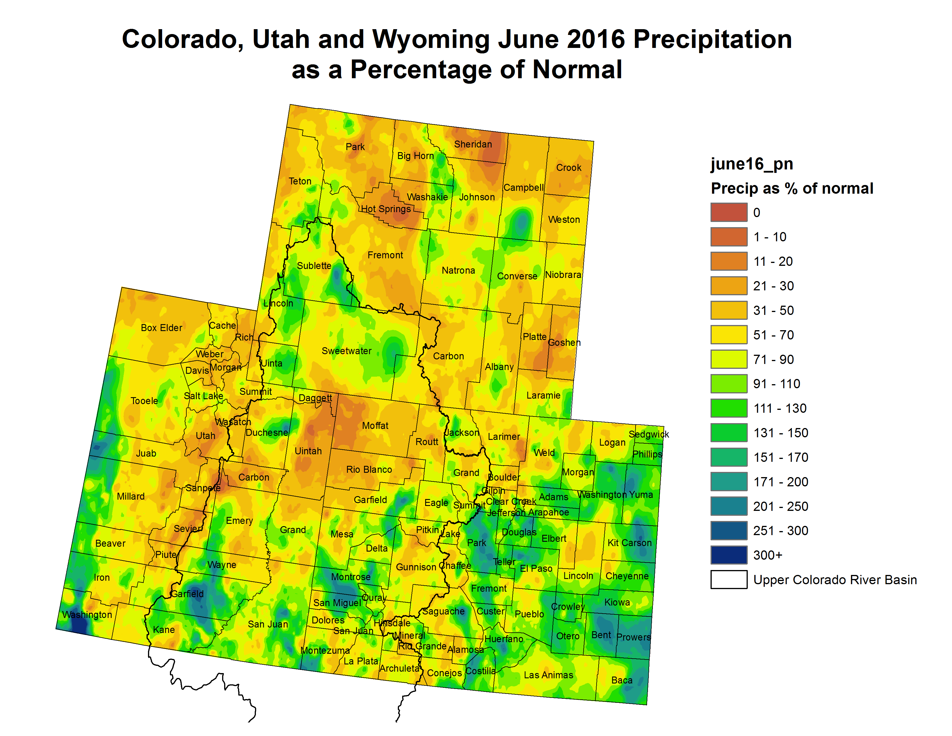
The July 8 Western Climate briefing is hot off the presses
Click here to view the briefing (scroll down):
Latest Monthly Briefing – July 8, 2016 (Micro-Briefing)
Highlights
June was a very hot Western US Seasonal Precipitation and very dry Western US Seasonal Precipitation month for the region, with much of the region seeing less than 50% of normal precipitation, and above-normal precipitation only in scattered areas. It was the hottest June on record for Utah, the 2nd hottest for Wyoming, and the 3rd hottest for Colorado. The dry June did not greatly impact the spring snowmelt and runoff, which was already well underway. As forecasted, below-average runoff has predominated at Utah forecast points, with near-average to above-average runoff in Colorado and Wyoming. April-July Lake Powell inflows are on track to exceed the official forecasts, at around 6750 KAF (95% of average). The vast majority of reservoirs in Colorado and Wyoming have above-average storage for this time of year, with most major reservoirs near capacity or spilling. Utah’s reservoirs are split between below- and above-average storage. The 2015-2016 El Niño event has finally ended, and ENSO-neutral conditions are now present . ENSO forecasts ENSO Prediction Plume indicate a roughly 75% chance of La Niña conditions during the coming fall and winter. Both the CPC outlook 3-mo precip forecast, 0.5-mo lead and the experimental SWcast outlook SWcast show little or no tilt for July–September precipitation for our region .
#AnimasRiver: No fish die-off from #GoldKingMine spill

From CBS Denver:
On Friday the EPA mobilized contractors to stabilize the mine and the waste pile…
Wildlife officials shared some good news, saying their testing shows the fish survived with no evidence of die-offs. But the problems are far from over…
The spill drew attention to the thousands of abandoned mines throughout the West that may also pollute rivers.
And on Friday EPA crews returned to the mine to start work stabilizing the entrance. Here’s a report from Dan Elliott writing for the Associated Press. Here’s an excerpt:
Construction crews will return this weekend to the scene of a massive mine-waste spill in southwestern Colorado to stabilize the mine opening with steel and concrete, the U.S. Environmental Protection Agency said Friday.
The EPA said the work is designed to keep rock and dirt from collapsing at the entrance to the Gold King Mine and to make sure it’s safe to enter during future cleanup efforts. The stabilization work will last through October…
In an email to The Associated Press, the EPA said it is very unlikely the work being done at the mine this year would trigger another spill. “The EPA has taken precautions to prevent any unanticipated discharges,” the agency said.
The contractor hired to do this summer’s work, Environmental Restoration LLC, was also on the scene at the time of the August blowout. But the EPA and outside investigators have said it was government officials, not the contractor, who made the decision to begin the work that led to the spill.
The EPA pledged to alert downstream communities if anything goes wrong this summer, using a notification plan put in place after the August blowout. The agency was widely criticized for not alerting all the tribal, state and local governments affected by the spill.
Wastewater is still running from the mine, and if the rate increases during this summer’s work, a temporary treatment plant installed last fall can handle a higher flow, the EPA said.
The $1.8 million plant went into operation in October. Officials said at the time it could handle 800 gallons per minute, while wastewater was flowing from the mine at about 560 gallons per minute.
The plant is scheduled to run through November of this year. Colorado lawmakers have urged the EPA to keep it operating, and the agency said Friday it is looking into that.
Monument water leak located — KKTV.com

From KKTV.com:
Crews hired by the Triview Metropolitan District Water Board found a major leak on Saturday that they believe is the cause of more than 50 million gallons of missing water.
The leak was in a pipe in an older part of the Triview system, near Bear Creek Elementary School in Monument. Coincidentally water board officials had held a public meeting at the school just a couple of hours before the leak was discovered to talk with water customers about the missing water, and what they were doing to solve the problem.
The board first started noticing a problem back in June when their water usage jumped drastically, averaging around 2 million gallons of water per day, more than the 1.8 million gallons their wells could handle…
In all the water board estimates more than 50 million gallons of water were lost in the month of June.
The part of the system with the leak has been shut off, and is expected to be repaired within the next few days. The shut off should not affect residential water customers, it mainly services parks.
The water board vice president Mark Melville tells 11 News they expect to remove the current watering ban on Monday, and customers would be able to go back to watering their lawns up to three days per week.
Melville said he was extremely excited when he was told the leak had been found.
Mark Melville/Triview Metropolitan District Water Board President: “It was a tremendous relief because our residents are counting on us to provide them with all these resources. When you’re out you realize how key water is and I felt personally like we were letting them down.”
There is no word yet on how the millions of gallons of lost water and the cost to find and repair it will affect water customers’ bills, but possible rate increases will be discussed at the board’s next meeting on Tuesday, July 12th.
#ColoradoRiver: “..in the Colorado Constitution, the Continental Divide doesn’t exist” — Jim Pokrandt

From The Grand Junction Daily Sentinel (Dennis Webb):
A proposal to divert Colorado River water to Denver recently has won the endorsement of Gov. John Hickenlooper and the approval of the Colorado Department of Public Health and Environment.
But Denver Water’s Gross Reservoir expansion project may be just as notable for its general lack of opposition west of the Continental Divide. That’s thanks to a wide-ranging agreement, effective in 2013, in which Denver Water obtained concessions including a promise that numerous Western Slope parties to the agreement wouldn’t oppose the expansion project. In return, Denver Water made a number of commitments to the Western Slope.
Now Western Slope interests are working on a similar agreement with Northern Water and others on what’s called the Windy Gap Firming Project, which would store Colorado River water in a proposed Boulder County reservoir.
These approaches represent a far cry from how the Western Slope used to respond to transmountain diversion proposals.
“This is the new paradigm. It’s not the old school. In the old school it was like … we’ll see you in court,” said Jim Pokrandt of the Colorado River District, a party to the 2013 Denver Water deal.
For Denver Water, what’s called the Colorado River Cooperative Agreement provided greater certainty for its customers through means such as resolving longtime disputes regarding West Slope water. For the Western Slope, the deal meant dozens of obligations by Denver Water, such as millions of dollars in monetary payments to various entities, protections of Colorado River flows and water quality, a commitment to further water conservation and reuse efforts by Denver Water customers, and a provision aimed at helping assure maintenance of historic flows in the Colorado River even when the Shoshone Power Plant in Glenwood Canyon is not operating. That hydroelectric plant has a senior right helping control flows in the river.
Another key point in that deal is a promise that Denver Water and its customers won’t try to further develop Colorado River water without agreement from the river district and affected counties.
The cooperative agreement has 18 signatories but more than 40 partners, primarily West Slope governments, water conservation and irrigation districts, and utilities. Among them are the Ute Water Conservancy District and multiple irrigation districts in Mesa County.
Pokrandt said the 2013 deal is a win-win for both sides of the Continental Divide.
“That said, yes, more water would be moving east” if the Gross Reservoir project proceeds, he said.
The project, also sometimes called the Moffat Collection System Project, would nearly triple the capacity of the Boulder County reservoir. Denver Water is targeting water in the Fraser River, a tributary of the Colorado.
“Right now there are some periods of time when Gross Reservoir is full at its current size and their water rights are in priority but they can’t take any more water,” Pokrandt said.
The project has an estimated cost of $380 million, and Denver Water hopes to obtain the remaining major permits by the end of next year. CDPHE in June certified that the project complied with state water quality standards, and Hickenlooper endorsed it last week.
“The state’s responsibility is to ensure we do the right thing for Colorado’s future, and this project is vital infrastructure for our economy and the environment,” Hickenlooper said in a news release. “The partnerships and collaboration between Denver Water, the West Slope and conservation organizations associated with this project are just what the Colorado Water Plan is all about.”
That recently adopted plan in some respects took its lead from the Denver Water/Western Slope deal in seeking to address the state’s future water needs in a cooperative rather than confrontational manner statewide.
Pokrandt conceded that not everyone loves the Gross Reservoir proposal…
Trout Unlimited takes a more positive view of the Gross Reservoir project, pointing to its inclusion of a “Learning by Doing” program requiring monitoring of the health of the Fraser River and adjusting operations as needed. The Gross Reservoir proposal envisions drawing water from the Western Slope in wetter years and seasons, but providing the Colorado River watershed with extra water during low flow periods and investing in restoration projects.
“Moreover, Denver Water has entered into partnerships on the Front Range to ensure that the project alleviates chronic low-flow problems in South Boulder Creek. Both sides of the Divide benefit,” David Nickum, executive director of Colorado Trout Unlimited, said in a news release…
Denver Water Chief Executive Officer Jim Lochhead said in a news release, “The Denver metropolitan area is tied to the economic and environmental health of the rest of the state, and Denver Water is committed to undertake this project in a way that enhances Colorado’s values.”
Pokrandt said Western Slope water interests face the reality that under the state Constitution the right to appropriate water shall not be denied if the water can be put to beneficial use and a party can obtain the necessary financing and permitting.
“There’s not a legal stance to say no, so that’s why the river district was even formed in 1937, was to negotiate these things, because no is not an answer in the legal arena because of the Colorado Constitution,” he said.
When it comes to water rights, Pokrandt said, “in the Colorado Constitution, the Continental Divide doesn’t exist.”
#COWaterPlan: Pueblo area lawmakers weigh in

From The Pueblo Chieftain (Chris Woodka):
Colorado’s Water Plan was ordered by Gov. John Hickenlooper in 2013, and completed last year by the Colorado Water Conservation Board.
It built on 10 years of efforts by nine basin roundtables and the Interbasin Compact Committee, a 26-member panel representing diverse political and geographic areas across the state.
One hiccup in the plan came in 2014, when some members of the state Legislature demanded a more active role, perhaps ignoring that the engine driving the train was conceived and constructed by lawmakers in 2005. In the end, most lawmakers have concrete ideas on how to move the plan ahead in years to come in a cooperative way.
In the final plan, the emphasis is on both state and local responses to water needs, it calls for new revenue — $3 billion by 2050 — which will certainly require cooperation from the Legislature. Sprinkled throughout the plan are recommended regulatory changes as well, all of concern to lawmakers.
The Pueblo Chieftain, working with the Arkansas Basin Roundtable, reached out to state lawmakers from the Pueblo area to get their ideas on how the water plan will be implemented. Responding were Sen. Leroy Garcia, D-Pueblo; Sen. Larry Crowder, R-Alamosa; Rep. Clarice Navarro, RPueblo; and Rep. Daneya Esgar, DPueblo.
How do we fill the gap in the Arkansas River Basin within the Colorado Water Plan and Basin Implementation Plan?
Garcia:
“It depends on the basin, because each one is different.
“As I talk to my colleagues, everyone has a unique perspective in the state Legislature. I think there’s a lot to be celebrated. The state has put forward a good plan, but it’s a challenge because each basin is different.”
Crowder:
“With a projected population of 10 million people in 2050, Colorado’s Water Plan attempts to study and prepare for the future. Since agriculture uses 86 percent of the state’s water, the pressure for transfer will increase. A 560,000 acre-foot shortage is predicted by 2030 for municipal and industrial uses. Conservation, storage, transfers, and other issues are an ongoing discussion.
Recreation in this state is estimated at $7 billion-8 billion per year on nonconsumptive use of our water. . . .
“There are issues in which need continuing monitoring such as, in 2013 alone, more than 13,500 acre-feet of water was lost in Denver, Aurora and Colorado Springs due to faulty infrastructure. Broken water mains, leakage, malfunctioning meters and waste caused nearly 4 billion gallons of water to be lost before it ever reached these cities’ 2.1 million residents. . . .
Therefore, it is my strong belief that upgrading the metro areas’ antique water delivery systems is the better way to ensure urban residents have an adequate water supply.”
Navarro:
“The water plan talks about three main objectives which will all help meet the gap between our current water supply and our projected need. Efficiency is one of those components and we, indeed, need to get better at efficiency.
Conservation is another component which would help. Everyone needs to be aware of how to better use their water.
“For example, when people are watering their yards or businesses we shouldn’t see water running down pavement.
The third component is storage. We can become more efficient, and we can conserve, but if we have no place to keep that water for future needs, we have done it all in vain. Although new storage is an option, so is expanding existing storage and we should not forget about underground storage. All three are key to meet our future water needs.”
Esgar:
“I’m not sure that we will ever ‘fill’ the gap in the Arkansas River Basin. The water in the basin is already spoken for and appropriated, and the population of Colorado just continues to climb. I’m not convinced that we will ever be able to fill the supply of water that we need to sustain this growing population, so we must find ways to keep the water we do have, and to keep the gap from spreading even more.
“We need to be creative and diligent when it comes to the Arkansas River Basin. We need to be able to find innovative ways to conserve, store and repurpose the water we do have in our basin.
“One of the ways I’ve heard to accomplish this goal is to really look at responsible storage and flow for the entire area.
Agriculture depends on the water for farms and livestock, consumers depend on the water for their gardens and lawns, and our economy and Colorado lifestyles depend on the water for recreation throughout the entire Arkansas River Basin.”
What projects do you plan to fill the gap?
Garcia:
“Every approach will depend on the basin, and I don’t have any specific projects in mind. It will take a robust conversation.
In general, I would say we need to look at fixing the gap when it’s smaller, because that’s easier than watching it grow.
“I was talking to someone about the evaporative losses in Lake Pueblo. I’m a big fan of the reservoir and it’s no secret I use it to go fishing and boating with my boys and wife.
Lake Pueblo is a unique community gem that’s a destination for the entire state of Colorado.
“People take for granted the valuable resource we have and we need to be prepared so we don’t lose it to other uses. I think increasing storage could be a huge economic benefit.”
Crowder:
“It may easier to expand existing storage capabilities than creating new storage, and this is being looked at under the plan. I would like to see how the mitigation of Fountain Creek by Colorado Springs is going to prevent the devastation to the Arkansas River.
“Transferring water out of the basin is certainly not in the area’s best interest. A continuation of funding in water conservation districts is imperative under the circumstances.
Navarro:
“There are a number of opportunities for efficiency and conservation projects that can, and should be used by residents as well as businesses. Those would not only help with the water shortages, but it would also save money.
Many people are already realizing the benefits of xeriscaping and droughtresistant lawns, and as others see the results, the trend will be to do the same.
“When it comes to projects regarding storage, there are a number of small projects that have been talked about for years. Our basin roundtable is already talking about which options may be best to try and move forward on, and as to how to incentivize efficiencies and conservation. They are the experts and I will listen to them on how to best prioritize our water gap.
Esgar:
“As a state representative, I plan to work closely with the experts on water in Colorado, farmers, ranchers, and the conservation community to find the right projects to help stop the gap from getting bigger for the Arkansas River Basin. We have to have honest conversations and collaboration to keep the water in our basin.”
How do we keep the gaps for agriculture and municipalities from becoming bigger?
Garcia:
“Agriculture has a big target on its back, and I don’t think people appreciate the benefit it has to downstream users. We need a regional approach that involves the entire basin.
Crowder:
“Snowpack is always the predominate issue. “1. Municipalities need to make sure that their replacement decrees are in place to adequately serve their purposes. Inhouse water will always be available, but domestic use may not “2. Technology and advanced water practices for consumptive use should be studied and implemented.
“3. The conduit should be promoted for better quality water needs and conservation.
“4. The number one water right should be protected and that is the interstate compact.
“5. The prior appropriation rule of law for Colorado users should be adhered to.
“6. Updating canal by-laws is a very useful tool in protecting water transfers.”
Navarro:
“The water plan outlined those problems and those three main ideas are important for both agriculture and municipalities. Water storage needs to be that leveling factor to help us keep the water that we are entitled to use. When the river runs high, we need to keep that water so that we can use it when the river is limited.
It makes absolutely no sense to send extra water to Kansas when we have needs here.
“While agriculture has led the charge in becoming more efficient, they will need to find ways to produce more with less.
Incidentally, agriculture has done that very well over the last century.
Municipalities have also done a good job at creating incentives and finding ways to be more efficient. However, both will need to do even more in the future to meet the growing demands.”
Esgar:
”We need to depend on science to help us better use water that is allocated to Colorado’s important agricultural needs. As water shortages across America continue, there will be new and innovative ways to water crops and livestock. Colorado needs to be sure that we really look and see if these new methods could work here.
“When it comes to municipalities, we need to do a better job of educating consumers when it comes to conservation.
Folks didn’t completely understand why the rain barrel bill was so important to me. The simple tool of a 55-gallon barrel that collects rain that would have ran directly to the gutter, helps people understand how much water they may actually be consuming. Also, we need to be innovative when it comes to landscaping. I know that Coloradoans love their lawns, I do, too, but we have to have real conversations about more water-conscious ways to landscape our beautiful neighborhoods.”
Lodgepole fire near #Leadville update via Leadville Today
PFC pollution’s 800 pound gorilla — what are the costs for clean up?

From The Colorado Springs Gazette (Jakob Rodgers):
Government agencies are just beginning to scratch the surface of costs incurred by a frustratingly hardy, toxic chemical polluting waterways across the U.S.
Air Force officials already expect to spend more than $400 million to study the chemical’s use in a firefighting foam at nearly 200 sites and replace it. Peterson Air Force Base and the Air Force Academy are on that list.
And on a local level, officials for water districts serving Security, Widefield and Fountain say they also may have to pay millions of dollars upgrading their water systems over the next few years to filter it out of tap water.
The tabs are expected to grow, and they don’t include costs associated with cleanup efforts. In one such project, the Air Force will pay $4.3 million to help filter well water across southeast El Paso County.
Nor does that tally include similar assessment efforts being conducted by the Navy and Army as well as clean up efforts in many other communities across the nation. One such study at Fort Carson had yet to start as of Wednesday.
All of it is for a chemical that the Environmental Protection Agency says may cause health ailments at levels no greater than a drop of water in a string of railroad tank cars 10 miles long.
“The fact that it doesn’t go away – it doesn’t degrade naturally, it stays in the environment – is a cause for concern,” said Daniel Medina, who is heading up the Air Force Civil Engineer Center’s response.
The substance, called perfluorinated compounds, or PFCs, remains unregulated by the Environmental Protection Agency. However, the EPA has grown increasingly concerned about the substance.
In May, the EPA’s health advisory level dropped to 70 parts per trillion – leaving every well used by water districts in Security, Widefield and Fountain above the new limit.
The advisory was tailored to ensure it protected the most sensitive population – in this case, developing fetuses and breast-fed and bottle-fed infants. That means people using water below that level should not expect health effects, even if drinking that water over a lifetime, state and federal health officials said at a town hall Thursday.
Communities across the U.S. are grappling with the chemical.
To mitigate residents’ exposure here, local water officials have relied more heavily on surface water pumped in from the Pueblo Reservoir.
Doing so has limited the number of people receiving contaminated tap water to 10,000 to 15,000, said Tyson Ingels, with the Colorado Department of Public Health and Environment’s Water Quality Control Division.
Officials running local water districts are working to drop that number to zero, though it may take time. Projects underway or in development are unlikely to change how many people receive PFC-laden water this summer, water district officials say (see accompanying report).
In the meantime, people receiving water above the EPA’s new limit should consider other water sources – especially women who are pregnant, planning to become pregnant or breastfeeding, as well as infants, a Colorado health department official said Thursday.
The exact source of the PFCs in the Widefield aquifer remains unclear, though an Air Force official recently said that the chemicals possibly originated at Peterson Air Force Base.
From 1970 through the mid-1990s, firefighters at the base used a type of foam laden with the chemicals while training to extinguish high-intensity fires, such as during plane crashes.
Ever since then, firefighter have trained using water in a lined basin. It still has the firefighting foam that contains PFCs, but it is only used in emergency situations, Medina said.
The Air Force has spent more than $137 million through Thursday as part of an effort to study 191 sites across the nation where the foam is believed to have been used, Medina said. They include active duty and National Guard installations, as well as decommissioned bases.
So far, assessments have been completed at 96 percent of those sites, he said.
The Air Force also expects to spend another $271 million incinerating that foam and replacing it with another substance, Medina said. That effort is underway at Peterson, base officials said.
The price tag is expected to grow as more thorough assessments are ordered across the nation.
At Peterson, for example, officials plan to drill monitoring wells to pinpoint the source, and a draft report is due in March 2017.

#COWaterPlan racked up at least a $6 million tab — The Colorado Independent

From the Colorado Independent (Marianne Goodland):
Colorado taxpayers have spent at least $6 million on the state’s water plan, an eight-month-old document that has led to little, if any, real water policy action.
“That’s more than I expected,” said Republican state Sen. Jerry Sonnenberg of Sterling, a member of a legislative water committee that took public comment on the state water plan a year ago.
According to information obtained by The Colorado Independent, the price tag for the state’s first water plan is at least $5,964,227.
That amount doesn’t include hundreds, if not thousands of work-hours state employees at the Colorado Water Conservation Board spent combing through and responding to more than 30,000 public comments about early draft of the plan, which was finalized in November.
Nor does it include travel costs for CWCB employees. The board’s director, James Eklund, made more than 100 presentations on the water plan over the course of two years.
It also doesn’t include the travel or per diem costs for the 10-member legislative committee that visited nine communities throughout Colorado last year to gather public input on the plan.
According to Todd Hartman, spokesman for the state Department of Natural Resources, “It is difficult to tease out [travel] costs related to plan due to the typically statewide and water-related nature of the CWCB’s work” and the interim water committee since in most cases the water plan would have been discussed as part of other discussions and conversations around water-related matters.
Some $287,263 in tax dollars paid for project management fees, layout, design, photography, printing and video production, as well as a rental fees for meeting spaces and an event at the Colorado History Center for the plan’s official roll-out last November.
According to the CWCB, $5,659,364 was spent by the state’s nine basin roundtables to develop the “implementation plans” that are the basis of the state water plan. These plans detail ways each region of the state would help to solve a potential one million acre-foot water storage projected by 2050.
An acre-foot of water is the amount of water it would take to cover Mile High Stadium from end zone to the other with a foot of water.
The basin roundtables are groups of water providers, as well as representatives of agricultural, environmental, recreational and other water users. The basins refer to eight major waterways in the state, plus a separate roundtable convened for the Denver metropolitan area.
Eight implementation plans were developed. The Denver and the South Platte roundtables collaborated on their plan, for a total cost of $2.2 million. But just how those dollars were spent is still unknown.
The other six roundtables collectively spent about $3.4 million to develop their plans.Sen. Pat Steadman, a Democrat on the Joint Budget Committee, was taken back when informed about the costs, especially for the amounts tied to the basin roundtables.
“Where did they get the money?” he asked.
Gov. John Hickenlooper ordered Colorado’s first statewide water plan to ward against an impending water shortfall. By 2050, Colorado needs as much new water as it takes to serve about 2 million people.
They say the revised, 416-page document still is less of a plan than a water study — a detailed account of the struggles faced by water users throughout the state, painstakingly compiled by an administration more interested in making everyone feel heard than in making tough decisions.
Critics say the plan still lacks priorities and actionable specifics and that it fails to address the most practical question – how to pay for solutions. They’re also disappointed that it sets no clear expectations for how much, statewide, all of Colorado’s water users should be conserving.
Winds of political change shifting on #climate issues in Colorado, experts say — Real Vail

From Real Vail (David O. Williams):
The Guardian newspaper this week produced a report stating voters, especially young ones, are increasingly dismayed that climate change has been “the missing issue of the 2016 campaign.”
In Colorado, that means turning a cold shoulder to global warming, an issue that a 2013 Yale study found is “very or somewhat important” to 73 percent of Coloradans – 70 percent of whom believe climate change is real.
“There are fewer and fewer people who believe climate change isn’t real, and fewer people who believe that humans don’t have some role in causing it,” former Colorado Gov. Bill Ritter recently told RealVail.com.
In his recent book “Powering Forward,” Ritter says a transition away from coal as the state’s primary resource for generating electricity is inevitable because Coloradans increasingly prefer cleaner-burning natural gas and carbon-free renewables resources such as wind, solar and biomass. But he argues the state owes hard-hit coal-mining communities a “Just Transition.”
Many residents of struggling coal towns on Colorado’s Western Slope, from Hayden to Delta, blame the climate policies of Ritter and his successor Gov. John Hickenlooper for undermining state coal production. But both men counter that market forces – primarily the abundance of cheap natural gas and ever-more affordable renewables – are driving down demand for coal.
The perfect storm of coal company bankruptcies and plummeting natural gas and renewable prices is being driven by those market forces more than state and federal policies, Ritter argues in a recent RouteFifty.com story produced by RealVail.com. And he adds that even conservative lawmakers are beginning to realize the value of promoting renewable resources.
Ritter, who now serves as the director of the Center for the New Energy Economy at Colorado State University, has been working with 13 western states on plans to comply with the EPA’s proposed Clean Power Plan, which is stuck in a legal quagmire that ultimately may be decided by the U.S. Supreme Court. That makes November’s election all the more critical, Ritter says.
“Certainly, as we’ve seen by [Antonin] Scalia’s death, appointment of the next justice could mean a lot about what happens even at state level on environmental and energy policy, so a lot of this is still up in play, but understand that even with all of that happening, states are doing a variety of really important things in transitioning to clean energy,” Ritter said.
Ritter points to a recent clean energy accord signed by 17 governors, four of them Republicans.
“States with very conservative governors are doing what I would consider to be some very important things,” Ritter said. “Partly that may be because they realize the business opportunities that are available, they realize that the price of wind and solar have come down so dramatically that while they’re still intermittent, they’re fairly cheap.”
Climate concerns aside, mproving technology plays a big role in that transition, he adds.
“They realize there’s great research and development on the energy storage front, so if you get to a point where you combine rooftop solar with storage, people are actually able to provide their own power from the sun, and that makes them independent in many respects, and there are a lot of conservatives that like that idea,” Ritter said.
The presidential election features a likely Republican nominee, Donald Trump, who outright denies global climate change is happening, despite overwhelming scientific evidence to the contrary.
#AnimasRiver: Long-term stabilization kicks off tomorrow at #GoldKingMine

From The Denver Post (Jesse Paul):
The Environmental Protection Agency said Friday morning, specifically, it is mobilizing contractors to shore up the mine’s opening and the waste rock pile just outside the adit. The operations are expected to continue through October.
“We anticipate that the interim water treatment plant (below the Gold King) will continue to capture and treat any discharge from the mine,” the EPA said in a news release. “However, should any of this work impact downstream watersheds, EPA will notify stakeholders.”
The work will include installing steel bracing and concrete, the removal of waste sludge stored in the mine’s temporary water treatment plant and an analysis of how to move forward with water treatment in the long run.
With the beginning of the new initiative, the EPA is signaling it has heard the complaints of communities downstream of the mine who say they weren’t notified quickly of the Gold King disaster. The agency says it has an expansive notification plan in place to prevent any further communication issues.
Perhaps the biggest focus, however, of downstream stakeholders has been the still-leaching mine’s temporary water treatment plant. Officials have been worried about the EPA’s commitment to keep open the facility, which has been running since October.Gov. John Hickenlooper, Sen. Cory Gardner and local leaders for months have urged EPA officials to commit to keep this temporary plant running, and maybe expand it, until a federal Superfund cleanup of old mines is done.
The plant’s future, as of Friday, remained an unknown though the EPA said it has committed to taking a hard look — including public input — about how to proceed in the long-term. The plant will continue to operate as officials investigate alternatives.
Meanwhile the House of Representatives passed a funding bill for mine cleanups today. Here’s a report from Kate Magill writing for The Durango Herald. Here’s an excerpt:
The bill, introduced by Rep. Jody Hice, R-Ga., would create the Energy and Minerals Reclamation Foundation, which would be tasked with obtaining and using funds for the cleanup of abandoned coal mines, hard-rock mines and onshore oil and gas wells.
Hice’s legislation is part of a three-part bill package introduced to address abandoned mine cleanup. The other two bills include the Mining Schools Enhancement Act and the Locatable Minerals Claim Location and Maintenance Fees Act, which also includes good Samaritan language that was added by Rep. Scott Tipton, R-Cortez.
The Foundation Act specifically refers to mines that are located on federally managed lands. If created, the foundation would be a nonprofit corporation that would not be associated with an agency or government establishment. It would be led by a board of directors appointed by the Interior Department secretary.
The purpose of the foundation would be to obtain and administer private donations to be used for the “activities and services of the BLM,” according to the bill. In addition to the cleanup of abandoned mine sites and oil and gas wells, these activities include caring for wildlife habitats, National Conservation Lands, and cultural, recreation and historical resources. The foundation would also raise money for educational and technical resources to help with the management of the Bureau of Land Management.
Though Tipton supported Tuesday’s passage of the Foundation Act, he believes it is just the first step in the process of reclaiming abandoned mines, and it needs to be followed by the passage of good Samaritan legislation, according to Liz Payne, a spokesperson for Tipton.
Payne said it is a positive step to raise money to do site cleanup, but good Samaritan groups need liability coverage, a key component of the language Tipton added to legislation. Such coverage would protect groups that have the technical expertise to reclaim abandoned mine lands from being held completely liable for unforeseen problems such as a mine blowout.
Hice introduced the bill in part because of the Aug. 5 Gold King Mine spill, so that more private sector resources could be dedicated to cleanup efforts.
“By incorporating private sector policies and procedures, H.R. 3844, the Bureau of Land Management Foundation Act, revamps and improves the cleanup of contaminated water in abandoned mine sites,” Hice said in a statement following the passage of the bill.
The bill now goes to the Senate, where it has been assigned to the Energy and Natural Resources Committee.

There is little opposition to Superfund designation for the Bonita Peak Mining District according to Dan Elliot writing for the Associated Press via The Colorado Springs Gazette:
A proposal to deploy the powerful Superfund program to clean up leaky Colorado mines — including one that unleashed millions of gallons of wastewater last year — isn’t stirring up much passion, despite formidable resistance in the past.
Some people who live in the scenic southwest corner of the state feared a Superfund designation would scare off vital tourist traffic, even though dormant mines have been belching poisonous wastewater into rivers for years.
Others objected on the grounds that it was a federal intrusion. Some worried Superfund status, which delivers federal money up-front for extensive cleanups, would diminish the chances of mining making a comeback.
But as of Wednesday, the U.S. Environmental Protection Agency had received only seven written comments opposing the planned cleanup, and 18 supporting it.
“I’ve gotten more letters to the editor on this topic,” said Mark Esper, editor of the Silverton Standard, a weekly newspaper in the heart of the storied mining district in the San Juan Mountains. “I’m a little bit surprised,” he said.
Since opening the public comment period in April, the EPA said, the agency has received a total of just 33 written comments , with 25 clearly for or against. Others made suggestions about specific sites or commented on other projects.
Monday is the deadline for the public to weigh in.
Opposition to a Superfund designation softened after a 3-million-gallon spill from the Gold King Mine on Aug. 5, 2015, even though it was an EPA-led crew that inadvertently triggered the blowout during a preliminary cleanup operation.
Many people came to believe only the federal government could pull off the sweeping cleanup that will be required, Esper said. The project is expected to cost millions and take years.
Silverton Town Administrator Bill Gardner said the scant comments might signal that residents had their say during months of public meetings.
“I’m hoping that people feel included and that their concerns have been heard,” he said.
Tainted wastewater from the Gold King reached the Animas River in Colorado and the San Juan River in New Mexico and Utah. The EPA estimates the spill sent 880,000 pounds of metals into the Animas, including arsenic, cadmium, copper, lead, mercury, nickel and zinc.
Water utilities shut down their intake valves and farmers stopped drawing from the rivers. The EPA says the water quality quickly returned to pre-spill levels.
After local officials and Colorado Gov. John Hickenlooper endorsed a Superfund cleanup, the EPA proposed the Bonita Peak Mining District Superfund area in April. It encompasses 48 sites that spill a combined 5.4 million gallons of acidic waste daily, the agency said.
The EPA could formally create the Superfund district as early as this fall, after the agency reviews the comments and makes any changes to the plan.
If the area is designated a Superfund site, the EPA would examine the mountains for pollution sources and compile a list of cleanup alternatives. Long-term cleanup work would begin once the EPA chooses an alternative.
Eric Baker
2016 #coleg: Conservation Colorado hands bouquets to Democrats, rocks to Republicans — The Denver Post

Click here to go to the scorecard page on the @ConservationCO website.
From The Denver Post (Joey Bunch):
Graded on 17 energy and environment bills picked by Conservation Colorado, 31 of 34 Democrats in the state House scored 100. Eleven of 17 Democrats in the Senate got perfect scores, as well.
On the Republican side, Rep. Kevin Priola scored the highest in his House caucus, 44 percent. Sens. Randy Baumgardner, Bill Cadman, Larry Crowder, Owen Hill, Ellen Roberts, Mark Scheffel and Jack Tate topped all party members in the upper chamber at 27 percent each.
Of the three Democrats who were less than perfect by Conservation Colorado’s grade, Rep. Ed Vigil scored the lowest, 67 percent, for his votes on three unsuccessful bills, House Bill 1441, requiring the Public Utilities Commission to consider the full cost of carbon for electricity generation; House Bill 1310 to make operators liable for oil and gas operations; and House Bill 1355 on local governments’ authority over where oil and gas facilities locate.
Reps. Millie Hamner and Paul Rosenthal each scored 89 percent. Rosenthal was docked for his vote on House Bill 1355. Hamner was flagged for voting against House Bill 1228, which became law and allows one-year water rights transfers.
In the Senate, Mary Hodge was the lowest scoring Democrat with 80 percent. She lost points on two bills. She voted with Republicans in favor of Senate Bill 007, which would have encouraged the use of biomass fuel for renewable energy generation in areas with high risk of wildfire.
She also voted in favor of Senate Bill 210, which would have allowed voters to decide whether to borrow money to expedite major road-and-bridge projects.
Democratic Sens. Kerry Donovan, Cheri Jahn, John Kefalas, Linda Newell and Nancy Todd each scored 91 percent. They also voted for Senate Bill 007, which passed the Senate 24-11, but was killed by a Democrat-led House committee.
The lowest scores in the Senate went to Republicans Kevin Grantham, Kent Lambert and Vicki Marble, each with a 9.
The lowest scores in the House, at 11 each, were assigned to Republicans Justin Everett, Gordon Klingenschmitt, Clarice Navarro and Jim Wilson.
SDS opens the tap for Security — The Pueblo Chieftain
From The Pueblo Chieftain (Chris Woodka):
Security will be able to use increased capacity in the Southern Delivery System pipeline to deal with contaminated well water in the Fountain Creek aquifer.
Security Water District reached an agreement with Colorado Springs Utilities to increase the amount of water transported through SDS in order to eliminate perfluoralkyl substances, or PFASs, in drinking water.
“The start of SDS could not have come at a better time,” said Roy Heald, Security Water general manager. “We always said SDS was being built to improve reliability to the existing water systems and the situation with PFASs in drinking water underscores that.”
SDS went online in April.
The cause of the PFAS contamination is unknown, but it typically finds its way into water systems through manufacturing processes or deicing at airports.
When contaminants were first detected, Security stopped using some wells and initiated voluntary watering restrictions.
Security, located south of Colorado Springs, historically blended equal parts well water and surface water. The majority of customers are not affected by PFASs, but in some parts of the district increased use of groundwater normally would be needed to meet summer watering demands.
Security also gets some of its water from the Fountain Valley Conduit, which, like SDS, pumps water from Lake Pueblo to El Paso County.“We are pleased to work with our longtime SDS partner Security Water to help resolve the water contamination issues,” said Dan Higgins, Colorado Springs Utilities chief water services officer. “SDS is already showing how critically important it was for all the communities who partnered to build it.”
Meanwhile, here’s a report about the public meeting held yesterday about the problem from Bruce Finley writing for The Denver Post. Here’s an excerpt:
More than 1,000 people south of Colorado Springs packed a high school Thursday night and buffeted government officials with questions and concerns about an invisible toxic chemical contaminating public water supplies…
Colorado Department of Public Health and Environment officials repeated recommendations — especially for women and children, because they may be more vulnerable to the perfluorinated chemicals (PFCs) — to switch to other water as a precaution.
“You may or may not be getting your tap water from an area of concern,” CDPHE water-quality official Tyson Ingals told residents. “We have about 60,000 people in the areas of concern. We estimate 10,000 to 15,000 may be receiving water with PFCs above the level of the heath advisory.”
What about schools? residents asked. How long have people here been drinking water tainted with PFCs? What about property values? Should pets be drinking different water? Could organically home-grown vegetables be tainted?
Local utility officials in Widefield, Security and Fountain — all partially dependent on municipal wells drawing from tainted groundwater — assured residents they are intensifying efforts to dilute supplies by mixing in cleaner water piped from Pueblo, 40 miles to the south. A CDPHE preliminary health assessment has found elevated cancer in the area, but officials emphasized no link to PFCs has been established…
Officials from El Paso County, the CDPHE and the military now are looking more closely at contamination in the Widefield-Security-Fountain area. Of 43 private wells tested recently, county officials have received results from 37 tests, with PFC levels in 26 exceeding the EPA limit, spokeswoman Danielle Oller said.
In Security, all 32 municipal wells are contaminated, and water officials ranked the wells based on levels of contamination. One well where the level was nearly 20 times higher than an EPA health advisory limit has been shut down. Security officials urged voluntary cutbacks in lawn watering to reduce the need to use contaminated groundwater.
Security Water and Sanitation District manager Roy Heald has divided the city into three zones and said about 25 percent of residents live in a zone receiving water from contaminated wells. The residents in two other zones “are supplied water mainly from surface water sources,” Heald said…
Next week, utility officials plan to begin re-plumbing, installing new pipelines, trying to blend in more water from Pueblo into that zone and other areas…
Air Force representatives at the forum, where residents filled an auditorium, adjacent cafeteria and stood in hallways at Mesa Ridge High School, said the Air Force will pay $4.3 million to set up temporary treatment systems — while local utilities address the long-term implications of contaminated groundwater and a possible fix. Military airfields are suspected as a source of PFC contamination, and a broad investigation is planned, with drilling in October at Peterson Air Force Base east of Colorado Springs.
“Our short-term to mid-term solution is to use more surface water, which is not affected by these contaminants. Our mid-term to long-term solution will be to treat the groundwater,” said Heald, who met with Air Force officials and will continue those discussions. Security also has requested financial help from the EPA, CDPHE and elected officials.
“Security Water is a relatively small water district, and the costs of managing this issue is expensive for our customers,” Heald said.
Security residents typically pay about $25 a month for their water.
Widefield officials said they’ll set up a free bottled water distribution station — limiting residents to 10 gallons a week. They’re relying as much as possible on water from Pueblo, although they may draw from contaminated wells to meet peak demands during summer as temperatures rise.
Fountain utility officials planned to notify residents about PFCs in notices mailed along with July water bills. Fountain normally draws from eight municipal wells, all now contaminated with PFCs above the EPA limit, and has shifted to water from Pueblo while contract engineers search for a solution.
Yet Ingals from CDPHE pointed out that these cities “cannot function on surface water alone. … There are groundwater wells that are being pumped. … The wells kick on and off at different intervals. … Because it is not predicable, we cannot tell you that it always is safe…
CDPHE experts in February began a preliminary assessment of cancer rates in the area south of Colorado Springs and on June 30 completed a report showing elevated cancer rates. The CDPHE team found lung cancer rates 66 percent higher than expected, bladder cancer up 17 percent and kidney cancer up 34 percent. CDPHE officials emphasized there’s no clear link to PFCs…
The assessment looked at births from 2010-14 and all cases of 11 types of cancer from 2000-2014 in 21 census tracts covering Security, Widefield and Fountain. CDPHE researchers compared these with birth and cancer data from the rest of El Paso County.
They found no spike in low birth weights in the areas where water is contaminated with PFCs. But there were a higher-than-expected rates of lung, kidney and bladder cancers.
“Of these types of cancer, only kidney cancer has been plausibly linked to PFC exposure in human and laboratory animal studies,” Van Dyke said.
The increases may be explained by higher rates of smoking and obesity in the area. Smoking and obesity, CDPHE officials said, may be factors explaining the increased kidney cancer.
More coverage from The Colorado Springs Gazette (Jakob Rodgers):
Residents from across Security, Widefield and Fountain flocked to hear more than a dozen federal, state, local and military officials hold a town hall about the work being done to clean the water in the Widefield aquifer.
As the evening wore on, one question rose above the rest: Why must residents have to incur more costs for bottled water and home filters because of a problem that wasn’t their fault?
“Why does the consumer have to pay more?” one man asked, to applause. He received no answer…
Roughly 60,000 people are served by water districts pulling from the contaminated Widefield aquifer, most of whom are in Security, Widefield and Fountain, officials said Thursday.
However, the majority of those people receive clean surface water pumped in by the Pueblo Reservoir. About 10,000 to 15,000 people receive contaminated water from wells tapped into the aquifer – and even they sometimes receive clean surface water, depending on daily water usage, a state health official said.
In general, those affected homes are along the western portions of Security and Widefield. Fountain has switched to clean surface water…
Throughout the meeting, officials stressed they are doing all they can to fix the problem.
Within a month, the Widefield Water and Sanitation District plans to set up a water dispensing site, allowing residents along the western portions of Widefield to receive up to 10 gallons of water a week. It is also working on a construction project to pump in more surface water.
Security officials announced a deal Thursday with Colorado Springs Utilities to increase the amount of Southern Delivery System water it will receive.
The project, which could take three months to complete, will likely end the community’s reliance on well water until a more permanent solution can be implemented. It might, however, come at the cost of higher water rates next year, the district’s water manager said.
Fountain officials also are working on a treatment plant.
#Drought news: The Southwest Monsoon kicks up storms over most of #Colorado

US Drought Monitor July 5, 2016.

West Drought Monitor July 5, 2016.

Colorado Drought Monitor July 5, 2016.
Click here to go to the US Drought Monitor website. Here’s an excerpt:
Summary
A stationary front located over the central U.S., along with several systems dropping southeastward out of the Canadian Prairies, triggered widespread moderate to heavy (2 to 6 inches, locally up to 10 inches) showers and thunderstorms from eastern Colorado eastward into Kentucky. The wet and cool weather quickly dashed any thoughts of a possible July flash drought in the central Plains and Midwest. Decent rains (1-3 inches) also fell on parts of the north-central and south-central Plains, along the Gulf and Atlantic Coasts, the central Appalachians, parts of northern New England, and in southeastern Arizona as the monsoon commenced. Temperatures averaged much below normal (4 to 10 degF) in the Midwest, and subnormal in most of the Northeast, northern half of the Plains, and the Four Corners region. In contrast, seasonably dry and warm conditions enveloped the Far West, while portions of the southern Plains, Delta, and Southeast received little or no rain. Similarly, most of the upper Midwest, north-central Great Plains, Great Lakes region, and coastal New England saw minimal rainfall. Elsewhere, conditions were wet in interior Alaska, the windward sides of the Hawaiian Islands, and eastern Puerto Rico…
Plains
Scattered light showers (generally less than an inch) fell on most portions of the D0-D3 area in western South Dakota, southwestern North Dakota, northern Wyoming, and southeastern Montana, enough to maintain – but not improve – conditions from last week. An exception was in southwestern South Dakota where 2-3.5 inches of rain fell on southeastern Custer, Oglala Lakota, and Bennett counties, improving the area by 1 category. In northern Kansas, enough rain (1.5-2.5 inches) fell on Smith and Jewell counties to erase the D0; however, just to the west, Graham and Rooks counties missed the rain, and with 30-day dryness impacts occurring, D0 was added there. As mentioned in the Midwest summary, surplus rains eliminated much of the D0 in eastern Kansas. In north-central Oklahoma, heavy localized thunderstorms dropped 5-8.5 inches of rain on Osage and Pawnee counties, effectively ending the recently added D0 and D1 there. Farther west, the rains were less plentiful, so most D0 and D1 areas remained. Similarly, locally heavy rains also erased D0 in east-central Oklahoma, but dryness expanded eastward into west-central Arkansas where the rains missed. Drier weather in southern and central Texas during the 30-60 days is currently showing up in the SPIs as mild D0 with a few D1s, but seasonable temperatures have limited evapotranspiration rates across the state. As a compromise, D0 was added along the Rio Grande near Maverick County and immediate area where the indices had indicated as the worst spot in the short-term…
Northwest and Northern Rockies
July and August are normally the driest months of the year in the Pacific Northwest, so changes to the drought depiction are usually minor, if any. Similarly, precipitation typically decreases in the northern Rockies during the summer months, so deterioration is not common. However, the lack of rainfall over the past 30-90 days, along with bouts of above-normal temperatures and an early snow melt in the northern Rockies, has depleted soil moisture and lowered stream flows to much-below normal levels. As a result, D0 was added to portions of south-central and eastern Idaho. In coastal Oregon, although springtime precipitation is much lower than the winter, enough rain typically falls on coastal mountains to provide adequate stream flows. This spring, however, a lack of rain and occasional warmth has led to 90-day deficits of 3-6 inches and very low stream flows, thus D1 was added to coastal Oregon. Similar deficits existed in western Washington, but recent rains and lower temperatures were enough to temper the D1 expansion there for now…
California and the Great Basin
Little or no rain fell on California and much of the Great Basin, except for light monsoonal showers in eastern Nevada and western Utah. Since much of this region is climatologically dry and warm during the summer months, any drought degradation or improvement is highly unlikely in this region when dry is the norm, and any rain that falls quickly evaporates. Not surprisingly, no changes were made to the drought in California and the western Great Basin…
Southwest
The southwest monsoon kicked into gear around July 1 in Arizona, dropping light to moderate amounts (0.5-2 inches) of rain on southeastern and northwestern Arizona, southern Nevada, southern Utah, western New Mexico, and most of Colorado. With the increased moisture and cloud cover, temperatures also averaged slightly below normal. Since this was the first significant precipitation in southeastern Arizona and the D1 –D2 is long-term, it will take a few more events before any improvement is warranted there. Elsewhere, the rains were enough to prevent deterioration, but not great enough for any improvement. Therefore, no changes were made to the Southwest this week…
Looking Ahead
During the next 5 days (July 7-11), moderate precipitation (more than an inch) should fall along the northern tier of States (Washington-Oregon eastward to New England), and in the northern and central Great Plains, Midwest, Tennessee and Ohio Valleys, and Appalachians. The greatest totals (more than 2.5 inches) were forecast for North Dakota, the western Corn Belt, the Tennessee Valley, and northern New England. Little or no precipitation was expected for the southwestern quarter of the Nation, the southern Plains, and Florida. Temperatures should average below-normal in the West, northern Plains, upper Midwest, and New England, with above-normal readings in the southern Plains and along the southern and mid-Atlantic Coast States.
The NWS 6- to 10-day outlook for July 12-16 favors above-median precipitation along the U.S.-Canadian border, the Midwest, Tennessee Valley, southern Appalachians, and northern Alaska, with sub-median rainfall probable for most of the West and Rockies, south-central Plains, along the Gulf Coast, and in New England. Temperatures are likely to be subnormal in the northwestern quarter of the nation, while the odds favor above-normal readings in most of the eastern half of the U.S., southern Plains, and Alaska.
NOAA: June was record warm for contiguous U.S. #climatechange #keepitintheground
From NOAA:
Summer is off to a sizzling start.
The average June temperature for the Lower 48 states was 71.8 degrees F, making it the warmest June on record, according to scientists from NOAA’s National Centers for Environmental Information. Above-average temperatures spanned the nation from coast to coast, and 17 states across the West, Great Plains and parts of the Southeast experienced temperatures much above average. June precipitation for the contiguous U.S. averaged 2.46 inches, 0.47 inch below average, ranking as the 14th driest on record.
Through the midpoint of the year (January–June), the contiguous U.S. average temperature was 50.8 degrees F, 3.2 degrees F above average and the third warmest on record. Every state was warmer than average for the year to date, and Alaska continued to shatter heat records.
Notable climate events include:
Alaska: Record warmth spanned Alaska from January through June. The statewide average temperature for this period was 30.4 degrees F, 9.0 degrees F above average, and 2.5 degrees F warmer than the previous record in 1981.
West Virginia: During June 23-24, more than 10 inches of rain in parts of West Virginia causing record flooding that resulted in at least 23 fatalities and the loss of over 1,500 homes.
Tropical Storm: Tropical Storm Colin made landfall along Florida’s Gulf Coast on June 6 with sustained winds of 50 mph. Colin brought heavy rainfall to the Southeast and caused four fatalities.
U.S. Drought: By the end of June, 16.2 percent of the contiguous U.S. was in drought, up about 3.5 percent compared to the end of May. Drought remained entrenched in parts of California and the far west, and expanded to other parts of the nation.
Billion Dollar Disasters: So far in 2016, the U.S. has experienced eight billion-dollar weather and climate-related disasters, resulting in the loss of 30 lives and causing at least $13.1 billion in damages (note: losses from the late-June West Virginia floods are still being assessed and are not included in this tally).
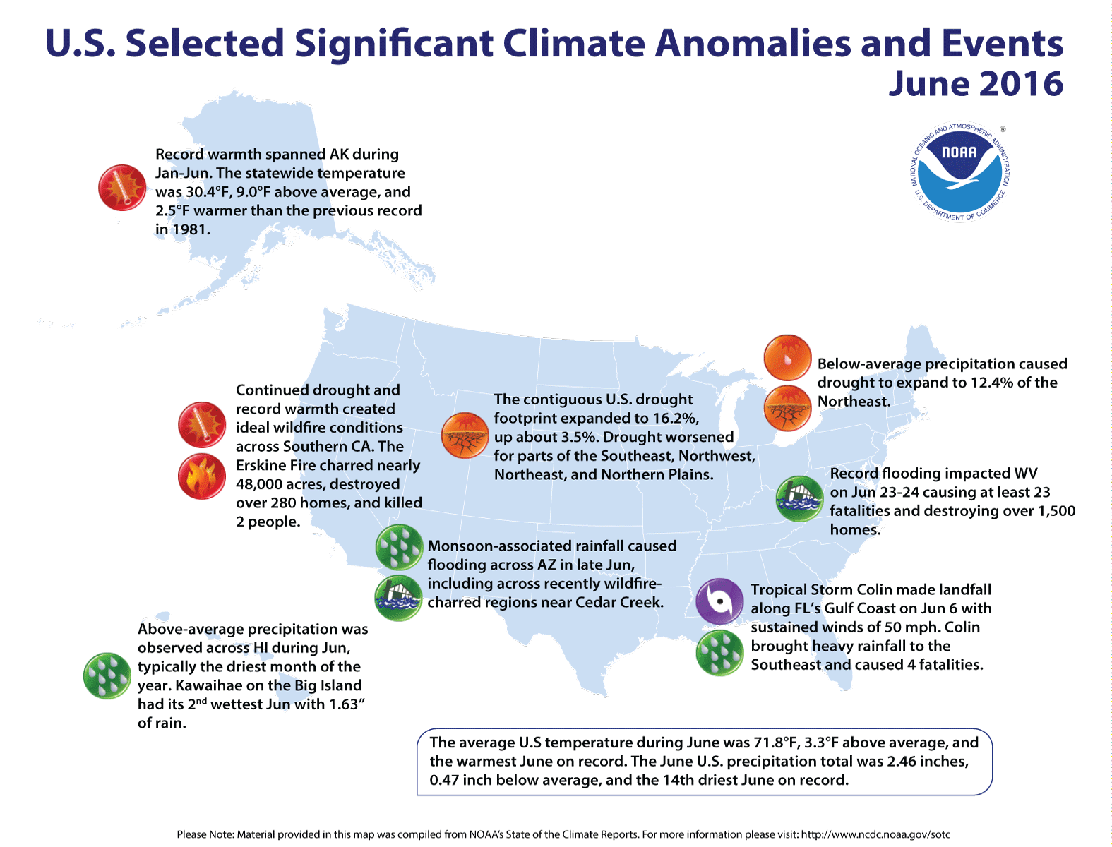
More from NOAA:
U.S. climate highlights: June
Temperature
- Above-average temperatures spanned the nation from coast to coast. Seventeen states across the West, Great Plains and parts of the Southeast had June temperatures that were much above average. Above-average temperatures continued for Alaska, which had its ninth warmest June with a temperature 2.5°F above average. Arizona and Utah were each record warm with temperatures 5.9°F and 7.0°F above average, respectively.
- The warm and dry conditions across the West created ideal wildfire conditions with several large fires impacting the region. The Erskine fire charred nearly 48,000 acres in Southern California, destroying more than 280 homes and killing two people.
Precipitation
Below-average precipitation was widespread across the Northern and Central Plains, Midwest and Northeast. Five states — Massachusetts, Nebraska, South Dakota, Rhode Island and Wyoming — had June precipitation totals that were much below average. Above-average precipitation was observed across parts of the Southwest, Southern Plains, Midwest and Mid-Atlantic. In Arizona, rainfall associated with the seasonal monsoon caused flooding across parts of the state. Despite West Virginia having a June statewide precipitation total that only ranked as the 14th wettest, on June 23-24 a series of thunderstorms passed over southern parts of the state dropping upwards of 10 inches of rain on already saturated soils. The rapid rainfall rates across the mountainous terrain caused massive runoff and record flooding in the valley floors. Over 1,500 homes were destroyed and at least 23 fatalities were blamed on the flooding, including 15 in the small town of Rainelle. According to the June 28 U.S. Drought Monitor report, 16.2 percent of the contiguous U.S. was in drought, up about 3.5 percent compared to the end of May. Drought conditions worsened across parts of the Southeast, Northwest and Northeast with drought developing in the Northeast and parts of the Upper Midwest and Northern Plains. Drought conditions remain entrenched across much of California.
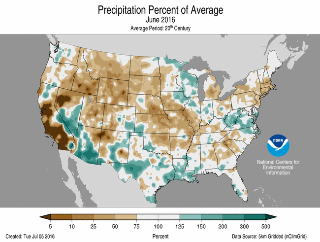

2016 #coleg HB16-1228: Aurora tells judge legislation hurts ability to take Ark Valley water– The Pueblo Chieftain

From The Pueblo Chieftain (Chris Woodka):
Aurora has filed a water court challenge to its 2009 agreement with the Lower Arkansas Valley Water Conservancy District, claiming legislation the city itself backed could hurt its ability to remove water from the Arkansas Valley…
HB1228, the latest version of flex water rights legislation Aurora, Colorado Corn and Ducks Unlimited began promoting in 2013, was signed into law by Gov. John Hickenlooper in May. The current bill is titled “Alternative Transfer Mechanism for Water Rights” rather than flex legislation.
During committee hearings, lawmakers tiptoed around saying the bill set up a flex water right. But some members of Colorado Water Congress jokingly called it “Son of Flex” during the process.
The bill allows water to be transferred from farms to other uses five years out of 10, but only within the basin of origin under a new type of court decree. It also requires the Colorado Water Conservation Board and state engineer to approve and develop rules about how to implement transfers on an annual basis.
Aurora’s lobbyist, Margy Christiansen, registered in support of the bill in March. Also in March, Lower Ark officials testified before the CWCB that Arkansas Valley Super Ditch would have no interest in using the legislation because it was too cumbersome.
Lower Ark proposed a different method that has yet to be introduced as legislation.
In a court filing Friday, Aurora’s attorney John Dingess asked Division 2 Water Court Judge Larry Schwartz to limit Super Ditch’s used of HB1228, claiming it would reduce the amount of water available to Aurora to take out of the Arkansas River basin.
One of the provisions of the 2009 agreement between Aurora and the Lower Ark was that Aurora would first attempt to lease water, if needed, from the Super Ditch.
In his filing, Dingess argues that Super Ditch would not be able to lease water to Aurora because the city is outside the Arkansas River basin. He also argues there would be less water available to Aurora because the new bill would make leases available five years out of 10.
In the Super Ditch pilot program, leases are available only three years in 10 from any farm.
Aurora is constrained by its 2003 agreement with the Southeastern District to take water only three years in 10 until 2028. Aurora could lease water in seven years out of 15 until 2043 under the agreement. Aurora is limited to leasing 10,000 acre-feet of water (3.26 billion gallons) annually and only in drought-recovery years.
Finally, Dingess questions the constitutionality of HB1228 because it promotes speculation.
“The change frees up to half the yield of the water right from the anti-speculation doctrine in that neither the type of use nor place of use need be specified in the change decree,” Dingess wrote. “Suspension of the anti-speculation doctrine presents constitutional questions.”
Triview Metropolitan District enacts emergency water restrictions

From KOAA.com (Andy Koen):
Neighboring water districts in the Monument area sending help to the Triview Metro District which enacted emergency restrictions Tuesday amid an unexpected water shortage.
The Town of Monument notified residents via Facebook that the Donala Water District, which has a connection with Triview, will open their line temporarily to help during the shortage. The Town of Monument does not have a direct connection with Triview, but manager Chris Howe said they will send some utility workers to help where needed.
Triview District Manager Valerie Remington said the district noticed a spike in demand in mid-June. There was another peak on Monday diminishing the water supply to an emergency level.
Remington said there were no obvious signs of a major pipe break. They have not filed a report of a water theft with local law enforcement, but Remington said they have not ruled out the possibility.
“We haven’t ruled out any of the different possibilities right now,” she said. “I can’t say, since we don’t know what it is, I can’t say what it is what else I can’t say what it isn’t.”
Triview recently charged a transmission line to service the new Sanctuary Point development. Remington said no houses have been built there and the district ruled out that line a source of the sudden drop in supply.
Under the emergency restrictions, customers are prohibited from outdoor watering. Customers who violate the restriction will be warned on their first offense. Second offenses carry a $50 fine, third offenses a $500 fine and all subsequent offenses will be fined $750.
From The Colorado Springs Gazette (Kaitlin Durbin):
Outside watering is suspended for Monument residents.
Following a period of high usage, the Triview Metropolitan District has restricted outside watering “until further notice,” according to its website.
“We are continuing to experience a water problem and are asking that all residents stop outside watering until we are able to correct the issue,” the district said.
According to Gazette news partner KKTV, a spike in use around the holiday is to blame.
The district said demand among its 4,200 customers has risen to about 2 million gallons of water per day. Just one of the district’s eight wells has the capacity to pump 1.8 million gallons of water each day, KKTV reported.
“The restrictions went into place on July 4 as we noticed that our tank levels were always getting lower and we were having trouble recovering,” District Manager Valerie Remington told KKTV.
#ColoradoRiver: Facing historically low levels, Lake Mead officials are fending off a water war — The Los Angeles Times #COriver
From The Los Angeles Times (William Yardley):
Drought is draining the West’s largest reservoir, Lake Mead, to historic low levels. Forecasts say climate change will make things worse. Headlines warn of water shortages and cutbacks. Members of Congress are moving to protect their states’ supplies.
Yet if war is really imminent, why is one of the region’s most experienced water managers doing the same thing he has done for years: tinkering?
“I like to describe this as another incremental step,” said Tom Buschatzke, director of the Arizona Department of Water Resources.
Buschatzke was talking about a plan he is helping develop, along with water managers in California, Nevada and Mexico, that would voluntarily reduce water allocations from the Colorado River to those three states and Mexico. They hope to have it in place in time to avoid steeper, mandatory cuts that could begin as soon as 2018.
Would their plan change everything? Would it finally fix the increasingly inadequate blend of canals, conservation and compromises that somehow keeps water flowing to more than 25 million people, including a substantial chunk of those in Southern California?
Not even close.
But for Buschatzke, who has spent decades efficiently providing water for a desert population — Arizona uses less water now than it did 60 years ago even though the population has soared from 1.1 million to 6.7 million — the big fix is actually in the accumulation of all the little fixes he and others are constantly making. A federal grant for new technology that will better measure water use. Paying a farmer to fallow a field. Saying nice things about your colleagues across the state line and the fine folks in Washington. Keeping things collegial. Sharing. Saving. Preserving the process — and the peace.
“I don’t think a water war is inevitable,” he said. “I think we’ve proven over the last 20 years that we can effectively work together to find solutions that really work. And as long as we continue to do that, the water war won’t happen.”
The current project, called the drought contingency plan, is a tweak to a previous tweak. Nearly a decade ago, water managers recognized that Lake Mead was draining faster than predicted. They recalibrated plans for how they could handle cutbacks. Now, with Lake Mead dropping even faster, they are recalibrating again.
The goal, as has been the case for years, is for water users to limit how much they take out of Lake Mead. The less they take, the less likely the lake will drop to levels that prompt mandatory cuts.
Yet the cuts would not apply evenly. Under an agreement reached in the 1960s, California is not required to make any cuts, even if the lake drops so low that Arizona and Nevada lose everything.
But now, even California is willing to conserve because officials know that, in the event of catastrophe, they will be forced to share anyway. It is better to try to prevent the catastrophe in the first place — and keep the federal government from taking over a process the states want to control.
There is no firm draft of the drought contingency plan, but the gist of it has been floated at meetings for several weeks. Under the plan, Arizona and Nevada would take cuts before California, but California eventually could take cuts too — again, with the goal of staving off even more severe cuts if it does nothing.
Buschatzke, who speaks weekly with managers in other states, said he thinks California has a new appreciation for Arizona’s endless search for efficiency.
“I think the drought in California, the severe impacts on the state water supply, have made them feel what it’s like to be Arizona,” he said.

#ColoradoRiver #COWaterPlan: “Having this additional storage enables that flexibility” — Jim Lochhead #COriver
From The Denver Post (Bruce Finley):
This formal backing completes the state’s environmental reviews for the Moffat project, 13 years in the making, clearing the way for construction — if remaining federal permits are issued. Denver Water and opponents from Western Slope towns and nature groups reached a compromise aimed at enabling more population growth while off-setting environmental harm.
It is a key infrastructure project that will add reliability to public water supplies and protect the environment, Gov. John Hickenlooper wrote in a letter to Denver Water manager Jim Lochhead.
It “aligns with the key elements of Colorado’s Water Plan,” Hickenlooper wrote. “Denver Water and its partners further our shared vision for a secure and sustainable water future while assuring a net environmental benefit in a new era of cooperation.”
Denver would siphon 10,000 acre-feet a year, on average, more water out of Colorado River headwaters, conveying it eastward under the Continental Divide through a tunnel for more than 20 miles to an expanded Gross Reservoir southwest of Boulder. By raising that reservoir’s existing 340-foot dam to 471 feet, the project would increase today’s 41,811 acre-feet storage capacity by 77,000 acre-feet — more than doubling the surface area of the reservoir…
For more than a decade, Denver Water has been seeking permits, including federal approval for construction affecting wetlands and to generate hydro-electricity at the dam.
“During dry years, we won’t be diverting water. It is a relatively small amount of water. … It is a water supply that Colorado is entitled to develop,” Lochhead said in an interview.
The increased storage capacity “allows us to take water in wet times and carry it over through drought periods. It gives us operational flexibility on the Western Slope. … Having this additional storage enables that flexibility.”
Colorado leaders’ formal endorsement follows a recent Colorado Department of Public Health and Environment decision to issue a water quality permit for the project, certifying no water quality standards will be violated. Hickenlooper has directed state officials to work with federal water and energy regulators to expedite issuance of other permits. Denver Water officials said they expect to have all permits by the end of 2017, start construction 2019 and finish by 2024…
…Trout Unlimited and other conservation groups call the project a realistic compromise considering the rapid population growth along Colorado’s Front Range.
“If the state needs to develop more water, they need to do it in a less-damaging, more responsible way — as opposed to going to the pristine headwaters of the South Platte River, which is what the Two Forks project was going to do,” TU attorney Mely Whiting said.
“We’ve put things in place that will make Denver Water be a steward of the river,” Whiting said. The agreement hashed out between Denver Water and conservationists “does not specifically say they have to tweak the flows to help the environment. It does say they have to monitor, for water temperature and macroinvertebrates. And if there’s a problem, they are responsible for figuring out why and they need to do something about it. It does not say exactly what they have to do but they have to fix any problem.”

From The Colorado Independent (Marianne Goodland):
Gov. John Hickenlooper has officially endorsed a project to expand Boulder County’s Gross Reservoir, a move he hopes will improve Colorado’s water capacity for the next several decades.
The endorsement was considered a formality; Hickenlooper wrote to President Barack Obama four years ago, asking for the president’s help in speeding up the process for Gross and other water projects.
Colorado is predicted to face a gap of more than one million acre-feet of water by 2050, according to a 2010 estimate that many believe may be on the low end. One acre-foot of water is the amount of water it would take to cover the field at Mile High Stadium from endzone to endzone with one foot of water. That’s 325,851 gallons of water. The average family of four uses about half an acre–foot of water per year.
Hickenlooper couldn’t give his formal okay for the expansion of the reservoir, which is northwest of Eldorado Springs, until the state’s Department of Public Health and Environment had completed its review that certifies the project would comply with state water quality standards.
At 41,811 acre feet, Gross is among the state’s smallest reservoirs. It’s operated by Denver Water, supplied by water coming from the Fraser River on the west side of the Continental Divide through the Moffat Tunnel.
The expansion would allow the reservoir to collect another 18,000 acre-feet of water, enough to supply 72,000 more households per year. The estimated cost is about $380 million, which includes design, management, permitting, mitigation and construction.
The Gross expansion has been in the works for more than 13 years, with its first permits applied for in 2003. If all goes according to plan, the permitting process will be completed in 2017,with construction to begin in 2019 or 2020. The reservoir could be fully filled by 2025, according to Denver Water spokesman Travis Thompson.
In his letter to Denver Water, Hickenlooper called the Gross project key to serving more than 25 percent of the state’s population. It will “add reliability to our public water supply, and provide environmental benefits to both the East and West Slopes of Colorado,” he said.
Aye, there’s the rub: the Western Slope, whose residents fear that anything that will divert more water from the Western Slope to the Eastern Slope will cut into their water supplies. They also worry that more diversions of Colorado River water will make it more difficult to satisfy multi-state compacts with southwestern states that rely on water from the Colorado River, of which the Fraser is a tributary.
But Jim Lochhead, head of Denver Water, told The Colorado Independent that any further diversions will require buy-in from folks on the Western Slope.
It’s part of an arrangement between Denver Water and 17 Western Slope water providers that has been in development for the past six years, Lochhead said. “We’ve worked extensively with the West Slope to develop the Colorado River cooperative agreement,” which will make the environment and economy of Western Colorado better off, he said.
The agreement addresses impacts of Denver Water projects in Grand, Summit and other counties, all the way to the Colorado-Utah border.
Lochhead hopes the Gross Reservoir project will be a model for cooperation, with benefits for both sides of the Continental Divide.
And the cost? The budget for the agreement starts at $25 million and goes up from there. That first funding goes to Summit and Grand counties for enhancement projects, which includes improved water supply for Winter Park, Keystone and Breckenridge ski areas. Lochhead said the locals will figure out exactly how to spend the money, and that Denver Water isn’t dictating what those counties will do with it beyond setting some parameters for protection of watersheds, the area of land that drains to a particular body of water.
Denver Water has also committed to making improvements to the Shoshone Power Plant on the Colorado River near Glenwood Springs, and improvements to wastewater treatment plants all the way to the western state line to enhance area water quality.
“We have an extensive list of commitments to partner with the Western Slope, to do the right thing,” Lochhead said.
The Gross Reservoir expansion is critical to Denver Water’s future needs, as Lochhead sees it, because its improved capacity will allow the water utility to operate its system with more flexibility. That’s most important for Denver Water’s attention to environmental concerns, both on the Western Slope and for South Boulder Creek, which flows out of Gross Reservoir.
“The state’s responsibility is to ensure we do the right thing for Colorado’s future, and this project is vital infrastructure for our economy and the environment,” Hickenlooper said in a statement today. “The partnerships and collaboration between Denver Water, the West Slope and conservation organizations associated with this project are just what the Colorado Water Plan is all about.”
Added Lochhead in a statement Wednesday: “The Denver metropolitan area is tied to the economic and environmental health of the rest of the state, and Denver Water is committed to undertake this project in a way that enhances Colorado’s values.”
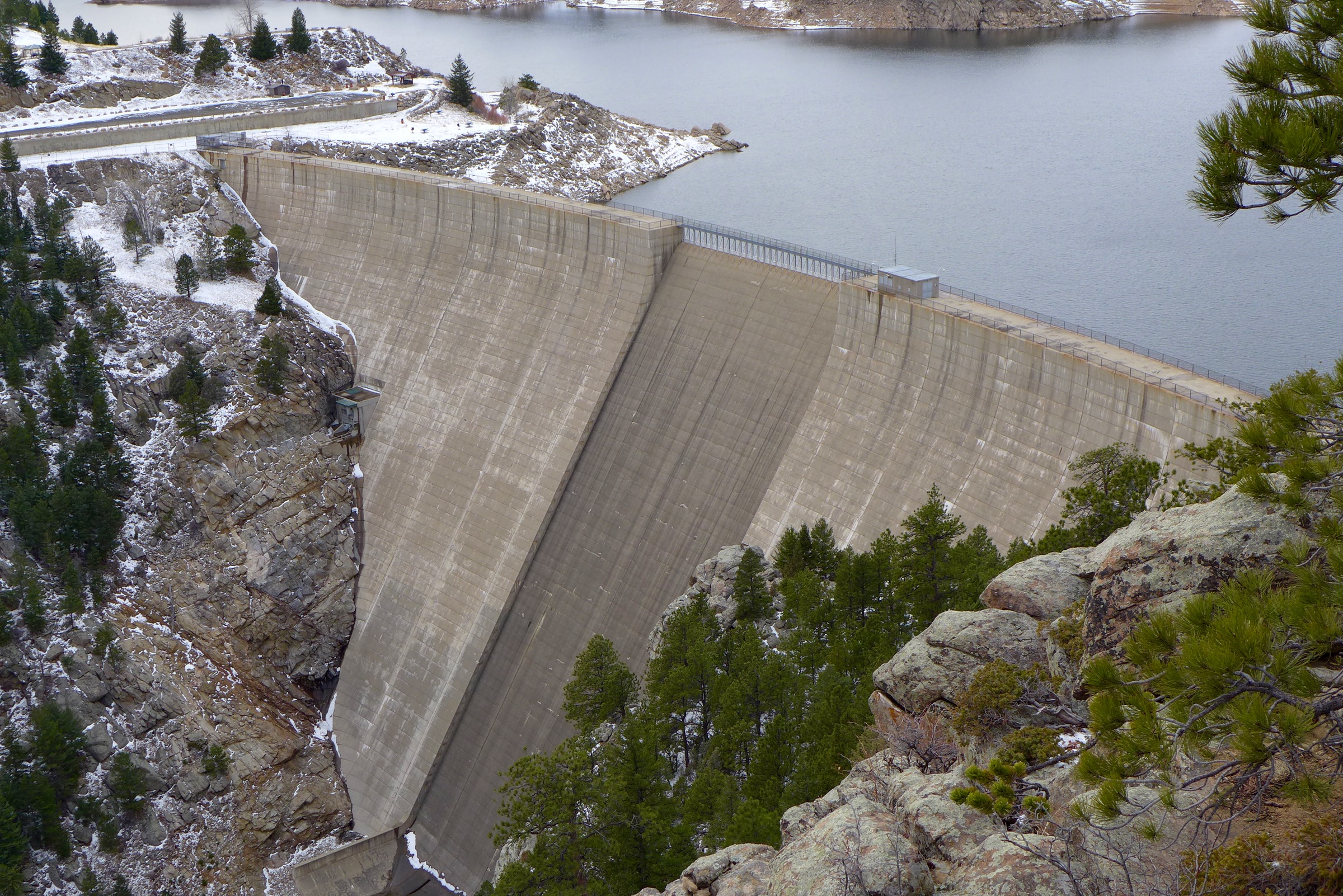
@ColoradoClimate: Weekly Climate, Water and Drought Assessment of the Upper #ColoradoRiver Basin #COriver
Click here to read the current assessment. Click here to go to the NIDIS website hosted by the @ColoradoClimate.
Battle lines form over oil shale — The Grand Junction Daily Sentinel

Yampa/White/Green/North Platte river basins via the Colorado Geological Survey

White River via Wikimedia

Map of oil shale and tar sands in Colorado, Utah and Wyoming — via the BLM

Green River Basin oil shale deposits via the Bureau of Land Management

Oil shale deposits Colorado, Wyoming and Utah

Colony Oil Shale Project Exxon — Photo / Associated Pres
As my friend Ed Quillen once said, “Oil shale has been the ‘Next big thing’ in Colorado for over a hundred years.”
From The Grand Junction Daily Sentinel (Gary Harmon):
The White River meanders through Utah on its way to joining the Green River, flowing slowly through land on which an energy company hopes to develop its oil shale holdings.
Opponents and supporters of the proposal by Enefit American Oil have drawn familiar lines in the sandstone of the Colorado Plateau.
Opponents contend that the project threatens the local environment and that development could unbalance the global climate.
Supporters say the project would prop up local economies in two states still reeling from the fall in oil prices that slowed production and put a virtual halt to exploration.
Enefit is seeking a right of way across federal land administered by the Bureau of Land Management, which listed the route as a preferred alternative in its environmental study of the request.
Oil shale development is a greater threat to the atmosphere than other fossil-fuel development, said John Weisheit of Living Rivers.
“It’s not a contribution to society,” Weisheit said. “It’s a detriment to society.”
More like a lifeline to struggling northwest Colorado and northeast Utah, said Lannie Massey, natural resource specialist for Rio Blanco County.
“This Enefit deal is a good deal for everybody involved,” Massey said. “It would lessen our dependence on foreign sources” of energy and pump new life into the moribund energy industry.
Enefit’s project has attracted an array of opposition, including the Grand Canyon Trust, Earthjustice, Western Resource Advocates, the Center for Biological Diversity, Natural Resources Defense Council, Sierra Club, Utah Physicians for a Healthy Environment, as well as Living Rivers.
The northwest Colorado town of Rangely stands to benefit from Enefit’s project because of the town’s proximity. Rangely is about 30 miles from the area via Rio Blanco County Road 23, which could connect to Dragon Road in Utah, and then into the project site.
The project is expected to require about 2,000 jobs, which would be “a huge boost for this area and for this region, eastern Utah and western Colorado,” said Tim Webber, executive director of the Western Rio Blanco County Metro Recreation and Park District.
Bonanza, Utah, and Rangely are the nearest towns and they sit 20 miles apart as the crow flies, 28 miles apart by road. The rough-and-tumble territory in between is pockmarked with drillpads and Gilsonite mines that cut deep, straight-edge swaths into the earth.
Enefit’s oil shale project sits on private land as well as state land set aside for development to benefit Utah schools and other institutions.
Enefit is planning to mine oil shale under 27,243 acres, most it privately held.
The project under consideration by the BLM is a utility corridor over federal land that Enefit would use to extend utilities to serve the project, which projects production of 50,000 barrels of oil per day for as many as 30 years.
Enefit is planning to build three pipelines, expand an existing road and run a 138-kilovolt power line to the project area 12 miles southeast of Bonanza.
“I fly over that area a lot,” said Bruce Gordon of Aspen-based EcoFlight. The corridor land is “relatively pristine” with good habitat for animals, Gordon said.
The area is “pretty industrialized and disturbed already,” said Enefit Chief Executive Officer Rikki Hrenko-Browning.
Enefit could develop its private holdings without crossing federal land, but that would require a constant stream of heavy trucks and other heavy equipment, resulting in reduced air quality, the BLM said in its draft environmental impact statement.
The BLM needs to better understand the oil that would be produced by Enefit, as well as take into account the potential effects on water quality and of spent shale, said Anne Mariah Tapp of the Grand Canyon Trust.
The possible effects of a spill of oil into the White River or Evacuation Creek — and how to clean it up — have gone unstudied, Tapp said.
“Water quality is as important as water quantity,” Tapp said.
The BLM also should have a better idea of what will happen with 23 million tons of spent shale produced every year, Tapp said.
Spent shale — as the rock left over after the process is referred to — contains poisons, such as arsenic, as well as minerals, such as lithium.
Enefit is planning a “zero-liquid discharge” process in which all water to be used will be captured, treated and reused, said Hrenko-Browning. [ed. emphasis mine]
Plans also call for Enefit to have ongoing reclamation in areas of surface mining, Hrenko-Browning said.
Once the BLM completes its process, Enefit will seek permits from the state, including the state mining permit.
Rangely and western Rio Blanco County are working hard to diversify the regional economy, said Massey.
There is more at stake than that, however, Massey said.
Colorado, Utah and Wyoming contain the largest oil shale resources in the world.
“If we can get somebody to commit money and improve the retort process,” Massey said, “it would be a benefit to all of us in the oil shale region.”
#ColoradoRiver: Gov. Hickenlooper endorses Gross Reservoir Expansion Project — @DenverWater #COriver
Here’s the release from Denver Water (Stacy Chesney/Travis Thompson):
Colorado Gov. John Hickenlooper has officially endorsed Denver Water’s proposed Gross Reservoir Expansion Project as a model for achieving a balanced approach to environmental protection and water supply development through an inclusive and collaborative public process.
The endorsement follows the Colorado Department of Public Health and Environment’s issuance of a Section 401 Water Quality Certification on June 23, 2016, which ensures compliance with state water quality standards. The certification confirms that Denver Water’s commitment to extensive mitigation and enhancement measures for the project will result in a net environmental benefit.
“The state’s responsibility is to ensure we do the right thing for Colorado’s future, and this project is vital infrastructure for our economy and the environment,” said Colorado Gov. John Hickenlooper. “The partnerships and collaboration between Denver Water, the West Slope and conservation organizations associated with this project are just what the Colorado Water Plan is all about.”
The Gross Reservoir Expansion Project — also known as the Moffat Collection System Project — will strengthen Denver Water’s system against drought and climate change by nearly tripling the capacity of Gross Reservoir, located in Boulder County.
“Colorado is a growing and dynamic state,” said Denver Water CEO Jim Lochhead. “Denver Water has the critical responsibility to sustain over 25 percent of the state’s population and the majority of our economy for decades to come.”
Since 2003, Denver Water has been involved in federal, state and local permitting processes to evaluate the proposed project and develop ways to not only mitigate identified impacts, but also to enhance the aquatic environment and the economy of Colorado. The 401 certification — one of the major regulatory requirements — recognizes and builds upon other existing Denver Water agreements such as the landmark Colorado River Cooperative Agreement, Learning by Doing cooperative effort and the Grand County Mitigation and Enhancement Coordination Plan.
“The Denver metropolitan area is tied to the economic and environmental health of the rest of the state, and Denver Water is committed to undertake this project in a way that enhances Colorado’s values,” said Lochhead.
Denver Water expects to secure all of the major permits for the project by the end of 2017. The estimated cost of the project is about $380 million, which includes design, management, permitting, mitigation and construction.
Visit http://grossreservoir.org to read more about the project and http://denverwaterblog.org for videos with voices from a few of the many project supporters including, Gov. Hickenlooper, Western Resource Advocates, Trout Unlimited, Colorado Water Conservation Board and Colorado Parks and Wildlife.
Here’s a post from Brent Gardner-Smith (Aspen Journalism) dealing with the subject but with a West Slope angle.
Gross Reservoir Expansion Project takes a giant step forward
#ColoradoRiver #COriver
Pitkin County awards contract for Basalt whitewater park

By Brent Gardner-Smith, Aspen Journalism
BASALT – Pitkin County has awarded a construction contract worth $770,000 to a company in Durango to build a whitewater park in the Roaring Fork River near Basalt’s Elk Run subdivision.
The in-channel work, to be completed by next February, includes extensive rock work in the channel and on the riverbank and the installation of two wave-producing concrete structures anchored into the riverbed.
The upstream wave is designed to appeal to kayakers, while the downstream wave should also be suitable for stand-up paddlers at some water levels.
After a recent bid process, the county awarded the contract to build the in-channel features of the whitewater park last week to Diggin’ It River Works Inc. of Durango, according to Laura Makar, an attorney with Pitkin County who is overseeing the project. The whitewater park is being managed by the county attorney’s office, as it started as a water-rights effort.
The company has recently built whitewater parks in West Glenwood and Durango. River Restoration of Carbondale, which designed the West Glenwood wave, has designed the Basalt project and its two wave-producing features.
The in-channel work for the Basalt project includes:
constructing temporary coffer dams to channel the flow of the river into a 60-inch bypass pipe to expose the riverbed for construction;
the placement of boulders in the river to form five grade-control structures above the features;
the anchoring of the two wave structures themselves; and
installation of stabilizing boulders along the toe of a steep section of riverbank.
See drawings.

To the river
The county plans to build a modest level of access features and public amenities as part of the project, consistent with approvals for the project granted by the town of Basalt in 2015.
(See “Exhibit A” from town of Basalt ordinance number 18-2015).
The amenities, for example, do not include viewing platforms on the riverbank as shown in some conceptual renderings by the county during public meetings on the project last year.
The riverside improvements, to be completed by May 1, 2017, include a new ramp, or path, down the riverbank from Two Rivers Road to the downstream end of the whitewater park and a metal stairway down the riverbank across from the entrance to the Elk Run subdivision, at the upper end of the whitewater park.
The downstream ramp is to serve as both a public access path and as an emergency ramp big enough to drive an ATV down if necessary.
The stairway, to be built on the riverbank across from the entrance to Elk Run, may or may not be open to the public and might be used for emergency access only, according to James Lindt, a planner with the town.
The county’s plans also include the creation of five or six parallel parking spaces just downvalley of the whitewater park, on town land on the south side of Two Rivers Road, and the addition of four more parking spaces at Fisherman’s Park, which today can hold about eight vehicles in a small dirt lot next to a picnic pavilion and a bathroom.
The town has also required that the county delineate parking spaces for two or three vehicles with trailers near Fisherman’s Park and resurface the small boat ramp across Two Rivers Road from the park. The county also plans to add boulders in the river to enlarge the eddy at the bottom of the modest boat ramp.
In an effort to make it safer for kayakers and spectators heading to and from the whitewater park, the roadside improvements include a path on the south side of Two Rivers Road, just above the whitewater park, to be formed by two sections of split-rail fence running parallel to the road and the river.
The “pedestrian corral” is designed to safely guide people from the downstream end of the whitewater park back up Two Rivers Road toward Fisherman’s Park, which the county is viewing as the primary put-in for boaters to access the two play waves.
It’s a short float around the corner from Fisherman’s Park to the whitewater park location, but it’s a difficult paddle back up the river, especially in higher water, from the whitewater park location to Fisherman’s Park.
So if a boater parks at Fisherman’s Park and floats down to the park, they will likely need to walk back up through the “corral” when they get out of the river, cross the road at the Elk Run intersection, and then walk on the sidewalk on the north side of the road back to the parking lot at Fisherman’s Park.

Flashing lights
In an effort to increase pedestrian safety along the busy roadway, the county is also required to install three crosswalks across Two Rivers Road, each with flashing cautionary signs to warn and stop motorists.
The crosswalks are to be located at Fisherman’s Park, at the entrance to the tree farm property about a block down the road, and on the downvalley side of the entrance to Elk Run, at the upstream end of the walking corral. There are currently no marked crosswalks on Two Rivers Road in those locations.
The town intends to discourage accessing the whitewater park from the other side of the river, at the end of Emma Road, past Subway and Stubbies, although there is technically public access to the river from that location on town property. Emma Road is a private road, but it does have a public access easement on it, according to Lindt.
It’s also possible to access the whitewater park from Ponderosa Park, on the south side of the bridge by the 7-Eleven store, where there is public parking and a riverside trail leading up to the whitewater park location.
“The main access to be encouraged is off of Two Rivers Road,” Lindt said.
Construction staging for the project is slated to take place on the Emma Road side of the river, however, and the county is required to leave a dirt roadway for emergency vehicles to use to access the whitewater park when it’s finished.

Still Planning
The location for the Basalt whitewater park is not ideal, either in terms of the roadside access or its place on the river, just below a low highway bridge and hard against a steep bank on river-right.
But the choice of location, just above the confluence of the Roaring Fork and Fryingpan rivers and the Pitkin County line, has been driven more by a water rights consideration than the location in the river itself or in Basalt, where the town is working on a riverfront park downstream of the county’s whitewater park location.
Pitkin County officials have consistently stressed that their primary motivation in pursuing the whitewater park is to establish the water rights associated with the park’s wave-producing features, but they also think it will be a good recreational amenity.
“I think that this is going to be a water park that people will use, people will enjoy, and people will be safe while using,” Makar said.
The county is eager to move forward with construction of the in-channel work associated with the whitewater park, and is doing so before a “river recreation plan” and a master plan for Two Rivers Road have been completed by the town. Both plans are cited in the town’s approvals of the whitewater park, but there is not a requirement that they be complete before the county moves ahead.
“Pitkin County doesn’t have control over those planning processes, or control over when those planning processes are complete,” Makar said. “That’s why Pitkin County has gone forward with the instream work and the minimal improvements out of stream. If there were recommendations and changes made by the town of Basalt pursuant to those planning processes, certainly the park could adjust in the future to work with recommendations made by those planning processes.”
For example, there has been discussion of moving Two Rivers Road to the north to create more space to access the river. Lindt said a third public meeting on the river recreation plan will likely be held in August.


Final plans coming
The county still has to submit a final site plan for the project, which will provide additional details to the parking and pedestrian aspects of the plan, which are being worked on by Loris, a planning firm in Denver. The county must also obtain a construction management plan and a floodplain development permit from the town before construction begins.
Gregory Knott, the chief of police in Basalt, expressed concerns last year during the review process about public access and safety, given the location of the whitewater park along Two Rivers Road.
“Two Rivers Road is not suited to provide parking for individuals utilizing the whitewater park,” Knott said in a referral-comment letter dated Aug. 27, 2015, emphasizing that “parking along Two Rivers Road is not a safe or viable option.”
On Friday, Knott said he is comfortable that the safety measures ultimately included in the town’s October 2015 approval of the park will address his concerns, but also said he still needs to review the final site plan from the county.
The Army Corps of Engineers, which regulates changes to rivers and waterways, issued a 404 permit for the county’s work in the river in 2010, but the initial deadline to complete the work under the permit has expired and the county is currently seeking an extension until February 2018.
Funding for the project has come from the county’s Healthy Rivers and Streams board and was approved by the county commissioners. The $770,000 worth of work awarded last week does not include the cost of roadside amenities. Makar said an estimate for the final project is forthcoming as design work continues.

Flow rights
After an expensive water court process the county obtained a conditional water right for the whitewater park and it carries a 2010 priority date.
The right is known as a “recreational in-channel diversion,” or RICD, and county officials see the water right as a way to keep water in the river in the face of future potential transmountain diversions from the upper Roaring Fork.
From April 15 to May 17, the county could call for 240 cubic feet per second (cfs) of water to flow through the park.
Then, from May 18 to June 10, the county could call for 380 cfs.
And during peak runoff, from June 11 to June 25, it could call for 1,350 cfs of water to flow through the kayak park and create the biggest surf waves of the season.
After June 25, the water right steps back down to 380 cfs until Aug. 20, and then back to 240 cfs until Labor Day.
Editor’s note: Aspen Journalism, the Aspen Daily News, and Coyote Gulch are collaborating on coverage of rivers and water. The Daily News published this story on Monday, July 4, 2016.
Red Rocks Community College offers degree in water quality management

From The Lakewood Sentinel (Clarke Reader):
This fall, Red Rocks Community College makes Colorado history by offering a bachelor of applied science degree in water quality management technology.
Red Rocks is the first community college in the state to offer a BAS degree, the result oftwo years of work by college faculty.
“The accreditation to offer a BAS will expand the learning opportunities for the students,” said Chelsea Campbell, faculty lead of the Water Quality program, in an email interview. “This accreditation gives us the ability to offer more hands-on training for students and help them become better prepared for a career in the water industry.”
The water quality management technology program focuses on applications, regulations and technologies of water, and has been around since the 1970s, Campbell said. The campus’ water quality building contains a hard, wet lab for the two water and wastewater analytical classes, and an outdoor distribution lab. The outdoor distribution lab is a live lab where students are able to experience all of the elements seen within the distribution system. The curriculum is directed in a specific way to increase likelihood of employment in the industry.
“The BAS allows us to be pioneers in creating educational pathways that perhaps have not yet existed in this industry,” said Linda F. Comeaux, vice president of instructional services at the college. “Our students will get, what I believe, is the best learning experience, the elevated/upper division knowledge and hands-on, applicable experience to go right into the workforce and secure in-demand jobs.”
[…]
“I am most looking forward to the growth of opportunities for students, especially since the water industry has very few degrees that are specific to water,” Campbell wrote. “Most degrees are focused around the environment or more generic sciences. This degree provides students courses that match their specific interests. Employers can now hire graduates that match their specific needs and the graduates can get the degree they really want.”
As with most programs at Red Rocks, Water Quality is designed to be affordable and flexible — classes are offered in a variety of modalities including online, traditional classroom and hybrid.
“We already have Ph.D. and qualified faculty on staff that will be able to teach some of these upper division courses,” Comeaux wrote. “I am looking forward to the faculty having the opportunity to utilize additional parts of their spectrum of knowledge and do what they do best — give our students exceptional experiences.”
Brush Town Council reviews new flood plain maps

From the Brush News-Tribune (Katie Collins):
Flood Insurance Rate Map Project (FIRM) Update
One project in particular, the revamped area Floodplain map, topped last Monday night’s session with a presentation from Colorado Water Conservation Board Floodplain Mapping Coordinator Thuy Patton, who gave councilors and visitors an in-depth preview of the new map, its borders and insight into how it could affect insurance rates for many citizens owning property within the city limits.
With the first of such maps being issued as far back as 1977, and the latest revised in 1981, the Federal Emergency Management Agency (FEMA) made attempts to update those into the digital age and the Colorado Water Conservation Board took over the effort in 2008 to continue to bring those maps into the 21st century and to include the many changes that the Brush area has experienced in the past 35 years.
The new City of Brush Floodplain map will continue to be presented through the City of Brush and the public can feel free to make their voices heard on the redesigned borders during a Tuesday, July 12 public meeting, set to be held in the Morgan County Fairgrounds’ Mark Arndt Events Center, beginning at 4 p.m.
There, officials from the City of Brush, Floodplain Mapping Coordinator Thuy Patton and National Flood Insurance Program Coordinator Stephanie DiBetitto, will be on hand to answer questions, hear concerns and provide an interactive map for folks to plug in their address to see where they land on the new floodplain portions, as well as see how their insurance may be affected. The map, though slated for a 90-day public appeal period following the meeting before possible approval, will not go into effect until June of 2017.
More information on the Floodplain Map changes, as well as an updated map, can be found through the City of Brush online at http://www.brushcolo.com, the Colorado Water Conservation Board website at http://www.cwcb.state.co.us or inside the pages of the Brush News-Tribune and at http://www.brushnewstribune.com.
More coverage from Katie Collins writing for The Brush News Tribune:
Although the Federal Emergency Management Agency (FEMA) began a map modernization program in 2001, a lack of funding ended that initiative in 2008, halfway through the completion of Colorado area maps. In an effort to identify current and more accurate flood risks in the area, the Colorado Water Conservation Board signed up as a partner and in 2009 the program transitioned into the Risk Map Program, the agency took the FEMA maps and expanded them to provide in-depth and up-to-date floodplain risk awareness to community officials and citizens and to provide better assistance in flood mitigation.
“When we began the update, it was mainly an effort to convert from paper to digital offerings for all of Morgan County,” said Thuy Patton, E.I., CFM, who works as a Floodplain Mapping Coordinator for the Colorado Water Conservation Board. “However, when we met with many communities, we found that local flood data was incorrect and the topography was bad.
A map revision analysis was done and we incorporated that into the large scale map update, and distributed those preliminary maps to Morgan County Communities on March 16 of this year,” she continued as she spoke before the Brush City Council on Monday night.
Patton noted that two main items had stood out from that study concerning Brush, including a change in flow rates, which found discharge had been reduced by 30 percent since the 1970s Beaver Creek study, going from 55,200 cubic feet per second to 32,400. The second big change found was that the original study hadn’t included all five structures that cross of the Beaver Creek in and around the city of Brush.
With the newly updated maps now complete, officials from the Colorado Conservation Board are seeking public commentary on the new borders that now include 100-year floodplain limits as well as 500-year areas. Among the many changes to the borders are many surrounding Mill Street, with those north of it possibly due to experience an increase in risk, and those south somewhat of a decrease.
More information on the changes, the map history and on insurance rates and policies that could be affected by the map update will be available to all during a public open house, set to be held on Tuesday, July 12 starting at 4 p.m. at the Morgan County Fairgrounds’ Mark Arndt Events Center in Brush.
There, officials from the National Flood Insurance Program, the Colorado Water Conservation Board, FEMA and local officials will be on hand to help citizens understand the changes and how it may affect them. An interactive map that allows community members to plug in their address online to see where their properties lie within the new map borders will be made available there along with stations that will provide one-on-one assistance for anyone interested.
Following the open house, officials will post two publications in the Brush News-Tribune and Fort Morgan Times, and a 90-day appeal period will follow the second publication, in which anyone concerned can submit a technically based appeal. A period of resolving those issues will follow, should any arise. A date will set in which the map will officially go into effect and during the Monday night meeting, Patton proposed that date will likely lie somewhere in June of 2017.
More information on the updated maps, including links to the 1981 and current maps and to a video of the Monday night presentation, are posted on the City of Brush website at http://www.brushcolo.com and can be obtained by visiting City Hall at 600 Edison Street. Information from the Colorado Water Conservation Board can be found online at http://www.cwcb.state.co.us and on the National Flood Insurance Program at http://www.floodsmart.gov/floodsmart. Updates can also be found by following http://www.brushnewstribune.com.
Public water supply issues continue in Widefield, Security area — The Denver Post
From The Denver Post (Bruce Finley):
The Colorado Department of Public Health and Environment emphasized, in a preliminary health assessment, that there’s no established link between these perflourinated chemicals (PFCs) and the elevated kidney, lung and bladder cancer documented in Security, Widefield and Fountain.
Air Force officials on Tuesday confirmed they are stepping in with $4.3 million to set up a temporary water treatment system to try to reduce exposures to contaminated water. The Air Force also has agreed to accelerate testing at military airfields suspected as a source. They are doing this as a “good neighbor gesture,” officials said, not as an admission of fault.
CDPHE officials recommended that — as a precaution — residents in areas where PFCs levels are above the EPA’s newly established 70 parts per trillion health advisory limit should consider alternative sources of water…
Widefield water department director Brandon Bernard welcomed the Air Force intervention, aimed at deploying granulated carbon treatment technology, to give utilities “breathing room” to explore options for dealing with the PFCs in their water supplies. Most well water in the Widefield aquifer contains PFCs above the EPA limit, utility officials said, and they have joined counterparts in neighboring Security in blending water from wells as much as possible with water piped 40 miles from Pueblo.
Yet Widefield (pop. 18,000) cannot get by without using water from its 11 wells, [Brandon Bernard] said. “When we don’t have to run our wells, we won’t,” he said. “But at times of peak demand, 80 degrees, we are forced to run our wells.”
[…]
The utilities south of Colorado Springs have been scrambling since May 19, when the EPA tightened its previous 400 parts per trillion (ppt) health advisory limit for PFCs. The communities south of Colorado Springs, with a combined population of around 80,000 people, rank among the hardest-hit of 63 areas nationwide where the chemicals, widely used to fight petroleum fires, have been measured at levels the EPA deems dangerous.
These PFCs are among the worst in an expanding multitude of unregulated contaminants that federal scientists are detecting in city water supplies, including hormones, pesticides, antibiotics and anti-depressants. PFCs don’t break down and boiling water won’t get rid of them.
The CDPHE’s preliminary health assessment — “Southeast El Paso County Perfluorinated Chemicals Preliminary Assessment of Cancer” — found that overall cancer cases from 2000 to 2014 were “statistically higher than expected,” based on El Paso County cancer rates.
State health investigators determined that “lung cancers were about 66 percent higher, kidney cancers were about 17 percent higher, and bladder cancers were about 34 percent higher than expected.” However, each of these cancers has been linked to smoking, CDPHE officials said, and tobacco use in the area was relatively high…
Air Force officials stepped in with $4.3 million “as an interim measure,” said Maj. William Russell, spokesman for the 21st Space Wing at the Peterson Air Force Base, which is east of Colorado Springs and north of the contaminated watersheds.
Federal water experts at the Army Corps of Engineers, EPA and CDPHE officials and local utility crews have been discussing a temporary fix and heard from the Air Force civil engineers last week. Details were to be considered this week for a system for trying to remove PFCs, Russell said.
Air Force officials nationwide are investigating potential sources of PFC contamination and on Tuesday said they would begin drilling at Peterson Air Force Base in October…
Air Force investigators “are hoping to have that internal draft report by March 2017.”
Meanwhile, base officials are checking aircraft hangar fire suppression systems and investigating past use of PFCs. “They are also replacing their current stock” of an aqueous film-forming foam that may contain PFCs “with a newer EPA-compliant synthetic foam,” according to prepared material released Tuesday.
Peterson Air Force Base crews have used this standard fire-suppressing foam on airfields. For years, they’ve provided firefighting and emergency services to Colorado Springs in exchange for using land leased from the city. They also used the foam from 1970 to 1990 in training exercises at the base involving fire departments from across the region. This did not violate EPA guidelines, officials said.
After about 1990, training was done in a lined basin using water to fight controlled propane-fueled fires, officials said, and the foam then was used only in emergency response…
CDPHE officials had urged the Air Force to accelerate testing and on Tuesday said they are pleased with the response.
“Human studies show increased exposure to PFCs might increase the risk for some health effects,” Salley said. “However, these studies have scientific limitations, and results have not been consistent. The most consistent health effects in human studies are increases in blood cholesterol and uric acid levels, which may be associated with an increased risk of heart disease or high blood pressure.
“Studies have shown more limited findings related to low infant birth weights. It is not yet clear whether PFCs cause cancer, some studies have shown associations with higher level exposures to PFCs and increased risk of kidney and testicular cancer in humans and liver, pancreas and testicular cancer in laboratory animals. There is a large amount of uncertainty on exposure levels and health effects for PFCs.”
From The Colorado Springs Gazette (Jakob Rodgers):
The Air Force’s announcement Tuesday offered a possible stop-gap solution to a problem that local water district managers say may take years to permanently fix, and it comes as residents there flock to purchase bottled water.
The chemicals, called perfluorinated compounds, or PFCs, “possibly” came from Peterson Air Force Base, where firefighters used a foam rich in those chemicals for decades to put out aircraft fires, said Steve Brady, a spokesman for the base’s 21st Space Wing.
Base officials decided to expedite in-depth testing to pinpoint the source of the contaminants after a preliminary report in June suggested the installation as a possible source…
The Air Force expects to install granular activated carbon filters – devices that can filter PFCs from the water, Air Force officials said.
The devices are positioned at or near well heads, filtering water as it is pumped from the ground. Doing so would allow local water districts to once again rely more heavily on the Widefield aquifer – a vital water source for each community.
Still, the development appears unlikely to help residents for much of the rest of this summer, due to the time needed for installation, said Roy Heald, general manager of the Security Water and Sanitation Districts.
“This will just help solidify not having a concern next summer and in years to come,” Heald said.
Once installed, local water officials said the project could help keep residents from receiving water laden with PFCs, which have been linked to low birth weights in newborns or certain cancers.
The chemicals aren’t regulated, but the Environmental Protection Agency still sets baseline levels at which the public must be notified about potential health effects.
In May, the EPA lowered its baseline level to 70 parts per trillion, and the EPA said adverse health effects might happen after prolonged use.
All public wells for the Security, Widefield and Fountain water districts tested above the new health advisory levels – leaving local water officials scrambling to minimize exposure.
Fountain shut down all of its wells, and it has only used clean surface water from the Pueblo Reservoir to keep people from drinking contaminated water from the aquifer.
Its reliance on surface water has essentially left the city running at 80-percent capacity – a move its been able to achieve so far, due to mandatory watering restrictions, said Curtis Mitchell, the city’s utilities director.
The situation appears most urgent in Security and Widefield, where water districts still use contaminated wells to meet demand.
Officials for those two water districts have been diluting that contaminated water with surface water from the Pueblo Reservoir, limiting the number of residents exposed.
The Security Water and Sanitation Districts’ tactic could cause water rates to rise in the future, Heald said. It has instituted voluntary watering restrictions to limit water use – tamping down costs and limiting the need for well water.
Meanwhile, the Widefield Water and Sanitation District is on track to run out of clean surface water by sometime in November, said Brandon Bernard, its water department manager. At that point, every resident in the district would receive chemicals in their tap water, because it would have to rely solely on contaminated well water.
For now, the areas most often receiving contaminated tap water are those in the western portions of Security and Widefield.
Infants, pregnant and nursing women and women planning to become pregnant who live in affected areas may want to switch to bottled or treated water, health officials say.
The Air Force is working with the Army Corps of Engineers’ “rapid response group,” which plans to conduct a site visit Wednesday in the Pikes Peak region, said Tom Zink, who is the Corps’ Air Force national program manager for environmental support.
The visit also will focus on private wells, Zink said.
So far, 26 private wells tapped into the Widefield aquifer have tested above the EPA’s new levels, according Danielle Oller, an El Paso County Public Health spokeswoman. That equates to slightly more than half of the wells tested so far.
The aquifer stretches from Stratton Meadows area to Fountain and extends east to the Colorado Springs Airport…
The Associated Press reported earlier this year that Peterson Air Force Base was among 664 military sites across the nation due to be examined for the presence of PFCs. Fort Carson and the Air Force Academy also were on the list.
At Peterson Air Force Base, firefighters used the foam during training exercises from 1970 through about 1990, base officials said in a statement Tuesday.
The training site also was used by fire departments across the region, and it was in compliance with EPA standards at the time, the installation’s statement said.
Since roughly 1990, firefighters have trained in a lined basin using water and fighting flames fueled by a special propane system – not jet fuel. Since then, the foam has only used “in emergency response situations,” the base said.
Base officials said they are replacing their stock of firefighting foam with a new, EPA-compliant variety, and they are double-checking aircraft hangar fire suppression systems for residual chemicals.
Click here to read the release from Petersen Air Force Base via The Colorado Springs Independent (Pam Zubeck).
From KRDO.com (Chris Loveless):
The Air Force has awarded a $4.3 million rapid response contract as an interim measure to evaluate and treat PFC contaminated water in Security, Widefield and Fountain.
“This proactive measure is being taken as a good neighbor approach while the investigation continues,” said Lt. Col. Chad Gemeinhardt, 21st Civil Engineer Squadron commander.
The money will be used to evaluate affected potable water systems and develop short-term treatment solutions.
Peterson Air Force Base says that the treatment system is expected to be granulated activated carbon filters installed in the affected potable water systems to remove PFCs from drinking water.
The U.S. Army Corps of Engineers will meet with El Paso County Health, Colorado Department of Public Health & Environment, Air Force Civil Engineer Center and water district representatives July 6 to determine the best course of action.
Peterson Air Force Base officials requested and received an expedited date for further investigation as a possible source of the chemicals. The site investigation contractor will arrive at Peterson July 7, to determine best locations to drill monitoring wells. The wells will determine source and extent of the contamination, if any is found.
Drilling will begin in October 2016 and an internal draft report from the contractor is expected in March 2017. Soil samples will also be collected and sampled for PFCs to try and determine the source, according to Air Force Civil Engineer Center officials. The base was originally scheduled for further testing in May 2017, but testing was moved up to October 2016 based on the request.
Peterson provides airport firefighting and emergency services to the city of Colorado Springs in exchange for leased property from the city, and are the first responders for any aircraft or medical emergency on airport property.
Peterson used aqueous film forming foam, or AFFF, in joint fire training on Peterson, where fire departments from across the region used the training sites to adequately prepare for emergency response actions to provide public safety. The AFFF was used in a legal, responsible manner in full compliance with Environmental Protection Agency guidelines at the time.
An industry-standard fire suppressant used to extinguish flammable liquid fires such as jet fuel fires, the foam was used from 1970 until about 1990 when Peterson firefighters began training in a lined basin using water to fight a controlled propane-fueled fire, which provides realistic firefighting conditions in an environmentally-safe and controlled manner. Since developing the new lined training area, AFFF has only been used in emergency response situations.
Video: Flash Mob in China | Denver Philharmonic Orchestra
#Drought of the Future Will Not Be the Droughts of the Past — USGS
From the USGS:
Due to its prevalence and implications for humans, wildlife, and ecosystems, drought is a focal research theme of the North Central Climate Science Center (NC CSC). From December 7-8, 2015, twenty-eight scientists, managers, and communicators gathered in Fort Collins, CO to discuss and synthesize the existing knowledge of climate change and ecological drought across the North Central region. Over the course of the workshop, participants agreed on several important factors that exemplify the changes occurring in the region:
1. Droughts are a natural process in the North Central U.S
Data from the past 100 years show that periods of drought are normal for the region. In fact, droughts lasting several years are not uncommon, and many species that inhabit the region have adapted to these conditions. However, as the climate changes, droughts may last longer and cover larger areas, potentially pushing species beyond their adaptive capacity.2. Temperatures are increasing and precipitation patterns are changing
Over the past 50 years, average temperatures have increased by almost 2° Fahrenheit, with much of the change occurring during the winter months. Precipitation patterns are also projected to change. These changes will have implications for hydrology, vegetation, and wildlife in the region.3. Greater demand for less water
Water resources in parts of the region are already stressed, with changes being seen in ground water levels and stream flow. These problems could be exacerbated by climate change and have effects on both human and ecological communities.Drought in the North Central U.S. is typically discussed in terms of its impacts on municipal water supplies, agriculture, and livestock grazing. Yet as temperatures increase, precipitation patterns change, and water resources are stressed, it is increasingly important to consider drought in the context of its effects on ecosystems, species, and habitat. Moreover, as described in a new paper, there is no “one size fits all” method for understanding local drought impacts and responses. The theme of Ecological Drought helps to re-frame the discussion and bring a new focus to the environmental implications of drought.