Private well owners and people in several small water systems south of Colorado Springs will be eligible to receive the bottled water, said Steve Brady, a base spokesman.
Those places include the Fountain Valley Shopping Center, Security Mobile Home Park and NORAD View Mobile Home Park, according to the installation’s news release.
“It’s in place as an interim solution until they can figure out a long-term solution,” Brady said.
The water distributions will not include people relying on larger water systems, such as the Security Water & Sanitation Districts, the Widefield Water and Sanitation District and the city of Fountain, Brady said. That is because the smaller systems “don’t have any other options,” he said.
Thursday’s announcement is part of a $4.3 million initiative by the Air Force to address the presence of perfluorinated compounds, or PFCs, in drinking water across southern El Paso County.
The bulk of that money is expected to be spent on granular activated carbon filters installed on wells tapped into the contaminated Widefield aquifer, which runs along Interstate 25 from the Stratton Meadows area to Fountain and extends east to the Colorado Springs Airport.
The filters are viewed as vital to keeping contaminated water from flowing to the three larger water systems. But the filters are expected to take months to install, and no announcements have been made on how many filters water systems in Security, Widefield and Fountain will receive.
In the meantime, each water district has been working to reduce their reliance on the aquifer, often by pumping in PFC-free water from the Pueblo reservoir. That strategy has allowed Fountain to wean itself completely from the aquifer.
Security and Widefield, however, cannot meet demand without using contaminated well water – meaning some residents, particularly those along the western portion of each community, still receive PFC-laden tap water.
One stopgap measure for Widefield involves a water distribution site for people living along the community’s western edge.
Here’s the release from the City of Colorado Springs:
The City of Colorado Springs today released the draft Stormwater Program Improvement Plan designed to dramatically improve the city’s infrastructure and meet federal requirements.
City Public Works Director Travis Easton provided this statement.
“Today the City of Colorado Springs has released a draft Stormwater Improvement Plan. This is significant for our stormwater program, our citizens, and our City. The draft Stormwater Program Improvement Plan reflects strong leadership by the Mayor and City Council. We began this effort last fall and we reached a preliminary draft in January. Today’s release includes updates through July 2016.
“The City’s Public Works Department would appreciate the public’s comments and suggestions for improvement of the plan over the next 60 days. We will take public input into account and release the Plan in final form shortly thereafter.
“Thank you in advance for helping to shape this plan, and being a part of the process.”
Individuals wishing to provide feedback on the plan can contact Richard Mulledy, the City’s Stormwater Division Manager at stormwater@springsgov.com or by mail to: Richard Mulledy, Stormwater Division Manager, City of Colorado Springs, 30 S. Nevada Avenue, Suite 401, Colorado Springs, CO 80901.
The City of Colorado Springs and Colorado Springs Utilities have committed to investing a total of $460 million over 20 years, beginning this year. The commitments essentially replace the city Stormwater Enterprise that was defunded in 2009.
“Fixing the stormwater issues that we inherited stemming from the dissolution of the stormwater enterprise has been a top priority for me and the City Council,” said Colorado Springs Mayor John Suthers. “Sustainable stormwater funding and management is not optional – it is something that we must do to protect our waterways, serve our downstream neighbors, and meet the legal requirements of a federal permit.”
Colorado Springs this week released its draft stormwater plan, which was spurred earlier this year by negotiations with Pueblo County commissioners over permits for the Southern Delivery System.
The 305-page implementation plan mirrors the terms of an intergovernmental agreement, outlining at least $460 million in expenditures over the next 20 years and restructuring the city’s stormwater department. It was released Wednesday on the city’s website (http://coloradosprings.gov).
It’s important to Pueblo because work within Colorado Springs is expected to reduce damage along Fountain Creek.
Work already has started on some of the projects that are expected to benefit Pueblo County as well as Colorado Springs. A total of 61 of the 71 critical projects have downstream benefits to Pueblo and other communities, in a March assessment that included input from Wright Water Engineers, which has been hired by Pueblo County as consultant for Fountain Creek issues.
That list can change, depending on annual reviews of which work is needed, according to the IGA.
The plan also attempts to satisfy state and federal assessments that the existing stormwater services failed to meet minimum conditions of the city’s stormwater permits. An Environmental Protection Agency audit last year found Colorado Springs had made no progress on improving stormwater control in more than two years.
This year, Colorado Springs formed a new stormwater division and plans on doubling the size of its stormwater staff.
The plan includes a funding commitment of $20 million annually by the city and $3 million per year by Colorado Springs Utilities to upgrade creek crossings of utility lines.
The plan acknowledges that Colorado Springs significantly cut staff and failed to maintain adequate staffing levels after City Council eliminated the city’s stormwater enterprise in 2009. Pueblo County suffered significant damage, including the washout of part of Overton Road and excess debris in the Fountain Creek channel through Pueblo, during prolonged flows last May.
Other parts of the Pueblo County IGA expedited funding for flood control studies and projects by the Fountain Creek Watershed Flood Control and Greenway District, as well as providing an additional $3 million for dredging in Pueblo.
Click here to read Kara Godbehere’s post. Here’s an excerpt:
The standard Colorado Real Estate Commission form “Contract to Buy and Sell Real Estate” covers water rights under Paragraph 2.7 (“Water Rights, Well Rights, Water and Sewer Taps”). It’s important for real estate attorneys and brokers to understand what these provisions mean, and when the advice of a water attorney could be helpful (and maybe even save some time and money).
A water right is a conveyance in real property, generally conveyed in the same manner (see CRS 38-30-102). However, water rights records in my experience are notoriously unreliable. Title insurance companies DO NOT INSURE water rights, so the conveyancing documents are up to the seller or their attorney, and are often not specific. Sometimes they aren’t recorded at all, and often they contain vague language such as “any and all water rights.” It can be difficult to know what you are getting based on the language in a real estate contract or even the seller’s deed.
So what do attorneys and brokers need to be aware of in a typical real estate transaction? Let’s start with Paragraph 2.7.1, “Deeded Water Rights.” I advise broker clients to call me if they see deeded water rights, especially ditch company rights (all of the following information/recommendations regarding Paragraph 2.7.1 are equally applicable to paragraph 2.7.4, “Water Stock Certificates”). For deeded water rights you want to verify title in the seller with the ditch company’s records (or records of the managing entity – irrigation district, water company, etc.) and the county clerk and recorder’s records. Remember, ditch stock conveyances do not have to be recorded, and because they aren’t insured, they will not be included in your title commitment – nor will they be insured by your title policy! I have had remorseful buyers and even agents tell me, “but this water issue didn’t show up in the title commitment! How could we have known!” and the answer is, you should have performed your own due diligence or hired an attorney to do it for you. Always independently verify title to deeded water rights and investigate any decrees associated with the rights. You’ll also want to review the bylaws/rules/regulations of any ditch company or special district that may have administrative authority over the rights, and make sure any requirements of those entities are met during the conveyancing process.
Northern Colorado Water User’s Association water stock certificate photo via the Colorado Water Institute
In a brief meeting Monday, the Pueblo County commissioners approved a resolution granting permission to the federal Bureau of Reclamation to access county property for field work associated with the proposed Arkansas Valley Conduit.
Reclamation officials will conduct surveys and soil testing related to the conduit alignment, the commissioners learned. The county will be notified by Reclamation before entry onto county property is taken.
In voting to OK the resolution, Commissioner Liane “Buffie” McFadyen noted, “It makes me a bit more optimistic it (the conduit) could happen in my lifetime.”
USGS scientist collects noble gas sample from spring site near Roaring Judy, Colorado. Photo credit: Bert Stolp, USGS. Public domain
Assessing age of groundwater to determine resource availability
Groundwater discharge that flows into the Upper Colorado River Basin varies in response to drought, which is likely due to aquifer systems that contain relatively young groundwater, according to a new U.S. Geological Survey study published in Hydrogeology Journal.
The Colorado River and its tributaries provide water to more than 40 million people in seven states, irrigate more than 5.5 million acres of land, and support hydropower facilities. More than half of the total streamflow in the UCRB originates from groundwater. Reductions in groundwater recharge associated with climate variability or increased water demand will likely reduce groundwater discharge to streams.
This is the first study that examines the short-term response of groundwater systems to climate stresses at a regional scale by assessing groundwater age. USGS scientists determined the age of groundwater by sampling the water flowing from nineteen springs in the UCRB. Age-tracing techniques can assess how long it takes groundwater to travel from the time it enters the aquifer system as precipitation to when the groundwater exits to springs and streams. Scientists compared eight of the springs with historical discharge and precipitation records with the groundwater age to better understand how aquifers have responded to drought. These findings helped scientists understand the variability and timing of groundwater discharge associated with drought.
“About half of the springs analyzed in the Upper Colorado River Basin contained young groundwater, which was surprising,” said USGS scientist and lead author of the study John Solder. “These findings suggest that shallow aquifers, which are more responsive to drought than deeper systems, may be significant contributors to streamflow in the region.”
Results show that if springs contain mostly older water, groundwater discharge is less variable over time and takes longer to respond to drought conditions. Springs that contain predominately young water, around 80 years old or less, are more likely to vary seasonally and respond rapidly to drought conditions. These results indicate that young groundwater resources are responsive to short-term climate variability.
“Sampling 19 springs in a very large basin is just the start, and further studies are needed to better understand the groundwater resources of this specific region,” said Solder. “Determining groundwater age has promise in predicting how these systems will respond in the future and allows us to assess resource vulnerability where no historical records are available.”
This study was funded by the USGS National Water Census, a research program focusing on national water availability and use at the regional and national scales. Research is designed to build decision support capacity for water management agencies and other natural resource managers.
Water quality and sampling equipment deployed at spring site near Roaring Judy, Colorado. Public domain
Colorado Economic Development Commission members offered the first three matching grants on Wednesday to companies participating in a new program that helps to fund research-and-development projects if they are working collaboratively with businesses or universities located in Israel.
Announced in April, the program comes from a close relationship that Gov. John Hickenlooper has developed with Israeli Prime Minister Benjamin Netanyahu through several visits overseas in recent years. It’s meant to foster even deeper work between companies working on advanced-industry projects in areas such as technology and water conservation.
The city is asking anyone in the community that has suggestions or comments regarding this plan to contact Richard Mulledy, the City’s Stormwater Division Manager at rmulledy@ springsgov.com or by mail to: Richard Mulledy, Stormwater Division Manager, City of Colorado Springs, 30 S. Nevada Avenue, Suite 401, Colorado Springs, CO 80901.
Gov. John Hickenlooper’s administration vastly miscalculated the cost of Colorado’s first statewide water plan.
Earlier this month, the Colorado Department of Natural Resources provided The Colorado Independent with the total cost of the state water plan: nearly $6 million. But that number turned out to be more $2 million too high. State officials confirmed this week that the true cost of the water plan is actually $3,885,951, not including staff costs.
So what caused such an egregious error? The Department of Natural Resources says that almost $1 million of the discrepancy came from a simple miscalculation. A staff member accidentally double-counted the cost of the joint implementation plan submitted by metro Denver and South Platte River water stakeholders, one of eight regional implementation plans throughout the state.
These implementation plans are developed by nine regional stakeholder groups, known as basin roundtables, which are made up of representatives of water providers, plus environmental, recreational, industrial and agricultural water users. Each of the nine basin roundtables oversees a major river basin in the state, including the North Platte, the South Platte, the Arkansas, the Colorado, the Gunnison, the Yampa and the Rio Grande. Except for the Denver and South Platte roundtables, which worked jointly, each developed its own plan.
The implementation plans developed by these nine roundtables form the heart of the Colorado Water Plan. But they also include water projects, which aren’t listed in the state water plan itself, that are aimed at finding at least another 1 million acre-feet of water by 2050. One acre-foot is equal to the amount of water it would take to cover the field at Mile High Stadium, from endzone to endzone, with one foot of water – about 326,000 gallons. It’s about enough to quench the needs of four families per year. Multiply that by a million and you get the state’s projected water shortage for 2050, which many water experts say is a lowball estimate.
The rest of the error came from counting grant money that was ultimately not used. DNR spokesman Todd Hartman told The Independent that the original, nearly-$6 million figure included about $1.2 million in grant money, approved by the basin roundtables, that was not actually used to develop the plans. That means the roundtables spent about $3.6 million developing their plans, not the $5.6 million originally reported.
The department also shelled out $287,263 to write up and print the plan and to roll it out in a public presentation at History Colorado last November. That brings the total to $3,885,951.
So what did the basin roundtables spend that $3.6 million on? Most of the money went to pay consultants and project personnel to put together the basin implementation plans.
For example: the Colorado River basin roundtable spent $350,000 in two phases to compile its document. The funding came from a severance tax on revenues that oil and gas and mining companies pay to extract minerals in the state.
There’s one other cost tied to the water plan: more than $30,000 spent by lawmakers and nonpartisan staff who traveled around the state last year to hear from stakeholders about the water plan’s draft versions.
Lawmakers on the interim Water Resources Review Committee were tasked with holding forums in the nine basin areas, which took place between July and October of 2015.
These forums were authorized by legislation passed in 2014, with a two-year appropriation of $28,872. Of that, $25,572 was allocated for lawmaker and staff travel; the last $3,300 was for advertising the forums.
But the travel costs, at $32,481.52, exceeded the appropriation by nearly $7,000.
With those travel costs added in, the water plan’s tab is at $3,918.432.52. That doesn’t include the cost of hours for CWCB staff during the project’s two-year development, including the cost of travel and time for presentations made by Colorado Water Conservation Board chief James Eklund; nor does it include the cost of hours for Legislative Council staff who traveled with lawmakers a year ago.
What did taxpayers get for their nearly $4 million investment?
Not much, critics of the water plan say. Last year, Sen. Ellen Roberts, a Durango Republican who chairs the interim water committee, told the Colorado Water Conservation Board that the public input the committee gathered showed Coloradans wanted more more specifics in the plan to explain how the state will implement solutions. In a September 30 letter to the CWCB, Roberts said the plan should address how the state will come up with the estimated $20 billion required to pay for the water needed to make up for the projected shortfall.
Russ George is a former Speaker of the House from Rifle and former executive director of the Department of Natural Resources under then-Gov. Bill Owens. He sits on the water conservation board, and said of the plan’s roll-out last November that while the plan lacked actionable solutions, it was more of a “scientific document” than a political one. The plan is a “foundation to begin having the political conversation,” he told The Independent.
There has been some preliminary action on the plan since then. During the 2016 session, lawmakers adopted an annual projects bill for the water conservation board that includes $5 million for water plan implementation. That annual appropriation, according to the bill’s fiscal analysis, is to continue indefinitely, and is to be used for “studies, programs and projects” that will help implement the plan.
The projects bill also includes $1 million to continue work on an ongoing initiative to identify and track the state’s water shortage; $200,000 to fund the planning and construction of the Windy Gap Firming Project, one of the identified projects in the South Platte/Denver implementation plan; and $1 million for a reservoir dredging project, to be developed and jointly paid for with a water provider.
While a specific project isn’t identified in the bill, there are several reservoirs around the state that need dredging to clean out silt. Those are mentioned in basin implementation plans, according to Eklund, but not in the state plan.
Algae, an important bacterial and plant group in water ecosystems, are significant bioindicators in water quality evaluations. They are well suited for assessing water quality because of their short life cycle, fast rate of reproduction, and their nutrient needs. Algae are great determinants of the conditions in environments because they quickly respond to densities in a wide range of water conditions because of differences in water chemistry. An example is the change in the composition of genera because of the increase in acidity of water due to acid-forming chemicals that affect lake pH levels.
Eutrophic conditions are of great importance from the perspective of ecology and public health. The abundance of nutrients that contain nitrogen and phosphorus that flow into streams, lakes, rivers, and reservoirs greatly affect the water quality system. The ratio of nitrogen to phosphorus determines which algae genera are present, absent, or dominant in water systems that are affected by these nutrients. Commercial fertilizers that are utilized for agriculture and lawns, household laundry detergents, stormwater runoff, and organic pollution that includes livestock waste and leaky septic tanks are sources of these inorganic compounds. High densities of algae growth that result in algal blooms that annoy or produce toxins are evidence that lakes and reservoirs are recipients of these sources of pollution. Microscopic analysis of water samples from these bodies of water finds the density and diversity of these algal species that provide initial warning signs of degrading environmental conditions.
View of runoff, also called nonpoint source pollution, from a farm field in Iowa during a rain storm. Topsoil as well as farm fertilizers and other potential pollutants run off unprotected farm fields when heavy rains occur. (Credit: Lynn Betts/U.S. Department of Agriculture, Natural Resources Conservation Service/Wikimedia Commons)
A district formed in 2002 to keep water in the Arkansas Valley is turning its attention toward the quality of that water.
“We cannot stick our heads in the sand,” General Manager Jay Winner told the Lower Arkansas Valley Water Conservancy District board Wednesday. “There’s going to be a paradigm shift to water quality.”
Winner’s comment followed an assessment of how state regulations on nutrients in water will shift in the near future by Peter Nichols, the district’s attorney and a former chairman of the Colorado Water Quality Control Commission.
Nichols explained that four large dischargers in the Arkansas River basin — Colorado Springs, Pueblo, Fountain and Security — are headed toward state standards that will require them to further treat discharged wastewater to meet numeric standards for nutrients by 2022.
In addition, there will be more limits on nonpoint source pollutants, those which do not have a defined source. While the state enforces water quality, the directives are issued by the federal Environmental Protection Agency.
“What they’ll look at is whether the levels are protective to uses downstream,” Nichols said.
That would affect the largest user of water in the basin: large-scale, commercial irrigated agriculture.
“This is a very large problem,” Nichols said. “The state has taken an incremental approach to fund projects to get (the numbers) under control.”
The Lower Ark has taken an active role in flood control on Fountain Creek and the Arkansas River in the past, Winner said. It will now be more concerned about projects that improve water quality as well.
There also is concern that regulations for irrigators on water quality could tighten, and the Lower Ark’s Super Ditch program, which fallows some land so water can be leased, would benefit water quality, according to ongoing studies by Colorado State University- Fort Collins.
The Lower Ark also is developing a pilot project on 2,000 acres to see how improvements like sprinklers or drip systems could improve water quality. This would complement past studies that show water quality gains by changing irrigation patterns.
Flood control alternatives for Fountain Creek would be studied under a grant approved this week by the Arkansas Basin Roundtable.
“It will look at storage alternatives and determine a preferred alternative for future needs,” said Larry Small, executive director of the Fountain Creek Watershed Flood Control and Greenway District.
The district is seeking $93,000 in Water Supply Reserve Account grants through the Colorado Water Conservation Board. The board will vote on the application in September. The district will add $40,000 in local funds to the study.
The U.S. Geological Survey completed a study in December 2013 of 13 alternatives that would reduce the impact of a major flood on Pueblo, determining either a dam or series of detention ponds along Fountain Creek between Pueblo and Colorado Springs would be the best solution.
Last year, it completed a study that showed agricultural water rights downstream could be met through augmentation. Fountain Creek is the only drainage in the state not covered by a 72-hour store-andrelease law (SB212) passed last year by the state Legislature, Small explained.
Small assured some roundtable members that the protection of ag water rights would remain prominent, saying farmers have been invited to participate in past studies.
“We would keep the dialog open through the entire flood control study,” Small said.
Among the factors to be considered are the cost of projects and their ability to contain floods of four different magnitudes: 10-, 50-, 100- and 500-year floods.
The study also will evaluate where flood control structures should be located, what sort of property would need to be acquired and which permits are needed. It would evaluate the costs and benefits as well.
There would also be the opportunity to see if other storage needs, as identified in Colorado’s Water Plan and the basin implementation plan, could be filled. Those include municipal, agricultural and wildlife habitat purposes.
A hydropower project at Pueblo Dam has been given a green light by the Bureau of Reclamation and is in line for a $17.4 million state loan.
A finding of no significant impact was issued last week for the project being spearheaded by the Southeastern Colorado Water Conservancy District. Other partners in the project are Pueblo Water and Colorado Springs Utilities.
The Southeastern district will seek a $17.4 million loan for the project from the Colorado Water Conservation Board today. The loan would be for 30 years at 2 percent interest.
The new north outlet works at Pueblo Dam — Photo/MWH Global
A 7 megawatt hydropower facility is anticipated at the north outlet works, which was constructed by Utilities as part of the Southern Delivery System.
“A hydropower plant and associated facilities will be constructed at the base of Pueblo Dam, utilize the dam’s north outlet works and immediately return flows to the Arkansas River downstream of the dam,” said Signe Snortland, area manager of Reclamation’s Eastern Colorado Area Office.
The next step will be negotiation of a lease of power privilege contract.
About 1.4 miles of new power and fiber optic lines also will be constructed to connect the hydropower plant to Black Hills Energy’s substation at Lake Pueblo.
Construction is expected to begin later this year, with the first power generation to begin in 2018.
Bicycling the Colorado National Monument, Grand Valley in the distance via Colorado.com
FromThe Grand Junction Daily Sentinel (Gary Harmon):
A second round of invoices will go out in early August from the Grand Valley Drainage District to residents and businesses that have yet to pay their bills for the handling of stormwater — a charge that got a boost Tuesday from a court ruling.
Mesa County District Court Judge David Bottger rejected a request by Mesa County and the Grand Junction Area Chamber of Commerce for a preliminary injunction that would have halted the district from collecting the charge, which for most residents is $36 a year.
“Collection of the fee will allow (the drainage district) to better fulfill its statutory obligations to the businesses and residences it serves in the Grand Valley,” Bottger wrote in a 14-page opinion in a case in which the question of whether the charge is a tax or fee is central. “Thus, an injunction will more likely disserve than serve the public interest. For the same reasons, the equities weigh in favor of denying the injunction.”
The drainage district board had approved printing and mailing bills to delinquent property owners earlier Tuesday morning, said district General Manager Tim Ryan.
The district has an obligation to those who already have paid the fee to collect from those who haven’t, Ryan said.
The need for the projects that the district is planning hasn’t lessened either, Ryan said.
County and chamber officials said they were disappointed, but not deterred.
No one disputes that the Grand Valley needs to deal with stormwater, said Mesa County Commissioner Scott McInnis.
“We’ve taken that (the charge) was ill-timed and that the governance has to change,” McInnis said.
There has been some improvement on the district with a contested seat having been decided by an election earlier this spring and greater interest in discussing issues around the valley, McInnis said.
There have been “more positive conversations” recently with the drainage district, McInnis said.
The chamber is “fully committed to moving forward,” said Diane Schwenke, president and CEO. “We still fully believe it is a tax and not a fee.”
The charge, meanwhile, is “unfair and we firmly believe it definitely hurts the business community,” Schwenke said.
Bottger found that the county and chamber failed to demonstrate a reasonable probability of success with their contention that the charge was a tax. [ed. emphasis mine]
He pointed to two Colorado Supreme Court cases that stood for the proposition that a charge for storm-drainage services “is in the nature of a fee.”
Bottger’s rejection of the preliminary injunction is a setback for the county and chamber, but doesn’t decide the actual case.
That job will fall to another judge after Bottger’s Aug. 11 retirement.
The drainage district is hoping to collect $2.77 million this year for projects within its 90-square-mile area, which includes the most densely populated areas north of the Colorado River.
It has already collected $1.2 million.
The district is charging the $3-a-month stormwater fee to most residences and for each 2,500 square feet of impervious surfaces to businesses and other property owners.
Negotiations are continuing with participants in a master contract for the excess capacity storage of water in Fryingpan-Arkansas Project facilities, primarily Lake Pueblo.
The Bureau of Reclamation released a public notice in The Pueblo Chieftain on Saturday seeking comments on its draft master contract with the Southeastern Colorado Water Conservancy District.
The deadline for comments to the Eastern Colorado Area Office in Loveland is Sept. 15.
The contract was negotiated in January, but did not include storage amounts. The district is in the process of meeting with each of the participants on the details of subcontracts, which will be submitted to Reclamation in order to finalize the contract, said Jim Broderick, executive director of the district.
“We’ll be meeting with all the participants in August,” Broderick said.
In the environmental impact statement for the master contract, there were 37 participants seeking nearly 30,000 acre-feet (9.7 million gallons) annually.
More than half of those were participants in the Arkansas Valley Conduit, but others included several communities in the Upper Arkansas Valley, Pueblo West and El Paso County communities.
A $32 billion appropriations bill passed by the U.S. House of Representatives Thursday aims to block the expansion of a national monument into Conejos County.
The funding measure for the Department of Interior and U.S. Environmental Protection Agency includes a provision that would bar the use of any funds for a monument created by President Obama under the Antiquities Act.
Rep. Scott Tipton, R-Colo., voted in favor of the bill, which would block monument funding in five other Colorado counties and 41 counties in seven other states.
The Colorado counties are Chaffee, Dolores, Moffat, Montezuma, and Park…
Organizations Conejos Clean Water, based in Antonito, and the Conservation Lands Foundation of Durango have spent the last year trying to drum up support for the expansion of New Mexico’s Rio Grande del Norte National Monument onto 64,000 acres in Conejos County.
But their efforts have been met with opposition by ranchers in the county who fear a designation would hinder grazing on the targeted area, which is managed by the U.S. Bureau of Land Management.
Conejos Clean Water has argued that a potential designation would protect grazing, in addition to barring the area from oil and natural gas development.
The Antonito-based group joined 100 other groups earlier this month in urging the House to eliminate the monument provision, arguing that monument designations have been an economic boon to nearby communities.
“We do not support any bill that jeopardizes the ability to permanently protect our public lands,” Anna Lee Vargas, an outreach coordinator for Conejos Clean Water, said in an email.
The White House intends to veto the bill should it make it through the Senate for a host of reasons, including the monument provision. [ed. emphasis mine]
The administration’s formal statement said the measure would debilitate a program that’s successfully been used to protect the nation’s cultural and natural heritage.
The June temperature across global land and ocean surfaces was 1.62°F above the 20th century average of 59.9°F. This was the highest for June in the 1880–2016 record, surpassing the previous record set in 2015 by 0.04°F. June 2016 marks the 40th consecutive June with temperatures at least nominally above the 20th century average. June 1976 was the last time June global land and ocean temperatures were below average. June 2016 tied with March 2015 as the ninth highest monthly temperature departure among all months (1,638) on record. Overall, 14 of the 15 highest monthly temperature departures in the record have all occurred since February 2015, with January 2007 representing the one month prior to February 2015.
The June globally averaged land surface temperature was 2.23°F above the 20th century average of 55.9°F. This value tied with 2015 as the highest June global land temperature in the 1880–2016 record. This was the 34th consecutive June with global land temperatures above the 20th century average.
The June globally averaged sea surface temperature was 1.39°F above the 20th century monthly average of 61.5°F—the highest global ocean temperature for June in the 1880–2016 record, surpassing the previous record set in 2015 by 0.05°F. June 2016 was the 10th highest departure from average among all 1,638 months in the record. June 2016 marks the 40th consecutive June with global ocean temperatures above the 20th century average. Much warmer-than-average temperatures engulfed most of the world’s oceans during June 2016, with record high sea surface temperatures across parts of the central and southwest Pacific Ocean, northwestern and southwestern Atlantic Ocean, and across parts of the northeastern Indian Ocean. The 12 highest monthly global ocean temperature departures have all occurred in the past 12 months.
The June temperature for the lower troposphere (roughly the lowest 5 miles of the atmosphere) was the third highest in the 1979–2016 record, at 0.67°F above the 1981–2010 average, as analyzed by the University of Alabama in Huntsville* (UAH) using UAH version 5.6. It was also third highest on record, at 0.72°F above the 1981–2010 average, as analyzed by Remote Sensing Systems* (RSS). Both analyses rank June 1998 as the warmest June in the satellite record.
The June temperature for the mid-troposphere (roughly 2 miles to 6 miles above the surface) was the fifth highest for June in the 1979–2016 record, at 0.50°F above the 1981–2010 average, as analyzed by UAH. It was fifth highest on record, at 0.49°F above the 1981-2010 average, as analyzed by RSS. After removing the influence of temperatures above 6 miles in altitude, the University of Washington, using data analyzed by the UAH and RSS, calculated temperature departures from the 1981–2010 average to be 0.67°F and 0.65°F, respectively, both fourth highest in the record. All analyses rank June 1998 as the warmest June in the satellite record.
The average Arctic sea ice extent for June was 530,000 square miles (11.4 percent) below the 1981–2010 average. This was the smallest June extent since records began in 1979 and 100,000 square miles smaller than the previous record set in 2010. According to an analysis by the National Snow and Ice Data Center based on data from NOAA and NASA, sea ice cover was below average in the Kara, Barents, and Beaufort Seas. June Arctic sea ice extent is decreasing at an average rate of 3.6 percent per decade.
The Antarctic sea ice extent for June was 40,000 square miles below the 1981–2010 average. This was the smallest June Antarctic sea ice extent since 2011 and the 13th smallest on record. June Antarctic sea ice extent is increasing at an average rate of 1.7 percent per decade.
During the Colorado Ag Water Alliance workshop in Brush on Wednesday, speakers encouraged eastern plains farmers to think outside the box when using water.
MaryLou Smith, a Colorado State University professor and member of the university’s Colorado Water Institute, gave a talk about why farmers should think about using their water differently in order to prevent shortages. Several other speakers spoke about practical ways to do that, as well as some projects that have already begun. Part of the workshop’s goal was to introduce producers to the opportunities for alternative transfer methods under the new Colorado Water Plan.
The Plan encourages farmers to conserve water, but Smith said that’s only part of the equation.
“We recognize that ag water conservation can mean a lot of different things to a lot of different people,” she said. “So we actually talk more about, ‘How might ag producers use their water differently?'”
She said Colorado often faces water shortages between agricultural and urban uses, and urban policy makers often blame ag producers for not conserving enough water. Her organization works with farmers to find a solution to these problems, although she said “there is no easy answer.” A few problem-solving steps she put forward included improving irrigation efficiency, using updated equipment like soil moisture sensors and trying new farming methods like split-season fallowing. These methods, Smith said, might help “take the target off farmers’ backs” when it comes to disputes about water shortages.
Dick Wolfe, [State Engineer] for the Colorado Division of Water Resources, addressed the “use it or lose it” mentality farmers often have toward their water rights, saying they should focus on finding beneficial uses for water instead of just using it up at any cost.
“How much water do you need to put to beneficial use for that crop, if you need to do it without waste?” Wolfe asked farmers.
Like many speakers throughout the day, he said he wanted to encourage dialogue between his organization and the producers who have to deal with water regulations on the ground.
At the end of the workshop, a panel of producers presented water-saving projects that are already underway. Chris Kraft, a Morgan County dairy farmer and member of the Fort Morgan Ditch Company, spoke about the longstanding ag and energy lease that exists between Fort Morgan farmers and the Pawnee Power Plant (now Xcel Energy). Agricultural producers have found a way to share water with the power plant instead of instituting a “buy and dry,” by selling all their water rights.
[…]
The other panelists mentioned several similar ongoing projects. Greg Kernohan, from the company Ducks Unlimited, talked about the Colorado Ag Water Protection Act, which he helped promote; Todd Doherty, of Western Water Partnerships, presented the South Platte Ag/Urban Pilot Project, an attempt to share water between farmers and the city; and Gerry Knapp, of the City of Aurora, talked about ag and urban partnership concepts as well.
Colorado ranks among the top 10 states with the fastest-warming summers. And as the climate changes, temperatures could rise even more.
The information comes from the news and science organization Climate Central, which analyzed historical data and used more than two dozen different climate models to make future projections…
Historical data analyzed by Climate Central paint a picture of Colorado cities already seeing prolonged heat. Greeley and Fort Collins rank among the top 20 cities that have seen the fastest rate of increase in 90 degree days since 1970. Boulder ranked third among cities that have seen a change in air moisture.
The findings interest Colorado State University Epidemiologist Brooke Anderson, who studies the impact of heat on human health. She said current research shows that the risk of death and hospitalizations can increase during really hot weather…
In Colorado, one concern is that hotter summers can lead to increased ground-level ozone. Front Range residents are already familiar with ozone alerts, which warn the public to limit ozone causing pollutants. People who already have asthma and other respiratory illnesses may be particularly susceptible to negative impacts of high ozone.
From Colorado State University via The Pueblo Chieftain:
Colorado State University Extension will offer the Yard and Garden Series, Rain Barrel Workshop scheduled from 9 a.m. to noon Aug. 2 at the Southeastern Colorado Water Conservancy District, 31717 E. United Ave.
The cost is $15 per person or $25 per couple sharing materials.
The workshop will include learning about the new rain barrel law, how to use rainwater in your landscape and how to make your own rain barrel.
Register by mail with check payment, payable to Extension Program Fund, 701 Court St., Suite C, Pueblo, CO 81003 or in person with cash or check payment at the extension office at 701 Court St. Participants also may register online through Eventbrite, http://pueblo.colostate.edu/hor/upcoming-rain.shtml, payable by credit/debit card.
Preregistration with payment is required by July 26. No walk-ins accepted. Seating is limited.
Here’s the release from Colorado State University (Joanne Littlefield):
With Climate Smart Agriculture (CSA) practices, farmers and ranchers constantly adjust to weather variability to assure their economic and ecological resilience.
CSA is a major U.S. Department of Agriculture initiative, and U.S. Secretary of Agriculture Tom Vilsack visited campus on May 20 to discuss CSA initiatives at CSU, a followup to a daylong forum held on campus May 5.
Vilsack shared his assessment of global climate change and the challenges confronting global food production and distribution. He applauded CSU’s engagement with Colorado producers as well as USDA’s Northern Great Plains Climate Hub, located at the Agricultural Research Service in Fort Collins. CSU is a partner in the Climate Hub with land-grant universities in Montana, Wyoming, North and South Dakota and Nebraska. The Secretary visited the Climate Hub and the USDA’s ARS office in Fort Collins prior to his on campus meeting.
In addition to recognizing the efforts of the Climate Hub and CSU’s research, teaching and engagement climate programs, Vilsack answered a broad array of questions from a small group of agricultural leaders who had also attended the May 5 forum.
CSA initiatives
CSU leaders emphasized that its CSA initiatives enhance partnerships with Colorado producers, where ideally farmers and ranchers will take the lead in working with their neighbors. CSU Extension, the Colorado Water Institute (CWI) and the College of Agricultural Sciences are actively seeking collaborations with farmers and ranchers and their respective organizations.
“These initiatives are focused on improving Colorado’s food systems and food value chains as they adapt to variable weather and climate,” said Lou Swanson, vice president for CSU’s Office of Engagement. “The College of Agricultural Sciences and our Office of Community and Economic Development have programs focused on agriculture and food systems innovations that are equally impactful in rural and urban areas of Colorado.”
Faculty from a variety of colleges and departments, along with CWI and CSU Extension, are providing the primary engagement and outreach programing for these CSA initiatives. A principal program goal, in collaboration with Colorado’s farmers and ranchers and their organizations, is to improve their economic and ecological adaptability and resilience as weather patterns change. A guiding engagement principle is emphasis on co-creating programs and developing applied research with farming and ranching communities.
Both USDA and CSU are founding and active members of the United Nations Food and Agriculture Organization’s Global Alliance for Climate Smart Agriculture.
More information on CSA and CSU’s initiatives, including identifying faculty and staff working in this area is available on the Engagement website.
The Spring 2016 issue of the magazine Colorado Water, dedicated to Climate Smart Agriculture, is available online.
FromThe Colorado Springs Gazette (William J. Dagendesh):
Landin kicked off the demonstration by explaining the value of water and asking where this resource comes from. “It comes from the sewer,” one boy blurted, to which the other children exclaimed with disgust.
Landin explained that Colorado Springs relies on precipitation from snow that falls west of the continental divide 100 miles away. A small portion comes from precipitation from the Arkansas River 40 miles away, she said, and that water travels through pipes down from the Rocky Mountains.
“Water falls to earth as rain, snow and precipitation,” Landin said. “Water later evaporates into the air, creates clouds and falls back to earth as fresh water.”
That’s when Landin discussed Utilities’ water treatment role. “Has anyone cooked spaghetti with unclean water?” Landin asked as children grimaced and shook their heads. “Of course not, that would taste yucky. This is why Utilities cleans up the water before you use it.”
Landin also conducted several water-related games to demonstrate how people receive and use water. In the water system relay, children rolled whiffle balls down half cylinder makeshift ramps to show that most of Colorado Springs’ water is imported from more than 100 miles away, and that the system infrastructure is vast and complex to ensure customers have quality water.
A vapor shower demonstrated that water is used in many ways and that everyone needs to use it wisely to ensure a sustainable future. The white vapor that spilled out of a bucket in a fun way emphasized that taking shorter showers is a great water-conserving idea.
The disappearing water trick game, “Where’s the Water?” emphasized that everyone must conserve and use water wisely. A chemistry experiment showed children how waste water can be restored to its usable state. Two volunteers stirred a chemically treated makeshift waste water-filled beaker only to watch the liquid return to its unclean state.
“It takes a lot to clean up waste water,” Landin said.
The cloud in a bottle and cloud cannon experiments showed that precipitation produces water and that everyone depends on nature for the amount of water available. The latter experiment, in which Landin shot wisps of cloud vapor into the crowd from a black plastic trash can cloud cannon, proved popular with youngsters…
Following the demonstrations, children received a Water Warriors Activity Book filled with water-related crossword puzzles, and fun money and water-saving tips. Energy and water conservation stickers reminded youngsters to take shorter showers and to turn off the water when brushing their teeth.
“This event is an experience kids can carry with them throughout life,” Landin said as children collected their activity books and stickers.
Citizens can learn more about water conservation during the Southern Delivery System Waterfest from 10 a.m.-1 p.m. on July 23 at the Edward W. Bailey Water Treatment Plant, 977 Marksheffel Rd. During the event, guests will get to touch a cloud, create a snowball, cool off with a fire hose and participate in a water scavenger hunt.
Tours of the new water treatment plant also will be offered. Everyone is encouraged to wear flat, sturdy shoes and to bring a small item for inclusion in the SDS time capsule scheduled for burial at noon. To learn more visit sdswater.org.
Mendenhall Glacier in winter via Wikimedia Commons.
From the High Country News (Paige Blankenbuehler):
As the climate warms, glacier retreat is just one impact that climate scientists expect to happen more frequently. Melting permafrost and sea ice are also causing major problems. Some Alaskan coastal communities have already been forced to move inland as sea level rise erodes the coastline and thawing permafrost causes infrastructure to fail.
Melting this summer is far-outpacing climate projections, says Julienne Stroeve, a research scientist for the National Snow and Ice Data Center (NSIDC), based in Boulder, Colorado.
Alaskan glaciers in total lose ice at a rate of around 75 billion metric tons each year, according to a 2015 study by the U.S. Geological Survey and University of Alaska, Fairbanks. But this summer, reports NSIDC, glaciers are melting 70 percent faster than the typical rate, thanks to warming temperatures.
Over the past 60 years, the state’s average temperature has increased by about 3 degrees, about twice the rate of warming experienced by the rest of the country, according to the Environmental Protection Agency, and over the past three months temperatures have run as much as 8 degrees Fahrenheit above normal. Under current climate projections, temperatures can be expected to rise up to 12 degrees in the north, 10 degrees in the interior, and 8 degrees in the rest of the state by 2050.
Of course glaciers aren’t the only mass melting in Alaska. In June, Arctic sea ice hit a new record low. The average sea ice extent in June, according to NSIDC data, was 100,000 square miles smaller than in 2010, when the last record low was set. NASA Landsat satellites found that over the past century permafrost in Alaska has warmed up to 7 degrees, and researchers from the University of Alaska, Fairbanks, say it could lose more than 60 percent of its current permafrost mass.
The various types of melting — be it from glaciers, sea ice or permafrost — have disparate effects on climate and sea-level rise, but all contribute to the instability of communities in the state. Glacier melt, globally, has added about a half inch of sea level rise per year or about 30 percent of total rise observed since 2003. As sea ice melts, it accelerates warming of Arctic waters because there’s less ice to reflects the heat from the sun, Stroeve says. Permafrost’s greatest impacts are to climate (methane gas is released as it melts) and to infrastructure built upon frozen ground that bends and breaks as the soil thaws.
While melting glaciers and lake outbursts, like the recent flooding at Mendenhall Lake, are more dramatic, it’s the sum of total impacts that will affect Alaskan populations. As melting from land ice, which includes glaciers, ice sheets and ice caps, as well as sea ice and permafrost continue, many communities are at risk of displacement. In Anchorage, Robin Bronen, executive director of the Alaska Immigration Justice Project, tracks climate events like glaciers melting as she develops programs that might one day provide aid to Alaskan climate refugees. Many villages in northwest Alaska already have crumbling infrastructure that’s fracturing as permafrost melts, and are consequently without running water. “This is an example of how completely unprepared we are to adapt to the radical changes that are happening to our environment,” she says. “The relocation of populations is going to be one of the most complicated strategies that humanity will have to develop.”
Currently, two northwestern Alaska villages, Shishmaref and Kivalina are considering relocation. Newtok has already started. In 2011, residents began moving to Mertarvik, about 9 miles away, but it will take until 2021 to finish the relocation, and by next year, erosion is projected to reach the school, the largest building in the community.
Bronen says that relocating residents from such communities should happen years before natural disasters force relocations, but presently there isn’t funding or any programs in place. “It fills me with despair,” she says. “If the United States doesn’t have the capacity to do this, what’s the hope that any other country will?”
Monument Creek, taken looking south from the northern section of Monument Valley Park via Loraxis
Here’s the release from Colorado Springs Utilities:
The Fountain Creek Watershed Flood Control and Greenway District will hold its second round of public open houses to present information on the Monument Creek Watershed Restoration Master Plan project and to collect input from the public. The public will have an opportunity to learn about analysis results to date and provide input on alternatives being considered to mitigate flooding and erosion issues within the study area.
Please join the Fountain Creek Watershed Flood Control and Greenway District, the City of Colorado Springs, El Paso County, Colorado Springs Utilities and the United States Air Force Academy at public information open houses regarding flood restoration and mitigation planning within the Monument Creek Watershed.
The Fountain Creek Watershed Flood Control and Greenway District has received funding from the Colorado Department of Local Affairs to investigate restoration planning options for the Monument Creek Watershed. Several of the creeks within the watershed suffered from extensive flooding during the summer and fall of 2013, as well as from the recent Waldo Canyon and Black Forest fires. El Paso County, the City of Colorado Springs, the United States Air Force Academy and other regional municipalities and agencies have undertaken various projects to mitigate the risk and maintain the proper flow and water levels in the main stem of Monument Creek and a number of tributaries. The Fountain Creek Watershed Flood Control and Greenway District has organized the public stakeholders to coordinate the restoration planning and implementation of projects to restore the Monument Creek Watershed to a resilient and naturally-stable condition and mitigate the risk of future flooding.
Two open house meetings will be held in July 2016 in ADA-accessible facilities. Each meeting will address the alternatives being considered for restoring the watershed.
Public Invited to Discuss Progress on Monument Creek Watershed Restoration Planning OPEN HOUSE DATES:
Wednesday, July 20, 2016
5 to 7 p.m.
Discovery Canyon Campus, Middle School Library 1810 North Gate Blvd.
Colorado Springs, CO 80921
Thursday, July 21, 2016
4to6p.m.
Rockrimmon Library, Meeting Room 832 Village Center Drive
Colorado Springs, CO 80919
A Telecommunications Device for the Deaf (TDD/TTY) is available to the public at each of these meetings by calling 7-1-1 and asked to be connected to 719-447-9012. Persons with disabilities may contact the Fountain Creek Watershed, Flood Control and Greenway District and request reasonable accommodations such as a sign language interpreter by contacting Larry Small or Graham Thompson at the numbers/email addresses below as soon as possible.
For more information contact Larry Small, Executive Director, Fountain Creek Watershed Flood Control and Greenway District at (719) 447-5012 (lsmall42@comcast.net) or Graham Thompson, Matrix Design Group at (719) 575-0100 (graham_thompson@matrixdesigngroup.com).
Here’s an interview with Audubon’s new Colorado River Project director, Jennifer Pitt, from Xander Zellner writing for the Audubon website. Here’s an excerpt:
Over the past century, the dams and diversions built to support the explosive growth of cities and agriculture in the American West have left the once-mighty Colorado River a shadow of its former self. The river, which once flowed straight to the Gulf of California, and through parts of Mexico, is now fully allocated for human use, and dries up some 100 miles short of the sea, disrupting the riparian ecosystems along the river’s banks. With climate change promising to make water an even scarcer commodity, it’s more important than ever that water-management plans in the West take the health of the river and the wildlife it supports into account.
That’s where Jennifer Pitt, the National Audubon Society’s new Colorado River project director, comes in. Before joining Audubon last winter, Pitt spent 17 years working on Colorado River projects for the Environmental Defense Fund, including taking part in the negotiations for Minute 319, an historic water-sharing agreement between the United States and Mexico. Through that treaty, conservationists were able to secure a delivery of 34 billion gallons water to the Colorado River Delta; that release of water allowed the Colorado River to flow all the way to the Gulf of California for the first time in decades, providing a desperately needed shot of hydration to the delta’s ecosystems. In her role at Audubon, Pitt is working on the negotiations for the second iteration of the Minute 319 agreement, in addition to increasing Audubon’s role in western water policy to ensure the Colorado River is used to support both people and wildlife.
Pitt spoke with Audubon about how she’s hoping to change the future of the Colorado River, and why the moment is ripe for productive partnerships between conservationists and other Colorado River stakeholders.
Audubon: Why are we at a such a critical moment for the Colorado River?
Jennifer Pitt: There is no excess water in the Colorado River; it’s all been over-allocated. From a water supply perspective, or water user’s perspective, the fact that demand now exceeds supply is the big story. The reservoirs are 50 percent empty right now—as an average—and in the last 15 years of drought, instead of reducing uses, we’ve been emptying what’s in storage. And we can’t do that forever, obviously.
A: What’s been the impact on wildlife that depends on the river?
JP: Eighty percent of the water in the Colorado River starts out as snow: It snows in the mountains and then over the late spring and summer, that snow begins to melt and it flows into headwater creeks and flows downstream and into the bigger rivers, eventually flowing all the way down to the Upper Gulf of California. The riparian forests—the cottonwoods and willows—evolved along with these big spring and summer floods. For those trees to grow or reproduce, they need to have floods that get onto the river bank. That’s how you sustain healthy riparian forests over time.
But that water cycle has been quite altered by the extensive building of reservoir storage on this river and by all the diversions. From the bird’s-eye view, there’s been a loss of the healthy riparian forests extensively through the entire watershed.
In the Colorado River Delta, the environmental impact of the imbalance between supply and demand has been quite extreme. The delta was North America’s most significant desert estuary—380 bird species have used the habitat in the delta. Remnant wetlands in the region support 70 percent of the entire population of the Yuma Ridgeway’s Rail, an endangered bird. But until the Minute 319 treaty in 2012, the delta had been decimated.
A: How do we ensure that in the midst of this water crisis, wildlife and their habitats get their due?
JP: A couple of decades ago, the conservation community on its own had all these ideas about how to change water management to be more in line with what we need for healthy rivers to support fish and wildlife. And we weren’t making a lot of progress, because water users had a management system that was working for them.
We’re now in a moment where everything is not working for the water users. The water stored in Colorado River reservoirs is declining nearly every year, and we’re witnessing an extended drought. Climate change is already decreasing water availability in this region, and over the next several decades we’ll see the impact of those reduced flows playing out to an even greater degree. On top of that, more and more people continue to move into this region.
Water users and managers across this region have been forced to a day of reckoning; they have to take a fresh look at how water is managed and used in this region. And as they’re doing that, Audubon has an opportunity to come to the table to look for places where river and water management can align better with what we need to sustain healthy habitats for birds and wildlife.
A: Why has the existing legal framework been so challenging to work with?
JP: Let me take you back to the first European settlers who moved out to this region to mine. There was a gold rush here around 1859 and in order to do the mining they needed a water supply. Some guy went up to the mountains and he diverts the creek so he has a flow going through. So he’s got his mine up and running and he’s getting gold and getting rich. The next spring, some other dude comes and claims a mining claim further up the mountain. Now the first guy who was there, his water dries out because the guy uphill from him is diverting the water. It’s on that settlement pattern that the one of the fundamentals of water management was established—and it’s called the Doctrine of Prior Appropriations: The first person who diverted the water has the most senior right and the new guy is not allowed to take water until the first person gets all of their water.
A: Is this system outdated?
JP: It’s just the way it is. There’s not going to be a revolution; we’re not trying to wipe the legal system clean and start over from scratch. Thousands of people own water rights, and this is the United States of America, so we’re not going to seize their property. So the question is, how can you—within the constraints of this existing system—build policies and programs and investments and infrastructure that meet 21st century water needs? The fundamental thing we need to ensure is that we’re taking care of our rivers is to include river health as one factor when making decisions.
A: What’s the big project on your plate right now?
JP: Minute 319 expires in 2017, and at the moment, the United States and Mexico are engaged in figuring out the next agreement. They don’t want to just let the agreement expire; they want a new version, which might be exactly the same or it might be modified. I’m working on trying to make sure that that agreement has solid components that ensure that the water deliveries go to environmental purposes. And I’m also working on making sure that we’re implementing the existing commitments to flows and dollars in restoration [for the existing agreement].
Lake Granby spill June 2011 via USBR. Granby Dam was retrofitted with a hydroelectric component and began producing electricity earlier this year (2016) as water is released in the Colorado River.
One by one, many of the dams built during the 20th century are being retrofitted with hydroelectric turbines to create non-carbon electricity.
In May, power generation began at Granby Dam. The 298-foot-tall dam on the Colorado River was completed in 1959. It is used to hold water that is sent via a tunnel under Rocky Mountain National Park (and the Continental Divide) to cities and farms along Colorado’s Front Range.
The installation cost $5.7 million and can produce 4 million kilowatt-hours of electricity per year. That’s enough for 370 customers of Mountain Parks, the local electrical co-operative for the Grand Lake-Winter Park area.
In Wyoming, the Snake River originates in and near Yellowstone National Park, flowing south through Jackson Hole, where it is impounded by a dam in Grand Teton National Park. Paul Hansen, who has spent the last 40 years as an environmental advocate for the Izaak Walton League and other organizations, says he would never have built a dam there. But the dam exists, and so it should be evaluated for its potential to produce electricity, he says.
The Snake River, Jackson Lake Dam and the Teton Range. 1997 photo/Wikipedia
The potential, he says, is to produce enough electricity for more than 3,000 homes in the town of Jackson. It’s also almost exactly the amount that Grand Teton National Park and its concessions use.
“That would effectively make Grand Teton National Park the first carbon-neutral national park in America,” he says. In 2012, a smaller hydro generator was brought on line in Yellowstone.
Currently, most of the power in Jackson Hole comes from hydroelectric dams in the Columbia River Basin, including the Snake River, a tributary. That allocation is now fully subscribed. New demand is supplied from fossil fuel plants.
Hansen, writing in the Jackson Hole News&Guide, says that the hydro conversion has been blocked in the past by sentiments of “not in my backyard.” That, he says, is not a pro-environment position.
Here’s the release from Berkeley Lab (Maryann Villavert):
Climate and Ecosystem Sciences Division Ecology Department Environmental and Biological Systems Science Program Domain Environmental Remediation & Water Resources Program Geochemistry Department Geophysics Department Hydrogeology Department
The mountainous headwaters East River catchment, located in the Upper Colorado River Basin, serves as a testbed for the SFA team. Credit Roy Kaltschmidt (2014), Berkeley Lab.
Berkeley Lab will lead the Watershed Function Scientific Focus Area (SFA) to quantify how perturbations to mountainous watershed—floods, drought, fire and early snowmelt—impact the downstream delivery of water, nutrients, carbon, and metals. Researchers will observe and model watershed response to perturbations over seasonal to decadal timeframes, and from genome to watershed scales. The Department of Energy (DOE) Office of Biological and Environmental Research greenlighted the Watershed Function SFA earlier this week. DOE will fund the project at over $20 million for three years.
The Watershed Function SFA takes a “system-of-systems” approach, as depicted in this illustration, to quantify how fine-scale processes occurring in different watershed subsystems aggregate into downgradient export of water, nitrogen, carbon, and metals. (Credit: D. Swantek)
The SFA’s research site is the mountainous East River watershed in the Upper Colorado River Basin. Mountainous watersheds are recognized as the ‘water towers’ of the Earth. The Upper Colorado is perhaps the most important basin in the Western U.S.—it supplies water to more than one in ten Americans, irrigation water and nutrients to more than 5.5 million acres of land, and more than 4,200 megawatts of hydroelectric power. The East River mountainous headwaters catchment provides an ideal testbed for the team to discover and predict water and biogeochemical cycles, and how disturbances influence downstream water discharge, carbon cycles, and nutrient delivery.
“The East River catchment represents an incredible natural laboratory for pursuing research that links climate, hydrology, biogeochemistry and vegetation, with the site constituting an exciting new “community watershed” for DOE, Berkeley Lab, and their collaborating institutions,” says deputy lead Ken Williams.
“The project will develop the first ever scale-adaptive approach that will enable scientists to zoom into a watershed, simulating microbially mediated and other fine-scale processes only when and where that information is needed to accurately predict watershed behavior,” says Susan Hubbard, SFA lead. “Capabilities to predict the multi-scale response of watersheds respond to extreme weather, land use change, and climate change are not currently available, but are increasingly needed as resource managers strive to optimize hydropower, agriculture, water quality, and water resources over seasonal to annual timescales. This project will tackle that gap by developing modeling capabilities, observational tools, and deep insights about how vulnerable mountainous watersheds respond to increasingly common perturbations.”
The team is taking a ‘system of systems’ perspective to explore and simulate the aggregated response of complex multi-scale, multi-physics processes that occur across bedrock to canopy compartments. A key aspect is the development and testing of a scale-adaptive watershed simulation capability.
The project takes advantage of and integrates the team’s deep expertise in environmental microbiology, hydrology, geochemistry, ecology, geophysics, data science and computational science. The project builds on the team’s previous Genome-to-Watershed SFA efforts, and the scale-adaptive modeling will use the National Energy Research Scientific Computing Center (NERSC), a Department of Energy user facility located at Berkeley Lab.
The Watershed Function SFA is led by Susan Hubbard, the Associate Lab Director for the Earth & Environmental Sciences Area at Berkeley Lab, and involves more than 65 scientists. Partner institutions are: University of California, Berkeley; Colorado School of Mines; Fort Lewis College; University of Arizona; Desert Research Institute; Navarro, Inc.; Subsurface Insights. Scientists at several other institutions also are participating.
Several Earth & Environmental Sciences Area scientists help to lead the SFA, including Ken Williams, deputy SFA lead, and team leads Eoin Brodie, Jill Banfield, Harry Beller, Tetsu Tokunaga, Nick Bouskill, Phil Long, Deb Agarwal, Peter Nico, Carl Steefel and Haruko Wainwright. Other team leads include Heidi Steltzer of Fort Lewis College and Reed Maxwell of Colorado School of Mines.
The Watershed Function SFA team. Credit Deb Agarwal, Berkeley Lab (2016).
More coverage from Simmone Shaw writing for The Daily Californian:
Researchers at the Lawrence Berkeley National Laboratory received $20 million from the Department of Energy last week to lead a three-year research project in the Upper Colorado River Basin, where they will study the processes that influence water availability and water quality as a result of climate change…
The University of Oregon is working on a similar study, the Alsea project, which focuses on how logging affects watershed in Oregon creeks. Another related project, the Flood Prevention Authority, is working on a four-part plan to understand the characteristics of watershed and the changes over time that affect flooding of California’s Pajaro River, with an end goal of preventing floods.
According to Williams, the team hopes to artificially create conditions for early snow melt by the winter of 2017-18. Researchers then plan to compare and contrast how the artificial melt and snow melting in current conditions will impact their respective environments, though Williams noted that the experiments would have to be continued for multiple years to get an accurate understanding of the longterm effects of snow melt times on vegetation.
“As a resident of a state where we are fundamentally dependent on the Colorado River, I am excited to participate in a project that is looking to understand the impact of system disturbance on the Colorado River system,” Williams said.
FromThe Texas Tribune (Jim Malewitz) via The Midland Reporter-Herald:
More than three years after Texas filed a complaint in the U.S. Supreme Court alleging that New Mexican farmers were slurping up too much water along the river — illegally curbing the flow downstream into Texas — the justices appear likely to take up the challenge.
That’s after Gregory Grimsal, a court-appointed special master, issued a draft report recommending that the court deny New Mexico’s motion to dismiss the complaint, a major development in the high-stakes dispute.
“This is a big victory for the state of Texas,” said Russell Johnson, a water rights lawyer who is not involved in the case. “The special master has in essence swept aside the impediments to Texas pursuing a claim.”
If Texas ultimately prevails, it could receive more than just extra water. New Mexico could be forced to fork over hundreds of millions of dollars in damages, experts say.
Like most interstate water skirmishes, this one is complicated and has deep historical roots. Grimsal’s report, currently in draft form, spans 273 pages.
Here are five things you should know about the battle.
— The Rio Grande holds some of the most studied and squabbled-over waters in North America. And it’s drying up.
The river is lifeblood for folks in three U.S. states and Mexico. It’s an international border. It’s ravaged by drought. The river begins about 12,000 feet above sea level in Colorado and flows southeast after cutting through New Mexico. It forms the Texas-Mexico border between Chihuahua State and El Paso, where it flows through a concrete channel.
Elephant Butte Reservoir back in the day nearly full
Before reaching Texas, the Rio Grande collects at New Mexico’s Elephant Butte Reservoir, which is currently just 13 percent full.
Of the American West’s four iconic river basins, the Rio Grande is “facing the largest climate-change water-supply deficits,” according to a December 2015 report in the journal Ecological Applications.
— The three-state Rio Grande Compact prevents states from claiming more than their fair share of the water. Except when it doesn’t.
In the 1910 Rio Grande Project, the federal government established an irrigation system aimed at helping agriculture and industry in the states the river flows through. But that project, which also upheld a 1906 treaty that promises Mexico 60,000 acre-feet of water annually, didn’t specifically address state-by-state allocation. Historically, Texas has received 43 percent of the water, with New Mexico getting 57 percent.
Congress approved the Rio Grande Compact in 1938, which determined how much water folks in Texas — the most downstream state — should get before those upstream sucked it up. Or so Texas argues.
Now, the states are fighting over whether the compact actually requires New Mexico to cede a certain amount of water to Texas.
— Both states’ arguments have quirks.
Texas claims New Mexico is siphoning off more water than the compact allows by drawing too much from the river itself and pumping too much groundwater from wells nearby.
The groundwater argument “is probably what makes New Mexico go batshit crazy,” said Johnson, the water rights attorney.
That’s because Texas law does not recognize the nexus between groundwater and surface water — that over-pumping can lower river levels. Since New Mexico’s law does make the connection, however, Texas argues that it has the responsibility to ensure its wells are not curbing the river’s flow.
New Mexico points out that the compact does not explicitly state that it must deliver 43 percent of water to the state line. Rather, the agreement aims only to ensure enough water flows into the Elephant Butte Reservoir and is properly stored, the state claims. Previous agreements, in fact, had split the water between the two states.
That line of defense may be “ignoring reality,” Johnson said. “That seems to fly in the face of what the compact was intended to do — apportion the water between the states.”
— This time, the feds are siding with Texas
Despite Texas’ often-testy relationship with the federal government, the Obama administration actually supports the state’s position here.
In 2014, the U.S. solicitor general filed a motion to intervene on the Lone Star State’s side, arguing that the 43 percent figure of water New Mexico must send into Texas was “frozen” by the time the compact took effect.
The federal government also believes it has a stake in the outcome because of its international duties to provide Rio Grande water to Mexico, as detailed in the 1906 treaty.
But the federal government might not get the chance to make those arguments before the justices. That’s because Grimsal, the special master, recommended that the court dismiss the federal motion “to the extent that it fails to state a claim” under the compact.
New Mexico officials have focused on that partial victory in their public statements.
“We applaud the Special Master’s suggestion to limit the claims of the United States, and we will continue to work diligently in protecting the interests of all New Mexicans and our water,” Attorney General Hector Balderas, a Democrat, said in a statement this week.
— Resolving this case could still take years and plenty of taxpayer money.
It’s not clear when the Supreme Court will decide whether to accept the case. And if the challenge moves forward, that will take some time.
Though Grimsal’s report was filled with plenty of facts for the justices to evaluate, his job could be just beginning. If the case continues, he would oversee a full-fledged trial — complete with extensive discovery — before the justices ever heard oral arguments.
Together, the states and federal government have already been charged nearly $400,000 for Grimsal’s services, according to court documents. That tab will likely grow.
Meanwhile, the office of Texas Attorney General Ken Paxton has spent nearly $116,000 litigating the case, its records show.
Paxton declined to comment on the case.
A spokesman for the Texas Commission on Environmental Quality said that agency agrees with Grimsal’s recommendation. “We believe we have a strong case and the draft opinion validates the need to litigate Texas’ concerns,” Terry Clawson said in an email.
Each party has until Aug. 1 to comment on the report. Grimsal can still make changes before submitting his final recommendations.
Here’s the release from the University of Cincinnati (M.B. Reilly):
Methane comes from various sources, like landfills, bacterial processes in water, cattle and fracking. In testing methane sources at three national sites, University of Cincinnati geologists found no evidence fracking affected methane concentrations in groundwater in Ohio. At sites in Colorado and Texas, methane sources were found to be mixed, divided between fracking, cattle and/or landfills.
Researchers from the University of Cincinnati recently studied the sources of methane at three sites across the nation in order to better understand this greenhouse gas, which is much more potent at trapping heat in the atmosphere than is carbon dioxide.
The UC team, led by Amy Townsend-Small, assistant professor of geology, identified sources for methane in Carroll County, Ohio; Denver, Colorado; and Dallas/Fort Worth, Texas, by means of an analysis technique that consists of measuring carbon and hydrogen stable isotopes (isotopic composition). This approach provides a signature indicating whether methane is coming from, say, natural gas extraction (fracking), organic/biologic decay, or the natural digestive processes of cattle.
Said Townsend-Small, “This is an analysis technique that provides answers regarding key questions as to specific sources for methane emissions. With isotopic composition analysis, it’s possible to tell whether the source is fracking or biogenic processes (like bacterial decomposition in landfills or algae-filled water). It’s a laborious technique to implement, but its use makes it possible to trace and attribute the source of methane production.”
[…]
Niobrara Shale Denver Julesberg Basin
MONITORING FRACKING IN COLORADO AND TEXAS
In the Denver Basin, which encompasses the city of Denver and the surrounding region, Townsend-Small and her team examined about 200 methane samples in 2014, collecting airborne measurements via aircraft as well as measuring methane levels on the ground, site by site.
Collection efforts focused on both atmospheric data and ground-level, site-specific samples in order to help ensure accuracy via cross checking of results.
In the Denver region, the isotopic composition signatures of the samples collected demonstrated that up to 50 percent of methane emissions in the region were from agricultural practices (cattle) and/or landfill sources, with the other half (about 50 percent) coming from fracking for natural gas.
For nearly 30 years, Mead was a bustling community. At its peak, Mead had three general stores, a hotel, a combination grocery store and meat market, two saloons, butcher shop, filling station, two auto garages. Photo via HistoricHighlandLake.org.
“Water is the new gold,” said Scott Shuman, a partner in Hall and Hall, the auction house that will sell 411 acres of the Reynolds Farm and 13.75 shares in the Highland Ditch, along with the big-ticket item: 276 units of Colorado-Big Thompson water.
As Colorado’s population has grown, so has demand for water. Shuman said he expects farmers, cities and developers to try to get a piece of the Reynolds Farm portfolio…
High demand means prices are already high. C-BT shares have sold for between $25,000 and $28,000 each, according to the Northern Colorado Water Conservancy District, the agency that manages the C-BT system — which conveys water from the headwaters of the Colorado River to the Front Range and plains.
This means the C-BT water alone could bring in $6.9 million to $7.7 million, compared with the auction house’s estimate for the land of $5,000 to $15,000 per acre, or $2 million to $6.2 million…
These particular water rights are especially attractive because they can be used for multiple purposes — agriculture, development and industrial processes, including fracking — and can be easily traded as long as they stay within C-BT boundaries, said Reagan Waskom, director of Colorado State University’s Colorado Water Institute…
The Reynolds farmland, which is northeast of the intersection of Interstate 25 and Colorado 66, is bounded by Weld County roads 9 1/2, 32 and 13, and another property.
It is not annexed into a town, although it is in Mead’s growth area. Town manager Mike Segrest said he assumes it will be annexed in the future…
“The price of water is out of reach and the price of land is out of reach.” Waskom said. “Those are development prices.”
He said a farmer would need to have deep pockets and be willing to work the land without making much profit. He added that a young farmer could buy the land and the ditch rights and not the C-BT shares, shifting to dryland farming of crops such as wheat. But that’s a difficult transition and profits would be minimal, especially compared with an irrigated farm.
“Bankers are not going to go there with him,” Waskom said.
It’s more likely that a developer will buy the land, Waskom said. A developer could build on the land or transfer the water rights to a water provider that supplies an area where it has a project.
“I feel like it is inevitable,” Waskom said about the possibility that the water will be separated from the land. “I wish we could plan it better so that our best agricultural lands could stay in working lands. To me, it’s all being driven by the market, which I’m not saying is bad, but it may not end up with the kind of Front Range Colorado we want in 10 to 20 years.”
Colorado-Big Thompson Project Map via Northern Water
With uncertainty surrounding state funding for water projects, officials in the San Luis Valley hosted state lawmakers Tuesday with an eye toward reminding them why the region was a good investment.
Local water officials emphasized the initiative water users have undertaken to solve their own problems and the collaboration they’ve displayed in implementing water projects with multiple partners and benefits.
“We used to have an attitude that’s adversarial,” said Nathan Coombs. “That’s dissolving away.”
His remarks were directed at the Water Resources Review Committee, which held a two-hour hearing and earlier in the day toured a string of projects in the south end of the valley.
Coombs is the manager of the Conejos Water Conservancy District and he also heads up the Rio Grande Basin Roundtable.
Since lawmakers created the roundtables in each of the state’s major river basins in 2006, none have secured as much funding as the $12.8 million the Rio Grande did for its 29 projects.
But the revenue stream used by the state to fund roundtable projects faces some uncertainty.
The Governor’s Office of State Planning and Budgeting projects the severance tax on oil and natural gas producers, a portion of which goes toward water projects, will decline by 77.6 percent, from $218 million to $63 million, this year.
The decline is due to slumping oil and natural gas prices and also to a state Supreme Court ruling in the spring on tax deductions for producers of oil and natural gas.
Travis Smith represents the Rio Grande basin on the Colorado Water Conservation Board, which administers and gives final approval to projects from the roundtables.
He told lawmakers the board was working on a way to redress the funding decline and could vote on a proposal when it meets later this month.
Lawmakers would likely not see the proposed fund juggling until they consider the water projects bill in next spring’s session.
“It will require your support,” Smith said.
Regardless of that potential funding fix, local officials used the hearing to bring home why the Rio Grande basin was a good place to park state funds.
Cleave Simpson, general manager of the Rio Grande Water Conservation District, pointed to the creation of Subdistrict No. 1 and planning for five others to come on line.
Inspired by the forced shutdown of groundwater wells along the South Platte and Arkansas rivers, groundwater users in the valley devised the subdistrict as a voluntary mechanism in which groundwater users taxed themselves to restore the aquifer.
“Subdistrict No. 1 is unique in that it’s a community solution to a community problem,” he said.
Since its creation in 2012, the subdistrict, which takes in the most densely irrigated area in the valley, has reduced groundwater pumping by a third among its roughly 3,000 wells.
Lawmakers also heard how the valley’s projects place an emphasis on having multiple benefits for multiple user groups.
One of the four examples included the Rio Grande Cooperative Project, which funded the rehabilitation of two reservoirs and invested in software to research the timing of their water releases.
Partners included Trout Unlimited, the San Luis Valley Irrigation District, Colorado Parks and Wildlife and the San Luis Valley Water Conservancy District.
View along Main Street in early Montrose (between 1905 and 1915). Shows a horse-drawn carriage, bicycles, and two men talking. Signs include: “The Humphries Mercantile Co. Dry Goods, Clothing, Hats & Shoes” “Montrose National Bank” and C. J. Getz, Pharmacist, Druggist.” via http://photoswest.org
Montrose City Council will consider the 182-page document at its regular meeting Tuesday evening.
Public comment will be accepted and following the hearing, a resolution to adopt the plan may be considered.
Drawing the plan began shortly after the Colorado Water Conservation Board determined each public entity distributing 2,000 acre-feet per year or more of water to encourage efficient use of water, according to city documents provided in Tuesday’s council agenda packet.
In the document, the city spells out how the plan will be implemented, monitored, reviewed and revised over the next seven years. It also estimates how much water will be conserved by implementing the plan.
“The goal of the City of Montrose Water Conservation Plan is to increase the efficient use of water throughout the city by identifying challenges and methods for overcoming each,” an executive summary of the plan says…
A truck drives out to Ritschard Dam, which forms Wolford Reservoir, on July 13, 2016. The dam has settled 2 feet downward and moved 8 inches horizontally since being built in 1995.
KREMMLING – Denver Water has taken steps to distance itself from a recent risk assessment of Ritschard Dam, which forms Wolford Reservoir five miles north of Kremmling.
The 21-year-old dam has found to be moving slightly and settling more than normal and a risk analysis workshop was held in February by a group of experts assembled by the Colorado River District, which owns the dam and reservoir.
After the risk workshop John Currier, the chief engineer for the River District, wrote a memo to the district’s board saying “a key conclusion” of a consultant review board is that “the dam is safe” and “there is no need for immediate action.”
Currier also wrote in his April 7 memo that the “key parties and participants” in the February risk workshop “included 1) the State Dam Safety Branch, 2) Denver Water, 3) our consultant review board, 4) our engineer, AECOM and 5) River District staff.”
But on May 2, Robert Mahoney, the director of engineering for Denver Water, sent Currier a letter critical of his April memo.
“In the memorandum, you characterize Denver Water as a ‘risk estimator’ and an active participant during the workshop,” Mahoney wrote. “Denver Water takes exception to these characterizations. At no time did Denver Water participate in the workshop as a risk estimator, nor was it ever invited to participate as a risk estimator on the panel.”
Mahoney also said that Denver Water “disagrees with characterizations in the memorandum implying that Denver Water was an active participant and that we concluded and agreed with the findings of the risk estimators. Denver Water’s role in attending the workshop was that of a concerned observer.”
Currier included the letter from Denver Water in a July 7 memo to the River District board. The memo and the letter were made public this week when the public agenda was released for the district’s July 20 board meeting in Glenwood Springs.
Mahoney raised other concerns in his letter as well.
“Based on our observations, the workshop and your memorandum only addressed the probability of a dam failure consequence,” Mahoney wrote. “While the probability of a dam failure appears low, dam failure is not the only potential adverse impact of concern to Denver Water. The probability of cracking in the core of the dam, which could reduce storage capacity, has a much greater range of uncertainty.”
Denver Water currently leases 40 percent of the water in Wolford Reservoir from the River District.
The reservoir can store 66,000 acre-feet of water and on July 14 the dam was holding back 65,240 acre-feet.
When its lease expires at the end of 2020, Denver Water is slated to become a part owner of the water in the reservoir.
“The River District will convey ownership, use and control of 40 percent of storage space and water right in Wolford Reservoir to Denver Water,” according to Jimmy Luthye, a communications specialist with Denver Water who checked Friday on the status of Denver Water’s stake in the facility.
As Jim Pokrandt, director of community affairs at the Colorado River District put it on Friday, “Denver Water currently holds a 40 percent lease. After 2019, it will be a 40 percent owner.”
The upstream side of Ritschard Dam, which forms Wolford Reservoir.
Dam has issues
In his letter, Mahoney also suggested that developing a plan to fix the dam would be “beneficial.”
“According to Mr. Dick Davidson (of AECOM), cracking of the core has a 50 percent annual probability of occurrence starting in 20 years (the time criteria set for the workshop and probability estimation),” Mahoney wrote. “Given this uncertainty, it would be beneficial to develop plans now to remediate Ritschard Dam in the event of a crack.
“Further, based on the information presented at the workshop, Denver Water does not agree that Ritschard Dam is functioning as designed because no dam is designed to function with the degree of movement observed at Ritschard Dam to date.
“As addressed in the April 27, 2016 letter from Bill McCormick, chief of the Dam Safety Branch of the state engineer’s office, Ritschard Dam is in the category ‘of dams with significant issues’ and is on ‘an abnormal trend,'” Mahoney wrote.
Ritschard Dam is 122 feet tall, 1,910 feet wide, and sits across Muddy Creek, which flows into the Colorado River east of Gore Canyon. It was built for the River District in 1995 at a cost of $42 million by D.H. Blattner and Sons of Minnesota.
The dam has an impermeable clay core that is covered on both the upstream and downstream sides with rock fill, including shale rock excavated on site during construction.
In 2008, engineers working for the river district noticed the dam had settled downward by a foot-and-a-half, instead of the expected normal settling of one foot.
They decided to install monitoring equipment, including inclinometers, which measure slope angles.
Engineers for the river district have since installed an increasingly sophisticated array of monitoring devices. And they’ve verified that the dam has settled over 2 feet downward.
The dam has also moved horizontally, by 8 inches, at a location about 40 to 50 feet from the top of the dam.
Mike May, an engineer with AECOM, told the river district board in January 2015 that because of “poorly compacted rock fill,” the dam’s rocky outer shells are still moving, especially the downstream shell, and that the clay core of the dam, which is somewhat elastic, is also moving.
While the dam does not have “a global stability problem,” May said the concern is that if enough movement occurs, it could cause cracks in the clay core.
Water could then find its way into those cracks, start transporting material and widening the cracks, and the dam could eventually be at risk of failing.
Ritschard Dam, which creates Wolford Reservoir on Muddy Creek north of Kremmling, is moving slightly but steadily. The Colorado River District expects rehabilitation of the dam to be expensive.
Abnormal behavior
McCormick, in his April 27 letter referenced by Mahoney, also included Denver Water as part of the risk assessment group.
“At the conclusion of the meeting it was the opinion of the participants, CRD, AECOM, risk analysis consultants John Smart and Larry Von Thun, Colorado Dam Safety and Denver Water that the risk of sudden failure of the dam by any of the failure modes analyzed was remote,” McCormick wrote. “It was also agreed that given that determination the need to continue to actively pursue physical modifications to the dam was not warranted at this time.”
McCormick also said that the results of the risk analysis session “now allow the Colorado River District and Colorado Dam Safety Branch to return to more normal reservoir operations with confidence that public safety is not being compromised.”
However, McCormick also noted that “due to the remaining uncertainty of the deformation behavior we agreed that Ritschard can only be classified as ‘conditionally satisfactory’ and that continuing action with respect to monitoring and observations is required by Colorado River District to operate the reservoir as planned.”
In his letter, McCormick cited a presentation at the risk workshop by Dr. Gavin Hunter, a professor at the University of New South Wales who has researched deformation behavior in 130 embankment dams.
Gavin compared the magnitude of the settlement observed at Ritschard dam with other dams in his data set.
“The displacement observed at Ritschard exceeds the majority of the dams studied, with only half the available data,” McCormick wrote. “Dr. Hunter describes this as ‘an abnormal trend.'”
McCormick also noted that Gavin’s research on the amount of settlement at Ritschard put it in the “region of dams with significant issues” category.
As such, McCormick said the River District should develop a plan for remediation work on the dam.
“We would encourage the Colorado River District to fully appreciate the abnormal and as yet not fully understood behavior of Ritschard dam and put an appropriate timeline on the ‘foreseeable future,’ McCormick wrote. “Based on the analyses done to date one could reasonably anticipate that remediation work will be necessary at some point in the future. We strongly encourage the Colorado River District to continue to plan for such remediation to avoid undue pressure on the operation of that facility as might be caused by a sudden change in the dam’s performance.”
McCormick said Friday that a workshop to develop an “action plan” has been set for the third week of August.
A detail of the rock outer shell on the downstream side of Ritschard Dam.
Long odds
In his April 4 memo, Currier of the River District had written that the district’s analysis indicated that risk of failure of the dam from deformation was 1 in 100 million, while the risk of the dam failing by a “probable maximum flood” causing overtopping – a standard measure of risk – was one in a million.
He also explained why monitoring the dam’s movement was a better approach than trying to stop the dam from moving.
“With the dam failure risk so low, even with twice the current deformation, the estimators concluded that there is really no compelling technical or health, safety and welfare reason to embark on a remediation plan,” Currier wrote. “In fact, from a ‘do no harm’ perspective continued monitoring is equally if not more preferable to active remediation.
“While remediation might put to rest some nagging uneasiness about on-going deformation and when it might end, there is no absolute certainty that it would or should allay that uneasiness.
“In essence, remediation might replace one known uncertainty with a new, unknown, uncertainty. All dam owners are faced with some level of future uncertainty, we just happen to be keenly aware of it by virtue of extensive monitoring and investigation,” Currier wrote.
And in his July 7 memo sent to the River District board, Currier said an additional inclinometer has recently been installed at the toe of the dam to track movement, and that he would be sending Mahoney of Denver Water “a short response clarifying a few matters and inviting Denver’s continued involvement and expertise in the deformation issues.”
…United States Geological Service biologist Theodore Kennedy and his colleagues point out, the danger to ecosystems could go beyond an immediate threat to fish populations. In particular, no one’s really looked at the consequences of hydropeaking, in which dam operators release more water through the dam during the day to produce more electricity when it’s most in demand. Like the underlying electricity demand, the hour-to-hour changes in river flow are enormous. In some places, river flows change by as much as a factor of 10 over the course of the day, leading to a cycle of drying and re-wetting along the shore of a river. That creates intertidal zones more akin to what you’d see at an ocean beach than a typical river.
The dry phases, Kennedy and his team point out, could be very bad for mayflies, caddisflies, and other insect species that birds and fish rely on for food—in particular, it could be very bad for their eggs. To test that idea, the researchers first collected mayfly and caddisfly eggs from Utah’s Green River, downstream of the Flaming Gorge Dam, and tested them under hydropeaking-like cycles of wet and dry. Very few survived.
To see how much impact hydropeaking had in the real world, however, the researchers turned to citizen scientists—specifically, river rafters on the Colorado River downstream from the Glen Canyon Dam. Each night, rafters collected insects at various points along the river. Combining that data with a model of hydropeaking’s effect on river flow at those points, the team was able to estimate the effects hydropeaking had on insects.
The results: While different species responded to hydropeaking differently, insects that lay their eggs right at the river’s edge, such as mayflies, had all but vanished from the Colorado River. Midges, which lay their eggs in somewhat broader areas, were most abundant at places where hydropeaking had the smallest effect on water levels. A follow-up study of 16 rivers in the Western U.S. confirmed that hydropeaking had a strong negative impact on insect biodiversity.
Whether or not you care about insects themselves—and many people don’t—the authors point out that healthy insect populations are essential for species that we do care about. “For instance, recent food-web and bioenergetics studies demonstrate that in the popular Lees Ferry sport fishery downstream of the Glen Canyon Dam, the maximum size and growth of rainbow trout are limited by the abundance and overall small size of their invertebrate prey,” Kennedy and his team write.
The lack of insect biodiversity also makes for unstable fish populations—an issue that fisheries managers need to take into account.
Click here for all the inside skinny and to register. From the website:
You Can Help Rivers: Create Habitat!
Urban Water Conservation Through Native Landscaping. A Colorado River Day Webinar.
Thursday, July 21, Noon – 1 p.m. MT Register here.
Co-presented by:
Abby Burk, Western Rivers Program Lead, Audubon Rockies
Don Ireland, Habitat Hero Award Winner and Volunteer HOA President, Cherry Creek 3
Did you know native landscaping can save both significant water and money? When we say significant, we mean it! Find out how a neighborhood in southeast Denver saved 15 million gallons of water and $100,000 annually by transforming to native landscaping and incorporating water efficiency into everyday life.
The Cherry Creek 3 Homeowner’s Association (HOA) won the 2015 Colorado WaterWise Conservation Award for their efforts! HOA Volunteer President Don Ireland will talk about how he and fellow volunteers led this 251-condo development into a new era of water conservation while simultaneously establishing a new landscaping plan that has attracted many new birds and pollinators into the neighborhood. This HOA, without formal training in water conservation but with a burning desire to “do the right thing,” has been a poster child for water conservation and Audubon Rockies’ Habitat Hero program around the Front Range and beyond.
Wednesday, September 21, 1 – 2 p.m. MT: River Funding and Restoration Efforts
Presented by Jennifer Pitt, Director – Colorado River Project, National Audubon Society and Scott Deeny, Arizona Water Program Lead, The Nature Conservancy
MOUNTAIN CLIMBER Male valerian plants like this one have moved up in elevation in response to hotter, drier climate conditions. As a result, male-female plant ratios have changed since the late 1970s, researchers have found. This plant is growing in the research team’s highest study site, at 3,790 meters. Via Science News.
Scientists at the Rocky Mountain Biological Laboratory near Crested Butte have documented sex-specific responses to climate change for the first time. The study, published in the journal Science, shows changes in the valerian plant’s growth patterns over 40 years of research.
Kailen Mooney, the report’s co-author and a professor at the University of California Irvine, said a warming planet has already affected where the plant grows at different elevations.
“Just like in humans, where where males and females are different, in plants, males and females are different and they have responded to climate change differently,” he said. “Specifically, what we found is that over the last 40 years, males have been increasing in abundance.”
He explained male plants have traditionally grown at lower elevations, where it’s hot and dry, and females grow higher up, in cooler, wetter areas. Mooney said warmer conditions have allowed more males to settle into female territory. Unlike most flowering plants, valerian, like asparagus, papaya, spinach, and aspen, can’t self-fertilize.
Mooney noted that the report is the first of its kind to show how male and female plants respond differently to climate change. He said the research could help scientists get a better understanding of how humans and other animals might adapt to changing conditions.
This image was taken during the peak outflow from the Gold King Mine spill at 10:57 a.m. Aug. 5. The waste-rock dump can be seen eroding on the right. Federal investigators placed blame for the blowout squarely on engineering errors made by the Environmental Protection Agency’s-contracted company in a 132-page report released Thursday [October 22, 2015]
Senators Cory Gardner, R-Colorado, and Orrin Hatch, R-Utah, on Thursday called for a hearing on a bill that would expedite reimbursements to communities impacted by last year’s Gold King Mine spill.
In a letter to senators Chuck Grassley, R-Iowa, and Patrick Leahy, D-Vermont, the chairman and ranking member of the Senate Judiciary Committee, the pair called for a hearing on Gold King Mine Accountability and Compensation for Taxpayers legislation that they introduced in May.
The bill would require the EPA to fully reimburse communities for expenses caused by the spill. It would also expedite the payout of emergency response costs for tribes, local and state governments. The letter asks for the “swift consideration” of the bill.
It is one of several pieces of legislation pending approval in Congress concerning the spill, as well as good Samaritan legislation for mine reclamation. Sen. Michael Bennet, D-Colorado, introduced a similar EPA reimbursement bill in September last year that would also require the EPA to compensate those affected by the spill.
Here’s the release from US Senator Gardner’s office.
Forests across the country have been impacted by increasingly prevalent drought conditions in the last two decades, according to a new study by scientists from 14 research institutions.
Drought has the potential to impact the distribution of species, biodiversity, and the goods and services that forests provide. These and other responses have already been observed in the West, a region which has experienced its fair share of drought and resulting forest diebacks (when a community of trees has above average mortality rates), changes in the composition and structure of forests, and wildfires. Droughts are also now affecting forests in the eastern U.S., in particular in the South and Upper Midwest—regions where there is comparatively less information on how drought affects forests, particularly at the larger ‘stand’ (forest community) scale.
Understanding how drought has already affected forests will help managers anticipate what the broader scale impacts of drought will look like in the future as the climate continues to change. To address this need, researchers – including Southwest Climate Science Center director Stephen Jackson – produced a synthesis of the current state of knowledge of the effects of drought on forests across the continental U.S. The results were recently published in the journal Global Change Biology.
Researchers synthesized studies on the effects of drought on tree growth and mortality, tree recruitment, range shifts, and community composition. They also examined the role of forest management practices in mitigating and exacerbating the effects of drought, and summarized various modeling approaches used to estimate forest change.
Key findings include:
In the West, stand- and regional-level consequences of drought are well-documented. Extensive drought has coincided with reduced tree growth and an increased risk of mortality. In the East, there is very little information available at the stand-scale, though numerous studies have looked at individual tree response.
Human fire suppression in the West has resulted in higher density stands comprised of small-diameter trees. High density forests face increased moisture stress during drought, and fires that occur in these forests have more fuel and are more severe than those that occur under low-density forest conditions.
In the eastern U.S., where there are large areas of low relief, even a modest change in climate can result in large shifts in the location of suitable habitat. Meanwhile, in the more mountainous West, moisture and temperature gradients are more compact and migration has the potential to be more effective.
Models suggest that suitable habitats of many tree species are shifting faster than populations are adjusting by adaptation or migration.
Photo: Tree mortality in the southern Sierra Nevada mountains, California. Credit: USFS
Interestingly, the researchers note that forest managers already engage in several practices that can be harnessed to mitigate the effects of drought. For example, thinning can be used to selectively remove moisture-demanding species, allowing drought tolerant species to take their place and improving moisture access to remaining trees. Artificial regeneration (i.e. plantings) can also be implemented during drought to help forests recover.
Anticipating the future of forests is a challenging task that relies heavily on observational data, which is difficult to extrapolate to larger scales and is unavailable in some parts of the country. Furthermore, other variables that affect forests are changing simultaneously, such as rising CO2 levels, nitrogen deposition, and invasive species, making it difficult to attribute observed changes in forests to drought.
The results of this study show that we have some understanding of how drought affects the individual trees that make up a forest. However, we do not yet have sufficient information to predict the future of forest ecosystems in the face of a changing climate. The authors emphasize that future research should prioritize identifying how drought effects forests at the larger community scale, so that managers can take appropriate action to protect forests.
Neutral ENSO conditions reigned during June and so far in July, as the sea surface temperature in the Niño3.4 region, often used to measure the El Niño/La Niña (ENSO) state, was between -0.5°C and 0.5°C away from average. ENSO-neutral means forecasters can relax a bit, and phones are no longer ringing off the hook now that this whale of an El Niño finally bit the dust.
Sea surface temperature in June 2016 compared to the 1981-2010 average. Cooling in the central tropical Pacific confirms that El Niño is over and hints that La Niña may develop later this year, if the atmopshere responds. NOAA Climate.gov map by Dan Pisut (NOAA EVL), based on GEO-Polar data.
However, we can’t rest too much. During the last 60 or so years, strong El Niño years have often been followed by La Niña years. There are known physical reasons for this, which we have covered (here and here). Although the record is short, it appears the stronger the El Niño, the greater the chance for a La Niña the next year. And we just had a pretty strong El Niño!
Sure enough, forecasters currently believe there is an approximately 50% chance that sea surface temperatures for the Niño3.4 region will drop to at least -0.5°C below average (qualifying as a La Niña condition) during the August–October season, and a 55-60% chance for La Niña for the fall. Although 55-60% is far from a sure thing, it means that getting some grade of La Niña, even if just a weak one, is more likely than not.
At the moment, there is a good supply of cooler-than-average water below the surface in the central and eastern tropical Pacific. This cold water has been making contact with the surface along portions of this vast stretch of ocean right along the equator, and the Niño-3.4 index dropped into weakly negative territory by late June as a result.
Weakened Probabilities for La Niña
However, the 55-60% chance for La Niña represents a noticeable drop in probability from last month, which had peak probabilities of about 75%. Why the decrease? A typical cop-out answer would be “The ENSO forecast models now show a decrease in the likelihood, and also in the peak La Niña strength, and we trust them.”
But why are they showing the decrease? What are the models seeing that the sea gull of average intelligence flying over one of the TAO or Argo buoys in the eastern tropical Pacific might not see? Or that some egghead scientist sitting on the 13th floor of an ivory tower at a high-powered university overlooking a green hill might miss in eyeballing a dozen busy-looking charts and graphs?
First, let’s probe the obvious, and look at the recent monthly rate of decrease of the ocean temperature in the Niño3.4 region since the peak of the 2015-16 El Niño, in comparison with what happened following other past El Niño events—in particular, the very strong 1997-98 and 1982-83 events. The figure below shows the result.
Temperatures in the Niño3.4 region of the tropical Pacific compared to the 1981-2010 average for 2015-16 (black line) and for other moderate-to-strong El Niño years since 1950. The two strongest previous events (1982-83 and 1997-98) are shown in magenta, four more strong events in purple, and the moderate events in light gray. The graph starts in July of the first year of El Niño and ends two years later in June. Climate.gov graph, based on ERSSTv4 data.
We can see that between May and June this year, the temperature decrease lost pace with that of 1998, after more closely paralleling it up through May. Note that a significant La Niña developed by late summer 1998. However, this year’s rate of decrease has been steeper, so far, than the one in 1983, and a weak La Niña condition even emerged in late 1983 (but it didn’t last long enough to make in on NOAA/CPC’s official list). So far, we’re on a trajectory this year that is somewhere in between those two cases.
But looking carefully at the behavior of 1998, 1983 and other significant post-El Niño cases like 1973, 1992, 1958 and 1988, we see that monthly fluctuations in behavior may not mean much in the grander scheme of things. Remember that ENSO usually acts more on a seasonal time scale than a monthly one, although ENSO-relevant events can occur within a single month from time to time, such as when the MJO interacts with ENSO. We may not have cooled at a very fast rate between May and June, but could easily make up for it in the coming months. So then, why are the models weakening their forecasts at this point in time?
One likely answer is the delay in the expected onset of La Niña-like ocean-atmosphere coupling in the eastern tropical Pacific Ocean. What is coupling? To set the stage, cooler than average water currently sits beneath the surface, and is now impacting the surface across the eastern Pacific Ocean, as seen in the figure below.
Departure from average of the surface and subsurface tropical Pacific sea temperature averaged over July 5-9 2016. The vertical axis is depth below the surface (meters) and the horizontal axis is longitude, from the western to eastern tropical Pacific. Values are for right along the equator. The massive volume of water of below-average temperature extends to the surface near 130°-150°W, and also near 105°W and 85°-90°W.
With below-average water temperature along the equator in the eastern tropical Pacific, we would expect some atmospheric coupling, such as enhanced trade winds that blow from the colder-than-average water in the east toward the warmer-than-average waters of the central and western Tropical Pacific. Sinking motion (higher surface pressure) tends to occur over anomalously cool water, with rising motion (lower pressure) over warm water. And surface winds blow from high toward low pressure. If the trade winds were to increase, they would cause upwelling of the even more anomalously cold waters from below the surface, which would then cause even stronger trade winds, and so on—the typical La Niña feedback loop. This is nothing more than a strengthening of the Walker circulation that typifies La Niña.
Enhanced Trades—Where Are You??
But the first nod toward above-average trade winds has not yet been observed, as we can see in the figure below. Trades are very close to average across most of the tropical Pacific.
Departure from average low-level (850 hPa) winds across the tropical Pacific Ocean from June 10–July 9, 2016. Arrows show wind direction, and shading shows areas where the speed is different from zero to a noteworthy degree. Along the central and eastern equatorial Pacific, the trade winds were mostly average.
To get a La Niña started, someone—the ocean or the atmosphere—has to make the first move. The ocean has done that—the ocean surface has cooled somewhat, and appears to be “waiting” for some stronger surface winds to upwell still colder water. To get the La Niña to grow, we need more upwelling. It is the atmosphere’s turn to play ball. Is it going to kick in or isn’t it?
Climate forecast models, which look at the latest observations, are beginning to wonder the same thing. Therefore, they recently have become less bullish on the La Niña—both for the rate of onset and the peak strength later in 2016. But they are not forecasting a cancellation of the event, so we need to keep our eyes peeled over the coming weeks and months to see if we get some action.
Fog-filled Black Canyon via the National Park Service
FromThe Grand Junction Daily Sentinel (Gary Harmon):
Summer arrived a bit late water-wise, but the rest of the year looks to be hot and dry, even though it began cold and wet.
The Bureau of Reclamation today is releasing more water from Crystal Dam to boost fast-falling flows in the lower Gunnison River, the agency said.
The increased releases are needed to keep the lower Gunnison at levels required to support endangered fish and the timing of this year’s increased release is a bit later than last year, probably by a couple weeks, said bureau spokeswoman Justyn Liff.
Releases from Crystal Dam increased from 1,850 cubic feet per second to 2,000 cfs today.
Blue Mesa Reservoir, the largest impoundment in the Aspinall Unit of reservoirs on the Gunnison, is 796,000 acre-feet, or 96 percent full. The releases are also intended to begin lowering the reservoir to meet wintertime goals.
On the Colorado River, the winter snowpack disappeared quickly and for the past two weeks, most streams and rivers were flowing at half of normal, said Chris Treese, spokesman for the Colorado River Water Conservation District.
“Runoff curves dropped very steeply this year,” Treese said.
Lake Powell, the all-important holding area for water sent down by the Upper Colorado River Basin states to Arizona, California and Nevada, is 57 percent full and the reservoir has received 95 percent of the water it typically receives during the water year, Oct. 1 to Sept. 30.
Ute Water Conservancy District is seeing the end of the runoff, as well, after a long, slow melt, said Steve Ryken, assistant general manager.
Ute, which draws water from the top of Grand Mesa, is the largest supplier of domestic water in the Grand Valley.
“This has been our best year since 2011,” Ryken said. While the snowpack wasn’t a record, it did come off slowly, filling reservoirs, such as Mesa Lakes, which hadn’t filled since 2011, Ryken said.
“The Jerry Creeks have been spilling and we’re just getting ready to draw them down,” Ryken said.
The Colorado River, which has been running about 2,500 cfs near Palisade, is about to dip sharply to about 1,500 cfs, as the last of winter snow melts away, Ryken said.
The Yampa River flows through the Carpenter Ranch. Photo courtesy of John Fielder from his new book, “Colorado’s Yampa River: Free Flowing & Wild from the Flat Tops to the Green.” — via The Mountain Town News
Click here for all the inside skinny and to register.
From email from Doug Kemper:
Our Summer Conference is now just six weeks away. I am writing to give you some quick updates.
Registration for our Summer Conference that will be held August 23 to 26 at the Sheraton Steamboat Springs is proceeding quite well. We have enjoyed a long run of great summer conferences at the Sheraton and we hope you will be able to join us as we celebrate our last time at the Sheraton. (The hotel has been sold and will no longer hold events such as ours.)
For more information and to register for the conference, Click Here.
Interim Water Resources Review Committee
We are pleased to have the Interim Committee with us again this year. This is an excellent opportunity to meet with your legislators early as they prepare water legislation for 2017.
Workshops
We have 7 workshops this year in addition to an extensive workshop on Stream Management Planning. The latter is actually a co-event presented by the Colorado Water Trust with funding from the Colorado Water Conservation Board. A separate registration is required for this workshop and space will be very limited.
Room Reservations
Room reservations at the Sheraton are filling up quickly. We are urging attendees to get their room reservations in soon.
Conference Program
We are finalizing program speakers. Please look for updates as speakers are confirmed and adjustments to the program are made.
We are pleased to have just confirmed Sue Sims, Group Manager for External Affairs for the Metropolitan Water District of Southern California who is managing a $2.2 Million water conservation campaign called H2Love. Also confirmed is Jennifer Persike, Director of External Affairs with the Association of California Water Agencies (our California counterpart) who under contract with the State of California is managing an $11 Million statewide public communications campaign on water conservation. They will present a workshop on Wednesday along with Denver Water’s Melissa Elliott. Sue and Jennifer are also on the main conference program on Thursday.
POND Activities
Our POND Committee has created six exciting activities on Thursday afternoon: Storm Peak Lab Tour, Hayden Generating Station Tour, Fish Creek Falls Hike, fly fishing, mountain biking, and golf. The will also host a reception, gondola ride, and an evening on the mountain with live music.
Coyote Gulch will be in Steamboat Springs live-tweeting the goings on. Don’t be bashful — say hello if you see me.
Click here to go to the website for the cool photography and story. Here’s an excerpt:
Wild River. What comes to mind? It’s a trick question because there aren’t many wild rivers. The Yampa River, which begins as a trickle from melting snow high in Colorado’s Flat Tops Wilderness is the only remaining wild river in the Colorado River watershed. The Yampa flows freely to the Green River, a major tributary of the Colorado River, so the Yampa has a big role if we’re ever to reach some measure of stream flow sustainability in a watershed that runs from Wyoming’s Wind River Range to the Gulf of California – it doesn’t make it that far today. Colorado’s thirsty Front Range cities that surround Denver are calling for transmountain diversions from the Colorado River watershed – importing 195,000 acre feet for growing cities and 260,000 acre feet for irrigation. I wonder, does irrigation include growing Kentucky Blue Grass to be installed and watered forever? An acre foot is as it sounds, one acre that is one foot deep. Drought is the new normal, rivers are over allocated, people are flooding in, and there’s this one wild river in northwest Colorado. Logically we must have the courage to let the Yampa run free.
Click here to go to the US Drought Monitor website. Here’s an excerpt:
Summary
A ridge of high pressure across the South and a trough of low pressure over the Northwest combined for an active storm track along the northern tier of the U.S. into the Midwest and southeastward into the Tennessee Valley. As numerous cold fronts tracked from the Northwest and southwestern Canada into the Nation’s mid-section and encountered the Southern ridge, they would stall and generate bands of heavy showers and thunderstorms. The week’s greatest totals fell on western and southern Kentucky, south-central North Dakota, central Minnesota, and northwestern Wisconsin where 4-8 inches (locally over 10 inches) was measured. Elsewhere, light to moderate rains occurred in the northwestern quarter of the U.S., most of the northern two-thirds of the Great Plains, upper Midwest, western Corn Belt, Tennessee Valley, portions of the Southeast, most of the Carolinas, and sections of the Northeast. Mostly dry weather enveloped the southwestern quarter of the Nation, the southern Plains, most of Florida, the Ohio Valley and eastern Great Lakes region, and mid-Atlantic. Weekly temperatures averaged below normal in the West, northern Plains, parts of the Midwest, and in New England. Positive temperature anomalies were found in the southern half of the Plains, across the Southeast, mid-Atlantic, and eastern Great Lakes region, with excessive heat (anomalies more than +6 degs F and triple-digit highs) in the southern High Plains. Precipitation decreased in Alaska as compared to last week (except in east-central sections), windward showers continued across Hawaii, and most of Puerto Rico saw light to moderate showers except for drier weather in south-central and southwestern sections of the island…
Plains
Several storm systems from the Pacific Northwest and southwestern Canada dropped moderate to heavy rain (1-5 inches, locally 8 inches) on Montana, North Dakota, and parts of South Dakota, providing a 1-category improvement where the totals exceeded 2 inches. While much of the heaviest rain fell on non-drought areas of the Dakotas, some D0 and D1 were improved in southwestern North Dakota (Morton, Grant, and Sioux counties) and northwestern South Dakota (Corson and northeastern Perkins counties). Farther east, a general 1-category improvement was made in southeastern North Dakota and northeastern South Dakota (see Midwest summary) where 2-5 inches fell. In contrast, less rain fell in northwestern South Dakota and extreme southwestern North Dakota (Bowman and Slope counties), and with reports of low yield and alfalfa harvests rivaling 1988, near-record June warmth, and poor VegDri values, some deterioration was made. D2 was extended northward into western Harding County, SD, and D1 was pushed northward into western Slope County, ND. In the central Plains, showers were more scattered in nature, with the few small D0 and D1 areas generally unchanged except for the removal of D0 in eastern Nebraska (see Midwest summary). In the southern Plains, scattered decent rainfall was limited to southwestern Texas, north of Midland, TX (Martin, Howard, Borden, and Dawson counties), and northeastward into central Oklahoma. Hot weather, however, overspread much of the southern Plains with temperatures averaging 6 to 9 degs F above normal and triple-digit highs. Where the rains missed and short-term (at 30- and 60-days) deficiencies have developed, small D0 areas were added in the Texas Panhandle, northeastern Texas, and south of Beeville, TX (Live Oak and San Patricio counties). Similarly in Oklahoma, D0 and D1 was expanded where the rains missed and short…
Northwest and Northern Rockies
After last week’s addition of D1 along the Oregon coast due to unseasonably dry and occasionally warm weather since April, this week brought unseasonably cool and wet weather to the entire region. In fact, it was cold enough for accumulating snow to fall in central Idaho north of McCall at an elevation of 6,000-7,000 feet. With precipitation amounts of 0.5-2 inches along the coast and in the northern Cascades and parts of the northern Rockies, it was almost enough to make improvements in parts of the region, however, since the past 3-4 months were quite dry and warm and some drought impacts had already commenced (e.g. northeastern Oregon), this event was not enough for any improvements west of the Rockies. In the northern Rockies and eastward, however, enough precipitation (2-3 inches) fell to remove D0 in northwestern Montana (Lake County) and 1.5-2 inches in northern Musselshell and northern Golden Valley Counties in central Montana. In eastern Idaho, D0 was reassessed, with the northern portion removed per 0.5 inches of precipitation and good water supplies while D0 was shifted southward into the headwaters of the Snake River where less precipitation fell and most indicators are showing moisture shortages. In northern Colorado (central Rockies), D0 was expanded into Larimer, Boulder, and Gilpin counties due to recent dryness, 6-month SPIs 0 to -1.5, and the VegDri showing some stressed vegetation. Western Boulder County saw a wild fire start last week aided by the hot, dry, and windy weather…
California and the Great Basin
The normally dry summer months in this region lived up to its billing as no precipitation fell across the entire area except for light amounts (0.1-0.5 inches) in far northern locales. Temperatures generally averaged below normal for the week, providing some relief for containment of new wild fires thanks to lower readings and higher humidity. As to be expected during the summertime, status-quo is most-likely for the next few months – unless the monsoon changes its trajectory – and even that may not be enough for any improvement depending on temperatures…
Southwest
After a promising start to the monsoon last week in the Four Corners states, shower activity abruptly stopped across most areas as dry and warm weather prevailed. In fact, weekly temperatures averaged 6-8 degs F above normal with triple-digit highs in eastern New Mexico and west Texas, but gradually decreased to subnormal readings in far western areas. Light, scattered rains (less than 0.5 inches) were confined to extreme southeastern Arizona and parts of New Mexico, with heavier amounts (0.5-2 inches) in southwestern Texas. The rains were enough near El Paso, TX, to remove a bit of the D0 there. Since the previous week was generally wet and short-term indices are actually near or above normal (wet) due to low late spring and early summer normal precipitation totals, no changes were made…
Looking Ahead
During the next 5 days (July 14-18), light to moderate precipitation (0.75-1.5 inches) is expected across much of the northern and central Plains, Midwest, Tennessee Valley, southern Appalachians, Carolinas, southern Louisiana and Florida, and the Northeast, with the largest totals (2-3.5 inches) in the south-central Plains, southern Appalachians, and North Carolina. Little or no rain is forecast for much of the Far West, Rockies, southern Plains, and coastal New England. Temperatures should average above normal in the Southwest and southern High Plains, Deep South, and in the Atlantic Coast States, with subnormal readings in the Northwest, northern Plains, and Midwest.
The NWS 6- to 10-day outlook for July 19-23 favors sub-median precipitation for much of the lower 48 States (West, northern Rockies, Plains, Midwest, southern Alaska), except for odds tilted toward above-median rainfall in northern Alaska, the Southwest, and small areas of the Pacific Northwest, southern Texas and Florida, and eastern Carolinas. The chances for above normal temperatures are high in southern Alaska and across much of the contiguous U.S., especially in the North Central States. Exceptions to this include eastern Alaska and the Pacific Northwest where subnormal readings are likely.


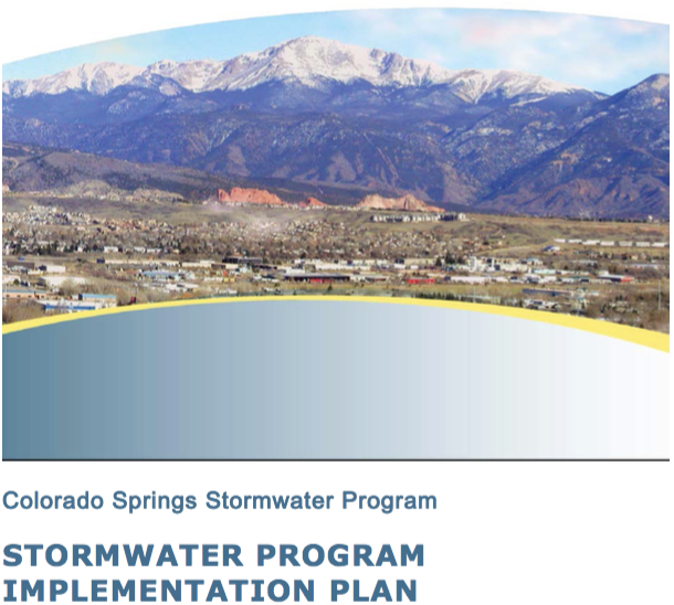
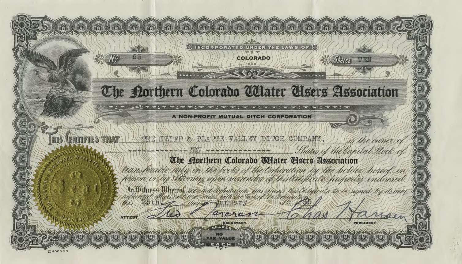

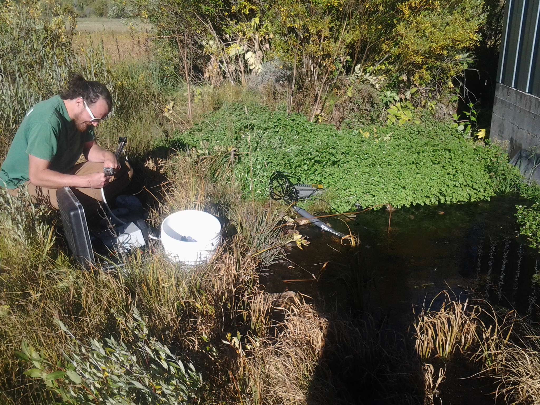
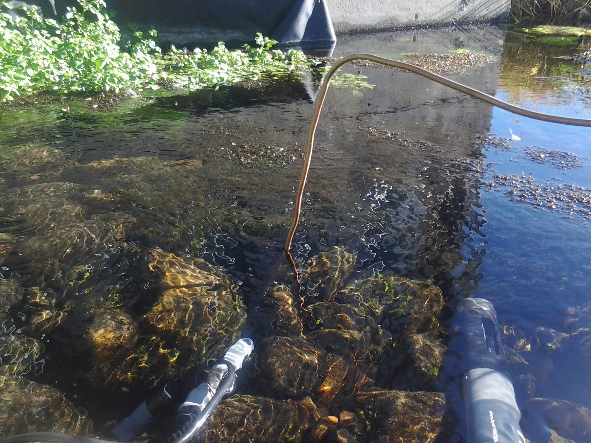


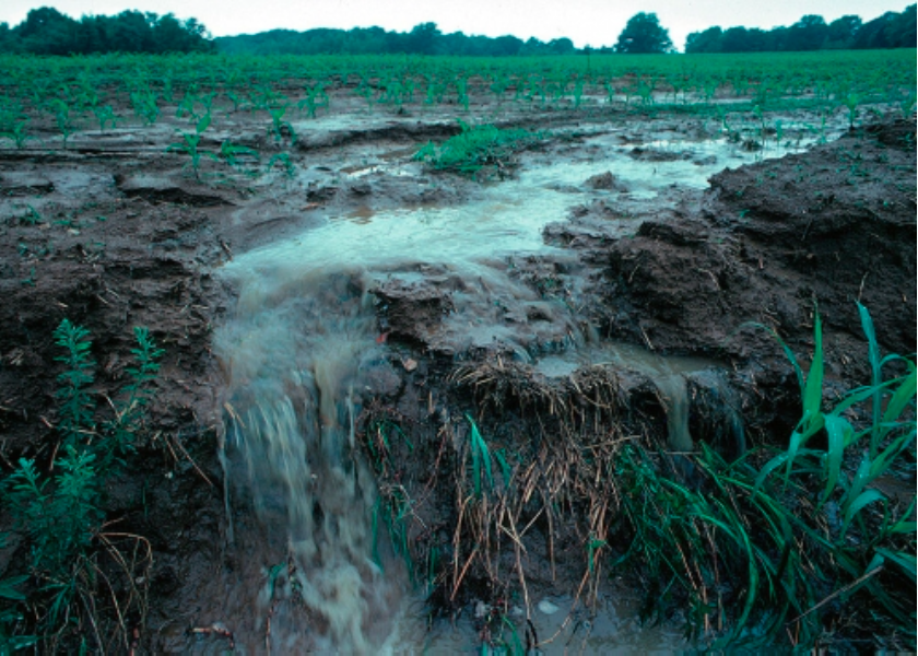

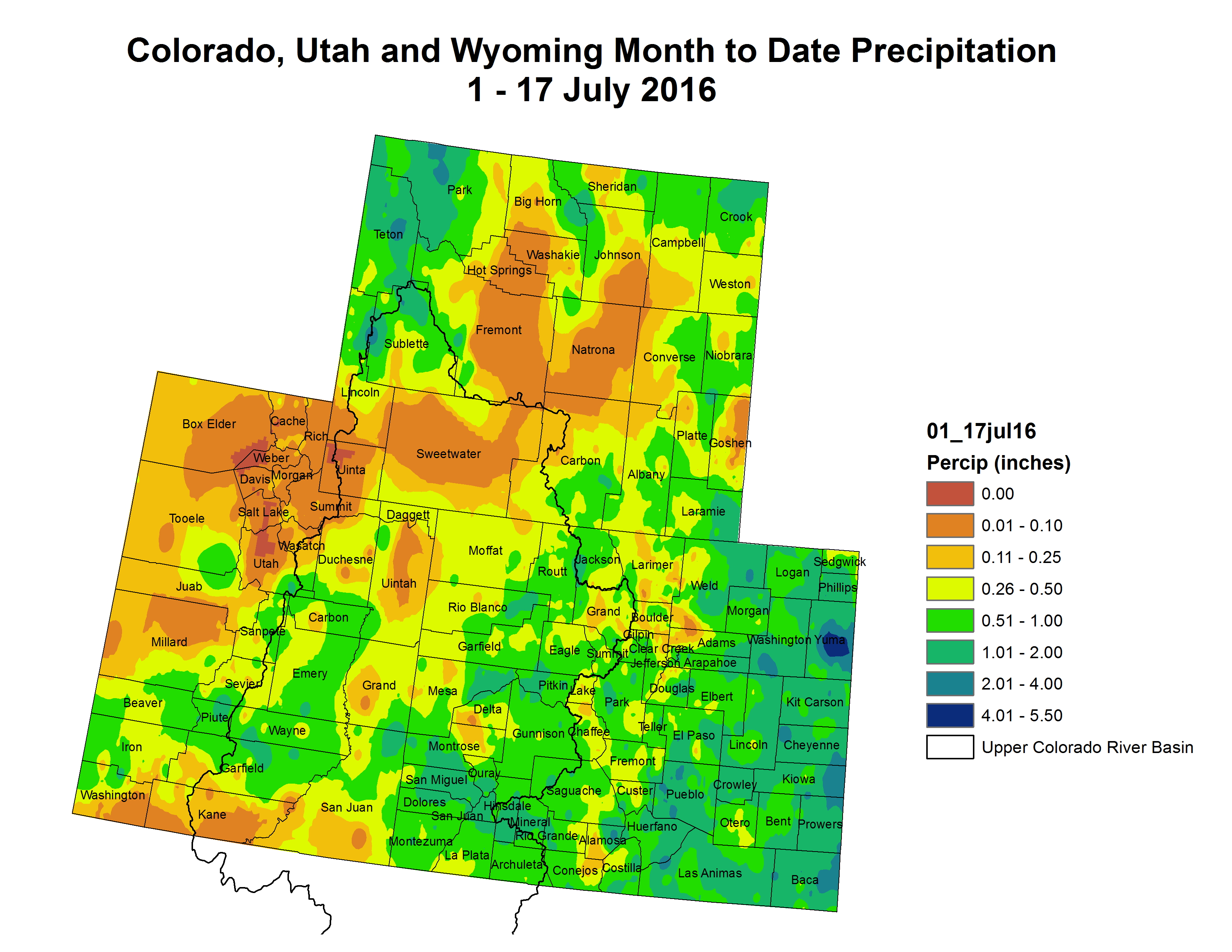


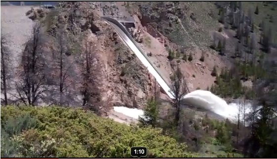
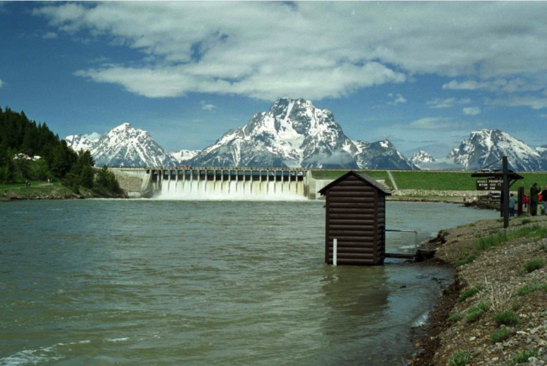
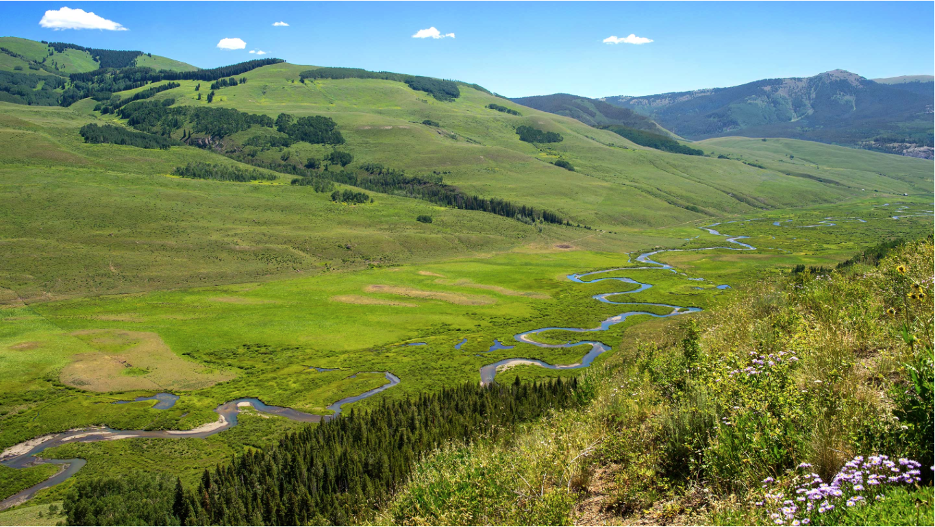

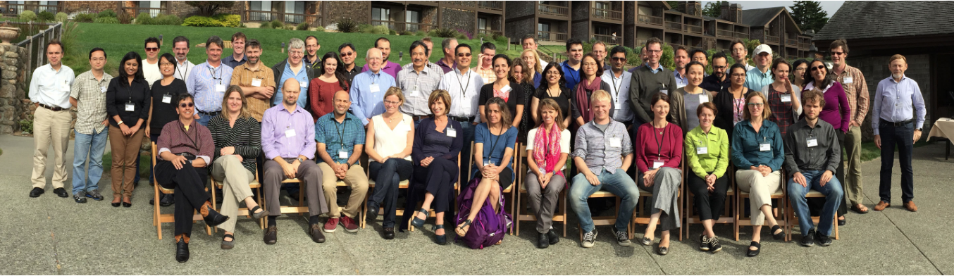

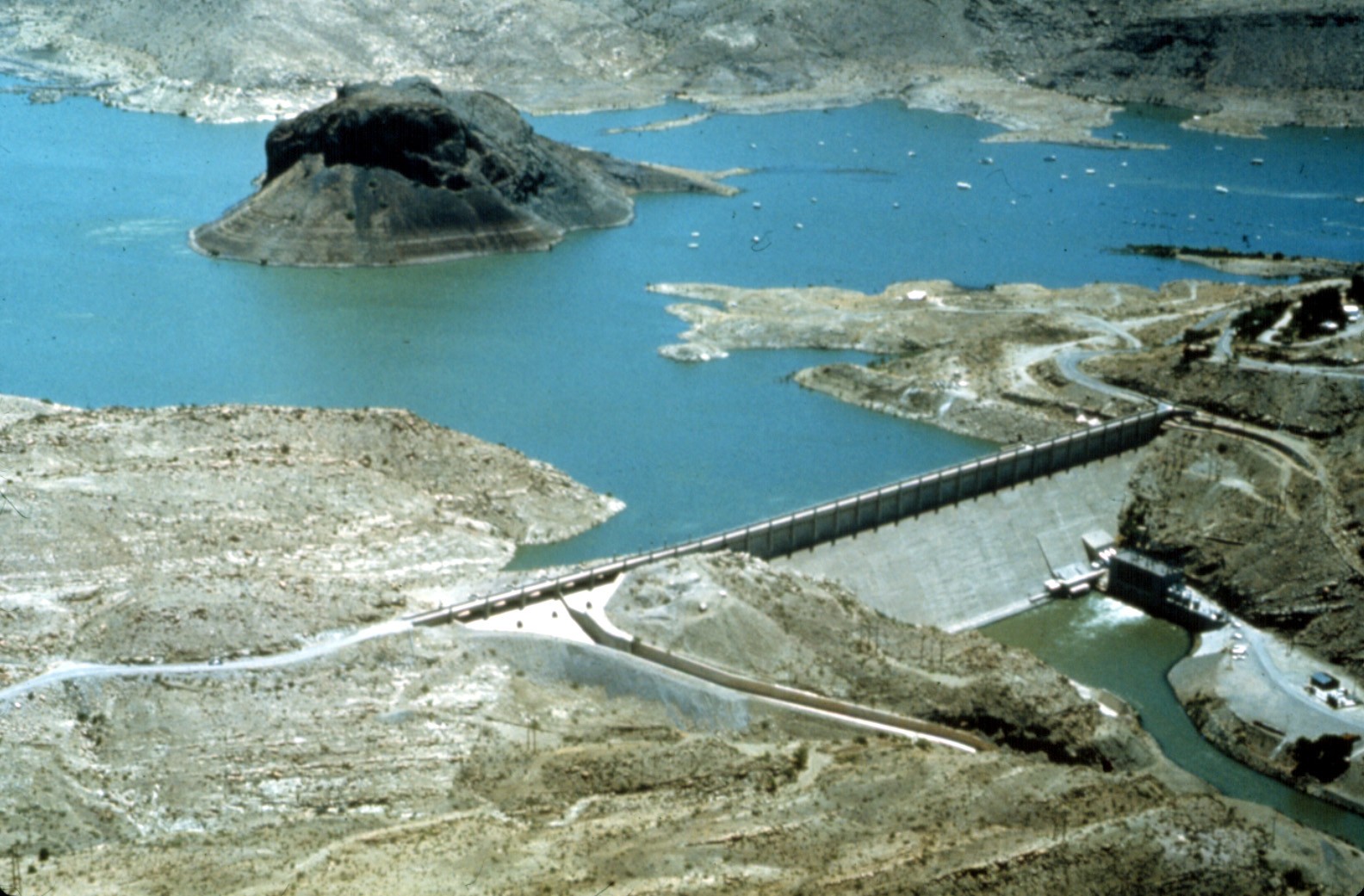


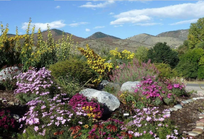
![This image was taken during the peak outflow from the Gold King Mine spill at 10:57 a.m. Aug. 5. The waste-rock dump can be seen eroding on the right. Federal investigators placed blame for the blowout squarely on engineering errors made by the Environmental Protection Agency’s-contracted company in a 132-page report released Thursday [October 22, 2015]](https://coyotegulch.blog/wp-content/uploads/2015/10/goldkingminespill1057am08052015viaepa.png)
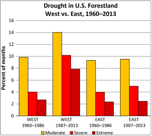

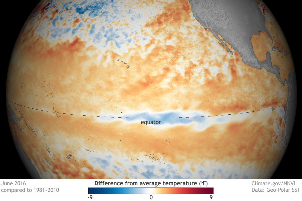

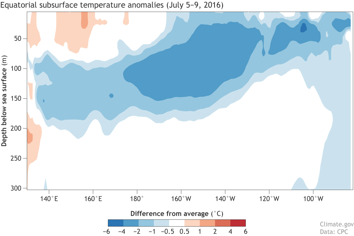
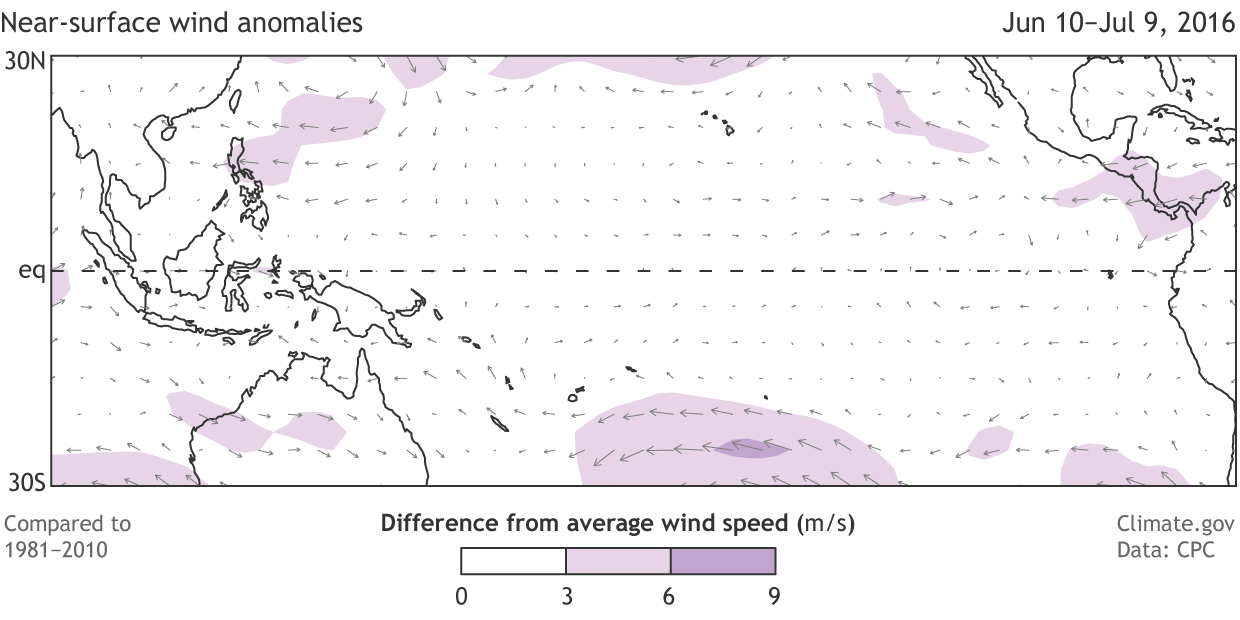


