The project to bring raw water irrigation to the town of Norwood is gaining traction with a recently approved grant awarded by the Hermitage Fund, a philanthropic fund advised by the Telluride Foundation.
The $10,000 grant is the first won by The Norwood Lawn & Garden group, community raw water advocates who have been in charge of advocacy efforts and community surveying for the project.
Not to be confused with grey water, raw water is untreated [surface water or groundwater] — in this case from the Gurley Reservoir — that can be used for agricultural and home irrigation.
The raw water project has been on the radar of the town of Norwood for many years but did not become a tangible project until a grant issued to the town by the Colorado Water Conservation Board was used to conduct a $47,000 feasibility study.
After the feasibility study was presented in February, the Norwood Lawn & Garden group was formed and started distributing surveys to the community to see how many residents would be ready to give a tap commitment — a $2,500 fee for installing a tap to access the new water source — which also helps offset the initial costs of the project.
Led by Clay Wadman, the group of volunteers consists of members of the Norwood Water Commission, the Norwood Board of Trustees, the Colorado Water [Conservation] Board and community citizens that want to see raw water from the nearby Gurley Reservoir be directed to the town of Norwood for lawn and garden irrigation purposes.
This grant is one of three that is being solicited in order to see the raw water project come to fruition. A second grant from the Southwestern Water Conservation District for $175,000 will be submitted on Friday, and a third grant will be requested from the state Department of Local Affairs in late fall of 2016.
“Our hope is that this grant from the Hermitage Fund helps spearhead additional fundraising and grant efforts for the project,” April Montgomery, programs director of the Telluride Foundation said.
According to Montgomery, the grant provided by the Hermitage Fund will be split between two areas of concentration: for a senior citizen scholarship fund, which will provide senior citizens on fixed incomes with subsidized or free taps to access the new water source, and for administrative costs associated with running the project including marketing, community outreach and grant-writing initiatives.
The Hermitage Fund was created in memory of Reverend Sylvester Schoening and gives funds to organizations “which promote the preservation and restoration of land, water, natural resources and wildlife habitat in the San Miguel region of Colorado,” according to the Telluride Foundation.
According to Wadman, 107 people have already said they would be interested in the taps (up from 80 in July) and if they could get that number to 150 and win the other two grants the project will have enough funding to begin the first phase of construction in the summer of 2017. The project needs to raise $1.1 million dollars to reach that goal.
Wadman said that for residents, the tap commitments are “a big bullet to bite” but that in the long run it will be worth it. “(People are) going to save money on water bills, water is going to be much cheaper, it is going to make their properties more valuable, and going to make their rentals more rentable.”
If Norwood were to complete the project, it would join the ranks of other Colorado towns that have adapted to a raw water system including Carbondale, Nucla, Dove Creek and Grand Junction.
For Wadman, the raw water project is an extension of the growing agricultural movement taking place in Norwood.
“Norwood is defining itself as food centric. It is gardening, it is food based … raw water supports that,” he said.
Wadman will be presenting at the Norwood Board of Trustees meeting this Wednesday where the presale of taps will be up for discussion.
Here’s the release the US Bureau of Reclamation (Justyn Liff):
Reclamation has awarded a contract for $1.4 million to Gracon, LLC of Loveland, Colorado for fabricating and installing a steel intake bulkhead gate and refurbishing four trash racks and high-pressure slide gates at Lemon Dam located near Durango, Colo.
The bulkhead gate will seal the intake structure to provide a dry work environment for working on the high pressure slide gates while allowing flows into the Florida River to continue. The trash racks prevent unwanted debris from entering the intake structure and protect the high pressure gates that regulate flows through the dam.
Off-site fabrication for the steel intake bulkhead gate and other preparatory work will begin in September 2016. On-site work at Lemon Dam is tentatively scheduled to begin in late October 2016 and be completed in January 2017.
Here’s the release from the US Army Corps of Engineers (Eileen Williamson):
Three public meetings to provide an update on the status of two studies taking place at Cherry Creek Dam are scheduled for the week of September 20.
The U.S. Army Corps of Engineers will host meetings to provide a status update on alternatives under consideration to address risks from extreme storm events associated with Cherry Creek Dam including a study to modify the dam’s water control plan.
The meetings will be held at the following times and locations:
Tuesday, Sept. 20 from 6 – 8 p.m.
Cherry Creek Presbyterian Church
Rooms 112/113 (Main Building)
10150 E. Belleview Avenue
Englewood, CO 80111
Wednesday, Sept. 21 from 5:30 – 7:30 p.m.
Virginia Village Library
1500 S. Dahlia Street
Denver, CO 80222
Thursday, Sept. 22 from 5:30 – 7:30 p.m.
Aurora Municipal Center
City Café
15151 E. Alameda Parkway
Aurora, CO 80012
The public meetings will include a presentation and an open house to provide the public an opportunity to ask questions about Cherry Creek Dam and the alternatives being presented and considered as part of the Dam Safety Modification Study and Water Control Plan Modification Study.
Meeting materials will be made available online following the meetings at http://go.usa.gov/cQ7hP.
Background: Cherry Creek Dam and Reservoir is located in the southeast Denver metropolitan area on Cherry Creek, 11.4 miles upstream of its confluence with the South Platte River.
In 2005, (post-Katrina) USACE began screening its dams (approximately 700 across the U.S.) to determine each dam’s risk level. Cherry Creek Dam received an elevated risk rating primarily because of the large downstream population and the potential for overtopping during an extremely rare precipitation event.
A dam safety modification study began in 2013 and is being conducted in accordance with USACE policy as described in Engineering Regulation 1110-2-1156 “Safety of Dams – Policy and Procedures.” An Environmental Impact Statement is also being prepared pursuant to the National Environmental Policy Act of 1969, as amended.
How much water reaches the Westwater stretch of the Colorado River, and then Lake Powell, is taking on increasing importance to Colorado water officials. A new study is underway to look at much more water is available to develop on the Western Slope, and it’s caught the attention of east slope water officials. Photo: Brent Gardner-Smith/Aspen Journalism
I’ve been spending a lot of time lately talking to colleagues about the current state of the Colorado River, and if there’s one word that captures their collective assessment, it is momentum. Throughout the basin, a lot of really good innovations are occurring. Conservation has, rightly, emerged as a credible management tool, and not merely something for the hippies to talk about. Cooperation among the states, between the US and Mexico, and between the water users and environmentalists, is arguably at an all-time high. Thoughtful people hold key posts in many of the relevant agencies. And so on. Sure, there’s still too many efforts to build new straws to further depletions, some key players—such as the tribes—are still struggling for meaningful inclusion, and there’s never enough money, especially for costly reforms such as improved watershed management. But compared to 20 years ago, or even 10 years ago, it’s a different world. Momentum.
But is it enough? Can incremental progress on several fronts congeal to form a comprehensive, lasting solution to the river’s problems? And can it happen on a schedule that acknowledges that the climate will continue to warm, populations will continue to grow, and that persistently low reservoir storage makes the region increasingly vulnerable should a few really dry years be around the corner. The challenges are all growing, and despite our current momentum, Lake Mead—the unofficial canary in this coal mine—is projected to drop further over the next 2 years. We are doing better—arguably, much better. Nobody should be shy in acknowledging this; some boasting is justified. But we aren’t winning yet. Can incremental reforms ultimately tip the scales, shifting the basin’s course from one of steady decline to one leading to true sustainability, or will it only delay a day of reckoning that ushers in more sweeping changes—reforms that go beyond what current negotiations envision? I don’t pretend to definitely know that answer. Nobody does. But I suspect we likely need one or more new “grand bargains” to get us to the finish line. If so, the ultimate value of the incremental reforms may be in establishing the networks and laying the groundwork for those conversations to occur. Momentum.
Dr. Doug Kenney Doug is the Senior Research Associate, Getches-Wilkinson Natural Resources Law Center and Director of the GWC Western Water Policy Program. Doug is a member of The Colorado River Research Group; a self-directed team of ten veteran Colorado River scholars. A founding member of Carpe Diem West, he also participates on the program team. He researches and writes extensively on several water-related issues, including law and policy reform, river basin and watershed-level planning.
This week, the U.S. Environmental Protection Agency (EPA) added three mining-related sites to the National Priorities List (NPL) of Superfund sites. These include the Bonita Peak Mining District (BPMD) site in San Juan County, Colorado; the Argonaut mine, Amador County, California; and the Anaconda Aluminum Co.’s Columbia Falls Reduction Plant site, also known as the Columbia Falls Aluminum Co. (CFAC) site, in Columbia Falls, Montana.
The law establishing the Superfund program, the Comprehensive Environmental Response, Compensation and Liability Act (CERCLA), requires the EPA to update the NPL at least annually and clean up hazardous waste sites. The designation comes a little more than a year after the EPA released 3 million gallons of water from the Gold King mine into the Animas River fouling rivers and lakes from Colorado to Nevada. The Gold King mine is one of several abandoned mines in the Bonita Peak district…
The lawsuits stemming from this mishap are just now coming to a head. The state of New Mexico, however, is suing the state of Colorado, claiming it approved the plans that led to this situation.
The Bonita Peak Mining District site consists of historic and ongoing releases from mining operations in three drainages, which converge into the Animas River near Silverton, Colorado. Water quality in the BPMD has been impaired by acid mine drainage for decades. Since 1998, the state of Colorado has designated portions of the Animas River downstream from Cement Creek as impaired for heavy metals, including lead, iron and aluminum. The EPA has waste quantity data on 32 of Bonita Peak’s 48 sources. These 32 sources have waste rock and water discharging out of adits at a combined rate of 5.4 million gallons per day. Cadmium, copper, manganese and zinc are the known contaminants associated with these discharges.
Click here to go to the US Drought Monitor website. Here’s an excerpt:
Summary
This U.S. Drought Monitor week saw improvements in drought conditions in parts of the Southeast and Mid-Atlantic in association with Hurricane-Tropical Storm Hermine. Hurricane Hermine marked the first hurricane to make landfall in Florida in eleven years since Hurricane Wilma in 2005. The hurricane came ashore along the Florida Panhandle moving northeast and impacting eastern portions of Georgia, South Carolina, and North Carolina before moving off-shore. The system brought flooding and heavy rainfall accumulations ranging from three-to-eighteen inches with the heaviest accumulations observed in Florida as well as coastal areas of the Carolinas. In the Central Pacific sector, two hurricanes (Hurricane Madeline and Hurricane Lester) approached the Hawaiian Islands during the past week; both veered away from the island chain, however. Some impacts were observed on the windward side of the Big Island where seven-to-nine inches of rain fell in association with moisture from Hurricane Madeline as it passed just south of the Big Island. Elsewhere, significant rainfall accumulations were observed in southeastern New Mexico as well as portions of the Central Plains where bands of heavy rainfall soaked northwestern Kansas. In New England, dryness continued to deteriorate conditions in Maine, New Hampshire, and Upstate New York. In the West, California and the Great Basin remained in a dry pattern…
The Plains
Across the Plains, short-term conditions improved in isolated areas of western South Dakota and northeastern Wyoming leading to one-category improvements in areas of Extreme Drought (D3), Severe Drought (D2), and Moderate Drought (D1). Conversely, a small area of Extreme Drought (D3) in northwestern South Dakota was slightly expanded in response to very dry conditions observed on satellite-based vegetative health products as well as reports of lack of forage and deteriorating stock pond conditions. In northwestern Kansas, a band of heavy rain improved conditions leading to the removal of an area of Moderate Drought (D1) and reduction in areas of Abnormally Dry (D0). Temperatures were two-to-eight degrees above average in the Northern Plains while further south temperatures hovered within a few degrees of normal…
The West
During the past week, average temperatures were below normal across California, most of the Great Basin, Northern Rockies, and western portions of the Southwest while areas east of the Continental Divide were slightly above normal. Overall, the West was dry last week with the exception of areas of isolated precipitation in northwestern Washington, eastern Montana, and southeastern New Mexico. Dryness during the past 90 days led to expansion of areas of Abnormally Dry (D0) and Moderate Drought (D1) in southeastern and south-central Idaho. In northwestern Wyoming, an area of Severe Drought (D2) was expanded in the headwater region of the Snake River where baseflow has been well below normal. In southeastern New Mexico, locally heavy rainfall accumulations ranging from two-to-ten inches led to one-category improvements in areas of Abnormally Dry (D0) and Moderate Drought (D1)…
Looking Ahead
The NWS WPC 7-Day Quantitative Precipitation Forecast (QPF) calls for significant rainfall accumulations (two-to-five inches) across the nation’s midsection – primarily focused on eastern portions of the Southern Plains, Midwest, and southern portions of the Southwest in association with Tropical Storm Newton. Rainfall accumulations in southeastern Arizona and southern New Mexico are forecasted to be in the two-to-four inch range. Dry conditions are forecast in the Far West, Pacific Northwest, and Intermountain West. The CPC 6–10 day outlooks call for a high probability of above-normal temperatures in the eastern third of the U.S. and most of the Pacific Northwest while below-normal temperatures are expected in the Desert Southwest, Intermountain West, Rockies, and extending eastward into the Plains and western portions of the Midwest. Below-normal precipitation is forecasted for the Pacific Northwest, Northern Rockies, Northern Plains, and northern portions of the Mid-Atlantic while there is a high probability of above-normal precipitation across the Central Rockies, eastern portions of the Southwest, Central and Southern Plains, and northern portions of the Midwest.
The High Valley Farms marijuana cultivation facility near Basalt. The court has yet to rule on the question posed: Can a water right be issued specifically to grow pot when it is still illegal to grow weed under federal law?
BASALT – It’s been two years since High Valley Farms, LLC applied for a water right to grow marijuana near Basalt, but it’s still not known if officials in the Division 5 water court will issue a decree to water pot plants when it is still a federal crime to do so.
And while the hazy legal question posed by court officials has been lingering in the air since 2014, High Valley Farms has amended its application twice and both times has increased the size of its proposed water right.
Instead of seeking a right to use 2.89 acre-feet annually from an on-site well and the Roaring Fork River, High Valley Farms is now seeking to use 9.24 acre-feet a year.
Put in terms of gallons instead of acre-feet, High Valley Farms has gone from asking for the right to use 941,711 gallons of water a year, or 2,580 gallons a day, to asking for 3,010,867 gallons a year, or 8,249 gallons a day.
Further, High Valley Farms has recently picked up two opposers in the case, both oil-company executives from Texas who own property near the 25,000-square-foot pot-growing facility along Highway 82.
Both men, according to their attorney, Scott Miller of Basalt, are concerned that the use of water at the High Valley Farms facility is drying up wells on their property, and are less concerned about the issues of federal law raised in the case.
Miller also represents the Roaring Fork Club, which filed the first statement of opposition in the case. That, too, concerns its water rights, not federal legal questions about growing pot.
A graphic from High Valley Farms showing the location of the facility and water sources.
More water
High Valley Farms, which is controlled by Jordan Lewis, the owner of the Silverpeak marijuana store in Aspen, wants to use the water covered by the proposed water right to fill and refill large underground storage tanks. The water will be used for plants in the indoor greenhouse, and to power the mist and evaporative cooling systems in the greenhouse.
Those systems now include an expensive odor-suppression system that uses water and carbon filters to stop the smell of potent buds from wafting through the neighborhood.
The water would also be used in sinks and bathrooms in both the greenhouse and a nearby single-family home, and for landscaping purposes on the 4.7-acre lot, which is near the Roaring Fork Club, just upvalley from Basalt.
Rhonda Bazil, the attorney for High Valley Farms, declined on Tuesday to discuss the application.
The map submitted with the original High Valley Farms water right application in August 2014.
Legal questions
Both the original application from High Valley Farms in August 2014 and the amended version in May 2015 prompted the same question from the water referee in Division 5 water court: Can a water right to grow marijuana be granted in Colorado when growing pot is still a federal crime?
“The application must explain how the claim for these conditional water rights can be granted in light of the definition of beneficial use as defined [under state law],” the water referee said in a summary of consultation in August 2015. “Specifically, beneficial use means the ‘use of that amount of water that is reasonable and appropriate under reasonably efficient practices to accomplish without waste the purpose for which the appropriation is lawfully made.’”
The document put an emphasis on the word “lawfully,” as in, can it be done lawfully if it is still a federal crime?
It was the first time a water court official in Colorado had posed the question, and the case is likely to set a precedent, at least in Division 5, which encompasses the Colorado River basin above the Gunnison River.
The answer to the question remains outstanding, although Bazil, the attorney for High Valley Farms, filed a response to the court in November 2015 making three main points.
She argued that the state water engineer has already said it’s OK to use water to grow pot plants; that the federal Bureau of Reclamation has also said it’s fine to water pot plants in Colorado (as long as you don’t use water taken directly from a federal facility); and that the federal government has long ceded general management of water rights to the states.
Bazil also told the court at the time, “If this court were to determine that, contrary to the findings of the state engineer, the use of water for marijuana facilities is not a beneficial use, the entire industry, which reportedly employs almost 160,000 resident, would be shut down.”
An underground water tank, yet to be buried, next to the High Valley Farms grow facility in Basalt in February 2016.
Next steps
After receiving the second amended application from High Valley Farms in May, the water court referee set Oct. 4 as the next date for a status conference.
But on Aug. 31, in response to a motion to extend from High Valley Farms, the referee vacated the scheduled October status conference while all the parties await the third “summary of consultation” in the case from the division engineer’s office.
Once the consultation, or review of the application, is submitted to the court, High Valley Farms will have 30 days to respond and “circulate a proposed ruling.” There is no deadline set for the consultation to be submitted by the division engineer.
Opposers in the case will then have another 30 days to respond to the proposed ruling from High Valley Farms, and a status conference will be scheduled after that.
When ready to act, the water court referee doesn’t necessarily have to address the larger legal question posed by the High Valley Farms application in order to recommend approval by the water court judge.
If satisfied by answers to the lingering federal question, the referee could simply recommend approval of a proposed decree, without comment.
If the referee denies the decree, for any reason, the decision could then be appealed to the water court judge. And an eventual decision by the judge could be appealed directly to the Colorado Supreme Court.
In the meantime, High Valley Farms can continue to water its pot plants; it just doesn’t have a decreed water right to do so.
Editor’s note: Aspen Journalism and the Aspen Daily News are collaborating on coverage of rivers and water. The Daily News published this story on Wednesday, Sept. 7, 2016.
Collaboration! Everyone seems to be talking about it. Most everyone in Colorado’s water community agrees we are at a juncture where it is critical for us to collaborate. But what does this mean? How is this lofty idea actually put into practice? How is collaboration different from its distant cousin–compromise–in which all parties give up something and no one ever emerges very happy?
True collaboration takes a whole new way of looking at things. We all worked hard to craft the voluminous Colorado Water Plan. Now it is time for the challenging conversations and decision-making among the diverse stakeholders in our state to put it into practice. Maybe we have the motivation to do that, and even the energy. But do we have the know-how and the skills to practice effective collaboration?
For those who want to gain that know-how and those skills, or to practice and fine-tune what they already know in theory or from past experience, Colorado Water Institute at CSU is once again teaming up with CDR Associates to offer a hands-on workshop on ‘Strengthening Collaborative Capacity for Better Water Decisions.’ This fall’s training will take place November 9-11 at the Sylvan Dale Guest Ranch, west of Loveland. It is the second such workshop CSU and CDR have offered, following a similar workshop last fall in Palisade. One participant from the Palisade training said, “Given the complex water issues we face in Colorado, it’s inspiring to learn skills to help transcend the polarized positions of different geographic and stakeholder sectors. I can’t wait to apply these new tools to improve collaboration as I approach water challenges in my work.” Participants came from state and federal agencies, ditch companies and conservancy districts, basin roundtables, and non-governmental organizations.
“That mix of sectors involved in water throughout Colorado is a real strength of the training,” says MaryLou Smith of the Colorado Water Institute. Participants are able to jump right in, bringing with them their real-world challenges and some success stories. “They bring their own set of experiences and issues that provide really good material for us to work with,” Smith says. Smith, along with CDR’s Ryan Golten, and the Colorado River District’s Dan Birch, will staff the training.
The retreat-style workshop is an opportunity for “collaboration in action,” as participants learn right off how to establish trust and relationships critical for collaboration—not by just hearing about it, but by practicing it. The workshop offers a dynamic blend of discussions, presentations, practice and role-playing. Key topics include understanding the dynamics of conflict; moving from positional bargaining to interest-based thinking; when and under what circumstances collaborative processes are most effective; and the mechanics and skills-building of designing, facilitating and/or participating in collaborating in problem-solving processes. The workshop offers participants a greater toolbox, concrete skills, and confidence in their collaboration practice, whether as conveners, facilitators or stakeholders. “This is very much hands-on training,” Smith says, “which is what makes it so valuable. Attendees practice role-playing in which they’re challenged to come to agreement in a collaborative setting.”
Colorado’s Water Plan has a subtitle: “Collaborating on Colorado’s Water Future.” The first page of the executive summary says “This is the beginning of the next phase in Colorado water policy, where collaboration and innovation come together with hard work to meet and implement the objectives, goals, and actions set forth in Colorado’s Water Plan.”
Register now to get some down-to-earth instruction and practice in collaboration and innovation critical to Colorado’s water future. For questions, contact MaryLou at MaryLou.Smith@colostate.edu.
UCCS Clean the Stream Team at the 2015 Creek Week. Photo via the Fountain Creek Watershed, Flood Control and Greenway District.
Click here to read the newsletter from the Fountain Creek Watershed, Flood Control and Greenway District. Here’s an excerpt:
The 2016 Steering Committee has been working very hard to make this 3rd annual event bigger and better than ever, including a new website! Mark your calendars for Sept. 24-Oct 2 , gather up your Creek Crew and get ready to make a huge difference for our watershed and beyond. Read about last year’s event for inspiration. Interested in getting involved, need more info, want to sponsor – contact us (creekweeksoco@gmail.com)!
Mountains reflect off of Bolts Lake as seen from US 24 S in Colorado. Photo via LessBeatenPaths.com.
Here’s the release from Congressman Polis’ office via Real Vail:
Polis’s Bolts Ditch bill passes House of Representatives
WASHINGTON – Rep. Jared Polis (D-Colo.) today passed the Bolts Ditch Access and Use Act (H.R. 4510) out of the House of Representatives. This bill directs the U.S. Department of Agriculture to authorize special use access of Bolts Ditch for the diversion of water and maintenance by the town of Minturn, Colorado.
When Congress designated Holy Cross a Wilderness Area in 1980, legislators inadvertently left Bolts Ditch off the list of existing water facilities. The bill would authorize special use of the Bolts Ditch headgate and the segment of the Bolts Ditch within the Holy Cross Wilderness Area, allowing the Town of Minturn to use its existing water rights to fill Bolts Lake.
“This bill provides the Town of Minturn access to clean and affordable drinking water while preserving the sanctity of the surrounding wilderness areas,” Rep. Jared Polis said. “We can all agree that water is a precious resource, and we must be deliberate about how we use it. The efforts by our residents, the conservation community, and water utilities displays how we can work together to resolve a long-term problem, and I look forward to swift passage by the Senate.”
“The Town of Minturn has actively pursued a common sense solution to fill Bolts Lake,” Matt Scherr, mayor of Minturn, said. “This bill will give our community the ability to use existing water rights and obtain clean water without harming the wilderness. We commend Rep. Jared Polis for his leadership in the House of Representatives on passing this practical bill, and are excited that it’s one step closer to becoming law.”
Sen. Michael Bennet (D-Colo.) and Sen. Cory Gardner (R-Colo.) introduced companion Bolts Ditch legislation in the Senate. Both Rep. Doug Lamborn (R-Colo.) and Rep. Scott Tipton (R-Colo.) are co-sponsors of H.R. 4510 in the House of Representatives.
…a lot of people. But on Tuesday the House of Representatives actually passed a bipartisan bill that should prove very helpful for the town of Minturn. Sponsored by U.S. Rep. Jared Polis, D-Boulder, it’s called the Bolts Ditch Access and Use Act.
If it passes in the Senate, where Colorado Sens. Michael Bennet and Cory Gardner have introduced a version in the upper chamber, the bill would allow the town of Minturn to access Bolts Ditch in order use existing water rights to fill Bolts Lake. Right now that’s problematic because Bolts Ditch was accidentally included in the Holy Cross Wilderness Area back in 1980.
That’s why it’s a good idea to get all the local water authorities and local governments on board before proposing wilderness legislation. One of the big hurdles in drafting a Senate version of Polis’ Continental Divide Wilderness and Recreation Act was understandable resistance from the Eagle Valley Water and Sanitation District, which wants to maintain access to water sources in any proposed additions to the Eagles Nest and Holy Cross Wilderness Areas.
“Eagle River Water and San has been kind of a thorn, but it sounds like they’ve got things worked out,” Eagle County Commissioner Kathy Chandler-Henry said during an EcoFlight flyover of the proposed wilderness additions last month. “All of that [access for management of water resources] is in the language already, and I’ve heard they’re ready to say OK.”
On April 7, 2016, the Environmental Protection Agency proposed adding the “Bonita Peak Mining District” to the National Priorities List, making it eligible for Superfund. Forty-eight mine portals and tailings piles are “under consideration” to be included. The Gold King Mine will almost certainly be on the final list, as will the nearby American Tunnel. The Mayflower Mill #4 tailings repository, just outside Silverton, is another likely candidate, given that it appears to be leaching large quantities of metals into the Animas River. What Superfund will entail for the area beyond that, and when the actual cleanup will begin, remains unclear. Eric Baker
Here’s the release from the Environmental Protection Agency (Laura Jenkins):
The U.S. Environmental Protection Agency (EPA) will add the Bonita Peak Mining District (BPMD) site in San Juan County, Colo., to the National Priorities List (NPL) of Superfund sites on September 9, 2016. Superfund is the federal program that investigates and cleans up the most complex, uncontrolled or abandoned hazardous waste sites to protect public health and the environment.
“Listing the Bonita Peak Mining District on the National Priorities List is an important step that enables EPA to secure the necessary resources to investigate and address contamination concerns of San Juan and La Plata Counties, as well as other downstream communities in New Mexico, Utah, and the Navajo Nation,” said Shaun McGrath, EPA’s Regional Administrator. “We look forward to continuing our efforts with the State of Colorado, the Bureau of Land Management, the U.S Forest Service, Tribal governments, and our community partners to address the impacts of acid mine drainage on the Animas River.”
EPA proposed the BPMD site for addition to the NPL on April 7, 2016, and conducted a 68-day public comment period on the proposal. After reviewing and responding to all comments in a responsiveness summary, EPA has added the site to the NPL. To view the responsiveness summary (Support Document) and other documents related to the addition of the Bonita Peak Mining District to the National Priorities List, please visit: http://www.epa.gov/superfund/current-npl-updates-new-proposed-npl-sites-and-new-npl-sites.
The Bonita Peak Mining District site consists of historic and ongoing releases from mining operations in three drainages: Mineral Creek, Cement Creek and Upper Animas; which converge into the Animas River near Silverton, Colorado. Mining began in the area in the 1860s and both large- and small-scale mining operations continued into the 1990s, with the last mine ceasing production in 1991. The site includes 35 mines, seven tunnels, four tailings impoundments, and two study areas where additional information is needed to evaluate environmental concerns.
Water quality in the BPMD has been impaired by acid mine drainage for decades. Since 1998, Colorado has designated portions of the Animas River downstream from Cement Creek as impaired for heavy metals, including lead, iron and aluminum. EPA has waste quantity data on 32 of Bonita Peak’s 48 sources. These 32 sources have waste rock and water discharging out of mining adits at a combined rate of 5.4 million gallons per day. Cadmium, copper, manganese and zinc are the known contaminants associated with these discharges.
“Listing the Bonita Peak Mining District is critical to addressing historic mining impacts in San Juan County and our downstream communities,” said Martha Rudolph, director of environmental programs for the Colorado Department of Public Health and Environment. “We are committed to working closely with our Federal and state partners to achieve an effective cleanup, while ensuring that all our affected communities have a voice in the process as this moves forward.”
The Comprehensive Environmental Response, Compensation and Liability Act (CERCLA), the law establishing the Superfund program, requires EPA to update the NPL at least annually and clean up hazardous waste sites to protect human health with the goal of returning them to productive use. A site’s listing neither imposes a financial obligation on EPA nor assigns liability to any party. Updates to the NPL do, however, provide policymakers with a list of high-priority sites, serving to identify the size and nature of the nation’s cleanup challenges.
The Superfund program has provided important benefits for people and the environment since Congress established the program in 1980. Those benefits are both direct and indirect, and include reduction of threats to human health and ecological systems in the vicinity of Superfund sites, improvement of the economic conditions and quality of life in communities affected by hazardous waste sites, prevention of future releases of hazardous substances, and advances in science and technology.
From the Associated Press (Dan Elliott) via The Farmington Daily Times:
A Colorado mine that spewed 3 million gallons of contaminated wastewater into rivers in three Western states was designated a Superfund site Wednesday, clearing the way for a multimillion-dollar federal cleanup.
The U.S. Environmental Protection Agency added the inactive Gold King Mine and 47 other nearby sites to the Superfund list…
The Colorado Superfund designation is the beginning of a years-long effort to clean up the wreckage of a once-booming mining industry in the San Juan Mountains in the southwestern corner of the state. Abandoned mining sites send millions of gallons of acidic wastewater to creeks and rivers every year…
The spill triggered a storm of criticism of the EPA and at least three lawsuits.
New Mexico has sued both the EPA and Colorado over the spill, while the Navajo Nation sued the federal government. Utah officials say they also plan to sue…
An investigation last year by the Interior Department, which is independent of the EPA, said the cleanup crew could have avoided the spill but rushed its work.
Interior officials said they found no evidence of criminal wrongdoing. A separate criminal investigation is still underway, along with an internal EPA inquiry.
Congress has conducted multiple hearings on the spill and is considering several bills to address hundreds of old, leaking mines nationwide.
The EPA said Wednesday it’s too early to say how long the cleanup will take and what it will cost.
Authorities will first gather data including water and sediment samples and assessments of fish and wildlife habitat and other information. That process will probably end next year, said Rebecca Thomas, EPA’s manager for the project, known as the Bonita Peak Mining District Superfund Site.
The EPA will then study different cleanup methods, choose a preferred option and ask for public comment. Work would then start on designing and implementing the cleanup.
Fixes could include water treatment plants for acidic waste draining from the site, plugging abandoned mines that are leaking and moving mine waste piles away from streams, Thomas said.
The Superfund listing marks a dramatic shift in public sentiment in Silverton and surrounding San Juan County, where many residents first feared the designation would stamp the area with a stigma and hurt its vital tourism industry. The EPA does not designate Superfund sites without local support…
Esper said Silverton could become a research center for cleaning up leaking mines across the nation. The Government Accountability Office estimates that at least 33,000 abandoned mines across the West and in Alaska are contaminating water or causing other environmental problems.
The cleanup might also improve the town’s finances, which have been in decline since a mine and mill closed in 1991, Esper said.
The U.S. Environmental Protection Agency (EPA) will add the Bonita Peak Mining District (BPMD) site in San Juan County, Colo., to the National Priorities List (NPL) of Superfund sites on September 9, 2016. Superfund is the federal program that investigates and cleans up the most complex, uncontrolled or abandoned hazardous waste sites to protect public health and the environment.
“Listing the Bonita Peak Mining District on the National Priorities List is an important step that enables EPA to secure the necessary resources to investigate and address contamination concerns of San Juan and La Plata Counties, as well as other downstream communities in New Mexico, Utah, and the Navajo Nation,” said Shaun McGrath, EPA’s Regional Administrator. “We look forward to continuing our efforts with the State of Colorado, the Bureau of Land Management, the U.S Forest Service, Tribal governments, and our community partners to address the impacts of acid mine drainage on the Animas River.”
EPA proposed the BPMD site for addition to the NPL on April 7, 2016, and conducted a 68-day public comment period on the proposal. After reviewing and responding to all comments in a responsiveness summary, EPA has added the site to the NPL. The responsiveness summary can be found here: https://www.regulations.gov/docket?D=EPA-HQ-OLEM-2016-01522
Location map for abandoned mine near Silverton. The Silver Wing is in the upper right corner of the aerial.
Here’s the release from the US Bureau of Reclamation (Lesley McWhirter, Justyn Liff):
The Bureau of Reclamation has released a draft Finding of No Significant Impact and Environmental Assessment evaluating if Reclamation will provide partial funding to the North Fork Water Conservancy District to make repairs to the Paonia Dam intake structure and bulkhead, part of the Paonia Project located near Paonia, Colo.
Repairs will include dismantling the damaged upper concrete bulkhead of the intake structure and replacing the bulkhead with a modified aluminum trash rack and support members. Prior to repairing the intake structure, increased turbidity downstream of the dam will be noticeable due to normal reservoir operations and drawdown. Repairs on Paonia Dam will ensure continuation of normal dam operations and water delivery to downstream users.
The draft environmental assessment is available online at http://www.usbr.gov/uc/wcao/progact/paonia/documents.html or a copy can be received by contacting Jenny Ward at 970-248-0651 or jward@usbr.gov. Reclamation will consider all comments received by September 20, 2016. Written comments can be submitted by email to jward@usbr.gov or mailed to: Ed Warner, Bureau of Reclamation, 445 West Gunnison Ave., Suite 221, Grand Junction, CO 81501.
To learn more about the Paonia Project, the upcoming repair work, or sedimentation issues in the reservoir, visit our website at: http://www.usbr.gov/uc/wca/progact/paonia/index.html. You can also be added to our email list for project updates by clicking the “Contact Us” link.
The Environmental Protection Agency announced Wednesday its will add the district of mines around Silverton to its National Priorities List as a Superfund site this week.
In a press release, the EPA said it would add the “Bonita Peak Mining District” – a group of about 50 mine waste sites in San Juan County – to the NPL on Friday.
“Listing the Bonita Peak Mining District on the National Priorities List is an important step that enables EPA to secure the necessary resources to investigate and address contamination concerns of San Juan and La Plata counties, as well as other downstream communities in New Mexico, Utah and the Navajo Nation,” Shaun McGrath, EPA’s regional administrator, said in a prepared statement.
EPA officials said they’ll announce the prioritization of these sites along Animas River headwaters above Silverton – “the Bonita Peak Mining District” – in the federal register on Friday. These are among 10 new sites nationwide targeted for cleanups — dependent on Congress providing funds. The federal Superfund program involves investigating and cleaning up the nation’s worst environmental disasters to protect human health and the environment.
“Listing the Bonita Peak Mining District on the National Priorities List is an important step that enables EPA to secure the necessary resources to investigate and address contamination concerns of San Juan and La Plata Counties, as well as other downstream communities in New Mexico, Utah, and the Navajo Nation,” EPA regional administrator Shaun McGrath said in a prepared statement.
“We look forward to continuing our efforts with the state of Colorado, the Bureau of Land Management, the U.S Forest Service, tribal governments and our community partners to address the impacts of acid mine drainage on the Animas River.”
The district consists of 35 dormant mines, seven tunnels, four heaps of tailings and two study areas — sites located along Mineral Creek, Cement Creek and the Upper Animas. These waterways flow into the Animas River just below Silverton…
EPA data on 32 sources in the area, discharging contaminants at a combined rate of 5.4 million gallons per day, identify contaminants including cadmium, copper, manganese and zinc.
Boulder aims derive 100 percent of its electricity from renewable energy sources by 2030. By the Sierra Club’s measure, that makes Boulder the 17th city nationwide to commit to the ambitious climate goal.
Mayor Suzanne Jones announced the plan last week during a clean energy event in Denver put on by environmental groups. She said the commitment is good news in the fight against climate change, but that Boulder’s motivation stems largely from an unfortunate lack of action at the state and national levels.
“The story here is that cities are having to lead because there isn’t national leadership, and frankly there’s limited state leadership,” she told The Independent.
The need for state and local government action has been a focus of environmentalists since the Paris climate conference. As Jones tells it, Boulder aims in the future “to push for better state policies and programs through the legislature, and (to) work with the administration to try to move the ball forward.”
Boulder’s clean energy goal has been in the works since May, when council members agreed in theory to commit to 100 percent renewable electricity. The goal for 2030 will become official, in the form of a finalized citywide climate commitment, this December. In the meantime, the city’s staff has been directed to develop a roadmap to make the commitment possible.
One such staff member is Jonathan Koehn, Boulder’s regional sustainability coordinator. Koehn said the commitment to 100 percent renewables is a sub-strategy for meeting the city’s larger goal of reducing overall greenhouse gas emissions by 80 percent by 2050. The same goal was set statewide in 2008 via an executive order by then-Gov. Bill Ritter, but Gov. John Hickenlooper’s 2015 climate plan made no mention of it — or any other measurable, quantifiable goals.
Koehn is quick to point out that Boulder’s latest commitment is only to clean electricity, and thus doesn’t mean the city will suddenly stop using oil and gas. Boulderites will still use natural gas to heat their homes, and the city’s public transportation system will still run on fossil fuels. But powering the electric grid with renewables will better prepare Boulder for the inevitable uptick in electricity use that future changes — like a shift to electric cars and buses — will undoubtedly bring.
“If we want to move people off of fossil fuels, we want to do it when the electricity supply is as clean as it can be,” said Koehn.
The plan also doesn’t mean that Boulder will stop using carbon-powered electricity. It will stay connected to the state’s larger grid, which, like the city does now, uses a mix of renewable and fossil fuels to smooth out the supply during peak demand times. But by 2030, Boulder will produce enough renewable energy for its own use, leading to the same net impact as if it used only its own, separate grid.
This commitment to generating enough electricity to cover total use differs from that of Aspen, which is currently known as one of three U.S. cities to already run only on renewables. Aspen actually still gets about half of its electricity from coal-fired power plants and simply offsets the difference by purchasing renewable energy credits from out-of-state utilities, like a wind farm in Nebraska. Boulder is committed to actually creating renewable energy, not just paying for it.
Boulder’s energy staff will spend the next several months hammering out the details of its climate commitment plan. Then, according to a memo released from the May 10 meeting, a finalized “comprehensive energy transition strategy” will be expected in 2017, when the city has a better sense of whether it will municipalize its utility or renew a contract with Xcel Energy.
Both Jones and Koehn admit that transitioning to a 100 percent renewable electricity supply won’t be easy, but say it’s both necessary and economically sound. [ed. emphasis mine]
Said Koehn, “People can continue to shake their heads at this, but we know that this is where our society needs to go in terms of stabilizing our climate.”
Jones added, “The wonderful thing about this is that moving to 100 percent renewable energy is not only the right thing to do, but it’s the right business choice.”
A remote-operated cloud-seeding generator is being installed in the mountains above Dolores in an attempt to improve snowpack and runoff into McPhee Reservoir.
Cloud seeders emit plumes of silver iodide into winter storm clouds to coax additional precipitation from clouds.
There are about 30 cloud-seeding generators stretching in an arc from Telluride to Mancos to Pagosa Springs. Most of the units are 40-year-old designs and require an operator to turn them on and off when conditions warrant.
The Cortez Journal reports that the Dolores Water Conservancy District has partnered with the Idaho Power Co. and Colorado Water Conservation Board on the project. Idaho Power has developed a more efficient remote-controlled generator that can be placed in locations higher in the mountains and closer to the clouds they seed.
reckoning arrives every August for the Colorado River and the 40 million people across the West who depend on it.
After water managers measure annual inflows and outflows and do their best to estimate future precipitation in places as far-flung as northwestern Wyoming and southwestern New Mexico, they make a pronouncement that once was arcane but has become increasingly prominent — and ominous.
Technically, what they announce is the projected elevation of Lake Mead, the Colorado River’s largest reservoir, on Jan. 1 for each of the next two years.
Psychologically, in a region already parched by years of drought and staring into a hotter, drier, climate-changed future, they are forecasting anxiety.
Under current policy, if the projected elevation falls below 1,075 feet on Jan. 1, states in the southern part of the basin face a “shortage.” That would prompt mandatory cuts in water use that could force farmers to fallow fields and require cities and tribes to reduce use.
In the eight decades since the Hoover Dam was completed and Lake Mead was first filled, that has never happened.
Then, last month, it did.
For a while. Sort of. Maybe.
On Aug. 16, the Bureau of Reclamation, the federal agency that oversees the basin, projected that Lake Mead would fall below the 1,075 threshhold — not next year, but in 2018. It released a report predicting it would reach the 2018 shortage by a narrow margin — the lake would fall to 1.074.31 feet on Dec. 31, 2017 — but it would be a shortage nonetheless.
Yet the following week, another bureau report came out that shed more light on that forecast. Instead of just projecting an elevation level, it stated the specific probability that the lake would hit that level. The chance, the agency said, was 48%.
Or, as Rose Davis, a spokeswoman for the Lower Colorado region of the bureau, put it: “It’s kind of a flip of the coin.”
So, by that math, maybe there will be a shortage in 2018 and maybe there will not be. Maybe the Southwest will finally confront the very real limits of its water supply. Or maybe it will not.
Except the story does not end there.
The Bureau of Reclamation’s projection does not take into account some major conservation measures that states in the lower part of the river basin are undertaking — measures that water managers say have already helped avoid a shortage in 2017.
In Arizona alone, water officials say that, by next summer, their conservation work could be effective enough to lift the projected elevation of Lake Mead for 2018 by more than 2 feet, enough to fend off a shortage for another year.
And then there is the “drought contingency plan,” which is being developed by Mexico, Arizona, Nevada, California and the Bureau of Reclamation to voluntarily reduce water use even further — before a shortage could be declared for 2018, but also in the event one is declared after that. The plan, which would need legislative approval in Arizona and the support of water managers in other states, could be in place by early 2017.
State and local water managers say they are working together so that, well, they can keep working together. If they do not, they fear, the federal government will intervene and they will lose control…
While forecasting the level of Lake Mead might seem like fuzzy math, the general arc of things is not in dispute. The same report that showed a 48% chance of a shortage in 2018 shows the chance of shortage at 60% in 2019, 60% in 2020 and 56% in 2021.
Few water managers hold out great hope that the snowpack, the single most important source of precipitation for the basin, will suddenly rise dramatically, year over year. Experts have established that there is a structural deficit on the river — more demand than supply. Most people close to the process think the region will slowly, sometimes painfully, shift water resources away from certain kinds of agriculture, which uses the vast majority of the supply, and toward urban populations.
So when you look at it that way, the fuzzy math at Lake Mead is not really fuzzy at all.
“Basically, what the models say is that, in the future, most years will be shortage years,” said Bill Hasencamp, the manager of Colorado River resources for the Metropolitan Water District of Southern California. “Shortages are going to be a way of life.”
MONTROSE — Dick Wolfe, Colorado’s state water engineer, told a group of irrigators here last week that it’s illegal for someone to take more water than they need because they are speculating on the future potential value of their water rights.
Wolfe was one of several guest speakers at the Uncompahgre Valley Water Forum, which was held on Sept. 1 at the Montrose County Fairgrounds.
“He’s going to talk about probably one of the most misunderstood parts of Colorado water law, and that is ‘use it or lose it,’” Lipton said.
Wolfe, who has been state engineer since 2007, began by saying that some people who own a water right can have a “misunderstanding” of what it means to “own and operate that water right in the context of ‘lose it or use it.’”
“They are really thinking in their minds, ‘I better divert it or I’m going to lose it,’” Wolfe said. “So oftentimes the context of ‘use it or lose it’ is ‘divert it or lose it.’”
But that thinking should actually “be framed as ‘beneficially use it or lose it,’” Wolfe said. “Because really the true measure of your water right is based on the beneficial consumptive use of that water right. Not how much you diverted, but how much you beneficially used it.”
Wolfe also said that when you go to change a water right in water court, “the measure of your water right is not based on how much you divert, but how much you consume of that. That’s how much you can take and transfer into the future. That’s what values that water right.”
He said it was easy for short adages to roll off one’s tongue, but when it comes to water rights in Colorado, the phrase “use it or lose it” should really be a mouthful, as in “establish and maintain a pattern of beneficially using it, for its decreed beneficial use, over a representative period of time, while in priority, without waste, or lose it.”
Or, in short, “beneficially use or lose it.”
“The essence of a water right is the application to a beneficial use without waste,” said Wolfe, the official responsible for enforcing compliance with Colorado water law. “In Colorado there are laws — specific provisions and statutes — that prevent someone from wasting water.”
(Please also see “Don’t take more than you need: wrangling wasted water on the Western Slope,” by Aspen Journalism.)
Well-tended fields along the White River west of Meeker irrigated by the Meeker Ditch. The ditch has been directed to divert less water at its headgate than it used to.
The ‘use it or lose it’ report
Wolfe said given the misperceptions about “use it lose it,” he began participating two years go with a group of stakeholders to help the Colorado Water Institute at Colorado State University issue a special report on the subject.
The report, released in February, is called “How diversion and beneficial use of water affect the value and measure of a water right,” and is subtitled “Is ‘use it or lose it’ an absolute?”
“It was engineers, attorneys, environmentalists, people from the cattleman’s association, corn growers,” Wolfe said of the group. “We thought we had a very wide range of stakeholders in this.”
He said the resulting 11-page document, which is in a question-and-answer format, is a helpful document that has been “very valuable in our administration efforts.”
“Administration” refers to managing the almost 180,000 decreed water rights in Colorado, which give people the right to use water from the state’s rivers and aquifers, but do so in priority based on the date of their water rights.
“We recognize that even some of our own staff had misunderstandings, misperceptions, of this ‘use it or lose it,’” Wolfe said. “So as water users come into contact with [our staff], we’ve got to make sure we are sending a consistent message on what it means when we talk about ‘use it or lose it.’”
A photo from the Resource Engineering report documenting waste on the Meeker Ditch in 2014. Water from the ditch is being turned out into Sulphur Creek, while the main flow in the ditch continues through the pipe above the outfall.
Still applies in some cases
Wolfe described several ways in which some aspects of “use it or lose it” can still shape a water right, which is why the phrase has such staying power.
One is when you have a conditional water right.
Every six years in Colorado “you either have to demonstrate that you are maintaining diligence or that you’ve put it to use to make it absolute,” Wolfe said of such rights. “If you have an inability to put that water to beneficial use, there is a potential to lose that through [the] diligence process.”
Another area where “use it or lose it” can apply is to absolute water rights, where water has been physically put to beneficial use.
But Wolfe said that “as long as you’re operating within the decreed conditions of that decree, you’re not going lose it.” And, he added, it is only in “very rare situations where an issue would come up with an absolute water right.”
Wolfe explained that every 10 years, regional division engineers prepare an “abandonment list” of water rights that have not been used consecutively in the last 10 years.
But once put on such a list, the holders of the water rights can usually explain that they never intended to abandon their water right.
Wolfe said it’s “pretty easy” for a water rights owner to get off the list, and “they can continue to move forward until we go to the next abandonment process 10 years later.”
Another area where “use it or lose it” comes up is in a change case in water court. If someone goes to sell a water right, they can’t sell the portion they’ve never put to beneficial use, Wolfe explained.
He then walked the audience through an example.
A field flooded with water from the Yampa RIver this year. The division engineer for Division 6 said this is an example of diverting more water than is necessary.
Farmer X
Say a farmer has a paper right to divert 150 cubic feet per second from the river, but they only divert 100 cfs.
“This could be because over time, maybe they’ve put in a sprinkler irrigation system, something that made them more efficient, so that they are only needing to divert 100 cfs,” Wolfe said.
The farmer’s corn crop consumes 60 cfs of the 100 cfs that has been diverted, and so 40 cfs returns to the river, either on the surface or underground.
So when the farmer goes to sell their water right to a city, they can sell the 60 cfs that was historically consumed by the crop. But they can’t sell the 40 cfs that returned to the river — in order to make sure that downstream users still get the same amount of water as before the sale.
“That’s the measure of your water right, how much you’ve historically consumed,” Wolfe said.
But if the farmer was overly worried about “use it or lose it,” they might instead divert 150 cfs — the full decreed amount of water in their right, he said.
“When someone is thinking about ‘use it or lose it,’ they oftentimes think about, in this example, ‘I’ve got 150 cfs water right, I’m only diverting 100 cfs, so boy, if I’m concerned about maybe selling that someday, and I might lose some of my water right, I better divert that entire 150 cfs,’” Wolfe said. “This can lead to a practice of diverting more water than someone needs.”
Wolfe said the state of Colorado has the right to reduce the amount of water someone diverts from the river, if they are taking more than they need to get the job done.
“If we determine in that process that there is waste occurring, then we can curtail that water right back to what we think is a representative duty of water,” Wolfe said. “Remember, in the state constitution, the water belongs to the public. It’s the public resource, and there are a lot of laws written trying to protect this precious resource we have.
“We have this duty to only use what you beneficially need without waste, because there is all these other people and other uses that rely on that public resource.”
Editor’s note: Aspen Journalism and the Aspen Daily News are collaborating on the coverage of rivers and water. The Daily News published this story on Tuesday, Sept. 6, 2016.
The state’s population is growing. Its water supply is not.
This reality is the driving force behind the Colorado Water Plan, which aims to conserve what we have against a 560,000 acre-feet gap between supply and demand projected by 2030.
“That’s water that has to come from somewhere else,” John Stulp, director of the Inter Basin Compact Commission, said Thursday. “ … most likely, from agriculture and the Western Slope. We’re trying to avoid that.”
Stulp, who is also a special advisor to Gov. John Hickenlooper and a rancher, was in Montrose for the Uncompahgre Valley Water Forum, hosted by the Shavano Conservation District.
Stulp addressed how agriculture fits into the Colorado Water Plan. Agriculture “has the preponderance” of first use of water in the state — about 80 percent of Colorado water use begins in agriculture, he said.
The plan’s measurable outcomes address the projected supply-demand gap by 2030, plus the conservation goal of 400,00 acre-feet per year by 2050. Colorado is expected to add 5 million people in the coming decades, a number that includes native-born residents.
Conservation must be done on all levels, not just in agriculture, Stulp said, but also industrial and municipal.
“That, in itself, can provide a lot of water,” he said. Denver Water, for example, is using the same amount of water as it did 30 years ago, despite serving 350,000 more people now.
Storage is another factor. “That’s what made the West,” Stulp said. “We need more storage as we have more people coming.”
Agricultural objectives include the need to keep pace with national and global demand for food in the face of declining agricultural land worldwide, as well as finding alternatives to “buy and dry.”
Buy and dry refers to the selling or transfer of agricultural land and the water rights that may come with it, which can take both the land and the water out of ag. production.
The state has already lost between 500,000 and 700,000 irrigated acres to buy and dry, which the Colorado Water Plan does not prevent.
The state must guard against dry years by developing alternatives, Stulp said, citing both the 2012 drought in Colorado and the recent, crippling drought in California.
The former resulted in a $700 million loss; the latter loss is estimated at $9 billion.
“Drought can be devastating,” Stulp said.
Rotational fallowing, interruptive supply, deficit irrigation, water cooperatives and water conservation easements have all been presented as alternatives to buy and dry, as have alternate transfer methods.
Pilot projects are taking place in the state and elsewhere, along with discussions about irrigation technology needs.
“Alternate transfer methods are designed to be able to transfer water from agriculture to municipal (use) on a temporary basis,” Stulp said.
That can be mutually beneficial, and also contributes to resiliency. In times of drought, farmers “need to be able to squeeze every drop,” Stulp said.
The concept of water banking also ties into conserving water, but the challenge lies in making it happen basin-wide, said Montrose County Water Rights Development Coordinator Marc Catlin.
Catlin also sits on the Colorado River Water Conservation Board and the Gunnison Basin Roundtable.
Water banking would also encourage some fallowing of ground on a rotational basis.
“Right now, we’re studying water banking,” Catlin said. Water banking would depend in part on the ability to move unused irrigation water to places where it is needed, past diversion structures.
This could require adjustments to the Colorado River Compact.
The 1922 compact is a multi-state agreement for the use of Colorado River water. It requires 7.5 million acre-feet of water each year to be transferred to upper basin states.
With Mexico’s interests factored in, 8.2 million acre-feet of water flows across Lee’s Ferry each year to meet the compact requirements, a feat made possible by Lake Powell — “our insurance policy,” Catlin said.
If the compact provisions are not met, the upper basin states can place a call for curtailment; Lake Powell makes it possible to make sure the required amount of water is always going to be available. Drought is currently affecting the lake and hydropower generation from it.
Catlin said he has concerns with water banking, among these, “urban cousins” selling permanent water taps based on a temporary water supply.
“It’s going to take everybody” to decide what conservation looks like, Catlin said. “It’s a limited supply.”
Said Stulp: “The water plan is going to be as good as we implement it.”
A stretch of unusually hard rock inside a mountain near Cameron Pass has slowed a tunneling project aimed at shoring up Fort Collins’ water supply.
Progress on a 760-foot tunnel that will carry Michigan Ditch water to the city-owned Joe Wright Reservoir was stopped as of Thursday.
Crews are waiting for the arrival of replacement parts for the cutting head of a tunnel boring machine, or TBM, that was custom built for the project, said Owen Randall, chief engineer for Fort Collins Utilities.
Bearings on cutting disks on the rotating head have repeatedly burned out while dealing with a wall of pegmatite, a type of granite that can have various minerals and be exceptionally hard, Randall said.
Project managers are “literally looking around the world” for replacement disks, he said. When some will arrive at the work site is not known.
Rock conditions have varied tremendously during the course of the tunneling, which began in late June. Some layers of rock have been fractured and relatively easy to cut through, he said. Others have been difficult.
“We went 300 feet on the first set of disks,” Randall said. “We used up two sets going the next 8 feet. It’s just been very variable.”
Before the TBM was shut down, the cutting wheel was grinding out clouds of powder rather than chunks of rock, he said.
The machine was 482 feet into the mountain as of Thursday. Time and weather are becoming concerns as crews want to have the TBM off the mountain before heavy snow comes.
Randall said crews still expect to finish the project this fall.
Once the tunnel is cut, a 60-inch pipe made of fiberglasslike material will be put in place to carry Michigan Ditch. Randall said he wants to have water flowing through the pipe before the onset of winter.
“We are going to get through,” he said. “But safety will dictate how long we keep people working up here.”
Crews have been working seven days a week, 12 hours a day. That will increase to 24 hours a day Sept. 12. About 1,000 feet of pipe is expected to be delivered that week, Randall said.
The project is in response to a slow-moving landslide that has been affecting the ditch for several years. Damage was especially severe in 2015.
The Roaring Fork River bounding down the Grottos on Thursday, June 16, 2016, after the Twin Lakes Tunnel was closed. Photo Brent Gardner-Smith (Aspen Journalism).
From email from the Colorado Water Conservation Board (Ben Wade):
The next Water Availability Task Force meeting will be held on Friday, September 16, 2016 from 9-11:00am at the Colorado Parks & Wildlife Headquarters, 6060 Broadway, Denver in the Red Fox Room.
An agenda will be posted at the CWCB website. In the event you are unable to attend the meeting in person, please email Ben Wade (ben.wade@state.co.us) for call in & web conference information.
Water line construction and drainage improvement work will begin in Cortez after the Labor Day weekend, Public Works director Phil Johnson said Thursday.
About 3,900 feet of 6- and 8-inch waterline will be installed, as well as 245 feet of 12-inch storm drain line, valves, fire hydrants and other infrastructure items. Construction will start this week and is expected to continue until the end of October.
The affected areas are Henry Street from Main Street to Montezuma Avenue, Montezuma Avenue from Henry Street to Sligo Street and S. Market Street from Seventh Street to 10 Street. Storm drain work along Edith Street also will begin.
At their meeting Aug. 9, Cortez City Council members awarded a $496,774 contract for the project to D&L Construction of Cortez, which had the lowest of five bids, according to city documents.
The Republican River Compact Administration signed off on a resolution presented by Colorado last week during the three-state entities’ annual meeting.
The resolution lays out the final steps Colorado has to take for compliance with the Final Settlement Stipulation and Republican River Compact, between it, Nebraska and Kansas.
If Colorado meets the requirements laid out in the resolution, it will be protected from any further lawsuit filings in the matter by Kansas or Nebraska.
“It basically means Kansas can’t come after us again and again,” Colorado State Engineer Dick Wolfe said. “It doesn’t prevent them from raising some other issue we haven’t thought of yet.”
He added the states have agreed to try to work out future issues among themselves instead of immediately going to the costly and time-consuming non-binding arbitration process.
“This is not nearly as restrictive as some people fear,” Deb Daniel, general manager of the Republican River Water Conservation District, said of the resolution.
A final agreement on the use of Colorado’s compact compliance pipeline, as well as the voluntary retiring of more acreage along the South Fork of the Republican River, are the key components in the resolution. Colorado already has removed 23,838 acres from irrigation in the South Fork Republican River Basin, through voluntary retirement programs such as the federally-funded CREP.
The resolution, presented last week in Burlington by Wolfe, and signed by him and Kansas’ David Barfield and Nebraska’s Gordon W. Fassett, calls for Colorado to utilize voluntary programs to retire up to an additional 25,000 acres from irrigation in the South Fork Republican River basin.
The resolution states Colorado will retire at least 10,000 acres by 2022, and the remaining 15,000 acres by December 31, 2027. It also includes language allowing Colorado to submit to the other states for their approval a plan to reduce consumption within Colorado by other means if the state cannot or will not retire 25,000 acres by the 2027 deadline.
“It gave us and the users the most flexibility going into the future,” Wolfe said.
Daniel noted the agreement does not make any mention of stream flows or how much acre feet of water must be removed from consumptive use, only acreage.
Among the myriad strategies farmers in Colorado’s San Luis Valley have attempted during a decade-long, soil-wracking drought is planting cover crops: efficient plants that enhance the soil’s ability to hold water. Cover cropping has helped Rockey slash water use by 40 percent and eliminate synthetic fertilizers.
“It’s all about building a resilient system that takes care of itself,” Rockey said of his business, Rockey Farms, which he operates with his brother, Sheldon, 41. The Rockeys’ cover crop mix includes legumes that pull nitrogen from the air and store it in the soil, allowing the brothers to create nitrogen-rich fields without dousing them in chemicals. More organic matter in the ground, like decomposing roots of the cover crops, makes better soil; better soil needs less water; less water means more valley farmers can sustain their livelihoods.
More farmers here are adopting the practice, said Samuel Essah, an associate professor with Colorado State University’s San Luis Valley Research Center. It’s a model that, in theory, could work for bigger operations.
Even so, cover crops are used on only about 1 percent of farmland nationwide, according to the U.S. Department of Agriculture, though the trend is increasing. The sparse uptake is partly due to economics: Cover cropping requires part of a farm to go out of production each year, growing fewer cash crops and, in turn, generating less revenue. And the transition doesn’t happen overnight. It took several years for the Rockeys to see the kinds of soil benefits that saved them money – a tough sell to banks that expect a loan payment every year.
In some ways, the Rockeys are poster children of the San Luis Valley, a largely agricultural region the size of New Jersey flanked by mountain ranges and home to about 45,000 residents. Their grandfather established the farm in 1938. Today, four generations later, the Rockeys’ children are growing up in the fields. On a recent morning, Ellaree Rockey, 10, drove a tractor the size of a mobile home.
But a few things set Rockey Farms apart. For one, they plant cover crops on half of their 500 acres, instead of just a fraction of their operation, each year.
They’re also experimenting with more diverse cover crops than other farmers. Whereas some farmers in the San Luis Valley rotate potatoes with a single crop – one favorite is a grass called Sorghum Sudan – the Rockeys plant a 16-species mix.
Instead of spraying insecticides or other chemicals, the Rockeys plant flowers to attract insects that eat disease-carrying bugs – a practice unrelated to their water-saving efforts, but important to controlling viruses.
The Rockeys didn’t always farm like this. Though their family has always been innovative – their uncle, a former missile range worker with a Ph.D. in physics, experimented with injecting ozone into irrigation water, a practice the Rockeys still use – until recently the Rockeys farmed much like their neighbors, rotating potatoes and barley, irrigating their crop circles with sprinklers the length of football fields.
But, fighting against hard and compacted soil, they turned to cover crops, whose root systems break up the ground and create pores for rainwater to infiltrate into the dirt. Cover crops were also an alternative to barley, which hosted a fungal disease that harmed their potatoes. Their uncle had read about the practice, and in 2000 they decided to give it a try.
Then, water got scarce. A multi-year drought starting around 2002 shrank the region’s water table, drying up wells and forcing farmers to take some acres entirely out of production.
“We are definitely now doing it for water savings,” Sheldon Rockey said. “We would never switch back, because we couldn’t afford to.”
Growing a field of barley takes about 20 inches of water, according to the San Luis Valley Research Center’s Samuel Essah. A crop of Russet potatoes typically needs about 18. Only about seven inches of rain fall in the valley each year, so farmers pump the rest from their shared aquifer.
The Rockeys say their soil’s improved water retention has allowed them to grow potatoes using just 14 inches of water, instead of 18. The 16-species cover crop mix needs just six inches to flourish, cutting their overall water use by about a third.
The benefits of cover crops are more than just anecdotal. Studies have shown that cover crops improve soil, slow wind erosion, help control pests and weeds and, in some cases, even improve yield. A survey by Sustainable Agriculture Research and Education of more than 700 Midwestern farmers in 2012, for instance, found corn planted after cover crops had a 10 percent higher yield than adjacent fields without cover crops. The survey found that yields were even higher in areas hard-hit by drought.
By saving on water and the cost of synthetic fertilizers, the Rockeys make as much money now as they did when they farmed and sold both potatoes and barley. “For their varieties, it’s working,” said Essah. “Whether that can work (on a large scale), that’s where we are not sure.”
The Rockeys farm a special kind of potato called fingerlings, a niche product that draws up to three times the price of a mainstream potato, like the Russet. That’s a potential problem for transporting this strategy to bigger farms. Although some large-scale farmers have pioneered the practice in other regions, using other crops, it’s unclear whether potato farmers with slimmer profit margins can take half their farm out of production each year, like the Rockeys have, and still make ends meet.
Cover crops need water, too, a turnoff for some farmers whose water supplies are already limited, said Rudy Garcia, a soil health specialist for the National Resources Conservation Service. A Texas A&M study found multi-species cover crop mixes, like the blend that the Rockeys use, require the most water of any cover crop studied, but also create the most soil-fueling biomass. For the strategy to work, the water savings from healthier soil have to outweigh the water a farmer uses on the cover crops themselves. And that might not be the case for everyone: research suggests the benefits of cover cropping are highly site-specific, and can vary widely.
“Because they’ve already mastered their conventional system, large-scale farms are going to have to be shown (its effects) before they adopt it on a large scale,” Garcia said. “Cover crops are much easier to introduce (to) small-scale farmers.”
For the Rockeys, eliminating synthetic fertilizer and reducing water use is not just about yielding a better crop. It’s about ensuring the future of their community by naturally improving soil and reducing water use. Their father, after all, was the first to warn the Rockey boys about drought as they grew up in the 1980s.
Even then, he saw the future of the valley irrevocably tied to the future of its water.
From the Colorado River District via The Grand Junction Daily Sentinel:
The Colorado River District’s one-day annual water seminar arrives Friday, Sept. 16, from 9 a.m. to 3:30 p.m. at Two Rivers Convention Center.
This year’s meeting comes amid new widespread focus on the Colorado River, and its sustainability. The meeting’s theme this year is “Colorado River Waves of the Future: Fitting the West to the River’s New Normal,” organizers said.
Cost of the seminar, which includes lunch, is $30 if preregistered; $40 at the door. More registration information can be found at ColoradoRiverDistrict.org.
Keynoting the lunchtime program will be journalist Abrahm Lustgarten, who authored a western water news series that examined how Colorado River water is put to use in agriculture and by cities.
The controversial work was adapted to a Discovery Channel film, now streaming at the channel’s site online. Lustgarten writes for the website ProPublica and his work has been published in the New York Times as well as other places.
In the main program, speakers will address how water leaders in the seven states on the Colorado River are addressing ways to adapt their use of the river to deal with low storage levels at lakes Powell and Mead through techniques that reduce demands. Speakers will then discuss Colorado-specific challenges such as the confusion over the “use it or lose it” doctrine in Colorado water law and how the new Colorado Water Plan can be put into action, especially with financial obstacles before it.
Other planned seminar highlights:
9:45 a.m. — “How the Lower Basin is Attacking the Structural Deficit,” Suzanne Ticknor, Central Arizona Project — Low reservoir levels at Lake Mead are forcing Arizona, California and Nevada to plan for reduced water draws, to fit water use to water supply. The “structural deficit” is 1.2 million acre-feet.
1:45 p.m. — “Use It or Lose It – Separating Truth, Myth and Reality,” Retired Justice Greg Hobbs, Senior Water Judge, Colorado Supreme Court — How to properly exercise and protect water rights is wrapped up in a hot and topical discussion of what’s waste, what’s not and what does “Use It or Lose It” really mean.
2:30 p.m. — “Colorado’s Water Plan – What Now?” A panel discussion with Colorado Water Conservation Board Director James Eklund; Colorado State Representative Don Coram and Anne Castle, former U.S. assistant secretary of the Interior and now fellow with the Getches-Wilkinson Center for Natural Resources, Energy and the Environment at the University of Colorado Boulder.
Looking up the Colorado River as it flows through Horseshoe Bend, just east of downtown Glenwood Springs. The site is one of three where Glenwood Springs seeks to build a whitewater park. The city is now in the process of obtaining a water right for the parks but has yet to reach agreements with Aurora and Colorado Springs about the proposed water rights.
GLENWOOD SPRINGS – The city of Glenwood Springs is making progress toward securing a recreational water right for three potential whitewater parks on the Colorado River, but it has yet to come to terms with Aurora, Colorado Springs and the Colorado Water Conservation Board.
In kayaking terms, it could be said the city has greased close to a dozen Class II and III rapids so far since it started its run through water court in 2013. And it’s recently made it cleanly through a Class IV hole called “Denver Water.” But it is now facing two gnarly Class V rapids called “Homestake” and “CWCB.”
Aurora and Colorado Springs are co-owners of the Homestake Project, which includes a reservoir on Homestake Creek in the upper Eagle River basin that holds 43,300 acre-feet of water.
The water is stored and then shipped through the Homestake Tunnel to Turquoise Reservoir and on to the two Front Range cities, which also hold conditional water rights in the Homestake Project that could allow for development of more water.
The two cities, acting jointly as Homestake Partners, have told the water court and the Colorado Water Conservation Board (CWCB) that Glenwood Springs is claiming more water than it needs for a valid recreational experience.
And they say Glenwood Springs’ proposed water right for the parks would prevent the additional development of more water-supply projects in the upper Colorado River basin within Colorado.
“Glenwood’s proposed RICD [recreational in-channel diversion] would unilaterally foreclose development in the Colorado River basin above Glenwood, affecting users both in the basin and on the Front Range,” Aurora and Colorado Springs told the water court in June 2015. “This will result in further ‘buy and dry’ of agricultural water rights, and could in addition motivate West Slope users to make trans-basin diversions from other river basins, such as the Yampa and Gunnison.”
Looking up the Colorado River as it flows past the No Name rest stop on I-70. The site is one of three locations for potential whitewater parks that the city of Glenwood Springs is seeking a water right for.
Seeking flow
Glenwood Springs has filed for a single water right tied to “three proposed boating parks” to be known as the No Name, Horseshoe Bend and Two Rivers whitewater parks. Each park would include two wave-producing structures.
The whitewater parks would be able to call for between 1,250 cubic feet per second of water from April 1 to Sept. 30, for 2,500 cfs between June 8 and July 23, and for 4,000 cfs for five days between June 30 and July 6.
The ability for Glenwood to call for 1,250 cfs doesn’t seem to be much of an issue in the case, as that’s the same amount of water that the Shoshone hydropower plant upstream of the proposed whitewater parks has been calling downriver since 1902.
But flows of 2,500 and 4,000 cfs are apparently a different matter.
“We see nothing substantiating that there is any demand for water-based recreational experiences beyond those that are already available in view of the current stream regimen,” wrote attorneys for Homestake in 2014.
Yet the city has so far managed to file signed stipulations in water court with Denver Water, Ute Water Conservancy District, Orchard Mesa Irrigation District, Grand Valley Water Users Association, Ute Water Conservancy District, Glenwood Hot Springs Lodge and Pool, Bureau of Land Management and Colorado Dept. of Transportation.
The most recent of those agreements approved in Div. 5 water court in Glenwood Springs was with CDOT on July 25 and with Denver Water on May 31.
The agreement with Denver Water includes a provision where Glenwood Springs will not oppose a future, and as yet undefined, project to develop an additional 20,000 acre-feet of diversions from the West Slope, as contemplated in the 2013 Colorado River Cooperative Agreement, or CRCA, which Glenwood Springs signed.
“We’ve just agreed that we’re not going to have our water right impede that project once it’s defined and agreed to by the signatories of the CRCA,” said Mark Hamilton of Holland and Hart, the attorney representing Glenwood Springs in the case (2013CW3109).
Glenwood Springs has also reached conceptual agreements with the Colorado River District, West Divide Water Conservancy District and the town of Gypsum, but has yet to file signed stipulation agreements with the court.
Also in the case, but in support of Glenwood Springs’ application, are American Whitewater, Western Resource Advocates, and Grand County.
“We’ve made a really diligent specific effort to address a whole variety of concerns from a whole bunch of different people,” Hamilton said. “We’re making every effort to get there, but until Homestake and CWCB come to rest, we can’t assure anybody we still don’t need to have some kind of hearing in front of Judge Boyd.”
Judge James Boyd oversees water court proceedings in Div. 5 water court. The city’s application is still before the water court referee, who works with opposing parties to see if settlements can be reached before referring the case to the judge.
The referee has given the parties at least until Oct. 27 to see if agreements can be reached, but extensions of time are not usually hard to obtain.
Hamilton is set to meet on Sept. 8 with representatives from Aurora and Colorado Springs in another effort to reach an agreement. It will be the fourth such meeting since February.
Joe Stibrich, the water resources policy manager for Aurora Water and a member of the board of the Homestake Steering Committee, said last week he couldn’t discuss the ongoing settlement negotiations, but did say Aurora and Homestake Partners were working in good faith.
He also said, however, that the concerns already articulated by the two cities to the court and CWCB are still outstanding.
A view from the Pitkin County end of Homestake Reservoir, located on Homestake Creek, a tributary of the upper Eagle River.
Carving out the MOU
Aurora and Colorado Springs are both parties to the Eagle River Memorandum of Understanding, which is tied to the Homestake Reservoir and Tunnel.
The 1998 agreement allows for a new water supply project in the upper Eagle River basin that would provide 10,000 acre-feet of water for a variety of West Slope entities and 20,000 acre-feet for Aurora and Colorado Springs.
Such a project is now being actively studied, and may include a new dam on lower Homestake Creek that would flood complex wetlands.
Hamilton put a clause in the draft water rights decree that Glenwood Springs “shall not use the RICD water rights as a basis to oppose” projects described in the Eagle River MOU.
“That’s something that we offered up without even having a settlement agreement with them,” Hamilton said. “It was my initial shot at trying to draft a ruling that I though would address their concerns. And so I would envision that any additional settlement terms would be laid on top of what we’ve already put in there.”
There is likely more than the Eagle River MOU of interest to Aurora and Colorado Springs.
In 2012, the two cities told the BLM and USFS, in comment letters regarding potential Wild and Scenic designation on a section of the Colorado River, that “as much as 86,400 acre feet of water supplies may be developed by completion of the Homestake Project” and that “Aurora and Colorado Springs plan to develop the remaining portions of Homestake Project.”
Looking up the Colorado River toward Glenwood Springs at Two Rivers Park, where the city of Glenwood may someday build a whitewater park. The city has been working since 2013 on securing a recreational water right for three such parks on the river.
The CWCB
Even if an agreement can be worked out with Aurora and Colorado Springs, Glenwood Springs will still need to come to terms with the Colorado Water Conservation Board, which recommended in June 2015 that the water court deny the city’s RICD filing.
The CWCB is charged by the state legislature with reviewing proposed RICDs and then making a recommendation to the water court.
When it came to Glenwood’s filing, the CWCB board of directors concluded in an 8-to-1 vote that it would “impair Colorado’s ability to fully develop its compact entitlements” and would not promote “the maximum beneficial use of water” in the state.
The state agency also directed its staff to oppose Glenwood’s filing in water court.
It’s not clear at this point how Judge Boyd might handle the recommendation-to-deny from the CWCB, or if Glenwood Springs might be able to get the CWCB to change its stance opposing the proposed water right.
“If we reach settlements with Homestake it’s possible that the CWCB would then reconsider and change its recommendations,” Hamilton said.
When it comes to reaching terms with Aurora and Colorado Springs, Hamilton said he remains “optimistic.”
“There is diligent ongoing discussion on all sides and good faith efforts being made,” he said. “And if it fails, it fails, and we’ll go to Judge Boyd and start setting deadlines and dealing with things more formally. But I think everybody is giving it a fair shot and seeing if we can get there shy of that.”
Editor’s note: Aspen Journalism and the Aspen Daily News are collaborating on coverage of rivers and water. The Daily News published this story on Monday, Sept. 5, 2016.
On March 15, 1887, Colorado’s Sixth General Assembly passed a law designating the first Monday in September as a holiday honoring workers. Less than a month earlier, Oregon had been the first state to create an official labor holiday. President Grover Cleveland signed legislation that made Labor Day a federal holiday on June 28, 1894.
FromThe Arizona Daily Star (Tony Davis) via Tuscon.com:
…a new study warns that the lake could virtually dry up in as few as six years if the region gets a repeat of the dry spell it experienced from 2000 to 2005.
That could cripple the ability of the Colorado River’s four Upper Basin states to deliver river water to the Lower Basin states of Arizona, California and Nevada, as they’re legally obligated to do.
And it would increase the likelihood of cutbacks in river water deliveries to Arizona, in particular.
The state already is on the edge of shortages for its $4 billion Central Arizona Project.
During the 2000-2005 drought, Lake Powell lost 13 million acre-feet of water and dropped almost 100 feet.
Today, the lake has about 13 million acre-feet left, said Eric Kuhn, general manager of the Colorado River Water Conservation District, which is helping to oversee the study.
The study was financed by the district, which is based in Glenwood Springs, Colorado, along with the Southwestern Water Conservation District in Durango, and four water groups in Western Colorado that represent various interests.
The lake avoided serious problems during the drought because, in 1999, it was almost full.
“Today it’s about half full,” Kuhn said. “You can’t go into a drought like that today if it’s half full. Things will have to change in how we do business.”
The first warning sign would come if a drought pushed the lake below 3,525 feet, almost 85 feet below where it is now. At that point, Upper Basin states would start delivering water from their other reservoirs to Powell.
If levels dropped below 3,490 feet, there wouldn’t be enough water flowing through Glen Canyon Dam’s turbines to generate power.
The study is aimed, in part, at trying to help guide efforts at devising a contingency plan, “to keep things from getting out of hand,” Kuhn said. The four Upper Basin states — Colorado, New Mexico, Utah and Wyoming — are devising a “three-legged stool plan” to protect Lake Powell.
One leg would involve reducing water demand by farmers and cities in the Upper Basin. The second would step up cloud-seeding programs to try to boost snowfall in the region. The third would transfer some water stored in the smaller Upper Basin reservoirs to Lake Powell.
Officials managing the effort say computer models show that taking these steps would reduce the risk of catastrophically low levels to near zero.
Brad Udall, a water researcher at Colorado State University who’s not involved with the contingency plan, is less optimistic. He says such measures “can help, for sure. With modest reductions in flow, they would be meaningful.”
But if the region’s dry period repeats itself, he said, “you’ll need fundamental change.” His uncle, Stewart Udall, voted to create Lake Powell as an Arizona congressman in 1956 and shepherded construction of the Glen Canyon Dam that holds back the lake while he was interior secretary in the early 1960s.
“We can not, unfortunately, say that these kinds of potentially catastrophic events will not occur under climate change,” he said. “Such is the nature of the climate change beast that we have unleashed.”
STORAGE IS POWELL’S PRIMARY PURPOSE
Lake Powell has many functions, one of them as a major recreation center for fishermen, houseboaters and other tourists. But its fundamental purpose under the federal law that created it is to serve as a water insurance policy for the Colorado River Basin.
Every year, it stores water that flows downstream from the four Upper Basin states. When it’s needed it’s released to Lake Mead and the three Lower Basin states.
For the Upper Basin states, the reservoir storage has ensured they’ll be able to meet their legal requirement under the 1922 Colorado River Compact to deliver 75 million acre feet to the Lower Basin every 10 years. The Lower Basin’s legal share is 7.5 million acre feet a year.
In an average year, Lake Powell gets enough water that it can release a bit more — 8.23 million acre-feet a year. In a wetter year, it will release 9 million acre feet to Mead.
“Lake Mead and Lake Powell rise and fall together,” said Chuck Cullom, the Central Arizona Project’s Colorado River programs manager.
In case of a drought like that of 2000-2005, Lake Mead would get 7.48 million acre-feet, worsening the “structural deficit” that is already causing Mead to drop by up to 12 feet a year due to the Lower Basin states’ chronic overuse of river water compared to supply.
The new study’s analysis is consistent with the studies and analyses CAP has been doing — and is part of the reason it’s been focusing on trying to protect Lake Mead, Cullom said.
The Lower Basin states have already agreed on two short-term programs to reduce their take of water from Mead. They are trying to negotiate a three-state deal that would reduce water deliveries even further, he said.
Whether the six-year cycle of 2000-05 repeats itself “is anybody’s guess,” said Pat Tyrrell, Wyoming state engineer who has been involved in the Upper Basin water talks. Kuhn’s analysis is “the worst case,” said Pat Tyrrell, Wyoming state engineer who has been involved in the Upper Basin water talks.
If that does come to pass, Tyrell said he is “fairly confident we can deal with worst case scenario if it ever happens.”
It’s impossible to even guess the odds of the Colorado Basin getting another six-year arid spell any time soon, said Udall and another longtime Colorado River researcher, Connie Woodhouse, a professor in the University of Arizona’s School of Geography and Development.
Given today’s changing climate, led by continued warming caused by greenhouse gas emissions, “any knowledge we have of the past that historically would help us make predictions does not help us any more,” Udall said.
UNPRECEDENTED CLIMATIC EVENTS
The new Lake Powell study looks at the likelihood of lesser shortages in water availability for the Upper Basin as well as the possibility of the lake completely drying.
Applying data from three droughts from a 25-year period starting in 1988, it predicted that even with little new growth in that basin, a moderate drought would trigger shortages of 350,000 to 500,000 acre-feet.
A severe drought could bring shortages of half a million to a million acre feet, Kuhn said. A drastic drought could bring shortages of one to 1.5 million acre feet, he said.
The study’s computer models didn’t factor in rising temperatures expected in this region due to climate change.
“I haven’t shown the climate change hydrology because it just scares everybody,” Kuhn told his district’s governing board in June, according to an account of the meeting published in the Aspen Daily News.
The Upper Colorado Commission’s computer models have shown that if the Upper Basin states take the precautionary measures they’re talking about, the risk of Powell falling to dangerously low levels is “near zero” — even if the basin gets another 25 years of weather like it did from 1988 through 2012, said Don Ostler, executive director the Upper Colorado River Commission. Even if nothing is done, he believes the risk “quite low. I would say less than 20 percent,” Ostler said.
During those 25 years, the river’s annual flow averaged 13.2 million acre feet — a bit less than what the Bureau of Reclamation’s studies have predicted it would carry by 2050 thanks to warming weather and other climate changes, Ostler noted.
The river carried an average of 14.7 million acre feet from 1906 through 2015.
Udall questioned the validity of using the years before 2000 because the years 1990 to 1999 were very wet and not representative of the weather we see now.
“After seeing 30 inches of rain in one day in Louisiana, 20 inches in Houston, unprecedented drought in California over the last 5 years, not to mention the flow reductions in Colorado River,” Udall said, “I think we need to seriously consider water-related climatic events that have no historical precedent.”
Selection of the 2015 native heirloom maize harvest of the seed library of The Acequia Institute in Viejo San Acacio, CO Photo by Devon G. Peña
An acequia along the Las Trampas in northern New Mexico is suspended on a trestle. (Eddie Moore/Albuquerque Journal)
Fig. 7. Tunicate white flint. From 2010 harvest at Almunyah Dos Acequias. Viejo San Acacio, CO. Compare with (c) in Fig. 6. Photograph by D. G. Peña
San Pedro Acequia. The headgate of the second oldest acequia in Colorado. Photo by Devon G. Peña
Water from acequias, a shared collection of gravity-fed irrigation ditches have been a historical part of irrigation in the San Luis Valley. Acequia San Antonio via Judy Gallegos
Acequia cleaning prior to running the first water of the season
San Luis People’s Ditch via The Pueblo Chieftain
Here’s a in-depth look at acequias from Gerald Zarr writing for AramcoWorld. Click through and read the whole article and for the great photographs. Here’s an excerpt:
Derived from the Arabic as-saqiya (“that which gives water”), acequias are gravity-flow irrigation ditches that evolved over 10,000 years in the arid regions of the Middle East. Especially from the ninth through the 16th century, control of the movement of water—hydrology—was one of the most important technologies developed from Mesopotamia and Persia to Arabia, North Africa and Spain. When the Spanish colonized the New World, they brought with them their acequia technology. (Acequias have subterranean cousins from the same regions, known variously as qanats or falajs.)
My own visit to New Mexico started in Albuquerque with a tutorial on acequias in bravura style by José A. Rivera of the University of New Mexico and author in 1998 of Acequia Culture: Water, Land and Community in the Southwest. Acequias, he explained, have not just history, but also culture, governance and issues of sustainability. He pointed me to the nearby Maxwell Museum of Anthropology, where a recent exhibit featured artworks and 130 objects relating to digging and maintaining the waterways. One painting in the exhibition showed water from an acequia seeping through the ground to recharge the aquifer below. Other exhibits included a wooden headgate to open and shut the acequia’s flow (perhaps of a type Nichols had imagined for Mondragón); a pair of overalls and rubber boots worn by a mayordomo, or water master; and the rusted back end of an early 1950s Dodge pickup, displayed as a typical mode of transportation to and from acequias. A bumper sticker proclaimed, “Our Acequias: Life, Culture, Tradition”—fighting words in a region where it’s not just The Milagro Beanfield War but real communities, government authorities and property developers that are cooperating and contesting the water rights that mean the difference between feast and famine, endurance and eviction.
Three days later I was driving north out of Santa Fe following the Rio Grande through the Espanola Valley on New Mexico State Road 68, also known as the “River Road to Taos.” Soon I was in real “Milagro Beanfield” territory, for the film was shot at Truchas, just 30 kilometers east. This road began as the northern leg of the Camino Real de Tierra Adentro (Royal Road to the Interior Lands), Spain’s 2,400-kilometer route of conquest from Mexico City that reached north to Taos. On this road in July 1598, Capitan General Don Juan de Oñate brought the first Spanish settlers to New Mexico and established one of the earliest European settlements in what is now the United States.
Four hundred colonists and soldiers, and several hundred Indians from what is now Mexico, came with 83 creaking wagons, 1,000 horses and 7,000 head of livestock in a procession six kilometers long that moved as fast as the cattle walked. Oñate settled his headquarters about 50 kilometers north of present-day Santa Fe in a town he called San Gabriel (today’s Chamita). Water was so essential he ordered construction of acequias even before the town’s houses, public buildings and churches were finished. It was easy to understand why: Settlers were carrying buckets of water hanging from yokes across their shoulders. In Acequia Culture, Rivera described how the settlers diverted water on one of the might-iest stretches of the Rio Grande and built an acequia:
[They built] dams made of logs, brush, rocks and other natural materials…. Using wooden hand tools, the digging of earthen ditches and laterals would follow the construction of the main diversion dam…. [T]hese irrigation works included the acequia madre (mother ditch or main canal), compuertas (headgates), canoas (log flumes for arroyo crossings), sangrias (lateral ditches cut perpendicular from the main canal to irrigate individual parcels of land) and a desague channel, which drains sur-plus water back to the stream source.
The acequia network channeled the swollen flow of springtime mountain snowmelt into community fields and gardens that blossomed with jalapeño peppers, blue corn, squash, lettuce, cabbage, peas, garbanzos, cumin seed, carrots, turnips, garlic, onions, artichokes, radishes and cucumbers. More than 400 years later, these same crops are grown in the Espanola Valley, some still watered by acequias.
In 1610 Oñate’s successor, Pedro de Peralta, moved the capital to Santa Fe. Once again, building acequias was the first order of business. On each side of the Santa Fe River, an acequia madre was dug, and eventually dozens of ace-quias sustained the growing population. Today, although the city’s acequias no longer serve primarily for agriculture, they are a treasured part of the urban scene: One of Santa Fe’s prettiest streets is the narrow, winding street named Acequia Madre.
In following years, acequias were built also across much of the Southwest in lands that became Texas, Colorado, Arizona and California, but it is in New Mexico that the system proved most durable. Today New Mexico boasts some 800 active acequias, all survivors of political, legal and administrative changes through the Spanish (1598-1821), Mexican (1821-1848) and Territorial (1848-1912) periods, as well as us statehood, to the present day. After New Mexico, Colorado comes next with an estimated 150 active acequias in the four southern counties of Costilla, Conejos, Huerfano and Las Animas.
By contrast, in the other states, most colonial-era acequias were abandoned or supplanted by private mutual ditch companies, water-user associations, irrigation districts or conservancy districts. Few remain in Arizona, California and Texas—although San Antonio has preserved one near Espada Dam southeast of the city.
Rivera explained that the word “acequia” refers not only to the physical trench in the ground, but also, and just as importantly, to the system of community self-governance. “You don’t just have a ditch; you belong to an acequia,” he explains, emphasizing that the word also means the co-op of farmers who share the water and govern their own use of it. So important are the organizations that the state of New Mexico recognizes acequias as political subdivisions.
The acequia elects its own mayordomo, whose role has antecedents in the Moorish sahib al-saqiya, or “water giver,” who assesses how much water is available daily and prescribes times for each farmer to water his crops.
Acequia water law also requires that persons with irrigation rights in the acequia participate in an annual, springtime ditch cleanup. This is when, all along the upper Rio Grande, the sound of rakes and shovels brings a bustle to largely tranquil hills, as members scoop and scrape whatever has settled in the ditch over the winter. “It’s a tradition,” says Rivera. “The annual cleanup bonds the community.”
The renewed flow of water that followed the work marked a festive time. “Kids would run ahead yelling, ‘the water is coming!’” wrote New Mexico historian and former mayordomo Juan Estevan Arellano in Enduring Acequias: Wisdom of the Land, Knowledge of the Water, published just before his death in 2014.
Arellano spent much of his life as an acequias advocate. In his book he took the reader to his farm at the confluence of the Embudo and Río Grande Rivers, about halfway between Santa Fe and Taos on the Camino Real, which had been in his family since 1725. He wrote that he lived on “a combination experimental farm and recreational site that I call my almunyah, from the classical Arabic word meaning ‘desire.’
[…]
In New Mexico acequia water was historically treated as a community resource that irrigators had a shared right to use and a shared responsibility to manage and protect. With statehood, however, came the Doctrine of Prior Appropriation. Based on the principle that water rights are not connected to land ownership, it meant that water—from any source—could be sold or mortgaged like other property. This gave rise to the populist Southwest adage, “water flows uphill to money”—or, more simply, water ends up being owned by the rich and powerful.
G. Emlen Hall, author in 2002 of High and Dry: The Texas-New Mexico Struggle for the Pecos River, explains that real- estate developers often try to secure water rights for new projects by buying irrigated land served by acequias. Then, he says, they try—often against local opposition—to transfer those rights to new, distant developments. “This, of course, would have picked the acequias apart, tract by tract, and eventually destroyed them,” he notes, “These battles over water are continuing, and they can be intense.”
Rivera agrees. “One water transfer at a time erodes the function of a community ditch. Eventually there is a tipping point if too much water is taken out of the ditch,” he says. “Beyond the tipping-point threshold, reached after many such sales and transfers, the acequia institution and governance collapse.”
Starting in the late 1980s, there was a burst of “acequia activism” in New Mexico that culminated in 1988 with the establishment of the statewide New Mexico Acequia Association (nmaa) and, around the same time, farmers formed regional acequia associations. In a major legislative victory for the groups, the New Mexico Legislature enacted a law in 2003 allowing acequias to block water transfers outside the physical acequia if detrimental to it or its members.
Although some developers disparage acequias as water-guzzlers, the claims are disproved by recent research. Studies by hydrologist Alexander “Sam” Fernald, professor of watershed man-agement at New Mexico State University in Las Cruces, show that traditional earthen irrigation ditches offer hydrologic benefits beyond simply delivering water to crops.
His data show that, on average, only seven percent of the water diverted from the Rio Grande into a north-central New Mexico acequia is lost to evapotranspiration—the sum of evaporation from all sources, including water vapor released by plants. The remaining 93 percent returns to the river, 60 percent as surface water from irrigation tailwater and 33 percent as groundwater. Acequias also help build healthy aquifers by filtering the water that percolates underground: Aquifers are key sources of drinking water. Furthermore, they bene-fit livestock, which can drink directly from acequias rather than going to the river. “Most people are unaware of these positive effects of acequias,” says Fernando.
Click here for all the inside skinny and register. From the website:
The NMAA is preparing for the annual Congreso de las Acequias as we celebrate another growing season and the bountiful late summer rains. The Congreso is the only statewide gathering of acequia leaders where we share knowledge and create strategies for protecting our precious acequias and the water that flows through them. Our theme this year is Nuestra Agua, Nuestro Futuro: Acequias Rising. Please join us as we celebrate our traditions, make plans for our collective future, and work together to keep acequias flowing and our communities strong!
This year, the Congreso de las Acequias will take place on Saturday, November 19th at the Sagebrush Inn and Suites in Taos, NM from 9:00am to 5:00pm. $25 registration fee at the door, or take advantage of our Early-bird registration rate and pay $20 until Nov 14th!
The Congreso de las Acequias is the state-wide governing body of the NMAA, comprised of regional delegates from across the state. The annual meeting is held in the fall of each year to pass resolutions that guide the strategic direction of the NMAA, and to elect the eleven-member Concilio. Every year, we’re drawing in more and more folks who are dedicated to the cause. The NMAA is working to continue building the movement throughout the state, protecting our land and water resources for future generations of acequia farmers and ranchers. Click here to view the 2015 resolutions.
Looking down the Roaring Fork River where Pitkin County intends to build a temporary dam as part of the construction of a new whitewater park. Flows to the park are meant to protect the long-term health of the river, but one of the first steps was to cut streamside vegetation and lay it down along the river.
BASALT – Pitkin County has started building a temporary cofferdam across the Roaring Fork River in Basalt to bypass the waterway, install wave-producing structures in the riverbed, and ultimately secure recreational flow rights.
As of Friday afternoon, vegetation along the riverbank at the emerging whitewater park had been cut and cottonwood trees flagged. And heavy equipment, trailers, and fencing were set up at the end of Emma Road, which is not in Emma but off of the Basalt Avenue roundabout.
This upper Emma Road curves past The Basalt Store, Subway, and Stubbies Sports Bar and Eatery and then ends in a cul-de-sac, a stone’s throw from the river and the project site. From the staging area, heavy equipment will trundle down a construction road and into a soon-to-be exposed riverbed.
“During the six-month-long project this section of river will be temporarily diverted around the construction site through man-made channels and pipes,” states a press release sent Friday afternoon from the Pitkin County Healthy Rivers and Streams Board. “Heavy equipment will be visible in the dry river channel from Two Rivers Road.”
The construction work in the river will take place across from the entrance to the Elk Run subdivision, at a scenic curve on the river that’s hard to ignore from Two Rivers Road.
Looking across the Roaring Fork River toward Two Rivers Road, which borders the river. A ramp slanting down the steep bank is to provide access to a new whitewater park.
Work in the river
The county awarded the $770,000 construction contract for the project in June to Diggin’ It River Works of Durango. The Army Corps of Engineers has issued a permit for the project, as have the state and the town of Basalt.
In-channel construction is expected to last until mid-February on a 400-foot section of the river from Fisherman’s Park to just below the entrance to Elk Run.
Work is also to be done in the river to reshape the eddy below the small boat ramp across from Fisherman’s Park, at a spot river-right just below the low Basalt highway bridge.
After the main stem of the Roaring Fork has been dammed and diverted into a bypass pipe, concrete forms will be affixed into the riverbed to create two waves for kayakers and others to play on.
Once the structures are installed, the cofferdam will be removed.
“The temporary diversion is being created by placing a temporary dam in the Roaring Fork,” the county’s press release says. “The dam will divert water out of the main channel [river right facing down the river] down a secondary channel on river left and through a system of large pipes.”
“We will use pumps and a series of settling ponds to keep the main channel dry and to minimize downstream turbidity during construction,” said Jason Carey of River Restoration, the project engineer, according to the county’s release.
Carey, based in Carbondale, also designed the popular surf wave in the Colorado River in West Glenwood Springs.
When the work is done and water flows over the newly installed wave-producing structures, and someone goes out and plays on the waves, Pitkin County’s conditional water right for a “recreational in-channel diversion” will be all but made absolute.
“The whitewater features will be fully functional for the spring runoff of 2017,” the county’s press release stated.
The resulting water right with a decreed date of 2010 may be relatively junior today, but it’s a sizable right designed by the county to protect the upper Roaring Fork from future diversions.
The recreational water right was obtained to draw between 240 and 1,350 cubic feet per second of water down the upper Roaring Fork to a spot slightly above the Fork’s confluence with the Fryingpan River.
As of Aug. 3, construction staging had begun and riverside vegetation had been cut as the first steps toward building a cofferdam across the Roaring Fork River. The river will be directed into a pipe during the duration of the in-channel work.
The site
The location is a couple of blocks upriver of the 7-Eleven store and Basalt Elementary School. And it’s well above the emerging “river park” off of Midland Avenue in downtown Basalt, which is below the confluence of the Fork and Pan.
The stretch of river to be reworked is hard against a steep bank below Two Rivers Road that has been eroded by the river once before and repaired. Now an access ramp is to take boaters and others down the bank from Two Rivers Road.
The in-channel construction phase of the project does not include “streamside amenities,” as the Pitkin County release says those are still being designed. The county will present updated plans sometime this fall.
And the county’s press release alludes to the challenges of the site.
“For public safety reasons, pedestrians are asked not to approach or view construction from the top of the riverbank along Two Rivers Road,” the release says. “There is very little room along the road for pedestrians, and the river bank is steep with construction activities occurring immediately below.”
As part of the eventual streamside improvements, the town of Basalt is requiring the county to install three crosswalks across upper Two Rivers Road near the whitewater park, each with flashing cautionary signs to warn and stop motorists.
The county also says that during construction “users navigating the river are asked to take out at Fisherman’s Park (or above), or to put on the river below the project site.”
Boating traffic on this section of the Fork in September is usually light. On Friday morning, the Fork above the Pan was flowing at about 250 cfs, too low for most boaters.
“We deliberately chose late September to do this work since it’s low-water season, and we can minimize ecological and recreational impacts,” Carey said, according to the county’s press release.
Editor’s note: Aspen Journalism, the Aspen Daily News, and Coyote Gulch are collaborating on the coverage of water and rivers. The Daily News published this story on Saturday, Sept. 3, 2016.
The EPA has stabilized the collapsing mouth of the Gold King Mine, cementing heaps of rock and sediment dug up during mining’s glory days, trying to prevent another blowout and pioneer a solution to the West’s continuing acid metals contamination of coveted water.
And as the feds push through this work, they face once-resistant Colorado communities that are increasingly keen on having a clean watershed.
The action this summer in the mine-scarred mountains above Silverton is raising expectations that, whatever final fix may be made at the Gold King, it will build momentum for dealing with toxic mines elsewhere.
That all depends on Congress lining up funding.
At the Gold King’s timberline portal, an EPA team sprayed gray cement across an area 50 feet high and 30 feet wide to secure entry. Initially, EPA workers crawled into the mine on hands and knees over planks put down to keep them from sinking into orange-hued acid metals muck. They installed cement blocks and a wooden dam to divert a 691 gallons-a-minute toxic discharge…
Then the EPA team welded steel frames 63 feet deep into a cleared 18 foot-wide tunnel. They buttressed the tunnel deeper, another 67 feet in, drilling in expanding screws, steel bolts and grates. They’re pumping that acid metals discharge through a partially buried pipeline that runs 4,000 feet to a temporary waste treatment plant.
At the plant, EPA contractors — mixing in a ton a day of lime to neutralize the 8.3 pH acid flow to 3.5 pH — recently sliced open bulging sacks filled with reddish-brown sludge. They spread 3,500 cubic yards of the sludge across a flat area to dry, trying to extend the plant’s capacity to clean Gold King muck.
Generators rattle. A canary-yellow air tube snakes out the mouth as workers in helmets with head lamps hike in.
Down in town, Silverton and San Juan County leaders’ recent about-face — from a tribe-like mistrust of the EPA toward eagerness to get cleanup done at the Gold King and 46 other sites — is becoming more adamant. Some locals say they see economic benefits if mining’s toxic hangover can be cured. And Silverton’s town manager is broadening his appeal to the nation’s most ambitious geologists to make this a hub for hydrology research…
Next, the EPA must officially designate a National Priority List disaster and find a Superfund or other way to cover cleanup costs — action that’s delayed until fall. Then in the Superfund process, the EPA would start studies to find the best way to fix each of the Animas sites.
At issue is whether final cleanup should rely on water plants, costing up $26 million each, to treat mine drainage perpetually, saddling future generations with huge bills — or aim for a more complicated “bulkhead” plug approach that could contain acid muck inside mountains, perhaps using pressure sensors to give early warning of blowouts…
But Silverton and San Juan County leaders last month said they’re mostly pleased with EPA progress at the mine, though federal muzzling of front-line crews and access restrictions have impeded close-up inspection.
Outstanding issues include locals seek assurances water treatment will continue until final cleanup is done; a demand for reimbursement of $90,000 they spent — “They did pay one tithing, and promised more,” Kuhlman said; and a desire to close off an ore heap used by motorcross riders along the Animas…
A solution based on plugging likely would be controversial. State-backed bulkheads installed near the Gold King Mine “are what started this whole problem,” Commissioner Kuhlman said, referring to the plugs in the American Tunnel of the Sunnyside Mine, which backed up mine muck and doubled discharges from mines in the area — setting up the Gold King blowout. A bulkhead installed in the adjacent Red and Bonita Mine hasn’t been closed.
The appeal is that holding water inside mountains means the acidic muck, which forms when natural water leaches minerals exposed by mining, does less harm.
Bulkheads, like this one at the Red and Bonita Mine, help stop mine water discharges and allow engineers to monitor the mine pool. Credit: EPA.
Gold King Mine circa 1899 via The Silverton Standard
Bonita Mine acid mine drainage. Photo via the Animas River Stakeholders Group.
Settling ponds used to precipitate iron oxide and other suspended materials at the Red and Bonita mine drainage near Gold King mine, shown Aug. 14, 2015. (Photo by Eric Vance/EPA)
The “Bonita Peak Mining District” superfund site. Map via the Environmental Protection Agency
Location map for abandoned mine near Silverton. The Silver Wing is in the upper right corner of the aerial.
Wastewater continued to stream out of the Gold King Mine on Tuesday [August 11, 2015] near Silverton, several days after a rush of 3 million gallons of it flooded Cement Creek and the Animas River. At the top of the photo is the mine’s opening, where an Environmental Protection Agency cleanup team was working with heavy machinery Aug. 5 and hit an earthen wall that had millions of gallons of water built up behind it
A “get well soon” balloon floats in the contaminated waters of the Animas River flowing through Durango on Monday afternoon August 10, 2015 — photo The Durango Herald, Shane Benjamin
Animas River at the New Mexico/Colorado State line August, 2015.
Animas River through Durango August 9, 2015, after the Gold King Mine spill. Photo credit Grace Hood
Confluence of Cement Creek and the Animas River from the Coyote Gulch archives (11/21/2010)
Silverton, Colo., lies an at elevation of 9,300 feet in San Juan County, and the Gold King Mine is more than 1,000 feet higher in the valley at the left side of the photo. Photo/Allen Best
Gold King mine treatment pond via Eric Vance/EPA and the Colorado Independent
The EPA’s wastewater treatment plant near Silverton, Colorado, on Thursday, Oct. 16, 2015 — photo via Grace Hood Colorado Public Radio
The Environmental Protection Agency’s temporary water-treatment facility at Gold King Mine, October 2015, via Steve Lewis/The Durango Herald.
President Barack Obama and Chinese President Xi Jinping formally committed their countries to last year’s Paris climate change agreement on Saturday, ratcheting up pressure on other nations to follow suit.
During a ceremony in the southeastern Chinese city of Hangzhou one day before the G-20 summit, the two leaders submitted documents to United Nations Secretary-General Ban Ki-moon that officially accept the terms of the Paris agreement.
“The challenge of climate change could define contours of future,” Obama said, according to pool reports. “Some day we may see this as the moment when we decided to save our planet.
“History will judge today’s efforts as pivotal.”
Climate, Obama said, could “define the contours of this century more dramatically than any other challenge.”
[…]
The Obama administration is hoping that the Paris deal will enter into force before the president leaves office, a move that would simultaneously bolster his environmental legacy and make it more difficult for Donald Trump to withdraw from the accord if he wins the presidency. The U.N. is hosting a summit in on Sept. 21 in New York aimed at further pressuring countries to formally ratify the deal.
Saturday’s announcement, which POLITICO earlier this week reported was in the works, comes as leaders of the world’s largest economies are arriving in China for the G-20 summit. Xi and Obama are expected to lean on the other world leaders to formally endorse the agreement. Obama is expected to meet briefly with Indian Prime Minister Narendra Modi on the sidelines of the summit to encourage him to quickly join the Paris deal, according to a source briefed by the administration. White House climate adviser Brian Deese told reporters that he expects Modi and Obama will “touch base” about climate change during the G-20, but officials have not announced a formal bilateral meeting between the two leaders.
The Paris accord is one step closer to entering into force with China and the U.S. formally on board. Under U.N. rules, the agreement will take effect 30 days after 55 countries representing 55 percent of global emissions formally approve or ratify it. Together, China and the United States account for just under 40 percent of global emissions.
About two dozen other countries have already joined the agreement, accounting for about 1 percent of global emissions. More than 30 additional nations have indicated they plan to join this year. If those countries follow through, the deal should clear the threshold required for entry into force.
Climate change is a rare bright spot in the U.S. relationship with China, which has suffered amid tension over hacking and uncertainty about trade. After repeated failures to reach consensus at international global warming negotiations, U.S. and Chinese officials embarked on a years-long diplomatic push to find common ground on climate change. The campaign culminated in November 2014 when Obama and Xi jointly announced domestic plans to limit their emissions.
“Cooperation between the U.S. and China on climate change once unimaginable, now stands as the brightest spot in their relationship. In joining the Paris Agreement in tandem, these two leaders have reconfirmed their responsibility to lead by example,” World Resources Institute President Andrew Steer said in a statement…
Scientists warn that unchecked global warming will lead to catastrophic temperature increases, sea-level rise, drought and ocean acidification. While the effects of the warming planet are already being felt around the world, experts say that countries must dramatically limit greenhouse gas emissions in the coming decades to prevent disastrous climate change.
Republicans have long opposed the Paris agreement and expressed outrage at the president’s decision to join it.
“The president is again putting America’s economy and jobs at an extreme disadvantage for an international agreement that China and other countries have no incentive to abide by,” Sen. John Barrasso (R-Wyo.) said in a statement. “This questionable unilateral action by the president can and should be struck down as soon as possible.”
India is the world’s third-largest greenhouse gas emitter, behind China and U.S., and its speedy decision to ratify the deal would help ensure it goes into effect this year. The country is also a key player in negotiations over an ambitious push to phase down hydrofluorocarbons, powerful greenhouse gases used in refrigerators and air conditioners that exacerbate climate change. International negotiators are scheduled to meet in Rwanda in October to finalize an HFC-phase-down amendment to the Montreal Protocol, a 1987 international agreement that helped eliminate gases that caused a hole in the ozone layer…
Despite objections from Republicans in Congress, there appears to be little they can do to undermine the deal, given how it was structured. Deese told reporters that the use of executive agreements instead of treaties is “well established, both legally and diplomatically,” adding, “We’re very comfortable with its legal form.”
The Fryingpan River just above Basalt, flowing at about 300 cfs. While many anglers prefer flows at 240 cfs, the river looks lively and pretty thanks to flows from Ruedi Reservoir meant to help endangered fish in the Colorado River.
BASALT – The lower Fryingpan River below Ruedi Reservoir has been flowing steadily at about 300 cubic feet per second since Aug. 12, when flows were increased by 50 cfs for the benefit of the endangered fish recovery program on the Colorado River below Palisade.
Flows in the Fryingpan are now expected to remain at about 300 cfs – 298 to 302 – at least until mid-September, according to Jana Mohrman, a hydrologist with the U.S. Fish and Wildlife Service, which manages the fish recovery program.
Fly-fishing guides on the Fryingpan River say many of their clients prefer when the river is flowing at 240 cfs rather than 300 cfs, because higher water makes it harder to wade.
But flows may also stay at the 300 cfs level throughout September, Mohrman said. They could be lowered back to 250 cfs, however, if conditions – temperature, precipitation, irrigation return flows, plant growth rates – allow at some point in September.
“We look forward to it and we hope it happens,” Mohrman said of returning to flows of 250 cfs in the ‘Pan.
If favorable conditions do arrive, it could make it easier for Mohrman to reach the targeted flows of 1,240 cfs in the Colorado River near Palisade without the additional 50 cfs from Ruedi that she called for on Aug. 11.
Mohrman manages a pool of “fish water” stored in Ruedi Reservoir that can be released to flow down the Fryingpan, Roaring Fork, and Colorado rivers.
The water from Ruedi contributes to the flows in critical fish habitat in a 15-mile reach of the Colorado River between Palisade and the confluence of the Colorado and Gunnison rivers in central Grand Junction.
But not all of the water coming out of Ruedi Reservoir is fish water.
Of the 298 cfs flowing out of Ruedi Reservoir on Aug. 31, for example, 186 cfs was fish water, 107 cfs was to offset inflow to the reservoir, and about 5 cfs was coming in below the dam from Rocky Fork.
This year, the Fish and Wildlife Service is expected to ask for the release of between 21,412 acre-feet and 24,912 acre-feet of fish water from Ruedi, which can store 102,373 acre-feet of water.
As of Aug. 31, 12,184 acre-feet of fish water had been released from Ruedi Reservoir, leaving between 9,228 and 12,728 acre-feet of fish water yet to be released, according to a “state of the river flow sheet” prepared by the Colorado Division of Water Resources as part of a weekly conference call held by regional water managers about the 15-mile reach.
(The range of how much fish water is left depends on whether the Fish and Wildlife Service decides to use 6,000 or 9,500 acre-feet of water available to it through a contract between the Colorado Water Conservation Board and Ute Water, a water provider in Grand Junction that owns the storage right to 12,000 acre-feet of water in Ruedi.)
At a release rate of 186 cfs a day, there would be enough fish water left in Ruedi for 25 to 34 days of releases, depending on how much water from the Ute Water contract is used.
But Tim Miller, a hydrologist at the Bureau of Reclamation who manages the flows from Ruedi, said the rate of incoming water to Ruedi can vary quite a bit, and when it drops, more fish water is released to hit the proscribed release flows.
As such, nature has another card to play in how many days of fish water are remaining in Ruedi. For example, fish water flows could be higher than 186 cfs and that would reduce the number of potential days of flow.
But the water meant for endangered fish near Grand Junction is also causing some grumbling in another 15-mile reach, the one on the Fryingpan River between Ruedi Reservoir and Basalt.
The Fryingpan River flowing at 298 cfs on Wednesday, Aug. 31, 2016. The river is likely to stay at 300 cfs for two weeks, and possibly four.
Higher flows
Since the flows out of Ruedi were increased by 50 cfs on Aug. 12 from about 250 cfs to about 300 cfs, the manager of Frying Pan Anglers in Basalt said he has been hearing unprompted complaints about the river being up.
“I even heard it twice today,” said Marty Joseph of Frying Pan Anglers, on Wednesday.
While Joseph said he and other local guides on the river would rather see the river at 240 cfs throughout September for their fly-fishing clients, he also said the “hatches are still good and the fishing is great at 298” cfs.
But there could also be other water released from Ruedi beside fish water and base release flows, especially if it gets hot and dry. More water could potentially be released to meet demands for “contract water” held in Ruedi or if a call comes up the river from Grand Valley irrigators with senior water rights.
In any event, local anglers frustrated by the higher flows in the Fryingpan might appreciate knowing that in addition to water stored in Ruedi, the Fish and Wildlife Service also uses water stored in Granby, Williams Fork, Green Mountain, and Wolford reservoirs to help keep the Colorado River flowing at various targeted flows, depending on the season. And that the fish water is needed because of both upstream transmountain diversions and irrigation diversions just above the 15-mile reach.
For example on Aug. 31, at least 550 cfs of water from the Colorado River headwaters was flowing east through tunnels to the Front Range.
And 2,045 cfs was being diverted from the Colorado River above Palisade by various Grand Valley irrigators.
Meanwhile, flows in the 15-mile reach were left at 1,130 cfs on Aug. 31, below the target flow of 1,240 cfs, but still boosted by the fish water from Ruedi.
Editor’s note: Aspen Journalism, the Aspen Daily News, and Coyote Gulch are collaborating on coverage of rivers and water. The Daily News published this story on Friday, Sept. 2, 2016.
Here’s the release from the High Line Canal Conservancy:
HIGH LINE CANAL CONSERVANCY REVEALS DRAFT VISION AT THIRD SERIES OF COMMUNITY OPEN HOUSES OPEN TO ALL
For the first time, guests can see the initial community-driven vision for the future of the Canal and share feedback
The High Line Canal Conservancy, which is dedicated to preserving the recreational and environmental future of the High Line Canal, is excited to share the dates and locations in Denver, Cherry Hills Village, and Highlands Ranch for “Chapter 3: Our Story,” a series of community open houses dedicated to shaping the future of the High Line Canal. The goal of the open houses is to present the initial vision of the future of the High Line Canal reached by residents and ask the public to share their feedback.
“After two successful rounds of community open houses where we’ve listened to passions, concerns and priorities for the Canal, we’re thrilled to host a third where we will present the draft vision for the Canal. This vision embodies the specific elements of the Canal that the community values, including its natural character, connectedness, and varied sections,” said Harriet Crittenden LaMair, executive director of the High Line Canal Conservancy. “We set up these open houses in communities all along the Canal so that we can hear from as many people as possible, including families, neighbors, and friends of anyone living near the Canal.”
After months of listening to residents share how they envision the future of the Canal, for the first time, the High Line Canal Conservancy team will share its draft shared vision for the Canal, giving the public a chance to respond. Friends, families, and neighbors are welcome!
The vision looks ahead to opportunities to enhance the Canal’s vivid sense of place, rooted in nature and the varied communities through which it passes. It also looks for opportunities for enhancing management and stewardship, ensuring the Canal continues to be a beloved natural refuge for our region for future generations.
The dates and locations of the interactive open houses are:
Wednesday, September 7, from 5-8 p.m. at the Kent Denver Dining Hall
4000 E Quincy Ave., Englewood, CO 80113
Thursday, September 8, from 1-1:30 p.m. at the Green Valley Ranch Library
4856 Andes Ct., Denver, CO 80249
Thursday, September 8, from 5:30-8 p.m. at Westridge Recreation Center
9650 Foothills Canyon Blvd., Highlands Ranch, CO 80129
All three sessions will be identical, so guests are invited to drop by the open house most convenient to them and stay for as long as they would like.
Here’s how to stay updated on High Line Canal project updates:
● The High Line Canal newsletter.
● High Line Canal’s social media channels (Facebook, Twitter, and Instagram).
● Participate in public meetings
● Help us spread the word: Please invite your friends and neighbors to participate too!
ABOUT THE HIGH LINE CANAL CONSERVANCY
The High Line Canal Conservancy was formed in 2014 by a passionate coalition of private citizens to provide leadership and harness the region’s commitment to protecting the future of the High Line Canal. With support from each jurisdiction and in partnership with Denver Water, the Conservancy is connecting stakeholders in support of comprehensive planning to ensure that the Canal is protected and enhanced for future generations. For more information, please visit http://www.highlinecanal.org.
Greg Hobbs at the 2015 Martz Summer Conference (of course there is a projected image of a map — this one was the division of Colorado into water divisions by major basin, heeding the advice of John Wesley Powell)
Click here to read the newsletter. Here’s an excerpt:
Register for Water 101/202!
Registration is now open for the Annual Water 101 Workshop and Pilot Water 202 Session on September 22-23, 2016 at the La Plata County fairgrounds in Durango, CO. You can register for the full-day Water 101 ($35), the half-day Water 202 ($25), or both ($50). For a small additional fee, the workshop qualifies for 10 continuing education credits (CEC) for lawyers, as well as CECs for realtors, TUs for water utility personnel, and contact hours for teachers. Colorado Supreme Court Justice Greg Hobbs (retired) will be the keynote speaker both days. Register over the phone at (970) 247-1302.
From the Associated Press (Matthew Perone) via The Denver Post:
Friday’s decision primarily targets two once-ubiquitous ingredients — triclosan and triclocarban — that some limited animal research suggests can interfere with hormone levels and spur drug-resistant bacteria.
The chemicals have long been under scrutiny, and a cleaning industry spokesman said most companies have already removed the now banned 19 chemicals from their soaps and washes.
The FDA said it will allow companies more time to provide data on three other chemicals, which are still in a majority of products sold today.
The agency told manufacturers nearly three years ago that they must show their products are safe and effective. Regulators said Friday the data submitted for the chemicals did not meet federal standards for proving safety and effectiveness.
“Consumers may think antibacterial washes are more effective at preventing the spread of germs,” Woodcock said in a statement. “In fact, some data suggests that antibacterial ingredients may do more harm than good over the long-term.”
The FDA ban comes more than 40 years after Congress asked the agency to evaluate triclosan and dozens of other antiseptic ingredients. Ultimately, the government agreed to publish its findings only after a three-year legal battle with an environmental group, the Natural Resources Defense Council, which accused the FDA of delaying a decision on the safety of triclosan.
The group cited research by the Centers for Disease Control and Prevention that found triclosan in the urine of three-quarters of Americans tested for various chemicals.
The FDA is now undertaking a sweeping reevaluation of soaps and washes used by consumers and health professionals.
The American Cleaning Institute, a cleaning chemical association, disputed the FDA’s findings, saying in a statement “the FDA already has in its hands data that shows the safety and effectiveness of antibacterial soaps.”
The group’s spokesman said companies are planning to submit data on three chemicals currently used by industry: benzalkonium chloride, benzethonium chloride and chloroxylenol. The FDA delayed making a decision on those chemicals for one year.
The FDA decision does not apply to hand sanitizers, most of which use alcohol rather than antibacterial chemicals.
The Longmont City Council has opted to participate in the Windy Gap Firming Project, which would construct a reservoir in order to hold some of the water produced by Longmont’s water rights.
There are three options to finance Longmont’s projected $47 million portion of the Windy Gap Firming Project — one using all cash and two using variations of debt.
If the council chooses to pay the $47 million in cash, it would mean initial water rate increases of 13 percent in 2017 and 12 percent in 2018, above the 9 percent increase in both of those years that has already been approved, for totals of 22 percent and 21 percent.
Or, the council could choose to use $41 million cash and $6 million in debt. This would mean initial rate increases of 8 percent in both 2017 and 2018 above the already approved 9 percent increase in those years. With this option, the city would spend $50.1 million total, including interest, on the project.
Finally, the council could choose to finance the project with $30.3 million in cash and $16.7 million of debt, it would mean initiative water rate increases of 5 percent in both 2018 and 2019 above the 9 percent increase in both those years. This option would ultimately cost the city $55.8 million.
For the cash option and the $6 million debt option, the rate increases over 10 years would be similar. The $16.7 million debt option would result in the highest total rate increase over a decade.
Longmont spokeswoman Holly Milne said that the council asked for the survey and the online comment form because they wanted resident feedback before they make a decision.
The Colorado School of Mines recently completed a preliminary study of Rico’s geothermal resources and presented three potential development options during a town meeting Aug. 25…
Paul Morgan, senior geologist and geophysicist for the college, reported that surface hot springs in the Rico area have low toxic elements, and have temperatures ranging between 93 and 111 degrees Fahrenheit…
Becky Lafrancois, School of Mines economics professor and co-author of the study, evaluated the business potential for a small hot-springs spa, commercial-grade geothermal greenhouse, and district-level heating of buildings.
About two-thirds of those holding agricultural water rights in Colorado are interested in learning more about temporarily leasing their water for municipal, industrial, recreational, environmental or other uses, according to a report released Thursday by the Colorado Cattlemen’s Association.
The report summarized the results of a survey of 250 ag producers.
The association’s Ag Water NetWORK initiated the survey, which was conducted to better understand the interests, concerns and perspectives about leasing water rights…
The survey also found:
• Income diversification was seen as the greatest potential advantage of leasing water;
• Reduced total delivery was preferred over rotational reduced irrigation as a means of generating water for leasing;
• There is concern that ag water rights could be put in jeopardy if they are leased for other uses;
• Acceptable lease rates will vary with location;
• Ag producers expressed concern about the impact of temporary reduced irrigation on soil quality;
• Given a choice, respondents preferred leasing their water rights over selling by a 20 to 1 margin;
• And more research is needed on cropping system and soil quality under reduced irrigation.
The full report, titled “2016 Ag Water Right Holder Survey Results,” is available online.
The Colorado River District’s popular one-day Annual Water Seminar is scheduled for Friday, Sept. 16, 2016 from 9:00 am to 3:30 pm at Two Rivers Convention Center, 159 Main Street, Grand Junction, CO
Theme: “Colorado River Waves of the Future: Fitting the West to the River’s New Normal”
Cost, which includes lunch buffet, is $30 if pre-registered by Friday, Sept. 9; $40 at the door. For information, contact Meredith Spyker. at 970-945-8522
Speakers will address the Lower Basin living within its water means and dealing with its “structural deficit,” how the Upper Basin is planning to deal with low levels at Lake Powell, sorting through the confusing programs addressing ag fallowing, a discussion of Use It or Lose It myths and a panel addressing what comes next after the Colorado Water Plan, especially with declining financial resources – plus more.
Draft agenda:
Temperatures Matter: Jeff Lukas, Western Water Assessment
How the Lower Basin is Attacking the Structural Deficit: Suzanne Ticknor, Central Arizona Project
How the Upper Basin is Attacking Low Water Levels at Lake Powell: Eric Kuhn, Colorado River District
Sorting through the Demand Management Weapons: Water Banking/System Conservation – who’s doing what: Dave Kanzer, Colorado River District
Lunch Program – “Killing the Colorado” author Abrahm Lustgarten, ProPublica
Use It or Lose It – Separating Truth, Myth and Reality: Justice Greg Hobbs
Colorado’s Water Plan – What Now? Panel Discussion with Colorado Water Conservation Board’s James Eklund; Colorado State Representative Don Coram and Getches-Wilkinson Center for Natural Resources, Energy, and the Environment’s Anne Castle
Eric Kuhn along the banks of the Colorado River in Glenwood Springs, general manager of the Colorado River District. Photo via the Grand Junction Daily Sentinel.
My friends in the University of New Mexico water community, faculty and students, threw a party for me last night to welcome me as the new director of UNM’s Water Resources Program and celebrate Book Day Eve. A bunch of Albuquerque water people came too. It was a blast, nobody got drunk and trashed the place, and I signed a bunch of books.
It was great to share with the people who have surrounded and supported me these years as I toiled on something that would otherwise have been lonely.
I wish y’all, my Inkstain readers, could have been there too, because the conversation here has been a big part of what made the book popular. Readers of Water is for Fighting Over: and Other Myths about Water in the West will find much that is familiar. This has been my sketchbook, where I worked out the ideas that ultimately became the book, and I thank you all especially for also making it a less lonely endeavor.
With the official publication date today, I’m now asking for help to get the word out.
If you’d like to buy a copy from Island Press, use the code 4FLECK, which is good for a 20% discount. You can also get it from Amazon, Barnes and Noble, and your local independent bookseller. And this month only, you can get the e-book for just $3.99.
I hope you will consider sharing the book with your own networks. You can help in a few ways:
Forward this message to your own contacts or share the news on your social media networks. Feel free to include the discount code, 4FLECK.
If you’d like to review it for a publication or website, you can request a review copy from press@islandpress.org.
If you’d like to use it in a class, you can request an exam copy here.
Encourage your organization to ask info@islandpress.org for details about a discounted bulk purchase.
Review the book on Amazon, Goodreads, or another review site.
For a journalist, few things make better headlines than a good resource crisis. Which is why reporters writing about water issues in the American West are often attracted to the prospect of apocalypse — that the region is going to run out of water someday.
With California facing the worst drought in the historical record and Lake Mead dropping to its lowest level ever, there are plenty of worries that the region’s vast agricultural regions will one day wither and cities will run dry. The West’s water woes can even seem like karmic retribution. In the 20th century, humans brazenly built vast dams and reservoirs in this dry region to sustain irrigation districts and golf courses and fountains in Las Vegas. Now Mother Nature is showing us the folly of our ways.
It’s a sexy story. But it’s not always an entirely accurate story. As longtime water reporter John Fleck argues in his thought-provoking new book, Water Is for Fighting Over, the constant doom and gloom about water in the West misses something extremely important that’s been going on in recent years. Even in the face of scarce water and apocalyptic fears, communities have managed to adapt and thrive in surprising ways.
Yes, the West faces daunting water problems, particularly as climate change starts to shrivel up the crucial Colorado River, which supplies water to seven states from Colorado to California. But there’s also a case for optimism. Farmers and cities in the West have shown an impressive ability to adapt and even cooperate across state lines to overcome water scarcity.
Those stories aren’t sexy. They don’t always get headlines. But learning from those successes is crucial if places like Phoenix and Los Angeles and Las Vegas and the Imperial Valley (which supplies a huge chunk of our fruits and vegetables) are to survive a hotter, drier future.
Fleck, who is now writer-in-residence at the Water Resources Program at the University of New Mexico, has long been one of my go-to reads for understanding water in the West. We talked by phone recently about his new book, why he’s cautiously optimistic about the West, and how a region that’s perpetually water-stressed might cope with the very serious threat of global warming.


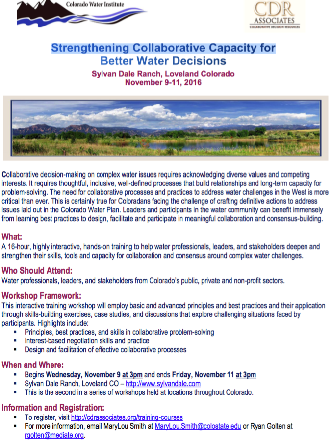


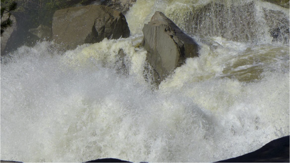


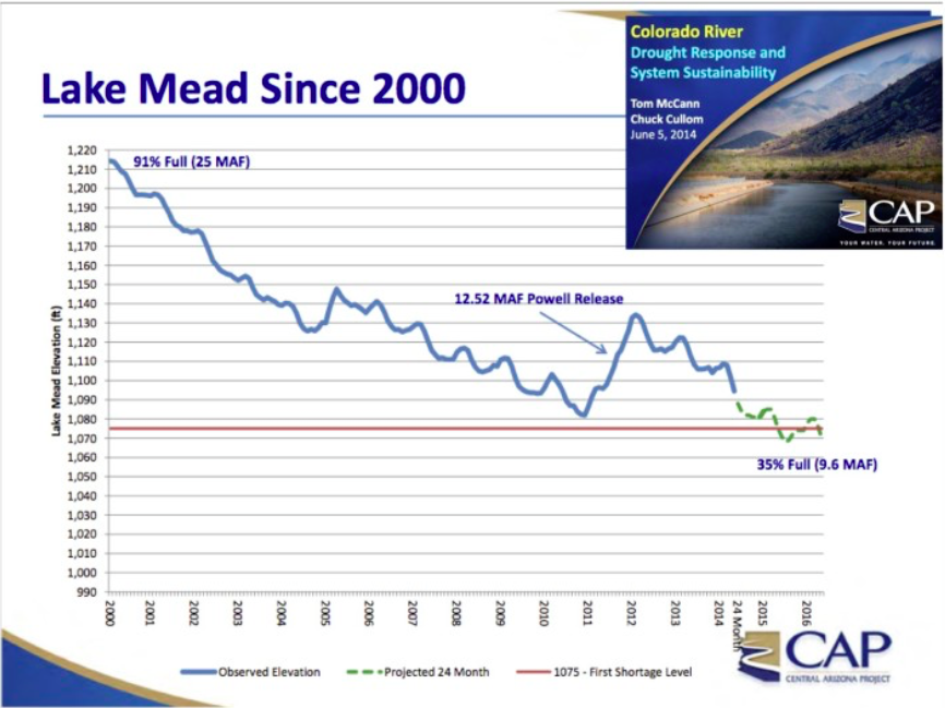


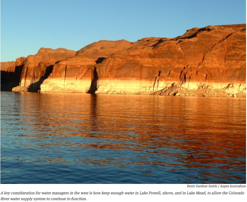


")


![Wastewater continued to stream out of the Gold King Mine on Tuesday [August 11, 2015] near Silverton, several days after a rush of 3 million gallons of it flooded Cement Creek and the Animas River. At the top of the photo is the mine’s opening, where an Environmental Protection Agency cleanup team was working with heavy machinery Aug. 5 and hit an earthen wall that had millions of gallons of water built up behind it](https://i0.wp.com/coyotegulch.blog/wp-content/uploads/2015/08/goldkingmine08132015deseretnewsgeoffliesik.png?w=422&h=296&ssl=1 "goldkingmine08112015deseretnewsgeoffliesik")