Click here to buy your tickets. Here’s the pitch from the Colorado Water Trust:
Overview
The destiny of the west is written in the headwaters of Colorado. Tens of millions of people, billions of dollars of agricultural production, and an enormous amount of economic activity across a vast swath of America from California to the Mississippi River are all dependent on rivers born in the mountains of Colorado. In this time of increasing demand and limited supply, it is essential to promote a more informed and inclusive discussion concerning decisions affecting our water resources.
VIP Reception starts at 5:30pm in Henderson’s Lounge followed by the screening.
Proceeds from the event will go to support the Colorado Water Trust:
The Colorado Water Trust is a private, nonprofit organization whose mission is to restore flows to Colorado’s rivers in need. Founded in 2001, the Colorado Water Trust coordinates market-based water transactions, water-sharing agreements, infrastructure projects, and other creative solutions to restore flows to our state’s dry rivers and streams. Together with our diverse partners throughout the state, we are restoring habitat for fish and other wildlife, improving local economic opportunities, and where lost, returning to Colorado’s landscape the beauty of a flowing river. http://www.ColoradoWaterTrust.org
“I used to be a orthodox card-carrying humanities academic with contempt for the manipulations of nature that engineers perpetrated. And then, I realized how much a beneficiary I was of those perpetrations.” — Patty Limerick (The Great Divide)
This is an important film and Ms. Limerick hits the nail on the head with her statement. When folks understand the history of Colorado and how water has shaped that history, when they learn about the disease and hardship that goes hand in hand with scarcity of water here in the arid west, when they witness the bounty from plains farms and the western valleys and the economic drivers associated with Colorado’s cities, when they take time to sit down to talk and learn from neighbors and others, opinions can change, understanding can grow, problems can be solved, and opportunities can be realized.
Jim Havey and the filmmakers set out an ambitious goal, that is, the telling of Colorado’s water story, without advocacy and without pointing fingers. The Great Divide accomplishes the telling using a superb screenplay written by Stephen Grace, the stunning footage by Jim Havey, along with the old photographs and maps of Colorado (and the Colorado River Basin).
Prior appropriation and anti-speculation are big ideas that form the foundation of Colorado water law. Article XVI of the Colorado Constitution includes detail about the preferred uses and the rights of diverters to cross private land to put the public’s water to beneficial use. All water in Colorado belongs to the citizens but diverters gain a property right allowing them to use the water.
The filmmakers manage to explain these details well during the film. The film describes the law, the compacts between states, river administration, and the 21st Century world of water. They emphasize the work and pioneering efforts needed to get Colorado where it is today.
San Luis People’s Ditch via The Pueblo Chieftain
Starting with the San Luis People’s ditch (the oldest water right in continuous use in Colorado — 1852) Coloradans have built out many projects large and small to put the water to beneficial use. The Great Divide describes many of these projects including the big US Bureau of Reclamation projects, Colorado-Big Thompson, Fryingpan-Arkansas, the Aspinall Unit, and what many think will be USBR’s last big project, Aninas-La Plata.
According to the film an early project, Cheesman Dam on the South Platte River, enabled delivery of high quality water to the City of Denver which had been plagued by outbreaks of cholera and other waterborne diseases.
These projects have gotten Colorado to this point with over 5 million residents and a diversified economy. However, in the documentary the head of Denver Water Jim Lochhead states, “If we grow the next 5 million people the way we’ve grown the last 5 million — that may not be sustainable.”
There is a tension between environmentalists and water developers in today’s Colorado, highlighted by the film. The Great Divide explores the historical roots of the environmental movement starting with the Sierra Club effort to save Echo Park on the Yampa River, up through the legislation allowing the Colorado Water Conservation Board to hold and establish instream flow rights, the successful efforts to block groundwater withdrawals in the San Luis Valley for Front Range growth, and the mammoth decision to not permit the Two Forks Reservoir on the the South Platte River.
The City of Denver and many of the suburbs were counting on that project for future needs. It is interesting to note that the loss of Two Forks led to increased groundwater withdrawals from the Denver Basin Aquifer System and an increase in purchases of agricultural rights by municipal systems. Both of these alternatives are unsustainable but have led to recharge projects, water reuse projects by Denver Water and Aurora Water, along with serious efforts to allow alternative transfer methods for agricultural water that would protect farmers and keep the water with the land. The Great Divide touches on these newer more sustainable solutions.
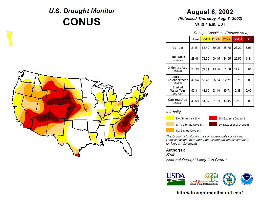
Drought is a constant possibility in Colorado. The film shows how the drought of the 1930s spurred northeastern Colorado to line up behind the Colorado-Big Thompson Project for new supplies and storage.
US Drought Monitor August 6, 2002
When things turned around after the drought of 2002 The Great Divide informs us that municipalities had to rethink conservation efforts and that pumpers with insufficient augmentation water were shut down. Denver Water managed to cut per capita consumption by 20% below pre-2002 levels and other utilities noted similar savings.
The film examines the aftermath of the 2002 drought and the efforts by the Colorado legislature which passed the Colorado Water for the 21st Century Act. It established the Interbasin Compact Committee (IBCC) and the nine basin roundtables. The roundtables and the IBCC were formed as a forum to share needs but most importantly share values. One of the outcomes of the effort has been the realization, stated in the film by Travis Smith that, “We are more connected than we’d like to admit.”
Colorado Water Plan website screen shot November 1, 2013
This connectedness, along with the need to solve looming wide-ranging supply gaps were the motivation for Governor Hickenlooper to issue an executive order to the Colorado Water Conservation Board to create Colorado’s first ever water plan. The Governor has an opportunity to present his view of the need for the plan in the film. He touches on the fact that however the plan turns out it will be built by the grass roots.
During his introduction of the film Justice Gregory Hobbs advised us to listen to the words along with viewing the images. He was right, the narrative by Peter Coyote engages and informs. You cannot listen to Mr. Grace’s words without learning at the same time. And that’s the point right? Educate and inform with an accurate representation of Colorado water issues and history…
The film is a stellar vehicle for educating and generating conversation. Go see it when you can, buy the book, and then start talking and teaching.
Click here to go to the US Drought Monitor website. Here’s an excerpt:
Summary
Dry, hot conditions across the central and southern U.S. contrasted with heavy rain and mountain snow in the northwestern quarter of the nation. As a result, drought continued to rapidly intensify from the Delta to the Southeast, with drought intensification also noted over portions of the Northeast. Conversely, large swaths of drought were reduced or eliminated from the northern Rockies into the Pacific Northwest…
Northern Plains
There were no changes to this area’s drought depiction, with light showers (less than 0.5 inch) offering no substantial relief to the Long-term Moderate to Severe Drought (D1 and D2)…
Central and Southern Plains
Dry, hot weather resulted in rapid expansion of Abnormal Dryness (D0) and Moderate Drought (D1). Temperatures during the period averaged 7 to 13°F above normal, with daytime highs reaching the upper 90s and lower 100s across the southern High Plains. The summer-like heat coupled with a lack of rainfall over the past 30 days exacerbated the impacts of the dryness, with some producers holding off on winter wheat sowing operations due to a lack of soil moisture. Conditions vary locally, with wetter soils in the east contrasting with protracted short-term dryness farther west. For example, while central and eastern Kansas has received favorable rain (100-200 percent of normal precipitation over the past 30 days), the D1 area in the southwestern corner of the state has reported little — if any — precipitation over the same time period…
Texas
Conditions remained largely unchanged in Texas during the week, with modest increases in Abnormal Dryness (D0) and Moderate Drought (D1) in northern and southern portions of the state. In the panhandle, D0 was expanded to capture areas which have received little — if any — precipitation over the past 30 days, with daytime highs approaching 100°F accelerating soil moisture losses for winter wheat. Pockets of D0 were also introduced on the Edwards Plateau and in southeastern Texas, where similar heat and dryness have been observed. In Deep South Texas, D0 and D1 were expanded where 90-day rainfall has totaled 25 to 60 percent of normal and soil moisture was likewise in very short supply…
Western U.S.
Heavy drought-easing precipitation in northern portions of the region contrasted with dry, warmer-than-normal conditions across the south. In California, some modest drought reduction was noted in the north, with the biggest change for the week noted in the Impact Type; much of the drought in central and northern California is now a Long-term Drought (denoted on the map by an “L”), meaning that short-term impacts have been eased or alleviated but long-term impacts (ground water, reservoir supplies, etc.) remained.
From the Pacific Northwest into the northern Rockies, a steady fetch of Pacific moisture coupled with a series of disturbances triggered heavy rain and mountain snow. Event totals varied considerably based on topography, but liquid-equivalent amounts averaged 3 to 15 inches in the Coastal Ranges to 1 to 4 inches in the northern Rockies. Areas lee of the mountains received less, but amounts of 0.5 inch to locally more than an inch were observed. As a result, widespread 1- and 2-category reductions were made in areas where the heaviest precipitation fell.
Meanwhile, moderate to heavy rain and mountain snow (2-10 inches liquid equivalent, locally more) were observed in northern California, the Sierra Nevada, and along the immediate coast as far south as Santa Cruz. While the rain was beneficial for streamflow and soil moisture recharge, the state will need more cool-season precipitation to undo the far-reaching impacts of the ongoing 5-year drought.
In the Great Basin and Four Corners, a modest reduction of D0 in eastern Nevada was supported by feedback from local experts following near- to above-normal precipitation in these areas during the just-concluded 2015-16 Water Year. The rest of the region remained unchanged, though a continuation of hot, dry conditions may necessitate increases in drought intensity and coverage over the upcoming weeks…
Looking Ahead
Unfavorably dry conditions are expected to linger over many of the nation’s drought areas over the next 5 to 7 days. In particular, little — if any — rain is expected over the Southeast as well as the southern half of the Great Plains. Exceptions to the dry outlook include the potential for locally heavy rain from the central Appalachians into northern New England, and from northern California into the northern Rockies and Pacific Northwest. The NWS 6- to 10-day outlook for October 25- 29 calls for near- to above-normal temperatures over most of the nation, with cooler-than-normal conditions confined to New England and the central Pacific Coast. However, the outlook features a wetter-than-normal signal from the Pacific Coast into the Ohio Valley and Great Lakes, with drier-than-normal conditions limited to portions of Texas and from the Delta into the Southeast and Mid-Atlantic States.
Dams are a core element of American infrastructure and provide many important services. However, aging infrastructure has led to many dams becoming obsolete, costly, and unsafe, threatening human life if they fail. By 2020, more than 65 percent of dams will be past their designated lifespan. Further, these structures put a strain on American rivers and wildlife by blocking an estimated 600,000 miles of U.S. rivers. Without a comprehensive plan for this failing infrastructure, the problem will continue to grow.
Please join the Center for American Progress for a panel discussion to highlight the progress that has already been made and explore the future of policymaking that aims to modernize the management of dam infrastructure, remove unneeded dams, and restore the health of American rivers.
Introductory remarks:
David Hayes, Senior Fellow, Center for American Progress
Panelists:
Mike Connor, Deputy Secretary of the Interior
Steve Ellis, Vice President, Taxpayers for Common Sense
Rose Marcario, President and CEO, Patagonia Inc.
Rebecca Miles, Executive Director of the Nez Perce Tribe
Moderator:
Annie Snider, Energy Reporter, POLITICO Pro
The “Minute 319 Colorado River Limitrophe and Delta Environmental Flows Monitoring Interim Report,” released by the International Boundary and Water Commission, documents the effects of the environmental flows in the delta from the initial release of a pulse of water from March 23 through May 18, 2014, plus subsequent supplemental deliveries of water through December 2015.
Here’s the release from the University of Arizona (Mari N. Jensen):
Two growing seasons after the engineered spring flood of 2014, the delta’s birds, plants and groundwater continue to benefit, according to a report by a binational, UA-led team.
Two growing seasons after the engineered spring flood of the Colorado River Delta in 2014, the delta’s birds, plants and groundwater continue to benefit, according to the latest monitoring report prepared for the International Boundary and Water Commission by a binational, University of Arizona-led team.
“This short-term event has had lasting consequences. This really demonstrates that a little bit of water does a lot of environmental good,” said Karl W. Flessa, UA professor of geosciences and co-chief scientist of the Minute 319 monitoring team.
“Some of the cottonwoods that germinated during the initial pulse flow are now more than 10 feet tall,” Flessa said.
Martha Gomez-Sapiens, a monitoring team member and postdoctoral research associate in the UA Department of Geosciences, stands on a riverbank next to willows and cottonwoods that germinated as a result of the pulse flow. (Photo: Karl W. Flessa/UA Department of Geosciences)
The “Minute 319 Colorado River Limitrophe and Delta Environmental Flows Monitoring Interim Report,” released by the International Boundary and Water Commission, documents the effects of the environmental flows in the delta from the initial release of a pulse of water from March 23 through May 18, 2014, plus subsequent supplemental deliveries of water through December 2015.
Minute 319 is the 2012 addition to the 1944 U.S.-Mexico Water Treaty that authorized environmental flows of water into the Colorado River Delta from 2013 to 2017.
Birdlife responded to the post-flood burgeoning of vegetation, and bird diversity is still higher than before, the monitoring team reports. Migratory waterbirds, nesting waterbirds and nesting riparian birds all increased in abundance.
Upstream dams and water diversions for farms and cities in both countries have dried up most of the river south of the border. With the exception of a few wet years, the river has not reached the Gulf of California since 1960.
“This is the first time environmental water has ever been delivered across an international boundary.” said Eloise Kendy, a senior freshwater scientist with The Nature Conservancy’s North America Water Program.
“The level of collaboration was really unprecedented — from two national governments to the individual farmers whose irrigation canals were used for some of the water deliveries,” she said. [ed. emphasis mine]
Flessa, Kendy and Karen Schlatter of Sonoran Institute compiled and edited the report on behalf of the binational partnership of many people and federal agencies, universities and non-governmental organizations that monitored the Colorado River Delta under Minute 319.
Some of the water from the pulse flow and subsequent smaller environmental flows recharged the groundwater, which had both ecological and social benefits, Kendy said. The vegetation greened up in areas that received surface water and also in some areas that did not.
“The farmers were happy because it recharged the aquifer they use for groundwater irrigation,” Kendy said. “And plants that were outside the inundation zone got a big drink of water.”
Before 1960, spring floods regularly roared down the Colorado River, scouring the river bottom and overtopping the bank, thereby creating the conditions necessary for cottonwood and willow trees to germinate and establish.
An invasive plant species known as salt cedar or tamarisk is now the dominant plant along the river. Cottonwoods and willows need bare ground and sunlight to germinate, so they cannot establish themselves on tamarisk-covered riverbanks, said Schlatter, a restoration ecologist of the Sonoran Institute’s Colorado River Delta Program.
The March 2014 pulse flow delivered a fraction of the water the pre-1960 spring floods delivered. People from Sonoran Institute and Pronatura Noroeste cleared some areas of non-native vegetation beforehand. The researchers hoped that reducing competition would allow native plants such as willows and cottonwoods to germinate and grow after the pulse flow.
“We mechanically cleared the tamarisk vegetation from the riverbank and old oxbows,” Schlatter said. “We reconnected the meanders to the main river channels so when the pulse flow came there were these nice backwater areas where the conditions were good for the establishment of native trees.”
Now in those restoration areas, cottonwood and willow seeds that germinated after the pulse flow have become trees 3 to 4 meters tall (10 to 13 feet), and bird diversity and abundance has increased, she said.
“Now we have diverse habitat types, including lagoons, cottonwoods-willow forest, mesquite bosque and marshes,” she said. “We are seeing a much higher diversity of riparian bird species in the restoration sites compared to other areas along the river.”
The abundance of 19 bird species of conservation concern, including vermillion flycatchers, hooded orioles and yellow-breasted chats, was 43 percent higher at the restoration sites than at other sites in the floodplain, the monitoring team found.
In addition, the pulse flow reduced soil salinity in some areas that had been targeted for restoration, Schlatter said. “We didn’t expect that — it is a huge bonus.”
Reducing the soil salinity makes conditions more favorable for native plant species.
If there’s another pulse flow, she suggests mechanically clearing tamarisk and other non-native vegetation from the river’s bank.
“We’re not going to get a huge flood on the Colorado River anymore,” Schlatter said. “If the flood isn’t going to provide the same ecological processes floods did in the past, we will have to have active management.”
Other UA members of the monitoring team are Ed Glenn of the UA Department of Soil, Water and Environmental Science and Martha Gomez-Sapiens and Hector Zamora of the UA Department of Geosciences.
The International Boundary and Water Commission in El Paso, Texas, funded the UA portion of the Minute 319 monitoring program.
Carlos de la Parra of the Colegio de la Frontera Norte is co-chief scientist of the Minute 319 monitoring team. Key contributors to the report include Osvel Hinojosa of Pronatura Noroeste, Jorge Ramírez and Jesus Eliana Rodriguez Burgueño of the Universidad Autónoma de Baja California, Francisco Zamora of Sonoran Institute, Jeffrey Kennedy of the U.S. Geological Survey and Dale Turner of The Nature Conservancy.
The Minute 319 monitoring team includes more than 21 scientists from universities, government agencies and nongovernmental organizations from both Mexico and the U.S., including El Colegio de la Frontera Norte, the Ensenada-based Pronatura Noroeste, The Nature Conservancy, the Tucson-based Sonoran Institute, the Universidad Autónoma de Baja California, the University of Arizona, the U.S. Geological Survey and the U.S. Bureau of Reclamation.
Colorado River pulse flow (Minute 319) reaches the Sea of Cortez for the first time since 1998 on May 15, 2014 via the Sonoran Institute