“This is the first time in recorded history of a report of fish existing in the headwaters of Mineral Creek” –Bill Simon

South Fork Mineral Creek, Silverton photo via hhengineering.com

From The Durango Herald (Jonathan Romeo):

“This is the first time in recorded history of a report of fish existing in the headwaters of Mineral Creek,” said Bill Simon, a retired coordinator of the Animas River Stakeholders Group. “We are a bit surprised by the great results so soon after remediation.”

Over the past few weeks, U.S. Geological Survey crews were out in the streams and tributaries within the Animas River watershed around Silverton collecting fish for the Environmental Protection Agency.

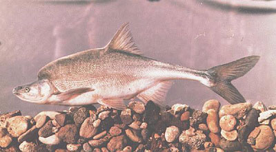
Andrew Todd, research biologist with USGS, said about five rainbow trout and five brook trout were collected from select stretches of the creek, and will be used for the EPA’s “ecological and human health risk assessment,” as the agency seeks to better understand the region in its Superfund efforts.

“We’re also looking at what’s likely fish habitat, and what’s not,” Todd said. “It’s about setting realistic expectations for what could be gained in the Superfund process, from a perspective of trout habitat in the headwater reaches.”

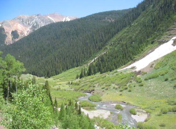
Upstream of Burro Bridge – which crosses Mineral Creek going up to Ophir Pass – USGS crews found brook trout in multiple age classes in a stretch not known to support fish populations.

“Brook are not stocked, so those fish are there on their own volition,” Todd said.

Peter Butler, a coordinator of the Animas River Stakeholders Group, said when the group started addressing the negative impacts of mining around Silverton more than 20 years ago, Mineral Creek was devoid of aquatic life.

Since that time, he said 12 mine remediation projects affecting upper Mineral Creek have been completed: eight by ARSG, two by Sunnyside Gold Corp., which also provided funding for one other project, and one by the Forest Service.

“We knew that water quality in the upper part of Mineral Creek had dramatically improved, but we didn’t expect it to support trout,” Butler said. “We’re thrilled with the result. This may be the first time in one hundred years that fish have been seen in this stretch.”

Butler and Simon speculated the trout came from Mill Creek and its headwaters at Columbine Lake, which is upstream of the Burro Bridge and has good water quality. Because the fish spanned various ages, the men said it’s likely the population is resident to Mineral Creek.

Mineral Creek has been a success story. Since remediation began, there’s been a 70 percent reduction in zinc and copper, and a 50 percent reduction in cadmium. Because of natural circumstances, Butler said, there hasn’t been a reduction in levels of iron and aluminum.

The EPA has listed seven mining-related sites within the Mineral Creek drainage basin out of its total 48 sites that make up the Bonita Peak Mining District Superfund listing.

During the summer, the agency embarked on an “early action” task at a Brooklyn Mine pipeline that reduced the discharge of 15 gallons a minute of acid mine drainage to 1 gallon a minute.

Rebecca Thomas, project manager for the Superfund site, said over the winter the agency will identify other early actions it can take, as well as draft an overall plan for each source of pollution in the basin.

All in all, the summer was filled with good news for trout in the Animas: The state health department found no bioaccumulation in fish tissue after last year’s Gold King Mine spill; Colorado Parks and Wildlife found encouraging signs in fish populations around Durango; and anglers around the area noted the better-than-usual fishing year.

The USGS also found brook trout for the first time in a short stretch of the upper Animas River between Denver Lake and Burrows Gulch, below the Lucky Jack mine, which the ARSG remediated about 10 years ago.

However, there’s much room for improvement, officials agree, as fish populations are impaired below the Burro Bridge, and on a large stretch of the Animas River below Silverton to above Bakers Bridge, among other areas.

As the EPA increases its focus on the basin, it’s likely researchers as well as the public will learn much more about the Animas River.

“Understanding is the point of this exercise,” Todd said. “By exploring and understanding, we can get a sense of where we might head.”

@USBR Releases Final Environmental Assessment on Repairs to the Paonia Dam Intake Structure

Paonia Reservoir

Here’s the release from the US Bureau of Reclamation (Lesley McWhirter):

The Bureau of Reclamation has released the final Finding of No Significant Impact and Environmental Assessment evaluating if Reclamation will provide partial funding to the North Fork Water Conservancy District to make repairs to the Paonia Dam intake structure and bulkhead, part of the Paonia Project located near Paonia, Colo. Repairs are expected to begin in September 2017.

During construction, work crews and an excavator will be operating at the dam. Crews will dismantle the damaged upper concrete bulkhead of the intake structure and replace it with a modified aluminum trash rack and support members. These repairs are necessary to help ensure continuation of normal dam operations and water delivery to downstream users.

Prior to repairing the intake structure, increased turbidity downstream of the dam will be noticeable due to normal reservoir operations and drawdown. Turbidity will temporarily increase in Muddy Creek and the North Fork of the Gunnison River downstream of Paonia Dam, and sediment deposition will occur primarily in Muddy Creek from the dam to the confluence of Anthracite Creek until high flows begin the following spring.

The final Finding of No Significant Impact and Environmental Assessment are available online at http://www.usbr.gov/uc/wcao/progact/paonia/documents.html

To learn more about the Paonia Project, upcoming repair work or sedimentation issues in the reservoir, visit our website at: http://www.usbr.gov/uc/wca/progact/paonia/index.html. You can also join our email list for project updates by clicking the “Contact Us” link.

#ColoradoRiver Economics: “…our new economy is based on water in the rivers in western Colorado” — Jim Pokrandt #COriver

Hayfield message to President Obama 2011 via Protect the Flows

From KRCC (Maeve Conran):

It’s been almost a century since the Colorado River Compact was created, divvying up the resources of this mighty waterway between seven states and Mexico. That means almost 40 million people are dependent on the river in some way. Traditionally, the economic value of the river was based on what the water could be used for when extracted—things like agriculture, mining, and industry. Now, more people are pointing to the economic value of keeping water in the river itself.

The Fraser River in Grand County is a tributary of the Colorado River, which starts in Rocky Mountain National Park. It runs through the heart of the town of Fraser and neighboring Winter Park. These towns attract skiers in winter and fly fishers and outdoor enthusiasts the rest of the year.

“The recreation is all based around the river… it’s the absolute base of the recreational system,” says Dennis Saffell, a real estate broker in the mountain communities of Grand and Summit Counties. Saffell says there’s a direct connection to property values and proximity to the river…

Saffell says a loss of flow in the river would likely decrease the values for all properties in these mountain communities that are dependant on the river for a tourism economy.

That’s something that others in western slope communities are well aware of, including Jim Pokrandt with the Colorado River District, the principal water policy and planning agency for the Colorado River Basin within the state.

“We understand that water left in the river is important to the economy,” says Pokdradt, “and if we have dried up rivers then we’d have degradation to our western slope economy.”

Pokrandt says the fortunes of many western slope towns hinge on understanding that the strength of local economies is beginning to shift from taking water out of the river to leaving it in.

“Rafting, that’s a big deal, skiing that’s a big deal now, hunting, fishing… this is our economy here on the west slope,” says Pokrandt. “Yes, ag is still big, and yes there’s still some mining, but our new economy is based on water in the rivers in western Colorado.”

Historically, most Colorado water rights have involved uses that divert water from the streams, but back in the early 1970s lawmakers began to recognize the need to create rights allowing water to remain in the river, to help protect ecology. But that was just a first step. Now 43 years later, a lot of water is still being taken out of the Colorado River basin and diverted to the east. There are 13 major trans mountain diversions and many other smaller ones.

It’s a concern for advocates like Craig Mackey, co-director of the non-profit Protect the Flows.

“In the 21st century we have an economic reason to have the river itself, the recreation economy, the tourism economy and I think the hardest one to quantify is a quality of life economy,” says Mackey.

Protect the Flows advocates for conservation of the Colorado River Basin, pointing to the connection between a healthy river and healthy economies.

“People want to live here, they want to locate here, they want to grow businesses here, they want to raise their families here,” says Mackey. “And water and our snow in our mountains, which becomes the water in our rivers, is a huge driver in that quality of life economy that we’re so lucky to have here in the state of Colorado.”

Protect the Flows worked with Arizona State University in 2014 on the first study on the economic impact of the Colorado River. It found that the major waterway generates $1.4 trillion in economic benefits annually throughout the entire seven state river basin. In Colorado, the tourism and outdoor recreation economy tied to the river brings in more than $9 billion annually.

The Colorado Water Plan acknowledges the need to keep water in streams, but it also acknowledges the water needs of growing cities.

Realtor Dennis Seffell says even more needs to be done.

“Now it’s time to take a new fresh look as to why it’s important to keep rivers full of water,” Saffell says.

A prolonged drought in the south west, paired with over allocation, has left the Colorado River in a sorry state. Front Range communities, largely dependent on that western water, are having some success with conservation. But with an additional 2 million people expected to move to the Denver metro area over the next 25 years, demand will only increase.

Connecting the Drops is a collaboration between Rocky Mountain Community Radio stations and the Colorado Foundation for Water Education, with support from CoBank.

Test wells may determine path of water contamination south of #Colorado Springs — The Colorado Springs Gazette

Graphic via GeologicResourcs.com

From The Colorado Springs Gazette (Tom Roeder):

Drilling has begun on a test well near Peterson Air Force Base to assess how military firefighters contributed to water contamination south of Colorado Springs, and an investigation into a recent, massive release of water tainted with toxic firefighting foam at the base remains ongoing.

The first of 18 test wells was being drilled Thursday near the Colorado Springs Airport terminal close to a runway on the south side of the base. The Air Force said soil samples will be checked for perfluorinated compounds contained in the firefighting foam and groundwater contamination will be monitored…

[The Colorado Department of Health and Environment] said it was waiting for the conclusion of the Air Force’s investigation into the discharge to determine impacts.

The Air Force is in the process of installing $4.3 million worth of filters to scrub the chemical from the aquifer’s water with charcoal. The service has also paid nearly $900,000 for a Colorado School of Mines study into more efficient ways to remove the chemical from drinking water.

“The Air Force is still determining the ideal site for conducting the demonstration test,” the school said in a news release. “Due to the benefits of proximity, Mines researchers hope the chosen site will be in Colorado.”

Widefield aquifer via the Colorado Water Institute.

#Drought news: Expansion of D0, D1 N. #Colorado

Click here to go to the US Drought Monitor website. Here’s an excerpt:

Summary

This U.S. Drought Monitor week saw deterioration in drought conditions across the South and Southeast in an area extending from South Carolina westward to eastern Texas and northward into Tennessee. In the Southeast, a persistent dry weather pattern during the past 60 days continues to negatively impact the agricultural sector as well as hydrologic and soil moisture conditions across much of the region. Elsewhere, significant rainfall accumulations (two-to-six inches) were observed in the Northeast during the past week helping to improve drought-affected areas of western New York, Connecticut, Maine, and Rhode Island. In eastern Ohio, western Pennsylvania, and West Virginia, locally heavy rainfall accumulations led to improvements on the map. Out West, one-to-five inches of precipitation fell in western portions of Oregon and Washington. Recent storm events in the Pacific Northwest during the past 30 days led to improvements on the map in drought-affected areas in Oregon and Washington…

The Plains

Across the Plains, short-term precipitation deficits during the past 30–60 days led to expansion of areas of Abnormally Dry (D0) and Moderate Drought (D1) in the Oklahoma Panhandle and South Dakota. In South Dakota, some agricultural and wildfire-related impacts are being reported. In northeastern Colorado, short-term precipitation deficits during the past 30 days led to expansion of Abnormally Dry (D0). Overall, the region was very dry during the past week with average temperatures ranging from two-to-eight degrees above normal…

The West

During the past week, most of the West was very dry with the exception of portions of northern California, western Oregon, western Washington, and the northern Rockies. The heaviest precipitation accumulations were observed in coastal areas and the Cascades of Washington where two-to-five inches were observed. According to the Natural Resource Conservation Service SNOTEL network, Water-Year-to-Date (beginning Oct 1st) precipitation is above normal across the central and northern Sierra, Cascades, and most of the northern Rockies. Also, SNOTEL observations show below normal precipitation across much of the Intermountain West, central and southern Rockies, and the mountains of northern and central Arizona. On this week’s map, improvements were made in south-central, central, and northeastern Oregon as well as in southeastern Washington in response to precipitation events during the past 30 days. In north-central Colorado, mounting precipitation deficits during the past four months led to expansion of an area of Moderate Drought (D1)…

Looking Ahead

The NWS WPC 7-Day Quantitative Precipitation Forecast (QPF) calls for significant precipitation accumulations in northern California (two-to-ten inches) and western portions of Oregon and Washington (two-to-six inches). One-to-two inches of precipitation are forecasted for northern portions of the Midwest, while one-to-four inches are forecasted for the Northeast. Conversely, most of the southern tier of the conterminous U.S. will be dry. The CPC 6–10 day outlooks call for a high probability of above-normal temperatures across the entire conterminous U.S., with the exception of California and western Nevada where there is a high probably of below-normal temperatures. Below-normal precipitation is forecasted for the eastern third of the U.S. as well as the South and Desert Southwest. A high probability of above-normal precipitation is expected across the remainder of the West, Plains, and the western half of the Midwest.

Here’s the latest statewide snowpack map:

Statewide snowpack map October 25, 2016 via the NRCS.

#ColoradoRiver: High Flow Experiment at Glen Canyon Dam — @USBR #COriver

November 2012 High Flow Experiment via Protect the Flows

Here’s the release from the US Bureau of Reclamation (Marlon Duke):

The Bureau of Reclamation will increase water releases from Glen Canyon Dam beginning on Monday, November 7, 2016 to support a high flow experiment (HFE) in partnership with the National Park Service, U.S. Fish and Wildlife Service and U.S. Geological Survey. This high flow experiment will include a peak magnitude release of approximately 36,000 cubic feet per second (cfs) for 96 hours to move accumulated sediment downstream to help rebuild beaches and backwater habitats. The decision to conduct this HFE was made following substantial consultation with Colorado River Basin states, American Indian tribes and involved federal and state agencies.

Reclamation and National Park Service officials remind recreational users to use caution along the Colorado River through Glen and Grand Canyons during the entire week of November 7. Flow level information will be posted at multiple locations in both Glen Canyon National Recreation Area and Grand Canyon National Park. Note that it will take several hours following the beginning and end of the HFE for high flow waters to reach and then recede at downstream locations in the canyons.

High flow experiments benefit the Colorado River ecosystem through Glen and Grand Canyons by moving sand in the river channel and re-depositing it in downstream reaches as sandbars and beaches. Those sandbars provide habitat for wildlife, serve as camping beaches for recreationists and supply sand needed to protect archaeological sites. High flows may also create backwater areas used by young native fishes, particularly the endangered humpback chub.

The HFE will not change the total annual amount of water released from Lake Powell to Lake Mead. Releases later in the water year will be adjusted to compensate for the high volume released during this high flow experiment.

Members of the media who wish to view the high flow experiment should contact Marlon Duke at 385-228-4845 or mduke@usbr.gov.

Additional information about this high flow experiment will be posted and updated online at: http://www.usbr.gov/uc/rm/gcdHFE/index.html.

Humpback chub
Humpback chub