A plan is being considered by local, state and federal agencies to close the McPhee and House Creek boat ramps with locked gates during times when boat inspectors are absent. The new management strategy would go into effect in 2017.
Currently, there are no gates at the boat ramps, and trailered boats can launch after hours when boat inspection stations are unattended.
“It is important to fill the inspection gaps, because the problems and expense of mussel contamination are severe,” said Mike Preston, general manager of the Dolores Water Conservancy District, which manages irrigation at McPhee reservoir…
Their presence causes damage and vastly increases maintenance costs long-term. They negatively impact the lake’s sport fishery by filtering the water and competing for food.
McPhee is considered an at-risk lake for the mussels because of its proximity to Lake Powell and Lake Mead, both of which are heavily contaminated with the mussel…
Locals know about the problem, and understand the importance of draining and drying their boats, Preston said.
“The worry is a visitor arrives with an infected boat that slips through. It just takes one,” he said.
DWCD, the Bureau of Reclamation, San Juan National Forest, and Colorado Parks and Wildlife signed a memorandum last week to share long-term costs and management for the proposal to improve the McPhee boat inspection program. The program currently costs $85,000 per year to run.
McPhee’s two boat inspection stations typically analyze between 8,000 and 12,000 trailered boats per year since 2009, and the numbers have increased in the past two years.
This year at McPhee, the number of boats needing decontamination went up 40 percent, managers said.
The new plan would limit access for the public such as for boaters wanting to put on early in the morning, or late evening, before and after the boat inspection stations are open. Access during shoulder seasons would also be reduced because inspections stations are open less.
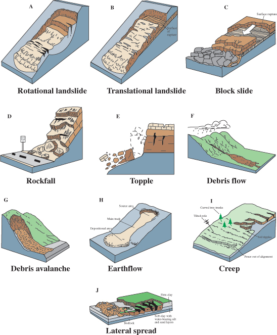
Landslides in the United States occur in all 50 States. The primary regions of landslide occurrence and potential are the coastal and mountainous areas of California, Oregon, and Washington, the States comprising the intermountain west, and the mountainous and hilly regions of the Eastern United States. Alaska and Hawaii also experience all types of landslides.
Landslides in the United States cause approximately $3.5 billion (year 2001 dollars) in dam- age, and kill between 25 and 50 people annually. Casualties in the United States are primarily caused by rockfalls, rock slides, and debris flows. Worldwide, landslides occur and cause thousands of casualties and billions in monetary losses annually.
The information in this publication provides an introductory primer on understanding basic scientific facts about landslides—the different types of landslides, how they are initiated, and some basic information about how they can begin to be managed as a hazard…
LANDSLIDE CAUSES
1. Geological causes
a. Weak or sensitive materials
b. Weathered materials
c. Sheared, jointed, or fissured materials
d. Adversely oriented discontinuity (bedding, schistosity, fault, unconformity, contact, and so forth)
e. Contrast in permeability and/or stiffness of materials
2. Morphological causes
a. Tectonic or volcanic uplift
b. Glacial rebound
c. Fluvial, wave, or glacial erosion of slope toe or lateral margins
d. Subterranean erosion (solution, piping)
e. Deposition loading slope or its crest
f. Vegetation removal (by fire, drought)
g. Thawing
h. Freeze-and-thaw weathering
i. Shrink-and-swell weathering
3. Human causes
a. Excavation of slope or its toe
b. Loading of slope or its crest
c. Drawdown (of reservoirs)
d. Deforestation
e. Irrigation
f. Mining
g. Artificial vibration
h. Water leakage from utilities
Greg Hobbs can’t help himself. He’s a restless soul and must get to the Colorado mountains often. Click on a thumbnail below to view a gallery of photos from one of his latest wanderings.
Below is the poem Greg include in his email yesterday accompanying the photos:
I’VE SEEN THE MOUNTAINS FALLING
I’ve seen the mountains falling,
heard the mighty canyons ring
with Colorado thunder
and clear blue mountain streams,
I’ve seen the nights grow brighter
and the days just shine in gold,
been looking for El Dorado
in the mountain of my dreams.
I hear the eagles calling,
see torches in the sky,
went off to Colorado,
had a gleaming in my eye,
there I found my measure
was a bird upon the wing
and the mountains’ greatest treasure
is the way the aspen sing.
I guess you might get crazy
thinking you’re going to die,
you drive your body pounding,
waste beauty on your way,
you turn your only fortune
into gambling your life away,
when El Dorado’s being
on a Colorado Day.
I wish I’d seen the world,
been a woman and a man,
felt the grip of dry starvation
and sailed the Rio Grande,
I’d be a farmer, mountaineer,
write a book about the mind,
but lay me down a fossil
in Colorado land.
(Justice Greg Hobbs Colorado Mother of Rivers, Water Poems
at 25, Colorado Foundation for Water Education 2005).
Freeport-McMoRan — the world’s largest moly producer and owner of the Climax Mine near Leadville and the soon-to-shutter Henderson Mine near Empire — has inked a preliminary deal to permanently remove mining claims from Mount Emmons and return about 9,000 acres to the Forest Service. It will also work with Crested Butte to continue treating tainted water flowing from a long-defunct mine on the mountain.
For decades, every time molybdenum prices peaked, locals raised money and filed lawsuits to fight a proposed 1,000-worker mine digging 25 million tons of high-grade moly from the belly of beloved Mount Emmons. The crusade was at times so pitched that residents pledged to lay down in the middle of Whiterock Avenue to block ore-hauling trucks.
“This fight has defined our community for so long and its been an amazing sort of rally cry for what it means to be Crested Butte,” said Glenn Michel, mayor of the 1,500-resident town where a new economy is anchored in tourism and outdoor recreation in some of Colorado’s most pristine playgrounds.
Crested Butte
In November, Crested Butte voters will be asked to approve use of the town’s real estate transfer tax to fund a $2 million payment to Freeport’s Mount Emmons Mining Co. Town leaders soon will visit Washington seeking bipartisan support for legislation that would permanently remove the mining claims from 12,343-foot high Mount Emmons, known as the Red Lady thanks to the pink hue it takes on as alpenglow dances across the snowy slope above downtown.
“This is a pretty cool Colorado solution where the town of Crested Butte and a globally traded mine can come together and find a solution and go forward with it,” Michel said. “If we pull this off, it’s going to be something very special that’s occurred.”
U.S. Sen. Michael Bennet, a Democrat from Colorado, said he would sponsor the legislation in the next session.
“This agreement represents a commonsense, collaborative, Colorado solution,” Bennet said. “We have been working with Freeport and the community on how best to solidify this agreement into law, and we look forward to working with the rest of the delegation to make sure that happens.”
Moly mining was never embraced in Crested Butte in the way that it was in Clear Creek County and Leadville. The High Country Citizens Alliance in Crested Butte formed in 1977 in response to the proposed mine above town. The mine plan faded as the price of molybdenum fell in the early 1980s. AMAX, which was running the plant that treated heavy-metal runoff from the Keystone into Coal Creek, applied to patent claims on Red Lady in 1992 as the moly market improved. Crested Butte, Gunnison County, the grassroots Red Lady Coalition and the High Country Citizens Alliance protested the application and labored to block the mine’s application for water rights in state court.
In 1999, international mining giant Phelps Dodge acquired AMAX and the Mount Emmons mining rights.
In 2004, the Bureau of Land Management, which handles mineral leases on federally managed land, sold AMAX 155 acres — including the Red Lady Basin — for $5 an acre under the antiquated General Mining Act of 1872. The town, county and HCCA filed a federal lawsuit protesting the sale.
Lawsuits and appeals flew as Crested Butte attacked the mine’s water plans and the legality of the BLM’s sale of public land to AMAX. Phelps Dodge in 2006 transferred the mining properties on Mount Emmons to its previous owner, U.S. Energy, after a legal battle over the responsibility for running the Keystone Mine water treatment plant.
In 2007, U.S. Energy and partner Kobex Minerals revived plans for the mine as molybdenum prices neared historical highs around $45 a pound. The next year, U.S. Energy partnered with Thompson Creek Metals, the world’s fifth largest molybdenum producer. That partnership dissolved in 2011.
In 2013, U.S. Energy won preliminary approval from the Forest Service to develop the mineral deposit on Mount Emmons, reigniting efforts to push the company out of Red Lady Basin and galvanizing locals aghast at the idea of round-the-clock mine traffic hauling 6,000 to 12,000 tons of ore through town every day.
Then the molybdenum market collapsed again and U.S. Energy struggled to find a partner to help mine Mount Emmons. The company’s financial woes left locals in Crested Butte worried that it could no longer support the $1 million annual cost of running the treatment plant filtering heavy metals watershed above town.
In August 2015, as molybdenum prices hovered around $5 a pound, HCCA, the town of Crested Butte and Gunnison County submitted a letter to the Colorado Water Quality Control Division, questioning U.S. Energy’s ability to keep the plant running.
“We were very concerned they were not going to be able to continue,” said Alli Melton, the Red Lady program director for what is now the High Country Conservation Advocates…
Within days of the Gold King disaster, national reports detailed Colorado’s bounty of abandoned mines swollen with toxic metals. The Environmental Protection Agency began talking about listing more mine sites across southern Colorado on the National Priorities List for Superfund cleanup.
Freeport acquired U.S. Energy ‘s Mount Emmons mine site in February, taking on responsibility for the water treatment plant. If U.S. Energy had gone bankrupt, the operation of plant and Keystone Mine cleanup would have reverted to the previous owner of the Mount Emmons claims: Freeport-McMoRan.
“I think Gold King kind of spurred conversations between the companies and the EPA. It was a really interesting time for us,” Melton said.
Mount Emmons Mining in the spring approached Crested Butte’s town leaders with a plan. The company, which never actually mined on Mount Emmons, offered to sell its mining claims and work with local leaders on a long-term plan for maintaining the water treatment plant.
“As the previous owner of the site and water treatment plant, Mount Emmons wanted to ensure sustained operation of the water treatment plant that discharges to Coal Creek,” said Freeport spokesman Eric E. Kinneberg.
First, the company said it would prefund two years of operation of the water treatment plant. And second, if the town came up with $2 million, Freeport said it would ask the federal government to withdraw all the unpatented mining claims from the mountain, permanently removing any chance of a mine on Red Lady.
In the Sept. 6 memorandum of understanding, Freeport and the town said they understand the deal is “only a first step in a long-term relationship,” and they they will work on other agreements.
High Country Conservation Advocates chief Brett Henderson called the agreement a monumental shift from decades of failed negotiations with U.S. Energy.
“It was sort of trench warfare with previous owners,” his colleague Melton said, “and for the first time, there’s a path forward and it’s collaborative.”
As High Country Conservation Advocates maps future projects, the General Mining Law of 1872 is a target. Oil and gas developers have to divert a portion of their revenues into funds that help clean up after accidents. Mining companies don’t have to do that.
Building a pool of money for mine reclamation is crucial, said Melton, who hopes the success of HCCA can bolster other mine cleanup efforts around the state.
The Crested Butte crusade to beat back the mine should serve as an example for other communities, Gunnison County Commissioner Jonathan Houck said.
“This is a joint effort of federal, state and local governments — supported by citizens and citizen groups — that is respectful of private property rights, mindful of public health, safety and welfare,” Houck said, “and ultimately will unknot a thorny issue in a manner not only productive for the local community but also a model for other actions in our state.”
Gunnison River Basin via the Colorado Geological Survey


