Click here to go to the US Drought Monitor website. Here’s an excerpt:
Summary
This U.S. Drought Monitor week saw deterioration in drought conditions across the South and Southeast in an area extending from South Carolina westward to eastern Texas and northward into Tennessee. In the Southeast, a persistent dry weather pattern during the past 60 days continues to negatively impact the agricultural sector as well as hydrologic and soil moisture conditions across much of the region. Elsewhere, significant rainfall accumulations (two-to-six inches) were observed in the Northeast during the past week helping to improve drought-affected areas of western New York, Connecticut, Maine, and Rhode Island. In eastern Ohio, western Pennsylvania, and West Virginia, locally heavy rainfall accumulations led to improvements on the map. Out West, one-to-five inches of precipitation fell in western portions of Oregon and Washington. Recent storm events in the Pacific Northwest during the past 30 days led to improvements on the map in drought-affected areas in Oregon and Washington…
The Plains
Across the Plains, short-term precipitation deficits during the past 30–60 days led to expansion of areas of Abnormally Dry (D0) and Moderate Drought (D1) in the Oklahoma Panhandle and South Dakota. In South Dakota, some agricultural and wildfire-related impacts are being reported. In northeastern Colorado, short-term precipitation deficits during the past 30 days led to expansion of Abnormally Dry (D0). Overall, the region was very dry during the past week with average temperatures ranging from two-to-eight degrees above normal…
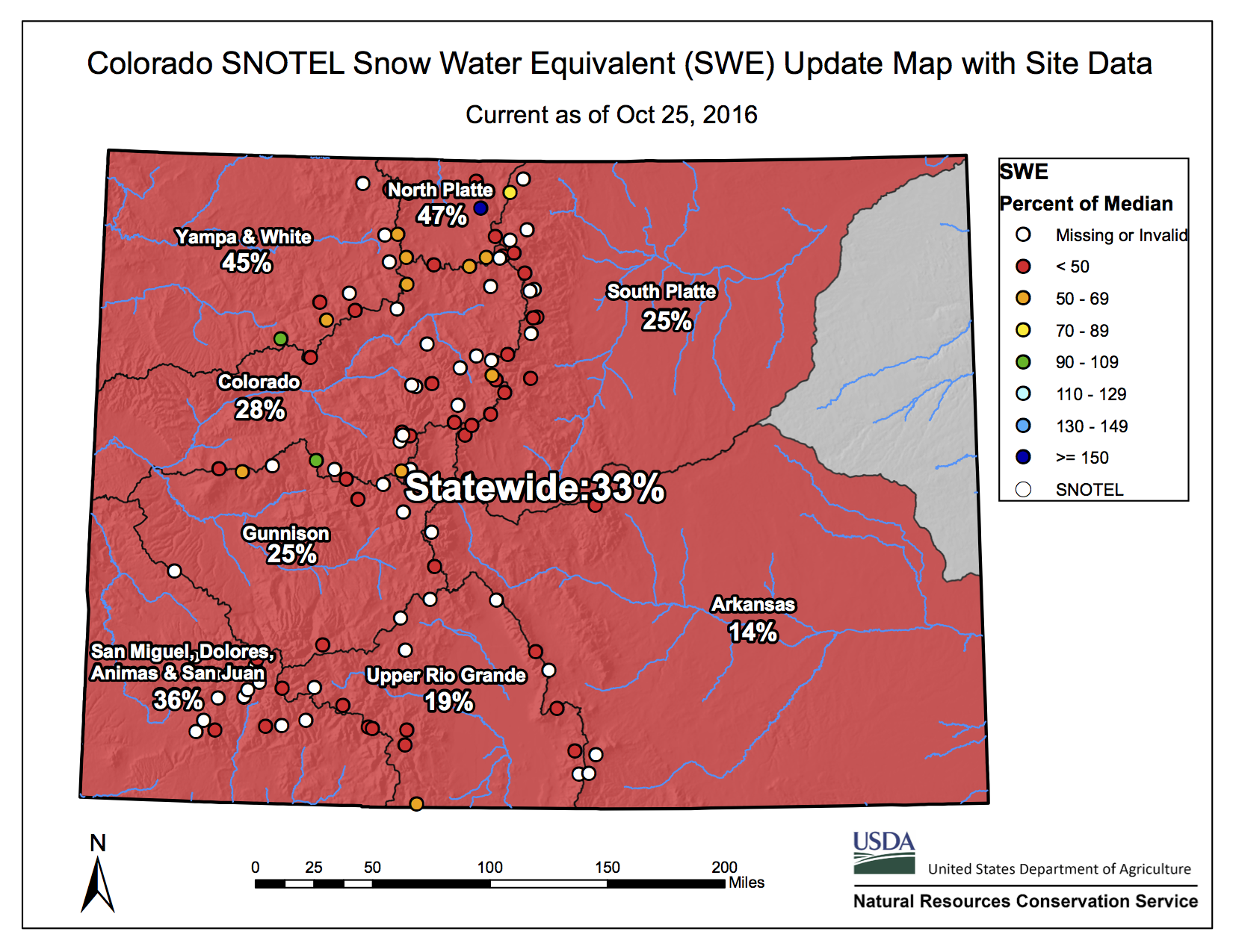
The West
During the past week, most of the West was very dry with the exception of portions of northern California, western Oregon, western Washington, and the northern Rockies. The heaviest precipitation accumulations were observed in coastal areas and the Cascades of Washington where two-to-five inches were observed. According to the Natural Resource Conservation Service SNOTEL network, Water-Year-to-Date (beginning Oct 1st) precipitation is above normal across the central and northern Sierra, Cascades, and most of the northern Rockies. Also, SNOTEL observations show below normal precipitation across much of the Intermountain West, central and southern Rockies, and the mountains of northern and central Arizona. On this week’s map, improvements were made in south-central, central, and northeastern Oregon as well as in southeastern Washington in response to precipitation events during the past 30 days. In north-central Colorado, mounting precipitation deficits during the past four months led to expansion of an area of Moderate Drought (D1)…
Looking Ahead
The NWS WPC 7-Day Quantitative Precipitation Forecast (QPF) calls for significant precipitation accumulations in northern California (two-to-ten inches) and western portions of Oregon and Washington (two-to-six inches). One-to-two inches of precipitation are forecasted for northern portions of the Midwest, while one-to-four inches are forecasted for the Northeast. Conversely, most of the southern tier of the conterminous U.S. will be dry. The CPC 6–10 day outlooks call for a high probability of above-normal temperatures across the entire conterminous U.S., with the exception of California and western Nevada where there is a high probably of below-normal temperatures. Below-normal precipitation is forecasted for the eastern third of the U.S. as well as the South and Desert Southwest. A high probability of above-normal precipitation is expected across the remainder of the West, Plains, and the western half of the Midwest.
Here’s the latest statewide snowpack map: