Northern Water General Manager Eric Wilkinson has announced he will be retiring in the early part of 2018. He made the announcement to the Northern Water Board of Directors during its September 14 meeting.
Wilkinson has spent 30 years at Northern Water, the past 24 as general manager. He is recognized as one of Colorado’s leading water statesmen and is a past recipient of the Colorado Water Congress’ Aspinall Award given to Colorado’s water leader of the year.
In October, the Board will be deciding its course of action to replace Wilkinson.
Northern Water Board President Mike Applegate said, “Eric Wilkinson is one of those rare people that comes along once in a lifetime and Northern Water was blessed to have him as our manager. He built an organization with a culture based on excellence and continual improvement. The Board of Directors are confident that the next general manager will continue to lead Northern Water with that same vision of service to Northern Colorado.”
The Colorado River is often described as being shared among seven states, but the number is really nine—seven in the United States and two in Mexico. U.S. farms and cities use most of the river’s water, and what little is left when it arrives at the U.S.-Mexico border near the towns of Algodones and San Luis is diverted for use by Mexican farms and cities. The last hundred miles of river channel between the border and the Sea of Cortez is usually dry.
The agreement includes provisions for the two nations to share shortages if (when?) drought and climate change shrink the river. The deal gives Mexican water users the ability to store their water in Lake Mead, the massive storage reservoir behind Hoover Dam on the Arizona-Nevada border, near the city of Las Vegas. Storage is critical to give Mexico flexibility in managing its water. U.S. water agencies will contribute under the deal to water efficiency improvements to Mexican infrastructure, with some of the saved water available for use in the United States.
Crucially, the agreement also sets aside water for habitat restoration in the dry river channel of Mexico.
The agreement was negotiated over a more than two-year period, but it is really rooted in more than a decade of increasingly deep collaboration between a community of water managers on both sides of the border. When the Trump administration took over in January, there was fear that the carefully crafted deal, so beneficial and important to communities on both sides of the border, would be sidelined by the heated rhetoric over free trade and immigration, over NAFTA and walls. But Wolf was right. Even as conflict raged over other issues, the trust and reciprocity built around the Colorado River proved remarkably resilient. The old saw that “water is for fighting over” was proven wrong again.
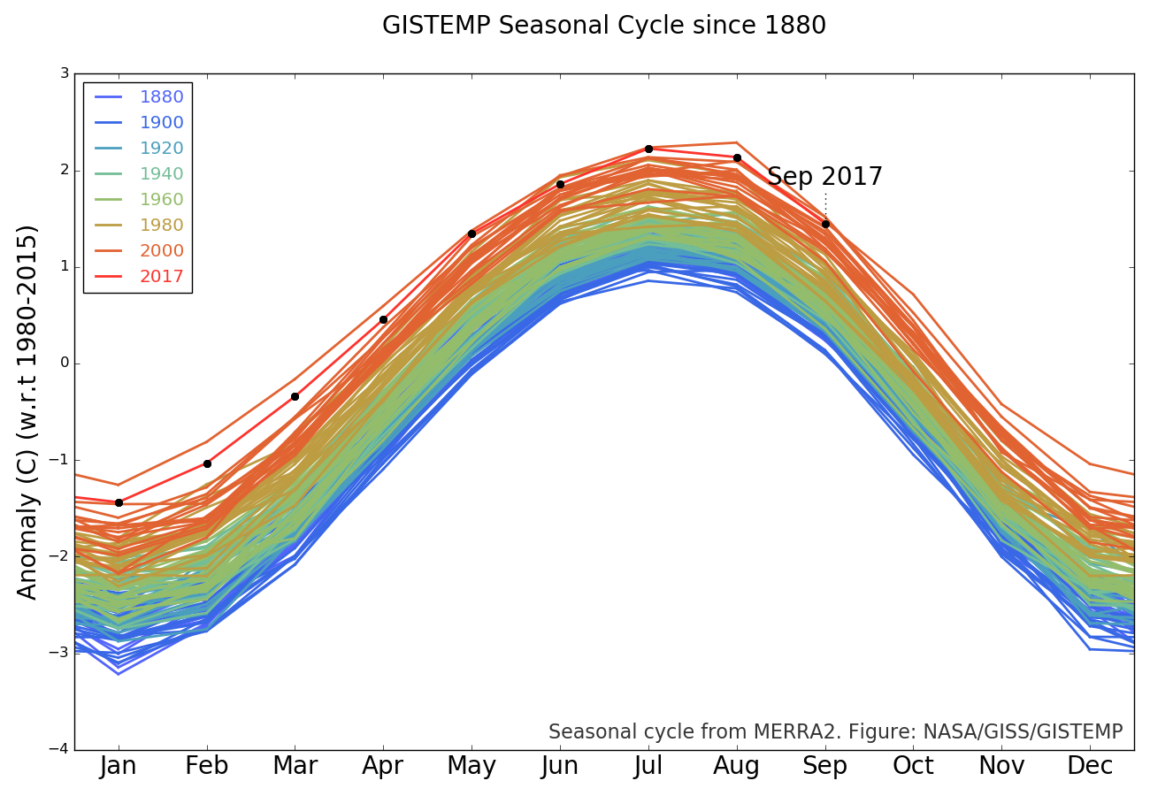
September 2017 was the fourth warmest September in 137 years of modern record-keeping, according to a monthly analysis of global temperatures by scientists at NASA’s Goddard Institute for Space Studies (GISS) in New York.
Last month was +0.80 degrees Celsius warmer than the mean September temperature from 1951-1980. The warmest months of September according to the analysis happened in 2016 and 2014 (+0.87 degrees Celsius) and 2015 (+0.82 degrees Celsius).
A global map of the September 2017 LOTI (land-ocean temperature index) anomaly, relative to the 1951-1980 September average
The monthly analysis by the GISS team is assembled from publicly available data acquired by about 6,300 meteorological stations around the world, ship- and buoy-based instruments measuring sea surface temperature, and Antarctic research stations.
The modern global temperature record begins around 1880 because previous observations didn’t cover enough of the planet. Monthly analyses are sometimes updated when additional data becomes available, and the results are subject to change.
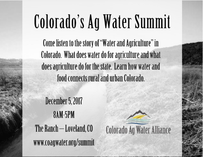
Click here for all the inside skinny and to register:
Our future requires that regional efforts provide some solutions to water supply shortfalls and projects. As Colorado’s urban areas grow, we must consider leveraging resources, infrastructure, water supply and facilities to secure general well-being and a healthy economy. This informative, day-long workshop provides a forum for planning and discussion around the best approaches for regional water solutions. It includes a close examination of the tradeoffs, hurdles, and opportunities for success.
California burning, Category 5 hurricanes, extreme heatwaves, coral reefs dying, king tides flooding coastal cities. Global warming is changing our world and making these events more common and more extreme.
It is not fake news, it is the reality of basic thermodynamics — when HEAT is added, it gets WARMER!
The problem is SIMPLE (see last sentence).
The problem is SERIOUS — a global threat multiplier (climate refugees, loss of coral reefs, sea level rise, terrorism, severe storms, drought and floods).
The problem is SOLVABLE — the cost of renewable energy is dropping so quickly that nearly every forecast of the increase of solar and wind energy is way too conservative.
We can and will develop the technologies that will enable us to POWER FORWARD with clean, renewable energy. The Age of Carbon is being replaced by The Age of Silicon!
John Thorburn, general manager of the Tri-Basin Natural Resources District, explains the idea.
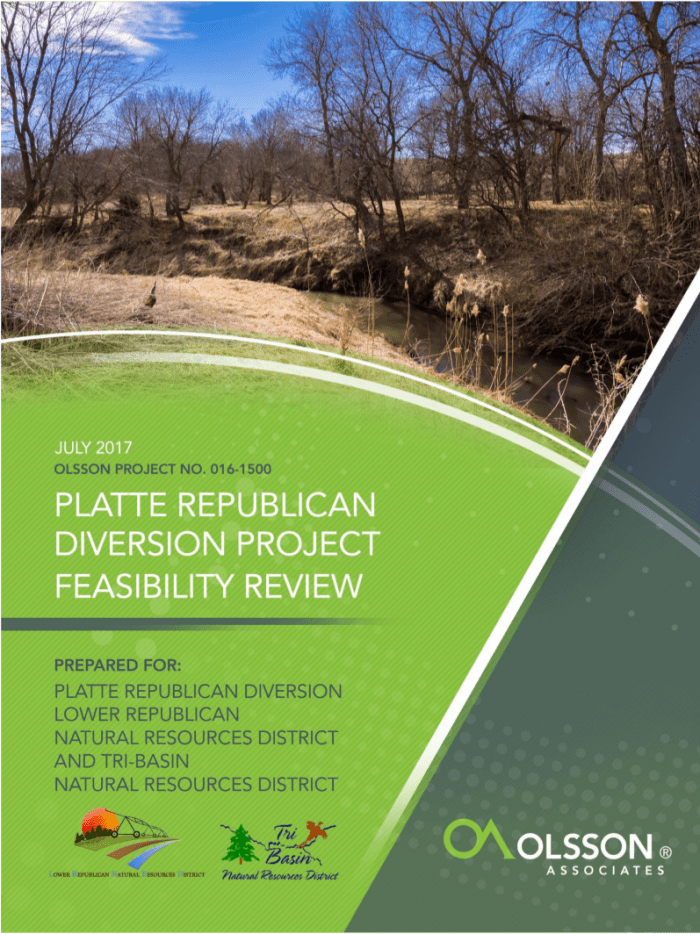
“What we’re hoping to do is take advantage of times when flows in the Platte River are high — high enough to satisfy all existing water rights and to satisfy requirements of endangered species– take some of that excess water, which potentially is floodwater and certainly provides no necessary benefit in the Platte basin — and divert some of that through the canal system of Central Public Power and Irrigation District to a point where it could be diverted into a tributary of the Republican River,” Thorburn said.
That could help Republican River farmers avoid more restrictions on their ability to irrigate crops. Two years ago, a U.S. Supreme Court decision forced Nebraska to pay Kansas $5.5 million for using too much water a decade earlier. The overuse was calculated at about 35,000 acre feet a year — an “acre-foot” being the amount of water it takes to cover an acre of land with a foot of water. A consultant estimates the proposed project could divert anywhere between 2,000 and 20,000 acre feet from the Platte to the Republican in years when there’s enough water, which might be twice a decade. (To see the consultant’s feasibility study on the project, click here)…
Not everyone thinks that’s a good idea. Bill Taddicken is with Audubon Nebraska, which has been working since the 1970s to ensure there’s enough water in the Platte to protect endangered bird species, including the whooping crane, piping plover, and least tern.
“For the good of the river, for wildlife, for people, for everybody it’s important that that water stays in this basin and not goes out of the basin,” Taddicken said.
Thorburn says the project would take water only after everybody in the Platte basin, including wildlife advocates, get what they are legally entitled to.
“Those are the only times when we would be taking water is when all the irrigation rights are met, all the target flow needs are met. This is water that is truly excess to the system in our opinion,” Thorburn said.
“Target flows” are the daily goals of water in the river to protect fish and wildlife on the Platte, part of an agreement between Nebraska, Wyoming, Colorado and the federal government. Taddicken says in an average year, actual flows fall far short of the target– by about 413,000 acre feet – even though they do exceed the target on some days.
“Just because on say, a particular day, there is what they consider excess water in the river it doesn’t mean that it’s not doing good for wildlife, it doesn’t mean that it’s not soaking into ground for use later on. We have big cities like Lincoln, Nebraska that are reliant on wellfields that are associated with the Platte River. Any water that gets transferred out of the basin is just water that can’t go to them,” Taddicken said.
Taddiken says flows above the targets are useful for clearing excess vegetation and restoring habitat. He says the proposed project would be a move in the wrong direction.
“About 90 percent of the original habitat that these birds use along the river is gone already. Seventy percent of the water is already gone before it gets to us. And they want to take more water out. So it’s a reduction in habitat even more. So we’re going backwards instead of forwards,” he said.
But Thorburn doesn’t buy the argument that high flows are needed to preserve habitat.
“It’s just not an efficient use of water. It’s potentially harmful for those who live near the river because the amounts of water required are virtually at flood levels. And unfortunately the system is not in the native state that it was 150 years ago. And so, we have to accommodate the people that have settled here,” Thorburn said.
All these issues are likely to be hashed out after Central, Tri-Basin and the Lower Republican ask the Department of Natural Resources for permission to build the project, later this year. But even if they get approval, that may not be the final word. When a big proposal to transfer water from the Platte was made in the late 1970s, the Nebraska Supreme Court ruled on different aspects of the project three times over the next decade before it was finally rejected.
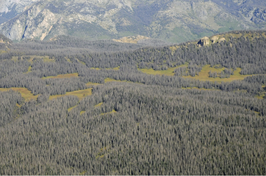
Nearly every mature spruce tree has been killed by spruce beetle in this area of the Rio Grande National Forest in southwest Colorado. (Credit: U.S. Forest Service; photo: Brian Howell)
Abstract. This analysis quantifies the topoclimate niche of 14 tree species in southwestern Colorado and predicts the 2060 niche distribution for each species. It draws on comprehensive, high-resolution vegetation datasets, a precise climate downscaling model, GCMs and RCPs used by IPCC, a foremost decision-tree learning algorithm, and advanced analytical techniques. The models accurately predict recent species distributions at high resolution based on reference climate, slope, and aspect. The results are presented as spatially explicit change zones to enhance utility in management. Results can be used to: (a) determine site-specifically the most appropriate management actions for climate adaptation of vegetation, (b) focus efforts where they have the greatest likelihood of long-term success, and (c) identify potential climate refugia.
Introduction
In the southern Rocky Mountains, it is increasingly evident that weather, insects, diseases, stand conditions, and fire will interact to transform forests as the climate changes. We have already seen widespread changes. Fires have been larger and more severe (van Mantgem et al. 2013, Westerling et al. 2006). Piñon ips responded to the turn-of-the-century drought by killing piñon on over 2.9 million acres in the 4-corner states (Breshears et al. 2005). In Colorado, sudden aspen decline impacted 1.2 million acres (17% of the aspen cover type) (Worrall et al. 2015), mountain pine beetle killed trees on 3.4 million acres, and spruce beetle has impacted 1.6 million acres to date (Howell et al. 2016). These agents kill stressed trees, often building their populations to kill trees in the absence of stress.
These large-scale disturbances provide a strong reminder of the powerful influence of climate on vegetation. The Forest Service and other agencies increasingly mandate extensive consideration of climate change in project, landscape, and forest planning. While vulnerability assessments and other elements provide a good overview of potential climate change impacts and general adaptation measures, they do not provide the quantitative, spatially explicit projections needed to adapt vegetation management to climate change. Impacts to tree species will vary greatly across the landscape – from habitat lost to new habitat emerging. Our management today should be quite different among these locations.
Bioclimate models offer an approach to develop spatially explicit projections of climate change impacts. By analyzing the relationship between known presence/absence of a species and reference climate (which led to the current distribution) at each point, they can predict the likelihood that a given climate will be suitable. Predicted distributions based on grids of reference climate match very well with known distributions. Grids of projected future climate then result in spatially explicit projections of future suitability. Bioclimate models have been extensively used and tested in research (Fettig et al. 2013, Gray & Hamann 2012, Hamann & Wang 2006, Iverson et al. 2008, Rehfeldt et al. 2006, Rehfeldt et al. 2014a, Sáenz-Romero et al. 2012, Worrall et al. 2013). Their application in management has been limited due to the coarse scale of mapping (~ 1 km resolution), lack of topographical response, and the complexity of results. Recent work has addressed these issues: methods for mapping at a 90-meter pixel scale suitable for landscape analysis, incorporation of topographic variables to increase fine-scale accuracy, and a method for projecting change zones that are directly applicable to management (Rehfeldt et al. 2015).
Here we report the methods, results, and some management implications of bioclimate modeling and change projections for 14 tree species in southwestern Colorado. The objectives of this phase of the project were to: (a) develop bioclimate models for dominant tree species of southwestern Colorado based on local data, incorporating topographic variables, and with results presented at a scale useful to management, and; (b) interpret the models by projecting change zones for the species (Lost, Threatened, Persistent, and Emergent) to make them useful for management.
In the past 20 years, Southwest Colorado forests have been in the line of fire of insect epidemic and disease.
The pattern is a clue of a drying climate that could produce a much different landscape 60 years from now in the Dolores watershed, said Jim Worrall, a forest pathologist with the U.S. Forest Service.
He presented the results of a new Forest Service study during a recent meeting of the Dolores Watershed and Resilient Forest Collaborative in Cortez.
First, it was the ongoing spruce beetle epidemic in the eastern San Juan Mountains, Worrall said, then a sudden aspen decline, which focused in the La Plata Mountains.
About the same time, the round-headed pine beetle moved farther north then before, ravaging forests in northwestern Montezuma County. Add to that an emerging budworm infestation in the Dolores Valley.
Many of these forest problems can be attributed to a drying trend from the mid-1980s that culminated in a turn-of-the-century drought with record temperatures in 2001-2003, Worrall said.
“It was a climate change-type drought, and it occurred across the interior West,” he said. “Put in context, you have to go back 800 years in the tree ring data to find a drought that severe.”
Climate studies forecast that the severe dry conditions of 2002 could be the norm by mid-century, Worrall said. Other research shows they could be the norm by the 2030s.
Worrall and his team developed bioclimate models with data from 14 tree species in Southwest Colorado to tease out what the landscape might look like for the future of the Dolores River watershed.
Computer modeling of the watershed used 850,000 tree-location data points and accounted for tree type-location or absence, topography, historic climate and climate variables. It then used algorithms to predict the likelihood of the species being present there in the future.
The modeling shows significant future changes. It predicts that by 2060, a drying climate will have eliminated ponderosa pines from current locations. They will move to higher elevations, possibly replacing spruce-fir stands. Oak brush is also shown moving into higher elevations.
A lot of the stands of the Utah juniper variety would be lost to a drier climate, models show, but aspen stands will likely persist because of to their resistance to drought…
That could guide future management decisions, Worrall said. For example, the round-headed pine beetle is impacting ponderosa forests in the Lake Canyon area of western Montezuma County, the farthest the beetle has ever been seen at that concentration north of New Mexico.
Local foresters are thinning the forest there to try and stop or slow down the beetle’s damaging progress.
“Long-term ponderosa may not be the future, so where there are good piñon stands, that component should be preserved instead of hydro-axing it,” Worrall said.
Protecting seed sources is an important aspect of planning for the future, agreed Bruce Short, a silviculturist from Mancos.
“We need to be proactive in thinking about how we manage what we have in the next 50 years,” he said. “Should we start taking seeds from one area to another based on future suitability?”
The forest crystal ball also reveals potential erosion problems in the future, added Mike Preston, general manager for the Dolores Water Conservancy District, which manages McPhee Reservoir.
“If the ponderosa pine zone comes apart, and there are no re-emergent species to replace it, it could impact water quality,” he said.
Rabbs’ fringe-limbed tree frog photo credit Wikimedia.com.
Click here to read the whole article from The New Yorker (Elizabeth Kolbert). Here’s an excerpt:
Instead of looking at the fate of Earth from our anxious perspective, from a human perspective, I’d like to try to look at it from the viewpoint of the millions and millions of non-human species with which we share the planet. This represents a different kind of imaginative exercise. It requires us not to imagine events that might happen but to look at events that have happened through different eyes—or even without eyes, since so many of our fellow-creatures lack them. We will always fall short in these exercises, but I think it’s important to try, so I hope you will indulge me.
I want to start off with an individual animal [a Rabbs’ fringe-limbed tree frog], who went by the name of Toughie. Toughie, as I understand it—and I never had the pleasure of meeting him, though I did meet one of his siblings, or perhaps cousins—was a very charming fellow. He was born in the cloud forest above the town of El Valle, in central Panama, a beautiful, rugged area that’s unusually rich in biodiversity. Specifically, Toughie was born in a tree hole. It was filled with water, the way most things in the cloud forest are filled with water. His mother deposited her eggs there, and then, when Toughie and his siblings were tadpoles, their father took over, and he cared for them. Up in the tree hole, there wasn’t much for the tadpoles to eat, so Toughie and his sisters and brothers sustained themselves by literally eating the skin off their father’s back. Toughie was living in the cloud forest in 2005, when he was found by a group of herpetologists. Eventually, he came to live in the botanical garden in Atlanta…
So these biologists—some were American, some were Panamanian—were, as I said, trying to catalogue what was out there before it was lost. And they were also collecting live animals, with the idea that, if they could save breeding pairs, they could create a sort of ark. In the case of the Rabbs’ fringe-limbed tree frog, only a handful of animals were caught before the scourge hit. Researchers had managed to collect a few females and a few males, including Toughie, but, although they were brought together in various configurations, they never produced viable offspring. Meanwhile, efforts to collect more members of the species were unsuccessful; the frog has a distinctive call that sounds like a dog’s bark, and though many man-hours were spent listening for it, it has not been heard in the forest since 2007. The last female Rabbs’ fringe-limbed tree frog died in 2009, the second-to-last male in 2012. This left just Toughie. And when he died, in September of 2016, it is likely that the species went extinct. A notice of Toughie’s death ran in the Times, under the headline, “A Frog Dies in Atlanta, and a World Vanishes With It.”
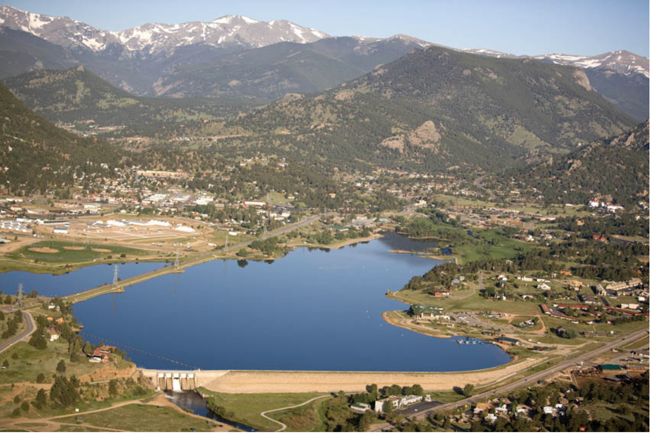
Aerial view of Lake Estes and Olympus Dam looking west. Photo credit Northern Water.
Here’s the release from Reclamation (James Bishop):
The Bureau of Reclamation, in cooperation with Estes Valley Recreation and Park District (EVRPD), is seeking public input on a Resource Management Plan (RMP) for Lake Estes, Marys Lake and East Portal lands.
The agencies will host an open house where the public can learn and ask questions about the resource management planning process, the lands affected by the plan, and provide comments. The open house will be held on Wednesday, October 25, 2017, from 6 to 8 p.m. at Estes Park High School Commons, 1600 Manford Avenue, Estes Park, Colo. Public comments will be welcomed in writing at the open house and throughout the 30-day public comment period.
The 30-day public comment period will begin on Wednesday, October 18, 2017 and will end at close-of-business on Friday, November 17, 2017. Comments must be provided in writing and can be submitted by e-mail, fax, or regular mail. E-mail comments can be sent to EstesRMP@usbr.gov, and faxed comments can be sent to the attention of Ms. Justina Thorsen at (970) 663-3212. Regular mail comments should be sent to the attention of Ms. Thorsen at: Bureau of Reclamation, 11056 W. County Road 18E, Loveland, Colo. 80537.
Reclamation is preparing the Estes Valley RMP. The agency will also prepare an Environmental Assessment in compliance with the National Environmental Policy Act. Reclamation owns and operates the Colorado-Big Thompson project, which includes Lake Estes, Marys Lake, East Portal, and the surrounding federal lands. Through a management agreement with Reclamation, EVRPD is responsible for managing recreation at Lake Estes, Marys Lake, and East Portal. The RMP will guide future recreation development as well as the management of natural and cultural resources on federal lands.
Media inquiries or general questions about Reclamation should be directed to James Bishop at 970-962-4326 or jbishop@usbr.gov. Specific questions about the resource management planning process should be directed to Justina Thorsen at 970-962-4207 or EstesRMP@usbr.gov.
Three-quarters of the world’s food today comes from just 12 crops and five animal species and this leaves supplies very vulnerable to disease and pests that can sweep through large areas of monocultures, as happened in the Irish potato famine when a million people starved to death. Reliance on only a few strains also means the world’s fast changing climate will cut yields just as the demand from a growing global population is rising.
There are tens of thousands of wild or rarely cultivated species that could provide a richly varied range of nutritious foods, resistant to disease and tolerant of the changing environment. But the destruction of wild areas, pollution and overhunting has started a mass extinction of species on Earth. The focus to date has been on wild animals — half of which have been lost in the last 40 years — but the new report reveals that the same pressures are endangering humanity’s food supply, with at least 1,000 cultivated species already endangered.
Tutwiler said saving the world’s agrobiodiversity is also vital in tackling the number one cause of human death and disability in the world — poor diet, which includes both too much and too little food. “We are not winning the battle against obesity and undernutrition,” she said. “Poor diets are in large part because we have very unified diets based on a narrow set of commodities and we are not consuming enough diversity.”
The new report sets out how both governments and companies can protect, enhance and use the huge variety of little-known food crops. It highlights examples including the gac, a fiery red fruit from Vietnam, and the orange-fleshed Asupina banana. Both have extremely high levels of beta-carotene that the body converts to vitamin A and could help the many millions of people suffering deficiency of that vitamin.
Gabrielle Katz, Ph.D., assistant professor in the Department of Earth and Atmospheric Sciences at MSU Denver, has been studying river hydrology and its impact on ecosystems for the last two decades. Photo by Alyson McClaran
Here’s the release from Doug McPherson writing for Metropolitan State University of Denver. Click through and read the whole article. Here’s an excerpt:
When Colorado lawmakers wanted to know how the massive floods of 2013 affected plants along the South Platte River, they needed experts.
Enter Gabrielle Katz, Ph.D., assistant professor in the Department of Earth and Atmospheric Sciences at Metropolitan State University of Denver. Katz has been studying river hydrology and its impact on ecosystems for the last two decades.
“I’ve been fascinated by water management influences since my graduate research in the 1990s,” Katz said.
Specifically, she’s become an expert on how flood control downstream of dams affects plant structure and composition and how groundwater pumping and hydrologic restoration affect streamside plant communities.
A federal lawsuit filed in September against the state of Colorado seeks to have the Colorado River ecosystem recognized as “possessing rights similar to a ‘person,'” including “certain rights to exist, flourish, regenerate and naturally evolve.”
The litigation, filed by Denver attorney Jason Flores-Williams, actually names the river ecosystem as the plaintiff in the suit. Environmental groups Deep Green Resistance (DGR) and the Southwest Coalition and several individual activists also are participating as the role of “next friends” acting on behalf of the river to bring the lawsuit. DGR activist Will Falk explained in a San Diego Free Press article that the lawsuit is an effort to counter a system that “currently defines nature as property.”
Flores-Williams has significant experience representing homeless people in class-action litigation against the city of Denver and city officials. He says that that previous work inspired the river lawsuit. “The only thing more homeless than homeless people is nature,” he says.
Flores-Williams says that after researching legal efforts to protect the environment, he came to the conclusion that even those “heroic” lawsuits hadn’t prevented environmental conditions from worsening. One reason, he says, is that “many environmental cases are dismissed for a lack of standing, because you can’t show what somebody, or a corporation or a state, is doing is of immediate harm to a human being.”
“It’s a real problem, a procedural defect,” says Flores-Williams.
If the river lawsuit is successful, Flores-Williams says that it would enable groups to act on behalf of the river, and make their case by showing that a defendant is damaging the waterway, without the need to prove that humans are being hurt.
The idea of nature having legal rights isn’t a new idea. Back in 1972, Supreme Court Justice William O. Douglas, in his dissenting opinion in the case of Sierra Club v. Morton, argued that environmental issues might be put in better focus if lawsuits could be filed “in the name of the inanimate object about to be despoiled, defaced, or invaded by roads and bulldozers, and where injury is the subject of public outrage. Contemporary public concern for protecting nature’s ecological equilibrium should lead to the conferral of standing upon environmental objects to sue for their own preservation.”
Douglas cited legal scholar Christopher D. Stone, whose book “Should Trees Have Standing?” made the case that natural objects could have legal rights, which would be exercised with the assistance of appointed guardians.
Since then, an international movement has sprouted to confer legal rights on nature, and recently, several countries have afforded such status to rivers. In March 2017, for example, after long negotiations with indigenous people, the New Zealand Parliament passed legislation that declared the Whangagui (Te Awa Tupua) River to be “a legal person” with all of the rights, powers, duties and liabilities that any other New Zealand resident might have.
Shortly after the New Zealand decision, a court in the northern Indian state of Uttarakhand ruled that the Ganges River and its main tributary, the Yamuna River, also deserved the same legal status as human beings.
Even so, the Colorado River lawsuit may face a difficult legal road. Reed Benson, chairman of the environmental law program at the University of New Mexico, told the New York Times that he considered it “a long shot in more ways than one.”
But Flores-Williams doesn’t seem deterred by the challenge, or by worries that some might take a dim view of a river being granted rights similar to those of a human being, or of a corporation.
“I wish people would get hung up on the idea that our environment is being diminished,” he says. “The river should have a right to exist.” Additionally, he says, “anyone knows that if the Colorado River is extinguished, it would cause an injury to us all.”
The office of Colorado Gov. John Hickenlooper declined to comment on the suit itself, but, via email, spokesperson Jacque Montgomery defended the state’s efforts to protect the river.
“Colorado and countless partners have long understood the significance of the Colorado River system and the need to balance our needs for water with conservation and enhancement of the river ecosystem,” she wrote. “This extends from efforts to protect — and improve habitat for — endangered fish in the river over the course of decades to the recent development of Colorado’s Water Plan. That plan’s very essence is about working together to ensure sufficient water supplies for agriculture, cities, recreation and the environment as our state continues to grow. The Colorado River, and its protection, has been a fundamental focus of Colorado as a state, but also of local governments and water utilities who themselves depend upon the river’s health and function as necessary for their own success.”
Flores-Williams says that activists in other states have expressed interest in filing similar suits
Colorado River Ecosystem/Deep Green Resistance v. the State of Colorado, Case No. 17-cv-02316, U.S. District Court, Colorado.
Information only.
Board members may have read recent news reports about a novel lawsuit that seeks to declare the Colorado River ecosystem as a “person” with standing to bring a lawsuit on its own behalf. The lawsuit was filed by the environmental group, Deep Green Resistance, as a “next friend”1 of the Colorado River Ecosystem. The complaint seeks a declaration from the court that the Colorado River Ecosystem is a “person” with standing to sue in court to protect its right to “exist, flourish, regenerate, be restored, and naturally evolve.” Additionally, the complaint alleges that the State of Colorado can be held liable for violating the River’s rights.
The premise of this lawsuit is certainly unique in Colorado (as well as the nation) but it is not completely without precedent. As noted in the complaint, Ecuador has amended its constitution to recognize the rights of ecosystems. Likewise, jurisdictions in Columbia and India have found rivers to have certain rights that warrant protection.
If successful, the lawsuit would be precedential not only in Colorado but throughout the country. Thus, we expect the State of Colorado will receive lots of help from others in opposing the lawsuit (we have already offered the River District’s help). A ruling granting the requested relief could totally upend environmental litigation. A key question would be why any specific group of individuals should be entitled to serve as an ecosystem’s “next friend” as opposed to any other group of individuals, organizations, municipalities, or States. The fights over the right to be appointed “next friend” status alone would be chaotic – not even taking into consideration the unique claims that could be asserted. The Attorney General’s Office will be taking the lead on Colorado’s behalf. We will continue to be in contact with the AG’s office as it prepares Colorado’s defense of the lawsuit – hopefully with a swift and successful motion to dismiss.
Frustrated by what they perceive as a failure of existing environmental law, advocates are exploring a new strategy to protect natural resources: asking federal district court to recognize the Colorado River as a person.
Yes, a person — with inalienable rights to “exist, flourish, regenerate, and restoration.”
The Colorado River is seeking the judicial recognition of “legal personhood” in a lawsuit filed Sept. 25 against the governor of Colorado in federal court (the first hearing is scheduled for Nov. 14). A favorable ruling would not only affect Nevada and the six other states with direct ties to the 1,450-mile-long river; it would spark a significant shift in environmental preservation nationwide.
The Community Environmental Legal Defense Fund, a nonprofit public-interest law firm and a leader in the push for “rights of nature,” is adviser on the lawsuit. Executive Director Thomas Linzey says existing environmental laws focus on damage to people and their property.
“Climate change is presenting itself in full force,” Linzey says. “People are beginning to understand that environmental law is falling short. Something new is needed. … This emerging system is about recognizing that ecosystems need to be protected in the plenary sense — not just to benefit humans.”
Individuals from the nonprofit organization Deep Green Resistance have been designated as “next friends” who act as surrogates on behalf of the river. The concept is similar to guardianship in cases involving minors or people considered too mentally incompetent to vocalize their own interests.
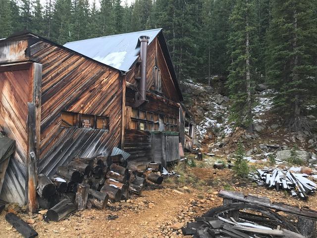
Jumbo Mine Cabin in-front of Adit September 25, 2017. Photo credit Environmental Protection Agency.
From the Environmental Protection Agency via Summit County (Brian Lorch):
The U.S. Environmental Protection Agency (EPA) is taking immediate action to perform mine cleanup activities at the Jumbo Mine in Summit County’s Peru Creek Basin, approximately seven miles east of Keystone Resort.
The Jumbo Mine, which produced gold, copper, lead and silver, operated from 1915 to 1918. Historic mine operations also generated significant volumes of waste rock and tailings piles. Inactive and abandoned for a century, the mine site was identified in the early 1990s by EPA and the Colorado Department of Public Health & Environment (CDPHE), as well as in the Snake River Watershed Plan, as a significant point-source contributor of metal-contaminated flows into Peru Creek and the downstream Snake River.
Historic hard-rock mining in the Peru Creek Basin left a legacy of contaminated and abandoned mine sites, whose acid mine drainage significantly degrades water quality. Much has been done to study the problems in the Snake River watershed, beginning in the early 1970s. Most studies have focused on the Peru Creek drainage, which is home to the Pennsylvania Mine, the largest, longest-operating mine in the watershed. In coordination with Summit County and the Colorado Division of Reclamation, Mining and Safety (DRMS), EPA completed cleanup actions at the Pennsylvania Mine in 2016.
The Jumbo Mine is another high-priority abandoned mine site in the Peru Creek Basin identified by the Snake River Watershed Coalition as a remediation project site capable of significantly improving water quality in the Snake River watershed.
Summit County purchased the land surrounding the abandoned Jumbo Mine in early 2016 for public open space. A restrictive covenant placed on the adjacent property containing the abandoned mine site allows for EPA’s cleanup actions to occur, but also limits the County’s liability for the existing environmental issues and associated cleanup actions.
“We had been looking to acquire this piece of property for a long time, recognizing that it has many open space values,” said Brian Lorch, Summit County Open Space and Trails director. “But before we could take steps to purchase the property, we needed to ensure that it could be cleaned up in an economical manner.”
EPA is implementing the cleanup work as a time-critical removal action under the Comprehensive Environmental Response, Compensation and Liability Act (CERCLA). Last week, the agency began the work, which it plans to complete in about three weeks.
Cleanup activities involve diverting water draining from a mine adit around or over adjacent tailings piles in a limestone and membrane-lined ditch. According to EPA studies, water quality of the adit drainage degrades as it crosses the mine tailings, contributing high levels of suspended and dissolved lead, zinc and other metals into the stream. Diverting drainage around the tailings into a lined ditch should greatly improve water quality.
“The overall approach will help reduce the discharge of metals into Peru Creek,” Lorch said. “A passive treatment approach at the Jumbo Mine site is quite similar to numerous mine cleanups performed elsewhere by the County.”
Since 2001, Summit County has worked with EPA to identify and prioritize mine sites in need of cleanup in the Peru Creek Basin. The County’s proactive coordination with EPA facilitated recent cleanup efforts at the Pennsylvania Mine and numerous other sites in the area.
“We are really happy and grateful to see EPA continue its mine cleanup efforts in the Peru Creek Basin,” Summit County Commissioner Karn Stiegelmeier said. “The Summit County community is very supportive of our efforts to clean up abandoned mine sites on County property, voting in 2015 for a mill levy that provides funding for cleaning up mine-impacted sites.”
Jumbo Mine looking up at channel liner installation from lower middle section of waste rock pile. Photo credit Environmental Protection Agency.
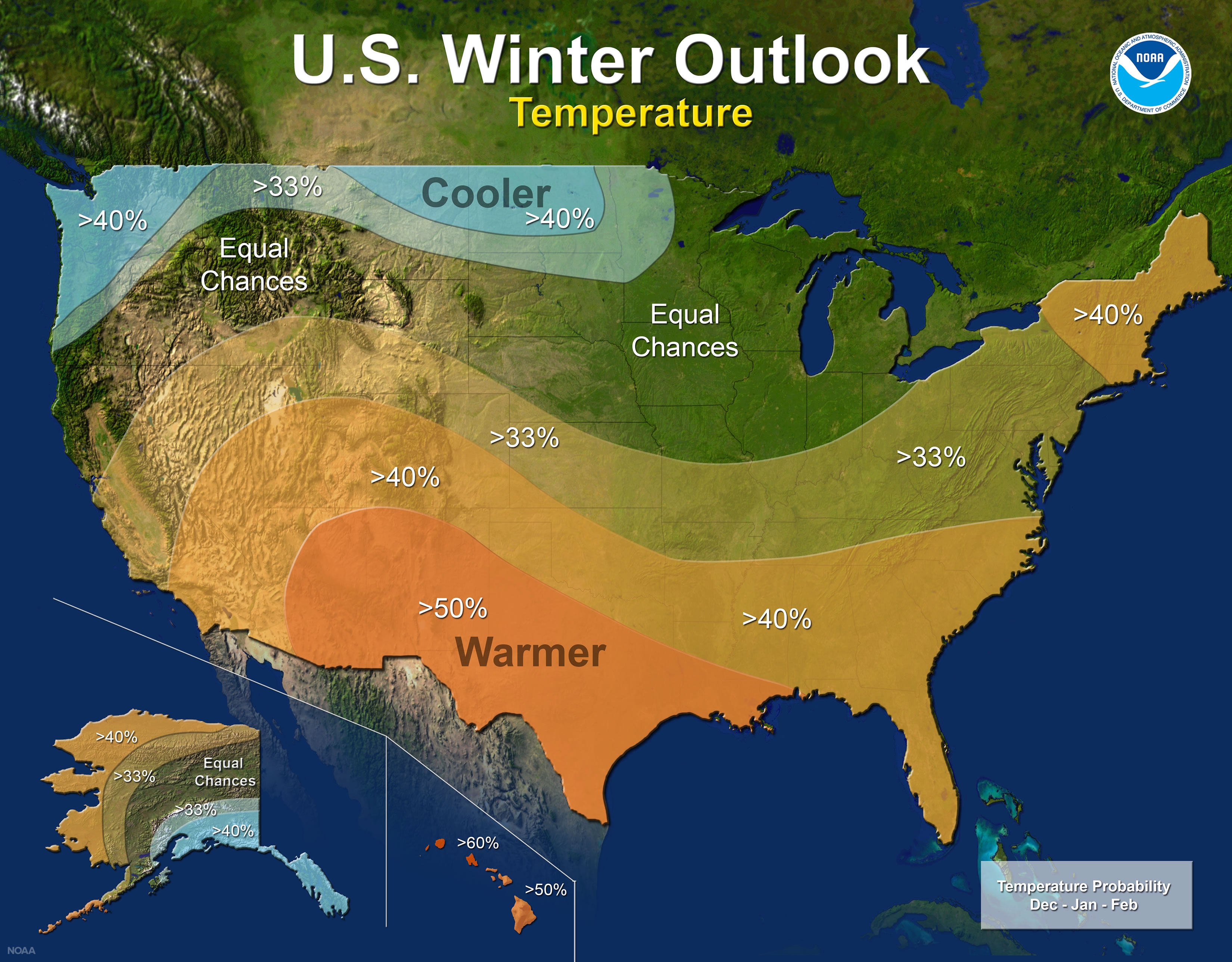
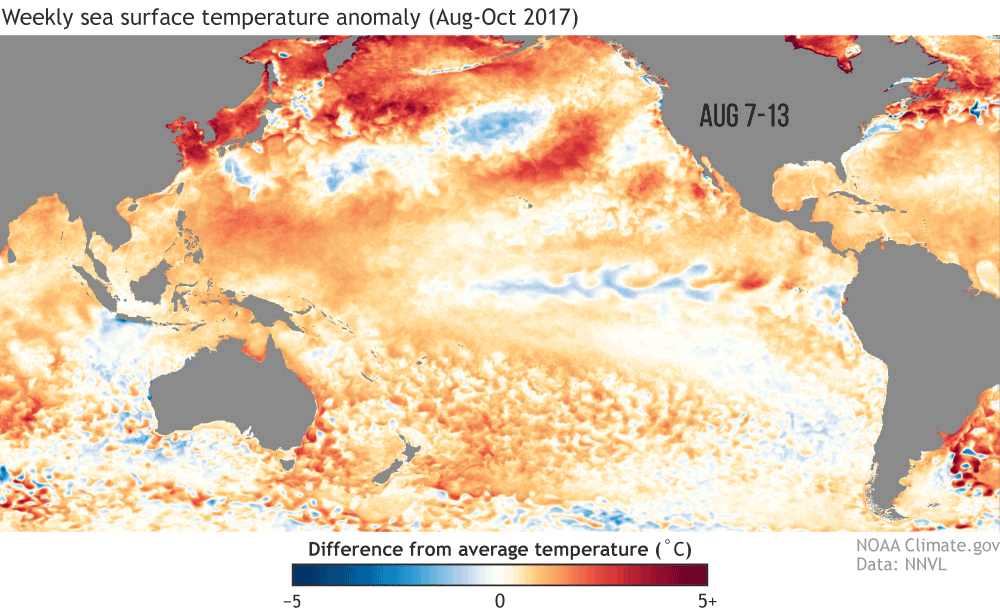
“Colorado will favor above-average temps” in the coming winter, Mike Halpert, National Oceanic and Atmospheric Administration (NOAA) Climate Prediction Center deputy director, said Thursday in a media teleconference.
“The northern part of Colorado will go toward wet. A fair amount of the state falls into the ‘equal chances’ category,” Halpert said.
The middle of the country is the dividing line, so Colorado and middle America are considered equal chance – meaning there is not a strong enough climate signal to shift the odds one direction or the other.
Colorado and other similar states can expect equal chances of above, near or below normal temperatures and precipitation.
Part of the forecast relies on computer simulation. At this point, the computer forecast is leaning toward La Niña, Halpert said, abnormally cool water around the equator in the Pacific Ocean that can influence weather patterns worldwide.
According to a forecasters’ press release Thursday, La Niña has a 55 to 65 percent chance of developing before winter starts.
Regarding snowfall, “NOAA is not issuing snow forecasts at this time. La Niña winters typically see less snow,” said Halpert.
Forecasters at NOAA’s Climate Prediction Center released the U.S. Winter Outlook today, with La Nina potentially emerging for the second year in a row as the biggest wildcard in how this year’s winter will shape up. La Nina has a 55- to 65-percent chance of developing before winter sets in.
Snowstorm photo via NOAA.
NOAA produces seasonal outlooks to help communities prepare for what’s likely to come in the next few months and minimize weather’s impacts on lives and livelihoods. Empowering people with actionable forecasts and winter weather tips is key to NOAA’s effort to build a Weather-Ready Nation.
“If La Nina conditions develop, we predict it will be weak and potentially short-lived, but it could still shape the character of the upcoming winter,” said Mike Halpert, deputy director of NOAA’s Climate Prediction Center. “Typical La Nina patterns during winter include above average precipitation and colder than average temperatures along the Northern Tier of the U.S. and below normal precipitation and drier conditions across the South.”
Other factors that influence winter weather include the Arctic Oscillation, which influences the number of arctic air masses that penetrate into the South and is difficult to predict more than one to two weeks in advance, and the Madden-Julian Oscillation, which can affect the number of heavy rain events along the West Coast.
The 2017 U.S. Winter Outlook (December through February):
Precipitation
Wetter-than-average conditions are favored across most of the northern United States, extending from the northern Rockies, to the eastern Great Lakes, the Ohio Valley, in Hawaii and in western and northern Alaska.
Drier-than-normal conditions are most likely across the entire southern U.S.
2017-18 Winter Outlook map for precipitation (NOAA)
Temperature
Warmer-than-normal conditions are most likely across the southern two-thirds of the continental U.S., along the East Coast, across Hawaii and in western and northern Alaska.
Below-average temperatures are favored along the Northern Tier of the country from Minnesota to the Pacific Northwest and in southeastern Alaska.
The rest of the country falls into the equal chance category, which means they have an equal chance for above-, near-, or below-normal temperatures and/or precipitation because there is not a strong enough climate signal in these areas to shift the odds.
2017-18 Winter Outlook map for temperature (NOAA).
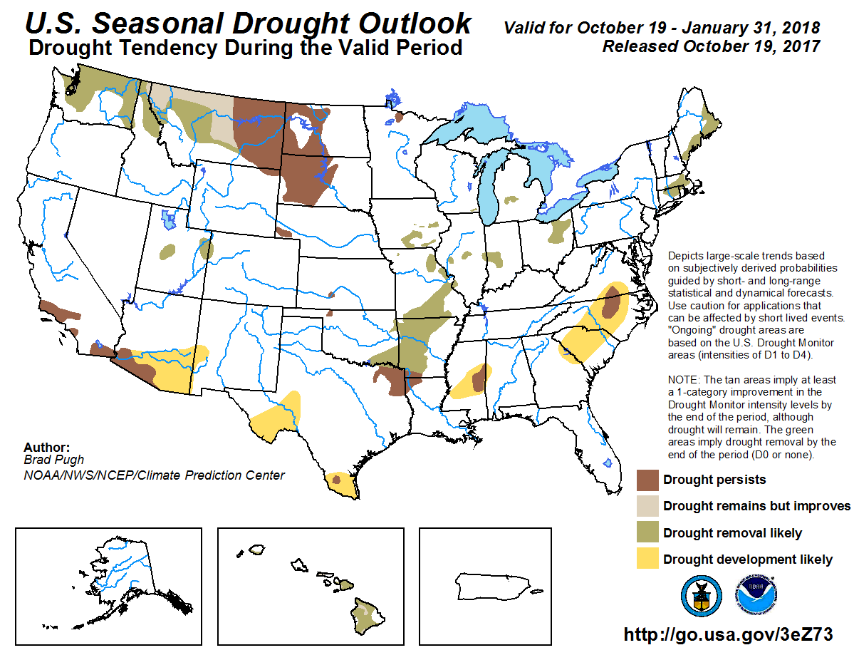
Drought
Despite the outlook favoring above-average precipitation this winter, drought is likely to persist in parts of the northern Plains, although improvement is anticipated farther West.
Elsewhere, drought could develop across scattered areas of the South, mainly in regions that missed the rainfall associated with the active 2017 hurricane season.
NOAA’s seasonal outlooks give the likelihood that temperature and precipitation will be above-, near, or below-average, and also how drought is expected to change, but do not project seasonal snowfall accumulations. While the last two winters featured above-average temperatures over much of the nation, significant snowstorms still impacted different parts of the country. Snow forecasts are generally not predictable more than a week in advance because they depend upon the strength and track of winter storms. The U.S. Winter Outlook will be updated on November 16.
Three month temperature outlook October 19, 2017 through January 31, 2018 via the Climate Prediction Center.Three month precipitation outlook October 19, 2017 through January 31, 2018 via the Climate Prediction Center.
Click here to go to the US Drought Monitor website. Here’s an excerpt:
Summary
As usual, there were winners and losers with respect to precipitation this week. Heavy rain fell across much of the Midwest, particularly notable in an area stretching from eastern Iowa northeastward to Michigan where upwards of 600% of typical precipitation for the week was received. Rainfall was below-average across most of the Northeast, the South, and Southeast. Additionally, temperatures were almost summer-like for several days from the Midwest to the Northeast, where departures were up to 15-30 degrees F above average in places, making it feel like August rather than October in many places. The dryness and heat brought about expansion of dry areas across parts the South, Southeast, and Northeast, while the Midwest saw the most improvements this week…
High Plains
Dry conditions improved in southeastern Nebraska and northeastern Kansas (see Midwest section).
Abnormally dry conditions were expanded to the San Juan Mountains and Four Corners in southwest Colorado. This area did not receive as much moisture as areas to the north, west, and east during a recent wet spell.
Much of the Dakotas continued to see improvements, with recent rainfall helping to slowly alleviate ongoing drought conditions. While there are lingering long-term deficits, local experts in North Dakota observe that farming conditions are currently very good…
West
Montana is experiencing slowly improving conditions, including vegetation and soil moisture. However, in Valley, Roosevelt, and McCone Counties, empty stock ponds remain and there are still large cracks in the soil. This week, conditions improved enough such that exceptional drought (D4, the most dire category) in the north near this area was improved one category to extreme drought (D3). Overall in Montana, large deficits still remain across the state. For example, Glasgow is 5 inches below normal for the year-to-date (53% of normal) and Zortman is 4.75 inches below normal (69% of normal). Wildfires still continue to burn in areas.
In Oregon, conditions have improved and moderate drought (D1) in Oregon and southern Washington were upgraded to abnormally dry (D0), which better reflect current impacts in the region…
Looking Ahead
For the week of October 17-23, the extreme Northwest and the South/Southeast are likely to receive above-average precipitation, very heavy in the Northwest and up to 3 inches in parts of the South. Less than half an inch of precipitation is forecast across the mid-Atlantic states, the Northeast, and the High Plains into Montana. Looking a bit further to the October 22-26 timeframe, above-normal temperatures are expected over the western U.S, while parts of Texas may see below-average temperatures. Below-normal precipitation is also forecast for the western U.S. Looking even further out to the week of Oct 24-30, most of the contiguous U.S. is favored to see below-average precipitation, while above-normal precipitation is favored across the Appalachians and eastward. The Great Lakes region is also favored to receive above-normal precipitation at this time.
Here’s the latest 3 month drought outlook map from the Climate Prediction Center.
Seasonal Drought Outlook October 19, 2017 through January 31, 2017.
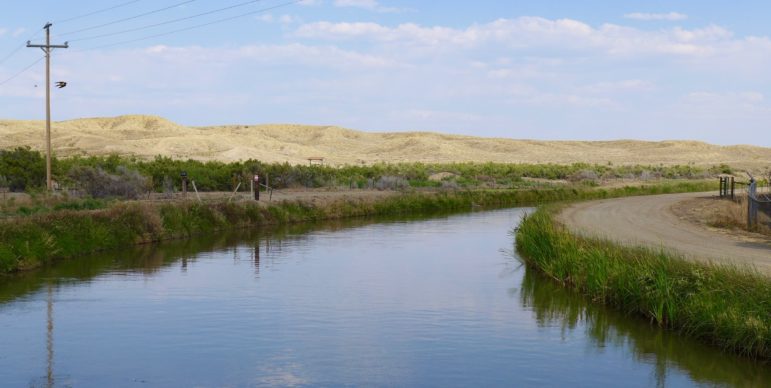
The Government Highline Canal is managed by the Grand Valley Water Users Association, and serves as a major source of irrigation water in the Grand Valley.
GLENWOOD SPRINGS — A group of water leaders in Colorado, most new to their posts, appeared before the board of the Colorado River District on Tuesday in Glenwood Springs.
Becky Mitchell, executive director of the Colorado Water Conservation Board, and Kevin Rein, state hydraulic engineer for Colorado, both of whom took their current positions in July, introduced themselves to the river district board, which includes representatives of 15 Western Slope counties.
Mitchell said it was important for the state to develop a long-term source of funding for new water projects in both the Denver metro area and the Western Slope, but she said the various river-basin plans in the state needed to be prioritized before a funding question is put to voters.
“We don’t want to take some ballot measure up that won’t pass,” said Mitchell, who was promoted to her new position at CWCB after working on the 2015 state water plan. “We want to make sure we get everything prepared so we have the most chance for success, because this is such an important issue.”
Rein, who serves as the state’s water-law enforcer, said he intends to continue the policies and practices of his predecessor, Dick Wolfe, and that he hopes to administer water rights and respond to water court applications with consistency and transparency.
“It all comes down to balance for me,” Rein said, in trying to administer water rights against competing demands.
Jayla Poppleton, who has been the executive director of the Colorado Foundation for Water Education since January, also went before the river district board Tuesday, describing her organization’s new brand positioning.
Created by the state Legislature in 2002 to inform citizens about water, the organization is changing its name to Water Education Colorado, and its new logo is based on the layout of the state’s eight river basins.
The logo for Water Education Colorado seeks to convey a conversation about the eight river basins in Colorado as defined by the state’s basin roundtables, which are represented in the logo in clockwise fashion, and include, from the top left, the Yampa/White, North Platte, South Platte, Arkansas, Rio Grande, Gunnison, Southwest/San Juan/Dolores, and Colorado basins.
Andrew Mueller, who starts as new general manager of the river district on Dec. 1, was also at the meeting.
An attorney at a law firm in Glenwood Springs, Mueller once lived in Ouray and represented Ouray County on the Colorado River District’s board from 2006-2015. He was hired in September upon unanimous consent by the river district’s board.
At the district’s next quarterly board meeting in January, Mueller will officially replace Eric Kuhn, the district’s current general manager, who is retiring after 37 years.
Kuhn has a deep understanding of Colorado River issues, and he and John Carron, an engineer with Hydros Consulting Inc., presented to the board the latest findings of an ongoing “risk study” focusing on ways to keep enough water in Lake Powell in the face of another sharp drought.
Also presenting at Tuesday’s meeting was Mark Harris, the general manager of the Grand Valley Water Users Association, which diverts water out of the Colorado River in De Beque Canyon, at the red-roofed roller dam.
Harris was before the river district’s board seeking financial support for the second year of an experimental program that pays irrigators to fallow fields or crops, lower their consumptive use, and leave water in the river to help keep Lake Powell operational.
The association is one of the big three diverters in the Grand Valley, and provides water to 25,000 irrigated acres on the north side of the valley from Palisade to Mack via the 55-mile-long Government Highline Canal.
In 2017, the association compensated 10 large irrigators, whose names have not been disclosed, to fallow a total of 1,252 acres of irrigated land on parcels ranging from 60 acres to 240 acres.
A map showing, in red, the participants in the Grand Valley Water User’s Association program in 2017 to conserve consumptive use in the Grand Valley near Grand Junction.An irrigated hayfield in the Grand Valley irrigated by the Government Highline Canal. Summer, 2017.
The 2017 program, which concludes this month, will result in 3,200 acre-feet of water not being used for irrigation.
The association funded the program with $1,039,000. Of that, it put $145,000 in an infrastructure fund, used $169,000 for program management, and paid $725,000 to irrigators. (That works out to about $225 per acre-foot of “conserved consumptive use” to the irrgators.)
Major funding sources for the program included The Nature Conservancy, the state of Colorado, and Denver Water. The association intends to run the program again in 2018.
Harris said the association continues to learn about how such a fallowing program in the Grand Valley might work in the face of a drought or other challenge to complying with the Colorado River compact, which requires Colorado and other states in the upper Colorado River basin to provide a set amount of water to California, Arizona, and Nevada, even in dry years.
The equinox on September 22 marked a seasonal milestone for planet Earth. It signified a rapid progression into autumn for those of us in the Northern Hemisphere and spring for those “down under” in the Southern Hemisphere.
Let’s dive deeper into our monthly analysis to see how the planet fared for the month and the year to date:
Climate by the numbers
September 2017
The average global temperature set in September 2017 was 1.40 degrees F above the 20th-century average of 59.0 degrees, according to scientists from NOAA’s National Centers for Environmental Information. This average temperature was the fourth highest for September in the 1880-2017 record. This marked the 41st consecutive September and the 393rd consecutive month with temperatures above the 20th-century average.
Year to date | January through September 2017
The year-to-date average temperature was 1.57 degrees F above the 20th-century average of 57.5 degrees. This was the second warmest for this period, 0.23 of a degree behind the record set in 2016. Nine of the 10 warmest January-September global temperatures have occurred since 2005, with 1998 as the only exception.
Here are some noteworthy climate events that occurred around the world in September. (NOAA NCEI)
Other notable climate events and facts around the world last month included:
Below-average sea ice at the poles persists
The average Arctic sea ice coverage in September was 25.5 percent below the 1981-2010 average, the seventh smallest on record. On September 13, Arctic sea ice reached its annual minimum extent (coverage) at 1.79 million square miles, the eighth smallest in the 1979–2017 satellite record.
Antarctic sea ice extent in September was 4.2 percent below average, the second smallest on record.
Warmer-than-average lands and oceans
The globally averaged land-surface temperature ranked as third warmest for the month of September and second highest for the year to date (January to September).
The globally averaged sea-surface temperature ranked fourth warmest for September and third highest for the year to date.
Africa leads the continents in September warmth rankings
Africa had its warmest September on record; South America, its fifth; Asia, its seventh; North America, its eighth; Oceania, its 12th; and Europe, its 19th.
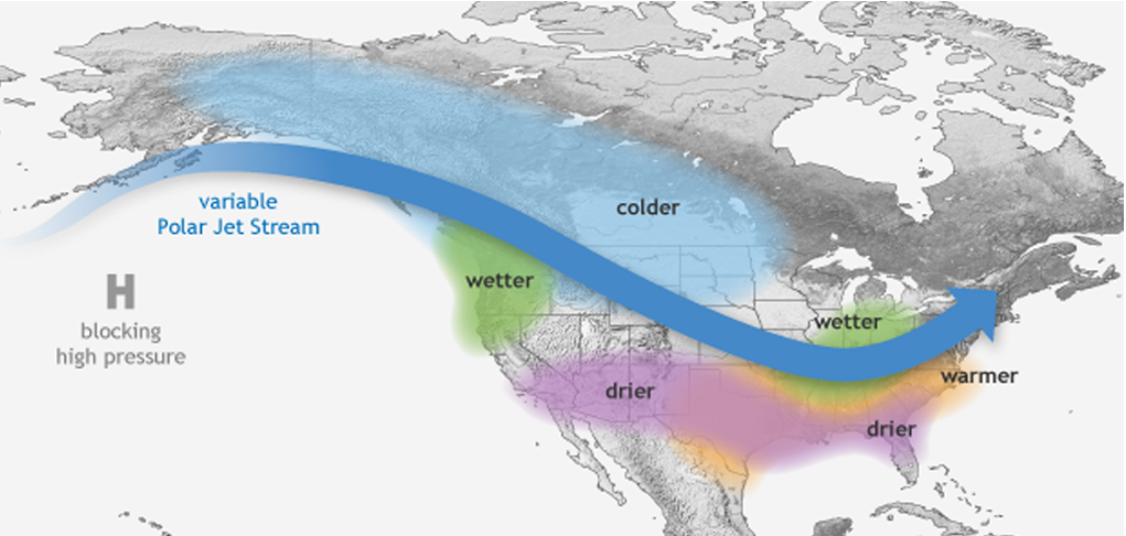
A La Niña pattern typically means drier than average conditions for most of Southern Colorado, but that’s not always the case. La Niña will usually shift the Polar jet stream to the north, meaning cold air and storms typically miss Colorado to the north and north east. That pattern and storm track can often rob Southern Colorado of an up slope wind, which is a big ingredient for snowfall along the Front Range and the foothills. Past data has shown this often brings drier conditions to most of the I-25 corridor due to the lack of that moist, up slope wind.
SNOTEL data shows La Niña will usually provide above average snowfall to the Upper Arkansas River Basin, near or below average to the Upper Rio Grand and San Juan River Basins, and below average to the Sangre De Cristo and Wet mountains. While the data shows we are typically dry, there was a strong La Niña in 1999 and yet Colorado Springs saw one of it’s highest annual precipitation measurements on record.
The take away? Southern Colorado weather is always very active and difficult to predict. If we do see a La Niña develop,(remember the chance right now is between 55 to 65 percent) it’s no guarantee that we’ll get the usual dry pattern. Even if we do see the La Niña form, remember that we live next to a mountain range and we’re going to see a few big snows throughout the winter season.
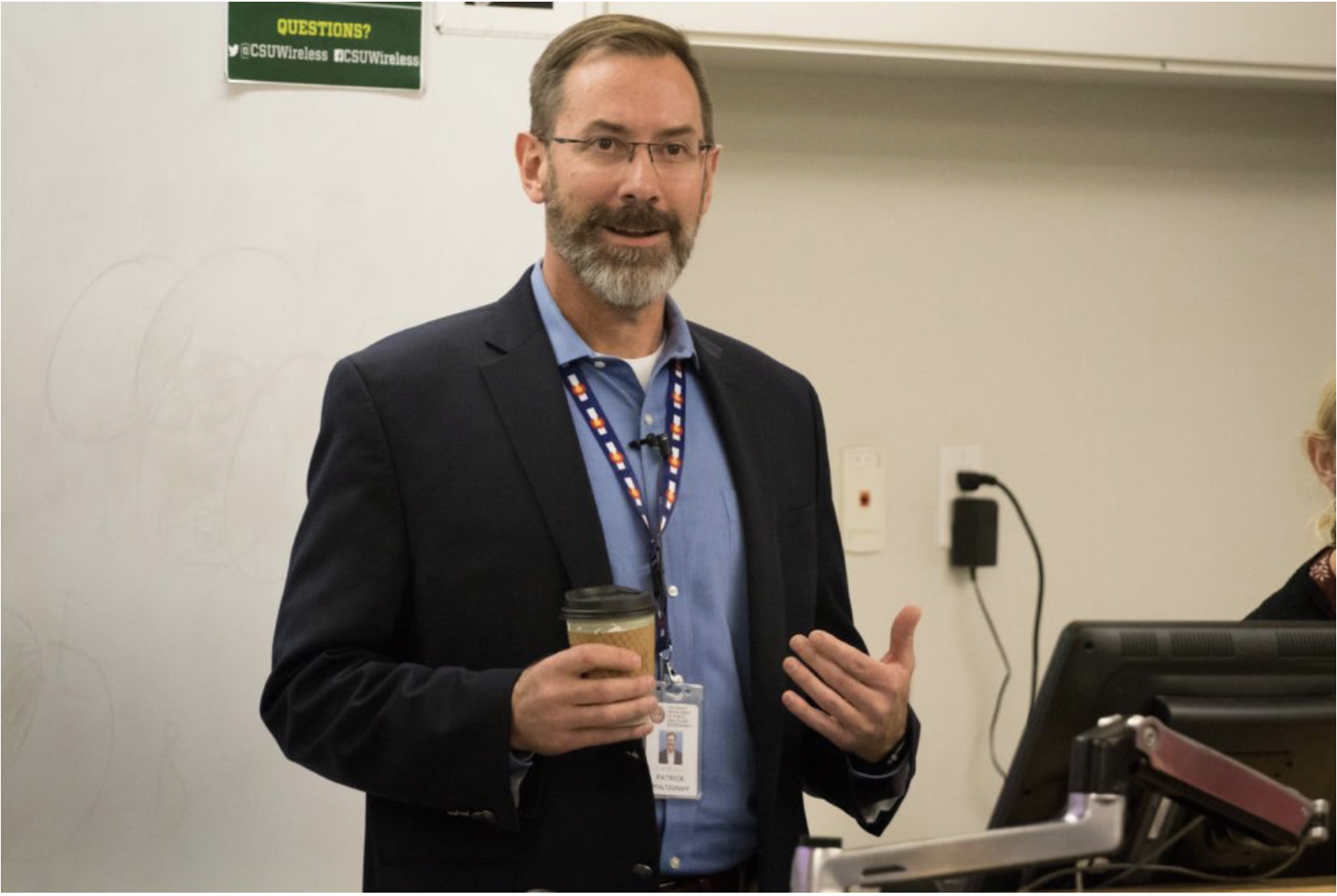
Watershed science majors listened to and discussed water quality control and clean water regulations for an interdisciplinary water resources seminar class Monday evening.
Patrick J. Pfalzgraff, the director of the Water Quality Control Division of the Local Public Health and Environment Resources Department, spoke to watershed sciences majors for a GRAD 592 interdisciplinary water resources seminar class, which are open to the public. Pfalzgraff works with regulations of water quality control in terms of clean water and drinking water.
According to the syllabus, the purpose of this course is “to prepare students in water resources by increasing their understanding of how water is actually managed in Colorado.” The seminar class brings in professionals in the water resources industry to speak about their work in the field.
The Water Quality Control Division issues regulations on water treatment, pollution control, and does some water tests, with regulation standards finalized by state politicians.
“Almost all of the decisions we make are based on some form of data, whether that is science data or weather data, we pull the data from these sources to determine the stream or lake health,” Pfalzgraff said.
The division also aides smaller communities with meeting water regulation standards by providing funds or services if the communities do not have access to them.
“A lot of small towns don’t have a lot of revenue because they don’t have a big population or industry, and they may or may not have the resources or revenue in order to do necessary upgrades,” Pfalzgraff said. “That’s where we can step in and get them back on their feet.”
Patrick J Pfalzgraff, the Director of the Water Quality Control Division of the Local Public Health and Environment Resources Department (Julia Trowbridge | Collegian)
Clean water, like the water in the Poudre River, have to pass regulations regarding pollution levels. A common pollution level issue is the concentrations of nitrogen and phosphorous in water levels, which can either come from human pollution or agricultural pollution.
High concentrations of these elements in water, called nutrient loadings, can make the crops have excessive amounts of these elements, and the crops might not pass regulation standards for consumption.
“We try to maintain that environmental balance with how pollutants are discharged throughout the state,” Pfalzgraff said.
Clean water and clean drinking water are completely different standards. Drinking water is regulated through chemically treating clean water to insure that the water is safe and clean to distribute out to the public to prevent things like waterborne diseases being distributed in the drinking water.
“In Puerto Rico, there are waterborne diseases,” Pfalzgraff said. “That’s not an issue in Colorado. We haven’t had a wate borne disease in the last five years.”
The study of watershed sciences and the design of water flow is especially important in Colorado. According to Pfalzgraff, the population of Colorado is predicted to double by 2050, which creates a strong need in water quality regulation and the delegation of water resources.
“There are a lot of uses on what are already stressed resources,” Pfalzgraff said.
Stressed resources has been brought up by groups like Save the Poudre, who advocate that diversion plans made by the Northern Integrated Supply Project would drain even more water from the already depleted river. The river also has to pass a minimum water flow, which could cause problems with these diversion plans.
Regardless, the growing population of Colorado needs to access water, whether it is by the proposed plan or another alternative.
Cache la Poudre River from South Trail via Wikimedia Foundation.
I was at an event on the Colorado River Basin that focused on issues such as state and international water allocations, the “drought” and policy issues. The private sector was woefully under-represented except through NGOs.
My concern about the siloed nature of the water sector also applies to water technology events — multinationals, NGOs and academics are typically not in attendance to a significant extent.
While attendance at conferences doesn’t tell the entire story of collective action in the water sector, I believe it does signal the need for dynamism in building cross-sector programs and strategy to address water challenges. There is an opportunity to broaden our view of stakeholder ecosystems so we are not always ranting in an echo chamber. Consider the potential value of an expanded ecosystem in the water sector to ensure economic development, business growth, social well-being and ecosystem health.
I am particularly concerned about the pace of progress as we face the deadline to achieve SDG 6 by 2030. We don’t have time for business as usual.
What has to change? I believe we need to do more of the following.
Establish ecosystems (PDF) of stakeholders across industry sectors dedicated to solving specific private and public sector issues. An example of such an ecosystem is the Cross-Sector Biodiversity Initiative, a partnership between IPIECA, the oil and gas industry association; the International Council on Mining and Metals (ICMM); and the Equator Principles Association “to develop and share good practices related to biodiversity and ecosystem services in the extractive industries. The initiative supports the broader goals of innovative and transparent application of the mitigation hierarchy in relation to biodiversity and ecosystem services.”
Further expand the role of water funds to include actions beyond conservation. Water funds have been successful in cost-effectively addressing water risks but could be expanded to fund innovation and scaling of new technologies (digital water technologies) and business models (water as a service).
Proactively include industry in watershed level public policy programs. For example, why not establish a Colorado River Basin coalition of industry stakeholders with a commitment to support state and regional water public policy programs within the basin? This will require developing a platform for public sector, NGOs and companies to engage in dialogue and commit to actions to address issues such as the over-allocation of water and readily available access to water data.
Engage the information, communication and technology (ICT) sector. These companies should be encouraged to broaden the reach of their water footprint and stewardship programs to focus on how ICT technologies actively can be deployed to increase water efficiency, reuse, recycling, resource recovery, etc.
The “wicked” problem of water will not be solved with the same suspects and the same solutions. There is a lack of exponential progress in addressing water issues. We need to engage a broader group of stakeholders to solve 21st-century water challenges and be more like the tech sector — driving invention and innovation. These challenges will not be solved via more presentations to siloed stakeholder groups.
[The budget was] presented to the board of the Pagosa Area Water Sanitation District (PAWSD) on Sept. 21.
The PAWSD budget includes four funds: a general, debt service, water enterprise and wastewater enterprise.
In a follow-up phone call with The SUN, Business Services Manager Shellie Peterson explained some of the larger changes for each portion of the budget…
Water enterprise fund
There were also a few notable proposed changes to the water enterprise fund.
“There are a lot of similarities to the water fund and the wastewater fund,” she said.
Both are proprietary funds, she explained.
“These are supposed to be run as you would a private business, meaning that the amount that you charge for service charges in all of your different revenues, ideally, should cover all of your related operating expenses and your capital expenditures and the debt service that’s involved with the enterprise funds,” she said.
Peterson noted that PAWSD can transfer from the general fund up to 9.99 percent of a funds’ revenues.
“So in doing that in a small way we’re subsidizing the enterprise funds with a little bit of tax dollars,” she said.
Capital projects was also included on the water enterprise fund as having a projected negative 35 percent change for 2018.
This projected change would move the capital projects budget from $428,211 in 2017 to $279,890 in 2018.
According to the draft budget summary sheet, there is a distinct decrease in capital expenditures, but many of the decreases are off- set by “increases in major mainte- nance item expenditures.”
“We’re projecting to spend less on capital next year,” she said.
In an email to The SUN Peterson explained that the reason for spending less on capital is that some years present a bigger need for capital projects than others.
“There really is not a ‘why’ to capital spending. Some years present the need for major new construction or processes more so than others,” Peterson wrote.
Water loss was also listed as a larger maintenance item in the draft budget.
“During the restructuring of the Colorado Water Conservation Board loan for the Dry Gulch prop- erty, a commitment was made to spend $125,000 per year on water line replacement or repairs to re- duce water loss,” she wrote.
Peterson noted that the water line replacement or repairs are not capital expenditures.
“They will not be capitalized and depreciated over a useful life,” she wrote.
The next big capital project will be the installation of ultraviolet disinfection at the San Juan Water Treatment Plant.
“That work is being engineered this year, dirt work, excavation will be started next year, and the UV project itself will be bid out in 2019,” she wrote.
The ending fund balance for the water enterprise fund is projected to have a 12 percent increase.
This would raise the balance up from $5,061,503 in 2017 to $5,666,128 in 2018.
“That’s saying if everything went exactly according to this formula I would have just over $5 million at the end of 2017, in this fund, and then yet I’m projecting to have a 12 percent increase in that ending fund balance,” she explained.
Why the fund balance is going to go up involves a few things, Pe- terson noted.
“Part of the reason that the fund balance is going to go up is because my revenues are going to go up just a titch, but my expenses are going to go up too, just a little bit,” she said.
Wastewater enterprise fund
Peterson explained that the wastewater enterprise fund and the water enterprise fund work in the same way, but offer different services.
“They operate identically other than the fact that they provide two completely different services,” Peterson said.
The majority of revenue that the wastewater fund receives is from the minimum monthly ser- vice charge for wastewater, she explained.
“The wastewater fund is less complicated because it’s a flat rate, everyone who is connected to Pagosa Area Water sewer is paying $32 per equivalent unit,” she said. The wastewater fund’s revenue is easier to determine because it doesn’t have a oating volumetric rate that the water enterprise fund has, Peterson noted.
Two of the bigger proposed percentage changes within the wastewater enterprise fund were wastewater collection and capital projects.
Wastewater revenue is projected to increase by 42 percent for 2018. The potential increase would move wastewater’s budget of $458,300 in 2017 to $652,935 in
2018.
“It means we are expecting our expenses to be higher in that department,” she said.
Collection of wastewater in- volves everything that happens in the collection system, the pipes underground, to bringing the sewage to the sewer plant, Peterson explained.
“We expect to go out to bid on $200,000 basis to have a commer- cial sewer line cleaning service come in,” she said.
The company responsible for the line cleaning would spray the sewer lines clean, and install cameras and create tapes from the cameras, Peterson explained.
With these tapes, PAWSD could see any potential problems within the sewer line, she explained.
Right now PAWSD is using local firm, Pagosa Rooter, to clean its sewer lines.
“They just aren’t able to televise for us, but we’ve been doing cleaning that way,” she said.
The problem for PAWSD is that it is harder to have larger firms come to Pagosa Springs because they won’t mobilize for that small amount of work.
“That’s the lion share of why that budget is going to increase,” Peterson said.
Another reason for the increase for wastewater revenue is having lift station rehab at lift station 21 and lift station 7, Peterson ex- plained.
Capital projects was again listed under this section of the budget.
Capital projects is proposed to have a 59 percent decrease in the proposed budget, from $371,525 in 2017 to $153,320 in 2018.
“In the capital department, we just have less being forecast, really where the big dollars are this year is more in the maintenance line,” Peterson said.
Both the water and wastewater funds stay at close to the same level of total expenditures, but the weighting is changed for this year, she said.
Click here to read the briefing. Here’s an excerpt:
Highlights:
Multiple early-season storms have brought snow to the high country, resulting in much-above-normal SWE for early October in many basins. However, with dry conditions forecasted for the next 7-10 days, it’s not clear that much of this early bounty will persist.
August was generally very dry for our region except for several islands of wetter conditions from scattered convective storms. The first half of September was likewise dry, and then a pattern change brought cooler air and more moisture, continuing into early October. September ended up bringing above-normal precipitation to eastern Colorado, central and northern Utah, and nearly all of Wyoming. Dry conditions continued in September for western Colorado and southern Utah.
August temperatures were slightly above normal in Utah, and below normal in Colorado and Wyoming. September saw most of Utah and Wyoming with below-normal temperatures, with Colorado above normal.
Since early August, there have been only minor changes in drought conditions across the region, with some areas improving and others worsening, according to the US Drought Monitor. As of October 3, there are several small areas of D1 in the region, in northeastern Wyoming, central Utah, and northwestern Colorado.
Overall, the 2017 water year was extremely warm and very wet for the region. In all three states, 2017 was among the 10 warmest water years (inc. 3rd warmest for Colorado, 4th warmest for Utah) and the 20 wettest water years (inc. 4th wettest for Wyoming) since 1895.
The experimental PSD precipitation forecast guidance for the October-December period shows slightly enhanced chances for above-normal precipitation for northeastern Colorado, while the guidance for January-March shows enhanced chances for above-normal precipitation for northern Utah and southeastern Colorado.
Click here for all the inside skinny and to register:
On Tuesday, October 24th, from 12:00 pm – 1:00 pm, the Colorado Water Congress and the Colorado Foundation for Water Education will host a webinar on the threat of aquatic nuisance species, specifically zebra and quagga mussels, to our waterways and delivery systems in Colorado.
Aquatic nuisance species continues to be a hot topic for the water community, but we need to reach beyond our own network when communicating about this looming threat to our pristine waterways. Join us to learn about the threat these invasive mussels pose, and how Colorado is working to educate the public and our policy makers so we can maintain healthy waterways and infrastructure.
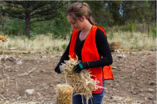
CSU junior Brad Simms gets to work with his shovel in efforts to restore the area around Left Hand Canyon from the floods. Brad is a member of CSU’s Watershed club. (Jenna Van Lone | Collegian)
Humans who rebuild an environment which nature destroyed seems like a backwards scenario.
And yet, dozens of Colorado State University students partnered with the Wildlands Restoration Volunteers Saturday to restore Left Hand Creek, an area devastated by the 2013 Boulder floods.
According to Brad Simms, vice president of the Watershed Club and intern at WRV, the project was made specifically for college students by Luke McNally, the WRV watershed restoration manager. Simms, who had participated in a previous restoration, helped several CSU clubs mobilize their members.
Roughly 60 people attended in total: 17 came from the Environmental Sustainability and Science Club, 10 from the Watershed Club, six from the Fly Fishing Club and several others from CSU and around the community.
Volunteers arrived at 8 a.m. and stayed until 4 p.m. They were divided into five groups with each group taking on a different area of the riverbed and the tasks which came with it.
Eliot Hawkes, a sophomore ecosystem science and sustainability major, spent her morning spreading native seeds and mulch by the downstream bank.
“You feel like you’re getting a good day’s (worth) of hard work in,” Hawkes said. “I’ve wanted to volunteer with the WRV since last spring, and I got an email about it and decided just to sign up over email.”
Kelly Nelson, a member of the Ecosystem Science and Sustainability Club at CSU, drops wood chips to compact the soil near Left Hand Canyon in attempts to restore the land from the floods. The flood restoration event was open to members of the ESS Club, the Watershed Club, the Fly Fishing Club, and the Boulder community on Saturday. (Jenna Van Lone | Collegian)
Natalie McNees, sophomore natural resources management major, signed up independent of any clubs. Her morning consisted of backfilling trenches and pounding down stakes to keep erosion control fabric in place.
“(The riverbank) would just be this dirt pile if we weren’t doing anything,” McNees said. “And, it was fun hitting things with (a) little hammer.”
The September 2013 floods scoured large parts of the riverbanks and caused sediment deposition. According to McNally, floodwaters ripped out riparian vegetation, heightening chances of further erosion.
With funding from the National Resource Conservation Service, the WRV has been rebuilding the Left Hand Creek since February, and they expect to finish by the end of October. Before Saturday, the group focused on river channel reconstruction and realignment.
CSU students participated in the final implementation stage of restoration: revegetation, the laying down of native seed mixes, soil amendments, erosion control blankets and mulch. They also planted a palette of native wood plants such as junipers, alders and cottonwoods among others.
“We have more diversity of native plants on this project than we’ve probably ever had on a project,” McNally said. “We’re really pushing the envelope with Left Hand Creek to make this as biodiverse as possible.”
WRV will return to the site next year to evaluate the effectiveness of the restoration and look for how to improve in the future.
As a CSU alumnus, McNally said he enjoyed seeing so many young people involve themselves in environmental projects, especially students from the Warner College of Natural Resources.
“This work is directly relevant to what they’re going to school for and can help to supplement their education with some field experience,” McNally said.
Even though the Saturday was done through several CSU clubs, students can sign-up for any WRV project they want by going to http://www.wlrv.org.
At the end of the day, Jess Jackman, president of the ESS Club, said she enjoyed the experience.
“I love watching students get engaged in restorations,” Jackman said. “I think it was productive and successful, and I think everyone had a lot of fun as well … We’re proud of our work.”
A winter wonderland in Winter Park, Colorado, near the west portal of the Moffat Tunnel, which delivers water from the Fraser and Williams Fork River basins, under the Continental Divide and on to the Moffat Treatment Plant in Lakewood, Colorado. Photo credit: Denver Water. (Photo taken in winter of 2016-2017.)
The stretch of the Fraser River will be reconfigured to have a narrower, deeper stream channel to improve aquatic life.
Members of Learning By Doing tour the Fraser Flats on Sept. 27, 2016. Photo credit: Denver Water
Fish in the Fraser River have struggled because there was too little water for the riparian area that had been created by natural flows. Segments have now been mechanically manipulated to be more narrow. Photo/Allen Best.
The meadow along the Fraser River, about 70 miles northwest of Denver, with Byers Peak in the background. 2007photo/Allen Best –
Kirk Klancke Erica Stock Fraser River. Photo credit: Bob Berwyn
The plan includes environmental enhancements and protections to ensure the Fraser River will be better off with the Moffat Project than without it.
Fishing the Fraser River
Fraser Colorado
Denver Water’s collection system via the USACE EIS
The Fraser Flats Habitat Project is a cooperative venture conducted by Learning By Doing, an amalgamation of local water stakeholders who several years ago formed a committee in an effort to increase cooperation and decrease litigation between Front Range water diverters, local governments and High Country conservation groups. The Fraser Flats Project is the group’s pilot project, restoring a roughly one-mile section of the Fraser River.
Work on the project, which was conducted on a section of the Fraser River between Fraser and Tabernash, wrapped up in late September and the members of Learning By Doing are, to put it mildly, thrilled with the success of the project.
“We are elated,” said Mely Whiting, legal counsel for Trout Unlimited. “This is amazing. The biomass [in the river] has more than tripled, just from last year, and only in the matter of a couple of weeks since the project was completed.”
Denver Water Environmental Scientist Jessica Alexander explained the intention of the project.
“To start, we wanted to improve the habitat of the river for fish and aquatic insects,” Alexander said. “We saw problems with the way the river channel looked and behaved before the project and we wanted to improve those things, to provide more habitat.”
Alexander went on to explain that the Fraser River channel was too wide and shallow to provide good habitat and resulted in high sedimentation in the river rocks that are essential to development of bug life, which in turn serves as base of the food web within the river. Additionally there was little large vegetation on the river banks at the project site, resulting in river bank erosion and higher stream temperatures due to lack of a shade canopy.
To fix these problems work on the project centered on a few key areas. Project organizers wanted to deepen and narrow the river’s main channel, allowing the water that does flow down the Fraser to flow deeper and faster, helping clear sediment out of river rocks. Additionally they planted roughly 2,500 willows and cottonwoods on the river’s banks, to address erosion and shade concerns.
The project got underway last fall as Learning By Doing secured permits for the project and conducted design work. In May this year about 150 local local and regional volunteers spent two days harvesting and planting willows and cottonwoods along the banks of the Fraser in the project area.
Over the summer and fall contracting firm Freestone Aquatics, specializing in aquatic habitat restoration, conducted the physical work of narrowing and deepening the river channel…
The total cost of the project was roughly $200,000. The cost was broken down between several stakeholders including the Colorado River District, Northern Water, Trout Unlimited, and more. Denver Water pitched in roughly $50,000 and the project received a Fishing is Fun grant from Colorado Parks and Wildlife. Moving forward Learning By Doing is looking at a few different projects in Grand County and is trying to decide which project it will tackle next.
For decades, the Fraser River in Colorado’s Grand County has turned into a trickle every fall as the snowmelt that powers the river dissipates. The low flows have led to warmer water temperatures and less wildlife.
That changed this year, at least along a short stretch of the Fraser. And it’s due to an unusual partnership that includes Denver Water, which diverts most of the river to the Front Range, and Trout Unlimited, which has fought for decades to protect it. The group, dubbed Learning by Doing, focused its efforts on nearly a mile of the river near Tabernash. Work wrapped up on the $200,000 project earlier this fall.
“I had man tears when I saw this for the first time,” said Kirk Klancke, president of the Colorado River Headwaters Chapter of Trout Unlimited. “It was very emotional to see the river look healthier than it has in the 47 years I’ve lived there.”
Now, instead of a wide shallow creek, the low-flow Fraser River drops into a narrow channel that allows to run deeper, faster and colder. That led to a nearly immediate rebound in the fish population, according to a preliminary assessment by Colorado Parks and Wildlife.
“We found about a four-fold increase in trout population,” said Jon Ewert, an aquatic biologist at CPW who surveyed the river both before and after the project was finished. “It was pretty exciting to see that.”
Ewert was cautious not to get too far ahead of his data. He plans to survey the fish population again next year to see if they reproduce like he hopes they will. But he says he’s very encouraged by what he’s seen so far.
Klancke credits cooperation by Denver Water, Trout Unlimited, Grand County and others for this initial success. Before his Trout Unlimited days, Klancke said he was “radical” in his opposition to the diversion of water to the Front Range. He even used to urinate in diversion ditches, he told me last year. He’s since changed his tactics.
“Working with the people who have impacts on your river is far more effective than trying to fight them, or just trying to stop them,” he said.
Frustrated by what they perceive as a failure of existing environmental law, advocates are exploring a new strategy to protect natural resources: asking federal district court to recognize the Colorado River as a person.
Yes, a person — with inalienable rights to “exist, flourish, regenerate, and restoration.”
The Colorado River is seeking the judicial recognition of “legal personhood” in a lawsuit filed Sept. 25 against the governor of Colorado in federal court (the first hearing is scheduled for Nov. 14). A favorable ruling would not only affect Nevada and the six other states with direct ties to the 1,450-mile-long river; it would spark a significant shift in environmental preservation nationwide.
The Community Environmental Legal Defense Fund, a nonprofit public-interest law firm and a leader in the push for “rights of nature,” is adviser on the lawsuit. Executive Director Thomas Linzey says existing environmental laws focus on damage to people and their property.
“Climate change is presenting itself in full force,” Linzey says. “People are beginning to understand that environmental law is falling short. Something new is needed. … This emerging system is about recognizing that ecosystems need to be protected in the plenary sense — not just to benefit humans.”
Individuals from the nonprofit organization Deep Green Resistance have been designated as “next friends” who act as surrogates on behalf of the river. The concept is similar to guardianship in cases involving minors or people considered too mentally incompetent to vocalize their own interests.
Representing the river is Jason Flores-Williams, a civil rights lawyer known in Colorado for filing a class-action lawsuit on behalf of Denver’s homeless population.
Denver’s project to ensure at least some water for fish in a 40-mile urban stretch of the South Platte River — even during the winter low-flow months when people practically drain it — is gaining momentum.
A fundraising goal has been met to buy space in Chatfield Reservoir, southwest of Denver, to store an “environmental pool” of water – about 500 acre-feet (163 million gallons), Denver Water officials confirmed last week.
Starting next year, state aquatic biologists plan to release that water strategically, concentrating on 65 or so low-flow days each year. The South Platte still will be one of the world’s most tightly controlled rivers, unable to be a natural river that meanders through a flood plain moving sediment…
Water releases will begin “after the completion of the Chatfield Reallocation Project,” Denver Water officials said, with the water moving from Chatfield through a Colorado Parks and Wildlife fish hatchery. Fish grown there, including rainbow trout, may be used to stock river pools where fish currently struggle to reproduce on their own.
Storing water at Chatfield, built for flood control but now in the process of “reallocation” for water supply, costs $7,500 per acre-foot (325,851 gallons). Denver Water officials agreed to spend $1.8 million and match 19 contributions made by metro county and municipal governments, the Greenway Foundation and the Walton Family Foundation. “The pledge drive was successful and complete,” Denver Water spokeswoman Stacy Chesney said…
The Colorado Water Conservation Board will serve as the owner of the water held in Chatfield for environmental purposes. Water rights owned by the agricultural Central Colorado Water Conservancy District are being used to create that pool.
Aquatic biologists say that, by putting more water into the river, river managers can mimic natural flows, lost after the channelization of the Platte following a ruinous 1965 flood that destroyed structures built in the floodplain.
FromThe Cañon City Daily Record (Carie Canterbury):
The plan focuses on the whitewater park between First and Fourth streets, which is a small part of the overall Arkansas River Corridor Master Plan, which also meshes with the Centennial Park Master Plan.
The overall goal is river beautification by removing concrete debris and other hazardous materials from the site and then recreational and habitat enhancements, said Nathan Werner, a designer and engineer with S2O Design.
“For recreation, we are creating structures that give the river more character to create more eddies and pools for in-stream users,” he said. “Random boulders and jetties create this recreational enhancement, but they also create fish habitat.”
Right now the river is largely just uniform with not a lot of velocity breaks, Werner said, so designers are creating a more diverse river.
The estimated cost of this multi-user, multi-use project is about $700,000, half of which is expected to be funded through a Great Outdoors Colorado grant, said Will Colon, who spearheaded the fundraising and creation of the Whitewater Kayak & Recreation Park. The park, built at a cost of about $450,000, also includes a feature near Black Bridge. The annual Royal Gorge Whitewater Festival since 2010 helps to fund improvements on the river…
Construction is expected to begin in the fall and winter of 2018, making the area usable in the spring of 2019.
Click here to read the newsletter. Here’s an excerpt:
Webinar: Aquatic Nuisance Species, the Threat and Solutions Oct. 24
From 12-1 p.m. on Oct. 24, the Colorado Water Congress and Colorado Foundation for Water Education are partnering to host a webinar on the threat of aquatic nuisance species, specifically zebra and quagga mussels, to our waterways and delivery systems in Colorado. Join us for this free offering to hear about the threats these invasive mussels pose and how Colorado is working to educate the public and our policy makers so we can maintain healthy waterways and infrastructure.
Speakers:
Mike Preston, Dolores Water Conservancy District
Ken Curtis, Dolores Water Conservancy District
Doug Vilsack, Colorado Parks and Wildlife
Doug Krieger, Colorado Department of Natural Resources
Registration is FREE! Register here.
From the SummitDaily (Jack Queen) via The Aspen Times:
[Larry] Hjermstad and his company, Western Weather Consultants, now run cloud seeding programs across the state, including in Summit County.
For decades, local ski areas have paid him to send plumes of silver iodide up to their slopes when opportune storms approach, squeezing out a couple of extra inches of snow each time.
In recent years, however, water managers on the Front Range and even states further down the Colorado River have started to pitch in some of the $250,000 to $300,000 it costs to run the program in the Summit County area, hoping the extra snow will flow into their water system when it melts.
Here, in the Central Colorado Mountains River Basin, the company operates about 36 cloud seeding generators. They’re small, almost homebrew-looking devices that burn a solution of inert silver iodide and send it into the atmosphere.
Some of the generators are on private land, and when Western Weather Consultants detects an optimal storm coming, it sends instructions to the landowners to fire them up. It varies, but Hjermstad says the process can boost snowfall by as much as 25 percent…
SNAKE OIL OR SCIENCE?
The concept of cloud seeding has been around since the 1940s, when Bernard Vonnegut (brother of author Kurt) discovered that silver iodide could produce ice crystals when introduced into cloud chambers.
In those heady days, cloud seeding was heralded as a way to produce rain where there was none, boosting crop yields and filling reservoirs to the brim.
That was a wild overstatement, and cloud seeding’s reputation suffered for it…
Studies in Australia and Israel have debunked the idea that airplanes spewing silver iodide willy-nilly will do much of anything. But a targeted approach that hits the right clouds at the right time high in the mountains has gained scientific currency in recent years.
Russ Schumacher, Associate Professor of Atmospheric Science, Director of the Climate Center and Colorado State Climatologist, Colorado State University, October 6, 2017
Here’s the release from Colorado State University (Anne Manning):
Most of Russ Schumacher’s atmospheric science research career has centered on weather extremes: heavy rain, flash floods, snowstorms and the like.
This knowledge and experience makes Schumacher a perfect fit for the job of Colorado State Climatologist. Take the flood of 2013, the Windsor tornado of 2008, or the perpetual threat of drought and wildfire in summer months.
An associate professor in the Department of Atmospheric Science at Colorado State University, Schumacher became Colorado State Climatologist Oct. 6. He’ll continue in his academic role while taking on the added, vast responsibility of key statewide climate expert and spokesperson.
“Part of our mission is to help people understand what sort of extreme weather we need to prepare for and be cognizant of here in Colorado – which of course varies hugely from one part of the state to the other,” Schumacher said. “Yet the majority of our work deals with day-to-day aspects of measuring and understanding our state’s unique weather and climate, from normals to extremes.”
As State Climatologist, Schumacher will lead the Colorado Climate Center, the CSU-based office that provides climate monitoring and research for the benefit of scientists, educators and the general public. The center’s long list of activities includes drought monitoring for the National Integrated Drought Information System; operation of the Colorado Agricultural Meteorological Network; and administration of the Community Collaborative Rain, Hail and Snow Network.
Filling big shoes
Schumacher succeeds Nolan Doesken, who has served as Colorado State Climatologist since 2006 and as assistant state climatologist for close to three decades prior. Schumacher says “it will never be possible to fill the shoes of my predecessor,” who built up the visibility of the Colorado Climate Center and created a vast network of stakeholders – from farmers to government officials to meteorologists.
What Schumacher brings to his new position is an extensive research background, teaching prowess, and intimate familiarity with Colorado’s climate.
Coming from the academic side of weather and climate, Schumacher hopes his dual role can forge stronger connections between the Department of Atmospheric Science – his academic home – and the activities of the climate center. That might include more integration of department graduate students with climate center outreach and research, for example.
Established roots
Schumacher’s CSU and Colorado roots are well established. He first came to Colorado as a graduate student in the Department of Atmospheric Science in Fall 2001, completing his M.S. in 2003 and Ph.D. in 2008. He became a faculty member in 2011 following a postdoctoral stint at the National Center for Atmospheric Research in Boulder, and two years as an assistant professor at Texas A&M.
Schumacher received a National Science Foundation CAREER award in 2010, and he is editor of the American Meteorological Society’s Monthly Weather Review. His research is in mesoscale meteorology; mesoscale convective systems; weather analysis and forecasting; climatology of precipitation; precipitation extremes; flash floods; and societal impacts of weather.
Schumacher’s expertise matches his enthusiasm for the weird, wacky world of Colorado weather.
“The weather and climate of Colorado is fascinating, it’s diverse – and it’s hard to understand sometimes,” he said.
Last week in Keystone, a modern-day prophet on climate change addressed a room of several hundred High Country residents as they chomped away at their breakfasts, daring each of them to accept a simple challenge.
“I’m asking you to save civilization,” he said unabashedly. “You’re being asked to do a major thing and your response should be, ‘Oooh, I don’t know if I’m your person, I can barely wake up in the morning.’ But the truth is history is replete with people of no power at all who have done incredible things.”
The directive seemed straightforward enough to Auden Schendler, who is regarded by many as an oracle on the future of outdoor-centric life and sustaining human existence as we know it, but it was perhaps not the lesson attendees might have expected over their buffet bacon and eggs. However, if maintaining the mountain lifestyles they’ve come to enjoy is important, he said, the time to act is now.
“There’s risk in not taking action vocally on climate,” said Aspen Skiing Co.’s vice president of sustainability. “There’s opportunity in moving (on it), and we can solve this problem.”
Schendler, also the chair of the activist group Protect Our Winters, was the keynote for the annual winter season kickoff and he took the opportunity to present a grim yet optimistic portrayal of the ski industry’s prospects if they don’t collectively work to combat the warming of our globe. Efficiency-minded activities like swapping out light bulbs, no matter the scope, aren’t going to do it alone.
Send us your best pictures of your favorite river!
Second Runner Up, 2016 Celebrating Rivers Contest Grace Carberry, Watching the River – Platte River
Our second annual “Celebrating Rivers” photo contest is underway!
Last year, we announced our first annual photo contest in celebration of our 15th anniversary. We were thrilled to see over 70 photos, including the second-runner up winner above, from Grace Carberry. Grace is a junior high student in the Denver metro area who works on river restoration projects on the Platte River, and her affection for “her river” is seen in her photo above.
We’re lucky to have generous and loyal friends, like Peter McBride and Down River Equipment, who have offered prizes for our contest winners and finalists. Our grand-prize and runner-up winners will receive a free ticket each to our annual fundraising event, RiverBank, in June 2018, gear from Down River, and this gorgeous hard-copy book, “The Colorado River, Flowing Through Conflict,” featuring two award-winning National Geographic contributors, photographer Peter McBride, and writer Jonathan Waterman. All this and bragging rights? Get your entries in!
The Colorado River: Flowing Through Conflict — McBride/Waterman
So don’t delay! Submit your entries via email with the subject line “Photo Contest Entry” by next Friday, October 20, to Missy Yoder at myoder@coloradowatertrust.org.
We can’t wait to see your favorite spots on your favorite rivers.
Mountain Studies Institute and Southwest Conservation Corps continue to wage war against the Russian olive, an invasive species that chokes out native trees and degrades the quality of the watershed.
Last year, MSI was awarded a $195,000 grant from the Colorado Water Conservation Board and an additional $52,000 from Colorado Parks and Wildlife for a three-year Russian olive-removal project.
Removal efforts continued Saturday morning at Animas Valley Elementary and Christ the King Lutheran Church with two saw crews from SCC, and help from Durango Daybreak Rotary Club.
MSI’s Amanda Kuenzi said the project specifically targets Russian olive trees on private land…
Originally introduced for ornamental landscaping, the plants are native to East Asia and Russia, and consume nearly 75 gallons of water per day.
They are considered a “List B noxious weed,” which requires local governments to manage their spread under Colorado state law…
“Russian olive reduce wildlife habitat, interfere with nutrient cycling and outcompete native species,” Kuenzi said. “The wetlands have been deteriorating in the West because of irrigation practices and water storage. We have to protect these important ecosystems.”
She said crews will be working on removal efforts through mid-November with about 60 private landowners throughout the Animas River Valley.
On Saturday, the Rotary Club collected wood from the removal effort for its firewood-distribution project.
Storm drain and open channel improvements between the East Rail Line (38th & Blake Station) and the South Platte River (Globeville Landing Outfall), Stormwater detention/conveyance between the East Rail Line (38th & Blake Station) and Colorado Blvd, (Montclair Basin) Stormwater detention/ conveyance immediately east of Colorado Blvd. (Park Hill Basin).
The $270 million project is part of a proposal to improve drainage and prevent catastrophic flooding to neighborhoods north of the park.
“Water goes where it wants to go and it wants to go here,” said Denver Department of Public Works communications manager Nancy Kuhn.
Kuhn was one of several city employees at the City Park Golf Course clubhouse Saturday for an informational session on the project.
It was the final one before the course closes on Oct. 31 until 2019.
“[This project] will greatly minimize the flooding potential to the homes to the north of here,” said Denver Director of Golf Scott Rethlake.
The project has been in the works for two years. The city says the course is the largest basin in Denver without a natural waterway. It means most of the area’s rain water trickles into it, where it pools and floods.
The plan would cut 261 trees on the course to make room for the ditches, but it would also replant nearly 750 more to make up for the lost canopy in 10 years.
The city would also relocate the club house and driving range, increasing the yardage from 240 to 320, which would allow for drivers, a club that can’t be used on the current driving range…
Eight people are suing the city over this project. A ruling hasn’t been made by the judge but the attorney on the case, Aaron Goldhamer says they are meeting with the judge for an update on Oct. 26.
Ouray Silver Mines wants to reopen a mine that produces silver, gold, lead and copper and would bring 152 jobs to Ouray County, along with, its proponents say, a 10 to 20 percent boost to the county’s tax base.
But that mine is on hold, due to issues with water quality at a nearby creek tied to the mine that the mine owners say they have worked on for 18 months without any concerns raised by CDPHE until now.
Sneffels Creek, the surface water source near the mine, is about halfway between Ouray and Telluride, as the crow flies. The creek has a long history with mining, going back 140 years.
The mine dates back to 1876 and ran until its mill burned down in 1912. During its early operations, the mine produced 25 million ounces of silver.
Sneffels Creek joins up with another creek and then into Canyon Creek downstream, and then into the Uncompahgre River. Briana Greer, an environmental consultant with Ouray Silver Mines, said when the water originating in Sneffels Creek reaches the Uncompahgre, water quality in that river improves by 50 percent. It’s better water quality than area drinking water, she told the committee.
The idea of starting the mine back up for its silver, gold, zinc and copper began in the 1980s. The mine passed through numerous hands until 2014, when Fortune Minerals of Canada bought it hoping to mine its silver veins. But the company couldn’t sustain production and defaulted on its loans. The chief investor, Lascaux Resource Capital of New York, took over the mine and renamed it Ouray Silver Mines.
Mine CEO Brian Briggs told the General Assembly’s interim Water Resources Review Committee Wednesday that the company has invested $70.5 million to get the mine up and running, and it will take another $36 million to get up to full production. The payoff? Fourteen million ounces of silver, which costs $7.89 per ounce to mine and can bring in about $17 per ounce on the market. The mine also has rich veins of gold, lead and zinc, and the company expects a net a profit of around $76 million, along with 152 well-paying jobs for experienced miners, according to Briggs.
A fifth-generation Ouray native, Briggs has several decades experience in mining, called Ouray “a very, very good mine, the best I’ve every worked on for economic results.”
Ouray County could benefit more than just how the mine will improve its tax base. Briggs explained that Ouray has no gravel pits or other sources for road base. So mine tailings and waste rock, which metallurgical tests show are “benign,” are ground up by the company and provided to the county for road base.
Starting up an old mine has not been without its problems. According to a chart from the company, lead, zinc and cadmium discharges briefly exceeded state standards in 2014, leading to a violation notice last year from CDPHE. Lead discharges exceeded the standards again this past summer due to the failure of a lining in a mine tunnel that is being replaced.
Then there’s the water quality issue, and that’s delaying the mine’s startup.
The mine’s previous owner had a permit to discharge water to Sneffels Creek. The new owners set up a passive water system that could discharge either to surface or to groundwater (underground) water sources.
Briggs explained to the committee that the passive system is not only one for today’s mining but for 50 or 60 years from now. Briggs said the system, which has been piloted in Wyoming, for example, should prevent the kinds of problems that happened at the old Gold King Mine near Durango two years ago, when contractors for the Environmental Protection Agency accidentally released more than a million gallons of toxic mine waste into the Animas River.
In the mine’s passive system, used mining water is passed through a clay liner that contains fabric with peat moss to absorb metals and then a layer of topsoil. “It makes a tremendous impact on the three metals we’re concerned about: cadmium, lead and zinc,” Briggs said.
The hangup has been just who’s in charge of making sure the system is in compliance at the CDPHE. Briggs said the mine had provided quarterly updates, explaining the passive system, to CDPHE’s enforcement division. In November 2016, the mine owners applied for a termination of its surface water discharge permit, believing it was no longer necessary since the passive system was discharging its water into underground water sources.
In July, CDPHE denied the request, stating the surface water interacts with groundwater sources. “We can’t confirm” whether that’s true, Briggs said.
That left the owners in a pickle – tear up the previous system? Install a new one? “If they want us to discharge into surface water we’ll do that,” Briggs said. But he also appeared to be frustrated that after 18 months of telling CDPHE what they were doing that the agency came back and said that system doesn’t work.
Installing another system will take another year, Briggs said.
The story from CDPHE is a tad different. In a September 3 letter to Sen. Don Coram, R-Montrose, CDPHE’s Karin McGowan said the mine had an active permit for a surface water discharge. “They are not waiting for a new permit, but may be frustrated because they have not been able to successfully modify their permit because they have not provided the necessary information needed to execute a modification. We are currently working with them to get the necessary information needed,” McGowan wrote.
McGowan further added that the mine changed its manner of discharge, from surface to groundwater, without notifying the division.
The September, 2016 notice of violation was for discharging to a new location without a permit, effluent violations, and administrative violations, McGowan pointed out. “The facility has consistently failed whole effluent toxicity testing permit requirements,” she wrote. The 2016 notice pertains to a 2014 discharge, when the mine was owned by Fortune Minerals, in which water contaminated with lead, cadmium and zinc was dumped at a rate of 400 gallons per minute into Sneffels Creek for about 18 hours.
Briggs told the committee CDPHE has never even visited the site, despite numerous requests by the mine owners…
In a statement, CDPHE spokesman Mark Salley told Colorado Politics that most enforcement is completed through evaluations of self-reported data. “Resource limitations makes it impossible to visit every site on an annual basis and hence permittees are put on a schedule for inspection,” he said.
…when Lower South Platte Water Conservancy District Manager Joe Frank reviewed them for his board of directors at the board’s October meeting, there was much shaking of heads and rolling of eyes.
The first draft document, identified only as Bill 9, would attempt to address rising water tables in a couple of places on the South Platte River, and in at least one area that would mean allowing un-augmented irrigation pumping to lower the artificially high water table.
The draft legislation was triggered by a series of reports by the Colorado Department of Natural Resources on high water tables in the town of Gilcrest, south of Greeley on U.S. 85, and the Sterling area subdivision of Pawnee Ridge…
the Colorado Legislature’s Water Resources Review Committee was not. In September the WRRC drafted a bill, tentatively labeled Bill 9, that requires owners of “artificial recharge facilities” (ie. augmentation ponds) in District 2 of Water Division 1 to install monitoring wells; if their groundwater comes up within 10 feet of the surface, they have to stop augmenting, notify the state engineer’s office, and continue pumping until the water table goes down.
Water Division 1 is simply the South Platte River watershed; District 2 is an area directly north of Denver that includes Gilcrest.
Here on the lower reaches of the river, in District 64, there are two reasons that bill could cause a whole lot of trouble.
First, and most obviously, there isn’t sufficient data yet to make such a sweeping requirement of every irrigator in District 2. Bob Mari, a member of the LSPWCD, said during the board’s meeting on Tuesday that it’s a typical one-size-fits-all solution that doesn’t need to be applied so broadly.
“You’ve got just a few sections of land where there’s a high water problem, but (legislators) want a statewide law to address the problem in that one spot,” Mari said. There was almost unanimous head nodding around the table when Mari made his remarks.
The second problem, according to Frank, is that allowing un-augmented pumping is simply not legal and would almost certainly harm downstream water users.
“Don’t get me wrong, we are very sympathetic to the problem, and we know it has to be addressed,” Frank said. “But it has been proven in the past that any pumping that goes un-replaced does cause harm. Even legislation that allows (un-augmented pumping) goes against legally binding water decrees. Taking water out (of the river aquifer) and putting it on crops without replacing it and putting it on crops is taking water that would have ended up back in the stream. Since they’re upstream from us, that creates a domino effect that affects us.”
State Sen. Jerry Sonnenberg, who chairs the WRRC, said the committee wanted to address the situation legislatively because, frankly, the $11 million solution just doesn’t make sense. He pointed out that the draft bill, which still needs some work, applies only in the district where the most severe problem exists. He said the committee believed the augmentation forgiveness shows promise, but needs some improvement.
“The idea was to try to figure out how to deal with high groundwater rather than pumping the water into the river from a dewatering well,” he said. “I don’t think it makes sense to dewater when they’re augmenting. Let’s consolidate the augmentation, move it closer to the river so we can control it better.”
Thus, the second document Frank shared with his board at that meeting, a bill draft tentatively called “Bill 10,” which directs the CWCB to engage “a qualified engineering consultant” to answer those questions and others. The bill tentatively directs that a report on the scope and goals of the study be delivered to the CWCB by Aug. 31, 2018, that a five-year pilot project be designed and begun by April 2019, and that the pilot project end by June 30, 2024.
Frank is hopeful that the study will identify ways other than un-augmented pumping, and he ticked off a list of ideas including improving surface drainage, cleaning out barrow ditches, finding new supplies for augmentation sources, tile drains in the area that move the water to the river, and moisture monitoring to avoid over-irrigating.
“Unfortunately, everyone points to that one solution, which is pumping un-augmented,” he said. “For us, that’s just not a solution.”
The task of a climate forecaster is to see the forest, and not get hung up on the individual trees. Especially that extra tall one over there, with the gnarl that looks like a face, and the low branches that would be so easy to climb, and… uh, right. My point is that we try to look beyond shorter-term weather to see longer-term monthly and seasonal patterns. After all, a particular winter can have several colder-than-average days and still be warmer than average overall.
Which brings me to the current situation in the tropical Pacific! The October ENSO forecast says La Niña conditions are favored during the fall and winter 2017-18, but at press time the ocean-atmosphere system didn’t quite meet the criteria for a La Niña Advisory. Specifically, while the atmosphere is generally consistent with La Niña, the sea surface temperature in the Niño3.4 region has been volatile, recently edging up close to average following several weeks near or below the La Niña threshold (0.5°C colder than average).
Animation showing sea surface temperature departure from the 1981-2010 average from early August through early October 2017. Graphic by climate.gov; data from NOAA’s Environmental Visualization Lab.
Is the overall pattern truly La Niña, with some short-term fluctuations temporarily obscuring the pattern? Or has the atmosphere-ocean system really not settled down into a consistent pattern at all? The difference between these two scenarios is subtle, and the ENSO forecast team is maintaining the La Niña Watch as we wait for a clearer picture. The forecast is for that picture to become clearer soon, with La Niña conditions 55-65% likely during this fall and winter.
The devil’s in the details
The average wind and cloud pattern over the equatorial Pacific during September looked a fair bit like what we’d expect during La Niña, including stronger near-surface east-to-west winds and upper-level west-to-east winds over the western tropical Pacific. The pattern of greater-than-average clouds and rain over Indonesia and less over the central Pacific is also typical during La Niña. The Southern Oscillation Index and Equatorial Southern Oscillation Index were both weakly positive during September, another indicator of a stronger-than-average Walker Circulation.
Places that were more (purple) or less (orange) cloudy than the 1981-2010 average during September 2017, based on satellite observations of outgoing longwave radiation (heat). Thick clouds block heat from radiating out to space, so less radiation = more clouds, and more radiation = clearer skies. Climate.gov map from CPC data.
All those atmospheric bits sound like La Niña. But the first criteria for La Niña is a monthly average Niño3.4 index more than half a degree below the long-term average. Which we had! The September Niño3.4 average sea surface temperature anomaly (departure from long-term average) was -0.5°C. For NOAA to declare La Niña, though, we need the expectation that it will stay there for five overlapping 3-month periods.
Instead, we saw the surface temperatures warm substantially over the last half of September. The warming wasn’t enough to wipe out the whole-month cool anomaly, but it was enough to undermine—at least a little—forecasters’ confidence that the pattern is solidly established and will last for the required five overlapping seasons. So…no La Niña yet.
Diagnosing exactly why the surface temperatures warmed over a few weeks is difficult. One possibility is the tropical instability waves that have been active in the east-central tropical Pacific over the past month. These waves can mix warmer surrounding water into the cooler waters right along the equator and cause sea surface temperatures in the Niño3.4 region to rise.
It seems likely that the surface waters will tend cooler again, as those stronger-than-average surface winds I mentioned above work to cool the surface and keep the warmest Pacific waters trapped in the far western Pacific. Also, we still have a substantial amount of cooler-than-average water below the surface. The cool subsurface waters increased during September, and will likely provide a source of cooler waters to the surface over the next few months.
The dynamical computer models are not very clear on which way sea surface temperatures will go for the next month or so. As you can see here, there is a very large range of potential outcomes for October, including well above and below the La Niña threshold. However, the models are more consistent after October, predicting that the most likely outcome for the late fall and early winter is sea surface temperatures below the threshold for La Niña.
Climate model forecasts for the Niño3.4 index, from the North American Multi-Model Ensemble (NMME). Darker purple envelope shows the range of 68% of all model forecasts; lighter purple shows the range of 95% of all model forecasts. NOAA Climate.gov image from CPC data.
Usually, we wouldn’t focus that much on a short-term change in one of the physical signs we monitor. (For example, we’ve cautioned our readers against using a single weekly anomaly to conclude that the El Niño of 2015-16 was the Most Powerful Ever.) But the sea surface temperature anomaly is essential to the ocean-atmosphere system that is ENSO. If it doesn’t return to cooler-than-average territory soon, it could leave the whole system looking more like a bunch of random trees than a forest… that is, more like random climate variability than La Niña.
If that favored La Niña develops…
Fun fact time! My blog-brother Tom has spent a lot of time studying the historical record of ENSO. He discovered that if La Niña develops this year, it will be the only La Niña on record where the Niño3.4 sea surface anomaly increased for several months, nearing the El Niño threshold, before diving into La Niña territory. Said another way, all the other 21 La Niña events followed a steady decline from warmer-than-average or followed consistently below-average sea surface temperatures. This year would follow cooler, then warmer, then cooler again sea surface conditions.
Monthly sea surface temperature in the Niño 3.4 region of the tropical Pacific compared to the long-term average for all years when La Niña developed, showing how 2017 (purple line) compares to other events. Climate.gov graph based on ERSSTv5 temperature data.
That’s kind of interesting, but would it be significant in some way? Maybe. Or maybe Tom should get a new hobby…
Images: Natascha Seideneck, Uncanny Territory, 2017; Cannupa Hanska Luger, We Have Agency VII, 2016; Anna McKee, WAIS Reliquary: 68,000 Years (detail), 2016, image by Joe Rudko.
I had the time today to tour Water Line: A Creative Exchange at the Metropolitan State University of Denver Center for Visual Art. Make some time to go see the artwork if you haven’t already. The exhibit closes next Saturday.
Xcel Energy proposes to close two of its coal-fired generating units at Comanche, indicated by smokestacks at right. The stack at left, for the plant completed in 2010, provides energy for a portion of Aspen and for the Roaring Fork and Eagle valleys. In the foreground is the largest solar farm east of the Rocky Mountains at its opening. Photo/Allen Best
Xcel decision fortifies calls for 100 percent renewables
The Sierra Club has been pushing Durango to commit to 100 percent locally produced and renewable electricity by 2050.
The argument of petitioners, reports the Durango Herald, is that in addition to cutting carbon emissions, the local, renewable energy would create local jobs and stabilize energy rates as the cost of fossil fuels continues to rise.
The petition in Durango fits in with a broad pattern across the country of calls for municipalities to embrace goals of 100 percent renewables during the next few decades. In Utah, for example, Salt Lake City, Moab, and Park City have all embraced that goal. In Colorado, so have the Front Range communities of Fort Collins, Boulder, and Pueblo.
That goal no longer seems so far-fetched. Major, investor-owned utilities have been rapidly investing in renewables not because they have to, but because of tumbling prices for wind, but also solar. Cost of utility-scale storage has also started sliding.
Last week, Colorado’s largest utility, Public Service Co., a subsidiary of Xcel Energy, announced that it would seek approval of state regulators to retire two coal-fired generating plants at Pueblo, which began operations in 1972 and 1974. The retirements, if approved by the Colorado Public Utilities Commission, will mean Comanche I and II will be retired a decade earlier than previously scheduled.
Xcel wants to replace the lost power with some natural gas-fired electricity but mostly with renewables, with up to 1,000 megawatts of wind and 700 megawatts of solar. It wants to move fast, too, to take advantage of federal tax credits that are scheduled to expire in 2020.
Cost to consumers will stay the same or more likely go down, explained David Eves, the utility’s president of Colorado operations. Reduced greenhouse gas emissions are a bonus.
After the switch, Xcel expects its will be at 55 percent in carbon-free generation. This year, it will be completing conversion of a coal-fired power plant in Denver to natural gas. It had also converted a plant in Boulder last year.
Xcel delivers power to Colorado’s Summit County, where Breckenridge elected officials recently heard from a local group that wanted a commitment to 100 percent renewables, first in city operations and then a few years later in the community at large. Town officials weren’t ready to commit, lacking a clear path to achieve these goals. This was a week before the Xcel announcement.
Mark Truckey, a town planner in Breckenridge who is a member of the local 100 percent group, called the Xcel announcement “huge.”
“This has to speak volumes about how the cost is coming down,” he said. Yet he concedes it’s not exactly clear how Breckenridge can achieve what his group advocates.
In Utah, it’s the same story. Rocky Mountain Power last week reached a deal with solar advocates about a transition. The utility, which serves Park City, has a plan for adding more wind generation from southern Wyoming and upwards of 1,000 megawatts —the equivalent of a giant coal-fired power plant—in solar generation from Utah.
It used to be that renewables came with a price premium. As the Xcel and Rocky Mountain Power cases illustrate, that has changed. Aspen also proves the case.
Aspen gets more than half of its electricity from wind turbines just north of I-80 in the Nebraska panhandle. Photo credit The Mountain Town News.
Aspen Electric was an early adopter. The utility serves half to two-thirds of Aspen. More than a decade ago it invested in two wind turbines in Nebraska. It has also invested heavily in hydroelectric. As a municipality, it is also eligible for electricity from the giant dams of the West.
Several years ago it was able to achieve 100 percent renewables. Despite the renewables—or maybe because of them—residential customers in Aspen pay 20 percent less per kilowatt-hour than co-op members such as those serving Durango.
The rest of Aspen, including the ski area, gets its electricity from Holy Cross Energy. If moving briskly toward renewables, Holy Cross still gets a substantial amount of its electricity from another coal-fired power plant at Pueblo. Although news as of 2010, it increasingly looks archaic.
Solar panels have become abundant on rooftops. Even so, solar delivered just 2 percent of Colorado’s electricity in 2016. Solar energy proponents expect that will change. Costs of panels have declined 64 percent in the last five years, points out the Summit Daily News, citing the Colorado Solar Energy Industry Association. Too, utilities like Xcel, Rocky Mountain Power, and Tri-State Generation and Transmission are increasingly investing in giant farms of solar panels.
Tri-State provides electricity for the co-operatives that serve the Colorado mountain towns of Winter Park, Grand Lake, Crested Butte, and Telluride. The power for Durango also comes from Tri-State through La Plata Electric Association.
Last year, 53 percent of Tri-State’s electricity came from coal, although 27 percent came from renewables, and more is coming on line all the time, says Lee Boughey, spokesman. He points to 75 megawatts of wind generation from southeastern Colorado that will go on-line later this year.
About 4 percent of Durango’s power comes from local renewable sources, but a major solar plant on the Southern Ute reservation has also been added, reports the Durango Telegraph.
Volunteers help to construct the solar system at a low-income, rental-housing subdivision in La Plata County. Photo/LPEA
Can Durango get to 100 percent renewables, as the Sierra Club petition seeks? La Plata hasn’t said no, although there are many challenges. Most illuminating is a white paper from the co-op’s chief executive, Mike Dreyspring. The paper describes the evolution of markets that will allow slow-cost electrons from renewable sources to be moved around the grid to match demands. That other changes are poised to disrupt old business models—including the centralized power generation of the last half of the 20th century.
Locally produced power, called distributed generation, “shifts the balance sheet risk from owners of central station bulk power generation assets to DG owners,” the paper says. “The traditional, vertically integrated electric utilities that adapt to this changing market place will financially thrive.”
Another way of saying this is that yes, the train is out of the station. It’s just a matter of accommodating the new renewables. Whether 100 percent renewables is possible is a discussion for another day.
Might less Gore be more in north-central Colorado? That’s the proposal from Summit County, where part of the county line is defined by the range of 13,000-foot peaks. It’s called the Gore Range.
There’s a Gore Creek that flows through Vail and then farther north, a Gore Canyon, where the Colorado River thrashes its way through the range, the steepest three or four miles of descent in the river’s 1,450 mile journey. There’s also a crossing, Gore Pass, and a brass plaque is affixed to a granite boulder remembers an Irish baronet after whom all these Gores are named.
The baronet, Sir St. George Gore, traveled to the United States in 1854 and hired Jim Bridger, the famous mountain man and guide, to show him the sights and lead him to rich hunting grounds.
It was an extravagant expedition. His entourage included a valet, an expert at tying flies, a dog-handler, 20 greyhounds and foxhounds, 100 horses, 20 yoke of oxen, and 4 Conestoga wagons, each pulled by 6 mules.
Jeff Mitton, a professor at the University of Colorado, in a 2010 op-ed in the Vail Daily, further noted that Gore had an arsenal of 75 rifles, a dozens shotguns and many pistols.
There were also abundant creature comforts: a carpet, a brass bedstead, a carved marble washstand, and a big bathtub. There were also enough men, 40 altogether, to create the hot water needed to make a bath in the wilderness, a luxury.
If Lord Gore, as he was remembered colloquially, suffered few wilderness discomforts, he caused great pain to the wildlife that came within range of his armory during his three years in the West. He claimed to have killed 2,000 bison, 1,600 deer and elk, and 105 bears.
In his first summer, he ventured as far as today’s Kremmling, but then spent the next two years in Wyoming, Montana and the Dakotas before returning across the Atlantic Ocean.
Shouldn’t this princely geography be named for somebody more deserving? Or maybe something altogether, perhaps a name given it by the Utes who lived there?
(Although it should be noted that when John Fremont traveled through the Blue River Valley in June 1844, he saw much evidence of Arapahoe Indians, too, and a few miles away, in South Park, turned down an invitation from the Utes to join in a battle with the Arapahoes).
Mitton, in his 2010 op-ed, proposed keeping the same name—but to honor a different Gore, as in the former U.S. vice president named Al, a Nobel Peace Prize winner for his efforts to heighten public awareness about climate change.
“All that we have to do is to mountain a new plaque on the granite boulder on Gore Pass,” he said.
Now comes the efforts of Summit County resident Leon Joseph Littlebird, who has persuaded county officials to take up the cause.
“It’s one of the most beautiful and spectacular areas we have,” Littlebird recently told the Summit Daily News. “Considering Lord Gore was a pretty bad dude —the stories are really horrible, really scary —it would be great to see it recognized as what it really is, instead of for a guy like that.”
Summit County has adopted a resolution seeking a name change. It has received support from the Friends of the Eagles Nest Wilderness, a local group, and the Colorado Mountain Club. A meeting was planned for Monday night to take public input, including ideas on what the range should be named.
The final arbiter in such matters is the U.S. Board of Geographic Names, an agency nested within the U.S. Geological Survey. John Wesley Powell was second director of that agency, from 1891 to 1894. His name lingers on Mt. Powell, which is the range’s highest peak, at 13,586 feet.
From the Associated Press via The Fort Collins Coloradoan:
The rugged mountain underbite in Summit and Eagle counties known as the Gore Range has drawn people to the area for generations, but soon the distinctive 60-mile run of peaks could have a different moniker.
Like Gore Pass, Gore Creek and many other regional spinoffs, the craggy reach — which also touches parts of Grand and Routt counties — is named for a 19th century Irish aristocrat named Lord St. George Gore. Of course, the peaks existed for millennia ahead of the baronet’s first steps on American soil for a hunting expedition in the 1850s.
For roughly 10,000 years and before formal government removal to a Utah reservation in 1879, the Ute tribe, who called themselves the Nuntzi, resided in the valley they referred to as Naa Ohn Kara. Loosely translated, the term means “where blue water meets the sky,” and may have even been the origin of the Blue River’s name.
The native Ute spoke of the Rockies as the Shining Mountains, and if a local group gets its way that’s what they intend to re-label the local range. Summit’s Board of County Commissioners formally supported the change through a recent resolution, and the campaign is gaining steam.
“I am amazed how few people know anything about Lord Gore,” said Commissioner Karn Stiegelmeier. “It’s universal in any writing that he was despised by the time he left. He was disdained by all parties, including the natives, the U.S. Cavalry and the mountain men.”
Al Gore at a Climate Reality Leadership Corps training.
This revegetation project uses log cribbing to hold the bank of Gore Creek in place while the plants get established. The logs will slowly decay. Photo credit Jack Affleck via The Mountain Town News.
Riparian areas were crowded or completely eliminated as the town was developed. In this, Vail is hardly alone. Photo by Jack Affleck via The Mountain Town News.
Streets and other artificial impervious areas result in rapid runoff of pollutants into the creek. Photo via The Mountain Town News and Jack Affleck.
Gore Creek is healthy as it emerges from the Eagles Nest Wilderness Area, but has problems soon after, via The Mountain Town News. All photos by Jack Affleck.
Snow-dusted Gore Range in Colorado, photographed from the air.
Kayaking Gore Creek via Vail Recreation
Gore Creek through Vail golf course summer 2002
Big snows coated the Gore Range in March 2014. bberwyn photo.
The Colorado Ag Water Alliance is hosting its Ag Water Summit on December 5th in Loveland, Colorado at The Ranch-Larimer County Fairgrounds. We want to encourage water professionals, conservationists, public officials, and the general public to learn about the importance and role of irrigated agriculture in Colorado. Come listen to farmers, ranchers, and agricultural professionals across the state talk about the story of “Ag and Water in Colorado.”
We are planning an exciting event this year and want to have a constructive dialogue about agricultural water issues.