Water leaders from the seven states that make up the Colorado River basin are one step closer to finalizing a drought contingency plan. Representatives from Colorado, Wyoming, Utah, New Mexico, Nevada, California and Arizona met in Phoenix Tuesday to sign a letter to Congress asking for federal approval of the plan.
Recent heavy snows in the southern Rockies have relieved some short-term pressure on the region’s water supplies. If dry conditions in the southwest return in the next six years, the plan would force Arizona, Nevada, California and Mexico to cut back the amount each takes from the overallocated river system.
If snowpack remains high the next few years the plans might never be used.
“Today is a very important day in the history of the Colorado River,” said U.S. Bureau of Reclamation commissioner Brenda Burman, who for more than a year has pressured state water managers to agree on voluntary cutbacks. “Today the seven basin states have come to an agreement and signed together a letter to Congress memorializing that agreement. The intrastate drought contingency plans are done. They are complete.”
In the letter, water leaders from throughout the basin say they want to execute the drought contingency plan no later than April 22, 2019.
In declaring the plans done, Burman also decided to rescind her call to Colorado River basin state governors for input to craft a federal plan should the states fail to coalesce.
The plan has been cobbled together through a series of agreements over the last five months among the states that make up the Colorado River watershed. Nevada first approved its portion of the plan in November 2018. Colorado, Wyoming, Utah and New Mexico followed suit in December. Starting Jan. 31, 2019 California and Arizona failed to meet a series of federal deadlines while the two states attempted to calm warring intrastate factions.
In Phoenix, water officials attempted to provide closure to the drought contingency plan process, while acknowledging big hurdles remain, including projected climate impacts to snowpack and the river’s structural deficit where more water exists on paper in the form of water rights than in the system itself…
“This is definitely a euphoric high point that we’re in right now, but there are miles and miles to go before we sleep,” said Upper Colorado River Commission member James Eklund. He signed the letter on behalf of the state of Colorado.
The euphoria isn’t shared by all users in the southwestern watershed. The plan now moves forward without the support of the single largest user of the river’s water. The Imperial Irrigation District (IID) in southern California said it would only sign on to the drought plan when it received $200 million in federal funds to mitigate public health and environmental problems brought on by the shrinking Salton Sea.
“By forging ahead, what they are saying is that the only acceptable way to check the boxes marked ‘IID’ and ‘Salton Sea’ is to erase them,” said IID board president Erik Ortega in a written statement. “What they’re also saying is that getting the [drought contingency plan] done is more important than getting it right.”
[…]
The drought contingency plan overlays onto a set of 2007 guidelines that govern how the river’s reservoirs are managed. Those guidelines weren’t able to keep up as dry conditions and chronic overuse in the basin caused reservoirs to drop to critical levels. The plan is meant to provide temporary stability while water managers negotiate a new set of operating guidelines which go into effect in 2026…
“If we were aliens visiting Earth from another system years from now would we run it this way? Probably not,” said Eklund, of the Upper Colorado River Commission. “But there are history and legacy, pieces of law and policy, politics in this basin that have guided us to where we are and what we have to do. And I think given the hand we’ve been dealt this is a pretty outstanding moment.”
FromThe Denver Post (Bruce Finley) via The Fort Morgan Times:
This “drought contingency” plan completed by the seven Western states to meet an extended federal deadline is “meant to avoid a crisis on the river,” said U.S. Bureau of Reclamation Commissioner Brenda Burman.
After 2026, the feds will look at flows in what scientists project will be a more diminished Colorado River and, working with states, “we will negotiate our next step,” Burman said.
This complex water plan hashed out since 2017 depends on all residents of the West using less water to deal with a 19-year shift toward aridity. Negotiators tinkered with fundamentals of the 1922 law that divvies up shares of Colorado River water for each state — an improvisation to try to address one of the planet’s toughest water problems caused by chronic overuse and climate change.
For two years, federal water authorities at the brink of declaring a shortage — which would trigger a federal takeover of managing deliveries from the Colorado River — have been pushing states to hash out drought plans as a temporary bridge toward sustainable use of the river. Congressional officials have scheduled hearings next week aimed at implementing the plan…
Federal scientists have projected that, if dry times continue, reservoir operators within five years will not be able to deliver water as usual to downriver cities including Phoenix, Los Angeles, Tucson and San Diego. The other main reservoir on the Colorado River, Lake Mead, remained only 41 percent full, with feds projecting that by the end of 2019, the water level will barely exceed (by about 6 feet) the threshold for federal declaration of that official shortage.
“This plan means we have seven states concerned about how to move forward and, instead of balkanizing the basin into fractured state interest groups, we’re all working together to control our own destiny,” said James Eklund, the Denver-based attorney who represented Colorado through extended multistate negotiations.
The outlook for the Colorado River “has not been rosy for the last 20 years. This snowpack does look decent. It may be an outlier. We have got to plan for the worst and hope for the best,” Eklund said in an interview with The Denver Post on Tuesday.
For Colorado, the plan “does not obligate us to use less water,” Eklund said, but instead creates incentives for conservation. It allows Colorado and other upper basin states (Wyoming, Utah, New Mexico) to use Lake Powell as a bank account for extra water. Under river drought protocols negotiated in 2007, extra water in Powell above the amount those states are required to deliver to the lower basin states (Arizona, Nevada, California) could be moved out toward Lake Mead to help address the chronic depletion there.
That now has changed so that ranchers, growers, cities and industries that use less water can store it in Lake Powell. Federal officials said they hope this plan, once Congress directs implementation, will immediately create incentives for using less water.
“If the Colorado River reservoirs keep going down and down and down, then two sectors will feel the brunt of the pain: the environment and people in poverty. Those are the two that always, globally, when there is water stress, feel the pain disproportionately,” Eklund said. “We’re trying, with this contingency plan, to go a different route that allows us to manage our water and the river system so that it stays healthy longer. It allows us to keep away from that acute crisis that, if history is any guide, would hit hardest on the environment and people in poverty.”
A key concern for upper basin states has been the electricity generated at the federally run dam atop the Grand Canyon. If Lake Powell water, formed by that dam, drops 81 feet lower than it was this week, cities including Denver, Pueblo, Colorado Springs and scores of rural electrification districts that rely on distribution of electricity by the Western Area Power Administration could see sharp increases in their power bills…
Beyond the West’s booming cities, expanding fossil fuels and other industries, and agricultural operations, semi-arid landscapes and wildlife, including endangered fish and bird species, depend on healthier ecosystems along the Colorado River…
“If we don’t do something to address the drought situation for agriculture, cities and industry, and stabilize the river system, then the environment is going to suffer. This is a critically important step,” said Matt Rice, Colorado River Basin program director for the advocacy group American Rivers.
“Realistically we have to understand that with the huge economy driven by this river, we have to figure out ways to stabilize it,” Rice said, “or else rivers, the natural environment and recreation are going to suffer most.”
Headwaters of the Arkansas River basin. Photo: Brent Gardner-Smith/Aspen Journlaism
From the Upper Arkansas Water Conservancy District (Terry Scanga) via The Ark Valley Voice:
Most discussions involving water supply or quality require a good examination of historical perspective of water development. For this reason, understanding the system by which water is and has been allocated in Colorado since statehood, is a good starting point.
Water in Colorado is allocated as a private property right through a system referred to as the Appropriation Doctrine. It is the only arid Western state that utilizes a pure form of this doctrine called the “Colorado Doctrine”. This doctrine is enshrined in the state’s constitution. It is a constitutional right for the citizens of Colorado to an appropriation of water based on its beneficial use. Although many legislative statutes deal with water appropriation and use, these all rely upon, and must comport, with the basic constitutional right granted the citizens of the state.
This article is not intended to delve into the Appropriation Doctrine, except to point out that water rights and decrees are granted as a private property right. In fact, this system is automatically designed to apportion available water supply without undue interference from government, except for the administration of the existing water decrees or through the water court.
In 2005 legislation was passed creating the inter-basin compact committee and the nine basin roundtables. The basins utilized the Statewide Water Supply Initiative (a project to calculate the available water supply compared to demand –a needs assessment) to identify the projects and processes needed to address any water supply gap out to the year 2050; for all uses– municipal, industrial, irrigation (agricultural), environmental and recreational. Water entities and individuals were involved in each basin throughout the state to develop these plans.
Projects were identified and some were funded in part with grants from the state’s Colorado Water Conservation Board. The Colorado Water Plan was developed from these plans and processes. These projects have gone a long way to make available the necessary water supplies for the future. Many of the projects are ongoing and more will be needed to meet future needs.
Colorado is an arid state with future shortages forecast in the higher growth regions. In the Arkansas Basin, many junior water rights were established during high precipitation periods. Due to this, the Arkansas Basin today is considered an over-appropriated basin meaning that on average there are more decreed water rights than water available. Most of these junior water rights are decreed for irrigation use in agriculture. In the Arkansas Basin shortages are forecast for all water uses.
The Colorado Water Plan is a collection of the ideas and projects on how we can meet future water demands. Meeting the future need revolves around developing new Colorado River Supplies and Alternative Agricultural Transfers coupled with storage. The Colorado River normally has water that is unused and could be utilized to fill the gaps in the higher growth regions. Presently Colorado is well ahead in meeting its Compact obligations on the Colorado River, despite unsubstantiated claims from some state politicians and the administration that Colorado may be unable to meet its obligations.
Agricultural irrigation uses 80 percent or more of the available supply statewide. Some of these uses could be temporarily interrupted through court approved Lease-Fallowing agreements, and the water owner compensated, to meet shortages in drier years. In wet years existing storage and new storage could be utilized to save the excess for drier times. Storage projects, including alluvial storage, need to be built to meet the future needs. Water storage operations could be adapted to meet multiple uses for stream management, to meet increased demands for the environment and recreation.
Through the existing Appropriation System, the above plans and others are underway to meet this future need. All this can, and should, be completed through the Colorado Doctrine of Appropriation, a strong legal framework to guarantee the security, reliability and flexibility in the development and protection of water resources.
In terms of water supply, the greatest threat for the future would be a loss or erosion, through legislative or administrative action, of the time-tested Colorado Doctrine of prior appropriation. Actions are underway to use the water plan as a framework to advocate for the use of policy to appropriate water. Using policy for water appropriation would give the administration and legislature a pathway or initiative to utilize legislation, in lieu of the more deliberate Appropriation system that is designed to protect existing water rights from injury. This strongly suggests that the legislature and administration may attempt to act upon perceived crises to garner support to move future appropriations or changes of current water use through legislation instead of the water court system.
Already underway is a Demand Management Plan that will allow administrative policies to transfer water rights from agriculture through Deficit Irrigation, or by utilizing an undefined process termed “Conserved Consumptive Use”, to Lake Powell, or to municipal use. In the Arkansas Basin most irrigation is already in a deficit so there is no water to be saved. Under Colorado’s pure form of prior appropriation, in low flow periods, water rights are curtailed automatically to force reductions in use. There is no need to use state policy to create conservation.
The frightening part of these actions is that, if successful, the only way for water right owners to protect themselves from injury will be expensive court action. If legislation is successful in adopting the concept of “Conserved Consumptive Use” it is possible we will see lower flows in the Arkansas River due to a reduction in trans-mountain diversions. These diversions support all uses in the river, such as the voluntary flow management program. Instead of water flowing to the Arkansas River, some may flow down the Colorado River to Lake Powell for storage and eventual evaporation there, under a plan called Demand Management.
In the Upper Arkansas Basin water quality has been addressed is various ways. The Arkansas River was polluted by mining runoff and is normally affected by natural geologic formations. Most of this pollution has been cleaned-up, and today there are large sections of gold medal fishing. Studies conducted by the US Geologic Survey have concluded that most of our ground water is of good quality. These are good things.
But the threat to water quality from sediment runoff from burn areas in our forests are real. Due to the beetle infestations and decimation of the forest stands in the US Forest lands, fire is more likely and has occurred.
The after effects of fire is larger than normal storm runoff. This will, and has already caused, heavy sediment loading on our streams and the Arkansas River. The Upper Arkansas Water Conservancy District (UAWCD) and the Arkansas Basin Roundtable is working with the US Forest Service and local entities to address some of these areas. Locally, the UAWCD is working with the Forest Service on a pilot project to remove beetle killed forest stands and make it a commercially viable resource. If successful, this may be part of the solution.
In the lower part of the Upper Arkansas River Basin, in Eastern Fremont County, there is a geologic formation that contains selenium that contributes to contamination in this part of the Arkansas River. At this time simply identifying these areas is a challenge, but it is being worked on by the US Geologic Survey. Most of this type of contamination primarily affects the Lower Arkansas Basin. Delivery of good municipal drinking water supplies is being undertaken by the South Eastern Colorado Water Conservancy District, with the construction of a pipeline from Pueblo Reservoir to the Lower Basin communities.
Colorado’s U.S. senators said this week they will both fight hard for full funding of the Land and Water Conservation Fund despite the Trump administration’s plans to gut the program that’s pumped more than $268 million into the state for parks, ball fields, trails and open space.
“Congress finally secures LWCF for future generations, and the administration turns around and tries to cut its funding. This is exactly why Coloradans are so frustrated with Washington,” Democratic Sen. Michael Bennet told the Vail Daily on Tuesday via a spokeswoman.
Bennet was referring to the signing last week of the John D. Dingell Jr. Conservation, Management and Recreation Act (formerly the Natural Resources Management Act) by President Donald Trump — the day after the White House released a proposed 2020 budget with deep cuts to the LWCF and other public lands programs…
Established by Congress in 1965, the LWCF uses offshore drilling lease fees to develop parks, wildlife refuges and recreational facilities on federal, state and local lands. It also funds additions and upgrades to national parks, forests and other public lands, including projects in western Colorado. Trump’s budget would reportedly slash LWCF funding by 95 percent…
State groups dependent on the funding would love to see an end to the annual budget battle for the program, which is now permanently reauthorized and collecting money from drilling operations.
“I struggle with that; I struggle with the whole (funding) concept, not just LWCF but the Forest Service and BLM budgets as a whole,” said Scott Jones, chairman of Colorado Parks and Wildlife’s State Recreational Trails Committee. “When Land and Water Conservation Fund money went away, the non-motorized side of the state trails program almost disappeared. It would have been less than a million bucks a year, and that was going to be a big problem.”
[…]
The ongoing construction of the Continental Divide Trail depends on LWCF money, particularly in areas where there’s no nearby federally owned public land. In those cases, proponents of the trail use LWCF funds to acquire private land for the trail.
In a statement, the Continental Divide Trail Coalition blasted the president’s “drastic cuts to LWCF,” which the coalition argued “undermined White House claims of support for the program.”
Teresa Martinez, executive director of the Golden-based CDTC, celebrated the renewal of the program but said it’s time to “get back to work to fight to ensure strong funding for LWCF.”
Local plants vow to minimize coal-ash contamination to meet new EPA rules; report finds cases much worse in other states
Since federal regulations kicked in a few years ago, coal-fired power plants are required to monitor and publicly report what happens to the residue from burning coal and determine whether chemicals are seeping from the coal-ash disposal sites into the groundwater.
But the reporting process is inconsistent between facilities and the data collected is often complicated to interpret. So a group of environmentalists culled the data from 265 coal-fired power plants or ash dumps, including seven in Colorado, and found 91 percent had unsafe levels of one or more chemicals in nearby groundwater.
“This is only the beginning of the end,” said Abel Russ, a senior attorney for The Environmental Integrity Project, which published the report as part of a collaboration between the Sierra Club, Earthjustice and other environmental organizations. “If it’s gradually leaking and if you don’t do anything about it now, future generations will have to deal with it. And it’s not any one chemical but a bunch. Most had four different chemicals (contaminating groundwater). The coal-ash rule and our report are looking at drinking water standards, but there’s the whole fish and wildlife (ecosystem) that this doesn’t address.”
U.S. Bureau of Reclamation Commissioner Brenda Burman commended Arizona, California, Nevada, New Mexico, Utah and Wyoming for reaching a consensus on the Colorado River drought contingency plan. Now the states are seeking approval from Congress to implement it.
“It is time for us to work with our congressional delegations to move forward to make sure we can implement DCP this year,” Burman said on a call with reporters.
Under the drought plan, states voluntarily would give up water to keep Lake Mead on the Arizona-Nevada border and Lake Powell upstream on the Arizona-Utah border from crashing. Mexico also has agreed to cuts.
The push for federal legislation comes after the Colorado River Board of California voted Monday to move ahead without a water agency that has the largest entitlement to the river’s water.
The Imperial Irrigation District was written out of California’s plan when another powerful water agency, the Metropolitan Water District, pledged to contribute most of the state’s voluntary water cuts.
Imperial had said it would not commit to the drought plan unless it secured $200 million in federal funding to help restore a massive, briny lake southeast of Los Angeles known as the Salton Sea. The district also accused others in the Colorado River basin of reneging on a promise to cross the finish line together.
“IID has one agenda, to be part of a DCP that treats the Salton Sea with the dignity and due consideration it deserves, not as its first casualty,” Imperial board President Erik Ortega said.
The Southern Nevada Water Authority called Imperial’s refusal to approve the plan “shortsighted” and “manipulative.” Burman has said the drought plan would have no effect on the Salton Sea, and Imperial could choose to join the deal later.
The Bureau of Reclamation had given states until Tuesday to submit comments on what to do next after California and Arizona failed to meet federal deadlines to wrap up their drought plans. The agency received no comments, and Burman canceled the request.
Arizona says it doesn’t expect its remaining work to delay implementation of the drought plan. But the state cannot officially sign on until Congress approves it.
At least two congressional subcommittee hearings on the drought plan are scheduled for later this month…
The latest study shows a shortage might be averted because of above-average snowpack, though the call for 2020 won’t be made until August. In New Mexico, the basin that feeds the Rio Grande is about 135 percent above median levels.
But officials say one good year of snowpack won’t reduce long-term risks for the Rio Grande or the Colorado River.
The drought contingency plan takes the states through 2026, when existing guidelines expire. The states already are preparing for negotiations that will begin next year for new guidelines.
“We all recognize we’re looking at a drier future,” said Tom Buschatzke, director of the Arizona Department of Water Resources.
Arizona and the six other Colorado River Basin states took a big step toward completion of a drought plan by asking Congress to approve it.
The request is an acknowledgment by the states and the U.S. Bureau of Reclamation that they’ve now finished work on the plan to conserve Colorado River water to keep Lakes Mead and Powell from dropping to critically low levels.
The seven basin states’ representatives signed the letter to Congress at a ceremony Tuesday in Phoenix.
At a media teleconference held afterward, officials expressed hope for relatively speedy approval, and noted that both the U.S. House and the Senate are scheduled to hold hearings on the drought plan next week.
But the plan leaves behind a key player — Southern California’s Imperial Irrigation District, which controls by far the largest share of river water in the basin…
Congressional approval of the drought plan will kick in a series of gradually escalating reductions in river water use by the Lower Colorado Basin, first mostly by Arizona but eventually by California with lesser reductions incurred by Nevada.
The most serious reductions may well be forestalled for a year if not longer because of unusually heavy snows falling upon the colder Upper Basin states in February and early March.
Because of the snowpack those storms left behind, the Bureau of Reclamation dramatically raised its forecast for expected Lake Mead levels in 2020 to the point where a major shortage is no longer likely then.
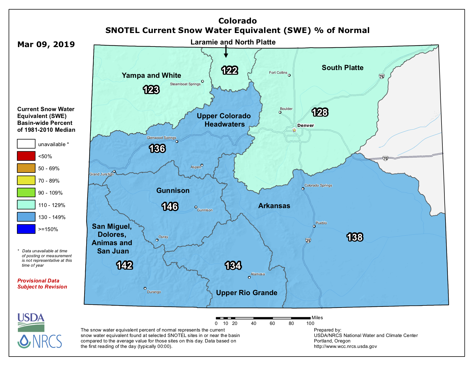
Through Tuesday, snowpack in the Upper Basin was 136 percent of normal.
The predicted April-July runoff into Lake Powell, a key benchmark of the river’s health, is now at 133 percent of normal, which would be the 14th highest total on record.
By contrast, last year’s April-July runoff was 36 percent of normal, the fifth lowest on record…
But since this year would get only the river’s sixth year of above-average runoff since the drought started in 2000, state officials at Tuesday’s teleconference stressed the need for continued vigilance and conservation of river water.
“What we do know is that as temperatures increase, that should reduce the river flows” from evaporation, said Terry Fulp, director of the bureau’s Lower Colorado Region. “If we look at this particular drought, we believe that is due in part to increased temperatures.
“The real question is what about the future? The drought plan is a really good step toward insuring, ourselves, that the two reservoirs don’t reach critical elevations.”
Reclamation Commissioner Brenda Burman said she’s pleased to see that the seven basin states’ work is finished for now.
She said she’s halting work on her previous plan to take written suggestions from the seven states on how to manage the river because of their then-unfinished business on the drought contingency plan, or DCP.
“This is the best path forward,” Burman said. “The DCP will reduce the risks that the Colorado River Basin is facing.”
Even if Lake Mead doesn’t fall into the shortage trigger level of below 1,075 feet at the end of 2019, the new drought plan once approved will require Arizona to reduce its take of Central Arizona Project water from the Colorado by 192,000 acre-feet. That’s well below one-third of the entire CAP’s annual delivery.
Once Mead drops below 1,075, the cuts will gradually escalate, starting at about 20 percent of the total CAP supply and topping off at nearly half the total supply, at about 700,000 acre-feet.
The Imperial district’s participation in the drought plan wasn’t needed for its approval by the seven states. That’s because Southern California’s Metropolitan Water District recently agreed to conserve the water that Imperial decided not to leave in Lake Mead, thus boosting California’s total share of conserved water to the minimum required.
Imperial District officials said the $200 million in federal funds requested for the Salton Sea would match more than $200 million of state funds already approved. They said it would not only help boost the sea’s shrinking habitat for birds and fish, but prevent toxic dust from the drying sea from hurting surrounding air quality and causing human health problems.
“That money is not for us. It’s that Salton Sea in our backyard,” said Robert Schettler, an irrigation district spokesman, in a telephone interview. “We have citizens, lands and crops around the Salton Sea that are all suffering from the sea’s declines.”
Burman acknowledged the district’s concerns and said the federal government supports the Salton Sea restoration effort.
But the U.S. Department of Agriculture, which controls the funding for such drought-related agricultural projects, is only now ramping the program up after Congress last year authorized such projects, and it’s impossible to say when the money will be forthcoming, officials said.
FromThe Arizona Republic (Ian James and Janey Wilson):
The set of agreements would prop up water-starved reservoirs that supply cities and farms across the Southwest and would lay the groundwork for larger negotiations to address the river’s chronic overallocation, which has been compounded by years of drought and the worsening effects of climate change.
The states’ delegates met in Phoenix and signed their joint letter to Congress alongside federal Reclamation Commissioner Brenda Burman, who had set a Tuesday deadline for the states to complete the agreements.
“Today is a very important day in the history of the Colorado River,” Burman said after the signing. “Congratulations to all for a job well done.”
The first cuts in water deliveries to Arizona and Nevada could begin as soon as next year under the terms of the deal…
Tuesday’s meeting was held behind closed doors at the office of the Arizona Department of Water Resources. Doug MacEachern, a department spokesman, said that due to limited space, “we simply cannot reasonably accommodate public access to these meetings.”
[…]
While the signing was underway in Phoenix, a veteran board member of the IID spoke angrily at a meeting on the shore of the Salton Sea, condemning his counterparts for writing his district out of the deal and suggesting they were sipping champagne while ignoring an urgent “environmental and public-health disaster” at the shrinking lake.
Burman and other officials said the drought plan was designed in a way that will avoid causing further declines in the Salton Sea, which has been receding as water has increasingly been transferred from the farmlands of the Imperial Valley to urban areas in Southern California.
Burman said IID decided not to join the plan but can sign on later if the district chooses.
In their letter, the states’ representatives asked Congress to promptly pass legislation authorizing the Interior secretary to implement the agreements. Hearings have been scheduled in the Senate and the House next week. Once the legislation is passed, the agreements still need to be signed by representatives of the states…
During a meeting on the shore of the Salton Sea on Tuesday, IID officials lashed out at those gathering to sign on to the drought deal without them in Arizona.
“I have six grandchildren who live on the Salton Sea and five of them have asthma. On behalf of them, I say, ‘Damn them. Damn them,’” said IID board member Jim Hanks.
“As we gather here today on the shore of the Salton Sea strewn with bleached bones, bird carcasses and a growing shoreline,” Hanks said, “and as champagne is being prepared for debauched self-congratulation in Phoenix, remember this: The IID is the elephant in the room on the Colorado River as we move forward. And like the elephant, our memory and rage is long.”
Hanks spoke at a meeting of California’s State Water Resources Control Board, where regulators received an annual update on the lack of progress on Salton Sea projects. Water board Chair E. Joaquin Esquivel said both the drought contingency plan and the Salton Sea are important, but that efforts can proceed on separate tracks…
Some conservation groups voiced concerns that fast-tracking the drought plans could mean that environmental laws are ignored.
Kim Delfino of the group Defenders of Wildlife noted that while the proposed legislative language sent to Congress had explicitly protected water rights, it did not mention environmental protections. Instead, the proposed legislation includes the exact language from an earlier court decision regarding the All-American Canal, part of the river delivery system, that allowed environmental reviews to be bypassed.
State officials said the intent from the beginning was for the new plans to abide by existing decisions on environmental compliance. They noted the drought plans rely on the seven states voluntarily leaving more water in Lake Mead and Lake Powell and not breaking ground on any new water projects.
Delfino said she understands that but still worries about the inclusion of the language in the legislation and what it might mean.
“They’ve actually made it worse than the original version by protecting water rights but not anything else,” Delfino said.
Audubon California raised similar concerns. Other environmental groups, including Environmental Defense Fund and Trout Unlimited, applauded the completion of the drought plans.
Here’s the release from Governor Polis’ office:
The seven Colorado River Basin States of Colorado, Arizona, California, Nevada, New Mexico, Utah, and Wyoming signed a letter to Congress today requesting legislation to implement a negotiated contingency plan that responds to the historic dry conditions and the effects of climate change on the Colorado River.
“Water is the lifeblood of the West. We all have a vested interest in the management of the Colorado River,” Governor Jared Polis said. “Thanks to the excellent work from each of the Basin States, we are in position to ensure lasting success for the Colorado River, its environment, economy, and future.”
The announcement comes on the deadline set by the Bureau of Reclamation Commissioner Brenda Burman for the Basin States to address the situation or provide her agency with input as to Colorado River operations and management.
Gov. Polis’s principal representative on Colorado River negotiations, James Eklund, echoed the call for action, “As we finish this race, we begin another… and our pace needs to quicken. Our exceptional snowpack this year merely signals that the more extreme swings in precipitation and the warmer temperatures of climate change require effective and efficient implementation of the tools we are creating in the contingency plan.”
While the state of California chose to join Colorado and the other Basin States in signing the letter to Congress, an important water user, the Imperial Irrigation District in Southern California unfortunately could not move forward at this time due to an outstanding request for federal assistance. “We support regional, state and local stakeholders in their efforts to obtain federal funding through existing and future programs to help address impacts to the Salton Sea. However, as negotiated, the DCP is not linked to and does not result in adverse impacts to the Salton Sea. The flexible tools found in the DCPs are needed now,” said Eklund.
The Colorado River provides water to approximately 40 million people and 5.5 million acres of irrigated agriculture in the Upper Basin (Colorado, New Mexico, Utah and Wyoming) and Lower Basin (Arizona, California and Nevada). The river originates in Colorado and Colorado contributes approximately 70 percent of its flow. Since 2000, the Basin has experienced historically dry conditions and combined storage in Lakes Powell and Mead has reached its lowest level since Lake Powell initially filled in the 1960s. Last year’s runoff into the Colorado River was the second lowest since 2000, and there is no sign that the trend of extended dry conditions will end any time soon even if 2019 provides above average runoff. Lakes Powell and Mead could reach critically low levels as early as 2021. Declining reservoirs threaten water supplies that are essential to the environment, economy, and overall health of the Southwestern United States.
Las Vegas could face up to a 10 percent cut in its water right if Lake Mead falls below a shortage elevation, a reduction water managers said they are prepared for…
In a statement, the Southern Nevada Water Authority, called Imperial’s decision “shortsighted, manipulative and simply not supported by any reasonable view of the facts.”
As always, the congressional process could spark debate on other issues. Last week, the trade publication E&E News reported that there was some concern that some proposed legislation could override laws that require federal agencies to conduct environmental reviews.
Congress is expected to begin discussing the plan in a Senate hearing on March 27. Sen. Catherine Cortez Masto is the ranking member of the subcommittee that will review the plan.
“I look forward to discussing the drought contingency plan at the Senate Energy and Natural Resources subcommittee hearing next week and will continue to collaborate with my western state colleagues to solidify a plan that protects Lake Mead, the Colorado River and the water resources of those who live in Nevada and across the west,” Cortez Masto said in a statement.
John Entsminger, the general manager of the Southern Nevada Water Authority, is scheduled to testify at the hearing. On Tuesday, he called agreement on the drought plan a “historic” day. He said negotiators have briefed their delegations and see a nonpartisan path through Congress…
John Fleck, the director of the University of New Mexico’s Water Resources Program, said he had mixed feelings about the approval of the drought plan. He said the plan is necessary. At the same time, he said it was concerning the river’s largest water user was left out.
“There is the moral problem of poor people whose health is being impacted by these decisions being left out of the decision-making process,” he said. “And there is the practical problem of the largest water users with senior water rights being left out of the process.”
“That could really bite us in the long-run,” he added.
The district had planned to cut its use under the drought plan, with the condition that it received a commitment for $200 million in Farm Bill funding to restore the Salton Sea. The Metropolitan Water District, a powerful wholesale water provider for Southern California cities, said that it would cover the district’s cuts to allow the drought plan to move forward by March 19.
It is possible that funding could still come in the future through U.S. Department of Agriculture programs that are still being developed. However, those programs will likely be competitive.
During the call, Entsminger noted that the states had written a letter one week ago, emphasizing the importance of finding a solution to the Salton Sea crisis. But he also said that the plan would not worsen the problem and needed to move forward. Once implemented, the states can begin leaving more water in critical reservoirs, Lake Mead and Lake Powell, to prevent shortages on a binational river system that supports agriculture and about 40 million people in the Southwest.
The Southern Nevada Water Authority released a statement after the call, saying that the the drought plan was of “critical importance” and that the district’s claims were unfounded.
“The Imperial Irrigation District’s refusal to approve the plans supported by every one of its counterparts in the Upper and Lower Colorado River Basin is shortsighted, manipulative and simply not supported by any reasonable view of the facts,” the water authority said, adding that the plan complies with environmental laws. “The DCPs have no effect on the Salton Sea, a fact acknowledged by [the district’s] own Board of Directors during a September 2018 meeting.”
[…]
The disagreement in California comes after months of infighting between water users in Arizona, the state would require to take the sharpest cuts under the drought plan. Many of Arizona’s issues have been resolved, although the state is still finalizing some agreements.
Peter Nelson, chairman of the Colorado River Board of California, said Tuesday at the press conference that he was disappointed California could not move forward in complete consensus. But he said that the drought plan would not make the impacts to the Salton Sea worse.
“It is my feeling we would have been better served with the Imperial Irrigation District participating with the state of California, but that was unable to happen,” Nelson said.
The water in Lake Mead, the vast reservoir formed by the Hoover Dam that supplies the lower basin, has dropped to levels not seen since it began to fill in the 1960s. Lake Mead and Lake Powell, another reservoir on the river, are essential sources of water for Southern California and Arizona, and sit at less than 40 percent full…
By the beginning of March, the water level in Lake Mead had dropped to 1,088 feet above sea level. At 1,075 feet, under guidelines agreed to in 2007, the federal government would declare a shortage on the lower Colorado River, and mandatory water restrictions would go into effect.
Without sacrifices by the states — Colorado, New Mexico, Utah and Wyoming in the upper basin, and Arizona, California and Nevada in the lower basin — the reservoir could reach the trigger point next year, though recent heavy snowfall in the mountains that feed the river may help for a time…
The federal government regulates the water, but the states own the rights to it, said Jennifer Pitt, an expert on river issues with the Audubon Society. “So there’s a tension there,” she said. “The federal government’s consistent approach is to use that authority as a stick, but not ever go so far as to have to claim it.”
The river is important to the people who use its water, but also to “all of nature that depends on the river in the arid landscape of the Southwest,” Ms. Pitt said.
Another big risk is that Lake Mead could eventually drop below 950 feet, when water could no longer turn the dam’s turbines, or even 895 feet, when the lake would reach “deadpool” status and no water could flow out. That, said Patricia Aaron, a spokeswoman for the Bureau of Reclamation, need never happen. “That’s what the drought contingency planning on the river is about,” she said.
Brad Udall, a senior scientist at Colorado State University and an expert on water supplies in the West, told a congressional panel last month that the lower basin uses about 10.2 million acre-feet of water from the river each year, while upstream flows provide just nine million. (An acre-foot is the volume of one foot of water over one acre, about 325,000 gallons.)
Beyond that drain, climate change is bringing on a long-term crisis. “The Colorado River, and the entire Southwest, has shifted to a new hotter and drier climate, and, equally important, will continue to shift to a hotter and drier climate for several decades after we stop emitting greenhouse gases,” he said in his testimony.
In an interview, Mr. Udall said the influence of climate change was already apparent in the West. “Climate change is not some distant process,” he said. “It’s here, it’s now, it’s in our faces. It’s creating messes we have to deal with.”
Jonathan T. Overpeck, a climate scientist at the University of Michigan, said that politicians and policymakers needed to factor climate change into their plans. Lack of river water will lead people to pump more groundwater, which was deposited in the ice ages. “We’re using this fossil groundwater in unsustainable ways,” he said.
In a warming world, Dr. Overpeck said, less water in rivers and lakes is inevitable, whatever relief a wet season might bring. But for the most part, Western political leaders “don’t want to talk about it,” he said. “It is the disaster that’s over the horizon, if we don’t talk about it.”
In a teleconference from Phoenix announcing the plans’ completion, Wyoming State Engineer Pat Tyrrell said the general intent of the plans and the subsequent legislation will be to protect water levels at both Lake Mead and Lake Powell by incentivizing additional conservation of water…
A generous snowpack in the West is sitting at nearly 140 percent of average and may actually stave off an anticipated water shortage declaration in 2020 for the lower basin states.
But Burman warned Tuesday that one wet year doesn’t erase 18 years of the driest period on the river in 1,200 years.
“It takes years to recover from the type of intense drought this region has experienced,” he said.
Eric Millis, director of the Utah Division of Water Resources, said the plans are the culmination of years of hard work.
Comment on this story
“The significance is that it provides protection to the upper basin uses and the state of Utah, and the entire basin and helps us deal with drought and climate change. It offers us that security and protection.”
The components of the plans for the upper and lower basin states have to work in tandem, he added. For the upper basin, the magic number is keeping Lake Powell at 3,525 elevation, or 25 feet above the power pool elevation, Millis said.
Take a helicopter ride with the Colorado Department of Transportation and see for yourself what they are up against on Red Mountain Pass.
US 550 Red Mt. Pass is a major mountain highway in southwest Colorado. The high-country mountain corridor links the mountain communities of Silverton and Ouray. The highway is part of the San Juan Skyway (scenic byway) and is also known as the “Million Dollar Highway.”
Footage of US 550, Red Mt. Pass, traveling north from Silverton to Engineer Pass Rd., then views of the highway returning back, south to Silverton.
Severe snowstorms and epic avalanche activity have closed this highway, located in southwest Colorado, since Sunday, March 3, 2019.
This video was captured on March 15, immediately following avalanche mitigation operations intended to knock down potential existing avalanches and snow slides that have kept road maintenance crews from working on the highway. Mitigation efforts were successful, and crews can now work safely (from avalanche danger) to clear snow and debris from the roadway.
Operations are expected to be slow-going because many of the snow slides are “dirty,” containing rocks, limbs and even trees brought down from the mountain sides.
This story by Jonathan P. Thompson ran in the Silverton Mountain Journal in winter of 2002. Given the historic avalanche cycle, and the lengthy closure of Red Mountain Pass, it seemed like an opportune time to re-up it. Spoiler: Silverton has been shut off from the world by avalanches many times in the past. In 1932, the roads and railroad were shut down from February until the end of April. Yikes!
Eddie Imel died 10 years ago this March (editor’s note: in March 1992). Imel was a plow driver for the Colorado Department of Transportation on the Ouray side of Red Mountain Pass. Like all the plow drivers between Ouray and Cascade, Imel was part of the infantry; he was a foot soldier in the war to keep Highway 550 into Silverton open and keep the town it feeds alive. Imel was the third soldier to die in that war in 22 years and, like the other two, he was slain by the deadliest enemy of this unending conflict: the East Riverside Slide.
The winter of 1991-1992 was not an especially heavy one in these parts. In fact, after a good start–43″ of snow fell in Silverton in November–the snowfall petered out. December (15″), January (10″), and February (15″) were all unusually dry months for snow in the San Juans. Long periods of sunny days and cold, clear nights between storms served to rot out the early, scant snowpack. In other words, conditions were ripe for a serious avalanche season upon the arrival of the big, spring storms.
And arrive they did: Over 30 inches of snow fell in the San Juan Mountains and the slides were running all over the place. Highway 550 was finally closed, but by the time the gates were shut, it was too late. The CDOT truck that swept the road to make sure all motorists were out of danger dodged big slides before being blocked by a portion of the East Riverside Slide that had hit the road just north of the snowshed. Edie Imel and Danny Jaramillo were piloting a CDOT plow, attempting to clear the road so that the sweep truck and other motorists inside the snowshed could get to safety. The plow came to a stop, the two soldiers got out to adjust the chains, and, as the East Riverside is apt to do, it ran again, burying the plow and the drivers.
Everyone in the snowshed, CDOT officials, and local law enforcement reasonably assumed both victims of the slide were dead. A body recovery effort would have been too risky, so it was delayed. The motorists in the shed were escorted back to safety, the mourning began, and, 18 hours after the slide ran, a call came in from the emergency telephone in the snowshed. Danny Jaramillo had tunneled his way out of the cement-like snow. Imel’s body was recovered not long after.
The system, or rather the lack of a real system, for determining avalanche hazard and deciding when to close the road had failed one too many times. Things had to change.
Silverton’s connection with the outside world has always been vulnerable to snowslides. Before there were plow drivers risking their lives to keep the arteries and veins of San Juan civilization from being blocked, there were mail carriers. Before the railroad arrived in 1882, Silverton’s winter link to the lowlands usually consisted of no more than one man on a set of “snowshoes,” or long, wide, heavy wooden skis. Men with names like Greenhalgh, Aspaas, Bales, Mears, and Nelson skied regularly over Cunningham Pass (south of Stony Pass) with huge, 50- to 60-pound sacks on their backs or dragging sleds full of mail and supplies. It was not a job for the faint at heart — avalanche danger was ignored, at least one froze to death, and others, somehow, survived both snow and cold — but it was a necessary one. Without their efforts, Silverton would have had to shut down come winter.
Newspaper clipping from March 1906, after a huge storm resulted in a deadly St. Patrick’s Day avalanche cycle.
In 1882, the railroad finally reached the heart of the San Juans, but by no means did this signal an end to avalanche troubles. The snowshoe-riding mail carriers of old, as long as they avoided being hit by slides, could simply ski over the top of the slide debris, but the train could not. From Needleton to Silverton, the tracks pass through the depository for dozens of slides, some of significant size. Dramatic photos of the Saguache slide (probably also known as the Snowshed slide north of Elk Park) show a trench dug for the train through a 60 foot pile of snow and debris. Nearly every winter saw at least one avalanche-caused blockade during which the train could not reach Silverton. Sometimes they only lasted a few hours while tens or even hundreds of men cleared the tracks. But there were times when Silverton was cut off from the world for days, weeks, and, in one case, three months. In 1884, Silverton was without a train for 73 days. Food ran short and milk cows were killed for beef.
The winter of 1906 will long be remembered as the most tragic, avalanche-wise, in the San Juans. Big January storms pounded the region following a relatively dry November and December, and the slides came down. Five men were killed at the mouth of the tunnel of the Sunnyside Mine near Eureka when they were engulfed by a slide. Eleven avalanches were reported between Silverton and Elk Park that ranged from seven to 30 feet deep and 50 to 450 feet long; the train was kept at bay for 18 days.
All of that was minor compared to what followed in March when an enormous storm sat over the region for about a week, relentlessly pounding the San Juans. Slides swept away the Shenandoah boarding house, killing twelve men, and ravaged a number of other structures in the area, often killing their inhabitants and making that the most deadly avalanche season ever in the San Juans. Twenty-four people lost their lives to snowslides in San Juan County that winter.
Transportation in and out of Silverton came to a standstill. Two-hundred men of Japanese descent worked to clear 50-foot deep piles of debris that at least 15 slides had deposited on the tracks between Needleton and Elk Park. It took 33 days for them to break through. Local newspaper editors blamed the Railroad, not the snowslides, for the delay in opening the tracks, a sentiment that would echo throughout the years, even after the highway became the main link between Silverton and everywhere else.
Perhaps the worst winter, in terms of Silverton being cut off from the outside, was 1931-1932. By then the highways to Ouray and Durango were gaining importance as supply routes through the San Juans. That gave the newspapers someone else, the highway department, to blame for closures. After a December storm, the editor of the Silverton Standard wrote: “Now during the recent storm it was not deemed expedient for men to attempt to keep the highway open, but after the storm settled it was clearly the duty of the maintenance department of Colorado to open the roads, or at least determine that they should not be opened. What was done? Nothing. How long in our case did the situation continue? For at least one week.”
Silverton continued that year to be pummeled by storm after storm. In February, following a devastating “San Juaner,” all highways were closed, including those to Howardsville and Gladstone; a slide wrecked the Iowa-Tiger boarding house at Silver Lake; all telephone lines in and out of Silverton were down; and the train crashed near Rockwood while attempting to reach Silverton. One couple hiked out to Ouray in order to escape the confines of Baker’s Park, some snowshoed to Rockwood in order to catch the train, and a 350-pound load of butter, eggs, and meat was brought by toboggan from Ouray. In April, it was reported that the Riverside Slide had deposited a pile of snow 300 feet long and 60 feet deep. The road to Durango (which at that time traveled down avalanche-riddled Lime Creek, not over Coal Bank Pass) was opened on April 30, and the Ouray side was cleared shortly thereafter.
Only four years later Silverton was shut off again by slides for weeks, prompting a team made up of Louis Dalla, E.F. Sutherland, James Baudino, John Turner, and Carl Larson to snowshoe down the canyon to Needleton to fetch the mail.
By the time one of the biggest winters in San Juan history hit in 1951, the railroad’s importance had been diminished somewhat by the improved highways, especially to the south. But in the San Juans even good highways, which traveled through slightly less avalanche-prone areas, are liable to be shut down, and that’s exactly what happened that year. There was so much snow that people had trouble getting around town, not to mention over the passes. The Highland Mary Mill in Cunningham Gulch was wrecked by a slide, killing one. The highway to the north opened after six days, and it took several more days of around-the-clock effort, to break through the dozens of slides that covered the road to the south.
In spite of the huge winters, the series of avalanches that hit the roads with regularity, and the lack of any avalanche policy governing Highway 550 at the time, not one motorist had been killed by an avalanche on the highway by the middle of the 20th century. Nevertheless, following the huge winter of 1952, the Colorado Highway Department implemented an official policy dealing with road closures and avalanche hazard. The policy said that if avalanche danger was determined to be high, the road would be closed, control work would be done, the debris would be cleared, and the road re-opened.
At first glance, the system seems identical to the current one. In practice, however, the road was usually kept open until the slides were coming down so big, and with such frequency, that the plows were simply unable to punch through them anymore. It was a policy that, at best, was unscientific. Louie Dalla, road supervisor for the Silverton district, who was known as a man who almost always kept the roads open, described the non-policy policy in a 1963 interview with Allen Nossaman: “About the only good rule is not to go in a storm. They ask us how an accident could have been prevented in many slides. The best answer to that is — They should have stayed in bed. The study of slides is a science, and the study comes pretty close to getting the answers but not close enough.”
In other words, it was up to the motorist, not the highway department, to ultimately assess the danger and make the decision about whether to travel the road or not. It is a noble sentiment, and one from another time before liability and lawsuits were the norm. Up until 1991, the only avalanche forecasters were the plow drivers themselves, their command centers the cabs of their plows. The policy was imperfect, at best and, in 1963, its fatal flaws were first revealed.
On March 3, 1963, Reverend Marvin Hudson made his usual trip over Red Mountain Pass to preside over services at the Silverton Congregational Church. He had his daughters Amelia and Pauline in the car with him. A large storm had hit and the East Riverside Slide had already run once. His car was slip-sliding across the road as he passed under the ominous East Riverside slide, so the Reverend stopped to install his chains. That is when the Riverside ran again. It took rescuers a week to find the Reverend’s body and another to find Amelia’s. Pauline was not recovered until May 30.
The tragedy inspired a Colorado Highway Department Engineer to recommend the construction of a snowshed under the Riverside, a suggestion made by a Swiss avalanche expert two years earlier. The shed was not built, the road closure policy remained the same, and, in 1970, plow driver Robert Miller was killed by the Riverside’s infamous second release.
Angered citizens demanded the construction of a snowshed but Highway 550, which is still one of the last places to get funding from the state transportation coffers, would get no protection. Nothing was done.
It took yet another fatality, under similar circumstances, to motivate the state to finally build the snowshed. This time it was plow driver Terry Kishbaugh who was taken by the East Riverside on February 10, 1978. Seven years later, the snowshed was built. At least one expert recommended the snowshed be 1,200 feet long; others said that the absolute minimum length for it to be effective was 400 feet. When all was said and done, the snowshed only covered 180 feet of highway (as it does today), leaving cars, and plow drivers, and Eddie Imel and Danny Jaramillo exposed to the deadly torrent known as the East Riverside slide.
Those were the fatalities. Then there were the close calls. According to CDOT statistics, 68 cars were hit by slides between 1951 and 1991 between Coal Bank and Ouray. These included a Trailways bus that was knocked off Molas Pass by the Champion slide and a bus bashed by the Brooklyns filled with miners coming home to Silverton from their shift at the Idarado Mine. Injuries were relatively minor. Finally, when the San Juans had to say goodbye to a third plow driver in 22 years, things changed.
In July 1992, CDOT announced its new Highway 550 Avalanche Hazard Reduction Plan. Weather and snowpack evaluation stations would be installed under the plan; avalanche control equipment such as Howitzers would be implemented; CDOT workers would all be trained in avalanche awareness; and fixed control-gun towers would be installed. Most significantly, however, the avalanche forecasting job would go to two Colorado Avalanche Information Center professionals based in Silverton (plow drivers, however, continue to serve an important role, communicating their on the road observations to forecasters).
Silverton’s forecasters are devoted, full-time, to assessing the avalanche hazard on the passes. Even during long periods between storms, they patrol the passes and analyze the snowpack, its structure, and its stability, allowing them to know approximately how much snow, and at what density, the current snowpack can hold in the event of a storm. When a storm does hit, the forecasters are out on the highway alongside the plow drivers, constantly monitoring conditions and passing recommendations on to the local road supervisor in Durango or Ridgway. Ultimately, it is the road supervisor, not the forecaster, that makes the decision to close the road.
The days of waiting for several big slides to come down before deeming the hazard high are over, according to Silverton Avalanche Forecaster Andy Gleason. This has sometimes caused impatience in Silverton, where people still remember the old days and where mail, supplies, and commuter routes are shut down along with the roads. And, of course, when the road is closed it means the precious few winter tourists and their money are kept out, an issue that may even get more urgent when the new ski area opens. Many citizens, especially those that have been around for a while, feel that it is premature to close the roads before any slides have come down.
Gleason disagrees. “When I recommend closure I’m always asked: ‘What slides hit the road,” said Gleason. “If we were doing our job really well we would answer that nothing hit the road, but this is what is about to hit the road.” Gleason concedes that, partly because of the importance of the roads to Silverton, the road is usually not closed until smaller “indicator” slides such as the Blue Point have run. Or, he says, if two inches of snow fall in one hour or less in the Uncompahgre Gorge, then it is time to lock the gates with or without indicator slides. “It will avalanche,” said Gleason.
The ultimate goal of the avalanche reduction program, according to Gleason, is to create more avalanches of smaller size. “Our perfect avalanche control day would be if every slide ran small to the edge of the road so that there is no clean-up necessary,” said Gleason.
Although this policy may mean more frequent and earlier closures, ultimately it could result in cumulative closures of fewer hours during a winter than under the old policy. Most importantly, of course, it means that everyone — the plow drivers, the motorists, the law enforcement people patrolling the roads — are safer.
Its first decade of existence has been a successful one for the Avalanche Hazard Reduction Plan. Imel’s was the last avalanche-related fatality on Highway 550, close calls are rare, and during the past five years, long, sustained closures have been kept to a minimum. In 1998-1999 Red Mountain Pass was closed for a total of 110 hours and Molas/Coal Bank for 17 hours; in 1999-2000, the road to the north was only out of service for a total of 33 hours and Molas was closed for a paltry 6.5 hours; and last year, an average snow year, Red Mountain was down for 83 hours and Molas/Coal Bank for 30 hours. These numbers are not small, but in earlier years it was not unheard of for the road to be closed in both directions for 83 hours at one time.
Improvements during the last five years have helped the forecasters and controllers immensely. Snow measurement stakes have been placed in the starting zones of the West Lime Creek and Mother Cline slides; Howitzers have returned to their traditional place in avalanche control work, making helicopters less necessary and allowing for more efficiency and quicker control work; and the forecasters learn more about the snowpack each year.
Still, the new plan is not perfect. Gleason would like to see more forecasters here (two, Silverton-based forecasters cover Coal Bank, Molas, and Red Mountain Passes in addition to Lizard Head Pass, which is two hours away by CDOT truck); more passive control measures such as snowsheds, snow fences, and snow defense structures; better automated weather stations; and a remote avalanche detection system (one is being researched here but Gleason signed a waiver promising not to talk about it).
John Greenell (a.k.a. Greenhalgh) and his trusty pair of snowshoes was one of the mail carriers that provided Silverton a link with the outside world in its earliest winters of existence. He was known as a man that could make the trip up Cunningham Gulch, over Cunningham Pass, into the Rio Grande Country and to Del Norte and back in any type of weather.
On Monday, November 27, 1876, Greenell set out from Carr’s Cabin on the other side of the divide on the return trip (over Stony Pass this time) to Silverton. He never arrived. A group of searchers found his body a few days later, frozen to death near the top of Stony Pass, his hand rigidly clutching his mailbag.
We have changed a great deal since Greenell’s days, but the mountains are just about the same. Winters are still hard, avalanches still rush down mountainsides, and Silverton is still, occasionally, isolated from the outside world.
A heavy duty snow blower punches a hole through the snow that came down the West Riverside slide triggered yesterday, Monday, March 4, on north Red Mountain Pass, US 550. The snow shed which protects the traveling public from natural slide activity is seen in the background.
Nebraska state officials flew over the flood-ravaged Spencer Dam on March 16, 2019. The Niobrara River had been running at 5 or 6 feet of gage height before it broke through the 90-year-old dam early on March 14, 2019. After that, an 11-foot wave rolled through. Photo credit: State of Nebraska
Here’s a report on the flooding in Nebraska from Peter Salter writing for The Lincoln Journal Star. Click through and read the whole article and check out the various videos. Here’s an excerpt:
From their offices in Lincoln early Thursday, hydrologists with the U.S. Geological Survey were monitoring the final few moments of a stream gauge more than 200 miles away, on the Niobrara River.
It was hinting at something catastrophic.
“We were watching it from here, and it looked like something incredible was happening that we couldn’t believe,” said Jason Lambrecht. “And suddenly, everything went dark.”
The gauge had been ripped away by the wall of water released when the 90-year-old Spencer Dam failed under the pressure of the river, swollen with rain and rapid snowmelt and broken ice. But its last readings allowed Lambrecht to measure the size of the surge.
Earlier, the Niobrara had been running at 5 or 6 feet of gauge height. After it broke through the dam, it measured nearly 17.5 feet. It wasn’t a gradual increase, either…
And in its wake, three Nebraska counties would learn how that much moving water can become immediately destructive and potentially deadly. How it can cause instant pain and long-term suffering. How it can harm not only those in its path, but those living miles away.
First, the wave swept away a section of U.S. 281, a nearby riverside saloon and at least one home, possibly occupied. And it continued downstream, barreling toward the town of Niobrara — and its mouth at the Missouri River — about 40 miles away.
Knox County: ‘It’s crazy’
The service station owners thought they were ready for the coming water.
They’d taken the tire machine and other equipment away. They brought the important paperwork home. They put their ’68 Camaro up on the lift. They moved the rest of what they could to higher ground, filling the rafters with inventory.
And the couple had a huge inventory. Vic’s Service has anchored the west edge of Niobrara for 25 years, and had enough hydraulic fittings and plumbing pieces to serve as a kind of farmer’s supply store, said Ruth Janak, who co-owns the station with her husband, Victor.
They checked on their business Wednesday, and found it already swamped with 4 feet of water, her desk upturned, pop machines on their sides. A mess, but nothing they couldn’t handle.
“We thought, when the water recedes, we’ll be able to get in and clean all that up,” she said.
They returned Thursday, and found most of it missing.
“Our main building, the one we did our business at, it’s gone. The gas pumps are gone. We lost the propane tank. So many tools are gone,” Janak said Friday. “Where’s all that stuff at? It’s crazy.”
Later, she would find a jug of hydraulic fluid — and someone else’s pontoon boat — on what remained of the town’s golf course. But their main building, and much of what it contained, had likely tumbled downstream.
Theirs wasn’t the only missing building. The wall of water had brutalized Niobrara’s west side, a low-lying commercial district, and the part of town closest to the river.
Jody Stark, the chair of the village board, listed the other casualties. Several buildings from a hay business? Gone. A state Department of Transportation garage? Gone. A Knox County road shop? Gone. The Mormon Bridge on Nebraska 12? Stark has video of the deck floating away. The Country Cafe? Still standing, but it had been nearly swallowed by water and ice, with maybe a foot of the roof visible at one point.
“A lot of buildings washed away,” he said. “They were pretty much swept right down the river and they’re in the Missouri somewhere.”
The good news? Almost all of the 300 or so residents of Niobrara live on higher ground, and weren’t directly hurt by the floodwaters…
Still, his town was struggling. The flooding compromised the town’s two wells, leaving its residents without a water supply, and the fire department was going door-to-door, filling containers. Getting in and out of town was also difficult; by Friday, the Standing Bear Bridge to South Dakota had reopened, and there was one passable gravel road south of town. Nebraska 14, the main route south out of Niobrara, was so strewn with ice it was only open for emergency travel.
The damage was unprecedented, Stark said, and worse than they had originally expected. But that was before they’d heard the Spencer Dam had failed and even more water was headed their way…
The Spencer Dam was a flow-through hydroelectric dam, with garage-type doors that let water through, and Becker said it wasn’t known whether the doors had been open or closed at the time. They disappeared downstream, he said.
Its breach triggered immediate and long-term problems. It swept away a Holt County house just downstream, and authorities were still searching for its owner.
“On March 14th at around 5 in the morning the dam on the niobrara river south of Spencer NE was overtaken by flooding and ice jams. 2 days prior to this there was significant snow melting. 1 day prior there was all day rain measuring 1-1.5 inches. The ground was still frozen from recent below normal temperatures. All that water broke loose ice chunks the size of cars and trucks. The dam was no match for this extreme force. The dam and the dike were both destroyed. The water then washed out Hwy 281 and flooding many communities downstream.” — Birkel Dirtwork
And the force of the flow severed the supply of water to the north, in Boyd County. Many of its 2,000 residents relied on the pipeline from Holt County that was buried beneath the river. Now that it’s gone, they don’t have the water they need for drinking, for livestock, for flushing.
They received a truckload of bottled water Friday, enough to last maybe a day, said Doug Fox, Boyd County’s emergency management coordinator. They need more…
And Boyd County was struggling to stay connected with the rest of the state. The failure of Spencer Dam took out a pair of routes over the Niobrara River, and the only ways out of Boyd County were north into South Dakota or west into Keya Paha County, Fox said.
Nebraska Rivers Shown on the Map: Beaver Creek, Big Blue River, Calamus River, Dismal River, Elkhorn River, Frenchman Creek, Little Blue River, Lodgepole Creek, Logan Creek, Loup River, Medicine Creek, Middle Loup River, Missouri River, Niobrara River, North Fork Big Nemaha River, North Loup River, North Platte River, Platte River, Republican River, Shell Creek, South Loup River, South Platte River, White River and Wood River. Nebraska Lakes Shown on the Map: Harlan County Lake, Hugh Butler Lake, Lake McConaughy, Lewis and Clark Lake and Merritt Reservoir. Map credit: Geology.com
Click through to view a gallery of photos from the School Stride for Climate on March 15, 2019:
From Sydney to Seoul, Cape Town to New York, children skipped school en masse Friday to demand action on climate change.
It was a stark display of the alarm of a generation. It was also a glimpse of the anger directed at older people who have not, in the protesters’ view, taken global warming seriously enough.
The Colorado Avalanche Information Center described the snowy torrents thundering over the weekend as historic. There were deaths, there were bizarre circumstances. And at least one snowslide occurred at a scale perhaps not seen since 1910.
“The avalanches are running much larger than they have, in some cases, for maybe 50 to 100 years,” Spencer Logan, an avalanche forecaster with the center, told the Summit Daily News last Friday, soon after the avalanche cycle began.
First, the bizarre circumstances of the death of a 25-year-old man who was shoveling a low-angle roof with a companion on Saturday at a housing development near Crested Butte. According to a preliminary report by the avalanche information center, no one noticed the roof avalanche for about 10 minutes.
Help was summoned, and their bodies were located by probes. The second snow shoveler, a 37-year-old man, who had not been buried as deeply, was treated for hypothermia. They had been buried for 20 to 30 minutes.
This was in a subdivision about a mile south of the town of Crested Butte. Another roof avalanche buried a 28-year-old man the evening before in Mt. Crested Butte, the town at the base of the ski area. He was treated for low core-body temperature. Yet another roof shoveler had been rescued from a roof avalanche the weekend before.
CBS4 in Denver said the Crested Butte area had received more than 4 feet of wet, heavy snow in the days prior to the weekend avalanches. Several days more of snowfall are predicted for early this week…
In Summit County, Arapahoe Basin Ski Area was closed for two days as a precautionary measure. Probably a good thing, said the Summit Daily News as notorious avalanche paths called the Little Professor and the Widowmaker ran, burying the highway to the ski area.
More notable yet was an avalanche in the Tenmile Range above Frisco. There, a slide in 1910 took out a mining camp called Masontown. In local lore, everybody had been off to the bars in Frisco when the slide occurred. In fact, the town had been abandoned. Whatever. It was a big slide, and experts tell the Summit Daily that the slide that occurred last week might have been even bigger.
Finally, U.S. Highway 550 between Ouray and Silverton in the San Juan Mountains had been closed for a week as of Monday. Also called the Million Dollar Highway, the route was projected by Colorado highway crews to remain closed “indefinitely.”
The notorious Riverside slide had claimed many lives over the years until a snowshed was erected to funnel snows over the highway. This time it wasn’t enough. There was 20 to 30 feet of snow on the pavement before state crews intentionally triggered more slides, leaving up to 60 feet of snow. The new slide filled in the snowshed, too.
Colorado’s snowpack is now over 140 percent of normal thanks to a series of winter storms. Southern river basins are above 150 percent of normal.
The state has already exceeded average annual snowpack which usually doesn’t happen until early April. Any additional snow this spring will simply be icing on the cake in terms of water storage and drought reduction.
The latest U.S. Drought Monitor map released on Thursday showed incredible news for southwest Colorado.
For everyone who was caught in Colorado’s historic “bomb cyclone” blizzard Wednesday, a couple of visions come to mind: whipping winds, pelting snow and whiteout conditions.
But Weld County farmers and water managers are still thinking about what happened in the relative calm before the storm: steady rainfall that seeped into the ground early on.
It’s the type of moisture farmers want for their soil.
“This storm that we got was really beneficial from a moisture standpoint because a lot of that moisture came as rain early on,” said Randy Ray, the executive director of the Central Colorado Water Conservancy District. “So that rain was able to penetrate and soak into the ground.”
The ensuing blizzard? “It’s not as beneficial in these ground blizzards because the snow doesn’t stick to the ground,” he said. “The most beneficial snow is a nice foot of snow that just falls naturally on ground without 80 mph winds pushing it.”
[…]
Snowpack in Colorado’s South Platte River Basin, as of a Thursday measurement, was at 16 inches of snow water equivalent, a measurement that accounts for the amount of water in snow. The basin is 133 percent of average snowpack, and 168 percent of last year…
During the 2018 water year, which ended in September and was the second-driest year on record for Colorado, behind 2002, about 15 percent of the state — mostly the southwest region — experienced exceptional drought conditions, the type states only expect once every 50 years. When the water year started over in October, conditions started to change dramatically. As of March, not one region of the state is experiencing exceptional drought conditions. Most of the state, 57 percent, is abnormally dry.
Greeley and portions of Weld County are experiencing a moderate drought…
[Russ Schumacher] said he usually expects the peak of snowpack to come in early to mid-April. But many portions of the state have already passed the normal peak in just the first half of March.
Westwide SNOTEL basin-filled map March 18, 2019 via the NRCS.
Our much-delayed weak El Niño continued into March, and forecasters give it an 80% chance to continue through the spring, with a 60% chance of continuation through the summer.
Spring showers
As you may remember from February’s update, the atmosphere finally started showing signs of a response to the warmer-than-average sea surface temperatures in the central tropical Pacific, leading the forecast team to issue an El Niño Advisory. More rain and clouds than average formed over the warmer waters of the central Pacific, less over Indonesia, and near-surface winds in the central Pacific slowed. These patterns continued over the past few weeks, with the dry-Indonesia/rainy-central-Pacific pattern showing up clearly in the cloud patterns.
Places that were more (purple) or less (orange) cloudy than the 1981-2010 average during February 2019, based on satellite observations of outgoing longwave radiation (heat). Thick clouds block heat from radiating out to space, so less radiation equals more clouds, and more radiation equals clearer skies. Climate.gov map from CPC OLR data.
(For a really cool investigation into why the atmospheric response may have been delayed this year, be sure to check out the recent post by Nat Johnson, P.I.)
The strength of the atmospheric component of ENSO, the Southern Oscillation, is measured using two different indexes. While they use different specific locations, both indexes compare the atmospheric pressure in the far western Pacific to that in the east-central Pacific. When these indexes are negative, it means there is less rising air than average (higher pressure) in the west, and more rising air (lower pressure) in the east. Both the Southern Oscillation Index and the Equatorial Southern Oscillation Index were -1.4 during February.
Near-surface wind anomalies over the tropical Pacific (5°N-5°S) during 2018, starting at the top in September 2018 and ending in early March 2019 at the bottom. Each row in this type of image is the departure from average (1981-2010) at that time. Pink areas show weaker-than-average trade winds, and green stronger. NOAA Climate.gov image, based on data provided by the Climate Prediction Center.
During most of February, the winds near the surface of the central Pacific were substantially slower than normal. When the trade winds slow, they allow the surface waters to warm, and can sometimes kick off or enhance a downwelling Kelvin wave, a large area of warm water that slides from the west to the east under the surface. Likely in part due to the slowing winds, sea surface temperatures in the equatorial Pacific Niño3.4 monitoring region increased to ~1°C warmer than average during February, reversing some cooling that had taken place in January.
Area-averaged upper-ocean heat content anomaly (°C) in the equatorial Pacific (5°N-5°S, 180º-100ºW). The heat content anomaly is computed as the departure from the 1981-2010 base period pentad (5-day) means. Heat content has been elevated for the last 12 months, but recently increased again. Climate.gov figure from CPC data.
The amount of warmer-than-average water below the surface of the tropical Pacific also increased substantially in February, after dropping over the past few months. As the current downwelling Kelvin wave continues to move to the east and gradually rise, it will provide warmth to the surface—one of the sources of confidence in forecasters’ predictions that El Niño conditions will continue through the spring.
Spring training
The state of the tropical Pacific in early 2019 has some eerie similarities to that of early 2015. After several months of warmer-than-average sea surface temperatures, the atmosphere responded with weak El Niño conditions, similar to 2015. And, a downwelling Kelvin wave is present, as in 2015. Many climate models are predicting that sea surface temperatures will remain elevated through the year.
Climate model forecasts for the Niño3.4 Index. Dynamical model data (purple line) from the North American Multi-Model Ensemble (NMME): darker purple envelope shows the range of 68% of all model forecasts; lighter purple shows the range of 95% of all model forecasts. Statistical model data (dashed line) from CPC’s Consolidated SST Forecasts. NOAA Climate.gov image from CPC data.
So are we in for another 2015-style strong El Niño? Even with now and then having so much in common, it’s far too soon to tell. Climate models are notoriously unreliable when making predictions in March and April, when ENSO is often in transition. As this graph of climate model forecasts shows, the range of potential outcomes is huge, and includes everything from a moderate La Niña through a stronger El Niño. This huge range tells us that the climate models do not have much agreement about what will happen next fall.
Also, wind patterns and heat content in March are not very powerful predictors of fall El Niño patterns. While it’s likely that the current weak El Niño conditions will continue through the summer, as Michelle said in 2015, “there are still plenty of innings left to play.” Hopefully, we’ll have a clearer picture of next fall after the spring predictability barrier is behind us.
Spring green
What do El Niño conditions through the spring portend for global weather patterns? El Niño’s effect on global circulation is weaker in the spring than in winter, but still detectable. Historical global temperature and rain patterns during El Niño in the spring show less rain than average over a lot of the tropics, for example.
Weak El Niño conditions mean these impacts may be less consistent than during strong El Niño. Check the Climate Prediction Center for an outlook on US seasonal patterns. El Niño conditions through the summer can affect the hurricane season, too—the Climate Prediction Center’s hurricane season outlook will be issued in May, so stay tuned!
The Pentagon is reportedly lobbying for a more lenient standard for cleaning up toxic chemicals used for decades in firefighting foam that have been found in drinking water in southern El Paso County and around the country.
Even if the Pentagon is successful, the Air Force appears unlikely to get off the hook for cleaning up the contaminated Widefield aquifer serving tens of thousands of residents south of Colorado Springs, state health officials said.
The Defense Department’s push to revise safety standards comes as it faces billions of dollars in cleanup costs tied to its decades-long use of a firefighting foam laced with per- and polyfluoroalkyl substances. The chemicals, known as PFAS, are tied to cancer, liver disease and low infant birth weight.
The lobbying appears aimed at influencing the Environmental Protection Agency’s groundwater cleanup standard — a level at which cleanup would be required of polluters.
In a report to Congress, the Pentagon said an appropriate level is 380 parts per trillion, the New York Times reported. It’s at least five times what the EPA says could be harmful to people, and dozens of times higher than another federal agency says is toxic to people.
At that level, the military could avoid paying to clean up many contaminated sites across the nation, said David Andrews, senior scientist for the Washington D.C.-based Environmental Working Group, an advocacy group.
“Even if it’s the same number of sites, the amount of cleanup you’re doing at each site would be drastically reduced,” Andrews said. “The likely impact is that DoD is really trying to pass on the responsibilities and the cost for cleaning up this contamination. Which is dreadful.”
In a statement, the Pentagon said it takes its cleanup responsibility “seriously.”
“DOD is not seeking a different or weaker cleanup standard but wants the standard risk-based cleanup approach that is based on science and applies to everyone,” the statement said.
Still, one of Delaware’s Democratic U.S. senators, Tom Carper, claimed in a letter to the EPA that the Defense Department is currently only cleaning up sites where groundwater readings exceed 400 parts per trillion, and only removing the chemicals to 70 ppt. The Pentagon was joined by NASA and the Small Business Administration in lobbying for more relaxed standards, the senator said.
The Pentagon report only referenced two PFAS varieties — PFOA and PFOS — even though thousands of other varieties are known to exist. The report was issued last year, and reported Thursday by The New York Times, along with Carper’s letter.
The Defense Department’s maneuvering is expected to have little impact on cleanup operations around Peterson Air Force Base, Colorado health officials say.
State regulations would still force the Air Force to clean up the tainted Widefield aquifer to a more stringent standard that is in line with the EPA’s current health advisory, according to Kelly MacGregor, a Colorado Department of Health and Environment spokeswoman.
The state’s Water Quality Control Commission voted unanimously in April to adopt a site-specific groundwater quality standard of 70 ppt for the same two chemicals — PFOA and PFOS — combined.
Even without the state standard, the aquifer’s contamination downstream from the base is so bad that cleanup efforts around Peterson would likely go unaffected by the Pentagon’s lobbying.
Seven wells drilled about three years ago in the Widefield aquifer showed PFOS at levels of 400 ppt or greater. One well drilled at the Colorado Springs Airport found the chemical at 1,600 ppt.
Neither the state’s adopted groundwater standard, nor lobbying efforts in Washington, D.C., touch on the thousands of other types of chemicals, also called perfluorinated compounds.
For communities affected by use of the foam, such as Security, Widefield and Fountain, that could be a significant problem, Andrews said.
For example, another type of chemical called PFHxS is often associated with use of the firefighting foam. And no other type of perfluorinated compound was as common in drinking water samples taken from Security or Fountain wells as PFHxS, nor present at such high levels, according to EPA drinking water data.
A couple of other chemicals were reported as frequently in wells serving Widefield. But again, none were as consistently high as PFHxS.
It also has been found in the drinking water of dozens of other water districts across the country, EPA results show. The federal Agency for Toxic Substances and Disease Registry says it could cause liver damage and a decreased ability to respond to vaccines.
Several other types of PFAS also have raised health concerns while being found in water systems across the country.
“Really we’d like to see the EPA and the DoD focusing on reducing the total PFAS contamination … shifting into high gear and taking responsibility for cleaning up all of this contamination,” Andrews said.
FromThe Los Angeles Times (Alejandra Reyes-Velarde):
For the first time since 2011, the state shows no areas suffering from prolonged drought and illustrates almost entirely normal conditions, according to a map released Thursday by the U.S. Drought Monitor.
“The reservoirs are full, lakes are full, the streams are flowing, there’s tons of snow,” said Jessica Blunden, a climate scientist with the National Climatic Data Center at the National Oceanic and Atmospheric Administration. “All the drought is officially gone.”
[…]
In January, storms filled up many of the state’s water reserves almost to capacity and added about 580 billion gallons of water to reservoirs across the state. That month, the snowpack in the Sierra Nevada, a major source of California’s water supply, doubled — and then doubled again in February…
A year ago, just 11% of the state was experiencing normal conditions while 88.9% of the state was “abnormally dry,” according to the drought report. Some parts of Los Angeles and Ventura counties were still colored dark red, meaning they were experiencing “extreme drought.”
[…]
Small portions in the far northern and southern parts of the state were still marked as “abnormally dry,” but elsewhere, the map registered no drought conditions at all. In San Diego County, reservoirs were only 65% full, which contributed to the dry conditions in that area, Blunden said.
In 1922, Federal and State representatives met for the Colorado River Compact Commission in Santa Fe, New Mexico. Among the attendees were Arthur P. Davis, Director of Reclamation Service, and Herbert Hoover, who at the time, was the Secretary of Commerce. Photo taken November 24, 1922. USBR photo.
If, as being widely reported, the Colorado River basin states (and the major water agencies that largely dictate what the states do) ultimately decide to proceed with a Lower Colorado River Basin Drought Contingency Plan that cuts out the Imperial Irrigation District (IID), no one should be surprised. It’s simply continuing a long, and perhaps successful, tradition of basin governance by running over the “miscreant(s)”…
In our new book Science be Dammed, John Fleck and I argue that the beauty of the 1922 Compact was that it was a social contract between the faster growing states on the lower river (primarily California) and the slower growing states on the upper river to leave some water in the river for their future development. This allowed the states to cautiously form the coalitions necessary to pass the federal legislation needed to develop the river. As we have seen, for the major decisions there was rarely unanimous agreement. Today, in an era of reallocation of existing supplies, what is needed is a similar social contract between the haves, the rural areas of the basin that rely on agriculture (with senior rights), recreation and a healthy river and the have-nots, the urban centers with mostly junior rights, but with a need for certainty of supply and the political and economic power to overwhelm the rest of the basin. The goal of such a social contract would be to allow the inevitable reallocations, but only if there is a clear and real benefit to the areas-of-origin.
Leaving IID out of the Lower Basin DCP might make sense for a number of good reasons (especially with the great snowpack which reduces the risk faced by the Metropolitan Water District of Southern California in shouldering the DCP burden without IID’s help), the question policy makers should consider is in the long run (post 2026 for the Colorado River Basin) is such an action going to make it easier or harder to manage conflicts on a shrinking river?
Westwide SNOTEL basin-filled map March 17, 2019 via the NRCS.
Description of Job
Although the Division of Water Resources Office is located in Alamosa, the position’s primary duties are performed within 30 miles of the border of Colorado.
This position assists the Division of Water Resources (DWR) State Engineer in carrying out the statutory duties required of the DWR and any written instruction of the State Engineer within the geographic area of State Division Three; serve as Division Engineer as designated; assure integrity of the Prior Appropriations Doctrine while maximizing beneficial use of water; coordinate the regulation of water within the Division; consult with the Water Court; resolve disputes that exceed the abilities of Water Commissioners; supervise field and office personnel; assist the public through the Water Court process and well permit application process and in the understanding of water law, hydrology and water supply, and other water-related issues; prepare expert witness reports; consult with the Water Court regarding Water Court applications; respond to water user complaints and write reports summarizing the agency’s position; and negotiate or provide expert engineering support / testimony to litigate any conditions necessary to protect existing water rights. Other duties as assigned.
Rio Grande River Basin via the Colorado Geologic Survey
Map of the Rio Grande watershed. Graphic credit: WikiMedia
San Luis Valley. In this perspective, S is on top. Costilla County is along the edge of the southeastern side of the Valley between the Sangre de Cristo sub-range known as the Culebra Mountains (on the E) and the Rio Grande (on the W); upper left quadrant within SLV on this map. Source: http://geogdata.scsun.edu.
Westwide SNOTEL basin-filled map March 16, 2019 via the NRCS.
From email from Reclamation (Marlon Duke/Patti Aaron):
The Bureau of Reclamation today updated its monthly 24-month study projections, indicating improved hydrological conditions throughout the Colorado River Basin. Current snowpack in the Upper Basin is nearly 140 percent of average, with a forecasted inflow to Lake Powell of 92 percent of average for water year 2019.
“We are pleased to see the above average snowpack conditions in the Upper Basin and the improvement in the inflow forecast for Lake Powell,” said Reclamation Upper Colorado Regional Director Brent Rhees. “Significant risks and uncertainty persist and storage at Lake Powell remains essential to the overall well-being of the basin.”
“These developments may lessen the chance of shortage in 2020,” said Reclamation Lower Colorado Regional Director Terry Fulp. “However, one near- or even above-average year will not end the ongoing extended drought experienced in the Colorado River Basin and does not substantially reduce the risks facing the basin.”
In Reclamation’s March 2019 24-Month Study Lake Powell’s releases are projected to increase to 9.0 maf in water year 2019. Lake Mead’s elevation is projected to be 1,080.85 feet by year’s end.
The operating tiers for Lake Powell in water year 2020 and the operating condition for Lake Mead in calendar year 2020 will be determined based on the projected conditions on January 1, 2020, as reported in the August 2019 24-Month Study.
After more than four hours of impassioned pleas from members of the public Thursday night, Boulder County commissioners voted unanimously that Denver Water’s planned expansion of Gross Reservoir must go through the county’s review process.
That vote, affirming an earlier finding by Boulder County Land Use Director Dale Case, now poses a significant challenge for the utility, which serves 1.4 million water users in the Denver metro area — none of them in Boulder County — and claims the project is needed to meet the needs of metro population that’s just going to keep growing.
“I think it’s just critical that local people have their say on this project that affects them the most,” said Boulder County Commissioner Matt Jones, just before the vote was taken…
Denver Water’s plan had been to start construction this year on a project to raise the Gross Reservoir Dam in southwestern Boulder County by 131 feet to a height of 471 feet and to expand the reservoir’s capacity by 77,000 acre-feet.
The cost of the endeavor, said to be the biggest construction project ever contemplated in Boulder County, is now estimated at $464 million (in 2025 dollars) and could take at least six years to complete.
Boulder County Land Use Director Dale Case issued a finding on Oct. 22 that Denver Water’s plans, formally known as the Moffat Collection System Project,were subject to the county’s so-called “1041” review process — that number references the state House bill passed in 1974 allowing local governments to regulate matters of statewide interest through a local permitting process.
Denver Water however, has argued to the contrary.
“We contend that state law exempts the expansion from the 1041 process because it was permitted under local land use codes at the time that the state enacted the law authorizing the 1041 review process,” said Denver Water spokesman Travis Thompson.
From the Water Education Foundation (Gary Pitzer):
Western Water Q&A: Jayne Harkins’ duties include collaboration with Mexico on Colorado River supply, water quality issues
Jayne Harkins, the U.S. Commissioner of the International Boundary and Water Commission. (Image: IBWC)
For the bulk of her career, Jayne Harkins has devoted her energy to issues associated with the management of the Colorado River, both with the U.S. Bureau of Reclamation and with the Colorado River Commission of Nevada.
Now her career is taking a different direction. Harkins, 58, was appointed by President Trump last August to take the helm of the United States section of the U.S.-Mexico agency that oversees myriad water matters between the two countries as they seek to sustainably manage the supply and water quality of the Colorado River, including its once-thriving Delta in Mexico, and other rivers the two countries share. She is the first woman to be named the U.S. Commissioner of the International Boundary and Water Commission for either the United States or Mexico in the commission’s 129-year history.
The IBWC, whose jurisdiction covers the 1,954 miles of border from San Diego to the Gulf of Mexico, is responsible for applying the boundary and
he United States and Mexico, and settling differences that may arise in their application.
The IBWC is recognizable to many people as the implementing body for the additions to the 1944 U.S.-Mexican Water Treaty on the Colorado, Rio Grande and Tijuana rivers known as Minutes. In 2017, the latest addendum, Minute 323, built on previous agreements that specified reductions in water deliveries to Mexico off the Colorado River during a shortage and allowed Mexico to store water in Lake Mead, the nation’s largest reservoir which sits near Las Vegas.
The New River, a contaminated waterway that flows north from Mexico, spills into the Salton Sea in southwestern California’s Imperial Valley. Transborder pollution is among Jayne Harkins’ priorities as U.S. IBWC Commissioner. (Image: U.S. Bureau of Reclamation)
There are other issues, as well. Transborder pollution – from the New River spilling into the Salton Sea and from the Tijuana River fouling San Diego County beaches – is on her radar. Last year, the San Diego Regional Water Quality Control Board sued the U.S. section of the IBWC, claiming it is violating the Clean Water Act by not monitoring or stopping the untreated waste flowing to the Pacific Ocean from the Tijuana River that has caused beach closures in San Diego County.
Harkins, who lives in El Paso, Texas, spoke recently to Western Water about her new mission, transborder pollution and addressing Colorado River shortages with Mexico. The transcript has been lightly edited for space.
You are the first woman to be selected as IBWC commissioner. Do you see that as a significant accomplishment?
Yeah, I do. It is [significant] but I wish it weren’t. It should have happened a long time ago from my perspective. For me, you just plow on and get work done.
What is the significance of the IBWC and how its mission affects the various stakeholders?
We started as the International Boundary Commission and, of course, that is more straightforward. They work to demarcate the boundary, [and] maintain our boundary monuments.
Jayne Harkins (seated, far left), as executive director of the Colorado River Commission of Nevada, was one of the signers in 2017 of domestic agreements that were part of Minute 323, the addendum to the 1944 U.S.-Mexican Water Treaty. (Image: U.S. Bureau of Reclamation)
In 1944, of course, we got the treaty with Mexico that went beyond boundary stuff. That is what distributed waters between the United States and Mexico on the Colorado River. A part of that treaty authorized the joint construction and operation of international storage dams on the Rio Grande, and there is some discussion on a preferential solution to the issue of border sanitation problems.
I think a lot of what IBWC can do in both the U.S. and Mexico is bring all the stakeholders together into binational meetings to talk about the data we have, what are we lacking and then try to resolve issues.
What are your priorities as commissioner?
My priority is border sanitation. We have a number of areas with border sanitation issues and that’s one to try and figure out and see what we can do. Also, we have our treaty water deliveries and water quantity and quality responsibilities, depending on what the minutes require. We have those pieces that we need to make sure get done. We have got infrastructure issues on some of our dams and we just need to be operating and maintaining older infrastructure and make sure we are repairing and replacing as needed.
What is the IBWC’s role in water quality issues?
We are coordinating with others because there are some things that we can’t do that others can, and so we are trying to bring a coordinated effort among the federal U.S. entities. With Mexico, it’s what are the appropriate entities, federal and state, that they have to have. Each one of these is a local issue and we’ve got to bring in the local stakeholders because they have an interest as well. Some solutions may include infrastructure on both sides of the border. A number of studies regarding infrastructure improvements have been completed or are underway. We are working with local, state and federal agencies, as well as Mexico, to address the Tijuana River sanitation issue in a cooperative manner.
This has been ongoing for a long time. As I looked at it, I’m like, “Are things better than they were?” If you look at the data, even New River stuff [the New River flows from Mexico into California’s Imperial Valley and toward the Salton Sea], it’s much better than it was 20 years ago. If you look at the numbers overall, it’s not good enough. It’s not like the discharges meet U.S. standards and that’s what people in the U.S. are looking for. We are trying to help be a convener of folks to make sure we know what the data looks like, to make sure we know fact from fiction and bring people together who can perhaps bring some money to this and work with Mexico to see who can do what parts.
The water quality issues on the Colorado River are outlined in Minute 242 as related to salinity requirements. Minute 323 established a Salinity Work Group to minimize the impact of Minute 323 activities on salinity and to undertake cooperative actions like modernizing salinity monitoring equipment.
How is the IBWC involved with drought planning efforts?
Colorado River water released from Morelos Dam, along the border with Mexico, flows downstream into the Colorado River channel in March 2014 to benefit the environment as part of the cooperative measures agreed to by the United States and Mexico under Minute 319. (Image: U.S. Bureau of Reclamation)
We are not specifically engaged in the Lower Basin Drought Contingency Plan, but we are very interested in it and monitoring it and checking in with folks about what’s going on. Mexico is very interested because they have agreed to sharing shortages when the Lower Basin is in shortage. If there is a Lower Basin Drought Contingency Plan, Mexico has their Binational Water Scarcity Plan and they would take some additional reductions. So from the standpoint as to how we implement Minute 323 and what we need to do with sharing information with Mexico, that’s our part of the involvement.
The Binational Water Scarcity Contingency Plan is essentially how the DCP would be applied to Mexico.
What’s the status of Minute 323 implementation?
There are a number of conservation projects in Mexico that are wrapping up. We are involved in the verification that they got constructed. We will work with Mexico on the quantity of water that’s being conserved. As construction gets done, those projects are funded by some of the U.S. stakeholders, and we move that money over to Mexico so they can pay the contractors.
A recent report provided findings of the 2014 pulse flow of more than 100,000 acre-feet of water into the riparian corridor of the Colorado River Delta implemented under Minute 319. How will that inform future efforts?
We learned many things about water delivery methods, infiltration, irrigation techniques and groundwater – information that will guide our Minute 323 environmental work. This report provides solid scientific information about our restoration efforts. The findings will help us apply environmental water more effectively in the future.
The Eagle River roils with spring runoff in June 2011 near Edwards, Colo. Photo/Allen Best
From the Eagle River Watershed Council (Lizzie Schoder) via The Vail Daily:
In low snow years like last year, the effects to our community can be felt immediately from the loss of revenue from ski tourism to low flows in our rivers in the following hot summer months leading to voluntary fishing closures and a lackluster whitewater season. Our angling, boating, recreation, wildlife and aquatic communities all feel the impact. While it seems Ullr has different plans this year, as we are in the midst of back-to-back storm cycles refreshing our snowpack and currently putting us at about 136 percent of normal, we aren’t nearly in the clear of the drought in the Colorado River Basin, or its long-term companion, aridification.
Research shows earlier runoff timing, higher ambient air temperatures, the dust-on-snow effect, and lower flows aren’t just periodic concerns, but more a representation of our new normal. The Eagle River and its tributaries support a wide array of uses inextricably tied to the wellbeing of our local economies and our high quality of life, not limited to: drinking water, agriculture, boating, angling, wildlife and biodiversity, aesthetics, lawns and gardens, snowmaking, and industry and power production. The effects of climate change, coupled with increasing demand from our ever-growing population, and the likelihood of future water storage projects, underline the need to plan for our community’s water future.
The Eagle River Watershed Council — with the help of its many community partners and stakeholders — has undertaken an exciting initiative to be on the forefront of water management planning and engage the community through the Eagle River Community Water Plan. While the council has undertaken successful planning and assessment initiatives in the past, including the Eagle River Watershed Plan and the Colorado River Inventory & Assessment, these completed plans have largely focused on water quality issues in our watershed. The Community Water Plan will place a greater focus on future water quantity issues and will address increasing demand shortage scenarios.
What is a community water plan?
Colorado’s Water Plan, adopted by the state in 2015, set a goal of communities implementing community water plans, also known as stream management plans, on 80 percent of Colorado’s locally prioritized streams by the year 2030. The plan seeks to identify the desired environmental and recreational flows in our watershed and will provide the opportunity to safeguard the environmental, recreational, agricultural, tourism, and municipal uses of the river. In other words, the plan will allow for the protection of river health as well as the other uses of water the community values.
Focusing on the entire length of the Eagle River, from its headwaters on Tennessee Pass to the confluence with the Colorado River in Dotsero, the plan will consider past, present, and future human and river health values to identify opportunities to correct historical degradation and mitigate against non-desirable future conditions due to stressors such as climate change and population growth.
The plan’s diverse stakeholder group includes: local governments, fishing and rafting guide companies, the Eagle County Conservation District, the Northwest Colorado Council of Governments, American Rivers, the National Forest Foundation, the US Forest Service, the Bureau of Land Management, Colorado Parks and Wildlife, the Colorado Division of Water Resources, and the Eagle River MOU partners, including Climax Molybdenum Company, Vail Resorts, the Colorado River District, the Eagle River Water & Sanitation District, the Upper Eagle Regional Water Authority, and the partners in Homestake Reservoir (the cities of Colorado Springs and Aurora).
The plan will culminate in a set of recommendations for projects, policies or management actions that can be used to mitigate stressors and encourage land and water management actions that promote ecosystem health.
The stakeholder group is committed to striving for equitable outcomes through engaging and listening to a broad range of community members. Community meetings will be held throughout the planning process to provide an opportunity for the community to engage in the process. Although the first round of community meetings were held in late February with presentations about the plan and current river conditions, the opportunity to submit formal input through online surveys still exists.
To have a truly representative Community Water Plan, members of the community are encouraged to complete these surveys that inquire about how the community uses the river, and which degraded segments of and threats to the river are most concerning. A recording of the presentations, surveys (in English and Spanish) and more information are available online at http://www.erwc.org. The Watershed Council and its partners encourage the community to make their voice heard in this important planning process and to stay tuned for future community meetings planned for this summer.
Eagle River Watershed Council has a mission to advocate for the health and conservation of the Upper Colorado and Eagle River basins through research, education, and projects. To learn more, call (970) 827-5406 or visit http://www.erwc.org.
Click on a thumbnail graphic to view a gallery of drought data from the US Drought Monitor website.
US Drought Monitor March 12, 2019.
West Drought Monitor March 12, 2019.
Colorado Drought Monitor March 12, 2019.
Click here to go to the US Drought Monitor website. Here’s an excerpt:
Summary
As spring nears, winter has kept its grip over much of the country. Temperatures were below average across the contiguous U.S, up to 25 degrees below normal for the week in the North. Following the wettest winter (December-February) on record for the contiguous U.S. as a whole, storms continued to bring heavy rain and snow, piling on snowpack and filling reservoirs in the West, but also causing avalanches in Colorado. Generally, heavy snow fell across high elevations in California, the Rockies into the Upper Great Lakes and Mid-Mississippi Valley, with heavy rain across parts of Southern California and the Tennessee Valley. The abundant precipitation in the West led to more widespread drought improvement. Little to no precipitation fell across the southern tier of the U.S., continuing a pattern of below-average rainfall seen over the last 2-3 months in parts of the Southeast, as dry conditions begin to emerge improvement to return to drought-free conditions. In this region reservoirs are expected to fill and there is deep snow, unfortunately with problematic avalanches…
Most areas of the High Plains were free of drought or saw little change in current status, the exception being Colorado, where heavy snow continued to build snowpack but also caused avalanches. With well-above average precipitation in February and adequate precipitation in March to date, improvements were made across the Yampa/White Basin. The Gunnison Basin, already well past its normal seasonal peak, received an additional 2-4 inches of precipitation over the last week. Severe drought (D2) improved to moderate (D1) over the San Juan Basin east through the San Luis Valley, where the San Juans have received well-above-average precipitation and basin-wide snowpack is already past the normal seasonal peak. North central Colorado into Carbon County, Wyoming saw as much as 2-category drought…
Well-above-average precipitation continues in the West, improving long-term soil moisture deficits, building snow pack, and filling reservoirs, therefore leading to more widespread drought improvement. Areas of western Utah received up to double their typical precipitation in the last month, improving conditions across the region. From northern California into Oregon and Idaho, snowpack continues to build at mid and high elevations, compensating for long-term dry soil moistures. Reservoirs have also continued to fill. Improvements were made across this region, including a vast reduction in severe drought (D2) in Oregon and a return to normal conditions across most of Idaho and northern Nevada. Idaho’s central mountains received more snowfall in February than the previous three months combined. Snow there continued to accumulate, with continuing colder-than-normal temperatures. As such, no irrigation issues are anticipated and water supplies are expected to be adequate. Dry conditions also improved to normal to the north across parts of eastern Washington, northern Idaho, and northwestern Montana. Precipitation in recent months, including for the water year to-date, has been above average and enough to erase long-term impacts. In the Southwest, improvements were seen along the Mogollon Rim and White Mountains of eastern Arizona. Many of the lakes are full and spilling, and snow remains to melt in the higher elevations. Normal conditions also returned to most of southwestern Arizona to the Salton Sea in southeastern California. The rest of the region in Southern California is still abnormally dry due to very dry previous years. Reservoirs in San Diego County are only at 65% capacity. Big Bear Lake was down 18 feet in early March, although expected to continue to rise…
Drought-free conditions continued across most of the South. Western Oklahoma and northern and western Texas received rainfall late in the drought week that allowed some retreat of both moderate drought (D1) and abnormal dryness (D0). South central and southern Texas received little to no precipitation and D0 conditions expanded slightly eastward…
Looking Ahead
The central U.S. is anticipating a very strong storm from the 12th to the 14th, with the threat of blizzard conditions from the Rockies to the Central and Northern Plains to the Upper Midwest, and severe storms with hurricane-force winds from the Southern Plains to the Mid-Mississippi River Valley. Heavy rains in the Midwest and Great Plains may melt snow that lead to significant flooding. The storm is expected to impact 70 million people. Looking further out into the next week, much of the nation may see dry, cool weather, with below-average temperatures and below-average precipitation forecast across most of the eastern half of contiguous U.S. Looking two weeks ahead, increased chances of above-normal precipitation are forecast for Alaska, the southern Florida Peninsula, and the western half of the contiguous U.S. The eastern half, on the other hand, is forecast to continue seeing drier-than-normal conditions.
Here’s the one week change map through March 12, 2019.
From the Rio Blanco Water Conservancy District via The Rio Blanco Herald-Times:
The Rio Blanco Water Conservancy District (RBWCD) is as busy as ever with many projects in the works that affect residents on both ends of Rio Blanco County. District Manager Alden Vanden Brink explained that the board is in the pre-permitting process for the White River Storage Project.
“They are getting organized enough so that they can go into permitting. Their goal is to be in the permitting process at this time next year in 2020,” Vanden Brink said.
According to the Rio Blanco Water Conservancy’s website, the Northwest Colorado Water and Storage Project, also known as “Wolf Creek” has been in water resource planners’ sights since the 1940s when it was first proposed. Since then it seems every 10 years or so interest in the project is renewed and a feasibility study is completed. After reviewing all the pieces involved in reservoir construction the Wolf Creek project appears to make perfect sense for a White River reservoir. This is due, in part, to the potential for a significant portion of water to be stored off of the main channel, even with the main-stem White River dam. The geology of Wolf Creek and the surrounding area allows the inundation areas for the main-stem versus off-channel dam to be very similar. The Wolf Creek area also has the advantage of having all necessary raw materials available on site for the construction of the dam.
Estimates of the reservoir’s potential capacity are still in the development stages, but all indications point to a minimum reservoir capacity of 20,000–30,0000 acre-feet (AF) to 90,000 AF of storage with a maximum build capacity of stored water up to 1.2 million AF.
This is the only basin or main tributary to the Colorado River in the state that does not currently have drought resiliency. This project is a response to a developing water crisis for the lower White River including the Town of Rangely. No private lands will be inundated by this project as the location sits on federal, state and private land. That private land belongs to the Rio Blanco Water Conservancy District.
Not only will this project help the water storage crisis on the White River, Vanden Brink asserts “the local and regional economy will be enormously impacted and stimulated by the construction of this project.” The public can look forward to updates on the project as they develop.
The popular annual Rio Blanco Water Conservancy District Fishing Derby is set for June 1-2 this year. This event coincides with Colorado Parks and Wildlife’s free fishing weekend. The conservancy district offers free camping at Kenney Reservoir that begins Friday, May 31 and is honored on a first-come, first-serve basis. The weekend is also a free boating weekend a the reservoir.
“The Rangely Area Chamber of Commerce will be executing a Visit Rangely promotion during this time as well,” Vanden Brink said.
The White River Management Plan is a plan being developed for the endangered species within the White River. The lower White River system, which includes Kenney Reservoir, is a unique Colorado fishery. The Colorado Pike Minnow and the Razorback Sucker are the two endangered species that this plan is targeting for aid. The White River Management Plan puts the state in compliance with the Endangered Species Act of 1973. The RBWCD is a cooperating agency along with U.S. Fish and Wildlife Service, the State of Colorado, the Colorado Water Users Association, The Upper Colorado River Endangered Fish Recovery Program, and the Nature Conservancy. Vanden Brink said “his board has been very active with this plan” to ensure that it gets completed.”
The investigation into the problematic algae bloom in the White River is ongoing. A group of concerned citizens and agencies have convened to address the excessive amount of algae in the White River from the headwaters to the Utah state line. The Technical Advisory Group includes the Rio Blanco Water Conservancy District, Colorado Parks and Wildlife, Colorado River Water Conservation District, Rio Blanco County, Town of Meeker, Town of Rangely, Meeker Sanitation District, White River Conservation District, Douglas Creek Conservation District, Natural Resource Conservation Service, US Forest Service, Bureau of Land Management, U.S. Geological Survey, and Trout Unlimited.
According to Colorado Parks and Wildlife, in 2016 the visible filamentous alga was identified as Cladophora glomerata. All water users on the White River are impacted by this algae growth. It has especially caused intake problems for water users such as The Town of Rangely as well as private land owners. The RBWCD financially contributes to this investigation which hired the U.S. Geological Survey last year to conduct the water quality and stream morphology investigation. Vanden Brink reports that the RBWCD had success in 2018 flushing water out of the dam into the lower White River which helped to alleviate some of the algae problems in that area. They intend to use that method again in 2019 but likely earlier in the year.
Taylor Draw Dam was constructed in 1983 to create Kenney Reservoir. One hundred percent of the dam was funded by the taxpayers of western Rio Blanco County, including the Town of Rangely. In 1993 a 2-megawatt hydroelectric generator was added. The generator is capable of variable power output matching the flows of the White River. At full power production capacity, the hydroelectric facility provides up to 30 percent of renewable energy for Rangely. The energy created goes immediately onto the energy grid.
The Rio Blanco Water Conservancy District will meet again on Wednesday, March 27 at 6 p.m.
A view looking downstream of the White River in the approximate location of the potential White River dam and reservoir. The right edge of the dam, looking downstream, would be against the brown hillside to the right of the photo. Photo credit: Aspen Journalism/Brent Gardner-Smith
A view of the White River foreground, and the Wolf Creek gulch, across the river. The Rio Blanco Water Conservancy District and the State of Colorado have reached a settlement for a reservoir and dam project at this site. Photo credit: Aspen Journalism/Brent Gardner-Smith
The White River, in the vicinity of the proposed Wolf Creek Reservoir. Photo by Brent Gardner-Smith/Aspen Journalism.
Thursday looms as an important day for both proponents and opponents of an expansion at Gross Reservoir, as Boulder County commissioners meet to hear Denver Water officials make the case that the massive project should not be subject to the county review process.
Denver Water, which serves about 1.4 million customers in the Denver metro area, but none in Boulder County, had hoped to start construction this year on a project to raise the Gross Reservoir Dam in southwestern Boulder County by 131 feet to a height of 471 feet and expend the reservoir’s capacity by 77,000 acre-feet.
The project is subject of a federal lawsuit filed by a half-dozen environmental groups, and still must also obtain a licensing amendment at the Federal Energy Regulatory Commission in order to go forward.
Boulder County Land Use Director Dale Case on Oct. 22 issued a finding that Denver Water’s plans were subject to the county’s so-called “1041” review process, a decision Denver Water asked without success for Case to reconsider, before finally appealing the question to the commissioners.
Commissioners will hear Denver Water’s appeal starting 4:30 p.m. Thursday in a public hearing expected to last at least four hours. It will take place in the commissioners’ third-floor hearing room at 1325 Pearl St. in Boulder.
In-person sign-ups to speak will be taken beginning an hour in advance of the hearing, and commissioners are expected to issue a decision that night.
The Imperial Irrigation District is being written out of a massive, multi-state Colorado River drought plan at the eleventh hour.
IID could sue to try to stop the revised plan from proceeding, and its board president called the latest development a violation of California environmental law.
But Metropolitan Water District of Southern California general manager Jeffrey Kightlinger disagreed, and said Tuesday that attorneys for his agency, the U.S. Bureau of Reclamation and others in a working group are finalizing new documents to remove IID from the Lower Basin Drought Contingency Plan.
“The agreement will be rewritten so IID is not referenced at all, and the net effect of that is Met takes on the risk of potentially contributing 250,000 acre-feet that IID might have,” Kightlinger said.
The new deal, without IID, could enable seven states to meet a March 18 deadline set by U.S. Bureau of Reclamation Commissioner Brenda Burman to submit a joint request to Congress to authorize the domestic plans and an international one with Mexico. IID has so far refused to sign onto the plan, saying they want a pledge of $200 million in federal funds to restore the also badly eroding Salton Sea.
The Metropolitan Water District of Southern California on Tuesday sealed California’s participation in a landmark Colorado River drought management plan, agreeing to shoulder more of the state’s future delivery cuts to prevent Lake Mead from falling to dangerously low levels.
With California signed on, the plan can move to Congress, which must approve the multi-state agreement before it takes effect.
The MWD board took the step over the objections of the Imperial Irrigation District, which holds senior rights to the biggest allocation of river water on the entire length of the Colorado.
The sprawling Imperial Valley agricultural district has refused to sign the drought plan until the federal government provides $200 million for restoration of the Salton Sea, and its intransigence has forced California to miss federal deadlines for joining the pact…
MWD executives have said it is vital that the drought plan go into effect as soon as possible to prevent Lake Mead from dropping to levels that jeopardize Hoover Dam’s hydropower production and, eventually, water releases. They worry that if a shortage is declared, the agency would lose access to its substantial Lake Mead reserves.
Under the drought contingency plan, Arizona and Nevada would be the first to reduce their withdrawals from Lake Mead. If the huge reservoir drops farther, California would cut back, spreading its reductions across the MWD, Imperial and other agencies that use the river.
With no federal funding for the Salton Sea on the immediate horizon, MWD leaders said they would assume responsibility for Imperial’s share of the cuts to push California across the finish line.
Imperial protested and raised the threat of legal action in a letter it sent to the board on Monday.
Noting that the MWD’s river rights are junior to Imperial’s, Imperial General Manager Henry Martinez argued that the move amounted to a major change that should trigger an environmental review.
“It is an unbelievable assumption … that only one minor modification will be needed for a lower priority water rights holder to sign multiple agreements on behalf of a senior priority water rights holder,” Martinez wrote. “By changing — in a way that the public cannot readily understand or see — the project description … at the last moment, MWD has violated both the letter and spirit” of California’s Environmental Quality Act.
Metropolitan General Manager Jeffrey Kightlinger told the board Tuesday that agency attorneys had reviewed Imperial’s letter and said no environmental review was necessary. Without any discussion, the board then unanimously approved a motion to finalize California’s part of the shortage deal.
“However well-meaning MWD’s action is intended, it is simply unworkable and unacceptable to take the IID and the Salton Sea out of the [drought plan] equation,” Imperial board President Erik Ortega said in a statement after the vote…
In a Saturday letter to the Colorado River Board of California, the six other river states urged California to immediately approve the shortage plan. All six have agreed to it, although Arizona is still completing its documentation. According to Kightlinger, reclamation bureau attorneys said the MWD could sign for California.
Imperial leaders have said they intend to join the pact but won’t ink the final documents until the federal government commits to funding Salton Sea restoration…
If Imperial later signs the shortage documents, the MWD says it would be relieved of picking up Imperial’s share of the cuts.
As promised, U.S. Bureau of Reclamation Commissioner Brenda Burman on Friday wrote a letter of support to the Imperial Irrigation District, backing efforts to win substantial Farm Bill funds to restore the dwindling Salton Sea.
But she stopped short of linking a pledge of funds to the seven-state Colorado River drought package that she is pushing to complete in two weeks. Instead, she said adopting the drought plan was the single biggest step to both preserving drinking water across the West and to preserving the Salton Sea.
“We recognize the urgency of taking action to protect the Salton Sea given the current and anticipated decline in its elevation,” Burman wrote. “We stand ready to support the efforts of our USDA colleagues as they work to implement the new provisions” of the Farm Bill. that could aid the Salton Sea.
But Burman politely implored the rural water district to first sign on to the drought plan to shore up Lake Mead reservoir.
“Actions are (also) needed immediately to address the risk of Lake Mead declining to low elevations,” she wrote. “We simply must work together as partners …to avoid such a deviating scenario.”
Youth activists rally for climate justice in front of the US Capitol in Washington,DC. Across Australia children skipped school as part of the School Strike 4 Climate protests . Image: Lorie Shaull,CC BY-SA 2.0, via Wikimedia Commons
Inspired by a Swedish teenager, students around the world on Friday will protest political inaction.
The girl in long braids and lavender pants was in striking contrast to the rich and powerful adults gathered in Davos in January for the World Economic Forum, and her brief address lacked the usual niceties.
“Adults keep saying, ‘We owe it to the young people to give them hope,’” she said. “But I don’t want your hope. I don’t want you to be hopeful. I want you to panic. I want you to feel the fear I feel every day. And then I want you to act.”
The applause was tepid.
Hers was not a tone grown-ups welcome from a 16-year-old. But Greta Thunberg is someone they should listen to. In fact, must listen to.
Not because the catastrophe she sees coming is news: The warnings of impending climatic catastrophe are already deafening — in the 2018 report of the United Nations Intergovernmental Panel on Climate Change, which warns that we are less than 12 years away from the point of no return; in the findings of 13 United States federal agencies that describe the grave threats posed by climate change to the nation; in the extremes of weather reported daily; in the vanishing Arctic ice, raging wildfires, violent tornadoes and other consequences of an overheating planet that appear with ever increasing frequency.
The grown-ups should listen because the alarm is being sounded by kids like Greta who, unlike President Trump and other willful deniers of the obvious, have realized that they stand to inherit a wounded world their elders are failing to protect.
“You are not mature enough to tell it like it is,” Greta told COP24, a United Nations climate change conference in Poland in December, where the United States joined Russia, Saudi Arabia and Kuwait in watering down a response to the climate change panel’s report. “Even that burden you leave to us children.”
Greta is an unlikely agent of change. She is autistic, diminutive, not given to long speeches. But her decision to regularly skip school to sit in front of the Swedish Parliament since August to demand action on the climate has helped inspire a global movement of young people who share her alarm and anger. Tens of thousands of school and university students in Australia, Belgium, Britain, France, Germany, Japan and many other countries have followed her lead. A global school boycott to raise climate consciousness is scheduled for Friday.
In the United States, young environmental activists of the Sunrise Movement created a major stir when more than 150 staged a sit-in at Representative Nancy Pelosi’s office a week after the midterm elections. And a video of a youthful delegation delivering a letter to Dianne Feinstein, the veteran Democratic senator from California, in which she tries to school them on the realities of politics while they talk of a dying earth, went viral in February.
The American students have found a strong ally in Alexandria Ocasio-Cortez, the 29-year-old Democratic congresswoman from New York who last month introduced a “Green New Deal” resolution in the House. The document sets out not only a remarkably ambitious program for a rapid transfer to renewable energy, but also a broad set of ideas on how society should be fundamentally rebuilt. Not surprisingly, the Green New Deal was gleefully pounced on by Republicans as a “Trojan horse for socialism” and stands no chance of adoption, but it has become something of a litmus test for where Democrats stand on climate change — and something of a manifesto for the rising generation of activists.
This week marks a significant milestone in the conservation and recovery of the endangered whooping crane. On March 11 and 13, the U.S. Geological Survey’s Patuxent Wildlife Research Center transferred its last two cranes of the approximately 75 that were in its flock to other institutions, closing out more than 50 years of the center’s whooping crane research and captive breeding success.
Researchers at the center pioneered the science informing much of the birds’ recovery to date, including assessing dietary needs, developing breeding methods and techniques for raising chicks, and preparing birds for reintroduction into their natural habitats. Over the years, the program at Patuxent has naturally transitioned to a more operational role of producing chicks for reintroduction. With other institutions capable of filling that role, the USGS has transferred the birds to organizations in North America interested in continuing the captive breeding and reintroduction efforts, allowing the USGS to focus its resources on other species at risk and in need of scientific research.
“Whooping cranes are still endangered, but the overall population has grown more than tenfold in the last 50 years since Patuxent’s program began,” said John French, a USGS biologist and director of the USGS Patuxent Wildlife Research Center. “The end of the USGS program is an indication of just how far we’ve come in our research and recovery efforts and is a tribute to the numerous researchers from the U.S. Geological Survey and numerous collaborators and partners who dedicated five decades to help chart the course for the recovery of this iconic species.”
Whooping cranes are North America’s largest bird and a longtime symbol of the American conservation movement. They are native to North America and their current population is estimated at more than 700 birds. In 1942, the entire population declined to 22 birds. This decline was primarily due to human actions, such as overhunting and the development of shorelines and farmland that led to habitat loss.
Whooping crane adult and chick. Credit: USGS (public domain)
The Start of the Largest Whooping Crane Captive Breeding Program
The captive breeding program began in 1967 when biologists from the U.S. Fish and Wildlife Service captured a young whooping crane and collected 12 eggs from the wild in Canada. All were sent to the Patuxent center, which was then under the USFWS. The center was transferred to the USGS in 1996. The overall conservation goal for the species has been to help establish new populations in places where the large, majestic birds once lived. The Patuxent effort became the world’s largest whooping crane captive breeding program, and a model for science-based reintroduction of endangered species.
USGS scientist training whooping crane chicks to follow an ultralight aircraft. Credit: USGS (public domain)
USGS Role in Breeding and Raising Whooping Crane Chicks
“When the staff at Patuxent first got involved in whooping crane recovery, new scientific research was needed on just about every aspect of whooping crane biology,” said French. “That research was used to establish captive breeding programs, to develop methods of reintroduction and, more recently, to assess how the reintroduced populations are faring.”
Scientists sought ways to increase the number of eggs laid and chicks hatched. In the wild, whooping cranes typically lay two eggs at a time and only one clutch (group) per year. If the eggs don’t survive or are lost to predators, a whooping crane may lay a second or even a third clutch that year. In captivity at Patuxent, scientists removed eggs from the parents’ nests for incubation in the lab, which encouraged re-nesting and increased the total number of eggs and chicks produced. Sandhill cranes were often used to incubate the extra eggs.
Methods developed at Patuxent for artificial insemination of breeding females have allowed the production of chicks with a healthy genetic heritage and allowed the preservation of genetic diversity in the captive flock.
From the moment a whooper chick hatched, technicians interacted with them only when wearing a crane costume. Costumed technicians taught the chicks how to find food, purred or played brood calls to the chicks like their parents would, and introduced them to wetland habitats. The costume prevented chicks from imprinting on—or attaching themselves to—humans. This is especially valuable after release, as it is beneficial for the chicks to act as natural in their habitat as possible.
Various methods were also developed for preparing whooping crane chicks for reintroduction to the wild. Federal scientists and partners developed and improved the method of training young crane chicks to follow an ultralight aircraft, which was used to teach the fledglings a migration route south for their first winter.
The Next Phase and Transferring Cranes
Patuxent’s cranes were transferred to other institutions that can produce chicks for reintroduction. These institutions are the Smithsonian Conservation Biology Institute in Front Royal, Virginia; the White Oak Wildlife Conservation in Yulee, Florida; the International Crane Foundation in Baraboo, Wisconsin; the Dallas, Houston, Abilene and San Antonio Zoos in Texas; the Oklahoma City Zoo in Oklahoma; the Omaha Zoo in Nebraska; the Freeport-McMoRan Audubon Species Survival Center in Louisiana; and the Calgary Zoo and the African Lion Safari in Canada.
USGS scientists use a whooping crane puppet to train a newly hatched chick to eat. Credit: Jonathan Fiely, USGS Patuxent Wildlife Research Center (public domain)
Conservation and Recovery Plan
Whooping crane captive breeding for reintroduction in North America is one part of the strategy for conservation and restoration of the species. A joint U.S.-Canada International Recovery Team develops and guides the strategy for whooping crane management, which is detailed in the International Recovery Plan for the Whooping Crane. The team also oversees the management of wild and reintroduced populations of whooping cranes.
Whooping crane standing in shallow water. Credit: Randolph Femmer, USGS (public domain)Young whooping crane and costumed USGS caretakers at the USGS Patuxent Wildlife Research Center. Credit: Jonathan L. Fiely, USGS Patuxent Wildlife Research Center (public domain)
It’s important to pick metaphors carefully. Writers try to explain complex subjects in few words and in ways everyone can understand. Metaphors — words or phrases that imply that one thing can symbolically represent another — become one way to accomplish that task. This thought crossed my mind when I attended the 6th Annual Poudre River Forum on Feb. 1. (See http://prti.colostate.edu/forum_2019.shtml)
Trying to sort out what allows a river to serve human needs while still providing the ecological services that keeps the world over which it flows alive is about as complex a problem as one can imagine. So, I picked my article title carefully. Rivers do not deliver water like a concrete ditch. Instead, like the arteries and veins of a living organism, they convey not only water, but also oxygen, nutrients and host of microbial servants to needed destinations in the biosphere. As we use a river’s resources for human needs, we should take her pulse regularly to ensure the health of the greater body she nourishes.
MaryLou Smith via the Colorado Water institute.
After attending the forum last year, I wrote a four-month series in the “North Forty News” that ran from March to June 2018. Please refer to that for background information on some of the basic issues of Poudre River ecology and management. This year I would like to focus on some of the people who make the forum work, and the process of talking TO each other rather than AT each other. That process was largely established under the leadership of MaryLou Smith, policy and collaboration specialist with the Colorado Water Center at Colorado State University. Since she will retire after this year, someone else must replace her leadership — and her optimism.
John Stokes, head of the Natural Areas Department of the city of Fort Collins, made a special point of highlighting Smith’s optimism. It’s easy to get pessimistic about complex problems with no simple solutions, but Smith manages to stay upbeat. She says she has “devoted her career to encouraging an open dialogue between people.” That was exemplified in 2011 when the concept for the Forum first developed.
In 2011, Ray Caraway, chief executive officer of Community Foundations of Northern Colorado, invited Smith to host a community forum discussing issues relating to NISP — the Northern Integrated Supply Project (https://www.northernwater.org/sf/nisp/home) — a collection of communities along the Front Range intending to build Glade Reservoir northwest of Fort Collins. Opposed by Friends of the Poudre and other conservation groups, Smith felt that a conference built solely around NISP would tend to create more polarization. She proposed the Poudre River Forum instead, with the intent of bringing together a wide swath of people from agriculture, urban planning, recreation, conservation and business — all with a stake in maintaining “a healthy working river.”
This year, approximately 360 people met to have that discussion — roughly, a 17 percent increase over last year. Smith said she was gratified that discussions at the various tables seemed earnest and forthright. They listened to water commissioners, city managers, water lawyers, engineers, ecologists, farmers, conservationists, land developers, and others. The keynote speaker, Professor Edward B. Barbier, from the Department of Economics at Colorado State University, tackled the growing problem of water scarcity. (Yale University Press will release his new book about this problem, “Water Paradox,” in February.)
Another Colorado State researcher, Brad Udall (not in attendance at this conference), highlighted this problem in a 2017 study published in “Water Resources Research.” Colorado River flows in the 21st century are 19 percent lower than those in the 20th. Predicted flows could drop by up to 55 percent by 2100 as a consequence of global warming. (See “Re-engineering the Colorado River” in the February issue of Scientific American.) We can expect similar reduced flows in the Poudre River.
Ecologist Dr. LeRoy Poff from Colorado State said, “We need to face up to the ecological damage our pioneering spirit has caused to the Poudre River.” To do that requires gathering the data necessary to understand just what makes a river healthy. In an online report (https://natsci.source.colostate.edu/sustainable-dams-possible-csu-expert-weighs/) he said, “As a researcher, I am concerned about biodiversity conservation, and about sustaining rivers at a level of functional integrity that enables them to provide both biodiversity support as well as ecosystem goods and services.”
Now for some news we can really get behind here at Coyote Gulch.
FromThe Boulder Daily Camera (Beau Wilson) via The Longmont Times-Call:
The Rocky Mountain Field Conservancy is holding an introductory course on the behavior, biology, anatomy and histories of the coyote on Mar. 23.
Participants of this field class will observe and walk through coyote habitat in Rocky Mountain National Park. The class will be a full day event, while walks through meadows will be brief and on mostly even terrain.
The class instructor, Jared Gricoskie, said it’s an opportunity to “explore the natural history of North America’s second largest canine, Native American stories, coyote discovery by Lewis and Clark, and the animal’s expansion to the East,” and much more.
Gricoskie owns and operates Yellow Wood Guiding in Estes Park, a guiding service that specializes in nature tours and photo safaris in Rocky Mountain National Park.
To register for “Coyotes: The Song Dogs of the West” or for more information on the Field Institute, call the Rocky Mountain Conservancy Field Institute at 970-586-3262, or visit the website at http://rmconservancy.org.
Coyote crossing creek in Pennsylvania: The Trailcomologist
Coyote Albuquerque February 2015 photo by Roberto E. Rosales
Here’s the release from the Colorado River District (Andy Mueller):
Please join us for a free, educational webinar hosted by the Colorado River District and the Center for Snow and Avalanche Studies on Tuesday, April 2nd, from 12:00 to 1:00pm.
“Know Your Snow” will provide important updates on current snowpack conditions, ongoing drought in the Colorado River Basin, threats posed to our water supply by dust on snow, and an overview of changing runoff trends important to water users on Colorado’s Western Slope.
PHOTO CREDIT: McKenzie Skiles McKenzie Skiles (right) measures snow density, which is used to estimate the amount of water in the snowpack.
As public officials, water leaders and concerned citizens we recognize that you play an important role in educating your communities on important water issues.
The American Canal carries water from the Colorado River to farms in California’s Imperial Valley. Photo credit: Adam Dubrowa, FEMA/Wikipedia.
FromThe Associated Press via Colorado Public Radio:
Most of the seven states that get water from the Colorado River have signed off on plans to keep the waterway from crashing amid a prolonged drought, climate change and increased demands. But California and Arizona have not, missing deadlines from the federal government.
Arizona has some work to do but nothing major holding it back. California, however, has two powerful water agencies fighting over how to get the drought contingency plan approved before U.S. officials possibly impose their own rules for water going to California, Arizona and Nevada.
The Metropolitan Water District is positioning itself to shoulder California’s entire water contribution, with its board voting Tuesday on a proposal to essentially write out of the drought plan another agency that gets more Colorado River water than anyone else.
That agency, the Imperial Irrigation District, has said it won’t approve the plan unless the federal government agrees to commit $200 million to address the Salton Sea, a massive, briny lake southeast of Los Angeles that has become an environmental and health hazard in the Imperial and Coachella valleys.
The Metropolitan Water District would have to provide what could be nearly 2 million acre-feet of water between 2020 and 2026…
That water would be stored behind Lake Mead on the Arizona-Nevada line to keep the key reservoir from dropping to drastically low levels. Water is delivered through Lake Mead to Arizona, California and Nevada.
“The more we delay, the harder it is to hold that deal together,” Metropolitan general manager Jeff Kightlinger said.
California isn’t required to contribute water under the drought plan unless Lake Mead drops to 1,045 feet, which might not ever happen. But if it does, the Imperial Irrigation District said the public would likely demand that it contribute as the agency with the largest and oldest rights to Colorado River water.
“The way to arrive at a resilient and durable drought contingency plan is for the parties to work through the Salton Sea issue, not around it,” Imperial general manager Henry Martinez told a Metropolitan Water District committee Monday. “Our two agencies have shown that we can do good things for the river and each other when we take the long view, and that capacity to see past the moment is what’s urgently needed now.”
The U.S. Bureau of Reclamation has given governors or their representatives in the seven states until March 19 to recommend the next steps after California and Arizona failed to meet its deadlines.
Arizona, Colorado, Nevada, New Mexico, Utah and Wyoming wrote to the Colorado River Board of California over the weekend, urging California to unite with them in seeking authorization from Congress for the drought plans. Without it, the states won’t be able to implement the plans, Mexico won’t contribute water and the federal government will step in and decide what to do, the states said.
The states and the Bureau of Reclamation said they support Imperial’s call for federal funding for the Salton Sea.
Colorado Springs and the four parties suing the city now have an extra month to either settle a longstanding lawsuit over federal stormwater permit violations or agree how to continue the case in court.
U.S. District Judge Richard P. Matsch in December ordered the case paused until this month so the parties could find common ground. The lawsuit was to restart last week, but Matsch extended the break by more than a month.
Now the parties have until April 12 to agree on next steps, or the case goes back to court.
The request for a break in the case came from the plaintiffs — the U.S. Environmental Protection Agency, the Colorado Department of Public Health and Environment, Pueblo County and the Lower Arkansas Valley Water Conservancy District — after Matsch ruled that Colorado Springs violated federal stormwater regulations at three development sites.
Most backyards in Steamboat Springs are filled with thigh-deep snow. In the mountains, the Natural Resource Conservation Service’s snow telemetry sites above Steamboat are all at or above average, from 47 inches of snow at the Bear River site in South Routt to 148 inches at the Tower site on Buffalo Pass.
On Saturday, the Yampa and White River Basin’s snowpack hit 23.8 inches of snow water equivalent, a measure that considers the amount of water contained in the snowpack. Considering snowpack data from 1986 to present, the median peak of snowpack in the Yampa and White River Basin is 22.9 inches of snow water equivalent. This typically occurs around April 13 when snowpack peaks before melting off.
This year’s snowfall has exceeded that median, and it did so about a month before it typically happens. Snowpack is at 119 percent of average in the Yampa and White River Basin and at 129 percent of average statewide…
The impacts of those dry years don’t disappear, though. As of Monday, Routt County was still under moderate drought and abnormally dry conditions, according to the U.S. Drought Monitor.
“Runoff isn’t going to be totally mirroring the snowpack because of low soil moisture,” said Jim Pokrandt, community affairs director of the Colorado River District, which encompasses Routt County. “Some of the runoff is going to be going into the ground before it starts hitting the streams, which is a general fact when you’re coming off of a couple dry, hot summers like we’ve had.”
Utah statewide basin-filled map March 11, 2019 via the NRCS.
February snapped Utah’s eight-year dry spell like a dry twig, and these latest rounds of storms in March propelled every single hydrologic basin into star-studded snowpack performances…
Last year, the Dixie region sat at 40 percent of normal for precipitation, with agricultural producers enduring cutbacks and a shortened growing season. The Virgin River was a trickle.
This year?
The Virgin River Basin is doing swimmingly, sitting at 175 percent, with Thompson now looking to the skies for possible rain-on-snow events that could bring flooding.
Southeastern Utah, which was also parched last year, has a snowpack at 158 percent of normal…
[Cody] Moser said the Colorado River was at 108 percent of average at Cisco on March 1 and within the region, the Dolores River Basin was at 180 percent of median and Gunnison was at 145.
Along the Wasatch Front, the Ogden-Weber Basin hovers at 131 percent of average, while Jordan-Provo sits at 140.
Westwide SNOTEL basin-filled map March 11, 2019 via the NRCS.
Click here to access the paper from the paywall at PNAS.org (Kimberley T. Davis, Solomon Z. Dobrowski, Philip E. Higuera, Zachary A. Holden, Thomas T. Veblen, Monica T. Rother, Sean A. Parks, Anna Sala, and Marco P. Maneta). Here’s the abstract:
Significance
Changes in climate and disturbance regimes may cause abrupt shifts in vegetation communities. Identifying climatic conditions that can limit tree regeneration is important for understanding when and where wildfires may catalyze such changes. This study quantified relationships between annual climate conditions and regeneration of Pinus ponderosa (ponderosa pine) and Pseudotsuga menziesii (Douglas-fir), two ecologically and economically important conifer species in low-elevation forests of western North America. We found that regeneration exhibited a threshold response to annual climate conditions and the forests we sampled crossed these climate thresholds in the past 20 years, resulting in fewer recruitment opportunities through time. In areas that have crossed climatic thresholds for regeneration, stand-replacing fires may result in abrupt ecosystem transitions to nonforest states.
Abstract
Climate change is increasing fire activity in the western United States, which has the potential to accelerate climate-induced shifts in vegetation communities. Wildfire can catalyze vegetation change by killing adult trees that could otherwise persist in climate conditions no longer suitable for seedling establishment and survival. Recently documented declines in postfire conifer recruitment in the western United States may be an example of this phenomenon. However, the role of annual climate variation and its interaction with long-term climate trends in driving these changes is poorly resolved. Here we examine the relationship between annual climate and postfire tree regeneration of two dominant, low-elevation conifers (ponderosa pine and Douglas-fir) using annually resolved establishment dates from 2,935 destructively sampled trees from 33 wildfires across four regions in the western United States. We show that regeneration had a nonlinear response to annual climate conditions, with distinct thresholds for recruitment based on vapor pressure deficit, soil moisture, and maximum surface temperature. At dry sites across our study region, seasonal to annual climate conditions over the past 20 years have crossed these thresholds, such that conditions have become increasingly unsuitable for regeneration. High fire severity and low seed availability further reduced the probability of postfire regeneration. Together, our results demonstrate that climate change combined with high severity fire is leading to increasingly fewer opportunities for seedlings to establish after wildfires and may lead to ecosystem transitions in low-elevation ponderosa pine and Douglas-fir forests across the western United States.
Forests around the world face being permanently wiped out because climate change is making them unable to recover from devastating wildfires.
Solomon Dobrowski at the University of Montana and colleagues painstakingly dug up approximately 3,000 small trees from 90 burn sites across the western US to look at the ability of forests to regenerate after a wild fire.
They found that before the 1990s, low-lying forests could grow back after being burned, but between the early 1990s and 2015 there was a sharp drop in the ability of seeds to regenerate a forest at most sites.
The team used tree ring dating to see which year their trees had germinated since a fire, and used those samples to build a model of how forests would likely recover in different conditions.
Climate change appears to have changed soil moisture and surface temperatures so much that the forests have passed a threshold where conditions no longer favour new growth after a fire. Unlike mature trees, seedlings’ roots are too shallow to reach water deeper underground.
Higher temperatures
Climate scientists have warned for years of the possibility of such abrupt responses to higher temperatures, such as the rapidly-accelerating loss of ice sheets.
“These dramatic disturbance events, the changes we will see over the landscape won’t be gradual over decades, they will happen very quickly,” says Dobrowski.
The study looked at just two types of conifers, ponderosa pine and Douglas-fir. But Dobrowski said the findings were also relevant to similar semi-arid forests around the world, such as those of southern Europe.
That would be bad both in terms of the ecosystem services those forests provide, but also limiting future climate change.
Human interventions could help some of these burned forests grow back, for example by reintroducing seedlings when they are 2-3 years old and have roots long enough to reach water underground. But this costs money and time.
“Bergen Park” was painted by John Frederick Kensett circa 1870. The painting illustrates the open, spatially-variable structure of a ponderosa pine stand with an open understory typical of some Front Range forests at that time. (Bergen Park, at an elevation of 7800 ft., is located near Evergreen, CO, 25 miles west of Denver.) via Rocky Mountain Research Station
Pinon and juniper forests that burned in the early 2000s show little sign of regeneration. Pony Fire, Happy Camp, Siskiyou County, California. Photo credit AWeekOrAWeekend.com.
Piñon pine (Juniperus_occidentalis). Photo credit: Wikimedia
Glen Canyon Dam on the Colorado River in April 2017. The dam is 15 miles upstream from Lees Ferry, Arizona. Photo by Alexander Stephens/courtesy Bureau of Reclamation.
Here’s the release from the Bureau of Reclamation(Theresa Eisenman):
Budget continues Reclamation’s efforts to deliver water and generate hydropower in cost-efficient and environmentally responsible manner
[The President] today proposed a $1.1 billion Fiscal Year 2020 budget for the Department of the Interior’s Bureau of Reclamation. The budget supports the Administration’s and Interior’s goals of ensuring reliable and environmentally responsible delivery of water and power for farms, communities and industry, while providing Reclamation with tools to confront the widening imbalances between supply and demand throughout the West.
“This budget reaffirms the Administration’s commitment to water and power reliability,” said Commissioner Brenda Burman. “A significant portion of this request is dedicated to improving existing infrastructure, including dams and reservoirs, and alleviating the impact of current and future droughts, so the West can continue to be the engine that drives our nation’s economy for years to come.”
Reclamation’s FY 2020 budget of $1.110 billion consists of $962.0 million for Water and Related Resources, $60.0 million for Policy and Administration, $33.0 million for the California Bay Delta account and $54.8 million for the Central Valley Project Restoration Fund.
The proposed budget includes $114.1 million in appropriations for various projects for Extraordinary Maintenance (XM) activities across Reclamation. Reclamation’s XM budget is part of its overall asset management strategy to improve the management of its assets and deal with aging infrastructure challenges. Significant additional XM items are directly funded by revenues, water and power customers, or other federal agencies (e.g., Bonneville Power Administration).
Reclamation provides services through many of its projects and programs to fulfill its trust responsibilities to Tribes. The FY 2020 budget request includes a total of $132.9 million for Indian water rights settlements. This includes funding of $69.2 million for the Navajo-Gallup Water Supply Project, $12.8 million for the Crow Tribe Water Rights Settlement, $8.3 million for the Aamodt Litigation Settlement, and $10.0 million for the Blackfeet Water Rights Settlement. Other settlements include the Nez Perce Settlement within Columbia and Snake Rivers Salmon Recovery Project ($5.6 million), the San Carlos Apache Tribe Water Settlement Act ($1.6 million), the Ak-Chin Indian Water Rights Settlement Act ($15.3 million), and the Colorado Ute Settlement Act within the Animas La Plata Project ($10.2 million).
The FY 2020 budget will continue to support water delivery and quality concerns along the Colorado River. The long-term impacts from droughts, such as those in the Colorado River Basin, can’t be solved by a single wet year. Even in states such as California, where hydrologic patterns have recently been beneficial, the hydrologic system is ill equipped to address long term needs. The FY 2020 budget, through programs such as the Lower Colorado River Operations Program ($31.3 million) and the Central Valley Project ($144.3 million), will continue efforts in both areas to find a long-term, comprehensive solution to water supply and quality issues in Colorado and California.
Other highlights of Reclamation’s FY 2020 budget proposal include:
$92.8 million for the Dam Safety Program, to effectively manage risks to the downstream public, property, project and natural resources and provides for risk management activities at Reclamation’s high and significant hazard dams.
$54.8 million for the Central Valley Project Restoration Fund, to protect, restore, and enhance fish, wildlife, and associated habitats and address impacts of the Central Valley Project (CVP). Offset by discretionary receipts to be collected from project beneficiaries.
$2.6 million for the Desalination and Water Purification Research Program, to support new and continued projects in three funding areas — laboratory scale research studies, pilot-scale testing projects and full-scale testing projects.
$11.0 million for the Science and Technology Program to support continued science and technology projects, water and power technology prize competitions, technology transfer and dissemination/outreach activities that address critical water and power management issues.
$36.4 million for the Site Security Program, which includes physical security upgrades at key facilities, guards and patrols, anti-terrorism program activities and security risk assessments.
$19.9 for the WaterSMART Program to support Reclamation’s collaboration with non-federal partners in efforts to address emerging water demands and water shortage issues in the West as well as promote water conservation and improved water management.
Here’s the release from the Arizona Department of Natural Resources (Sally Stewart Lee):
On March 8, 2019, the Arizona Department of Water Resources (ADWR) is releasing the Preliminary Hydrographic Survey Report for the Navajo Reservation (Preliminary Navajo Reservation HSR) for inspection and comment. The Preliminary Navajo Reservation HSR was prepared by ADWR as part of the Little Colorado River General Stream Adjudication (LCR Adjudication), which is pending before the Apache County Superior Court.
The purpose of the Preliminary Navajo Reservation HSR is to provide the Navajo Nation, the United States and interested parties with the opportunity to inspect the information that ADWR gathered pertaining to water right claims filed by the Navajo Nation and by the United States (on behalf of the Navajo Nation), and to file comments with ADWR.
In accordance with A.R.S. § 45-256(H), the ADWR Director gives notice that the comment period on the Preliminary Navajo Reservation HSR shall extend until June 7, 2019. All comments must be in writing and received by ADWR on or before June 7, 2019 at the following address:
The Preliminary Navajo Reservation HSR is being made available for downloading from ADWR’s website at https://new.azwater.gov/adjudications. In addition, an electronic version of the N Preliminary Navajo Reservation HSR is being made available for purchase for $20.00. Special arrangements may be made to purchase a hard copy of all or selected portions of the Preliminary Navajo Reservation HSR, including appendices. Electronic and hard copies may be purchased by calling (602) 771-8634 or (866) 246-1414 (toll free).
Two lawsuits making their way through the federal court system are challenging two significant water projects in Colorado designed to divert more water from the Colorado, Fraser and Williams Fork river basins in Grand County.
The projects — Northern Colorado Water Conservancy District’s Windy Gap Firming project and Denver Water’s Moffat Collection System Project — would provide a combined firm yield of 48,000 acre-feet of water for the sprawling Front Range.
But environmental groups say government agencies violated the law in the environmental permitting processes of both projects.
“Our biggest claim is that [the agencies] claim they looked at reasonable alternatives [to the projects],” said Gary Wockner, the director of Save the Colorado, the lead plaintiff on both cases. “But they didn’t look at conservation or efficiency. Water providers are trying to go to big water projects first and not the cheaper option of conservation.”
Both Northern and Denver Water say they factored in conservation efforts when they calculated water demand and that even aggressive conservation efforts won´t be enough to meet water demand in the future.
“There are only a few answers for water supply in the future and Windy Gap Firming is one of those options,” said Brad Wind, the general manager of Northern Water. “Without that project, I can’t fathom where we will end up.”
But some water experts say that the state’s use of population growth as one of the major drivers of water demand was flawed.
“As population goes up, water demand continues to go down and it’s been that way for decades,” said Mark Squillace, a water law expert at the University of Colorado Law School.
Denver Water’s collection system via the USACE EIS
Decoupled demand
The phenomenon of increasing populations with declining water use is known as “decoupling,” and it has been happening in nearly every part of Colorado since the 1990s.
Higher efficiency appliances, utility-driven conservation programs and greater citizen awareness of water shortages have all driven the change.
But water managers say the state’s growing urban areas are reaching the point of “demand hardening,” where the additional water that can be conserved will not outweigh the amount needed in the future.
“We have been hearing those kind of stories for a long time and it never happens,” Squillace said. “There are a lot of things that we could still do on the conservation end that would be a lot cheaper [than new infrastructure] and a lot more consistent with the environment that we live in.”
While they differ, the pair of lawsuits being spearheaded by Save the Colorado could both hinge on demand and conservation estimates, and the assumption that additional conservation won’t be sufficient in the future.
Both lawsuits were filed in federal district court and are now awaiting action by a judge to move forward.
The Windy Gap Firming case was filed in October of 2017 against the U.S. Bureau of Reclamation and the U.S. Army Corps of Engineers.
The Moffat Collection System case was filed in December against the Army Corps, the U.S. Interior Department and the U.S. Fish and Wildlife Service.
An aerial view of Windy Gap Reservoir, near Granby. The reservoir is on the main stem of the Colorado River, below where the Fraser River flows into the Colorado. Water from Windy Gap is pumped up to Lake Granby and Grand Lake, and then sent to the northern Front Range through the Adams Tunnel.
The projects
Both the Windy Gap and Moffat projects were conceived decades ago to address projected water shortages on Colorado’s Front Range and to add resilience to both Northern and Denver Water’s supplies.
Now estimated to cost about $600 million, the Windy Gap project will include a new 90,000 acre-foot reservoir in western Larimer county called Chimney Hollow Reservoir.
The reservoir is designed to store water from the Colorado and Fraser rivers transported from the Western Slope through the existing infrastructure of the Colorado-Big Thompson project.
Windy Gap Reservoir, built in 1985, is created by a low river-wide dam across the main stem of the Colorado River, just downstream from where the Fraser River flows in.
The reservoir is relatively small, holding 445-acre feet, but it’s well situated to gather water from the Fraser, pump it up to Lake Granby and Grand Lake, and then send it through the Adams Tunnel under the Continental Divide.
With the Moffat project, Denver Water plans to spend an estimated $464 million in order to expand Gross Reservoir in Boulder County, by raising the height of the dam by 131 feet, in order to store an additional 77,000 acre-feet of water.
Gross Reservoir is a part of the utility’s existing northern collection system and is filled with water from the headwaters of the Fraser and Williams Fork river basins. The water is moved through a pipeline in the Moffat Tunnel, which runs east through the mountains from the base of the Winter Park ski area.
The upper South Platte River, above the confluence with the North Fork of the South Platte. Photo: Brent Gardner-Smith/Aspen Journalism
The fork not taken
The plans to expand Gross Reservoir started in 1990 after the EPA rejected Denver Water’s plan to build Two Forks Reservoir on the South Platte River.
The EPA’s rejection of Two Forks signaled the end of an era of large dams and forced groups planning large water infrastructure projects to give more consideration to the environmental impacts of their plans.
Following this rebuke, Denver Water turned to the environmental groups that had opposed their project and solicited advice.
Throughout the 1990s, the utility implemented water conservation and recycling programs and started making plans to expand an existing reservoir instead of building a new dam.
“We embarked on the path that the environmental groups suggested. We implemented a conservation program and reduced our demands,” said Jim Lochhead, the CEO and manager of Denver Water. “But you can’t get to zero. We continue to be committed to conservation, but at the end of the day we still need more water.”
In partnership with environmental groups like Western Resource Advocates and Trout Unlimited, Denver Water has agreed to spend $20 million on environmental improvements in watersheds on the Western Slope as part of the Gross Reservoir expansion.
Denver Water has also agreed to a monitoring program that will require them to mitigate any unforeseen environmental problems caused by the project, a compromise between environmental groups and the largest water utility in the state.
“In some sense this project was the development of an alternative from a number of groups,” said Bart Miller, the director of the Healthy Rivers Program at Western Resource Advocates. “In some respect you are putting this in context next to what could happen or could have happened.”
Concerned with having their own projects fail, as Two Forks did, other water managers emulated Denver Water’s strategy.
When Northern Water started planning for the Windy Gap Firming project it also reached out to environmental groups, and ended up committing $23 million to mitigate problems caused by past projects and to make other improvements in the upper Colorado River watershed.
Even though there will be impacts from taking more water from the river, Northern Water says that these “environmental enhancements” will leave the river better off than it would be without the project.
And environmental groups working on the project agree.
“There is a lot of damage on the river that will continue to go on without an intervention,” said Mely Whiting, legal counsel for Trout Unlimited. “This is probably the best shot.”
Gross Reservoir in the mountains to the southwest of Boulder. Denver Water hopes to increase the height of the dam 131 feet, to a new height of 471 feet, to store three times as much water, which it says will help it meet increasing demands and to better weather severe droughts.
The lawsuits
While some environmental groups have seen compromise as the best step forward, Save the Colorado and the other plaintiffs in the two lawsuits take a harder stance.
Save the Colorado, in particular, is against any new dams or diversions.
“The river has already been drained enough,” Wockner said. “The mitigation, in our mind, is not consequential.”
Colorado and the six other states that use Colorado River water are now negotiating a plan to better manage Lake Powell and Lake Mead in response to drought and acidification.
Last week, an engineer from Northern Water told the city council of Loveland that it may have to take a ten percent cut in the water it draws from the headwaters of the Colorado River, sending the water instead to Lake Powell, where water is held before being moved through the Grand Canyon and into Lake Mead for use in California, Arizona and Nevada.
And Northern’s statement did not go unnoticed by the plaintiffs in the Windy Gap and Moffat lawsuits.
“The old guard in water have the default setting that we need to build more reservoirs and we need to find more ways to bring water from the western slope,” said Kevin Lynch, the lawyer representing the environmental groups in the Windy Gap Firming case. “The argument my clients are hoping to make with this case is that that may have made sense in the past but it doesn’t now. We are definitely trying to buck the status quo and change the historical way of doing things.”
Lynch and his team are arguing that the Bureau of Reclamation and the Army Corp of Engineers — the two government agencies being sued in the Windy Gap Firming case — failed to update and independently verify the water demand data used to justify the project.
To back up this allegation, the plaintiffs petitioned the court to include a statistics report in the administrative record.
The report, which looks at water use statistics in communities with stakes in Windy Gap Firming water, showed that their demand projections made back when the agencies conducted their environmental assessments were between 9 and 97 percent higher than the actual water use rates in those areas.
The lawyers in the Moffat Project lawsuit also found that Denver Water used old data from 2002 to project their demands future demands.
The complaint filed by the plaintiffs says that the Army Corps and the Department of the Interior — which are the two agencies being sued in the Moffat case along with the Fish and Wildlife Service — ignored more recent data that was available when they conducted their assessments.
“If they were to use today’s data they would no way be able to justify that they need the water,” said Bill Eubanks, the lawyer for the plaintiffs in the Moffat Project case. “Here we are talking about almost two decades. Two decades where we have seen the most transformative uses of water in a century.”
Both legal teams say that even if the data did reveal a demand for more water, the agencies failed to analyze the alternatives to two large infrastructure projects, including conservation.
Specifically, Wockner and Eubanks both spoke about how a “cash for grass” program — where the government pays people to dry up their lawns — was never analyzed as an alternative. Looking at similar programs in California, they say the same amount of water could be saved, but for less money than either of the two infrastructure projects.
To this claim both Northern Water and Denver Water say that additional conservation measures are already planned for the future, but that they are not enough.
“The state has done a lot of studies for need for water on the Front Range,” said Jeff Drager, Northern Water’s director of engineering and the project manager for the WIndy Gap firming project. “We agree that there can be more conservation, but it won’t be enough to meet our participants needs.”
The pipeline, at the base of the Winter Park ski area, that moves water as part of the existing Moffat Collection System Project. The portal of the railroad tunnel is behind the pipeline, in this view. Photo credit: Brent Gardner-Smith/Aspen Journalism
Looking forward
Due to a long backlog in the court, both lawsuits are unlikely to see their day in court any time soon. According to both lawyers, it could be months or years until the cases are decided. The court’s slow pace could impact the construction of both projects.
Citing the lawsuit, Northern Water delayed bonds to build the project back in August.
Executives at Northern say they are using the time to hammer out the last of the details of the project’s design, but that if the project is delayed it may cause costs to rise or endanger the water supplies of the project’s participants.
Denver Water is still waiting on several permits before they can begin planning construction and is less concerned about a delay. Both Lochhead and Wind say they believe that the projects will go forward once the lawsuits are resolved.
“We feel confident that our permitting processes are on solid ground,” Wind said. “I don’t think there is anyone in this organization at all that has thought this lawsuit would be effective.”
While both Northern Water and Denver Water are confident that their projects will move forward, the plaintiffs in the cases are hoping for an upset that could topple the entire water system in Colorado.
“If we win this case, using this particularly egregious example of inaccurate water demand projections, we think we can set a precedent that would force the state to look at more recent data for different types of projects,” Eubanks said.
According to an email from Diane Johnson, the communications and public affairs manager for the Eagle River Water & Sanitation District, the Feb. 28 snowpack on Vail Mountain exceeded the peak reached in April of 2018.
The news is better still in other areas.
Peter Goble of the Colorado Climate Center at Colorado State University said there are places in the state — particularly in the southwest — where snow so far has already exceeded the historic averages…
Goble added that Copper Mountain’s snowpack is already at 88 percent of its historic peak. That’s good news, since March and April are the snowiest months in this area…
Dennis Phillips, a forecaster at the Grand Junction office of the National Weather Service, said a combination of bigger weather patterns is bringing a combination of moisture and cool air to the area.
The moisture is coming off the Pacific Ocean via the southwestern U.S. Meanwhile, the jet stream has dropped, bringing cold air in the region. That adds up to a good chance of both snow, and temperatures cool enough to keep that snow on the ground.
Forecasters a few weeks ago declared an official “El Nino” weather pattern in the Pacific. Those patterns often bring storms to Southern Colorado and the Front Range.
Phillips said he suspects the most recent storm was due to something called a Madden-Julian oscillation. Those patterns can last between 30 and 90 days, and will often pump moist air from the Pacific to the U.S…
Colorado Drought Monitor March 5, 2019.
The current snow throughout the state has prompted the Colorado Climate Center to downgrade the severity of drought conditions through most of the state.
Eagle County is still listed as being in a “severe” drought. But the southwest part of the state is no longer in the “exceptional” drought conditions that have lingered for more than a year.
Goble said forecasters at the state climate office have been cautious about downgrading drought conditions through the winter, waiting to see what this season and the spring bring, from sudden heat to wind-driven dust on snow that can accelerate the seasonal melt.
“But at this point, we’re extremely optimistic that drought (conditions) will improve in the Summit and Eagle County areas,” Goble said.
And, while spring is coming, we need the snow that falls to stick around on area hillsides.
Johnson in an email noted that cold temperatures are helping this year, especially compared to the same period in 2018.
“Lack of snow was bad enough, but warm weather really had it melting,” she wrote.
One week after extreme drought made a nearly complete retreat from Colorado, severe conditions were also in sharp decline in the state.
At the start of the water year October 1, nearly half of Colorado was in extreme or exceptional drought, the two worst categories. This week, extreme drought is absent, less than one percent of the state is under extreme conditions, and severe drought dropped from 35 percent to 12 percent. Western Colorado continues to see the most significant improvements as frequent winter storms blanket the area under increased snowpack.
Severe drought now mainly covers south central Colorado, interrupted by a pocket of moderate conditions in the San Luis Valley. Remaining exceptional conditions are in southeast La Plata and Costilla counties, southern Archuleta County, and a sliver of southwest Las Animas County.
Parts of Moffat and Routt counties, along with nearly all of Jackson County, saw moderate drought drop to abnormally dry conditions. Parts of a few eastern Colorado counties also saw moderate drought shift to abnormally dry. Southern Douglas and central Elbert counties were the prime beneficiaries, in addition to northern El Pass and a small portion of west central Lincoln counties.
Overall, 11 percent of the state is drought-free, while 31 percent is abnormally dry, up from 27 percent one week ago. Forty-six percent of Colorado is experiencing moderate drought, up from 27 percent, with 12 percent in severe conditions, down from 34 percent. Extreme drought was steady at less than one percent of the state.
One year ago, 10 percent of Colorado was drought-free, with 19 percent abnormally dry. Twenty-five percent was in moderate drought, while 37 percent experienced severe conditions. The remaining nine percent was in exceptional drought.
Snowpack continues to increase, improving snow water equivalent measurements for this time of year. Statewide, snow water equivalent – the measure of liquid water available in the snowpack – stood at 127 percent of the median, up from 114 percent February 28. Individual basins across the state ranged from 118 to 136 percent of the median. The Gunnison and San Miguel, Dolores, Animas and San Juan basins were strongest at 136 percent, a substantial improvement from the mid-70s two months ago, while the Arkansas basin followed at 134 percent.
Colorado basin-filled snowpack map March 9, 2019 via the NRCS.
A group of county residents is appealing to those concerned about water issues in the county to attend an important water meeting March 12 at 6:30 p.m. at the Road and Bridge Building in Saguache, 305 3rd Street, to sit in on a discussion with commissioners regarding water export plans.
The meeting is styled as “a listening work session,” meaning no public comment or questions will be allowed. The guest speaker is Sean Tonner, who will host a water export proposal presentation…
The water plan, apparently in the works for the past several years, was officially announced during a Rio Grande Water Conservation meeting in Alamosa, the Valley Courier reported Dec. 7, 2018…
Background
While some of those proposing the plan are newly arrived players, the proposal is not. The plan first emerged in the late 1980s with Maurice Strong’s Arizona Land and Cattle Co. and Stockmen’s Water. After reorganizing as AWDI, the new version of the plan was opposed and defeated in the early 1990s by the Rio Grande Water District and Valley citizens.
Originally AWDI, backed by then Baca Ranch owner Gary Boyce — also owner of numerous other water rights — presented a plan to pump 200,000 acre-feet of water annually from the underground aquifer. They claimed there would be no impact on the environment or existing water users. The application was later amended to 60,000 acre-feet annually, (approximately twice the amount consumed yearly by the City of Pueblo).
The new version of the water transport plan was most recently run past Saguache County Commissioners in 2014, prior to the death of Baca Ranch owner Gary Boyce. The entity then proposing the water was Sustainable Water Resources (SWR), now retitled as Renewable Water Resources (RWR). The new company is a mix of the previous organization and new members, a media advisor for the group said Tuesday.
Rio Grande River Basin via the Colorado Geologic Survey
After the third 10-year voter approval of the county one-percent sales tax was passed, Park County commissioners voted Jan. 24 to eliminate any person on the Land and Water Trust Fund board who owns or administers water rights.
The specific language in Section 3(e) of the 2019 resolution reads “No member of the board shall be a member of the governing body, employee, agent or representative of any public or private entity engaged in acquiring, operating or maintaining water rights, water systems, water structures or water augmentation plans, or shall otherwise have a conflict of interest or the appearance of a conflict of interest in relation to his or her service on the board.”
Two current members, Dan Drucker and County Manager Tom Eisenman, work for entities that own and administer water rights and associated augmentation plan.
The resolution did not address when the two would be removed, immediately or when their terms expire.
One exception to the new rule is that a member of family-owned ranches and farms with water rights may still be appointed to the LWTF board…
The 2019 change was made “to prohibit people from serving on the board that may not have the best interest of Park County in mind, but are serving other water organizations with their own water interests,” Commissioner Dick Elsner told The Flume…
The 2019 resolution added that all members must be registered to vote in Park County.
Elsner said the requirement was to make sure Park County people are making the decision on how to spend Park County money.
Map of the Rio Grande watershed. Graphic credit: WikiMedia
From the San Luis Valley Water Conservancy District via The Monte Vista Journal:
During the 2019 “State of the Basin Symposium” at Adams State University, the Rio Grande Basin was reminded that Colorado has a water plan as Heather Dutton, manager of the San Luis Valley Water Conservancy District and Rio Grande Basin representative on the Colorado Water Conservation Board, shared some insights on the Colorado Water Plan.
Officially completed on Nov. 19, 2015 by the Colorado Water Conservation Board, the statewide effort followed an Executive Order from Governor John Hickenlooper and represents a great deal of work and input from many experts across the state. Dutton opened her remarks by giving a brief history of the San Luis Valley Water Conservancy District. Next, she turned the focus of her presentation to some of the components of the plan and the work of the Colorado Water Conservation Board.
Dutton noted that the plan was designed to address the major water issues that Colorado faces. Some of the key areas that the plan focuses on include agriculture, conservation, land use, the supply-demand gap, storage, and watershed health environment, funding, and outreach and education. The plan has been called a roadmap for the future of Colorado’s water. There are numerous goals that the plan has outlined such as maximizing alternatives to permanent agriculture dry-up and the promotion of water efficiency ethic for all Coloradans. The overarching goal of the plan is to help Colorado meet its water needs relative to growing population levels and reach a degree of sustainability by 2030.
Dutton also mentioned the Colorado Water Plan Grant Program, which is the funding portion of the plan that is designed to provide needed financial assistance for vital water projects across the state. “The CWCB is putting its money where its mouth is,” said Dutton.
Dutton further noted that part of the process of creating the plan included gathering input from each of Colorado’s respective basin roundtables. Each basin was required to submit its own plan. This led to the Rio Grande Basin Implementation Plan. The result was the San Luis Valley water community having a voice in the entire process. Dutton acknowledged the work of many of the leaders that were present.
While the implementation process is ongoing, Dutton expressed optimism that Colorado Water Plan will continue help the Rio Grande Basin and the rest of the state see a brighter future when it comes to water.


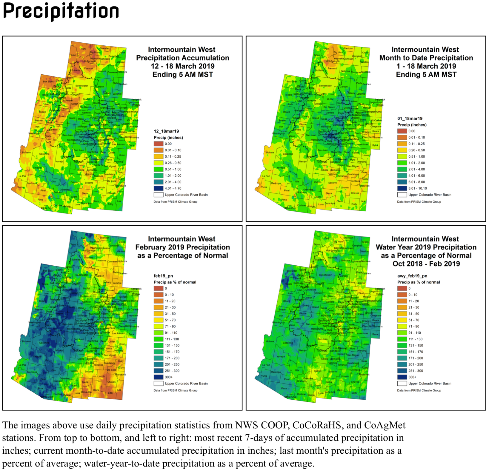

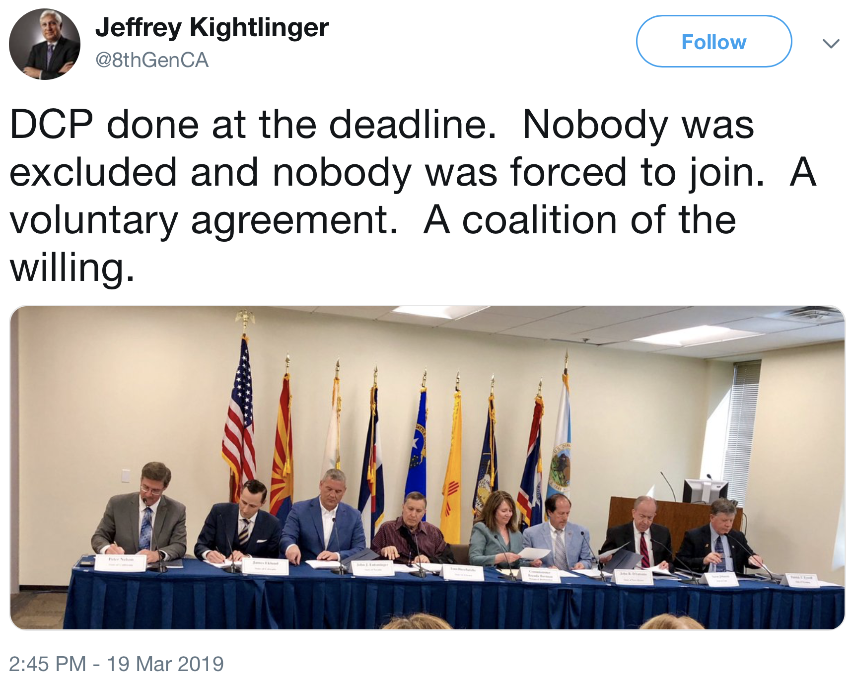
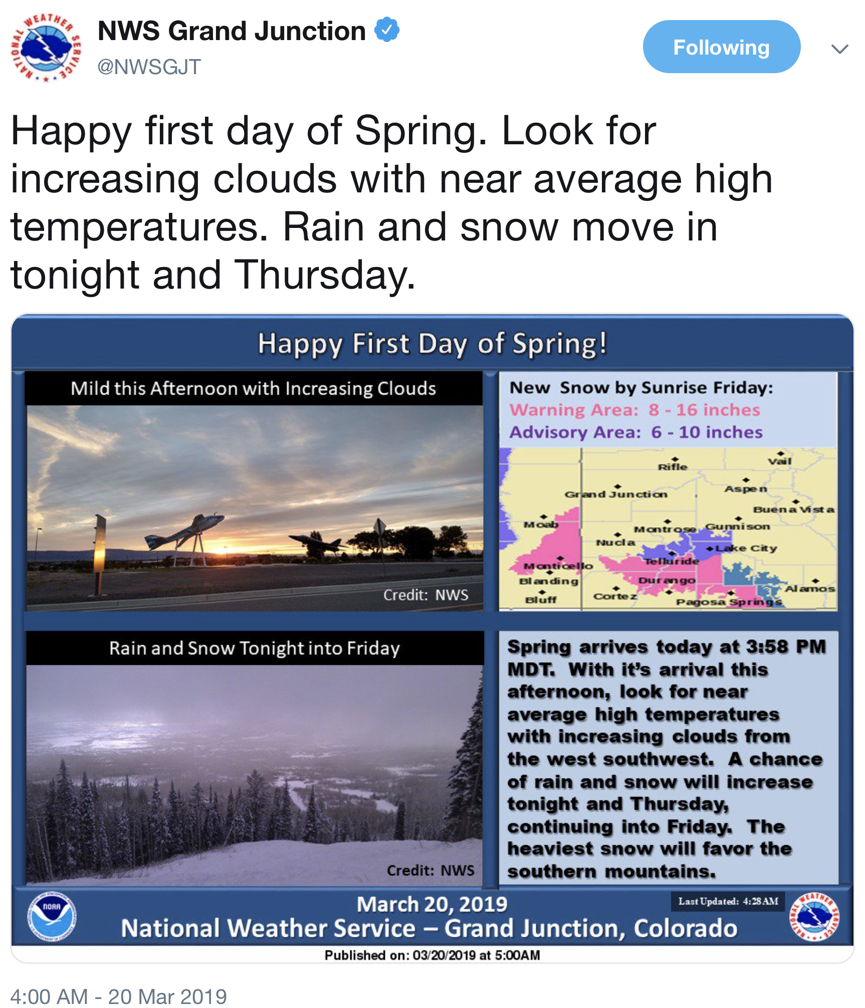
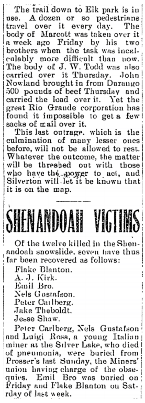
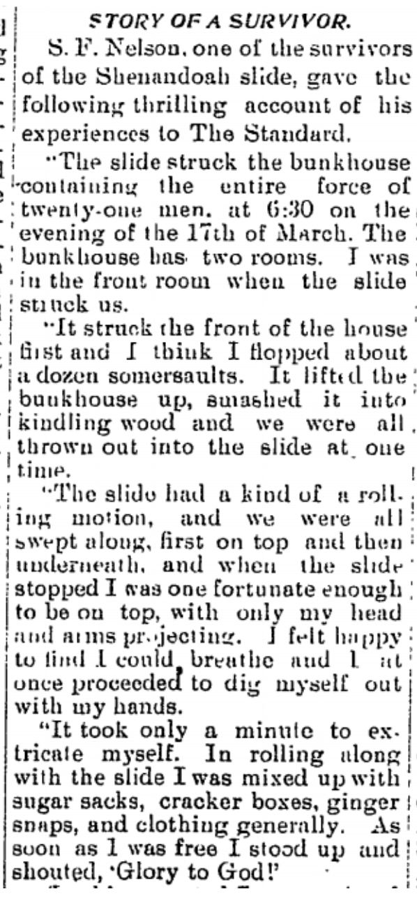


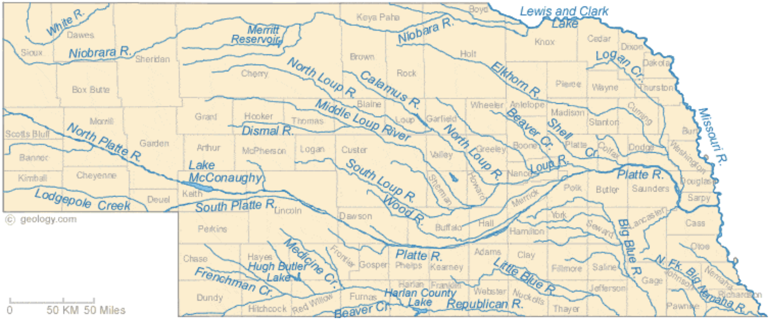

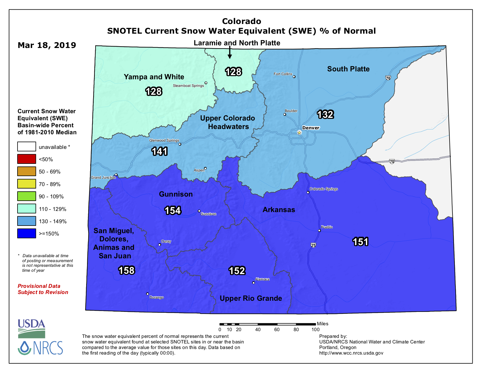
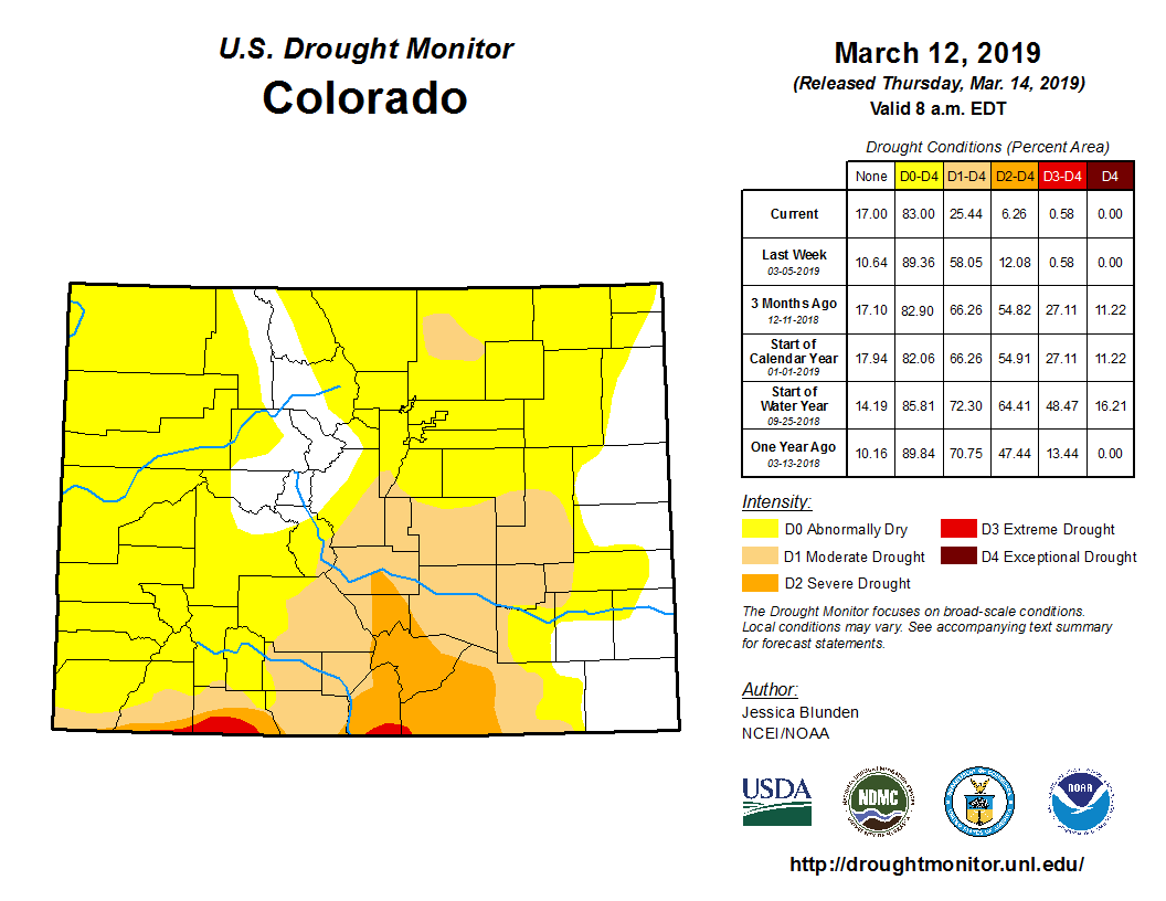
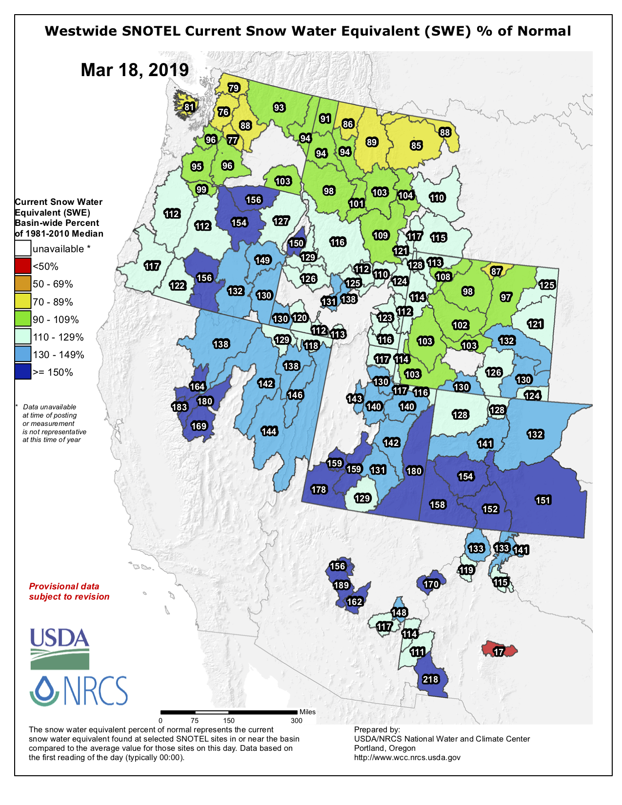
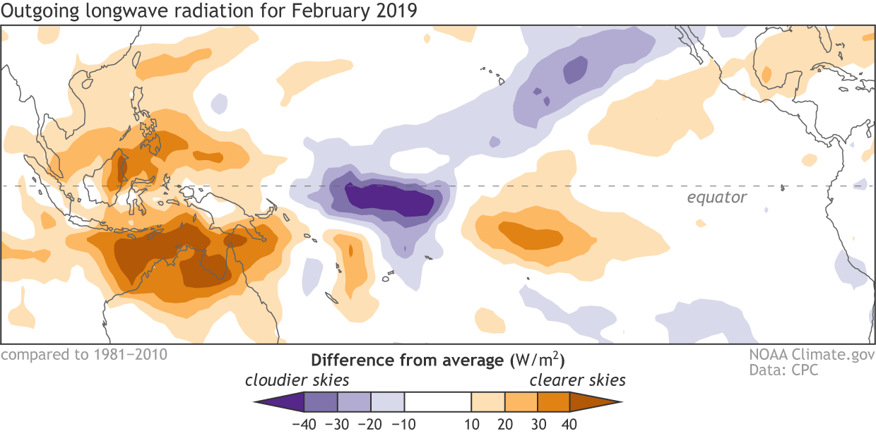
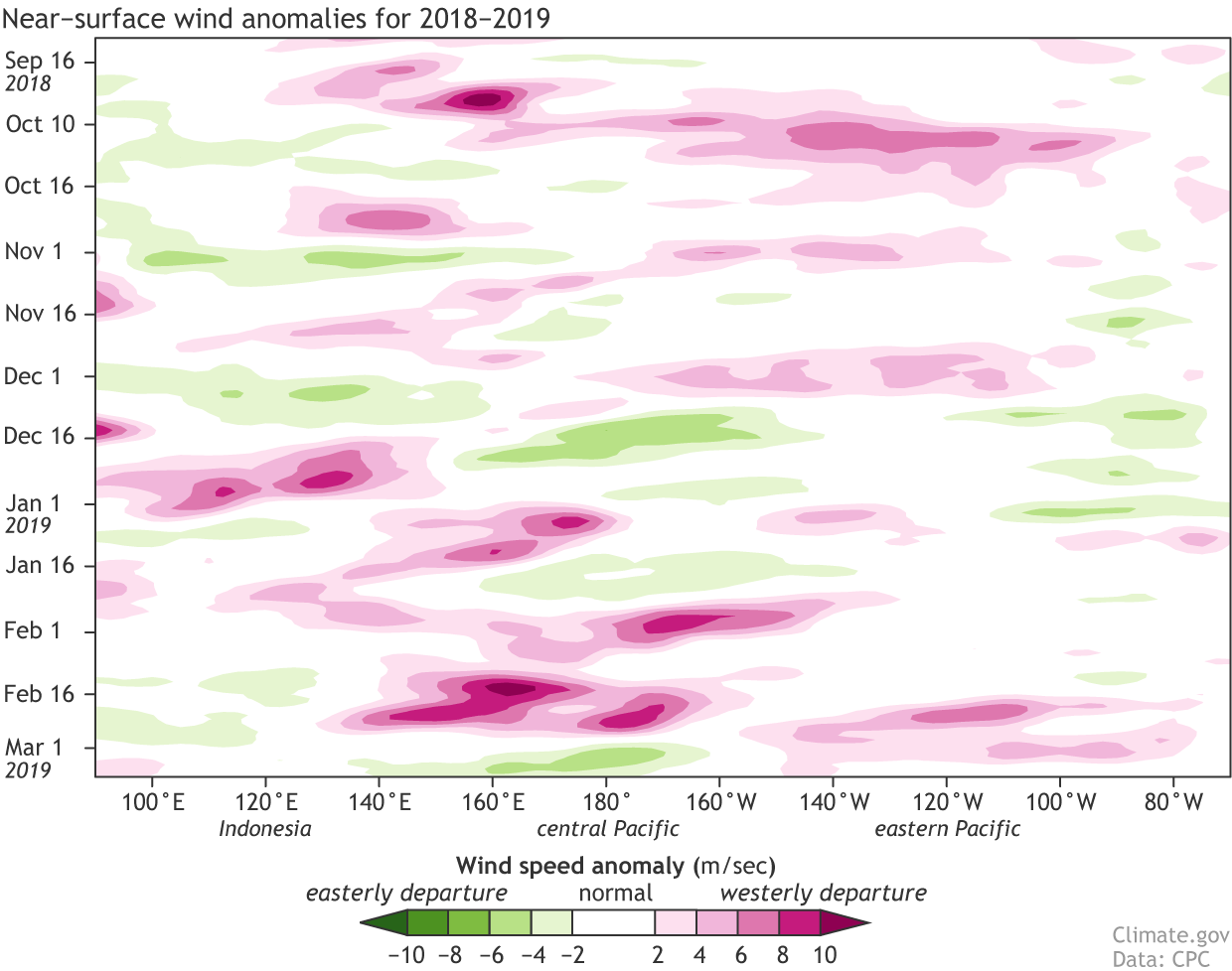
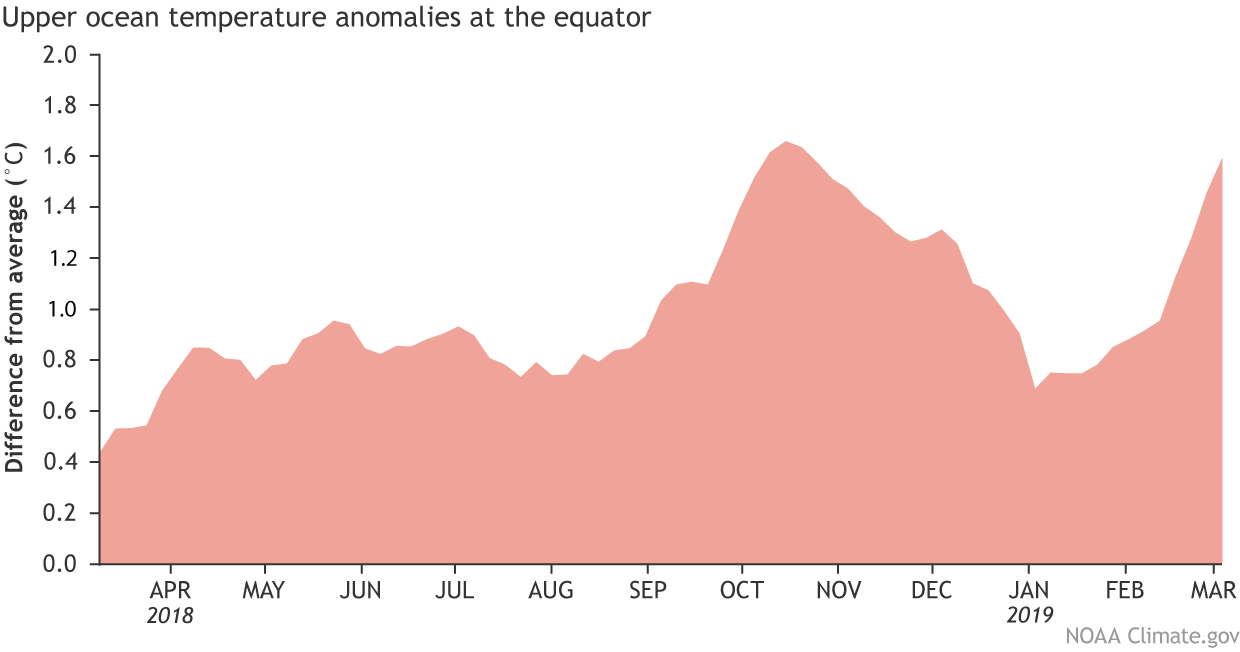
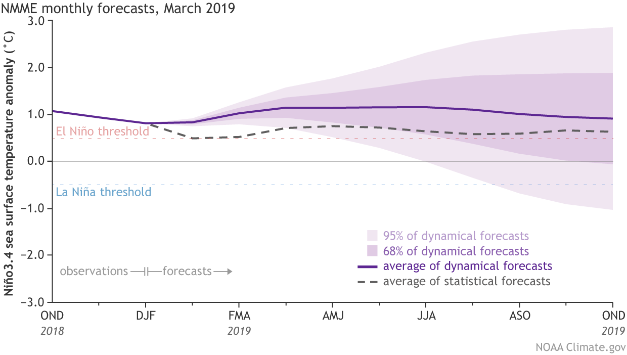


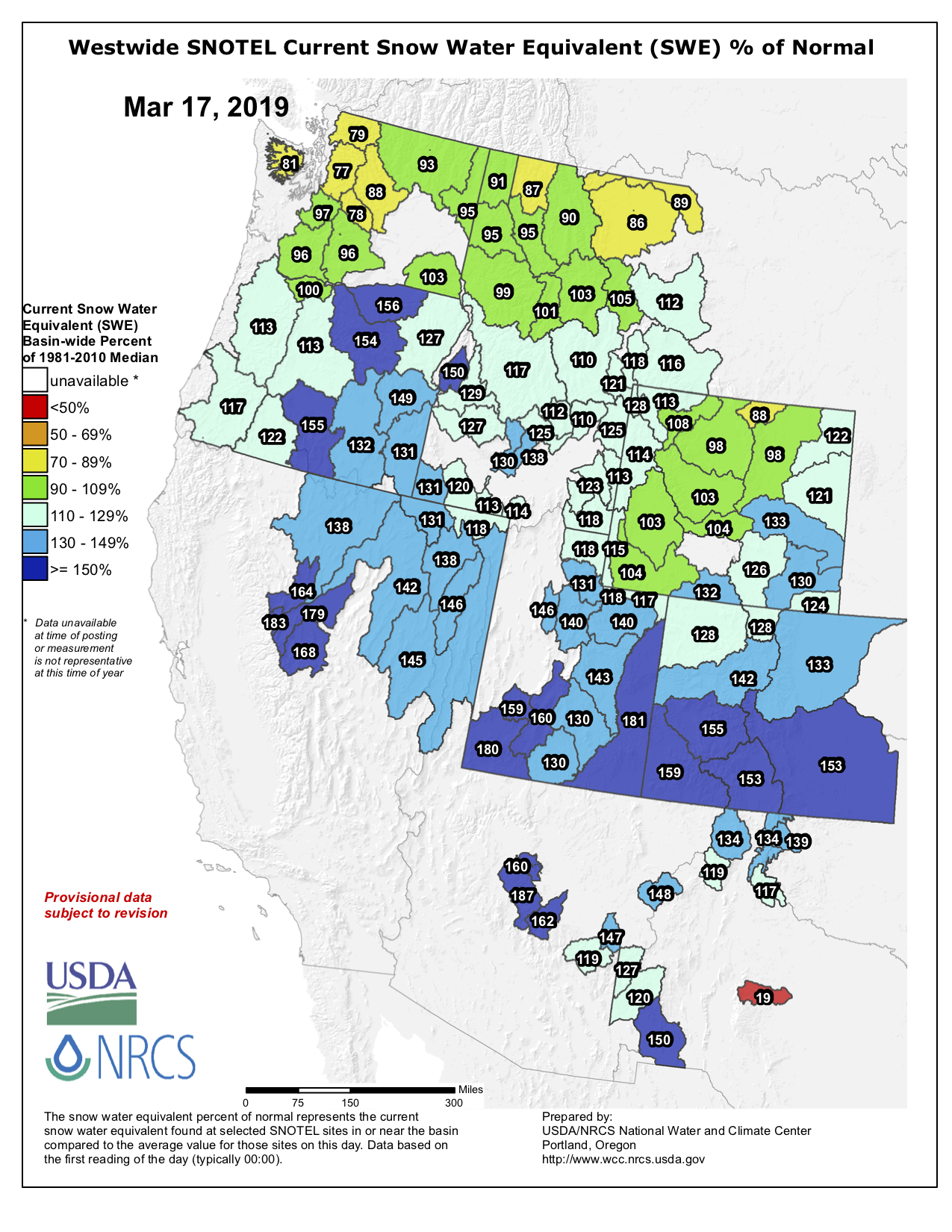


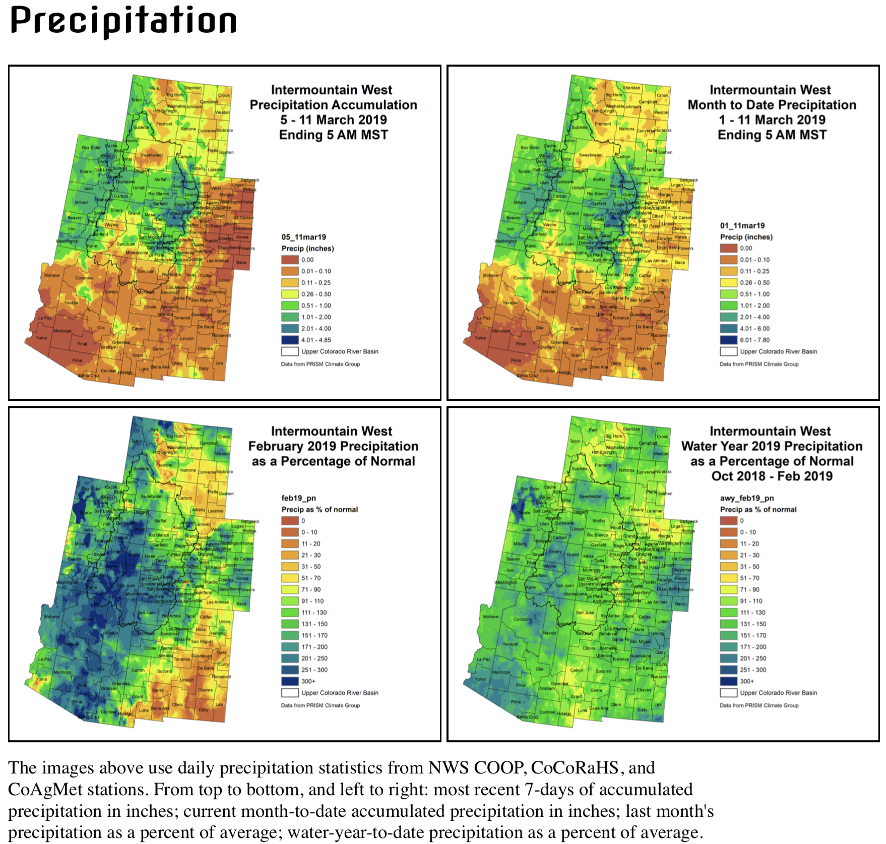


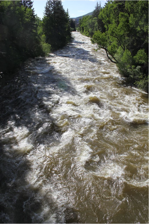


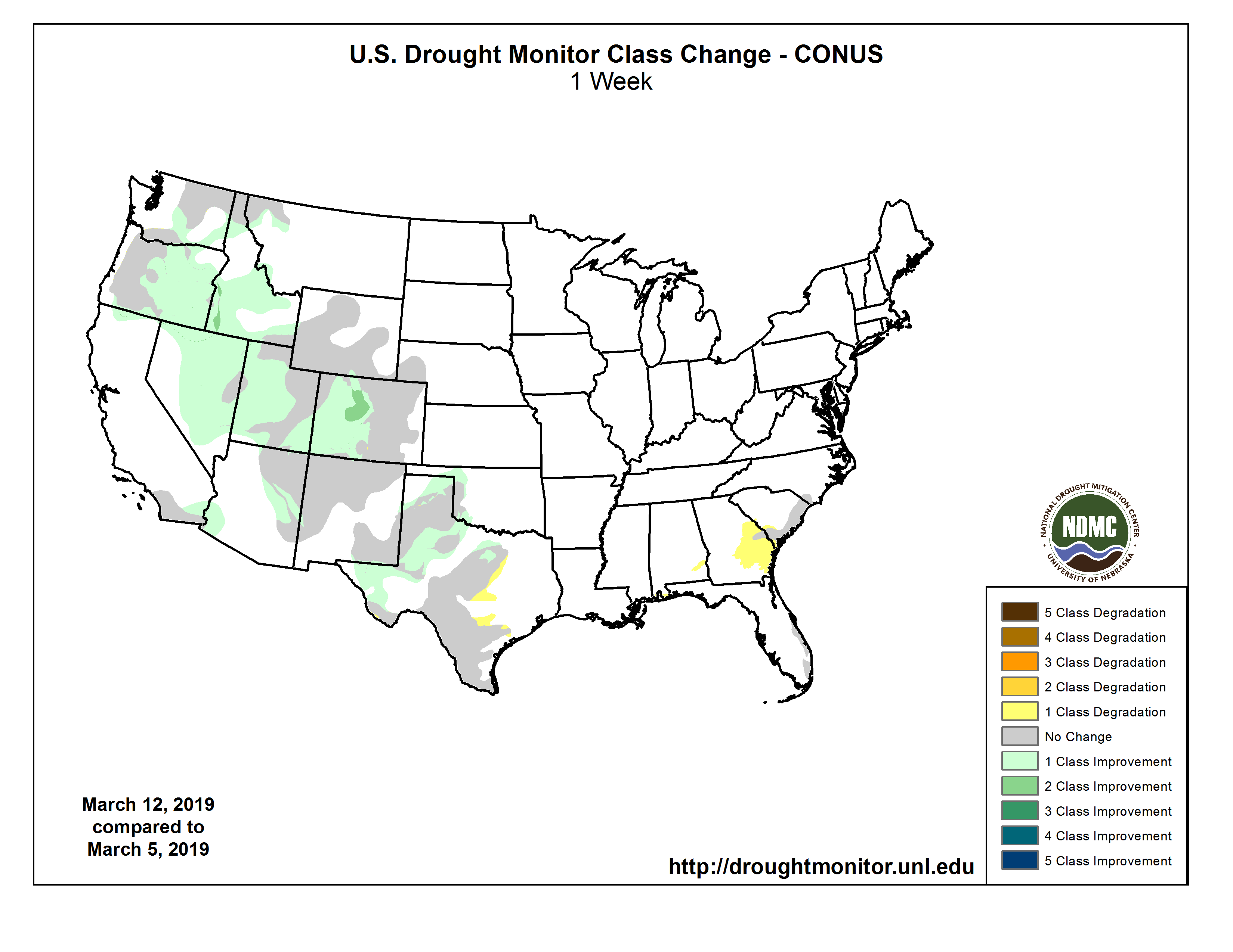

_basin_map")


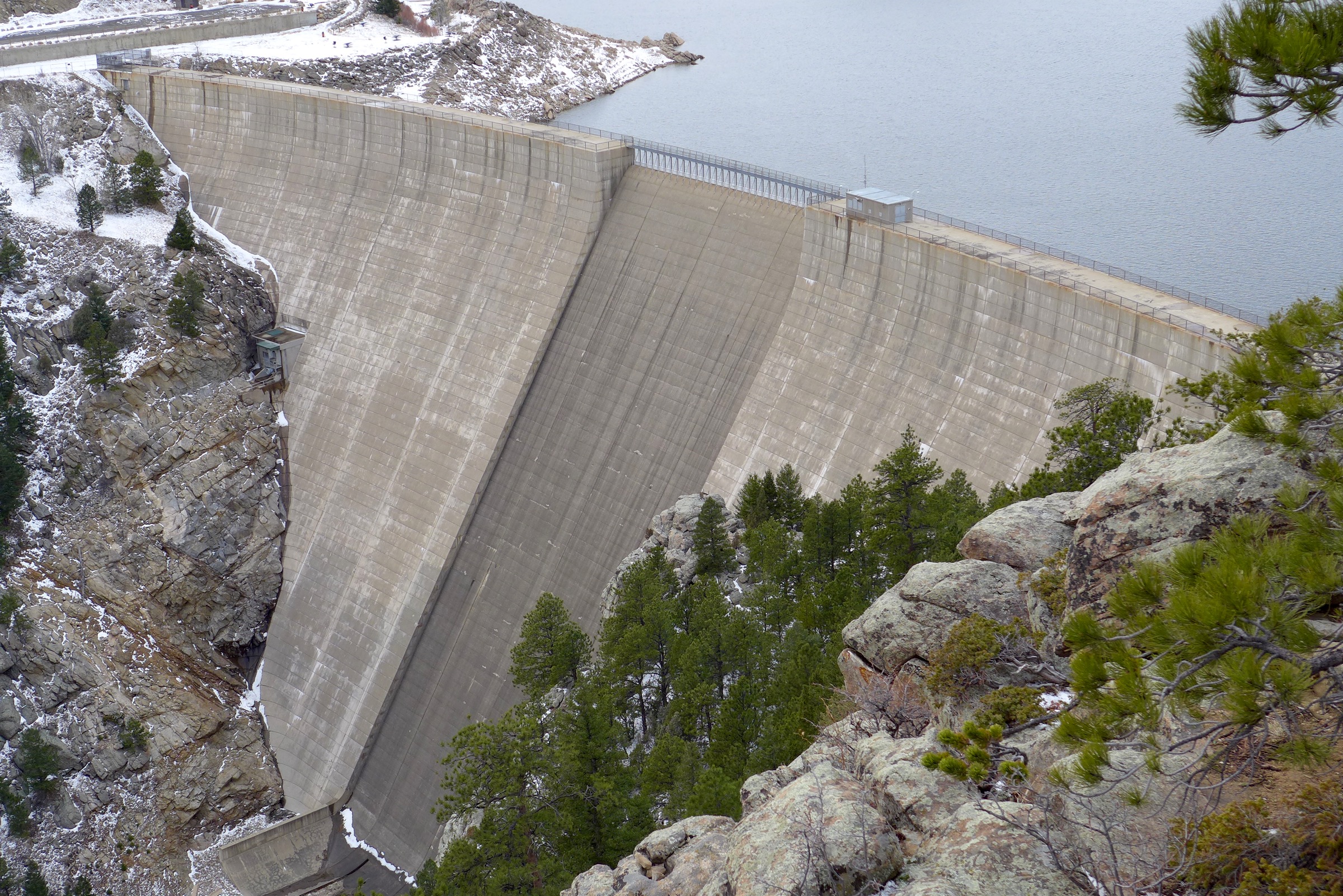
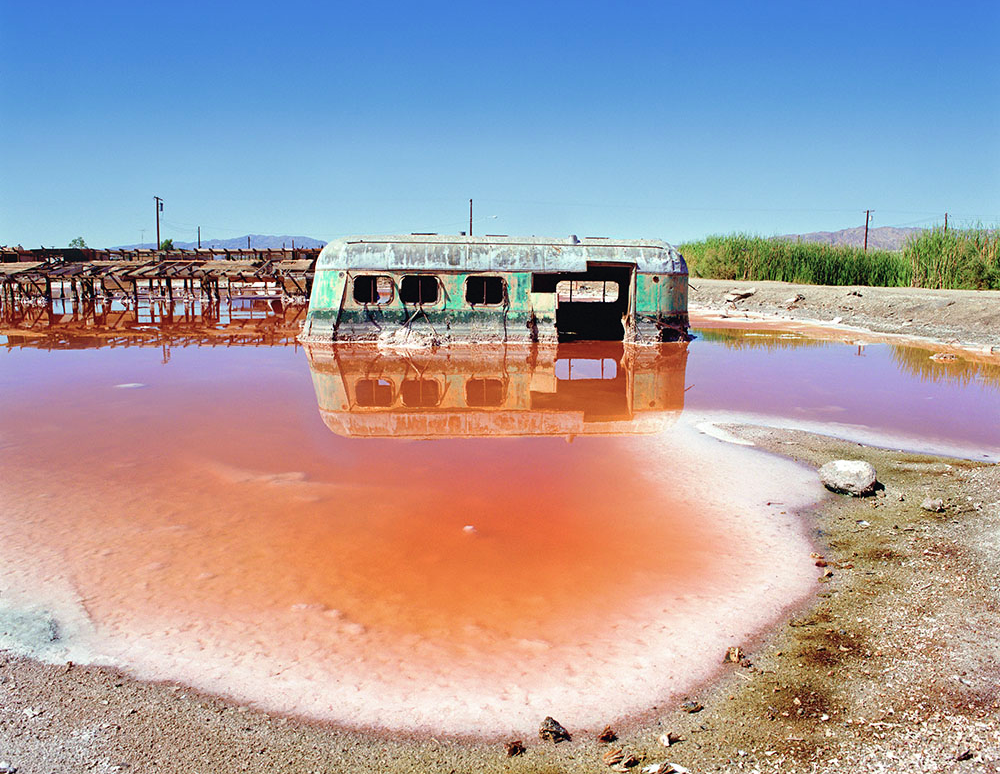


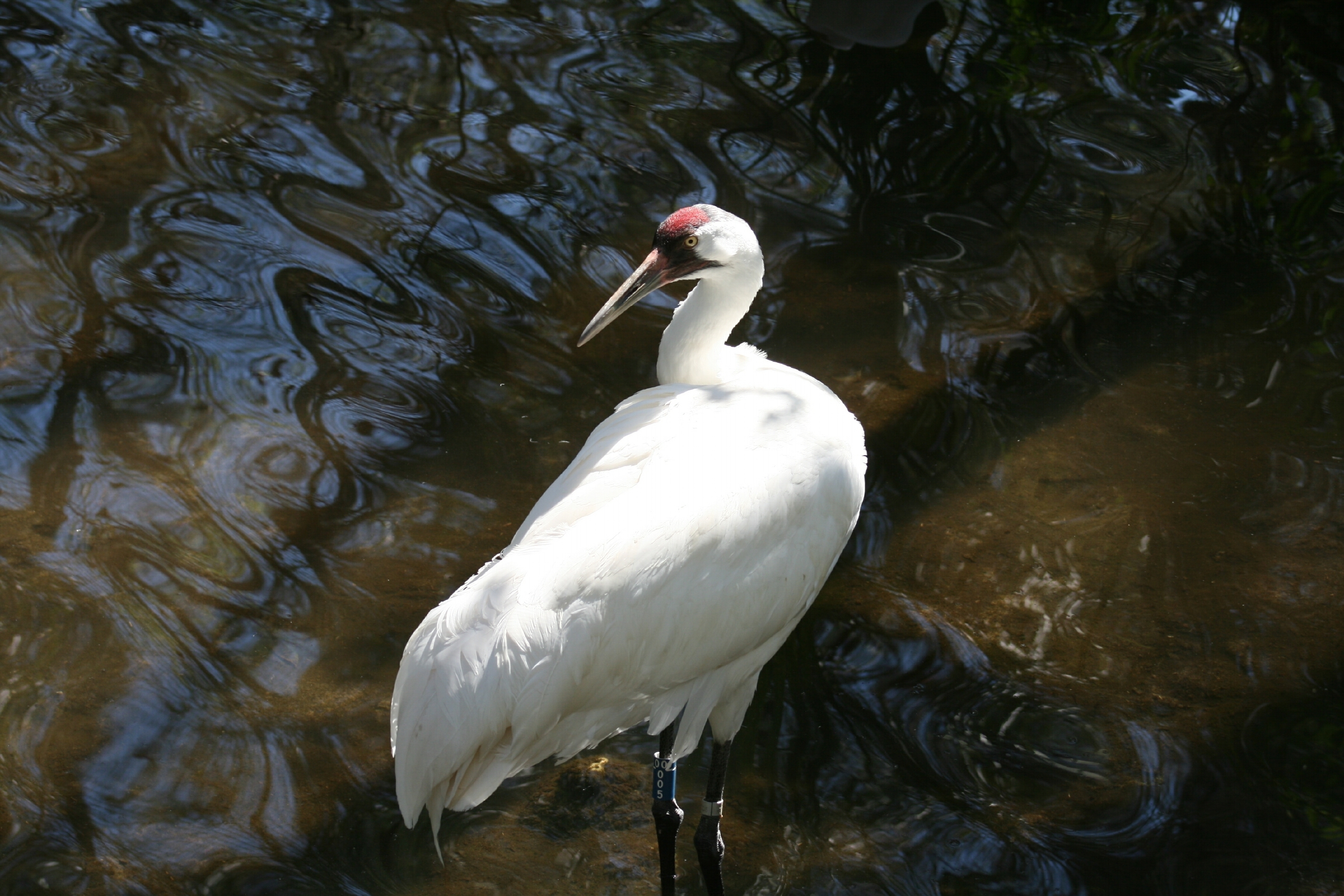
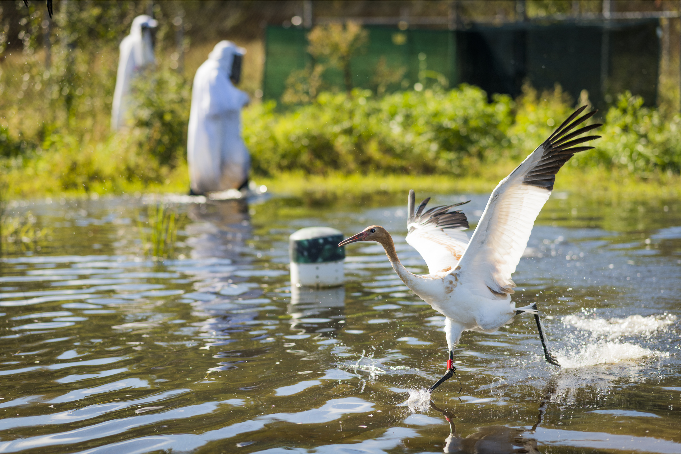
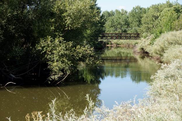


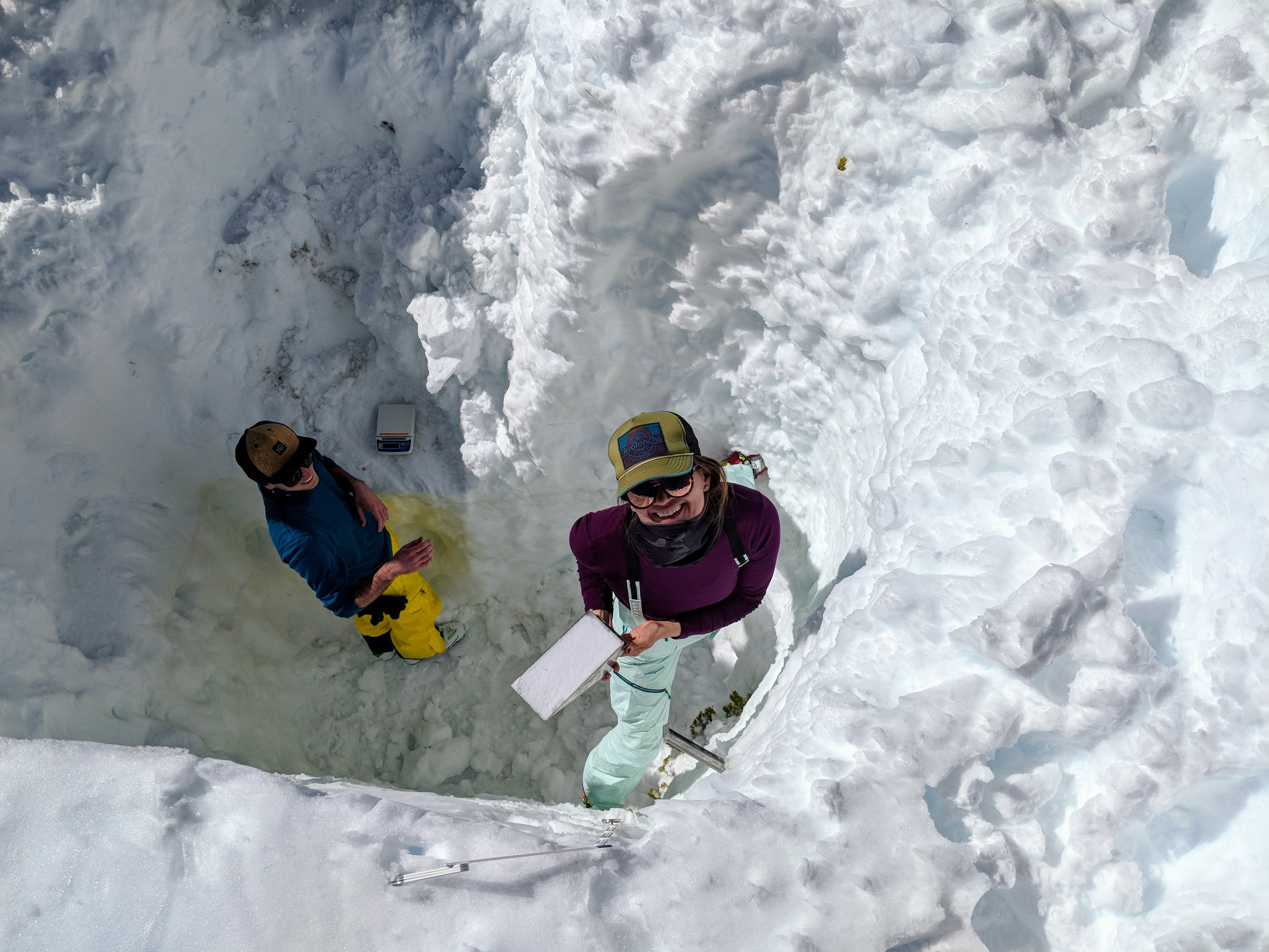


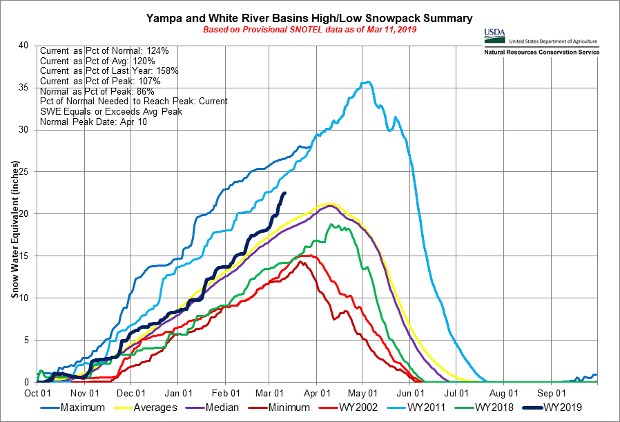
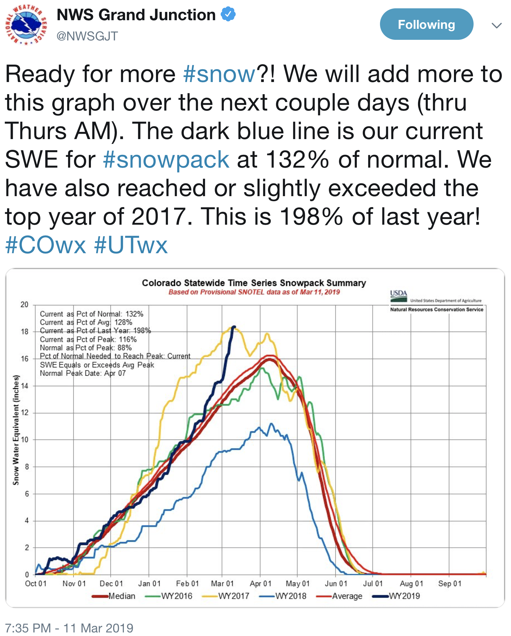

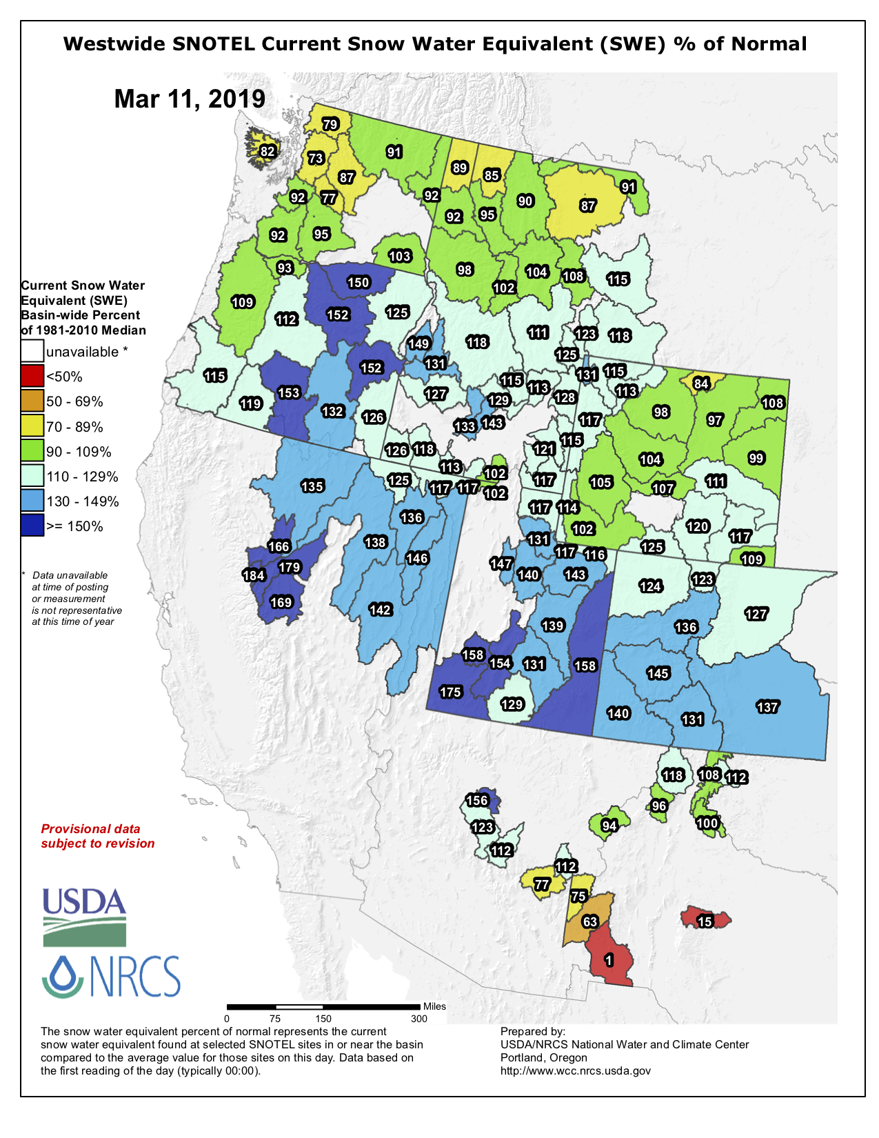


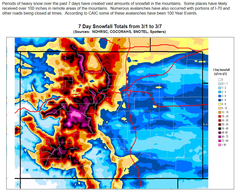


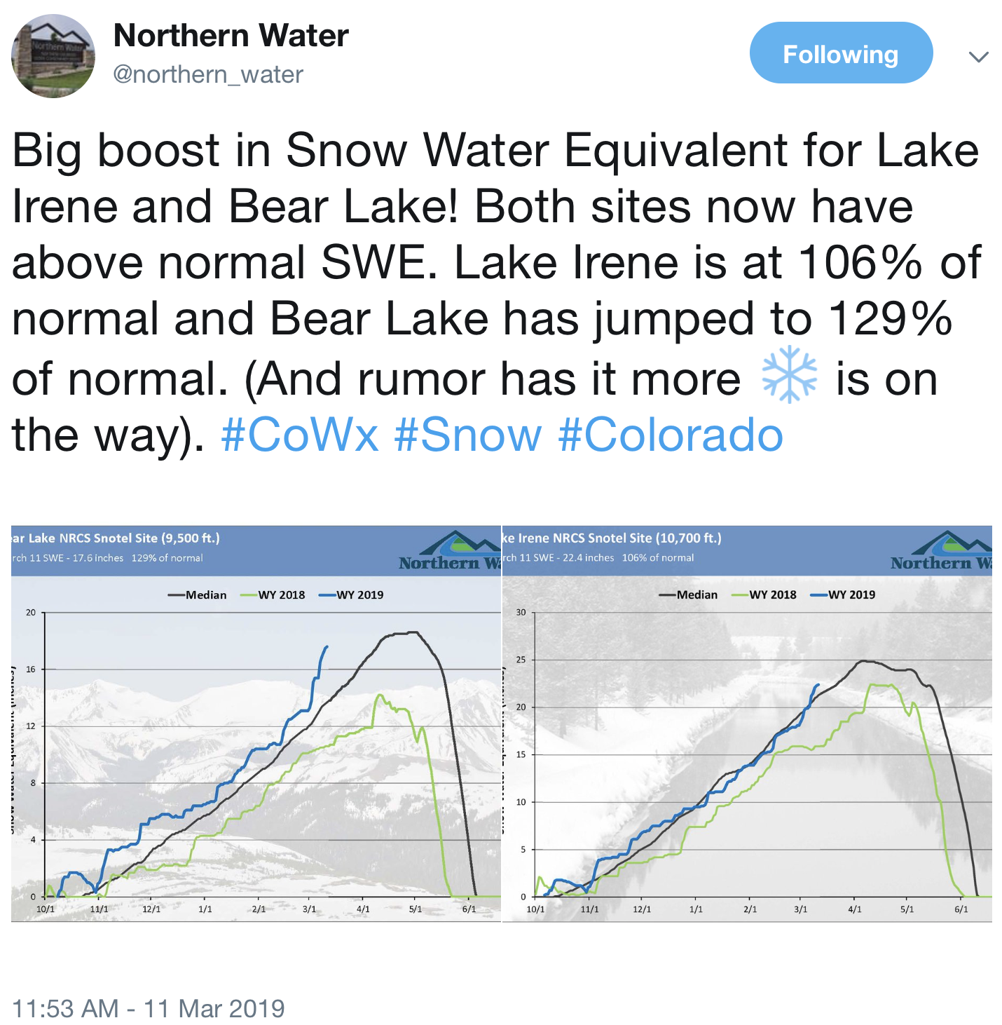


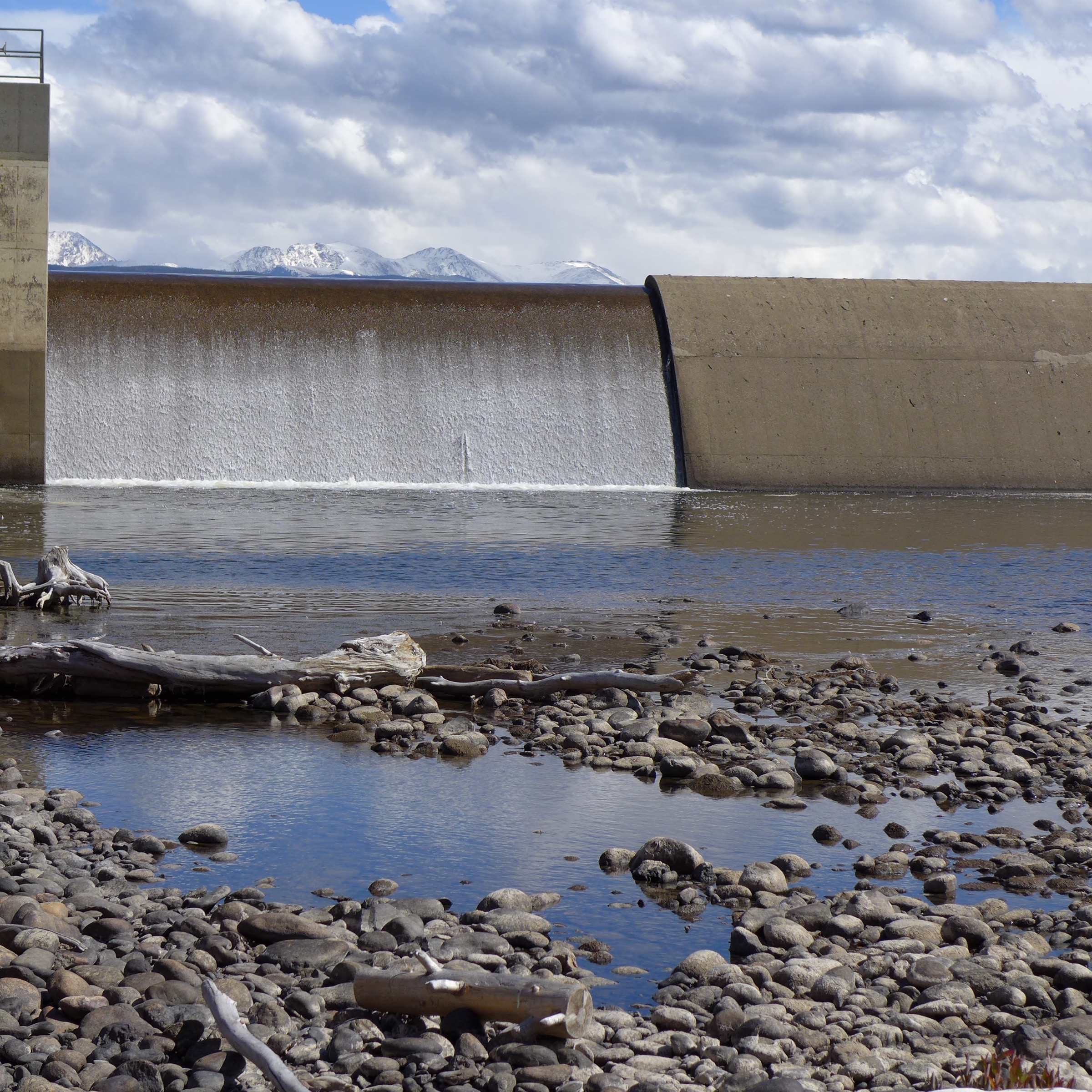

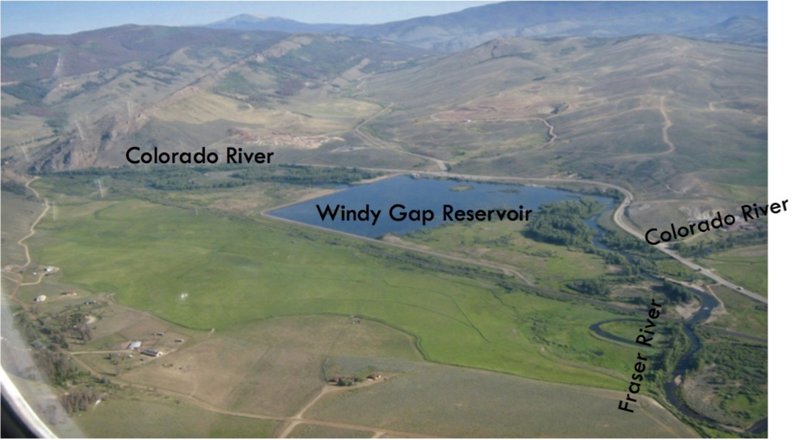

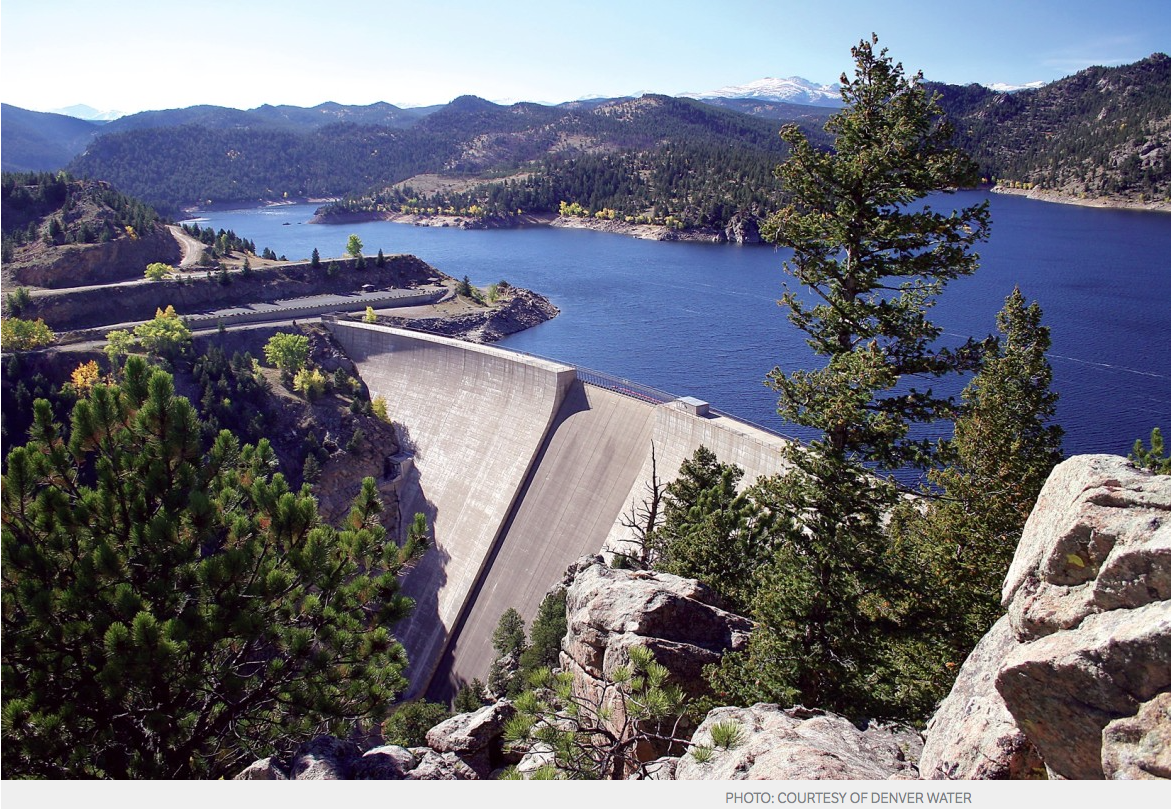
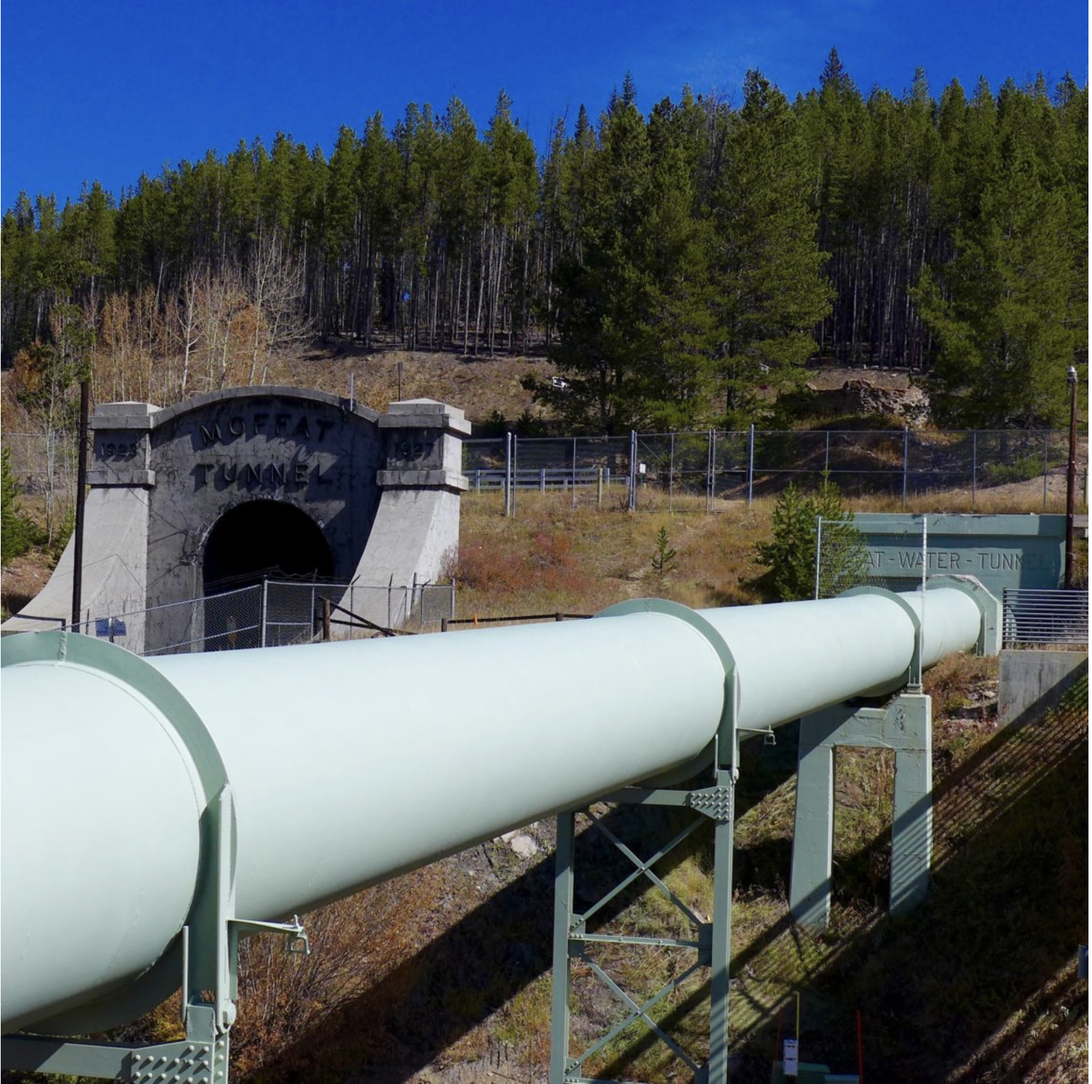

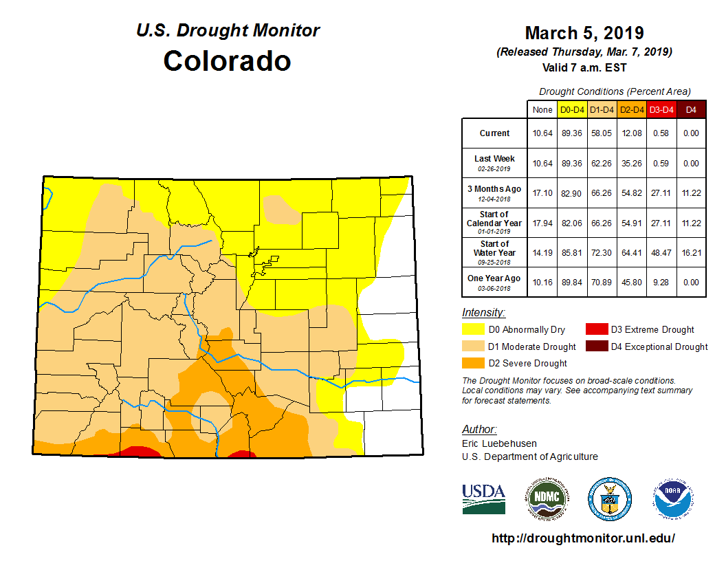