Photo essay: Crossing the Divide through Three Watersheds, the Platte, the Arkansas, the Colorado, Elk are on the move one day in May — Greg Hobbs

South Park Dawn, Upper South Platte Watershed

This slideshow requires JavaScript.

Moving up Monarch Pass in the Arkansas River Watershed

This slideshow requires JavaScript.

Across the Divide into the Upper Gunnison watershed of the Colorado River

This slideshow requires JavaScript.

Returning across the Divide at Monarch Pass in snowstorm down into the Collegiate Peaks Range of the Arkansas River Basin

This slideshow requires JavaScript.

Full Moon reveals itself moment-by-moment along Colorado’s Front Range in the South Platte River Basin

This slideshow requires JavaScript.

Greg Hobbs 5/17/2019
(Travelling from Denver to attend the Water Education Colorado board meeting at Western Colorado University, Gunnison)

“Thinking about risk on the #ColoradoRiver” — The Colorado River Research Group #COriver #aridification

Detailed Colorado River Basin map via the U.S. Bureau of Reclamation.

Click here to read the paper:

In workshops in 2017 and 2018, approximately 100 of the leading water‐supply and river managers, scientists, and stakeholders concerned about the future of the Colorado River assembled to identify key research needs in the basin. One of the most prominent themes that emerged from those discussions was the need to better understand how the river system is vulnerable to low‐probability, high‐impact events that fall outside the scope of normal expectations and existing management plans. Included in this category are completely unexpected shocks, so‐called “black swan” events, as well as the more familiar and predictable, albeit highly improbable, events. Many of these risks pertain to extreme hydrologic conditions, including megadroughts and catastrophic floods. Other risks include possible physical phenomena that might further undercut ecosystem stability affecting endangered species and environmental restoration efforts, and socioeconomic events that might stress the existing legal/management framework beyond any known circumstance. There are many reasons to believe that the likelihood of such events occurring in the Colorado River basin is increasing at the same time our water‐supply safety net—including reservoir storage, ground‐water reserves, and “unused” apportionments—is increasingly under unprecedented stress.

As the states of the Colorado River basin reconvene in 2020 to negotiate new rules concerning how to allocate the pain of water‐supply shortage and thereby supplant the expiring Interim Shortage Guidelines and Minute 323 of the Mexican‐US Water Treaty, an opportunity and need exists to do so with an eye toward the full range of potential futures that may stress the region and the river. Many of the current management challenges in the basin—including the thorny problem of overallocation—can be traced back to poor planning assumptions regarding hydrology, climate, and consideration of the full spectrum of the river’s values and services. To do better in the future will require good data fed through well‐constructed scenarios and planning frameworks. Central to this effort will be scientifically informed anticipation about the low‐probability, high‐impact events that have thus far received little attention outside of small subsets of the scientific community. To that end, we encourage planning processes embracing a wide range of possible climate futures and societal responses to those future conditions.

The Hydrologic Swans
The Colorado River basin has warmed steadily in recent decades and will continue to do so as long as humans emit greenhouse gases into the atmosphere. This warming, which is already causing river flows to decrease, is a component of a wider range of interrelated climate change impacts to watershed runoff, stream flow, and water demands. More frequent and intense extreme events are expected in a warmer future. To the extent that the rarest of these events (i.e., the extreme tails of the probability curves) fall outside of what is considered reasonably possible, the occurrence of these events has the potential to blindside and overwhelm management systems.

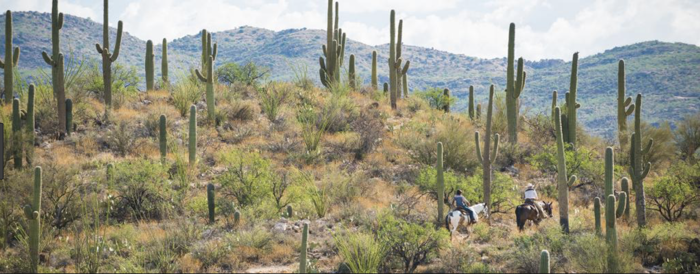
Perhaps the most acknowledged of these risks is megadrought—a drought measured in multiple decades rather than years. When compared to the paleohydrologic record, the first 19 years of the 21st century are already among the five driest extended periods in the past 1,200 years. Whether the current period is characterized as the beginning of a new megadrought, or whether the low basin runoff of the early 21st century is merely a consequence of an emerging aridification trend (discussed in an earlier CRRG publication1) associated with rising temperatures—or a combination of both—is unknown. Whatever the case, the present is a condition that is quite anomalous with respect to the 1906‐to‐present historic record used in most water scenario planning. This situation is disconcerting given the role of multiple megadroughts in undermining past civilizations in the region, namely the Ancestral Puebloans (Anasazi) on the Colorado Plateau (mid‐1100s and late 1200’s) and the Hohokam in Arizona (late 1200s and late 1400’s). This kind of a possible black swan hydrologic event—a protracted megadrought—demonstrates that planning scenarios should consider a longer hydrologic record than the last century. In fact, the abnormally wet period of the early 20th century that water managers have traditionally considered part of the “normal” watershed runoff pattern might be better viewed as a highly unlikely hydrologic event that cannot be assumed to be part of the future.

There are multiple pathways for a megadrought to overtake the Colorado River Basin in the coming decades of the 21st century. First, there is the likelihood that the current drought, driven by warming as much (or more) than precipitation deficit, might continue to worsen for years or decades into the future. The risk of such aridification certainly increases with time unless greenhouse gas emissions are curbed, and could yield a more or less permanent (on human time scales) megadrought worse than any of the last 1,000 years. This scenario is in line with recent assessments of future Colorado River stream‐flow reductions driven by continued warming. Additionally, there is still the risk that natural variability could trigger megadroughts in the future, and that these megadroughts could be as long and severe as those in the recent geologic past. Megadroughts lasting as long as 50 years have occurred in the shared headwaters of the Colorado River and Rio Grande. The odds of such extreme drought happening again only go up as the planet warms.

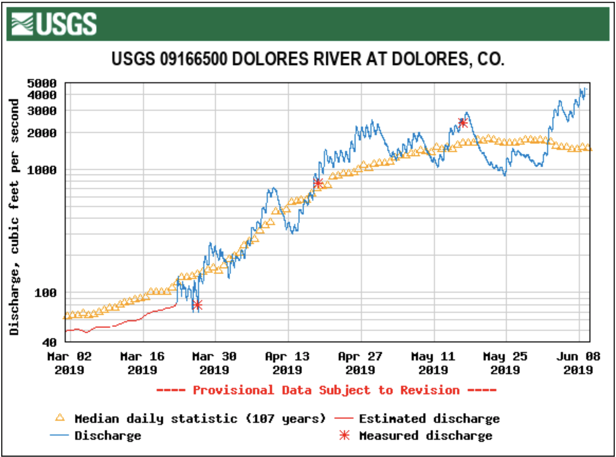
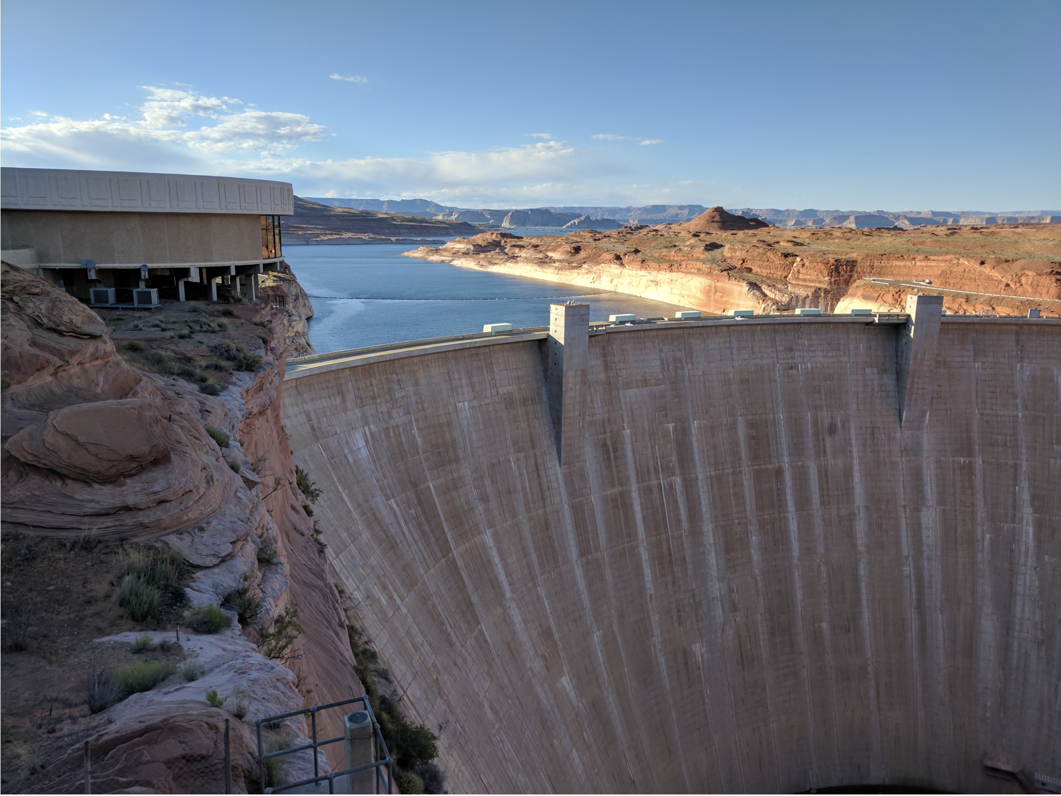
Perhaps less appreciated are the risks of catastrophic flooding in the basin. The spillways at Glen Canyon Dam were significantly eroded by cavitation in 1983, as were those at Oroville Dam (in California) in 2017, when floodwaters exposed weaknesses of existing infrastructure. Although weather prediction and water resource management plans have improved and been revised following the events at Glen Canyon Dam, there is nevertheless the possibility that an unusually large flood might occur in the basin headwaters. We know such great floods have occurred in the past (outside of the relatively short stream gauge period) based on field observations of the flood deposits and analysis of the paleohydrologic record. Even if Lake Powell and Lake Mead remain low, megaflood risk persists and is likely to be increasing. Precipitation intensity, and the amount of precipitation falling in the most intense events, are increasing globally and across the United States, in large part because sea surface temperatures and atmospheric water vapor content are both rising, increasing the odds of more extreme precipitation events. These trends will continue as long as emissions of greenhouse gases to the atmosphere continue.

Recent scientific work also highlights that the climate system may have more multi‐decadal variability than previously thought, or than simulated by state‐of‐the‐art climate models. This variability has most famously manifested itself in the form of past megadroughts, but may also generate periods of above normal precipitation, or “mega‐pluvials.” It is conceivable that such a wet period could reoccur in the future, only to be supercharged by warmer sea surface temperatures and atmospheric moisture content to yield a combination of much above normal late‐season snowpack (remember 2015’s “Miracle May”), more intense melt‐season runoff, and an extreme and persistent rain event in just the right location to generate an unprecedented megaflood. Short lead times, when combined with a dependence on often untested (and perhaps under‐capacity) flood control infrastructure, often leave managers with few tools to deal with such extremes.

Other Risks

Adapting planning frameworks to consider threats beyond the hydrologic black swans creates even more challenges. Recent history in the basin has featured dozens of salient stressors that, while not completely unanticipated, were outside of the scope of past planning endeavors. Examples include the massive loss of forest ecosystems in the Rocky Mountains and Pacific Northwest from beetle kill, the destruction of Mexican water delivery infrastructure in the 2010 earthquake, and the introduction of new exotic species (e.g., quagga muscles). Other conceivable risks include shocks to world trade that shift energy costs or agricultural production, the potentially unpredictable impact of national immigration policy on other aspects of relations with Mexico, and regional economic booms and recessions. As the recent DCP negotiation highlighted, two of the most problematic features of the current management framework—the inability of Pinal County, Arizona farmers to easily absorb CAP curtailments, and the environmental and public health challenges associated with limiting Salton Sea inflows—have influenced, and are influenced by, matters that were heretofore considered outside of basin water management planning.

Certainly it is not realistic to charge water managers with simultaneously addressing all possible interrelationships among water‐related sectors, especially in the context of totally unexpected black swan events. But it is reasonable to expect planning and decision‐making efforts, such as the basin states negotiations over new guidelines, to broaden the scope of scenario planning as applied to the analysis of water delivery reliability. At a minimum, environmental needs should be an integral part of that assessment. Similarly, it is increasingly evident that the decision‐making mechanisms through which new challenges are addressed must become more agile. Admittedly, identifying planning processes that are both broader in scope yet support more agile and adaptive management in application is a heavy lift, but it is a challenge the Basin’s water management and policy community must accept.

Conclusion

Omitting low‐probability, high‐impact events from future scenario planning efforts on the grounds that we are powerless to prepare for what we cannot fully anticipate or comprehend is both foolish and unnecessary. The reality is that we are learning a great deal about many such risks. For example, one step forward is Reclamation’s recent emphasis on “stress test” modeling, which assesses how the water delivery system would perform if the hydrology of recent decades were to persist. Perhaps the next step could take inspiration from the approach used in the Severe Sustained Drought study of the early 1990s, which used the hydrology of a megadrought from the late 1500s to test modern system performance under extreme water scarcity, focusing not only on water deliveries, but on the drought’s economic and environmental impacts, legal/political ramifications, as well as considering potential coping mechanisms. And even if we cannot predict what the next actual black swan event will be, basin managers can establish a process to continuously evaluate all of the climatic, hydrologic, socio‐political, economic, and other trends that might affect basin management, and to advise on the implications of those factors and possible ways to mitigate or address them. Many researchers in the academic community are already mobilized to assist in this effort.

Undoubtedly, the basin will continue to experience events and conditions that surprise even the most insightful managers and diligent researchers. Effectively dealing with these risks will test the social capital built up among basin leaders and the limits of our governance regimes. The (generally) collaborative environment among water managers that has evolved over the past 15 years is a welcome asset in this increasingly turbulent period. The renegotiations of the Interim Guidelines is a looming (although not isolated) opportunity to build upon that framework, and to create increasingly broad and inclusive planning frameworks to seek truly robust management solutions.

Centuries-old irrigation system shows how to manage scarce water — @NatGeo

Selection of the 2015 native heirloom maize harvest of the seed library of The Acequia Institute in Viejo San Acacio, CO
Photo by Devon G. Peña

Here’s an in-depth look at acequia culture and administration from Robert Neuwirth writing for National Geographic. Click through to read the whole thing and to take in the illustrations and animations. Here’s an excerpt:

It’s spring again, the time of year—for the 300th time in some instances—when New Mexico communities come together to clean the acequias, irrigation channels that carry snowmelt from the mountains to newly tilled farm fields. Each annual cleaning is one more demonstration that at least here, in these close-knit communities arrayed across arid and rugged rangeland, it’s possible for people to share scarce resources to achieve a common goal—in this case, making sure everyone in the group has enough water.

Acequias are mutually managed, irrigation channels that have been in continuous operation in the arid American Southwest since before the formation of the United States. This communal water system traces its roots to the Spanish conquistadors, who brought their traditions to the territory in the 1600s, and who themselves borrowed it from the Muslims who invaded Spain in the 8th century. Indeed, the word acequia (pronounced ‘ah-seh-key-uh,’ stress on the ‘seh’) is an adaptation of the Arabic as-saqiya, meaning water carrier.

There are close to 700 functioning acequias in New Mexico, according to the state’s Acequia Commission, and a score more in Colorado. Many of these gravity-fed ditches that bring runoff from the mountains to the fields have been operating for three centuries, and some were likely dug long before that.

Most acequias are open channels and many farmers irrigate by flooding their fields, which means that lots of water leaches away or evaporates. Yet studies show that the dirt waterways provide more robust environmental benefits than concrete culverts and metal pipes, says Sam Fernald, professor of watershed management at New Mexico State University in Las Cruces and the head of the school’s Water Resources Research Institute.

Seepage—which can range between one-third and one-half of the flow—replenishes groundwater while also fostering a rich wetlands around each ditch, Fernald says. A number of other studies suggest that irrigating with acequias extends the hay-growing season and so boosts the number of cattle that can be grazed. And the largest benefit, though much harder to quantify, is that the acequias create communities that serve as stewards of the environment.

Parciantes—members who own water rights in an acequia community—express this in a slightly different fashion. “Belonging to the land is what’s important,” says Joseph Padilla, a retired teacher who irrigates his family’s land with water diverted from the Gallinas River into the Acequia Madre de los Vigiles just outside of Las Vegas, New Mexico. Fat snowflakes float around us, falling onto his field of newly sown winter wheat. “We don’t control it. The land owns us. We’re just a small part of it.”

The acequias also protect traditional farming techniques. “I still have the same chile seed my ancestors grew and I still grow the same chile variety,” says Don Bustos, master-farmer and long-time mayordomo of the Acequia de Santa Cruz in the hills above Española.

As Bustos and I stroll the fields that once belonged to his great-grandmother, he says: “This acequia does more than distribute water. It holds the community together as a spirit enterprise.”

GoPro Mountain Games recap

Steep Creek Championship 2016 1st Place Alec Voorhees. Photo Caleb Chicoine/Downriver Media

From The Vail Daily (John LaConte) via The Summit Daily:

Dane Jackson has been called the world’s best kayaker and, on Thursday, he bested boaters from all over the globe to prove the title true.

Jackson was the only American man in the top five at the Steep Creek Championship, a timed race down Homestake Creek that doubles as the kick off to the GoPro Mountain Games every year.

International competitors outnumbered Americans in the women’s event, with only four female competitors completing both of their preliminary round runs through the tight section of class-5 whitewater.

Adriene Levknecht, of Greenville, South Carolina, was the fastest woman on the day.

Colorado was well represented in the competition, with Glenwood Springs paddlers Kenny and Dally Kellogg, Peter Farmelo of Silverthorne and Alex Tansey of Kremmling holding it down as the most local kayakers in the 37-person field.

Tansey said if they had any “home water” advantage, it was the fact that they were already acclimated to the elevation and the cold water.

“Some of these folks aren’t used to true snowmelt water,” Tansey said. “As cold as cold can get.”

Traveling to Colorado for the first time from Costa Rica, Arnaldo Cespedes said the water nearly paralyzed him at first.

“Even though I was wearing a wet suit, I thought that I was going to get frozen,” he said.

Cespedes said as a result, he didn’t perform as well as he was expecting…

Paddlers from Chile, Argentina, Canada, France and Norway also competed.

Second-place Gerd Serrasoles, a native of Catalonia, now calls the Columbia River Gorge home in White Salmon, Washington…

The Ultimate Mountain Challenge tests competitors across six events of their choosing, with at least one biking and paddling event mandatory. It wraps up on Sunday with the Pepi’s Face Off, also mandatory, which sets a clock to 30 minutes and pits runners against each other in a challenge to see who can complete the most laps up the steep, 40% grade ski run at the base of Gondola One in Vail.

“Just the idea that women can farm is new to our psyche in America even though women have been farming forever” — Harper Kaufman

Photo credit: TwoRootsFarm.com

Here’s a report from The Aspen Times (Scott Condon). Click through and read the whole thing and to check out the photo gallery. Here’s an excerpt:

Working the Aspen farmers’ market booth last summer for Rock Bottom Ranch, agriculture manager Alyssa Barsanti was chatting with a customer who couldn’t believe she was one of the farmers responsible for growing the vegetables he was about to buy.

“He asked to see my hands,” Barsanti recently recalled with a snicker.

She’s used to the doubters, most of them Doubting Thomases. But make no doubt about it, the resurgence of small farms in the Roaring Fork Valley is coming largely on the backs and biceps of women.

Rock Bottom Ranch in the Emma area has an all-female team of six working its fields and livestock pastures this year.

Two Roots Farm co-owner Harper Kaufman hired two women to prepare soil, plant seeds and young plants, weed and harvest land leased from Pitkin County Open Space and Trails near the Emma schoolhouse.

Entrepreneurs such as Vanessa Harmony are finding ways to cultivate their passion for a niche in agriculture into a business. Harmony hopes to turn a sidelight venture selling fruit trees and eligible perennials into a full-time job.

“Just the idea that women can farm is new to our psyche in America even though women have been farming forever,” Kaufman said…

The Edwards native got interested in farming while attending the University of Montana.

“After college I really wanted to go somewhere where I could get my hands dirty,” she said.

She also believed in agriculture’s ability to ease climate change through practices such as carbon sequestration rather than contributing so much to carbon emissions.

After first working at a farm in Northern California, she landed at Rock Bottom Ranch where she served for two years as agriculture manager. That solidified her desire to get into farming on her own. She and Christian LaBar, her life and business partner, started Two Roots Farm. They rented land for two years in Missouri Heights, then earned a 10-year lease from Pitkin County at the fertile Emma property last year. They grow vegetables on 3 of the 22 acres they lease and have expansion plans in mind.

Kaufman, 27, said she loves their decision despite “hard work, low pay and risky business.”

“My understanding of farming has definitely evolved,” she said. “I came into it with a lot of naivety.”

In the Roaring Fork Valley and an increasing number of areas around the country, farming isn’t economically viable because of high land costs. Initiatives such as Pitkin County Open Space’s purchase of land to preserve agriculture will be vital for the future of farming, she said.

“It’s such small margins and such hard work,” Kaufman said. Any number of factors — drought, hail, pests — can “really cripple a farm.”

Nevertheless, she’s encouraged that farming is attracting a lot of young, passionate newcomers and that many of them are women. She estimated that 80 percent of applicants for job openings at Two Roots are women. She senses greater interest among women in connecting to food and learning where it’s coming from.

“Even at the farmers’ market, we tend to sell to women,” she said…

Like Rock Bottom Ranch, Kaufman is working to encourage people to get into farming. She founded the collaborative Roaring Fork Farmers & Ranchers five years ago as a resource for people to share ideas and resources.

“Farming is hard enough,” she said. “We don’t need to be competing and keeping secrets.”

Kaufman said the number of farming-related, start-up businesses that have sprouted in the Roaring Fork Valley in recent years has encouraged her. Women head many of them.

#Runoff news: Flood advisories issued for the Dolores, Animas, and La Plata rivers, #LakePowell elevation moving up #ColoradoRiver #COriver

From The Durango Herald:

The National Weather Service on Saturday issued flood advisories for the Mancos, Animas and La Plata rivers, and residents reported flooding along the Dolores River about 10 miles north of town.

“We have major flooding on Road 37, Dolores, 10 miles north of Dolores,” Jeffrey L. Jahraus told The Journal. Eight to 10 properties were getting water, he said.

The flooding began Tuesday and has continued intermittently, Jahraus said. About a half-acre of his neighbor’s property was under water.

Flooding has happened at their property once or twice before, he said, but never like this. The Jahrauses live along Road 37, right by where the now-famous rock slide happened on Memorial Day Weekend…

At the gauge in Dolores, the river was flowing Saturday morning at 4,200 cubic feet per second, about 256% the average June 8 rate of 1,604 cfs. Saturday afternoon, it reached 6.7 feet at the gauge, more that a foot shy of the 8-foot flood stage…

Meanwhile, flood advisories continued Saturday until further notice for the Mancos, Animas and La Plata rivers.

Mancos River
The river flow along the Mancos River was expected to remain near to slightly above bankfull, and minor lowland flooding was possible. Saturday morning, the river was at 5.3 feet – several inches above bankfull – and flood stage was at 6 feet. The river was expected to rise to about 5.4 feet around midnight Sunday.

La Plata River
A flood advisory also continued Saturday for the La Plata River at Hesperus. The flows along the La Plata River were expected to remain slightly above bankfull, and flooding is possible, the National Weather Service said. Bankfull stage is 5 feet, and flood stage is 5.5 feet. Saturday morning, the river was at 5.1 feet and expected to rise to nearly 5.3 feet by Monday morning.

Animas River
The Animas River was flowing Saturday at 6.6 feet. The National Weather Service said the river was expectd to reach 6.93 feet by Sunday morning, a foot shy of the flood stage of 8 feet. Moderate flooding would occur at 9 feet, and major flooding at 10.5 feet. The record height of the Animas is 11 feet, the weather service says.

San Juan River Basin. Graphic credit Wikipedia.

From the Brigham Young University The Daily Universe (Josh Carter):

Lake Powell is benefitting considerably from this year’s runoff following a strong snow year in the Rocky Mountains. The lake has risen 16 feet in the last month and is experiencing an inflow of 128% the average. While water levels are expected to continue to rise until the peak month of July, there is still a long way to go before the lake reaches full capacity.

“This year definitely helps,” said Bureau of Reclamation Public Affairs Officer Marlon Duke.
“But people need to keep in mind that when we came into this season Lake Powell was about 140 feet low. Even after this year, we’re going to be about 100 feet below full pool. So what we really need is three or four years just like this in a row.”

Lake Powell is currently stuck in the worst drought of its 56-year history. Its water levels and inflow have dropped significantly since the summer of 1999 — the last time Lake Powell was essentially full at 97% of capacity. The lake hit an all-time low in 2005 when its elevation sank to 3,555 feet, 145 feet below full pool.

The lake did experience a spike during the summer of 2010, when its levels got within 40 feet of full capacity. The drought has since continued, however, affecting not only Lake Powell but its sister reservoir Lake Mead as well.

“In 2000, when the drought started, Lake Powell and Lake Mead were both full,” Duke said. “Today Lake Powell is about 42% full and Lake Mead is even lower than that. Before we can start talking about whether or not the drought is over we need those reservoirs to be full again.”

Lake Mead was formed in 1935 and Lake Powell in 1963 after the completion of the Hoover and Glen Canyon dams, respectively, along the Colorado River. They were created in hopes to store and provide water for the Colorado River Basin states during times of drought. Lake Powell predominately serves the Upper Basin states of Utah, Colorado, Wyoming and New Mexico, while Lake Mead provides for the Lower Basin states of Arizona, Nevada and Southern California.

The Glen Canyon Dam was completed in 1963 and subsequently caused the formation of Lake Powell. Photo credit: Esri Photo Library/Flickr via Brigham Young University

While both man-made reservoirs have served their purpose throughout the current drought, experts are thankful for this year’s runoff after a particularly low year in 2018.

“We’re coming off of 2018 which was the second-driest year ever since we’ve been keeping records in the Basin,” Duke said. “We were worried because if we had another year like 2018 then that would have really put us in some trouble.”

The drought hasn’t been the only threat to the lake’s water levels in recent years. A couple different proposals and campaigns are calling for Lake Powell to be drained and to distribute its water to Lake Mead and elsewhere.

“Fill Mead First” is a campaign first started in 1996 to encourage conversation about restoring the dammed Glen Canyon to its natural state. As the drought continued, the campaign has gained traction, arguing that Lake Mead needs more water from Lake Powell to ensure big cities such as Las Vegas, Phoenix, Los Angeles and San Diego have enough. The campaign also argues that Lake Powell loses water through both rapid evaporation and water seeping into the porous sandstone walls.

BYU geology professor Gregory Carling talked about the potential benefits that could come from restoring Glen Canyon to what it once was.

“When the Glen Canyon Dam was built, it not only flooded one of the most beautiful canyons in the world but also thousands of archeological sites and side canyons,” Carling said. “Also, the way it is now with Lake Powell and Lake Mead half-full, both are losing lots of water through evaporation. So there probably is some sense in looking into what the benefits would be of draining Lake Powell and filling Lake Mead.”

Carling added, however, the proposal would have to go through a lengthy legislative process in order for anything to change.

“There are a lot of legal requirements and bureaucracy behind that, so it’s not just as easy as saying, ‘let’s drain one and fill up the other,’” Carling said. “You’d have to go back through a hundred years of the law of the river.”

Those opposing the “Fill Mead First” campaign argue that Lake Powell, one of the most popular boating and camping spots in Utah, supports the local economy through both recreation and tourism. The lake saw over 4 million visitors during each of the past two years for the first time in its history. Lake Powell supporters also argue the lake ensures a steady water supply to Lake Mead and the Lower Basin states.

Lake Powell attracts millions of boaters and tourists every year. Photo credit:Bernard Spragg/Flickr via Brigham Young University

The Lake Powell Pipeline is another proposal aimed at transferring water from Lake Powell to nearby Kane and Washington Counties in southern Utah. The proposed pipeline would run approximately 140 miles underground and deliver over 82,000 acre-feet of water per year to Washington County and 4,000 acre-feet of water per year to Kane County.

The proposal did take a hit last year when the Federal Energy Regulatory Commission ruled it would need greater oversight from other federal land agencies such as the Bureau of Land Management, the Bureau of Reclamation and the National Park Service. Officials expect a final decision to be made on the project by 2020.

Even amid the recent controversies experts hope the Colorado River Basin can take full advantage of its water resources, especially in times of drought. Representatives from all seven Colorado River Basin states recently met to sign drought contingency plans for the Upper and Lower Basins.

“This brings us one step closer to supporting agriculture and protecting the water supplies for 40 million people in the United States and Mexico,” said Bureau of Reclamation Commissioner Brenda Burman. “Working together remains the best approach for all those who rely on the Colorado River.”

From The Farmington Daily Times (John R. Moses):

“The City of Farmington has temporarily closed sections of trails in Berg Park due to rising water levels.” City spokesperson Georgette Allen said in a press release June 7. “Trails on the north side of the Animas River near the All Veterans Memorial Plaza will be closed throughout the weekend.”

Extensive #PFAS contamination found under Air National Guard base in Tucson — the #Arizona Daily Star

Photo credit: VisitTucson.com

From the Arizona Daily Star (Tony Davis):

Perfluorinated compounds, commonly known as PFAS, turned up in levels exceeding recommended federal standards in the aquifer underneath the Air Guard base, said the consultant’s report.

But while the contamination appears to be moving toward city drinking wells on Tucson’s south side, the pollution doesn’t pose any immediate health risk to water users, Tucson Water officials say…

That’s because PFAS pollution already detected on the south side is being routed to a treatment plant that’s cleaning it up, and because the city drinking wells nearest the Air Guard base already are shut down.

The newly discovered contamination was widespread, tainting eight monitoring wells across the base and at least one more well at the base’s northern boundary, the report found. Sampling for the report was done from January through March 2018…

The pollutant concentrations ranged from nearly 70 times the EPA’s recommended health advisory level at a well at the base’s northern boundary, to just above the EPA advisory farther south on the base, said the report.

Another monitoring well contained about 30 times the EPA health advisory level of 70 parts per trillion, the consultant’s study found…

Measurable levels of PFAS compounds turned up in soil samples collected on 14 locations on the Guard base, but exceeded recommended health limits only at one of those locations, the report said…

At the same time, Tucson Water officials note that the nearest city wells, lying 1.5 to 2.7 miles northwest of the base, are already out of service because of previously discovered contamination from PFAS, trichloroethylene and 1,4-dioxane.

Polluted water from those wells is being funneled to a south-side treatment plant known as the Tucson Airport Remediation Project.

There, it’s being treated so thoroughly that the compounds are no longer detected as the water leaves the plant to be served to people in the downtown area and just north and south of there…

The ADEQ said it doesn’t have the legal authority to require the Guard base to clean up the contamination on its site.

That’s because the EPA has no formal drinking water limit for PFAS compounds and because Arizona law doesn’t allow the state to have more stringent environmental regulations than the federal government has.