Morgan Conservation District annual meeting recap

The Platte River is formed in western Nebraska east of the city of North Platte, Nebraska by the confluence of the North Platte and the South Platte Rivers, which both arise from snowmelt in the eastern Rockies east of the Continental Divide. Map via Wikimedia.

From The Fort Morgan Times (John La Porte):

Competition for the limited water resources used to be a primary, if not the primary, issue for agriculture in northeastern Colorado.

While quantity is still a major issue, water quality is increasingly important, particularly with deterioration of that quality.

That was apparent at an annual locally led meeting hosted Wednesday in Brush by the Morgan Conservation District…

The Morgan Conservation District works with the Fort Morgan NRCS field office and is a member of the Lower South Platte watershed of Morgan, Centennial, Sedgwick and Haxtun Conservation Districts.

C.W. Scott, team leader for Morgan and Logan County NRCS, was among the leaders of the discussion, as were Madeline Hagen, Morgan district manager, and Todd Wickstrom, district board president.

Groundwater, human consumption and whether water is safe for livestock are all concerns, participants said.

The question is at what point does the quality deteriorate so much that water kills the crops instead of growing them.

With more runoff this year than in recent years, water will have more foreign material in it.

Municipalities such as Wiggins using reverse osmosis are allowed to flush the by-products of that process into the river when the flow in the river is sufficient, participants said, but that is far from the only concern.

Human hormone supplements in the water are on the rise, as are total dissolved solids.

Salt people put on sidewalks and residue from water softeners are also factors.

#Colorado and hail

From KOAA.com (Sam Schreier):

There are many ways a storm is formed. It can be a cold front moving through a region, pushing warm and moist air up into the sky, or something as simple as warm and moist air running up a mountain slope and getting lifted into the atmosphere (orographic lift). The latter is a pretty common occurrence for southern Colorado, especially in Colorado Springs and Denver.

Hail formation relies very heavily on an important piece of a thunderstorm, the updraft. An updraft provides the fuel and power to a thunderstorm by lifting warm and moist air into the heart of a storm…

As water droplets move through an updraft, they collect more water and ice around them, growing larger as they travel up into the storm. Some of these ice droplets fall out of a storm as small hail or melt back to rain, but some fall back into the storm updraft. Ice droplets that fall back into an updraft will collect more water and ice their surface, growing larger as they travel up through the storm.

Strong storms come with strong updrafts and can send hail through the center of a storm multiple times, eventually turning these ice droplets into damaging hail stones. Eventually, hailstones will get so big they can no longer be held in a storm by its updraft and fall out of the storm with the rain.

What makes the Front Range so susceptible to large hail?

The easy answer is probably pretty obvious, we live next to some big mountains. One of the ways storms are formed is warm or moist air being pushed up against a mountain range. This process is called orographic lift and it’s probably the most common way storms develop in Colorado.

Storms that form over the mountains are typically not drawing in very warm or moist air, meaning they usually stay pretty weak or non-severe. On the other side of the mountains near Colorado Springs or Denver, there is usually warmer and moist air, both of which are fuel for thunderstorms. The air in and over the mountains is also less dense, meaning there’s a larger volume of air in Colorado Springs compared to Cripple Creek.

Once storms form over the mountains, the jet stream will usually push them east into a warmer and moister airmass. This allows thunderstorms to grow explosively which in turn creates a stronger updraft and allows larger hail to form within a storm.

This is the basic reason why Colorado Springs, Denver, and the surrounding area tend to see so many hail events through the Spring and Summer seasons. Storms that form over the mountains grow rapidly over the towns right next to the mountains and can drop small to large hail as they travel east to the plains. As Colorado Springs and Denver grow larger in area, that leaves more and more of both cities exposed to falling hail from thunderstorms.

#Runoff news: Tenmile Creek, Straight Creek and the Snake River all approaching flood levels

From The Summit Daily (Deepan Dutta):

The water is roaring across Summit County. Tenmile Creek, Straight Creek and the Snake River are all approaching flood levels as the great 2019 spring runoff rushes in with thunderstorms on the way this weekend…

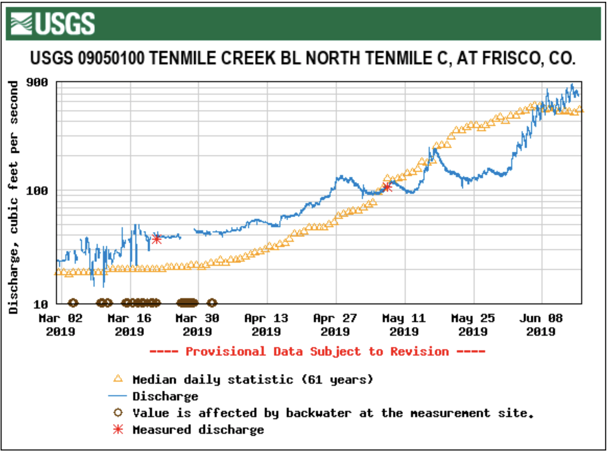
Tenmile Creek is one of the best gauges of how powerful the runoff is. The stream is currently cresting at 3.88 feet, with overflows into low-lying areas in and west of Frisco beginning at 4.8 feet…

At 5 feet, Tenmile Creek is at flood stage. At that point, there will be minor flooding of roads and properties along Tenmile Creek. At 6.5 feet, or moderate flood stage, houses begin to flood. Major flood stage starts at 7.5 feet, with significant flooding in Frisco and on the westbound lane of Interstate 70.

Residents should take some comfort in knowing that Tenmile Creek never has gone above 5.14 feet, a mark set June 17, 1995. Frisco authorities have continued to warn residents about potential flooding, with town and county staff on standby in case banks get run over.

The Snake River is currently sitting at 2.7 feet, with flood mitigation action called for at 3.3 feet. The Snake’s record crest was set June 6, 1972, when it reached 3.88 feet. At 3.8 feet, Keystone begins to flood, but that level has been reached only twice since record keeping began there in the 1940s.

Straight Creek in Dillon is currently at 4.86 feet, with action stage at 5.3 feet and flood stage at 6 feet. That stage never has been reached in recorded history, with Straight Creek topping out at 5.78 feet June 17, 1995.

Water flows into and out of local reservoirs also are rapidly speeding up. On Friday, Green Mountain Reservoir started ramping up outflows into the Blue River. Starting at 800 cubic feet per second, the reservoir will increase flows by 50 cfs every two hours until it reaches 1,400 cfs at 4 a.m. Saturday. That flow will be maintained until further notice.

The increased flows are meant to support the Coordinated Reservoir Operations initiative which seeks to enhance spring water flows consistent with the Upper Colorado River Endangered Fish Recovery Program. The conservation program seeks to boost the number of humpack chub, razorback sucker, bonytail and Colorado pikeminnow populations in the Blue.

Further south, the Dillon Reservoir is rapidly filling up after space was made for runoff these past few weeks. Water is dumping into the reservoir at a rate of more than 2,100 cfs, with outflows into the Blue River under the dam reaching up to 700 cfs. The reservoir is currently 83% full and just 15 feet shy of reaching peak elevation.

From The Moab Times-Independent (Carter Pape):

Based on historical averages, the Colorado River typically peaks near Moab during the first week of June. This year the river is projected to peak later; a forecast from the National Weather Service showed the river could reach its maximum on June 15.

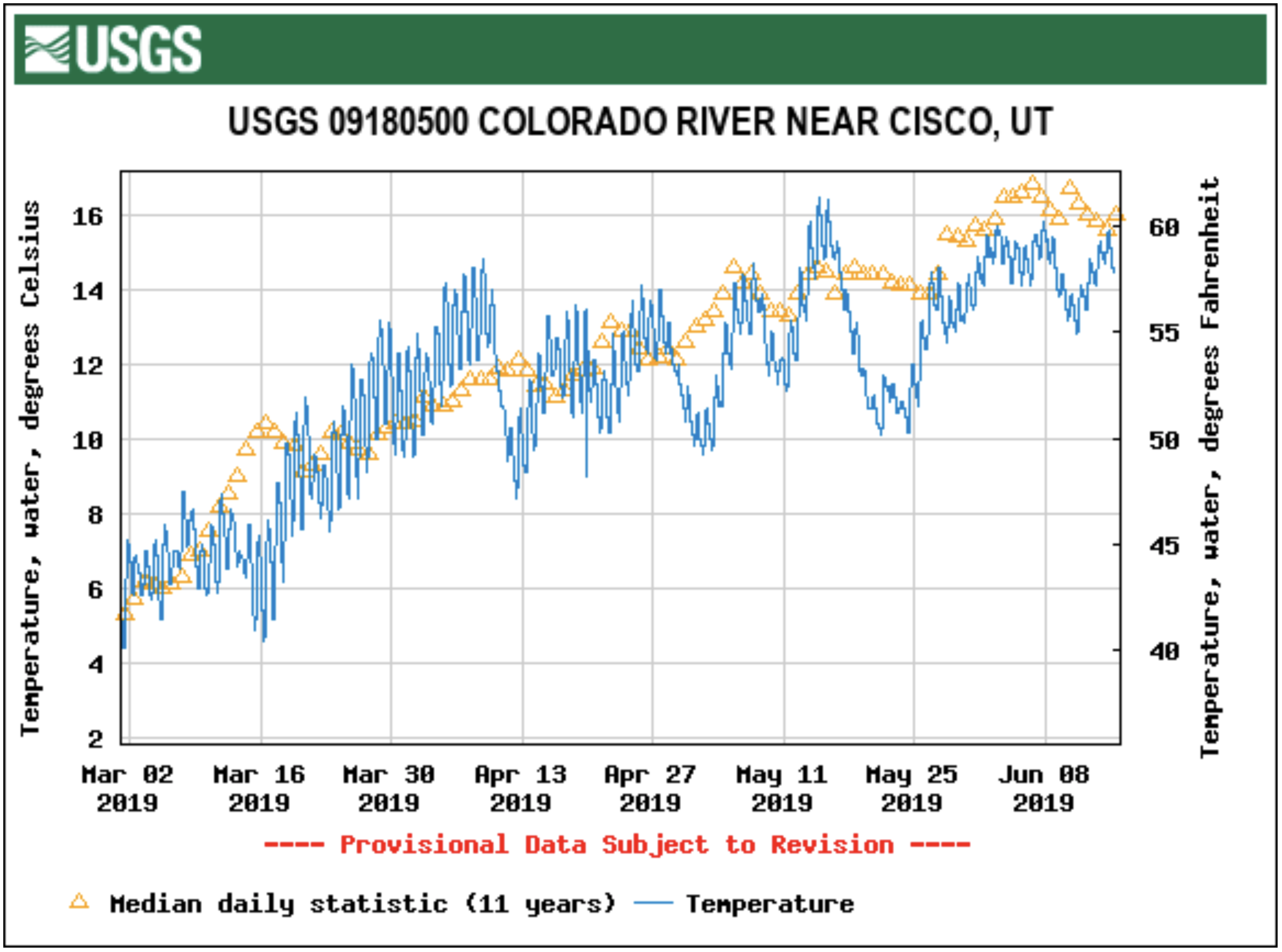
Regardless of whether the peak is already behind, the river is high this year. On Monday, June 10, the United States Geological survey measured nearly 40,000 cubic feet of water per second flowing through the Colorado near Cisco, roughly twice the average for this time of year. The National Weather Service has issued a flood advisory for the Colorado River near the Utah/Colorado state line in Mesa and Grand counties…

Farther upstream, the National Weather Service issued a flood advisory on June 11 between Grand Junction and the Utah state line as a result of the river nearing flood levels that morning.“ Minor low land flooding is expected with impacts along recreation trails already being experienced,” the Weather Service said in its flood advisory statement. “Water levels and flows along the Colorado River in Mesa and Grand counties will continue to increase due to the recent warm trend. River levels will stay high through the week…The water is swift, [it is] cold and contains debris and snags. Know your limits if recreating on or near the Colorado. A life jacket and proper equipment is a must. Smaller tributaries in the area are also running fast and cold.”

Down the river, the water has been higher than typical, but not a danger to areas in the floodplain. At its peak, the U.S. Geological Survey gauged the height of the river near Cisco to be over 14 feet this week…

Local Colorado River tributaries are also higher than typical for this time of year. Near the head of the Dolores River, the USGS measured the location’s highest instantaneous flow since 1987 at 4,360 cfs.

At Mill Creek, before the Sheley Diversion that flows into Ken’s Lake, a gauge measured an average flow rate of 88 cfs on June 8, three times the daily average for the same time of year.

As high as the waters may seem this week, they are far from a record for the area, which had much heavier flows historically due to a lack of damming upstream. In one day in 1884, more water flowed past Moab than the city has used since January 2000.

According to the USGS, the highest flow rate on record for the Colorado River at the gauging location near Cisco, just after the Dolores River junction, was measured on July 4, 1884. The flow rate that Independence Day was measured to be 125,000 cfs.

#NewMexico: Reducing water demand key to Southwest’s future — Steve Harris #conservation #RioGrande #ColoradoRiver #COriver #aridification

Map of the Rio Grande watershed. Graphic credit: WikiMedia

Here’s guest column penned by Steve Harris that’s running in The Albuquerque Journal:

Those of us who live and recreate in the arid Southwest have always faced serious water supply challenges; struggling to survive through endlessly recurring droughts, we understand how precious water is to our communities, livelihoods and economy.

Today, our survival anxieties are compounded by ominous climate trends: shorter winters, declining snowpack and diminishing streamflow. There’s little doubt that water conservation and management will assume even greater importance in New Mexico in the years ahead, which is why we need forward-thinking, bipartisan policy solutions.

In 2009, under the sponsorship of then-Sen. Jeff Bingaman, D-N.M., Congress passed the Secure Water Act, creating the West-wide WaterSMART program. Under WaterSMART, local water managers, municipal utilities and irrigation districts became eligible for funding to support an array of local water conservation projects, including water-use efficiency, water reuse and recycling, technological innovation – e.g., desalination and precision irrigation – sharing and marketing of water rights and watershed restoration.

All of these conservation strategies aim to achieve a measure of water security in an insecure world.

It’s gratifying to river conservationists like myself that WaterSMART also recognizes the need to protect healthy river flows and ecosystems. Here in New Mexico, WaterSmart is helping to fund the Rio Chama Flow Project, which in part restructures dam releases to serve the river’s multitude of wildlife and habitats, alongside the traditional imperative of securing water for communities and irrigators.

A Basin Studies program was launched under WaterSMART, and one of the studies funded, the Colorado River Basin Water Supply and Demand Study, has contributed many new ideas on how to stretch the dwindling water supplies of the Colorado River system, whose millions of users are clearly confronting a future crisis. Among other achievements, the Colorado Basin Study gathered visionary ideas from each water-using sector – both consumptive, like cities, and non-consumptive, like recreation – and a variety of constituents to boost water supplies in Lake Mead, where stored water is approaching all-time lows.

Under WaterSMART, a Rio Grande Basin Study also received funding. Thus, those of us who depend on New Mexico’s great river will have the opportunity to come together and harness our own unique abilities and resources to secure our water future.

While the results of this cooperative approach are still to be fully realized, surely the recognition of our mutual dependence on the river offers hope that collaborative conservation can help the region “tighten its belt” in the face of a manifestly drier future.

It’s important that Congress supports federal initiatives, such as WaterSMART, that bring people together on the local, state and regional levels to solve these looming challenges. It’s encouraging that Congress recently passed – and the president signed into law – the Colorado River Drought Contingency Plan Authorization Act, which helps the seven states in the Colorado Basin, including New Mexico, implement plans for conserving water and shoring up supplies.

We must build upon this success and ensure our elected leaders support policy that will sustain this basin for generations to come. Federal funds can be deployed for the benefit of all taxpayers and water users, including by creating ecological resiliency in the face of drought with the kind of stream restoration being done on the Rio Chama.

We all depend on our rivers and water, and the chain of life they support – these are things that we cannot bear to lose.

Working together is our best hope for securing those precious resources for the future.