#Drought news: Snow above 9,000 feet in the #Colorado Rockies, long-term drought decreased in #NewMexico

Click on a thumbnail graphic below to view a gallery of drought data from the US Drought Monitor.

Click here to go to the US Drought Monitor website. Here’s an excerpt:

This Week’s Drought Summary

Multiple cold fronts progressed across the central and eastern U.S. during mid to late June with widespread showers and thundershowers from the Great Plains east to the East Coast. During the past week (June 18 to 24), heavy rainfall (2 to 6 inches) maintained excessively wet conditions across eastern portions of the Great Plains, middle Mississippi Valley, and Ohio Valley. Diurnal convection resulted in locally heavy rainfall (more than 2 inches) from the Florida Panhandle south to the central Florida Peninsula. An unseasonably strong low pressure system resulted in accumulating snow to the northern and central Rockies on the first full day of the summer. More than a foot of snow was observed at elevations above 9,000 feet in the Colorado Rockies. During mid to late June, cooler-than-normal temperatures persisted throughout the western and central Corn Belt. Above average rainfall has occurred throughout a majority of the central and eastern U.S. during the past 30 days, with below average rainfall limited to scattered areas of the Southeast, south Texas, the northern Great Plains, upper Mississippi Valley, and Pacific Northwest…

High Plains
An increase in rainfall (1.5 to 3 inches) this past week (June 18 to 24) resulted in a slight reduction of D1 to D2 (moderate to severe drought) across North Dakota. In addition, 7-day maximum temperatures averaged 4 to 8 degrees F below normal throughout the northern Great Plains. Maximum temperatures remained below 80 degrees F from June 15 to 24 at Minot, North Dakota. Large variations in soil moisture continue with excessively wet conditions (above the 99th percentile) across Kansas, Nebraska, and South Dakota, while soil moisture falls below the 20th percentile across northern North Dakota. According to the National Centers for Environmental Information, Kansas had its wettest meteorological spring (March to May 2019) on record…

West
Following a dry spring across northeast Montana, more frequent rainfall occurred this past week (June 18 to 24) with 7-day rainfall amounts mostly above 2 inches. Due to this wet week and increase in topsoil moisture, an elimination of moderate drought (D1) was warranted. Moderate drought (D1) was expanded south across northern Idaho due to increasing 30 to 90-day precipitation deficits. Since 28-day stream flows have fallen below the 10th percentile, severe drought (D2) was introduced to parts of northern Idaho and adjacent areas of northwest Montana and northeast Washington. Also, 90-day SPI values generally support the expansion of moderate drought and addition of severe drought. Based on the Vegetative Health Index, the long-term drought (D1) area was reduced across western New Mexico. Following notable changes in the spatial extent and severity of drought conditions in the Pacific Northwest the previous week, no changes were necessary this week due in part to much cooler temperatures. Severe drought (D2) remains over parts of Washington which experienced its 13th driest March to May on record…

South
Frequent thunderstorms resulted in widespread, heavy rainfall (2 to 4 inches, locally more) throughout the Tennessee Valley during the past week (June 18 to 24). Due to the recent heavy rainfall, the coverage of abnormal dryness (D0) was reduced across Tennessee and northern Alabama. In addition to the heavy rainfall, numerous severe weather reports (mostly wind damage) were recorded on June 19 and 21. The Vegetative Health Index (VHI) reflects moist conditions throughout much of the region. According to the Oklahoma Mesonet network, the northeast quarter of Oklahoma has received 20 to 33 inches of rainfall during the past 60 days. Increasing 30 to 60-day precipitation deficits along with slightly above normal temperatures since mid-June led to the addition of abnormal dryness (D0) to Lafourche and Terrebonne Parishes in southeast Louisiana. Heavy rainfall (localized max of 10 inches) eliminated abnormal dryness in parts of southern Texas. However, the core drought areas in the Rio Grande Valley missed this recent rainfall thus leading to a slight increase in D1 (moderate drought) and the addition of D2 (severe drought) in Duval County…

Looking Ahead
During the next 5 days (June 27-July 1, 2019), an area of upper-level high pressure is likely to strengthen over the north-central U.S., resulting in a major warming trend across the Great Plains, Corn Belt, and Midwest. Maximum temperatures are forecast to peak in the middle 90s to near 100 (degrees F) across the central Plains and western Corn Belt. Due to the strengthening ridge aloft, the axis of heaviest rainfall (locally more than 1 inch) is expected to become focused from the northern Great Plains east to the upper Mississippi Valley and Great Lakes. An easterly wave of low pressure is forecast to shift west from the Gulf of Mexico and enhance scattered thundershowers with locally heavy rainfall across the western Gulf Coast. Scattered showers and below-normal temperatures are forecast across drought-stricken areas of the Pacific Northwest through June 28. Much above-normal temperatures along with below-average precipitation is forecast throughout much of Alaska. Ongoing heavy rainfall is expected to gradually ease across the western Hawaiian Islands. Below-average rainfall is likely to continue for Puerto Rico into the beginning of July.

The CPC 6-10 day outlook (July 2-6, 2019) favors above-normal temperatures across the north-central and eastern U.S. with the highest odds over the Southeast. Near to below-normal temperatures are most likely across the western U.S. Elevated chances for above-normal precipitation were forecast for much of the central and eastern U.S. although near to below-normal precipitation is favored across the Southeast. Increased chances for below-normal precipitation is forecast for the desert Southwest to begin July. A relatively warm and dry pattern is likely to persist across the Alaska Panhandle and southern mainland Alaska.

@ColoradoClimate: Weekly #Climate, Water and #Drought Assessment of the Intermountain West

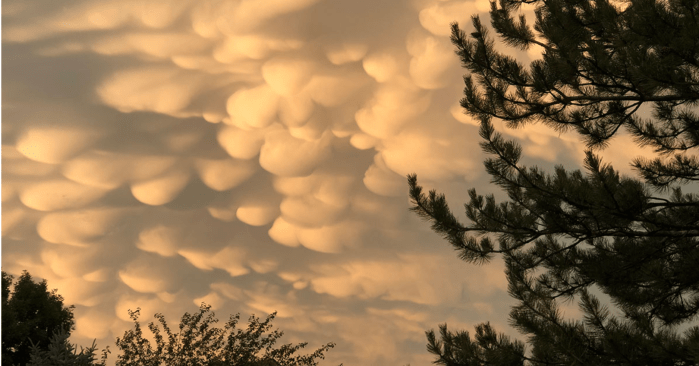
Mammatus clouds, associated with strong convection, grace a sunset over Fort Collins, Colorado, home of the NOAA Cooperative Institute for Research in the Atmosphere at Colorado State University. Photo credit: Steve Miller/CIRA

Click here to read the current assessment. Click here to go to the NIDIS website hosted by the Colorado Climate Center.

Colorado Water Center awards innovative research and education grants — #Colorado Water Center — Colorado State University

Here’s the release from Colorado State University (Katie Boehmer):

Water managers and policymakers are facing increasingly urgent threats to water resources worldwide and interdisciplinary tools and approaches may hold the answers to addressing these challenges. The Colorado Water Center, designated by the federal State Water Resources Research Act Program as the research institute for the state’s water resources, has announced awards of nearly $170,000 to provide seed funding for four Colorado State University research teams, two faculty fellows, and two education and engagement projects for the 2019-20 academic year.

The annual competitive grants program is one avenue through which the Center catalyzes water research, education and engagement across the state, as part of CSU’s land-grant mission. Awards support interdisciplinary collaboration and creative scholarship among the University’s faculty and students. The goal is to accelerate progress in research and enable both academic and experiential investigations into water resource challenges and opportunities.

The proposals funded for 2019-20 come from a broad range of disciplines, including engineering, natural resources, and agricultural sciences.

ā€œCSU has a very strong and diverse group of faculty engaged in compelling water problems of the twenty-first century,ā€ said Reagan Waskom, director of the Colorado Water Center. ā€œOur goal with this competitive grants program is to help them increase the effectiveness and impact of their research.ā€

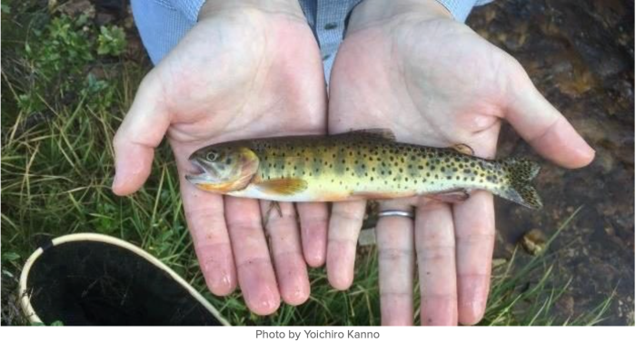
Greenback cutthroat trout. Photo credit: Yoichiro Kanno

Broad water research

Aditi Bhaskar, an assistant professor in the Department of Civil and Environmental Engineering, will lead a research team that hopes to harness the power of crowdsourced monitoring to better understand urban street flooding. Not only will this method generate more robust on-the-ground data than is possible with sensors, this pilot project will also provide a foundation for integrating social media with a new Flood Tracker citizen science app.

John Hribljan, a research scientist in the Department of Forest and Rangeland Stewardship, and his team will investigate how peatlands in western Washington respond to changes in precipitation and temperature over time. Despite peatlands’ significant role in global carbon storage, uncertainties remain in how these systems respond to hydrologic alterations from changing climate and land use. This research will inform regional wetland management and has far-reaching implications for more northern peatlands.

Kristen Rasmussen, an assistant professor in the Department of Atmospheric Science, will use high-resolution modeling to investigate how predicted changes in climate will modify the snowpack and hydrology of the Rocky Mountains. By generating a better understanding of future snow dynamics – especially given snow’s complex interactions with the atmosphere, land cover, and terrain – her team’s work will also inform management efforts for Rocky Mountain National Park and surrounding areas.

Jay Ham, a professor in the Department of Soil and Crop Sciences, was awarded the Center’s inaugural Food-Water-Sustainability grant, which is funded in partnership with the School of Global Environmental Sustainability and the CSU Agricultural Experiment Station. Irrigation water management in agricultural and urban systems is currently hamstrung by a lack of affordable, real-time, soil moisture data; Ham’s research team seeks to remedy this gap by using the Internet of Things and cloud computing to develop better technology and infrastructure for data collection, as well as education resources for researchers deploying these new tools. Backed by research to increase soil moisture monitoring efficiency and sustainability, the end-product will be open-source and available for purchase online.

Faculty fellows

Yoichiro Kanno, an assistant professor in the Department of Fish, Wildlife, and Conservation Biology, and Michael Ronayne, an assistant professor in the Department of Geosciences, were awarded faculty fellowships by the Center. By tracing trout movement and exploring how habitat features impact their genetics, Kanno plans to produce research that will provide support for the restoration of greenback cutthroat trout in the Cache la Poudre basin. Ronayne will study the hydrogeologic processes of complex multi-aquifer systems.

Education and engagement projects

For the first time since its competitive grant program was launched at CSU in 2014, the Water Center also will fund two education and engagement projects: one led by Steven Fassnacht, professor in the Department of Ecosystem Science and Sustainability; and the other by Amy Kremen, research project manager in the Department of Soil and Crop Sciences.

Fassnacht’s team will create high school curriculum that integrates water science and poetry, the impact of which will be twofold: students, as well as their educators, will gain a better understanding of the links between the humanities and the environment – specifically ecology, climate, and hydrology – and, they hope, students will be inspired to study water and environmental sciences at the college level. Kremen and her team will also develop curriculum, one for a ā€œMaster Irrigatorā€ education and training program in Northeastern Colorado. Her project, complemented by state and local policy efforts, will target producers and crop consultants, encouraging them to adopt water-use efficiency and water conservation practices that will ultimately help push the region toward fulfilling its water conservation goals.

#Runoff news: “Farmers are happy. Farmers and ranchers seem to be a lot happier this year” — Brian Romig

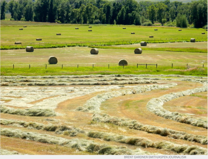
Hay fields in the upper Yampa River valley, northwest Colorado. Photo credit: Brent Gardner-Smith/Aspen Journalism

From The Craig Daily Press (Clay Thorp):

fter several weeks of rising water on the Yampa River, homes near the waterway might see drier river banks soon as river level continues to fall.

ā€œWe had a big snow year,ā€ said Jim Pokrandt, community affairs director for the Colorado River District. ā€œThen we had a cool, wet spring even into summer as you saw in Steamboat with their snowfall.ā€

Officials say much of the snow in Steamboat Springs and other highland areas of the Yampa Valley hasn’t melted yet. So, unless there’s a series of exceptionally hot days, the Yampa River should stay steady…

That standing water has caused some mosquito issues in Moffat County. At least one mosquito tested positive for West Nile Virus near the South Beach boat ramp in Craig. No official human cases of West Nile Virus have been reported anywhere in Colorado yet, but officials want residents to be proactive in protecting themselves during the peak mosquito feeding times of dawn and dusk…

Though it breeds mosquitoes, much of that water has made things green up at ranches across the Yampa Valley as cows and other livestock are having their fill of the foliage.

ā€œIt’s been a great year, especially compared to last year,ā€ [Brian Romig] said. ā€œFarmers are happy. Farmers and ranchers seem to be a lot happier this year.ā€

From the Steamboat Pilot & Today (Eleanor C. Hasenbeck):

Nearly 5 inches of June precipitation and 2 inches of June snow have contributed to keeping the Yampa River flowing near peak levels since the beginning of the month.

Since the river rose to 2,300 cubic feet per second at the Fifth Street gauge in downtown Steamboat Springs on June 5, the river hasn’t fallen below that level, according to data from the U.S. Geological Survey.

ā€œIt’s a good year, and that’s no surprise to anybody at this point,ā€ Upper Yampa Water Conservancy District General Manager Kevin McBride said. ā€œIt’s a good thing that it comes off and stays at that level for a long time, because the last thing we want to see is one big peak because that means flooding.ā€

[…]

Scott Hummer, Colorado Division of Water Resources water commissioner serving water users in South Routt, said the ranchers he works with say it’s peaked, but he’s still waiting to see.

ā€œSome of my water users have told me they think the river’s peaked,ā€ Hummer said. ā€œI’m not particularly sold that it’s peaked. I think that everything is still totally temperature dependent. We may see a very sustained, higher-flow rate.ā€

Hummer added that water users in the southernmost end of the district have seen high water — with the Yampa spilling out of its banks and pooling up in fields — that hasn’t been seen for a lifetime.

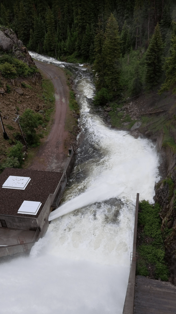
ā€œWe are light years ahead of where we were last year at this particular point in time,ā€ Hummer said. ā€œLast Saturday (June 22), we saw record all-time inflows into Stagecoach (Reservoir). On Sunday, we saw Stagecoach spill at an all-time record amount, so it’s a much different season than last season, simply based on the snowpack.ā€

On Thursday, about 200 cfs of water was flowing into Stagecoach Reservoir. The mean for this date — the average of the 31-year record — is 90 cfs…

These higher flows are a boon for river runners who are still catching big waves on the Yampa and to ecosystems that rely on fluctuating flows. While ranchers are glad to have enough water to irrigate hay, the moisture and low temperatures have likely pushed back the growing season, meaning they’ll cut hay later in the season, Romero-Heaney said.

For those who hope to hit the river, it might be a better bet to rent a raft instead of a tube for awhile yet. Commercial outfitters typically start renting out tubes when the river falls below 700 cfs. The Yampa is still flowing at four times that rate.

Romero-Heaney guessed — based on data from 2011, a similar runoff year — that the river might fall to a tube-able level in mid- to late-July.

And while the water is high now, McBride cautions that it doesn’t remedy years of low flow in the greater Colorado River Basin, which the Yampa is a part of.

ā€œAs they say, don’t get too comfortable with just one year of good runoff in the Colorado Basin as a whole, but for users in the Yampa, it looks like a banner year,ā€ he said.

Stagecoarch Reservoir outflow June 23, 2019. Photo credit: Scott Hummer