Food production generates more than a third of manmade #greenhousegas emissions – a new framework tells us how much comes from crops, countries and regions — The Conversation


A farmer walks through a rice paddy in India’s northeastern state of Assam.
Buu Boro /AFP via Getty Images

Xiaoming Xu, University of Illinois at Urbana-Champaign and Atul Jain, University of Illinois at Urbana-Champaign

Producing enough food for a growing world population is an urgent global challenge. And it’s complicated by the fact that climate change is warming the Earth and making farming harder in many places.

Food production is a big contributor to climate change, so it’s critically important to be able to measure greenhouse gas emissions from the food sector accurately. In a new study, we show that the food system generates about 35% of total global man-made greenhouse gas emissions.

Breaking down this share, production of animal-based foods – meat, poultry and dairy products, including growing crops to feed livestock and pastures for grazing – contributes 57% of emissions linked to the food system. Raising plant-based foods for human consumption contributes 29%. The other 14% of agricultural emissions come from products not used as food or feed, such as cotton and rubber.

We are atmospheric scientists who study the effects of agriculture and other human activities on Earth’s climate. It’s well known that producing animal-based foods generates more greenhouse gas emissions than plant-based foods, which is why shifting toward a more plant-based diet is recognized as an option for curbing greenhouse gas emissions and climate change.

But to quantify the potential impact of such a shift, we saw a need for better tools to estimate emissions from individual plant- and animal-based food items, with more details about how emissions are calculated and covering all food-related sub-sectors, such as land use change and actions beyond the farm gate.

Current methods rely on sparse data and simplified representations of many key factors, such as emissions from farmland management. They don’t treat different sub-sectors consistently or calculate emissions for producing many specific commodities.

To fill those gaps, we have developed a comprehensive framework that combines modeling and various databases. It enables us to estimate average yearly global emissions of the greenhouse gases carbon dioxide, methane and nitrous oxide from the production and consumption of plant- and animal-based human food. Currently, our study covers the years 2007-2013. Here are some of the insights it offers, using data that represents an average of those years.

Hunger and food insecurity are urgent global challenges. Climate change is one contributing factor.

Greenhouse gases from food production

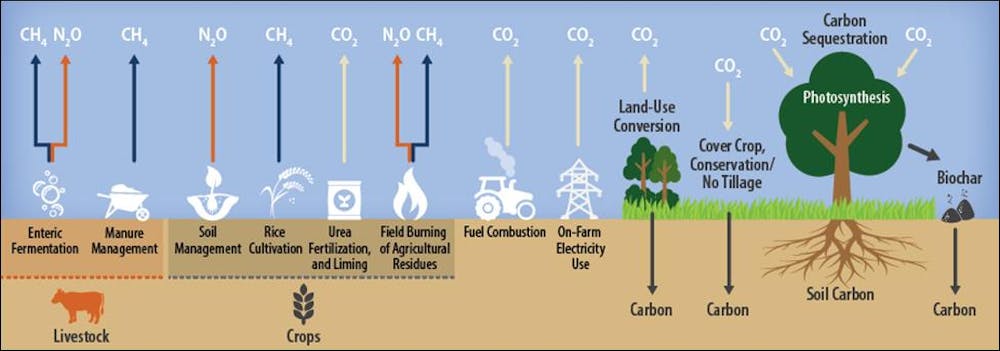
We considered four major sub-sectors of emissions from plant- and animal-based food production. Overall, we calculated that the food system produces emissions that are equivalent to approximately 17.3 billion metric tons (17.318 teragrams) of carbon dioxide yearly.

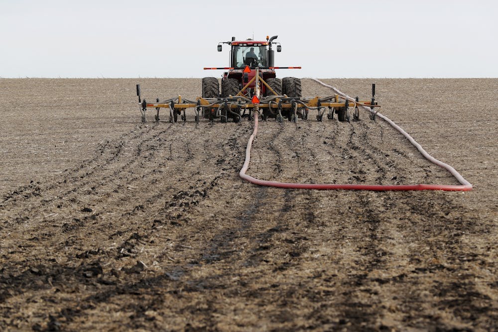
Land use change – clearing forests for farms and ranches, which reduces carbon storage in trees and soils – accounts for 29% of total food production greenhouse gas emissions. Another 38% comes from farmland management activities, such as plowing fields, which reduces soil carbon storage, and treating crops with nitrogen fertilizer. Farmers also burn a lot of fossil fuel to run their tractors and harvesters.

Raising livestock generates 21% of greenhouse gas emissions from food production. It includes methane belched by grazing animals, as well as methane and nitrous oxide released from livestock manure. The remaining 11% comes from activities that occur beyond farm gates, such as mining, manufacturing and transporting fertilizers and pesticides, as well as energy use in food processing.

Graphic of agricultural greenhouse gas sources and sinks.
Many agricultural activities release carbon dioxide (CO₂), methane (CH₄) and nitrous oxide (N₂O) to the atmosphere. Some store carbon in plants and soil.
CRS

Which foods generate the most greenhouse gas emissions?

Our framework makes it possible to compare how different food products and food-producing regions affect Earth’s climate.

Among animal-based foods, beef is the largest contributor to climate change. It generates 25% of total food emissions, followed by cow milk (8%) and pork (7%).

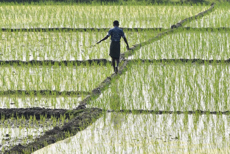
Rice is the largest contributor among plant-based foods, producing 12% of the total greenhouse gas emissions from the food sector, followed by wheat (5%) and sugarcane (2%). Rice stands out because it can grow in water, so many farmers flood their fields to kill weeds, creating ideal conditions for certain bacteria that emit methane.

This helps to explain why South and Southeast Asia have the greatest food-production-related emissions by region, producing 23% of the global total. This region is the only place where plant-based emissions are larger than animal-based emissions. South America is the second-largest emitter at 20%, and has the largest emissions from animal-based food, reflecting the dominance of ranching there.

Among individual countries, China, India and Indonesia have the highest emissions from plant-based food production, contributing 7%, 4%, and 2% respectively of global food-related greenhouse gas emissions. The countries with leading emissions from the production of animal-based foods are China (8%), Brazil (6%), the U.S. (5%) and India (4%).

A tractor spreads manure on a dirt field.
Injecting manure into a field as fertilizer in Lawler, Iowa. Manure management is a major source of greenhouse gas emissions from livestock.
AP Photo/Charlie Neibergall

How food production affects land use

Our framework also shows that raising animal-based foods consumes six times as much land as producing plant-based foods.

Worldwide, we estimate that humans are using 18 million square miles (4.6 billion hectares) of land to produce food – about 31% of Earth’s total land area, excluding areas covered by snow and ice. Of this, 30% is cropland and 70% is various types of grazing land.

Looking at how these areas are managed, we estimate that 13% of total agricultural land is being used to produce plant-based foods. The other 77% is being used to produce animal-based foods, including croplands that are growing animal feed and grazing lands. The remaining 10% is being used to raise other products, such as cotton, rubber and tobacco.

[Over 100,000 readers rely on The Conversation’s newsletter to understand the world. Sign up today.]

Our study uses a consistent framework to provide a complete estimation of greenhouse gas emissions from food production and consumption, covering all food-related sub-sectors, at local, country, regional and global scales. It can help policymakers identify the plant- and animal-based food commodities that contribute the largest shares to climate change, and the higest-emitting sub-sectors at different locations.

Based on these results, governments, researchers and individuals can take actions to reduce emissions from high-emitting food commodities in different places. As U.N. leaders have stated, making food production more climate-friendly is essential to reduce hunger in a warming world.The Conversation

Xiaoming Xu, Postdoctoral Research Associate in Atmospheric Sciences, University of Illinois at Urbana-Champaign and Atul Jain, Professor of Atmospheric Sciences, University of Illinois at Urbana-Champaign

This article is republished from The Conversation under a Creative Commons license. Read the original article.

#Holyoke City Council work session recap

Holyoke photo credit dankalal.net.

From The Holyoke Enterprise (Andrew Nygaard):

At City Superintendent Mark Brown’s request, Holyoke City Council members held a work session immediately following their Sept. 7 meeting to discuss issues related to the city’s water.

He told the council that he, Lennie Fisbeck and Jeremy Thompson met with Element Engineering LLC on Friday, Sept. 3, to review ideas to address the issues…

Brown provided council members with spreadsheets showing nitrate level samples of the city’s different wells from 2002 through the third quarter of this year.

He said the increasing nitrate levels in the cemetery well are raising concerns. One of the possibilities of the increased levels is that an excessive nitrate plume could be headed in that direction.

He then discussed the possibility of getting the Stout well set up as a municipal well. This well, along with 318 acres located 2 1/2 miles south of Holyoke, was purchased by the city in 1996 from Clarence and Bernice Stout.

Brown said there are different options that can be used to bring the Stout well in, it’s just a matter of finding the one that suits the city best.

One of these options is to blend the Stout well with the cemetery well and come up with an acceptable nitrate limit.

This would involve connecting the two wells with underground pipes to let the water mix at a suitable distance before it ever gets to the city.

If the cemetery well gets to the point where it exceeds nitrate levels, allowing water from the Stout well to blend with water from the cemetery well would create an acceptable nitrate limit while still keeping both allocations…

Flushable wet wipes still causing problems

Brown then brought up the subject of the city’s wastewater, noting that flushable wet wipes continue to be an issue.

He outlined two possible scenarios to try to address the problem.

He said a grinder could be installed in the wet well of the existing lift station in Holyoke, grinding wipes up and pumping them to the lagoons. This would mean the lagoons would have to be dredged much more frequently since the debris would collect in the bottom of the lagoons.

The Republican River Water Conservation District meeting draws crowd to discuss new rates — The #Burlington Record

North Fork Republican River via the National Science Foundation.

From The Burlington Record (Cheri Webb):

One of the meeting rooms at the Burlington Community and Education Center filled up as farmers, ranchers, landowners, bankers and concerned citizens – not just from Kit Carson County, but surrounding counties and states – filed in. They were there to listen and ask questions of the representatives of the Republican River Water Conservation District (RRWCD).

The meeting was set to inform the public of recently approved resolutions by the RRWCD that changes the rates to be paid for conservation contracts in the South Fork Focus Zone (SFFZ). It was facilitated by Deb Daniel, general manager of RRWCD; Steve Kramer, conservation committee chairman; and Rod Lenz, board chairman.

The trio took turns laying the groundwork of how in 2016 Colorado, Kansas and Nebraska came together as the Republican River Compact Administration and agreed to a resolution giving 100% credit from Colorado’s Compliance Pipeline, allowing it to apply to Colorado’s obligations under the compact. However, in exchange for this, Colorado had to agree to retire 25,000 acres in the South Fork Focus Zone by the end of 2029, with 10,000 of those having to be retired by the end of 2024.

If the goal of retiring the 10,000 acres by 2024 and 25,000 by 2029 is not met, Kansas or Nebraska could terminate the agreement, cutting the 100% credit down to 22% credit. This would be disastrous for the whole area, landowner or not, because it would put all large capacity wells at risk of being shut down. This would include irrigation, commercial and municipal wells within the Republican River Basin.

The board then went on to outline their plan to significantly increase payments for retirement of irrigated acres to meet these lofty goals within the SFFZ. However, this did generate some rumblings throughout the crowd as the topic was slightly diverted to how these payments were going to be made.

To offset the additional expenses for the increased payments, the RRWCD is considering increasing the annual water use fee to a total of $30 per irrigated acre in 2022. This is doubling the fee that all consumers are currently being charged, while only the ones within the SFFZ will be getting the increased payments.

One member of the crowd, in a question/statement put it into layman’s terms, “So basically everyone on the inside of the zone pays the same as everyone outside the zone, but the wells outside the zone aren’t eligible for the sweet new deals.”

Daniel responded, noting the effort to determine what people think their water is worth, “We know it’s not ideal, nothing is going to be. However, expediency is key here.”

[…]

The RRWCD will be holding several more meetings throughout the month of Sept., to discuss the matter. They will be in Yuma on Sept. 21 at Quintech at 1:30; in Stratton at the community building on Sept. 22 at 1:30; in Cheyenne Wells at the fairgrounds on Sept. 28 at 1:30; and at the Idalia school on Sept. 30 at 6:30 p.m.

#ClimateChange isn’t coming in the future, it’s already here. This is how it’s impacting your everyday life — The #Colorado Sun #ActOnClimate

A longer walk from the dock to the water is in store for boaters at the Elk Creek marina, Blue Mesa Reservoir. Blue Mesa is being drawn down to feed critically low Lake Powell, as continued dry weather and rising demand deplete the Colorado River.
(Courtesy photo/National Park Service) August 2021 via the Montrose Daily Press

From The Colorado Sun (Michael Booth):

Following are just a few of the ways “climate change now” made its full force known in the Rocky Mountains this year and showed its impact on everyday life.

Record high heat changes Colorado school life, for kids and parents

Seventeen Denver Public Schools closed or sent students home early Friday because of heat, underlining the fact that many school buildings still lack modern air conditioning despite years of bond issues and calls for renovation.

In a note sent to parents last week, Steele Elementary’s principal warned the school would shut at noon Friday, and apologized for the late notice for those needing child care during the workday. “Weather forecasters say temperatures in Denver tomorrow and Friday will hit 97 degrees,” Principal Marti Rosenberg said. With Thursday setting a record high, she added, “the consecutive days of heat will make it challenging to keep temperatures at a reasonable level on Friday.”

Wildfire smoke and ozone have been a daily blur for long range views along the Front Range this summer. Photo credit: Chase Woodruff/Colorado Newsline

For those dismissing a Sept. 10 heat blast as typical for Colorado, 9News meteorologist Cory Reppenhagen put together an astonishing 2021 summer compilation: Four Colorado weather stations recorded their hottest average summer temperatures on record. Steamboat would have made it five, but was off by one-tenth of a degree. Central Park station had its second hottest summer on record. Denver’s annual heat streaks of 90-plus have doubled in length since 1970, to 12 days.

Until about 1900, Reppenhagen’s charts show, a roughly equal number of daily high and low records would be broken in Colorado each year. The scales tipped then. So far in 2021, eight daily highs have been broken, and only one low.

A draining Colorado River hits recreation life and the economy

When the federal government pulled the plug on Blue Mesa Reservoir to save the Colorado River and Lake Powell downstream, the big Gunnison-area bathtub drained so far that the boats had to pack up and go home.

Federally-managed Blue Mesa on the Gunnison River was already low from two decades of western drought when managers announced in July they would partially drain the lake, plus Flaming Gorge and Navajo Reservoir, in order to protect the hydroelectric power pool at Lake Powell. The drought had so severely dried up Powell that the massive generating dam there would stop without help from upstream.

By September, Blue Mesa’s draining pool left boats literally high and dry. The National Park Service told the marina concession to cut six weeks from its five-month season, before the floating dock hit lake bottom.

Vega State Park, near Grand Junction, also closed its main boat ramp at the end of July, a least a month early, citing low water levels at the lake part way up the Grand Mesa. Earlier in the summer, Mesa County’s largest municipal water provider said it would take the unprecedented step of using Colorado River water directly in order to protect water levels at cleaner reservoirs it owns on the shoulders of Grand Mesa.

The boat ramp at the Lake Fork Marina closed for the season on Sept. 2 due to declining reservoir levels. The Bureau of Reclamation is making emergency releases out of Blue Mesa Reservoir to prop up levels in Lake Powell and preserve the ability to make hydropower.
CREDIT: HEATHER SACKETT/ASPEN JOURNALISM

Cause and effect: “Because of changes in greenhouse emissions, we see more droughts in the American West,” said Iglesias, the EarthLab researcher. Researchers who used to shy away from pinning individual droughts on climate change have by now “stopped talking about it because it’s become so obvious that it’s boring,” she said…

Morning coughing with the morning coffee brought 2021 hazards home

If you could hang on to the orange-tainted, smoke-enhanced sunsets, the summer days of 2021 redeemed themselves a bit. But only after a full day of coughing and wheezing from distant wildfire smoke and Front Range-generated ozone, which you were not just imagining.

Massive fires in California, Oregon and Canada — still burning, by the way — sent plumes of smoke across Colorado, with smoke forecasts becoming a staple of commercial TV weather segments. The smoke raised levels of particulate matter in Front Range skies, referred to in public monitoring as PM2.5. Doctors at National Jewish Health and other medical experts warned all summer that those with asthma or other respiratory sensitivity should wear N95 masks outdoors or stay indoors on the worst days.

Meanwhile, existing auto and oil and gas pollution that produces Front Range ozone was baked into a bigger problem by the 2021 heat wave. Ozone is likely made worse by the imported wildfire smoke as well, though researchers haven’t yet concluded how much.

The result was by far the highest number of ozone action-alert days declared by the Colorado Department of Public Health and Environment since the EPA ratcheted down allowable ozone limits in 2016. The state issued 65 alerts over their summer reporting period, up from 43 in 2020 and well past the previous high of 52 days in 2018.

National Jewish researchers capped late summer with a new study directly attributing climbing ozone levels to higher temperatures from climate change. The study, published in Nature, also said that the impacts of higher ozone are much worse in areas of the Front Range with higher numbers of Hispanic residents and low-income households. The study concludes that the heat-caused rise in ozone has delayed the Front Range counties’ coming into compliance with EPA limits by two years. Metro planners now have to agree on policy changes that could lower pollution in order to reach EPA compliance.

“The ozone climate penalty can be expected to grow over the next several decades,” the study says. “We found that residents of the Front Range are already affected by climate change through higher temperatures and higher ozone levels, and that the resulting ozone burden is already falling disproportionately on historically disenfranchised and frontline communities.”

[…]

More bad news, Colorado: This could be just the beginning

There are lifetime droughts, and then there are geologic-time droughts. Matthew Lachniet, at University of Nevada, Las Vegas, studies the latter, and the stalactites and stalagmites tell him stories you may not be ready to hear.

Human-kept climate records detail the past 100 to 150 years, Lachniet notes. Tree rings, an important climate and biology tool, can take scientists reliably back 1,000 years or more. Lachniet is a “paleoclimatologist,” studying the growth of drip-rocks in caves over tens of thousands of years. A stalactite dripping from a cave ceiling charts the passing of floods and droughts through water seepage, taking a thousand years to grow an inch.

What Lachniet has seen in caves in the Southwest is evidence of a painful drought stretching from 9,000 years ago to 5,000 years ago. Four thousand years of dry winters.

“We can see that aridity can extend for not just decades, but centuries, and potentially even millennia,” Lachniet said. And that’s the record before humankind made things worse by adding uncontrolled CO2 into the atmosphere for more than a century.

The cave records underline the recent folly of federal water management officials helping to write Colorado River compacts that distribute water — to 40 million people in seven states — based on river flows in much wetter than average years, Lachniet added.

“We have to plan for the possibility that flow in the Colorado River is going to be far below the 16 million acre-feet that we’re allocating, maybe as low as 12 million acre-feet, or potentially lower,” he said.

Homestake hike highlights uncertainties with proposed reservoir project — @AspenJournalism

Ken Neubecker, formerly of American Rivers, gives a presentation about the Eagle River Memorandum of Understanding during a hike and public outreach event organized by the Eagle River Watershed Council. The 1998 MOU, which lays out the amounts of water the signatories are entitled to develop, may be based on hydrology that is outdated due to climate change impacts of the last 20 years.
CREDIT: HEATHER SACKETT/ASPEN JOURNALISM

From Aspen Journalism (Heather Sackett):

The Eagle River Watershed Council on Tuesday hosted a hike for the public in the Homestake Valley, an area receiving increased scrutiny because of a project that proposes to take more water from the Colorado River basin and bring it to the fast-growing Front Range.

The goal of the event — which included presentations from representatives from public-lands conservation group Wilderness Workshop, municipal water provider Aurora Water and other experts — was to provide a broad overview of a complicated issue, according to watershed council executive director Holly Loff.

“We know it’s going to be a long process, but we want to make sure people are engaged in the conversation and look to us as a resource,” Loff said. “We will continue to provide science-based, factual information.”

The watershed council advocates for the health of the upper Colorado and Eagle river watersheds through research, education and projects, according to its website.

The cities of Colorado Springs and Aurora, which operate together as Homestake Partners, have water rights in the Homestake Valley and plan to use them to develop Whitney Reservoir. The project would be located near the Holy Cross Wilderness Area, which is 6 miles south of Red Cliff. Homestake Partners is currently doing geotechnical drilling to study whether the soil and bedrock in the area could support a dam and reservoir.

The proposed project would create a new reservoir on lower Homestake Creek, where water collected would be pumped up to the existing Homestake Reservoir, about 5 miles upstream. Then it would go through a tunnel under the Continental Divide to Turquoise Reservoir, near Leadville, and then to Aurora and Colorado Springs. Various configurations of four potential reservoir sites show it holding between 6,850 and 20,000 acre-feet of water.

Homestake Valley, in the upper Eagle River watershed near Red Cliff, is narrow and filled with aspen trees. A proposed water project could develop more water from the valley for the benefit of Front Range municipalities and Western Slope entities.
CREDIT: HEATHER SACKETT/ASPEN JOURNALISM

Project opposition

Although it’s still early in the process and no application for the storage project has yet been filed, the proposal has already been met with opposition. Some iterations of the project would necessitate moving a section of the Holy Cross Wilderness boundary, which requires an act of Congress, and would inundate rare, groundwater-fed, peat wetlands, known as fens. The U.S. Forest Service received nearly 800 comments about the drilling study during its public scoping phase last year, and the majority of the remarks were against the reservoir project as a whole.

Some who attended the hike — which attracted about 20 people — questioned the concept of taking more water from the headwaters of the Colorado River over to thirsty and growing Front Range cities in the face of a climate change-fueled crisis.

“I’m just very concerned that if this is a typical year, is there enough water in the drainage to take 20,000 acre-feet out every year and how does that tie into the future curtailment call on the Colorado Compact?” said Tom Allender, who is board president of the watershed council, a former board member of Eagle River Water & Sanitation District and a retired planner for Vail Resorts.

The compact call to which Allender is referring could occur if the upper-basin states (Colorado, Wyoming, Utah and New Mexico) can’t deliver the 7.5 million acre-feet of water per year to the lower basin states (Arizona, California and Nevada), as required by a nearly century-old binding agreement. Water users in the upper basin would be forced to cut back, something known as “curtailment.”

A larger share of the state’s cutback obligations could fall to Front Range water providers since most of the water rights that let them divert water from the Colorado River basin over the Continental Divide are “junior” to the compact, meaning they date to after the 1922 agreement. If there was a compact call, Front Range diverters could potentially have to stop diverting and let the water flow downstream to Lake Powell.

“If the Homestake Valley is important to people and if they are interested in the impacts of a compact call and the impacts of climate change overall, then they should have an eye out for additional transmountain diversions,” Loff said. “That’s a bigger concern than a reservoir in general.”

Last year, Homestake Partners tested how they could get their stored water to the state line in the event of a compact call by releasing downstream about 1,700 acre-feet from Homestake Reservoir.

Contractors for Homestake Partners are drilling test holes for a geotechnical study near Homestake Creek. A proposed project could develop more water from Homestake Creek for Aurora and Colorado Springs, and could also benefit Western Slope entities.
CREDIT: HEATHER SACKETT/ASPEN JOURNALISM

Eagle River MOU

Homestake Partners is not the only entity set to benefit from a new water-storage project. The Eagle River memorandum of understanding lays out a plan for both Front Range and Western Slope entities to develop water in the upper Eagle River basin. The agreement, signed in 1998, provides 20,000 acre-feet of water a year to Homestake Partners and 10,000 acre-feet a year to the Colorado River Water Conservation District, the Eagle River Water & Sanitation District, Upper Eagle Regional Water Authority, and Vail Resorts, known collectively in the MOU as the “Reservoir Company.”

Ken Neubecker, a retired Colorado project director at American Rivers and a former environmental representative on the Colorado Basin Roundtable, gave an overview of the MOU. He said the 23-year-old agreement is based on hydrology that is now outdated because of the worsening impacts of climate change. The models used to estimate streamflows are based on records from the 50 years between 1945 and 1994.

“Storage is an early-20th-century response to water-shortage problems and doesn’t really fit in the conditions we are facing now in the 21st century, and it’s based on laws established in the 19th century,” Neubecker said.

In their presentation, representatives from Aurora Water laid out the measures that the municipality is taking to conserve water, including offering rebates for high-efficiency toilets, water-wise landscaping and irrigation efficiency. Over 10 years, Aurora says it has conserved almost a half-billion gallons, or about 1,500 acre-feet.

That savings, however, does not translate into Aurora taking less water from the Western Slope. About 25,000 acre-feet of water a year is sent through Homestake Tunnel to the Front Range.

“We are a growing community,” said Greg Baker, manager of public relations for Aurora Water. “Our conservation program helps us meet that future need the development is going to place on our system. Does it reduce (transmountain diversions)? No. Does it mean we are using the water more efficiently? Yes.”

Baker said there are still a lot of uncertainties with the Whitney Reservoir project. The geotechnical drilling study will help determine whether it is even feasible to move ahead.

“We have not applied current climatological conditions to (the MOU) yet because we haven’t gotten that far,” he said. “Until we know exactly what comes out of that report, we can’t say what we would want to pursue. It’s way too early for us to even come up with that timeline.”

Aspen Journalism covers water and rivers in collaboration with The Vail Daily and other Swift Communications newspapers. For more, go to http://www.aspenjournalism.org.

Colorado transmountain diversions via the State Engineer’s office

#ColoradoRiver can no longer sustain Western thirst — Western Farm Press #COriver #aridification

Metropolitan Water District of Southern California scouting team looking for where to site our Colorado River Aqueduct intake on the Colorado River. Boats powered w Model T motor! — Jeffrey Kightlinger via Twitter. I will miss the photos that Mr. Kightlinger published from the Metropolitan archives.

From Western Farm Press (Todd Fitchette):

Back when the Colorado River Compact was being negotiated about 100 years ago, water was not viewed as a problem. Officials deemed there was plenty to go around.

Fast forward a century and the seven Colorado River Basin states – particularly the three lower basin states of California, Arizona, and Nevada – are using more than the system can sustain. Nowhere is this more evident than on the chalk-white dry rims of Lakes Mead and Powell, the two large reservoirs on the system that some fear will hit catastrophically low levels in the next couple years.

Chris Harris, executive director of the Colorado River Board of California, says the basin states must grapple with the “new normal” of reduced flows in a river system once thought to provide ample water for the West…

Brad Udall: Here’s the latest version of my 4-Panel plot thru Water Year (Oct-Sep) of 2019 of the #coriver big reservoirs, natural flows, precipitation, and temperature. Data goes back or 1906 (or 1935 for reservoirs.) This updates previous work with @GreatLakesPeck

The 14maf annual average is bookmarked by years of plenty – 15 of them over the last century at over 20maf. Conversely, 44 of those years, or nearly half of that period, produced under 14maf of natural flow at the Lees Ferry Gaging Station in Arizona.

Viewed another way, Harris points to data that show the worst hydrology years on record since 1906 are all in the 21st Century…

The vulnerability of the Colorado River system was seen in a 2012 basin study report showing the average annual natural flow at Lee Ferry of 13.8maf. Some years were much less.

When California alone has access to 4.4 maf and there are years when the unregulated flow into Lake Powell in the upper Colorado River basin is at or below 5maf, “the math doesn’t add up,” he said.

Climate scientists similarly point to water scarcity because of severe drought, and the need for the basin states to “pull together, and that includes California.” Not only must water managers and urban planners consider water-short years that challenge supply, they must manage for the extreme rain events that can damage and destroy flood control infrastructure…

By 2019 California’s use of the Colorado River had fallen to 3.85maf and the following year California had about 1.4maf of “intentionally created storage” (ICS) water banked in Lake Mead for years like the current. This created concerns in Arizona and Nevada as Lake Mead continued to fall and officials there tried to slow the inevitable Tier 1 shortage call by encouraging MWD to not take all its saved water from Lake Mead.

Because California also has access to [Central Valley Project and State Water Project] water, Harris said there are huge incentives for water management there to become sustainable and reduce demand for the Colorado River.

“You take an entity like the Metropolitan Water District of Southern California (MWD), which gets about 2.2maf from the State Water Project; they got 100,000-acre feet this year from the State of California,” he said.

Navajo Dam operations update (September 17, 2021): Releases to bump to 900 cfs #SanJuanRiver #ColoradoRiver #COriver #aridification

The San Juan River’s Navajo Dam and reservoir. Photo credit: U.S. Bureau of Reclamation

From email from Reclamation (Susan Novak Behery):

In response to decreasing flows in the critical habitat reach, the Bureau of Reclamation has scheduled an increase in the release from Navajo Dam from 850 cubic feet per second (cfs) to 900 cfs on Friday, September 17th, starting at 4:00 AM. Releases are made for the authorized purposes of the Navajo Unit, and to attempt to maintain a target base flow through the endangered fish critical habitat reach of the San Juan River (Farmington to Lake Powell).

The San Juan River Basin Recovery Implementation Program recommends a target base flow of between 500 cfs and 1,000 cfs through the critical habitat area. The target base flow is calculated as the weekly average of gaged flows throughout the critical habitat area from Farmington to Lake Powell. This release change is calculated to be the minimum release required to maintain the minimum target base flow.

The latest Seasonal Outlooks (through December 31, 2021) are hot off the presses from the #Climate Prediction Center