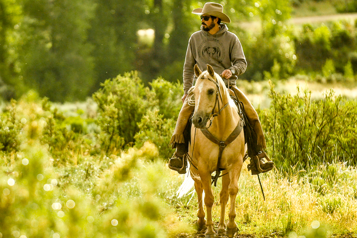
Rancher and fly-fishing guide Paul Bruchez raises cattle on 6,000 acres near Kremmling. Bruchez has taken an active role in Colorado River issues ever since his family suffered from a critical water shortage during the 2002 drought. Photo credit: Russ Schnitzer via Aspen Journalism
Not long after Paul Bruchez’s family bought a ranch along the Colorado River near Kremmling, his father became ill amid a crippling drought in 2002 that left them without irrigation water.
“The family conversation was we either need to be involved and create some positive change or we need to go,” Bruchez recalled. “Dad said we’re going to fight for what we have. I’ve been doing it ever since then.”
The 40-year-old Bruchez is a fifth-generation Colorado farmer and rancher and is vice chairman of the Colorado Basin Roundtable. He works with area ranchers, environmentalists, scientists and local and state officials on conserving water and restoring stretches of the Colorado River for irrigators and wildlife.
“From my perspective, if we don’t fight for it, no one will,” said Bruchez.
Bruchez acknowledges the fight farmers and ranchers are in could determine not just the future of his family’s ranch, but the future of agriculture in Colorado and beyond. Whether it’s called climate change or long-term drought, the hotter, drier weather is threatening water supplies and crop yields, and is driving ranchers to cut herd sizes or find greener pastures elsewhere for the animals.
Agriculture is one of Colorado’s major industries, contributing $47 billion annually and supporting nearly 200,000 jobs, according to state data. A state task force projects that drought could cost the state an additional $830 million in annual damages by 2050, with $511 million of that occurring agriculture alone.
An analysis by The Washington Post highlights the climate change challenge facing the region. Based on National Oceanic and Atmospheric Administration data between 1895 and 2019, the analysis found that a group of counties in northwest Colorado and eastern Utah warmed more than 3.6 degrees Fahrenheit. That’s double the global average.
According to the Colorado Climate Center, this summer has been the second-warmest on record for western Colorado…
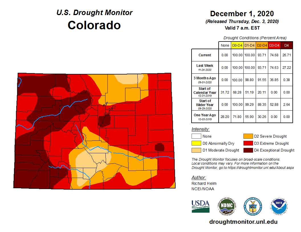
Colorado Drought Monitor December 1, 2020.
But the rest of Colorado has not been spared. Statewide, this August was the 14th-warmest August in 127 years. In 2020, all of Colorado was declared in drought or abnormally dry for the first time in eight years…
Governor Hickenlooper, John Salazar and John Stulp at the 2012 Drought Conference
Lamar farmer and rancher John Stulp said a former state climatologist told him that Colorado is so large, there’s rarely a part of the state that isn’t in drought…
Southeast Colorado, where his family has farmed dryland wheat for about 50 years, is always on the edge of a drought, Stulp said. This year, the fields started turning brown when the moisture didn’t come in March and April…
And while he ended up with a good crop, Stulp called the warming trend “a slow moving train coming down the track,” straining water supplies and producing less snowpack in the mountains to feed the rivers. Agriculture will face pressure to use less…
Growing food for the world
As in other Western states, the lion’s share of the water in Colorado goes to agriculture. The Colorado Department of Natural Resources figures put the percentage at 85.2%, while 6.6% goes to commercial and municipal uses.
Bruchez was on a panel discussion three years ago when a reporter asked if there are problems with water quality and supply and if agriculture uses most of the water, why not just cut the flows to farmers and ranchers? He said he asked the reporter if he enjoyed his lunch that day. The reporter did.
“And I’m like, ‘When you say ag water, that’s what we do, grow food to feed the world,’” Bruchez recounted.
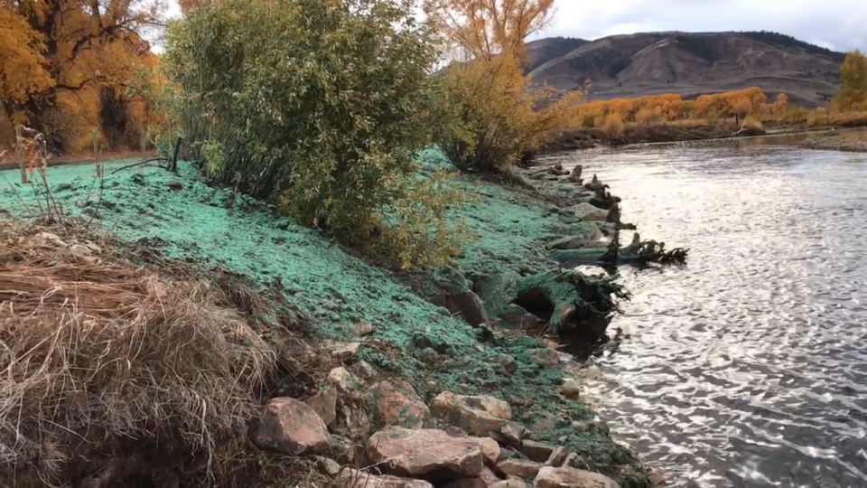
Funds provided by grants and landowners near Kremmling, Colorado, have facilitated improvements such as this back stabilization project. (Source: Paul Bruchez)
The Colorado River, which runs through the family’s ranch, is key to being able to keep producing food, Bruchez said. The lifelong fly fisherman who oversees the family’s fishing guide business worked with the conservation group Trout Unlimited and area ranchers to raise money and obtain grants to build riffles in the river. The structures mimic natural features where rocks break the water surface, improving fish habitat by increasing oxygen and the presence of insects that feed fish.
Riffles also help to raise the water table, which greatly aided Bruchez’s neighbors, Bill and Wendy Thompson. The structures raised the water levels at their irrigation intakes on the river…
Bruchez has rallied area ranchers to participate in a study to figure out how much water hay grown at high altitudes consumes and how long it takes a field to recover after a period of no irrigation. Results will provide information the Colorado Water Conservation Board needs as it determines the feasibility of voluntary reductions in irrigation…
[Harrison] Topp said everyone has a stake in figuring out if agriculture is sustainable in certain parts of the state. He said farmers and ranchers can stay in business with access to adequate water and support from state and federal governments to recover from extreme weather and natural disasters…
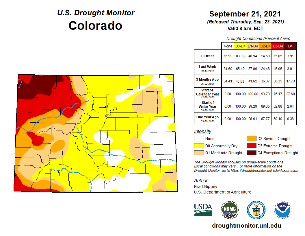
Colorado Drought Monitor map September 21, 2021.
Monsoon rains, absent three of the last four summers, showed up this year, providing relief for the southwest part of the state and pulling the Eastern Plains out of drought. However, Bolinger, assistant state climatologist, said short-term dryness is returning after several hot days and spotty rainfall.
And much of northwest and southwest Colorado remain in exceptional, extreme or severe drought, according to the U.S. Drought Monitor…
Another goal is to show that ranching can be part of the solution to a warming climate by keeping range land intact to help store carbon dioxide. John Sanderson at Colorado State University is one of the authors of a paper that says range land stores up to 20% of the world’s organic carbon and that not enough attention is paid to the drawbacks of converting it to other uses.
Activities like oil and gas production and transportation generate atmosphere-warming carbon dioxide. But methane is even more potent than carbon dioxide at trapping heat in the short term and cow belches and manure are big sources.
The agriculture industry is looking at whether food additives, such as seaweed, could significantly reduce methane emissions from cows.
The weather is expected to be more variable, including more intense drought and more intense rainfall as well low as lower snowpack, said Kim Stackhouse-Lawson, an animal science professor and director of CSU’s AgNext. There are a number of stratgies farmers and ranchers can use to adapt, she said…
“There are definitely ways to adapt. I don’t have any illusion that it’s going to be easy,” [Kate] Greenberg said. “But I think what’s exciting about this is that (agriculture) can be such an important part of the solution when it comes to making sure we have the resilience and the natural reserves, not to mention the food production capacity, we’re going to need moving into this more volatile, more uncertain future.”
Opinion: The chances are increasing for lakes Mead and Powell to reach dangerously low levels. There are basically two solutions, and neither will be easy.
Lake Mead and Lake Powell are in trouble.
It’s hard to view the latest five-year projections released from the federal Bureau of Reclamation any other way.
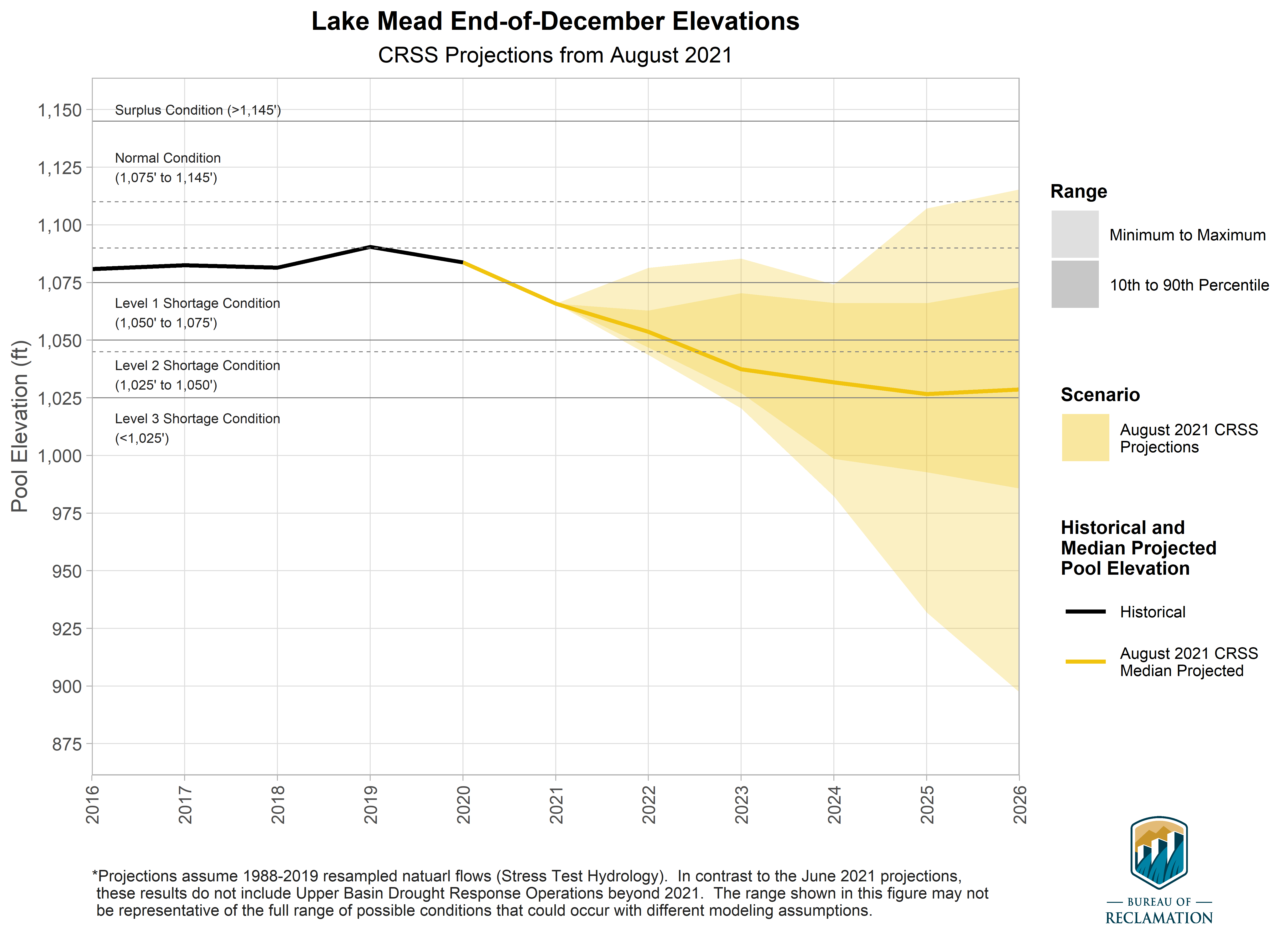
Projection of Lake Mead end-of-December reservoir elevations. The colored region, or cloud, for the hydrology scenario represents the minimum, 10th percentile, 90th percentile, and maximum of the projected reservoir elevations. Solid lines represent historical elevations (black), and median projected elevations for the scenario (yellow). Dashed gray lines represent important elevations for operations, and the vertical line marks the adoption of the 2019 Drought Contingency Plans. Graphic credit: Bureau of Reclamation
At Lake Mead – the reservoir Arizona depends on for about 40% of its water supply – there is now a 66% chance of falling below 1,025 feet of elevation in 2025. And a 41% chance of enacting a Tier 3 shortage that year, the worst for which we have planned and one that would begin cutting into the supplies that feed metro Phoenix’s major cities.
That’s up from a 25% chance in April.
There also is a 1 in 5 chance of dipping below 1,000 feet of elevation in 2025, a dangerously low level that would likely force Hoover Dam, which supplies hydropower to 1.3 million people, to cease production.
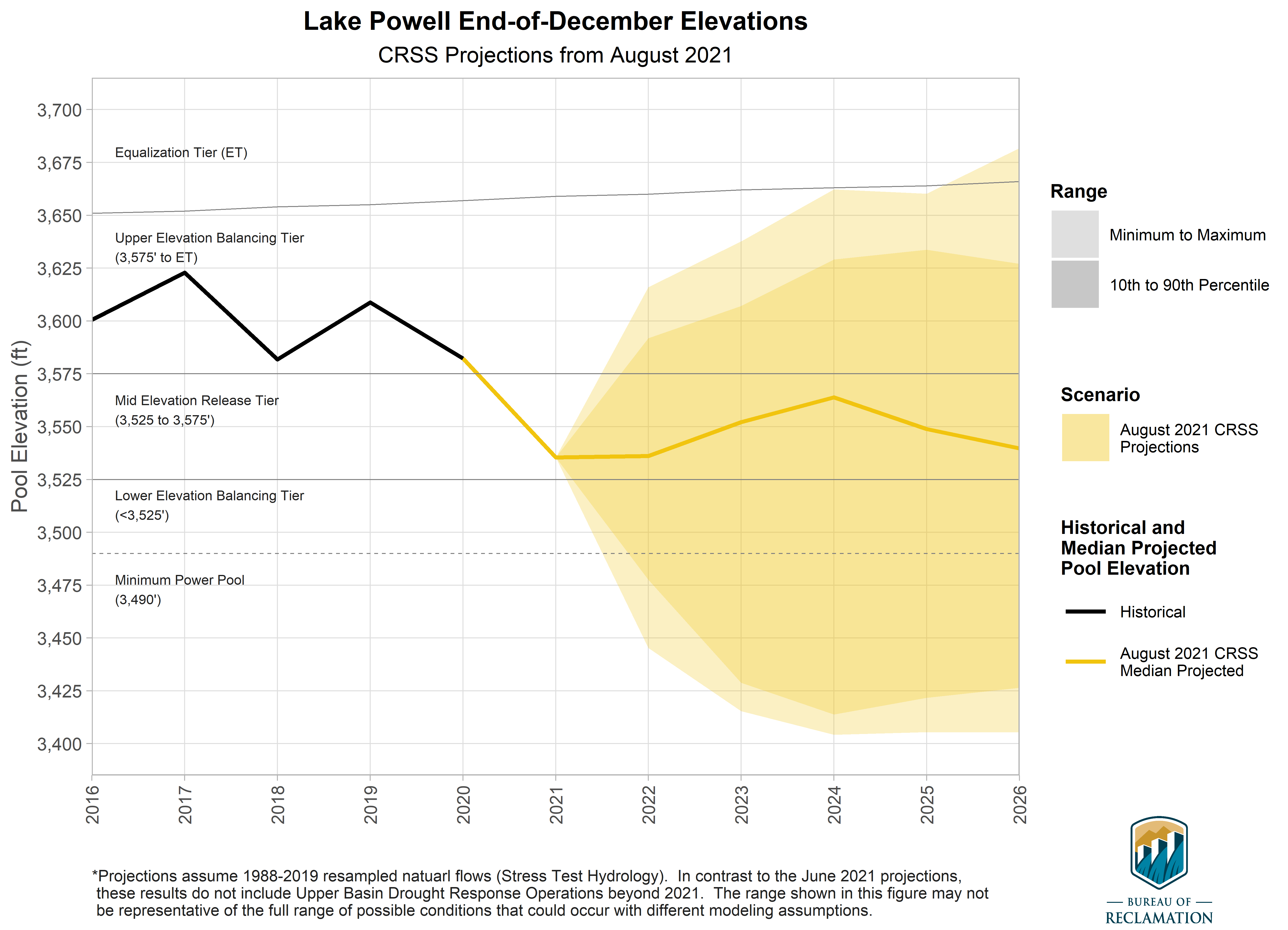
Projection of Lake Powell end-of-December reservoir elevations. The colored region, or cloud, for the hydrology scenario represents the minimum, 10th percentile, 90th percentile, and maximum of the projected reservoir elevations. Solid lines represent historical elevations (black), and median projected elevations for the scenario (yellow). Dashed gray lines represent important elevations for operations, and the vertical line marks the adoption of the 2019 Drought Contingency Plans. Graphic credit: Bureau of Reclamation
The scenarios are just as bad on Lake Powell – or maybe worse, considering it is facing the possibility of turning off its generators much sooner. There is an 88% chance of dipping below 3,525 feet of elevation next year (a buffer meant to help protect power production) and a 1 in 3 chance of falling below 3,490 feet in 2023 – the point at which power can no longer be generated.
That would cause immediate problems for the 5 million people that rely on this power, not to mention nix revenues from generation that are used to fund a slew of programs along the Colorado River.
This forecast is our ‘new normal’
It’s important to understand how Reclamation arrived at these projections. The agency has in recent years begun using what’s called the “stress test hydrology” in its modeling, which is based on runoff for the last three decades or so.
But until this forecast, that hydrology was used as a supplement. The model also included projections based on the “full hydrology,” which also includes decades of unusually wet years.
The September update includes only the stress test – which as water blogger John Fleck noted, makes it the “new normal.”
The stress test is hardly the worst-case scenario for the Colorado River. Some consider it more of the middle-of-the-road view – not the hotter, drier future we are expected to experience (and may already now be experiencing), thanks to climate change.
Still, it’s a more realistic forecast that should help us get a better handle on how extensive the problem is and what we must do to fix it.
Mead is tanking because Powell is tanking
Mead is in trouble because Powell is in trouble.
Low inflows plus steady demand for the water have drained Powell far quicker than most folks imagined. Mead relies on annual releases from this upstream reservoir to stay somewhat stable, and because Powell is so low, the most likely scenario for the next few years involves a much smaller release (7.48 million acre-feet, as compared to the 8.23 million acre-feet we typically receive).
Those forecast lower releases have already triggered a provision requiring the lower basin states of Arizona, California and Nevada to decide what additional steps they’ll take to prop up lake levels.
Tom Buschatzke, Arizona’s water department director, has said there are basically two options, given the urgency: Either we agree to deeper, more painful cuts, or we find others willing to voluntarily store more water in the lake to cushion the blow.
Neither is a long-term solution, but that’s not the goal. It’s simply to buy time while we figure out how to sustain ourselves given this new, drier reality.
We need more than a Band-Aid to stabilize the lakes
If this sounds familiar, it’s because it is.
Mead was facing roughly a 1 in 5 chance of dipping below 1,000 feet before we passed the Drought Contingency Plan in 2019. And make no mistake: Were it not for that plan, we would be in much worse shape today.
But its million acre-feet in cuts has always been a Band-Aid – one that, unfortunately, has not protected the wound long enough to even begin to heal.
If anything, Reclamation’s latest forecast is proof that we must do more to ensure that what we consume from the Colorado River better matches what the river can realistically produce now.
Other modeling has suggested that we could find that equilibrium if the upper basin states agree not to grow their water usage, as they have long planned, and the lower basin remains in roughly a Tier 3 shortage from here on out.
George Frayne, who led the country-rock band Commander Cody and His Lost Planet Airmen, died today (September 26, 2021), at age 77. The announcement of his passing was posted on his Facebook page by his wife, Sue Casanova…
The eight-piece band, with Frayne on keyboards and as one of their many vocalists, was formed in 1967, and brilliantly fused country, rockabilly, western swing, R&B and vintage rock ’n’ roll.
The news of his death arrived three days after another post from his wife asked, “Can you send George some brilliantly good energy and love right now?”
The announcement of his death was written in the form of a poem:
Early this morning
As I lay my head upon his shoulder
George’s soul took to flight
I am heartbroken and weary
And I know you are too
Thank you so much for all the love you gave
And the stories you shared
We are working on 2 big gatherings
On both the east and west coast
(The Island and the Bay Area)
To celebrate the Old Commander’s phenomenal life
And to benefit musicians in need.
The band’s name was inspired by 1950s film serials featuring the character Commando Kody and from a feature version of an earlier serial, King of the Rocket Men, released under the title Lost Planet Airmen.
The Cody band’s classic lineup, whose members came from such far-flung locales as Alabama, California, Connecticut, Michigan, West Virginia, Idaho and New York, also featured Billy C. Farlow (harmonica, vocals), John Tichy (guitar, vocals), Bill Kirchen (guitar, vocals), Andy Stein (saxophone, fiddle), “Buffalo” Bruce Barlow (bass guitar), Lance Dickerson (drums), and Steve “The West Virginia Creeper” Davis, followed by Bobby Black (pedal steel guitar).
They toured non-stop to a legion of dedicated fans and recorded seven studio albums, preferring a no-frills, back-to-basics approach. Their 1971 debut, Lost in the Ozone, released by the Paramount label, included their sole Top 40 hit, a cover of “Hot Rod Lincoln.”
Here’s the release from the USGS (Elizabeth Goldbaum):
Right where the Colorado River flows into the mouth of the Grand Canyon, an inconspicuous 20-foot-high concrete tower rises from the riverbank.
Inside the tower is a U.S. Geological Survey streamgage that will mark its centennial year of monitoring the river on October 1, 2021. At a time when the Roaring Twenties were in full swing, the streamgage began collecting information about the water’s level and flow. USGS scientists chose the site in 1921 because it was readily accessible and strategically located to study the hydrology of the Colorado River drainage basin.
Now, seven states within the basin depend on the river for water supply and hydropower production. Natural resource managers look to the 100-year-old streamgage to make informed decisions while recreationists and trout seekers check the streamgage’s information before they set off in their boats and scientists use it to study region’s geology and ecology.
The gauge sits right across the river from Lees Ferry, named after John Doyle Lee. In a twist of fate, Lee started the ferry in the late 1800s after John Wesley Powell, the second USGS director, gifted him a boat while he was exploring the Grand Canyon.
Although its equipment has been updated over the last century, the streamgage is not that different from its initial installation a century ago.
“The gauge at Lees Ferry is among the most watched and accurate big-river monitoring locations in the country and is an excellent example of how consistent, long-term scientific information beneficially informs water-management decisions in a changing world,” Jim Leenhouts, the Director of the USGS Arizona Water Science Center, said.
September 21, 1923, 9:00 a.m. — Colorado River at Lees Ferry. From right bank on line with Klohr’s house and gage house. Old “Dugway” or inclined gage shows to left of gage house. Gage height 11.05′, discharge 27,000 cfs. Lens 16, time =1/25, camera supported. Photo by G.C. Stevens of the USGS. Source: 1921-1937 Surface Water Records File, Colorado R. @ Lees Ferry, Laguna Niguel Federal Records Center, Accession No. 57-78-0006, Box 2 of 2 , Location No. MB053635.
A basin splits into two
One year after the gauge was established, the seven states in the Colorado River Basin negotiated the 1922 Colorado River Compact that divided it into the Upper and Lower Basins. The Lees Ferry gauge as well as a streamgage on the Paria River are used as critical, continuous measurement points to determine how much water passes to the Lower Basin each year.
USGS scientists have collected various data at the site, from streamflow to water quality. The gauge’s longevity means scientists have been able to tease out long-term trends and note how dramatic changes impact the river.
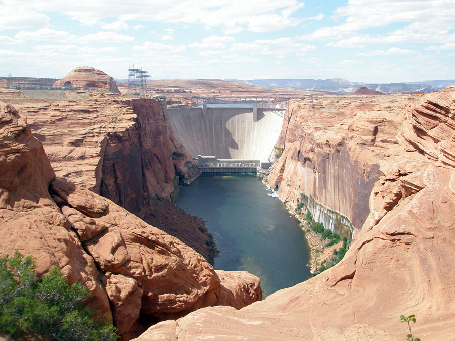
Glen Canyon Dam as seen from an overlook on the south side, downstream of the dam in Page, Arizona. (Public domain.)
In 1963, the basin experienced a particularly dramatic change – the construction of the Glen Canyon Dam 15 miles (24 km) upstream of the streamgage. The gauge recorded the difference between unregulated water flow, prior to the construction of the dam, and regulated flow following the dam’s completion.
The U.S. Bureau of Reclamation constructed the dam to harness the power of the Colorado River and provide water to millions of people in the West. Glen Canyon Dam impounded 186 miles (300 km) of the Colorado River, creating Lake Powell.
The dam stores water for the Upper Colorado River Basin states of Utah, Colorado, Wyoming and New Mexico to ensure those states are able to access the river especially during droughts. Releases from the dam ensure that the Lower Basin states of California, Nevada and Arizona are able to access these essential water supplies from the Colorado Rivers.
“We built this streamgage in the Middle Ages of gauging,” Daniel Evans, a USGS scientist said. “And yet, it has consistently collected accurate information that accounts for how much water is released by the Glen Canyon Dam and enters the Grand Canyon on its way to Lake Mead,” Evans said.
“Per the 1922 Colorado River Compact, the states of the Upper Division must ensure the flow of the river at Lee Ferry doesn’t deplete below an aggregate of 75 million acre-feet for any period of 10 consecutive years,” said Reclamation’s Upper Colorado Basin hydraulic engineer Heather Patno. “Reclamation works closely with the USGS and utilizes the gauge at Lees Ferry to calculate the flow of the Colorado River at this important measuring point,” Patno said.
When in drought, check the streamgage
Since 2000, the Colorado River Basin has been in a historic drought. The combined water storage in Lake Powell and Lake Mead are at their lowest levels since Lake Powell initially began to fill in the 1960s.
On August 16, 2021, the Bureau of Reclamation announced the first-ever water shortage declaration for the Lower Basin. Downstream releases from both Glen Canyon Dam and Hoover Dam will be reduced in 2022. The streamgage at Lees Ferry, as well as other streamgages in the area, will be there to capture how changing dam operations affect streamflow.
“Like much of the West, and across our connected basins, the Colorado River is facing unprecedented and accelerating challenges,” said Assistant Secretary for Water and Science Tanya Trujillo in an August 2021 statement. “The only way to address these challenges and climate change is to utilize the best available science and to work cooperatively across the landscapes and communities that rely on the Colorado River.”
Lees Ferry streamgage and cableway downstream on the Colorado River, Arizona. (Public domain.)
Once upon a streamgage
The streamgage at Lees Ferry is one of over 8,000 that measure streamflow year-round in every state as well as the District of Columbia and the territories of Puerto Rico and Guam.
The gauges are often stored in waterproof boxes perched near flowing water. They contain instruments that measure and record the amount of water in a river or stream approximately every 15 minutes. If there’s a flood, the gauge will collect measurements more frequently.
The Grand Canyon survey party at Lees Ferry. Left to right: Leigh Lint, boatman; H.E. Blake, boatman; Frank Word, cook; C.H. Birdseye, expedition leader; R.C. Moore, geologist; R.W. Burchard, topographer; E.C. LaRue, hydraulic engineer; Lewis Freeman, boatman, and Emery Kolb, head boatman. Boatman Leigh Lint, “a beefy athlete who could tear the rowlocks off a boat…absolutely fearless,” later went to college and became an engineer for the USGS. The Grand Canyon survey party at Lees Ferry in 1923. (Public domain.)
Sometimes, as in the case of the streamgage at Lees Ferry, the only way to access the gauge is by boat or cableway. “With a cableway, we basically zipline across the river to the streamgage,” Kurt Schonauer, a USGS scientist, said.
Schonauer visits the gauge about 10 times a year to ensure it’s working properly, do any necessary repairs and soak in its majestic locale. “It may not have a whole lot of fancy instrumentation, but it produces high-quality data,” Schonauer said.
The streamgage at Lees Ferry measures water height using a stilling well. Water from the river enters and leaves the well through underwater pipes, allowing the water surface in the well to be at the same level as the water in the river. The water level is measured inside the well using a float and noted in an electronic data recorder.
To determine how fast the water is flowing, USGS hydrologists and hydrologic technicians take streamflow measurements on the river or stream. Then, they develop a mathematical relation between the streamflow measurement and the water height values that the streamgage regularly collects. They use that mathematical relation to compute streamflow information every 15 minutes.
Anglers on rafts departing the boat dock at Lees Ferry, AZ. v(Credit: Lucas Bair, USGS. )
“This streamgage is at a really beautiful site,” Schonauer said. It’s a popular spot for recreation and a renowned trout fishing area. “A lot of people who go on rafting trips down the Grand Canyon check the gauge to make sure conditions are safe on the river,” Schonauer said.
When he’s not gazing at the beautiful layers of geology, working on the streamgage, or taking a streamflow measurement, Schonauer likes to check in on the local wildlife. “We have a resident beaver that we see from time to time,” Schonauer said.
As scientists, decision makers, recreationalists, fishermen, and, possibly, a beaver or two, celebrate the streamgage’s 100th birthday, they also look forward to 100 more years of robust and reliable information.