Click on a thumbnail graphic to view a gallery of drought data from the US Drought Monitor.
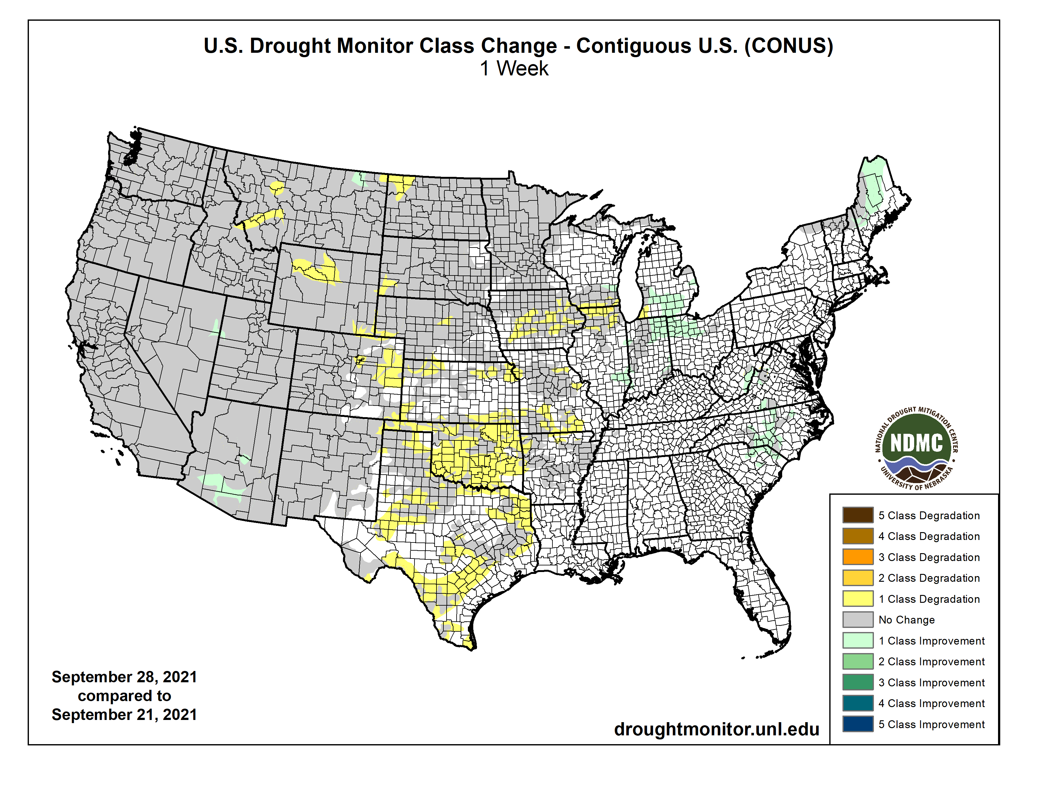
US Drought Monitor map September 28, 2021.
High Plains Drought Monitor map September 28, 2021.
West Drought Monitor map September 28, 2021.
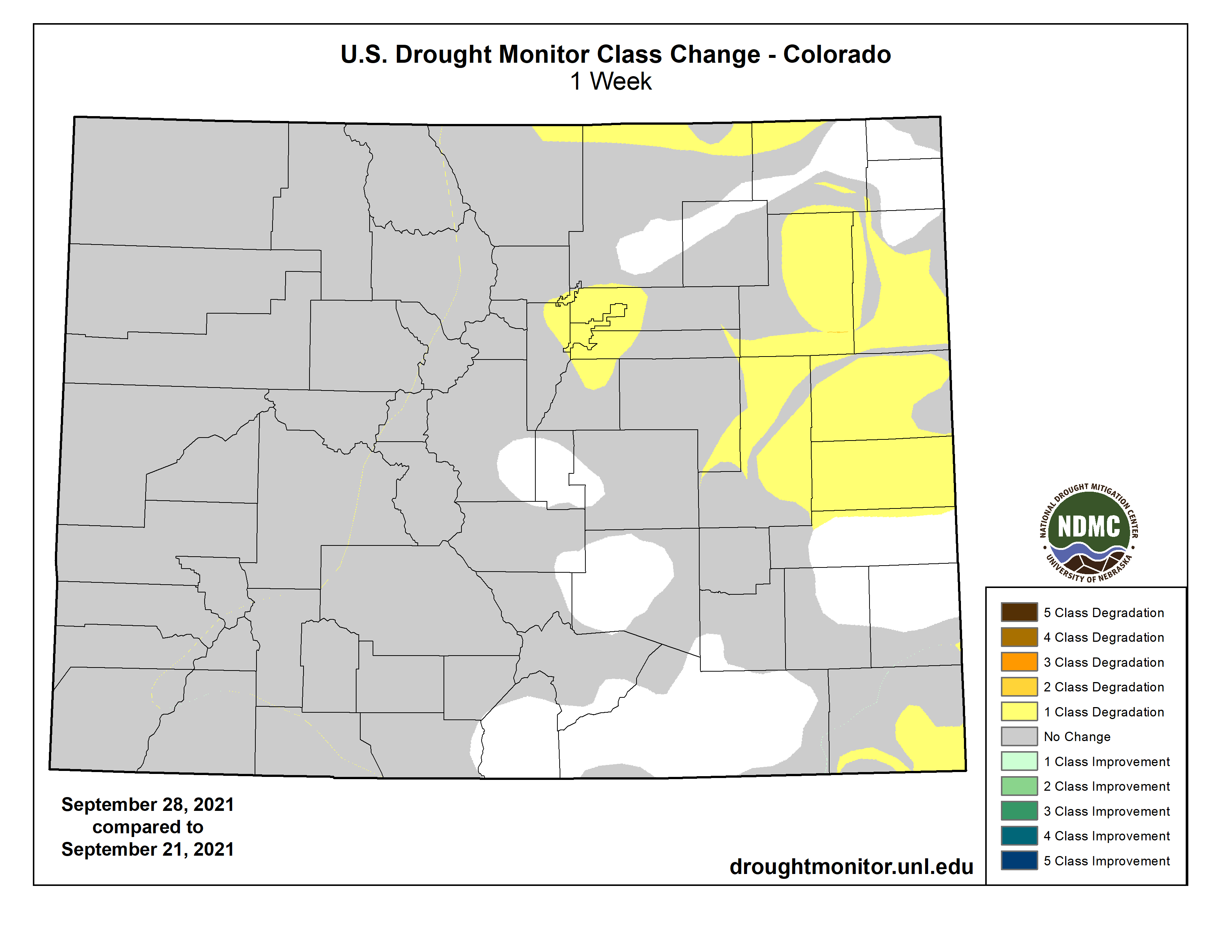
Colorado Drought Monitor map September 28, 2021.
Click here to go to the US Drought Monitor website. Here’s an excerpt:
This Week’s Drought Summary
Warm and dry conditions dominated much of the western half of the United States while some needed rain fell on portions of the Midwest, Mid-Atlantic, and into the Northeast. Some late summer precipitation also fell in the deserts of Arizona and New Mexico as well as along the coastal regions of the Pacific Northwest. As the 2021-22 water year came to a close, the West, northern Plains and upper Midwest had the poorest recorded precipitation while portions of the South and Southeast have recorded 110-150 % of normal precipitation during this time. Over the last week, temperatures were well below normal in the South and Southeast with some areas of Alabama and Mississippi at 4-8 degrees below normal. The warmest temperatures were in the northern Rocky Mountains and into New England where readings were 6-8 degrees above normal…
Colorado Drought Monitor one week change map ending September 28, 2021.
Almost the entire region was dry this week with only light precipitation recorded in portions of the region. Most all of the region was at or above normal for temperatures this week with the warmest readings in the Dakotas where temperatures were 6-8 degrees above normal. The dry weather coupled with the warm temperatures accelerated grain dry down and maturity, kickstarting harvest in the area. It also allowed for drought to both expand and intensify. Portions of northwest North Dakota had extreme drought conditions return. Moderate and severe drought were expanded over portions of eastern Colorado, northern and southern Kansas, western and central Nebraska, southwest South Dakota and southeast Wyoming. Severe and extreme drought were also expanded over north central Wyoming. The warm and dry conditions, especially in September, have been the catalyst for degradation over the region that has remained dry…
Coastal areas from northern California to Washington as well as Arizona and western New Mexico did record some decent precipitation. For the water year ending at the end of September, the 2021-22 period will go down as one of the driest in portions of California and Nevada, where many areas are at 50% or less of their normal values for the time period. Temperatures this last week were near to slightly above normal, with most places 1-2 degrees above normal for the week. Portions of central and southern Arizona continued to record much-needed rains and areas of moderate drought were improved there this week, with the “L” designation being the prominent impacts in most of southern Arizona where long-term hydrological issues remain. Some exceptional drought was removed in northeast Nevada and into western Utah while exceptional drought was expanded over western Montana. Moderate drought was intensified to severe drought in the northwest portion of Montana while some exceptional drought was improved over northeast Montana…
Temperatures for the week were cooler than normal over most of the region with departures of 2-4 degrees below normal quite common. Portions of west Texas and the panhandles of both Oklahoma and Texas were at to slightly above normal for weekly temperatures. Only a few areas of Arkansas had much measurable precipitation this week, with dryness dominating the region. Winter wheat being planted into dry soils as well as deteriorating grazing lands have many producers concerned. Almost all of Oklahoma had drought conditions worsen this week with degradation being shown on moderate and severe drought conditions as well as abnormally dry regions expanding. These changes bled into northern and central Texas where large areas of abnormally dry conditions were introduced based upon mainly the last 60 to 90 days…
Looking Ahead
Over the next 5-7 days, it is anticipated that the best chances of precipitation will be over the southern Rocky Mountains, Plains, South and into the Midwest and Northeast. The greatest amounts are anticipated over Texas, where up to 4 inches of rain could occur. Temperatures are anticipated to be warmest over the West, northern Plains and Midwest with departures of 9-12 degrees above normal during the period. Cooler than normal temperatures are anticipated over the Four Corners region with departures of up to 3 degrees below normal.
The 6-10 day outlooks show the high probability of above-normal temperatures over the northern Plains and into the northern Rocky Mountains. Near-normal temperatures are expected over portions of the southern Plains and South while there are higher probabilities of below-normal temperatures along the coastal regions of the Pacific Northwest. Precipitation probabilities are greatest over the West and eastern portions of the country while the upper Midwest and Plains have the greatest chances of below-normal precipitation.
US Drought Monitor one week change map ending September 28, 2021.
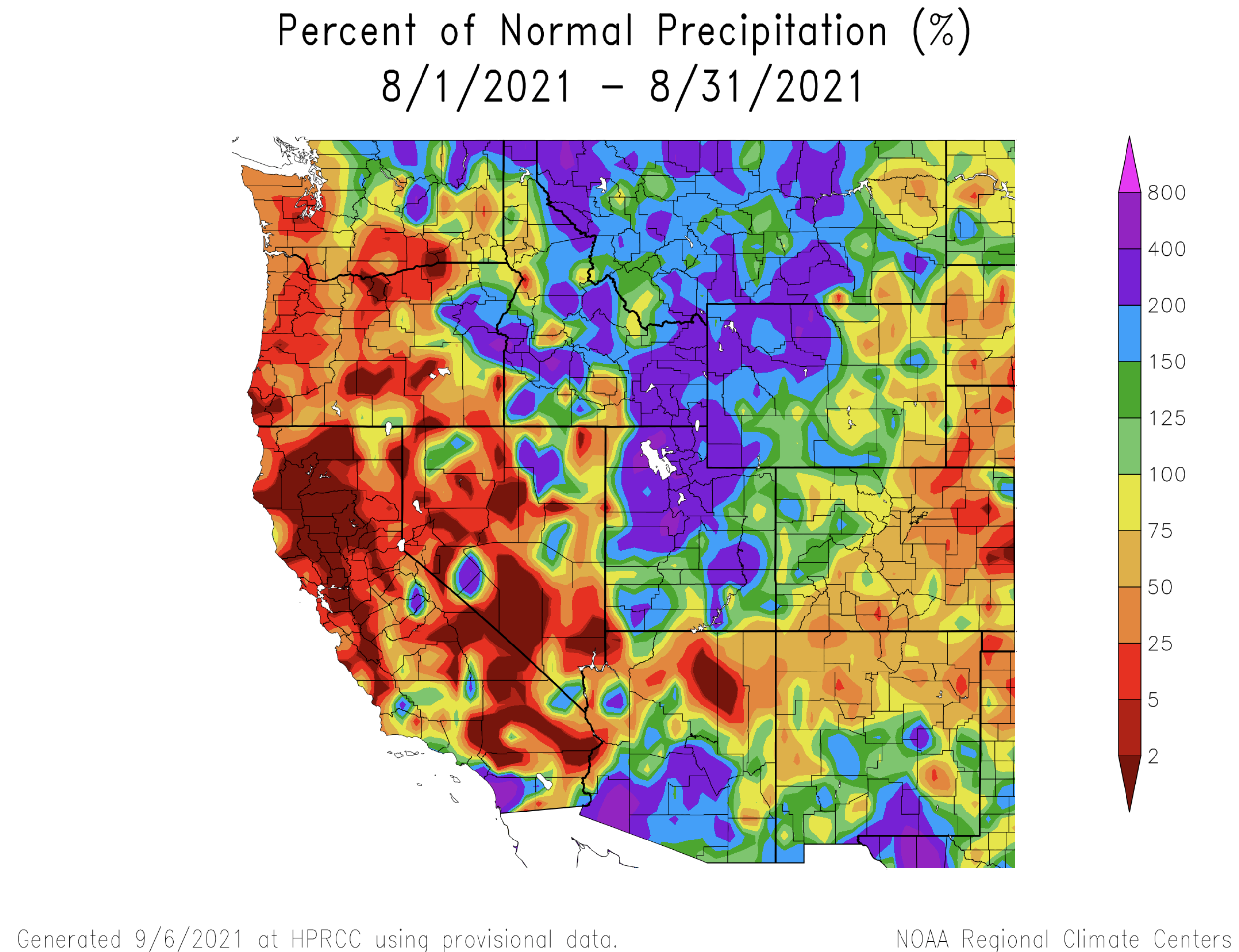
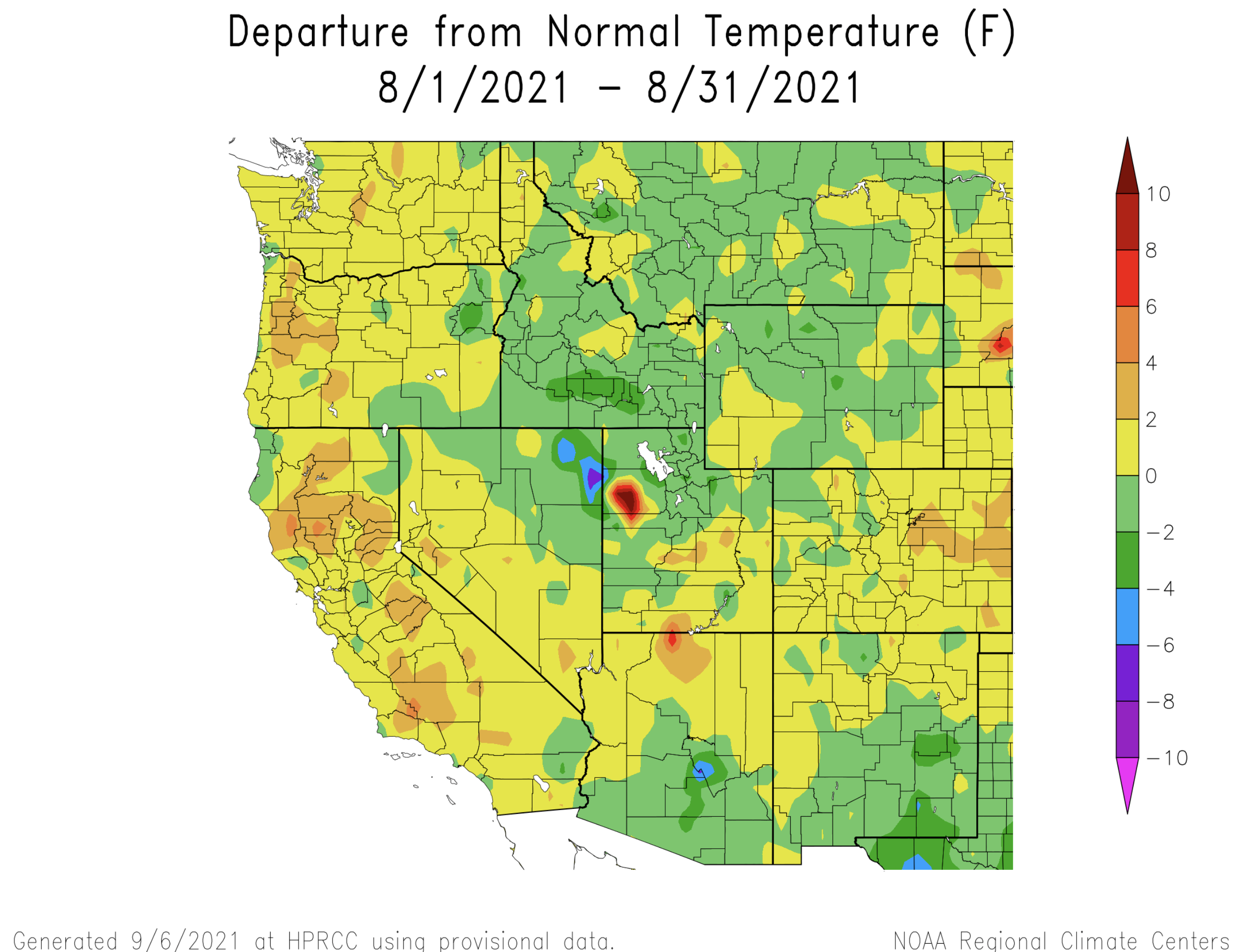
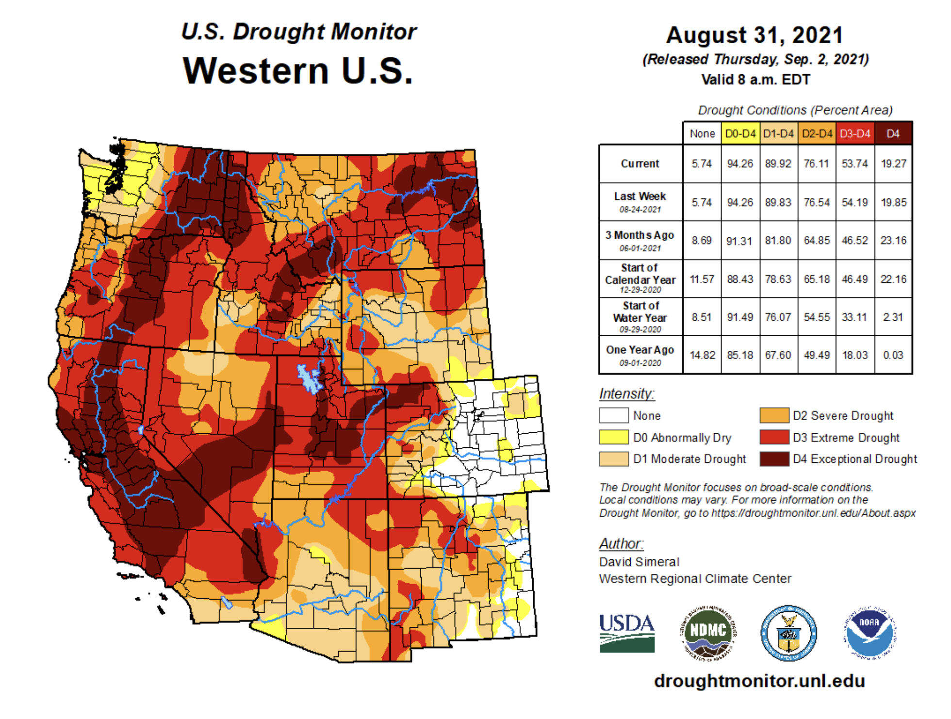
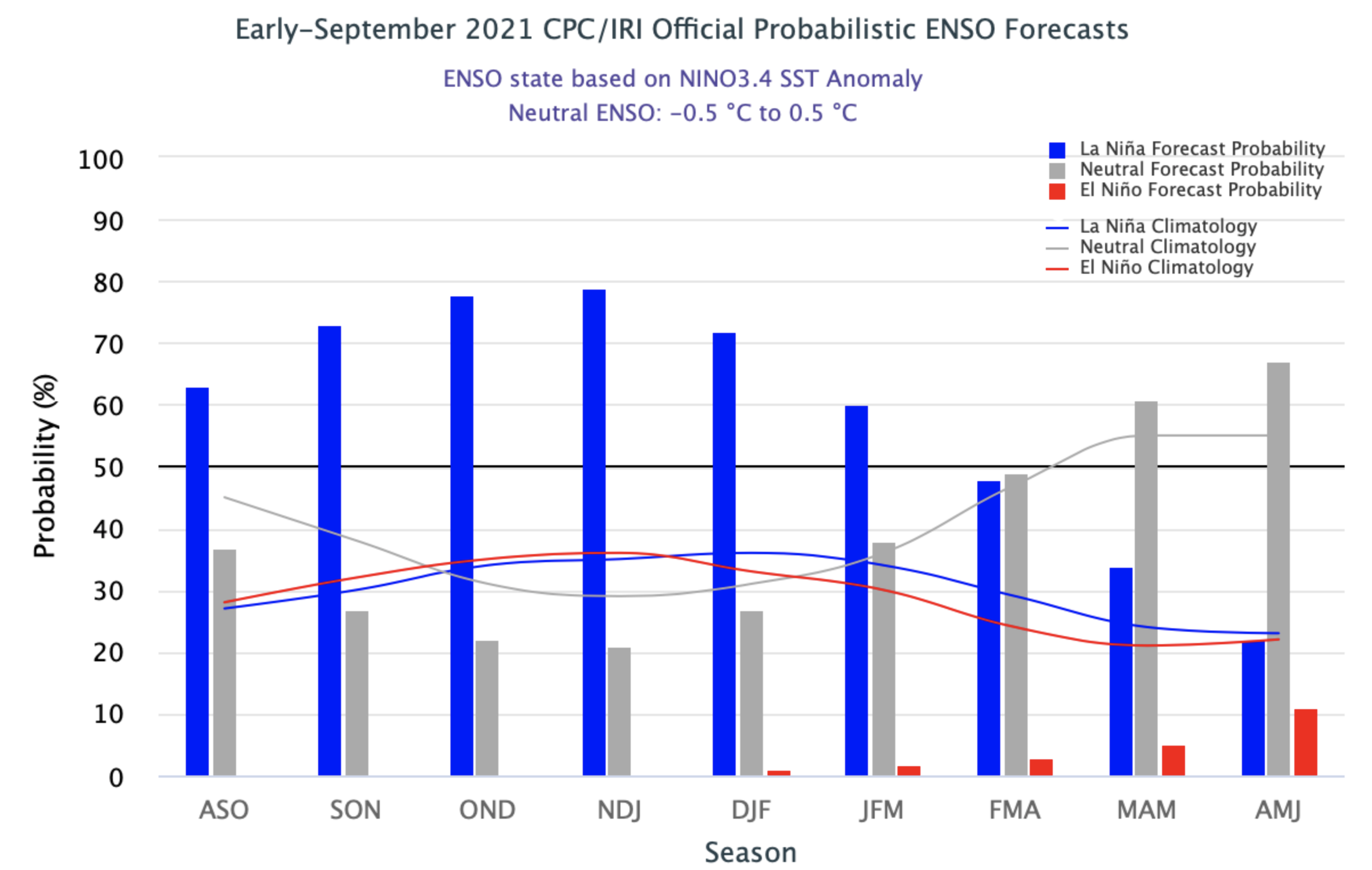
Much above average rainfall in Utah and western Wyoming during August caused some improvement to drought conditions in the Intermountain West, but drought persists across nearly the entire region except eastern Colorado. Improvements to drought conditions were aided by a return to near normal temperatures during August. Despite near-normal August temperatures, much of Utah and parts of western Colorado and Wyoming experienced record hot summer (June-August) temperatures. There is a 60 – 80% probability of La Niña conditions developing during fall and persisting through winter.
Precipitation was much above normal during August for much of the region, especially in Utah and western Wyoming due to a strong North American monsoon that brought precipitation further west and north than normal. Much of Utah and western Wyoming received 150-200% of normal August rainfall; many of these locations received up to 400% of normal August precipitation and isolated areas received even greater rainfall totals. August is a dry month in the Intermountain West and even 400% of normal is not enough to recover from long-term drought, however areas of northern Utah and northwest Wyoming received 1.5 – 3 inches more rainfall than typically falls in August. The eastern two-thirds of Colorado, including the Front Range and eastern Wyoming received below normal precipitation during August.
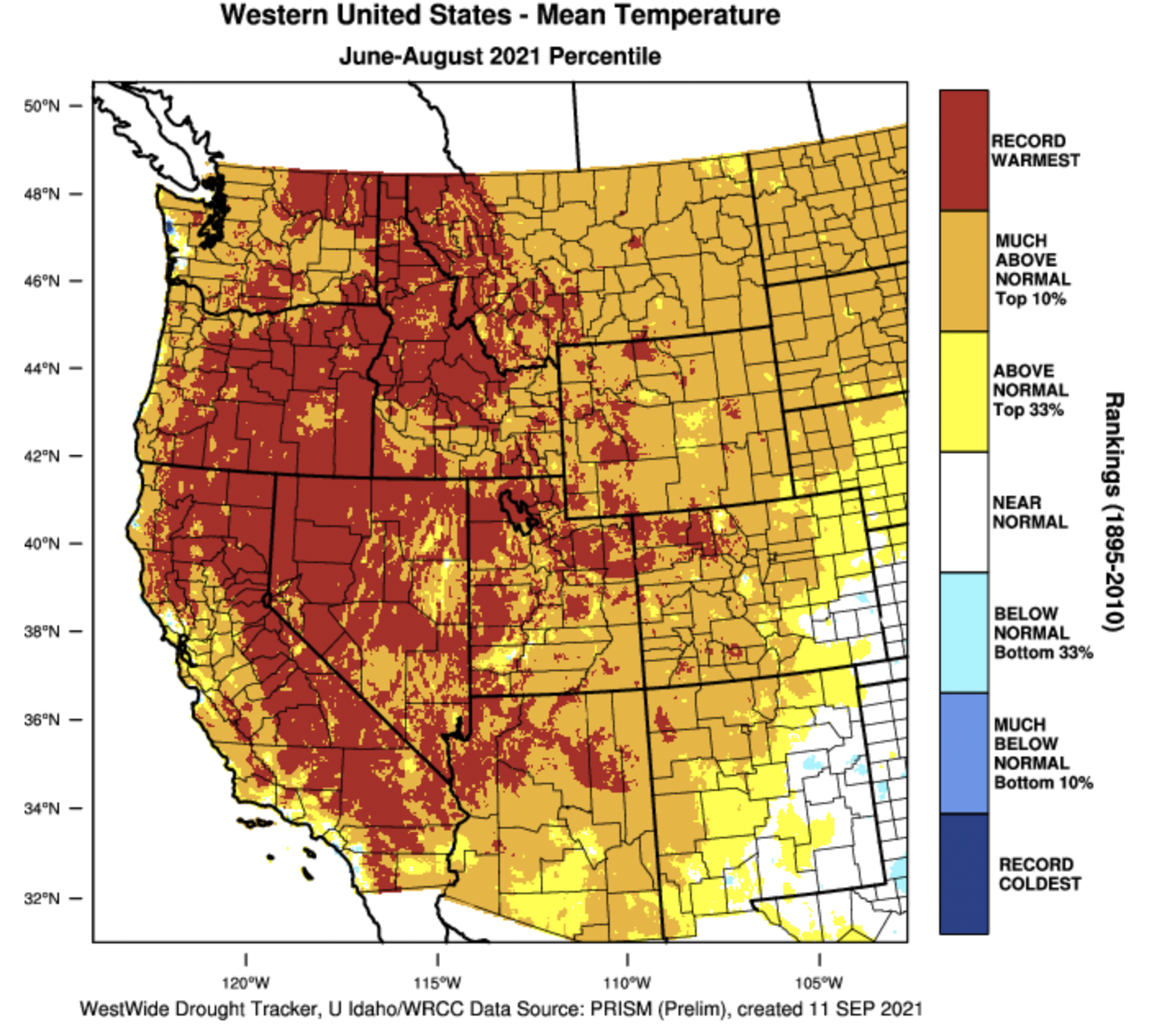
During August, Intermountain West temperatures were near-normal. In much of Utah and Wyoming, temperatures that were up to 2 degrees below normal and temperatures were up to 2 degrees above normal for much of Colorado. Despite a near-normal August temperatures, nearly half of Utah and parts of northwestern Colorado and western Wyoming experienced the hottest June – August on record. June – August 2021 was among the 12 hottest summers on record for the nearly the entire region.
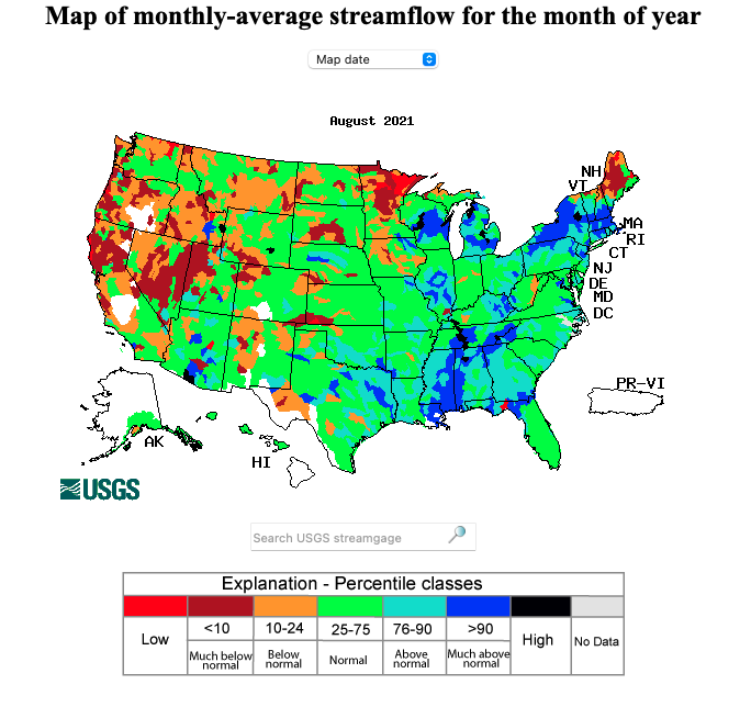
Prior to the onset of monsoonal rains in July and August, many regional rivers were approaching record-low streamflow values. A relatively wet August increased streamflow so that large areas of Colorado, Utah and Wyoming saw near-normal streamflow during August. Despite recent rainfall, rivers in western Utah, western Wyoming and northwestern Colorado were flowing below to much-below normal during August. Record low August streamflow was observed in the Weber and Logan Rivers in northern Utah.
Above average August monsoonal rains led to a one category improvement of drought conditions across portions of Utah and western Wyoming. Extreme and exceptional drought (D3-D4) persist across Utah, Wyoming and western Colorado, but conditions improved slightly during August. Improvements to drought conditions were most significant in Utah. In Utah, areal coverage of extreme drought decreased from 99% to 88% during August and the area of exceptional drought decreased by a factor of two, from 52% to 24% of the state. In Wyoming, drought conditions improved slightly in the western portion of the stated but worsened in the southeastern corner. Drought conditions improved by one category in portions of western Colorado, but a dry August caused areas of abnormally dry and D1 drought conditions to develop in the eastern plains of Colorado.
Eastern Pacific Ocean temperatures are slightly below normal, but regional climate remains in an ENSO-neutral condition. There is a 60 – 80% chance of La Niña conditions developing during fall and greater than a 50% probability of La Niña conditions persisting through late winter. There is an increased probability for above average precipitation during September in southern Colorado. During September – November, the NOAA seasonal forecast predicts an increased probability for above average temperatures and below average precipitation for the entire region.
Significant August weather event. Heavy monsoonal rains caused record August precipitation in parts of northern Utah. August rainfall was above to much-above normal for two-thirds of Utah and half of Wyoming during August. While rainfall was not great enough to alleviate multi-year drought, the heavy rainfall did improve drought conditions and eased fire danger during August. In Utah, parts of Carbon, Davis, Duchesne, Juab, Millard, Salt Lake, Summit, and Wasatch Counties received record amounts of August precipitation. Daily precipitation records were set at 43 locations in Utah during August. On August 18-19, 36 sites in Utah broke daily precipitation records.
FromThe High Country News [September 21, 2021] (Jonathan Thompson):
Late on the hot and sunny morning of July 13, 2021, a distribution troubleman for Pacific Gas & Electric drove up the Feather River Canyon in Northern California to check out a possibly blown fuse on one of the utility’s lines. His route took him past the blackened skeletons of trees burned by the Camp Fire in 2018. Sparked by PG&E’s equipment, it raged through the town of Paradise, killing at least 86 people.
The troubleman — delayed by roadwork — reached the location of the tripped fuse, near the Cresta Dam, at 4:40 p.m. Sure enough, two of the three fuses on the Buck Line had been tripped. As his truck’s cherry-picker bucket lifted him up to the fuses, he suddenly noticed a fire, estimated at about 600 square feet in size. There was a Douglas fir leaning against the line nearby.
He shut off the third fuse, killing power to the system, then descended to the ground to call dispatch, emptying first one, then another extinguisher on the flames, to no avail. Shortly thereafter Cal Fire aircraft arrived, followed by a ground crew. But the grass, shrubs and trees were simply too dry — baked by the kiln-like combination of drought and hot temperatures — and the flames swiftly got away from them, crawling and then exploding up the canyon’s slopes.
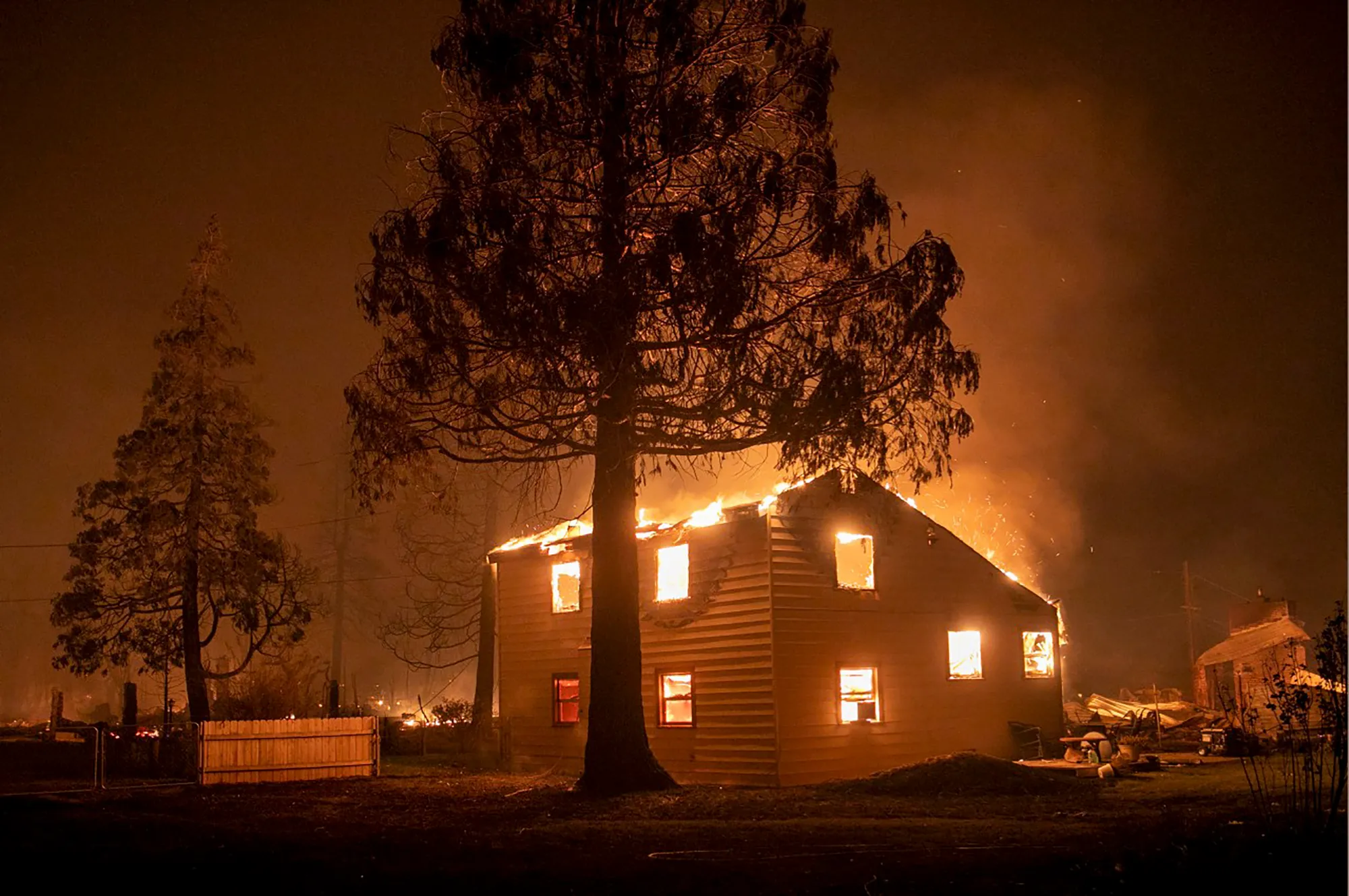
By the next day, the 600-square-foot blaze had grown to 600 acres and was spreading north and east at a rate of thousands of acres per day. It joined up with the 2,000-acre Fly Fire — which may have been started by a white fir toppling onto PG&E electrical equipment — and leveled the town of Greenville, forcing the evacuation of tens of thousands of residents. The pyrocumulonimbus plume it spawned rose thousands of feet into the air and sent smoke wafting across the West, affecting the air quality of communities as far away as Colorado. More than six weeks after it started, in early September, the Dixie Fire was still raging, having burned more than 800,000 acres of forest and hundreds of structures. And it was just one of a dozen or so blazes tearing across the state and the region.
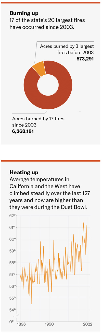
PG&E’s equipment, with some help from that errant Douglas fir, may have provided the spark that ignited California’s second-largest fire on record — the exact cause is still under investigation — but climate change clearly fueled it and numerous other recent megafires, from last year’s record-breaking conflagrations in Colorado, to this summer’s destructive blazes in Montana and Oregon. The entire West has been heating up significantly over the past century, exacerbating the effects of two decades of drought and priming dry forests to burn more intensely than ever before.
Graphic credit: The High Country News
15,000
Number of firefighters on the frontlines of 16 major California fires as of Sept. 1.
1.88 million
Acres burned in California this year as of Sept. 1.
2.68 million
Total acreage of 86 large fires burning across the Western U.S. as of Sept. 1.
August 30
Date on which the U.S. Forest Service closed all national forests in California due to extreme wildfire hazard.
80 degrees Fahrenheit
California’s average temperature for July 2021, the hottest July ever for the state as well as for Nevada, Oregon and Washington.
153,000
Acres of forest in California’s carbon offset program that had been burned in wildfires this year as of Aug. 24.
1,282
Number of structures destroyed by the Dixie Fire as of Sept. 1, when it had reached a size of 844,801 acres, making it the second-largest fire in California history.
1.03 million acres
Size of the largest fire in California history — the August Complex — which burned in the northern part of the state in 2020.
811
Number of structures destroyed by the Caldor Fire as of Sept. 1; an additional 35,000 structures were threatened.
Graphic credit: The High Country News
Utility ignitions, payouts, plunges
Some of the most destructive fires in California history were ignited by electrical utility equipment, and Northern California’s Pacific Gas & Electric is one of the worst offenders in this regard.
6
Minimum number of the 20 most destructive fires ignited by electrical equipment in California.
122
Minimum number of fatalities resulting from California fires sparked by electrical equipment.
84
Number of counts of manslaughter PG&E pled guilty to for its role in starting the 2018 Camp Fire, which leveled the town of Paradise. The official death toll was 86, but an investigation by the Chico Enterprise-Record found an additional 50 deaths indirectly linked to the fire.
$13.5 billion
Amount of a PG&E fund — half of it made up of company stock — for compensating victims of past fires caused by the utility’s equipment.
$2.6 billion
Amount by which the value of the stock in the compensation fund dropped after PG&E indicated it may have ignited the Dixie Fire this year.
$15 billion to $20 billion
Estimated cost of PG&E’s project to bury 10,000 miles of powerlines to reduce wildfire hazard.
The Dixie Fire destroys a home in the Plumas County town of Greenville, Aug. 4, 2021. Photo by Karl Mondon, Bay Area News Group
Infographic design: Luna Anna Archey/High Country News
Sources: Cal Fire, National Interagency Fire Center, Documents from the U.S. District Court Northern District Of California, PG&E, National Oceanic and Atmospheric Administration
We welcome reader letters. Jonathan Thompson is a contributing editor at High Country News. He is the author of Sagebrush Empire: How a Remote Utah County Became the Battlefront of American Public Lands. Email him at jonathan@hcn.org
The biggest blow came in August, when the U.S. government issued its first ever water shortage declaration for the Colorado River, triggering water use restrictions.
These strategies conceal a more fundamental problem: the unchecked growth of water consumption. The Southwest is in an “anthropogenic drought” created by the combination of natural water variability, climate change and human activities that continuously widen the water supply-demand gap.
In the long run, this can lead to “water bankruptcy,” meaning water demand invariably exceeds the supply. Trying to manage this by cranking up water supply is destined to fail.
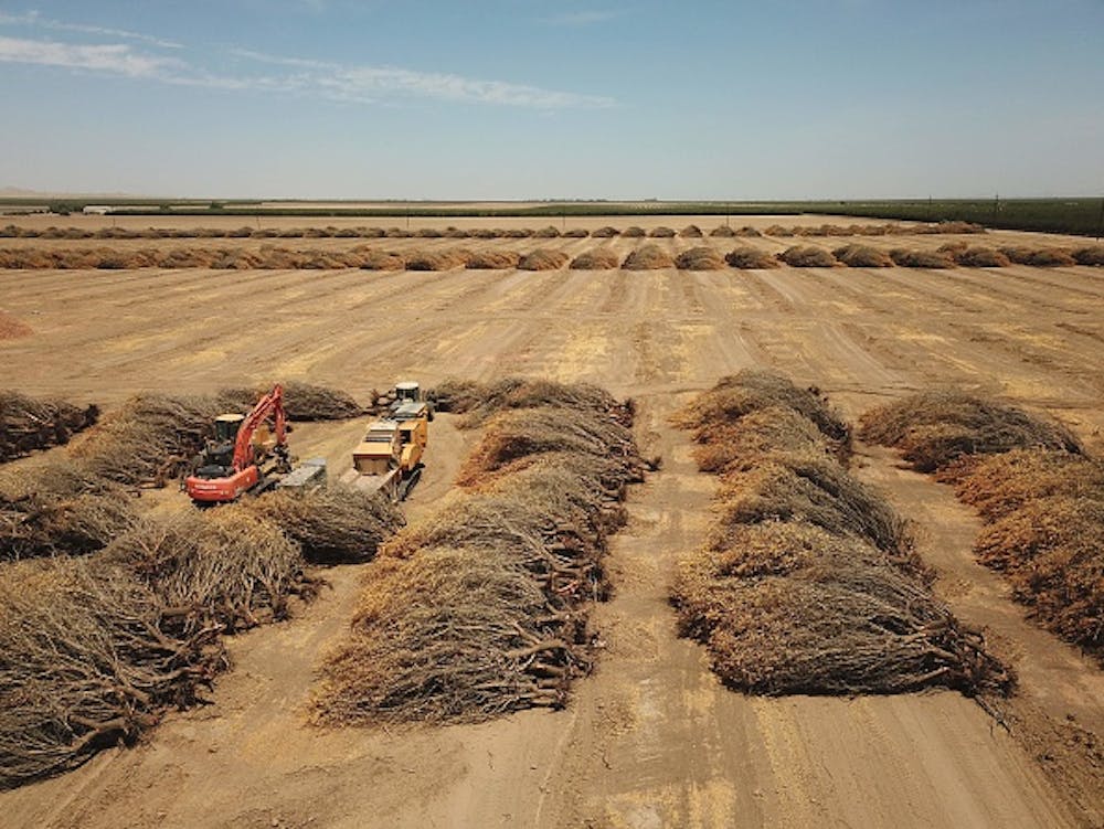
A California farmer tore out dead almond trees in July 2021 because of a lack of water to irrigate them. Robyn Beck/AFP via Getty Images
More than 7,000 miles away, Iran is grappling with water problems that are similar to the U.S. Southwest’s but more severe. One of the driest years in the past five decades, on the back of several decades of mismanaged water resources, brought warnings of water conflicts between Iranian provinces this year.
Asenvironmentalengineers and scientists – one of us is also a former deputy head of Iran’s Department of Environment – we’ve closely studied the water challenges in both drought-prone regions. We believe past mistakes in the U.S. and Iran offer important lessons for future plans in the U.S. Southwest and other regions increasingly experiencing drought and water shortages.
Groundwater pumping: A temporary fix with consequences
Iran offers a case study in what can go wrong with that approach, as our research shows. The country nearly doubled its groundwater extraction points between 2002 and 2015 in an attempt to support a growing agricultural industry, which drained aquifers to depletion. As its water tables drastically declined, the groundwater’s salinity increased in aquifers to levels that may no longer be readily suitable for agriculture.
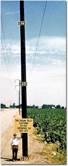
As water-filled pores in the soil are drained, the weight of the overlying ground compresses them, causing the aquifers to lose their water holding capacity and accelerating land subsidence. Iran’s capital, Tehran, with more than 13 million residents, subsided more than 12 feet between 2003 and 2017. Similarly, some areas of California are sinking at a rate of up to 1 foot each year.
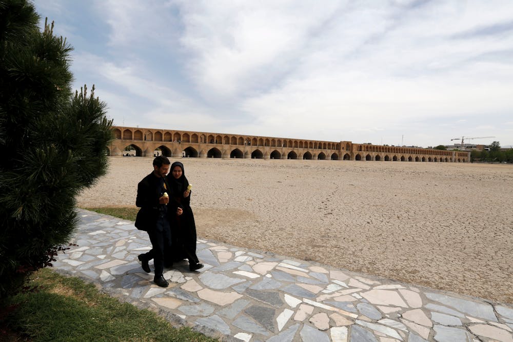
Kaveh Madani discusses the drying of the Zayandeh Rud riverbed in Isfahan, Iran.
In Iran, multiple interbasin water transfer projects doubled the flow of the Zayandeh Rud, a river in the arid central part of the country. The inflow of water supported unsustainable growth, creating demand without enough water to support it. In dry years now, no one has enough water. Many people in Khuzestan – the region supplying water to central Iran – lost their livelihood as their farms dried out, wetlands vanished, and livestock died of thirst. People in central Iran also lost crops to the drought as incoming water was cut. Both regions saw protests turn violent this year.
Another project, the California Aqueduct, was constructed in the 1960s to transfer water from the Sacramento-San Joaquin Delta in Northern California to the Central Valley and southern parts of the state to support agriculture and some urban demand. This also did not close the water demand-supply gap, and it pushed economically and culturally important native fish species and ecological systems in the delta to the point of collapse.
Looking ahead in light of looming water bankruptcy
As the continued influx of population into the U.S. Southwest raises water demand in the face of shrinking water supply, we have to wonder whether the Southwest is heading toward water bankruptcy.
While there is no easy solution, a number of actions are possible.
First, recognize that water shortages cannot be mitigated only by increasing water supply – it’s also important to manage water demand.
U.S. Geological Survey researcher Joseph Poland shows the high rate of subsidence in California’s San Joaquin Valley. USGS
Cities can save water by curbing outdoor water losses and excess water use, such as on ornamental lawns. Californians successfully reduced their water demand by more than 20% between 2015 and 2017 in response to severe drought conditions. Replanting urban landscapes with native drought-tolerant vegetation can help conserve water.
[Over 110,000 readers rely on The Conversation’s newsletter to understand the world.Sign up today.]
There are also emerging technological solutions that could boost water resources in some regions, including fog water collection, which uses sheets of mesh to capture moisture from fog, and desalination plants that turn seawater and saline groundwater into drinking water. One new desalination plant planned for Huntington Beach, California, is awaiting final approval. Environmental consequences of these measures, however, should be carefully considered.
Yampa River. Photo credit: Yampa River Integrated Water Management Plan website
FromThe Steamboat Pilot & Today (Gene Hinkemeyer):
Did you know the Colorado Department of Natural Resources calls for 80% of prioritized rivers to be covered by a stream management plan by 2030? Yes, that includes our Yampa River Basin.
The Yampa-White-Green Basin Roundtable — YWG BRT — is one of nine grassroots water policy roundtables throughout Colorado working to develop locally driven, collaborative solutions to water supply challenges. The YWG BRT has been working on an integrated water management plan for the past several years.
The overall goal of the integrated water management plan is to use science, data and community input to build a healthy, productive water future in the Yampa basin for all water users. A committee of volunteers selected by and reporting to the YWG BRT coordinates the project.
Over the past two years, the integrated water management plan has focused on four geographic segments in the basin: upper, middle and lower main stem of the Yampa and the Elk River. Stakeholder interviews were conducted of agricultural, environmental/recreational and municipal/industrial water stakeholders in the basin. Interviews were conducted to learn about stakeholder’s operation and diversion infrastructure, water and riparian land management related concerns and opportunities for improvement.
Diversion assessments were also conducted to identify, evaluate and recommend multibenefit projects. The diversion infrastructure assessment report, which can be found at http://YampaWhiteGreen.com, represents the findings of the structures assessed. The primary goal of the diversion assessments was to gain an understanding of infrastructure used for diversions and to identify locations where infrastructure improvements could provide multiple benefits to the river and water users. These assessments evaluate opportunities that could benefit the structure owner(s), fish passage, recreational boating and overall river health.
So, what do we do with all this information? The integrated water management plan volunteer committee organized three focus areas around key topics to learn more and help identify projects for future work: ag infrastructure; riparian habitat/wetland/natural bank stability; and flows/shortages. A few projects are already in the works, with other projects to begin later this year.
The ag infrastructure work group has identified an initial set of agricultural diversion infrastructure projects that the integrated water management plan hopes to support and fund starting in 2022. Using data collected from interviews, the riparian focused work group has identified landowners with concerns related to erosion, bank stability and riparian habitat. Follow up interviews over the next few months are planned to better characterize their concerns and learn more about potential solutions.
Additional work has been completed, including a remote assessment that provided geomorphic, hydrological and ecological context for the integrated water management plan planning effort. This broad characterization applies remote sensing and GIS-based tools and techniques to assess moderate-resolution data sets across watershed and planning segment scales to identify and map trends and characteristics in physical and biological functions within the basin. Field assessments are underway to ground truth and verify the remote assessment findings.
A fluvial hazard mapping project is also in progress to delineate areas vulnerable to sediment and debris impacts spurred by rainfall or rapid snowmelt. As a final product, these maps can be used to inform land use planning, stream interventions and to identify and prioritize the conservation or restoration of natural geomorphic floodplains, wetlands and river corridors within the basin.
The integrated water management plan volunteer committee has been busy and continues to work hard on community driven plans for the Yampa Basin. We can only be successful with input and ideas from all stakeholders. If you would like to learn more, please visit our website, http://YampaWhiteGreen.com/iwmp.
Gena Hinkemeyer is segment coordinator of the Yampa-White-Green Basin Roundtable.
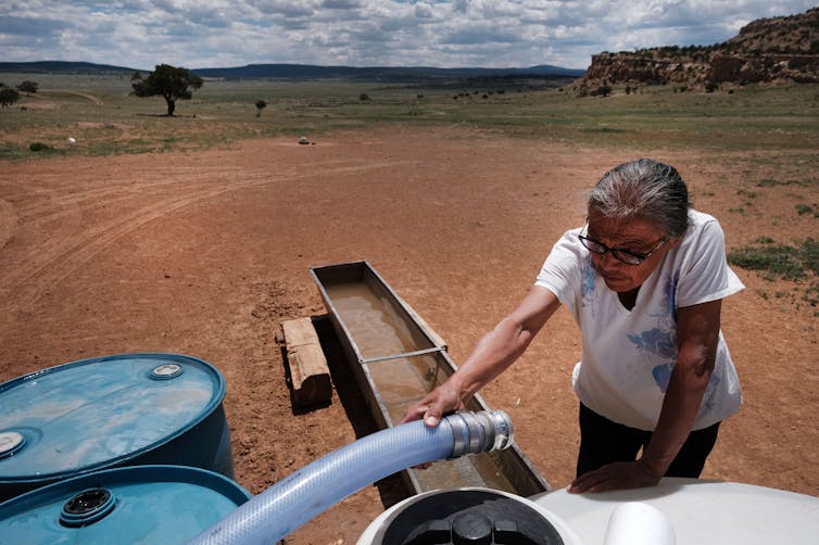
A stock pond that is normally full of water stands dry because of drought on the Little Bear Ranch near Steamboat Springs, Colo., on Aug. 11, 2021. Due to low snowpack, warming temperatures and dry soil during the past two years, followed by the same in 2021, Northwest Colorado is in a severe drought. Credit: Dean Krakel, special to Fresh Water News.
Colorado’s water forecast, already strained by back-to-back drought years, is unlikely to brighten this fall and winter, as forecasts indicate more dry weather lies ahead.
Water planners use something known as the water year to track and predict snow and rain, as well as winds and soil conditions. It begins Oct. 1, leading into the period of critical mountain snows and the spring runoff they generate, and estimations of what it will yield help farmers, cities and others determine how much H20 they will have to work with.
But water year 2022 is getting off to another dusty, dry start.
“The seasonal outlook is not pointing in a favorable direction,” said Peter Goble, a climate specialist at Colorado State University’s Colorado Climate Center. “We’re a lot better off than we were a year ago. Having blue skies as opposed to smoke is a big improvement, but we are going into water year 2022 on shaky footing.”
Goble was referring to Colorado’s disastrous fire season during last year’s drought, when the state saw three of the largest wildfires in its history erupt in late summer and early fall.
Last week, at a meeting of the state’s Water Availability Task Force, forecasters said Colorado was likely to experience another La Niña this coming year, a weather pattern that can bring healthy moisture to the Northern Rockies but which often leaves the southwestern portion of the state dry. Because 2020 saw the same La Niña develop, this year’s may bring less moisture.
In the broader Colorado River Basin, water storage levels continue to drop, with total storage at lakes Powell and Mead down to a combined 39% full, below last year’s already low 49% full mark, according to an update released Sept. 22 by the U.S. Bureau of Reclamation. The Colorado River Basin is made up of seven states. Colorado, Utah, Wyoming and New Mexico comprise the Upper Basin, while Arizona, California and Nevada comprise the lower basin.
In July, Reclamation began a series of emergency water releases from Flaming Gorge, Blue Mesa and Navajo reservoirs in the Upper Basin to help bolster Lake Powell and protect its hydropower generating stations. But conditions there continue to deteriorate.
Lake Powell could see just 44% of average inflows starting in October. Without a snowy winter and spring, hydropower generation at Powell’s Glen Canyon Dam could come to a halt as early as July 2022, according to Reclamation.
“The latest outlook for Lake Powell is troubling,” said Wayne Pullan, director of Reclamation’s Upper Colorado Basin Region.
Weather experts are also deeply worried about a phenomenon that continues to grow in intensity: the arrival of healthy snows that evaporate or seep into parched soils, never reaching streams in the volumes they once did.
Karl Wetlaufer, who is assistant snow survey supervisor at the Natural Resources Conservation Service, said water planners have long relied on a solid connection between snow and subsequent water supplies, where healthy snowpacks were reflected in healthy streamflows.
But with Colorado and other Western states mired in a 20-year drought, where soils get drier and drier each year, streamflow forecasts are becoming less predictable.
“Snowpack [last winter] was not terrible, but with those dry soils and a warm and dry summer we really saw dramatically decreased streamflows,” said Wetlaufer, who is a member of the state’s Water Availability Task Force.
In Northwest Colorado’s Yampa River Basin, snowpack peaked at 90% of average last winter, but streamflows this spring and summer reached only 30% of average.
“As long as I can remember, this is the most dramatic example of the multi-decadal drought’s impact. We are really going to have to start paying closer attention to these dry soils,” Wetlaufer said.
Jerd Smith is editor of Fresh Water News. She can be reached at 720-398-6474, via email at jerd@wateredco.org or @jerd_smith.
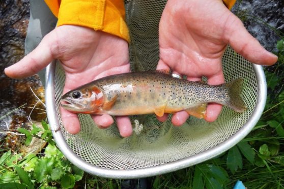
Colorado Parks and Wildlife (CPW) continues to reintroduce one of the state’s prized animals to its natural habitat.
This week, CPW officers released infant Colorado River Cutthroat Trout to waterways in Southern Colorado. These fish were released into the North French Creek drainage because this body of water does not contain fish in its higher regions, allowing the trout to grow and reproduce.
The fish being stocked are the descendants of roughly 200 fish taken out of Hayden Creek near Salida, Colorado, during the Hayden Pass Fire in 2016. The fish were then taken to a CPW fish hatchery for their protection.
CPW said because of the fire, the creek is still uninhabitable, which is why they are putting the fish in other areas.
“When we have three to five stable populations in the Arkansas watershed, I’ll know we are preserving this unique species,” said PSICC Fisheries Biologist Janelle Valladares. “When I’m working on this project, I always think about conservationist Aldo Leopold. He said, ‘To keep every cog and wheel is the first precaution of intelligent tinkering’. We may not know just how this fish fits into the larger picture, but despite fires and flooding, it is important to preserve as many species as possible until we have a more complete understanding of their contribution to the environment.”
Crews will stock about 2,000 fish over the next few weeks and plan to stock more over the next three years.
“Actively managing these increasingly rare fisheries habitats is critical to maintaining the viability of these rare cutthroat,” said Pikes Peak District Ranger Oscar Martinez. “I am excited we can capitalize on the unique characteristics of Ruxton and French Creeks to help us with the stewardship of the cutthroat in response to an increasing number of stressors, like climate change and wildland fire events.”
The fish are most closely related to the Colorado River cutthroat trout, but with unique genetics that do not exist in any other trout population. The genetics of these cutthroat trout match museum specimens collected from Twin Lakes, near Leadville, Colorado, in 1890, according to CPW.


