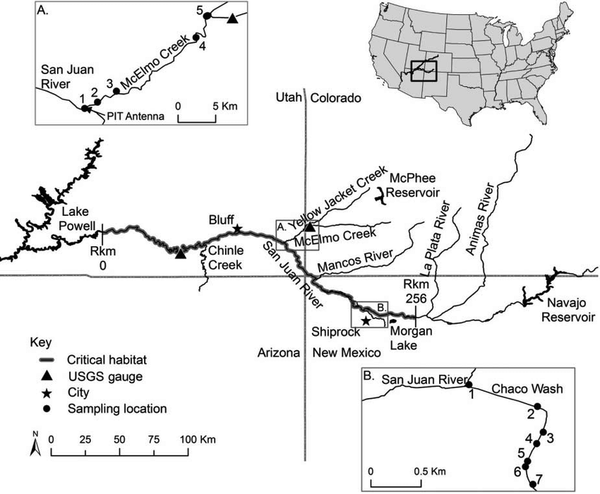
Map of the San Juan River Basin showing tributary sites in the inset maps, relevant endangered fish habitat: Credit: ResearchGate.net
From email from Reclamation (Susan Novak Behery):
In response to increasing flows in the critical habitat reach, the Bureau of Reclamation has scheduled a decrease in the release from Navajo Dam from 850 cubic feet per second (cfs) to 700 cfs today, September 29th, at 1:00 PM. Releases are made for the authorized purposes of the Navajo Unit, and to attempt to maintain a target base flow through the endangered fish critical habitat reach of the San Juan River (Farmington to Lake Powell).
The San Juan River Basin Recovery Implementation Program recommends a target base flow of between 500 cfs and 1,000 cfs through the critical habitat area. The target base flow is calculated as the weekly average of gaged flows throughout the critical habitat area from Farmington to Lake Powell. This release change is calculated to be the minimum release required to maintain the minimum target base flow.
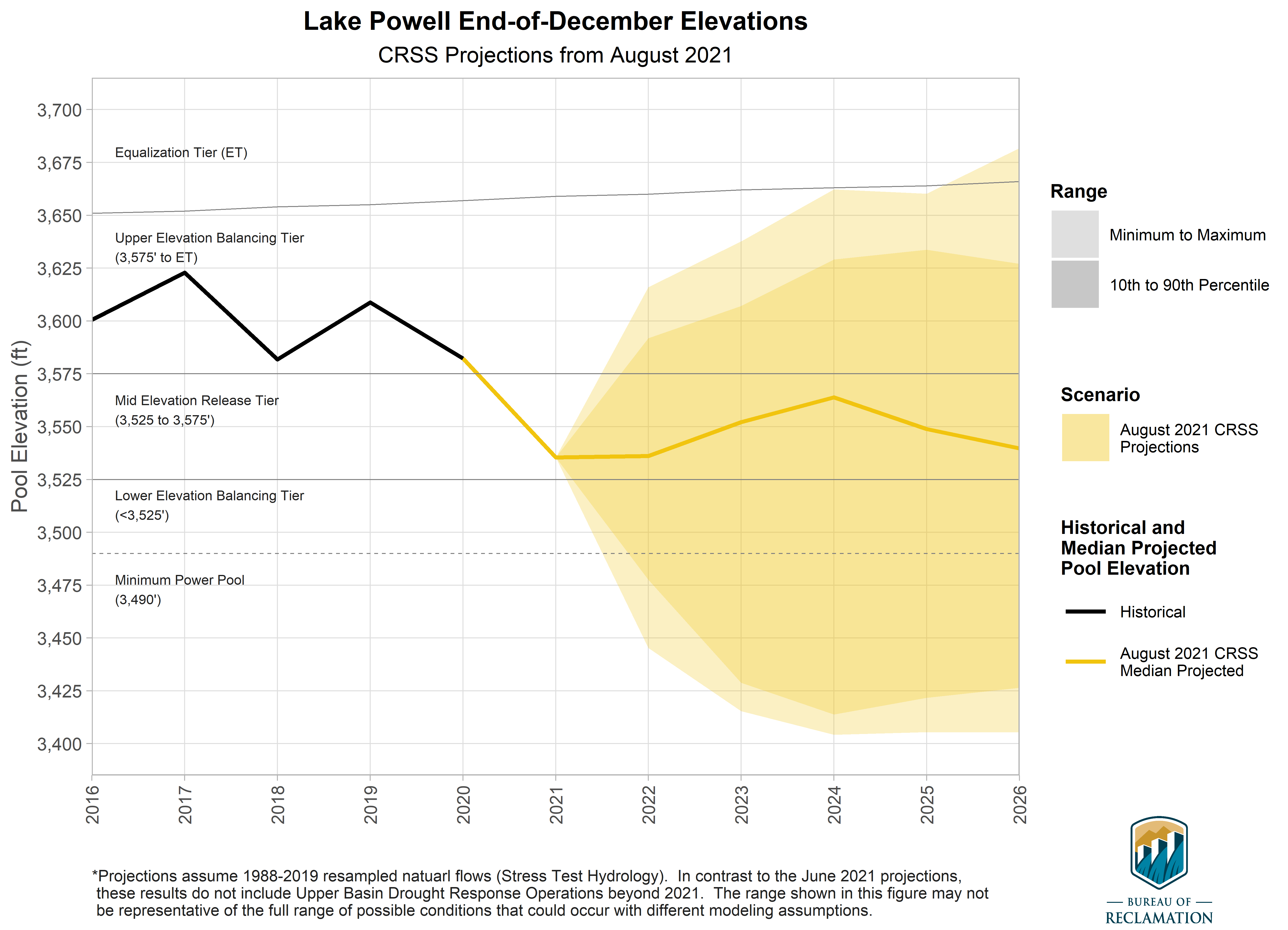
Projection of Lake Powell end-of-December reservoir elevations. The colored region, or cloud, for the hydrology scenario represents the minimum, 10th percentile, 90th percentile, and maximum of the projected reservoir elevations. Solid lines represent historical elevations (black), and median projected elevations for the scenario (yellow). Dashed gray lines represent important elevations for operations, and the vertical line marks the adoption of the 2019 Drought Contingency Plans. Graphic credit: Bureau of Reclamation
From email from the Colorado Water Conservation Board:
On September 22, the Bureau of Reclamation released updated projections for levels in the Colorado River’s major reservoirs – Lake Powell and Lake Mead. As a result of continued historic drought and low runoff conditions, both reservoirs are at risk of reaching critically low levels.
In Lake Powell, projections indicate that the critical elevation of 3,525 feet now has a near 90% chance of being reached next year. In Lake Mead, elevation 1,025 feet (the third shortage trigger) is as high as 66% in 2025.
Statement from Colorado River Commissioner Rebecca Mitchell:
“Though deeply troubling, these projections tell us what we already know and have experienced in Colorado and the whole Upper Basin – that this has been a very dry and challenging year and these conditions will continue into the future. Our water users have already experienced painful and deep cuts, and these will continue. Colorado is fully committed to working with the basin states and the Bureau of Reclamation to chart a course that provides additional security to the entire Colorado River Basin and its water users during this challenging time and into the future.”
I recently had the opportunity to speak with the “Science Moab Podcast” about my views on Indigenous Archaeology as well as on-going conservation work in Southeastern Utah. This interview was included as a part of the Moab Festival of Science. You can hear the interview here–>https://sciencemoab.org/perspectives-from-a-hopi-archaeologist/ The interview was followed by a live-stream Q & […]
The Department of the Interior plays a central role in how the United States stewards its public lands, increases environmental protections, pursues environmental justice, and honors our nation-to-nation relationship with Tribes.
Our mandate from President Biden is clear: we must address the four intersecting challenges of COVID-19, economic recovery, racial equity and climate change.
We have no time to waste in taking action to protect public lands, the environment and Americans’ lives and futures. Interior is ready to take the bold action desperately needed to ensure all communities — including communities of color and urban, rural, and Indigenous communities — benefit from an aggressive and whole-of-government response.
To meet the scope of our challenges and the multiple, overlapping crises, we are:
Identifying steps to accelerate responsible development of renewable energy on public lands and waters. We are investing in climate research and environmental innovation to incentivize the rapid deployment of clean energy solutions, while reviewing existing programs to restore balance on America’s public lands and waters to benefit current and future generations.
Strengthening the government-to-government relationship with sovereign Tribal Nations. We understand that Tribal sovereignty and self-governance, as well as honoring the federal trust responsibility to Tribal Nations, must be the cornerstones of federal Indian policy.
Making investments to support the Administration’s goal of creating millions of family-supporting and union jobs. This includes establishing a new Climate Conservation Corps Initiative to put a new generation of Americans to work conserving and restoring public lands and waters, increasing reforestation, increasing carbon sequestration in the agricultural sector, protecting biodiversity, improving access to recreation, and addressing the changing climate.
Working to conserve at least 30% each of our lands and waters by the year 2030. We will work to protect biodiversity, slow extinction rates and help leverage natural climate solutions by conserving 30% of America’s lands and waters by 2030. This relies on support for local, state, private, and Tribally-led nature conservation and restoration efforts that are underway across America.
Centering equity and environmental justice. The impacts of the multiple crises in the United States are not evenly distributed in our society. Communities of color, low-income families, and rural and Indigenous communities have long suffered disproportionate and cumulative harm from air pollution, water pollution, and toxic sites. At every step of the way, Interior will engage diverse stakeholders across the country, as well as conduct formal consultation with Tribes in recognition of the U.S. government’s trust responsibilities.
Lake Mead low elevation. Photo credit: Department of Interior via ensia
Water authorities in the Western U.S. don’t know what the future will bring, but they are working collaboratively and with scientific rigor to make sure they’re prepared for anything.
September 27, 2021 — Editor’s note: This story is part of a four-part series — “Hotter, Drier, Smarter: Managing Western Water in a Changing Climate” — about innovative approaches to water management in the U.S. West and Western tribal nations. The series is supported by The Water Desk , an independent journalism initiative based at the University of Colorado Boulder’s Center for Environmental Journalism. You can read the other stories in the series, along with more drinking water reporting, here.
In a thirsty Western United States that has become increasingly vulnerable to extreme weather events, rampant wildfires and years of unprecedented drought, those at the helm of the region’s water agencies are accelerating their plans to grapple with climate change.
“The Western United States — especially the 40 million people who use the Colorado River — we’re in the bullseye of climate change,” says Cynthia Campbell, water resource management advisor for the City of Phoenix. “This is not a conceptual conversation anymore. We’re in full-on adaptation.”
With that reality comes the need to plan around the future of water for the people and wildlife who call the Colorado River Basin home.
“You can’t just plan for one future.” –Carly Jerla
But, says Carly Jerla, an operations research analyst for the United States Bureau of Reclamation’s Lower Colorado Region, “you can’t just plan for one future.”
As climate change casts its shadow over water resources in the Western U.S., water authorities must navigate uncertainty in the form of the many possible futures in front of them. Those futures almost certainly hold more of what climate change has already brought — rising temperatures, changes in precipitation, shifts in snowpack, longer and more severe droughts, more frequent flooding — plus people’s responses to those changes. Taken together, these fateful forecasts go into climate projections: models that explore an array of possible future climate conditions or scenarios.
Today, planning agencies are working together to diversify the technology they’re using and integrate scientific research into local and regional adaptation strategies in an effort to be rigorous in their analysis of the uncertainty.
Adapting to climate change “shouldn’t be scatter-shot,” Campbell says. “It can actually be more scientific.”
Mix of Solutions
Although local regulations vary among Western water agencies, the inclusion of climate projections into authorities’ planning processes has become all but universal. Grappling with uncertainty requires water managers to account for supply and demand challenges that are (and will be) driven by climate change, says Jerla, who is currently stationed at the University of Colorado Boulder. On the supply side, she explains, are factors such as higher temperatures, precipitation and snowpack changes, and droughts and flooding. Shifts in demand, meanwhile, are from things like rising evapotranspiration rates in agriculture and impacts to residential irrigation.
A longtime expert on modeling applications and planning operations for the Lower Colorado Region, Jerla was the study manager for the Bureau of Reclamation’s Colorado River Basin Water Supply and Demand Study. The assessment was completed in 2012, and its technical foundations helped guide climate adaptation policies. The research, which occurred under the umbrella of the agency’s larger Basin Study Program, quantified water imbalances through 2060 and suggested potential strategies for mitigation and adaptation.
The Colorado River Compact divided the basin into an upper and lower half, with each having the right to develop and use 7.5 million acre-feet of river water annually. (Source: U.S. Geological Survey via The Water Education Foundation)
The study identified shortfalls between projected supplies and projected demand in the Colorado River Basin by looking at a range of possible future climatic scenarios and analyzing many possible outcomes, according to Jerla. One particular scenario, called a downscaled general circulation model (GCM), forecasted that as the climate continues to warm, the mean natural flow of the Colorado River at Lees Ferry, Arizona — significant because it’s the point that separates the river’s Upper and Lower Basin, and from which water allocations for the Basin states are determined depending on river measurements — would decrease by about 9% over the next 50 years, alongside longer, more frequent droughts.
“One of the things that this opened our eyes to is the importance of communicating the uncertainty with respect to future outcomes, especially when you’re looking 50 years in the future,” Jerla says.
In addition to examining these scenarios, she and her colleagues evaluated adaptation and mitigation strategies that might reduce supply and demand imbalance. One important conclusion, according to Jerla, was the notion that water agencies would need to diversify their portfolios to include a variety of mechanisms like water reuse, desalination and increased water transfers to urban areas.
“There was no one solution that was going to be a fix-it,” Jerla says. “It has to be a mix of stakeholders involved.”
A Critical Period
The next few years will be a critical policy planning period for Western water agencies, culminating in the particularly pivotal year of 2026. The drought contingency plans for the Upper and Lower Basins of the Colorado River, which have helped further the understanding that the status quo is no longer sustainable, will expire that year and likely undergo significant changes. In the plans, first approved by Congress in 2019, the seven Colorado River Basin states committed to protect the water levels of Lake Powell and Lake Mead — the human-made reservoirs that store Colorado River water and serve the basin states — through various conservation mechanisms.
Not only will the Colorado River Drought Contingency Plan expire in 2026, so too will the 2007 Colorado River Interim Guidelines for Lower Basin Shortages and Coordinated Operations for Lake Powell and Lake Mead, as well as the terms of the International Boundary and Water Commission’s Minute 323 — an updated “implementing agreement” of the Mexican Water Treaty of 1944 that established U.S.-Mexico protocols for collaborative management of the Colorado River. Experts agree that new negotiations on the interim guidelines, as well as between the U.S. and Mexico on a new Minute, will be instrumental in shaping collaborative water management for the future, which will no doubt involve serious consideration of climate change projections.
This animation shows a comparison of Lake Mead water levels from 2000 to 2015. Images by Joshua Stevens, using Landsat data from the U.S. Geological Survey, courtesy of NASA Earth Observatory (public domain)
“In the Colorado River Basin, we’ve been at work really since the Interim Guidelines for Powell and Mead Operations, since 2007, slowly building and adding to our operational decisions, planning efforts, policies — all with a mind toward more flexibility, enhanced resiliency, preparing for the challenges ahead, building science into the activities,” Jerla says.
For the Colorado River, Jerla and her colleagues have been making projections about relevant reservoir elevations through 2025, as they know what the operational guidelines will be until 2026. Generating such projections and sharing them with their local and regional partners remains crucial in order to help stakeholders understand what water reductions they might need to make.
Jerla says she is confident in the “robust set of policies” in place through 2026, which specify the water reductions that both U.S. states and Mexico will need to implement when the basins reach specified levels. Although she acknowledges the “dismal hydrology” that the region will likely encounter for the next five years, Jerla expresses hope that through “the spirit of cooperation the basin will come together.”
A Collaborative Approach
Beyond 2026, once new guidelines are in place, Jerla says she envisions more collaborative decision-making, more incorporation of science and more involvement from area tribes and Mexico as the region embraces new action plans for coping with a drier future.
While the Bureau of Reclamation has taken responsibility for many of the climate modeling efforts and continues to work collaboratively with local programs, it is the states that “have the most primary responsibility for allocating and receiving the water in their own state,” with their own sets of water laws and systems, Jerla explains. Down another level, she adds, local government authorities, urban municipalities, water councils and water associations employ the state regulations to manage water supplies on a local level. As a federal body, the Bureau’s role is to facilitate agreements across state boundaries — a process that has largely gone smoothly through mutual consensus.
“All the states have interests and priorities. The Colorado River ties us together.” –Amy Ostdiek
“All the states have interests and priorities,” says Amy Ostdiek, deputy section chief at the Colorado Water Conservation Board, a cohort appointed by the governor to represent each major Colorado basin and relevant state agencies. “The Colorado River ties us together.”
As demands have continued to shift, the Colorado River Basin states have been “negotiating and renegotiating,” with a keen interest in furthering collaborative solutions, Ostdiek says. The Bureau of Reclamation, she explains, has always played a key role in this process, but planning occurs at the state level.
Individual states are now implementing the commitments made in the 2019 Drought Contingency Plan. Upper Basin states, which sit upriver from the Lower Basin states and are therefore responsible for not depleting the flow of the Colorado River, are focused on planning for a future with less water. Colorado itself sits at the headwaters of the river and is exploring options such as temporary compensated reduction of use, in which water users could get paid for using less water, Ostdiek explains.
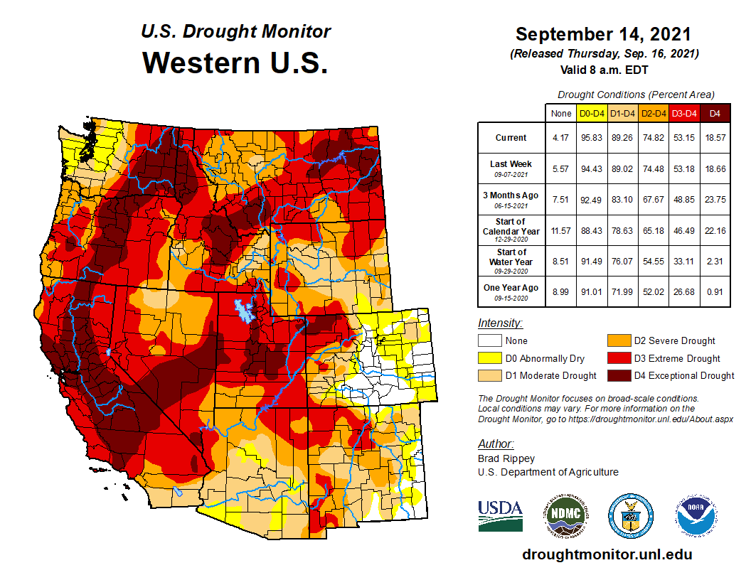
West Drought Monitor map September 21, 2021.
Internally, state water agencies also have individual programs that focus on a sustainable future, such as the 2015 Colorado Water Plan. The Water Plan was Colorado’s first such program and in its first five years funded more than 241 water projects, such as infrastructure improvements, irrigation efficiency measures and engagement projects like taking science teachers on a five-day trip of the Rio Grande to show them various water issues facing Colorado. Set to be updated in 2022, the Water Plan builds upon previous supply planning and projects how much water the state will need in the future, according to Megan Holcomb, climate change risk management specialist at the Colorado Water Conservation Board.
A recent pilot initiative of the Water Conservation Board, the Future Avoided Cost Explorer (FACE:Hazards), aims to anticipate Colorado’s economic impacts from flood, drought and wildfires in 2050. The study, funded predominantly by the Federal Emergency Management Agency, according to Holcomb, paired four population scenarios (ranging from current population to high growth) with three climate scenarios (current, moderate and more severe change). The authors then discussed actions that Coloradans could take to reduce economic impacts from these hazards, as well as the relative cost associated with each action.
“If we can quantify what impacts from climate change will be without any action, then we have a baseline to say why resilience investments are worthwhile now,” Holcomb says.
Another internal Coloradan water program that takes climate change into account is the Drought Task Force, which is able to recommend mitigation measures as necessary statewide. While the governor makes the ultimate decision regarding these measures, the Task Force involves representatives from departments of natural resources, public safety and agriculture, among others.
Moving forward, both Ostdiek and Holcomb say that operational flexibility and a willingness to adopt creative solutions will be key to coping with climate change in water planning. Due to Colorado’s unique headwater position — which already limits how much Colorado River water the state is entitled to each year — Holcomb argues that Colorado needs to be particularly creative about water rights by furthering innovative tools like water leasing, which allows water rights holders to lease their water to other users.
Collaboration and scientific rigor are key, all these experts agree, to making sure the region is as prepared as possible for any future that may present itself.
“We can all acknowledge that we need to be able to share within the state as well,” she says.
At the other end of the Colorado River Basin, water officials in Phoenix, Arizona, are recognizing that some 40% of the city’s water supply may be in jeopardy due to climate change, according to Campbell from Phoenix Water.
That’s one reason, Campbell explains, planners in Arizona are observing shifts in the flow pattern of the Colorado River that are the direct result of climate change. She and her colleagues are strategizing how they might replace the supplies that are in jeopardy — looking at exact times and places where reductions can be made through “targeted demand management.”
For example, Campbell suggests, a project could work to reduce the amount of water used by cooling towers at a power plant by studying the precise impact of changing the water used by certain towers. Such adaptation tactics, according to Campbell, would have a much more significant impact than, for example, shutting off the water while brushing teeth — a practice that, while good for conservation, is “not going to yield the type of water we’re talking about.”
And because the amounts of water experts are talking about are not set in stone, dealing with that uncertainty will continue to be a critical responsibility of water agencies going forward. Collaboration and scientific rigor are key, all these experts agree, to making sure the region is as prepared as possible for any future that may present itself.
Editor’s note: The main image is courtesy of the U.S. Department of the Interior. The original can be found here.
We are excited to debut Splash Lab, a series of short videos where our own research scientists make science simple and fun. This episode is about source water monitoring. Let’s dive in!
The risk of lower and lower water levels in Lake Powell and other reservoirs in the Colorado River Basin keep getting higher and higher.
An analysis by the U.S. Bureau of Reclamation released Sept. 22 finds an elevated risk of 25% to 35% of the water level in Powell falling below the minimum power pool by July 2022.
Minimum power pool is the level below which there is insufficient power to produce electricity.
The drought began in 2000, but as several studies have concluded that drought fails to fully describe what is happening in the river basin. Those studies point to rising temperatures that have produced aridification. Even with the same volume of water falling from the sky, less of it will become river water.
As an Aug. 24 article in Science magazine pointed out, about 17% of baseline precipitation ended up in the Colorado River in the 1930s and ‘40s, with a majority of that water coming from Colorado in the form of snowmelt. Today, it’s about 14%.
Since July, the Bureau of Reclamation began releasing water from its smaller reservoirs upstream of Powell—Flaming Gorge, Blue Mesa and Navajo—with the hope of augmenting Powell sufficiently. The headwaters states for the Colorado River had an exceptionally dry spring, exactly opposite of what was happening east of the Continental Divide in Colorado. The runoff into Lake Powell was 26% of average, despite near-average snowfall last winter.
otal storage in the Colorado River reservoirs today is 39% of capacity, down from 49% at this time last year.
John Fleck, writing on his website, Inkstain, called the latest announcement “something remarkable.” The government predictions used something pioneered a decade by Eric Kuhn and Dave Kanzer of the Glenwood Springs-based Colorado River District along with John Carron of Boulder-based Hydros Consulting. They thought it not useful to base predicts on the full hydrologic record of the Colorado River going back to 1906. Instead, they said, better would be to use a short-term frame, the last 30 years. They call it the stress test.
“The idea is that the traditional approach—using the entire period of record to model the probabilities of future river flows—is no longer valid because climate change is changing the river,” he explained.
From Allen’s latest newsletter:
The letter finally arrived. The Internal Revenue Service has recognized Big Pivots as a 501(c)3 non-profit.
Precious little journalistic income has rolled in the door during the last two years. This will help immediately. Two grants previously rewarded can be realized. Together, they’re a strong start. In coming weeks, I will return to you with suggestions about how you might want to assist the forward movement of Big Pivots.
I also want to recognize two “advertisers” in this issue of Pivots. Mike Foote, a former state senator from Erie, has a law office specializing in land and water. His is a sponsorship ad, meaning he has his name and website but mostly he’s saying he wants Big Pivots to go forward.
Might others want to do so also?
There’s also an advertisement from Colorado Solar and Storage Association about their November conference (and discount on registration if you say Big Pivots).
Then there was a reader from North Park who, after the last issue, sent this message.
“I just have to tell you how much I learn from every issue. I’m printing this one out as as write,” wrote Debby Burnett, whose home lies near the Wyoming border. She was hoping to mount a campaign against U.S. Rep. Lauren Boebert. “I’ve been faithfully reading every issue of yours to make sure I can communicate effectively about the issues facing Colorado, specifically rural Western Colorado. … I will continue to scour each issue for the incredible nuggets of information you’ve packed onto every page.”
In this endeavor, many days have felt uncertain. That day was bright.
NOAA has awarded more than $5 million to the CU Boulder-based Western Water Assessment to advance climate resilience in Intermountain West communities facing low river flows, wildfires, heat, drought and major economic transitions.
With renewed support from NOAA for five years, the Western Water Assessment will work with the University of Wyoming, the University of Utah, water providers, rural communities and Tribes, to understand the compounding effects of rapid economic transitions and climate change, and build regional resilience. Organized around two major themes—resilient water supply and resilient communities—the research will directly involve partners on the ground to define what resilience in our region means and how best to achieve and measure success.
“Our work has never been more urgent,” said WWA director Lisa Dilling, a CIRES Fellow and Professor of Environmental Studies at CU Boulder. “The region’s institutional, infrastructural and societal capacity to support the well-being of its residents is being severely tested.” The work will examine the connections between climate variability and change as they cascade through impacts on forest health, water supply and quality, and wildfire risk, and intersect with economic opportunity, tourism, community well-being, and justice and equity. The ultimate goal is to build usable knowledge that communities and water managers can use in their own decision making as they navigate the Intermountain West’s rapidly changing conditions, Dilling said.
The Western Water Assessment, which is part of CIRES, has been a NOAA RISA program—Regional Integrated Sciences and Assessments—for over 20 years. These regional teams of experts conduct user-driven research designed to expand and build the nation’s capacity to prepare for and adapt to climate variability and change.
With the latest funding from NOAA, the WWA will focus particularly on the needs of, and challenges faced by, communities on the frontline of climate change—particularly Tribes and smaller rural communities, said WWA managing Director Benét Duncan: “Frontline communities are experiencing the impacts of climate change, but have less access to information and resources to help build resilience. This is a critical need in our region.”
In recent years, towns and cities across Colorado, Wyoming and Utah have seen historically low river flows, record-setting wildfires, and extreme heat and drought, Duncan and Dilling said. Compounding those challenges are the impacts of dramatic economic transitions for rural communities and rapid population growth across the region.
“Understanding the connections between extreme weather and climate events and societal stressors is challenging and critical work,” said CIRES Director Waleed Abdalati. “WWA’s activities will increase the resilience of Western communities.”
American Whitewater floated a plan last year to expand protections for recreational river flows in Colorado. Maybe, the nonprofit protector of rivers thought, communities should not need to build whitewater parks to secure rights for recreational flows.
“It definitely, you know, got some ears perked,” said Hattie Johnson, American Whitewater’s southern Rockies stewardship director.
Colorado officially recognized recreation in a river as a beneficial use of water in 2001, enabling riverside communities to file for water rights to support whitewater parks. Those recreational in-channel diversion water rights, or RICDs, set a minimal stream flow between structures to support “a reasonable recreation experience.”
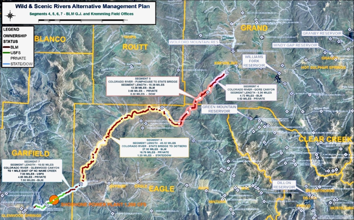
This map shows a stretch of the upper Colorado River, between Kremmling and Glenwood Springs, that is subject to a new framework designed to protect ecological and recreational values, in balance with the needs of water users on the Western Slope and Front Range. Graphic credit: Upper Colorado River Wild and Scenic Stakeholder Group
In the 20 years since the creation of RICDs and further legislation in 2006, Colorado communities have built dozens of whitewater parks, with 13 of them using RICD water rights. Some parks have delivered lasting economic benefits to riverside communities. But there hasn’t been a new RICD filing since 2013, when Glenwood Springs proposed three whitewater parks and found itself locked in Colorado water court for more than a year…
The nonprofit river conservation group American Whitewater is advancing a plan that structures in the river are not necessary for river recreation and communities should be able to file for RICD water rights without expensively engineered features that create waves and holes for kayaking, rafting and stand-up paddling. While there are 13 official RICD water rights in the state, there are more than 130 stretches of whitewater that can be rafted, kayaked and stand-up paddled in the state…
Early talks with Colorado’s sharp-elbowed water community have not gone well. No lawmaker took up American Whitewater’s proposed legislation, which has been scrapped. And opposition to a plan that expands recreational protection of water is stiff.
Montrose Water Sports Park. Photo credit: Google
The gist of opposition, which was voiced earlier this month at the meeting of the statehouse Water Resources Review Committee, is this: If any community can file for RICD water rights without actually building anything in the river, the expansion of those recreational rights could muddy Colorado’s already complicated water dealing.
Denver Water met with American Whitewater, where the powerful water utility expressed concerns over how changes to the RICD statute might “impact previous, hard-won agreements” that allowed recreational water rights, Hartman said. There is a lot of water trading that goes on in Colorado as the state’s water users navigate senior and junior water rights while meeting regional requirements to deliver Colorado River water to downstream users in Arizona, Nevada, California and Mexico.
“Reopening the statute to loosen it would probably make for a significant undertaking,” Hartman said.
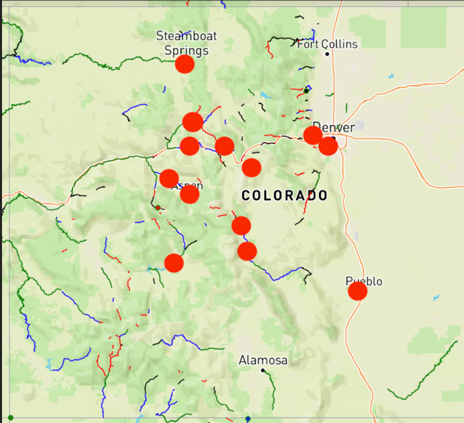
The red dots show communities who have applied for Recreational In-Channel Diversion water rights in Colorado. The green, blue, black and red lines indicate stretches of whitewater paddled by rafters, kayakers and stand-up paddlers. The nonprofit American Whitewater group is exploring a possible amendment to the state’s water laws that would allow communities to more easily protect recreational water rights. (Provided by American Whitewater)
American Whitewater is adjusting its plan to accommodate flexible exchanges of water and what Johnson called “creative water management we are going to need in a hotter, drier future.”
“Having larger decrees for in-stream flows for recreation would make that really difficult and prevent it when it would be needed to deliver water to people’s homes and fields,” she said. “That is understandable.”
While old-guard water users may be chafing at a plan to expand recreational water rights, they are not dismissing recreation as an invalid use of Colorado’s water.
“Recreational water use and recreational enjoyment of the state’s waters are integral to Western Colorado’s lifestyle and economy,” said Zane Kessler, the head of government relations for the Colorado River Water Conservation District, adding that the current RICD water laws in Colorado “provide a good amount of flexibility.”
Kessler said the 15-county Western Slope river district “is sympathetic to the goals of American Whitewater,” but he wonders about the necessity of amending Colorado water law to allow communities like Craig and Sterling and Del Norte to increase the recreational appeal of their riverfront land.
The river district’s policy, he said, says that a RICD should not be granted if it would “materially impair” Colorado’s ability to meet its water delivery obligations under the Colorado River Compact agreements of 1922 and 1948. Colorado is part of a coalition of upper basin states — with New Mexico, Wyoming and Utah — who must deliver 7.5 million acre feet of Colorado River water to lower basin states as part of a nearly century-old agreement allocating river water that now supports some 40 million users…
Johnson said American Whitewater will continue talks with Colorado water users about how communities can protect recreational flows without having to build whitewater features. The group hopes to craft an amendment to the state’s recreational water rights rules that will both protect recreational use of river water while preventing a flood of applications for RICD water rights.
Developer 4 Site Investments plans to build more than 3,200 homes north of Judge Orr Road adjacent to Eastonville Road and U.S. 24. County commissioners on Tuesday, Sept. 28, 2021, voted to approve a service plan for four new metropolitan districts that will fund the subdivision. Courtesy of Grandview Reserve Sketch Plan
El Paso County commissioners on Tuesday approved four new metropolitan districts that will fund a proposed subdivision of more than 3,200 homes in Peyton, a move some locals say could alter the area’s “small-town feel” as thousands of expected residents move in.
Commissioners voted unanimously to form the metropolitan districts that propose issuing $290 million in debt over 30 years to build the planned Grandview Reserve subdivision on about 768 acres between U.S. 24 and Eastonville Road, near Falcon Regional Park.
Grandview Reserve developers expect to build up to 3,260 single-family homes in the new subdivision over 14 years, said Russell Dykstra of law firm Spencer Fane LLC, representing developer 4 Site Investments LLC. About 244 homes would be built each year from 2022 through 2032 before construction gradually tapers down between 2033 and 2036, according to meeting documents. Previously, anticipated build-out was planned to occur over eight years.
County planner Kari Parsons said homes were expected to sell on average for about $340,000. Developers will charge each future property owner special district taxes to finance the $295 million debt. Owners of a newly built $400,000 home in the subdivision could owe about $1,859 in taxes annually, Dykstra said.
The proposal presented Tuesday was revised from a previous request to form five new metropolitan districts that proposed issuing $250 million in debt to build the new development. Parsons said developers now proposed issuing $290 million in debt because of increased construction costs…
Developers contended several other nearby districts — including the 4-Way Ranch, Meridian Ranch and Woodmen Hills metro districts — cannot support nor pay for traffic, water and storm drainage improvements planned for the area, meeting documents show.
In a March 31 letter addressed to commissioners and included in meeting documents Tuesday, the 4-Way Ranch Metropolitan District said it cannot provide services to the proposed Grandview Reserve subdivision because it does not have enough water. The district also said forming four new Grandview Reserve Metropolitan Districts “would provide an economic alternative for services and would eliminate undo [sic] financial burden” on the 4-Way Ranch Metro District No. 2.
The Grandview Reserve Metro District would provide water to the Grandview Reserve subdivision, which needs about 1,200 acre-feet a year, developers said. An acre-foot of water is enough to cover an acre of land to a depth of about one foot and is considered the amount needed by a family of four for about a year.
Denver Basin Aquifer System graphic credit USGS.
The metro district would source mostly from the Arapahoe and Laramie-Fox Hills aquifers, but offsite wells from neighboring lands owned by 4 Way Ranch will “likely be needed” for full development, meeting documents show.
Upper Black Squirrel Creek Designated Groundwater Basin
Mirko Cruz of Trout Raley law firm, representing the Upper Black Squirrel Creek Ground Water Management District, said the developer hasn’t “provided sufficient evidence” that the new metro district owns or controls adequate water rights to service the development. Developers have a purchase and sale agreement “for a portion of the water needed” to meet the subdivision’s demands but it doesn’t prove their guaranteed right to use the water, he said…
Cherokee Metropolitan District will provide wastewater services to the subdivision, developers said.
The water resource fee of $35,290 would be charged to new residential customers who want to connect to both water and sewer service. Extra funds would enable the district to purchase more water shares to keep up with demand.
Currently, new construction permits are about $20,000 for water and sewer or $11,000 for water only, said Jim Blasing, director of utilities for Pueblo West. Board Vice President Matt Smith said the $35,290 price tag seemed high when compared with communities in the area…
Options outlined for proposed rate increases
Melanie Hobart, project manager for FCS Group, shared with the board three scenarios for water fees to help the district realize growth. That growth would call for a $15 million water treatment plant expansion in 2027.
If the district wants new growth to pay for itself, it could enact the $35,290 water resource fee and charge existing customers a 4.6% annual increase. If new growth is charged just 50% of the water resource fee, existing customers would be charged 8.3% more annually.
Smith said he would prefer to see a medium between the first two choices.
In the third water scenario, without a water resource fee, there would be a 20% increase in all water bills next year and 10% annually from 2023 onward. Sewer rate scenarios included one the consultants recommended where customers would see a 20.3% increase in 2022, a 6.5% increase from 2023 to 2027 and a 3.25% increase the following four years.
The second sewer option, which would prevent the district from going into debt, would call for a 48% bill increase for customers in 2022 and a 23.5% increase in 2023.
Pueblo West resident Joe Mahaney suggested the district prioritize a capital improvement project that would enable the use of treated wastewater for non-potable uses like parks. He also suggested higher water rates for users who consume more than 9,000 gallons a month.
Residents will have a chance to weigh in on the proposed rate increases the district settles on at a public meeting set for 5 p.m. Nov. 8 at Fire Station 3, 729 E. Gold Drive.